Magnitude 7.6 & 7.4, SOLOMON ISLANDS Saturday 12 th April 2014 20:14:39 UTC Sunday 13 th April 2014...
9
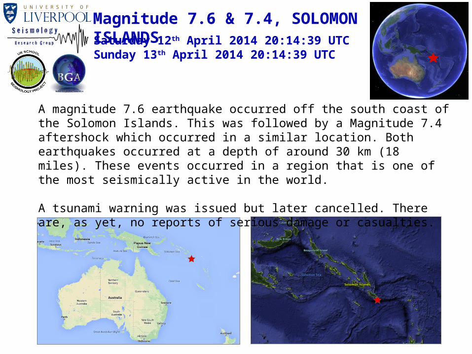
Magnitude 7.6 & 7.4, SOLOMON ISLANDS Saturday 12 th April 2014 20:14:39 UTC Sunday 13 th April 2014 20:14:39 UTC A magnitude 7.6 earthquake occurred off the south coast of the Solomon Islands. This was followed by a Magnitude 7.4 aftershock which occurred in a similar location. Both earthquakes occurred at a depth of around 30 km (18 miles). These events occurred in a region that is one of the most seismically active in the world. A tsunami warning was issued but later cancelled. There are, as yet, no reports of serious damage or casualties.
-
Upload
marley-spier -
Category
Documents
-
view
217 -
download
0
Transcript of Magnitude 7.6 & 7.4, SOLOMON ISLANDS Saturday 12 th April 2014 20:14:39 UTC Sunday 13 th April 2014...
Magnitude 7.6 & 7.4, SOLOMON ISLANDSSaturday 12th April 2014 20:14:39 UTC Sunday 13th April 2014 20:14:39 UTC
A magnitude 7.6 earthquake occurred off the south coast of the Solomon Islands. This was followed by a Magnitude 7.4 aftershock which occurred in a similar location. Both earthquakes occurred at a depth of around 30 km (18 miles). These events occurred in a region that is one of the most seismically active in the world.
A tsunami warning was issued but later cancelled. There are, as yet, no reports of serious damage or casualties.

Shaking intensityStrong (VI) to very strong shaking (VII) with localised destructive shaking (VIII) is believed to have occurred on the island of San Cristobal.
I. Instrumental
Not felt by many people unless in favourable conditions.
II. Weak Felt only by a few people at best, especially on the upper floors of buildings. Delicately suspended objects may swing.
III. Slight Felt quite noticeably by people indoors, especially on the upper floors of buildings. Many to do not recognise it as an earthquake. Standing motor cars may rock slightly. Vibration similar to the passing of a truck. Duration estimated.
IV. Moderate
Felt indoors by many people, outdoors by a few people during the day. At night, some awakened.
V. Rather Strong
Felt outside by most, may not be felt by some people in non-favourable conditions. Dishes and windows may break and large bells will ring. Vibrations like train passing close to house.
VI. Strong Felt by all; many frightened and run outdoors, walk unsteadily. Windows, dishes, glassware broken; books fall off shelves; some heavy furniture moved or overturned; a few instances of fallen plaster. Damage slight.
VII. Very Strong
Difficult to stand; furniture broken; damage negligible in building of good design and construction; slight to moderate in well-built ordinary structures; considerable damage in poorly built or badly designed structures; some chimneys broken. Noticed by people driving motor cars.
VIII. Destructive
Damage slight in specially designed structures; considerable in ordinary substantial buildings with partial collapse. Damage great in poorly built structures. Fall of chimneys, factory stacks, columns, monuments, walls. Heavy furniture moved.
IX. Violent General panic; damage considerable in poorly designed structures, well designed frame structures thrown out of plumb. Damage great in substantial buildings, with partial collapse. Buildings shifted off foundations.
X. Intense Some well build wooden structures destroyed; most masonry and frame structures destroyed with foundation. Rails bent.
XI. Extreme Few, if any masonry structures remain standing. Bridges destroyed. Rails bent greatly.
XII. Cataclysmic
Total destruction – everything is destroyed. Lines of sight and level distorted. Objects thrown into the air. The ground moves in waves or ripples. Large amounts of rock move position. Landscape altered, or leveled by several meters. In some cases, even the routes of rivers are changed.
Magnitude 7.6 & 7.4, SOLOMON ISLANDSSaturday 12th April 2014 20:14:39 UTC Sunday 13th April 2014 20:14:39 UTC
Modified Mercalli Intensity Scale

USGS PAGERGreen alert for shaking-related fatalities and economic losses. There is a low likelihood of casualties and damage.
Overall, the population in this region resides in structures that are vulnerable to earthquake shaking, though some resistant structures exist. The predominant vulnerable building types are mud wall and informal (metal, timber, GI etc.) construction.
Recent earthquakes in this area have caused secondary hazards such as tsunamis that might have contributed to losses.
Images courtesy of the US Geological Survey
Magnitude 7.6 & 7.4, SOLOMON ISLANDSSaturday 12th April 2014 20:14:39 UTC Sunday 13th April 2014 20:14:39 UTC
Population exposure
Iran
Pakistan
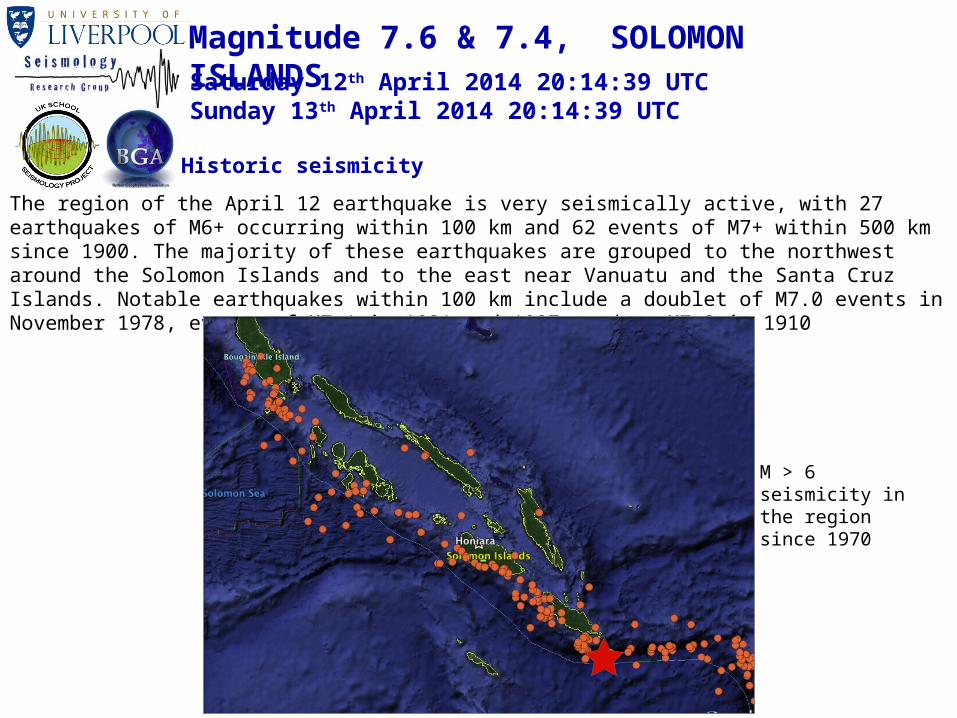
Historic seismicity
The region of the April 12 earthquake is very seismically active, with 27 earthquakes of M6+ occurring within 100 km and 62 events of M7+ within 500 km since 1900. The majority of these earthquakes are grouped to the northwest around the Solomon Islands and to the east near Vanuatu and the Santa Cruz Islands. Notable earthquakes within 100 km include a doublet of M7.0 events in November 1978, events of M7.1 in 1931 and 1937, and an M7.2 in 1910
M > 6 seismicity in the region since 1970
Magnitude 7.6 & 7.4, SOLOMON ISLANDSSaturday 12th April 2014 20:14:39 UTC Sunday 13th April 2014 20:14:39 UTC

Tectonic interpretation
Tectonic setting plotted using plate boundary data from the USGS.
Schematic fault motion
67 mm/yr
Nazca Plate
South AmericanPlate
Magnitude 7.6 & 7.4, SOLOMON ISLANDSSaturday 12th April 2014 20:14:39 UTC Sunday 13th April 2014 20:14:39 UTC
M7.6 mainshockThis earthquake occurred as the result of nearly pure transform faulting, on a NW-SE oriented left-lateral fault, on or near the plate boundary between the Australia and Pacific plates. At the location of the earthquake, the Australia Plate converges with and slips past the Pacific plate at a rate of 95 mm/yr. The earthquake occurred along a portion of this plate boundary that transitions from thrust to transform tectonics between the New Britain Trench to the northwest and the New Hebrides Trench farther east.
M7.4 aftershockThe M 7.4 Solomon Islands aftershock occurred as the result of reverse faulting on an approximately east-west oriented structure near the oceanic trench that marks the plate boundary between the Australia and Pacific plates.
Focal mechanism ‘beach ball’
Australia plate
Pacific plate
North New
Hebrides trench
95 mm/yr

Aftershocks
Most aftershocks have so far occurred to the south of the mainshock
Greatest slip (up to 6.5m) during mainshock occurred to the south-east
Over 50 thousand aftershocks have so far been recorded. Aside from the M7.4 aftershock, the largest of these was a magnitude 5.9 earthquake on Monday 14th April.More strong aftershocks are expected to occur.
Magnitude 7.6 & 7.4, SOLOMON ISLANDSSaturday 12th April 2014 20:14:39 UTC Sunday 13th April 2014 20:14:39 UTC
M7.6 mainshock
M7.4 aftershock
Aftershocks so far recorded by the USGS. Only
those earthquakes with mangitude > 4.5
are shown.

7
Seismogram recordings by UK seismometers
S-wavesP-waves Surface waves
Seismic waves took just 21 minutes to
travel through the Earth from
the earthquake to the UK!
Magnitude 7.6 & 7.4, SOLOMON ISLANDSSaturday 12th April 2014 20:14:39 UTC Sunday 13th April 2014 20:14:39 UTC

8
Seismogram recording from a school seismometer in Liverpool
Magnitude 7.6 & 7.4, SOLOMON ISLANDSSaturday 12th April 2014 20:14:39 UTC Sunday 13th April 2014 20:14:39 UTC
First seismic wavesarrive in Liverpool
Body waves(travel through centre
of the Earth)
Surface wavesHigher amplitude, travel close
to Earth’s surface

9
Find out more….
• BGS (British Geological Survey) – seismology and earthquakes – frequently asked questions http://www.earthquakes.bgs.ac.uk/education/faqs/faq_index.html
• IRIS (Incorporated Research Institutions for Seismology) – learning about earthquakes http://www.iris.edu/hq/programs/education_and_outreach/students
• UK School Seismology Project – classroom activities, videos and support documents http://www.bgs.ac.uk/schoolseismology/home.html
• USGS (United States Geological Survey) – FAQs, glossary, posters, animations http://earthquake.usgs.gov/learn/
• USGS summaries of the Solomon Islands earthquakes http://earthquake.usgs.gov/earthquakes/eventpage/usc000phx5#summary http://earthquake.usgs.gov/earthquakes/eventpage/usc000piqj#summary
• BBC news report on the earthquake http://www.bbc.co.uk/news/world-asia-27006985
Magnitude 7.6 & 7.4, SOLOMON ISLANDSSaturday 12th April 2014 20:14:39 UTC Sunday 13th April 2014 20:14:39 UTC