MacKays to Peka Peka Expressway: AEE: Landscape and visual ... · • Phormium tenax (New Zealand...
29
Appendix A Figures 1 - 64 Assessment of Landscape and Visual Effects MacKays to Peka Peka Expressway Prepared By Boffa Miskell Ltd AEE Lodgement - 15 March 2012 - rev 1
Transcript of MacKays to Peka Peka Expressway: AEE: Landscape and visual ... · • Phormium tenax (New Zealand...

Appendix A Figures 1 - 64
Assessment of Landscape and Visual EffectsMacKays to Peka Peka ExpresswayPrepared By Boffa Miskell Ltd
AEE Lodgement - 15 March 2012 - rev 1

AEE Lodgement 15 March 2012 rev 1 - Appendix A MacKays to Peka Peka Expressway- AEE- Landscape and Visual Assessment | page 2

page 3 | MacKays to Peka Peka Expressway- AEE- Landscape and Visual Assessment Appendix A - AEE Lodgement 15 March 2012 rev 1 KCDC ZONES FIGURE 1

AEE Lodgement 15 March 2012 rev 1 - Appendix A MacKays to Peka Peka Expressway- AEE- Landscape and Visual Assessment | page 4

page 5 | MacKays to Peka Peka Expressway- AEE- Landscape and Visual Assessment Appendix A - AEE Lodgement 15 March 2012 rev 1
PROPOSED PLANTING MITIGATION

AEE Lodgement 15 March 2012 rev 1 - Appendix A MacKays to Peka Peka Expressway- AEE- Landscape and Visual Assessment | page 6
Proposed Planting Mitigation
MASSED PLANTING Mass planting will primarily include native plant species to provide dense vegetated areas, and may consist of a mixture of species or areas of single species.
Species selection will consider the locality and planting substrate and generally include hardy pioneer species suited to the site. Species may include grasses, ground covers, shrubs and trees.
Indicative species:
Grasses:
• Festucanovae-zelandiae(Fescue tussock)• Chionochloaflavicans(Miniature toetoe)• Poacita(Silver tussock)• Chionochloatestacea• Carexinversa(Knob sedge)
Ground cover:
• Muehlenbeckiacomplexa(Pohuehue)• Hebeelliptica• Pimeleaprostrata• Dichondrarepens• Coprosmacultivars
MASSED PLANTING WITH TREE ENRICHMENTMass planting will primarily include native plant species to provide dense vegetated areas. Enrichment planting of canopy tree species, that require a sheltered environment to establish will enrich the biodiversity of the planting and wider area in the long term. Enrichment planting of canopy species will occur over 2 years following the initial mass planting.
Plant shrubs and small trees at close centres to form a vegetation mass that out competes weeds and other unwanted vegetation for minimal long term maintenance requirements.
Indicative species:
Canopy Trees:
• Alectryonexcelsus(Titoki)• Podocarpustotara(Totara)• Dysoxylumspectabile(Kohekohe)• Prumnopitystaxifolia(Matai)• Knightiaexcelsa(Rewarewa)• Corynocarpuslaevigatus (Karaka)
TREES UNDER PLANTED WITH GRASSSingle specimen or groups of tall, exotic and native trees established in lawn or pasture to reflect the open character of the local area- to be used in open rural areas and interchanges.
Tree planting in rural areas will reflect existing patterns, such as shelter belts,wood lots and small groups of trees using species such as poplar, willow, pine, eucalypt. Exotic or native amenity trees will be used in civic areas such as interchanges.
Indicative species:
• Eucalyptusspp.• Populus spp. • Quercuspalustris(Pin oak)• Metrosiderosexcelsa (Pōhutukawa)• Alnuscordata(Italian Alder)• Myoporumlaetum (Ngaio)• Podocarpustotara(Totara)• Metrosiderosrobusta (Northern Rata)• Knightiaexcelsa (Rewarewa)•
FIGURE 2 MITIGATION PLANTING TYPES
Small Trees:
• Rhopalostylissapida(Nikau)• Coprosmarepens(Taupata)• Macropiperexcelsa(Kawakawa)• Myrsineaustralis(Mapou)• Kunzeaericoides(Kanuka)• Myoporumlaetum(Ngaio)• Cordylineastralis(Cabbage tree)
Shrubs
• Dodonaeaviscosa(Akeake)• Coprosmapropinqua (Mingimingi)• Coprosmaacerosa(Sand coprosma)• Coprosmarobusta(Karamu)• Phormiumtenax(New Zealand flax)• Griselinialucida(Puka)

page 7 | MacKays to Peka Peka Expressway- AEE- Landscape and Visual Assessment Appendix A - AEE Lodgement 15 March 2012 rev 1
Proposed Planting Mitigation
RIPARIAN PLANTINGRiparian planting will provide transition to adjoining areas and enhance the ecological values of the stream and its margins, providing shade with overhanging vegetation, and stabilising banks.
Indicative species:
Riparian:
• Phormiumtenax (New Zealand Flax)• Carexsecta (Makuru)• Carexlessoniana(Swamp Sedge)• Cordylineaustralis(Cabbage Tree)• Plagianthusregius(Ribbonwood)• Austroderiafulvida (Toetoe)• Pseudopanaxarboreus(Fivefinger)
STORM WATER SWALESWetland species consistent with local species including species tolerant of permanent and occasional inundation and drier land on the margins.
Vegetation in swale channel will protect against soil erosion during peak flows.
Indicative species:
Wet swales:
• Baumearubiginosa (Orange nut sedge)• Baumeateretifolia(Pakihi rush)• Baumeatenax(Bumblebee nut sedge)• Austroderiafulvida(Toetoe)• Phormiumtenax(New Zealand Flax)• Cordylineaustralis(Cabbage Tree)• Carexvirgata (Swamp Sedge)
SPECIMEN TREES UNDER PLANTED WITH GROUND COVERSingle specimen or groups of tall, exotic and native specimen trees underplanted with massed ground cover species including grasses and low shrubs.
Typically used at interchange or civic areas to provide a low maintenance robust tree structure, shade, screening, and shelter.
Indicative species:
Ground Cover:
• Muehlenbeckiacomplexa(Pohuehue)• Corokiacotoneaster (Korokio)• Coprosmaspp.• Carexsolandri(New Zealand Bush Sedge)• Hebespp.
WETLAND/STORMWATER POND PLANTINGWetland species consistent with local species including species tolerant of permanent and occasional inundation and drier land on the margins.
Indicative species
• Phormiumtenax(New Zealand Flax)• Leptospermumscoparium(Manuka)• Carexsecta(Pukio)• Carexvirgata (Swamp Sedge)• Baumeateretifolia(Pakihi rush)• Austroderiafulvida(Toetoe)
Specimen Trees:
• Quercuspalustris(Pin Oak)• Metrosiderosexcelsa(Pōhutukawa)• Alnuscordata(Italian Alder)• Liquidambarstyraciflua(Liquidambar)• Vitexlucens(Puriri)• Knightiaexcelsa(Rewarewa)• Alectryonexcelsus(Titoki)
MITIGATION PLANTING TYPES FIGURE 2
ROAD MEDIANPlanting at the 6m wide median would consist of hardy indigenous species that will require low level of maintenance once established.
Indicative species:
• Muehlenbeckiaaustralis(Pohuehue)• Libertiaixioides (Mikoiko)• Libertiaperegrinans• Carexspp.• Chionochloaflavicans• Coprosmacultivars• Lomandraspp.
Dry swales:
• Mowngrass

AEE Lodgement 15 March 2012 rev 1 - Appendix A MacKays to Peka Peka Expressway- AEE- Landscape and Visual Assessment | page 8
Proposed Planting Mitigation
FIGURE 3 SECTOR ONE MITIGATION PLANTING

page 9 | MacKays to Peka Peka Expressway- AEE- Landscape and Visual Assessment Appendix A - AEE Lodgement 15 March 2012 rev 1
Proposed Planting Mitigation
Upper Drain 7
Manuka Wetland
Drain 7
Wharem
auku Stream
SECTOR ONE MITIGATION PLANTING FIGURE 3

AEE Lodgement 15 March 2012 rev 1 - Appendix A MacKays to Peka Peka Expressway- AEE- Landscape and Visual Assessment | page 10 AEE Lodgement 15 March 2012 rev 1 - Appendix A MacKays to Peka Peka Expressway- AEE- Landscape and Visual Assessment | page 10 Appendix A MacKays to Peka Peka Expressway- AEE- Landscape and Visual Assessment | page 10
Proposed Planting Mitigation
FIGURE 4 SECTOR TWO MITIGATION PLANTING
Drain
7
Drai
n 7

page 11 | MacKays to Peka Peka Expressway- AEE- Landscape and Visual Assessment Appendix A - AEE Lodgement 15 March 2012 rev 1 AEE Lodgement 15 March 2012 rev 1
Proposed Planting Mitigation
Wharem
auku Stream
Mazengarb Drain
SECTOR TWO MITIGATION PLANTING FIGURE 4

AEE Lodgement 15 March 2012 rev 1 - Appendix A MacKays to Peka Peka Expressway- AEE- Landscape and Visual Assessment | page 12 AEE Lodgement 15 March 2012 rev 1 - Appendix A MacKays to Peka Peka Expressway- AEE- Landscape and Visual Assessment | page 12 Appendix A MacKays to Peka Peka Expressway- AEE- Landscape and Visual Assessment | page 12
Proposed Planting Mitigation
FIGURE 5 SECTOR THREE MITIGATION PLANTING M
azen
garb
Dra
in
WW
TP D
rain
Otaihanga Southern Wetland
Landfill Drain
Otaihanga Northern Wetland
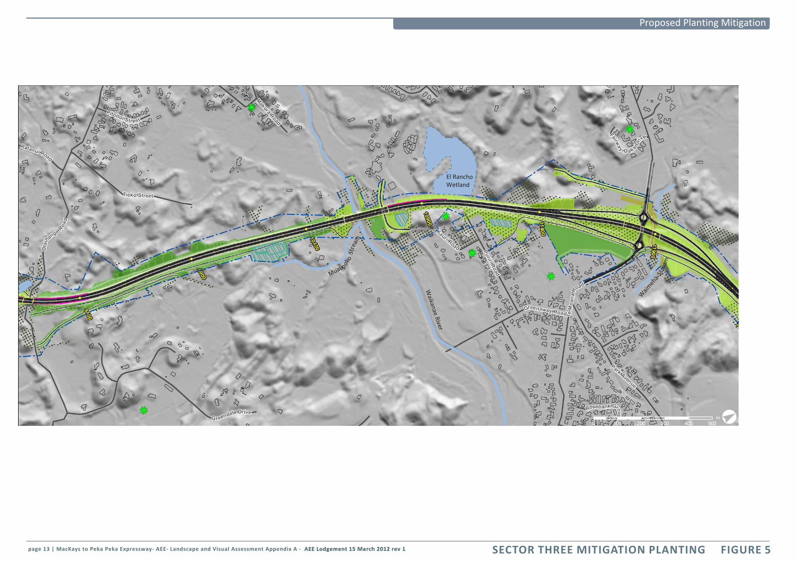
page 13 | MacKays to Peka Peka Expressway- AEE- Landscape and Visual Assessment Appendix A - AEE Lodgement 15 March 2012 rev 1 AEE Lodgement 15 March 2012 rev 1
Proposed Planting Mitigation
Muaupoko
Str
eam
Waikanae River
El Rancho Wetland
Waim
eha
Stre
am
SECTOR THREE MITIGATION PLANTING FIGURE 5

AEE Lodgement 15 March 2012 rev 1 - Appendix A MacKays to Peka Peka Expressway- AEE- Landscape and Visual Assessment | page 14 AEE Lodgement 15 March 2012 rev 1 - Appendix A MacKays to Peka Peka Expressway- AEE- Landscape and Visual Assessment | page 14 Appendix A MacKays to Peka Peka Expressway- AEE- Landscape and Visual Assessment | page 14
Proposed Planting Mitigation
FIGURE 6 SECTOR FOUR MITIGATION PLANTING
Ngarara
Creek
Kakariki
Stream
Smithfield Stream Dive
rsion

page 15 | MacKays to Peka Peka Expressway- AEE- Landscape and Visual Assessment Appendix A - AEE Lodgement 15 March 2012 rev 1 AEE Lodgement 15 March 2012 rev 1
Proposed Planting Mitigation
Paetawa Creek
SECTOR FOUR MITIGATION PLANTING FIGURE 6

AEE Lodgement 15 March 2012 rev 1 - Appendix A MacKays to Peka Peka Expressway- AEE- Landscape and Visual Assessment | page 16 AEE Lodgement 15 March 2012 rev 1 - Appendix A MacKays to Peka Peka Expressway- AEE- Landscape and Visual Assessment | page 16 Appendix A MacKays to Peka Peka Expressway- AEE- Landscape and Visual Assessment | page 16
Proposed Planting Mitigation
Landscape - Landforms Design
The dunes are the ‘signature’ landforms encountered along the Expressway corridor. In the first instance the route alignment seeks to avoid significant dunes if possible. However, loss or modification of some dunes will be inevitable in places given the confined corridor available and the scale of the Expressway footprint.
It is noted that some of the dunes that still remain today do so because they are located in the existing road designation and thus have been ‘protected’ from modification for residential and other development. Notwithstanding this, integrating the Expressway linear form into the dune landforms is a key design objective.
Several streams or parts of streams will be diverted. Regardless of their current state (many are channelized and/or weed infested) they will need to be reconstructed to allow indigenous ecology to re-establish. Other important landforms include the Waikanae River, existing wetlands, and distant views to Kāpiti Island.
Design Concept
The dune forms and other natural landform features have been avoided as best they can in the alignment of the Expressway. However, the Expressway will create change to landforms and the approach will be to ‘naturalise’ the changes as far as practicable, to integrate those changes with local topographical patterns.
Design Principles
The following principles will apply to the landform design:
1. Avoid modification of dunes, wetlands, and streams by minimising the construction footprint in sensitive areas.
2. Retain or enhance natural landforms wherever possible, including within both permanent and construction operational areas.
3. Design or modify landforms to acknowledge and reflect the local topographical pattern (scale, orientation, profile [refer Figure 99]).
4. Modify the slope or use retaining walls as appropriate to reduce the size of cut faces. A standard 1:3 grade has been proposed in the preliminary design (refer Figure 100).
5. Shape (roll off) the tops of cut/ fill faces so the faces integrate with the existing dune profiles as far as practicable.
6. Shape visual and noise mitigation bunds to appear as ‘naturally’ shaped landforms (refer Figure 99), avoiding engineered appearances unless these forms are a component of a designed ‘land art’ formation.
7. Recognise that the Waikanae River corridor, including, oxbows, river bed and flood plains are a different landform to the dunelands area. The alluvial landform is an important linear feature providing a physical and visual link between the mountains and the coast.
8. Ensure that realigned streams are reinstated and designed to allow re-establishment of natural streams able to support appropriate indigenous ecology.
9. Recognise the views to the Tararua Ranges and Kāpiti Island as prominent and important landforms and features in the design of east/west local road crossings.
10. Recognise that the sand and peat substrates are likely to need conditioning to provide a good growing substrate for plants. Soils substrate trials will be undertaken to assess the needs and methodology to achieve this.
The Expressway is a linear shape. Although the dunes are formed in an approximately linear pattern parallel to the coast they are not even and the Expressway cuts across them in places. In plan the remnant dune forms can be shaped to repeat slopes and shapes. The same approach should be used for bunds.
original dune shape
original dune shape
round off top and sides of cut
Expressway
standard cut zone extended earthworks integrate engineered batter into existing landform
Expressway integration into the dune landforms can be improved by managing the cut face slopes and their angle at the slope top to wrap to the natural forms
o
riginal dune shape
Steepening the sides of the wall with retained toe reduces the size of the cut face and retains more of the dune land form. This same approach can be used where it is desireable to minmise the footprint adjacent to wetlands or other features
Retaining wall
extended earthworks to integrate engineered batter into existing landform
In areas to be planted consider a steeper cut as this allows more of the ground to be retained and can limit the need for extended earthworks beyond the engineers construction cut zone
Expressway
round off top and sides of cut
Expressway
Expressway
round off top and sides of cut
In open rural areas or where the landform will be seen from beyond Expressway consider extending the earthworks beyond standard cut zone to allow rounded dune forms
standard cut zone
cut zone
shape the remnant landforms up slope as per Figure 100, but also around the dune sides
FIGURE 7 EARTHWORKS MITIGATION

page 17 | MacKays to Peka Peka Expressway- AEE- Landscape and Visual Assessment Appendix A - AEE Lodgement 15 March 2012 rev 1 AEE Lodgement 15 March 2012 rev 1
ZTV Analysis
The theoretical visibility analysis used ‘target’ points at every 10m along the Expressway, offset 15m each side of the centreline and at a height of 3m above the ground surface over a 3km distance.
The yellow areas on the map indicates from where the target points can theoretically not be seen. It can be thought of as an area in shadow of the line of sight from the target point.
This analysis is based on the LiDAR data for the ground surface only, it does not account for above ground features (vegetation and buildings).
Further detail about the ZTV analysis can be found in the Methodology section of the report.
KEY
Target Point (3m above ground)
Locations from where the target points can not be seen.
ZTV- 3KM EXTENT FIGURE 8

AEE Lodgement 15 March 2012 rev 1 - Appendix A MacKays to Peka Peka Expressway- AEE- Landscape and Visual Assessment | page 18 AEE Lodgement 15 March 2012 rev 1 - Appendix A MacKays to Peka Peka Expressway- AEE- Landscape and Visual Assessment | page 18 Appendix A MacKays to Peka Peka Expressway- AEE- Landscape and Visual Assessment | page 18 0 10.5 2km
Queen Elizabeth
Park
Raumati South
Raumati Road
Wharemauku Basin
Kāpiti-Mazengarb Otaihanga
South
Waikanae River Te
Moana
Ngarara
Peka Peka South
Peka Peka
SECTOR 1 Between chainage
1900 and 4500
SECTOR 2Between chainage
4500 and 8300SECTOR 3
Between chainage 8300 and 12400
SECTOR 4Between chainage 12400 and 18050
Twelve landscape character areas as they relate to the four sectors of the project identified for the purpose of the AEE assessment.
FIGURE 9 CHARACTER AREA LOCATIONS
Otaihanga North
page 19 | MacKays to Peka Peka Expressway- AEE- Landscape and Visual Assessment Appendix A - AEE Lodgement 15 March 2012 rev 1 AEE Lodgement 15 March 2012 rev 1
LANDSCAPE AND VISUAL ASSESSMENT BY CHARACTER AREA
SECTOR ONE - BETWEEN CHAINAGE 1900 AND 4500

AEE Lodgement 15 March 2012 rev 1 - Appendix A MacKays to Peka Peka Expressway- AEE- Landscape and Visual Assessment | page 20 AEE Lodgement 15 March 2012 rev 1 - Appendix A MacKays to Peka Peka Expressway- AEE- Landscape and Visual Assessment | page 20 Appendix A MacKays to Peka Peka Expressway- AEE- Landscape and Visual Assessment | page 20
Sector One
FIGURE 10 SECTOR ONE
Proposed Expressway
Existing Ground level
note: vertical scale exaggeration = 1:10
Cross section 1 Figure 16 Appendix A
Cross section 2 Figure 17 Appendix A
Cross section 3 Figure 18 Appendix A
Cross section 4 Figure 19 Appendix A
Cross section 5 Figure 22 Appendix A
Aerial Oblique A Figure 12 Appendix A
Aerial Oblique B Figure 13 Appendix A
Aerial Oblique C Figure 14 Appendix A
Visual Simulation 1 Figure 1 Appendix B
Visual Simulation 2 Figure 2 Appendix B
Stream/DrainExisting Wetland

page 21 | MacKays to Peka Peka Expressway- AEE- Landscape and Visual Assessment Appendix A - AEE Lodgement 15 March 2012 rev 1 AEE Lodgement 15 March 2012 rev 1
Sector One
Raumati South Character Area
Raumati Road Character Area
QE Park Character Area Poplar Avenue
Over Bridge
Raumati Road Over Bridge
Raumati South Character Area
Raumati Road Character Area
A
B
1
2
C
QE Park Character Area
Wharemauku Basin Character Area
Upper Drain 7
Manuka Wetland
Drain 7
Wharem
auku Stream
SECTOR ONE FIGURE 10
3

AEE Lodgement 15 March 2012 rev 1 - Appendix A MacKays to Peka Peka Expressway- AEE- Landscape and Visual Assessment | page 22 AEE Lodgement 15 March 2012 rev 1 - Appendix A MacKays to Peka Peka Expressway- AEE- Landscape and Visual Assessment | page 22 Appendix A MacKays to Peka Peka Expressway- AEE- Landscape and Visual Assessment | page 22
Sector One
FIGURE 11 SECTOR ONE ZTV 300M EXTENT
KEY
Target Point (3m above ground)
Locations from where the target points can not be seen.
ZTV Analysis
The theoretical visibility analysis used “target” points at every 10m along the Expressway, offset 15m each side of the centre line and at a height of 3m above the ground surface. The yellow areas on the diagrams show locations from where the target points can theoretically not be seen. It can be thought of as an area in shadow of the line of sight from the target point.
This analysis is based on the LiDAR data including the land(terrain) and above ground features (vegetation and buildings). Further detail about the ZTV analysis can be found in the Methodology section of the report.
QE Park Character Are a

page 23 | MacKays to Peka Peka Expressway- AEE- Landscape and Visual Assessment Appendix A - AEE Lodgement 15 March 2012 rev 1 AEE Lodgement 15 March 2012 rev 1
Sector One
Raumati Road Character Area
Raumati South Character Area
QE Park Character Area
Wharemauku Basin Character Area
SECTOR ONE ZTV 300M EXTENT FIGURE 11
AEE Lodgement 15 March 2012 rev 1 - Appendix A MacKays to Peka Peka Expressway- AEE- Landscape and Visual Assessment | page 24 AEE Lodgement 15 March 2012 rev 1 - Appendix A MacKays to Peka Peka Expressway- AEE- Landscape and Visual Assessment | page 24 Appendix A MacKays to Peka Peka Expressway- AEE- Landscape and Visual Assessment | page 24
Sector One
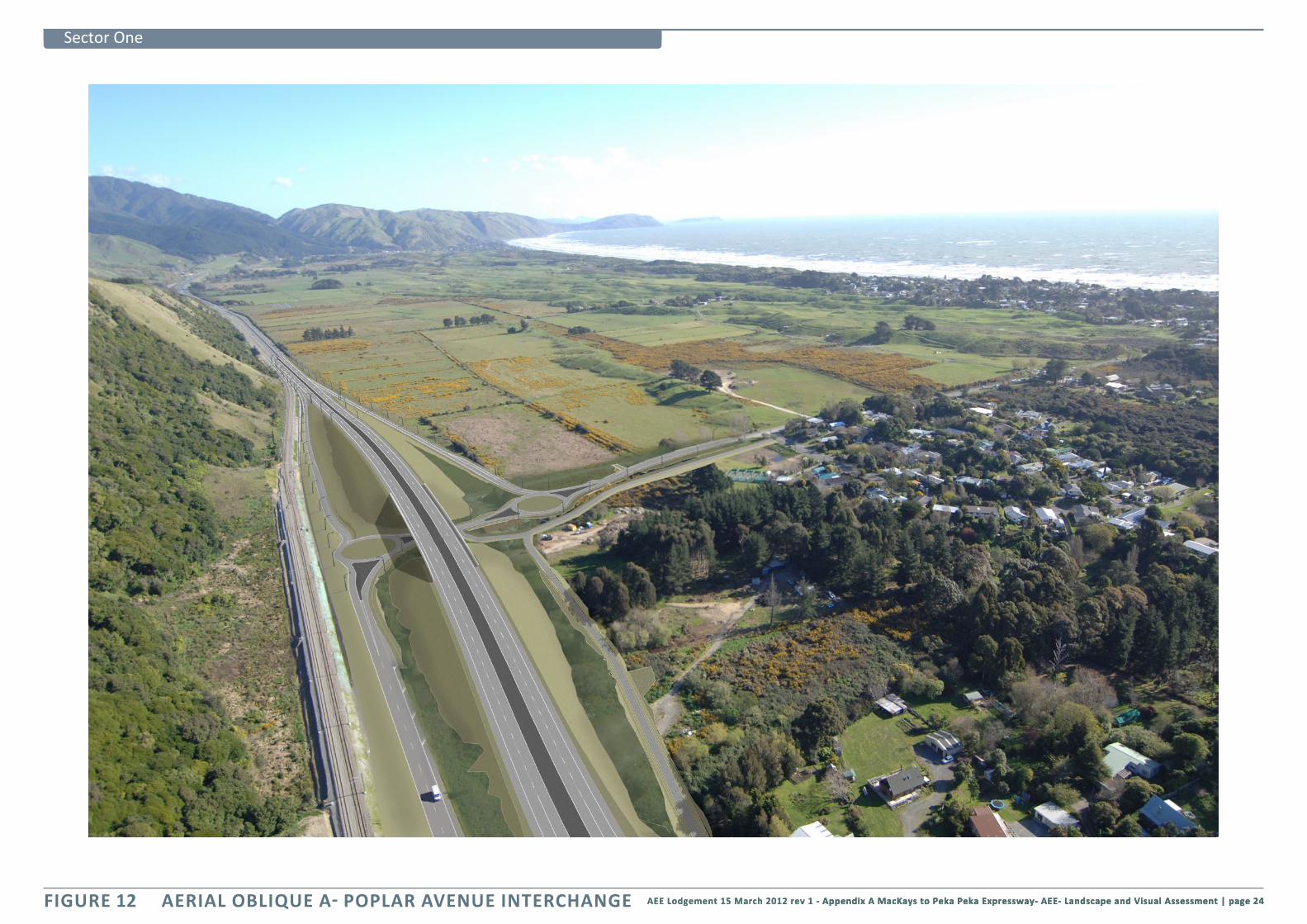
FIGURE 12 AERIAL OBLIQUE A- POPLAR AVENUE INTERCHANGE

page 25 | MacKays to Peka Peka Expressway- AEE- Landscape and Visual Assessment Appendix A - AEE Lodgement 15 March 2012 rev 1 AEE Lodgement 15 March 2012 rev 1
Sector One
AERIAL OBLIQUE B - RAUMATI SOUTH FIGURE 13

AEE Lodgement 15 March 2012 rev 1 - Appendix A MacKays to Peka Peka Expressway- AEE- Landscape and Visual Assessment | page 26 AEE Lodgement 15 March 2012 rev 1 - Appendix A MacKays to Peka Peka Expressway- AEE- Landscape and Visual Assessment | page 26 Appendix A MacKays to Peka Peka Expressway- AEE- Landscape and Visual Assessment | page 26
Sector Two
FIGURE 14 AERIAL OBLIQUE C RAUMATI ROAD

page 27 | MacKays to Peka Peka Expressway- AEE- Landscape and Visual Assessment Appendix A - AEE Lodgement 15 March 2012 rev 1 AEE Lodgement 15 March 2012 rev 1
Sector One
Queen Elizabeth Park
State Highway 1
Raumati Escarpment
Poplar Ave
Dunes
View south View south
QE PARK LANDSCAPE CHARACTER DESCRIPTION FIGURE 15
+
Queen Elizabeth Park
DunesRaumati Escarpment
Poplar Ave
Main Trunk Railw
ayState H
ighway 1
QE Park Character AreaDunes
Queen Elizabeth Park
Mai
n Tru
nk Rai
lway
Stat
e Hi
ghw
ay 1
QE Park Character Area
Character Area Boundary
Approximate Expressway Alignment
AEE Lodgement 15 March 2012 rev 1 - Appendix A MacKays to Peka Peka Expressway- AEE- Landscape and Visual Assessment | page 28 AEE Lodgement 15 March 2012 rev 1 - Appendix A MacKays to Peka Peka Expressway- AEE- Landscape and Visual Assessment | page 28 Appendix A MacKays to Peka Peka Expressway- AEE- Landscape and Visual Assessment | page 28
Sector One
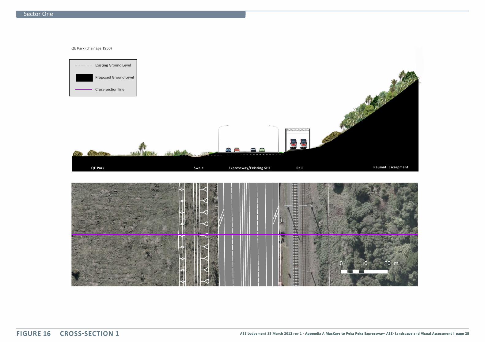
FIGURE 16 CROSS-SECTION 1
QE Park (chainage 1950)
Raumati EscarpmentExpressway/Existing SH1Swale RailQE Park
Existing Ground Level
Proposed Ground Level
Cross-section line

page 29 | MacKays to Peka Peka Expressway- AEE- Landscape and Visual Assessment Appendix A - AEE Lodgement 15 March 2012 rev 1 AEE Lodgement 15 March 2012 rev 1
Sector One
CROSS-SECTION 2 FIGURE 17
Rail
Expressway On ramp RailOff ramp
Poplar Ave intersection (chainage 2380)
Existing Ground Level
Proposed Ground Level
Cross-section line