Machu Picchu - Andy Roscoeandyroscoe.com/peru/guides/MachuPicchu-digital.pdf · MP compounds housed...
11
MACHU PICCHU ANDY ROSCOE’S FREE INCAN TOUR GUIDES Interactive Maps and Tour Guides available at: AndyRoscoe.com/peru WESTERN SIDE. MCGAREY
Transcript of Machu Picchu - Andy Roscoeandyroscoe.com/peru/guides/MachuPicchu-digital.pdf · MP compounds housed...

Machu Picchu
andy Roscoe’s FRee incan TouR GuidesInteractive Maps and Tour Guides available at:
AndyRoscoe.com/peru
wesTeRn sIde. McGARey
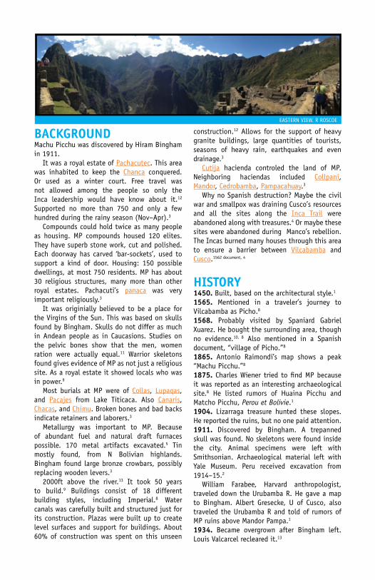
BackGRoundMachu Picchu was discovered by Hiram Bingham in 1911. It was a royal estate of Pachacutec. This area was inhabited to keep the chanca conquered. Or used as a winter court. Free travel was not allowed among the people so only the Inca leadership would have know about it.12 supported no more than 750 and only a few hundred during the rainy season (nov–Apr).3
compounds could hold twice as many people as housing. MP compounds housed 120 elites. They have superb stone work, cut and polished. each doorway has carved ‘bar-sockets’, used to support a kind of door. Housing: 150 possible dwellings, at most 750 residents. MP has about 30 religious structures, many more than other royal estates. Pachacuti’s panaca was very important religiously.3
It was originially believed to be a place for the Virgins of the sun. This was based on skulls found by Bingham. skulls do not differ as much in Andean people as in caucasions. studies on the pelvic bones show that the men, women ration were actually equal.11 warrior skeletons found gives evidence of MP as not just a religious site. As a royal estate it showed locals who was in power.9
Most burials at MP were of collas, Lupaqas, and Pacajes from Lake Titicaca. Also canaris, chacas, and chimu. Broken bones and bad backs indicate retainers and laborers.3
Metallurgy was important to MP. Because of abundant fuel and natural draft furnaces possible. 170 metal artifacts excavated.5 Tin mostly found, from n Bolivian highlands.
Bingham found large bronze crowbars, possibly replacing wooden levers.3
2000ft above the river.13 It took 50 years to build.9 Buildings consist of 18 different building styles, including Imperial.8 water canals was carefully built and structured just for its construction. Plazas were built up to create level surfaces and support for buildings. About 60% of construction was spent on this unseen
construction.12 Allows for the support of heavy granite buildings, large quantities of tourists, seasons of heavy rain, earthquakes and even drainage.3
cutija hacienda controled the land of MP. neighboring haciendas included collpani, Mandor, cedrobamba, Pampacahuay.3
why no spanish destruction? Maybe the civil war and smallpox was draining cusco’s resources and all the sites along the Inca Trail were abandoned along with treasures.4 Or maybe these sites were abandoned during Manco’s rebellion. The Incas burned many houses through this area to ensure a barrier between Vilcabamba and cusco.1562 document, 4
hisToRy1450. Built, based on the architectural style.1
1565. Mentioned in a traveler’s journey to Vilcabamba as Picho.8
1568. Probably visited by spaniard Gabriel Xuarez. He bought the surrounding area, though no evidence.10, 8 Also mentioned in a spanish document, “village of Picho.”8
1865. Antonio Raimondi’s map shows a peak “Machu Picchu.”8
1875. charles wiener tried to find MP because it was reported as an interesting archaeological site.8 He listed rumors of Huaina Picchu and Matcho Picchu, Perou et Bolivie.1 1904. Lizarraga treasure hunted these slopes. He reported the ruins, but no one paid attention.1911. discovered by Bingham. A trepanned skull was found. no skeletons were found inside the city. Animal specimens were left with smithsonian. Archaeological material left with yale Museum. Peru received excavation from 1914–15.2
william Farabee, Harvard anthropologist, traveled down the Urubamba R. He gave a map to Bingham. Albert Gresecke, U of cusco, also traveled the Urubamba R and told of rumors of MP ruins above Mandor Pampa.1
1934. Became overgrown after Bingham left. Louis Valcarcel recleared it.13
eAsTeRn VIew. R ROscOe
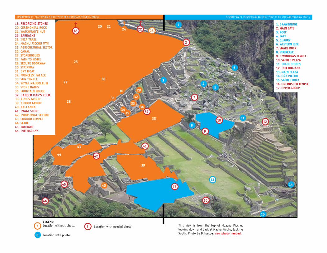
Description of locations on the right siDe of the map are founD on page 3.Description of locations on the left siDe of the map are founD on page 8.
1. DrawbriDge2. Main gate3. roof4. fake5. Quarry6. western siDe7. snake rock8. staircase9. 3 winDows teMple10. sacreD plaza11. iMage stones12. inti huatana13. Main plaza14. uña picchu15. sacreD rock16. unfinisheD teMple17. upper group
7
18 22
2
7
8
29
32
3637
31
6
202324
1
34
5
1314
15
6
21
5legenDlocation without photo.
location with photo.
25
26
30
33
3435
38
27
28
9
1011
12
16
39
41
40
42
43
44
45
46
18. recorDing stones20. cereMonial rock21. watchMan’s hut22. barracks23. inca trail24. Machu picchu Mtn25. agricultural sector26. canal27. storehosues28. path to hotel29. secure Doorway30. stairway31. Dry Moat32. princess’ palace33. sun teMple34. royal MausoleuM35. stone baths36. fountain house37. hangeD Man’s rock38. king’s group39. 3 Door group40. kallanka41. iMage stone42. inDustrial sector43. conDor teMple44. sliDe45. Mortars46. intiMachay
location with needed photo. this view is from the top of huayna picchu, looking down and back at machu picchu, looking south. photo by D roscoe, new photo needed.
17
3 descRIPTIOn OF LOcATIOns FROM THe RIGHT sIde OF THe MAP.
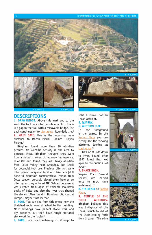
descRiPTions1. dRawBRidGe. Above this mark and to the west, the trail cuts into the side of a bluff. There is a gap in the trail with a removable bridge. The path continues on to Llactapata. Roundtrip 1hr.4
2. Main GaTe. This is the imposing main entrance to Machu Picchu. Frames Huayna Picchu.1
Bingham found more than 30 obsidian pebbles. no volcanic activity in the area to produce these. Bingham thought they were from a meteor shower. Using x-ray fluorescence, U of Missouri found they are chivay obsidian from colca Valley near Arequipa. Too small for potential tool use. Precious offerings were often placed in special locations, like here (still done in mountain communities). Person from colca canyon probably placed them here as an offering as they entered MP. Valued because it was created from apus of volcanic mountain peaks of colca and also the river that shaped the stones.3 Also found in Honduras, AZ, central europe– maybe from meteor.3. RooF. you can see from this photo how the thatched roofs were attached to the building. Most buildings have perfect stone work and dry masonry, but then have rough mortared stonework in the gables.2
4. Fake. Here is an archeologist’s attempt to
split a stone, not an Incan attempt.5. QuaRRy.6. wesTeRn side. In the foreground is the quarry. In the sacred Plaza you can clearly see the viewing platform, looking at Llactapata.12
Trail on w side down to river. Found after 1997 forest fire. not open to the public as of 2000.4
7. snake Rock.serpent Rock. several snakes are carved onto to rock, cave underneath.12
8. sTaiRcase to sacred Plaza.9. TeMPle oF The ThRee windows. Bingham believed this was birthplace of the Incas, which talked of the Incas coming forth from 3 caves. The edge
1. R ROscOe
4. d ROscOe
2. d ROscOe
5. R ROscOe
3. d ROscOe 9. BencH. M TAdLOck
6. A ROscOe

4 descRIPTIOn OF LOcATIOns FROM THe RIGHT sIde OF THe MAP.
of the windows are rounded more than usual to allow for wider view.11 A masmas, open sided building had a stone pillar to support the roof.6
Looks due east toward the rising sun.Reinhard, 1
A large stone block sits on a small cylindrical stone was used as roller to help in moving.4
Originally had 5 windows. Two were blocked off. near the base is a rock with the step motif carved onto it. The n corner-stone shows that the rock was being smoothed after placing. A “shallow groove in the end face” showed workers how far to cut.12
10. sacRed Plaza. Here are the Principal Temple and Priest’s house and stairway leading up to Intihuatana. sitting on the bench of the Priest House one faces the sun Temple at llactapata and the setting sun over Mt Pumasillo on the december solstice.11 w side over looks steep terraces. The base of the
platform is perfectly carved but the upper is rough: shows a later “hasty construction.”4
The Principal Temple is on the n side of the plaza. Presumably dedicated to Viracocha. It’s a masma,11 three walled building with large foundation stones and excellent stone work. “Only temple with a kind of sub-temple attached – sacristy.4
sacristy/Priest house, maybe a place for priest to prepare before entering Principal Temple. The left side of the door-jamb has a stone with 32 angles.4
There is a huaca which points to the cardinal
10. PRIncIPAL. R TAdLOck
10. LOOkInG s. d ROscOe
10. HUAcA. d ROscOe
10. LOOkInG n. R ROscOe
9. M ROscOe
5 descRIPTIOn OF LOcATIOns FROM THe RIGHT sIde OF THe MAP.
directions. Maybe represents the southern cross.4
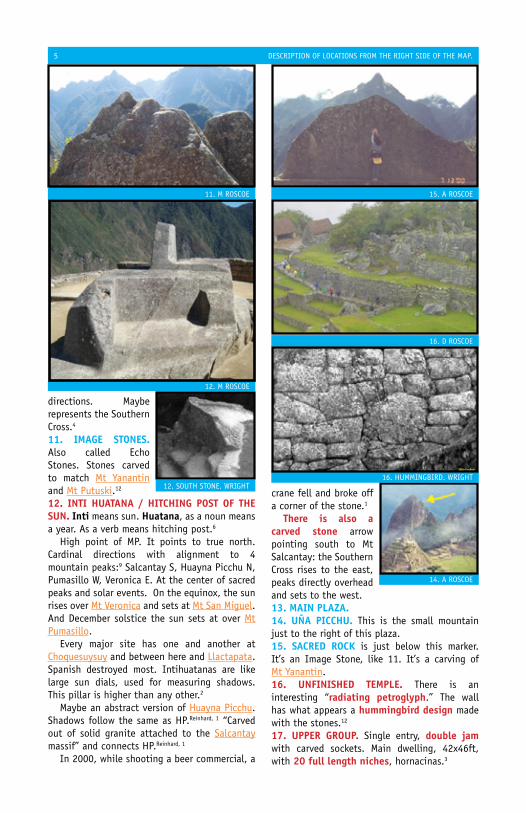
11. iMaGe sTones. Also called echo stones. stones carved to match Mt yanantin and Mt Putuski.12
12. inTi huaTana / hiTchinG PosT oF The sun. inti means sun. huatana, as a noun means a year. As a verb means hitching post.6
High point of MP. It points to true north. cardinal directions with alignment to 4 mountain peaks:9 salcantay s, Huayna Picchu n, Pumasillo w, Veronica e. At the center of sacred peaks and solar events. On the equinox, the sun rises over Mt Veronica and sets at Mt san Miguel. And december solstice the sun sets at over Mt Pumasillo. every major site has one and another at choquesuysuy and between here and Llactapata. spanish destroyed most. Intihuatanas are like large sun dials, used for measuring shadows. This pillar is higher than any other.2
Maybe an abstract version of Huayna Picchu. shadows follow the same as HP.Reinhard, 1 “carved out of solid granite attached to the salcantay massif” and connects HP.Reinhard, 1
In 2000, while shooting a beer commercial, a
crane fell and broke off a corner of the stone.1
There is also a carved stone arrow pointing south to Mt salcantay: the southern cross rises to the east, peaks directly overhead and sets to the west.13. Main Plaza.14. uña Picchu. This is the small mountain just to the right of this plaza.15. sacRed Rock is just below this marker. It’s an Image stone, like 11. It’s a carving of Mt yanantin.16. unFinished TeMPle. There is an interesting “radiating petroglyph.” The wall has what appears a hummingbird design made with the stones.12
17. uPPeR GRouP. single entry, double jam with carved sockets. Main dwelling, 42x46ft, with 20 full length niches, hornacinas.3
12. M ROscOe
12. sOUTH sTOne. wRIGHT
14. A ROscOe
15. A ROscOe
16. d ROscOe
16. HUMMInGBIRd. wRIGHT
11. M ROscOe
descRIPTIOn OF LOcATIOns FROM THe RIGHT sIde OF THe MAP. 8
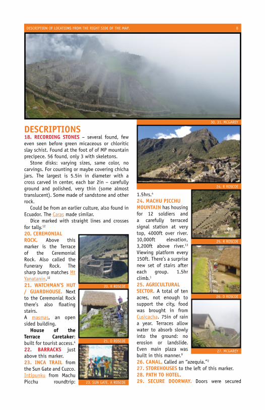
descRiPTions18. RecoRdinG sTones – several found, few even seen before green micaceous or chloritic slay schist. Found at the foot of of MP mountain precipece. 56 found, only 3 with skeletons. stone disks: varying sizes, same color, no carvings. For counting or maybe covering chicha jars. The largest is 5.5in in diameter with a cross carved in center, each bar 2in – carefully ground and polished, very thin (some almost translucent). some made of sandstone and other rock. could be from an earlier culture, also found in ecuador. The caras made similar. dice marked with straight lines and crosses for tally.12
20. ceReMonial Rock. Above this marker is the Terrace of the ceremonial Rock. Also called the Funerary Rock. The sharp bump matches Mt yanatanin.12
21. waTchMan’s huT / GuaRdhouse. next to the ceremonial Rock there’s also floating stairs.A masmas, an open sided building. house of the Terrace caretaker: built for tourist access.4
22. BaRRacks just above this marker.23. inca TRail from the sun Gate and cuzco. Intipunku from Machu Picchu roundtrip:
1.5hrs.4
24. Machu PicchuMounTain has housing for 12 soldiers and a carefully terraced signal station at very top, 4000ft over river. 10,000ft elevation, 3,200ft above river.13 Viewing platform every 150ft. There’s a surprise new set of stairs after each group. 1.5hr climb.1
25. aGRiculTuRalsecToR. A total of ten acres, not enough to support the city, food was brought in from cusicacha. 75in of rain a year. Terraces allow water to absorb slowly into the ground: no erosion or landslide. even main plaza was built in this manner.9
26. canal. called an “azequia.”2
27. sToRehouses to the left of this marker.28. PaTh To hoTel.29. secuRe dooRway. doors were secured
30, 31. McGARey
20. R ROscOe
24. R ROscOe
25. R ROscOe
26. d ROscOe
27. McGARey
21. d ROscOe
23. sUn GATe. A ROscOe
descRIPTIOn OF LOcATIOns FROM THe RIGHT sIde OF THe MAP. 9
using the ring above and side pegs were used with the noches on the sides.6
30. sTaiRway.31. dRy MoaT.32. PRincess’ Palace / PRiesT house. Two-story building for someone important. closest building to the sun Temple, excellent quality. A very important building, maybe housed a sun Temple priest.12
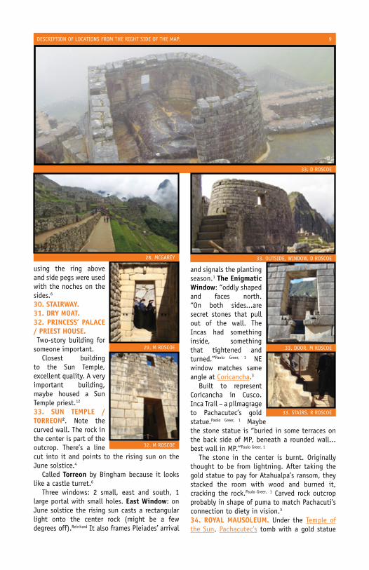
33. sun TeMPle / ToRReon2. note the curved wall. The rock in the center is part of the outcrop. There’s a line cut into it and points to the rising sun on the June solstice.4
called Torreon by Bingham because it looks like a castle turret.6
Three windows: 2 small, east and south, 1 large portal with small holes. east window: on June solstice the rising sun casts a rectangular light onto the center rock (might be a few degrees off).Reinhard It also frames Pleiades’ arrival
and signals the planting season.1 The enigmatic window: “oddly shaped and faces north. “On both sides...are secret stones that pull out of the wall. The Incas had something inside, something that tightened and turned.”Paolo Greer, 1 ne window matches same angle at coricancha.3
Built to represent coricancha in cusco. Inca Trail – a pilmagrage to Pachacutec’s gold statue.Paolo Greer, 1 Maybe the stone statue is “buried in some terraces on the back side of MP, beneath a rounded wall...best wall in MP.”Paulo Greer, 1
The stone in the center is burnt. Originally thought to be from lightning. After taking the gold statue to pay for Atahualpa’s ransom, they stacked the room with wood and burned it, cracking the rock.Paulo Greer, 1 carved rock outcrop probably in shape of puma to match Pachacuti’s connection to diety in vision.3
34. Royal MausoleuM. Under the Temple of the sun. Pachacutec’s tomb with a gold statue
33. d ROscOe
33. OUTsIde, wIndOw. d ROscOe
29. M ROscOe 33. dOOR. M ROscOe
32. M ROscOe
28. McGARey
33. sTAIRs. R ROscOe

descRIPTIOn OF LOcATIOns FROM THe RIGHT sIde OF THe MAP. 10
of himself on top of the center rock for worship.Luis Lumbreras, 1 entrance with steps is carved into a single stone. Fancy masonry filling in gap.35. sTone BaThs. The primary bath below the sun Temple.36. FounTain caReTakeR’s house is above the principal fountain. Has a recreated thatch roof. ceilings were probably “highly decorated, with a rattan mat woven in elaborate geometric designs stretched between the roof poles and thatch– lost half of Inca architecture.7, 4
37. hanGed Man’s Rock. The lintels has a protruding ring carved from it, probably held a lamp or image.6
38. kinG’s GRouP. Royal sector. Built with massive lintels and high pitched gables.6 Up to 3tons.4 Includes Hangman’s Rock.6
The sapa Inca would stay here. More difficult
to enter. doorway lintels are twice as large of others, private garden, fountains, and baths. entrance lintel has deep, long groove like at Ingenuity Group and coricancha in cuzco.3 Underneath king’s Group is a cave with remains of a woman.1980 Valencia, 3 Guinea pig sacrifice found in wall with a gold and silver tupus.eusebio Mendoza, 3
39. ThRee dooR GRouP. Three massive double jam doorways, each with “carved sockets with stone bar-holds”. Three kancas surrounding patio. windows to the e.3
40. kallanka. Large celebration hall.41. iMaGe sTones. Also called echo stones.stones carved to match visible moutians, like the one between the sacred Plaza and Intihuatana.42. indusTRial secToR. ingenuity Group, Private Garden Group. 4 sections, has a surrounding wall with only 1 entrance of a double
39. McGARey
34. sTePs. d ROscOe
34. MAsOnRy. d ROscOe
38. BedROOM. M ROscOe
35. M ROscOe
38. BedROOM. M ROscOe 38. BATHROOM. M ROscOe

descRIPTIOn OF LOcATIOns FROM THe RIGHT sIde OF THe MAP. 11
jam and massive lintel, opens into a huairona – 3 walled room. Houses and huaironas are lined with niches. sections connected by stairways, one of them is carved from a single block. 2 shrines of natural rock outcroppings. 2 stone mortars carved into ground. windows provide view of sun Temple and Temple of Three windows.3
Largest compound could house 50–60. compounds could hold twice as many people as housing. MP compounds housed 120 elites. They have superb stone work, cut and polished. each doorway has carved ‘bar-sockets’, used to support a kind of door. Bingham found remains of red stucco.3
43. condoR TeMPle / PRison GRouP. se of main Residential and Industrial sectors. could
have been used for prisoners, niches large enough. condor carved stone is here, a symbol of Incan prisons. Or possibly religious: many niches are mummy size. Or sacrificial area: small canals around condor stone resemble those at kenko.6
44. slide is a large white rock with platform carved into the top.45. MoRTaRs. A large room holds two stone mortars. not for grinding grain. These types found are found in shrines at sacsahuaman, Tarapata at Quente. Unknown use.Victor Angles
46. inTi Machay. A small cave, above and to the e of condor Temple.4 A solar observatory that marked the december solstice. Has coursed masonry and a window carved into a boulder that froms the front wall. Ten days before and after the winter solstice sunrise a beam of light shines throught the window and on the back wall.4
42, 43. R ROscOe
45. BInGHAM
44. M ROscOe
43. cOndOR. M ROscOe
46. HeMMInG, RAnney
43. cOndOR wInGs. M ROscOe

oTheR MaPs include:cusco and The sacRed Valley:cusco Guide – capital of the Incas.cusco History – history of the capital.cusco ceque map – holy lines / sites.coricancha – sun temple in cusco.sacsahuaman – fortress near cusco.Ollantaytambo – fortress in sacred Valley.Pisac – major Inca site in sacred Valley.
Machu Picchu and inca TRail:Machu Picchu – original lost city.chachabamba – near Machu Picchu.choquesuysuy – near Machu Picchu.Huayna Picchu – overlooks Machu Picchu.Inty Pata – near Machu Picchu.Phuyu Pata Marka – along Inca Trail.sayac Marka – along Inca Trail.winay wayna – near Machu Picchu.
VilcaBaMBa:choquequirao – very large site.Puncuyoc – near Vitcos.Vilcabamba – actual lost city.Vilcabamba area – jungle metropolis.Vitcos – rogue capital.yurak Rumi – Vitcos’ sun Temple.
chinchasuyu and cunTisuyu:saihuite – oracle along Apurimac.
collasuyu:Temple of Viracocha – largest building.
oTheR ResouRces include:Glossary of quechuaInca rulersHistoric namesReligionTribes
Mini-BiBlioGRaPhyIf you’d like to contribute photos, I’d love to have your help, [email protected]: Patrick McGarey, david Roscoe, Monica Roscoe, Robert Roscoe, Maria Tadlock, Richard Tadlock.
see Full Bibliography at website.1. Adams, Mark.2. Bingham, Hiram.3. Burger, Richard. salazar, Lucy.4. Frost, Peter.5. Gordon, Robert. Rutledge, John.6. Hemming, John.7. Lee, Vincent.8. MacQuarrie, kim.9. PBs, nova.10. Rowe, John11. Thomson, Hugh.12. wright, kenneth.13. Fejos, Paul.
42. sTAIRs, sHRIne. d ROscOe
38. kInG’s GROUP On LeFT. d ROscOe