MACGREGOR MEMORIAL LECTURE - geologicalsociety.org.z · MACGREGOR MEMORIAL LECTURE A.M....
61
MACGREGOR MEMORIAL LECTURE A.M. Macgregor’s (1951) Gregarious Batholiths and a Tripartite Subdivision of the Greenstone Belt Stratigraphy: Exploring our current Understanding of the Geological Evolution and Mineral Endowment of the Zimbabwe Craton Hielke Jelsma (PhD, FGSSA, Pr Nat Sci) Principal Geologist 15-17 May 2019
Transcript of MACGREGOR MEMORIAL LECTURE - geologicalsociety.org.z · MACGREGOR MEMORIAL LECTURE A.M....
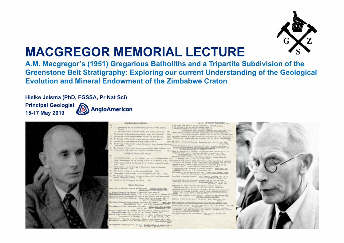
MACGREGOR MEMORIAL LECTUREA.M. Macgregor’s (1951) Gregarious Batholiths and a Tripartite Subdivision of the Greenstone Belt Stratigraphy: Exploring our current Understanding of the Geological Evolution and Mineral Endowment of the Zimbabwe Craton
Hielke Jelsma (PhD, FGSSA, Pr Nat Sci) Principal Geologist15-17 May 2019

2
INTRODUCTION
1. Overview of the life and accomplishments of A.M. Macgregor.2. Archean geology of Zimbabwe – lessons learnt in over 100 years of mapping3. Our current understanding of the Geological Evolution of the Zimbabwe Craton
Previous geochronology Unpublished geochronology (with Bob Nesbitt and with Erika Barton) “Untangling the Stratigraphy” - towards a new Provisional Stratigraphic Table
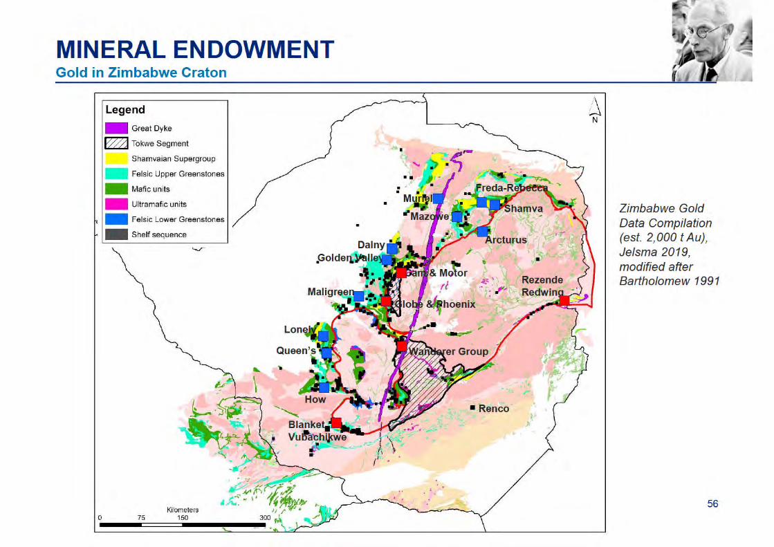
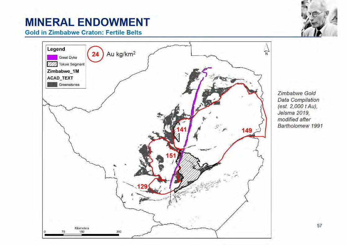
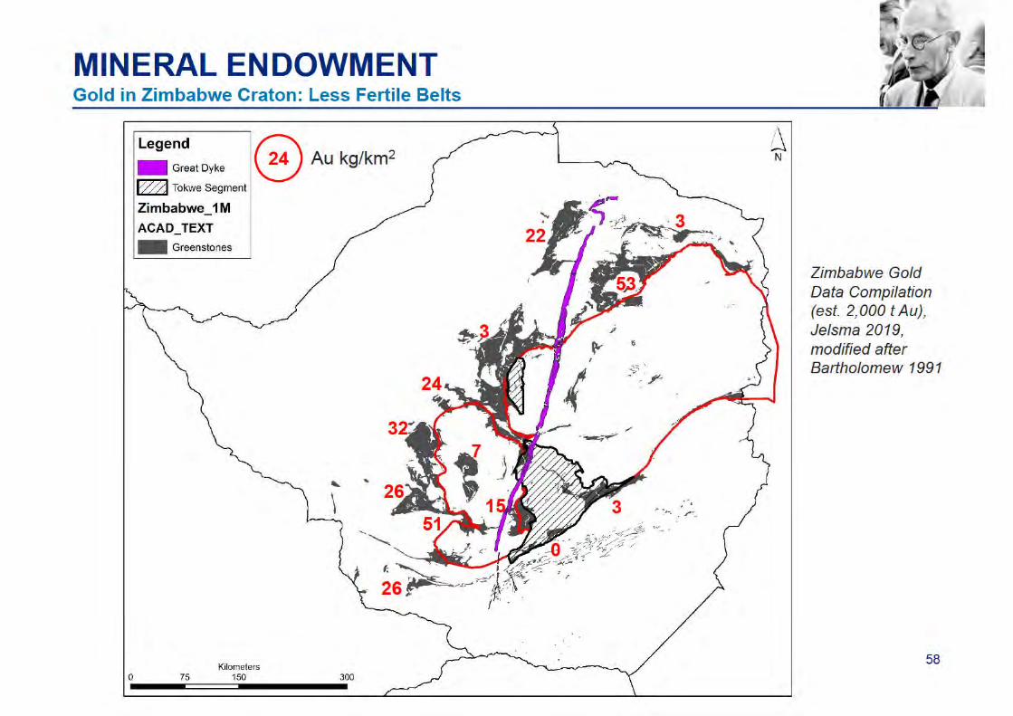
4. Relevance for the Mineral Endowment of the Zimbabwe Craton
Acknowledgements:• Brent Barber, Houda Bouammar, Tim Broderick, Tony Martin (Geological Society of Zimbabwe), Forbes
Mugumbate (Zimbabwe Geological Survey), Antony Mamuse (Midlands State University), Collins Mwatahwa and Caston Musa (Anglo American Unki Mine), Sharad Master (Wits University), Peter Fey (Consultant), Bob Nesbitt (University of Southampton), Engel Rutherford (Anglo American Group Discovery & Geosciences)
• John Vann (Anglo American Group Discovery & Geosciences); Charles Skinner (De Beers Exploration)
Preparations: Researched literature, scanned historic slides, captured ZGS occurrence data(Bartholomew 1991), compiled and reviewed geochronology data, reflected on own work and of others...
Reference: Fey P (2018). Alexander Miers Macgregor OBE, MA, DSc, FGS. The Geological Survey’sthird Director 1946-1948. Heritage of Zimbabwe, 37, 69-78.
60 slides, four themes
3
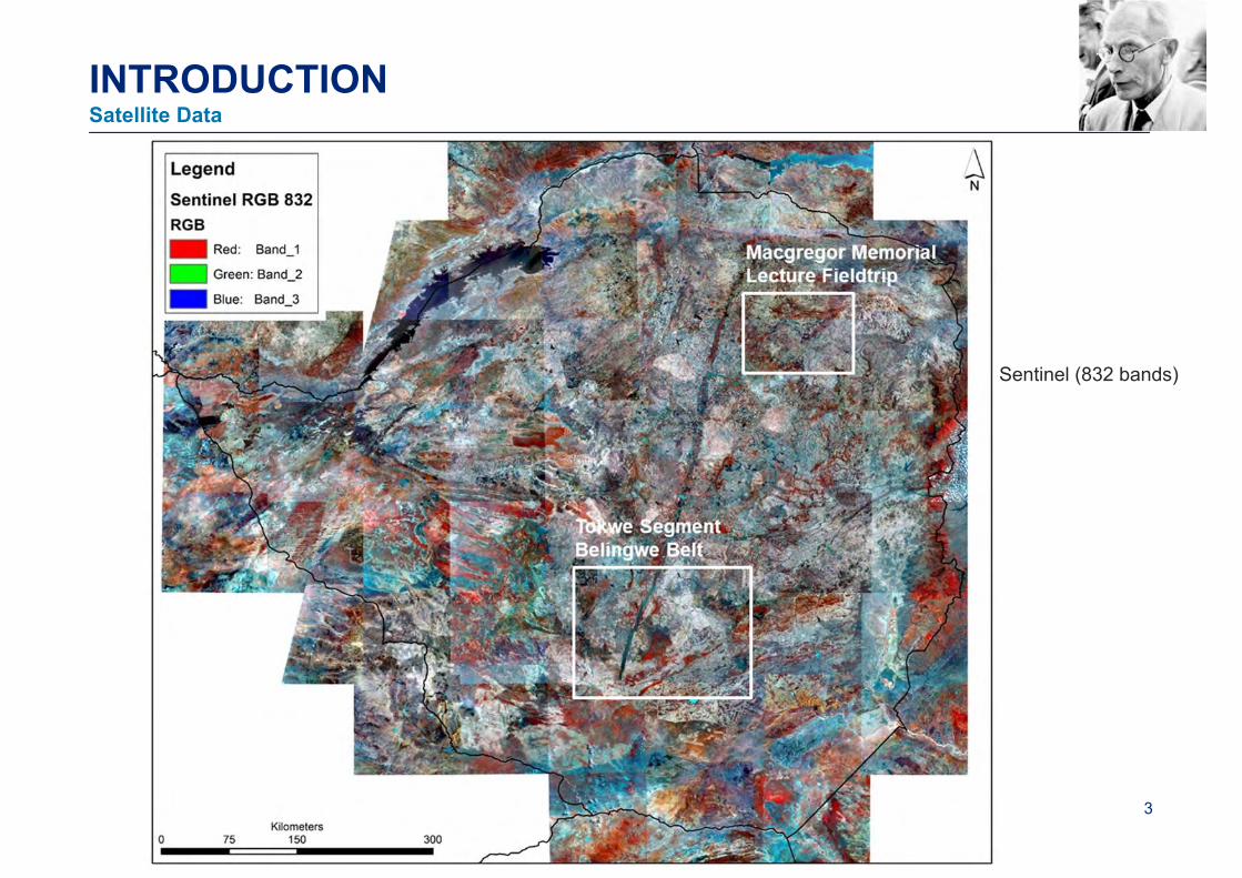
INTRODUCTION
Sentinel (832 bands)
Satellite Data
4
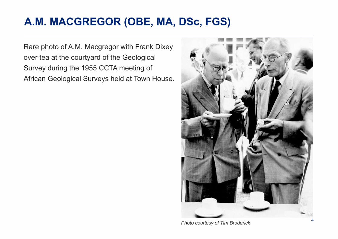
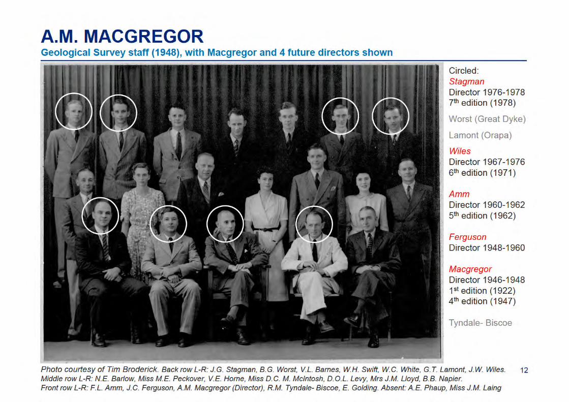
A.M. MACGREGOR (OBE, MA, DSc, FGS)
Rare photo of A.M. Macgregor with Frank Dixey over tea at the courtyard of the Geological Survey during the 1955 CCTA meeting of African Geological Surveys held at Town House.
Photo courtesy of Tim Broderick
5
A.M. MACGREGOR
• A truly remarkable man
• Alexander Miers Macgregor was born in London in 1888 and died in Bulawayo in 1961.
• He was a knowledgeable man, passionate about geoscience, and devoted his life togeological mapping.
• He was interested in fossils from a young age, encouraged by his father, a sculptor.
• He graduated with a BA degree from Queen’s College in Cambridge in 1911.
• In 1912 he was appointed as geologist and assistant curator at the Bulawayo Museum.
• He joined the Geological Survey in 1915 which was then directed by Herbert Maufe andassisted in mapping the Karoo rocks and younger sediments north-west of Bulawayo.
• He completed the work in 1916 and erected a new group, the Kalahari System.
• He enlisted in the army in the same year, rose to the rank of Lieutenant, and saw activemilitary service in France and Flanders during World War 1.
• In 1919 he returned and started a 27-year marathon of field work.
• He married in 1923 and the couple had two sons and a daughter; both sons died overGermany during World War 2.
6
A.M. MACGREGOR
• He completed the late Zeally’s mapping of the Somabula diamond field (1921) beforereturning to Bembezi Valley to complete his own mapping around Lonely Mine in 1923.
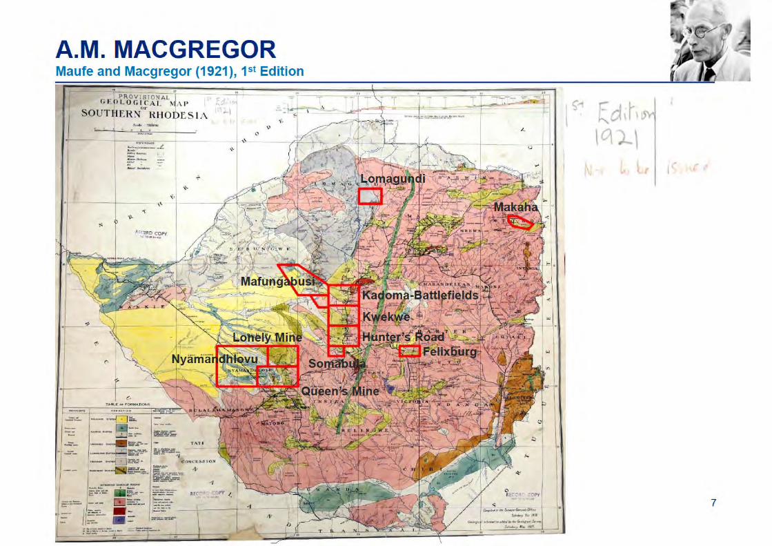
• Maufe and Macgregor conducted a reconnaissance survey of the country to compile the1st edition of the 1: 1 million geological map of the country which was published in 1921.
• He subsequently described the geology of the gold belts and mines, and worked his waysouth from Kadoma through Battlefields and Kwekwe to Hunters Road.
• The work resulted in his famous tripartite subdivision of greenstone belt stratigraphy intothe Sebakwean, Bulawayan and Shamvaian Groups, a broad framework still accepted.
• He was the first to map and describe rocks which became known as komatiite.
• His efforts produced 8 Bulletins and 7 Short Reports covering ~12,000 km2 (120 months)
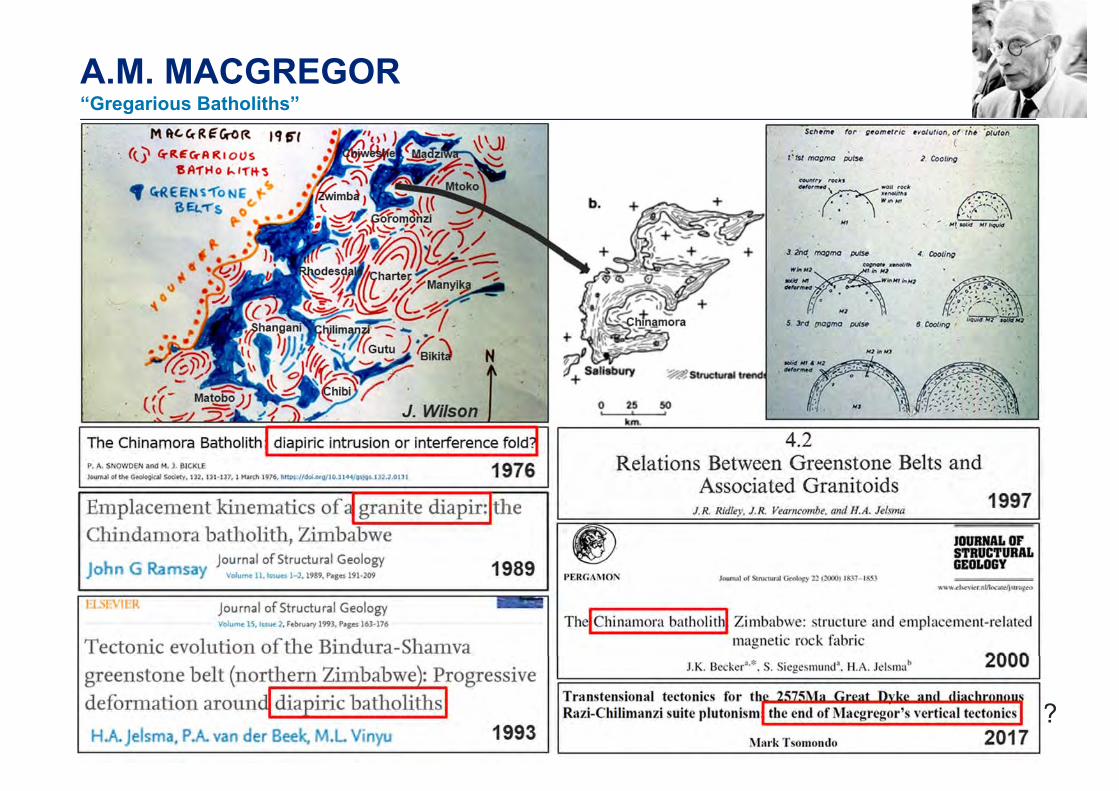
• He had a wide range of geological interests, just like Alex du Toit, with whom hecorresponded and he published on a range of topics such as Palaeolithic implements,the Precambrian atmosphere, stromatolites, fossil reptiles, “The Influence of Life on theFace of the Earth” and “Gregarious Batholiths”.
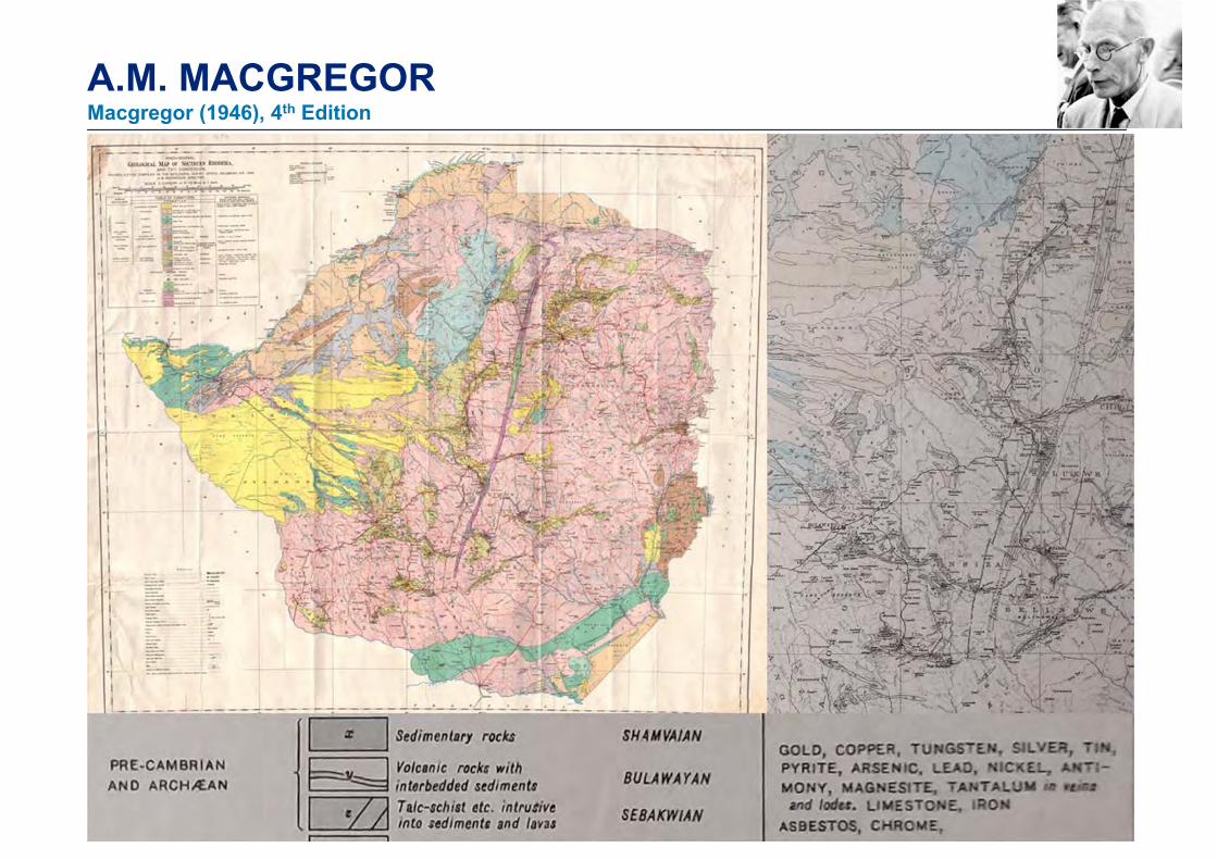
A.M. MACGREGORMacgregor (1946), 4th Edition
?
A.M. MACGREGOR“Gregarious Batholiths”
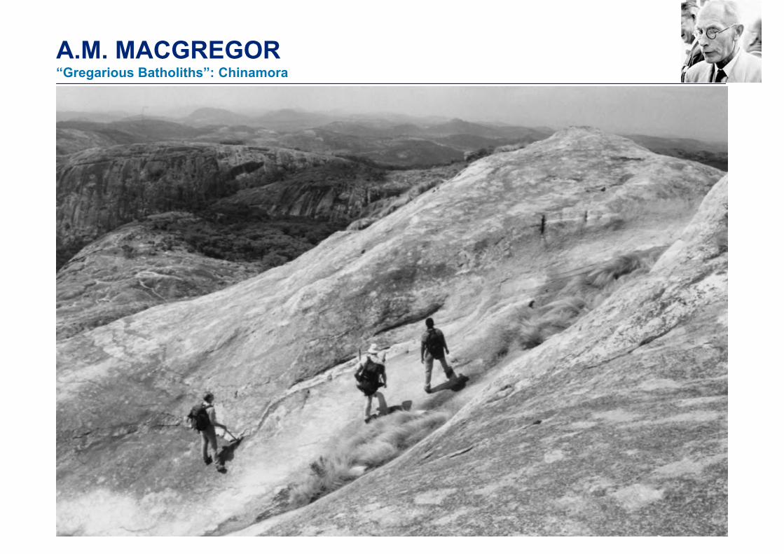
A.M. MACGREGOR“Gregarious Batholiths”: Chinamora

11
A.M. MACGREGOR
• Macgregor became the 3rd director of the Geological Survey in 1946 (after Herbert Maufeand Ben Lightfoot).
• The 4th edition of the 1: 1 million geological map of the country was published in 1946.
• He was awarded the degree of Doctor of Science by the University of Natal in 1947 forhis work on the geology of the country, which comprised of over 50 publications.
• He was awarded the Geological Society of South Africa Draper Memorial Medal in 1947,the highest award of the Geological Society of South Africa.
• He was honoured the OBE in 1949 for his significant impact on geology.
• He served on the council of the Geological Society of South Africa from 1947 to 1955.
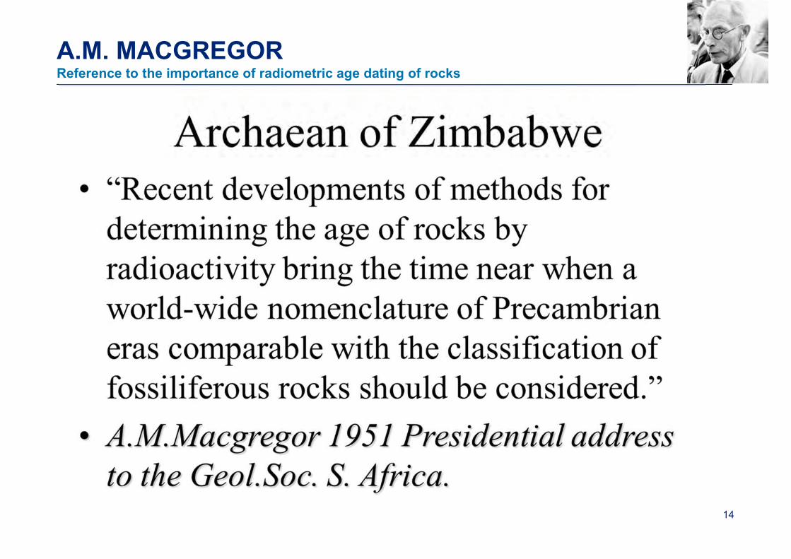
• He became the Society President in 1951. His presidential address 'Some milestones inthe Precambrian of Southern Rhodesia’ was a major contribution to our heritage.
• After his retirement in 1948 he consulted to the mining industry until 1956.
• He was engaged from 1954 by Anglo American Corporation to start their local office.
• In 1966, after his death, the Geological Survey named its refurbished museum after him.
13
A.M. MACGREGOR
• He was a modest and erudite man
• He is to be remembered for his enormous contribution to geology.
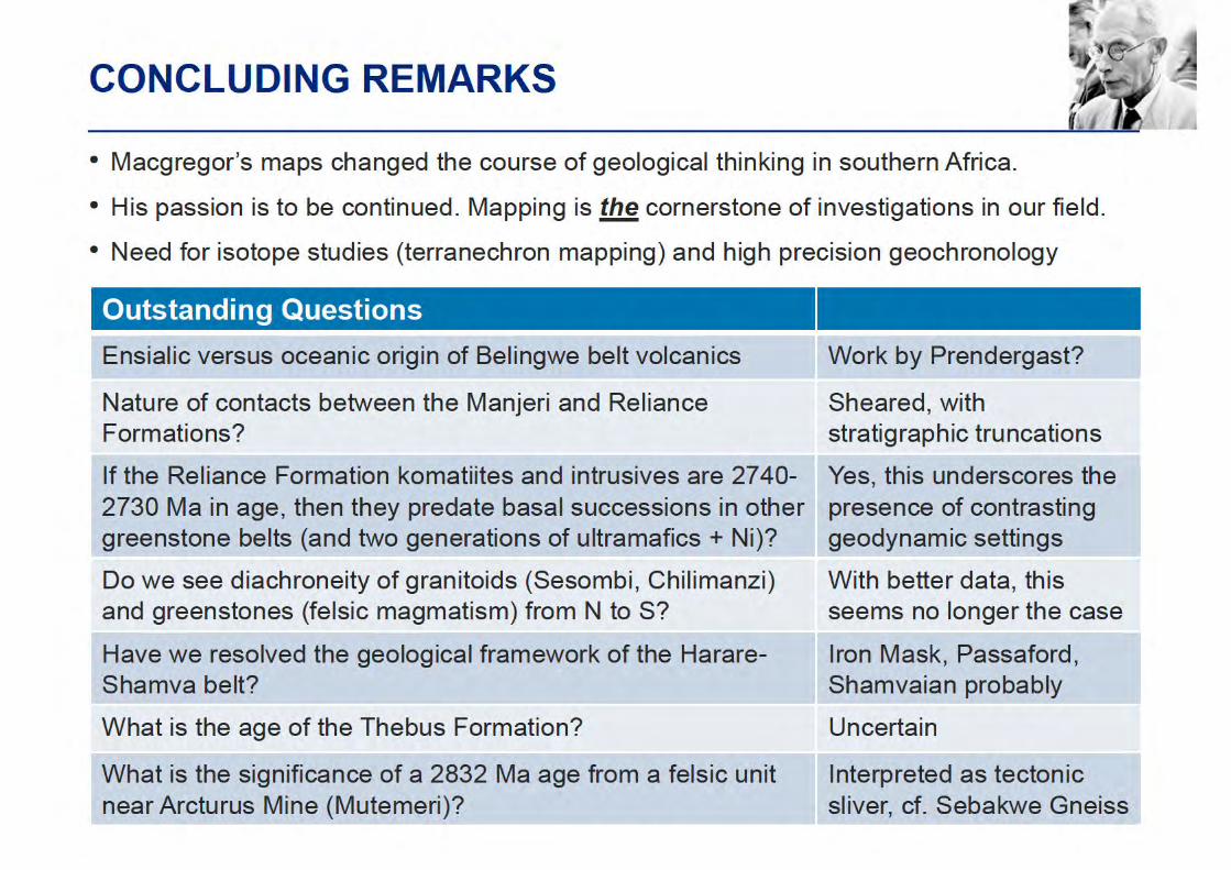
• His maps changed the course of geological thinking in southern Africa and impacted onour understanding of mineral endowment and the discovery of mineral deposits.
• His quiet enthusiasm was infectious.
His passion and determination in mapping and documenting field observations is to be continued,
which is the cornerstone of investigations in our field.
14
A.M. MACGREGORReference to the importance of radiometric age dating of rocks
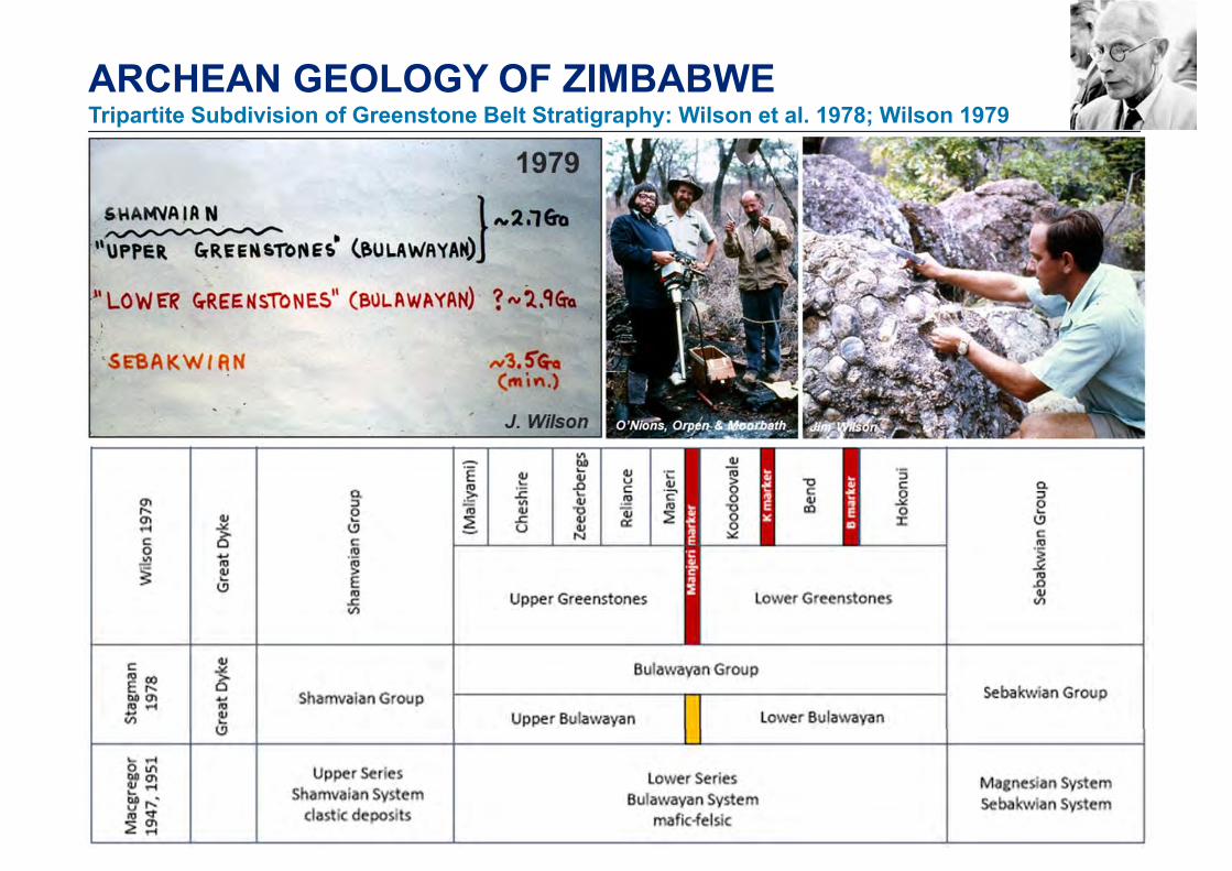
ARCHEAN GEOLOGY OF ZIMBABWETripartite Subdivision of Greenstone Belt Stratigraphy: Wilson et al. 1978; Wilson 1979
16
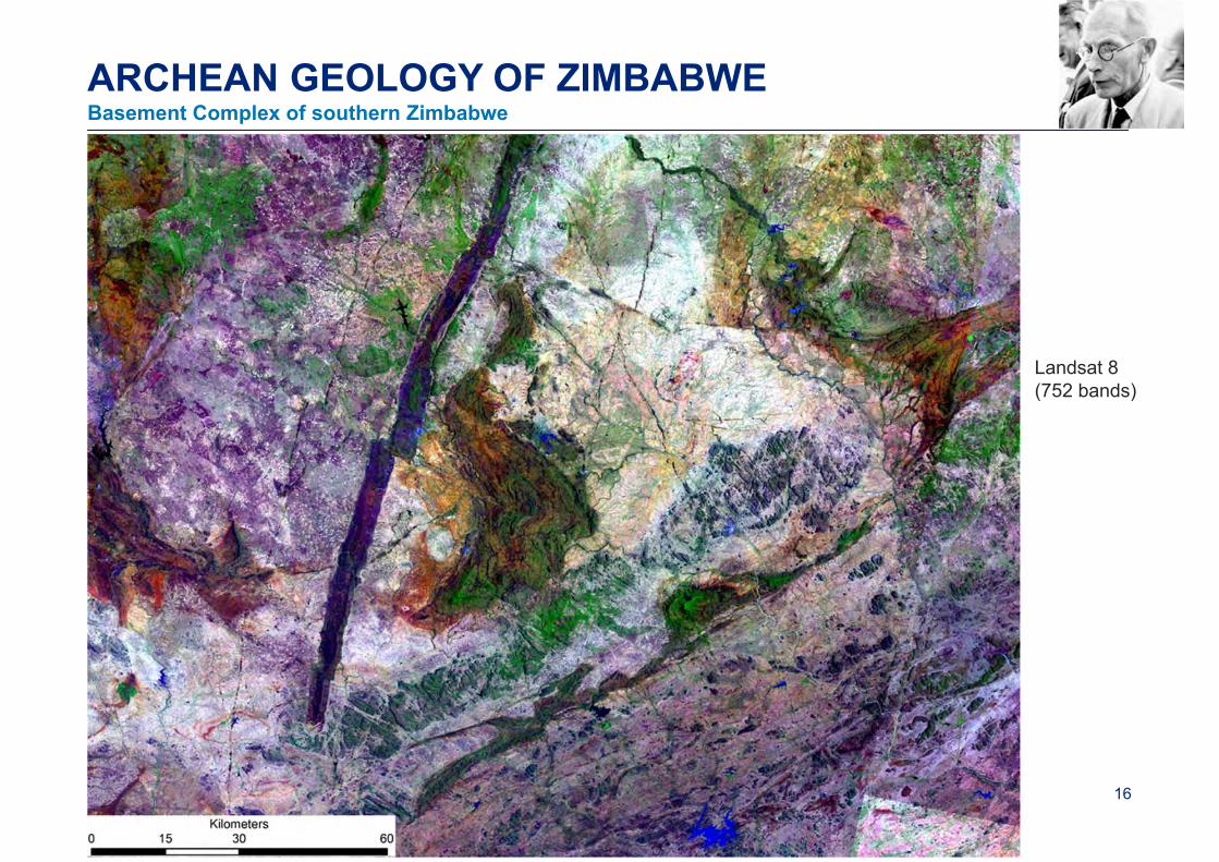
ARCHEAN GEOLOGY OF ZIMBABWE
Landsat 8 (752 bands)
Basement Complex of southern Zimbabwe
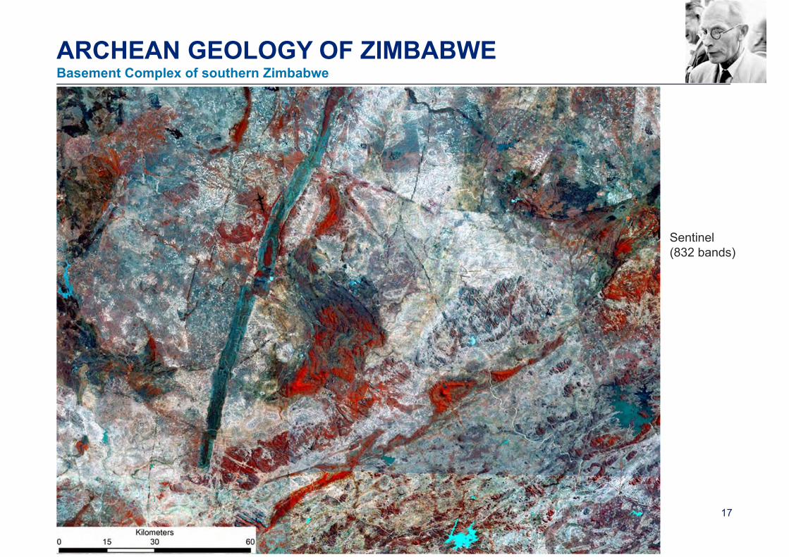
17
Sentinel(832 bands)
ARCHEAN GEOLOGY OF ZIMBABWEBasement Complex of southern Zimbabwe

ARCHEAN GEOLOGY OF ZIMBABWE
Photo of the late Jim Wilson, courtesy of Bob Nesbitt
Wilson et al. 1995: establishing a craton-wide greenstone stratigraphy
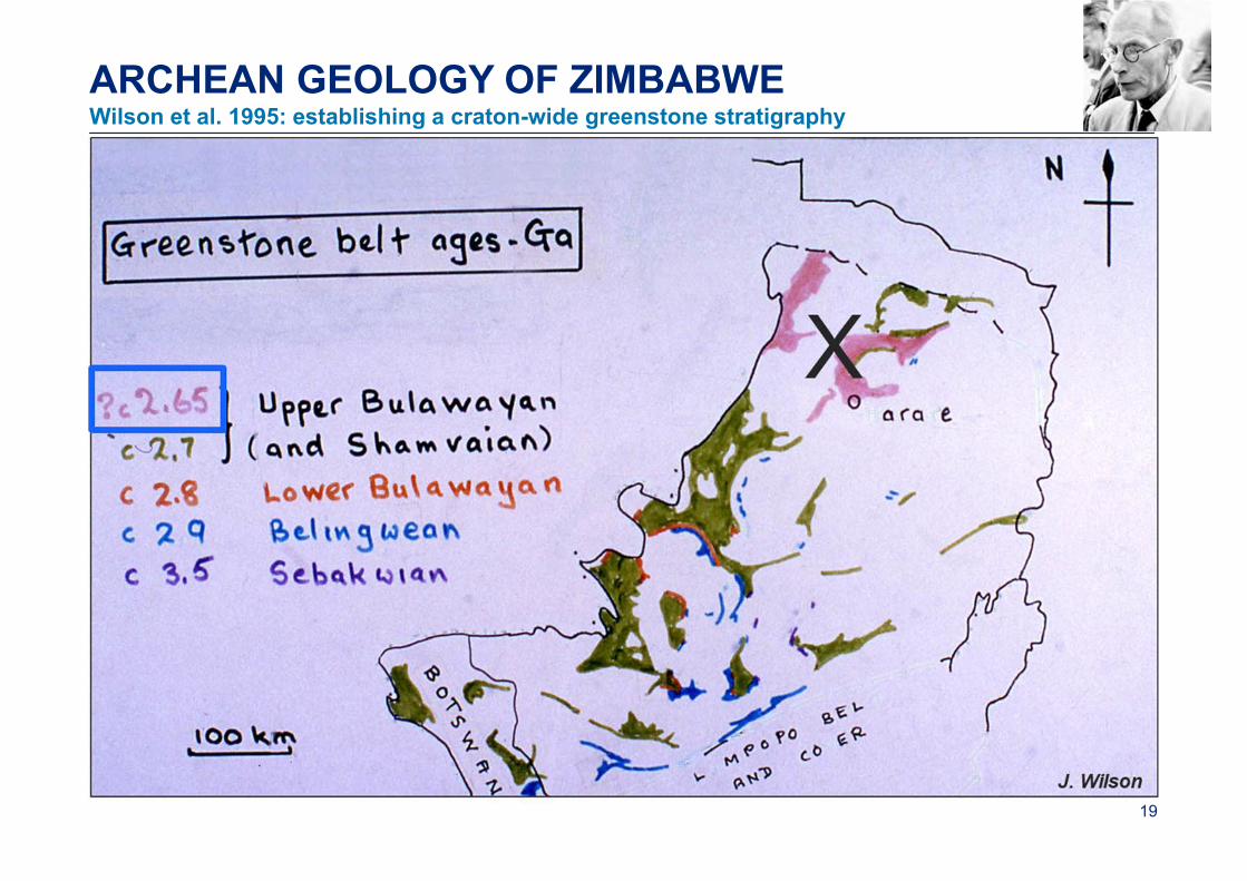
19
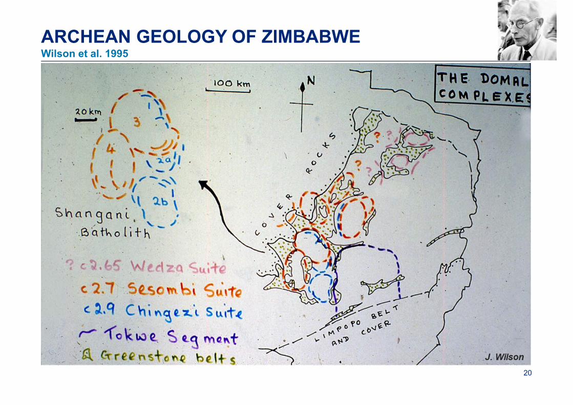
ARCHEAN GEOLOGY OF ZIMBABWE
Wilson et al. 1995: establishing a craton-wide greenstone stratigraphy
20
ARCHEAN GEOLOGY OF ZIMBABWEWilson et al. 1995
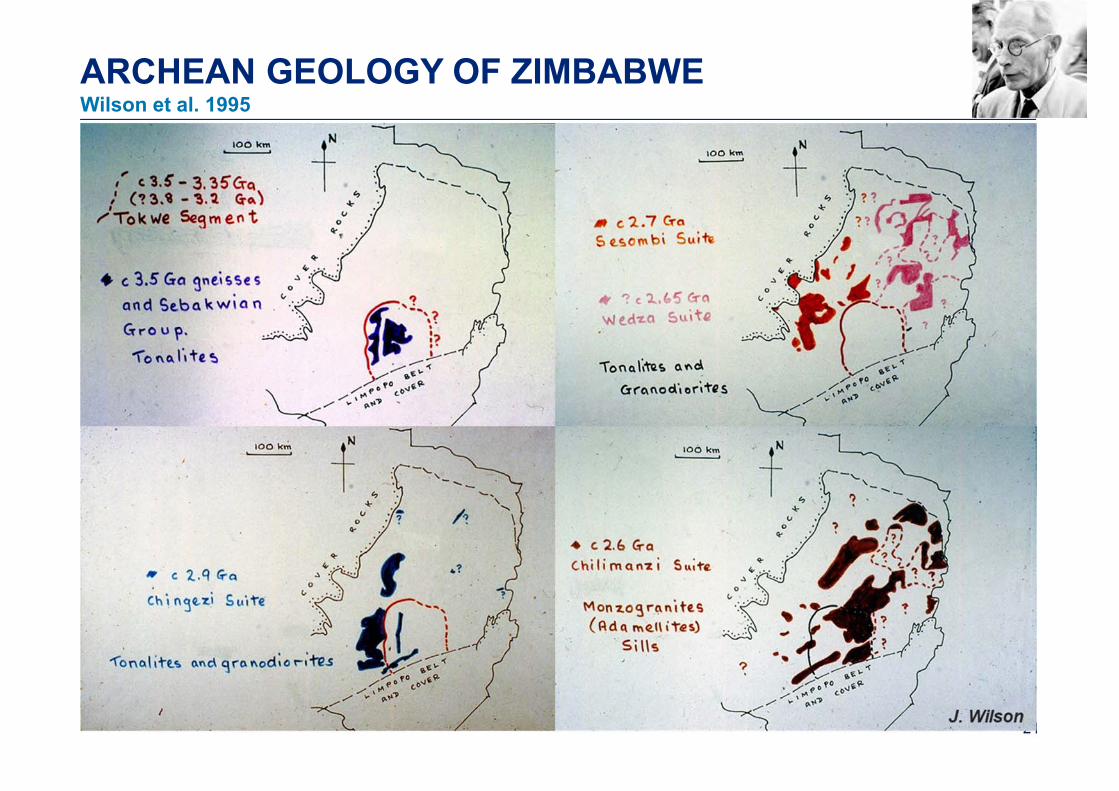
ARCHEAN GEOLOGY OF ZIMBABWEWilson et al. 1995
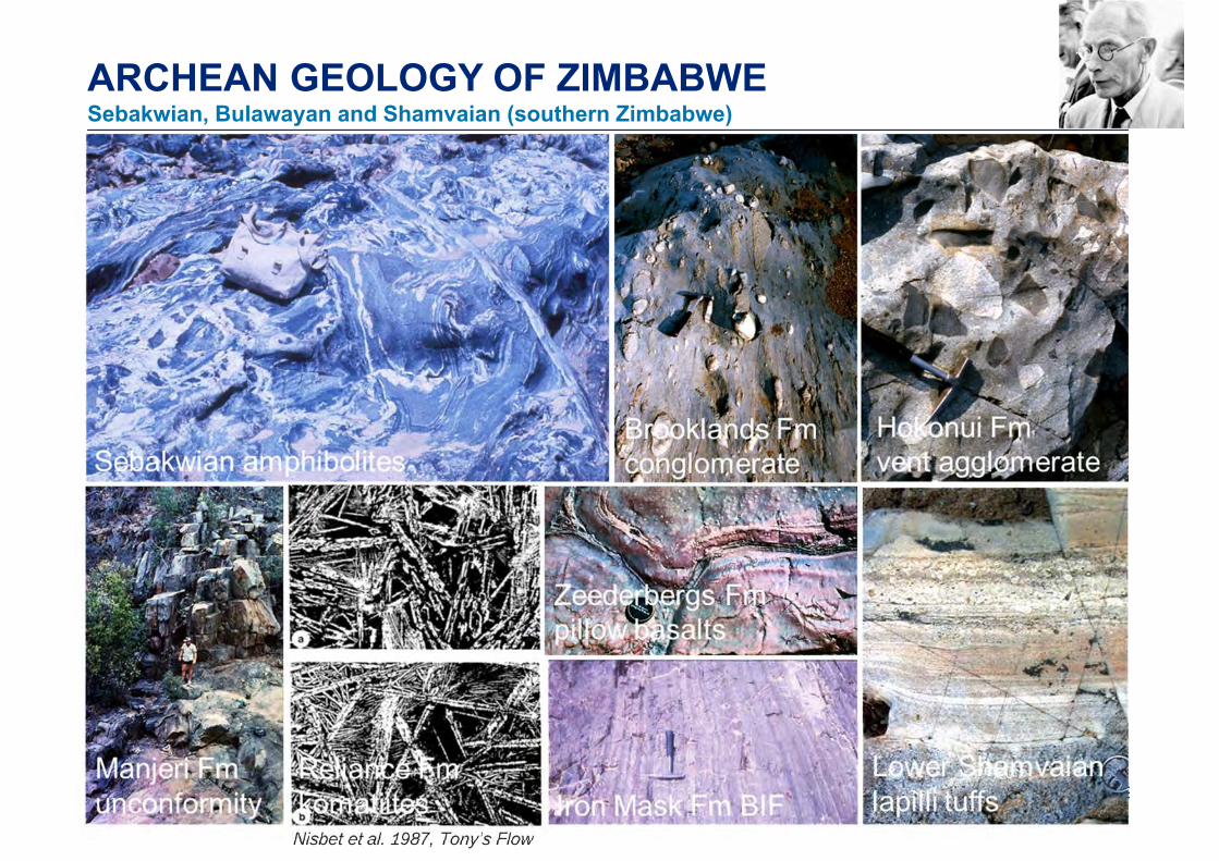
ARCHEAN GEOLOGY OF ZIMBABWESebakwian, Bulawayan and Shamvaian (southern Zimbabwe)
Nisbet et al. 1987, Tony s Flow
3
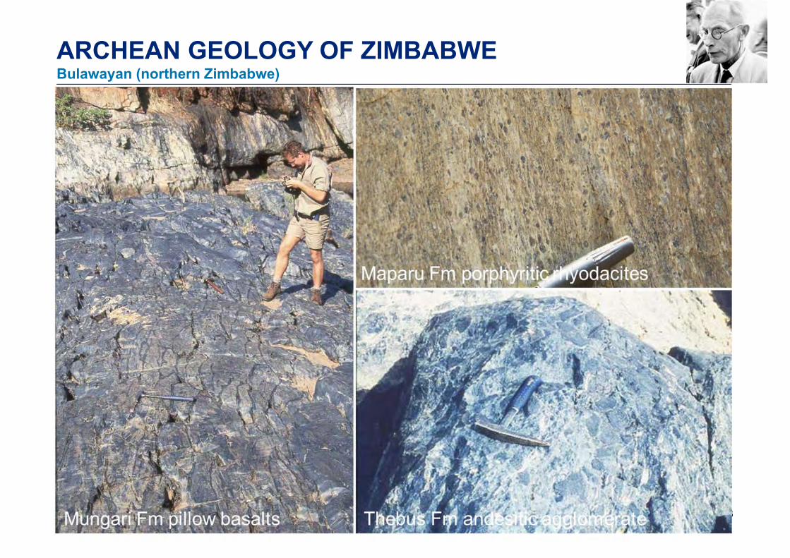
ARCHEAN GEOLOGY OF ZIMBABWEBulawayan (northern Zimbabwe)
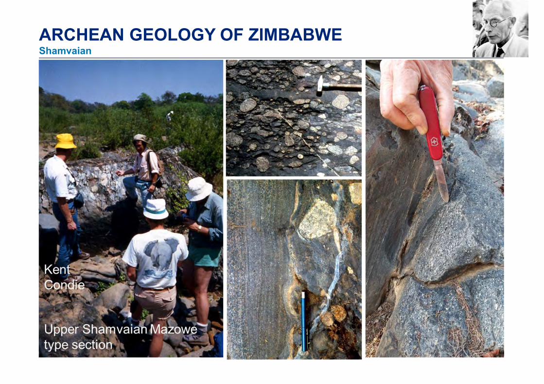
ARCHEAN GEOLOGY OF ZIMBABWEShamvaian
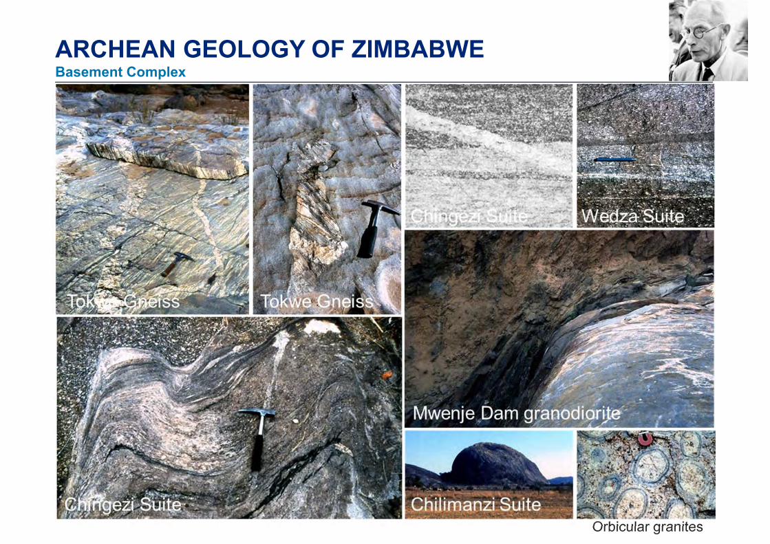
ARCHEAN GEOLOGY OF ZIMBABWEBasement Complex
Orbicular granites
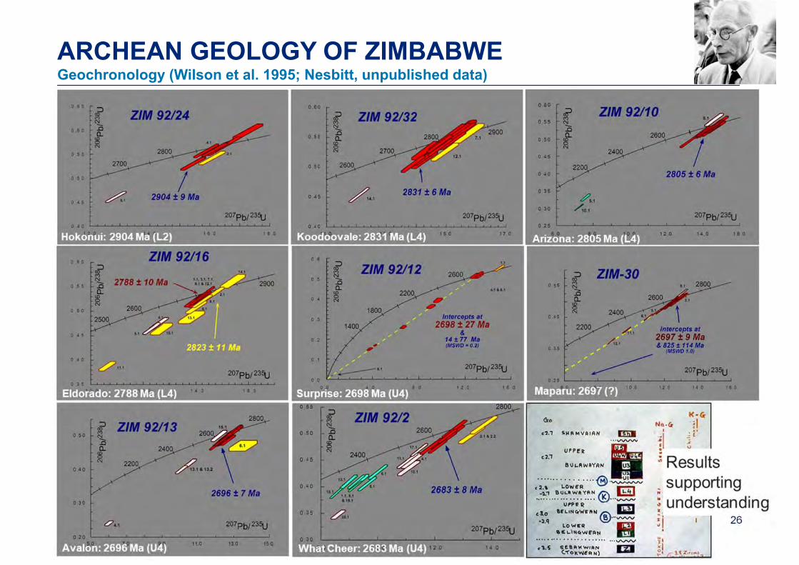
ARCHEAN GEOLOGY OF ZIMBABWEGeochronology (Wilson et al. 1995; Nesbitt, unpublished data)
27
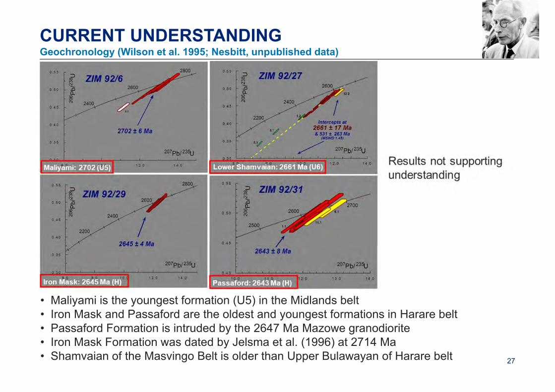
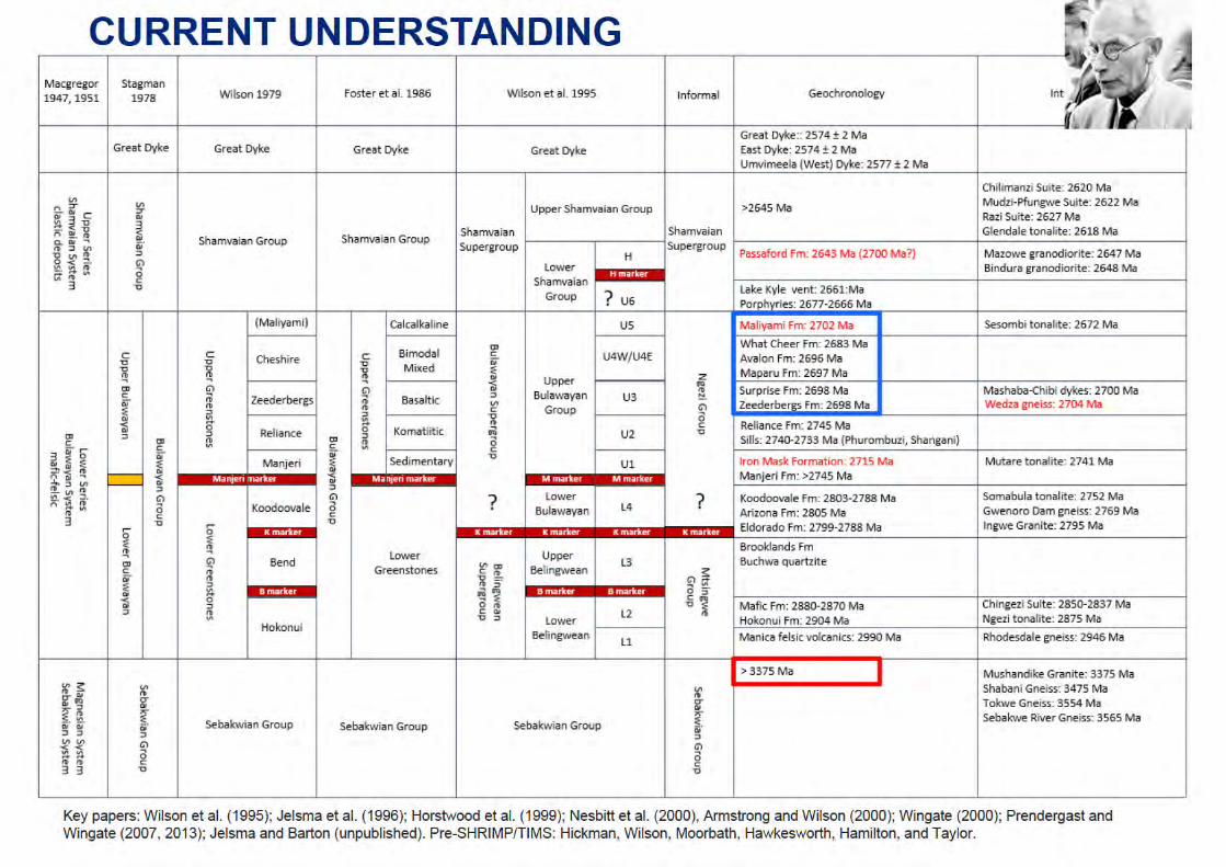
CURRENT UNDERSTANDINGGeochronology (Wilson et al. 1995; Nesbitt, unpublished data)
• Maliyami is the youngest formation (U5) in the Midlands belt• Iron Mask and Passaford are the oldest and youngest formations in Harare belt• Passaford Formation is intruded by the 2647 Ma Mazowe granodiorite• Iron Mask Formation was dated by Jelsma et al. (1996) at 2714 Ma• Shamvaian of the Masvingo Belt is older than Upper Bulawayan of Harare belt
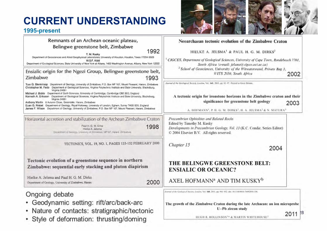
CURRENT UNDERSTANDING1995-present
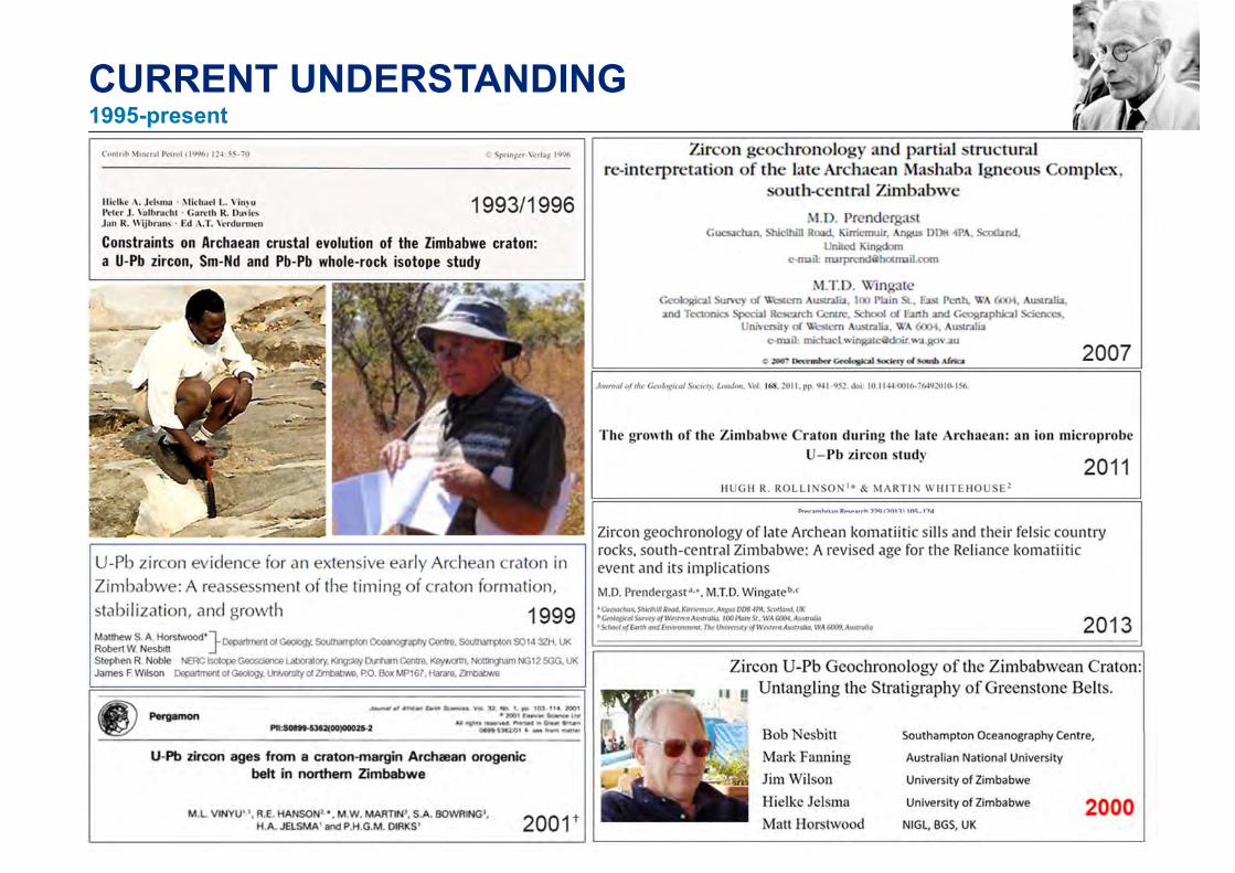
CURRENT UNDERSTANDING1995-present
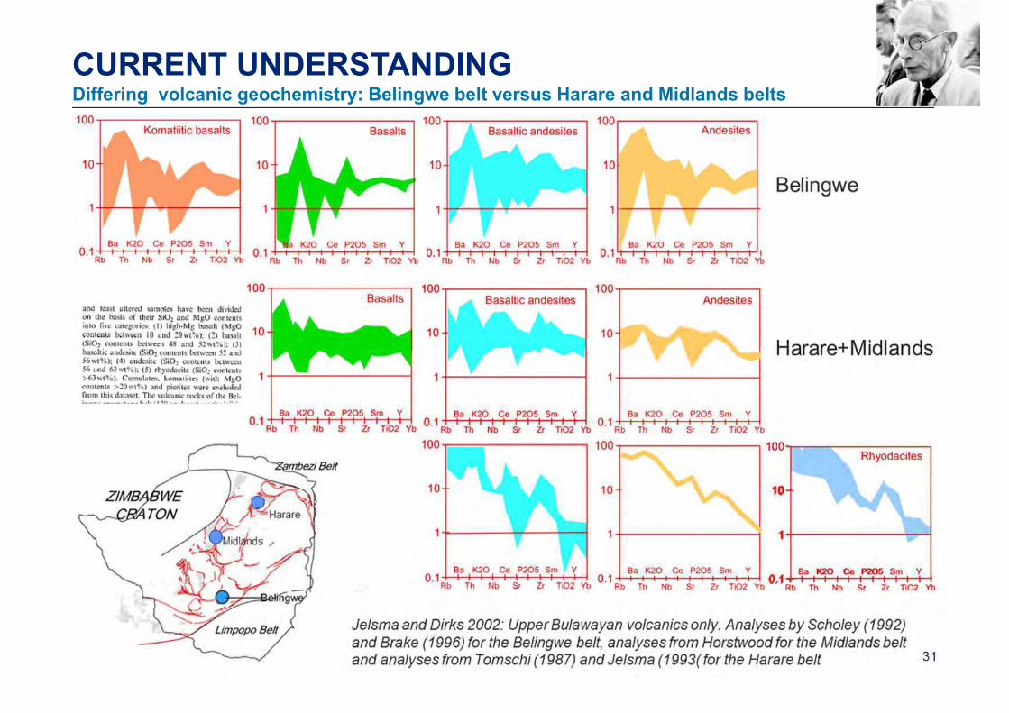
CURRENT UNDERSTANDINGDiffering volcanic geochemistry: Belingwe belt versus Harare and Midlands belts
32
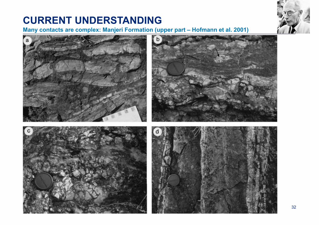
CURRENT UNDERSTANDINGMany contacts are complex: Manjeri Formation (upper part – Hofmann et al. 2001)
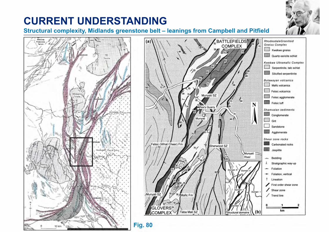
CURRENT UNDERSTANDINGStructural complexity, Midlands greenstone belt – leanings from Campbell and Pitfield
34
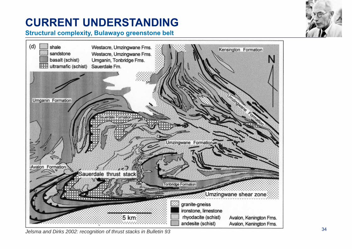
CURRENT UNDERSTANDINGStructural complexity, Bulawayo greenstone belt
Jelsma and Dirks 2002: recognition of thrust stacks in Bulletin 93
35
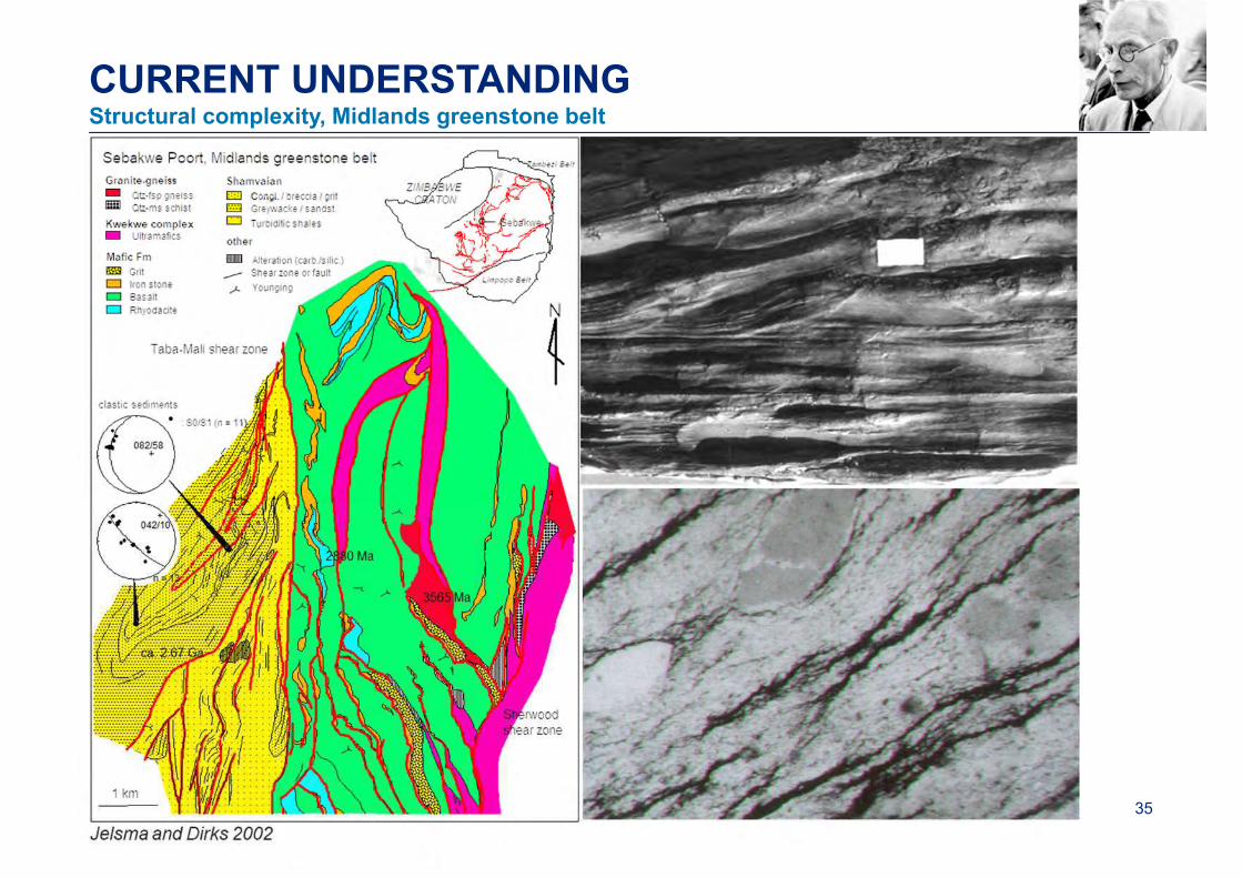
CURRENT UNDERSTANDINGStructural complexity, Midlands greenstone belt
36
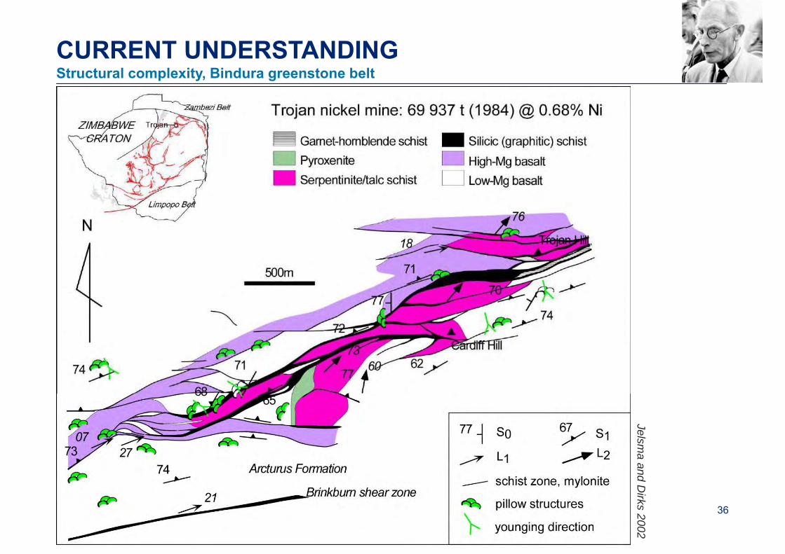
CURRENT UNDERSTANDINGStructural complexity, Bindura greenstone belt
Jelsma and D
irks 2002
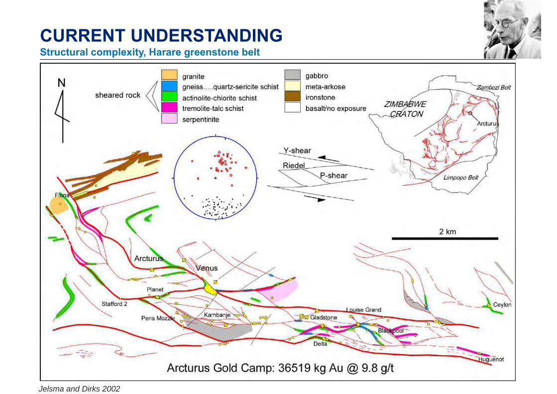
CURRENT UNDERSTANDINGStructural complexity, Harare greenstone belt
Jelsma and Dirks 2002
38
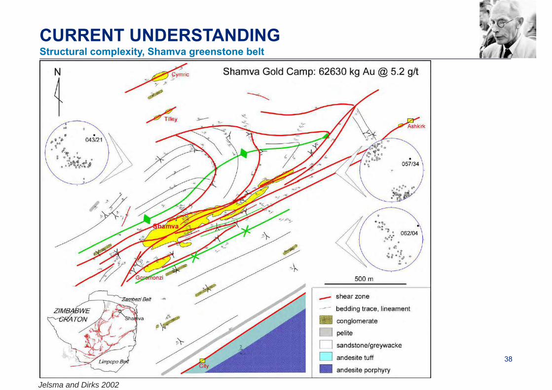
CURRENT UNDERSTANDINGStructural complexity, Shamva greenstone belt
Jelsma and Dirks 2002
UNTANGLING THE STRATIGRAPHYWork presented by Bob Nesbitt in Manchester in 2000
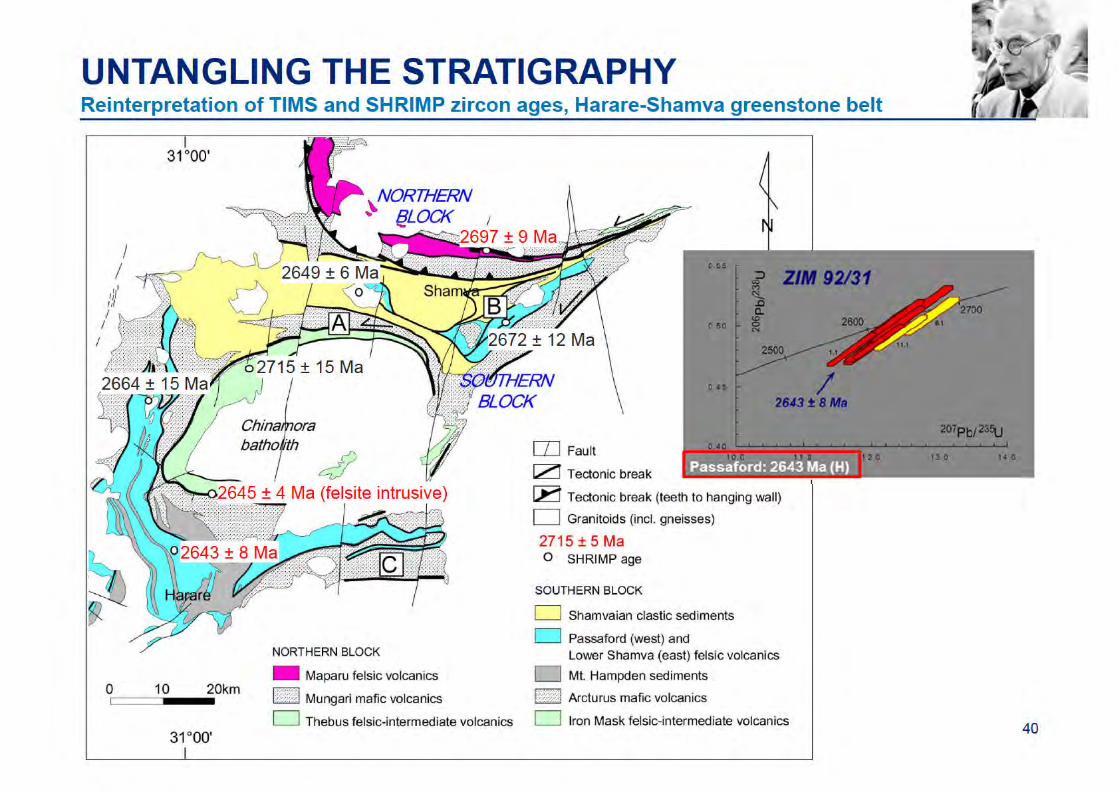
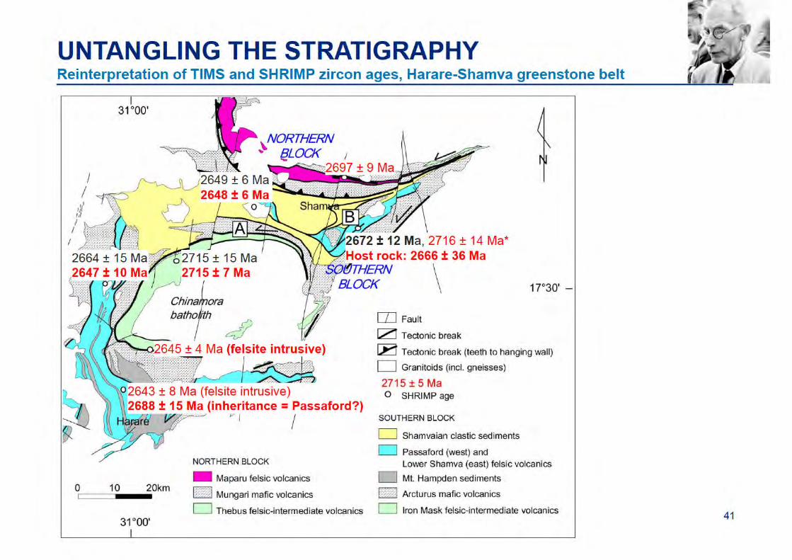

UNTANGLING THE STRATIGRAPHYReinterpretation of TIMS and SHRIMP zircon ages, Harare-Shamva greenstone belt
43
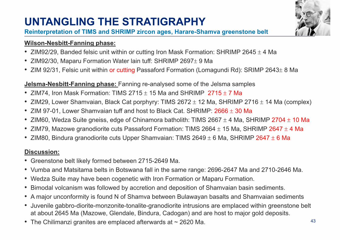
UNTANGLING THE STRATIGRAPHY
Wilson-Nesbitt-Fanning phase:• ZIM92/29, Banded felsic unit within or cutting Iron Mask Formation: SHRIMP 2645 4 Ma• ZIM92/30, Maparu Formation Water lain tuff: SHRIMP 2697 9 Ma• ZIM 92/31, Felsic unit within or cutting Passaford Formation (Lomagundi Rd): SRIMP 2643 8 Ma
Jelsma-Nesbitt-Fanning phase: Fanning re-analysed some of the Jelsma samples• ZIM74, Iron Mask Formation: TIMS 2715 15 Ma and SHRIMP 2715 7 Ma• ZIM29, Lower Shamvaian, Black Cat porphyry: TIMS 2672 12 Ma, SHRIMP 2716 14 Ma (complex)• ZIM 97-01, Lower Shamvaian tuff and host to Black Cat. SHRIMP: 2666 30 Ma• ZIM60, Wedza Suite gneiss, edge of Chinamora batholith: TIMS 2667 4 Ma, SHRIMP 2704 10 Ma• ZIM79, Mazowe granodiorite cuts Passaford Formation: TIMS 2664 15 Ma, SHRIMP 2647 4 Ma• ZIM80, Bindura granodiorite cuts Upper Shamvaian: TIMS 2649 6 Ma, SHRIMP 2647 6 Ma
Discussion:• Greenstone belt likely formed between 2715-2649 Ma.• Vumba and Matsitama belts in Botswana fall in the same range: 2696-2647 Ma and 2710-2646 Ma.• Wedza Suite may have been cogenetic with Iron Formation or Maparu Formation.• Bimodal volcanism was followed by accretion and deposition of Shamvaian basin sediments.• A major unconformity is found N of Shamva between Bulawayan basalts and Shamvaian sediments• Juvenile gabbro-diorite-monzonite-tonalite-granodiorite intrusions are emplaced within greenstone belt
at about 2645 Ma (Mazowe, Glendale, Bindura, Cadogan) and are host to major gold deposits.• The Chilimanzi granites are emplaced afterwards at ~ 2620 Ma.
Reinterpretation of TIMS and SHRIMP zircon ages, Harare-Shamva greenstone belt
44
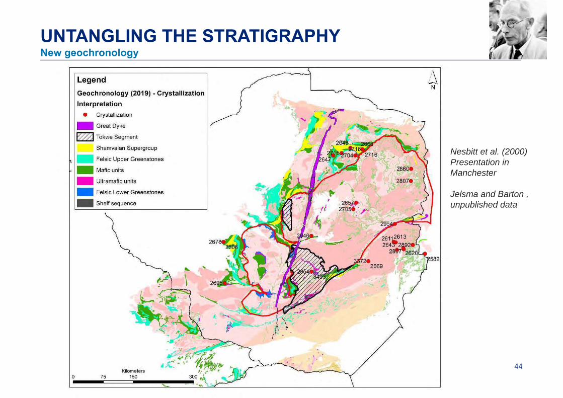
UNTANGLING THE STRATIGRAPHYNew geochronology
Nesbitt et al. (2000)Presentation in Manchester
Jelsma and Barton , unpublished data
45
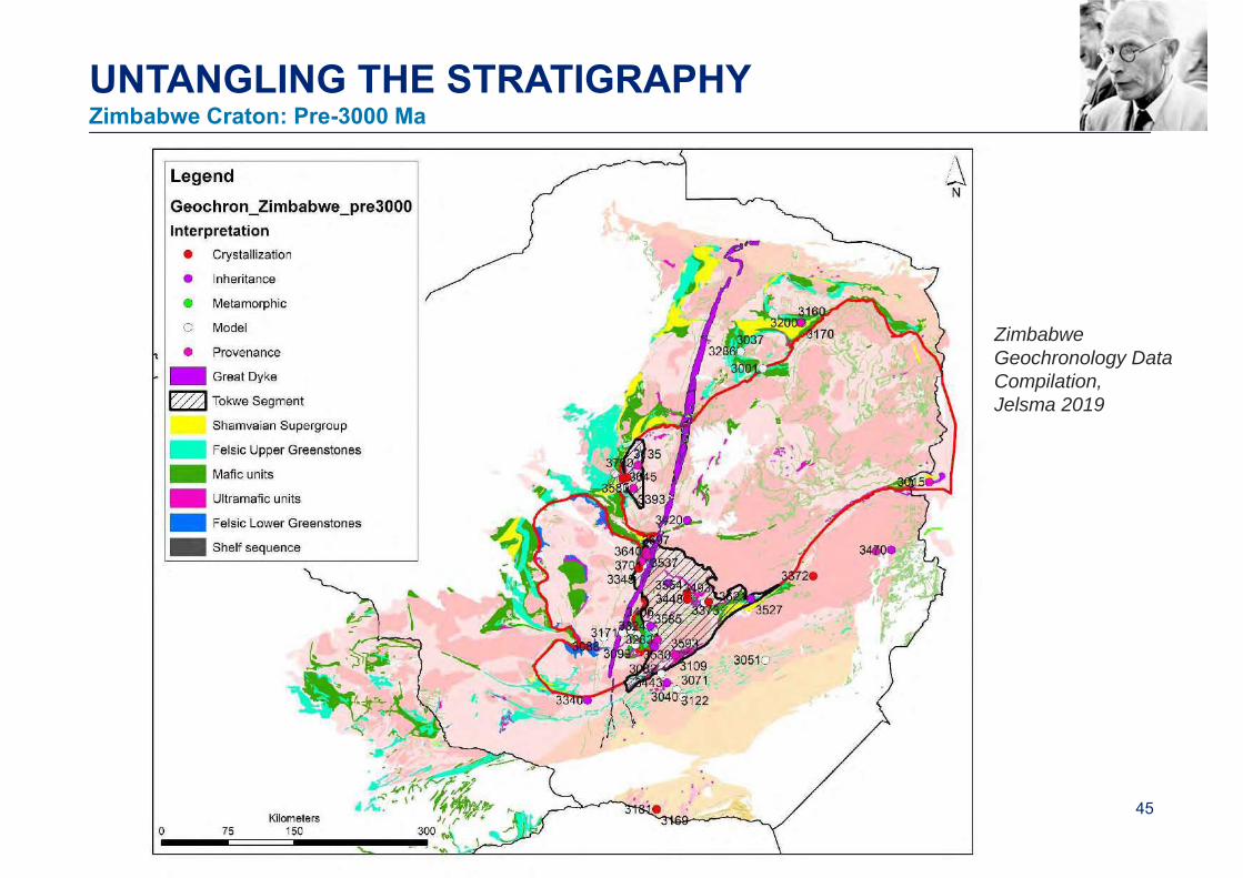
UNTANGLING THE STRATIGRAPHYZimbabwe Craton: Pre-3000 Ma
Zimbabwe Geochronology Data Compilation,Jelsma 2019
46
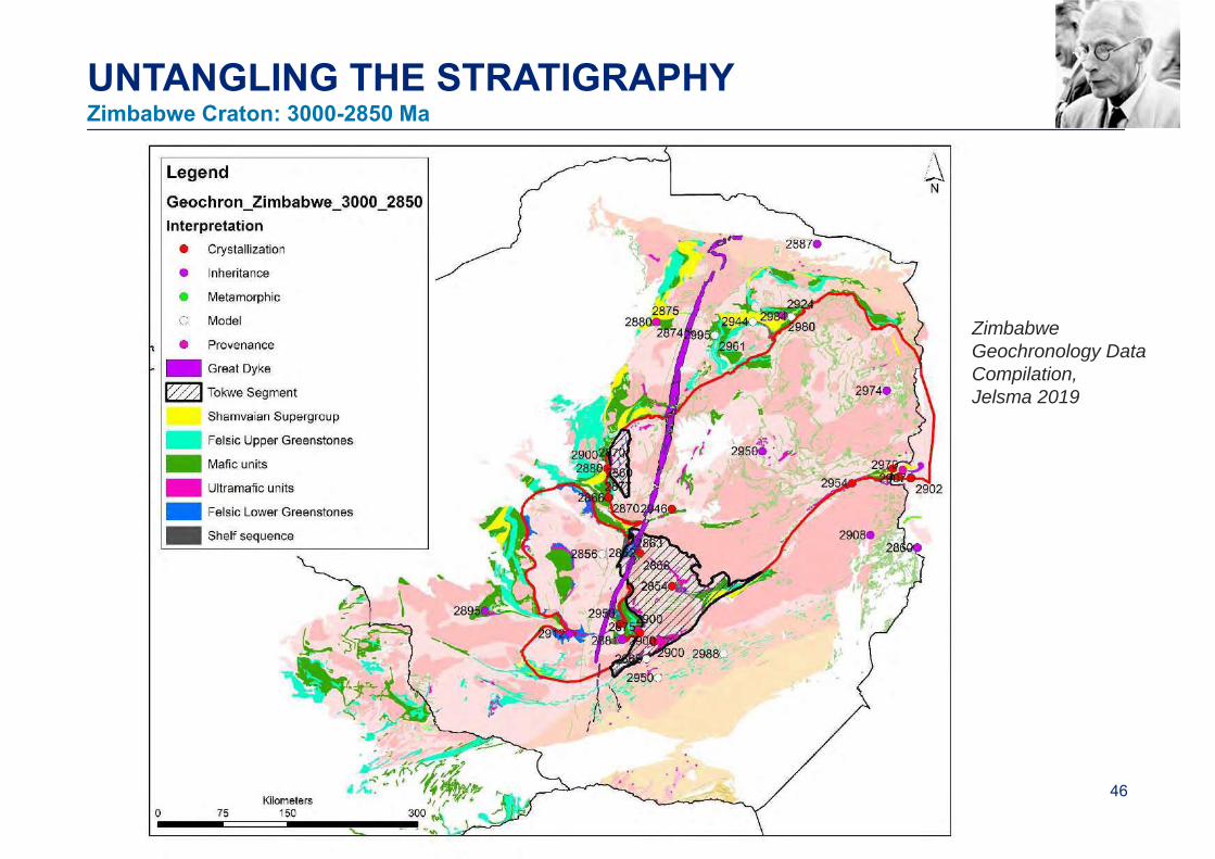
UNTANGLING THE STRATIGRAPHYZimbabwe Craton: 3000-2850 Ma
Zimbabwe Geochronology Data Compilation,Jelsma 2019

47
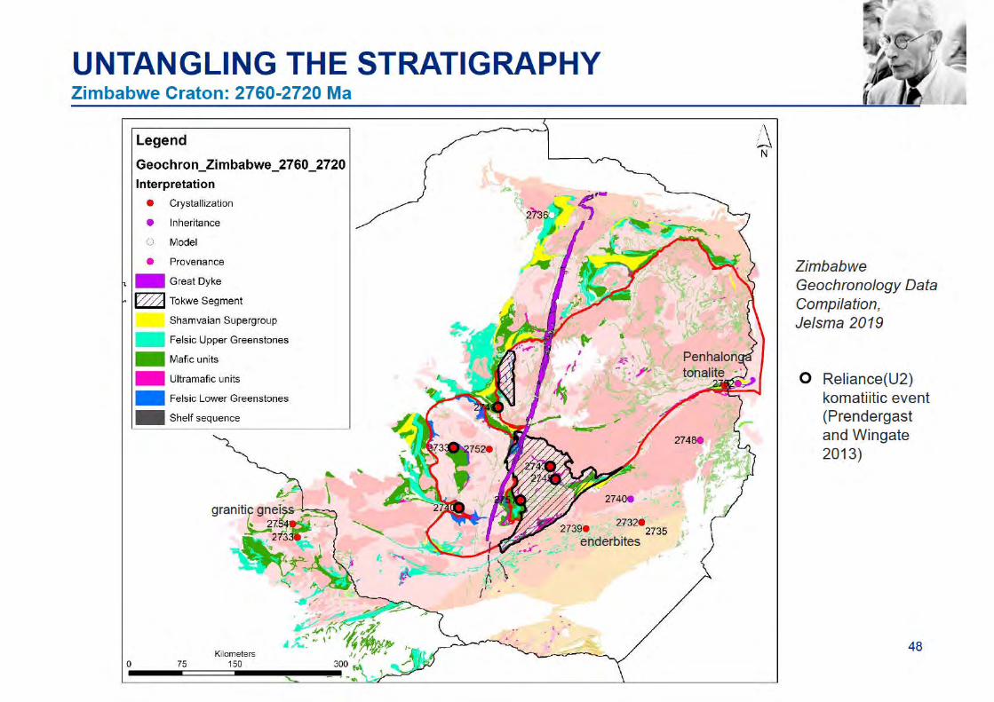
UNTANGLING THE STRATIGRAPHYZimbabwe Craton: 2850-2760 Ma
Zimbabwe Geochronology Data Compilation,Jelsma 2019
49
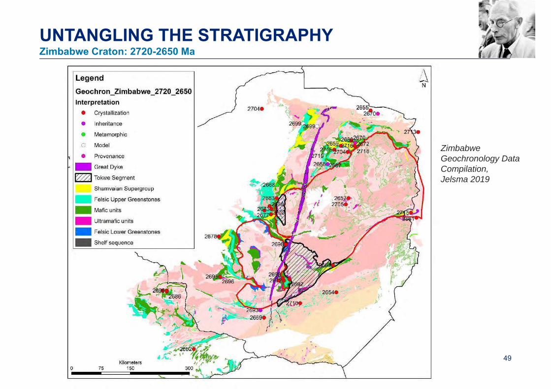
UNTANGLING THE STRATIGRAPHYZimbabwe Craton: 2720-2650 Ma
Zimbabwe Geochronology Data Compilation,Jelsma 2019

50
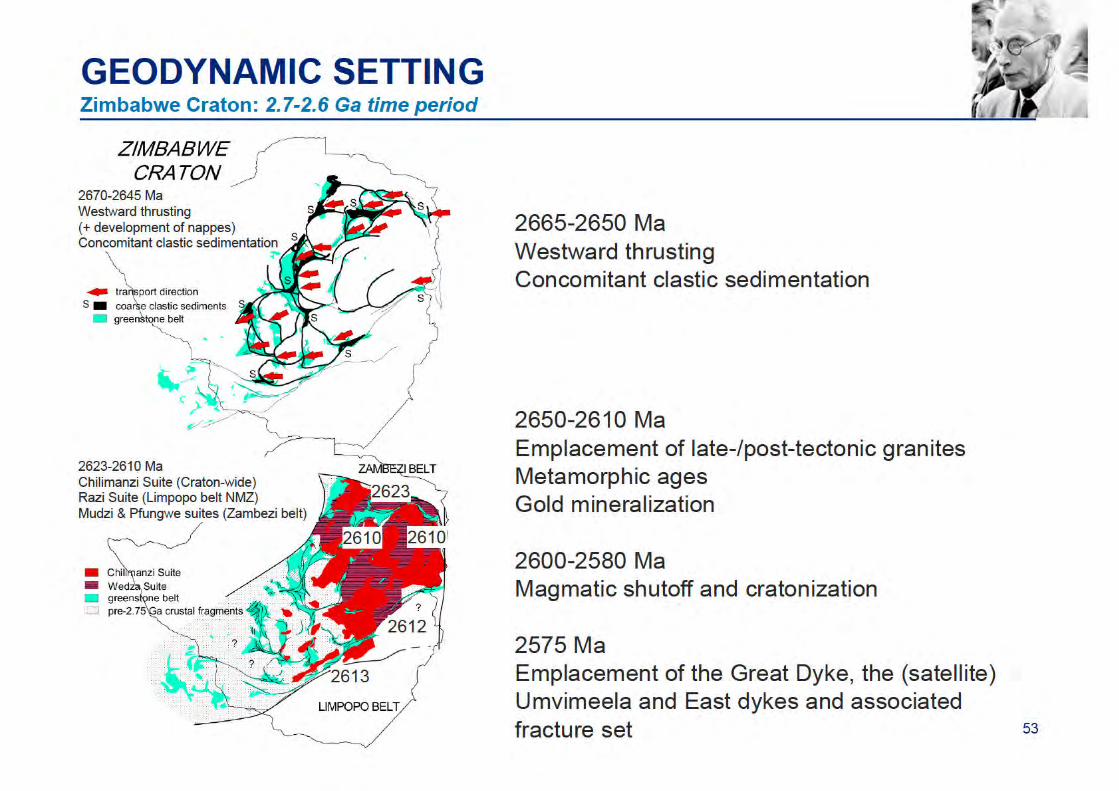
UNTANGLING THE STRATIGRAPHYZimbabwe Craton: 2650-2580 Ma
Zimbabwe Geochronology Data Compilation,Jelsma 2019
51
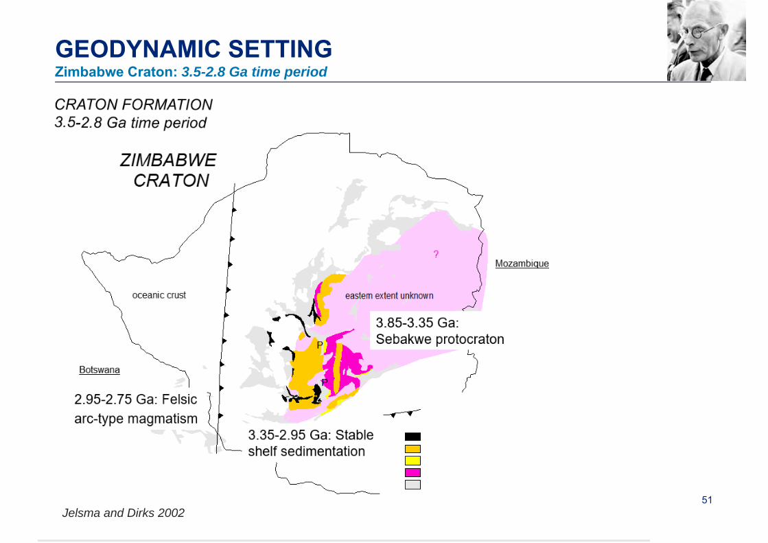
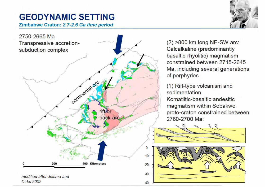
GEODYNAMIC SETTINGZimbabwe Craton: 3.5-2.8 Ga time period
Jelsma and Dirks 2002
54
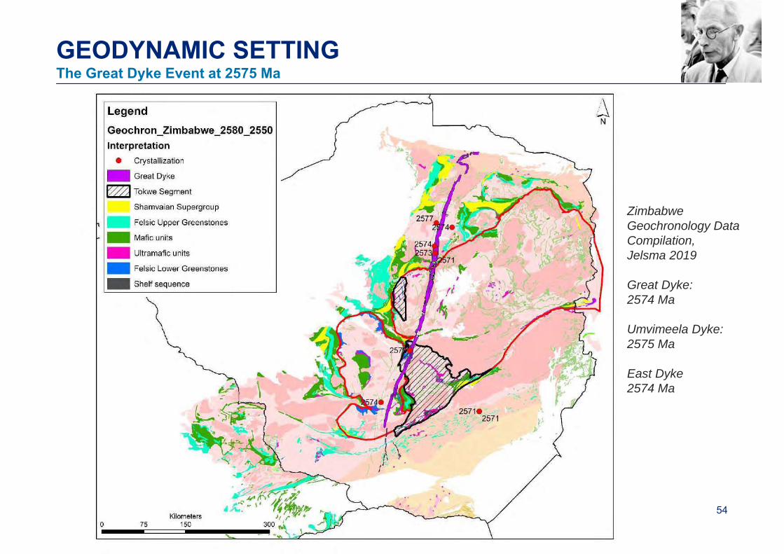
GEODYNAMIC SETTINGThe Great Dyke Event at 2575 Ma
Zimbabwe Geochronology Data Compilation,Jelsma 2019
Great Dyke: 2574 Ma
Umvimeela Dyke: 2575 Ma
East Dyke2574 Ma
60
A.M. MACGREGORBulletins• Macgregor A.M. (1921). The geology of the diamond-bearing gravels of the Somabula Forest. S. Rhod. geol. Surv. Bull. 8, 48p.• Macgregor A.M. (1928). The geology of the country around the Lonely Mine, Bubi District. S. Rhod. geol. Surv. Bull. 11, 96p.• Macgregor A.M. (1930). The geology of the country between Gatooma and Battlefields. S. Rhod. geol. Surv. Bull. 17, 144p.• Macgregor A.M. (1932). The geology of the country around Que Que, Gwelo District. S. Rhod. geol. Surv. Bull. 20, 113p.• Macgregor A.M. (1935). The geology of the Makaha Gold Belt, Mtoko District. S. Rhod. geol. Surv. Bull. 28, 46p.• Macgregor A.M., Ferguson J.C. and Amm F.L. (1937). The geology of the country around the Queen’s Mine, Bulawayo District. S. Rhod. geol. Surv.
Bull. 30, 179p.• Macgregor A.M. (1937). The geology of the country around Hunters Road, Gwelo District. S. Rhod. geol. Surv. Bull. 31. 78p.• Macgregor A.M. (1947). An outline of the geological history of Southern Rhodesia. S. Rhod. geol. Surv. Bull. 38, 73p.
Short Reports:• Maufe H.B. and Macgregor A.M. (1920). Second interim report on the geology of part of the Bembesi Basin. S. Rhod. geol. Surv. Short Rep. 9.• Macgregor A.M. (1921). Third interim report on the geology of part of the Bembesi Basin. S. Rhod. geol. Surv. Short Rep. 11.• Macgregor A.M. (1923). Preliminary Report on the Geology of the Country around the Lonely Mine. S. Rhod. geol. Surv. Short Rep. 14, 10p.• Macgregor A.M. (1924). Interim Report on the Geology of the Country South of Umsweswe, Hartley District. S. Rhod. geol. Surv. Short Rep. 16, 18p.• Macgregor A.M. (1925). Note of the geology of the Felixburg Goldfield. S. Rhod. geol. Surv. Short Rep. 18• Macgregor A.M. (1927). A geological reconnaissance of the Mafungabusi Gold Belt. S. Rhod. geol. Surv. Short Rep. 20• Macgregor A.M. (1931). The geology of the country around the Norah, Molly and Umboe copper claims, Lomagundi District. S. Rhod. geol. Surv.
Short Rep. 25• Macgregor A.M. (1941). The geology of the Mafungabusi Gold Belt. S. Rhod. geol. Surv. Short Rep. 35.
Selected papers:• Macgregor A.M. (1915). Notes on a graphic intergrowth of diopside and ilmenite from the Bembesi Diamond Field, Southern Rhodesia. Trans. Geol.
Soc. S. Afr. 18, 1-4• Macgregor A.M. (1917). The Karoo rocks and later sediments north-west of Bulawayo. Trans. Geol. Soc. S. Afr. 19, 20p.• Macgregor A.M. (1932). Batholiths of Southern Rhodesia. Geological Magazine 69, 18-28.• Macgregor A.M. (1941). A Precambrian algal limestone in southern Rhodesia. Trans, Geol. Soc. S. Afr. 43, 9-15.• Macgregor A.M. (1949). The influence of life on the face of the Earth. Presidential Address, Rhodesia Scientific Association. Proceedings and
Transactions 17, 5-11.• Macgregor A.M. (1951). Some milestones in the Precambrian of Southern Rhodesia. Proc. Geol. Soc. S. Afr. 54, 27-71.

THANK YOU