Mabira Forest Reserve (31293 ha) is a forest management area ...
31
ASSESSING THE IMPLICATIONS OF DECENTRALIZATION ON LIVELIHOOD, BIODIVERSITY AND ECOLOGICAL SUSTAINABILITY IN UGANDA A PRELIMINARY ANALYSIS OF THE PILOT SANREM/IFRI SITE JOSEPH B. BAHATI [email protected] ABWOLI Y. BANANA [email protected] WILLIAM GOMBYA-SSEMBAJJWE [email protected] UGANDA FORESTRY RESOURCES AND INSTITUTIONS CENTER MAKERERE UNIVERSITY FACULTY OF FORESTRY AND NATURE CONSERVATION P.O. BOX 7062 KAMPALA, UGANDA
-
Upload
vuongtuyen -
Category
Documents
-
view
215 -
download
0
Transcript of Mabira Forest Reserve (31293 ha) is a forest management area ...

ASSESSING THE IMPLICATIONS OFDECENTRALIZATION ON LIVELIHOOD, BIODIVERSITY
AND ECOLOGICAL SUSTAINABILITY IN UGANDA
A PRELIMINARY ANALYSIS OF THE PILOT SANREM/IFRI SITE
JOSEPH B. [email protected]
ABWOLI Y. [email protected]
WILLIAM [email protected]
UGANDA FORESTRY RESOURCES AND INSTITUTIONS CENTERMAKERERE UNIVERSITY
FACULTY OF FORESTRY AND NATURE CONSERVATIONP.O. BOX 7062
KAMPALA, UGANDA
This paper was presented by Joseph Bahati at theWorkshop in Political Theory and Policy Analysis
Indiana University, February 29, 2008

ASSESSING THE IMPLICATIONS OF DECENTRALIZATION ON LIVELIHOOD, BIODIVERSITY, AND ECOLOGICAL SUSTAINABILITY
IN UGANDA
A PRELIMINARY ANALYSIS OF THE PILOT SANREM/IFRI SITE
ByJoseph B. Bahati, Abwoli Y. Banana, and William Gombya-
Ssembajjwe
Abstract
In this paper we seek to assess the implication of decentralization on livelihood, biodiversity and ecological sustainability in Uganda. We aim to explain the change in woody-cover distributions in the Mabira Forest Reserve in the patches around Nakalanga and Kirugu settlements located on the northwestern edge of the forest. The purpose of the investigation was to further the understanding of how resource regimes, governed through a particular, enduring sociopolitical structure (decentralization), affect local use and management decisions in forest biomes as smallholders further integrate into external markets. Forest product use, residents’ occupation, food security, land, and food decisions are analysed to assess the importance of the forest on community livelihoods. The expansion of sugarcane in the Mabira forest edge, the introduction of collaborative forest management, and forest governance are linked to the sustainability of the current property arrangements and production systems practiced. Uganda’s historical forest policy insights are presented to aid in better understanding of institutional design for environmental governance in forest biomes that partly explain existing outcomes of not only local users (e.g., livelihood and flow of resources), but also stakeholders at national, regional, and global levels. Although ddecentralization is fully institutionalized as a governance strategy, there is yet limited impact of decentralization policy on the livelihood of residents at the local level.
Key words: decentralization, livelihood, biodiversity, ecological sustainability
1. Introduction
Mabira Forest Reserve (31,293 ha) is a forest management area consisting of six central forest reserves (CFRs)—Mabira, Namukupa, Nadagi, Kalagala Falls, Namawanyi, and Namananga. The forest complex lies within the administrative boundaries of Mukono and Kayunga Districts. Wakisi subcounty, where the research was conducted, is in Mukono District (between latitudes 00 22’ and 00 35’ N and longitudes 320 02’ and 330 02’ E)
Forest patches forming Mabira Forest Reserve were gazetted at different times. Mabira, Namukupa, and Nadagi were designated as CFRs in 1932. Kalagala Falls, Namananga and Namawanyi became local forest reserves in 1932 but were transferred to CFRs in 1968). A number of leases were granted over some parts of the forest, and, considering the lengths of the leases, it was decided that those leases be excised from the main body of the forest reserve. These patches form the present enclaves, settlements, and sugarcane plantations. Nakalanga and Kirugu settlements, where the SANREM-CRSP research was conducted, are located in Mukono District and use a patch of Mabira Forest Reserve locally known as Nakalanga.
Communities living adjacent to the Mabira Forest Reserve are key stakeholders in the management of the forest. It is essential that they play a role in its use and management. The communities extract resources from the forest (legally and illegally), but such resources are not inexhaustible. Under the decentralized form of governance that was introduced in Uganda in 1993, communities and the government need to mutually agree on mechanisms to regulate access and use of forest resources.
The objectives of the assessment were to: Review the impact of decentralization on livelihood, biodiversity, and
ecological sustainability around and in the forest patches that residents use. Review existing information on collaborative resource use. Inventory forest resources used by local communities in the settlements of
Nakalanga and Kirugu in Wakisi Subcounty, Mukono District. Provide recommendations on future resource use, including sustainable
harvesting strategies and alternatives.
2. Study area and methods
2.1 Study area
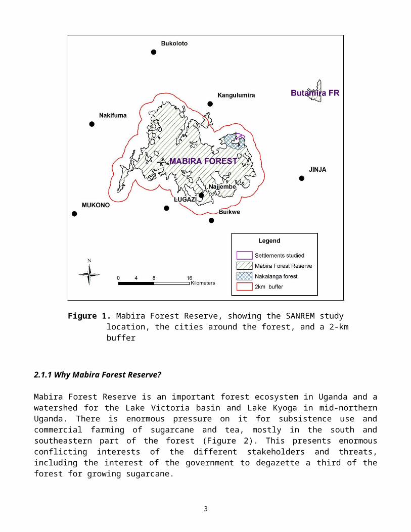
The Mabira Forest Reserve is a rainforest area covering about 300 km² in Uganda located mostly in Mukono and partly in Kayunga Districts between Kampala and Jinja. The towns surrounding Mabira Forest Reserve include Lugazi, Najjembe,
1

Buikwe, Kangulumira, Bukoloto, and Nakifuma (Figure 1). Mabira Forest Reserve has been protected since 1932.
Figure 1. Mabira Forest Reserve, showing the SANREM study location, the cities around the forest, and a 2-km buffer
2.1.1 Why Mabira Forest Reserve?
Mabira Forest Reserve is an important forest ecosystem in Uganda and a watershed for the Lake Victoria basin and Lake Kyoga in mid-northern Uganda. There is enormous pressure on it for subsistence use and commercial farming of sugarcane and tea, mostly in the south and southeastern part of the forest (Figure 2). This presents enormous conflicting interests of the different stakeholders and threats, including the interest of the government to degazette a third of the forest for growing sugarcane.
2
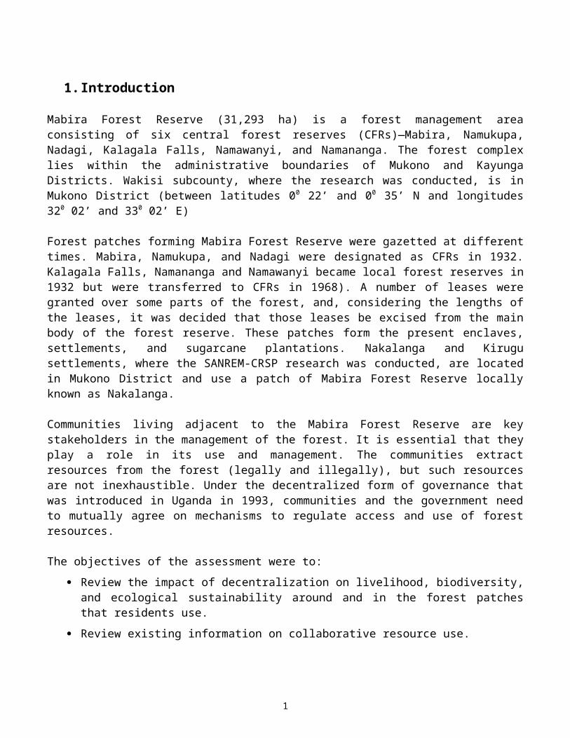
Figure 2. Mabira Forest Reserve, showing the SANREM study location, the cities around the forest, the sugarcane expansion, and the 2-, 5-, and 10-km buffers
The forest is unique because it consists of about 24 settlement enclaves. It was heavily encroached by local communities in the 1970s and the early 1980s, but people were forcibly evicted in 1988. Within the 2-km buffer, there are approximately 85 settlements that depend on the forest for 30% of their livelihood. The number of settlements depending on the forest increases as the forest buffer extends to 5 km and 10 km. Whereas areas to the south and west of the forest have several alternative natural forest patches from which residents may harvest the required forest products, the north and northeastern areas depend entirely on Mabira Forest Reserve for their forest products.
The two settlements that were the focus for this research—Kirugu and Nakalanga—are within the 2-km buffer. Also, they are heavily populated, mostly by migrants
3
from eastern Uganda with an average of 8 people per household. The households “own” small landholdings averaging less than 2 ha each. The settlements consist of land legally owned by two landlords and a patch of public land. More than 30% of the households depend on the forest to earn a living through the sale of forest products and production of food stuff.
2.1.2The History of Nakalanga and Kirugu settlements
The first settlers in these two settlements migrated from Bugerere County, East Mengo District of Buganda Kingdom in 1949. Mr. James Bakisula and Mr. Kagwa owned two pieces of mailo land that were excised from the main body of Mabira Forest Reserve. Between the two properties, there was public land that was forested but not gazetted as part of the reserve. At first, the migrants from Bugerere settled on public land.
Later in 1949, a migrant from Busoga (east of the Nile River) named Mr. Zirabamulaze Wanume Kibedi (a grandfather of Mr. Wanume Kibedi, former Minister of Foreign Affairs during Idi Amin’s rule) bought the mailo land from Mr. Bakisula. In 1950, Mr. Binaisa (father of G. Binaisa, the former President of Uganda) bought the other piece of mailo land from Mr. Kagwa.
In the local language, Nakalanga means a place inhabited by very short people with big heads. People with this type of abnormality lived in this forest patch. Consequently, this forest patch and the village were named Nakalanga. Parents with children who have this abnormality still bring their babies to this forest patch to offer sacrifices to the gods.
Migrants who came from Bugerere planted yams locally known as Barugu. The word was adapted to name the settlement: Kirugu. In the 1940s, a thick tropical forest covered the two settlements. In the early 1950s, there was a rapid increase in population as more migrants arrived from Busoga, Bukedea, and Bugisu. At that time, the land was very fertile and suitable for growing coffee.
Residents of both Kirugu and Nakalanga recall that the forest reserve was well protected in the 1950s and 1960s. At the time, forest reserve boundaries were well maintained and harvesting of forest produce was restricted and strictly monitored. Local communities’ dependence on the forest reserve was minimal because there were abundant forest resources in forests on private and public land. Singh sawmills from Jinja were given concessions to harvest saw logs and logs for the plywood factory.
Under the Amin regime (1971–1979), there was economic turmoil and a breakdown of law and order. The government allowed people to cultivate and settle in the forest reserve. The population rapidly increased as more migrants settled in the area and claimed forestland. Other migrants came to specifically harvest timber, charcoal, firewood, and other forest produce since there was no enforcement of forest rules. In 1974, a new land decree that abolished mailo land tenure was introduced. Mailo owners became leaseholders with legal rights to holdings.
4
Individuals leased some portions of the forest reserve. Schools, markets, and banana and coffee plantations were established in the area. All of this led to the degradation of Mabira Forest Reserve.
Civil war was fought in this area between 1980 and 1985. After the war, in 1986, law and order was re-established. People who had settled in the forest reserve were requested to evacuate the area, but local communities greatly resisted. In 1988, all “encroachers” were forcefully evicted from the reserve. Forest management strategies, including clearing the boundary of the reserve to separate it from surrounding settlements, aerial seeding with timber species, strict regulation of harvesting rules, and restricted access, were put in place to rehabilitate Mabira Forest Reserve. The local people never accepted these management strategies, and conflicts occurred between the communities and the forest managers.
People who had been evicted from the reserve settled in the enclaves and public land neighboring the reserve, thereby creating a severe land shortage. In 2000, the coffee plants were attacked by wilt. The residents also reported a significant loss of soil fertility due to limited crop rotation and reduction in fallow periods. This has in turn increased the dependence of the community on the already severely degraded forest resource for their livelihoods through illegal cultivation, fodder collection, commercial firewood harvesting, and charcoal burning.
2.2 Methods
The main methods used in our research included literature review and consultations with government stakeholders (e.g., National Forest Authority, local government, and district leadership), NGOs/CBOs, stakeholders at the parish level, local resource users, academics, researchers, and the private-sector businesses.
Socioeconomic surveys were carried out using the International Forestry Resources and Institutions (IFRI) household questionnaires with randomly sampled participants in the two target villages. One focus group discussion was held per village followed by stakeholder meetings.
A participatory resource inventory was conducted in the forest in concentric sample plots of 10-, 3-, and 1-m radii. It was participatory because village trainees identified by local residents were involved. The percent coverage of grass and herbs and the numbers of seedlings, shrubs, saplings, and trees encountered in the plots were recorded. The plots were randomly located in the forest patches that these communities use. In the plots, abundance, distribution, and local utilization of resources were assessed. Seedlings were counted; saplings and shrubs were counted and measured for maximum diameter with vernier calipers and for maximum height; and trees were counted and measured for diameter at breast height (DBH) using vernier calipers. Good or “usable,” young, and dead or dry saplings, shrubs, and trees were counted.
In addition, remote sensing and geographical information system (RS/GIS) methods were used to quantify and compare land-cover trajectories of tropical, high forest,
5

woodland savannah, tea, and sugarcane within the forest boundary and within a 2- to 10-km buffer area around the forest.
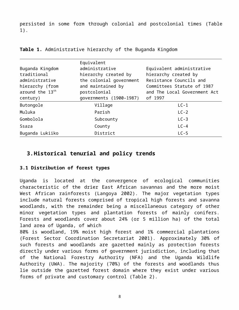
This investigation is in a portion of the Lake Victoria–basin forest biome occupied by the Buganda Kingdom since around the 13th century (Reid 2002). In this forest biome, both formal and informal arrangements have been well documented since the onset of colonization. Forms of the administrative and judicial hierarchies of the Buganda Kingdom have persisted in some form through colonial and postcolonial times (Table 1).
Table 1. Administrative hierarchy of the Buganda Kingdom
Buganda Kingdom traditional administrative hierarchy (from around the 13th century)
Equivalent administrative hierarchy created by the colonial government and maintained by postcolonial governments (1900–1987)
Equivalent administrative hierarchy created by Resistance Councils and Committees Statute of 1987 and The Local Government Act of 1997
Butongole Village LC-1Muluka Parish LC-2Gombolola Subcounty LC-3Ssaza County LC-4Buganda Lukiiko District LC-5
3. Historical tenurial and policy trends
3.1 Distribution of forest types
Uganda is located at the convergence of ecological communities characteristic of the drier East African savannas and the more moist West African rainforests (Langoya 2002). The major vegetation types include natural forests comprised of tropical high forests and savanna woodlands, with the remainder being a miscellaneous category of other minor vegetation types and plantation forests of mainly conifers. Forests and woodlands cover about 24% (or 5 million ha) of the total land area of Uganda, of which80% is woodland, 19% moist high forest and 1% commercial plantations (Forest Sector Coordination Secretariat 2001). Approximately 30% of such forests and woodlands are gazetted mainly as protection forests directly under various forms of government jurisdiction, including that of the National Forestry Authority (NFA) and the Uganda Wildlife Authority (UWA). The majority (70%) of the forests and woodlands thus lie outside the gazetted forest domain where they exist under various forms of private and customary control (Table 2).
Forests and woodlands are land-based resources; thus land tenure has important implications on access to land and its resources and, in fact, mirrors the broad patterns of ownership of forests and woodlands outlined above. The government of Uganda holds gazetted state land and all the resources on it in trust for all citizens
6
of Uganda through custodial ownership. Ordinary Ugandan citizens can access ungazetted land outside the state estate in three main ways:
1. Freehold ownership, which includes customary and mailo land under kingdoms. Colonial rulers purportedly placed considerable tracts of land under the private ownership of Buganda kings in order to secure colonial rule (Nyangabyaki 2002).
2. Leasehold land in which individuals lease land from someone, usually the government, and in normal cases for periods of not less than 49 years (Langoya 2002).
3. Bibanja land ownership in which an individual occupies land through a mutual agreement with the owner of such land.
However, to understand the present we have to understand the past. Contemporary tenurial patterns in Uganda have as much to do with the present as they have to do with the past. The next section gives a brief overview of trends in forest and related policies in Uganda. Emphasis is placed on major informing issues and goals as well as the drivers of the various policy changes (or lack of change) and their related impacts on people and forests.
Table 2. Distribution of forest types in Uganda
Cover type
Forest reservesunder state or local
authority (ha)
National parksand wildlife
reserves underUWA (ha)
Private land(private andcustomaryland) (ha) Total (ha)
Tropical high forests 306,000 267,000 351,000 924,000Woodlands 411,000 462,000 3,102,000 3,975,000Plantations 20,000 2,000 11,000 33,000Other 414,000 1,167,000 13,901,000 15,482,000Total 1,151,000 1,898,000 17,365,000 20,414,000Source: National Biomass Study of the Uganda Forest Department (1999)
3.2 Overview of trends in forest policy in UgandaAlthough no formal (written) policies were in place during the precolonial era, localized tribal kingdoms reputedly ensured environmental regulation through a system of customary controls that were informed by local indigenous knowledge systems. Land was reportedly more abundant in relation to population levels,1 and human need and resource availability were kept more or less in balance by subsistence modes of existence that were sustained by low-impact hunting and gathering and long-rotation shifting cultivation (Ndemere 2002). Without necessarily romanticizing human-environment relationships in typical Ugandan precolonial
1 Archaeological evidence, however, suggests that population levels may not have been low everywhere in precolonial times, as reflected through extensive ancient cultivation terraces in some parts of Africa (e.g., Nyanga), whose construction should have been labor intensive, thus suggesting high population levels (Summers 2000).
7
societies, evidence largely appears to suggest the context of people living in some form of “harmony with nature.”
The incipient phase of the colonial period saw a marked influx of foreign forces, including explorers and missionaries and later fortune seekers and business interests, and it culminated in colonial conquest and the advent of capital-led development policies. In the forest sector, new entrepreneurs sought to expand their fortunes through the commercial extraction of timber, wild rubber, and coffee, which in the absence of some form of regulation, resulted in rapacious destruction of forests. The introduction of cash crops and taxation further aggravated forest destruction through clearance for cultivation and other cash-generating activities.
Colonial administrators promulgated the first forest policy in 1929 as a reactive regulatory measure to ensure the conservation of forests. The policy marked the beginning of protectionism, and it was subsequently consolidated, in the 1940s, by the setting up of protection forests and the requisite bureaucracy to ensure such protection, i.e. a distinct forest management authority. Despite the creation of protected forests, commercial extraction of timber remained one of the policy mainstays, especially on the back of increasing demand for timber from Europe and America in the post–World War II period. A policy review in 1948 thus re-emphasized the commercial thrust of existing policies and identified the need to establish production forests of mainly planted exotics to support the commercial and export-led focus of the policy (Ndemere 2002).
Considered in retrospect, colonial forest policies overemphasized capital accumulation and environmental protection at the expense of livelihood and other interests of the peasant sector. Protected forests were invariably created through the eviction of some peasant communities from their ancestral homelands. Victims of eviction were further to be denied use rights to resources in protected areas through laws purportedly designed to maintain such areas in pristine condition. Elsewhere outside protected areas, other colonial forest laws denied peasants the right to extract resources other than for subsistence (Nyangabyaki 2002).
Forest policy during the early postcolonial period (1962–1980s) can best be summed as “more of the same,” in as much as it upheld the colonial status quo with emphasis on protection and production aspects as well as on commercial exploitation (Ndemere 2002). A policy review done during the 1970s further reinforced the commercial thrust of the founding colonial policy, and additionally envisioned more central control of forests, and of industry. At a broad level, this epitomized the general centralization of political power under the Idi Amin dictatorship, but the political conflicts and struggles associated with this era led to a breakdown of law and order and of forest management institutions as well as the collapse of industry. The institutional vacuum existing during this era was associated with a massive influx of people (encroachers) into most nature parks and protected areas.
A recent policy review that appears to have been instituted at the request of donors, and done in 1988, emphasized new initiatives to halt deforestation, the need for forest-sector rehabilitation and the creation of awareness on environmental
8
issues. It additionally emphasized a multiple stakeholder approach, a move that is thought to have spawned the emergence and mushrooming of local environmental NGOs, and other organizations that championed “conservation with a human face.” an agenda that mainly drew inspiration from the 1992 Earth Summit (Nyangabyaki 2002). In spite of its multiple-stakeholder orientation, the policy regrettably excluded local communities living close to or within the protected forests (Ndemere 2002). A further review in 2001 added emphasis on multiple-use forestry, including agroforestry, and recognized the realities and complexities of multiple use and the need for multiple-stakeholder collaboration and the roles of various stakeholders, including the private sector and local communities.
The multiple-stakeholder and collaborative orientations of the policy are seen to have created and enhanced the space for organizations using the network approach to champion peasant empowerment through community forest management (Ndemere 2002).2 While it is not easy to conclusively establish the chain of cause and effect in a complex and dynamic world of many interacting factors, it would generally appear that external drivers at the international level significantly influenced the latest changes in forest policy in Uganda. The pro-people orientation of the forest policy was further reinforced by its emphasis on decentralized governance, a tenet supported by a battery of other Ugandan laws.
3.3 Decentralization in Uganda: The structural aspects
The mainstreaming and formalization of decentralization as a guiding governance policy appears to have been an extended process informed by a variety of internal and external factors. From a historical perspective, decentralization was, as far back as the early 1980s’ struggle against the Amin regime, the founding vision of the National Resistance Movement. The first objective of the Movement’s Ten Point Programme reportedly espoused “a local government system that would empower communities to take charge of their own destiny through local institutions of self governance and resource mobilization” (Ahikire 2001). Resistance Councils became the Movement’s vehicle for mass mobilization, and these were transformed into a nationwide hierarchy of Resistance Councils and Committees upon the Movement’s ascension to power in 1986. The move was purportedly designed to enhance the Movement’s grip on the countryside where it hitherto had not established significant grassroots support and legitimacy (Ahikire 2001; Wagaba 2001). A battery of statutes formalized the Resistance Councils into the institutional infrastructure for decentralized governance in present-day Uganda. The Local Councils and Committees statute of 1987 made such councils legitimate entities, recognizing them as the formal administrative structures to which the central government transferred authority to plan, make decisions, and provide services at the local level. A subsequent statute in 1993 further refined the procedures to enhance “autonomous decision making” by the Resistance (Local) Councils.
2 Coglianese and Nicolaidis (1999) and Ribot (1999) argue that more genuine empowerment under decentralization takes much more than the transfer of power from one level and its retirement into another level. Both works explore the complexities potentially associated with decentralization in everyday social practice.
9
Decentralization as a policy was further strengthened by article 1b of the 1995 Ugandaconstitution, which states that “decentralization shall be a principle applying to all levels of local government and in particular, from higher to lower level units to ensure people’s participation and democratic control in decision making.” Decentralization was reportedly also swiftly instituted and implemented by the National Resistance Movement government to forestall demands for federalism then championed by Buganda, and apparently coming to the fore at that stage in history (Tukahebwa 2001). Elsewhere, at a broader level, decentralization was ostensibly accelerated by “the fall of communism and triumph of liberalism,” “the perceived failure of the state,” as well as “related international initiatives ostensibly designed to bring Africa out of its dire socio-economic predicament” (Tukahebwa 2001). Conditionality associated with initiatives such as Structural Adjustment Programs centered on the creation of “leaner,” “folded back,” and presumably more efficient states regarding civil society and local communities.
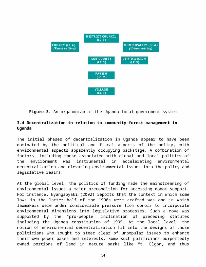
Uganda has a five-tier local government system comprising of both administrative and legislative functions with executive officers performing the administrative functions while elected representatives perform the legislative functions (Namara and Nsabagasani 2001). The overarching level of local government is the district (Local Council 5), below which is the county in rural areas or a municipality in urban areas, both of which are essentially administrative units. The next levels of local governance, in decreasing order, include the subcounty (Local Council 3), parish (Local Council 2), and village levels (Local Council 1) (Figure 3). Most of the entrustments decentralized by the 1997 local government statute, including income tax collection, service provision, and some aspects of environmental management, are held at the district and subcounty level. The subcounty retains 30% of the revenue collected, while 35% is remitted to the district government, with the county and parish each getting 5%, and the village getting 25% (Nyangabyaki 2002). Thus Uganda features prominently as one of the few countries in the Sahelian region to have pioneered with more thoroughgoing modes of decentralized governance.
10
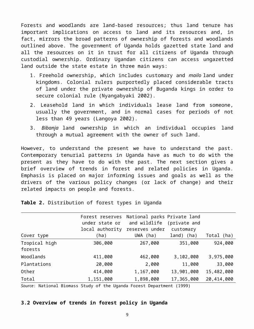
Figure 3. An organogram of the Uganda local government system
3.4 Decentralization in relation to community forest management in Uganda
The initial phases of decentralization in Uganda appear to have been dominated by the political and fiscal aspects of the policy, with environmental aspects apparently occupying backstage. A combination of factors, including those associated with global and local politics of the environment was instrumental in accelerating environmental decentralization and elevating environmental issues into the policy and legislative realms.
At the global level, the politics of funding made the mainstreaming of environmental issues a major precondition for accessing donor support. For instance, Nyangabyaki (2002) reports that the context in which some laws in the latter half of the 1990s were crafted was one in which lawmakers were under considerable pressure from donors to incorporate environmental dimensions into legislative processes. Such a move was supported by the “pro-people” inclination of preceding statutes including the Uganda constitution of 1995. At the local level, the notion of environmental decentralization fit into the designs of those politicians who sought to steer clear of unpopular issues to enhance their own power bases and interests. Some such politicians purportedly owned portions of land in nature parks like Mt. Elgon, and thus championed “peasant rights” by advocating for the freeing up of land from protected forests for peasant use (Nyangabyaki 2002). And at the grassroots level, the sheer weight of local tenurial land-use pressures rendered protectionist approaches untenable (Driciru 2002; Langoya 2002).
The main law governing environmental issues in Uganda is the National Environmental Statute of 1995. It encourages “maximum participation of the people of Uganda in the development policies, plans and processes for the management of
11

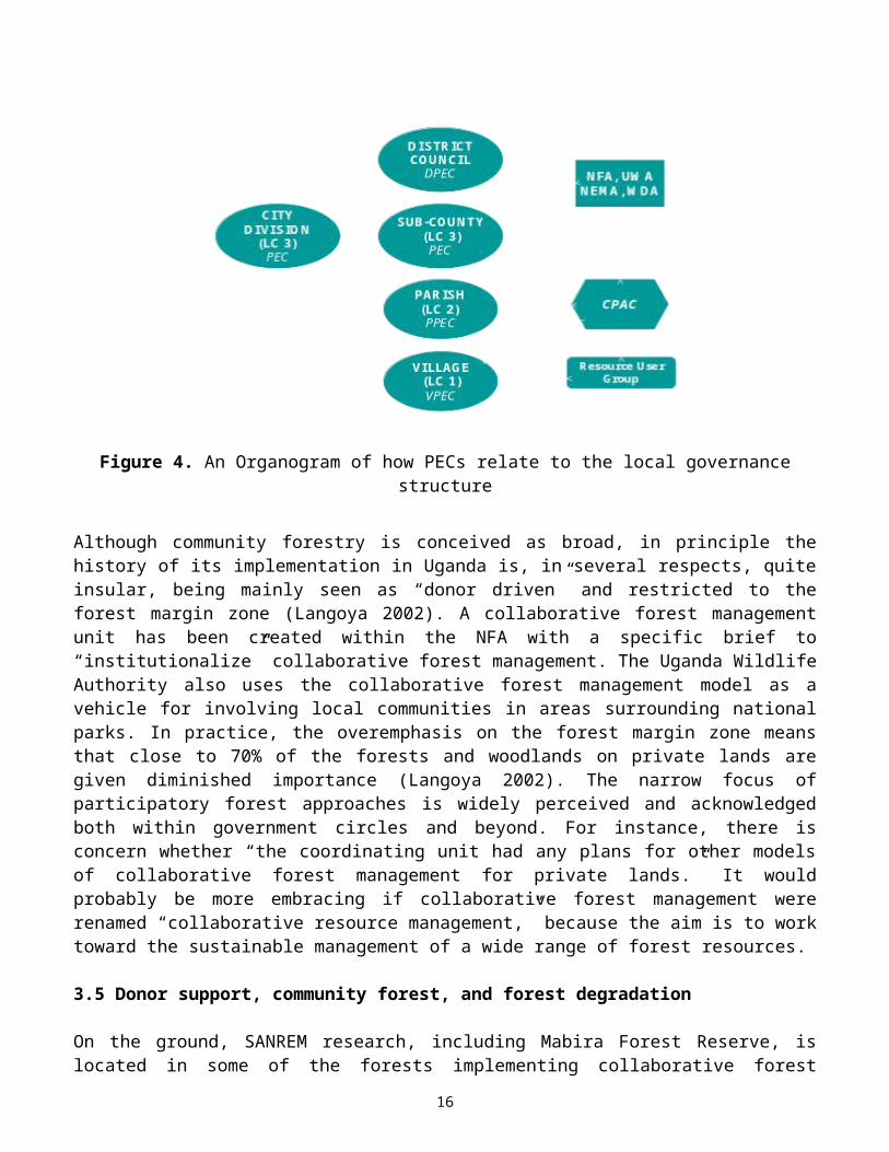
the environment.” The coordinating body, the National Environmental Management Authority (NEMA) is charged with the responsibility to work with lower-level institutions, namely District Environmental Committees and Local Environmental Committees, to ensure that environmental concerns are integrated into district and local-level planning processes, to ensure participation of local people in environmental planning, and to mobilize local people and resources to solve environmental problems (Nyangabyaki 2002). In the wildlife sector, committees that have been created to partner local government units with UWA in collaborative resource management include Production and Environmental Committees (PECs) at the district, subcounty, parish, and village levels (Figure 4). The PECs are comprised of elected representatives as well as technocrats and bureaucrats.
Because forest or protected areas are, in most cases, far larger than administrative village, parish, subcounty, or districts units, representatives of the PECs sit in the Community Protected Area Committee (CPAC), whose meetings are also attended by UWA, NFA, NEMA, and sometimes Wetland officials (Namara and Nsabagasani 2001). Thus, in line with preceding strands of analysis, political decentralization in Uganda provided the organizational mainframe upon which an additional hardware to sustain environmental decentralization was later superposed.
Figure 4. An Organogram of how PECs relate to the local governance structure
Although community forestry is conceived as broad, in principle the history of its implementation in Uganda is, in several respects, quite insular, being mainly seen as “donor driven” and restricted to the forest margin zone (Langoya 2002). A collaborative forest management unit has been created within the NFA with a specific brief to “institutionalize” collaborative forest management. The Uganda Wildlife Authority also uses the collaborative forest management model as a vehicle for involving local communities in areas surrounding national parks. In practice, the
12
overemphasis on the forest margin zone means that close to 70% of the forests and woodlands on private lands are given diminished importance (Langoya 2002). The narrow focus of participatory forest approaches is widely perceived and acknowledged both within government circles and beyond. For instance, there is concern whether “the coordinating unit had any plans for other models of collaborative forest management for private lands.” It would probably be more embracing if collaborative forest management were renamed “collaborative resource management,” because the aim is to work toward the sustainable management of a wide range of forest resources.
3.5 Donor support, community forest, and forest degradation
On the ground, SANREM research, including Mabira Forest Reserve, is located in some of the forests implementing collaborative forest management with all of them using project-based approaches relying on donor funding (Table 3). Thus, in addition to reflecting a conceptual bias that appears to equate community forest management with collaborative forest management, and a spatial bias that appears to focus on the forest margin zone, collaborative forest management also reflects a project bias. Because of their project proclivity and related requirements, including the need to demonstrate tangible impact within restricted timeframes, collaborative forest management initiatives lose a considerable measure of the flexibility of social-learning experiments that they are supposed to be (Langoya 2002). And because of related complexities, social experiments are best tackled in evolutionary perspective (Murphree 1990). The ethics of intervention additionally include the need to have an understanding of the drivers of intervention, including the criteria, standards, and benchmarks of entry as well as thresholds of exit.
Table 3. Some of the collaborative forest management sites, with supporting projects, donors, and IFRI-SANREM notations
Forest reserve (site)
Project support Donor Comment
Bukaleba Plantation Project NORAD IFRI siteMabira Natural Forest Management
Conservation ProjectWorld Bank, EU IFRI-SANREM site
Budongo Natural Forest ManagementConservation Project
EU IFRI site
Mpanga Natural Forest ManagementConservation Project
EU IFRI site
Echuya Natural Forest ManagementConservation Project
EU IFRI site
Sango Bay Natural Forest ManagementConservation Project
UNDP/GEF IFRI-SANREM site
Source: Adapted from Uganda Forest Department (2002)
Furthermore, the research findings show that over the years there is degradation taking place both within and outside the protected forest boundaries. Thus, the forest condition in Mabira Forest Reserve is not as good as expected despite the
13

donor support emphasis in areas near the forest, which may call for a new approach to strategies in forest governance and monitoring intervention. For example, no known commercial timber-size classes were observed in the plots studied; average DBH was 19 cm, mainly of non-commercial species. We had expected an average DBH to be more than 40 cm in this ecosystem. Few commercial timber species were encountered. Overall species richness was low—32 species—much lower than the 119 species recorded in the 1980 NBS inventory and the 142 species in the 1968 NFA inventory. Only 24 tree species were recorded instead of more than 70 tree species expected in this ecosystem. Thirty percent (30%) of the trees were Paper Mulberry (Brosnetia paperifera), an invasive tree species.
Consequently, questions like When is intervention necessary? What amount of intervention is enough? and Why intervene at all? Arise. More often than not, availability of donor funding invariably is the common denominator to all these essential questions. The extent of overreliance on external support in Uganda has been such that “where there has been no external funding, districts have been unable to create the necessary (environmental) institutions required in the law” (Nyangabyaki 2002:25). The flip side of this observation is that environmental institutions, including environmental action plans, mostly exist in districts that received donor support. For instance, the World Bank supported the crafting of such institutions in Mukono and Mbale Districts, while USAID funded the creation of similar institutions in Masindi and Masaka Districts (Nyangabyaki 2002:24).
3.6 House types, occupation, and common diseases in the communities
Twenty-six percent (26%) of houses in both Nakalanga and Kirugu settlements had been grass thatched. Because of the scarcity of grass, 72% of the roofs were iron with predominantly pole and mud walls. Roof rafters were made from poles—85% in Nakalanga and 57% in Kirugu. In an earlier study, Kiityo (1987) reported that an average grass-thatched house used 350–450 poles in construction. The study further reported that the turn-over period for grass-thatched houses is 3–12 years depending on the construction materials, skill, and insect (termite) infestation in the area. With a high population in both Nakalanga and Kirugu settlements, the use of construction poles is likely to impart negatively on the pole-sized condition of the forest for a long time.
The results show that the residents are predominantly subsistence: Nakalanga with 65%, while Kirugu reported 63%. Small businesses (shopkeeping and trade in food produce) was the next reported occupation, with 11% and 16% hits in Nakalanga and Kirugu, respectively.
Malaria prevalence, cough and flu, and diarrheal diseases were the most highly reported in the two settlements. Over 40% of the residents in both settlements were harvesting medicinal herbs from the forest to treat the ailments. Twenty-eight percent (28%) of the residents in Nakalanga and 33% in Kirugu were harvesting medicinal herbs for cough and flu. In Nakalanga and Kirugu, 9% and 19% of the residents, respectively, reported a problem of diarrheal diseases and referred to the forest patch as the source for their remedial medicines.
14

3.7 Food security and land decisions
Only 28% of the residents in both Nakalanga and Kirugu were able to provide food from their land during all twelve months. The remaining 72% were either depending partly on the forest or markets or relatives in urban towns to supplement their food production. The study unveiled the information that 60% of fathers were responsible for land acquisition decisions, while 60% of the mothers in most households were the ones responsible for food decisions, a characteristic in most sub-Saharan countries.
With the NFA becoming more strict in agricultural encroachment in the forest reserve, there was a reported increase in the number of residents migrating out of the communities. The predominant destination reported was Kiboga District in mid-central Uganda.
4. Forest governance and the role of local communities in local governance
Mabira Forest Reserve is under the Central Uganda and Lake Victoria range. The forest has one Sector Manager. Under him are a limited number of Section Supervisors. In the Nakalanga forest patch, one Forest Supervisor and three contracted patrolmen are contracted. Based on the stretch of the boundary perimeter that they have to monitor and patrol, they are underfacilitated in terms of routine transport.
Under the current collaborative management plan, the communities are expected to plant and maintain trees in degraded and farmed forest patches. They are expected to actively participate in the formation and implementation of collaborative forest management committees. The local leaders serve as tribunal in conflict resolution between illegal harvesters and NFA (LC 1). In addition, the local leaders are expected to encourage the residents to engage in alternative income-generating activities, such as beekeeping, pineapple/vegetable/upland rice cultivation, and livestock husbandry.
At the district level, the role of the District Forest Office (DFO) is to advise private forest owners and tree farmers in growing trees and forest management. The district authority issues harvesting licenses for forest products on local forest reserves and public land. In addition, the districts collect taxes on forest produce (e.g., charcoal and timber). Unfortunately, the district lacks resources to carry out most of the above roles.
With formation of community-based organizations (CBOs) in the settlements, the communities petition NFA to allow them use the taungya system (combination of trees and plants in a field) to plant and manage a buffer zone around the forest. They want to become more involved in monitoring and enforcement of forest rules,
15
especially the forests adjacent to their lands, and in allocating licenses for firewood collection in the forest patches they feel are under their jurisdictions.
4.1 Implications, opportunities and constraints of decentralization on the livelihoods of local communities
The local leaders and residents have realized that decentralization is fully institutionalized as a governance strategy. The different stakeholders at local, subcounty, district, and national levels are aware of the importance of environmental protection in Mabira Forest Reserve. Consequently, capacities of local communities and local government are being enhanced in improved agriculture techniques, energy saving, budgeting, and tree planting outside the forest.
The settlements studied have an opportunity for access to the forest, which would be a problem if the forest patch is to be converted to sugarcane growing. However, they are faced with several constraints: high population, limited sources of income, limited landholdings, declining soil fertility, and limited participation in decision making in resource management and monitoring of licences issued.
5. Conclusions
The study results show limited impact of decentralization policy on the livelihoods of local communities including women, the poor, and marginalized groups. The interest groups of commercial sugarcane growers and subsistence and commercial product users are not yet harmonized, although local capacity has been introduced. The process of formation of collaborative forest management should be completed and the structure of the NFA at the forest/local level should be reviewed.
In addition to local (community) institutions, higher-level institutional arrangements and external factors such as markets and investment interests have greatly affected the forest condition and the environment, both in the forest and within the forest buffer. This study provides examples of the impacts of higher-level institutional arrangements on local institutions and pushes for the recognition of the need to design institutions that are linked horizontally across space and vertically across levels of organization in order to manage the commons effectively for the benefit of both local and global users.
Tree growth on settled lands observed between 1955 and 1995 was not a shift in resource management induced by perceived scarcity as may be predicted by induced innovation models (Boserup 1965; Netting 1993; Scherr and Hazell 1994; Gibson 2001). Rather, the change in tree-cover distribution in and around Mabira Forest Reserve is better described as a side effect of a combination of formal property arrangements, adoption of cash-crop production, and changes in holding size as described above. However, in recent decades, with growth in rural populations and urbanites placing greater demands on salient forest products, the increase in woody cover on settled lands has become an important factor in decision making regarding land use and the maintenance of the flow of forest
16
products among users within and among lower governance units. The abundance of these trees on settled lands plays a considerable role in regard to the design of appropriate governance systems for the maintenance of large-scale forest commons in this forest biome.
We find that the increase in availability of forest products outside large-scale forest patches since 1959 allows local institutions to increase harvesting in forest patches and to occasionally allocate forest lands within lower governance units to other uses. Unfortunately, this was not realized by international organizations who, in the mid-1990s, promoted cuts in the forest department budgets and devolution of authority over forests to lower levels of government to stem deforestation and reduce costs to central governments. The Ugandan central government attempted to devolve authority over the state forest reserves without involving local authorities in the decision-making process, at precisely the time when dependence on those resources by non-local users was greatest and local users’ dependence relatively low. Widespread harvesting and degradation of the forests occurred during this time, and the forests were re-centralized (Banana et al. 2004).
If local governments in this area, at any level, are given full authority over large-scale forest patches even today, local administrators and clan elders will likely permit, and personally engage in seasonal cash-crop production in forests and permit higher levels of commercial fuelwood and charcoal harvesting by members within that governance unit. At this time, local institutions have little incentive to maintain large-scale forest patches solely to mitigate environmental impacts. They do not want to put forth the effort on behalf of the state or international organizations that only produce costs at any level of the enduring administrative hierarchy. Here is a case where robust local institutions could actually “degrade” the global forest commons from the perspective of conservationists, while successfully maintaining the flow of forest products to local users. And, the benefits to local users of more trees on occupied lands rather than in large-scale forest patches may actually increase (e.g., shade, boundary demarcation, animal hitch, and more). This supports the hypothesis that more complex and nested arrangements are better for governing forests across a biome than one-level property regimes (community level or state level, command and control alone) (Dietz et al. 2003).
Introduction of “one-size-fits-all” environmental management arrangements across Africa should be avoided. For example, devolution of authority over resources (e.g., promotion of community-based forest management) to any level of this enduring sociopolitical hierarchy at this time will not result in maintenance of large-scale forest patches. This is because robust Baganda institutions in this hierarchy can modify resource-use allocations to permit use and disposal of resources for income generation, while maintaining the flow of subsistence forestry products within the governance unit, without maintenance of forest patches. Thus, lower-level political units lack incentive to manage forests for the benefit of the environment at this time.
Our study does support other findings that sustainable arrangements and goals of multiple stakeholders are more likely achievable when they are designed to allow
17
for adaptive governance at multiple levels (Dietz et al. 2003), an important design of the former arrangements governing the forest reserves of West Mengo (Vogt et al. 2006). Structures facilitating local land-use and institutional adaptations are necessary. The burden of design may rest on regional or global stakeholders to tool an adaptive governance system at the higher levels that integrates with those enduring at local levels, and design it with local authorities. In the mid-1990s, the central government and international organizations seeking to stem deforestation should have been investing in updating and strengthening existing linkages between district forest authorities, trained managers, and the enduring, traditional institutions (Vogt et al., 2006) rather than devolving responsibility of monitoring and enforcement away from the DFOs to local administrative units with the least incentive to do so.
The new National Forest Plan (2002) and the National Forestry and Tree Planting Act (2003), rather than updating and strengthening the linkages between state and traditional administrative structure, have weakened the interface between the state machinery and the enduring, local decision-making structures. In crafting the new Act, the vision was myopically on forests and not on optimal land-use patterns for the biome in general. Did they view the biome from the local perspective, which we propose continuously weighs tradeoffs between individual production systems and flow of forest products? During the process, the designers appear NOT to have realized that the existing patterns of large-scale forest patches in this biome they intend to manage are part of the “optimal” land-use pattern for the biome negotiated between colonial authorities and Kingdom regents in 1900. The “optimal” pattern from the perspective of the local user may have changed in the last century. Was it updated in negotiation with relevant authorities and users? Or, were the existing patterns assumed to be ideal and local users (because of observed, pervasive absence of forests outside the current boundaries of the state reserves) assumed to be unable to manage natural resources? The process of creation and maintenance of the reserves successfully governed forest resources in the past century (Vogt et al. 2006). But this current Act did not follow such a process of negotiation with local leaders to determine of boundaries needed to be altered or to bring legitimacy to the new government property arrangement. And they removed the important role of the DFO and rangers in integrating with the enduring decision-making framework. Tensions may increase, frustrating local users’ capability to identify diverse arrangements, hindering both local and non-local stakeholders in achieving respective goals.
The interpretations in this work, stemming from constructed historical narratives, are more subjective but important considerations to contrast with limited range of interpretations that often result from more formal methods. This may be termed an applied historical ecology approach, heeding calls to consider historical processes and context in environmental change studies (Fairhead and Leach 1998; McCay 2002; Brondizio in press). This applied historical ecology approach promotes greater attention to longer-term processes and takes into consideration variation in ecological, cultural, socioeconomic, and historical contexts across space in studies of land-use and land-cover change. Here, this approach was integrated with the application of the institutional analysis and development (IAD) framework, and
18

followed in the influence of the broader sociopolitical structure on resource use and management decisions (Ostrom et al. 1994).
Acknowledgments
This publication/presentation was made possible through support provided by the United States Agency for International Development for the Sustainable Agriculture and Natural Resources Management Collaborative Research Support Program (SANREM CRSP) under terms of Grant No. EPP-A-00-04-00013-00 to the Office of International Research and Development at Virginia Polytechnic Institute and State University. We are grateful for the cooperation and time spent by the staff from the Mukono District Forest Office, the National Forest Authority, Local Council leaders in the communities studied, and leaders of the two community-based development organizations. We are grateful for input made by the staff of the Forest Inspection Division and the SANREM-CRSP National Advisory Committee during the study. We are grateful to Ms. Joanna Broderick for typesetting and editorial support in writing the paper. The authors are grateful to all who assisted in making this paper possible. Finally, the authors are grateful to Makerere University, Faculty of Forestry and Nature Conservation, for allowing us to commit time from our academic schedules to carry out the study.
ReferencesAhikire, J. 2001. Decentralization and the gender question: Issues at hand and the way forward for
NGO district networks. DENIVA Information Bulletin No 4. Kampala: DENIVA.
Banana, A.Y., Vogt, N.D., Gombya-Ssembajjwe, W., and Bahati, J. 2004. Local Governance and Forest Conditions: The Case of Forests in Mpigi District of Uganda. Presented at "The Commons in an Age of Global Transition: Challenges, Risks and Opportunities," the Tenth Conference of the International Association for the Study of Common Property, Oaxaca, Mexico, August 9–13.
Boserup, E. 1965. The Condition of Agricultural Growth. Chicago: Aldine.
Brondizio, E.S. (in press). Landscapes of the past, footprints of the future: Historical ecology and the study of contemporary land use change in the Amazon. In Time and Complexity in the Neotropical Lowlands: Studies in Historical Ecology, ed. W. Beleé and C. Erickson. New York: Colombia University Press
Coglianese, C., and Nicolaidis, K. 1999. Securing Subsidiarity: Legitimacy and the Allocation of Governing Authority. Presented at transatlantic symposium on “Rethinking Federalism” in the EU and US, April.
Dietz, T., Ostrom, E., and Stern, P.C. 2003. The struggle to govern the commons. Science 302:1907–1912.
Driciru, F.F. 2002. What Works and Does Not Work with Local/International Community Forestry Networks and the Networking Business: Experiences from the Uganda Forest Department. Presented at the workshop on “Learning from International Community Forestry Networks,” Faculty of Forestry and Nature Conservation, Makerere University, July 11.
Fairhead, J., and Leach, M. 1998 Reframing Deforestation: Global Analyses and Local Realities - Studies in West Africa. London: Routledge.
19

Forest Sector Coordination Secretariat. 2001. Voices from the Field: Review of Forestry Initiatives in Uganda. Volume 1, Synthesis Report. Kampala, Uganda: author.
Gibson, C.C. 2001. Forest Governance: Institutions for Local Governance in Guatemala. In Protecting the Commons: A Framework for Resource Management in the Americas, ed. J. Burger, E. Ostrom, R.B. Norgaard, D. Policansky, and B.D. Goldstein. Washington, DC: Island Press.
Kiityo, P. 1987. Semi-permanent house construction in Uganda: Basic wood material requirements. Lecture notes for wood science undergraduate students. Kampala, Uganda: Faculty of Forestry and Nature Conservation, Makerere University.
Langoya, C.D. 2002. Situating Community Forest Management within the Broader Forestry Context of Uganda. Presented at the workshop on “Learning from International Community Forestry Networks,” Faculty of Forestry and Nature Conservation, Makerere University, July 11.
McCay, B.J. 2002. Emergence of institutions for the commons: Contexts, situations, and events. In The Drama of the Commons, ed. E. Ostrom, T. Dietz, N. Dolsak, P.C. Stern, S. Stonich, and E.U. Weber, pp. 361–402. Washington, DC: National Academy Press.
Murphree, M.W. 1990. Decentralizing the Proprietorship of Wildlife Resources in Zimbabwe’s Communal Lands. Harare: Centre for Applied Social Sciences, University of Zimbabwe.
Namara, A. and Nsabagasani, X. 2001. Decentralised governance and the wildlife management sector: Bwindi Impenetrable National Park. Paper prepared for the World Resources Institute. Kampala, Uganda: Centre for Basic Research.
Ndemere, P. 2002. Trends in Forest Policy in Uganda with an Emphasis on Underlying Drivers, and the Impact of Local/International Community Forestry Networks. Presented at the workshop on “Learning from International Community Forestry Networks,” Faculty of Forestry and Nature Conservation, Makerere University. July 11.
Netting, R.M. 1993. Smallholders, Householders. Stanford, CA: Stanford University Press.
Nyangabyaki, B. 2002. Politics, Legal Land Reform and Resource Rights in Uganda. Panel presentation for “The Changing Political Economy of Land in Africa” at the Conference “Africa in the New Millennium,” Nile International Conference Centre, Kampala, Uganda, December 9–12. Available at http://www.acts.or.ke/paplrr/docs/CairoPAPLRR-Bazaara.pdf.
Ostrom, E., Gardner, R., and Walker, J. 1994. Rules, Games, and Common-Pool Resources. Ann Arbor: University of Michigan Press.
Reid, R. 2002. Political Power in Pre-Colonial Buganda: Economy, Society & Warfare in the Nineteenth Century. Oxford, UK: James Currey Ltd.
Ribot, J.C. 1999. Decentralization, participation and accountability in Sahelian forestry: Legal instruments of political administrative control. Africa 69:23–65.
Scherr, S., and P. Hazell. 1994. Sustainable Agricultural Development Strategies in Fragile Lands. Environment and Production Technology Division Discussion Paper No. 1. Washington, DC: International Food Policy Research Institute.
Summers, D.A. 2000. Forming Entrepreneurial Intentions. New York: Routledge.
Tukahebwa, G.B. 2001. The Quest for Good Governance in Uganda: The Role of NGO District Networks. DENIVA Information Bulletin 4. Kampala, Uganda: DENIVA.
Uganda Forest Department. 1999. Annual Report from the National Biomass Study. Kamapala, Uganda: author.
20
Uganda Forest Department. 2002. Annual Report from the National Biomass Study. Kamapala, Uganda: author.
Vogt, Nathan D., Abwoli Y. Banana, William Gombya-Ssembajjwe, and Joseph Bahati 2006. Understanding the stability of forest reserve boundaries in the West Mengo region of Uganda. Ecology and Society 11(1):art.38[online]. Available at: http://www.ecologyandsociety.org/vol11/iss1/art38/.
Wagaba, F.X. 2001. The Local Government Act 1997: Issues for NGOs. DENIVA Information Bulletin No.4. Kampala, Uganda: DENIVA.
21

![[TST] NetworkCoding COPE 31293](https://static.fdocuments.in/doc/165x107/563db98c550346aa9a9e5b89/tst-networkcoding-cope-31293.jpg)