Ma olliery Exten sion - Major Projects
100
Ma Min Aqu Job N Prepa nne ning uatic Numbe ared fo erin g Eco er:EL1 or: Ce ng C ology 101108 ntenn Colli y Ass 81 ial Co iery sess oal y Ex smen xten nt nsio on
Transcript of Ma olliery Exten sion - Major Projects
MaMinAqu
Job NPrepa
nneninguatic Numbeared fo
ering Eco
er:EL1or: Ce
ng C
ology101108ntenn
Colli
y Ass81 ial Co
iery
sess
oal
y Ex
smen
xten
nt
nsioon
MannerPrepared
EL10110
Cover I
DocuReportNumbe
EL1011
EL1011
EL1011
"© 2011documereproduprior wr
ring Collied for Centenn
081 Final, Octo
mage: Lak
ment Cot er
Statu
1081 Draf
1081 Draf
1081 Fina
1 Cardno Ecent belongs tuced in wholeritten consen
ry Extensionial Coal
ober 2011
ke Macquari
ontrol
us Da
ft 08
ft 01
al 05
ology Lab. Ato Cardno (Ne or in part in
nt of Cardno
on of Minin
Ca
ie, 2010. P
ate Au
.07.11 Ka
.09.11 M
.10.11 Ka
All Rights ResNSW/ACT) Ptn any manneEcology Lab
ng– Aquatic
ardno Ecology
Photographe
uthor
ate Reeds
ichelle Blew
ate Reeds
served. Copyty Ltd and m
er or form or b.”
c Ecology A
Lab
Trad
er: Kate Ree
KAR
itt MLB
KAR
yright in the wmay not be us
in or on any
Assessment
Cardno (Nding as Ca
Ne
TelepFacs
Internationecology
eds, Cardno
Reviewe
Dr. PeggO’Donne
Dr. PeggO’Donne
Dr. Arthu
whole and evsed, sold, tramedia to any
NSW/ACT) ardno Ecolo
ABN 95 0014 Gree
Bew South Wa
phone: 02 99simile: 02 99nal: +61 2 [email protected]
o Ecology L
er
gy ell
gy ell
ur Dye
very part of tnsferred, coy person wit
Pty Ltd ogy Lab
145 035 en Street
Brookvale ales 2100 Australia 907 4440 907 4446 907 4440 o.com.au o.com.au
Lab
POD
POD
AD
this pied or hout the
Mannering Colliery Extension of Mining– Aquatic Ecology Assessment Prepared for Centennial Coal
EL1011081 Final, October 2011 Cardno Ecology Lab i
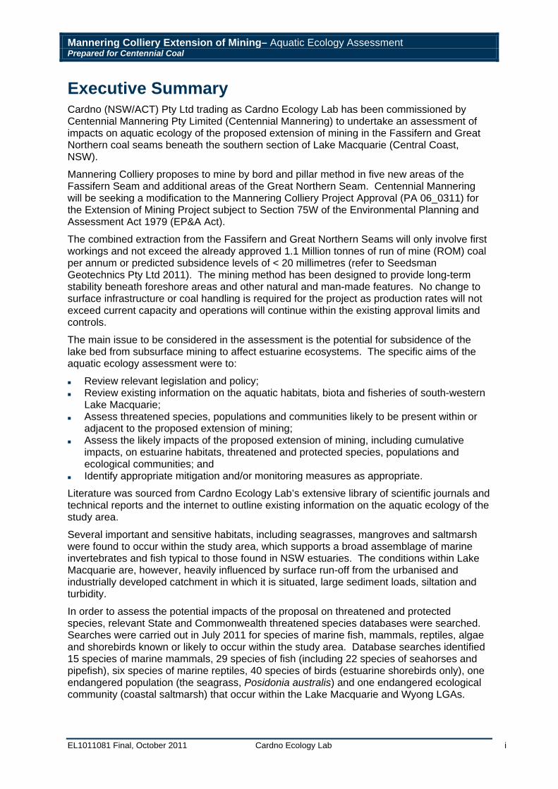
Executive Summary Cardno (NSW/ACT) Pty Ltd trading as Cardno Ecology Lab has been commissioned by Centennial Mannering Pty Limited (Centennial Mannering) to undertake an assessment of impacts on aquatic ecology of the proposed extension of mining in the Fassifern and Great Northern coal seams beneath the southern section of Lake Macquarie (Central Coast, NSW).
Mannering Colliery proposes to mine by bord and pillar method in five new areas of the Fassifern Seam and additional areas of the Great Northern Seam. Centennial Mannering will be seeking a modification to the Mannering Colliery Project Approval (PA 06_0311) for the Extension of Mining Project subject to Section 75W of the Environmental Planning and Assessment Act 1979 (EP&A Act).
The combined extraction from the Fassifern and Great Northern Seams will only involve first workings and not exceed the already approved 1.1 Million tonnes of run of mine (ROM) coal per annum or predicted subsidence levels of < 20 millimetres (refer to Seedsman Geotechnics Pty Ltd 2011). The mining method has been designed to provide long-term stability beneath foreshore areas and other natural and man-made features. No change to surface infrastructure or coal handling is required for the project as production rates will not exceed current capacity and operations will continue within the existing approval limits and controls.
The main issue to be considered in the assessment is the potential for subsidence of the lake bed from subsurface mining to affect estuarine ecosystems. The specific aims of the aquatic ecology assessment were to:
Review relevant legislation and policy; Review existing information on the aquatic habitats, biota and fisheries of south-western
Lake Macquarie; Assess threatened species, populations and communities likely to be present within or
adjacent to the proposed extension of mining; Assess the likely impacts of the proposed extension of mining, including cumulative
impacts, on estuarine habitats, threatened and protected species, populations and ecological communities; and
Identify appropriate mitigation and/or monitoring measures as appropriate.
Literature was sourced from Cardno Ecology Lab’s extensive library of scientific journals and technical reports and the internet to outline existing information on the aquatic ecology of the study area.
Several important and sensitive habitats, including seagrasses, mangroves and saltmarsh were found to occur within the study area, which supports a broad assemblage of marine invertebrates and fish typical to those found in NSW estuaries. The conditions within Lake Macquarie are, however, heavily influenced by surface run-off from the urbanised and industrially developed catchment in which it is situated, large sediment loads, siltation and turbidity.
In order to assess the potential impacts of the proposal on threatened and protected species, relevant State and Commonwealth threatened species databases were searched. Searches were carried out in July 2011 for species of marine fish, mammals, reptiles, algae and shorebirds known or likely to occur within the study area. Database searches identified 15 species of marine mammals, 29 species of fish (including 22 species of seahorses and pipefish), six species of marine reptiles, 40 species of birds (estuarine shorebirds only), one endangered population (the seagrass, Posidonia australis) and one endangered ecological community (coastal saltmarsh) that occur within the Lake Macquarie and Wyong LGAs.
Mannering Colliery Extension of Mining– Aquatic Ecology Assessment Prepared for Centennial Coal
EL1011081 Final, October 2011 Cardno Ecology Lab ii
The principal physical impact resulting from underground coal mining is subsidence, i.e. lowering of the surface above areas that are mined. Subsidence may result in areas of foreshore above the Mean High Water Mark, previously unexposed to tidal inundation becoming wetted at high tides and areas below this level becoming inundated for a longer period of time. Subtidally the seabed may become deeper in affected areas.
As seagrasses and algae are photosynthetic (i.e. they require light to grow) increased depth has implications for the distribution and condition of these habitats. Other habitats such as saltmarshes and mangroves only occur at certain levels of the shore and increased depth may result in landward migration. Unless the shore landward of the saltmarsh/mangrove habitat is suitable then this may result in a net loss of habitat.
Given the limited extent of where the proposed extension of mining would overlap with sensitive habitats and the minimal amount of predicted subsidence (< 20 millimetres), the direct impacts to these habitats is considered to be negligible. Any indirect impacts on fisheries resources and threatened species, populations and ecological communities (including matters of NES), would also be unlikely and as such, no significant impact on these species would be expected. There is potential for cumulative impacts to occur as a result of other mining activities within the region, however, Centennial Mannering currently manages and monitors for potential impacts in relation to their existing mining activities within Lake Macquarie. Any cumulative impacts outside of the management of Centennial Mannering would require management at the catchment level. No specific mitigation or monitoring of the aquatic environment is recommended for the proposed extension of mining at Mannering Colliery.
Mannering Colliery Extension of Mining– Aquatic Ecology Assessment Prepared for Centennial Coal
EL1011081 Final, October 2011 Cardno Ecology Lab iii
Table of Contents Executive Summary ............................................................................................................... i Glossary of Terms and Abbreviations ................................................................................ v 1 Introduction .................................................................................................................... 6 2 Relevant Legislation and Policy ................................................................................... 8
2.1 Environment Protection and Biodiversity Conservation Act 1999 (EPBC Act) ........ 8
2.2 Environmental Planning and Assessment Act 1979 (EP&A Act) ............................ 8
2.3 Threatened Species Conservation Act 1995 (TSC Act) .......................................... 9
2.4 Fisheries Management Act 1994 (FM Act) .............................................................. 9
2.5 National Parks and Wildlife Act 1974 (NPW Act) and the National Parks and Wildlife Regulation 2002 (NPWR). ...................................................................................... 9
2.6 Coastal Protection Act 1979 .................................................................................... 9
2.7 NSW Policy for the Conservation of Fish, Marine Vegetation and Aquatic Habitats 10
3 Existing Information .................................................................................................... 12 3.1 Regional Context ................................................................................................... 12
3.2 Physical Environment ............................................................................................ 12
3.3 Flora and Fauna .................................................................................................... 13
3.3.1 Estuarine Vegetation ......................................................................................... 13
3.3.1.1 Seagrasses ................................................................................................ 13
3.3.1.2 Mangrove ................................................................................................... 15
3.3.1.3 Saltmarsh .................................................................................................. 15
3.3.1.4 Macroalgae ................................................................................................ 18
3.3.2 Benthic Assemblages ........................................................................................ 18
3.3.2.1 Microalgae ................................................................................................. 18
3.3.2.2 Macrobenthos ............................................................................................ 18
3.3.3 Fisheries Resources .......................................................................................... 19
3.3.4 Threatened and Protected Species, Populations and Ecological Communities 20
3.3.4.1 Database Searches ................................................................................... 20
3.3.4.2 Assessments of Significance ..................................................................... 26
3.4 Areas of Conservation Significance ...................................................................... 27
3.4.1 State Conservation Areas ................................................................................. 27
3.4.2 Wetlands ........................................................................................................... 27
3.5 Impacts of Underground Mining on Estuarine Ecosystems ................................... 29
4 Assessment of Impacts ............................................................................................... 30 4.1 Description of Proposal ......................................................................................... 30
4.2 Physical Impacts Associated with Mine Subsidence ............................................. 30
Mannering Colliery Extension of Mining– Aquatic Ecology Assessment Prepared for Centennial Coal
EL1011081 Final, October 2011 Cardno Ecology Lab iv
4.3 Impacts to Flora and Fauna .................................................................................. 30
4.3.1 Estuarine vegetation .......................................................................................... 30
4.3.2 Benthic Assemblages ........................................................................................ 31
4.3.3 Fisheries Resources .......................................................................................... 32
4.3.4 Threatened and Protected Species ................................................................... 32
4.3.4.1 Assessments of Significance (State Legislation) ....................................... 32
4.3.4.2 Assessment of Significance (Commonwealth Legislation) ........................ 33
4.3.4.3 Other Listed and Protected Species .......................................................... 33
4.4 Areas of Conservation Significance ...................................................................... 33
4.5 Cumulative Impacts ............................................................................................... 33
5 Conclusion ................................................................................................................... 35 6 Acknowledgements ..................................................................................................... 36 7 References .................................................................................................................... 37 8 Appendices ................................................................................................................... 40
List of Tables Table 1: Species known or predicted to occur in the study area as listed under the NSW Fisheries Management Act 1994 (FM Act), the NSW Threatened Species Conservation Act 1995 (TSC Act) and the Environment Protection and Biodiversity Conservation Act 1999 (EPBC Act). ......................................................................................................................... 21
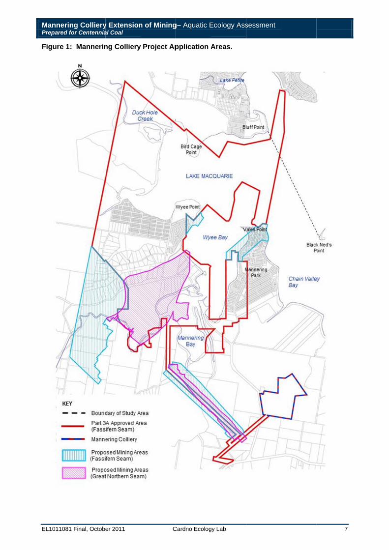
List of Figures Figure 1: Mannering Colliery Project Application Areas. ........................................................ 7
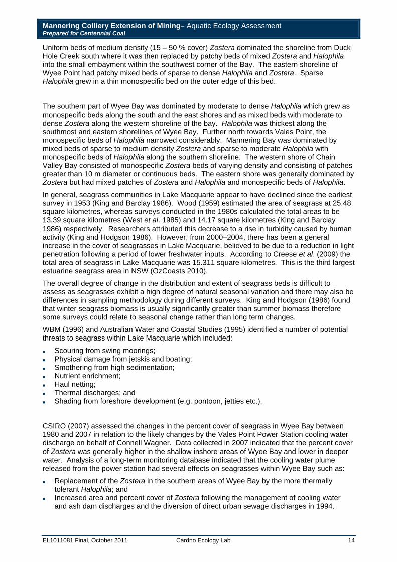
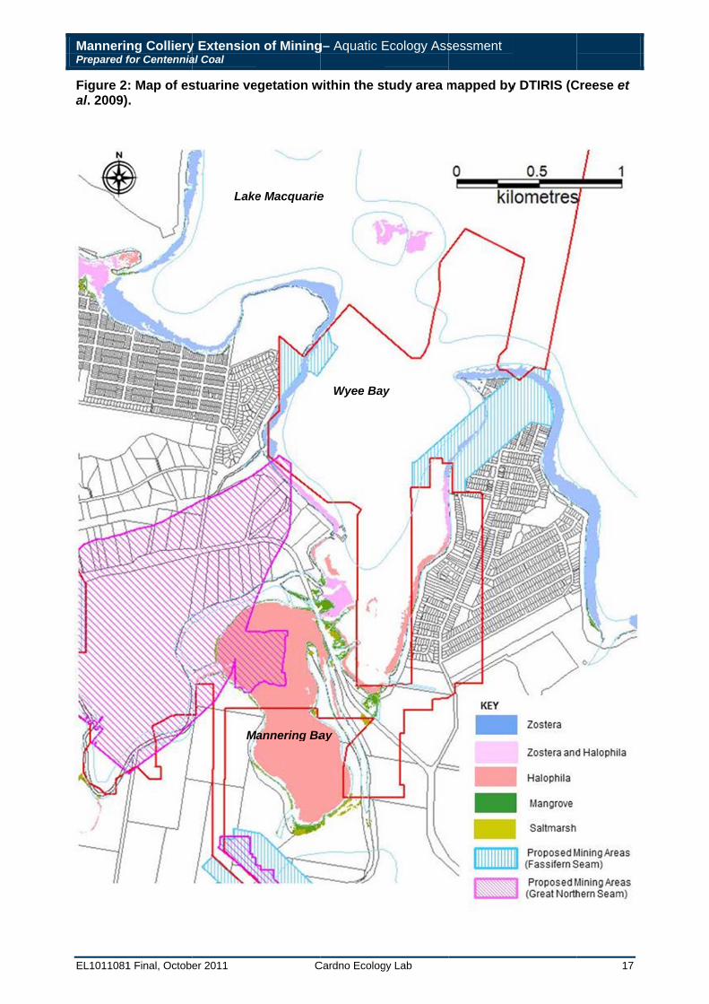
Figure 2: Map of estuarine vegetation within the study area mapped by DTIRIS. ................ 17
Figure 3: State Conservation Areas ..................................................................................... 28
List of Appendices Appendix A: Threatened Species Search Results ................................................................ 41
Appendix B: Threatened Species Assessment (State)…………………………………… 89
Appendix C: Threatened Species Assessment of Significance (Commonwealth) ................ 96
Mannering Colliery Extension of Mining– Aquatic Ecology Assessment Prepared for Centennial Coal
EL1011081 Final, October 2011 Cardno Ecology Lab v
Glossary of Terms and Abbreviations Benthic Living on or in the seabed.
DSEWPaC Department of Sustainability, Environment, Water, Population and Communities (formerly the Department of Environment Water, Heritage and the Arts).
DTIRIS Department of Trade and Investment, Regional Infrastructure and Services.
Ecological Community Populations of species that occur together (often delimited by a geographic boundary).
EP&A Environmental Planning and Assessment Act.
Estuarine Habitat lying at the interface between freshwater and marine environments; usually the mouths of streams and rivers.
FM Act Fisheries Management Act.
Habitat Any area occupied, or periodically or occasionally occupied, by fish or marine vegetation (or both), and includes any biotic or abiotic component.
Intertidal The portion of shoreline between low and high tide marks, that is intermittently submerged.
Invasive Marine Pests Organisms (usually transported by humans) which successfully establish themselves and then overcome otherwise intact, pre-existing native ecosystems.
Macroalgae Large aquatic photosynthetic plants that can be seen without the aid of a microscope.
Macrobenthos The collection of organisms attached to or resting on the bottom sediments (i.e. epifauna) and those which burrow into the sediments (i.e. infauna).
Macrofauna Organisms associated with sediment and retained in a sieve of 1.0 millimetres.
Microalgae Unicellular, microscopic algae (less than 0.062 millimetres) that occur on the seabed.
NP&W Act National Parks and Wildlife Act.
OEH Office of Environment and Heritage (formerly the Department of Environment and Climate Change).
Population Any collection of potentially interbreeding organisms in a given area.
SCA State Conservation Area
Threatened Species
Species listed under NSW or Commonwealth legislation as endangered or vulnerable. For the purpose of this assessment, it also includes species that are listed as ‘protected’ under the FM Act.
Mannering Colliery Extension of Mining– Aquatic Ecology Assessment Prepared for Centennial Coal
EL1011081 Final, October 2011 Cardno Ecology Lab 6
1 Introduction Cardno (NSW/ACT) Pty Ltd trading as Cardno Ecology Lab has been commissioned by Centennial Coal Company to undertake an assessment of impacts on aquatic ecology of the proposed extension of mining in the Fassifern and Great Northern coal seams beneath the southern section of Lake Macquarie (Central Coast, NSW).
Mannering Colliery is an underground coal mine which is wholly owned and operated by Centennial Mannering Pty Ltd (Centennial Mannering), a subsidiary of Centennial Coal Company (Centennial). Mannering Colliery is located approximately 40 kilometres south of Newcastle. The Mannering surface facilities (including administration building, workshops and local crushing facility) are located nearby to Vales Point Power Station, 3 kilometres south of Mannering Park. Mannering Colliery is located within the proclaimed mine subsidence districts of West Lake Macquarie and Swansea – north entrance and is within both the Lake Macquarie and Wyong Local Government Areas (LGAs).
Mannering Colliery was granted Project Approval by the then Minister for Planning under Part 3A of the Environmental Planning and Assessment Act 1979 (EP&A Act) on 12 March 2008 to undertake mining in the Fassifern seam by bord and pillar methods, producing up to 1.1 Million tonnes of run of mine (ROM) coal per year.
Mannering Colliery proposes to mine by bord and pillar method in five new areas of the Fassifern Seam and additional areas of the Great Northern Seam as indicated in Figure 1. Centennial Mannering will be seeking a modification to the Mannering Colliery Project Approval (PA 06_0311) for the Extension of Mining Project subject to Section 75W of the EP&A Act.
The combined extraction from the Fassifern and Great Northern Seams will only involve first workings and not exceed the already approved 1.1 Million tonnes of ROM coal per annum or predicted subsidence levels of < 20 millimetres (refer to Seedsman Geotechnics Pty Ltd 2011). The mining method has been designed to provide long-term stability beneath foreshore areas and other natural and man-made features.
No change to surface infrastructure or coal handling is required for the project as production rates will not exceed current capacity and operations will continue within the existing approval limits and controls.
The main issue to be considered in the assessment is the potential for subsidence of the lake bed from subsurface mining to affect estuarine ecosystems. Significant subsidence could destabilise aquatic vegetation and affect estuarine invertebrates and microalgae that live in the upper layers of the lake bed sediments. This aquatic ecology assessment includes:
A review of relevant legislation and policy; A review of existing information on the aquatic habitats, biota and fisheries of south-western
Lake Macquarie Assessment of threatened species, populations and communities present within or adjacent
to the proposed extension of mining. Assessment of impacts of the proposed extension of mining, including cumulative impacts,
of the proposed Project on estuarine habitats, threatened and protected species, populations and ecological communities; and
Identification of appropriate mitigation and/or monitoring as appropriate.
MannerinPrepared f
EL1011081
Figure 1
ng Collieryfor Centennia
1 Final, Octobe
: Mannerin
y Extensional Coal
er 2011
ng Colliery
n of Mining
C
Project Ap
g– Aquatic E
Cardno Ecolog
pplication A
Ecology Ass
gy Lab
Areas.
sessment
7
Mannering Colliery Extension of Mining– Aquatic Ecology Assessment Prepared for Centennial Coal
EL1011081 Final, October 2011 Cardno Ecology Lab 8
2 Relevant Legislation and Policy 2.1 Environment Protection and Biodiversity Conservation Act 1999
(EPBC Act) The EPBC Act is administered by the Commonwealth Department of Sustainability, Environment, Water, Population and Communities (SEWPaC) and aims to:
Provide for the protection of the environment, especially those aspects of the environment that are matters of national environmental significance (NES);
Promote ecologically sustainable development through the conservation and ecologically sustainable use of natural resources;
Promote the conservation of biodiversity; and Provide for the protection and conservation of heritage.
In the aquatic environment, the Act lists the following matters of NES relevant to this study:
Nationally threatened species and ecological communities; and Migratory species.
Threatened fauna and flora are listed in any one of the following categories as defined in Section 179 of the EPBC Act as:
Extinct; Extinct in the wild; Critically endangered; Endangered; Vulnerable; or Conservation dependent.
Species listed as ‘extinct’ or ‘conservation dependent’ are not considered matters of NES (protected matters). Under the EPBC Act any action that has, will have, or is likely to have a significant impact on a matter of NES is required to undergo an assessment and approvals process. Matters of NES cover a range of issues including Ramsar wetlands and migratory species listed under international treaties such as the Australian agreements with Japan (JAMBA), China (CAMBA), Republic of Korea (ROKAMBA), for migratory birds and the Bonn Convention.
2.2 Environmental Planning and Assessment Act 1979 (EP&A Act) The EP&A Act provides a framework for environmental planning in NSW and includes provisions to ensure that proposals with the potential to significantly affect the environment are subject to detailed assessment. The EP&A Act details various planning instruments including State Environmental Planning Policies and Local Environment Plans and specifies which types of developments require development consent.
The objectives of this Act include:
The proper management, development and conservation of natural and artificial resources, including agricultural land, natural areas, forests, minerals, water, cities, towns and villages for the purpose of promoting the social and economic welfare of the community and a better environment;
The protection of the environment, including the protection and conservation of native animals and plants, including threatened species, populations and ecological communities, and their habitats; and
Promoting ecologically sustainable development.
Mannering Colliery Extension of Mining– Aquatic Ecology Assessment Prepared for Centennial Coal
EL1011081 Final, October 2011 Cardno Ecology Lab 9
2.3 Threatened Species Conservation Act 1995 (TSC Act) In NSW, the TSC Act, administered through the Office of Environment and Heritage (OEH) includes provisions to declare and protect threatened species, populations and ecological communities. Species populations and communities identified as ‘endangered’ ‘critically endangered’ and ‘vulnerable’ are listed in Schedules 1, 1A and 2 of the TSC Act, respectively. The TSC Act also lists ‘key threatening processes’ that may threaten the survival of those species, populations and ecological communities. Marine birds, mammals and reptiles are included in schedules of the TSC Act. In addition, the TSC Act provides for the identification of habitat that is critical to the survival of an endangered species, population or ecological community.
2.4 Fisheries Management Act 1994 (FM Act) Provisions for the protection of fish and marine plants are administered through the NSW Department of Primary Industries (DPI) under the FM Act. Threatened species populations and communities identified as ‘endangered’ ‘critically endangered’ and ‘vulnerable’ are listed in Schedules 4, 4A and 5 of the FM Act, respectively. The FM Act also lists ‘key threatening processes’ that may threaten the survival of those species, populations and ecological communities. Part 2 (19) of the FM Act allows for the declaration of ‘protected species’, which, though not currently declining, must be protected, so they do not become threatened in future. Provisions for the protection of aquatic habitats and aquatic reserves (administered by OEH) are included under Part 7 of the FM Act. In addition, Division 3 Part 7A of the FM Act provides for the identification of habitat that is critical to the survival of an endangered species, population or ecological community.
2.5 National Parks and Wildlife Act 1974 (NPW Act) and the National Parks and Wildlife Regulation 2002 (NPWR).
Under the NP&W Act, the Director-General of the National Parks and Wildlife Service is responsible for the care, control and management of all national parks, historic sites, nature reserves, reserves, Aboriginal areas and State game reserves. State conservation areas, karst conservation reserves and regional parks are also administered under the Act. The Director-General is also responsible under this legislation for the protection and care of native fauna and flora, and Aboriginal places and objects throughout NSW. The National Parks and Wildlife Regulation which came into effect on 1 September 2002, governs various activities under the NP&W Act, including:
The regulation of the use of national parks and other areas administered by the NPWS (Part 2);
The preservation of public health in Kosciuszko National Park (Part 3); Licences and certificates (Part 4); The protection of fauna (Part 5) including the protection of certain types of marine mammals
(Division 3A); The exemption of Aboriginal people from the restrictions imposed by various sections of the
Act on the hunting of certain animals and the gathering of certain plants (Part 6); Boards of management and plans of management in relation to Aboriginal land (Part 7); and Advisory committees constituted under section 24 of the NP&W Act (Part 8).
2.6 Coastal Protection Act 1979 The objectives of this Act include:
To protect, enhance, maintain and restore the environment of the coastal region, its associated ecosystems, ecological processes, biological diversity and water quality;
To encourage, promote and secure the orderly and balanced utilisation and conservation of the coastal region and its natural and man-made resources, having regard to the principles of ecologically sustainable development; and
Mannering Colliery Extension of Mining– Aquatic Ecology Assessment Prepared for Centennial Coal
EL1011081 Final, October 2011 Cardno Ecology Lab 10
To recognise and foster the significant social and economic benefits to the State that result from a sustainable coastal environment, including:
o Benefits to the environment; and o Benefits to urban communities, fisheries, industry and recreation.
2.7 NSW Policy for the Conservation of Fish, Marine Vegetation and Aquatic Habitats
The following general policies are identified in the ‘Policy and Guidelines for Aquatic Habitat Management and Fish Conservation’ (quoted from Smith and Pollard 1999):
a) Fish and their aquatic habitats are important natural resources and impacts on these resources must be assessed in all development and planning procedures, using a precautionary approach.
b) Aquatic habitats must be protected when the habitat is important to maintain biodiversity at the ecosystem, species or genetic levels or is required to maintain harvestable fish populations.
c) Habitats of protected or threatened fish must be afforded special protection.
d) Protected areas (such as Aquatic Reserves and Marine Parks) and critical fish habitats should be given priority in the consideration of development of plans, in assessing the impacts of developments, and in determining applications.
e) Terrestrial areas adjoining freshwater, estuarine and coastal habitats should be carefully managed in order to minimise land-use impacts on these aquatic habitats. As a precautionary approach, foreshore buffer zones at least 50 metres wide should be established and maintained, with their natural features and vegetation preserved. Such buffer zones may need to be fenced or marked by signs. The width of these buffer zones may need to be increased to 100 metres or more where they are adjacent to ecologically sensitive areas.
f) Pollution of waterways should be avoided by:
Identification of point-source and diffuse pollutant discharges; Prevention or minimisation of such discharges; Effective treatment of any continuing discharges; Disposal of wastes to alternative land sites, or to processing facilities.
g) Free passage should be maintained for migratory fish species. Unlicensed barriers should be removed or fish passage facilities installed.
h) Alien, exotic or introduced fish species should not be released into any waterway without the approval of NSW Fisheries.
i) Where developments or activities are likely to affect fish or fish habitats, NSW Fisheries needs to be provided with sufficient information to assess their impacts, including: contact details, type, purpose and time of activity, location (map and photographs), habitat type and area affected, monitoring and proposed environmental compensation.
j) Environmental compensation needs to be integrated into the planning process. Where, despite mitigation, a significant environmental impact is unavoidable, environmental compensation should be provided. This would normally require the creation of new habitat (of the type lost) and on a 2:1 basis to account for the indirect as well as the direct impacts of development.
k) Degraded aquatic habitats should be rehabilitated, wherever possible, to repair past environmental damage.
l) Environmental monitoring is needed to determine if the assessment of the environmental impacts of a development were accurate. Monitoring needs to be undertaken in a scientifically rigorous manner, with impact and multiple control sites, surveys over time and statistical analyses. As a general rule, a change of 20 % in a biological indicator (e.g. abundance,
Mannering Colliery Extension of Mining– Aquatic Ecology Assessment Prepared for Centennial Coal
EL1011081 Final, October 2011 Cardno Ecology Lab 11
richness, biomass) one year after the impact should be regarded as a major impact and require environmental compensation.
Mannering Colliery Extension of Mining– Aquatic Ecology Assessment Prepared for Centennial Coal
EL1011081 Final, October 2011 Cardno Ecology Lab 12
3 Existing Information 3.1 Regional Context Lake Macquarie is located 15 kilometres south of Newcastle and 150 kilometres north of Sydney. It is the largest coastal lake in New South Wales, with an open water area of 115.1 square kilometres and a perimeter of 196.15 kilometres (OzCoasts 2010). The overall condition of the lake is scored as ‘very good’ according to the NSW State of the Catchments Draft Technical Report (NSW Department of Planning 2008), this is based on seven indicators; Chlorophyll a and turbidity, area of macroalgae, seagrass and mangrove and the estuarine fish community index. The lake is also used for a wide range of recreational activities such as recreational fishing, boating, water-skiing and bathing. There are approximately 2149 berths for vessels and four ramps within the estuary (OzCoasts 2010). Many camping and caravan reserves provide holiday and semi-permanent accommodation for visitors to the area.
The catchment at the northern end of the lake is industrialised and urbanised with a lead–zinc smelter, steel foundry, fertilizer plant, collieries and a number of sewage outflows. The focus of this study, however, is on the south west part of the lake which includes the area south west of a line drawn between Bird Cage Point and Black Ned’s Point (Figure 1). This area is less developed with extensive bushland, although there are collieries, the Vales Point Power Station and residential development at Mannering Park and Wyee Point. A significant part of the foreshore has been designated as part of the Lake Macquarie State Conservation Area.
An environmental management plan has been development for the Lake Macquarie estuary (Syme et al. 1997) and identifies a number of issues which are being addressed. This includes measures to reduce high pollutant loads entering the estuary (including metal contaminants), erosion and sedimentation control, managing damage to seagrass beds from moorings and addressing declining recreational catch rates and conflict between excessive seagrass growth and navigation/recreational uses.
3.2 Physical Environment Lake Macquarie is a wave-dominated estuary, which means the estuary has a high sediment trapping efficiency, naturally low turbidity and salt wedge/partially mixed circulation where there is likely to be sedimentation.
The total catchment area is 786 square kilometres (OzCoasts 2010) and falls under the jurisdiction of the Hunter-Central Rivers Catchment Management Authority (CMA). The estuary is 24 kilometres long, from north to south and 3.2 kilometres at its widest point from east to west.
The lake bed is generally flat, averaging seven metres in depth but is deeper (approximately 11 metres) off Pulbah Island. Depth within the study area does not generally exceed five metres apart from the main channel between Bluff Point and Black Ned’s Point where maximum depth is approximately 10 metres. Mannering Bay and the southern part of Wyee Bay does not exceed two metres depth.
Swansea Channel, a tidal inlet of approximately 4 kilometres in length, connects the lake to the ocean. Tidal ventilation through Swansea Channel is restricted; for a spring tidal range of 1.25 metres at the entrance, the associated range within the lake is approximately 0.06 metres. The mean lake level is typically super-elevated 0.07 metres above mean sea level. It has been estimated that only 1 % of the lake volume exchanges with ocean waters during an average tidal cycle (OzCoasts 2010).
The water quality within Lake Macquarie is affected by surface run-off and point source discharges. Water quality has been monitored in Lake Macquarie since 1983 by the Hunter Water Corporation and results of this monitoring are summarised in Syme et al. (1997) as part
Mannering Colliery Extension of Mining– Aquatic Ecology Assessment Prepared for Centennial Coal
EL1011081 Final, October 2011 Cardno Ecology Lab 13
of the Lake Macquarie Estuary Management Study. Urban run-off was considered to be the largest influence to water quality as it contributed to a significant proportion of nutrient input and sediment nutrient release rate. Construction sites and urban development were also considered to contribute to large sediment loads, siltation and turbidity. Sewage, powerboat engines and sedimentation caused from erosion also contributed to decreased water quality.
Water temperatures within Lake Macquarie are typical of temperate NSW estuaries although the temperatures of embayments receiving discharges from the major power stations at the southern periphery have been shown to be higher than elsewhere in the estuary by 0.5 – 1.0°C (WBM 1996). Mean annual salinity is between 32 – 34 parts per thousand (ppt). Mean annual pH ranges between 8.1 and 8.4, typical of temperate estuarine water bodies. Dissolved oxygen (DO) levels are found to be typical at full saturation (WBM 1996).
3.3 Flora and Fauna
3.3.1 Estuarine Vegetation
3.3.1.1 Seagrasses Seagrass beds often support a rich variety of animals and algae and act as sources of food (mainly indirectly via epiphytes and detritus) and provide shelter for numerous species (Keough and Jenkins 1995 in Creese et al. 2009). They also baffle water currents, causing them to release their sediment loads, thus maintaining water quality (Smith and Pollard 1999) and help prevent erosion by stabilising sediments and assisting in the removal of nutrients from the water (Smith et al.1997). Loss of seagrass can result in the destabilisation of sediments, removal of potential nursery habitats for fishes and a decrease in primary productivity of estuaries. Some water birds, for example black swans and some herbivorous fish, feed on the algal epiphytes of seagrasses. Many organisms also benefit from the organic matter released by the slow bacterial and fungal breakdown of seagrass detritus.
Depending on the species of seagrass, recovery of beds from disturbances can be slow. For all these reasons, seagrass beds are seen as critically important biogenic habitats in estuaries and consequently their distribution patterns and changes in their size over time have been documented as a means of monitoring the ecological health of estuaries (Williams et al. 2007, Roper et al. 2009).
Seagrass maps for the whole of Lake Macquarie were produced by DPI, in response to targets set by the NSW Natural Resource Commission to improve the condition of estuaries and coastal lake ecosystems by 2015. These maps have been overlayed onto a map of the existing and proposed mining areas and are used as the basis for the current assessment (Figure 2).
In Lake Macquarie, the majority of the foreshore area is fringed by seagrass beds with four species occurring; eel grass (Zostera capricorni), paddle weed (Halophila ovalis), Ruppia sp. and strapweed (Posidonia australis). Zostera fringes the majority of the study area with the exception of Mannering Bay and the southern part of Wyee Bay which is dominated by Halophila ovalis. Fringing sections of Wyee Bay and shallow inlets in the western part of the study area are composed of mixed beds of Zostera and Halophila. The distribution of seagrass beds within the study area is generally limited to within the two metre depth contours (Figure 2). Gray and Nankivell (2007) also mapped seagrass distribution and condition within the study area using transects. The distribution as mapped by Gray and Nankivell (2007) is generally consistent with that of DPI, although in some areas Halophila ovalis is more widespread. For example along the eastern side of Chain Valley Bay, a fringing patch of Halophila occurs landward of Zostera beds. Similarly, mixed beds of Zostera and Halophila extend northwards along the eastern shore of Wyee Bay beyond that indicated on DPI maps. Zostera also appears to occur within the southern part of Mannering Bay where only Halophila had previously been mapped. The condition of seagrass within the study area was also described in terms of density (i.e. percentage cover) and patchiness (i.e. whether there are individual strands or clumps or continuous beds of relatively even distribution). This is described by Gray and Nankivell (2007), anti-clockwise from Duck Hole Creek around to Chain Valley Bay:
Mannering Colliery Extension of Mining– Aquatic Ecology Assessment Prepared for Centennial Coal
EL1011081 Final, October 2011 Cardno Ecology Lab 14
Uniform beds of medium density (15 – 50 % cover) Zostera dominated the shoreline from Duck Hole Creek south where it was then replaced by patchy beds of mixed Zostera and Halophila into the small embayment within the southwest corner of the Bay. The eastern shoreline of Wyee Point had patchy mixed beds of sparse to dense Halophila and Zostera. Sparse Halophila grew in a thin monospecific bed on the outer edge of this bed.
The southern part of Wyee Bay was dominated by moderate to dense Halophila which grew as monospecific beds along the south and the east shores and as mixed beds with moderate to dense Zostera along the western shoreline of the bay. Halophila was thickest along the southmost and eastern shorelines of Wyee Bay. Further north towards Vales Point, the monospecific beds of Halophila narrowed considerably. Mannering Bay was dominated by mixed beds of sparse to medium density Zostera and sparse to moderate Halophila with monospecific beds of Halophila along the southern shoreline. The western shore of Chain Valley Bay consisted of monospecific Zostera beds of varying density and consisting of patches greater than 10 m diameter or continuous beds. The eastern shore was generally dominated by Zostera but had mixed patches of Zostera and Halophila and monospecific beds of Halophila.
In general, seagrass communities in Lake Macquarie appear to have declined since the earliest survey in 1953 (King and Barclay 1986). Wood (1959) estimated the area of seagrass at 25.48 square kilometres, whereas surveys conducted in the 1980s calculated the total areas to be 13.39 square kilometres (West et al. 1985) and 14.17 square kilometres (King and Barclay 1986) respectively. Researchers attributed this decrease to a rise in turbidity caused by human activity (King and Hodgson 1986). However, from 2000–2004, there has been a general increase in the cover of seagrasses in Lake Macquarie, believed to be due to a reduction in light penetration following a period of lower freshwater inputs. According to Creese et al. (2009) the total area of seagrass in Lake Macquarie was 15.311 square kilometres. This is the third largest estuarine seagrass area in NSW (OzCoasts 2010).
The overall degree of change in the distribution and extent of seagrass beds is difficult to assess as seagrasses exhibit a high degree of natural seasonal variation and there may also be differences in sampling methodology during different surveys. King and Hodgson (1986) found that winter seagrass biomass is usually significantly greater than summer biomass therefore some surveys could relate to seasonal change rather than long term changes.
WBM (1996) and Australian Water and Coastal Studies (1995) identified a number of potential threats to seagrass within Lake Macquarie which included:
Scouring from swing moorings; Physical damage from jetskis and boating; Smothering from high sedimentation; Nutrient enrichment; Haul netting; Thermal discharges; and Shading from foreshore development (e.g. pontoon, jetties etc.).
CSIRO (2007) assessed the changes in the percent cover of seagrass in Wyee Bay between 1980 and 2007 in relation to the likely changes by the Vales Point Power Station cooling water discharge on behalf of Connell Wagner. Data collected in 2007 indicated that the percent cover of Zostera was generally higher in the shallow inshore areas of Wyee Bay and lower in deeper water. Analysis of a long-term monitoring database indicated that the cooling water plume released from the power station had several effects on seagrasses within Wyee Bay such as:
Replacement of the Zostera in the southern areas of Wyee Bay by the more thermally tolerant Halophila; and
Increased area and percent cover of Zostera following the management of cooling water and ash dam discharges and the diversion of direct urban sewage discharges in 1994.
Mannering Colliery Extension of Mining– Aquatic Ecology Assessment Prepared for Centennial Coal
EL1011081 Final, October 2011 Cardno Ecology Lab 15
Effects of the Vales Point Power Station cooling water plume were considered to have moderate effects on seagrass beds within Wyee Bay when the effects of siltation from the catchment were also taken into account.
All of the above mentioned issues may therefore have a cumulative impact on the seagrass assemblage and distribution within the study area in addition to natural patterns in variation and requires consideration when attempting to design an appropriate monitoring program.
Seagrasses are protected in NSW and a permit is required from DPI to undertake works or activities that may harm them. Populations of Posidonia australis that occur in Lake Macquarie are listed as ‘endangered’ under Schedule 4 of the FM Act. Although Posidonia australis does occur within Lake Macquarie, it has not been mapped within the study area.
3.3.1.2 Mangrove The term ‘mangrove’ is a description of an estuarine habitat but also refers to the trees that grow in these habitats. Mangrove trees are just like ordinary trees, with roots, stems and leaves, but they have adapted to live in saltwater. They live in soft muddy sediments in more sheltered areas. As mud is generally low in oxygen, the roots of the mangrove trees are quite shallow and close to surface oxygen. This also means that the root system must be extensive to prove a stable base for the tree (Chapman and Underwood 1995). Large numbers of mangrove trees often occur together and are described as mangrove forests.
Mangroves grow along the shores of most NSW estuaries, with the general exception of those that are intermittently opened and closed (West et al. 1985). Mangroves often occur seaward of saltmarshes and are subject to regular tidal inundation. As well as stabilising shorelines, mangroves are thought to contribute significantly to estuarine productivity, trap sediment and pollutants (Burchmore et al. 1993) and provide important habitat for many species of invertebrates and juvenile fish and (Smith and Pollard 1999). Mangroves also provide shelter and roosting habitat for birds, some small mammals and reptiles.
NSW mangrove forests consist of only two species, river mangrove (Aegiceras corniculatum) and grey mangrove (Avicennia marina), although A. marina is most commonly found in Lake Macquarie. Mangroves are found in areas throughout Lake Macquarie with a significant area within Swansea channel. A total mangrove area of 1.130 square kilometres has been recorded within Lake Macquarie (Creese et al. 2009).
Mangroves have been mapped fringing the shallow inlets in the western part of the study area, the southernmost part of Chain Valley Bay, around Mannering Bay and within the south western part of Wyee Bay (Figure 2). These areas are characterised by shallow, intertidal, muddy soft sediment environments. Like seagrasses mangroves are also protected under the FM Act.
3.3.1.3 Saltmarsh Saltmarshes are estuarine habitats that occur high on the shore, typically just above the mean high water mark. Saltmarshes are often found behind, or close to mangrove forests and occur in soft, water-logged sediments. Saltmarsh habitats consist of small succulent plants, grasses, rushes, sedges and herbaceous plants; including Baumea juncea, Juncus krausii, Sarcocornia quinqueflora, Sporobolus virginicus and Suaeda australis (Morrisey 1995). Like mangroves, saltmarshes are believed to have important physical and biological functions in estuarine ecosystems. Because of their close proximity to the land, saltmarshes are often threatened by human development and it has been estimated that approximately 50 % of the saltmarshes of NSW have been destroyed since 1788 (Morrisey 1995). Estuarine saltmarsh found within Lake Macquarie consists of the herbs Sarcocornia quinqueflora, Quinqueflora sp., Einadia hastata, Salmolus repens and Suaeda australis, and the grasses Zoysia macrantha and Sporobulus virginicus. Creese et al. 2009 recorded a total saltmarsh area of 0.752 square kilometres in Lake Macquarie.
The value of saltmarsh communities and the threat they are under has recently been recognised, resulting in the declaration of coastal saltmarsh communities as an Endangered
Mannering Colliery Extension of Mining– Aquatic Ecology Assessment Prepared for Centennial Coal
EL1011081 Final, October 2011 Cardno Ecology Lab 16
Ecological Community under the TSC Act. Reclamation of estuarine foreshores and the introduction of invasive species are considered to be major threats to saltmarsh.
Saltmarsh cover within the study area is fragmented and limited to the southern part of Chain Valley Bay, the southern shore of Mannering Bay and the southern part of Wyee Bay (Figure 2).
MannerinPrepared f
EL1011081
Figure 2al. 2009)
ng Collieryfor Centennia
1 Final, Octobe
: Map of es.
y Extensional Coal
er 2011
stuarine ve
Lake
M
n of Mining
C
egetation w
e Macquarie
Mannering Ba
g– Aquatic E
Cardno Ecolog
within the s
Wyee Bay
e
ay
Ecology Ass
gy Lab
tudy area m
y
sessment
mapped byy DTIRIS (C
17
Creese et
Mannering Colliery Extension of Mining– Aquatic Ecology Assessment Prepared for Centennial Coal
EL1011081 Final, October 2011 Cardno Ecology Lab 18
3.3.1.4 Macroalgae Macroalgae are true photosynthetic organisms which grow in the photic zone of coastal regions where light penetrates sufficiently for photosynthesis to occur. In clear waters, macroalgae can survive and grow at depths of over 200 metres, but in turbid waters this may be reduced to only a few metres (Millar 2011). Macroalgae are an important resource as food and/or shelter for a large range of fish and invertebrates and may act as a nursery habitat for juvenile fish. Certain species respond to increases in nutrients and for that reason can be an indicator of water quality. Under certain conditions macroalgae can bloom in large quantities although have not been found to be toxic. Macroalgae can be damaged directly by boating related activities, dredging, reclamation and foreshore development. The diversity and distribution of macroalgae is generally influenced by:
Seabed morphology and topography; Nutrient upwelling; Tidal flushing (in relation to Intermittently Closed and Open Lakes and Lagoons); Natural weather events; The introduction of introduced or pest species.
Gray and Nankivell (2007) recorded several species of macroalgae within the study area from Bluff Point, around to Chain Valley Bay. These included Brown algae (Cystoseira trinodis and Sargassum sp.), which was common on the rocky shores around the point. Red algae (Corallina officinalis, Gracilaria perplexa and Hypnea spp.) were also present on these rocky shores. Green algae (Microdictyon umbilicatum), was also abundant forming patches between areas of seagrass. Cystoseira trinodis and Gracilaria spp. were present along the eastern shoreline of Wyee Bay. Red algae (Gracilaria secundata and Hypnea spp.) were abundant between patches of seagrass at the entrance to Mannering Bay and Chaetomorpha sp. and Hinksia mitchellae present in small patches within Mannering Bay. Chaetomorpha sp., Hypnea sp and Gracilaria spp. were prolific in southern parts of Wyee Bay. Gracilaria spp. Hinksia michellae Chaetomorpha sp. and Codium spp. were occasionally present along the northern shoreline of Vales Point. Brown alga (Cystoseira trinodis), red algae (Hypnea spp. and Gracilaria perplexa) and green algae (Codium fragile, Codium spongiosum and Ulva rigida) were present within Chain Valley Bay along the shoreline south of Black Ned’s Point. Macroalgae is also protected under the FM Act.
3.3.2 Benthic Assemblages
3.3.2.1 Microalgae Benthic microalgae are primary producers that use light penetrating the water column to grow and reproduce. Microalgae are generally less than 0.062 millimetres and invisible to the naked eye. They occur attached to sediment particles or in spaces among particles and may be found in numbers of up to 4x10⁸ photosynthetic protists per 1cm2 x 10 cm deep (Fenchel 1992). Microalgae are an important food source for other micro and macrobenthic organisms such as molluscs, worms and small crustaceans such as amphipods. The latter are important food sources for fish and larger mobile invertebrates such as prawns. Benthic microalgae also oxygenate the upper sediment layers, which may enhance nutrient cycling (Caffrey and Kemp 1990, Christensen et al. 1990, Eyre and Ferguson 2002). Microalgae require light to grow and therefore reduced light penetration associated with increased water depth may affect distribution and primary production and have implications for consumers higher up the food chain.
3.3.2.2 Macrobenthos ‘Macrobenthos’ is a term used to collectively describe macroinvertebrates and the benthic sediments in which they live. The most comprehensive study of macrobenthic communities of Lake Macquarie was conducted by MacIntyre (1959) between 1953 and 1956 (AWACS 1995). 400 sampling sites within Lake Macquarie were analysed. MacIntyre divided the bed into three zones: seagrass beds (occupying 23.5 % in 1956), mud slopes around the lake perimeter (16
Mannering Colliery Extension of Mining– Aquatic Ecology Assessment Prepared for Centennial Coal
EL1011081 Final, October 2011 Cardno Ecology Lab 19
%) and mud basins (60.5 %). Following this study, sampling was carried out between July 1977 and September 1979 by Robinson (unpublished). The groups of invertebrates found in association with different habitat types, including seagrasses were presented. The most numerically dominant species found in association with seagrass beds were (in order of dominance) the bivalve Anadara trapezia, the gastropod Velacumantus australis, the polychaete worm Notomastus torquatus, the gastropod Nassarius burchardi and the bivalve Trichomya hirsuta. In comparison with MacIntyre’s earlier studies, Robinson found there had been a general shift in the distribution of a large number of filter feeding bivalves from the ‘slope’ zone into the seagrass zone such that the dominant species in the slope zone had been replaced by polychaete worms. The fauna found in the ‘mud zone’ of the Lake appeared to have remained relatively constant and where the polychaete fauna had remained depauperate over the long term.
The Ecology Lab (1991) undertook a study to describe the benthic communities in the vicinity of ash-dam discharge outlets in Lake Macquarie. Within this study, Lake Petite (just north of the study area), was sampled as a control location. The most common taxa found were polychaetes (Opheliidae and Spionidae), along with dead bivalves (Tellinidae) and mud whelks (Batillariidae). The Ecology Lab (2008) also undertook a baseline survey of benthic assemblages using a ponar grab at Bardens Bay (north – eastern area of Lake Macquarie) where a total of 24 samples were collected. A relatively diverse assemblage of invertebrates were recorded, including 17 different families of polychaete worms (dominated by cirratulids, capitellids and magelonids), nine families of crustaceans including amphipods, tanaids, cumaceans, decapods and copepods and 14 families of gastropod and bivalve molluscs. The diversity and abundance of species found in these surveys would be fairly typical of that expected in a temperate NSW estuary.
3.3.3 Fisheries Resources Approximately 232 species of fish have been recorded in Lake Macquarie (Lake Macquarie City Council 2006a) from various different surveys. Abundant fish populations were observed in the vicinity of seagrass beds during baseline investigations conducted near Bardens Bay (The Ecology Lab 2008). Species of fish observed included yellowfin bream (Acanthopagrus australis), luderick (Girella tricuspidata), whiting (Sillago sp.) and mullet (Family Mugilidae). Many small juveniles of these and other species were observed associated with the seagrass beds. Syngnathids (i.e. pipefish and seahorses) commonly occur within seagrass beds and may be permanent residents all year round whereas many fish species only spend a small part of their life-history, often juvenile stages within the shelter of the seagrass beds. Swansea channel harbours a large number of different species of fish due to the diverse habitat it provides including weed beds, rocky reefs, soft substratum and artificial structure.
After many years of public discussion and consultation with various interest groups, commercial fishing ended in Lake Macquarie on 1 May 2002, with the lake being declared a Recreational Fishing Haven (Steffe et al. 2005). The commercial fishing annual catch in 2001 was approximately 300 tonnes.
DPI undertook two daytime recreational fishing surveys within Lake Macquarie, one before the Recreational Fishing Haven zoning (pre-RFH) between March 1999 and February 2000 and one survey after (post-RFH) between December 2003 and November 2004 (Steffe et al. 2005). The two recreational fishing surveys provide evidence of a relatively productive recreational fishery in Lake Macquarie and indicated that the post-RFH recreational fishery was very different to that prior to the implementation of the RFH. The recreational harvest of dusky flathead (Platycephalus fuscus), tailor (Pomatomus saltatrix), sand whiting (Sillago cilliata), trumpeter whiting (Sillago maculata) and large-toothed flounder (Pseudorhombus arsius) had increased significantly in abundance and weight during the post-RFH survey year. The recreational harvest of common squid (Loligo sp.), yellow-finned leatherjacket (Meuschenia trachylepis) and sand mullet (Myxus elongatus), however, had decreased significantly during the post-RFH survey year by number and weight.
Mannering Colliery Extension of Mining– Aquatic Ecology Assessment Prepared for Centennial Coal
EL1011081 Final, October 2011 Cardno Ecology Lab 20
Recreational angling effort in Lake Macquarie was lower in winter and spring compared to that of summer and autumn and overall was greatest in the northern part of the lake where greater angling effort occurs from boats (Virgona 1983). As Lake Macquarie has little tidal movement, there are few places where fish naturally gather on the tides to feed (Ross 1995). For this reason, the fast flowing Swansea Channel is a popular recreational fishing location. The fish caught by recreational fishers in Lake Macquarie are similar to other estuaries in NSW and are dominated by eight species (NSW DPI 2001). These are yellowfin bream (Acanthopagrus auratus) dusky flathead (Platycephalus fuscus), luderick (Girella tricuspidata), snapper (Pagrus auratus), tailor (Pomatomus saltatrix), tarwhine (Rhabdosargus sarba), whiting (Sillaginidae) and leatherjackets (Monacanthidae). The first four species have life-history stages generally dependent on estuaries for all their main ecological requirements, whereas the latter four species are dependent on estuarine habitats as juveniles only. All species are likely to occur in association with seagrass beds and subtidal macroalgae.
3.3.4 Threatened and Protected Species, Populations and Ecological Communities
3.3.4.1 Database Searches For the purposes of this assessment, ‘threatened species’ refers to any estuarine or coastal species, populations or ecological communities and their habitats as defined and listed under Schedules 4 or 5 of the FM Act, Schedules 1 or 2 of the TSC Act, or Subdivisions C or D of the EPBC Act. This assessment also includes any species of fish listed as protected under the FM Act.
In order to assess the potential impacts of the proposal on threatened and protected species, relevant State and Commonwealth threatened species databases were searched. Threatened or protected species listed under relevant schedules of the Commonwealth EPBC Act, NSW TSC Act and the FM Act were identified using the following online tools:
EPBC Environmental Reporting Tool (DSEWPAC 2011), Atlas of NSW Wildlife (OEH 2011); and NSW Threatened Species Database.
Searches were carried out in July 2011 for species of marine fish, mammals, reptiles, algae and shorebirds. For searches using the EPBC Environmental Reporting Tool and the Atlas of NSW wildlife, the local government areas of Lake Macquarie and Wyong were identified as the most relevant to the study area. Search results are provided in Appendix A.
These database records were used to produce a comprehensive list of all threatened and protected species, populations and communities that have previously been recorded within the study area.
For the FM Act, TSC Act and EPBC Act to have relevance there must be a likelihood that one or more threatened species occur in or encroach upon the study area which could then be potentially impacted upon by the proposed Project.
Species listed under State legislation that may occur in the study area and have potential to be affected by the proposal were assessed under the NSW Assessment of Significance Guidelines (NSW DPI 2007). Note that species listed as ‘protected’ do not require assessment of significance under State legislation.
As the Commonwealth assessment guidelines accept assessments using the State assessment format, only species that were not already assessed under the NSW Assessment of Significance, were assessed under the EPBC Significant Impact Guidelines 1.1.
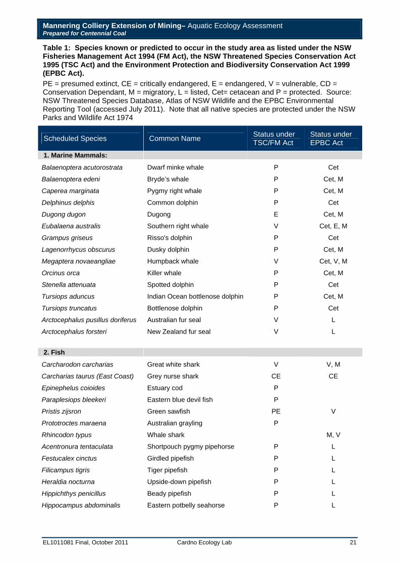
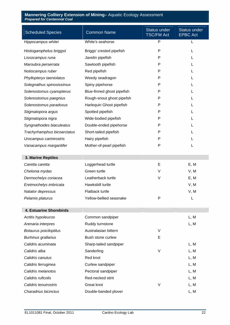
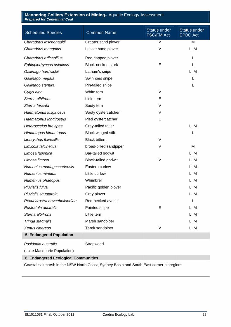
Database searches identified 15 species of marine mammals, 29 species of fish (including 22 species of seahorses and pipefish), 6 species of marine reptiles, 40 species of birds (estuarine shorebirds only), one endangered population (the seagrass, Posidonia australis) and one endangered ecological community listed under the threatened species Schedules that occur within the Lake Macquarie and Wyong LGAs (Table 1).
Mannering Colliery Extension of Mining– Aquatic Ecology Assessment Prepared for Centennial Coal
EL1011081 Final, October 2011 Cardno Ecology Lab 21
Table 1: Species known or predicted to occur in the study area as listed under the NSW Fisheries Management Act 1994 (FM Act), the NSW Threatened Species Conservation Act 1995 (TSC Act) and the Environment Protection and Biodiversity Conservation Act 1999 (EPBC Act). PE = presumed extinct, CE = critically endangered, E = endangered, V = vulnerable, CD = Conservation Dependant, M = migratory, L = listed, Cet= cetacean and P = protected. Source: NSW Threatened Species Database, Atlas of NSW Wildlife and the EPBC Environmental Reporting Tool (accessed July 2011). Note that all native species are protected under the NSW Parks and Wildlife Act 1974
Scheduled Species Common Name Status under TSC/FM Act
Status under EPBC Act
1. Marine Mammals:
Balaenoptera acutorostrata Dwarf minke whale P Cet
Balaenoptera edeni Bryde’s whale P Cet, M
Caperea marginata Pygmy right whale P Cet, M
Delphinus delphis Common dolphin P Cet
Dugong dugon Dugong E Cet, M
Eubalaena australis Southern right whale V Cet, E, M
Grampus griseus Risso's dolphin P Cet
Lagenorrhycus obscurus Dusky dolphin P Cet, M
Megaptera novaeangliae Humpback whale V Cet, V, M
Orcinus orca Killer whale P Cet, M
Stenella attenuata Spotted dolphin P Cet
Tursiops aduncus Indian Ocean bottlenose dolphin P Cet, M
Tursiops truncatus Bottlenose dolphin P Cet
Arctocephalus pusillus doriferus Australian fur seal V L
Arctocephalus forsteri New Zealand fur seal V L
2. Fish
Carcharodon carcharias Great white shark V V, M
Carcharias taurus (East Coast) Grey nurse shark CE CE
Epinephelus coioides Estuary cod P
Paraplesiops bleekeri Eastern blue devil fish P
Pristis zijsron Green sawfish PE V
Prototroctes maraena Australian grayling P
Rhincodon typus Whale shark M, V
Acentronura tentaculata Shortpouch pygmy pipehorse P L
Festucalex cinctus Girdled pipefish P L
Filicampus tigris Tiger pipefish P L
Heraldia nocturna Upside-down pipefish P L
Hippichthys penicillus Beady pipefish P L
Hippocampus abdominalis Eastern potbelly seahorse P L
Mannering Colliery Extension of Mining– Aquatic Ecology Assessment Prepared for Centennial Coal
EL1011081 Final, October 2011 Cardno Ecology Lab 22
Scheduled Species Common Name Status under TSC/FM Act
Status under EPBC Act
Hippocampus whitei White's seahorse P L
Histiogamphelus briggsii Briggs' crested pipefish P L
Lissocampus runa Javelin pipefish P L
Maroubra perserrata Sawtooth pipefish P L
Notiocampus ruber Red pipefish P L
Phyllopteryx taeniolatus Weedy seadragon P L
Solegnathus spinosissimus Spiny pipehorse P L
Solenostomus cyanopterus Blue-finned ghost pipefish P L
Solenostomus paegnius Rough-snout ghost pipefsh P L
Solenostomus paradoxus Harlequin Ghost pipefish P L
Stigmatopora argus Spotted pipefish P L
Stigmatopora nigra Wide-bodied pipefish P L
Syngnathoides biaculeatus Double-ended pipehorse P L
Trachyrhamphus bicoarctatus Short-tailed pipefish P L
Urocampus carinirostris Hairy pipefish P L
Vanacampus margaritifer Mother-of-pearl pipefish P L
3. Marine Reptiles
Caretta caretta Loggerhead turtle E E, M
Chelonia mydas Green turtle V V, M
Dermochelys coriacea Leatherback turtle V E, M
Eretmochelys imbricata Hawksbill turtle V, M
Natator depressus Flatback turtle V, M
Pelamis platurus Yellow-bellied seasnake P L
4. Estuarine Shorebirds
Actitis hypoleucos Common sandpiper L, M
Arenaria interpres Ruddy turnstone L, M
Botaurus poiciloptilus Australasian bittern V
Burhinus grallarius Bush stone curlew E
Calidris acuminata Sharp-tailed sandpiper L, M
Calidris alba Sanderling V L, M
Calidris canutus Red knot L, M
Calidris ferruginea Curlew sandpiper L, M
Calidris melanotos Pectoral sandpiper L, M
Calidris ruficolis Red-necked stint L, M
Calidris tenuirostris Great knot V L, M
Charadrius bicinctus Double-banded plover L, M
Mannering Colliery Extension of Mining– Aquatic Ecology Assessment Prepared for Centennial Coal
EL1011081 Final, October 2011 Cardno Ecology Lab 23
Scheduled Species Common Name Status under TSC/FM Act
Status under EPBC Act
Charadrius leschenaultii Greater sand plover V M
Charadrius mongolus Lesser sand plover V L, M
Charadrius ruficapillus Red-capped plover L
Ephippiorhyncus asiaticus Black-necked stork E L
Gallinago hardwickii Latham's snipe L, M
Gallinago megala Swinhoes snipe L
Gallinago stenura Pin-tailed snipe L
Gygis alba White tern V
Sterna albifrons Little tern E
Sterna fuscata Sooty tern V
Haematopus fuliginosus Sooty oystercatcher V
Haematopus longirostris Pied oystercatcher E
Heteroscelus brevipes Grey-tailed tatler L, M
Himantopus himantopus Black winged stilt L
Ixobrychus flavicollis Black bittern V
Limicola falcinellus broad-billed sandpiper V M
Limosa laponica Bar-tailed godwit L, M
Limosa limosa Black-tailed godwit V L, M
Numenius madagascariensis Eastern curlew L, M
Numenius minutus Little curlew L, M
Numenius phaeopus Whimbrel L, M
Pluvialis fulva Pacific golden plover L, M
Pluvialis squatarola Grey plover L, M
Recurvirostra novaehollandiae Red-necked avocet L
Rostratula australis Painted snipe E L, M
Sterna albifrons Little tern L, M
Tringa stagnalis Marsh sandpiper L, M
Xenus cinereus Terek sandpiper V L, M
5. Endangered Population
Posidonia australis Strapweed
(Lake Macquarie Population)
6. Endangered Ecological Communities
Coastal saltmarsh in the NSW North Coast, Sydney Basin and South East corner bioregions
Mannering Colliery Extension of Mining– Aquatic Ecology Assessment Prepared for Centennial Coal
EL1011081 Final, October 2011 Cardno Ecology Lab 24
Marine Mammals The majority of the marine mammals listed in Table 1 live predominantly offshore or in coastal waters, rarely entering the relatively narrow entrance channel and main basin of Lake Macquarie. Some species, for example southern right whales (Eubalaena australis) and humpback whales (Megaptera novaeangliae), are frequently observed in adjacent coastal waters during their annual migrations along the NSW coast to breeding grounds in warmer waters but would be very unlikely to travel into Lake Macquarie. Furthermore, there are no known resting breeding or calving areas within the region. The New Zealand fur seal (Arctocephalus forsteri) and Australian fur seal (Arctocephalus pusillus doriferus) are known to occasionally frequent adjacent coastal waters to forage and could also forage and/or rest within the estuary on occasion, however, these species have not been recorded within the estuary and would also be unlikely to occur there or take up residence there. The common dolphin (Delphinus delphis) and offshore bottlenose dolphins (Tursiops truncatus) are offshore species and not often sighted close to shore. The Indian Ocean bottlenose dolphin (Tursiops aduncus) is an inshore species that occasionally forage inside estuaries and may occur within the study area. However, no resident populations have been observed in this area and any animals in the vicinity are likely to be transient and therefore unlikely to be either directly or indirectly affected by the minimal level of subsidence predicted in relation to the proposed extension of mining. Any impacts to these species are considered highly unlikely.
Dugongs (Dugong dugon) mainly occur in northern Australia but there is evidence to suggest that they occasionally occur well beyond the southern limit of their accepted range into NSW (Allen et al. 2004). Individuals that have been recorded in NSW are mostly thought to be non-breeding vagrants that are influenced by warm currents and the availability of seagrass further south. They are most commonly found in shallow protected waters where they graze on large amounts of seagrass. The dugong does not breed in NSW, however, habitat and resources within the state remain important to visiting individuals (DECCW 2008). The dugong is threatened by coastal development and poor catchment management leading to siltation and the loss of seagrass beds. Isolated dugong populations are vulnerable to local extinction as a result of losing seagrass beds after stochastic events such as floods or cyclones among other issues. Dugongs have not been recorded within Lake Macquarie itself although there are two records of it occurring in Swansea Channel.
Fish The grey nurse shark (Carcharias taurus) typically occurs on shallow, coastal rocky reefs with sandy gutters within the reef matrix often the preferred microhabitat (Last and Stevens 1994). Although it is probable that grey nurse sharks would enter estuaries to forage on occasion there is no evidence to suggest that they depend on estuarine habitat in particular. Similarly, black cod (Epinephelus daemelii) are mostly found in caves and gutters in coastal areas and adults are highly territorial, usually adopting a cave as a core territory (I&I NSW 2009). Black cod have been observed by divers or caught by anglers in estuaries, however, the locations of these occurrences has generally been at the mouths of estuaries and involved juvenile fish.
The whale shark (Rhincodon typus) has a typically tropical distribution and would rarely occur in NSW waters. The green sawfish (Pristis zijisron) is presumed extinct with the last recorded sighting in NSW over thirty years ago at Yamba (northern NSW) and the species is therefore very unlikely to occur within the study area.
Great white sharks (Carcharodon carcharias) occur from cold temperate to tropical waters and generally frequent coastal waters, often close to shore. They also swim into bays and estuaries. The sharks do not appear to frequent specific habitats, although they may take up residence adjacent to rocky shores, particularly where seals or sea lions are present. There is no evidence to suggest that great white sharks depend on estuarine habitat in particular, but it is probable that juvenile great white sharks would enter estuaries to forage on occasion (Environment Australia 2002). In the event that any of these species of fish were present within the estuary it would be unlikely that the minimal level of predicted subsidence (< 20 millimetres) and subsequent impact to benthic habitats would pose any significant threat to these species.
Mannering Colliery Extension of Mining– Aquatic Ecology Assessment Prepared for Centennial Coal
EL1011081 Final, October 2011 Cardno Ecology Lab 25
Marine Turtles Most turtle species are predominantly oceanic, particularly the hawksbill turtle (Eretmochelys imbricata), and the leatherback turtle (Dermochelys coriacea), while the flatback turtle (Natator depressus) is a vagrant to NSW waters and typically confined to warmer tropical waters (Environment Australia 2003). Thus, these species are unlikely to be found in Lake Macquarie.
The loggerhead turtle (Caretta caretta) and green turtle (Chelonia mydas) are typical of tropical and subtropical waters of Australia, but are known to frequent the NSW coast and associated estuaries, where they feed or may establish populations near warm water outfalls (Environment Australia 2003). Both species are known to utilise seagrass habitat to forage, and have been recorded within Lake Macquarie. There are 85 records of green turtles occurring within Lake Macquarie and Swansea Channel. Like many marine turtles, these two species have low fertility rates and are under threat from pollution and critical habitat loss among other issues (Environment Australia 2003). Any significant impacts to seagrass habitat as a result of mine subsidence could therefore indirectly affect these species.
Estuarine Shorebirds Of the listed birds, several have been recorded in Lake Macquarie, many of which are also migratory. These include wading birds such as curlews, oystercatchers, plovers, bitterns, godwits and sandpipers and diving birds such as terns. Note that seabirds such as albatross, petrels and shearwaters may occur within the study area on occasion but they have not been included in the assessment as they spend the majority of their lives at sea and it would be very unlikely for them to be affected by the proposed extension of mining. Only species likely to occur in estuarine habitats were therefore considered further in the assessment of significance. This included five species listed as ‘endangered’ and 12 species listed as vulnerable under the TSC Act and 26 listed under the EPBC Act as ‘migratory’. As the potential impacts to estuarine shorebirds are likely to be similar, they have been assessed as a single group.
Estuarine Vegetation Sand spurge (Chamaesyce psammogeton) grows on sand-dunes and exposed headlands in coastal areas. It may occur on the exposed dunes and headlands on the seaward side of the Lake but would be unlikely to occur within the sheltered estuarine environment of the study area.
Ecological Communities Saltmarsh is listed as an endangered ecological community in NSW. Mapping by Creese et al. 2009 indicates that saltmarsh occurs within the study area along the south, south-west foreshore of Wyee Bay, the southern part of Mannering Bay and fringing parts of Chain Valley Bay.
Endangered Populations The seagrass Posidonia australis listed as an endangered population in Lake Macquarie under schedule 4 of the FM Act. Habitat maps of Lake Macquarie produced by I&I NSW (Creese et al. 2009) indicate that Posidonia beds do not occur within the study area.
Protected Species Estuary cod (Epinephelus coioides), giant Queensland grouper (Epinephelus lanceolatus) and 22 species of syngnathiformes (seahorses, seadragons, pipefish, pipehorses and seamoths) are listed as protected under the FM Act. Estuary cod generally occur in more tropical waters although may be found as far south as Sydney. Adults are often associated with rocky reef habitat in the lower reaches of estuaries and would be unlikely to be found within the study area, however, juveniles are more likely to be associated with soft sediments and seagrass beds and could therefore potentially be found in the study area. Seahorses and pipefish regularly occur in seagrass habitat and it is likely that they occur within the study area.
Mannering Colliery Extension of Mining– Aquatic Ecology Assessment Prepared for Centennial Coal
EL1011081 Final, October 2011 Cardno Ecology Lab 26
3.3.4.2 Assessments of Significance Assessments of significance under State and Commonwealth legislation were carried out for species that may occur within the study area and could potentially be affected by the proposed extension of mining activity.
Under the TSC/FM Act this applies to species, populations and communities listed as endangered, critically endangered and vulnerable, but do not apply to ‘protected species’. Under the EPBC Act, this applies to species listed as extinct in the wild, critically endangered, endangered, vulnerable or migratory and also to ecological communities that are endangered or critically endangered. The following species and populations were assessed:
1. Marine mammals
Dugong
2. Reptiles
Loggerhead turtle (Caretta caretta) Green turtle (Chelonia mydas)
3. Estuarine Birds
Common sandpiper (Actitis hypoleucos) Ruddy turnstone (Arenaria interpres) Australasian Bittern (Botaurus poiciloptilus) Bush stone Curlew (Burhinus grallarius) Sharp-tailed sandpiper (Calidris acuminata) Sanderling (Calidris alba) Red knot (Calidris canutus) Curlew sandpiper (Calidris ferruginea) Pectoral sandpiper (Calidris melanotos) Red-necked stint (Calidris ruficollis) Great knot (Calidris tenuirostris) Double-banded plover (Charadrius bicinctus) Greater sand plover (Charadrius leschenaultia) Lesser sand plover (Charadrius mongolus) Red-capped plover (Charadrius ruficapillus) Black-necked stork (Ephippiorhyncus asiaticus) Latham's snipe (Gallinago hardwickii) Swinhoe's snipe (Gallinago megala) Pin-tailed snipe (Gallinago stenura) White tern (Gygis alba) Little tern (Sterna albifrons) Sooty tern (Sterna fuscata) Sooty oystercatcher (Haematopus fuliginosus) Pied oystercatcher (Haematopus longirostris) Grey-tailed tattler (Heteroscelus brevipes) Black winged stilt (Himantopus himantopus) Black bittern (Ixobrychus flavicollis) Broad-billed sandpiper (Limicola falcinellus) Bar-tailed godwit (Limosa lapponica) Black-tailed godwit (Limosa limosa) Eastern curlew (Numenius madagascariensis) Little curlew (Numenius minutus) Whimbrel (Numenius phaeopus) Pacific golden plover (Pluvialis fulva) Grey plover (Pluvialis squatarola) Red-necked avocet (Recurvirostra novaehollandiae) Painted snipe (Rostratula australis)
Mannering Colliery Extension of Mining– Aquatic Ecology Assessment Prepared for Centennial Coal
EL1011081 Final, October 2011 Cardno Ecology Lab 27
Marsh sandpiper (Tringa stagnatilis) Terek sandpiper (Xenus cinereus)
The assessments of significance are provided in Appendix B for assessment under the TSC/FM Act and Appendix C for species assessed under the EPBC Act. Note that all estuarine birds and marine turtles were grouped together as the potential impacts would be similar.
No Key Threatening Processes (KTPs) were identified that could occur, or be exacerbated as a result of the proposed extension of mining that could potentially affect a threatened species and were therefore not considered for further assessment.
3.4 Areas of Conservation Significance
3.4.1 State Conservation Areas State Conservation Areas (SCAs) are reserved under the NP&W Act to protect and conserve areas that contain significant or representative ecosystems, landforms or natural phenomena or places of cultural significance, that are capable of providing opportunities for sustainable visitor use and enjoyment, the sustainable use of buildings and structures or research and that are capable of providing opportunities for uses permitted under other provisions of the Act. The bushland and open space of Lake Macquarie SCA, established in 1996, lines 16 kilometres of foreshore in six different sections around the lake (DECCW 2008). The pied oystercatcher (Haematopus longirostris), which is listed as ‘endangered’ under the TSC Act is known to occur within the SCA as well as over 400 species of native plants. SCAs which occur within the study area include the Morisset and Chain Valley Bay portions of the SCA. The Morisset portion of the SCA conserves 174 hectares and 4 kilometres of foreshore around the Morisset Hospital complex. The Chain Valley Bay portion of the SCA conserves 272 hectares of bushland behind 600 metres of foreshore on the south eastern side of the lake (Figure 3). Locals and anglers are the main users of this section of the park (NP&WS 2005).
3.4.2 Wetlands Wetlands cover a wide range of habitats, including lakes, lagoons, estuaries, rivers, floodplains, swamps, bogs, billabongs, marshes and coral reefs. Wetlands can be fresh, brackish or saline and include seagrass beds, mangroves and saltmarshes as described in Section 3.3.
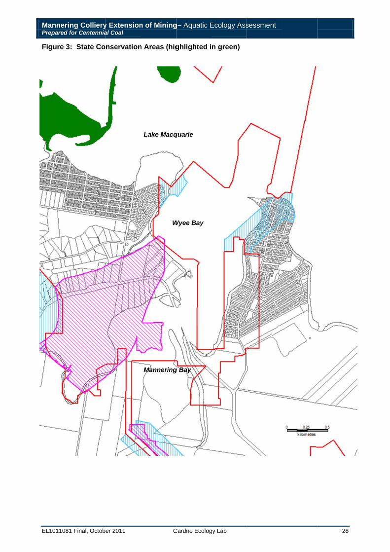
MannerinPrepared f
EL1011081
Figure 3
ng Collieryfor Centennia
1 Final, Octobe
: State Co
y Extensional Coal
er 2011
nservation
n of Mining
C
n Areas (hig
W
Lake Macq
Mannering
g– Aquatic E
Cardno Ecolog
ghlighted i
Wyee Bay
quarie
g Bay
Ecology Ass
gy Lab
n green)
sessment
28
Mannering Colliery Extension of Mining– Aquatic Ecology Assessment Prepared for Centennial Coal
EL1011081 Final, October 2011 Cardno Ecology Lab 29
3.5 Impacts of Underground Mining on Estuarine Ecosystems The principal physical impact resulting from underground coal mining is subsidence i.e. lowering of the surface above areas that are mined (Booth et al.1998, Holla and Barclay 2000). Vertical displacement of low lying foreshores can expose natural and man-made features to an increased frequency of flooding, to a risk of being permanently inundated or to a risk of flooding that may not have existed previously (NSW DoP 2008).
Studies that have documented the effects of coal extraction on the aquatic biota of estuarine ecosystems are limited, but have been documented in a strategic review of impacts of potential underground mining in the Wyong Local Government Area (NSW DoP 2008). According to the review, a number of subsidence events have occurred in the Newcastle coalfield in the late 1980s and early 1990s, resulting in four incidents of unplanned inundation of the foreshores of Lake Macquarie and Lake Munmorah, to the south of Lake Macquarie. Subsidence beneath the lakes was since controlled by the use of ‘bord and pillar’ mining, partial pillar extraction and restricting the width of the longwall panels. Despite this, extraction beneath parts of Lake Munmorah and Budgewoi Lake (from 140 – 180 metres depth cover) has resulted in unplanned subsidence of up to 1 metre along sections of foreshore at Lake Munmorah (at Colongra Swamp on the Lake’s western shore) and Buff Point (on the northern shore of Budgewoi Lake). Duchatel (1998) reported on the effects of mine subsidence to the foreshores and freshwater wetland at Colongra (Lake Munmorah). Approximately four hectares of wetland foreshore was subsided by 900 millimetres allowing saline water to flow into the freshwater swamp behind the more elevated foreshore. Widespread mortality of plants and associated wildlife was predicted and management strategies to deal with the problem were recommended (Roberts 2000). The Colongra Swamp area has recently been listed as part of a Nature Reserve. Subsidence has also occurred along the foreshore at Chain Valley Bay in Lake Macquarie, resulting in inundation of saltwater and the loss of riparian vegetation along the subsided shoreline (NSW DoP 2008).
The Tuggerah Lakes Estuary Process Study (Roberts 2000) identifies subsidence an as important issue affecting aquatic habitats, with particular reference to the potential effects on fringing wetland habitats such as seagrass beds. The main concern with regard to seagrass is the potential to alter the mean depth of seagrass habitat. Given that there is suitable substratum available, the depth limit and extension of seagrass beds, has been found to be constrained by light penetration underwater (Duarte 1991) which decreases with depth. The depth limit of seagrass beds is not established as a sharp threshold, but involves the gradual decline in abundance from the depth where maximum biomass is observed to their depth limit. Increased depth (e.g. as a result of mining subsidence) is therefore considered to lead to a decrease in the distribution of seagrass and may alter assemblages of benthic macroinvertebrates (Roberts 2000).
There are, however, several other factors which may affect seagrass growth and distribution as discussed in Section 3.3.1. It is notable that the methods of mining employed at Mannering Colliery have been designed for minimal surface subsidence (20 millimetres).
Mannering Colliery Extension of Mining– Aquatic Ecology Assessment Prepared for Centennial Coal
EL1011081 Final, October 2011 Cardno Ecology Lab 30
4 Assessment of Impacts 4.1 Description of Proposal Mannering Colliery proposes to mine by bord and pillar method in five new areas of the Fassifern Seam and additional areas of the Great Northern Seam. The combined extraction from the Fassifern and Great Northern Seams will only involve first workings only and not exceed the already approved 1.1 Million tonnes of ROM coal per annum. No change to surface infrastructure or coal handling is required for the project as production rates will not exceed current capacity and operations will continue within the existing approval limits and controls.
The main issue to be considered in the assessment is the potential for subsidence of the lake bed from subsurface mining to affect estuarine ecosystems. The mining method has been designed to provide long-term stability beneath foreshore areas and other natural and man-made features. According to the subsidence report prepared by Seedsman Geotechnics Pty Ltd 2011, the predicted subsidence levels would be limited to less than 20 millimetres.
4.2 Physical Impacts Associated with Mine Subsidence As described in Section 3.4 the principal physical impact resulting from underground coal mining is subsidence i.e. lowering of the surface above areas that are mined (Booth et al. 1998, Holla and Barclay 2000). Subsidence may result in areas of foreshore above the mean high water mark, previously unexposed to tidal inundation becoming wetted at high tides and areas below this level becoming inundated for a longer period of time. Subtidally the seabed may become deeper in affected areas. The extent of the morphological changes to the foreshore and seabed will, however, be dependent on the slope and topography of the shore. A greater surface area would be affected where the shoreline is flat and gradually sloping as opposed to areas where it is steeper. It is likely that any impacts of subsidence will be localised and based on the proposed extension of mining would potentially be limited to five distinct regions of the study area where the proposed extension of mining overlaps with foreshore areas. These regions include:
1. Western shore of Wyee Point (Fassifern Seam). The area covers approximately 330 metres of foreshore, 5919 square metres of seagrass habitat and a total of 30,970 square metres of subtidal seabed.
2. Western shore of Wyee Bay (Great Northern Seam). The area covers approximately 235 metres of foreshore, 3901 square metres of seagrass habitat and a total of 11,130 square metres of subtidal habitat.
3. Mannering Bay (Great Northern Seam). The area covers approximately 950 metres of foreshore, 2874 square metres of seagrass within the Bay and a total of 148,600 square metres of subtidal seabed. Approximately 2200 sq. m of saltmarsh also falls within this area along the western shore of the Bay.
4. Eastern Shore of Wyee Bay (Fassifern Seam). The area covers approximately 455 m of foreshore, 7500 square metres of seagrass habitat and a total of 76,660 square metres of subtidal seabed.
5. Vales Point (Fassifern Seam). The area covers approximately 505 metres of foreshore, 5959 square metres of seagrass habitat and a total of 10,670 square metres of subtidal seabed.
4.3 Impacts to Flora and Fauna
4.3.1 Estuarine vegetation Estuarine vegetation potentially affected by the proposed extension of mining includes seagrasses (Zostera and Halophila), mangrove and saltmarsh. Seagrass beds fringe the
Mannering Colliery Extension of Mining– Aquatic Ecology Assessment Prepared for Centennial Coal
EL1011081 Final, October 2011 Cardno Ecology Lab 31
majority of Lake Macquarie and within the study area large continuous beds occur in the areas identified in Section 4.2, where there is potential for subsidence. Under existing conditions, the outer extent of seagrass beds that fringe the majority of Wyee Bay and Chain Valley Bay, is likely to be constrained by the depth to which sufficient light can penetrate the water column. This appears to vary between two and five metres.
Deepening of the Lake bed as a result of subsidence could reduce the overall amount of light reaching seagrasses and consequently affect seagrass growth. The severity of the potential impact would depend on the size of the area affected, which, in turn would be dependent on the topography of the seabed at the point of subsidence. Impacts are likely to be greater for areas of gradually sloping flat seabed (e.g. within Mannering Bay which is uniformly < 2 metres depth) rather than the more steeply sloping areas where seagrass fringes the shore (e.g. around Vales Point).
Although some seagrass may be lost due to reduced photosynthetic capacity, new beds could potentially develop (or existing beds expand), in shallow areas that become deeper and remain inundated for longer periods of time. Colonisation of new beds may only occur where there is suitable soft sediment habitat available but not where seawalls or steeply sloping banks would preclude this.
Based on subsidence levels of < 20 millimetres, impacts to seagrass beds could result in subtle morphological and/or photo-adaptive changes such as reduced biomass, decreased productivity and longer shoot lengths (as described in Section 4.2). However, it is unlikely that any reduction in seagrass cover would be detectable. Tolerance to light reduction also varies among species, Halophila spp. for example, has low minimum light requirements as indicated by the ability to colonise greater water depths than other species (Butler and Jerkanoff 1999). As different species of seagrasses are adapted to living at different depths and light levels, a change in species composition may occur. The extent to which this occurs would depend on the topography of the Lake but an increase in depth of up to 20 millimetres is likely to have a minimal effect.
Mangroves and saltmarsh occur above the proposed extension of mining activities within the Great Northern Seam. The overall effect of increased depth would be potentially greater and more prolonged inundation of existing intertidal areas. These habitats may potentially expand landward into low-lying areas, but where the existing shoreline is steep, intertidal areas may recede. Saltmarsh may also be replaced with mangroves which are more tolerant of intertidal conditions.
Based on previous studies carried out in Lake Macquarie, green, red and brown macroalgae is likely to occur along rocky foreshores and among seagrasses within the study area. Macroalgae are an important resource as food and/or shelter for fish and invertebrates and may act as a nursery habitat for juvenile fish and play a role in nutrient cycling. As macroalgae are also photosynthetic and require light to grow, changes in depth which result in less light penetration could impact on growth and distribution. However, given the minimal amount of predicted subsidence, it is unlikely that species assemblages associated with mangroves, saltmarsh and/or macroalgae would be lost as a result of a minimal increase in depth. It is, however, possible that species composition of these assemblages could be altered, whereby species adapted for slightly deeper water outcompete with other species. This would be unlikely to result in any detectable impact within the study area.
4.3.2 Benthic Assemblages For the purpose of this assessment, benthic assemblages considered include microalgae (photosynthetic algae generally < 0.062 millimetres which occur on the surface of the seabed) and benthic macrofauna (organisms > 1 millimetre that live in association with the seabed). Microalgae are the main primary producers in most intertidal or shallow subtidal soft sediments (Connell and Gillanders 2007). The density of microalgae is light dependent and highest at the sediment surface and in shallow water. Microalgae can act as a sink for nitrogen, stabilise sediments by exuding extra polymeric substances and are an important source of food for
Mannering Colliery Extension of Mining– Aquatic Ecology Assessment Prepared for Centennial Coal
EL1011081 Final, October 2011 Cardno Ecology Lab 32
herbivorous demersal fish and macrofauna (Dye and Lasiak 1987). Increased depth in subtidal areas affected by the proposed extension of mining could potentially affect microalgae density by reducing light penetration. This could indirectly affect higher trophic levels, alter the sediment composition and affect nutrient cycling. However, given the area of subtidal seabed potentially affected by the proposed extension of mining is small in comparison with the amount of similar habitat within the study area, it is unlikely that a decrease in density of microalgae would have a significant impact on other ecosystem components, although this may contribute cumulatively with other anthropogenic impacts within the study area.
4.3.3 Fisheries Resources Fish would not be directly impacted by the proposed extension of mining. The extensive seagrass beds, within Lake Macquarie do, however, provide an important nursery habitat for many species of economically important fish including yellowfin bream (Acanthopagrus auratus), luderick (Girella tricuspidata), whiting (Sillago sp.) and mullet (Mugilidae). Loss of seagrass and other important habitats such as mangroves, saltmarsh, macroalgae and benthic ecosystem components could indirectly affect the fish populations that utilise these habitats for food and shelter. As the impacts on these ecosystem components are considered to be negligible, significant impacts on fisheries resources within the study area would not be expected.
4.3.4 Threatened and Protected Species
4.3.4.1 Assessments of Significance (State Legislation) Assessments of significance were undertaken for the following species known to occur within the study area that have potential to be affected by the proposal:
Dugong (Dugong dugon); Loggerhead turtle (Caretta caretta); Green turtle (Chelonia mydas); and Estuarine shorebirds (assessed as a group).
Results of the assessments are given in Appendix B and C. The dugong (Dugong dugon), green turtle (Chelonia mydas) and loggerhead turtle (Caretta caretta) have all been recorded in Lake Macquarie and are known to feed on, or forage within, seagrass habitats. Any potential reduction in seagrass has the potential to affect these species. However, given that dugongs rarely occur within Lake Macquarie (there are only two records of the species occurring within Swansea Channel) and that no measurable effect on seagrass distribution is expected, the proposed extension of mining is not considered to affect a viable population. Furthermore, any individual dugongs that could occur as far south as Lake Macquarie are likely to be vagrants and not part of a resident population.
Marine turtles, particularly green turtles (Chelonia mydas) are not uncommon within Lake Macquarie and are likely to feed on seagrass within the study area. Loggerhead turtles (Caretta caretta) do not feed on seagrass but forage within seagrass habitat for other prey species.
This area of habitat is not, however, critical to the species survival and any potential impacts on seagrass habitat would not limit the availability of seagrass as a food source for these species.
There are 39 species of estuarine shorebird that have been recorded within the study area that could potentially be affected by alteration of habitat as a result of subsidence related to the proposal. The predicted level of subsidence (< 20 millimetres) in foreshore areas is not, however, considered likely to have an effect on the habitat utilised by these species, such that it would cause any observable alteration to their behaviour or habitat requirements.
The proposal is not, therefore, considered to affect any of these species such that a species impact statement is recommended.
Mannering Colliery Extension of Mining– Aquatic Ecology Assessment Prepared for Centennial Coal
EL1011081 Final, October 2011 Cardno Ecology Lab 33
4.3.4.2 Assessment of Significance (Commonwealth Legislation) The dugong (Dugong dugon) is also listed under the EPBC Act as ‘migratory’ and the loggerhead turtle (Caretta caretta) listed as both ‘migratory’ and ‘endangered’. Five species of estuarine bird are also listed under the EPBC Act and international agreements for the protection of migratory birds. As these species are matters of NES an assessment of significance was undertaken according to EPBC Act ‘significant impact guidelines 1.1’. Results of the assessments are given in Appendix C. Based on this assessment the proposed extension of mining is considered unlikely to have a significant impact on matters of NES.
4.3.4.3 Other Listed and Protected Species Seahorses, pipefish and sea dragons (Syngnathidae) are ‘listed’ under the EPBC Act and ‘protected’ under the FM Act and although these species are not subject to assessments of significance, they require consideration in relation to the proposed Project. Seahorses and pipefish occur in seagrass beds (Kuiter 2000) and could therefore be indirectly affected as a result of any impact to seagrass habitat. It is unlikely that the potential minor impacts to seagrass described in Section 4.3.1 would affect populations of these species as there would be extensive seagrass and soft sediment habitats for these species to assimilate into if there were any minor alteration of immediate habitat.
4.4 Areas of Conservation Significance As described in Section 3.4 there have been documented events where unplanned subsidence of up to 1 metre has occurred in parts of Lake Munmorah, Budgewoi Lake and Lake Macquarie resulting in the inundation of foreshores by salt water and loss of riparian vegetation. Since these events, which occurred over 10 years ago, mining methods have been largely modified to ensure minimal impacts from subsidence and there have been no such events since. Furthermore, no areas of conservation significance occur within or near to the proposed extension of mining and no impacts to areas of conservation significance are expected.
4.5 Cumulative Impacts Cumulative impacts on the environment result from the incremental impact of an action when added to past, existing and reasonably foreseeable future actions regardless of who is carrying out those actions (Canter 1996).
The predicted impact of 20 millimetres of subsidence on aquatic components of the study area is likely to be negligible in isolation, but when coupled with other anthropogenic stressors has potential to cause a measurable impact. Potential stressors likely to exacerbate the effects of subsidence include those which have potential to increase turbidity and/or alter sea level resulting in poorer light penetration. These include, but are not limited to:
Increasing urban/industrial development within the catchment; Climate change resulting in more severe wet weather/storm events and sea level rise; Surface run-off resulting in increased turbidity; Point source pollution; Increased recreational boating; and Other mining activities within Lake Macquarie which have potential to cause subsidence.
Centennial Coal operates Myuna Colliery to the north of the study area. A separate environmental assessment has been prepared to manage the predicted subsidence impacts associated with this colliery including a Seagrass Management Plan. Other companies also operate within the Great Northern and Fassifern Seams beneath Chain Valley Bay. The total area of Lake Macquarie potentially affected by mining activity alone is therefore substantially more than that addressed in the current assessment. Provided that appropriate mitigation and management of seagrass beds and other subtidal habitats is implemented for individual project application areas, any cumulative impacts outside of the management of Centennial Mannering would be limited. At most, cumulative impacts might result in minor and undetectable changes
Mannering Colliery Extension of Mining– Aquatic Ecology Assessment Prepared for Centennial Coal
EL1011081 Final, October 2011 Cardno Ecology Lab 34
associated with the 20 millimetre subsidence predictions (as described in Sections 4.3.1 and 4.3.2). It is likely that the diffuse and less predictable impacts occurring at a catchment scale (e.g. from surface run-off and increased development) would have a greater overall impact on aquatic ecosystem health rather than potential cumulative impacts of mining activity.
Mannering Colliery Extension of Mining– Aquatic Ecology Assessment Prepared for Centennial Coal
EL1011081 Final, October 2011 Cardno Ecology Lab 35
5 Conclusion Within the footprint of the proposed extension of mining at Mannering Colliery the subsidence report (Seedsman Geotechnics Pty Ltd 2011) predicts subsidence of < 20 millimetres. Although sensitive habitats are known to occur within the study area, including seagrasses, mangroves, saltmarsh and State Conservation Areas, the direct impacts to these habitats is considered to be negligible and limited to areas where the proposed extension of mining overlaps with these habitats. Any indirect impacts on fisheries resources and threatened species, populations and ecological communities (including matters of NES), would also be unlikely and as such no significant impact on these species would be expected. Several impacts have been identified that might cumulatively impact upon the ecological values of the aquatic environment, specifically by affecting depth and turbidity which in turn may affect light penetration. This includes other existing mining activities within Lake Macquarie, climate change and sea level rise as well as increasing urban development. The impacts of these broader issues are difficult to predict, however, Centennial Mannering currently manages and monitors for potential impacts in relation to their existing mining activities within Lake Macquarie. Any cumulative impacts outside of the management of Centennial Mannering would require management at the catchment level, as such, no specific mitigation or monitoring of the aquatic environment is recommended for the proposed extension of mining at Mannering Colliery.
Mannering Colliery Extension of Mining– Aquatic Ecology Assessment Prepared for Centennial Coal
EL1011081 Final, October 2011 Cardno Ecology Lab 36
6 Acknowledgements This report was written by Kate Reeds and reviewed by Dr. Peggy O Donnell and Dr. Arthur Dye. Threatened species assessments were carried out by Dr. Michelle Blewitt.
Mannering Colliery Extension of Mining– Aquatic Ecology Assessment Prepared for Centennial Coal
EL1011081 Final, October 2011 Cardno Ecology Lab 37
7 References Allen, S., Marsh, H. and Hodgson, A. (2004). Occurrence and Conservation of the Dugong
(Sirenia: Dugongidae) in New South Wales. Proceedings of the Linnean Society of NSW. 125: 211–216.
Australian Water and Coastal Studies Pty Ltd and J H and E S Laxton Pty Ltd (1995). Lake Macquarie Estuary Process Study - Volume 1, AWACC Report, 94/25. Prepared for: Lake Macquarie Estuary and Coastal Management Committee of Lake Macquarie City Council. Australian Water and Coastal Studies Pty Ltd, Sydney, NSW.
Booth, C. J. Spande, E. D. Pattee, C. T. Miller, J. D. and Bertsch, L. P. (1998) Positive and negative effects of longwall mine subsidence on a sandstone aquifer. Environmental Geology 34: 223-233.
Burchmore, J. J. Pollard, D. A. Middleton, M. J. and Williams, R. J. (1993). Estuarine Habitat Management Guidelines. NSW Fisheries.
Butler, A. and Jerkanoff, P. (1999). Seagrass in Australia. CSIRO Publishing. Collingwood, VIC.
Caffrey J. M. and Kemp W. M. (1990). Nitrogen cycling in sediments with estuarine populations of Potamogeton perfoliatus and Zostera marina. Marine Ecology Progress Series 66: 147–160.
Canter, L. W. (1996). Environmental Impact Assessment, Second Edition, New York: McGraw-Hill Book Co., Inc.
Chapman, M. G. and Underwood, A. J. (1995). Mangrove Forests. In: Coastal Marine Ecology of Temperate Australia, Underwood, A. J. and Chapman, M. G., (eds.). University of New South Wales Press Ltd, Sydney. pp. 187-204.
Christensen, P. B., Nielsen L. P., Sørensen J. and Revsbeck N. P. (1990). Denitrification in nitrate-rich streams: diurnal and seasonal variation related to benthic oxygen metabolism. Limnology and Oceanography 35: 640–651.
Connell, S. D. and Gillanders, B. M. (2007). Marine Ecology. Oxford University Press, South Melbourne, Vic. pp. 630.
Creese, R. G. Glasby, T. M. West, G. and Gallen, C. (2009). Mapping the habitats of NSW estuaries. Report to the Hunter Rivers Catchment Management Authority. Industry and Investment NSW. Fisheries Final Report Series No. 113.
CSIRO (2007). Statistical Analysis of Seagrass and Macroalgae Percent Cover in Wyee Bay Compared to Background Locations in Lake Macquarie. Technical Memorandum, August 2007.
Department of Environment and Climate Change (2007). Threatened Species Assessment Guidelines: The Assessment of Significance, August 2007.
Department of Environment Climate Change and Water (2008). DECCW, Canberra. Accessed July 2011. http://www.environment.nsw.gov.au/determinations/DugongEndSpListing.htm
Department of Sustainability, Environment, Water Population and Communities (DSEWPAC) (2011). EPBC Environmental Reporting Tool. Viewed July 2011. http://www.environment.gov.au/epbc/pmst/index.html.
Duarte, C. M. (1991). Seagrass depth limits. Aquatic Botany 40: 363-377.
Duchatel, K. (1998). Colongra wetland subsidence impact assessment. Sainty and Associates Pty Ltd, Potts Point.
Mannering Colliery Extension of Mining– Aquatic Ecology Assessment Prepared for Centennial Coal
EL1011081 Final, October 2011 Cardno Ecology Lab 38
Dye, A. H. and Lasiak, T. A. (1987). Assimilation efficiencies of fiddler crabs and deposit feeding gastropods from tropical mangrove sediments. Comparative Biochemistry and Physiology. 87A 2: 341-344.
Environment Australia (2002). White Shark (Carcharodon carcharias) Recovery Plan. http://www.environment.gov.au/coasts/publications/gwshark-plan/index.html
Environment Australia (2003). Recovery Plan for Marine Turtles in Australia. Prepared by the Marine Species Section, Approvals and Wildlife Division, Environment Australia in consultation with the marine turtle recovery team.
Eyre, B. D. and Ferguson, A. J. P. (2002). Comparison of carbon production and decomposition, benthic nutrient fluxes and denitrification in seagrass, phytoplankton, benthic microalgae- and macroalgae dominated warm-temperate Australian lagoons. Marine Ecology Progress Series 229: 43-59.
Fenchel, T. (1992). What Can Ecologists Learn From Microbes: Life Beneath a Square Centimetre of Sediment Surface, Functional Ecology 6: 499-507.
Gray, R. and Nankivell, A. (2007). Aquatic Vegetation Mapping of Lake Macquarie. Southern Cross University.
Holla, L. and Barclay, E. (2000). Mine Subsidence in the Southern Coalfield, NSW, Australia. NSW Department of Mineral Resources.
Industry and Investment NSW (I&I NSW) (2009). Black Cod (Epinephelus daemelii) Draft Recovery Plan. Fisheries Conservation and Aquaculture Branch, Port Stephens Fisheries Institute.
Keough, M. J. and Jenkins, J. P. (1995). Seagrass meadows and their inhabitants. In: Coastal Marine Ecology of Temperate Australia pp. 221-39. UNSW, Sydney.
King, R. J. and Barclay, J. B. (1986). Aquatic angiosperms in coastal saline lagoons of New South Wales. III. Quantitative assessment of Zostera capricorni. Proceedings of the Linnean Society of NSW 109: 41-50.
King, R. J. and Hodgson, B. R. (1986). Aquatic angiosperms in coastal saline lagoons of New South Wales. IV. Long-term changes. Proceedings of the Linnean Society of NSW 109: 51-60.
Kuiter, R. H. (2000). Guide to Sea Fishes of Australia. New Holland Publishers, Australia, pp. 434.
Last, P. R. and Stevens, J. D. (1994). Sharks and Rays of Australia. CSIRO, Australia. pp. 513.
MacIntyre, R. J. (1959). Some aspects of the ecology of Lake Macquarie, NSW, with regard to the alleged depletion of fish. VII. The benthic macrofauna. Australian Journal of Marine and Freshwater Research 10: 341-353.
Millar, A. (2011). Primefact 947 - Macroalgae factsheet. Industry and Investment NSW. Cronulla, Sydney.
Morrisey, D. (1995). Saltmarshes. In: Coastal Marine Ecology of Temperate Australia, Underwood, A. J. and Chapman, M. G., (eds). University of New South Wales Press Ltd, Sydney. pp. 152-170.
NSW Department of Planning (2008). Impacts of Potential Underground Mining in the Wyong Local Government Area – Strategic Review. NSW Department of Planning, NSW.
NSW DPI (2006). Primefacts 21. Mine subsidence. http://www.dpi.nsw.gov.au/__data/assets/pdf_file/0009/56763/Mine_Subsidence_-_Primefact_21-final.pdf.
NSW DPI (2001). Recreational Fishing Areas: Lake Macquarie Issues Paper. 35 pp.
Mannering Colliery Extension of Mining– Aquatic Ecology Assessment Prepared for Centennial Coal
EL1011081 Final, October 2011 Cardno Ecology Lab 39
NSW Parks and Wildlife Service (2011). Atlas of NSW Wildlife. Viewed July 2011. http://wildlifeatlas.nationalparks.nsw.gov.au/wildlifeatlas/watlas.jsp
NSW Parks and Wildlife Service (NP&WS 2005). Lake Macquarie State Conservation Area, Pulbah Island Nature Reserve and Moon Island Nature Reserve Plan of Management.
Office of Environment and Heritage (OEH)(2011). Viewed July 2011. http://www.threatenedspecies.environment.nsw.gov.au/index.aspx
OzCoasts (2010). OzCoasts. Accessed May 2010. http://www.ozcoasts.org.au/index.jsp.
Roberts, D. E. (2000). Tuggerah Lakes Estuary Process Study. Wyong Shire Council.
Roper, T., Creese, R. G., Scanes, P., Stephens, K., Dela-Cruz, J. and Coates, B. (2009). Estuaries and Coastal Lakes – Technical Report. NSW State of Catchments 2008. DECCW NSW. 213 pp.
Ross. J. (1995). Fish Australia: the essential fishing companion. Viking, Penguin Books, Victoria, Australia. 498 pp.
Seedsman Geotechnics Pty Ltd (2011). Centennial Mannering Pty Ltd – Section 75W Assessment Great Northern and Fassifern Seams. Final Report for Centennial Mannering Pty Ltd, August 2011.
Smith, A. K. Holliday, J. E. and Pollard, D. A. (1997). Management of seagrass habitats in NSW estuaries Wetlands (Australia). 16(2): 48-55.
Smith, A. K. and Pollard, D. A. (1999). Policy and Guidelines Aquatic Habitat Management and Fish Conservation: 1999 Update, Policy and Guidelines Aquatic Habitat Management and Fish Conservation , 1999 Update. NSW Fisheries, Port Stephens Research Centre.
Steffe, A. S. Murphy, J. J. Chapman, D. J. and Gray, C. C. (2005). An assessment of changes in the daytime recreational fishery of Lake Macquarie following the establishment of a ‘Recreational Fishing Haven’. NSW Department of Primary Industries - Fisheries Final Report Series No. 79.103 pp.
Syme, W., Witt, C., Morton, R., Pocock and McAlister A. (1997). Lake Macquarie Estuary Management Plan, WBM Oceanics Australia (1997).
The Ecology Lab Pty Ltd (1991). The Impacts of Ash Dam Discharges on the Aquatic Environment of Lake Macquarie. Prepared for The Electricity Commission of NSW. The Ecology Lab Pty Ltd, Balgowlah, Sydney.
The Ecology Lab Pty Ltd (2008). Concept Plan for Trinity Point Marina and Mixed Use Development - Aquatic Ecological Investigations, Prepared for: Johnson Property Group. The Ecology Lab Pty Ltd, Brookvale, NSW.
Virgona, J. L. (1983). Lake Macquarie Fish Study. Prepared for the Electricity Commission for NSW State Fisheries.
WBM Oceanics Australia (1996). Lake Macquarie Estuary Management Study. WBM Oceanics Qld.
West, R. J., Thorogood, C. A., Walford, T. R. and Williams, R. J. (1985). An estuarine inventory for New South Wales, Australia. Division of Fisheries, NSW Department of Agriculture, Sydney, Australia.
Williams, R. J., West, G., Morrisson, D. and Creese, R. G. (2007). Estuarine Resources of NSW. In: The NSW Comprehensive Assessment Toolkit. CD ROM ISBN 0 7347 5805 7.
Wood, E. J. F. (1959). Some aspects of the ecology of Lake Macquarie, NSW with regard to the alleged depletion of fish. VI. Plant Communities and their Significance. Australian Journal of Marine and Freshwater Research. 10: 322-340.

Mannering Colliery Extension of Mining– Aquatic Ecology Assessment Prepared for Centennial Coal
EL1011081 Final, October 2011 Cardno Ecology Lab 40
8 Appendices Appendix A: Threatened Species Search Results. Appendix B: Threatened Species Assessment (State). Appendix C: Threatened Species Assessment of Significance (Commonwealth).
Appendix A Threatened Species Search Results
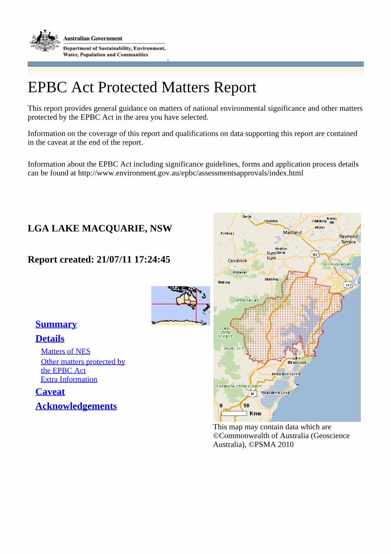
EPBC Act Protected Matters ReportThis report provides general guidance on matters of national environmental significance and other mattersprotected by the EPBC Act in the area you have selected.
Information on the coverage of this report and qualifications on data supporting this report are containedin the caveat at the end of the report.
Information about the EPBC Act including significance guidelines, forms and application process detailscan be found at http://www.environment.gov.au/epbc/assessmentsapprovals/index.html
This map may contain data which are©Commonwealth of Australia (GeoscienceAustralia), ©PSMA 2010
LGA LAKE MACQUARIE, NSW
Report created: 21/07/11 17:24:45
Summary
DetailsMatters of NESOther matters protected bythe EPBC ActExtra Information
Caveat
Acknowledgements
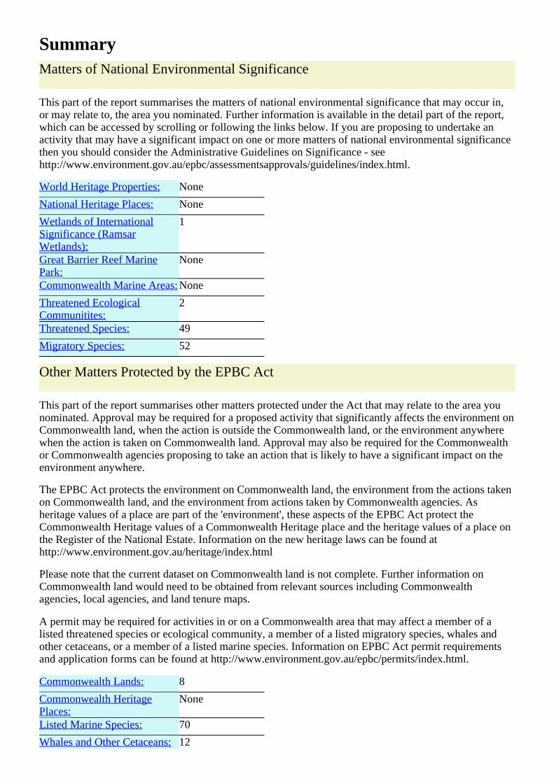
SummaryMatters of National Environmental Significance
This part of the report summarises the matters of national environmental significance that may occur in,or may relate to, the area you nominated. Further information is available in the detail part of the report,which can be accessed by scrolling or following the links below. If you are proposing to undertake anactivity that may have a significant impact on one or more matters of national environmental significancethen you should consider the Administrative Guidelines on Significance - seehttp://www.environment.gov.au/epbc/assessmentsapprovals/guidelines/index.html.
World Heritage Properties: None
National Heritage Places: None
Wetlands of InternationalSignificance (RamsarWetlands):
1
Great Barrier Reef MarinePark:
None
Commonwealth Marine Areas: None
Threatened EcologicalCommunitites:
2
Threatened Species: 49
Migratory Species: 52
Other Matters Protected by the EPBC Act
This part of the report summarises other matters protected under the Act that may relate to the area younominated. Approval may be required for a proposed activity that significantly affects the environment onCommonwealth land, when the action is outside the Commonwealth land, or the environment anywherewhen the action is taken on Commonwealth land. Approval may also be required for the Commonwealthor Commonwealth agencies proposing to take an action that is likely to have a significant impact on theenvironment anywhere.
The EPBC Act protects the environment on Commonwealth land, the environment from the actions takenon Commonwealth land, and the environment from actions taken by Commonwealth agencies. Asheritage values of a place are part of the 'environment', these aspects of the EPBC Act protect theCommonwealth Heritage values of a Commonwealth Heritage place and the heritage values of a place onthe Register of the National Estate. Information on the new heritage laws can be found athttp://www.environment.gov.au/heritage/index.html
Please note that the current dataset on Commonwealth land is not complete. Further information onCommonwealth land would need to be obtained from relevant sources including Commonwealthagencies, local agencies, and land tenure maps.
A permit may be required for activities in or on a Commonwealth area that may affect a member of alisted threatened species or ecological community, a member of a listed migratory species, whales andother cetaceans, or a member of a listed marine species. Information on EPBC Act permit requirementsand application forms can be found at http://www.environment.gov.au/epbc/permits/index.html.
Commonwealth Lands: 8
Commonwealth HeritagePlaces:
None
Listed Marine Species: 70
Whales and Other Cetaceans: 12
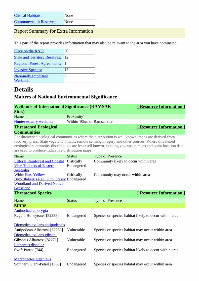
Critical Habitats: None
Commonwealth Reserves: None
Report Summary for Extra Information
This part of the report provides information that may also be relevant to the area you have nominated.
Place on the RNE: 30
State and Territory Reserves: 12
Regional Forest Agreements: 1
Invasive Species: 17
Nationally ImportantWetlands:
2
DetailsMatters of National Environmental Significance
Wetlands of International Significance (RAMSARSites)
[ Resource Information ]
Name ProximityHunter estuary wetlands Within 10km of Ramsar site
Threatened EcologicalCommunities
[ Resource Information ]
For threatened ecological communities where the distribution is well known, maps are derived fromrecovery plans, State vegetation maps, remote sensing imagery and other sources. Where threatenedecological community distributions are less well known, existing vegetation maps and point location dataare used to produce indicative distribution maps.
Name Status Type of PresenceLittoral Rainforest and CoastalVine Thickets of EasternAustralia
CriticallyEndangered
Community likely to occur within area
White Box-YellowBox-Blakely's Red Gum GrassyWoodland and Derived NativeGrassland
CriticallyEndangered
Community may occur within area
Threatened Species [ Resource Information ]
Name Status Type of PresenceBIRDSAnthochaera phrygiaRegent Honeyeater [82338] Endangered Species or species habitat likely to occur within area
Diomedea exulans antipodensisAntipodean Albatross [82269] Vulnerable Species or species habitat may occur within areaDiomedea exulans gibsoniGibson's Albatross [82271] Vulnerable Species or species habitat may occur within areaLathamus discolorSwift Parrot [744] Endangered Species or species habitat likely to occur within area
Macronectes giganteusSouthern Giant-Petrel [1060] Endangered Species or species habitat may occur within area
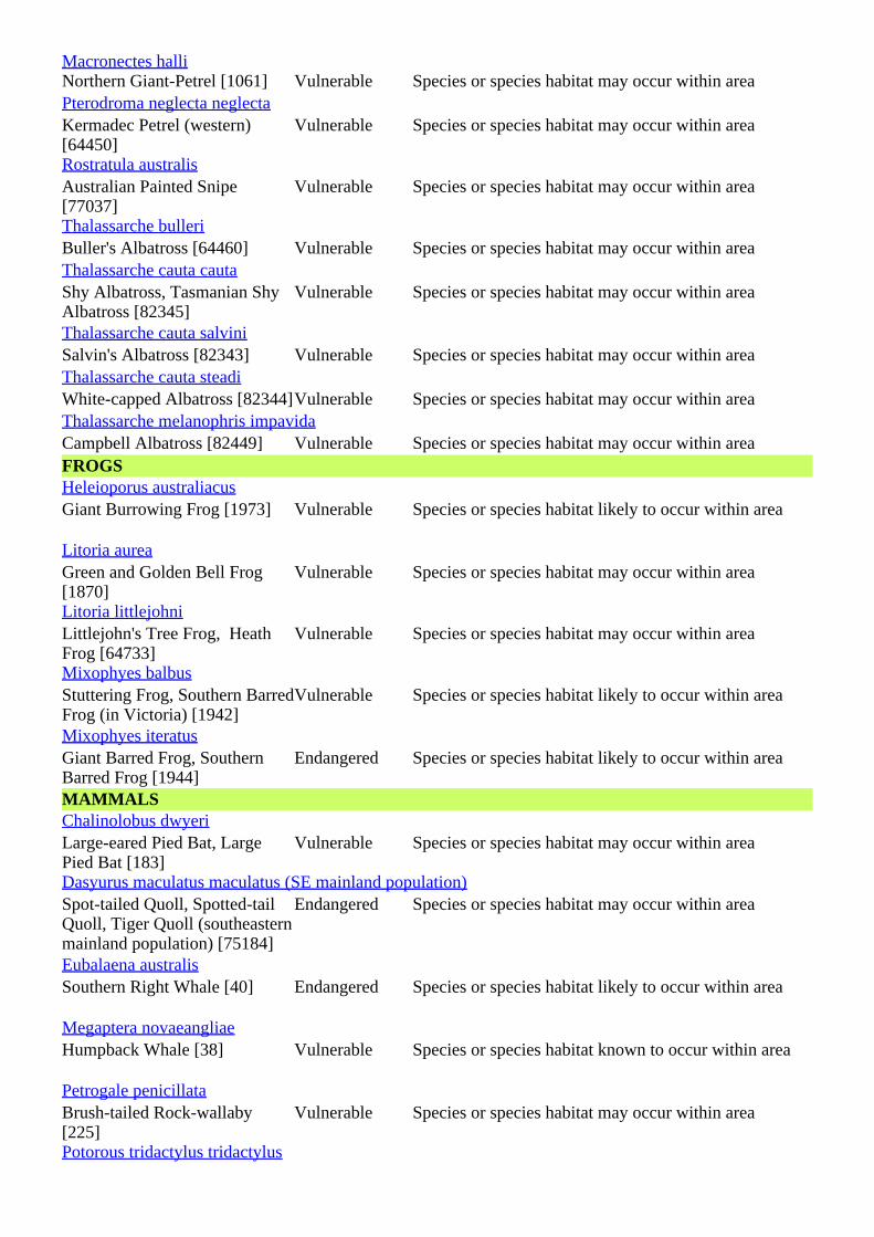
Macronectes halliNorthern Giant-Petrel [1061] Vulnerable Species or species habitat may occur within areaPterodroma neglecta neglectaKermadec Petrel (western)[64450]
Vulnerable Species or species habitat may occur within area
Rostratula australisAustralian Painted Snipe[77037]
Vulnerable Species or species habitat may occur within area
Thalassarche bulleriBuller's Albatross [64460] Vulnerable Species or species habitat may occur within areaThalassarche cauta cautaShy Albatross, Tasmanian ShyAlbatross [82345]
Vulnerable Species or species habitat may occur within area
Thalassarche cauta salviniSalvin's Albatross [82343] Vulnerable Species or species habitat may occur within areaThalassarche cauta steadiWhite-capped Albatross [82344]Vulnerable Species or species habitat may occur within areaThalassarche melanophris impavidaCampbell Albatross [82449] Vulnerable Species or species habitat may occur within areaFROGSHeleioporus australiacusGiant Burrowing Frog [1973] Vulnerable Species or species habitat likely to occur within area
Litoria aureaGreen and Golden Bell Frog[1870]
Vulnerable Species or species habitat may occur within area
Litoria littlejohniLittlejohn's Tree Frog, HeathFrog [64733]
Vulnerable Species or species habitat may occur within area
Mixophyes balbusStuttering Frog, Southern BarredFrog (in Victoria) [1942]
Vulnerable Species or species habitat likely to occur within area
Mixophyes iteratusGiant Barred Frog, SouthernBarred Frog [1944]
Endangered Species or species habitat likely to occur within area
MAMMALSChalinolobus dwyeriLarge-eared Pied Bat, LargePied Bat [183]
Vulnerable Species or species habitat may occur within area
Dasyurus maculatus maculatus (SE mainland population)Spot-tailed Quoll, Spotted-tailQuoll, Tiger Quoll (southeasternmainland population) [75184]
Endangered Species or species habitat may occur within area
Eubalaena australisSouthern Right Whale [40] Endangered Species or species habitat likely to occur within area
Megaptera novaeangliaeHumpback Whale [38] Vulnerable Species or species habitat known to occur within area
Petrogale penicillataBrush-tailed Rock-wallaby[225]
Vulnerable Species or species habitat may occur within area
Potorous tridactylus tridactylus
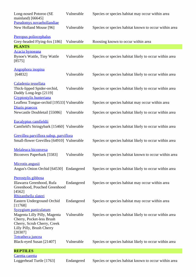
Long-nosed Potoroo (SEmainland) [66645]
Vulnerable Species or species habitat may occur within area
Pseudomys novaehollandiaeNew Holland Mouse [96] Vulnerable Species or species habitat known to occur within area
Pteropus poliocephalusGrey-headed Flying-fox [186] Vulnerable Roosting known to occur within areaPLANTSAcacia bynoeanaBynoe's Wattle, Tiny Wattle[8575]
Vulnerable Species or species habitat likely to occur within area
Angophora inopina [64832] Vulnerable Species or species habitat likely to occur within area
Caladenia tessellataThick-lipped Spider-orchid,Daddy Long-legs [2119]
Vulnerable Species or species habitat likely to occur within area
Cryptostylis hunterianaLeafless Tongue-orchid [19533] Vulnerable Species or species habitat may occur within areaDiuris praecoxNewcastle Doubletail [55086] Vulnerable Species or species habitat likely to occur within area
Eucalyptus camfieldiiCamfield's Stringybark [15460] Vulnerable Species or species habitat likely to occur within area
Grevillea parviflora subsp. parvifloraSmall-flower Grevillea [64910] Vulnerable Species or species habitat likely to occur within area
Melaleuca biconvexaBiconvex Paperbark [5583] Vulnerable Species or species habitat known to occur within area
Microtis angusiiAngus's Onion Orchid [64530] Endangered Species or species habitat likely to occur within area
Pterostylis gibbosaIllawarra Greenhood, RufaGreenhood, Pouched Greenhood[4562]
Endangered Species or species habitat may occur within area
Rhizanthella slateriEastern Underground Orchid[11768]
Endangered Species or species habitat may occur within area
Syzygium paniculatumMagenta Lilly Pilly, MagentaCherry, Pocket-less BrushCherry, Scrub Cherry, CreekLilly Pilly, Brush Cherry[20307]
Vulnerable Species or species habitat likely to occur within area
Tetratheca junceaBlack-eyed Susan [21407] Vulnerable Species or species habitat likely to occur within area
REPTILESCaretta carettaLoggerhead Turtle [1763] Endangered Species or species habitat known to occur within area
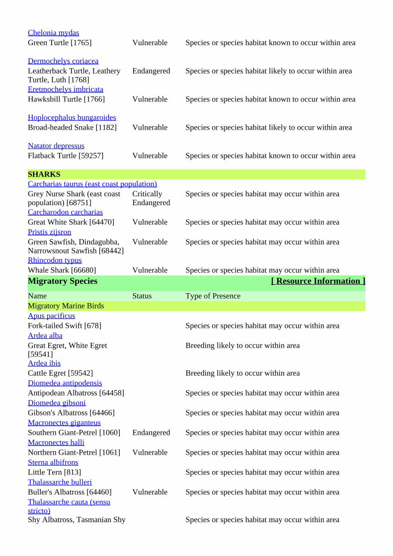
Chelonia mydasGreen Turtle [1765] Vulnerable Species or species habitat known to occur within area
Dermochelys coriaceaLeatherback Turtle, LeatheryTurtle, Luth [1768]
Endangered Species or species habitat likely to occur within area
Eretmochelys imbricataHawksbill Turtle [1766] Vulnerable Species or species habitat known to occur within area
Hoplocephalus bungaroidesBroad-headed Snake [1182] Vulnerable Species or species habitat likely to occur within area
Natator depressusFlatback Turtle [59257] Vulnerable Species or species habitat known to occur within area
SHARKSCarcharias taurus (east coast population)Grey Nurse Shark (east coastpopulation) [68751]
CriticallyEndangered
Species or species habitat may occur within area
Carcharodon carchariasGreat White Shark [64470] Vulnerable Species or species habitat may occur within areaPristis zijsronGreen Sawfish, Dindagubba,Narrowsnout Sawfish [68442]
Vulnerable Species or species habitat may occur within area
Rhincodon typusWhale Shark [66680] Vulnerable Species or species habitat may occur within area
Migratory Species [ Resource Information ]
Name Status Type of PresenceMigratory Marine BirdsApus pacificusFork-tailed Swift [678] Species or species habitat may occur within areaArdea albaGreat Egret, White Egret[59541]
Breeding likely to occur within area
Ardea ibisCattle Egret [59542] Breeding likely to occur within areaDiomedea antipodensisAntipodean Albatross [64458] Species or species habitat may occur within areaDiomedea gibsoniGibson's Albatross [64466] Species or species habitat may occur within areaMacronectes giganteusSouthern Giant-Petrel [1060] Endangered Species or species habitat may occur within areaMacronectes halliNorthern Giant-Petrel [1061] Vulnerable Species or species habitat may occur within areaSterna albifronsLittle Tern [813] Species or species habitat may occur within areaThalassarche bulleriBuller's Albatross [64460] Vulnerable Species or species habitat may occur within areaThalassarche cauta (sensustricto)Shy Albatross, Tasmanian Shy Species or species habitat may occur within area
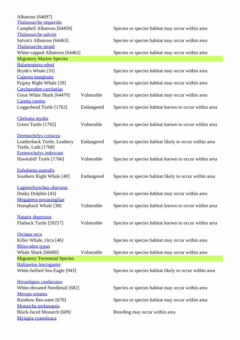
Albatross [64697]Thalassarche impavidaCampbell Albatross [64459] Species or species habitat may occur within areaThalassarche salviniSalvin's Albatross [64463] Species or species habitat may occur within areaThalassarche steadiWhite-capped Albatross [64462] Species or species habitat may occur within areaMigratory Marine SpeciesBalaenoptera edeniBryde's Whale [35] Species or species habitat may occur within areaCaperea marginataPygmy Right Whale [39] Species or species habitat may occur within areaCarcharodon carchariasGreat White Shark [64470] Vulnerable Species or species habitat may occur within areaCaretta carettaLoggerhead Turtle [1763] Endangered Species or species habitat known to occur within area
Chelonia mydasGreen Turtle [1765] Vulnerable Species or species habitat known to occur within area
Dermochelys coriaceaLeatherback Turtle, LeatheryTurtle, Luth [1768]
Endangered Species or species habitat likely to occur within area
Eretmochelys imbricataHawksbill Turtle [1766] Vulnerable Species or species habitat known to occur within area
Eubalaena australisSouthern Right Whale [40] Endangered Species or species habitat likely to occur within area
Lagenorhynchus obscurusDusky Dolphin [43] Species or species habitat may occur within areaMegaptera novaeangliaeHumpback Whale [38] Vulnerable Species or species habitat known to occur within area
Natator depressusFlatback Turtle [59257] Vulnerable Species or species habitat known to occur within area
Orcinus orcaKiller Whale, Orca [46] Species or species habitat may occur within areaRhincodon typusWhale Shark [66680] Vulnerable Species or species habitat may occur within areaMigratory Terrestrial SpeciesHaliaeetus leucogasterWhite-bellied Sea-Eagle [943] Species or species habitat likely to occur within area
Hirundapus caudacutusWhite-throated Needletail [682] Species or species habitat may occur within areaMerops ornatusRainbow Bee-eater [670] Species or species habitat may occur within areaMonarcha melanopsisBlack-faced Monarch [609] Breeding may occur within areaMyiagra cyanoleuca
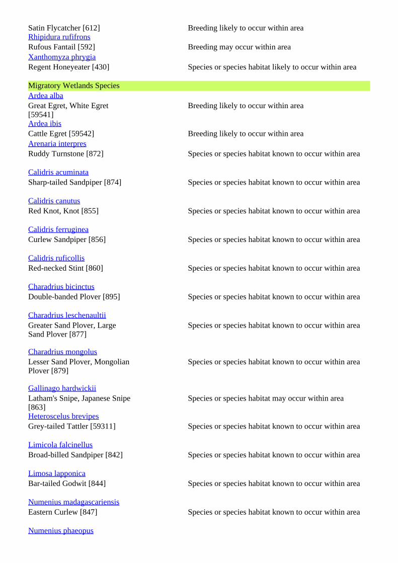
Satin Flycatcher [612] Breeding likely to occur within areaRhipidura rufifronsRufous Fantail [592] Breeding may occur within areaXanthomyza phrygiaRegent Honeyeater [430] Species or species habitat likely to occur within area
Migratory Wetlands SpeciesArdea albaGreat Egret, White Egret[59541]
Breeding likely to occur within area
Ardea ibisCattle Egret [59542] Breeding likely to occur within areaArenaria interpresRuddy Turnstone [872] Species or species habitat known to occur within area
Calidris acuminataSharp-tailed Sandpiper [874] Species or species habitat known to occur within area
Calidris canutusRed Knot, Knot [855] Species or species habitat known to occur within area
Calidris ferrugineaCurlew Sandpiper [856] Species or species habitat known to occur within area
Calidris ruficollisRed-necked Stint [860] Species or species habitat known to occur within area
Charadrius bicinctusDouble-banded Plover [895] Species or species habitat known to occur within area
Charadrius leschenaultiiGreater Sand Plover, LargeSand Plover [877]
Species or species habitat known to occur within area
Charadrius mongolusLesser Sand Plover, MongolianPlover [879]
Species or species habitat known to occur within area
Gallinago hardwickiiLatham's Snipe, Japanese Snipe[863]
Species or species habitat may occur within area
Heteroscelus brevipesGrey-tailed Tattler [59311] Species or species habitat known to occur within area
Limicola falcinellusBroad-billed Sandpiper [842] Species or species habitat known to occur within area
Limosa lapponicaBar-tailed Godwit [844] Species or species habitat known to occur within area
Numenius madagascariensisEastern Curlew [847] Species or species habitat known to occur within area
Numenius phaeopus
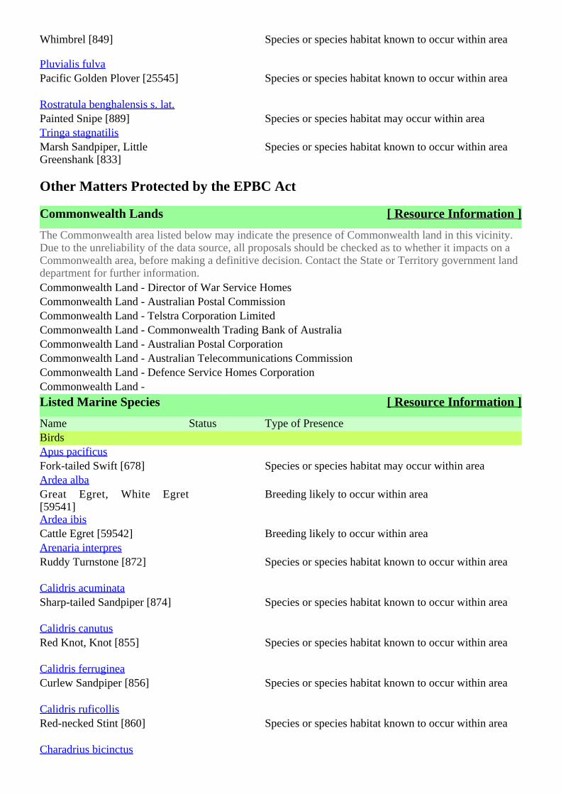
Whimbrel [849] Species or species habitat known to occur within area
Pluvialis fulvaPacific Golden Plover [25545] Species or species habitat known to occur within area
Rostratula benghalensis s. lat.Painted Snipe [889] Species or species habitat may occur within areaTringa stagnatilisMarsh Sandpiper, LittleGreenshank [833]
Species or species habitat known to occur within area
Other Matters Protected by the EPBC Act
Commonwealth Lands [ Resource Information ]
The Commonwealth area listed below may indicate the presence of Commonwealth land in this vicinity.Due to the unreliability of the data source, all proposals should be checked as to whether it impacts on aCommonwealth area, before making a definitive decision. Contact the State or Territory government landdepartment for further information.Commonwealth Land - Director of War Service HomesCommonwealth Land - Australian Postal CommissionCommonwealth Land - Telstra Corporation LimitedCommonwealth Land - Commonwealth Trading Bank of AustraliaCommonwealth Land - Australian Postal CorporationCommonwealth Land - Australian Telecommunications CommissionCommonwealth Land - Defence Service Homes CorporationCommonwealth Land -
Listed Marine Species [ Resource Information ]
Name Status Type of PresenceBirdsApus pacificusFork-tailed Swift [678] Species or species habitat may occur within areaArdea albaGreat Egret, White Egret[59541]
Breeding likely to occur within area
Ardea ibisCattle Egret [59542] Breeding likely to occur within areaArenaria interpresRuddy Turnstone [872] Species or species habitat known to occur within area
Calidris acuminataSharp-tailed Sandpiper [874] Species or species habitat known to occur within area
Calidris canutusRed Knot, Knot [855] Species or species habitat known to occur within area
Calidris ferrugineaCurlew Sandpiper [856] Species or species habitat known to occur within area
Calidris ruficollisRed-necked Stint [860] Species or species habitat known to occur within area
Charadrius bicinctus
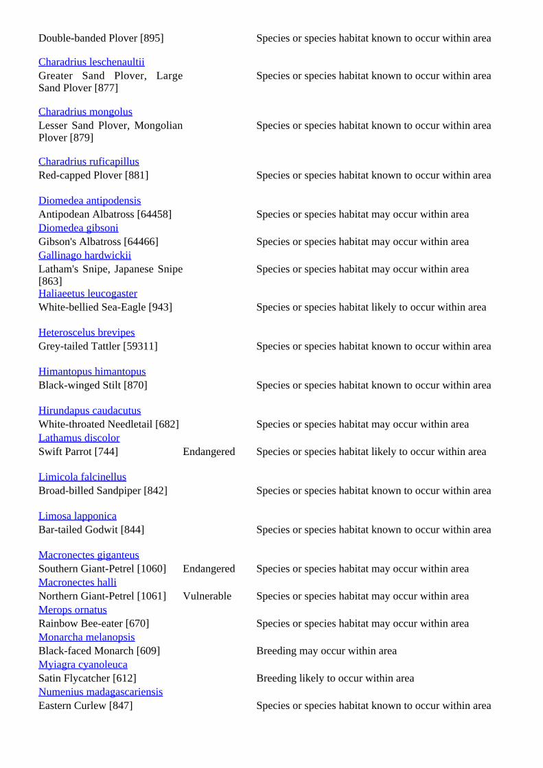
Double-banded Plover [895] Species or species habitat known to occur within area
Charadrius leschenaultiiGreater Sand Plover, LargeSand Plover [877]
Species or species habitat known to occur within area
Charadrius mongolusLesser Sand Plover, MongolianPlover [879]
Species or species habitat known to occur within area
Charadrius ruficapillusRed-capped Plover [881] Species or species habitat known to occur within area
Diomedea antipodensisAntipodean Albatross [64458] Species or species habitat may occur within areaDiomedea gibsoniGibson's Albatross [64466] Species or species habitat may occur within areaGallinago hardwickiiLatham's Snipe, Japanese Snipe[863]
Species or species habitat may occur within area
Haliaeetus leucogasterWhite-bellied Sea-Eagle [943] Species or species habitat likely to occur within area
Heteroscelus brevipesGrey-tailed Tattler [59311] Species or species habitat known to occur within area
Himantopus himantopusBlack-winged Stilt [870] Species or species habitat known to occur within area
Hirundapus caudacutusWhite-throated Needletail [682] Species or species habitat may occur within areaLathamus discolorSwift Parrot [744] Endangered Species or species habitat likely to occur within area
Limicola falcinellusBroad-billed Sandpiper [842] Species or species habitat known to occur within area
Limosa lapponicaBar-tailed Godwit [844] Species or species habitat known to occur within area
Macronectes giganteusSouthern Giant-Petrel [1060] Endangered Species or species habitat may occur within areaMacronectes halliNorthern Giant-Petrel [1061] Vulnerable Species or species habitat may occur within areaMerops ornatusRainbow Bee-eater [670] Species or species habitat may occur within areaMonarcha melanopsisBlack-faced Monarch [609] Breeding may occur within areaMyiagra cyanoleucaSatin Flycatcher [612] Breeding likely to occur within areaNumenius madagascariensisEastern Curlew [847] Species or species habitat known to occur within area
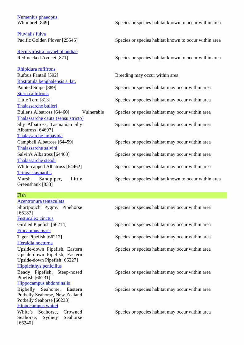
Numenius phaeopusWhimbrel [849] Species or species habitat known to occur within area
Pluvialis fulvaPacific Golden Plover [25545] Species or species habitat known to occur within area
Recurvirostra novaehollandiaeRed-necked Avocet [871] Species or species habitat known to occur within area
Rhipidura rufifronsRufous Fantail [592] Breeding may occur within areaRostratula benghalensis s. lat.Painted Snipe [889] Species or species habitat may occur within areaSterna albifronsLittle Tern [813] Species or species habitat may occur within areaThalassarche bulleriBuller's Albatross [64460] Vulnerable Species or species habitat may occur within areaThalassarche cauta (sensu stricto)Shy Albatross, Tasmanian ShyAlbatross [64697]
Species or species habitat may occur within area
Thalassarche impavidaCampbell Albatross [64459] Species or species habitat may occur within areaThalassarche salviniSalvin's Albatross [64463] Species or species habitat may occur within areaThalassarche steadiWhite-capped Albatross [64462] Species or species habitat may occur within areaTringa stagnatilisMarsh Sandpiper, LittleGreenshank [833]
Species or species habitat known to occur within area
FishAcentronura tentaculataShortpouch Pygmy Pipehorse[66187]
Species or species habitat may occur within area
Festucalex cinctusGirdled Pipefish [66214] Species or species habitat may occur within areaFilicampus tigrisTiger Pipefish [66217] Species or species habitat may occur within areaHeraldia nocturnaUpside-down Pipefish, EasternUpside-down Pipefish, EasternUpside-down Pipefish [66227]
Species or species habitat may occur within area
Hippichthys penicillusBeady Pipefish, Steep-nosedPipefish [66231]
Species or species habitat may occur within area
Hippocampus abdominalisBigbelly Seahorse, EasternPotbelly Seahorse, New ZealandPotbelly Seahorse [66233]
Species or species habitat may occur within area
Hippocampus whiteiWhite's Seahorse, CrownedSeahorse, Sydney Seahorse[66240]
Species or species habitat may occur within area
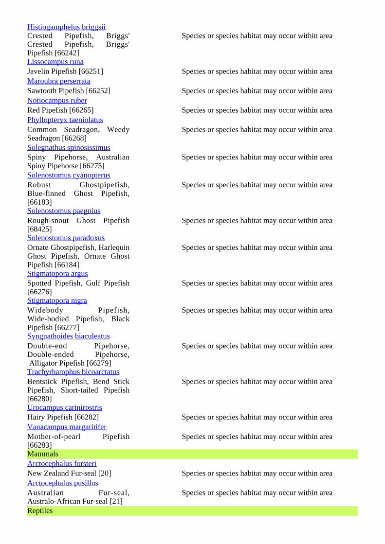
Histiogamphelus briggsiiCrested Pipefish, Briggs'Crested Pipefish, Briggs'Pipefish [66242]
Species or species habitat may occur within area
Lissocampus runaJavelin Pipefish [66251] Species or species habitat may occur within areaMaroubra perserrataSawtooth Pipefish [66252] Species or species habitat may occur within areaNotiocampus ruberRed Pipefish [66265] Species or species habitat may occur within areaPhyllopteryx taeniolatusCommon Seadragon, WeedySeadragon [66268]
Species or species habitat may occur within area
Solegnathus spinosissimusSpiny Pipehorse, AustralianSpiny Pipehorse [66275]
Species or species habitat may occur within area
Solenostomus cyanopterusRobust Ghostpipefish,Blue-finned Ghost Pipefish,[66183]
Species or species habitat may occur within area
Solenostomus paegniusRough-snout Ghost Pipefish[68425]
Species or species habitat may occur within area
Solenostomus paradoxusOrnate Ghostpipefish, HarlequinGhost Pipefish, Ornate GhostPipefish [66184]
Species or species habitat may occur within area
Stigmatopora argusSpotted Pipefish, Gulf Pipefish[66276]
Species or species habitat may occur within area
Stigmatopora nigraWidebody Pipefish,Wide-bodied Pipefish, BlackPipefish [66277]
Species or species habitat may occur within area
Syngnathoides biaculeatusDouble-end Pipehorse,Double-ended Pipehorse, Alligator Pipefish [66279]
Species or species habitat may occur within area
Trachyrhamphus bicoarctatusBentstick Pipefish, Bend StickPipefish, Short-tailed Pipefish[66280]
Species or species habitat may occur within area
Urocampus carinirostrisHairy Pipefish [66282] Species or species habitat may occur within areaVanacampus margaritiferMother-of-pearl Pipefish[66283]
Species or species habitat may occur within area
MammalsArctocephalus forsteriNew Zealand Fur-seal [20] Species or species habitat may occur within areaArctocephalus pusillusAustralian Fur-seal,Australo-African Fur-seal [21]
Species or species habitat may occur within area
Reptiles
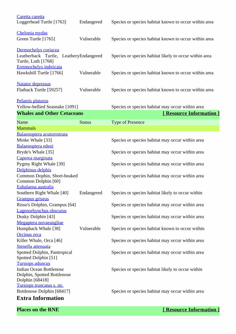
Caretta carettaLoggerhead Turtle [1763] Endangered Species or species habitat known to occur within area
Chelonia mydasGreen Turtle [1765] Vulnerable Species or species habitat known to occur within area
Dermochelys coriaceaLeatherback Turtle, LeatheryTurtle, Luth [1768]
Endangered Species or species habitat likely to occur within area
Eretmochelys imbricataHawksbill Turtle [1766] Vulnerable Species or species habitat known to occur within area
Natator depressusFlatback Turtle [59257] Vulnerable Species or species habitat known to occur within area
Pelamis platurusYellow-bellied Seasnake [1091] Species or species habitat may occur within area
Whales and Other Cetaceans [ Resource Information ]
Name Status Type of PresenceMammalsBalaenoptera acutorostrataMinke Whale [33] Species or species habitat may occur within areaBalaenoptera edeniBryde's Whale [35] Species or species habitat may occur within areaCaperea marginataPygmy Right Whale [39] Species or species habitat may occur within areaDelphinus delphisCommon Dophin, Short-beakedCommon Dolphin [60]
Species or species habitat may occur within area
Eubalaena australisSouthern Right Whale [40] Endangered Species or species habitat likely to occur withinGrampus griseusRisso's Dolphin, Grampus [64] Species or species habitat may occur within areaLagenorhynchus obscurusDusky Dolphin [43] Species or species habitat may occur within areaMegaptera novaeangliaeHumpback Whale [38] Vulnerable Species or species habitat known to occur withinOrcinus orcaKiller Whale, Orca [46] Species or species habitat may occur within areaStenella attenuataSpotted Dolphin, PantropicalSpotted Dolphin [51]
Species or species habitat may occur within area
Tursiops aduncusIndian Ocean BottlenoseDolphin, Spotted BottlenoseDolphin [68418]
Species or species habitat likely to occur within
Tursiops truncatus s. str.Bottlenose Dolphin [68417] Species or species habitat may occur within area
Extra Information
Places on the RNE [ Resource Information ]
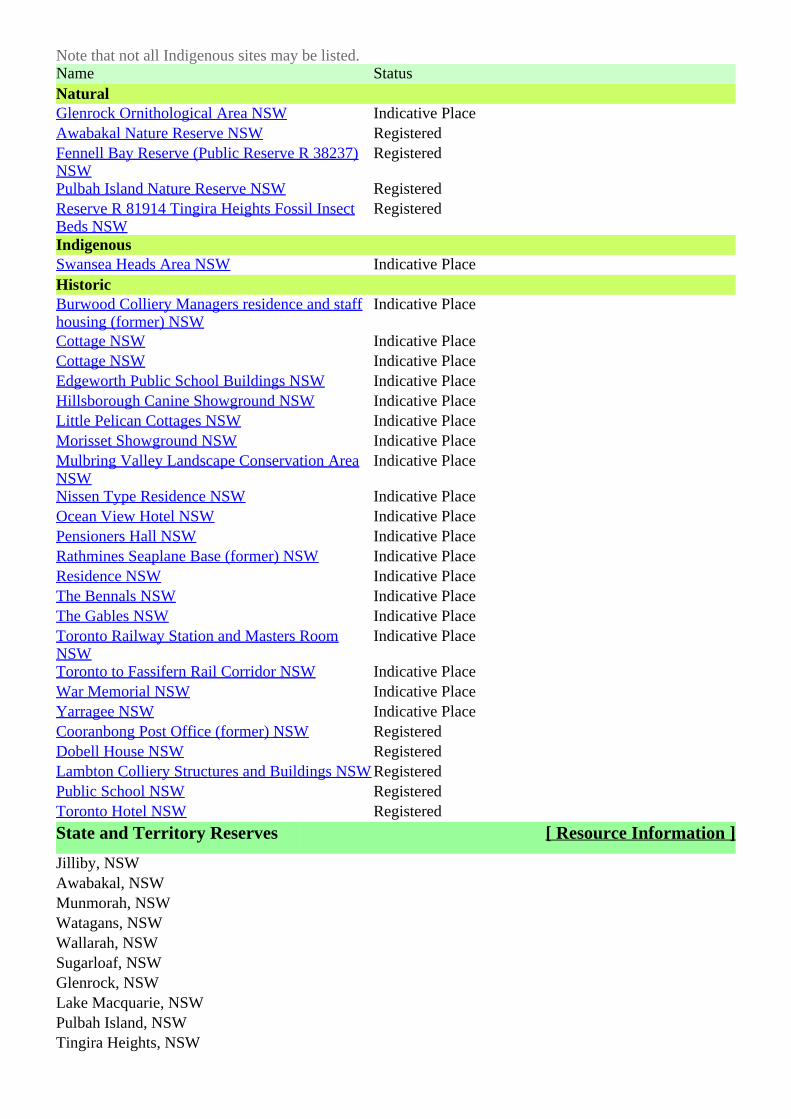
Note that not all Indigenous sites may be listed.Name StatusNaturalGlenrock Ornithological Area NSW Indicative PlaceAwabakal Nature Reserve NSW RegisteredFennell Bay Reserve (Public Reserve R 38237)NSW
Registered
Pulbah Island Nature Reserve NSW RegisteredReserve R 81914 Tingira Heights Fossil InsectBeds NSW
Registered
IndigenousSwansea Heads Area NSW Indicative PlaceHistoricBurwood Colliery Managers residence and staffhousing (former) NSW
Indicative Place
Cottage NSW Indicative PlaceCottage NSW Indicative PlaceEdgeworth Public School Buildings NSW Indicative PlaceHillsborough Canine Showground NSW Indicative PlaceLittle Pelican Cottages NSW Indicative PlaceMorisset Showground NSW Indicative PlaceMulbring Valley Landscape Conservation AreaNSW
Indicative Place
Nissen Type Residence NSW Indicative PlaceOcean View Hotel NSW Indicative PlacePensioners Hall NSW Indicative PlaceRathmines Seaplane Base (former) NSW Indicative PlaceResidence NSW Indicative PlaceThe Bennals NSW Indicative PlaceThe Gables NSW Indicative PlaceToronto Railway Station and Masters RoomNSW
Indicative Place
Toronto to Fassifern Rail Corridor NSW Indicative PlaceWar Memorial NSW Indicative PlaceYarragee NSW Indicative PlaceCooranbong Post Office (former) NSW RegisteredDobell House NSW RegisteredLambton Colliery Structures and Buildings NSW RegisteredPublic School NSW RegisteredToronto Hotel NSW Registered
State and Territory Reserves [ Resource Information ]
Jilliby, NSWAwabakal, NSWMunmorah, NSWWatagans, NSWWallarah, NSWSugarloaf, NSWGlenrock, NSWLake Macquarie, NSWPulbah Island, NSWTingira Heights, NSW
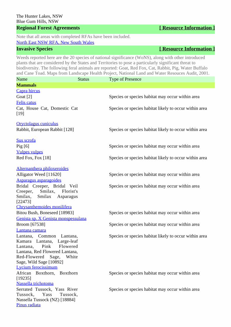
The Hunter Lakes, NSWBlue Gum Hills, NSW
Regional Forest Agreements [ Resource Information ]
Note that all areas with completed RFAs have been included.North East NSW RFA, New South Wales
Invasive Species [ Resource Information ]
Weeds reported here are the 20 species of national significance (WoNS), along with other introducedplants that are considered by the States and Territories to pose a particularly significant threat tobiodiversity. The following feral animals are reported: Goat, Red Fox, Cat, Rabbit, Pig, Water Buffaloand Cane Toad. Maps from Landscape Health Project, National Land and Water Resouces Audit, 2001.Name Status Type of PresenceMammalsCapra hircusGoat [2] Species or species habitat may occur within areaFelis catusCat, House Cat, Domestic Cat[19]
Species or species habitat likely to occur within area
Oryctolagus cuniculusRabbit, European Rabbit [128] Species or species habitat likely to occur within area
Sus scrofaPig [6] Species or species habitat may occur within areaVulpes vulpesRed Fox, Fox [18] Species or species habitat likely to occur within area
Alternanthera philoxeroidesAlligator Weed [11620] Species or species habitat may occur within areaAsparagus asparagoidesBridal Creeper, Bridal VeilCreeper, Smilax, Florist'sSmilax, Smilax Asparagus[22473]
Species or species habitat may occur within area
Chrysanthemoides moniliferaBitou Bush, Boneseed [18983] Species or species habitat may occur within areaGenista sp. X Genista monspessulanaBroom [67538] Species or species habitat may occur within areaLantana camaraLantana, Common Lantana,Kamara Lantana, Large-leafLantana, Pink FloweredLantana, Red Flowered Lantana,Red-Flowered Sage, WhiteSage, Wild Sage [10892]
Species or species habitat likely to occur within area
Lycium ferocissimumAfrican Boxthorn, Boxthorn[19235]
Species or species habitat may occur within area
Nassella trichotomaSerrated Tussock, Yass RiverTussock, Yass Tussock,Nassella Tussock (NZ) [18884]
Species or species habitat may occur within area
Pinus radiata
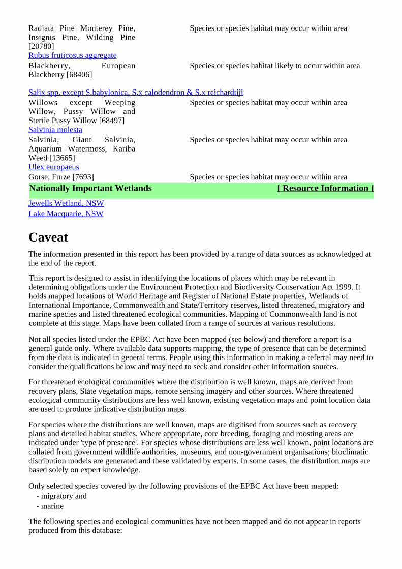
Radiata Pine Monterey Pine,Insignis Pine, Wilding Pine[20780]
Species or species habitat may occur within area
Rubus fruticosus aggregateBlackberry, EuropeanBlackberry [68406]
Species or species habitat likely to occur within area
Salix spp. except S.babylonica, S.x calodendron & S.x reichardtijiWillows except WeepingWillow, Pussy Willow andSterile Pussy Willow [68497]
Species or species habitat may occur within area
Salvinia molestaSalvinia, Giant Salvinia,Aquarium Watermoss, KaribaWeed [13665]
Species or species habitat may occur within area
Ulex europaeusGorse, Furze [7693] Species or species habitat may occur within area
Nationally Important Wetlands [ Resource Information ]
Jewells Wetland, NSWLake Macquarie, NSW
CaveatThe information presented in this report has been provided by a range of data sources as acknowledged atthe end of the report.
This report is designed to assist in identifying the locations of places which may be relevant indetermining obligations under the Environment Protection and Biodiversity Conservation Act 1999. Itholds mapped locations of World Heritage and Register of National Estate properties, Wetlands ofInternational Importance, Commonwealth and State/Territory reserves, listed threatened, migratory andmarine species and listed threatened ecological communities. Mapping of Commonwealth land is notcomplete at this stage. Maps have been collated from a range of sources at various resolutions.
Not all species listed under the EPBC Act have been mapped (see below) and therefore a report is ageneral guide only. Where available data supports mapping, the type of presence that can be determinedfrom the data is indicated in general terms. People using this information in making a referral may need toconsider the qualifications below and may need to seek and consider other information sources.
For threatened ecological communities where the distribution is well known, maps are derived fromrecovery plans, State vegetation maps, remote sensing imagery and other sources. Where threatenedecological community distributions are less well known, existing vegetation maps and point location dataare used to produce indicative distribution maps.
For species where the distributions are well known, maps are digitised from sources such as recoveryplans and detailed habitat studies. Where appropriate, core breeding, foraging and roosting areas areindicated under 'type of presence'. For species whose distributions are less well known, point locations arecollated from government wildlife authorities, museums, and non-government organisations; bioclimaticdistribution models are generated and these validated by experts. In some cases, the distribution maps arebased solely on expert knowledge.
Only selected species covered by the following provisions of the EPBC Act have been mapped:- migratory and- marine
The following species and ecological communities have not been mapped and do not appear in reportsproduced from this database:
- threatened species listed as extinct or considered as vagrants- some species and ecological communities that have only recently been listed- some terrestrial species that overfly the Commonwealth marine area- migratory species that are very widespread, vagrant, or only occur in small numbers.
The following groups have been mapped, but may not cover the complete distribution of the species:- non-threatened seabirds which have only been mapped for recorded breeding sites;- seals which have only been mapped for breeding sites near the Australian continent.
Such breeding sites may be important for the protection of the Commonwealth Marine environment.
AcknowledgementsThis database has been compiled from a range of data sources. The department acknowledges thefollowing custodians who have contributed valuable data and advice:
-Department of Environment, Climate Change and Water, New South Wales-Department of Sustainability and Environment, Victoria-Department of Primary Industries, Parks, Water and Environment, Tasmania-Department of Environment and Natural Resources, South Australia-Parks and Wildlife Service NT, NT Dept of Natural Resources, Environment and the Arts-Environmental and Resource Management, Queensland-Department of Environment and Conservation, Western Australia-Department of the Environment, Climate Change, Energy and Water-Birds Australia-Australian Bird and Bat Banding Scheme-Australian National Wildlife Collection-Natural history museums of Australia-Museum Victoria-Australian Museum-SA Museum-Queensland Museum-Online Zoological Collections of Australian Museums-Queensland Herbarium-National Herbarium of NSW-Royal Botanic Gardens and National Herbarium of Victoria-Tasmanian Herbarium-State Herbarium of South Australia-Northern Territory Herbarium-Western Australian Herbarium-Australian National Herbarium, Atherton and Canberra-University of New England-Ocean Biogeographic Information System-Australian Government, Department of Defence-State Forests of NSW-Other groups and individuals
The Department is extremely grateful to the many organisations and individuals who provided expertadvice and information on numerous draft distributions.
Please feel free to provide feedback via the page.Contact Us

Accessibility | | | | Disclaimer Privacy © Commonwealth of Australia HelpLast updated: Thursday, 16-Sep-2010 09:13:25 EST
Department of Sustainability, Environment, Water, Population and CommunitiesGPO Box 787Canberra ACT 2601 Australia+61 2 6274 1111 ABN
| |Australian Government
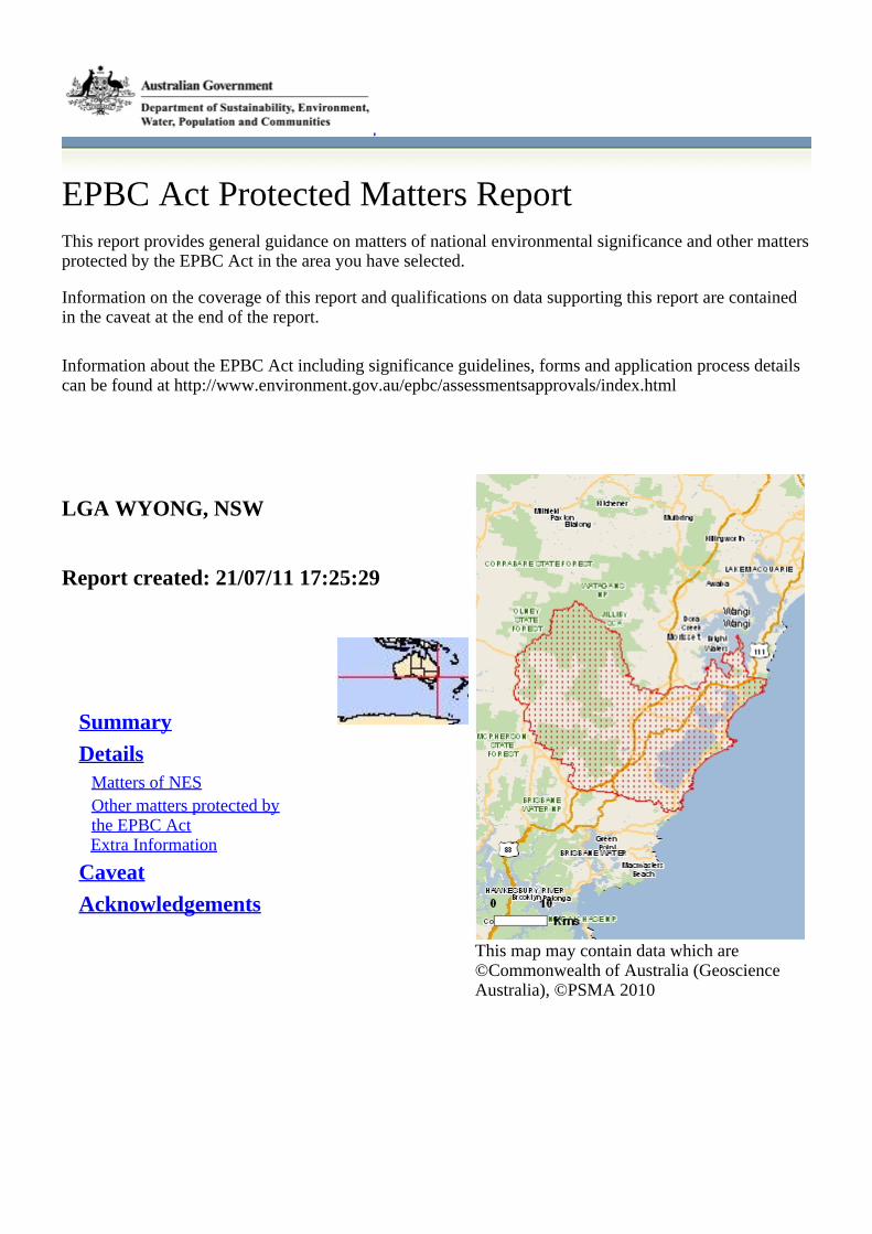
EPBC Act Protected Matters ReportThis report provides general guidance on matters of national environmental significance and other mattersprotected by the EPBC Act in the area you have selected.
Information on the coverage of this report and qualifications on data supporting this report are containedin the caveat at the end of the report.
Information about the EPBC Act including significance guidelines, forms and application process detailscan be found at http://www.environment.gov.au/epbc/assessmentsapprovals/index.html
This map may contain data which are©Commonwealth of Australia (GeoscienceAustralia), ©PSMA 2010
LGA WYONG, NSW
Report created: 21/07/11 17:25:29
Summary
DetailsMatters of NESOther matters protected bythe EPBC ActExtra Information
Caveat
Acknowledgements

SummaryMatters of National Environmental Significance
This part of the report summarises the matters of national environmental significance that may occur in,or may relate to, the area you nominated. Further information is available in the detail part of the report,which can be accessed by scrolling or following the links below. If you are proposing to undertake anactivity that may have a significant impact on one or more matters of national environmental significancethen you should consider the Administrative Guidelines on Significance - seehttp://www.environment.gov.au/epbc/assessmentsapprovals/guidelines/index.html.
World Heritage Properties: None
National Heritage Places: None
Wetlands of InternationalSignificance (RamsarWetlands):
1
Great Barrier Reef MarinePark:
None
Commonwealth Marine Areas: None
Threatened EcologicalCommunitites:
2
Threatened Species: 53
Migratory Species: 57
Other Matters Protected by the EPBC Act
This part of the report summarises other matters protected under the Act that may relate to the area younominated. Approval may be required for a proposed activity that significantly affects the environment onCommonwealth land, when the action is outside the Commonwealth land, or the environment anywherewhen the action is taken on Commonwealth land. Approval may also be required for the Commonwealthor Commonwealth agencies proposing to take an action that is likely to have a significant impact on theenvironment anywhere.
The EPBC Act protects the environment on Commonwealth land, the environment from the actions takenon Commonwealth land, and the environment from actions taken by Commonwealth agencies. Asheritage values of a place are part of the 'environment', these aspects of the EPBC Act protect theCommonwealth Heritage values of a Commonwealth Heritage place and the heritage values of a place onthe Register of the National Estate. Information on the new heritage laws can be found athttp://www.environment.gov.au/heritage/index.html
Please note that the current dataset on Commonwealth land is not complete. Further information onCommonwealth land would need to be obtained from relevant sources including Commonwealthagencies, local agencies, and land tenure maps.
A permit may be required for activities in or on a Commonwealth area that may affect a member of alisted threatened species or ecological community, a member of a listed migratory species, whales andother cetaceans, or a member of a listed marine species. Information on EPBC Act permit requirementsand application forms can be found at http://www.environment.gov.au/epbc/permits/index.html.
Commonwealth Lands: 4
Commonwealth HeritagePlaces:
None
Listed Marine Species: 77
Whales and Other Cetaceans: 12

Critical Habitats: None
Commonwealth Reserves: None
Report Summary for Extra Information
This part of the report provides information that may also be relevant to the area you have nominated.
Place on the RNE: 9
State and Territory Reserves: 11
Regional Forest Agreements: 1
Invasive Species: 17
Nationally ImportantWetlands:
4
DetailsMatters of National Environmental Significance
Wetlands of International Significance (RAMSARSites)
[ Resource Information ]
Name ProximityHunter estuary wetlands Upstream from Ramsar site
Threatened EcologicalCommunities
[ Resource Information ]
For threatened ecological communities where the distribution is well known, maps are derived fromrecovery plans, State vegetation maps, remote sensing imagery and other sources. Where threatenedecological community distributions are less well known, existing vegetation maps and point location dataare used to produce indicative distribution maps.
Name Status Type of PresenceLittoral Rainforest and CoastalVine Thickets of EasternAustralia
CriticallyEndangered
Community likely to occur within area
White Box-YellowBox-Blakely's Red Gum GrassyWoodland and Derived NativeGrassland
CriticallyEndangered
Community may occur within area
Threatened Species [ Resource Information ]
Name Status Type of PresenceBIRDSAnthochaera phrygiaRegent Honeyeater [82338] Endangered Species or species habitat likely to occur within area
Diomedea exulans antipodensisAntipodean Albatross [82269] Vulnerable Species or species habitat may occur within areaDiomedea exulans gibsoniGibson's Albatross [82271] Vulnerable Species or species habitat may occur within areaLathamus discolorSwift Parrot [744] Endangered Species or species habitat likely to occur within area
Macronectes giganteusSouthern Giant-Petrel [1060] Endangered Species or species habitat may occur within area
Macronectes halliNorthern Giant-Petrel [1061] Vulnerable Species or species habitat may occur within areaPterodroma neglecta neglectaKermadec Petrel (western)[64450]
Vulnerable Species or species habitat may occur within area
Rostratula australisAustralian Painted Snipe[77037]
Vulnerable Species or species habitat may occur within area
Thalassarche bulleriBuller's Albatross [64460] Vulnerable Species or species habitat may occur within areaThalassarche cauta cautaShy Albatross, Tasmanian ShyAlbatross [82345]
Vulnerable Species or species habitat may occur within area
Thalassarche cauta salviniSalvin's Albatross [82343] Vulnerable Species or species habitat may occur within areaThalassarche cauta steadiWhite-capped Albatross [82344]Vulnerable Species or species habitat may occur within areaThalassarche melanophris impavidaCampbell Albatross [82449] Vulnerable Species or species habitat may occur within areaFISHMacquaria australasicaMacquarie Perch [66632] Endangered Species or species habitat may occur within areaPrototroctes maraenaAustralian Grayling [26179] Vulnerable Species or species habitat likely to occur within area
FROGSHeleioporus australiacusGiant Burrowing Frog [1973] Vulnerable Species or species habitat likely to occur within area
Litoria aureaGreen and Golden Bell Frog[1870]
Vulnerable Species or species habitat may occur within area
Litoria littlejohniLittlejohn's Tree Frog, HeathFrog [64733]
Vulnerable Species or species habitat may occur within area
Mixophyes balbusStuttering Frog, Southern BarredFrog (in Victoria) [1942]
Vulnerable Species or species habitat likely to occur within area
Mixophyes iteratusGiant Barred Frog, SouthernBarred Frog [1944]
Endangered Species or species habitat likely to occur within area
MAMMALSChalinolobus dwyeriLarge-eared Pied Bat, LargePied Bat [183]
Vulnerable Species or species habitat may occur within area
Dasyurus maculatus maculatus (SE mainland population)Spot-tailed Quoll, Spotted-tailQuoll, Tiger Quoll (southeasternmainland population) [75184]
Endangered Species or species habitat may occur within area
Eubalaena australisSouthern Right Whale [40] Endangered Species or species habitat likely to occur within area
Megaptera novaeangliae
Humpback Whale [38] Vulnerable Species or species habitat known to occur within area
Petrogale penicillataBrush-tailed Rock-wallaby[225]
Vulnerable Species or species habitat may occur within area
Potorous tridactylus tridactylusLong-nosed Potoroo (SEmainland) [66645]
Vulnerable Species or species habitat may occur within area
Pseudomys novaehollandiaeNew Holland Mouse [96] Vulnerable Species or species habitat known to occur within area
Pteropus poliocephalusGrey-headed Flying-fox [186] Vulnerable Roosting known to occur within areaPLANTSAcacia bynoeanaBynoe's Wattle, Tiny Wattle[8575]
Vulnerable Species or species habitat likely to occur within area
Angophora inopina [64832] Vulnerable Species or species habitat likely to occur within area
Caladenia tessellataThick-lipped Spider-orchid,Daddy Long-legs [2119]
Vulnerable Species or species habitat likely to occur within area
Cryptostylis hunterianaLeafless Tongue-orchid [19533] Vulnerable Species or species habitat may occur within areaDiuris praecoxNewcastle Doubletail [55086] Vulnerable Species or species habitat likely to occur within area
Eucalyptus camfieldiiCamfield's Stringybark [15460] Vulnerable Species or species habitat likely to occur within area
Grevillea parviflora subsp. parvifloraSmall-flower Grevillea [64910] Vulnerable Species or species habitat likely to occur within area
Melaleuca biconvexaBiconvex Paperbark [5583] Vulnerable Species or species habitat known to occur within area
Pimelea curviflora var. curviflora [4182] Vulnerable Species or species habitat may occur within areaProstanthera askaniaTranquility Mintbush [64958] Endangered Species or species habitat likely to occur within area
Prostanthera junonisSomersby Mintbush [64960] Endangered Species or species habitat likely to occur within area
Rhizanthella slateriEastern Underground Orchid[11768]
Endangered Species or species habitat may occur within area
Syzygium paniculatumMagenta Lilly Pilly, MagentaCherry, Pocket-less Brush
Vulnerable Species or species habitat likely to occur within area
Cherry, Scrub Cherry, CreekLilly Pilly, Brush Cherry[20307]Tetratheca glandulosaGlandular Pink-bell [2350] Vulnerable Species or species habitat likely to occur within area
Tetratheca junceaBlack-eyed Susan [21407] Vulnerable Species or species habitat likely to occur within area
REPTILESCaretta carettaLoggerhead Turtle [1763] Endangered Species or species habitat known to occur within area
Chelonia mydasGreen Turtle [1765] Vulnerable Species or species habitat known to occur within area
Dermochelys coriaceaLeatherback Turtle, LeatheryTurtle, Luth [1768]
Endangered Species or species habitat likely to occur within area
Eretmochelys imbricataHawksbill Turtle [1766] Vulnerable Species or species habitat known to occur within area
Hoplocephalus bungaroidesBroad-headed Snake [1182] Vulnerable Species or species habitat likely to occur within area
Natator depressusFlatback Turtle [59257] Vulnerable Species or species habitat likely to occur within area
SHARKSCarcharias taurus (east coast population)Grey Nurse Shark (east coastpopulation) [68751]
CriticallyEndangered
Species or species habitat may occur within area
Carcharodon carchariasGreat White Shark [64470] Vulnerable Species or species habitat may occur within areaPristis zijsronGreen Sawfish, Dindagubba,Narrowsnout Sawfish [68442]
Vulnerable Species or species habitat may occur within area
Rhincodon typusWhale Shark [66680] Vulnerable Species or species habitat may occur within area
Migratory Species [ Resource Information ]
Name Status Type of PresenceMigratory Marine BirdsApus pacificusFork-tailed Swift [678] Species or species habitat may occur within areaArdea albaGreat Egret, White Egret[59541]
Species or species habitat may occur within area
Ardea ibisCattle Egret [59542] Species or species habitat may occur within areaDiomedea antipodensisAntipodean Albatross [64458] Species or species habitat may occur within areaDiomedea gibsoni
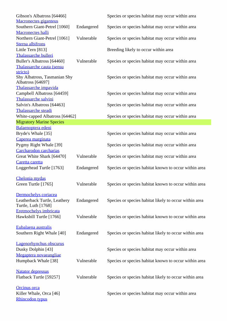
Gibson's Albatross [64466] Species or species habitat may occur within areaMacronectes giganteusSouthern Giant-Petrel [1060] Endangered Species or species habitat may occur within areaMacronectes halliNorthern Giant-Petrel [1061] Vulnerable Species or species habitat may occur within areaSterna albifronsLittle Tern [813] Breeding likely to occur within areaThalassarche bulleriBuller's Albatross [64460] Vulnerable Species or species habitat may occur within areaThalassarche cauta (sensustricto)Shy Albatross, Tasmanian ShyAlbatross [64697]
Species or species habitat may occur within area
Thalassarche impavidaCampbell Albatross [64459] Species or species habitat may occur within areaThalassarche salviniSalvin's Albatross [64463] Species or species habitat may occur within areaThalassarche steadiWhite-capped Albatross [64462] Species or species habitat may occur within areaMigratory Marine SpeciesBalaenoptera edeniBryde's Whale [35] Species or species habitat may occur within areaCaperea marginataPygmy Right Whale [39] Species or species habitat may occur within areaCarcharodon carchariasGreat White Shark [64470] Vulnerable Species or species habitat may occur within areaCaretta carettaLoggerhead Turtle [1763] Endangered Species or species habitat known to occur within area
Chelonia mydasGreen Turtle [1765] Vulnerable Species or species habitat known to occur within area
Dermochelys coriaceaLeatherback Turtle, LeatheryTurtle, Luth [1768]
Endangered Species or species habitat likely to occur within area
Eretmochelys imbricataHawksbill Turtle [1766] Vulnerable Species or species habitat known to occur within area
Eubalaena australisSouthern Right Whale [40] Endangered Species or species habitat likely to occur within area
Lagenorhynchus obscurusDusky Dolphin [43] Species or species habitat may occur within areaMegaptera novaeangliaeHumpback Whale [38] Vulnerable Species or species habitat known to occur within area
Natator depressusFlatback Turtle [59257] Vulnerable Species or species habitat likely to occur within area
Orcinus orcaKiller Whale, Orca [46] Species or species habitat may occur within areaRhincodon typus
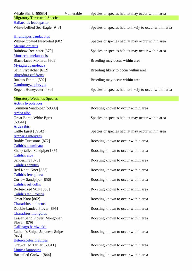
Whale Shark [66680] Vulnerable Species or species habitat may occur within areaMigratory Terrestrial SpeciesHaliaeetus leucogasterWhite-bellied Sea-Eagle [943] Species or species habitat likely to occur within area
Hirundapus caudacutusWhite-throated Needletail [682] Species or species habitat may occur within areaMerops ornatusRainbow Bee-eater [670] Species or species habitat may occur within areaMonarcha melanopsisBlack-faced Monarch [609] Breeding may occur within areaMyiagra cyanoleucaSatin Flycatcher [612] Breeding likely to occur within areaRhipidura rufifronsRufous Fantail [592] Breeding may occur within areaXanthomyza phrygiaRegent Honeyeater [430] Species or species habitat likely to occur within area
Migratory Wetlands SpeciesActitis hypoleucosCommon Sandpiper [59309] Roosting known to occur within areaArdea albaGreat Egret, White Egret[59541]
Species or species habitat may occur within area
Ardea ibisCattle Egret [59542] Species or species habitat may occur within areaArenaria interpresRuddy Turnstone [872] Roosting known to occur within areaCalidris acuminataSharp-tailed Sandpiper [874] Roosting known to occur within areaCalidris albaSanderling [875] Roosting known to occur within areaCalidris canutusRed Knot, Knot [855] Roosting known to occur within areaCalidris ferrugineaCurlew Sandpiper [856] Roosting known to occur within areaCalidris ruficollisRed-necked Stint [860] Roosting known to occur within areaCalidris tenuirostrisGreat Knot [862] Roosting known to occur within areaCharadrius bicinctusDouble-banded Plover [895] Roosting known to occur within areaCharadrius mongolusLesser Sand Plover, MongolianPlover [879]
Roosting known to occur within area
Gallinago hardwickiiLatham's Snipe, Japanese Snipe[863]
Roosting known to occur within area
Heteroscelus brevipesGrey-tailed Tattler [59311] Roosting known to occur within areaLimosa lapponicaBar-tailed Godwit [844] Roosting known to occur within area
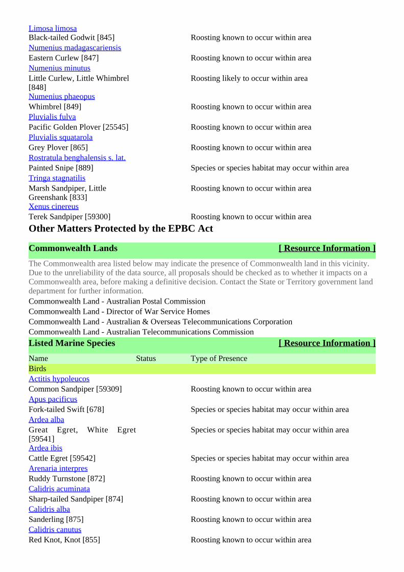
Limosa limosaBlack-tailed Godwit [845] Roosting known to occur within areaNumenius madagascariensisEastern Curlew [847] Roosting known to occur within areaNumenius minutusLittle Curlew, Little Whimbrel[848]
Roosting likely to occur within area
Numenius phaeopusWhimbrel [849] Roosting known to occur within areaPluvialis fulvaPacific Golden Plover [25545] Roosting known to occur within areaPluvialis squatarolaGrey Plover [865] Roosting known to occur within areaRostratula benghalensis s. lat.Painted Snipe [889] Species or species habitat may occur within areaTringa stagnatilisMarsh Sandpiper, LittleGreenshank [833]
Roosting known to occur within area
Xenus cinereusTerek Sandpiper [59300] Roosting known to occur within area
Other Matters Protected by the EPBC Act
Commonwealth Lands [ Resource Information ]
The Commonwealth area listed below may indicate the presence of Commonwealth land in this vicinity.Due to the unreliability of the data source, all proposals should be checked as to whether it impacts on aCommonwealth area, before making a definitive decision. Contact the State or Territory government landdepartment for further information.Commonwealth Land - Australian Postal CommissionCommonwealth Land - Director of War Service HomesCommonwealth Land - Australian & Overseas Telecommunications CorporationCommonwealth Land - Australian Telecommunications Commission
Listed Marine Species [ Resource Information ]
Name Status Type of PresenceBirdsActitis hypoleucosCommon Sandpiper [59309] Roosting known to occur within areaApus pacificusFork-tailed Swift [678] Species or species habitat may occur within areaArdea albaGreat Egret, White Egret[59541]
Species or species habitat may occur within area
Ardea ibisCattle Egret [59542] Species or species habitat may occur within areaArenaria interpresRuddy Turnstone [872] Roosting known to occur within areaCalidris acuminataSharp-tailed Sandpiper [874] Roosting known to occur within areaCalidris albaSanderling [875] Roosting known to occur within areaCalidris canutusRed Knot, Knot [855] Roosting known to occur within area
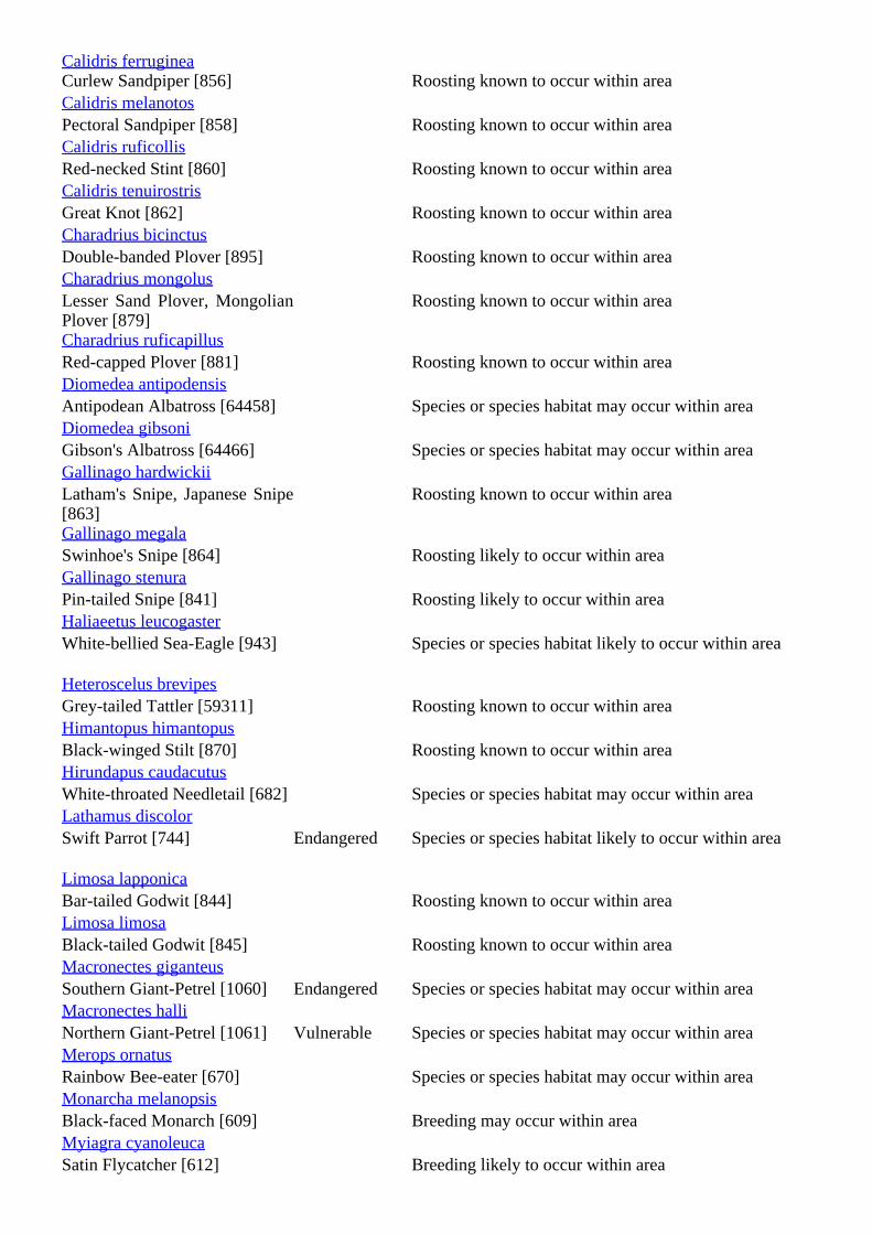
Calidris ferrugineaCurlew Sandpiper [856] Roosting known to occur within areaCalidris melanotosPectoral Sandpiper [858] Roosting known to occur within areaCalidris ruficollisRed-necked Stint [860] Roosting known to occur within areaCalidris tenuirostrisGreat Knot [862] Roosting known to occur within areaCharadrius bicinctusDouble-banded Plover [895] Roosting known to occur within areaCharadrius mongolusLesser Sand Plover, MongolianPlover [879]
Roosting known to occur within area
Charadrius ruficapillusRed-capped Plover [881] Roosting known to occur within areaDiomedea antipodensisAntipodean Albatross [64458] Species or species habitat may occur within areaDiomedea gibsoniGibson's Albatross [64466] Species or species habitat may occur within areaGallinago hardwickiiLatham's Snipe, Japanese Snipe[863]
Roosting known to occur within area
Gallinago megalaSwinhoe's Snipe [864] Roosting likely to occur within areaGallinago stenuraPin-tailed Snipe [841] Roosting likely to occur within areaHaliaeetus leucogasterWhite-bellied Sea-Eagle [943] Species or species habitat likely to occur within area
Heteroscelus brevipesGrey-tailed Tattler [59311] Roosting known to occur within areaHimantopus himantopusBlack-winged Stilt [870] Roosting known to occur within areaHirundapus caudacutusWhite-throated Needletail [682] Species or species habitat may occur within areaLathamus discolorSwift Parrot [744] Endangered Species or species habitat likely to occur within area
Limosa lapponicaBar-tailed Godwit [844] Roosting known to occur within areaLimosa limosaBlack-tailed Godwit [845] Roosting known to occur within areaMacronectes giganteusSouthern Giant-Petrel [1060] Endangered Species or species habitat may occur within areaMacronectes halliNorthern Giant-Petrel [1061] Vulnerable Species or species habitat may occur within areaMerops ornatusRainbow Bee-eater [670] Species or species habitat may occur within areaMonarcha melanopsisBlack-faced Monarch [609] Breeding may occur within areaMyiagra cyanoleucaSatin Flycatcher [612] Breeding likely to occur within area
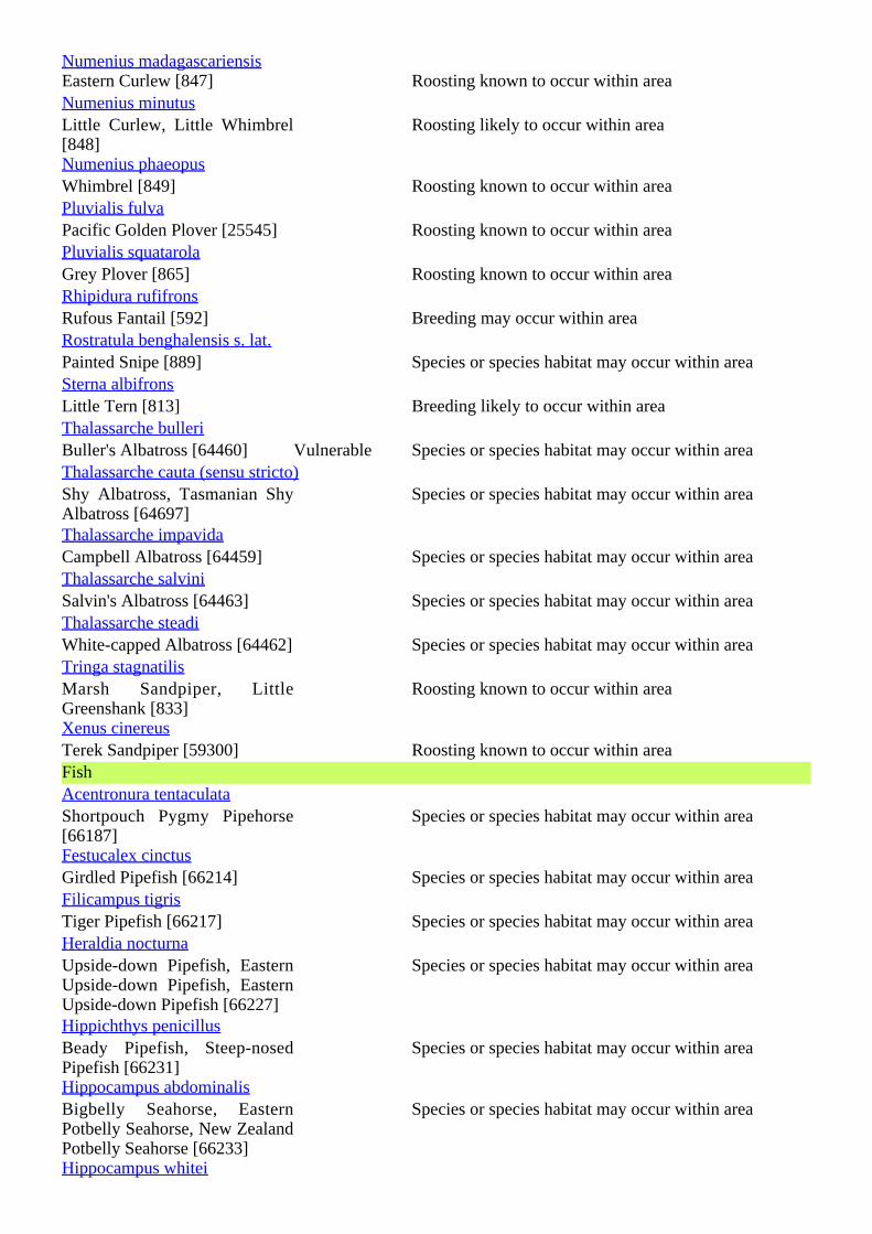
Numenius madagascariensisEastern Curlew [847] Roosting known to occur within areaNumenius minutusLittle Curlew, Little Whimbrel[848]
Roosting likely to occur within area
Numenius phaeopusWhimbrel [849] Roosting known to occur within areaPluvialis fulvaPacific Golden Plover [25545] Roosting known to occur within areaPluvialis squatarolaGrey Plover [865] Roosting known to occur within areaRhipidura rufifronsRufous Fantail [592] Breeding may occur within areaRostratula benghalensis s. lat.Painted Snipe [889] Species or species habitat may occur within areaSterna albifronsLittle Tern [813] Breeding likely to occur within areaThalassarche bulleriBuller's Albatross [64460] Vulnerable Species or species habitat may occur within areaThalassarche cauta (sensu stricto)Shy Albatross, Tasmanian ShyAlbatross [64697]
Species or species habitat may occur within area
Thalassarche impavidaCampbell Albatross [64459] Species or species habitat may occur within areaThalassarche salviniSalvin's Albatross [64463] Species or species habitat may occur within areaThalassarche steadiWhite-capped Albatross [64462] Species or species habitat may occur within areaTringa stagnatilisMarsh Sandpiper, LittleGreenshank [833]
Roosting known to occur within area
Xenus cinereusTerek Sandpiper [59300] Roosting known to occur within areaFishAcentronura tentaculataShortpouch Pygmy Pipehorse[66187]
Species or species habitat may occur within area
Festucalex cinctusGirdled Pipefish [66214] Species or species habitat may occur within areaFilicampus tigrisTiger Pipefish [66217] Species or species habitat may occur within areaHeraldia nocturnaUpside-down Pipefish, EasternUpside-down Pipefish, EasternUpside-down Pipefish [66227]
Species or species habitat may occur within area
Hippichthys penicillusBeady Pipefish, Steep-nosedPipefish [66231]
Species or species habitat may occur within area
Hippocampus abdominalisBigbelly Seahorse, EasternPotbelly Seahorse, New ZealandPotbelly Seahorse [66233]
Species or species habitat may occur within area
Hippocampus whitei
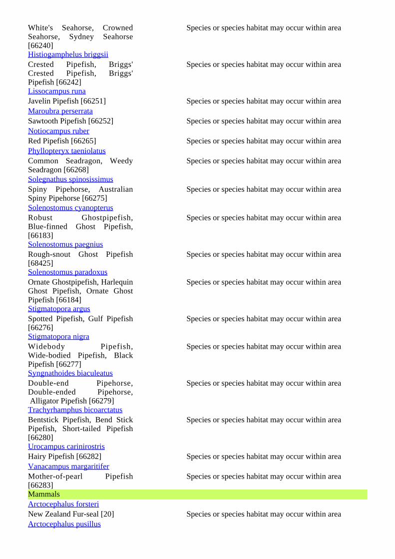
White's Seahorse, CrownedSeahorse, Sydney Seahorse[66240]
Species or species habitat may occur within area
Histiogamphelus briggsiiCrested Pipefish, Briggs'Crested Pipefish, Briggs'Pipefish [66242]
Species or species habitat may occur within area
Lissocampus runaJavelin Pipefish [66251] Species or species habitat may occur within areaMaroubra perserrataSawtooth Pipefish [66252] Species or species habitat may occur within areaNotiocampus ruberRed Pipefish [66265] Species or species habitat may occur within areaPhyllopteryx taeniolatusCommon Seadragon, WeedySeadragon [66268]
Species or species habitat may occur within area
Solegnathus spinosissimusSpiny Pipehorse, AustralianSpiny Pipehorse [66275]
Species or species habitat may occur within area
Solenostomus cyanopterusRobust Ghostpipefish,Blue-finned Ghost Pipefish,[66183]
Species or species habitat may occur within area
Solenostomus paegniusRough-snout Ghost Pipefish[68425]
Species or species habitat may occur within area
Solenostomus paradoxusOrnate Ghostpipefish, HarlequinGhost Pipefish, Ornate GhostPipefish [66184]
Species or species habitat may occur within area
Stigmatopora argusSpotted Pipefish, Gulf Pipefish[66276]
Species or species habitat may occur within area
Stigmatopora nigraWidebody Pipefish,Wide-bodied Pipefish, BlackPipefish [66277]
Species or species habitat may occur within area
Syngnathoides biaculeatusDouble-end Pipehorse,Double-ended Pipehorse, Alligator Pipefish [66279]
Species or species habitat may occur within area
Trachyrhamphus bicoarctatusBentstick Pipefish, Bend StickPipefish, Short-tailed Pipefish[66280]
Species or species habitat may occur within area
Urocampus carinirostrisHairy Pipefish [66282] Species or species habitat may occur within areaVanacampus margaritiferMother-of-pearl Pipefish[66283]
Species or species habitat may occur within area
MammalsArctocephalus forsteriNew Zealand Fur-seal [20] Species or species habitat may occur within areaArctocephalus pusillus
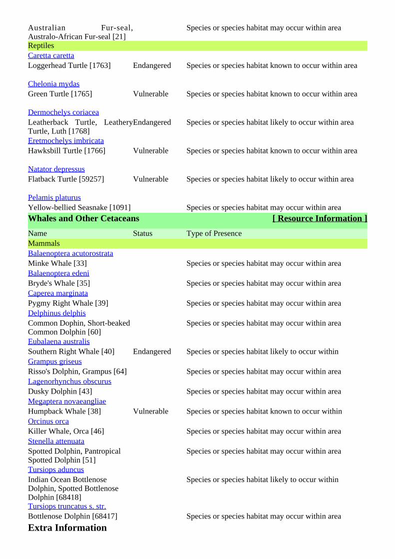
Australian Fur-seal,Australo-African Fur-seal [21]
Species or species habitat may occur within area
ReptilesCaretta carettaLoggerhead Turtle [1763] Endangered Species or species habitat known to occur within area
Chelonia mydasGreen Turtle [1765] Vulnerable Species or species habitat known to occur within area
Dermochelys coriaceaLeatherback Turtle, LeatheryTurtle, Luth [1768]
Endangered Species or species habitat likely to occur within area
Eretmochelys imbricataHawksbill Turtle [1766] Vulnerable Species or species habitat known to occur within area
Natator depressusFlatback Turtle [59257] Vulnerable Species or species habitat likely to occur within area
Pelamis platurusYellow-bellied Seasnake [1091] Species or species habitat may occur within area
Whales and Other Cetaceans [ Resource Information ]
Name Status Type of PresenceMammalsBalaenoptera acutorostrataMinke Whale [33] Species or species habitat may occur within areaBalaenoptera edeniBryde's Whale [35] Species or species habitat may occur within areaCaperea marginataPygmy Right Whale [39] Species or species habitat may occur within areaDelphinus delphisCommon Dophin, Short-beakedCommon Dolphin [60]
Species or species habitat may occur within area
Eubalaena australisSouthern Right Whale [40] Endangered Species or species habitat likely to occur withinGrampus griseusRisso's Dolphin, Grampus [64] Species or species habitat may occur within areaLagenorhynchus obscurusDusky Dolphin [43] Species or species habitat may occur within areaMegaptera novaeangliaeHumpback Whale [38] Vulnerable Species or species habitat known to occur withinOrcinus orcaKiller Whale, Orca [46] Species or species habitat may occur within areaStenella attenuataSpotted Dolphin, PantropicalSpotted Dolphin [51]
Species or species habitat may occur within area
Tursiops aduncusIndian Ocean BottlenoseDolphin, Spotted BottlenoseDolphin [68418]
Species or species habitat likely to occur within
Tursiops truncatus s. str.Bottlenose Dolphin [68417] Species or species habitat may occur within area
Extra Information
Places on the RNE [ Resource Information ]
Note that not all Indigenous sites may be listed.
Name StatusNaturalPossum Park NSW Indicative PlaceIndigenousNorah Head NSW RegisteredHistoricThe Entrance Carousel NSW Indicative PlaceAlison Homestead NSW RegisteredFelton Mathews Tree NSW RegisteredNorah Head Lighthouse NSW RegisteredNorah Head Lightstation Group NSW RegisteredNoraville NSW RegisteredOld Maitland Road Section NSW Registered
State and Territory Reserves [ Resource Information ]
Bar, NSWTuggerah, NSWJilliby, NSWMunmorah, NSWRichters Caves, NSWLake Macquarie, NSWColongra Swamp, NSWTuggerah, NSWWarrawolong, NSWPalm Grove, NSWWyrrabalong, NSW
Regional Forest Agreements [ Resource Information ]
Note that all areas with completed RFAs have been included.North East NSW RFA, New South Wales
Invasive Species [ Resource Information ]
Weeds reported here are the 20 species of national significance (WoNS), along with other introducedplants that are considered by the States and Territories to pose a particularly significant threat tobiodiversity. The following feral animals are reported: Goat, Red Fox, Cat, Rabbit, Pig, Water Buffaloand Cane Toad. Maps from Landscape Health Project, National Land and Water Resouces Audit, 2001.Name Status Type of PresenceMammalsCapra hircusGoat [2] Species or species habitat may occur within areaFelis catusCat, House Cat, Domestic Cat[19]
Species or species habitat likely to occur within area
Oryctolagus cuniculusRabbit, European Rabbit [128] Species or species habitat likely to occur within area
Sus scrofaPig [6] Species or species habitat may occur within area

Vulpes vulpesRed Fox, Fox [18] Species or species habitat likely to occur within area
Alternanthera philoxeroidesAlligator Weed [11620] Species or species habitat may occur within areaAsparagus asparagoidesBridal Creeper, Bridal VeilCreeper, Smilax, Florist'sSmilax, Smilax Asparagus[22473]
Species or species habitat may occur within area
Chrysanthemoides moniliferaBitou Bush, Boneseed [18983] Species or species habitat may occur within areaGenista sp. X Genista monspessulanaBroom [67538] Species or species habitat may occur within areaLantana camaraLantana, Common Lantana,Kamara Lantana, Large-leafLantana, Pink FloweredLantana, Red Flowered Lantana,Red-Flowered Sage, WhiteSage, Wild Sage [10892]
Species or species habitat likely to occur within area
Lycium ferocissimumAfrican Boxthorn, Boxthorn[19235]
Species or species habitat may occur within area
Nassella trichotomaSerrated Tussock, Yass RiverTussock, Yass Tussock,Nassella Tussock (NZ) [18884]
Species or species habitat may occur within area
Pinus radiataRadiata Pine Monterey Pine,Insignis Pine, Wilding Pine[20780]
Species or species habitat may occur within area
Rubus fruticosus aggregateBlackberry, EuropeanBlackberry [68406]
Species or species habitat likely to occur within area
Salix spp. except S.babylonica, S.x calodendron & S.x reichardtijiWillows except WeepingWillow, Pussy Willow andSterile Pussy Willow [68497]
Species or species habitat may occur within area
Salvinia molestaSalvinia, Giant Salvinia,Aquarium Watermoss, KaribaWeed [13665]
Species or species habitat may occur within area
Ulex europaeusGorse, Furze [7693] Species or species habitat may occur within area
Nationally Important Wetlands [ Resource Information ]
Tuggerah Lake, NSWColongra Swamp, NSWWyong Racecourse Swamp, NSWBudgewoi Lake Sand Mass, NSW
Caveat
The information presented in this report has been provided by a range of data sources as acknowledged atthe end of the report.
This report is designed to assist in identifying the locations of places which may be relevant indetermining obligations under the Environment Protection and Biodiversity Conservation Act 1999. Itholds mapped locations of World Heritage and Register of National Estate properties, Wetlands ofInternational Importance, Commonwealth and State/Territory reserves, listed threatened, migratory andmarine species and listed threatened ecological communities. Mapping of Commonwealth land is notcomplete at this stage. Maps have been collated from a range of sources at various resolutions.
Not all species listed under the EPBC Act have been mapped (see below) and therefore a report is ageneral guide only. Where available data supports mapping, the type of presence that can be determinedfrom the data is indicated in general terms. People using this information in making a referral may need toconsider the qualifications below and may need to seek and consider other information sources.
For threatened ecological communities where the distribution is well known, maps are derived fromrecovery plans, State vegetation maps, remote sensing imagery and other sources. Where threatenedecological community distributions are less well known, existing vegetation maps and point location dataare used to produce indicative distribution maps.
For species where the distributions are well known, maps are digitised from sources such as recoveryplans and detailed habitat studies. Where appropriate, core breeding, foraging and roosting areas areindicated under 'type of presence'. For species whose distributions are less well known, point locations arecollated from government wildlife authorities, museums, and non-government organisations; bioclimaticdistribution models are generated and these validated by experts. In some cases, the distribution maps arebased solely on expert knowledge.
Only selected species covered by the following provisions of the EPBC Act have been mapped:- migratory and- marine
The following species and ecological communities have not been mapped and do not appear in reportsproduced from this database:
- threatened species listed as extinct or considered as vagrants- some species and ecological communities that have only recently been listed- some terrestrial species that overfly the Commonwealth marine area- migratory species that are very widespread, vagrant, or only occur in small numbers.
The following groups have been mapped, but may not cover the complete distribution of the species:- non-threatened seabirds which have only been mapped for recorded breeding sites;- seals which have only been mapped for breeding sites near the Australian continent.
Such breeding sites may be important for the protection of the Commonwealth Marine environment.
AcknowledgementsThis database has been compiled from a range of data sources. The department acknowledges thefollowing custodians who have contributed valuable data and advice:
-Department of Environment, Climate Change and Water, New South Wales-Department of Sustainability and Environment, Victoria-Department of Primary Industries, Parks, Water and Environment, Tasmania-Department of Environment and Natural Resources, South Australia-Parks and Wildlife Service NT, NT Dept of Natural Resources, Environment and the Arts-Environmental and Resource Management, Queensland-Department of Environment and Conservation, Western Australia-Department of the Environment, Climate Change, Energy and Water
-Birds Australia-Australian Bird and Bat Banding Scheme-Australian National Wildlife Collection-Natural history museums of Australia-Museum Victoria-Australian Museum-SA Museum-Queensland Museum-Online Zoological Collections of Australian Museums-Queensland Herbarium-National Herbarium of NSW-Royal Botanic Gardens and National Herbarium of Victoria-Tasmanian Herbarium-State Herbarium of South Australia-Northern Territory Herbarium-Western Australian Herbarium-Australian National Herbarium, Atherton and Canberra-University of New England-Ocean Biogeographic Information System-Australian Government, Department of Defence-State Forests of NSW-Other groups and individuals
The Department is extremely grateful to the many organisations and individuals who provided expertadvice and information on numerous draft distributions.
Please feel free to provide feedback via the page.Contact Us
Accessibility | | | | Disclaimer Privacy © Commonwealth of Australia HelpLast updated: Thursday, 16-Sep-2010 09:13:25 EST
Department of Sustainability, Environment, Water, Population and CommunitiesGPO Box 787Canberra ACT 2601 Australia+61 2 6274 1111 ABN
| |Australian Government
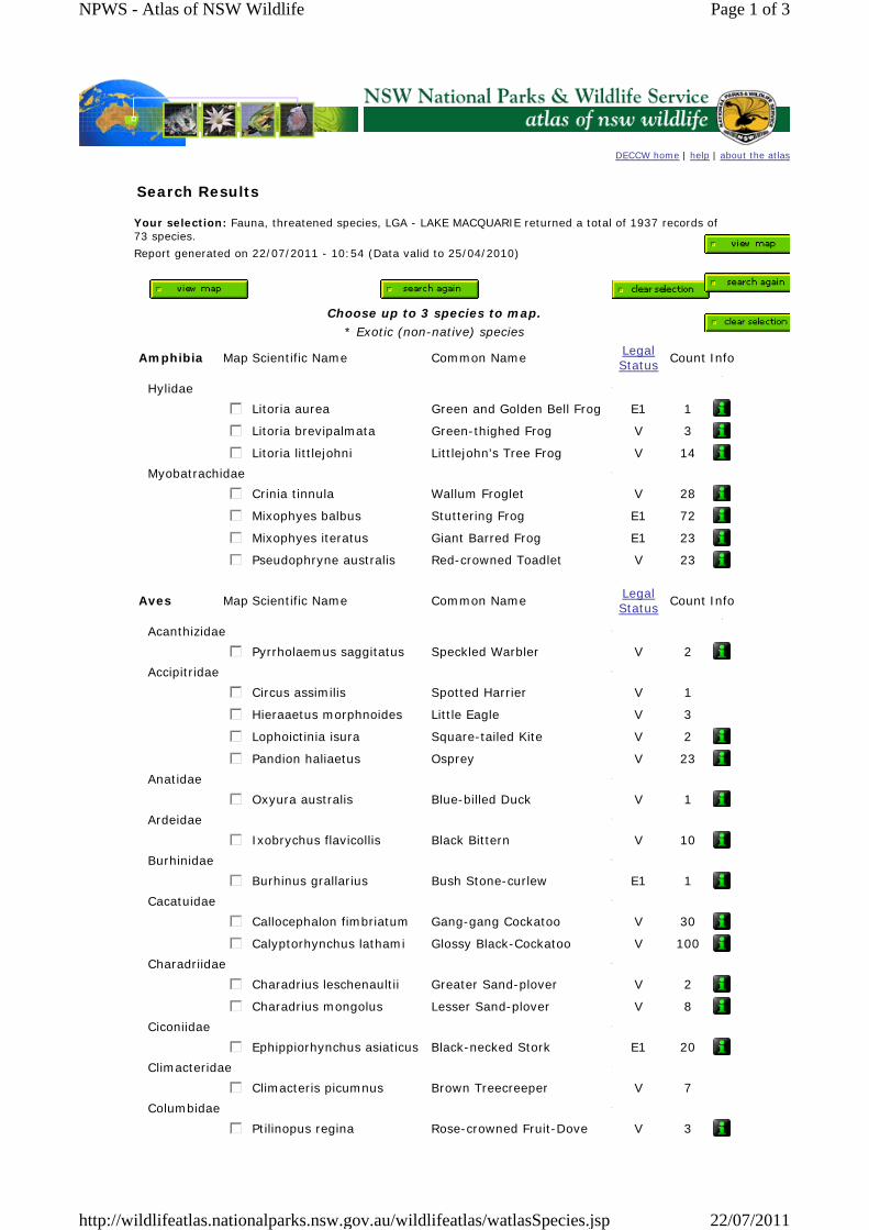
DECCW home | help | about the atlas
Search Results
Your selection: Fauna, threatened species, LGA - LAKE MACQUARIE returned a total of 1937 records of 73 species. Report generated on 22/07/2011 - 10:54 (Data valid to 25/04/2010)
Choose up to 3 species to map.
* Exotic (non-native) species
Amphibia Map Scientific Name Common Name Legal Status Count Info
Hylidae
gfedc Litoria aurea Green and Golden Bell Frog E1 1
gfedc Litoria brevipalmata Green-thighed Frog V 3
gfedc Litoria littlejohni Littlejohn's Tree Frog V 14Myobatrachidae
gfedc Crinia tinnula Wallum Froglet V 28
gfedc Mixophyes balbus Stuttering Frog E1 72
gfedc Mixophyes iteratus Giant Barred Frog E1 23
gfedc Pseudophryne australis Red-crowned Toadlet V 23
Aves Map Scientific Name Common Name Legal Status Count Info
Acanthizidae
gfedc Pyrrholaemus saggitatus Speckled Warbler V 2Accipitridae
gfedc Circus assimilis Spotted Harrier V 1
gfedc Hieraaetus morphnoides Little Eagle V 3
gfedc Lophoictinia isura Square-tailed Kite V 2
gfedc Pandion haliaetus Osprey V 23Anatidae
gfedc Oxyura australis Blue-billed Duck V 1Ardeidae
gfedc Ixobrychus flavicollis Black Bittern V 10Burhinidae
gfedc Burhinus grallarius Bush Stone-curlew E1 1Cacatuidae
gfedc Callocephalon fimbriatum Gang-gang Cockatoo V 30
gfedc Calyptorhynchus lathami Glossy Black-Cockatoo V 100Charadriidae
gfedc Charadrius leschenaultii Greater Sand-plover V 2
gfedc Charadrius mongolus Lesser Sand-plover V 8Ciconiidae
gfedc Ephippiorhynchus asiaticus Black-necked Stork E1 20Climacteridae
gfedc Climacteris picumnus Brown Treecreeper V 7 Columbidae
gfedc Ptilinopus regina Rose-crowned Fruit-Dove V 3
Page 1 of 3NPWS - Atlas of NSW Wildlife
22/07/2011http://wildlifeatlas.nationalparks.nsw.gov.au/wildlifeatlas/watlasSpecies.jsp
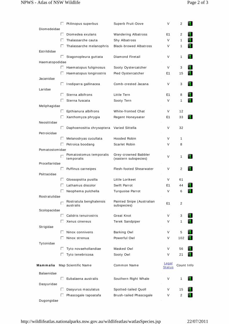
gfedc Ptilinopus superbus Superb Fruit-Dove V 2Diomedeidae
gfedc Diomedea exulans Wandering Albatross E1 2
gfedc Thalassarche cauta Shy Albatross V 1
gfedc Thalassarche melanophris Black-browed Albatross V 1Estrildidae
gfedc Stagonopleura guttata Diamond Firetail V 1Haematopodidae
gfedc Haematopus fuliginosus Sooty Oystercatcher V 3
gfedc Haematopus longirostris Pied Oystercatcher E1 15Jacanidae
gfedc Irediparra gallinacea Comb-crested Jacana V 3Laridae
gfedc Sterna albifrons Little Tern E1 8
gfedc Sterna fuscata Sooty Tern V 1Meliphagidae
gfedc Epthianura albifrons White-fronted Chat V 12
gfedc Xanthomyza phrygia Regent Honeyeater E1 33Neosittidae
gfedc Daphoenositta chrysoptera Varied Sittella V 32 Petroicidae
gfedc Melanodryas cucullata Hooded Robin V 1
gfedc Petroica boodang Scarlet Robin V 8 Pomatostomidae
gfedcPomatostomus temporalis temporalis
Grey-crowned Babbler (eastern subspecies) V 1
Procellariidae
gfedc Puffinus carneipes Flesh-footed Shearwater V 2Psittacidae
gfedc Glossopsitta pusilla Little Lorikeet V 61
gfedc Lathamus discolor Swift Parrot E1 44
gfedc Neophema pulchella Turquoise Parrot V 6Rostratulidae
gfedcRostratula benghalensis australis
Painted Snipe (Australian subspecies) E1 2
Scolopacidae
gfedc Calidris tenuirostris Great Knot V 3
gfedc Xenus cinereus Terek Sandpiper V 1Strigidae
gfedc Ninox connivens Barking Owl V 5
gfedc Ninox strenua Powerful Owl V 102Tytonidae
gfedc Tyto novaehollandiae Masked Owl V 56
gfedc Tyto tenebricosa Sooty Owl V 21
Mammalia Map Scientific Name Common Name Legal Status Count Info
Balaenidae
gfedc Eubalaena australis Southern Right Whale V 1Dasyuridae
gfedc Dasyurus maculatus Spotted-tailed Quoll V 15
gfedc Phascogale tapoatafa Brush-tailed Phascogale V 2Dugongidae
Page 2 of 3NPWS - Atlas of NSW Wildlife
22/07/2011http://wildlifeatlas.nationalparks.nsw.gov.au/wildlifeatlas/watlasSpecies.jsp
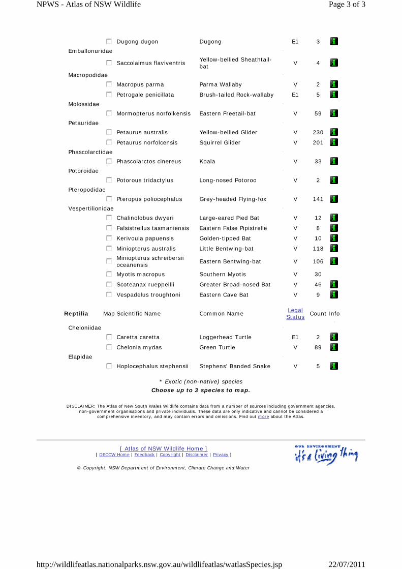
gfedc Dugong dugon Dugong E1 3Emballonuridae
gfedc Saccolaimus flaviventris Yellow-bellied Sheathtail-bat V 4
Macropodidae
gfedc Macropus parma Parma Wallaby V 2
gfedc Petrogale penicillata Brush-tailed Rock-wallaby E1 5Molossidae
gfedc Mormopterus norfolkensis Eastern Freetail-bat V 59Petauridae
gfedc Petaurus australis Yellow-bellied Glider V 230
gfedc Petaurus norfolcensis Squirrel Glider V 201Phascolarctidae
gfedc Phascolarctos cinereus Koala V 33Potoroidae
gfedc Potorous tridactylus Long-nosed Potoroo V 2Pteropodidae
gfedc Pteropus poliocephalus Grey-headed Flying-fox V 141Vespertilionidae
gfedc Chalinolobus dwyeri Large-eared Pied Bat V 12
gfedc Falsistrellus tasmaniensis Eastern False Pipistrelle V 8
gfedc Kerivoula papuensis Golden-tipped Bat V 10
gfedc Miniopterus australis Little Bentwing-bat V 118
gfedcMiniopterus schreibersii oceanensis Eastern Bentwing-bat V 106
gfedc Myotis macropus Southern Myotis V 30
gfedc Scoteanax rueppellii Greater Broad-nosed Bat V 46
gfedc Vespadelus troughtoni Eastern Cave Bat V 9
Reptilia Map Scientific Name Common Name Legal Status Count Info
Cheloniidae
gfedc Caretta caretta Loggerhead Turtle E1 2
gfedc Chelonia mydas Green Turtle V 89Elapidae
gfedc Hoplocephalus stephensii Stephens' Banded Snake V 5
* Exotic (non-native) species Choose up to 3 species to map.
DISCLAIMER: The Atlas of New South Wales Wildlife contains data from a number of sources including government agencies, non-government organisations and private individuals. These data are only indicative and cannot be considered a
comprehensive inventory, and may contain errors and omissions. Find out more about the Atlas.
[ Atlas of NSW Wildlife Home ] [ DECCW Home | Feedback | Copyright | Disclaimer | Privacy ]
© Copyright, NSW Department of Environment, Climate Change and Water
Page 3 of 3NPWS - Atlas of NSW Wildlife
22/07/2011http://wildlifeatlas.nationalparks.nsw.gov.au/wildlifeatlas/watlasSpecies.jsp
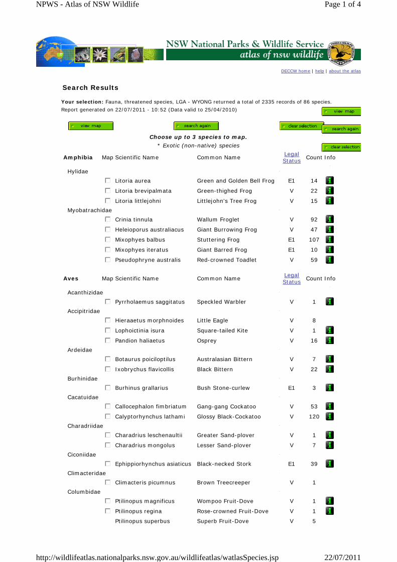
DECCW home | help | about the atlas
Search Results
Your selection: Fauna, threatened species, LGA - WYONG returned a total of 2335 records of 86 species. Report generated on 22/07/2011 - 10:52 (Data valid to 25/04/2010)
Choose up to 3 species to map.
* Exotic (non-native) species
Amphibia Map Scientific Name Common Name Legal Status Count Info
Hylidae
gfedc Litoria aurea Green and Golden Bell Frog E1 14
gfedc Litoria brevipalmata Green-thighed Frog V 22
gfedc Litoria littlejohni Littlejohn's Tree Frog V 15Myobatrachidae
gfedc Crinia tinnula Wallum Froglet V 92
gfedc Heleioporus australiacus Giant Burrowing Frog V 47
gfedc Mixophyes balbus Stuttering Frog E1 107
gfedc Mixophyes iteratus Giant Barred Frog E1 10
gfedc Pseudophryne australis Red-crowned Toadlet V 59
Aves Map Scientific Name Common Name Legal Status Count Info
Acanthizidae
gfedc Pyrrholaemus saggitatus Speckled Warbler V 1Accipitridae
gfedc Hieraaetus morphnoides Little Eagle V 8
gfedc Lophoictinia isura Square-tailed Kite V 1
gfedc Pandion haliaetus Osprey V 16Ardeidae
gfedc Botaurus poiciloptilus Australasian Bittern V 7
gfedc Ixobrychus flavicollis Black Bittern V 22Burhinidae
gfedc Burhinus grallarius Bush Stone-curlew E1 3Cacatuidae
gfedc Callocephalon fimbriatum Gang-gang Cockatoo V 53
gfedc Calyptorhynchus lathami Glossy Black-Cockatoo V 120Charadriidae
gfedc Charadrius leschenaultii Greater Sand-plover V 1
gfedc Charadrius mongolus Lesser Sand-plover V 7Ciconiidae
gfedc Ephippiorhynchus asiaticus Black-necked Stork E1 39Climacteridae
gfedc Climacteris picumnus Brown Treecreeper V 1 Columbidae
gfedc Ptilinopus magnificus Wompoo Fruit-Dove V 1
gfedc Ptilinopus regina Rose-crowned Fruit-Dove V 1
Ptilinopus superbus Superb Fruit-Dove V 5
Page 1 of 4NPWS - Atlas of NSW Wildlife
22/07/2011http://wildlifeatlas.nationalparks.nsw.gov.au/wildlifeatlas/watlasSpecies.jsp
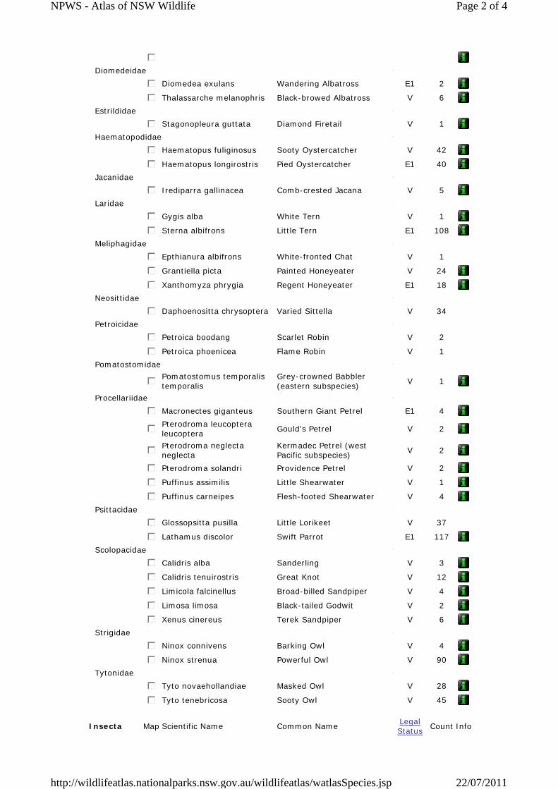
gfedc
Diomedeidae
gfedc Diomedea exulans Wandering Albatross E1 2
gfedc Thalassarche melanophris Black-browed Albatross V 6Estrildidae
gfedc Stagonopleura guttata Diamond Firetail V 1Haematopodidae
gfedc Haematopus fuliginosus Sooty Oystercatcher V 42
gfedc Haematopus longirostris Pied Oystercatcher E1 40Jacanidae
gfedc Irediparra gallinacea Comb-crested Jacana V 5Laridae
gfedc Gygis alba White Tern V 1
gfedc Sterna albifrons Little Tern E1 108Meliphagidae
gfedc Epthianura albifrons White-fronted Chat V 1
gfedc Grantiella picta Painted Honeyeater V 24
gfedc Xanthomyza phrygia Regent Honeyeater E1 18Neosittidae
gfedc Daphoenositta chrysoptera Varied Sittella V 34 Petroicidae
gfedc Petroica boodang Scarlet Robin V 2
gfedc Petroica phoenicea Flame Robin V 1 Pomatostomidae
gfedcPomatostomus temporalis temporalis
Grey-crowned Babbler (eastern subspecies) V 1
Procellariidae
gfedc Macronectes giganteus Southern Giant Petrel E1 4
gfedcPterodroma leucoptera leucoptera Gould's Petrel V 2
gfedcPterodroma neglecta neglecta
Kermadec Petrel (west Pacific subspecies) V 2
gfedc Pterodroma solandri Providence Petrel V 2
gfedc Puffinus assimilis Little Shearwater V 1
gfedc Puffinus carneipes Flesh-footed Shearwater V 4Psittacidae
gfedc Glossopsitta pusilla Little Lorikeet V 37
gfedc Lathamus discolor Swift Parrot E1 117Scolopacidae
gfedc Calidris alba Sanderling V 3
gfedc Calidris tenuirostris Great Knot V 12
gfedc Limicola falcinellus Broad-billed Sandpiper V 4
gfedc Limosa limosa Black-tailed Godwit V 2
gfedc Xenus cinereus Terek Sandpiper V 6Strigidae
gfedc Ninox connivens Barking Owl V 4
gfedc Ninox strenua Powerful Owl V 90Tytonidae
gfedc Tyto novaehollandiae Masked Owl V 28
gfedc Tyto tenebricosa Sooty Owl V 45
Insecta Map Scientific Name Common Name Legal Status Count Info
Page 2 of 4NPWS - Atlas of NSW Wildlife
22/07/2011http://wildlifeatlas.nationalparks.nsw.gov.au/wildlifeatlas/watlasSpecies.jsp
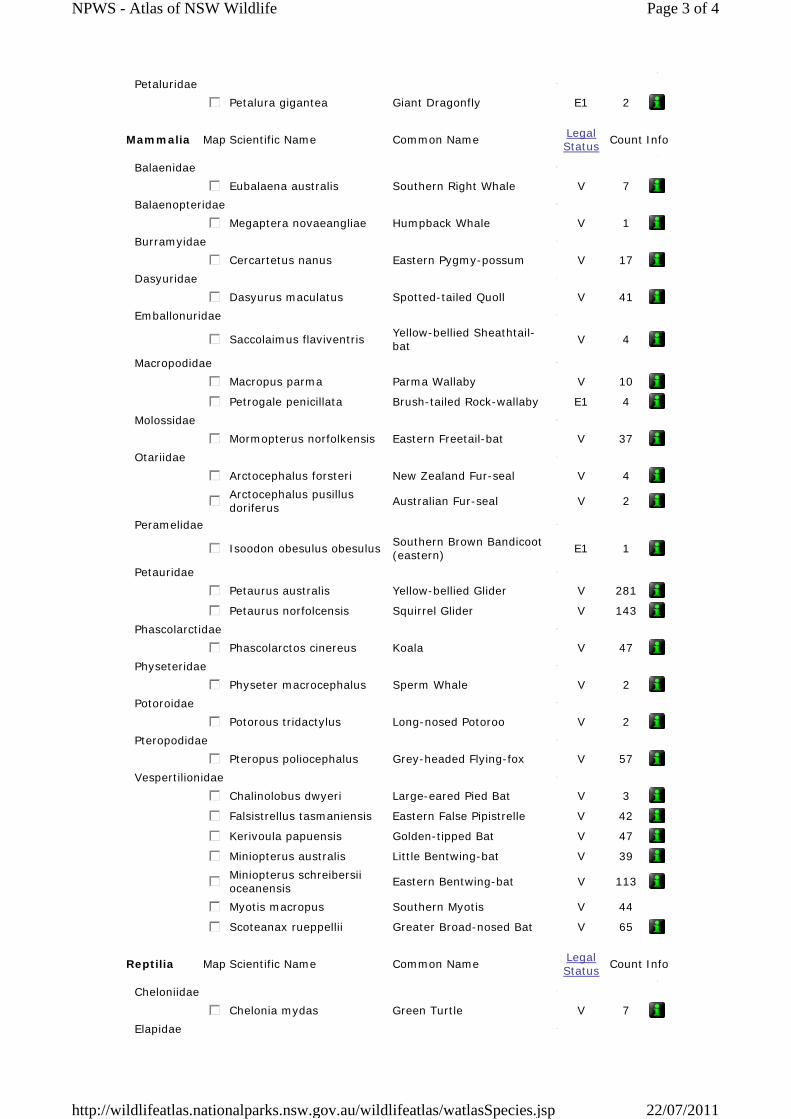
Petaluridae
gfedc Petalura gigantea Giant Dragonfly E1 2
Mammalia Map Scientific Name Common Name Legal Status Count Info
Balaenidae
gfedc Eubalaena australis Southern Right Whale V 7Balaenopteridae
gfedc Megaptera novaeangliae Humpback Whale V 1Burramyidae
gfedc Cercartetus nanus Eastern Pygmy-possum V 17Dasyuridae
gfedc Dasyurus maculatus Spotted-tailed Quoll V 41Emballonuridae
gfedc Saccolaimus flaviventris Yellow-bellied Sheathtail-bat V 4
Macropodidae
gfedc Macropus parma Parma Wallaby V 10
gfedc Petrogale penicillata Brush-tailed Rock-wallaby E1 4Molossidae
gfedc Mormopterus norfolkensis Eastern Freetail-bat V 37Otariidae
gfedc Arctocephalus forsteri New Zealand Fur-seal V 4
gfedcArctocephalus pusillus doriferus Australian Fur-seal V 2
Peramelidae
gfedc Isoodon obesulus obesulus Southern Brown Bandicoot (eastern) E1 1
Petauridae
gfedc Petaurus australis Yellow-bellied Glider V 281
gfedc Petaurus norfolcensis Squirrel Glider V 143Phascolarctidae
gfedc Phascolarctos cinereus Koala V 47Physeteridae
gfedc Physeter macrocephalus Sperm Whale V 2Potoroidae
gfedc Potorous tridactylus Long-nosed Potoroo V 2Pteropodidae
gfedc Pteropus poliocephalus Grey-headed Flying-fox V 57Vespertilionidae
gfedc Chalinolobus dwyeri Large-eared Pied Bat V 3
gfedc Falsistrellus tasmaniensis Eastern False Pipistrelle V 42
gfedc Kerivoula papuensis Golden-tipped Bat V 47
gfedc Miniopterus australis Little Bentwing-bat V 39
gfedcMiniopterus schreibersii oceanensis Eastern Bentwing-bat V 113
gfedc Myotis macropus Southern Myotis V 44
gfedc Scoteanax rueppellii Greater Broad-nosed Bat V 65
Reptilia Map Scientific Name Common Name Legal Status Count Info
Cheloniidae
gfedc Chelonia mydas Green Turtle V 7Elapidae
Page 3 of 4NPWS - Atlas of NSW Wildlife
22/07/2011http://wildlifeatlas.nationalparks.nsw.gov.au/wildlifeatlas/watlasSpecies.jsp
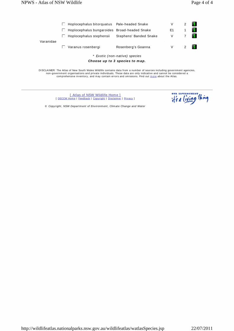
gfedc Hoplocephalus bitorquatus Pale-headed Snake V 2
gfedc Hoplocephalus bungaroides Broad-headed Snake E1 1
gfedc Hoplocephalus stephensii Stephens' Banded Snake V 7Varanidae
gfedc Varanus rosenbergi Rosenberg's Goanna V 2
* Exotic (non-native) species Choose up to 3 species to map.
DISCLAIMER: The Atlas of New South Wales Wildlife contains data from a number of sources including government agencies, non-government organisations and private individuals. These data are only indicative and cannot be considered a
comprehensive inventory, and may contain errors and omissions. Find out more about the Atlas.
[ Atlas of NSW Wildlife Home ] [ DECCW Home | Feedback | Copyright | Disclaimer | Privacy ]
© Copyright, NSW Department of Environment, Climate Change and Water
Page 4 of 4NPWS - Atlas of NSW Wildlife
22/07/2011http://wildlifeatlas.nationalparks.nsw.gov.au/wildlifeatlas/watlasSpecies.jsp
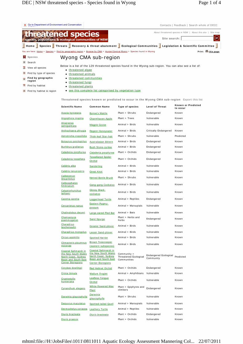
Go to Department of Environment and Conservation (NSW) homepage
Contacts | Feedback | Search whole of DECC
About threatened species in NSW | About this site | Site map
Site search:
Home Species Threats Recovery & threat abatement Ecological Communities Legislation & Scientific Committee You are here: Home > Species > Find by geographic region > Browse by CMA > Hunter/Central Rivers > Species found in Wyong Print: this page
Species
Search
View all species
Find by type of species
Find by geographic region
Find by habitat
Find by habitat & region
Wyong CMA sub-region Below is a list of the 129 threatened species found in the Wyong sub-region. You can also see a list of:
threatened algae threatened animals threatened communities threatened fungi threatened plants see this complete list categorised by vegetation type
Threatened species known or predicted to occur in the Wyong CMA sub-region Export this list
Scientific Name Common Name Type of species Level of Threat Known or Predicted to occur
Acacia bynoeana Bynoe's Wattle Plant > Shrubs Endangered Known
Angophora inopina Charmhaven Apple Plant > Trees Vulnerable Known
Anseranas semipalmata Magpie Goose Animal > Birds Vulnerable Known
Anthochaera phrygia Regent Honeyeater Animal > Birds Critically Endangered Known
Astrotricha crassifolia Thick-leaf Star-hair Plant > Shrubs Vulnerable Predicted
Botaurus poiciloptilus Australasian Bittern Animal > Birds Endangered Known
Burhinus grallarius Bush Stone-curlew Animal > Birds Endangered Known
Caladenia porphyrea Caladenia porphyrea Plant > Orchids Endangered Known
Caladenia tessellataTessellated Spider Orchid Plant > Orchids Endangered Known
Calidris alba Sanderling Animal > Birds Vulnerable Known
Calidris tenuirostris Great Knot Animal > Birds Vulnerable Known
Callistemon linearifolius Netted Bottle Brush Plant > Shrubs Vulnerable Known
Callocephalon fimbriatum Gang-gang Cockatoo Animal > Birds Vulnerable Known
Calyptorhynchus lathami
Glossy Black-cockatoo Animal > Birds Vulnerable Known
Caretta caretta Loggerhead Turtle Animal > Reptiles Endangered Known
Cercartetus nanusEastern Pygmy-possum Animal > Marsupials Vulnerable Known
Chalinolobus dwyeri Large-eared Pied Bat Animal > Bats Vulnerable Known
Chamaesyce psammogeton Sand Spurge Plant > Herbs and
Forbs Endangered Known
Charadrius leschenaultii Greater Sand-plover Animal > Birds Vulnerable Known
Charadrius mongolus Lesser Sand-plover Animal > Birds Vulnerable Known
Circus assimilis Spotted Harrier Animal > Birds Vulnerable Known
Climacteris picumnus victoriae
Brown Treecreeper (eastern subspecies) Animal > Birds Vulnerable Known
Coastal Saltmarsh in the New South Wales North Coast, Sydney Basin and South East Corner Bioregions
Coastal Saltmarsh in the New South Wales North Coast, Sydney Basin and South East Corner Bioregions
Community > Threatened Ecological Communities
Endangered Ecological Community Predicted
Corybas dowlingii Red Helmet Orchid Plant > Orchids Endangered Known
Crinia tinnula Wallum Froglet Animal > Amphibians Vulnerable Known
Cryptostylis hunteriana
Leafless Tongue Orchid Plant > Orchids Vulnerable Known
Cynanchum elegansWhite-flowered Wax Plant
Plant > Epiphytes and climbers Endangered Known
Darwinia glaucophyllaDarwinia glaucophylla Plant > Shrubs Vulnerable Known
Dasyurus maculatus Spotted-tailed Quoll Animal > Marsupials Vulnerable Known
Dermochelys coriacea Leathery Turtle Animal > Reptiles Vulnerable Known
Diuris bracteata Diuris bracteata Plant > Orchids Endangered Known
Diuris praecox Plant > Orchids Vulnerable Known
Page 1 of 4DEC | NSW threatened species - Species found in Wyong
22/07/2011mhtml:file://H:\JobsFiles\1011\0811011 Aquatic Ecology Assessment Mannering Col...
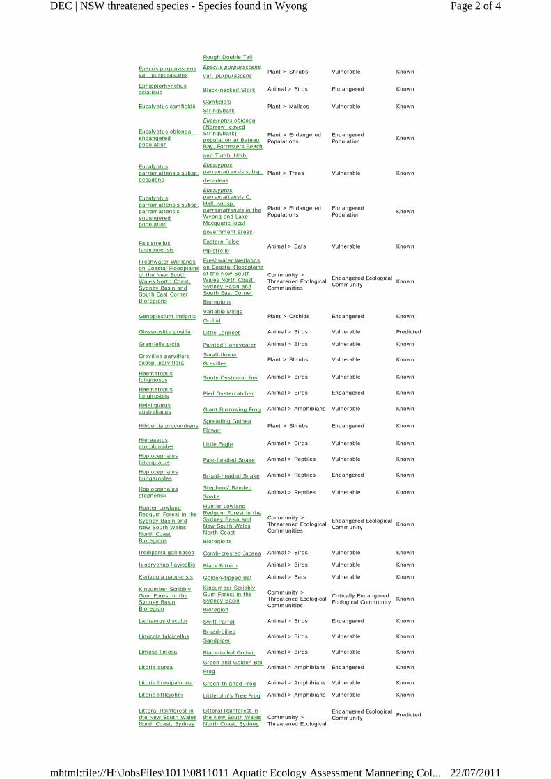
Rough Double Tail Epacris purpurascens var. purpurascens
Epacris purpurascens var. purpurascens Plant > Shrubs Vulnerable Known
Ephippiorhynchus asiaticus Black-necked Stork Animal > Birds Endangered Known
Eucalyptus camfieldiiCamfield's Stringybark Plant > Mallees Vulnerable Known
Eucalyptus oblonga - endangered population
Eucalyptus oblonga (Narrow-leaved Stringybark) population at Bateau Bay, Forresters Beach and Tumbi Umbi
Plant > Endangered Populations
Endangered Population Known
Eucalyptus parramattensis subsp. decadens
Eucalyptus parramattensis subsp. decadens
Plant > Trees Vulnerable Known
Eucalyptus parramattensis subsp. parramattensis - endangered population
Eucalyptus parramattensis C. Hall. subsp. parramattensis in the Wyong and Lake Macquarie local government areas
Plant > Endangered Populations
Endangered Population Known
Falsistrellus tasmaniensis
Eastern False Pipistrelle Animal > Bats Vulnerable Known
Freshwater Wetlands on Coastal Floodplains of the New South Wales North Coast, Sydney Basin and South East Corner Bioregions
Freshwater Wetlands on Coastal Floodplains of the New South Wales North Coast, Sydney Basin and South East Corner Bioregions
Community > Threatened Ecological Communities
Endangered Ecological Community Known
Genoplesium insignisVariable Midge Orchid Plant > Orchids Endangered Known
Glossopsitta pusilla Little Lorikeet Animal > Birds Vulnerable Predicted
Grantiella picta Painted Honeyeater Animal > Birds Vulnerable Known
Grevillea parviflora subsp. parviflora
Small-flower Grevillea Plant > Shrubs Vulnerable Known
Haematopus fuliginosus Sooty Oystercatcher Animal > Birds Vulnerable Known
Haematopus longirostris Pied Oystercatcher Animal > Birds Endangered Known
Heleioporus australiacus Giant Burrowing Frog Animal > Amphibians Vulnerable Known
Hibbertia procumbensSpreading Guinea Flower Plant > Shrubs Endangered Known
Hieraaetus morphnoides Little Eagle Animal > Birds Vulnerable Known
Hoplocephalus bitorquatus Pale-headed Snake Animal > Reptiles Vulnerable Known
Hoplocephalus bungaroides Broad-headed Snake Animal > Reptiles Endangered Known
Hoplocephalus stephensii
Stephens' Banded Snake Animal > Reptiles Vulnerable Known
Hunter Lowland Redgum Forest in the Sydney Basin and New South Wales North Coast Bioregions
Hunter Lowland Redgum Forest in the Sydney Basin and New South Wales North Coast Bioregions
Community > Threatened Ecological Communities
Endangered Ecological Community Known
Irediparra gallinacea Comb-crested Jacana Animal > Birds Vulnerable Known
Ixobrychus flavicollis Black Bittern Animal > Birds Vulnerable Known
Kerivoula papuensis Golden-tipped Bat Animal > Bats Vulnerable Known
Kincumber Scribbly Gum Forest in the Sydney Basin Bioregion
Kincumber Scribbly Gum Forest in the Sydney Basin Bioregion
Community > Threatened Ecological Communities
Critically Endangered Ecological Community Known
Lathamus discolor Swift Parrot Animal > Birds Endangered Known
Limicola falcinellusBroad-billed Sandpiper Animal > Birds Vulnerable Known
Limosa limosa Black-tailed Godwit Animal > Birds Vulnerable Known
Litoria aureaGreen and Golden Bell Frog Animal > Amphibians Endangered Known
Litoria brevipalmata Green-thighed Frog Animal > Amphibians Vulnerable Known
Litoria littlejohni Littlejohn's Tree Frog Animal > Amphibians Vulnerable Known
Littoral Rainforest in the New South Wales North Coast, Sydney
Littoral Rainforest in the New South Wales North Coast, Sydney
Community > Threatened Ecological
Endangered Ecological Community Predicted
Page 2 of 4DEC | NSW threatened species - Species found in Wyong
22/07/2011mhtml:file://H:\JobsFiles\1011\0811011 Aquatic Ecology Assessment Mannering Col...
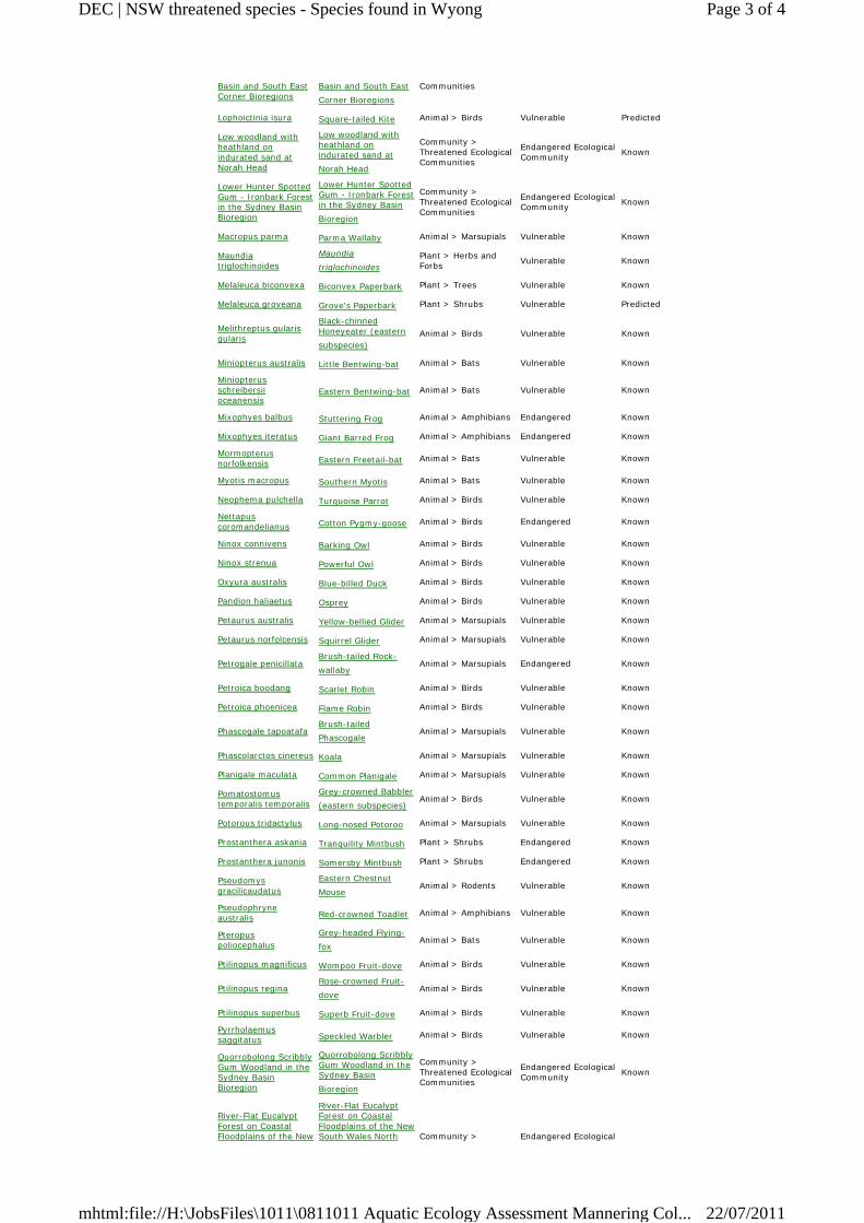
Basin and South East Corner Bioregions
Basin and South East Corner Bioregions
Communities
Lophoictinia isura Square-tailed Kite Animal > Birds Vulnerable Predicted
Low woodland with heathland on indurated sand at Norah Head
Low woodland with heathland on indurated sand at Norah Head
Community > Threatened Ecological Communities
Endangered Ecological Community Known
Lower Hunter Spotted Gum - Ironbark Forest in the Sydney Basin Bioregion
Lower Hunter Spotted Gum - Ironbark Forest in the Sydney Basin Bioregion
Community > Threatened Ecological Communities
Endangered Ecological Community Known
Macropus parma Parma Wallaby Animal > Marsupials Vulnerable Known
Maundia triglochinoides
Maundia triglochinoides
Plant > Herbs and Forbs Vulnerable Known
Melaleuca biconvexa Biconvex Paperbark Plant > Trees Vulnerable Known
Melaleuca groveana Grove's Paperbark Plant > Shrubs Vulnerable Predicted
Melithreptus gularis gularis
Black-chinned Honeyeater (eastern subspecies)
Animal > Birds Vulnerable Known
Miniopterus australis Little Bentwing-bat Animal > Bats Vulnerable Known
Miniopterus schreibersii oceanensis
Eastern Bentwing-bat Animal > Bats Vulnerable Known
Mixophyes balbus Stuttering Frog Animal > Amphibians Endangered Known
Mixophyes iteratus Giant Barred Frog Animal > Amphibians Endangered Known
Mormopterus norfolkensis Eastern Freetail-bat Animal > Bats Vulnerable Known
Myotis macropus Southern Myotis Animal > Bats Vulnerable Known
Neophema pulchella Turquoise Parrot Animal > Birds Vulnerable Known
Nettapus coromandelianus Cotton Pygmy-goose Animal > Birds Endangered Known
Ninox connivens Barking Owl Animal > Birds Vulnerable Known
Ninox strenua Powerful Owl Animal > Birds Vulnerable Known
Oxyura australis Blue-billed Duck Animal > Birds Vulnerable Known
Pandion haliaetus Osprey Animal > Birds Vulnerable Known
Petaurus australis Yellow-bellied Glider Animal > Marsupials Vulnerable Known
Petaurus norfolcensis Squirrel Glider Animal > Marsupials Vulnerable Known
Petrogale penicillataBrush-tailed Rock-wallaby Animal > Marsupials Endangered Known
Petroica boodang Scarlet Robin Animal > Birds Vulnerable Known
Petroica phoenicea Flame Robin Animal > Birds Vulnerable Known
Phascogale tapoatafaBrush-tailed Phascogale Animal > Marsupials Vulnerable Known
Phascolarctos cinereus Koala Animal > Marsupials Vulnerable Known
Planigale maculata Common Planigale Animal > Marsupials Vulnerable Known
Pomatostomus temporalis temporalis
Grey-crowned Babbler (eastern subspecies) Animal > Birds Vulnerable Known
Potorous tridactylus Long-nosed Potoroo Animal > Marsupials Vulnerable Known
Prostanthera askania Tranquility Mintbush Plant > Shrubs Endangered Known
Prostanthera junonis Somersby Mintbush Plant > Shrubs Endangered Known
Pseudomys gracilicaudatus
Eastern Chestnut Mouse Animal > Rodents Vulnerable Known
Pseudophryne australis Red-crowned Toadlet Animal > Amphibians Vulnerable Known
Pteropus poliocephalus
Grey-headed Flying-fox Animal > Bats Vulnerable Known
Ptilinopus magnificus Wompoo Fruit-dove Animal > Birds Vulnerable Known
Ptilinopus reginaRose-crowned Fruit-dove Animal > Birds Vulnerable Known
Ptilinopus superbus Superb Fruit-dove Animal > Birds Vulnerable Known
Pyrrholaemus saggitatus Speckled Warbler Animal > Birds Vulnerable Known
Quorrobolong Scribbly Gum Woodland in the Sydney Basin Bioregion
Quorrobolong Scribbly Gum Woodland in the Sydney Basin Bioregion
Community > Threatened Ecological Communities
Endangered Ecological Community Known
River-Flat Eucalypt Forest on Coastal Floodplains of the New
River-Flat Eucalypt Forest on Coastal Floodplains of the New South Wales North Community > Endangered Ecological
Page 3 of 4DEC | NSW threatened species - Species found in Wyong
22/07/2011mhtml:file://H:\JobsFiles\1011\0811011 Aquatic Ecology Assessment Mannering Col...
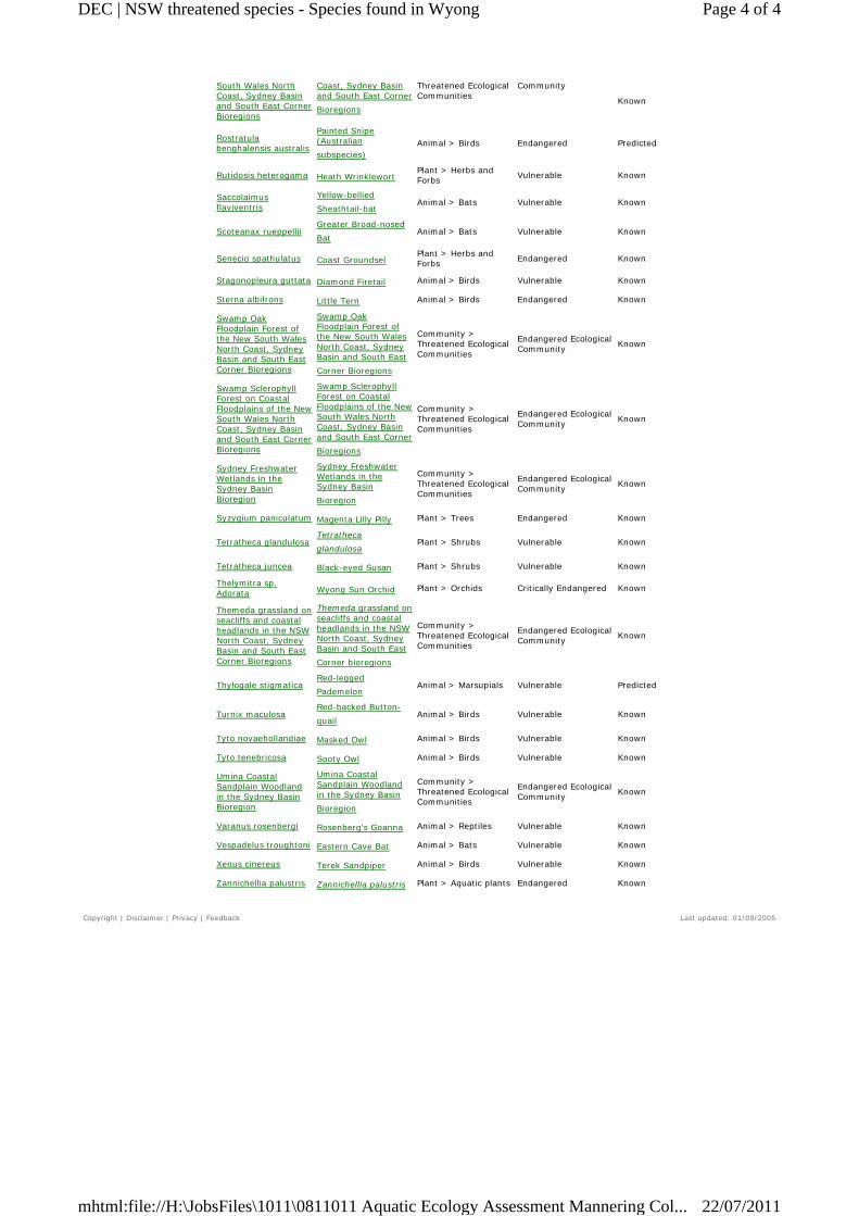
South Wales North Coast, Sydney Basin and South East Corner Bioregions
Coast, Sydney Basin and South East Corner Bioregions
Threatened Ecological Communities
Community
Known
Rostratula benghalensis australis
Painted Snipe (Australian subspecies)
Animal > Birds Endangered Predicted
Rutidosis heterogama Heath Wrinklewort Plant > Herbs and Forbs Vulnerable Known
Saccolaimus flaviventris
Yellow-bellied Sheathtail-bat Animal > Bats Vulnerable Known
Scoteanax rueppelliiGreater Broad-nosed Bat Animal > Bats Vulnerable Known
Senecio spathulatus Coast Groundsel Plant > Herbs and Forbs Endangered Known
Stagonopleura guttata Diamond Firetail Animal > Birds Vulnerable Known
Sterna albifrons Little Tern Animal > Birds Endangered Known
Swamp Oak Floodplain Forest of the New South Wales North Coast, Sydney Basin and South East Corner Bioregions
Swamp Oak Floodplain Forest of the New South Wales North Coast, Sydney Basin and South East Corner Bioregions
Community > Threatened Ecological Communities
Endangered Ecological Community Known
Swamp Sclerophyll Forest on Coastal Floodplains of the New South Wales North Coast, Sydney Basin and South East Corner Bioregions
Swamp Sclerophyll Forest on Coastal Floodplains of the New South Wales North Coast, Sydney Basin and South East Corner Bioregions
Community > Threatened Ecological Communities
Endangered Ecological Community Known
Sydney Freshwater Wetlands in the Sydney Basin Bioregion
Sydney Freshwater Wetlands in the Sydney Basin Bioregion
Community > Threatened Ecological Communities
Endangered Ecological Community Known
Syzygium paniculatum Magenta Lilly Pilly Plant > Trees Endangered Known
Tetratheca glandulosaTetratheca glandulosa Plant > Shrubs Vulnerable Known
Tetratheca juncea Black-eyed Susan Plant > Shrubs Vulnerable Known
Thelymitra sp. Adorata Wyong Sun Orchid Plant > Orchids Critically Endangered Known
Themeda grassland on seacliffs and coastal headlands in the NSW North Coast, Sydney Basin and South East Corner Bioregions
Themeda grassland on seacliffs and coastal headlands in the NSW North Coast, Sydney Basin and South East Corner bioregions
Community > Threatened Ecological Communities
Endangered Ecological Community Known
Thylogale stigmaticaRed-legged Pademelon Animal > Marsupials Vulnerable Predicted
Turnix maculosaRed-backed Button-quail Animal > Birds Vulnerable Known
Tyto novaehollandiae Masked Owl Animal > Birds Vulnerable Known
Tyto tenebricosa Sooty Owl Animal > Birds Vulnerable Known
Umina Coastal Sandplain Woodland in the Sydney Basin Bioregion
Umina Coastal Sandplain Woodland in the Sydney Basin Bioregion
Community > Threatened Ecological Communities
Endangered Ecological Community Known
Varanus rosenbergi Rosenberg's Goanna Animal > Reptiles Vulnerable Known
Vespadelus troughtoni Eastern Cave Bat Animal > Bats Vulnerable Known
Xenus cinereus Terek Sandpiper Animal > Birds Vulnerable Known
Zannichellia palustris Zannichellia palustris Plant > Aquatic plants Endangered Known
Copyright | Disclaimer | Privacy | Feedback Last updated: 01/09/2005
Page 4 of 4DEC | NSW threatened species - Species found in Wyong
22/07/2011mhtml:file://H:\JobsFiles\1011\0811011 Aquatic Ecology Assessment Mannering Col...
Appendix B Threatened Species Assessment (State)
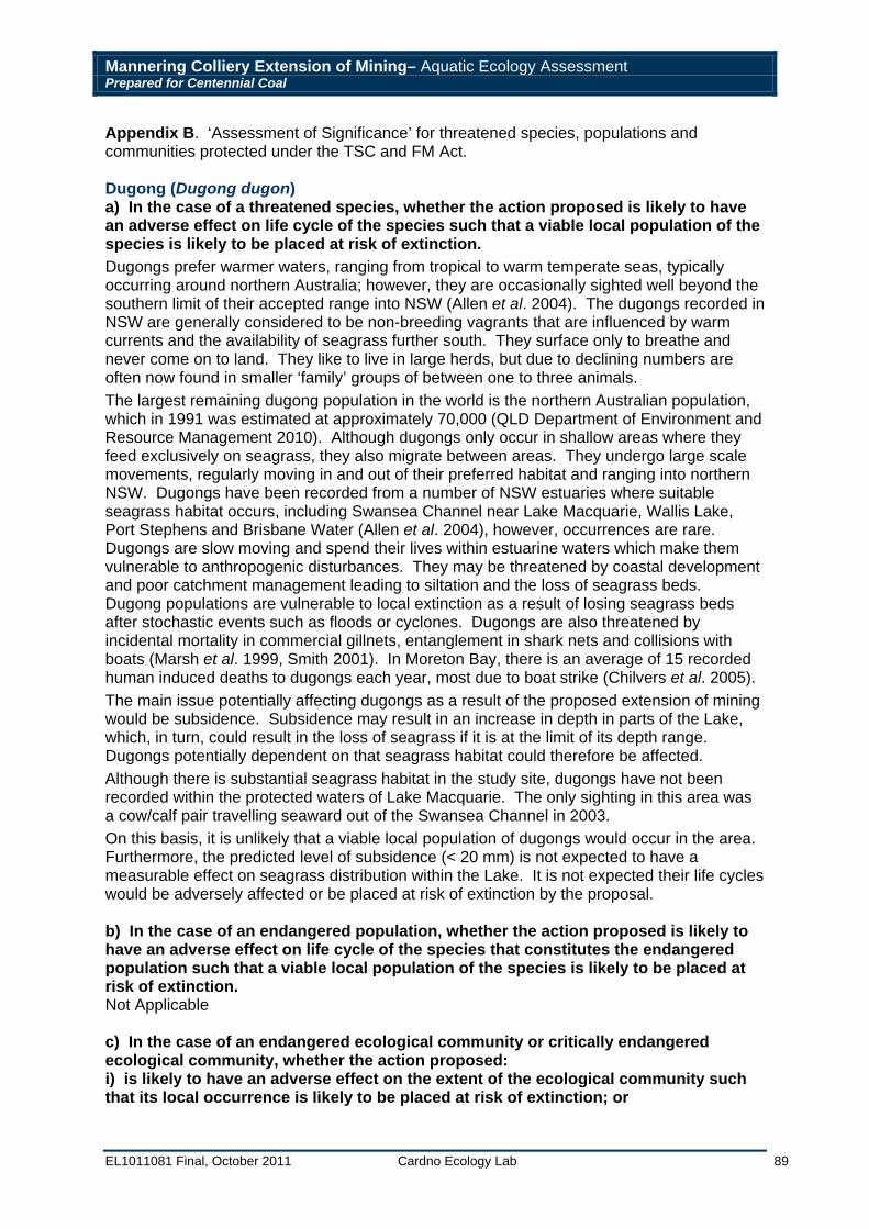
Mannering Colliery Extension of Mining– Aquatic Ecology Assessment Prepared for Centennial Coal
EL1011081 Final, October 2011 Cardno Ecology Lab 89
Appendix B. ‘Assessment of Significance’ for threatened species, populations and communities protected under the TSC and FM Act. Dugong (Dugong dugon) a) In the case of a threatened species, whether the action proposed is likely to have an adverse effect on life cycle of the species such that a viable local population of the species is likely to be placed at risk of extinction. Dugongs prefer warmer waters, ranging from tropical to warm temperate seas, typically occurring around northern Australia; however, they are occasionally sighted well beyond the southern limit of their accepted range into NSW (Allen et al. 2004). The dugongs recorded in NSW are generally considered to be non-breeding vagrants that are influenced by warm currents and the availability of seagrass further south. They surface only to breathe and never come on to land. They like to live in large herds, but due to declining numbers are often now found in smaller ‘family’ groups of between one to three animals. The largest remaining dugong population in the world is the northern Australian population, which in 1991 was estimated at approximately 70,000 (QLD Department of Environment and Resource Management 2010). Although dugongs only occur in shallow areas where they feed exclusively on seagrass, they also migrate between areas. They undergo large scale movements, regularly moving in and out of their preferred habitat and ranging into northern NSW. Dugongs have been recorded from a number of NSW estuaries where suitable seagrass habitat occurs, including Swansea Channel near Lake Macquarie, Wallis Lake, Port Stephens and Brisbane Water (Allen et al. 2004), however, occurrences are rare. Dugongs are slow moving and spend their lives within estuarine waters which make them vulnerable to anthropogenic disturbances. They may be threatened by coastal development and poor catchment management leading to siltation and the loss of seagrass beds. Dugong populations are vulnerable to local extinction as a result of losing seagrass beds after stochastic events such as floods or cyclones. Dugongs are also threatened by incidental mortality in commercial gillnets, entanglement in shark nets and collisions with boats (Marsh et al. 1999, Smith 2001). In Moreton Bay, there is an average of 15 recorded human induced deaths to dugongs each year, most due to boat strike (Chilvers et al. 2005). The main issue potentially affecting dugongs as a result of the proposed extension of mining would be subsidence. Subsidence may result in an increase in depth in parts of the Lake, which, in turn, could result in the loss of seagrass if it is at the limit of its depth range. Dugongs potentially dependent on that seagrass habitat could therefore be affected. Although there is substantial seagrass habitat in the study site, dugongs have not been recorded within the protected waters of Lake Macquarie. The only sighting in this area was a cow/calf pair travelling seaward out of the Swansea Channel in 2003. On this basis, it is unlikely that a viable local population of dugongs would occur in the area. Furthermore, the predicted level of subsidence (< 20 mm) is not expected to have a measurable effect on seagrass distribution within the Lake. It is not expected their life cycles would be adversely affected or be placed at risk of extinction by the proposal. b) In the case of an endangered population, whether the action proposed is likely to have an adverse effect on life cycle of the species that constitutes the endangered population such that a viable local population of the species is likely to be placed at risk of extinction. Not Applicable c) In the case of an endangered ecological community or critically endangered ecological community, whether the action proposed: i) is likely to have an adverse effect on the extent of the ecological community such that its local occurrence is likely to be placed at risk of extinction; or
Mannering Colliery Extension of Mining– Aquatic Ecology Assessment Prepared for Centennial Coal
EL1011081 Final, October 2011 Cardno Ecology Lab 90
ii) is likely to substantially and adversely modify the composition of the ecological community such that its local occurrence is likely to be placed at risk of extinction. Not applicable d) In relation to the habitat of a threatened species, population or ecological community: i) the extent to which habitat is likely to be removed or modified as a result of the action proposed; and ii) whether an area of habitat is likely to become fragmented or isolated from other areas of habitat as a result of the proposed action; and iii) the importance of the habitat to be removed, modified, fragmented or isolated to the long-term survival of the species, population or ecological community in the locality. Given the minimal level of subsidence expected (< 20 mm) it is unlikely that seagrass habitat could become fragmented and isolated and the extent of the overall impact is likely to be very minor in terms of scale. Such minor impacts to seagrass are not considered to affect the long term survival of dugong populations and would not affect the occasional vagrants that have been reported to occur in Lake Macquarie on rare occasions. e) Whether the action proposed is likely to have an adverse effect on critical habitat (either directly or indirectly). No dugong critical habitat occurs within or near to the study areas and would therefore not be affected by the proposal. f) Whether the action proposed is consistent with the objectives or actions of a recovery plan or threat abatement plan. There is currently no recovery plan for this species; however in NSW, OEH has prepared Priority Action Statements to promote the recovery of threatened species within NSW. They include the following priority actions for dugongs:
• This species is included in the threat abatement actions pertaining to the "Death or injury to marine species following capture in shark control programs on ocean beaches" KTP (Low priority); and
• The impacts of estuarine and coastal marine development on potential dugong habitat e.g. Halophila spp. seagrass meadows in northern NSW should be considered by consent and determining authorities (Medium priority).
There is also an approved Status Report and Action Plan (UNEP) for Australia and other countries. The proposal would not, however, affect any of the proposed action plans. g) Whether the action proposed constitutes or is part of a key threatening process or is likely to result in the operation of, or increase the impact of, a key threatening process. The action proposed does not constitute a key threatening process and would not result in the operation of or increase the impact of a key threatening process. Conclusion: Given that dugongs may occur only on occasion, if at all, within Lake Macquarie and that the potential impacts on seagrass habitat would be minimal, the proposal is not considered to affect a threatened population of dugongs. No species impact statement is recommended.
Mannering Colliery Extension of Mining– Aquatic Ecology Assessment Prepared for Centennial Coal
EL1011081 Final, October 2011 Cardno Ecology Lab 91
Marine Turtles There are two listed marine turtles: green turtle (Chelonia mydas; status – vulnerable) and loggerhead turtle (Caretta caretta; status - threatened) that have been recorded in Lake Macquarie. For the purpose of this study, they are grouped as they have similar distribution and share many similar ecological requirements. a) In the case of a threatened species, whether the action proposed is likely to have an adverse effect on life cycle of the species such that a viable local population of the species is likely to be placed at risk of extinction. Both species of marine turtles, the green and loggerhead turtle prefer warmer waters, ranging from warm to tropical temperate seas. For a large part of their life cycle, marine turtles are pelagic, particularly loggerheads, while green turtles tend to stay in coastal waters and may even take up residence in some areas. Adult green turtles feed mostly on seaweeds and seagrasses, although immature greens are carnivorous. Both of these species are vulnerable to hunting through much of their range. They are most vulnerable when they come ashore to nest; where adults, eggs and hatchlings are subject to direct harvesting, predation by natural fauna, domestic pets, feral animals and various forms of human disturbance. By-catch of marine turtles in fisheries, marine debris, coastal development, loss of habitat and deterioration of water quality are also a significant threats to the species. Lake Macquarie is outside the nesting range of both of these species and existing disturbances to the local beaches (e.g. humans, pets and feral animals) would make it almost impossible for nesting in these areas. Moreover, although these turtles (in particular the green turtle) are not uncommon in the area, it is unlikely that there is a viable local population within the study area. The main issue potentially affecting marine turtles as a result of the proposed extension of mining would be subsidence. Subsidence may result in an increase in depth in parts of the Lake, which, in turn, could result in the loss of seagrass if it is at the limit of its depth range. Green turtles potentially dependent on seagrass habitat could therefore be affected if the level of subsidence was significant and seagrass distribution and density was likely to be affected. The predicted level of subsidence (< 20 mm) is not, however, expected to have a measurable effect on seagrass distribution within the Lake. On this basis, it is unlikely that a viable local population of any marine turtles would be placed at risk of extinction by the proposal. b) In the case of an endangered population, whether the action proposed is likely to have an adverse effect on life cycle of the species that constitutes the endangered population such that a viable local population of the species is likely to be placed at risk of extinction. No endangered populations of marine turtles are identified in the legislation. c) In the case of an endangered ecological community or critically endangered ecological community, whether the action proposed: i) is likely to have an adverse effect on the extent of the ecological community such that its local occurrence is likely to be placed at risk of extinction; or ii) is likely to substantially and adversely modify the composition of the ecological community such that its local occurrence is likely to be placed at risk of extinction. Not applicable. d) In relation to the habitat of a threatened species, population or ecological community: i) the extent to which habitat is likely to be removed or modified as a result of the action proposed; and ii) whether an area of habitat is likely to become fragmented or isolated from other areas of habitat as a result of the proposed action; and
Mannering Colliery Extension of Mining– Aquatic Ecology Assessment Prepared for Centennial Coal
EL1011081 Final, October 2011 Cardno Ecology Lab 92
iii) the importance of the habitat to be removed, modified, fragmented or isolated to the long-term survival of the species, population or ecological community in the locality. The extensive seagrass beds within the study area theoretically provide habitat for marine turtles. Given the minimal level of subsidence predicted (< 20 mm), the extent of the potential impact on seagrass habitat is not likely to be measurable and is not likely to result in areas of seagrass becoming fragmented and/or isolated. e) Whether the action proposed is likely to have an adverse effect on critical habitat (either directly or indirectly). No listed critical habitat for marine turtles occurs within or in the vicinity of the study area. f) Whether the action proposed is consistent with the objectives or actions of a recovery plan or threat abatement plan. There is an approved ‘Recovery Plan for Marine Turtles in Australia’ (Environment Australia 2003). The proposal would not, however, affect any of the recovery actions proposed under the plan. g) Whether the action proposed constitutes or is part of a key threatening process or is likely to result in the operation of, or increase the impact of, a key threatening process. The action proposed does not constitute a key threatening process and would not result in the operation of or increase the impact of a key threatening process. Conclusion: Marine turtles, particularly green turtles, are not uncommon within Lake Macquarie and are likely to utilise seagrass habitat within the existing mining consent and project application area. This area of habitat is not, however, critical to the species survival and any potential impacts on seagrass habitat would be minimal. The proposal is not therefore, considered to affect a threatened population of marine turtle such that a Species Impact Statement is recommended. Management and monitoring as described in Section 6 should be carried out to ensure minimal impact to seagrass habitat.
Mannering Colliery Extension of Mining– Aquatic Ecology Assessment Prepared for Centennial Coal
EL1011081 Final, October 2011 Cardno Ecology Lab 93
Estuarine Birds There are 17 species of estuarine birds listed as either vulnerable or threatened under State legislation that have been recorded within the study area. Species are grouped together as they have similar distribution and many similar ecological requirements and include:
Australasian bittern (Botaurus poiciloptilus) Bush stone curlew (Burhinus grallarius) Sanderling (Calidris alba) Great knot (Calidris tenuirostris) Greater sand plover (Charadrius leschenaultia) Lesser sand plover (Charadrius mongolus) Black-necked stork (Ephippiorhyncus asiaticus) White tern (Gygis alba) Little tern (Sterna albifrons) Sooty tern (Sterna fuscata) Sooty oystercatcher (Haematopus fuliginosus) Pied oystercatcher (Haematopus longirostris) Black bittern (Ixobrychus flavicollis) Broad-billed sandpiper (Limicola falcinellus) Black-tailed godwit (Limosa limosa) Painted snipe (Rostratula australis) Terek sandpiper (Xenus cinereus)
a) In the case of a threatened species, whether the action proposed is likely to have an adverse effect on life cycle of the species such that a viable local population of the species is likely to be placed at risk of extinction. Shore birds or 'waders' are those birds commonly found on coastal shores, including beaches, rocky shores, mudflats, tidal wetlands and lagoons. These include plovers and sandpipers, stone-curlews, snipes and oystercatchers among others (Birds Australia 2009). Wading birds feed on marine invertebrates (including molluscs, worms and crustaceans), small fish that live within intertidal sand and mudflats. Small reptiles, earthworms, seeds and vegetation may also form part of their diet. Waders feed in the shallows or over exposed mud by probing their long slender bills into the substratum. Bill length, legs, body-structure, size and foraging techniques may subtly or markedly differ between groups of waders (Pizzey and Knight 1997). Important nesting areas may include sandbanks, sandpits, and islands in estuaries, mangroves and riparian vegetation adjacent to the waterway. Nesting often takes place close to the ground which can make these birds vulnerable to disturbance. Subsidence as a result of mining activity has potential to alter the profile of foreshores and wetlands and intertidal habitat utilised by estuarine birds. The predicted extent of subsidence (< 20mm) is not, however, considered to have an adverse effect on the habitat or resources of these species such that a viable local population could be put at risk of extinction. Furthermore, it is unlikely that the proposal would cause any observable alteration to the behaviour or habitat values of estuarine birds within the study area. b) In the case of an endangered population, whether the action proposed is likely to have an adverse effect on life cycle of the species that constitutes the endangered population such that a viable local population of the species is likely to be placed at risk of extinction. No endangered populations of estuarine birds are identified in the legislation. c) In the case of an endangered ecological community or critically endangered ecological community, whether the action proposed: i) is likely to have an adverse effect on the extent of the ecological community such that its local occurrence is likely to be placed at risk of extinction; or ii) is likely to substantially and adversely modify the composition of the ecological community such that its local occurrence is likely to be placed at risk of extinction.
Mannering Colliery Extension of Mining– Aquatic Ecology Assessment Prepared for Centennial Coal
EL1011081 Final, October 2011 Cardno Ecology Lab 94
Not applicable. d) In relation to the habitat of a threatened species, population or ecological community: i) the extent to which habitat is likely to be removed or modified as a result of the action proposed; and ii) whether an area of habitat is likely to become fragmented or isolated from other areas of habitat as a result of the proposed action; and iii) the importance of the habitat to be removed, modified, fragmented or isolated to the long-term survival of the species, population or ecological community in the locality. Intertidal foreshores and wetlands within the existing mining consent and project application area provide suitable habitat for a number of estuarine birds. The extent to which this habitat could be altered as a result of subsidence predicted from the proposed extension of mining would be negligible. It would be highly unlikely that habitat could become fragmented or isolated as a result of the proposal. Furthermore, there is no habitat of importance to the long-term survival of a species within the existing mining consent and project application area. e) Whether the action proposed is likely to have an adverse effect on critical habitat (either directly or indirectly). No listed critical habitat for estuarine birds is known to occur within the study area. f) Whether the action proposed is consistent with the objectives or actions of a recovery plan or threat abatement plan. There is no approved recovery plan for species of estuarine bird relevant to the proposal. g) Whether the action proposed constitutes or is part of a key threatening process or is likely to result in the operation of, or increase the impact of, a key threatening process. The action proposed does not constitute a key threatening process and would not result in the operation of or increase the impact of a key threatening process. Conclusion: A number of threatened species of estuarine birds have been recorded within Lake Macquarie and are likely to utilise intertidal and foreshore habitat within the study area. The proposal is not, however, considered to affect a threatened species of estuarine bird such that a Species Impact Statement is recommended.
Appendix C Threatened Species Assessment
(Commonwealth)
Mannering Colliery Extension of Mining– Aquatic Ecology Assessment Prepared for Centennial Coal
EL1011081 Final, October 2011 Cardno Ecology Lab 96
Appendix C. ‘Assessment of Significance’ for threatened species, populations and communities protected under the EPBC Act. Dugong (Dugong dugon) Status: migratory An action is likely to have a significant impact on a migratory species if there is a real chance or possibility that it will:
Substantially modify (including by fragmenting, altering fire regimes, altering nutrient cycles or altering hydrological cycles), destroy or isolate an area of important habitat of the migratory species; No area of habitat that supports an ecologically significant proportion of a dugong population would be affected by the proposal. Dugongs would rarely enter into the study area and the few that have been recorded within this region, are likely to be vagrants from southern Queensland populations. The area of habitat potentially affected by this proposal is not critical habitat of the dugong and does not occur in an area where the species is declining.
Result in invasive species that is harmful to the migratory species becoming established in an area of important habitat of the migratory species; or The proposal is not considered to result in an invasive species becoming established in an area of habitat important for the dugong.
Seriously disrupt the lifecycle (breeding, feeding, migration or resting behaviour) of an ecologically significant proportion of the population of the species.
Impacts of mining related subsidence could potentially impact upon seagrass habitat (within parts of the study area) which is a source of food for the dugong. However, given the negligible level of predicted subsidence (< 20 mm) and that dugong rarely occur within the study area, the lifecycle of an ecologically significant proportion of the population would not be affected.
Conclusion: The proposal would not result in a significant impact on this species, or its key habitat requirements. Green Turtle (Chelonia mydas) Status: vulnerable Seven of the nine criteria provided under the EPBC Act ‘Significant Impact Guidelines’ for an endangered species are very similar to criteria used to assess this species under the Assessment of Significance under State legislation (Appendix B). Hence, it is not considered that the proposal would:
Lead to a long-term decrease in the size of a population of a species; Reduce the area of occupancy of an important population; Fragment an existing population into two or more populations; Adversely affect habitat critical to the survival of a species; Disrupt the breeding cycle of a population; Modify, destroy, remove, isolate or decrease the availability or quality of habitat to the
extent that a species is likely to decline; or In addition, it is not expected that the proposal would:
Result in invasive species that are harmful to a vulnerable species becoming established in the vulnerable species’ habitat;
Introduce disease that may cause the species to decline; or
Interfere substantially with the recovery of the species. Conclusion: The proposal would not result in a significant impact on this species, or its necessary habitat requirements.
Mannering Colliery Extension of Mining– Aquatic Ecology Assessment Prepared for Centennial Coal
EL1011081 Final, October 2011 Cardno Ecology Lab 97
Loggerhead Turtle (Caretta caretta) Status: endangered Seven of the nine criteria provided under the EPBC Act ‘Significant Impact Guidelines’’ for an endangered species are very similar to criteria used to assess these species under the assessment of significance under State legislation (Appendix B). Hence, it is not considered that the proposal would:
Lead to a long-term decrease in the size of a population; Reduce the area of occupancy of the species; Fragment an existing population into two or more populations; Adversely affect habitat critical to the survival of a species; Disrupt the breeding cycle of a population; Modify, destroy, remove, isolate or decrease the availability or quality of habitat to the
extent that a species is likely to decline; or In addition, it is not expected that the proposal would:
Result in invasive species that are harmful to an endangered species becoming established in the endangered species’ habitat; or
Introduce disease that may cause the species to decline; Interfere with the recovery of a species.
Conclusion: The proposal would not result in a significant impact on this species, or its defined habitat requirements. Estuarine Birds Status: migratory There are 27 species of estuarine birds that are known to occur within the study area and are listed as ‘migratory’ under the EPBC Act (refer to Table 1). For the purpose of this study, they are grouped here as they have similar ecological requirements. Species include:
Common sandpiper (Actitis hypoleucos) Ruddy turnstone (Arenaria interpres) Bush stone curlew (Burhinus grallarius) Sharp-tailed sandpiper (Calidris acuminata) Sanderling (Calidris alba) Red knot (Calidris canutus) Curlew sandpiper (Calidris ferruginea) Pectoral sandpiper (Calidris melanotos) Red-necked stint (Calidris ruficollis) Great knot (Calidris tenuirostris) Double-banded plover (Charadrius bicinctus) Greater sand plover (Charadrius leschenaultia) Lesser sand plover (Charadrius mongolus) Latham's snipe (Gallinago hardwickii) Grey-tailed tattler (Heteroscelus brevipes) Broad-billed sandpiper (Limicola falcinellus) Bar-tailed godwit (Limosa lapponica) Black-tailed godwit (Limosa limosa) Eastern curlew (Numenius madagascariensis) Little curlew (Numenius minutus) Whimbrel (Numenius phaeopus) Pacific golden plover (Pluvialis fulva)
Mannering Colliery Extension of Mining– Aquatic Ecology Assessment Prepared for Centennial Coal
EL1011081 Final, October 2011 Cardno Ecology Lab 98
Grey plover (Pluvialis squatarola) Painted snipe (Rostratula australis) Little tern (Sterna albifrons) Marsh sandpiper (Tringa stagnatilis) Terek sandpiper (Xenus cinereus)
An action is likely to have a significant impact on a migratory species if there is a real chance or possibility that it will:
substantially modify (including by fragmenting, altering fire regimes, altering nutrient cycles or altering hydrological cycles), destroy or isolate an area of important habitat of the migratory species;
Subsidence as a result of the proposed extension of mining has potential to alter the profile of foreshores, wetlands and intertidal habitat which is utilised by estuarine birds. The predicted extent of subsidence is not, however, considered to have an adverse effect on the habitat or resources of these species such that a local population could be put at risk. Furthermore, it is unlikely that the proposal would cause any observable alteration to the behaviour or habitat values of estuarine birds within the study area.
In addition, it is not expected that the proposal would: result in invasive species that is harmful to the migratory species becoming
established in an area of important habitat of the migratory species; or seriously disrupt the lifecycle (breeding, feeding, migration or resting behaviour) of an
ecologically significant proportion of the population of the species.
Conclusion: The proposal is not considered to result in a significant impact on these species, or their obligatory habitat requirements.


![Distributed graph queries over models@run.time for runtime … · 2020-02-03 · data distribution service (RDDS [35]). RDDS is an exten-sion for the DDS standard [50] of the Object](https://static.fdocuments.in/doc/165x107/5ed726b0c30795314c174a2d/distributed-graph-queries-over-modelsruntime-for-runtime-2020-02-03-data-distribution.jpg)