M ANAGEMENT PLAN - British Columbia · 2020-04-15 · Junction Sheep Range Provincial Park...
73
M for Junction Sheep Range Provincial Park ANAGEMENT P LAN February 2006 Ministry of Environment Environmental Stewardship Division
Transcript of M ANAGEMENT PLAN - British Columbia · 2020-04-15 · Junction Sheep Range Provincial Park...
M
for Junction Sheep Range Provincial Park
ANAGEMENT
P LAN
February 2006
Ministry of Environment Environmental Stewardship Division

Junction Sheep Range Provincial Park
M
Prepared by Cariboo Region Environmental Stewardship Division
ANAGEMENT
P LAN

Library and Archives Canada Cataloguing in Publication Data British Columbia. Environmental Stewardship Division. Cariboo Region. Junction Sheep Range Provincial Park management
plan. Cover title: Management plan for Junction Sheep
Range Provincial Park. “February 2006” Includes bibliographical references: p. Also available on the Internet. ISBN 0-7726-5504-9 1. Junction Sheep Range Provincial Park (B.C.)
2. Provincial parks and reserves - British Columbia - Management. 3. Ecosystem management - British Columbia - Junction Sheep Range Park. I. Title. II. Title: Management plan for Junction Sheep Range Provincial Park.
FC38`5.J86B74 2006333.78’309711’75 C2006-960032-5


This Management Plan is a component of the Cariboo-Chilcotin Land-Use Plan (CCLUP), and was developed through direction from that land-use plan. The Management Plan has been endorsed by the Cariboo-Chilcotin Regional Resources Committee and the Cariboo Managers’ Committee as being:
“Consistent with the spirit and intent of the CCLUP.”

Table of Contents Acknowledgements ............................................................................................................................. i
Plan Highlights ................................................................................................................................... ii
1.0 Introduction.................................................................................................................................. 1 1.1 THE MANAGEMENT PLANNING PROCESS .................................................................................. 1 1.2 BACKGROUND SUMMARY ......................................................................................................... 2 1.3 RELATIONSHIP TO OTHER LAND USE PLANNING....................................................................... 2 1.4 ECOSYSTEM-BASED PLANNING................................................................................................. 4
2.0 The Role of the Park.................................................................................................................... 5 2.1 PROVINCIAL CONTEXT AND SIGNIFICANCE ............................................................................... 5 2.2 PROTECTED AREA ROLES.......................................................................................................... 6 2.3 VISION STATEMENT .................................................................................................................. 8 2.4 RELATIONSHIP WITH FIRST NATIONS ........................................................................................ 9
3.0 Protected Areas Zoning............................................................................................................. 10 3.1 INTRODUCTION ....................................................................................................................... 10 3.2 WILDERNESS RECREATION ZONE............................................................................................ 10 3.3 NATURE RECREATION ZONE ................................................................................................... 13
4.0 Natural and Cultural Values Management ............................................................................. 15 4.1 WILDLIFE ................................................................................................................................ 15 4.2 GRASSLANDS .......................................................................................................................... 20 4.3 ACCESS ................................................................................................................................... 24 4.4 CULTURAL HERITAGE ............................................................................................................. 26
5.0 Outdoor Recreation Opportunities and Management ........................................................... 29 5.1 INTRODUCTION ....................................................................................................................... 29 5.2 RECREATION CONCEPT ........................................................................................................... 29 5.3 COMMERCIAL RECREATION OPPORTUNITIES .......................................................................... 30 5.4 EXISTING RECREATION USES .................................................................................................. 31
6.0 Communications ........................................................................................................................ 33
6.1 INTERPRETATION AND MANAGEMENT MESSAGES .................................................................. 33
7.0 Monitoring ............................................................................................................................ 35
8.0 Plan Implementation............................................................................................................ 38 8.1 IMMEDIATE (1 TO 2 YEARS)..................................................................................................... 38 8.2 SHORT TERM (3 TO 5 YEARS) .................................................................................................. 39 8.3 LONG TERM (6 TO 10 YEARS).................................................................................................. 40
References......................................................................................................................................... 41

Appendices........................................................................................................................................ 47 APPENDIX 1: ASSERTED INTERESTS OF TWO NORTHERN SECWEPEMC COMMUNITIES ................. 48 APPENDIX 2: BC PARKS MANAGEMENT PLANNING ZONING DESCRIPTIONS .................................. 50 APPENDIX 3: KNOWN AND SUSPECTED RED AND BLUE-LISTED SPECIES IN JUNCTION SHEEP
RANGE PARK AS OF DECEMBER 31ST, 2003............................................................................ 52 APPENDIX 4: DESCRIPTION OF MAJOR GRASSLAND ECOSYSTEMS IN JUNCTION SHEEP RANGE
PARK ...................................................................................................................................... 58 APPENDIX 5: KNOWN AND SUSPECTED RARE AND ENDANGERED PLANTS AND VEGETATION
COMMUNITIES IN JUNCTION SHEEP RANGE PARK AS OF DECEMBER 31ST, 2003..................... 61
List of Figures FIGURE 1: REGIONAL CONTEXT ............................................................................................................3 FIGURE 2: ZONING ..............................................................................................................................11 FIGURE 3: ADJACENT PRIVATE AND LEASED LAND..............................................................................25
List of Plates PLATE 1: VIEW NORTH ALONG THE FRASER RIVER FROM RAM FLATS ...............................................13 PLATE 2: VIEW OF RAILROAD RAPIDS ALONG THE CHILCOTIN RIVER ................................................28 PLATE 3: GROUP OF CALIFORNIA BIGHORN SHEEP ..............................................................................32 PLATE 4: MAIN CABIN AT OLD WILDLIFE RESEARCH STATION.............................................................40
Cover photo: confluence of the Fraser & Chilcotin Rivers by Jim Young

i
Acknowledgements Environmental Stewardship Division would like to thank the Advisory Group for its time and efforts in developing the management plan. We realize they donated their personal time to come to evening meetings, in order to discuss the future management of Junction Sheep Range Park, and we greatly appreciate that effort. This document also reflects the interests and contributions of a number of First Nation communities. Environmental Stewardship Division thanks those who took the time to attend meetings and make written and oral submissions to assist in the development of the plan. Chris Wycotte from the Williams Lake Indian Band (T’exelc) provided the information in Appendix 1 which outlines the interests, west of the Fraser River, of the Northern Secwepemc Communities of Xatl’tem/Stwecem’c (Canoe Creek Band) and T’exelc (Williams Lake Indian Band). In addition, a number of government staff played a key role in providing information for the plan. Regional Environmental Stewardship Division staff who reviewed and helped develop the plan include Murray Carruthers, Herb Carter, Glen Davidson, Marcel Demers, Pat Dielman, Roger Packham, Julie Steciw and John Youds. Assistance and advice was also provided by Laura Darling, Lyle Gawalko, Gil Scott and Michelle Carr of the Parks and Protected Areas Branch, Victoria. Ordell Steen and Ray Coupe of the Ministry of Forests, Cariboo Region, provided the description of the grassland ecosystems in Appendix 4. Carole Ogborne of the Ministry of Sustainable Resource Management, Victoria, produced the maps. Stephanie Gustafson formatted the document. This plan was developed by Chris Hamilton1 and written by Chris Hamilton, Katharine VanSpall and Jim Young of the Environmental Stewardship Division, Cariboo Region. This management plan is dedicated to Harold Mitchell, past Regional Wildlife Biologist for the Cariboo Region who tragically died in 1981. It was because of his vision, that the land trade to conserve the range of the Junction California bighorn sheep herd was orchestrated in 1973. Without his efforts this park would not exist as a legacy for future generations.
1 Currently the Manager, First Nations Relations, Environment, Victoria

ii
Plan Highlights Cariboo-Chilcotin Land-Use Plan Commitments
This Management Plan for Junction Sheep Range Park was developed with the direct involvement of an Advisory Group comprising a variety of interests and perspectives. The Advisory Group will be invited to meet again should the plan require significant changes during its lifespan.
The park will be managed for its provincially significant wildlife and grassland values, and in particular, to protect California bighorn sheep and their habitat.
Sustainable public and commercial recreation will be encouraged in the park and will be managed on an ecosystem basis using the best available science to insure risks to conservation values are minimized. As a low level of commercial recreation has also been deemed acceptable for the park, two five year non-renewable commercial recreation licenses will be available for the purposes of low intensity ecotourism on a trial basis.
The right to hunt has been confirmed as an acceptable use in Junction Sheep Range Park. There are no grazing or mineral tenures in the park.
Management of Natural and Cultural Values The plan focuses on managing habitat in order to meet the needs of provincially and
internationally significant California bighorn sheep and other red and blue listed wildlife species.
The majority of the park (91%) has been designated as Wilderness Recreation Zone, where the protection of California bighorn sheep and grassland values are key objectives and recreational use is limited to non-motorized and non-mechanized public recreation and hunting.
A program of ecological research and monitoring will be implemented in order to gain more understanding of wildlife populations, population trends and habitat requirements.
Grassland and forest health will be maintained throughout the entire park area by implementing programs for control of noxious weeds and exotic insects and management of forest health. Additionally, in order to maintain or restore grassland and forest health, a fire management program will be implemented that includes fire suppression, fire prevention and prescribed burns.
Rare and endangered plant species and plant communities will be inventoried and mapped, and to the greatest degree possible risks from recreation and park management activities to these species and communities will be minimized.
The plan recognizes the cultural importance of the park to First Nations and others and will manage for those cultural values.
A program of cultural heritage research will be implemented as financial resources and opportunity allow, in order to gain a greater understanding of the cultural history of the park.

iii
Management of Recreation and Tourism The primary goal for recreation is to allow current types and levels of public recreation to
continue, with the overall emphasis being to provide low impact backcountry and day-use recreational opportunities in a natural setting.
Approximately 9% of the park has been designated as Nature Recreation Zone, to allow for motorized and mechanized recreation. Limited commercial recreation and general recreational access into the park will be allowed in this area.
Limited day use facilities will be developed in the park, and no new access roads will be developed.
For a two year period following approval of this plan, existing levels of access will continue, and public education and signage will be used to reduce negative impacts that are occurring to the grasslands within the park and on adjacent private lands. Following this two year period, the Advisory Group will meet again to review the results of monitoring and to provide advice on access management options for some of the designated access roads.
Two five year, non-renewable commercial recreation opportunities will be available for the Nature Recreation Zone of the park. This zone will be open for bike riding, horseback riding and/or nature tours. After the five year period, impacts on the park will be evaluated in order to determine whether commercial use will be extended.
One of the commercial opportunities will be made available to a local First Nation tour operator.
Types, levels and patterns of recreational use will be monitored to ensure that impacts to California bighorn sheep, the grasslands and other natural and cultural values are remaining at acceptable levels.
Using tools such as improved trail signage and interpretative signs and materials, a program of public education will be implemented in order to promote greater public awareness of conservation and cultural values, allowed activities, private land and park boundaries.
1
1.0 Introduction 1.1 The Management Planning Process This management plan has been prepared by the Environmental Stewardship Division to guide park management over a long-term period. Under the direction provided by the Park Act and the Park and Recreation Area Regulations, the management plan sets out objectives and actions for conservation, development, communications and recreational use. All actions are subject to the British Columbia Parks Impact Assessment Process. The management plan relies on information relating to such things as natural values, cultural activities, current recreation uses and activities occurring on surrounding lands. The process for preparing a management plan involves analysis of the overall goals for the area, patterns of use, management objectives, and possible sources of conflict among policies. The management plan not only establishes long-term management direction for the area, but also deals with immediate issues. This means that the management plan contains numerous statements describing management actions to be undertaken. Since the Environmental Stewardship Division cannot carry out every task at the same time, the management plan must also rank the priority of the management actions. The management plan was developed through a process facilitated by Environmental Stewardship Division planning staff. The planning process relied on an Advisory Group that met in Williams Lake. Five Advisory Group meetings were held, the first in January 2003, and the last in June 2003. Each meeting was focused on a specific management issue in the park, including access and communications, grasslands and wildlife management, and levels and types of recreational use. An additional meeting was held to review the draft plan. The Advisory Group had representation from local communities, adjacent private land holders, recreation and conservation groups and other interested public. The group provided local knowledge, technical advice and a broad range of perspectives to the planning process. This planning process also considered access to the park and access to areas in and around the park. When a land exchange occurred in 1973 to set aside the area now known as Junction Sheep Range Provincial Park, part of that agreement was to allow public access across some of the adjacent private land. This was accomplished through a right-of-way that was registered against the private land and adjacent grazing leases. This planning process examined those rights-of-way and looked at ways to minimize impacts on park land and upon the private property they traverse. Once a draft management plan was developed additional consultation occurred with local First Nation communities to determine their interests in the area and to reflect a Government-to- Government relationship. This document reflects the interests and contributions of a number of First Nation communities that provided both oral and written comments on the draft management plan. As a result of First Nation involvement, a number of sections of the management plan were revised to reflect their interests and concerns.

2
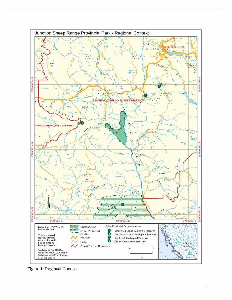
1.2 Background Summary The protected area was established as a Wildlife Reserve in 1973 and officially designated as the Junction Wildlife Management Area (WMA) in 1987 to protect a provincially important non-migratory population of California bighorn sheep. The original reserve was created through a land exchange which involved lands owned by Riske Creek Ranching Limited reverting to the Crown in exchange for other lands and grazing rights (Figure 1). The Cariboo Chilcotin Commission on Resources and Environment proposed the area for protection in 1994, and subsequently, the Cariboo-Chilcotin Land-Use Plan confirmed the area for protection. In 1995, Junction Sheep Range was legislated as a Class A Provincial Park under the Park Act, and was subsequently named and described in Schedule D of the Protected Areas of British Columbia Act.
1.3 Relationship to Other Land Use Planning
Cariboo-Chilcotin Land Use Plan In 1994, the Cariboo-Chilcotin Land-Use Plan recommended the establishment of 17 new parks and protected areas. The CCLUP 90 Day Implementation Process Report contains a significant amount of direction on the management of these new areas. Direction includes:
• Dominant ecological values should be protected, however, recreation, cattle grazing [except the Junction Sheep Range], hunting, trapping and backcountry tourism, will be allowed;
• Mining tenures fully within park boundaries will be extinguished. Fair compensation will be established through negotiation between the Provincial government and the affected tenure holders;
• Hunting and trapping will continue to be allowed; • The park will be available, in principle and where appropriate, for commercial tourism and
recreation. Development opportunities will be identified during area-specific management planning which will recognize the protection of the special natural values of each area and the provision for public non-commercial recreation. In some circumstances, development opportunities may include "fixed roof" accommodation;
• Existing approved levels of cattle grazing will continue. The maximum level of animal unit months (AUM’s) will be set at the existing level of authorized AUM’s as of October 24, 1994, and,
• No private land will be included within protected areas unless the government negotiates a mutually agreed purchase. Existing landowner use, development and access rights will be unaffected by protected areas.
3
Figure 1: Regional Context

4
The CCLUP 90 Day Implementation Report also contains a specific reference to Junction Sheep Range. It states: “Some of the new protected areas, such as Stum Lake, Itcha-Ilgachuz, Cariboo River and Junction Sheep Range, feature significant wildlife populations and require management that is focused on the habitat and populations of the resident species” (CCLUP 90 Day Report, page 34).
1.4 Ecosystem-Based Planning While the primary role of the Junction Sheep Range Park is to protect California bighorn sheep and grasslands values, this plan attempts to meet those objectives through ecosystem-based planning and management of wildlife habitat rather than management of the wildlife populations themselves. Ecosystem management is based on the concept that if biological communities resemble natural conditions with supporting processes and rates of change then there is a greater chance that all native species will be maintained within the landscape. In order to be successful, wildlife populations must be managed over their entire range, not just within small portions of their habitat such as Junction Sheep Range Park. Therefore the task of managing specific wildlife populations falls outside of the scope of this management plan. The actual management of wildlife populations is performed by the Fish and Wildlife Science and Allocation Section of the Ministry of Environment. One of the Ministry’s current initiatives is the formation of the Fraser River Bighorn Sheep Advisory Committee and development of a recovery plan for the Fraser River metapopulation of bighorn sheep. Efforts to manage bighorn sheep in the Junction area will therefore defer to the recommendations of the Advisory Team and the Ministry, whereas this management plan will focus on managing the habitat for bighorn sheep that exists within the park boundaries. Habitat management is frequently used by wildlife biologists as a wildlife management technique, and can be an effective way to simultaneously manage for the needs of multiple species. Additionally, for many wildlife species the lack of suitable habitat poses the greatest risk to that species’ population. Management of habitat therefore is a sound strategy to utilize in order to meet wildlife objectives for the Junction Sheep Range Park.

5
2.0 The Role of the Park 2.1 Provincial Context and Significance This 4,778 hectare park contains wildlife habitat and grassland conservation values that are of provincial and international significance. It is located at the confluence of the Fraser and Chilcotin Rivers approximately 30 kilometers southwest of Williams Lake, the closest community. The narrow band of valley-bottom grasslands that occur along the Fraser, Thompson and Chilcotin Rivers and in the Southern Okanagan are actually the continuation of a system of deserts and grasslands that occur in the rain shadow of mountain ranges from California to British Columbia. The bunchgrass grasslands occurring at Junction Sheep Range exist at the northern extent of this large arid and semiarid area, making it unique in Canada. The park is the most northern grassland protected area in British Columbia, and encompasses excellent examples of near natural grasslands. It contains areas of low and mid elevation grasslands with a variety of aspects and forests. This is combined with an exemplary variety of landforms created by glacial, fluvial, aeolian and erosional processes. Junction Sheep Range was originally protected as a Wildlife Management Area to provide habitat for the internationally significant resident population of California bighorn sheep. This population of sheep has provided a transplant source to other areas of North America for the past 40 years. Ram areas and critical lambing areas for the herd are contained within the park. This is the only park in the province which is focused primarily on the habitat needs of California bighorn sheep. In addition to California bighorn sheep habitat, the park makes a contribution to the system of grassland protected areas across the region. The south facing grasslands of the park, combined with its location at the confluence of two major river valleys, creates grassland micro-climates that are hotter and drier than similar grasslands at Churn Creek Protected Area, which are dominated by east and north facing aspects. The park contains a variety of dramatic erosional features, including silt and gravel cliffs, talus slopes and caves. In addition, the park also has a rolling mid-elevation grassland plateau with several small wetland areas, aspen copses and moist, shrub ravines. Many of these features provide habitat for red- and blue-listed species such as Flammulated Owl, Long-billed Curlew, Sharp-tailed Grouse, and a number of bat species associated with bunchgrass grassland ecosystems. Other protected areas in the vicinity include Edge Hills Provincial Park, with its lower grasslands and sheep populations, Churn Creek Protected Area with its diversity of grassland communities and wildlife populations, Big Creek Ecological Reserve, with its unique vegetation, and Doc English Bluff Ecological Reserve, with rare plant and bird communities. While many of the grassland protected areas in British Columbia have permitted grazing of domestic livestock, Junction Sheep Range is unique in that cattle have been more or less excluded since the mid 1970’s.

6
Junction Sheep Range lies within the Fraser River Basin ecosection (FRB). This small ecosection encompasses the lower Chilcotin River basin and the Fraser River basin between Sheep Creek and Big Bar Creek. This ecosection has the warmest and driest climate in the Central Interior. Currently 14.0% of the Fraser River Basin ecosection is represented in the protected area system and Junction Sheep Range comprises about 21% of that 14.0%. Other protected areas in the Fraser River Basin ecosection include Doc English Bluff and Big Creek Ecological Reserves and Churn Creek Protected Area. Due to the presence of many of the features mentioned above, along with the presence of major salmon runs in both the Fraser and Chilcotin Rivers, Junction Sheep Range Park and the surrounding ecosystem have contributed significantly to traditional and contemporary First Nations’ cultures. Particularly in more recent times, the area has also contributed to non-native society as well.
2.2 Protected Area Roles
Conservation Values of Junction Sheep Range • This area contains some of the best examples of natural grasslands in the Cariboo-Chilcotin,
providing critical habitat for a number of rare and endangered species, including Columbian Sharp-tailed Grouse, Long-billed Curlew and Spotted Bat.
• The park protects internationally significant California bighorn sheep habitat, including critical lambing areas and winter range of this blue-listed species.
• Approximately 200-400 bighorn sheep reside year round in the area, feeding on bunchgrass and other low growing plants, and finding refuge from predators in the steep breaks at the edges of grassland benches. In the past, the Junction California bighorn sheep have also provided a source of sheep for transplants to other areas of North America where California bighorn sheep had been extirpated.
• The park is situated in the Fraser River Basin ecosection, which is considered to be well represented as 14.0% of this area is dedicated to protected area status. Junction Sheep Range is one of four protected areas in this ecosection.
• Minimal disturbance from human activity has occurred in the area, largely retaining the natural landscape intact.
• The park contains three biogeoclimatic subzone variants - BGxh3 (Bunchgrass very dry, hot), BGxw2 (bunchgrass very dry warm) and IDFxm (Interior Douglas fir very dry mild). The amount of IDF protected in Junction is negligible. However, Junction has significant representation of the bunchgrass subzones, including protecting 6.3% of the BGxh3 and 5.4% of the BGxw2 subzones. Other protected areas which capture these variants include Edge Hills (primarily BGxh3), Churn Creek (significant amounts of all three variants), and Big Creek ER (small portions of BGxh3).
• This area also contains 29.0% of the protected BGxw2 biogeoclimatic subzone variant within the province.
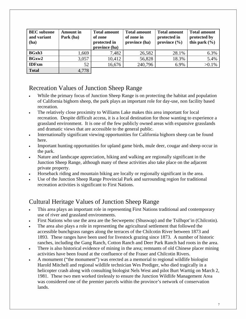
7
BEC subzone and variant (ha)
Amount in Park (ha)
Total amount of zone protected in province (ha)
Total amount of zone in province (ha)
Total amount protected in province (%)
Total amount protected by this park (%)
BGxh3 1,669 7,482 26,582 28.1% 6.3%BGxw2 3,057 10,412 56,828 18.3% 5.4%IDFxm 52 16,676 240,796 6.9% >0.1%Total 4,778
Recreation Values of Junction Sheep Range • While the primary focus of Junction Sheep Range is on protecting the habitat and population
of California bighorn sheep, the park plays an important role for day-use, non facility based recreation.
• The relatively close proximity to Williams Lake makes this area important for local recreation. Despite difficult access, it is a local destination for those wanting to experience a grassland environment. It is one of the few publicly owned areas with expansive grasslands and dramatic views that are accessible to the general public.
• Internationally significant viewing opportunities for California bighorn sheep can be found here.
• Important hunting opportunities for upland game birds, mule deer, cougar and sheep occur in the park.
• Nature and landscape appreciation, hiking and walking are regionally significant in the Junction Sheep Range, although many of these activities also take place on the adjacent private property.
• Horseback riding and mountain biking are locally or regionally significant in the area. • Use of the Junction Sheep Range Provincial Park and surrounding region for traditional
recreation activities is significant to First Nations.
Cultural Heritage Values of Junction Sheep Range • This area plays an important role in representing First Nations traditional and contemporary
use of river and grassland environments. • First Nations who use the area are the Secwepemc (Shuswap) and the Tsilhqot’in (Chilcotin). • The area also plays a role in representing the agricultural settlement that followed the
accessible bunchgrass ranges along the terraces of the Chilcotin River between 1873 and 1893. These ranges have been used for livestock grazing since 1873. A number of historic ranches, including the Gang Ranch, Cotton Ranch and Deer Park Ranch had roots in the area.
• There is also historical evidence of mining in the area; remnants of old Chinese placer mining activities have been found at the confluence of the Fraser and Chilcotin Rivers.
• A monument (“the monument”) was erected as a memorial to regional wildlife biologist Harold Mitchell and regional wildlife technician Wes Prediger, who died tragically in a helicopter crash along with consulting biologist Nels West and pilot Burt Warttig on March 2, 1981. These two men worked tirelessly to ensure the Junction Wildlife Management Area was considered one of the premier parcels within the province’s network of conservation lands.

8
2.3 Vision Statement The vision statement outlined below is intended to provide direction for the long-term management of Junction Sheep Range. The vision statement describes the condition of the park 50 years from now if the intent of the management plan is followed. It is not meant to describe the current condition of the park. The vision statement is used to provide context and guidance for park managers to make decisions about stewardship, recreation and other activities in the parks. The appropriateness of any new activities that may not have been contemplated when the plan was written should be considered in the context of the vision statements. The prime role of Junction Sheep Range Provincial Park is both to protect habitat of the internationally significant population of California bighorn sheep and to contribute to the province’s internationally significant network of grassland protected areas through protecting an area ungrazed by domestic livestock. Management reflects the importance of the area to First Nations, hunters and recreational users and recognizes the potential interactions between the park and adjacent private land owners. The California bighorn sheep have recovered to optimal levels, both inside and outside the park. The population is healthy and sustainable, and this allows for limited hunting opportunities and potential transplants to other areas. The grassland vegetation communities are healthy, vibrant and diverse, and supply adequate forage requirements for sheep and other wildlife in the park. Forest encroachment into the grasslands has been curtailed and natural processes such as fire have been reintroduced. Noxious weeds have never become a serious management issue, partly through good communication with users, and partly through aggressive management of any outbreaks that have been identified. Research and monitoring has increased our understanding and knowledge of grassland ecosystems and the wildlife they support. Low impact, day-use recreation that does not affect the purpose of the park continues, but visitor numbers have been managed through limited access and good communication to protect the sheep and the natural ecological integrity of the area. The main trail to the monument is the corridor that the majority of users, including those in vehicles, horseback riders and mountain bikers use. An informal day use area located on the site of the old Fish and Wildlife Research Station is the only facility in the park. The backcountry nature of Junction Sheep Range is still the main focus of recreation. Opportunities are provided for visitors to learn about the Junction Sheep Range area at an information kiosk located along the main access route to the park just off the Farwell Canyon Road. This structure is cooperatively managed by the province and a number of user groups. It provides information on the history and culture of the area, as well as the boundaries of the park and the adjacent private land. Trails across the private property to the park which are open to the public are clearly marked, and visitors to the area respect private lands and associated grasslands. First Nations, local residents and organizations have developed partnerships with BC Parks to help in the stewardship and management of the park.

9
2.4 Relationship with First Nations Portions of Junction Sheep Range Park have been identified in the asserted traditional territories of two First Nation groups, the Tsilhqot’in (Chilcotin) and the Secwepemc (Shuswap). The two Tsilhqot’in bands which have ties to the area are the Toosey Indian Band residing near Riske Creek and the Yunesit’in (Stone Indian Band) residing near Hanceville. Four Secwepemc bands have ties to the area including the T’exelc (Williams Lake Indian Band), the Xatl’tem/Stwecem’c (Canoe Creek Band), the Esketemc First Nation (Alkali Lake Indian Band) and the High Bar Indian Band residing near Clinton. As there are differing views of the historical use of the area by First Nations, each community was given an opportunity to provide a short written history documenting their traditional use of the local area. The Northern Secwepemc Communities of Xatl’tem/Stwecem’c (Dog Creek/Canoe Creek) and T’exelc (Williams Lake Indian Band) submitted a document asserting their interests in the area of Junction Sheep Range Park that can be found in Appendix 1. See also Section 4.4 Cultural Heritage, for a brief description of historical First Nations use of the Junction Sheep Range area. The Ministry of Environment has statutory responsibility to manage Junction Sheep Range Park. The Environmental Stewardship Division is committed to working with First Nations on a government-to-government basis. As a result, independent discussions were held with First Nation groups to allow for refinement of the park management plan to better reflect their interests. Environmental Stewardship Division will continue to work with these communities during the implementation of the plan with the intent of improving relationships and communication with First Nations. As a result, an informal steering committee made up of a representative from interested First Nations with asserted traditional territory within the Park and BC Park staff will be established. The intent of the committee is to provide advice to the Environmental Stewardship Division decision makers and to seek, where possible, consensus amongst First Nations on issues that may affect their interests. Consistent with the Constitution Act, 1982 s35(1), the management of Junction sheep Range Provincial Park will not justifiably infringe any existing aboriginal rights, including title, nor will the Management Plan limit the position that First Nations or the Crown may take in future negotiations or legal proceedings.

10
3.0 Protected Areas Zoning 3.1 Introduction BC Parks uses zoning to assist in the planning and management of provincial parks and protected areas. In general terms, zoning divides an area into logical units to apply uniform and consistent management objectives for conservation and recreational values. The zones reflect a mix of intended land use, existing patterns of use, the degree of human use desired, and the level of management or development required. At one end of the zoning spectrum, the Intensive Recreation Zone indicates a portion of a park or protected area that is appropriate for high levels of recreation and facility development. At the opposite end, the Wilderness Conservation Zone indicates an area of a park that receives the highest level of resource protection and minimal human presence. Between these two extremes, there are three additional zones providing a range of conservation and recreation management priorities - Nature Recreation Zone, Special Feature Zone and Wilderness Recreation Zone. Additional information on each zone can be found in Appendix 2: BC Parks Management Planning Zoning Descriptions. Junction Sheep Range has been divided into two Zones, Wilderness Recreation and Nature Recreation (Figure 2).
3.2 Wilderness Recreation Zone
Provincial Objective To protect a remote, undisturbed natural landscape and to provide backcountry recreation opportunities dependent on a pristine environment where air access may be permitted to designated sites.
Park Specific Zone Description The Wilderness Recreation Zone covers all areas of the park outside the higher use corridor from the old Wildlife Branch Research Station to the monument. The zone is 4342 hectares in size, or 91% of the park.
Key Zone Strategies • The key values in this zone are the pristine grasslands and year-round habitat for California
bighorn sheep. • Recreational activities will be managed to ensure ecological integrity is unimpaired. • Hunting and non-motorized/non-mechanized public (non-commercial) recreation is permitted
in the zone. • Snowmobiling, mountain biking, ATV use, boat access and horseback riding are not permitted
in this zone. • To protect First Nations’ traditional and contemporary use.

11
Figure 2: Zoning

12
Allowable Activities and Levels of Use in the Wilderness Recreation Zone Activity/Use/Facility Allowable in the Wilderness
Recreation Zone ctivity
Camping N Commercial Recreation (facility-based) N Commercial Recreation (non-facility based) N Fishing Y Hiking and walking Y Hunting Y Natural and cultural values appreciation (birding, photography, wildlife viewing)
Y
Recreational Gold panning and rock hounding N Scientific research (manipulative activities) Y Scientific research (specimen collection) Y Skiing (downhill or cross country tracked) N Skiing (helicopter or cat assisted) N/A Skiing (other) Y Trapping N
Use Aircraft Access N Exotic Insect/disease control Y Filming (commercial) N Fire Management (prescribed fire) Y Fire Management (prevention) Y Fire Management (suppression) Y Fish Stocking and enhancement N/A Forest insect/disease control Y Grazing (domestic livestock) N Guide outfitting (fishing) N Guide outfitting (hunting) N Guide outfitting (nature tours) N Horse use/pack animals (not exotic) N Non-motorized water access N Noxious weed control Y Off-road access (mechanical activities) N Off-road access (motorized – not snowmobiles) N Off –road access (snowmobiles) N Pack animals (exotic) N
Facility Administration buildings and compounds N Backcountry huts and shelters N Campgrounds with picnic areas (vehicle accessed and serviced) N Campgrounds (other) N Communication sites N Interpretation and information buildings N Roads and parking lots N Ski hills and snowplay areas N Lodges and other service accommodation N Trails (hiking, cross –country skiing) Y (existing only) Utility corridors N Water control structures (for conservation purposes) Y
13
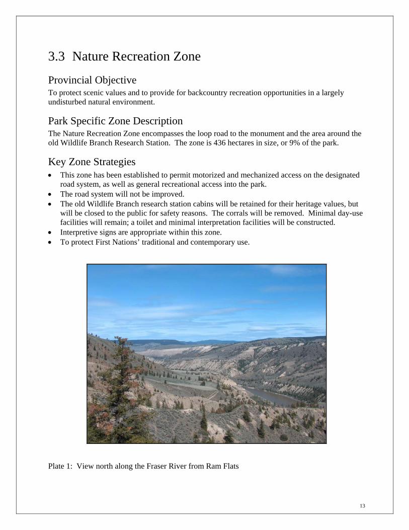
3.3 Nature Recreation Zone
Provincial Objective To protect scenic values and to provide for backcountry recreation opportunities in a largely undisturbed natural environment.
Park Specific Zone Description The Nature Recreation Zone encompasses the loop road to the monument and the area around the old Wildlife Branch Research Station. The zone is 436 hectares in size, or 9% of the park.
Key Zone Strategies • This zone has been established to permit motorized and mechanized access on the designated
road system, as well as general recreational access into the park. • The road system will not be improved. • The old Wildlife Branch research station cabins will be retained for their heritage values, but
will be closed to the public for safety reasons. The corrals will be removed. Minimal day-use facilities will remain; a toilet and minimal interpretation facilities will be constructed.
• Interpretive signs are appropriate within this zone. • To protect First Nations’ traditional and contemporary use.
Plate 1: View north along the Fraser River from Ram Flats
14
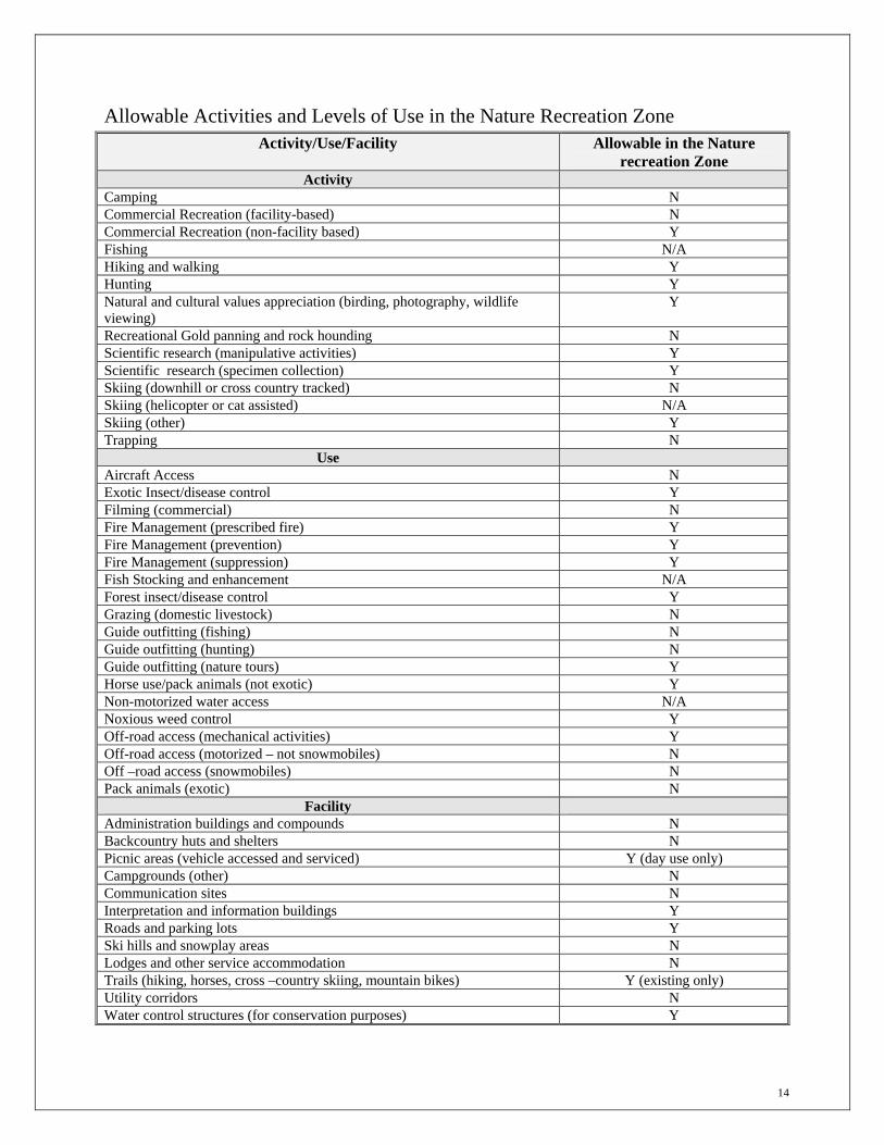
Allowable Activities and Levels of Use in the Nature Recreation Zone Activity/Use/Facility Allowable in the Nature
recreation Zone Activity
Camping N Commercial Recreation (facility-based) N Commercial Recreation (non-facility based) Y Fishing N/A Hiking and walking Y Hunting Y Natural and cultural values appreciation (birding, photography, wildlife viewing)
Y
Recreational Gold panning and rock hounding N Scientific research (manipulative activities) Y Scientific research (specimen collection) Y Skiing (downhill or cross country tracked) N Skiing (helicopter or cat assisted) N/A Skiing (other) Y Trapping N
Use Aircraft Access N Exotic Insect/disease control Y Filming (commercial) N Fire Management (prescribed fire) Y Fire Management (prevention) Y Fire Management (suppression) Y Fish Stocking and enhancement N/A Forest insect/disease control Y Grazing (domestic livestock) N Guide outfitting (fishing) N Guide outfitting (hunting) N Guide outfitting (nature tours) Y Horse use/pack animals (not exotic) Y Non-motorized water access N/A Noxious weed control Y Off-road access (mechanical activities) Y Off-road access (motorized – not snowmobiles) N Off –road access (snowmobiles) N Pack animals (exotic) N
Facility Administration buildings and compounds N Backcountry huts and shelters N Picnic areas (vehicle accessed and serviced) Y (day use only) Campgrounds (other) N Communication sites N Interpretation and information buildings Y Roads and parking lots Y Ski hills and snowplay areas N Lodges and other service accommodation N Trails (hiking, horses, cross –country skiing, mountain bikes) Y (existing only) Utility corridors N Water control structures (for conservation purposes) Y

15
4.0 Natural and Cultural Values Management 4.1 Wildlife The grasslands of the Cariboo-Chilcotin contain a tremendous diversity of wildlife species. As an example, in 1995 it was estimated these grasslands contain 14% of the species on the provincial red list and 39% on the blue list2. Junction Sheep Range Park captures much of this diversity, situated at the confluence of two major river valleys and encompassing arid grassland at river level, cooler benchlands, and grassland/forest edges. In addition to these terrestrial habitats, a number of small wetlands can be found in the grasslands. The mosaic of grasslands in Junction Sheep Range Park offers a variety of habitats, supporting populations of California bighorn sheep, mule deer, black bear, cougar and a number of small mammals. Noteworthy concentrations of bird species can also be found in the grasslands, and a number of these species are at their northern breeding limits.
California Bighorn Sheep Junction Sheep Range Park is a provincially significant area for the conservation of California bighorn sheep. It also has significance within the North American Wild Sheep fraternity as a conservation area for the California sub-species, and has been the source population for many transplants of California bighorn sheep to former habitat in the United States and other parts of British Columbia. It is still considered to be an important transplant source population, although this activity has been suspended due to recent population declines. Past research has identified two separate herds in the vicinity of the park, the Deer Park Herd and the Junction Herd, with some interchange occurring between these two herds. The current population size of the two herds is estimated at 150-200 sheep, down from highs of 450-500 sheep in the mid 1990’s. The Junction herd is a non-migratory herd and occupies the area year round. The Junction Herd is an important herd for research into the ecology of the California subspecies of bighorn sheep. While most of the other California bighorn sheep populations further south along the eastern side of the Fraser River are at risk of genetic mixing due to past transplants of Rocky Mountain bighorn sheep to the Spences Bridge area, the Junction herd is still considered to be a genetically pure source population.
2 Pitt and Hooper, 1995. Problem Analysis for Chilcotin-Cariboo Grassland Biodiversity. BC Environment Wildlife Bulletin No. B-82.
16
Bighorn sheep are a species adapted to open terrain. They use their keen eyesight and ability to negotiate steep and rugged terrain as their main method of detecting and avoiding predators. Lambing generally occurs from late April through to mid June. Lambing areas usually consist of steep cliff complexes intermixed with small terraces and/or ledges. Terrain commonly used for lambing is rugged and remote in order to provide ewes security from predators and isolation for the lambing period. The peak lambing period is usually early to mid-May. After lambing, ewes with newborn lambs will remain close to escape terrain during the initial few weeks. As the lambs get older, the groups gradually move to less secure habitats with a greater abundance of forage. Winter range for bighorn sheep usually consists of open grassland habitats, usually on warm aspects, that are associated with nearby escape terrain. Escape terrain is usually defined as steep slopes or cliffs with a minimum of 60% - 70% slope. In periods of excessive snow depth, bighorn sheep may retreat under nearby forest canopy, making them more vulnerable to predation. The Junction Herd is comprised of a number of ewe/lamb bands. The three ewe/lamb bands that overlap the Junction Park are found in the following general locations:
• Relict/Mouth Gulches – this band is located along the Fraser River near the monument. They lamb along the rugged terrain below the monument and as the summer progresses and the lambs get older and more able to escape predators this band moves onto the adjacent flats below and above the monument.
• Chilcotin Slopes – this band occupies the rugged terrain southwest of the old Wildlife Branch Research Station. They lamb on the lower slopes above the Chilcotin River south of Pit Draw and west of the monument. As summer progresses this band will move upslope and utilize the slopes near the old research cabins overlooking the Chilcotin River.
• Farwell Canyon Band – this band lambs on the cliffs just south of the Farwell Canyon Road. As with the other two bands, this group disperses upslope as summer progresses and generally occupies the area between Farwell Canyon Road and Pit Draw.
Two other bands of the Junction Herd have established themselves outside of the park and further upstream along the Chilcotin River, one in the area of Mary’s Gulch and the Wineglass Ranch, and the other west of Wineglass Ranch and just northwest of the confluence of Big Creek and the Chilcotin River. In addition, there are ram bands scattered along the Chilcotin and Fraser Rivers. Due to the herd’s provincial and international significance, the Junction Herd has in recent years been managed on a more conservative harvest regime than most other bighorn sheep populations, and harvest levels have never been maximized. Currently, due to low ram numbers, the Limited Entry Hunt season has been suspended until recovery has been observed. Low lamb survival has been a chronic problem in recent years in most of the Fraser River bighorn sheep herds and a study is currently being undertaken by the Fish & Wildlife Science & Allocation Section of the Ministry of Environment to determine the causes of this low survival.
17
Bighorn sheep in general are sensitive to aircraft disturbance, particularly helicopters. Bighorn sheep are also sensitive to upslope activity as this is where they are particularly vulnerable to predation. Bighorn sheep will generally react more negatively to human disturbance if it is upslope, and particularly if dogs are present.
Mule Deer Mule deer populations are scattered throughout Junction Sheep Range Park, with the highest densities of mule deer along the Fraser River, particularly in the northern portions of the park. These populations are not considered to be at risk. Most Fraser River mule deer populations are comprised of migratory and non-migratory components. Generally the migratory herd is the larger of the two components. Winter range for mule deer usually consists of old growth Douglas fir habitat, which mule deer rely heavily on during periods of deep snow. During mild winters, however, mule deer can be quite dispersed and will utilize more open habitats. Deer hunting is popular in portions of Junction Sheep Range Park, particularly in the northern areas of the park and on the adjacent crown and private land.
Columbian Sharp-tailed Grouse Generally, Columbian Sharp-tailed Grouse are a grassland or open habitat species, although they have also been observed using sedge meadow complexes and areas that were recently clearcut. The males of this species perform mating displays to attract females, from early April through end of May with the peak period in mid to late April. The areas where they perform these displays are called leks. A lek site is generally a flat area on a rise where most males in the vicinity display, and therefore they are key areas for the grouse. There is one known lek site within Junction Sheep Range Park and two on the adjacent private land. Lek sites are sensitive to disturbance and birds will on occasion abandon lek sites if there is too much activity in the area. Although the species is blue listed, the numbers of grouse observed at the Junction area leks have been fairly stable and the leks are currently not at risk compared to other leks in the general area. In other areas, such as Beecher’s Prairie and Bald Mountain, some leks have ceased to be used by Sharp-tailed Grouse. The main reasons for population decline are believed to be the reduction of grassland opening size due to forest encroachment, and the impacts of grazing. As a result some populations have declined to a point where hunting poses a risk to the population, and so the hunting of grassland populations has been closed for most of the province including the area surrounding the Junction. Sharp-tailed Grouse nesting occurs in tall grass clumps or in association with shrub cover.
18
Rare and Endangered Wildlife Species In addition to provincially significant California bighorn sheep and mule deer populations, the Junction Sheep Range Park grasslands provide habitats for a number of red and blue listed species. Some of the specific species at risk that may inhabit Junction Sheep Range Park are outlined in Appendix 3: Known and Suspected Red- and Blue-Listed Species in Junction Sheep Range Park as of December 31st, 2003. Objectives
The primary management objective is to ensure the protection and recovery of California bighorn sheep and their habitat.
The park will be managed for the habitat needs of all species by providing a range of habitats that include grassland and forest ecosystems.
An objective of management will be to maintain and/or recover to optimal levels3 species and habitats at risk4 within Junction Sheep Range Park which will contribute to recovery efforts over a broader area.
Wildlife habitat features5will be protected. Management will seek to maintain ungulate winter and spring ranges in a condition that will
support populations during critical winter conditions. Displacement of wildlife from preferred habitats will be minimized. A key objective will be to avoid disease transmission between domestic livestock and wildlife. Preventing the introduction of exotic plant and animal species and minimizing the spread of
existing exotics will be a priority. Opportunities for hunting of game species where population size and health allows will be
provided. The Junction herd should remain an important source of donor stock for transplants of
California bighorn sheep to former habitats within the province and other jurisdictions. Strategies General
Implement specific habitat prescriptions for selected species or habitats at risk. Use biophysical mapping and other resources to identify and manage high value ungulate
habitat areas, such as winter range, spring range and natal areas. Use prescribed burning to address maintenance of grassland ecosystems, reduce forest
encroachment and enhance wildlife habitat. Prohibit domestic sheep, goats or llamas in order to prevent transmission of disease to wild
populations. Utilize wildlife safe fencing standards.
3 “Optimal” is a combination of historic levels and the area’s carrying capacity for areas both inside and outside the park - this concept requires more research. 4 “At Risk” refers to species or habitats that are extirpated, endangered, threatened or vulnerable (red and blue listed). 5 “Wildlife Habitat Features” are specific features of wildlife habitat that support specific wildlife or groups of wildlife such as mineral licks, nest trees or nest sites etc.

19
For the road corridor only, access to the park by snowmobile may be granted under permit for specific wildlife management purposes.
Work with First Nations to develop and implement management strategies and utilizing traditional ecological knowledge (TEK).
California Bighorn Sheep
Support the efforts of the Fraser River Bighorn Sheep Advisory Committee and manage bighorn sheep habitat consistent with the recommendations of the Advisory Committee and the Fraser River metapopulation recovery plan.
Maintain the area as day use only to minimize human disturbance. Do not improve road access into the park. Maintain or minimize human use of the Park by not improving the condition of the designated
road system. Restrict motorized access to designated roads. Consider re-activating the ‘water guzzlers’ constructed in the 1980’s in order to provide water
for wildlife. Provide information to private land owners regarding the transfer of diseases between
domestic sheep and wild sheep populations. Close the road to Junction Sheep Range Park at the Farwell Canyon road from Dec 1- March
31 to minimize disturbance of California bighorn sheep during winter months. Research and Inventory
Support efforts to determine the long term carrying capacity for California bighorn sheep for the purpose of establishing sustainable population targets for the park and adjacent areas.
Examine the various factors affecting the health and long term vigor of the Junction California bighorn sheep herd.
Confirm the presence and distribution of red and blue listed species and their habitats in the park.
Encourage collaborative research between BC Parks and First Nations on threatened and endangered wildlife, plant species and communities.

20
4.2 Grasslands Junction Sheep Range Park was created to protect critical California bighorn sheep habitat as well as to represent and conserve its nationally significant grassland ecosystems. One of the tasks of this management plan is to develop ways to manage, and where necessary, restore or enhance grasslands in order to provide the best habitat possible for bighorn sheep and other grassland species. Junction Sheep Range Park contains representation of two major grassland types. These include 1,669 hectares of the Fraser Variant of the Very Dry Hot Bunchgrass Biogeoclimatic Subzone6 (BGxh3) and 3,057 hectares of the Alkali Variant of the Very Dry Warm Bunchgrass Biogeoclimatic Subzone (BGxw2). A minor component of the Very Dry Mild Interior Douglas-fir Biogeoclimatic Subzone (IDFxm) exists in the park. For the purposes of this plan, we will use the terms ‘Lower Grassland’ for the BGxh3 Biogeoclimatic Subzone, ‘Middle Grassland’ for the BGxw2 Biogeoclimatic Subzone, and ‘Upper Grassland’ for the IDFxm Biogeoclimatic Subzone. Detailed descriptions of grassland ecosystems can be found in Appendix 4: Description of Major Grassland Ecosystems of Junction Sheep Range Park.
Encroachment The grasslands and forested areas of Junction Sheep Range Park have historically been subject to frequent, low intensity fires. These fires acted to maintain a mix of open grasslands, grassland-forest transitional ecosystems, and open canopy and open understory forests. However, due to increased fire suppression over the past century, the frequency of fire has decreased dramatically. This has resulted in the gradual loss of grasslands due to the encroachment of Douglas-fir stands into the grasslands, and the in-filling of open fir stands. It has been calculated that approximately 11% of the estimated total area of grasslands in Cariboo Forest Region has been lost due to encroachment since 19657, while the loss of open grasslands over a 32 year period was calculated to be as high as 31% and 37% in some areas close to Junction Sheep Range8. 6 A biogeoclimatic zone is defined as “a geographic area having similar patterns of energy flow, vegetation, and soils as a result of a broadly homogenous macro-climate.” The Biogeoclimatic Ecosystem Classification (BEC) system is a principal tool used to classify and describe ecosystems in British Columbia. There are 14 biogeoclimatic zones in the province. These zones are subdivided into biogeoclimatic subzones (98 in BC) which have a more uniform climate than zones and have unique plant communities. Subzones in turn are subdivided into biogeoclimatic variants, which describe small variations in climate and vegetation within a subzone. This results in a total of 168 units (subzones and variants). For example, within the Junction Sheep Range Park, the Bunchgrass (BG) Biogeoclimatic Zone includes two subzones: the Very Dry Hot BG and the Very Dry Warm BG. Each of these subzones is further divided into variants with the Fraser and Alkali variants found with in the park. Other subzones and variants of the Bunchgrass Zone occur in other parts of B.C. 7 Cariboo-Chilcotin Grasslands Strategy Working Group. 2001. Forest Encroachment onto Grasslands and Establishment of a Grassland Benchmark Area. Cariboo-Mid Coast Interagency Management Committee. 8 Ross, T. 1997. Forest in-growth and forest encroachment on Bald Mountain and Becher Prairie: 1962 and 1993/95. Report submitted to BC Ministry of Agriculture and Cariboo-Chilcotin Grazing Enhancement Fund, Williams Lake, BC by Ross Range and Reclamation Services, Cranbrook, BC.

21
The loss of grassland area due to encroachment has significant implications for California bighorn sheep habitat, biodiversity and grazing on adjacent ranchlands. Both provincially and regionally, grasslands represent a small percentage of the total land base but contribute greatly to the province’s biodiversity. Diminishing grasslands therefore equate to reduced forage and a loss of critical habitats for red and blue listed species in not only local, but also regional and provincial contexts. Efforts to counteract the effects of encroachment and in-growth by re-introducing fire to the landscape have already begun. In 2000, BC Parks completed the Junction Sheep Range Provincial Park Prescribed Fire Management Plan, and two prescribed burns were carried out in 2001 and 2002.
Weed Management Non-native plant species, including many noxious weeds, are relatively infrequent in Junction Sheep Range Park, although some do occur on neighboring private lands. Many of these noxious weeds are non-native plants that have been introduced to British Columbia that do not have natural enemies (predators and diseases) that control them. These noxious weeds are aggressive, difficult to control and lead to the degradation of native plant communities and the reduction of forage production for California bighorn sheep. The total removal of all introduced species from the Park is a near impossible task. At the present time, mechanical removal and the application of herbicides are the main methods used to control noxious weeds. In other areas of British Columbia, such as the Okanagan, application of expensive herbicides has been replaced with bio-controls because infestations have become too widespread. Management is focused on eliminating small patches and keeping current infestations localized. Weeds in the grasslands can be widely classed into three broad groups:
1. Those that are invasive to range land and replace native plant species. Examples include spotted knapweed (Centaurea bierbersteinii), diffuse knapweed (Centaurea diffusa), blueweed (Echium vulgare), and leafy spurge (Euphorbia esula);
2. Those noxious weeds that are widespread and prefer disturbed sites or moister areas.
Examples include burdock (Arctium species), Hounds-tongue (Cynoglossum officinale), and Canada thistle (Cirsium arvense); and,
3. Other introduced species, all of which are undesirable from a conservation perspective.
An example is Kentucky bluegrass (Poa pratensis). There are also populations of Cheatgrass (Bromus tectorum) at the monument.
Of the three groups, the invasive weeds are much more serious and management should be focused on removing the plants, localizing their populations and limiting their spread to new sites.
22
Rare and Endangered Plant Species and Communities A number of red and blue listed plants and plant communities have been located in Junction Sheep Range, or are likely to occur there. Some of these are outlined in Appendix 5: Known and Suspected Rare and Endangered Plant and Vegetation Communities in Junction Sheep Range Park as of December 31st, 2003. Objectives
Maintain suitable habitat for red and blue listed species. Maintain natural plant communities for their inherent value and their contribution to wildlife
habitat, biodiversity and aesthetics. Protect rare, endangered and sensitive native plant communities. Promote and demonstrate excellent and innovative grassland management strategies. Control or eliminate noxious weeds and prevent the spread of non-native species. Maintain or restore natural processes including fire while considering implications for areas
adjacent to the park Manage riparian areas consistent with natural processes Encourage scientific research to increase knowledge of grasslands and vegetation species and
communities in the park. Strategies Fire Management
Continue to use fire or mechanical clearing in order to reduce forest encroachment and in-growth, and to enhance habitat for California bighorn sheep, while minimizing impacts on other listed species and communities.
Follow the recommendations of the Junction Sheep Range Provincial Park Prescribed Fire Management Plan.9
Permit motorized equipment (wheeled or tracked) only on existing developed roads.10 Forest Pest Management
Insect infestations will not be controlled unless a significant threat to adjacent private lands is identified.
Address insect infestations over the long term by reducing forest undergrowth and overall stand densities.
No new access will be created to address pest infestations. Where possible, allow infestations to run their natural course.
9 Junction Sheep Range Provincial Park Prescribed Fire Management Plan, Prepared by Ember Research Services Ltd. and Applied Ecosystem Management Ltd. 2000. 10 Fire Management Plan for Junction Sheep Range Park, BC Parks, 2003.
23
Disturbed Areas and Old Roads
Control erosion on open roads using methods such as waterbars and ditching.
Rehabilitate disturbed sites with native species where possible. Weed Management
Focus on the restoration of natural ecosystems (using tools such as fire) as the main method of reducing noxious weed infestations.
Map occurrences of noxious weeds. Complete reconnaissance level mapping for areas that are not currently inventoried for noxious weeds, including areas along the road access into the park.
Monitor vehicles that are in the park on a regular basis for the presence of noxious weeds.
Before bringing horses into the park, animals should be thoroughly checked and cleaned for burrs. Horse’s hoofs should be picked free of dirt.
Any equipment working in the park must be pressure-washed prior to entering the park.
Consider the use of bio-controls to control noxious weeds.
Minimize disturbance of grassland areas.
The priority for managing introduced species will focus on those species classed as noxious under the Weed Act and of those, emphasis should be placed on removing and controlling those that are invasive i.e. spotted knapweed, diffuse knapweed, leafy spurge.
Weed control and/or removal will be undertaken when new invasives and/or exotics are identified and in on-going programs for previously identified weeds.
The selection of methods that will be used to remove or control weed plants will vary depending on the species and its distribution. Options may include hand picking, mowing, bio-controls or herbicides. When appropriate preference will be given to mechanical methods over chemical and specific rather than broad-band methods.
Ensure all motorized vehicles stay on roads, and use communication tools to educate the public about noxious weed issues.
Maintain healthy grassland ecosystems and minimize soil disturbance to prevent the introduction and spread of non-native species.
Research & Inventory
Complete appropriate ecosystem mapping, such as Terrestrial Ecosystem Mapping
Complete an inventory of plant species and plant communities at risk.
Encourage research into the interactions of wildlife species and native grasslands, e.g. the effects of California bighorn sheep on plant species composition or structure; forage species preference of California bighorn sheep; utilization of grassland vegetation by small mammals and ground nesting birds, etc.

24
4.3 Access Junction Sheep Range Park is bounded by private property to the north and west of the park and bordered by the Fraser River on the east and the Chilcotin River on the south. As a requirement of the land trade that occurred in the 1970’s to establish the area, a public right-of-way11 was negotiated across private property to the park and other areas of Crown land. This provided public access to several points in the park as well as a loop road to the northwest of the park (Figure 3). As the access right-of-way was established as a component of the original Wildlife Management Area, this Management Plan will address access issues and management of the road corridor. A number of issues have arisen as a result of the presence of the road corridor. Some of them include:
• Impacts to grasslands from drivers not staying on roads (braiding); • Camping on private property, and associated waste, garbage and litter; • Potential for spreading weeds onto grasslands; • Long term security of public access to the park; • Proper communication/clear communication of rules around use of the area; • More information about the area, in particular, which areas are private; • Maintenance and condition of roads into the park and ; • Legal access to grazing leases by lessee outside the park but along/through managed right-of-
way As a way to address these issues, the plan recommends using communication and road management. The communication component is outlined in section 6.0 Communications. The Fraser and Chilcotin Rivers provide potential water based access corridors to the lower elevations of the Park
Objectives Minimize displacement of California bighorn sheep from preferred habitats Provide reasonable access to Junction Sheep Range Park and adjacent areas of Crown land
for hunting and recreational use Minimize impacts to grasslands Support public expectations of natural quiet and a natural environment experience Ensure public is aware of changes to access management Ensure grazing tenure holders have legal and reasonable access to areas of Crown land in the
vicinity of Junction Sheep Range Park.
11 This right-of-way was established under section 8 (2) under the Highways Act. Notice appeared in the British Columbia Gazette on March 10th and March 24th, 1977.

25
Figure 3: Adjacent private and leased land

26
Strategies The road right-of-way established over private land in 1977 will continue to allow for public
access. For a two year period commencing with the approval of this plan, public education and
signage will be used to reduce impacts to grasslands and adjacent private property. If impacts and negative behavior improves to an acceptable level, then the use of communication and signage will be continued. If the level of impacts and negative behavior are still considered unacceptable, then the following strategy will be implemented: • Motorized access (licensed vehicles) will continue to and within Junction Sheep Range
Park on roads designated as open to motorized traffic. • The northern section of the public road will be open to non-motorized traffic. • Use of the Wildlife Act will be explored for enforcement of the access strategy.
The road network will only be open for public use from April 1-November 30 in order to protect sensitive sheep habitat areas and to minimize damage to the road during winter.
Ways to restore damage to road right-of-ways will be explored. Water access from either the Fraser or Chilcotin Rivers to the park will be discouraged. See section 6.0 Communication for information on public information and signage.
4.4 Cultural Heritage Junction Sheep Range Park encompasses a small area, but one rich in cultural heritage and archaeological resources. The history includes First Nations use and habitation; a period of mining and ranching; and, most recently, a shift to a focus on habitat conservation. Archeological evidence confirms that the confluence of the Chilcotin and Fraser Rivers was occupied by First Nations people with several village sites located in the general area. Archaeological Site Reference maps record evidence of habitation in the form of house pits, petroglyphs, fishing stations, food caches, middens, campsites, and tool flaking sites which when combined, confirm that the area was extensively occupied.12 The first recorded contact between Euro-Americans and local First Nations occurred in 1808 when Simon Fraser explored the area during his travels down the Fraser River. By the 1820’s fur-traders were regularly in the area, followed soon after by missionaries and priests. In the 1850’s placer miners in search of gold explored the area, bringing new diseases with them that nearly wiped out the local communities in 1862. Of the local First Nations that survived the small pox epidemic some are reported to have moved east to the Alkali Lake Band of Secwepemc while others moved west to the Anaham Band of the Tsilhqot’in.13 12 Archaeological Site Reference maps, Archaeology and Recreation Inventory division of the Terrestrial Information Branch, Ministry of Sustainable Resource Management. 13 Teit, James. Jesup North Pacific Exedition Vol. 7: the Shuswap. Ed. Franz Boas. Leiden, New York: G.E. Stechert & Co., 1909.

27
With the Cariboo gold rush occurring in the 1860’s, exploration, mining and settlement of the area by miners and merchants continued. In addition, by this time the rangeland potential of the interior grasslands had been noted, and ranchers began settling in the Riske Creek and Gang Ranch areas. The history of ranching in what is now Junction Sheep Range Park continued until 1973 when the land was acquired by the government during a negotiated land exchange with the Riske Creek Ranching Company. Between 1975 and 1980 perimeter fencing was constructed along the western and northern boundaries of the established Wildlife Reserve and a number of buildings were erected, near the entrance to the area, to support research and management efforts. The land officially became the Junction Wildlife Management Area in 1987, and was later designated as a Class A Provincial Park in 1995. The physical evidence of these various uses is distributed throughout the park, some of it buried and some of it in plain view. Other indications of history are only in the memories of elders and those who worked in the area. All of these resources, aboriginal or non-aboriginal, will be managed in a sensitive way and in accordance with the appropriate legislation.
Objectives Protect and preserve the archaeological values and resources within the park. Increase archaeological, cultural heritage and historic knowledge relating to the park. Work in cooperation with community or special interest groups who have an interest in
maintaining heritage values in the park Improve relationships and communications with those First Nations with asserted traditional
territories overlapping the park. Raise awareness of First Nations interests and values as they pertain to Junction Sheep Range
Park Provide for the continued exercise of any existing aboriginal rights subject to meeting safety
and conservation objectives. Provide information to park users on the cultural heritage of the park but do not promote the
park as a cultural heritage destination.
Strategies Continue to work with First Nations to increase understanding of the values within the Park.
Ensure sensitive information is handled respectfully and appropriately. Archaeological Impact Assessments will be required for all major developments, but not for
minor developments.14 Archaeological Impact Assessments will be required before any sites are considered for
inclusion within a commercial tenure proposing to undertake cultural tourism.
14 Major work includes new developments such as new structures or fences. Minor work is defined as undertaking vegetation management (thinning and prescribed burning) and maintenance to existing facilities, gates or fences, installing signposts and installing gates and walkthroughs.

28
Undertake interpretation and/or investigation of First Nations heritage in Junction Sheep Range Park only with the participation of First Nations.
Provide information on the ranching, mining, First Nations and conservation history of the area in any signage and/or interpretation materials prepared. Restrict interpretive signage to the main access route and day use areas.
The old Wildlife Branch research station buildings will be retained and allowed to deteriorate naturally to preserve their heritage value, but will be closed to the public for safety reasons. The corrals and outbuildings will be removed.
Alter location and intensity of recreational activities if there are impacts to cultural values. Where available use Traditional Ecological Knowledge (TEK) in the management of natural
resources.
Plate 2: View of Railroad Rapids along the Chilcotin River

29
5.0 Outdoor Recreation Opportunities and Management 5.1 Introduction Junction Sheep Range Park hosts a range of recreational opportunities that vary by season and area of the park. Topography, access and the presence of roads are the largest factors that influence the use of the park. The following section describes the recreational vision (or “concept”) for the park. The main tools used to implement the recreational concept are the park zoning, as well as the recreation, access and communications objectives and strategies found in the appropriate sections.
The majority of the use in the park occurs from April to November. The most common summer uses are nature appreciation, wildlife viewing and hiking. In the fall, bird hunting, deer hunting and sheep hunting are also popular activities. Most users access the park by 4x4 vehicle, although horseback riding and mountain bikes are also popular modes of transportation. The largest factor that affects use of the park is the very rough road which leads to the park.
5.2 Recreation Concept The recreation concept for Junction Sheep Range Park focuses on maintaining the current levels of day-use, low impact, non-motorized recreation that have little impact on populations or habitat of the California bighorn sheep. The main strategies to accomplish this vision are keeping the vehicle access routes to the park very primitive, improving communication and signage, and restricting overnight use of the park. The main tools used to do this are the Zoning, Communication Strategy, and the Recreation and Access objectives and strategies. Although a relatively new park in British Columbia’s protected area system, actual use of the park should change little from the status quo. No new roads will be constructed into or within the park, and minimal new facilities permitted. Signage will be enhanced, both in the park and on the right-of-way leading to the park. The park will remain primarily a day-use walking and/or hiking park. Limited day use facilities will, over time, be situated at the old Wildlife Branch research station site. Visitors looking for a grassland protected area with overnight camping and relatively easy motorized access will be encouraged to use the Churn Creek Protected Area to the south. Motorized access, mechanized access and horse use will be permitted only on the main route to the monument, but not beyond and not off the main loop road. Utilizing powerboats or other watercraft to access the park from the Fraser or Chilcotin Rivers will be discouraged. The old Wildlife Branch Research Station will be removed, and limited day use facilities will, over time and as demand necessitates, be situated at that spot.

30
5.3 Commercial Recreation Opportunities Part of the rationale for completing a management plan for this park was to examine the opportunity for commercial tourism opportunities. The CCLUP states that parks:
…will be available, in principle and where appropriate, for commercial tourism and recreation. Development opportunities will be identified during area-specific management planning which will recognize the protection of the special natural values of each area and the provision for public non-commercial recreation. In some circumstances, development opportunities may include “fixed roof” accommodation. (CCLUP 90 Day Implementation Report).
One of the challenges with commercial tourism has been finding opportunities that are compatible with the natural values for which the park was created. This particular park was created for its California bighorn sheep population, a species which is very sensitive to human disturbance. Also, the relatively close proximity to the community of Williams Lake and high levels of local use and advertising have the potential for increasing levels of visitation. At the present time, there are no commercial tourism activities occurring within the park. During the planning process, a number of concerns were noted about offering new opportunities. Concerns included increasing use, introducing new users to the area, and advertising the area, which might result in increased use. The positives of commercial activities that were noted included the economic value to the community, the higher level of control that went with commercial permits, and the educational benefits of guided tours.
Objective Given the concerns regarding the introduction of commercial recreation into the park, a
cautious and adaptive approach will be taken.
Strategies Two, five year non-renewable opportunities will be available. One of the commercial opportunities will be made available to a local First Nation tour
operator based on the following criteria: o The permit is being awarded without prejudice to aboriginal rights, interests or treaty
negotiations. o That a prospective commercial operator applying for a permit on the basis of their
affiliation with a First Nation community would need to have the permit endorsed by a steering committee made up of representatives from those First Nation Bands with asserted traditional territory over the park (refer to Section 2.4).
Commercial recreation will be limited to the Nature Recreation Zone, which encompasses the main access into the park as well as some of the best viewing opportunities.
The opportunity will be available for wildlife viewing, cycling, horseback riding and vehicle touring or a combination of these activities.
At the end of the five year period, the impacts on the park, both physical and in terms of increased use will be reviewed to determine if commercial use will be extended.

31
5.4 Existing Recreation Uses Part of the rationale for completing a management plan for this park was to recognize existing non-commercial recreation. Direction from the Cariboo-Chilcotin Land-Use Plan states that:
Dominant ecological values should be protected and that uses, such as recreation, cattle grazing [except Junction Sheep Range], hunting, trapping and backcountry tourism, will be allowed. (CCLUP 90 Day Implementation Report)
Environmental Stewardship Division has interpreted this direction to mean that commercial and public recreation activities and levels of use that were taking place as of October 1994 will be accommodated in management and with a permit where appropriate. The challenge with this direction is that, while commercial operators can demonstrate their activities through records and receipts, few records are kept by public recreation groups. As a result, the following recreational strategies have attempted to recognize and accommodate existing levels of use. Section 4.3 Access and Adjacency, also contains sections which attempt to accommodate these uses so they are consistent with the conservation vision of the park.
Objectives To accommodate high quality, low impact public and commercial recreation activities that
have minimal impact on, or risk to, wildlife and other park values. To enhance visitor awareness of wildlife populations and grassland ecosystems and possible
human-wildlife conflicts. To provide opportunities for commercial recreation which are compatible with the values of
the park. To ensure public access to the park is not pre-empted by commercial recreation activities. To ensure recreation activities (public and/or commercial) are managed and monitored for
their potential impacts on natural and cultural heritage values, particularly on wildlife populations and vegetation.
Strategies Ensure that all park information specifies the primary purpose of the park is to protect
California bighorn sheep habitat, so that conflicting expectations are avoided. Allow public, non-mechanized, non-motorized and non-supported recreational use throughout
all of the zones in the park. Hiking, wildlife viewing, nature appreciation and cross-country skiing are all allowed activities throughout all zones of the park. Motorized access for these activities is only allowed in the Nature recreation Zone and only on existing roads. Levels, timing and areas of use will be adjusted if impacts are demonstrated.
Recognize hunting as an allowable activity in all zones in the park. Dogs must be controlled at all times in order to minimize impacts on wildlife. Snowmobiling is not allowed in the park. ATV’s are not allowed in the park. Horses are allowed only in the Nature Recreation Zone in the park. Users are required to use

32
existing trails and roads. Levels of use and areas of use may be adjusted over time if impacts are demonstrated or user conflicts develop.
Encourage all horse users to follow a Code of Ethics and to use weed-free pellets for large groups.
Mountain biking is allowed only in the Nature Recreation Zone in the park. Users will be required to use existing trails and roads. Levels of use and areas of use may be adjusted over time if impacts are demonstrated or user conflicts develop.
Llamas and other exotic pack animals are not allowed in the park. This may be reconsidered if new scientific data shows exotics have no impact on native species.
Assess conditions and monitor the effects of recreational use and regulate as necessary. Trails may be closed during certain conditions (extended periods of rain/snow, late thaws, etc.).
Aircraft are not allowed to land in the park. Discourage powerboats and other watercraft from accessing the Park from either the Fraser or
Chilcotin Rivers. Therefore, do not permit any commercial operators water-based access to the park.
No overnight camping allowed in the park. No fixed roof accommodation will be provided within the park. Retain the main cabins at the old Wildlife Branch research station for their heritage value and
develop a day use area as demand and use levels warrant.
Plate 3: Group of California bighorn sheep

33
6.0 Communications Management of the information that visitors to Junction Sheep Range Park receive, both in the park and prior to their trip, provides an important opportunity to increase visitor enjoyment and improve the management and stewardship of the park. Well communicated appropriate information can:
• Set visitor expectations and assist in planning recreational uses; • Promote user etiquette and minimize conflict between users; • Minimize impacts on wildlife, vegetation and other park values; • Create an awareness and appreciation of natural settings, cultural features and conservation
messages; and, • Build support for management efforts.
The sensitivity of the ecosystems in Junction Sheep Range Park combines well with the desire to have an enhanced communication program of signs and messages.
6.1 Interpretation and Management Messages A number of sections of this plan have outlined the general management objectives for the park. These objectives (in no particular order) include: • Protect native grasslands and for the populations and habitat of California bighorn sheep • Protect other species associated with grassland ecosystems, particularly species and
ecosystems at risk. • Manage human use to reduce impacts to park values; • Meet the objectives of the Cariboo-Chilcotin Land-Use Plan that recommended the creation of
the park; • Balance natural processes in the parks with management (e.g. fire and forest health) in order to
create and maintain natural and healthy ecosystems; • Increase knowledge of natural processes, ecosystems, and wildlife habitats and populations
(e.g. inventory and research).
Considering the above management objectives, the following messages should be integrated into any public information efforts around the park (e.g. signage, the park’s website, information provided to any permit holders and user groups, societies, volunteers, chamber of commerce etc):
1. User etiquette. This etiquette should stress appropriate behavior around wildlife in order to avoid habituation, direct impacts and displacement from key habitats. As well, users should be educated on the vulnerability of grassland ecosystems to human impacts (e.g. weeds, vehicles etc)
2. Managing expectations about access to the park and the level of facilities provided. It will be important to provide the rationale for the lack of management services provided.
3. Managing expectations of use of private property. A key message will be focused on showing users of the area where the private property is located, and clarifying that the right-of-way is the only legal access to the park. Maps of legal lots and grazing leases will be critical to this information.

34
4. The importance of the park in providing habitat for California bighorn sheep and protecting grassland ecosystems. This should include information regarding the vulnerability of California bighorn sheep and native grasslands in provincial and international contexts.
5. BC Parks is working cooperatively with adjacent landowners and tenure holders, user groups, stakeholders, local governments and associations and First Nation governments in managing the area.
Objectives Ensure users of Junction Sheep Range are aware of all legal rights-of-way and of adjacent
private property and leases.
Ensure information (published and verbal) is consistent with the park’s visions, roles and the key messages outlined above.
Minimize the promotion of the park while providing accurate and appropriate information for park users.
Work co-operatively with local and regional tourism agencies, permit holders and other agencies and user groups in communicating the key messages about park management.
Strategies Consolidate the current information and interpretive signs located along the main access road
to Junction Sheep Range just off the Farwell Canyon Road. Construct a single kiosk that would provide interpretive information regarding the park including information specific to the natural, recreational and cultural values, history and management of the area. A map showing land ownership, park boundary and legal access should be included. The site should be cooperatively designed and constructed by government, adjacent landowners, user groups and other associations and governments.
All access routes in the area will be clearly marked as open to motorized traffic, open to non-motorized traffic or closed to public access.
Encourage visitors looking for a grassland protected area with overnight camping and road access to use the Churn Creek Protected Area. Encourage users looking for overnight camping to utilize commercial campgrounds and facilities in the vicinity.
Work with tourism associations, chambers of commerce, or other agencies and groups which publish information in order to communicate the sensitive and day-use nature of the park and types of uses allowed.
Liaise with various conservation organizations, naturalist clubs, industry organizations, local government and land-use plan monitoring groups on a regular basis to discuss ongoing management issues.
Highway signs will not be erected.
Work with user groups to establish a “Junction Watch”, a self-managed group with the objective of park users taking a role in the management of the park as well as monitoring levels of use and compliance with park regulations.

35
7.0 Monitoring Monitoring the continuing status of the health of ecosystems, wildlife populations, and the levels and impacts of recreational use in the park is vital to ensuring the ecological integrity of the park. As such, a proactive and well-planned monitoring strategy is key to guaranteeing that the spirit and intent of this management plan is followed. Monitoring grasslands, recreational use and wildlife populations is not solely the responsibility of BC Parks. Many other agencies and groups either play a central role at the present time or could be partners in monitoring. Examples of new partners may include Williams Lake Sportsman’s Association, Grasslands Conservation Council, Cariboo-Chilcotin Conservation Society, Williams Lake Field Naturalists, BC Wildlife Federation, First Nations, permit holders, community groups, universities and colleges, hiking or walking groups or even interested individuals.
Objectives Monitor the distribution and population of umbrella species, keystone species and listed
species in the parks.15
Monitor the health of grassland and forest ecosystems within the park in relation to the park fire management plan.
Monitor the seral stage distribution of grassland ecosystems in the park.
Work with the Fish & Wildlife Science & Allocation Section of the Ministry of Environment to monitor California bighorn sheep and other wildlife species use of areas both within and adjacent to the park.
Monitor the impact of recreational uses on wildlife and vegetation in the park.
Monitor patterns, levels and trends of recreational use, especially in relation to the temporary commercial tenures.
Monitor compliance with the park access strategy.
Strategies (Conservation Monitoring) 1. Wildlife
Work with the Fish & Wildlife Science & Allocation Section of the Ministry of Environment to establish a monitoring regime for bighorn sheep and other wildlife species that is consistent with provincial methodologies.
15 Keystone Species – Species that have a crucial role in supporting the integrity of the entire ecosystem and that by their effective disappearance from the system result (directly or indirectly) in the virtual disappearance of other species (e.g. salmon). Umbrella species -A species whose habitat encompasses the habitat needed by a large number of other species. California bighorn sheep, for example, can be viewed as an umbrella species because of their broad ecological niche.

36
2. Identify Keystone or Umbrella Species Identify a number of keystone and umbrella species to focus monitoring on. Monitoring should focus on the long term population trends and habitat needs of these animals.
3. Forest Health Monitoring
Complete annual aerial survey of bark beetle populations, and monitor in-filling of Douglas fir stands over time, using vegetation surveys or photographic methods.
4. Grassland monitoring
Map areas of weed infestations and periodically update these maps for comparison to recreational use trends. In addition, use photopoints16 or permanent stations to monitor encroachment over long time periods.
5. Commercial Operators
Work with commercial operators, and encourage a formal, but simple, program for commercial operators to report wildlife species encountered and animal behavior observed. Commercial operators can play a key role in monitoring, enforcement and inventory. These roles need to be better defined and discussed.
Strategies (Recreational Monitoring) 1. Photopoints
Photopoints can be established at key points on trails and access roads to determine how road braiding is impacting grasslands or other areas of high public use, such as the monument or the old Wildlife Branch Research Station site. Photopoints should be updated once every five years.
2. Trail Counters
Consider using trail counters or cameras to determine user numbers on the access route to the park.
3. Rangers/Park Watch/ “Junction Watch” Consider using staff or other partners for monitoring levels and patterns of use in the park. This may include increased Park Ranger patrols into the area or encouraging “Junction Watch” (similar to the Wilderness Watch program) to determine use patterns. In particular, for the access management strategy, it is important that stakeholder groups work together with the private landowners to monitor and record instances of negative behavior as discussed in section 4.3 Access. Variables that could be monitored include numbers of users camping without permission in the area, incidences of garbage being left at campsites, and incidences of users driving off the designated trails and onto the grasslands.
16 Photopoints are areas where photographs are taken regularly over a long period of time. They can be used to monitor, track and communicate visible changes over time.

37
Adaptive Management The concept of "learning by doing" or "adaptive management" has become widely accepted in resource management and environmental planning. Adaptive management is generally thought of as being flexible, encouraging public input, and uses extensive monitoring to look at the results of actions in order to adjust plans and try new approaches. Adaptive management essentially involves a three-stage process of planning, action, and monitoring.
For the purposes of the Junction Sheep Range Management Plan, adaptive management will be balanced with a need to provide long-term direction on management of the park.
The plan has a life of ten years after which a formal public review will be undertaken of the vision, purpose, roles and zoning. In the interim however, adaptive management will be applied to areas such as recreation management (user numbers and use levels) and wildlife management and vegetation management (e.g. fire). Strategies for recreation for example, are interim and may change over time. The plan should be able to adapt and use new guidelines as they are developed or as new science emerges.
Park managers will work to adjust strategies in response to new information collected through monitoring and public feedback.
Role of the Advisory Group British Columbia Parks acknowledges the important role of the Advisory Group in helping to determine the long-term vision for the park and providing the strategies of how the vision can be implemented.
The Advisory Group, which was formed through the management planning process, will be invited to meet after two years to discuss the results of monitoring and ongoing implementation of the access management strategy and again after five years to review the benefits and impacts of the commercial recreation tenures. British Columbia Parks will keep a mailing list of Advisory Group members, and new members may be added to the Advisory Group list. Should significant changes be required to be made to the management plan within its ten year life span, the members of the Advisory Group will be contacted and once again asked to provide input to the management planning process.

38
8.0 Plan Implementation Implementation of the strategies in this management plan depends upon the availability of staff and resources within BC Parks, Environmental Stewardship Division, other agencies with a management role, and First Nations, and on the enthusiasm and support of the public. Approval of this management plan does not constitute automatic approval of funding for implementation of individual tasks. The timeframes given indicate when a strategy should be initiated. An asterisk (*) means the strategy is an ongoing one. This section should be used by the Advisory Group or the public to monitor the effectiveness of plan implementation and should also be used as the primary tool by BC Parks staff when completing Annual Management Plans (AMPs) for the park.
8.1 Immediate (1 to 2 years) • Provide information to private land owners regarding the problem of disease transfer
between domestic sheep and wild sheep populations. • Close the road to Junction Sheep Range Park at the Farwell Canyon road from Dec 1-
March 31 to minimize disturbance of California bighorn sheep during winter months. • Establish partnerships for monitoring, research and inventory with other agencies
including government organizations, conservation groups, hunter organizations, First Nations groups, and private land owners.*
• Continue to carry out prescribed burns according to the recommendations of the Junction Sheep Range Provincial Park Prescribed Fire Management Plan.*
• Map occurrences of noxious weeds by completing reconnaissance level mapping for areas that are not currently inventoried for noxious weeds, including areas along the road access corridor into the park.
• Use communication tools to educate the public about noxious weed issues.*
• Clearly mark all access routes in the area as either open to motorized traffic, open to non-motorized traffic or closed to public access.
• Utilize public education and signage to reduce impacts to grasslands and adjacent private property.*
• Monitor numbers of users utilizing the access route to the park.*
• Monitor and record incidences of undesirable behavior occurring within the park or on adjacent private land, such as users camping without permission, garbage being left at campsites, and users driving off the designated trails and onto the grasslands.
• Meet with the Advisory Group after two years to review the results of monitoring and decide on the future direction of the access management strategy.
• Assess road and weather conditions and monitor the effects of recreational use on the roads and trails, and regulate recreational use as necessary.*

39
• Encourage visitors looking for a grassland protected area with overnight camping and road access to use the Churn Creek Protected Area. Encourage users looking for overnight camping to utilize commercial campgrounds and facilities in the vicinity.*
• Work with tourism associations, chambers of commerce, or other agencies and groups which publish information in order to communicate the sensitive and day-use nature of the park and types of uses allowed.*
• Complete annual aerial survey of bark beetle populations.*
• Establish photopoints and update them once every five years.*
• Decommission the existing facilities at the old Wildlife Branch research station and develop a day use area as demand and use levels warrant. The outbuildings and fencing will be removed, while the two cabins and barn will be set aside, with perimeter fencing placed around the remaining building to provide for public safety.
8.2 Short Term (3 to 5 years) • Consolidate the current information and interpretive signs located along the main access
road to Junction Sheep Range just off the Farwell Canyon Road. Work with partners to establish this area as the main interpretive site for the park with information on the natural, recreational and cultural values, history and management of the area.
• Work with the Fish & Wildlife Science & Allocation Section of the Ministry of Environment to establish a monitoring regime for California bighorn sheep and other wildlife species that is consistent with provincial methodologies.*
• Support efforts to determine the long term carrying capacity for California bighorn sheep for the purpose of establishing sustainable population targets for the park and other adjacent areas.*
• Examine the various factors affecting the health and long term vigor of the Junction California bighorn sheep herd.*
• Confirm the presence and distribution of red and blue listed wildlife species and their habitats in the park.
• Undertake an inventory of plant species and plant communities at risk.
• Identify a number of keystone and umbrella species to focus monitoring on. Monitoring should focus on the long term population trends and habitat needs of these animals.*
• Control erosion on open roads using methods such as waterbars and ditching.*
• Rehabilitate disturbed sites with native species where possible.*
• Develop a plan to monitor vehicles that are in the park on a regular basis for the presence of noxious weeds.
• Monitor changes in noxious weed infestations for the purpose of controlling these infestations and comparing them to changes in recreational use.*

40
• Provide information on the ranching, mining, First Nations and conservation history of the area in any signage and/or interpretation materials prepared.
• Establish two, 5 year, commercial recreation opportunities in the park, as discussed in section 5.0 Outdoor Recreation Opportunities and Management.
• Develop a formal program for commercial operators to participate in monitoring, research and inventory, for example by reporting wildlife species encountered and animal behavior observed.
• Monitor levels and patterns of different types of recreational use and adjust allowable activities in the two park zones if necessary.*
8.3 Long Term (6 to 10 years) • Complete appropriate ecosystem mapping, such as Terrestrial Ecosystem Mapping.
• Address insect infestations over the long term by reducing forest undergrowth and overall stand densities.
• Work with user groups to establish a “Junction Watch”, a self-managed group with the objective of park users taking a role in the management of the park as well as monitoring levels of use and compliance with park regulations.
Plate 4: Main cabin at old wildlife research station

41
References Ashcroft, G.E.W. 1983. Sexual segregation and group sizes of California Bighorn Sheep. M.Sc.
Thesis, UBC, Vancouver, BC. Ashcroft, G., B. Baker and E. LaBossiere. No date. Junction Wildlife Management Area progress
report. Unpublished report, BC Fish and Wildlife Branch, Williams Lake, BC. Alexander, D. 1997. A Cultural Heritage Overview of the Cariboo Forest region. Report prepared for
the Cariboo Forest Region, Ministry of Forests, Williams Lake, BC. British Columbia Conservation Data Centre. 2003. 2003 Provincial Vertebrate Tracking List.
http://www.elp.gov.bc.ca/rib/wis/cdc/vertebrates.htm. Cariboo-Chilcotin Grasslands Strategy Working Group. 2001. Cariboo-Chilcotin Grasslands Strategy.
Unpublished report prepared for the Cariboo-mid coast Interagency Management committee. Campbell, R.W., N.K. Dawe, I. McTaggart-Cowan, J.M. Cooper, G.W. Kaiser and M.C.E. McNall.
1990a. The Birds of British Columbia Volume I. UBC Press, University of British Columbia, Vancouver, BC.
Campbell, R.W., N.K. Dawe, I. McTaggart-Cowan, J.M. Cooper, G.W. Kaiser and M.C.E. McNall.
1990b. The Birds of British Columbia Volume 2. UBC Press, University of British Columbia, Vancouver, BC.
Campbell, R.W., N.K. Dawe, I. McTaggart-Cowan, J.M. Cooper, G.W. Kaiser and M.C.E. McNall.
1997. The Birds of British Columbia Volume 3. UBC Press, University of British Columbia, Vancouver, BC.
Campbell, R.W., N.K. Dawe, I. McTaggart-Cowan, J.M. Cooper, G.W. Kaiser, A.C. Stewart and
M.C.E. McNall. 2001. The Birds of British Columbia Volume 4. UBC Press, University of British Columbia, Vancouver, BC.
Cannings, S.G., L.R. Ramsay, D.F. Fraser and M.A. Fraker. 1999. Rare Amphibians, Reptiles, and
Mammals of British Columbia. Wildlife Branch and Resource Inventory Branch, BC Ministry of Environment, Lands and Parks, Victoria, BC, 198pp.
Chatwin, T. and M. Nelson. 1995. Bat activity in the Junction Wildlife Management Area. Wildlife
Branch, Ministry of Environment, Lands and Parks, Victoria, BC. Chatwin T. and R. van den Driessche. 1996. Monitoring the long-term effects of prescribed burning on
non-game wildlife in a grassland ecosystem in Central British Columbia. Trans. 61st North American Wildlife and Natural Conference, p180-189.

42
Collard, T., S. Grindal, R. Brigham, and R. Barclay. 1990. Identification of the Status and Critical Habitats of the Spotted Bat, Pallid bat, and Fringed Bat in the south Okanagan Valley, British Columbia. Report submitted to the World Wildlife Fund, Ministry of Environment, Land and Parks, and BC Habitat Conservation Fund.
Cooper, J.M. 1996. Status of the Sandhill Crane in British Columbia. Wildlife Bulletin No. B-83.
B.C. Ministry of Environment, Lands and Parks, Victoria, BC. Cooper, J.M. 1998. An inventory report on the status of diurnal raptors at risk in the southern
grasslands of British Columbia. Wildlife Working Report No. WR-92. Ministry of Environment, Lands and Parks, Victoria, BC.
Cope, M.G. 1992. Distribution, habitat selection and survival of transplanted Sharp-tailed Grouse in
the Tobacco Valley, Montana. M.Sc. Thesis. Montana State University. Corkran, C. and C. Thoms. 1996. Amphibians of Oregon, Washington and British Columbia. Lone
Pine Publishing. Edmonton, Alberta. D’Angelo, M. 1980. Habitat Improvement (Watershed Development). Unpublished report, BC Fish
and Wildlife Branch, Williams Lake, BC. Demarchi, D.A. 1973. Relationship of range quality to range condition in the Chilcotin region, British
Columbia. J. Range Management 26:345-348. Demarchi, D.A. 1982. Variability in the timing of transplanted California Bighorn Sheep from the
Junction Herd. Unpublished Report, Wildlife Branch, Victoria, BC. Demarchi, D.A., and H.B. Mitchell. 1973. The Chilcotin River bighorn population. Can. Field Nat.
87:433-454. Douglas, G.W., D.V. Meidinger, J.L. Penny. 2002. Rare Native Vascular Plants of British Columbia
2nd. ed. BC Ministry of Sustainable Resource Management and BC Ministry of Forests, Victoria, BC. 359pp.
Ember Research Services Ltd. And Applied Ecosystem Management Ltd. 2000. Junction Sheep Range
Provincial Park Prescribed Fire Management Plan. Fenger, M. A. and Demarchi, D.A. 1992. Biophysical Habitat Units of the Junction Wildlife
Management Area and the Deer Park Wildlife Reserve. 1:20,000 scale map prepared by BC Ministry of Environment, Lands and Parks, Wildlife Branch, Habitat Inventory Section.
Fraser, D.F., W.L. Harper, S.G. Cannings and J.M. Cooper. 1999. Rare Birds of British Columbia.
Wildlife Branch and Resource Inventory Branch, BC Ministry of Environment, Lands and Parks, Victoria, BC. 236pp.
Green, D.M. and R.W. Campbell. 1984. The Amphibians of British Columbia. Royal British
Columbia Museum Handbook No. 45. Province of British Columbia, Victoria, BC.

43
Gregory, P.T. and R.W. Campbell. 1984. The Reptiles of British Columbia. Royal British Columbia Museum Handbook. Province of British Columbia, Victoria, BC.
Grindal, S., T. Collard and R. Brigham. 1991. Evidence for a Breeding Population of Pallid Bats
(Antrozous pallidus), in British Columbia. Royal British Columbia Museum Contributions to Natural Science No. 14. Victoria, BC.
Haines, F. 1938. The northward spread of horses among the Plains Indians. American Anthropologist.
40:429-437. Harrison, S. 1990. Cougar predation on Bighorn Sheep in the Junction Wildlife Management Area,
British Columbia. M.Sc. Thesis, UBC, Vancouver, BC, 105 pp. Harrison S. and D.M. Hebert. 1988. Selective predation by cougar within the Junction Wildlife
Management Area. Bienn. Symp. North. Wild Sheep and Goat Counc. 6:292-306. Hebert, D.M., and S. Harrison. 1988. The impact of coyote predation on lamb mortality patterns at the
Junction Wildlife Management Area. Bienn. Symp. North. Wild Sheep and Goat Counc. 6:283-291.
Holroyd, S.L., R.M.R. Barclay, L.M. Merk and R.M. Brigham. 1994. A survey of the bat fauna of the
dry interior of British Columbia. Report No. WR-63, British Columbia Ministry of Environment, Lands and Parks, Victoria.
Hooper, T.D. 1994. Breeding bird communities and habitat associations in the grasslands of the
Chilcotin region, British Columbia. M.Sc. Thesis, UBC, Vancouver, BC. Hooper, T.D. 1997a. Status of the Upland Sandpiper in the Chilcotin-Cariboo Region, British
Columbia. Wildlife Working Report WR-86. B.C. Ministry of Environment, Lands, and Parks, Williams Lake, BC.
Hooper, T.D. 1997b. Status of the Prairie Falcon in the Chilcotin-Cariboo Region, British Columbia.
Wildlife Working Report WR-85. B.C. Ministry of Environment, Lands, and Parks, Fish and Wildlife, Williams Lake, BC.
Hooper, T.D. and Pitt, M.D. 1995. Problem Analysis for the Chilcotin-Cariboo Grassland
Biodiversity. BC Ministry of Environment, Lands and Parks Wildlife Bulletin No. B-82, March, 1995. 106pp.
Lamb, W.K. 1960. Editor: The letters and journals of Simon Fraser 1806-1808. MacMillan Company,
Toronto, On. 2920pp. Leupin, E., D. J. Low, and B. Persello. 1994. Census and life history observations of the Great Basin
Spadefoot Toad (Scaphiopus intermontanus) breeding populations in the Thompson Nicola Regions. Unpublished report submitted to the Wildlife Branch of the Ministry of Environment, Lands and Parks in Kamloops, BC.

44
Martin, T.L. 1993. The effects of Livestock grazing in riparian areas and grassland biodiversity in the Cariboo/Chilcotin. Unpublished report submitted to the Ministry of Environment, Lands and Parks Wildlife Branch in Williams Lake, BC.
McLean, A. and E.W. Tisdale. 1972. Recovery rate of depleted range sites under protection from
grazing. Journal of Range Management 25(3):178-184. Mitchell, H.B. 1970. Request for Reserve: California Bighorn Sheep Junction and Deer Park Herds.
Unpublished report, BC Fish and Wildlife Branch, Williams Lake, BC. Mitchell, H.B. 1970. Fish and wildlife Branch proposed management plan for the Junction Band of
California bighorn sheep. Unpublished report, BC Fish and Wildlife Branch, Williams Lake, BC.
Mitchell, H.B. and M.L. Beets. 1972. Junction Grazing Study. Unpublished report, BC Fish and
Wildlife Branch, Williams Lake, BC. Mitchell, H.B. and G.W. Prediger. 1974. A Management Plan for the Junction Wildlife Management
Area. Unpublished report, BC Fish and Wildlife Branch, Williams Lake, BC. Mitchell, H.B. and G.W. Prediger. 1975. Junction Wildlife Management Area: A management plan
1975-80. Technical Report, W-75-2, Region V – Cariboo. BC Fish and Wildlife Branch, Williams Lake, BC, 39pp.
Mitchell, H.B., G.W. Prediger and J.H. Dick. 1976. Junction Wildlife Management Area prescribed
burn. Part 1: Pre-burn assessment. Unpublished Wildlife Branch Report, Ministry of Environment Lands and Parks, Victoria, 13 pp.
Nagorsen D., A. Bryant, D. Kerridge, G. Roberts, A. Roberts, and M. Sarell. 1993. Winter Bat
Records for British Columbia. Northwestern Naturalist 74:61-66. Nussbaum, R. A., E. D. Brodie and R. M. Storm. 1983. Amphibians and Reptiles of the Pacific
Northwest. University of Idaho Press, Moscow, Idaho. Ohanjanian, I. 1987. Status report and management recommendations for the Long-billed curlew
(Numenius americanus) on the Junction. Unpublished report prepared for BC Fish and Wildlife Branch, Ministry of Environment and Parks, Cariboo-Chilcotin Region.
Parminter, J. 1978. Forest Encroachment upon Grassland Range in the Chilcotin Region of British
Columbia. Masters of Forestry Thesis, Department of Forestry, UBC. Prediger, G.W. 1977. Junction Wildlife Management Area working plan. Unpublished report, BC Fish
and Wildlife Branch, Williams Lake, BC. Province of British Columbia. 1999. Managing Identified Wildlife: Procedures and Measures. Volume
1. BC Ministry Environment, Lands and Parks and BC Ministry of Forests, Victoria, BC

45
Province of British Columbia. 1997. Species and Plant Community Accounts for Identified Wildlife. Volume 1. BC Ministry of Environment, Lands and Parks and BC Ministry of Forests, Victoria, BC
Ritcey, R. 1995. Status of the Sharp-tailed Grouse – columbianus subspecies in British Columbia.
Wildlife Working Report No. WR-70. B.C. Ministry of Environment, Lands and Parks, Victoria, BC.
Roberts, G. 1994. Comparison of Rodent Populations of ungrazed and grazed areas in the Chilcotin
Grassland. Unpublished report submitted to the Ministry of Environment, Lands and Parks Wildlife Branch in Williams Lake, BC.
Roberts, G. and A. Roberts. 1992. Grassland Biodiversity in the Chilcotin Bunchgrass subzones and
adjacent Interior Douglas-fir subzone. Unpublished report submitted to the Ministry of Environment, Lands and Parks Wildlife Branch in Williams Lake, BC.
Roberts, G. and A. Roberts. 1993. Biodiversity in the Cariboo-Chilcotin Grasslands. Unpublished
report submitted to the Ministry of Environment, Lands and Parks Wildlife Branch in Williams Lake, BC.
Roberts, G. and A. Roberts. 1995. Bats in Douglas-fir Forests of the Cariboo Region. Unpublished
report submitted to the Ministry of Environment, Lands and Parks Wildlife Branch in Williams Lake, BC.
Roberts, G., and A. Roberts. 1995. Distribution, habitat selection, and densities of Flammulated Owls
in the Cariboo-Chilcotin. Unpublished report submitted to the Ministry of Forests and Ministry of Environment, Lands and Parks, Williams Lake, BC.
Roberts, G., A. Roberts, M. Waterhouse, and R. Dawson. 1996. The Distribution and Habitat
Selection of Flammulated Owls in the Cariboo Forest Region of British Columbia, unpublished report submitted to the Ministry of Forests and Ministry of Environment, Lands and Parks, Williams Lake, BC.
Sarell, M.J. and K.P. McGuinness. 1996. Status of the Brewer’s Sparrow (breweri supspecies) in
British Columbia. Wildlife Working Report No. WR-77. B.C. Ministry of Environment, Lands and Parks, Victoria, BC.
Sarell M., and D. Woodgate. 1991. Habitat Reconnaissance and first Observations of the Spotted Bat
in the Thompson Region. B.C. Ministry of Environment, Lands and Parks, Wildlife Branch, Victoria, B.C.
Spalding, D.J. and H.B. Mitchell. 1970. Abundance and distribution of California Bighorn Sheep in
North America. Journal of Wildlife Management, 34(2):473-475. Strang, R.M. and Parminter, J. 1980. Conifer Encroachment on the Chilcotin Grasslands of British
Columbia. Forestry Chronicle.

46
Sugden, L.G. 1961. The California bighorn in British Columbia with special reference to the Churn Creek herd. The Queen’s Printer, Victoria, BC, 58pp.
Teit, J. 1909. Jesup North Pacific Expedition Volume 7: The Shuswap. Editor Franz Boas. Leiden,
New York; G.E. Stechert & Co. Thomsen, L.B., L.P. Guichon and E.W. Tisdale. 1938. Report of the committee to investigate range
matters in the Riske Creek Area. Report to Chief Forester of British Columbia Forest Service. 15pp.
Toner, G.C. 1946. Notes on the mammals of the Lower Chilcotin River Region, Cariboo District,
British Columbia. The Canadian field Naturalist. 60:86-89. Underhill, R. 2003. The History of the Junction Sheep Range Provincial Park. Unpublished Report
submitted to Ministry of Water, Land and Air Protection, Parks Branch, Williams Lake, BC. van den Driessche, R. and K. Wright. 1995. Techniques of inventory and management of data
collected in the Junction Wildlife Management Area, April – August, 1995. Unpublished report prepared for the Habitat Conservation Fund.
van Rossum, G. 1992. Habitat of the Columbian Sharp-tailed Grouse in the southern interior of British
Columbia. Unpublished report submitted to Ministry of Environment, Lands and Parks, Kamloops, BC.
VanSpall, K. 1997. Survival and cause-specific mortality rates of California Bighorn Sheep in British
Columbia. Dep. Biol. Sci., SFU, BC, 56pp. VanSpall, K. and P. Dielman. 1997. Churn Creek California Bighorn Sheep, progress report. BC
Ministry of Environment and Lands, Williams Lake, BC, 22pp. van Woudenberg, A.M. 1999. Status of the Flammulated Owl in British Columbia. Wildlife Working
Report No. WR-95. B.C. Ministry of Environment, Lands and Parks, Wildlife Branch, Victoria. Wikeen, B.M. and Strang, R.M. 1983. Prescribed Burning on BC Rangelands: the State of the Art.
Journal of Range Management (36):3-8. Wilkinson, T. 1974. Range water development on the Junction Wildlife Management Area.
Unpublished report, BC Fish and Wildlife Branch, Williams Lake, BC. Youds, J.A. and D.M. Hebert. 1988. Prescribed Burning for Wildlife in the Cariboo. Pp. 78-83 in
Proc. Wildlife and Range Prescribed Burning workshop, Richmond, BC, October 27-28, 1997, M.C. Feller and S.M.. Thomson, eds., UBC Faculty of Forestry.

47
Junction Sheep Range Provincial Park
M
Appendices
ANAGEMENT
P LAN
48
Appendix 1: Asserted Interests of two Northern Secwepemc Communities
The Northern Secwepemc Communities of Xatl’tem/Stwecem’c (Dog Creek/Canoe Creek) and T’exelc (Williams Lake Indian Band) are submitting this appendix as an addition to the Junction Sheep Range Management Plan. The appendix is giving formal notice to all parties involved, especially the Provincial and Federal Governments, that the Northern Secwepemc has a legal interest in lands west of the Fraser River. The Treaty Commission has officially accepted the Northen Secwepemc’s claim to lands west of the Fraser River in the 1993 statement of claim. The Northern Secwepemc have always recognized and maintained that the lands in question have been in their possession since time immemorial. Furthermore, documentary and archaeological evidence strongly supports the Northern Secwepemc te Qelmucw’s claim. Our title has never been relinquished nor given away; neither has it been extinguished by conquest, purchases, or treaties. We, therefore, claim that the land is still invested in us. We are also maintaining that we were a self-governing, sovereign nation governed by clearly structured social, economic and political systems at the time of contact. We further maintain that our traditional values and customs and spiritual beliefs dictated that we lived in harmony with the land and nature. We also strongly maintain that if we had not lived according to our traditions and beliefs we would not have survived as a nation and people. The land use and settlement patterns of the Secwepemc bands living on the Fraser Plateau leaves clear evidence that salmon fishing and hunting were integral to the Secwepemc culture in pre-contact times. Archaeological evidence also indicates that the subsistence economy and settlement patterns, at the time of European contact, had a history of, at least, 3,500 to 4,000 years (Richards and Rousseau: 1987). Other studies, however, provide further evidence that the Secwepemc had occupied their traditional territories for a much longer period of time. Through the study of artifact assemblages, site stratigraphy, the determination of numerous radiocarbon dates from bone and charcoal samples, and geological information (including identification of a fixed time marker in the Mazama Ash dating to 6,600 years ago), David Sanger was able to define a chronological sequence of occupation and cultural development spanning a period of more than 7,000 years. This long cultural sequence formed the basis of comparison for subsequent archaeological research in the interior plateau for many years (Sanger 1969, 1970). Furthermore, Secwepemc history could extend even longer as archaeologists have established with some certainty that our traditional lands were occupied, at least, 11,000 to 12,000 years ago (Fladmark 1986, Rousseau 1993). Along with Archaeological evidence, oral traditions provide further support that we were here since time immemorial. By time immemorial, we mean, “time extending beyond the bounds of memory”. Beyond this point, archaeologists can only confirm that our traditional lands were occupied but say they can only speculate as to who was actually here. The Secwepemc, on the other hand, have legends and oral histories to support the claim that we were the first and only people occupying our lands since time immemorial.

49
Additionally, legal opinions and documentary evidence obtained by our communities does not support the Chilcotin’s exclusive claim to exclusive use and occupation of lands west of the Fraser River. Following is a brief summary to that evidence: In the treatise, The Jesup North Pacific Expedition, Vol II, James Teit recounts information obtained through elder interviews in 1900-04. Traveling through the Dog Creek and Williams Lake area at that time, Teit was specifically here to gather information related to Secwepemc culture and traditions. He describes a group of Secwepemc know as the “people of the Setl’ who claimed the area of land west of the Fraser River to beyond Riske Creek, “back to within a short distance of Hanceville”. The Riske Creek band (Peq) populations were, unfortunately, decimated by the smallpox epidemic in 1862. The survivors moved to live with other Secwepemc people in the Alkali Lake, Canoe Creek, High Bar and Soda Creek First Nations. There is evidence that the Secwepemc occupied villages at Farwell Canyon and Riske Creek up to 1863 when the smallpox came through. Teit notes that “the country a little below Hanceville, or at least all of it east of Big or Deer Creek, was looked upon strictly as Shuswap (Secwepemc) territory, and the Chilcotin never wintered within even a few miles west of this line, for fear of attack by the Shuswap people and other war-parties form the east and south.” It was not until after 1865 that the Chilcotin moved into the area. Department of Indian Affairs’ records reveal that the reserve at Riske Creek was not allotted to the Toosey Band until July 13, 1887. In his doctoral dissertation on the Chilcotin people in 1951, Dr. Robert Lane discusses the Chilcotin and Secwepemc boundaries. He notes that the Shuswap, “occupied both sides of the Fraser River, and their territory west of the Fraser was separated from the Chilcotin by a series of low watersheds of streams draining into the Chilcotin River.” Dr. Lane states that:
The Shuswap claimed and occupied the Chilcotin Valley up to a point near the present post office of Hanceville, thirty or forty miles up the Chilcotin from the Fraser…. On the west side of the Fraser River. There were many Shuswap settlements. From north to south, there was one southwest of Soda Creek and one on Riske Creek
Based on the historical material, oral testimonies and other evidence, it is clear that the Chilcotin were not in occupation of the territory claimed by the Secwepemc in 1846. The date which the Supreme Court or Canada has found to be the date that British sovereignty was asserted over British Columbia and hence, the relevant date for determining the existence of aboriginal title (see R. v. Delgamuukw, [1997] 3 S.C.R.1010 at Para 145).

50
Appendix 2: BC Parks Management Planning Zoning Descriptions
Zone Descriptions Protected Areas Management Planning Zone Descriptions
Intensive Recreation Nature Recreation Special Feature
Objective To provide for a variety of readily accessible, facility-oriented outdoor recreation opportunities.
To protect scenic values and to provide for backcountry recreation opportunities in a largely undisturbed natural environment.
To protect and present significant natural or cultural resources, features or processes because of their special character, fragility and heritage values.
Use Level Relatively high density and long duration types of use.
Relatively low use but higher levels in association with nodes of activity or access.
Generally low.
Means of Access
All-weather public roads or other types of access where use levels are high (see "Impacts" below).
Motorised (powerboats, snowmobiles, all terrain vehicles), non-motorised (foot, horse, canoe, bicycles). Aircraft and motorboat access to drop-off and pickup points will be permitted.
Various; may require special access permit.
Location Contiguous with all-weather roads and covering immediate areas, modified landscapes or other high-use areas.
Removed from all-weather roads but easily accessible on a day-use basis. Accessible by mechanised means such as boat or plane.
Determined by location of special resources; may be surrounded by or next to any of the other zones.
Size of Zone Small - usually less than 2,000 ha. Can range from small to large.
Small - usually less than 2000 hectares.
Boundary Definition
Includes areas of high facility development in concentrated areas.
Boundaries should consider limits of activity/facility areas relative to ecosystem characteristics and features.
Area defined by biophysical characteristics or the nature and extent of cultural resources (adequate to afford protection).
Recreation Opportunities
Vehicle camping, picnicking, beach activities, power-boating, canoeing, kayaking, strolling, bicycling, historic and nature appreciation, fishing, snowplay, downhill and cross-country skiing, snowshoeing, specialised activities.
Walk-in/boat-in camping, power-boating, hunting, canoeing, kayaking, backpacking, bicycling, historic and nature appreciation, fishing, cross-country skiing, snowmobiling, river rafting, horseback riding, heli-skiing, heli-hiking, and specialised activities.
Sightseeing, historic and nature appreciation. May be subject to temporary closures or permanently restricted access.
Facilities May be intensely developed for user convenience. Campgrounds, landscaped picnic/play areas, trail accommodation or interpretative buildings, boat launches, administrative buildings, service compounds, gravel pits, disposal sites, wood lots; parking lots, etc.
Moderately developed for user convenience. Trails, walk-in/boat-in campsites, shelters, accommodation buildings may be permitted; facilities for motorised access - e.g., docks, landing strips, fuel storage, etc.
Interpretative facilities only - resources are to be protected.
Impacts on Natural Environment
Includes natural resource features and phenomena in a primarily natural state but where human presence may be readily visible both through the existence of recreation facilities and of people using the zone. Includes areas of high facility development with significant impact on concentrated areas.
Area where human presence on the land is not normally visible, facility development limited to relatively small areas. Facilities are visually compatible with natural setting.
None - resources to be maintained unimpaired.
Management Guidelines
Oriented toward maintaining a high quality recreation experience. Intensive management of resource and/or control of visitor activities. Operational facilities designed for efficient operation while remaining unobtrusive to the park visitor.
Oriented to maintaining a natural environment and a high quality recreation experience. Visitor access may be restricted to preserve the recreation experience or to limit impacts. Separation of less compatible recreational activities and transportation
High level of management protection with ongoing monitoring. Oriented to maintaining resources and, where appropriate, a high quality recreational and interpretative experience. Active or passive management depending on size, location, and nature of the resource. Visitor access may be restricted to

51
modes. Designation of transportation may be necessary to avoid potential conflicts (e.g. horse trails, cycle paths, hiking trails).
preserve the recreation experience and to limit impacts.
Examples of Zoning
Campground in Rathtrevor Beach Park; Gibson Pass ski area in E.C. Manning Park.
Core area in Cathedral Park; North beach in Naikoon Park.
Botanical Beach tidepools within Juan de Fuca Park; Sunshine Meadows in Mount Assiniboine Park.
Protected Areas Management Planning Zone Descriptions
Wilderness Recreation Wilderness Conservation
Objective To protect a remote, undisturbed natural landscape and to provide backcountry recreation opportunities dependent on a pristine environment where air access may be permitted to designated sites
To protect a remote, undisturbed natural landscape and to provide unassisted backcountry recreation opportunities dependent on a pristine environment where no motorised activities will be allowed.
Use Level Very low use to provide solitary experiences and a wilderness atmosphere. Use may be controlled to protect the environment.
Very low use to provide solitary experiences and a wilderness atmosphere. Use may be controlled to protect the environment.
Means of Access
Non-mechanised & non-motorised - except may permit low frequency air access to designated sites; foot, canoe (horses may be permitted).
Non-mechanised & non-motorised (no air access); foot, canoe (horses may be permitted).
Location Remote - not easily visited on a day-use basis.
Remote - not easily visited on a day-use basis.
Size of Zone Large - greater than 5,000 hectares.
Large - greater than 5,000 hectares.
Boundary Definition
Defined by ecosystem limits and geographic features. Boundaries will encompass areas of visitor interest for specific activities supported by air access.
Defined by ecosystem limits and geographic features.
Recreation Opportunities
Backpacking, canoeing, kayaking, river rafting, nature and historic appreciation, hunting, fishing, cross-country skiing, snowshoeing, horseback riding, specialised activities (e.g., caving, climbing).
Backpacking, canoeing, kayaking, river rafting, nature and historic appreciation, fishing, cross-country skiing, snowshoeing, horseback riding, specialised activities (e.g., caving, climbing).
Facilities Minimal facility development for user convenience and safety, and protection of the environment e.g. trails, primitive campsites, etc. Some basic facilities at access points, e.g., dock, primitive shelter, etc.
None.
Impacts on Natural Environment
Natural area generally free of evidence of modern human beings. Evidence of human presence is confined to specific facility sites. Facilities are visually compatible with natural setting.
Natural area generally free of evidence of modern human beings.
Management Guidelines
Oriented to protecting a pristine environment. Management actions are minimal and not evident. Managed to ensure low visitor use levels. Visitor access may be restricted to protect the natural environment and visitor experience.
Oriented to protecting a pristine environment. Management actions are minimal and not evident. Managed to ensure low visitor use levels. Visitor access may be restricted to protect the natural environment and visitor experience.
Examples of Zoning
Quanchus Mountains Wilderness in Tweedsmuir Park; Wilderness Zone in Spatsizi Park.
Upper Murray River watershed within Monkman Park; Garibaldi Park Nature Conservancy Area.
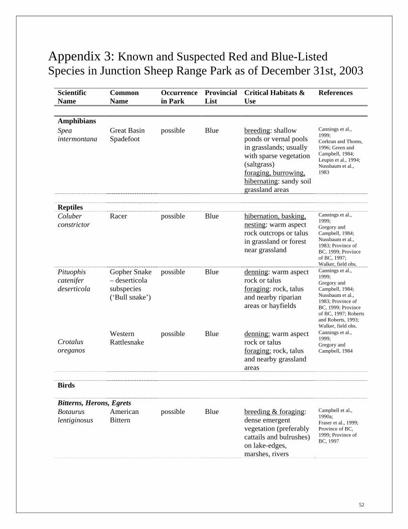
52
Appendix 3: Known and Suspected Red and Blue-Listed Species in Junction Sheep Range Park as of December 31st, 2003
Scientific Name
Common Name
Occurrence in Park
Provincial List
Critical Habitats & Use
References
Amphibians Spea intermontana
Great Basin Spadefoot
possible Blue breeding: shallow ponds or vernal pools in grasslands; usually with sparse vegetation (saltgrass) foraging, burrowing, hibernating: sandy soil grassland areas
Cannings et al., 1999; Corkran and Thoms, 1996; Green and Campbell, 1984; Leupin et al., 1994; Nussbaum et al., 1983
Reptiles
Coluber constrictor
Racer possible Blue hibernation, basking, nesting: warm aspect rock outcrops or talus in grassland or forest near grassland
Cannings et al., 1999; Gregory and Campbell, 1984; Nussbaum et al., 1983; Province of BC, 1999; Province of BC, 1997; Walker, field obs.
Pituophis catenifer deserticola
Gopher Snake – deserticola subspecies (‘Bull snake’)
possible Blue denning: warm aspect rock or talus foraging: rock, talus and nearby riparian areas or hayfields
Cannings et al., 1999; Gregory and Campbell, 1984; Nussbaum et al., 1983; Province of BC, 1999; Province of BC, 1997; Roberts and Roberts, 1993; Walker, field obs.
Crotalus oreganos
Western Rattlesnake
possible Blue denning: warm aspect rock or talus foraging: rock, talus and nearby grassland areas
Cannings et al., 1999; Gregory and Campbell, 1984
Birds
Bitterns, Herons, Egrets Botaurus lentiginosus
American Bittern
possible Blue breeding & foraging: dense emergent vegetation (preferably cattails and bulrushes) on lake-edges, marshes, rivers
Campbell et al., 1990a; Fraser et al., 1999; Province of BC, 1999; Province of BC, 1997

53
Scientific Name
Common Name
Occurrence in Park
Provincial List
Critical Habitats & Use
References
Ardea herodias
Great Blue Heron
possible Blue nesting colonies: mature undisturbed forests near feeding wetlands
Campbell et al., 1990a; Fraser et al., 1999
Osprey, Eagles, Hawks Buteo swainsoni
Swainson’s Hawk
suspected Red nesting: open woodlands near grasslands
Campbell et al., 1990b; Fraser et al., 1999
Falcons Falco peregrinus anatum
Peregrine Falcon
suspected Red winter foraging: farmlands and wetlands
Campbell et al., 1990b; Fraser et al., 1999
Falco rusticolus
Gyrfalcon known Blue winter foraging: open rangeland; unlikely to breed in the JSRP
Campbell et al., 1990b; Fraser et al., 1999; Roberts and Roberts, 1993
Falco mexicanus
Prairie Falcon suspected Red nesting: overhanging cliff ledges adjacent to water and open grassland areas
Campbell et al., 1990b; Cooper, 1998; Fraser et al., 1999; Hooper, 1997b; Province of BC, 1999; Province of BC, 1997
Grouse, Ptarmigan Tympanuchus phasianellus columbianus
Sharp-tailed Grouse, columbianus subspecies
known Blue nesting: shrublands and late seral/climax grasslands with adequate standing dead material dancing grounds (leks): knolls in grasslands (these should be delineated on the map as they are found three are known from JSRP) winter foraging and shelter: dense shrublands and aspen stands with dense, shrubby understories
Campbell et al., 1990b; Cope, 1992; Fraser et al., 1999; Ritcey, 1995; van Rossum, 1992
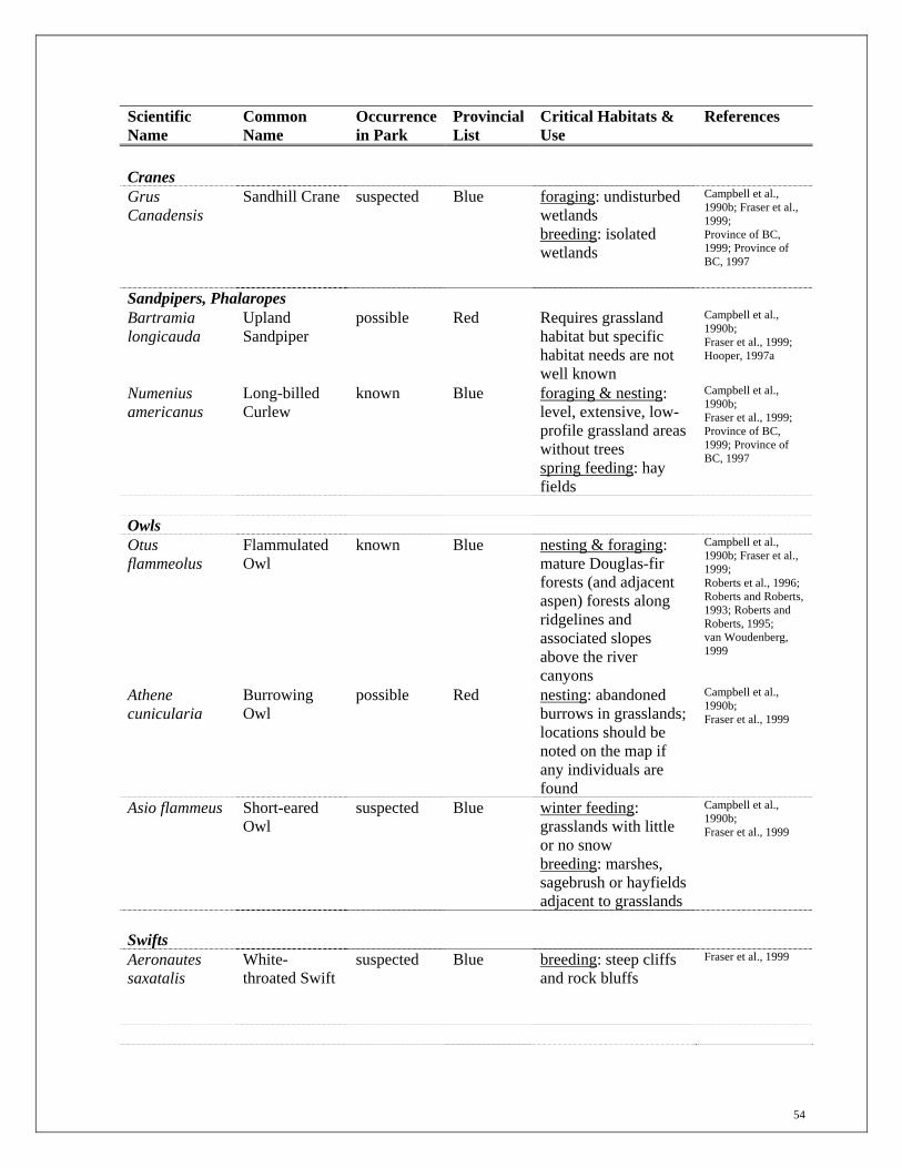
54
Scientific Name
Common Name
Occurrence in Park
Provincial List
Critical Habitats & Use
References
Cranes Grus Canadensis
Sandhill Crane suspected Blue foraging: undisturbed wetlands breeding: isolated wetlands
Campbell et al., 1990b; Fraser et al., 1999; Province of BC, 1999; Province of BC, 1997
Sandpipers, Phalaropes Bartramia longicauda
Upland Sandpiper
possible Red Requires grassland habitat but specific habitat needs are not well known
Campbell et al., 1990b; Fraser et al., 1999; Hooper, 1997a
Numenius americanus
Long-billed Curlew
known Blue foraging & nesting: level, extensive, low-profile grassland areas without trees spring feeding: hay fields
Campbell et al., 1990b; Fraser et al., 1999; Province of BC, 1999; Province of BC, 1997
Owls Otus flammeolus
Flammulated Owl
known Blue nesting & foraging: mature Douglas-fir forests (and adjacent aspen) forests along ridgelines and associated slopes above the river canyons
Campbell et al., 1990b; Fraser et al., 1999; Roberts et al., 1996; Roberts and Roberts, 1993; Roberts and Roberts, 1995; van Woudenberg, 1999
Athene cunicularia
Burrowing Owl
possible Red nesting: abandoned burrows in grasslands; locations should be noted on the map if any individuals are found
Campbell et al., 1990b; Fraser et al., 1999
Asio flammeus Short-eared Owl
suspected Blue winter feeding: grasslands with little or no snow breeding: marshes, sagebrush or hayfields adjacent to grasslands
Campbell et al., 1990b; Fraser et al., 1999
Swifts Aeronautes saxatalis
White-throated Swift
suspected Blue breeding: steep cliffs and rock bluffs
Fraser et al., 1999

55
Scientific Name
Common Name
Occurrence in Park
Provincial List
Critical Habitats & Use
References
Woodpeckers Melanerpes lewis
Lewis’ Woodpecker
known Blue foraging: very open forests and riparian areas nesting: Douglas-fir, Ponderosa pine or Cottonwood trees adjacent to feeding habitat
Campbell et al., 1990b; Fraser et al., 1999; Iverson, field obs.; Province of BC, 1999; Province of BC, 1997; Roberts and Roberts, 1993
Catbirds, Mockingbirds & Thrashers Oreoscoptes montanus
Sage Thrasher suspected Red nesting: tall sagebrush in open grasslands
Campbell et al., 1997; Fraser et al., 1999; Province of BC, 1999; Province of BC, 1997
Warblers, Sparrows Icteria virens Yellow-
breasted Chat suspected Red foraging & breeding:
dense riparian thickets in lower grasslands; can have small deciduous trees but lack a tall over-story; can’t be fragmented by cattle or human trails
Fraser et al., 1999; Province of BC, 1999; Province of BC, 1999
Spizella breweri breweri
Brewer’s Sparrow, breweri subspecies
suspected Red foraging & breeding: moderately dense sagebrush grasslands (sage approx. 64 to 100cm tall); seem to prefer steeper slopes but limited local data available; seem to avoid sagebrush areas with >50% cover
Fraser et al., 1999; Province of BC, 1999; Province of BC, 1997; Roberts and Roberts, 1993
Chondestes grammacus
Lark Sparrow suspected Red foraging, breeding: dry, open grasslands and sagebrush areas, often near wetlands
Fraser et al., 1999; Roberts and Roberts, 1993
Blackbirds, Orioles Dolichonyx oryzivorus
Bobolink suspected Blue foraging & nesting: cultivated fields and wet meadows in grassland areas
Fraser et al., 1999; Province of BC, 1999; Province of BC, 1997

56
Scientific Name
Common Name
Occurrence in Park
Provincial List
Critical Habitats & Use
References
Mammals
Antrozous pallidus
Pallid Bat suspected Red roosting: cliffs, broken rocky areas, and talus foraging: open grassland flats
Collard et al., 1990; Grindal et al., 1991
Corynorhinus townsendii
Townsend’s Big-eared Bat
known Blue roosting: cliffs, buildings, possibly large wildlife trees foraging: mature Douglas-fir forests, edges of riparian and deciduous vegetation in BG/IDFxm
Nagorsen et al., 1993; Roberts and Roberts, 1993
Euderma maculatum
Spotted Bat known Blue roosting: large, steep cliff faces foraging: open grassland, especially above larger deciduous stands and riparian areas
Collard et al., 1990; Roberts and Roberts, 1993; Sarell and Woodgate, 1991
Myotis thysanodes
Fringed Myotis
known Blue roosting: cliffs and / or wildlife trees, buildings foraging: edges of riparian and deciduous vegetation
Collard et al., 1990; Roberts and Roberts, 1993
Myotis ciliolabrum
Western Small-footed Myotis
known Blue roosting: cliffs, broken rocky areas, talus, buildings foraging: sagebrush flats, riparian patches, grassland ponds
Nagorsen et al., 1993; Roberts and Roberts, 1993
Perognathus parvus
Great Basin Pocket Mouse
possible Blue foraging and breeding: silt soils in grassland sites
Cannings et al., 1999
Martes pennanti
Fisher suspected Red resting, foraging & denning: riparian forest with coarse woody debris, large spruce and cottonwood or Douglas-fir trees
Cannings et al., 1999
Ovis Canadensis
Bighorn Sheep known Blue N/A

57
Scientific Name
Common Name
Occurrence in Park
Provincial List
Critical Habitats & Use
References
Taxidea taxus Badger possible Red general: bunchgrass
grasslands and open Douglas-fir or ponderosa pine forests
Cannings et al., 1999
Ursus arctos Grizzly bear possible Blue May occur in the park but it is unlikely that there are any critical habitats within the protected area.
Province of BC, 1999; Province of BC, 1997
Red List: Includes any indigenous species, subspecies or plant community that is Extirpated, Endangered or Threatened in British Columbia. Extirpated elements no longer exist in the wild in British Columbia, but do occur elsewhere. Endangered elements are facing imminent extirpation or extinction. Threatened elements are likely to become endangered if limiting factors are not reversed. Blue List: Includes any indigenous species, subspecies or community considered to be Vulnerable (Special Concern) in British Columbia. Vulnerable elements are of special concern because of characteristics that make them particularly sensitive to human activities or natural events. Blue-listed elements are at risk, but are not Extirpated, Endangered or Threatened. Known: are those species which have been observed in Junction Sheep Range Park. Suspected: are those species which are likely to occur in Junction Sheep Range Park based on known distribution of the species. Possible: are those species that could potentially occur in Junction Sheep Range Park but are less likely.

58
Appendix 4: Description of Major Grassland Ecosystems in Junction Sheep Range Park17 Lower (BGxh3) Grasslands Location:
In Junction Sheep Range Park, the Lower Grasslands occupy lower and middle slopes of the Fraser and Chilcotin River valleys. Elevations range from approximately 450 m on the valley floor to 650 m on valley side-slopes. The topography is characterized by eroded valley slopes and prominent terraces. Erosional features and colluvial slopes are very common. The terraces are primarily silt loam and sandy loam deposits which accumulated on the bed of the glacial Fraser and Chilcotin Rivers. The current Fraser and Chilcotin Rivers have downcut into the glacial deposits and, as a result, the valley bottom is relatively narrow and little floodplain is present. The Lower Grasslands are closely related to other low elevation grasslands in main valley systems of southern B.C. and to the sagebrush-bunchgrass grasslands of the northwestern U.S.
Climate: Mean annual temperature: 5.9°C Mean annual precipitation: 330 mm Mean summer precipitation: 177 mm
Vegetation: Zonal18 Sites: Climax vegetation on zonal sites is dominated by bluebunch wheatgrass
(Elymus spicatus), scattered to abundant big sagebrush (Artemisia tridentata), and a soil crust of lichens and dryland mosses. Other commonly occurring plants include needle-and-thread grass (Hesperostipa comata), sand dropseed (Sporobolus cryptandrus), Sandberg's bluegrass (Poa sandbergii), junegrass (Koeleria macrantha), prickly pear cactus (Opuntia fragilis), rabbitbrush (Ericameria nauseosa var. speciosa), pasture sage (Artemisia frigida), large-fruited desert-parsley (Lomatium macrocarpum), low pussytoes (Antennaria dimorpha), umber pussytoes (A. umbrinella), Holboell's rockcress (Arabis holboellii), and yarrow (Achillea millefolium). Vascular plants often cover less than 50% of the soil surface while ground lichens, algae and dryland mosses may cover up to 80% of the soil surface. Bluebunch wheatgrass typcially decreases while the other grasses initially increase with grazing. Big sagebrush has probably increased with grazing and fire suppression. Productivity is much lower and vegetation recovery following disturbance is much slower than in the Middle and Upper grasslands.
Other Sites:
Steep north aspects often have an bluebunch wheatgrass dominated vegetation in which the cover of bluebunch wheatgrass is much greater than on zonal sites. Big sagebrush is much less abundant and some cooler site species such as three flowered avens (Geum triflorum) are common. These slopes are often only lightly grazed by ungulates.
17 Description provided by O.A. Steen & R. Coupé, Ministry of Forests, Williams Lake. 18 Zonal sites are those sites where the influence of the prevailing climate on the vegetation is believed to be least modified by the local topography and the physical/chemical properties of the soil. They have intermediate soil moisture and soil nutrients.

59
Moderately sloping south and west aspects with sandy soils typically have a vegetation dominated by sand dropseed or needle-and-thread grass. Steep south aspects have a sparse vegetation of bluebunch wheatgrass, needle-and-thread grass, big sagebrush, compact selaginella, sand dropseed, and prickly pear cactus. Moist lower slopes have a relatively dense cover of grasses (primarily bluebunch wheatgrass and needle-and-thread grass) with relatively little big sagebrush. Riparian areas have a variety of taller shrubs including Douglas maple (Acer glabrum) and water birch (Betula occidentalis) and often poison ivy (Toxicodendron rydbergii).
Soils: Soils of the Lower Grasslands are predominantly Brown Chernozems. Organic matter levels in the Ah are lower than in the Middle and Upper grasslands and the Bm horizon is often more calcareous. Soils are developed primarily in silt loam to sandy loam fluvial deposits that are often gravelly.
Middle (BGxw2) Grasslands Location:
In Junction Sheep Range Park, the Middle Grasslands occur on the middle and upper slopes of the Fraser and Chilcotin River valleys. They occupy a band between the Lower and Upper grasslands at elevations of about 650 m and 950 m. The topography includes gullied valley slopes, colluvial slopes, fluvial terraces, basal moraine, bedrock cliffs and escarpments, and cliffs of unconsolidated fluvial deposits.
Climate: Mean annual temperature: 5.0°C Mean annual precipitation: 345 mm Mean summer precipitation: 197 mm
Vegetation: Zonal Sites: Late seral and climax vegetation on zonal sites is dominated by bluebunch
wheatgrass, needle-and-thread grass and junegrass. Other common species include umber pussytoes, meadow salsifly (Tragopogon pratense), trailing fleabane (Erigeron flagellaris), cut-leaved daisy (E. compositus), pasture sage, spike-like goldenrod (Solidago spathulata), wild blue flax (Linum lewisii), northern wormwood (Artemisia campestris), large-fruited desert-parsley, and slender hawksbeard (Crepis atrabarba). Total plant cover of species is typically greater than in the Lower Grasslands. Big sagebrush occurs primarily on steep warm aspects and at the lower elevations of the Middle Grasslands and is much less common than in the Lower Grasslands. Productivity and the diversity of vascular plant species is higher than in the Lower Grasslands but lower than in the Upper Grasslands.
Other Sites: Moist lower slopes and shallow depressions are dominated by short-awned porcupinegrass (Hesperostipa curtiseta), occasionally with spreading needlegrass (Achnatherum richardsoni) or green needlegrass (Nassella viridula) on very moist sites. Other species characteristic of these sites are sticky geranium (Geranium viscosissimum), balsam root (Balsamorhiza sagitatta), northern bedstraw (Galium boreale), prairie rose (Rosa woodsii), saskatoon (Amelanchier alnifolia), western snowberry (Symphoricarpos occidentalis), lemonweed (Lithospermum ruderale), and round-leaved alum root (Heuchera cylindrica). Dry, steep south-facing slopes are dominated by a relatively sparse cover of bluebunch wheatgrass, needle-and-thread grass, pasture sage, and sand dropseed. Big sagebrush and rabbitbrush are often present.

60
Soils: Soils are predominantly Orthic Brown or Dark Brown Chernozems with a 15 - 30 cm thick organic-rich surface (Ah) horizon which occurs primarily in the silty aeolian cap that covers most morainal deposits of the area.
Upper (IDFxm) Grasslands Location:
Upper Grasslands are very limited in Junction Sheep Range Park and occur above the Middle Grasslands on upper slopes of the Fraser River Valley and on the adjacent plateau. Elevations are mostly above 950 m on a predominantly level to gently rolling landscape. The vegetation is a mosaic of grasslands, Douglas-fir forests, and aspen forests.
Climate: (data available from only 1 station) Mean annual temperature: 5.4°C Mean annual precipitation: 386 mm Mean summer precipitation: 191 mm
Vegetation:
General: The IDFxm Subzone is a transition from an open grassland to continuous forest. Although the theoretical climax vegetation on zonal sites is a forest, the climate is only marginally suitable for forest. As a result, the vegetation shifts from forest to grassland and from grassland to forest in response to small local changes in climate, site or historical factors. The resulting landscape is a mosaic of forests and grasslands in which the forests occur predominantly on cooler, moister sites and the grasslands on warmer, drier sites. Soil differences may also contribute to the current pattern of forest and grassland.
Zonal Sites: Relatively undisturbed grasslands on zonal sites are dominated by bluebunch wheatgrass, short-awned porcupine grass and spreading needlegrass. Small patches dominated by one of the latter two grasses often occur within a matrix of all three species. Plant cover is nearly continuous and a thick litter layer is often present where fires have not occurred recently. A very diverse forb, graminoid, and lichen flora is present. Other common grass and grass-like plants are Rocky Mt. fescue (Festuca saximontana), Kentucky bluegrass (Poa pratensis), junegrass, pasture sedge (Carex petasata) and blunt sedge (Carex obtusata). In contrast to the Lower and Middle grasslands, needle-and-thread grass is uncommon. Common forb species include yarrow, umber pussytoes, northern bedstraw, spike-like goldenrod (Solidago spathulata), cut-leaved anemone (Anemone multifida) and Holboell's rockcress. Common lichens include Cladonia pyxidata, C. cariosa and Peltigera lepidophora.
Other Sites: On gentle north- and east-facing slopes, the vegetation is often dominated by short-awned porcupine grass with only incidental bluebunch wheatgrass. Moderate to steep north-facing slopes typically have a spreading needlegrass vegetation while moist, lower slopes are dominated by spreading needlegrass, Kentucky bluegrass and baltic rush (Juncus balticus). Steep, dry south-facing slopes typically have a bluebunch wheatgrass vegetation with sparse plant cover.
Soils: Soils in the Upper Grasslands are most often developed in a veneer (20 - 50 cm thick) of silty or loamy aeolian materials over basal moraine. Soils are predominantly Dark Brown Chernozems with a 15 - 30 cm thick organic-rich surface mineral (Ah) horizon. The Ah horizon is generally darker (contains more organic matter) than in the Middle Grasslands.

61
Appendix 5: Known and Suspected Rare and Endangered Plants and Vegetation Communities in Junction Sheep Range Park as of December 31st, 2003 Known and suspected listed plant communities: Latin Name Common Name Provincial
Rank Provincial
Listing Achnatherum richardsonii Spreading needlegrass S3 Blue Artemisia campestris / Hesperostipa curtiseta
Pacific sagebrush / short-awned porcupine grass
S2 Red
Artemisia tridentata / Pseudoroegneria spicata
Big sage / bluebunch wheatgrass
S2 Red
Distichlis spicata var. stricta Herbaceous Vegetation
alkali saltgrass herbaceous vegetation
S1 Red
Juncus balticus - Potentilla anserine
Baltic rush - silverweed S2 Red
Populus tremuloides / Achnatherum richardsonii - Geum triflorum
Trembling aspen / spreading needlegrass - old man's whiskers
S2 Red
Picea engelmannii x glauca / Rosa acicularis / Petasites frigidus var. palmatus
Hybrid white spruce / prickly rose / palmate coltsfoot
S2 Red
Pseudoroegneria spicata - Balsamorhiza sagittata
Bluebunch wheatgrass - balsamroot
S2 Red
Pseudoroegneria spicata - Koeleria macrantha
Bluebunch wheatgrass - junegrass
S2 Red
Sporobolus cryptandrus - Hesperostipa comata
Sand dropseed - needle-and-thread grass
S2 Red
Pseudotsuga menziesii / Juniperus communis / Cladonia
Douglas-fir / common juniper / Cladonia
S2 Red
Pseudotsuga menziesii / Juniperus scopulorum - Artemisia frigida
Douglas-fir / Rocky Mountain juniper - pasture sage
S3 Blue
Pseudotsuga menziesii / Pleurozium schreberi – Hylocomium splendens
Douglas-fir / red-stemmed feathermoss - stepmoss
S3 Blue
Pseudotsuga menziesii / Rosa acicularis / Aralia nudicaulis
Douglas-fir / prickly rose / sarsaparilla
S2 Red

62
Known and suspected rare plants: Latin Name Common Name Provincial
Listing Location
Allium geyeri var. tenerum Geyer's onion Red-listed Moist meadows and rock outcrops
Arabis holboellii var. pinetorum
Holboell’s rockcress Blue-listed likely occurs in grasslands
Arnica chamissonis ssp. incana Meadow arnica Blue-listed Wet to mesic meadows and forest Openings in IDFxm
Atriplex argentea ssp. argentea Silvery orache Red-listed Saline disturbed areas and fields
Carex hystricina Porcupine sedge Blue-listed Swamps, shorelines and wet meadows
Carex xerantica
Dry-land sedge Red-listed likely occurs in grasslands
Chamaerhodos erecta var. nuttallii American chamaerhodos Blue-listed found on rock outcrops
Crepis atribarba var. atribarba
Slender hawksbeard Red-listed may occur in grasslands
Draba reptans Carolina draba Red-listed Dry, often calcareous, cliffs, rocky slopes and forest openings
Epilobium halleanum Hall's willowherb Blue-listed Moist slopes and open forests
Potentilla nivea var. pentaphylla
Five-leaved cinquefoil Blue-listed may occur on gravelly slopes
Scolochloa festucacea Rivergrass Red-listed Ponds, marshes, lakeshores and streamsides
Silene drummondii var. drummondii
Drummond’s campion Blue-listed scattered throughout level to gently sloping grasslands
Red List: Includes any indigenous species, subspecies or plant community that is Extirpated, Endangered or Threatened in British Columbia. Extirpated elements no longer exist in the wild in British Columbia, but do occur elsewhere. Endangered elements are facing imminent extirpation or extinction. Threatened elements are likely to become endangered if limiting factors are not reversed. Blue List: Includes any indigenous species, subspecies or community considered to be Vulnerable (Special Concern) in British Columbia. Vulnerable elements are of special concern because of characteristics that make them particularly sensitive to human activities or natural events. Blue-listed elements are at risk, but are not Extirpated, Endangered or Threatened.

63
CDC CONSERVATION STATUS RANKS (S = Provincial, N = National, G = Global) X Presumed Extirpated - Not located despite intensive searches and no expectation that it will be rediscovered. or Extinct H Historical - Not located in the last 50 years, but some expectation that it may be rediscovered. 1 Critically Imperiled - Because of extreme rarity or some factor(s) making it especially susceptible to extirpation or extinction. Typically 5 or fewer existing occurrences3 or very few remaining individuals, e.g., fewer than 1000 Spotted Owl. 2 Imperiled - Because of rarity or some factor(s) making it very susceptible to extirpation or extinction. Typically 6 to 20 existing occurrences or few remaining individuals, e.g., 1000 to 3000 White Sturgeon. 3 Vulnerable - Because rare and local, found only in a restricted range (even if abundant at some locations), or because of some other factor(s) making it susceptible to extirpation or extinction. Typically 21 to 100 existing occurrences, e.g., Gopher Snake. 4 Apparently Secure - Because uncommon but not rare, and usually widespread in the province. Possible cause for long-term concern. Typically more than 100 existing occurrences, e.g., Olive-sided Flycatcher. 5 Secure - Because common to very common, typically widespread and abundant, and not susceptible to extirpation or extinction under present conditions, e.g., Red-osier Dogwood. ? Unranked - Rank not yet assessed. U Unrankable - Due to current lack of available information.