LUSIP 2 N M F S LUSIP W S P S
81
Kingdom of Swaziland - SWADE KINGDOM OF SWAZILAND GOVERNMENT OF SWAZILAND SWAZILAND WATER AND AGRICULTURAL DEVELOPMENT ENTERPRISE LUSIP 2EXT AND NSOKO MSELE FEASIBILITY STUDY AND LUSIP WATER SERVICE PROVIDER STUDIES Feasibility Report Main report July 2014
Transcript of LUSIP 2 N M F S LUSIP W S P S

Kingdom of Swaziland - SWADE
KINGDOM OF SWAZILAND
GOVERNMENT OF SWAZILAND
SWAZILAND WATER AND AGRICULTURAL DEVELOPMENT ENTERPRISE
LUSIP 2EXT AND NSOKO MSELE FEASIBILITY STUDY AND LUSIP WATER
SERVICE PROVIDER STUDIES
Feasibility Report Main report
July 2014

Kingdom of Swaziland - SWADE
Disclaimer
The designations employed and the presentation of materials in this present document do not imply the expression of any opinion whatsoever on the part of SWADE concerning the legal or development status of any country, territory, city or area or its authorities, or concerning the delimitation of its frontiers or boundaries. p:\brli\dressayre\800227_swaziland_lusipii\4_rapports livrables\lusip2_and_lusip2ext_fs\final\800227ext_volume i.docx / Lucie Torresan
Lower Usuthu Smallholder Irrigation Project Phase 2 & Nsoko Msele Studies – Feasibility and water service provider studies Final feasibility report

BRL ingénierie BP 94001 1105 Av Pierre Mendès-France 30001 NIMES CEDEX 5 FRANCE Tel: 04.66.87.50.00 www.brl.fr/brli
SSI Unit 5 - Country Club Estates 21 Woodlands Drive Woodmead - Gauteng SOUTH AFRICA
Coordinator: Evert DE NOOY Project n° 800227
Study LUSIP 2 & Nsoko Msele Feasibility Study and LUSIP Water Service Provider Studies
Name of the document Final Report on Feasibility
Client SWADE CEO's OFFICE P.O. Box 5836 Mbabane
Creation date of the document
2014-07-07
Reference of the document Feasibility Report
Index V1
Contact (quality control) Etienne DRESSAYRE
Printing date Index Remarks Produced by Verified and validated by
2014-07-7 V1 FS Team EDN
p:\brli\dressayre\800227_swaziland_lusipii\4_rapports livrables\lusip2_and_lusip2ext_fs\final\800227ext_volume i.docx / Lucie Torresan
Lower Usuthu Smallholder Irrigation Project Phase 2 & Nsoko Msele Studies – Feasibility and water service provider studies Final feasibility report

LOWER USUTHU SMALLHOLDER IRRIGATION PROJECT PHASE 2 & NSOKO MSELE STUDIES –
FEASIBILITY AND WATER SERVICE PROVIDER STUDIES FINAL FEASIBILITY REPORT
VOLUME I. EXECUTIVE SUMMARY AND MAIN REPORT
PREFACE ............................................................................................................... 1
EXECUTIVE SUMMARY......................................................................................... 3
1 INTRODUCTION AND BACKGROUND ........................................................ 13
2 GOVERNMENT POLICY AND ITS POVERTY REDUCTION STRATEGY .................................................................................................... 15
3 NATURAL RESOURCES ............................................................................... 16
3.1 General 16
3.2 Introduction to the Physical Environment 16
3.3 Climate 16
3.4 Drainage 16
3.5 Geology 17
3.6 Vegetation 17
3.7 Physiographic zones 18
3.8 Geomorphology and erosion 18
3.9 Hydrology and water resources 18 3.9.1 Updating of hydrological data 18 3.9.2 Water resources availability 18
3.10 Trend analysis 19 3.10.1 Effects of climate change 20 3.10.2 Climate change and water resources availability 20
Lower Usuthu Smallholder Irrigation Project Phase 2 & Nsoko Msele Studies – Feasibility and water service provider studies Final feasibility report

4 POPULATION AND SOCIO-ECONOMY ....................................................... 21
4.1 General 21
4.2 Baseline Survey 21 4.2.1 LUSIP2 21 4.2.2 NSOKO MSELE 21
4.3 Demographics and Socio-economy LUSIP2 22 4.3.1 General 22 4.3.2 Economic activity and range of incomes 22 4.3.3 Water and Agriculture 22 4.3.4 Sanitation and Health 23 4.3.5 Assets 23 4.3.6 Environment in the LUSIP2 command area 24
5 SOILS AND LAND SUITABILITY .................................................................. 25
5.1 Soils 25 5.1.1 LUSIP2 area 25 5.1.2 Nsoko Msele area 25
5.2 Land Suitability for Irrigated Agriculture 26 5.2.1 LUSIP2 area 26 5.2.2 Nsoko Msele area 27
5.3 Present Land Use 27 5.3.1 LUSIP2 27 5.3.2 Nsoko Msele 28
5.4 Conclusions 29 5.4.1 LUSIP2 29 5.4.2 Nsoko Msele 29
5.5 Recommendations 30
6 AGRICULTURE AND LIVESTOCK ............................................................... 33
6.1 General 33
6.2 Agriculture 33 6.2.1 General 33 6.2.2 Land use and land tenure system 33 6.2.3 Production and Processing of Major Crops 34 6.2.4 Institutional support to the farming sector 36
6.3 Yields of major crops 37
Lower Usuthu Smallholder Irrigation Project Phase 2 & Nsoko Msele Studies – Feasibility and water service provider studies Final feasibility report

7 IRRIGATION, DRAINAGE, DAMS AND LAND DEVELOPMENT ................. 38
7.1 Development Scenario's 38
7.2 Irrigation layout and possible improvements 39
7.3 Irrigation water requirements Nsoko Msele Area 40
7.4 Field irrigation systems Nsoko Msele area 40
7.5 Irrigation blocksLUSIP2 area 41
7.6 Irrigation blocks Nsoko Msele area 42
7.7 Proposed storage facilities and irrigation and drainage network 42 7.7.1 Proposed schemeLUSIP2 42 7.7.2 Proposed scheme Nsoko Msele 42 7.7.3 Selection of Conveyance Infrastructure Routes and Alternatives 45
7.8 Regulation of flows in the LUSIP2 and Nsoko Msele conveyance system 45
7.9 Cost aspects Nsoko Msele 46 7.9.1 Capital Costs 46 7.9.2 Cost Sensitivity 47 7.9.3 Operation and Maintenance Costs 47
7.10 Technical Risk Assessment – NSOKO MSELE 47
8 INSTITUTIONAL ARRANGEMENTS ............................................................. 48
8.1 LUSIP2 48
8.2 Water Service Provider Study 48 8.2.1 Institutional setting 48 8.2.2 The Project 49 8.2.3 Decisions needed 50 8.2.4 Steps forward 50
8.3 NEWCO Milling / Nsoko Msele Operating Business Model 51
9 ECONOMIC AND FINANCIAL ASSESSMENT ............................................. 52
9.1 Scope of the feasibility study 52
9.2 Basic assumptions 53
9.3 Demand and supply of sugarcane, maize, and other mixed crops 55
9.4 Farm and off-farm capital expenditures for base LUSIP2+PSC+NSOKO MSELE 56
9.5 Farm investments 57
9.6 Working Capital requirements 58
Lower Usuthu Smallholder Irrigation Project Phase 2 & Nsoko Msele Studies – Feasibility and water service provider studies Final feasibility report

9.7 Capital Expenditures – Main and Secondary Supply System - LUSIP2 and NSOKO MSELE 58
9.8 Farm income – Prices and yields 59
9.9 O & M Costs 61
9.10 Determination of farm incomes without Project 62
9.11 Water and Sanitation LUSIP2 62
9.12 The financial and economic feasibility of the project 63 9.12.1 Financial evaluation 63 9.12.2 Economic evaluation 66 9.12.3 Funding considerations 67
9.13 Conclusions and recommendations 68
10 ESIA/EIA ........................................................................................................ 70
10.1 LUSIP2 70
10.2 Nsoko Msele 71
Lower Usuthu Smallholder Irrigation Project Phase 2 & Nsoko Msele Studies – Feasibility and water service provider studies Final feasibility report

Kingdom of Swaziland - SWADE
LIST OF FIGURES
Figure 1: Lay-out scenario 3 (as recommended in final version of LUSIP2 FS study) ..................... 7 Figure 2: Overview of Nsoko Msele (with Dam E at 9.18 million m3) .............................................. 10 Figure 3: Overview of Nsoko Msele (with Dam E at 9.18 million m3) ............................................. 44
LIST OF TABLES
Table 3-1 : Data on flows in Usuthu River and tributaries ................................................................ 20 Table 5-1: Land suitability class coverage (ha) for selected crops in LUSIP2 area ......................... 26 Table 5-2: Soil Suitability per Farm in extension area ..................................................................... 27 Table 5-3: Current Land Use in Nsoko Msele area .......................................................................... 28 Table 5-4:Current Agricultural Use and Potential Arable Land in extension area ........................... 28 Table 5-5: Overview of land suitable for irrigated sugarcane for medium-high and optimum
commercial management (LUSIP2 only) ..................................................................... 31 Table 5-6: Different scenarios for development of land for irrigated sugarcane (LUSIP2 only)....... 31 Table 5-7: Scenario 4, maximum area for development of irrigated sugarcane (LUSIP2 only) ...... 32 Table 5-8: Scenario 4, area for sustainable development of irrigated sugarcane (LUSIP2
only) ............................................................................................................................. 32 Table 7-1: Monthly Sugarcane Irrigation Requirements(dry year) ................................................... 40 Table 7-2 : Summary of the irrigation blocks per chiefdom .............................................................. 41 Table 7-3: Summary of the Irrigation blocks per farm ...................................................................... 42 Table 9-1: Initial feasibility study area ............................................................................................ 53 Table 9-2: On-farm Investments LUSIP2 (Scenario 1) ................................................................... 57 Table 9-3: On-farm Investments Nsoko Msele ................................................................................. 57 Table 9-4: Capital Expenditures – Main and Secondary Supply System – LUSIP2 (scenario
1) .................................................................................................................................. 58 Table 9-5: Capital Expenditures – Main and Secondary Supply System – Nsoko Msele ................ 59 Table 9-6: Adopted yields ................................................................................................................. 60 Table 9-7: Annual O&M cost for LUSIP 2 and Nsoko Msele ........................................................... 61 Table 9-8: Assessment of farm income without project ................................................................... 62 Table 9-9: Basic assumptions (Base case) – sugarcane only ........................................................ 64 Table 9-10: Scenarios of feasibility study area .............................................................................. 64 Table 9-11: IRR for sugar cane production for one mill and two mill options ................................. 65 Table 9-12: EIRR for sugar cane by farming area (base case – two mills in operation) ................. 66 Table 9-13: Funding considerations ................................................................................................. 67 Table 9-14: Capital Investment (direct and indirect) ........................................................................ 68 Table 9-15: Original and reduced CAPEX ....................................................................................... 69
Lower Usuthu Smallholder Irrigation Project Phase 2 & Nsoko Msele Studies – Feasibility and water service provider studies Final feasibility report

Kingdom of Swaziland - SWADE
LIST OF ABBREVIATIONS AND ACRONYMS
ACMC Aid Coordination and Management Section in Ministry of Economic Planning AfDB African Development Bank ADEMU Agricultural Development and Environmental Management Unit (LUSIP 1) DCA Development Credit Authority ESIA Environmental and Social Impact Assessment EIB European Investment Bank EIRR Economic Internal Rate of Return EU European Union FAO Food and Agricultural Organization FA Farmers' Association GoS Government of Swaziland GRM Consultants IFAD International Fund for Agricultural Development IRR Internal Rate of Return KDDP Komati Downstream Development Project LDP Livestock Development Policy LSU Livestock Unit LUSIP Lower Usuthu Smallholders Irrigation Project MCM million cubic meters MDG Millennium Development Goal MEPD Ministry of Economic Planning and Development MNRE Ministry of Natural Resources and Energy MOA Ministry of Agriculture MTEC Ministry of Tourism, Environment and Communications NAMBoard National Agriculture Marketing Board NGO Non-governmental Organization NLP National Land Policy NDS National Development Strategy NEPAD New Partnership for Africa’s Development PRSAP Poverty Reduction Strategy and Action Plan RDI Rural Development Institute REPA Reciprocal Economic Partnership Agreement SADC Southern African Development Community SEA Swaziland Environment Authority SHIP Small Holder Irrigation Programme SNC Swaziland National Council SNL Swazi Nation Land SKPE Swaziland Komati Project Enterprise SME Small and Medium Enterprise SPEED Smart Programme on Economic Empowerment and Development SSA Swazi Sugar Association SWADE Swaziland Water & Agricultural Development Ltd. TDL Title Deed Land USAID United States of America’s Agency for International Development USD United States dollar WHO World Health Organization WUA Water Users Association
Lower Usuthu Smallholder Irrigation Project Phase 2 & Nsoko Msele Studies – Feasibility and water service provider studies Final feasibility report

Kingdom of Swaziland - SWADE 1
PPRREEFFAACCEE
Following the approval in June 2011 of the financing of the LUSIP2 studies the contract between SWADE and the Joint Venture (JV) of the consulting firms BRLi and SSI was signed on 1st July. The team leader was mobilized on 11th July 2011. The timeline for the studies was very much constrained by the planned donor conference in February 2012 and the preparation of the national budget 2012-2013 in March 2012. Therefore, it was decided that the JV and SWADE would start with the Phase 2 studies by the beginning of September, as planned during the Inception Phase.
The JV was prepared to allocate substantial resources in July and August to assist SWADE in trying to complete feasibility studies in time for the donor conference, as discussed at length during the Inception Report phase.
Progress during the Inception Phase and the following months of September - November went according to plan. Subsequent progress between mid-December and the end of February has been slow mainly because of suspension of activities between 15th December and 1st February and the need to remobilize staff between 1st February and mid-February. Therefore, the total delay amounted to two months. The reason for the suspension was the delay in payment for the Inception Phase Report beyond the contractual date of 45 days after submission of invoice which took place by the end of November. Another problem that contributed to the delay was the need to carry out substantially more soils investigations than was anticipated.
Finally, the soils and land suitability studies could be completed by the beginning of May. Progress in the follow-on studies during May and June was satisfactory resulting in finalizing the final Feasibility Report on Water and Supply and Sanitation and the draft Feasibility Report on Irrigation by 20th June.
In September 2012 a donor conference was held, after which the JV prepared the final version of the FS that was submitted in November 2012.
The original Terms of Reference (TOR) for the LUSIP2 study dated 15th December 2009, split the study into two parts:
• Component 1: Feasibility studies: The final report was submitted to the Client in November 2012.
• Component 2: Detailed Design and Tender Documents. The detailed design was completed and submitted in December 2013 and tender documents were prepared during January and February 2014.
The TOR of LUSIP2 was very detailed on the requirements of the social engineering component regarding sanitation and water supply. The submitted LUSIP2 FS and detailed design reports met the 2009 TOR requirements. The TOR for the Nsoko Msele studies did not include the demand to study and cost the social engineering component and therefore the reports do not include annexes dealing with this matter.
The cooperation between the SWADE staff and the JV consultants was good and support received by the JV from SWADE was much appreciated.
Lower Usuthu Smallholder Irrigation Project Phase 2 & Nsoko Msele Studies – Feasibility and water service provider studies Final feasibility report

Kingdom of Swaziland - SWADE 2
This Feasibility Report comprises the following volumes:
1) Volume I: Main Report, including executive summary
2) Volume II: Annexes A, B, C and D
3) Volume III: Annexes E, F, G, and H
4) Volume IV: Annex I
5) Volume V: Maps and drawings
6) Volume VI: Appendices
The final report on the Water Service Provider study has been issued as a separate document titled Volume A Water Service Provider studies.
This Volume I presents the executive summary and the main report.
Lower Usuthu Smallholder Irrigation Project Phase 2 & Nsoko Msele Studies – Feasibility and water service provider studies Final feasibility report

Kingdom of Swaziland - SWADE 3
EEXXEECCUUTTIIVVEE SSUUMMMMAARRYY
BACKGROUND, GOVERNMENT POLICY AND POVERTY REDUCTION STRATEGY
The Lower Usuthu Smallholder Irrigation Project (LUSIP) Area is situated in the south-eastern part of Swaziland, in the Lubombo Region. The larger LUSIP area is found in the area between Siphofaneni, Big Bend and Nsoko, chiefly on the southern side of the Usuthu area. The LUSIP2 study area forms part of the larger LUSIP area and is located in the Lowveld of the Kingdom of Swaziland. LUSIP involves the construction of three dams to form an off-river storage reservoir to impound 155 Million Cubic Metres (MCM) of water that would be diverted from wet season flood flows in the Lower Usuthu River. A main canal and distribution system has been and is being constructed, together with on-farm works, to irrigate a net 11,500 ha. A phased development covers a Phase 1 of the project that would develop a net area of 6,500 ha, while the current Phase 2 would develop a further net 5,000 ha. Phase 2 implementation was planned to start from 2013. The objective of the project is to alleviate poverty in the project area by transforming the existing subsistence farmers into commercial farmers of irrigated lands producing cash crops (principally sugarcane). Phase 1 of LUSIP has about 2,600 beneficiary households (about 20,000 people) and according to the 2011 census Phase 2 will directly benefit a further 2,259 households in 1,915 homesteads with 14,276 people in the chiefdoms of Ngcamphalala, Mngometula and Matsenjwa.
The Government of Swaziland has identified the development of the smallholder agricultural sector as a main element in its policy of poverty alleviation in rural areas. The major constraint for the development of resources is the lack of irrigation water, as the dry season run-off-river flows have already been fully allocated to existing farms. Currently, the bulk water infrastructure for LUSIP1 is complete and operational and efforts are being made to convert a substantial part of the area into food crop production areas. Chiefdom development plans established on a participatory basis with the community involved should guide further development efforts.
The LUSIP project originates from government policy. The targeting of poverty reduction is a key government policy objective articulated in the Poverty Reduction Strategy and Action Programme of 2007 (PRSAP), the Government Action Programme 2008-2013 and the government commitment to the UN millennium goals. The overriding assumptions of the PRSAP is that the Government will maintain macro economic stability and good governance; reducing vulnerability (especially to HIV/AIDS); human capital development; broad-based participation for empowerment and employment creation; and the implementation of re-distribution policies. An enabling environment for private investment and economic growth should be the catalyst for poverty reduction and creating opportunities for participation by the poor introducing re-distribution policies. The focus on food security and the provision of infrastructure, extension services, technology, markets, social and financial services are promises that should meet the goals of reducing poverty. The Government would thus support reforms increasing access to productive assets such as land, water, information and financial resources to enable the poor to benefit from growth.
Phase 2 of LUSIP or LUSIP2 involves the irrigation of a further 5,217 ha net new land and 455 ha net existing irrigation by extending the bulk water supply system and by providing additional on farm irrigation systems as well as by mobilizing the beneficiary community. Furthermore sanitation and potable water supply facilities will be provided to the farmers involved. In the project area of LUSIP2, the population has neither access to potable water supply nor to improved sanitation facilities. Water for human consumption is obtained from nearby streams and where available, simple pits serve as sanitation facilities.
Lower Usuthu Smallholder Irrigation Project Phase 2 & Nsoko Msele Studies – Feasibility and water service provider studies Final feasibility report

Kingdom of Swaziland - SWADE 4
An earlier study of 2005 on the financial and economic viability was prepared on basis of the 11,500 ha project area comprising LUSIP1 and LUSIP2, while the LUSIP2 feasibility study is focusing on the second phase only. Hence, the viability analyses did not incorporate LUSIP1 investment and its results.
LESSONS LEARNT FROM LUSIP1
The consultants have observed the current status of LUSIP1 but according to their ToR were not instructed to provide considerable information on the current status such as status of the infrastructure, O&M conditions, rate of implementation, physical and social environment etc.
During the studies for LUSIP2 they extensively analysed experience gained by SWADE in various sectors (engineering, agriculture, financial and economic, social, potable water supply) during construction and operation of LUSIP1. LUSIP2 has been designed in such a way that the weaknesses of LUSIP1 have been avoided. This is written in the technical annexes without referring to LUSIP1.
A number of conclusions and recommendations were formulated. The most important ones are summarized as follows:
balance reservoirs should be avoided as much as possible as seepage causes substantial losses and creates drainage problems in the surrounding area;
to limit pumping costs, pressurize the distribution system by the main conveyor, thereby using the maximum pressure possible;
a substantial area out of the 6,500ha under command is not suitable for cane cultivation. More attention has to be paid to soil surveys and land suitability classification.
associations or companies with 40-100 ha and their own pump stations are not viable. Per hectare investment costs for the pumps stations are very high and the associations cannot afford to pay for well trained and experienced managers and field staff. Therefore farmers should be organized into companies with 100-500ha and strong management that is supported by the private sector.
The responsibility of the operation, maintenance and management of the bulk water supply infrastructure for LUSIP and associated developments has to be transferred to an entity that is not involved in the agricultural development.
NATURAL, HUMAN RESOURCES AND SOILS AND LAND SUITABILITY
With regard to natural and human resources, there are no major constraints in the Project area. Level of poverty is high and level of education is low, compared to other regions in Swaziland. The results of the soils and land suitability and land use studies are summarized in the table below.
Lower Usuthu Smallholder Irrigation Project Phase 2 & Nsoko Msele Studies – Feasibility and water service provider studies Final feasibility report

Kingdom of Swaziland - SWADE 5
DIFFERENT SCENARIOS FOR DEVELOPMENT OF LAND FOR IRRIGATED SUGARCANE
Class Name
Model 1 Model 2 Model 3 Model 4
Entire Survey Area
Communal Area without MOA
Farm Matata Block
Entire area minus sectors
W2,C3,C4 S1 Very Suit 474 474 26 474 S2 Suitable 3,280 2664 2,716 2,807 S3 Marg Suit 2,787 1,955 2,391 2,099 N N1 very sh 2,648 2,130 2,318 1,823 N N1vertisols 238 108 223 238 N Not Suit 8,768 6,321 8,062 5,952
Total Area 18,195 13,652 15,736 13,392
Model 4 would result in the availability of a total net area of approximately 5,750ha (455ha existing and 5,295ha new land), with 3,477 ha below the main conveyor and 2,273 ha above the conveyor. In terms of suitability, half of this is S2 suitable land, a quarter S3 marginally suitable land, with the remainder either very suitable S1 or conditionally suitable N1.
In order to obtain a realistic overview of the hectarage available of the various land suitability categories, the following modifications were made considering the position of the land, in particular with reference to the main conveyor: (i) all marginally suitable and suitable land was eliminated when situated higher than 210m, with exception of the very suitable land; (ii) all marginally suitable land above the canal at 190m was eliminated; (iii) not more than 50% of land classified as N1 very shallow (subject to survey) and located below the conveyor was included (lower than 190m); and (iv) all land classified as N1 Vertisols below 210m was included.
Regarding the soils and land suitability of the proposed extension of 4,000ha in LUSIP2extension it can be stated that these soils have been studied in the past by experienced specialists for another client. Reports are available with this client, but are not part of the current LUSIP2 FS report.
WATER AVAILABILITY AND IRRIGATION
Reviews of previous water resources studies up to 2005 indicate that there is sufficient water for 12,500 ha in LUSIP1&2. Detailed hydrological data could not be made available, but additional detailed studies confirmed the findings of the review and showed that an additional 4,000 ha can be irrigated in a Nsoko Msele area comprising existing and new storage dams. The bulk water supply system has been designed taking into account topography, soil and geotechnical conditions and especially the dispersed distribution of about 6,000ha suitable soils over an area of 18,195ha. Without lined and piped main conveyor system and secondary piped distribution system under pressure sustainable irrigated agriculture is not possible. The distribution system is designed to supply water at the correct quantities and pressures to allow overhead irrigation comprising centre pivot and semi solid sprinkler systems. The system capacity is sufficient to supply in initial stage large quantities of water for furrow irrigation.
Development scenario’s studied
With the Nsoko Msele studies, a number of changes in the areas covered were introduced because of recent developments. Therefore, the following development scenario's were defined and studied:
During LUSIP2 FS:
Lower Usuthu Smallholder Irrigation Project Phase 2 & Nsoko Msele Studies – Feasibility and water service provider studies Final feasibility report

Kingdom of Swaziland - SWADE 6
1. Base case: Matata block with 5,750 ha net, Qpeak = 4.72 m3/s
2. Scenario 1: LUSIP2 + Poortzicht scheme (700 ha net), with a total area of 6,500 ha net, Qdesign = 5.29 m3/s
3. Scenario 2: LUSIP2 + 4,000ha, with a total area of 9,750 ha net, Qdesign = 6.72 m3/s
4. Scenario 3: LUSIP2 + 4,000ha at Nsoko Msele and Poortzicht (700ha net), with a total area of 10,500 ha net, Qdesign = 7.3 m3/s
1. During the LUSIP2 and NSOKO MSELE FS (U stands for updated):
5. Scenario 3Ubase: LUSIP2 + 4,090ha at NSOKO MSELE, Poortzicht scheme (750ha), with a total area of 10,512ha net, Qdesign = 7.3 m3/s
6. Scenario 3U1: LUSIP2 less 1,000ha new land+ 4,090ha at NSOKO MSELE , Poortzicht scheme (750ha) and riverside farms (1,000ha net), with a total area of 10,512 ha net, Qdesign = 7.3 m3/s
7. Scenario 3U2: LUSIP2 + 4,090ha at LUSIP2ext, Poortzicht scheme (750ha) and riverside farms (1,000ha net), with a total area of 11,512 ha net, Qdesign = 7.3 m3/s
Lower Usuthu Smallholder Irrigation Project Phase 2 & Nsoko Msele Studies – Feasibility and water service provider studies Final feasibility report

Kingdom of Swaziland - SWADE 7
Figure 1: Lay-out scenario 3 (as recommended in final version of LUSIP2 FS study)
Lower Usuthu Smallholder Irrigation Project Phase 2 & Nsoko Msele Studies – Feasibility and water service provider studies Final feasibility report

Kingdom of Swaziland - SWADE 8
Infrastructure for Proposed LUSIP2 scheme
The proposed bulk water supply scheme would consist of:
• a main supply system comprising 6,580 m double diam 1.8-2.0 m steel or GRP pipe and 28,187 m of concrete lined canal, at a gradient of 0.2m/km, with a capacity of 7.3 m3/s to supply 10,450 ha according to scenario 3;
• a secondary pipe network in LUSIP 2 supplying 5,750ha in irrigation blocks of 100-500 ha, including pump stations to supply water at the required pressure at the entrance of the blocks;
• increase of the capacity of the LUSIP1 bulk water supply canal (Main Canal South);
• a road network which will facilitate all weather transport and the evacuation of the produce and a drainage network, which will evacuate the excess rainfall runoff; and
• a tail-end dam with 2.5 MCM net storage capacity and supplying 2,421 ha, important buffer or regulation component, that will render water management in this upstream controlled irrigation scheme much easier and more efficient.
The proposed on-farm development systems would comprise:
• pipe systems and centre pivot or semi solid sprinkler systems, if necessary pressurised by small block pump stations; and
• if preferred by developers, furrow irrigation systems provided soils and topography are suitable to achieve economically viable sugarcane farming with this type of irrigation.
Infrastructure for Proposed Nsoko Msele scheme
At the end of the LUSIP2 Matata Canal the following components have been designed, taking into account that the initial point is the national road (see figure2 below) :
Main conveyance system: • Lined main canal (7,934 m) (designed for 5.3m3/s, conveying 3.0m3/s) • Single DN 1,800 mm pressurized steel or GRP pipe and siphon through the Ngwavuma
River (1,025 m) (designed for 5.3m3/s, conveying 3.0m3/s)
Bulk storage reservoirs (Dam E and balancing F)
Bulk pump station and DN 1,200 mm pipeline (1,081m) to lift water from canal into Dam E (capacity of 3.0m3/s. To be phased for later expansion to 5.3m3/s)
Bulk pump station and rising mainline DN 1,200 mm (5,000m) (capacity of 2.05m3/s)
Lined secondary canal (4,020m) (capacity of 2.0 m3/s)
Tertiary pumps and pipe network serving 4,000ha
Canal access roads, bridge and fences
Canal drainage system
Lower Usuthu Smallholder Irrigation Project Phase 2 & Nsoko Msele Studies – Feasibility and water service provider studies Final feasibility report

Kingdom of Swaziland - SWADE 9
Lower Usuthu Smallholder Irrigation Project Phase 2 & Nsoko Msele Studies – Feasibility and water service provider studies Final feasibility report

Kingdom of Swaziland - SWADE 10
Figure 2: Overview of Nsoko Msele (with Dam E at 9.18 million m3)
Lower Usuthu Smallholder Irrigation Project Phase 2 & Nsoko Msele Studies – Feasibility and water service provider studies Final feasibility report

Kingdom of Swaziland - SWADE 11
Economic and financial evaluation
The overall aim of the LUSIP project is poverty alleviation. Water is an avenue for economic growth and development benefitting the whole south east region of Swaziland. Without water there will be little or no development and the goal of transforming the local economy would be difficult to be realized. The feasibility study assesses thus the financial and economic viability of the LUSIP2 and Nsoko Msele projects. The LUSIP2 project is a smallholder scheme, while the Nsoko Msele project was initiated by private large scale commercial farmers based on a sharing approach by providing full title land to chiefdoms and inviting them to become shareholders of a joint agriculture and milling company producing raw and refined sugar, ethanol and electricity. The reduction of transportation costs has compelled this development providing choices between two mills, which are indicated as scenarios in the analysis below.
However, without water there would be no new mill and farmers would not be given any land. Water becomes thus the catalyst for agricultural production and economic development in the south eastern part of Swaziland. The focus is still on sugarcane due to the fact that so far developments have still been affirmative, an existing industry infrastructure is in place and Swaziland has international credibility as a consistent reliable sugar producer, which for the production and marketing of other mixed crops has still to emerge.
On-farm investment will amount to E 574 million. E 1.5 billion would be required as investments into the main and secondary water supply system, while from other investors a E 2.5 billion integrated sugar and cogeneration mill is planned to be constructed. The FIRR for the LUSIP 2 project only depending on one mill in view of the original investment costs is 5.3% compared to 11.8% when two mills are in operation. Taking into account the wider development impact of the project and reducing thus the capital costs allocated directly to the project the FIRR is 8.0% if depending on one mill only, while the FIRR would be 13.1% if two mills were in operation in the region.
This is based on the direct cash costs (capex expenditure / investments, revenues and related operational costs). The LUSIP 1 feasibility approach included indirect benefits. Substantial off farm capex were reallocated to the LUSIP 2 phase (56% and 36%). In the LUSIP 2 feasibility assessment indirect benefits have not been included as they are difficult to quantify in monetary terms. Capital expenditures have been reduced instead by 30% to signify the capex share that would generate other indirect benefits and regional development activities not considered in the EIRR and FIRR calculations.Labour costs have been valued at opportunity costs and an economic price for sucrose has been established using a blend price of SACU and world prices in order to arrive at the EIRR of 12.7% for the option with two mills. The reduced economic costs are offset by the lower border prices.
There are risks involved with regards to the long term sugar price:
The sugar market is volatile and long-term sugar price developments are uncertain.
Swaziland supplies sugar to the SACU block countries and the EU.
Preferential market treatments with the EU will cease and sugar production quotas in the EU will be abolished. The EU may even turn out to become a sugar net-exporter.
Local long-term forecasts are less fearful of any price collapse.
One condition would be for Swaziland to sign the Economic Partnership Agreement with the EU, mitigating the cessation of present preferential trading arrangements. (The consultants understand that this is close to a reasonable resolution).
The historical average has seen real increases year on year with the long term sucrose price of E1,710 used in LUSIP1 now being replaced by a price of E3,100 per ton.
Lower Usuthu Smallholder Irrigation Project Phase 2 & Nsoko Msele Studies – Feasibility and water service provider studies Final feasibility report

Kingdom of Swaziland - SWADE 12
The FIRR for the on-farm operation indicate that farmers will be able to service their debts and to obtain dividends from their sugarcane production. It is strongly recommended that the Swazi government takes responsibility for the infrastructure investment and determines a cost recovery policy which ensures that project beneficiaries participate in the cost recovery through water fees and taxes according to affordability. This should also be considered for cases of capital repayment issues
Lower Usuthu Smallholder Irrigation Project Phase 2 & Nsoko Msele Studies – Feasibility and water service provider studies Final feasibility report

Kingdom of Swaziland - SWADE 13
1 INTRODUCTION AND BACKGROUND The Lower Usuthu Smallholder Irrigation Project Area is situated in the south eastern part of Swaziland, in the Lubombo Region. The larger LUSIP project area is found in the area between Siphofaneni, Big Bend and Nsoko, chiefly on the southern side of the Usuthu area. The LUSIP 2 study area forms part of the larger LUSIP area (see the locality map in Figure 1 below) and is located in the Lowveld of the Kingdom of Swaziland
Map 1: Locality map of the LUSIP 2 study area
The LUSIP project involves the construction of three dams to form an off-river storage reservoir to impound 155 MCM of water that will be diverted from wet season flood flows in the Lower Usuthu River. A main canal and distribution system has been/is being constructed below the dam, together with on-farm works, to irrigate a net 11,500ha. A phased development covers a Phase 1 of the project that would develop a net area of 6,500ha, while a planned Phase2 will develop a further net 5,000ha.
LUSIP 2 Study Area
Swaziland Boundary
Lower Usuthu Smallholder Irrigation Project Phase 2 & Nsoko Msele Studies – Feasibility and water service provider studies Final feasibility report

Kingdom of Swaziland - SWADE 14
Phase1 is being implemented since 2007 and in Oct 2011 38 Farmers Associations have been established having developed 2,240 ha of land, of which 1,875 ha is in use for the production of sugarcane. Phase2 implementation has been planned to start from 2012. However, the implementation depends on the preparation and outcome of this feasibility study prior to a donor conference, at which funding from other sources than the government and the project beneficiaries would have to be pledged.
The objective of the original LUSIP project was to alleviate poverty in the project area by transforming the existing subsistence farmers into commercial farmers of irrigated lands producing cash crops (principally sugarcane). Phase 1 of LUSIP has about 2,600 beneficiary households (about 20,000 people) and Phase 2 would directly benefit a further 1,000 households (about 10,000 people) in the chiefdoms of Ngcamphalala, Mngometulu and Matsenjwa. In 2012, at the time that this section was written it was said that the number of households in the project area is now about 2,000. The Government of Swaziland identified the development of the smallholder agricultural sector as a main element in its policy of poverty alleviation in rural areas. The major constraint for the development of resources is the lack of irrigation water, as the dry season run-of-river flows have already been fully allocated to existing farmers. The original LUSIP would address this constraint by creating an off-river storage reservoir that would provide irrigation water for 6,500 ha at the end of Phase 1 and a total of 11,500ha upon completion of Phase 2. Currently, the main water infrastructure for LUSIP 1 is complete and operational. About 150 homesteads have been resettled as a consequence of the infrastructure developments. More than 700 graves have been relocated, in addition to one church and one school. Chiefdom development plans established on a participatory basis with the community involved should guide further development efforts. Out of the three plans to be prepared, the Matsenjwa Development Plan has been completed.
During the LUSIP2 feasibility study it became apparent that the intended rehabilitation of the Poortzicht Supply Company (PSC) irrigation water supply system including two pump stations could not be implemented because of lack of EU funds. Therefore, the Consultant proposed to include the supply of water to PSC into the LUSIP2 distribution system.
Lower Usuthu Smallholder Irrigation Project Phase 2 & Nsoko Msele Studies – Feasibility and water service provider studies Final feasibility report

Kingdom of Swaziland - SWADE 15
2 GOVERNMENT POLICY AND ITS POVERTY REDUCTION STRATEGY
The LUSIP project originates from government policy. The targeting of poverty reduction is a key government policy objective articulated in the Poverty Reduction Strategy and Action Programme of 2007 (PRSAP), the Government Action Programme 2008-2013 and the government commitment to the UN millennium goals. These goals imply that poverty is to be reduced by more than 50% by 2015 (the poverty incidence is presently about 65-75%) and to be fully eradicated by 2022.
The overriding assumptions of the PRSAP is that the Government will maintain macroeconomic stability and good governance; reducing vulnerability (especially to HIV/AIDS); human capital development; broad-based participation for empowerment and employment creation; and the implementation of re-distribution policies. An enabling environment for private investment and economic growth should be the catalyst for poverty reduction, creating opportunities for participation by the poor introducing re-distribution policies that will ultimately empower the poor and enable them to generate their own income arising from agricultural and non-agricultural activities. The focus on food security and the provision of infrastructure, extension services, technology, markets, social and financial services are promises that should meet the goals of reducing poverty. The Government would thus support reforms increasing access to productive assets such as land, water, information and financial resources to enable the poor to benefit from growth. In this respect, the Ministry of Agriculture and Cooperatives and the Ministry of Enterprises and Employment will support the drive for the commercialization of farm activities, agro-processing and rural micro-enterprises.
The original Phase 2 of LUSIP would involve the irrigation of a further 5,000 ha of land by extending the Main Canal South by more than 40 km and by providing additional secondary and tertiary irrigation systems as well as mobilizing the beneficiary community. Furthermore sanitation and water supply facilities were to be provided to the involved farmers. Access to potable water supply in Swaziland as a whole was 70% in 2007 and the sanitation coverage was 57% in the same year. In the project area of LUSIP2, the population had neither access to potable water supply nor to improved sanitation facilities. Water for human consumption was obtained from nearby streams and where available, simple pits served as sanitation facilities. SWADE made reference to an earlier study prepared by the ULG Consortium in 2005 on the Financial and Economic Viability of the Lower Usuthu Smallholder Irrigation Project. The 2005 study was prepared based on the 11,500 ha project area, while the LUSIP2 feasibility study would focus on the second phase only, i.e. the LUSIP2 project net area of 5,000 ha. SWADE, a parastatal under the Ministry of Agriculture, is the implementing agency of the LUSIP project with separate offices for LUSIP1 and LUSIP2.
The phase 2 feasibility studies carried out since 2011 recommend the development of an irrigation system covering 5,217ha new area in LUSIP2, 1,205ha existing area in LUSIP2 and Poortzicht, as well as 4,090ha in Nsoko Msele, bringing the total area to 10,512ha. An additional recently developed area of 1,000ha was identified in the riverside farms, which could bring the total command area to 11,512ha.
Lower Usuthu Smallholder Irrigation Project Phase 2 & Nsoko Msele Studies – Feasibility and water service provider studies Final feasibility report

Kingdom of Swaziland - SWADE 16
3 NATURAL RESOURCES
3.1 GENERAL The sections below present a summary of Annex A Natural Resources of the LUSIP2 Feasibility Study with additional information for the Nsoko Msele area. No separate annex was prepared for the Nsoko Msele area, as this was not included in the scope of work of the Consultants.
3.2 INTRODUCTION TO THE PHYSICAL ENVIRONMENT The LUSIP2 study area is characterised by uniformity of geology and landscapes. The western part consists largely of rolling land in a North-South elongated ridge and valley pattern. The eastern part with foot slopes of the Lubombo Ridge forms a typically undulating to gently undulating pediment landscape, however with some interruption by low ridges. The dominant basalt rock has led to formation of clayey soils. The climate in the Lowveld is semi-arid and warm, with mean annual temperatures in Big Bend of 22oC (winter and summer means of 17ºC and 27ºC) and annual rainfall of 590mm. The vegetation is typical Dry Acacia Shrub Savannah.
In the Nsoko Msele study area rolling topography is dominant, having gentle slopes of mostly less than 5% gradient. The eastern sector of the study area is bounded by the Lubombo Mountain Range. Here, mountain toe-slopes are moderately steep with gradients of 20 to 30%. The western periphery of the study area has moderately to strongly sloping gradients (5 to 15% slopes) and is characterized by a series of dolerite ridges of north/south orientation. Rock outcrops and surface stones are largely absent, except for a few occurrences on the slopes of the Lubombo Mountain as well as at the dolerite ridges in the west. Altitude above mean sea level is 150 m at the Ingwavuma River, rising to 220 m at the study area peripheries.
3.3 CLIMATE The LUSI2 and Nsoko Msele study areas lie in the Eastern Lowveld which has a mean July winter temperatures of 17ºC and a mean January summer temperatures of 27ºC. According to the Köppenclimate classification the Lowveld has a dry and hot steppe climate (BSh). The Eastern Lowveld has summer rains from October to March and a short dry cool winter from June to August. Maximum temperatures during the summer months are high and often exceed 35ºC, with absolute maxima close to 45ºC, especially in recent years. There are indications that temperatures in the past 10-20 years have increased as a result of climate change. Average minimum temperatures during the winter months range from 4 to 10°C. Freezing point is reached occasionally in June or July, with occasional ground frosts in valley bottoms. Average annual rainfall is 590mm at Big Bend, with 70-80% falling during the summer months. However, annual rainfall varies greatly (300-1,000mm) and drought is frequently occurring. Average annual reference evapotranspiration (Eto) in Big Bend is high, about 2,300mm.The climate is characterized as warm semi-arid with Dry Acacia Shrub Savanna vegetation (FAO, 1996).
3.4 DRAINAGE The Project area is part of the Maputo River Basin that extends over three countries (South Africa, Swaziland and Mozambique) and consists of two main rivers, the Usuthu River and the Pongola River, which two rivers join at the border of South Africa and Mozambique and flow north as the Maputo River to the Indian Ocean. The majority of the study area is part of the Usuthu catchment,
Lower Usuthu Smallholder Irrigation Project Phase 2 & Nsoko Msele Studies – Feasibility and water service provider studies Final feasibility report

Kingdom of Swaziland - SWADE 17
but the southern portion lies within the Pongola catchment. The northern part of the LUSIP2 study area forms is drained by several tributaries to the Usuthu River, of which the Mfulangwenya and Mantimansundvo Rivers are largest. The southern part of the study area drains to the Ngwavuma River, which flows into the Pongola River in Mozambique, before the confluence with the Usuthu River. The Mkhiwa River is the main tributary to the Ngwavuma River in the study area.
The LUSIP2ext area of interest is segmented by the Ingwavuma River as well as by perennial streams and ephemeral channels feeding the Ingwavuma River. Drainage is mostly to the Ingwavuma River.
3.5 GEOLOGY The overall geology of the LUSIP2 study area is characterised by the formations of the Karroo supergroup, consisting of Eccaclaystones (or shales) and sandstones, Nkondolo (or Cave) mature fluvial and aeolian sandstones, and the Sabie River (or Stormberg) series basalts, as well as by dolerite intrusions from a somewhat later date (Geological Map of Swaziland, GOS, 1982). Stratigraphically the Nkondolo sandstones fit in between the older Ecca series and the younger Sabie River basalts. The Karroo deposits are of Permian, Triassic and Jurassic age (in the order of 280-180 million years). With respect to the LUSIP2 study area, the entire area falls within the zone of basalt rock. The geology always has a profound impact on the development of the landscape and soils, but within the study area the uniform geology has not led to soils differentiation for that reason. Physiographic differences that can be observed may be the result of minor variations in the composition and structure of the basalts; however it is more likely that external factors such as tectonics, denudation processes or preferential weathering have played a major role. Basalt rock is largely composed of plagioclase which has a relatively high Na content (Na-Ca feldspar). The Na-rich weathering products from the plagioclase play an important role in the soil formation in the area.
The NSOKO MSELE area is underlain by basalt of the Lubombo Formation. Weathering of the basalt results in soils with clay texture (generally more than 45% clay and up to 60% in places). Soil hue is typically dark brown and red. The soil material, derived from the weathering igneous basalt, is inherently high in exchangeable bases (calcium, magnesium and potassium), resulting in the soils having an inherently high fertility. Soil base status is thus eutric (subsoil base status more than 15 cmol+/kg).The western periphery of the study area has dolerite dykes in places, occurring in association with the basalt. The soils here are typically somewhat shallower than those derived from basalt, and are of red hue. Dolerite boulders and rocks occur sporadically on the surface. Iron content of the dolerite derived soils is generally higher than the basalt derived soils. Alluvium (soils deposited by water) occurs as extensive, deep depositions on river terraces adjacent to the Ingwavuma River, and also within tributary channels of the Ingwavuma River.
3.6 VEGETATION The LUSIP2 study area lies in the Eastern Lowveld Dry Acacia Shrub Savannah Vegetation Unit, classified by Sweet and Khumalo (1994). This unit is described as a relatively and somewhat stunted savannah characterised by Acacias, but with gradual boundaries to the dry mixed savannah in the Western Lowveld and the Acacia nigrescens tree savannah to the north. Its main occurrence is between Big Bend and Lavumisa. Range conditions on TDL are fair with some encroachment of Acacia tortilis and Dichrostachyscinerea. On SNL range conditions are quite variable.
Lower Usuthu Smallholder Irrigation Project Phase 2 & Nsoko Msele Studies – Feasibility and water service provider studies Final feasibility report

Kingdom of Swaziland - SWADE 18
3.7 PHYSIOGRAPHIC ZONES The larger LUSIP Project Area is situated in two physiographic zones, namely the Western and Eastern Lowveld. Although both are classified as a plain, the Western Lowveld is characterised by a larger variation in landscape, geology and soils compared to the Eastern Lowveld. The LUSIP2 study area falls within the Eastern Lowveld, which is generally a gently undulating plain on basalt geology, but to the east it borders, or even includes a small part of it, the physiographic zone of the Lebombo Range, subunit LR33 undulating foot slopes. Four Eastern Lowveld physiographic units are distinguished.
3.8 GEOMORPHOLOGY AND EROSION The LUSIP2 study area is characterised by uniformity of geology and landscapes. The western part consists largely of rolling land in N-S elongated ridge and valley pattern. The eastern foot slopes of the Lubombo forms a typically undulating to gently undulating pediment landscape. Natural erosion can be observed in valleys and on the steeper slopes and seems to be quite stable. Most of the lower slopes were in general more eroded than the middle slopes, evidenced by a thicker weathering and soil mantle on middle slopes. Moderate gully and sheet erosion is found mainly on the eastern pediment slopes, in particular in places where arable farming has been abandoned and replaced by communal grazing. Areas that are still cultivated are in general less affected by erosion compared to grazing land. The rate of erosion and denudation processes is extremely important with respect to the depth of the soil mantle and subsequently the suitability of land for cultivation. In evaluating land one should appreciate that the soil depth is controlled by the equilibrium between erosion and weathering.
3.9 HYDROLOGY AND WATER RESOURCES
3.9.1 Updating of hydrological data
Climate data were requested from National Meteorological Centre in Mbabane but no updated data could be collected. Only data at a gauge in Big Bend (Ubombo) could be found. Daily rainfalls were collected from 1979 to 2011. Daily temperature and evaporation could also be collected for the period 1979 to 2011. Daily data on flows were collected from the Ministry of Natural Resources at four gauging stations: GS6 on Usuthu River (near Siphofaneni), GS12 on Mhlatuzane river upstream Lubovane dam, GS16 on Usuthu River at cross border and GS19 on Mhlatuzane river downstream Lubovane dam. In the series 1995-2011, there is substantial lack of data (absolutely no data between 2000 and 2006). Details are presented in Annex A of the LUSIP2 FS report.
The Nsoko Msele area is an extension to an existing scheme, with no addition of water resources. As such, the overall LUSIPhydrology remains relevant to the LUSIP2 scheme.
3.9.2 Water resources availability
During the LUSIP2 FS it was not possible to update information on water resources data because of a serious lack of reliable data. Also, it was not possible to complete runoff data with the help of a hydrological model because there are no updated climate data (only at Big Bend but these are not sufficient to model the whole Usuthu catchment area). A model was designed during the LUSIP1 feasibility study to estimate the runoff by using old rainfall data. With these data, there is a long runoff chronicle available from 1921 to 1995. Reviews of previous water resources studies up to 2005 that used these series of data indicate that there is sufficient water for 12,500ha in
Lower Usuthu Smallholder Irrigation Project Phase 2 & Nsoko Msele Studies – Feasibility and water service provider studies Final feasibility report

Kingdom of Swaziland - SWADE 19
LUSIP1&2. Additional detailed studies confirmed the findings of the review and showed that in addition 3,000ha can be irrigated in a LUSIP extension area comprising existing and new storage dams. Details are presented in Volume III - Annex A.
The Nsoko Msele has been proposed on the basis of excess water releases from LUSIP2 being available for the irrigation of fields in the target areas. A spreadsheet-based model was developed that ascertains the canal flows provided to the LUSIP2 scheme less the area developed from that section of canal, with the difference being available for further development downstream of LUSIP2. This water is stored within the extension area and therefore able to meet the demand of a further 4,000ha of development. This assessment calculates the monthly irrigation demand (inclusive of system losses) on a monthly basis for an assumed minimum system flow capacity and results in a bulk water supply flow capacity to suit the smallest storage required to satisfy irrigation in a “dry year.” All in-stream flows to dams located in a stream have been excluded, as none of these streams are considered reliable. The details of this calculation are provided in Volume III - Annex E3: Irrigation, Drainage and Dams Nsoko Msele. The calculation takes account of the following assumptions:
77% field application efficiency
93% conveyance efficiency
Consistent supply into LUSIP2 of 7.3 m³/s
Two weeks system closure in June
350 m³/h abstraction by the mill in months April to November, reduced by 50% in remaining months
Net irrigated area of 4,090 ha in Nsoko Msele
10% of water flow as losses in storage
In the analysis, excess flows (flows larger than the conveyance capacity of the Extension scheme) are spilled into Canterbury Dam. Storage requirement is calculated as the total sum of all consecutive monthly system deficits. This is shown in the Table as negative values resulting from a demand that exceeds supply. In order to cater for scheduling, management inefficiency, silt build-up and evaporation a further 30% storage has been added to determine the final design storage requirement. The minimum conveyance capacity is calculated as the minimum flow rate that does not increase the minimum storage amount required. For this study of 4,000ha this was calculated as 3 m³/s. However, as a design imperative, it was necessary to ensure that all bulk conveyance infrastructure is capable of being increased in the future to meet an ultimate supply for 8,000ha. For this reason the ultimate capacity of the canal was calculated at 5.3 m³/s and the ultimate storage capacity at 31 million m³.
It is recommended that the upstream LUSIP2 system implements a management system that allows it to minimize the excess overflow into Canterbury Dam and Dam E and to avoid losses as much as possible. Whilst it is recognised that Canterbury Dam will be utilised for irrigation of local farmers’ lands, this water does not represent a loss to the LUSIP system unless the dam is spilling at the time of filling by excess water emanating from the main conveyor.
3.10 TREND ANALYSIS Even if the data are not available on the whole Usuthu basin, updated data at Big Bend were analysed to estimate the trend of climate on the area of the project. Data for the period 1921-1995 were used and after processing all data the comparison between the old and new data showed that there is no clear trend. The variability is less important in the recent past years.
Lower Usuthu Smallholder Irrigation Project Phase 2 & Nsoko Msele Studies – Feasibility and water service provider studies Final feasibility report

Kingdom of Swaziland - SWADE 20
3.10.1 Effects of climate change
The method of assessing the impact of climate change consisted of choosing a climate change scenario and extract the anomaly (change in the physical data) on temperature, ETP or rainfall. Then, by using hydrological models, it is possible to determine the impact of the change on water resources availability. The estimation of anomalies is made from complex works that include scenario of concentration of greenhouses gases and the impact of these concentrations in global circulation models (GCMS). For the concentration of greenhouses gases scenario's selected, the GCMS provide changes expected in rainfall and temperature. The anomalies are the differences between actual data and the forecast data.
A specific study has been carried out in Swaziland on climate change but it has not been validated and could not be made available. There are several scientific works on climate change. IPCC (intergovernmental panel on climate change) is the best source of information. The approach available on the World Bank website has been retained. More explanations on hypotheses chosen are available in annex A. Different periods of forecast are available: 2020-2039; 2040-2059, 2060-2079, 2080-2099. The periods 2020-2039 and 2040-2059 are retained.
It can be concluded that because of climate the average monthly crop water requirements could increase by 10% or 15% in September/October when decrease of rainfall and increase of temperature is forecast to be most important. Monthly requirements during the peak months (January-February) will not be not affected significantly and therefore the design capacity does not have to be adjusted to take into account climate change. More information is presented in Annex A.
3.10.2 Climate change and water resources availability
It was not possible to update information on the water resources due to a lack of data. To determine the possible impact on water resources, a hydrological model is needed. The model GR2M (French model developed by the CEMAGREF institute) has been used. The models have been made for GS6 with Big Bend rainfall and ETo. The model is calibrated with the actual data within the period 1979-1995. The model showed that the change in rainfall and ETo data are small so it is logical to find here a very small impact of CC on the runoff.
The natural flow in the Usutu River and in the Lubovane dam comes from Usutu River but also from several tributaries. The main tributaries are Mzimphofu, Mhlatuzane (direct inlet into the dam), northern tributaries (W57C basin), Mhlatuze and Nyetane. The summary of the data on these rivers is shown below
Table 3-1 : Data on flows in Usuthu River and tributaries
parameters
average yearly runoff (m3/s) Usuthu at diversion
weir Mzimphofu Mhaltuzane North Tributaries Mhlatuze Big Bend
(Nyetane)
min 1.9 0.0 0.2 0.0 0.4 0.1 Q5 dry 18.8 0.4 0.4 0.5 1.2 0.6
average 57.7 1.0 1.4 1.3 2.4 1.4 Q5 wet 96.6 1.7 2.4 2.2 3.7 2.2
max 232.4 4.6 8.4 6.0 9.4 6.1
Note that the tributaries’ runoffs include intermediate lateral runoffs between outlets.
Lower Usuthu Smallholder Irrigation Project Phase 2 & Nsoko Msele Studies – Feasibility and water service provider studies Final feasibility report

Kingdom of Swaziland - SWADE 21
4 POPULATION AND SOCIO-ECONOMY
4.1 GENERAL The sections below for LUSIP2 present a summary of Annex B Demographics and Socio-economy of the LUSIP2 Feasibility Study. No such annex was prepared for the NSOKO MSELE area, as this was not included in the scope of work of the Consultants.
4.2 BASELINE SURVEY
4.2.1 LUSIP2
The household baseline survey is an important aspect of the EIA where information is collected directly from the people. Such a survey is vital to assist in the planning and implementation of the project by providing objective data that can be used to improve the prevailing conditions prior to project implementation. It helps to monitor the improvement of the socio-economic situation and guarding against worsening the situation. It is also crucial to help identify the appropriate scope of intervention for the improvement of the poverty situation and to determine the impact of project measures on living conditions of the project beneficiaries. In other words the baseline survey helps in determining project defined indicators for monitoring and evaluation. The exercise began with the development of a questionnaire as an instrument to be used for data collection from the project beneficiaries. A 10% sample was also extracted from the project population as was done in the 2000 EIA by Vakakis. The enumerators for the survey were recruited with assistance from the client and a total of 9 enumerators were recruited. The process commenced on the 5th of December 2011, and it started with the training of the enumerators as well as the pre-testing of the survey tool. The data collection was completed on 23 December 2011, after which data entry and analyses began.
4.2.2 NSOKO MSELE
There is limited impact on households within the NSOKO MSELE area as most development takes place on Private Land belonging to the developers. However, a strip of land at the southern boundary of Jozlind and SD Citrus properties is a servitude, of approximately 185m width, which has been used as an upper limit on the land that can be inundated by Dam E. Of concern, however, is that the canal does traverse some land adjacent to the Main Road where houses are established. To re-align the canal will be very costly therefore it is likely that one or two houses will be affected, along with their immediate adjacent land.
Lower Usuthu Smallholder Irrigation Project Phase 2 & Nsoko Msele Studies – Feasibility and water service provider studies Final feasibility report

Kingdom of Swaziland - SWADE 22
4.3 DEMOGRAPHICS AND SOCIO-ECONOMY LUSIP2
4.3.1 General
A total of 1,848 respondents of older than 21 years were interviewed in December 2011, with 895 of them being male and 953 female respondents. Respondents aged 50-54 made up the highest number of interviewees at 16%. The results further indicate that a majority of the respondents have received no education at 27 % of total interviewed. There are very few respondents in skilled employment. About 79% of the respondents reported that they have no income that is a cause for concern. It is appreciated that about 60% of the respondents have access to potable clean water. About 33% have gardens and they irrigate the crops from potable water and rivers. Livestock also relies on river water for drinking purposes. A striking feature is that about 58% of respondents rely on food donation from NGOs and the government. Fuel wood is a good resource used for cooking (about 84%). Plants and animals are important for medicinal and cultural / religious purposes. In the project area 52% of residents are female and 48% are male. The average number of occupants in each household is 7.7 persons although number of occupants ranges from 1 – 26. In terms of education the table below sets out the highest level attained by residents of school-going age and above.
4.3.2 Economic activity and range of incomes
19% of residents are in paid employment. A further 35% are currently at school. Only 21% of individuals are said to have an income. Income levels range from E50 per month to E30,000 per month with the majority falling in the E200 - E500 range. Ten of the 239 households interviewed stated that a member of the household owned a business within the community. This suggests that 4% of households in the project area own a business. There is a wide variety of businesses owned by residents. 10% of businesses owned are sewing shops as are selling dairy products; grocery shops; transport; bar / restaurants and sugarcane farming. 20% concern hair salons, street vending activities or hawking. The number of people employed in these businesses range from one to five persons although they most frequently hire only one person. In six of the businesses there are women employees.
4.3.3 Water and Agriculture
Potable water: the stand-pipe or tap is the most common source of drinking water at 60%. The river is the next common source at 18% very closely followed by the borehole at 17%. 70% of the households interviewed stated that the source of their drinking water is protected. Only 43% of those interviews stated said that this source was constant.It takes between 1 and 120 minutes to reach this water source although 75% take 30 minutes or less. Children are mainly responsible for collected drinking water. The responses for sources of water used other domestic activities are largely similar to the source of drinking water. Though slightly fewer households use the taps for other activities and more rely on the river. For that reason slightly fewer (66% compared to 70%) stated that this source is protected.
Gardens: 33% of the respondents stated that there was a homestead garden. Of these only 39% are planted at the current time. 15% of those who have gardens sell the produce predominantly within the community although some stated ‘market’ (83% compared to 17%)
Lower Usuthu Smallholder Irrigation Project Phase 2 & Nsoko Msele Studies – Feasibility and water service provider studies Final feasibility report

Kingdom of Swaziland - SWADE 23
Livestock: 46% of respondents stated that they do not have livestock. For the remainder who so do livestock the main source of water for livestock is the river (25%), followed by earth dam (18%). Relatively few use water from standpipes or boreholes at 7% and 5% respectively. 53% of respondents do not pay for water. The remainder pay between E2.00 and E360.00 per month. Respondents stated that their household uses between 5 litres and 210 litres of water per day. 82% use 100 litres or less.
Irrigated crops and food self sufficiency: Only 3% of respondents stated that they irrigate their fields. The sources of water are boreholes (14%) or the river (86%). 43% irrigate 1 hectare; 14% irrigate 2 hectares and another 14% are part of a scheme that irrigates 35 hectares. The remainder irrigate less than 1. 43% of those who irrigate their crops sell this crop. In the instance of irrigated crops 71% of respondents stated that the head of the household decides what to grow. In 14% of cases the spouse decides and in another 14% it was a grandchild who made the decision. In 67% of the households the head decides what to do with money derived from these crops and in 33% of cases the grandchild was said to make the decision on how the money would be spent. Less than a fifth of the households interviewed stated that they grow fruits. Only 2% of these stated that they sell the fruit. 58% of households interviewed in the project area stated that they benefitted from food distributions (Mshamdane) between January and December 2011.
4.3.4 Sanitation and Health
62% of respondents stated that they have a latrine, 99% of which are still functional. The most common type of latrines is the simple pit latrine (61%) followed by the Ventilated Pit Latrine (40%). Pits vary in from 3 meters to less than 1.5 m. 76% of respondents who have latrines stated that all family members can use the pit latrine regardless of age or status. The apparent lifespan of existing latrines ranges from 1 to 60 years. 15% of respondents stated that there was a member of the household living with disability. Very few received external assistance and 23% are said to take part in community activities including education, employment and sports. 23% of respondents stated that there was a member of the household who is currently sick. 74% of these have sought medical attention and 73% of cases are said to be showing signs of improvement since medical attention was sought. 7% of households stated that a household member had died in the past year.
Respondents were asked to rate a number of social pathologies in terms of occurrence in their area from rare to frequent. 60% said livestock theft was frequent, 22% occasional and 18% stated it was rare. 24% stated that house burglary was frequent, 32% occasional and 44% stated it was rare. 7% stated that other theft was frequent, 15% occasional and 78% stated it was rare. 12% said assault was frequent, 26% occasional and 62%% stated it was rare. 4% stated that domestic violence was frequent, 18% said occasional and 79% stated it was rare. 39% stated that substance abuse was frequent, 21% said it was occasional and 40% stated it was rare. 4% stated that xenophobia was frequent, 5% occasional and 90% stated it was rare.
4.3.5 Assets
Detailed information on assets is presented in Annex B and corresponding appendices. The issue of number of cattle produced conflicting responses as 66% of respondents claimed to have none as opposed to only 46% who did not respond to the question on water for livestock.
Lower Usuthu Smallholder Irrigation Project Phase 2 & Nsoko Msele Studies – Feasibility and water service provider studies Final feasibility report

Kingdom of Swaziland - SWADE 24
4.3.6 Environment in the LUSIP2 command area
0.4% of respondents stated that they use firewood for lighting; 44% use candles; 4.2% use paraffin and 50% use electricity. 76% of respondents stated that they use wood for heating; 0.4% use paraffin and 8% use electricity. 84% of respondents stated that they use wood for cooking; 11% use electricity and 5% use gas. 43% of households interviewed stated that they collect medicinal plants from the surrounding environment. 44% stated that they hunt wild animals for food whilst 35% hunt animals for medicinal use. 35% stated that they collect plants and for animals for ceremonial purposes. 10% of households visited have wood/stick and mud main structures. 25% of households visited have stones and mud/cement main structures. 0.4% of households have wooden poles / off-cuts as main structures and 69% had cement brick main structures. Asked the condition of the majority of structures belonging to each household, enumerators rated 34% of structures as good, 43% as fair and 20% as poor.
Lower Usuthu Smallholder Irrigation Project Phase 2 & Nsoko Msele Studies – Feasibility and water service provider studies Final feasibility report

Kingdom of Swaziland - SWADE 25
5 SOILS AND LAND SUITABILITY
5.1 SOILS
5.1.1 LUSIP2 area
Soils studies present an overview of soil survey methods used, soil classification systems applied, existing soils data consulted, and results achieved from the detailed soil investigations and survey of the LUSIP2 study area, including soil physical and chemical analyses of selected soil profiles. Two main classification systems are used: the Swaziland Soil Classification and the universal World Reference Base for Soil Resources (WRB). The relevance of both systems is discussed and summaries of the main elements in the classification procedures are provided in Annex C and the appendices. The main properties and soils characteristics of the various soil mapping units are summarised in the Legend of the Soil Map, including description of the physiography and slope as well as the dual soil classification. The spatial distribution of the soils is shown on the Soil Map of the LUSIP2 Area, produced and stored in GIS. Volume III-Annex C1and corresponding appendices present explanatory notes on specific soils and describes the spatial occurrence according to a number of logical land segments in which the overall study area has been divided. Analytical data are presented as selected reference data as well as a set of new analytical results obtained from representative soil profiles that were sampled during the survey.
5.1.2 Nsoko Msele area
Further assessment of land that is not currently under cultivation was carried out in the Nsoko Msele area, covering approximately 15,622 ha and occurring on the farms Nisela, Canterbury, Jozlind, SD Citrus, Ingwavuma, Richmond and Lismore. The soils investigation reviewed and extended the boundaries of previous work to refine the selection of arable land in some places. The soils assessment was presented in a report and GIS data for the different soil types. The positions and results of 180 soil observations were recorded. Soils were described according to FAO (2006) methods and where possible the comparable descriptions were classified according to Soil Classification: A Taxonomic System for SA (1991) and correlated with WRB (2006) and Murdoch (1970).
Representative soils (top- and subsoils) were sampled across the study area and submitted to BemLab in Cape Town for soil salinity (electrical conductivity), exchangeable cations and ESP (soil sodicity) testing. Only one sample was identified as saline, with an EC of 231mS/m, which occurred in a valley-bottom water course.The soils and land suitability reports in following sections are based on the report conducted by Keith Snyman and Associates, “Soils and Land Suitability for Irrigated Sugarcane Production at the Nsoko Msele Area, Nsoko, Swaziland, November 2013 Version 1b.” The full report is contained in Volume III-Annex C2 Soils and Land Suitability.
Lower Usuthu Smallholder Irrigation Project Phase 2 & Nsoko Msele Studies – Feasibility and water service provider studies Final feasibility report

Kingdom of Swaziland - SWADE 26
5.2 LAND SUITABILITY FOR IRRIGATED AGRICULTURE
5.2.1 LUSIP2 area
The assessment of the production potential of the land, which procedure is called land evaluation, requires a systematically designed land resource data base. The suitability for irrigated agriculture in the LUSIP2 study area is established on the basis of the findings and interpretation of the soil survey of the area, including the estimates of a variety of land qualities or factors such as slope, soil depth, soil toxicity and drainage. The Agro-ecological zones (AEZ) methodology is integral part of the general procedure of land evaluation and is used as the framework to organize, present and evaluate land resource data. Existing AEZ analysis of Swaziland provided the background for the current application in LUSIP2. Establishing valid relationships between sugarcane yields and soil types is relevant to the correct application of land evaluation. In this context, existing soil constraints, such as soil depth, drainage, vertic properties and alkalinity need be identified, qualified and related to yield and management. The key for evaluation of soil series forms a basic element in the AEZ analysis and general land evaluation procedure. The key is a dynamic tool which links the most relevant soil properties emanating and recorded from soil mapping, description and analysis with crop requirements. The key is used for the evaluation of the crops that were selected for land evaluation and estimation of the suitability for irrigation. The main selected crops are sugarcane, cotton, maize, banana and summer vegetables. Maize also represents sunflower, cowpeas, sorghum and sweet potato; banana represents citrus.
In the evaluation process the selected crops are matched directly with various soil types as mapped in the 16 soil mapping units that were distinguished in the LUSIP2 study area. The results of the AEZ analysis of the investigated LUSIP2 study area indicate that only about one third of the total land shows potential for irrigated agriculture with most suitable crop sugarcane (about 6,500ha out of 18,200ha surveyed), apart from vegetables. For other crops the suitability is less. Cotton also comes out as relatively favourable (about 5,500ha), due to its capacity to deal with relatively high pH, high sodium and high clay content. Maize and a group of crops with corresponding requirements come out with moderate to marginal suitability for a range of soils (about 3,700ha). Banana and citrus overall ratings show the same as maize but these crops have a larger number of restrictions because of their inability to cope with high clay contents, high pH, poor drainage and alkalinity. Summer vegetables would perform relatively well as they only require shallow to moderately deep soils (about 8,400ha).
Table 5-1: Land suitability class coverage (ha) for selected crops in LUSIP2 area
Land Suitability Class Sugarcane Cotton
Maize Sunflower Cowpeas Sorghum
Sweet Potato
Banana
Citrus Summer
Vegetables
S1 Very Suitable 474 0 0 0 474
S2 Suitable 3,280 474 474 474 3,280
S3 Marginally Suitable 2,787 4,019 3,280 3,280 4,696
N Non Suitable 11,654 13,702 14,441 14,441 9,745
Total Area 18,195 18,195 18,195 18,195 18,195
It should be noted that the large majority of the suitable land is classified as Class 2 Suitable or Class 3 Marginally Suitable land. Only a small portion is classified Class S1 Very Suitable. Class S1 is defined land having no significant limitation to sustained application of a given use, with a
Lower Usuthu Smallholder Irrigation Project Phase 2 & Nsoko Msele Studies – Feasibility and water service provider studies Final feasibility report

Kingdom of Swaziland - SWADE 27
dependable yield more than 80% of the optimum yield. For Class S2 and S3 the yield intervals are 80-60% and 60-40% of the optimum. Not suitable land Class N is defined as land having depth limitations that appear so severe as to preclude currently any possibilities of successful sustained use.
5.2.2 Nsoko Msele area
The soil survey of the Nsoko Msele Area, qualified as semi-detailed and based on a previous reconnaissance survey, forms the basis of classification of land suitability for sugarcane production under irrigation. The method used to determine land suitability is that of FAO (1996) where Agro-Ecological Zones are determined with ranking of soil units to determine land suitability. Of the total area, a significant portion of land was identified as suitable for irrigation, classed as S1, S2 and S3 (10,949 ha).
Table 5-2: Soil Suitability per Farm in extension area Farm Name Class S1
(very suitable) Class S2 (suitable)
Class S3 (marginally suitable)
Nisela* 310 1,270 215 Canterbury 307 470 70 Jozlind 573 668 278 Valley 301 183 206 Ingwavuma 83 262 167 Richmond* 47 1,440 859 S D Citrus 312 232 78 Lismore *
2,182 436
Total 1,933 6,707 2,309 * Newco/community development areas located on these farms
It was the soils expert’s recommendation that detail soil surveys (150m grid observation intensity) should be conducted of the areas targeted for the development prior to detailed design or implementation.
5.3 PRESENT LAND USE
5.3.1 LUSIP2
An inventory of present land use in the LUSIP2 study area lists the main land use categories in the Legend of Present Land Use Map of the LUSIP2 Area, with a land use map showing the spatial distribution. The main category Crop Agriculture comprises Small-scale Annual Field Cropping, which consists of individually allocated smallholder Swazi Nation Land. This arable land is characterised by a high percentage (more than 50%) of land currently not used or abandoned. Large-scale irrigated field cropping of sugarcane has been developed in several locations by communal smallholder associations.
There are two types of animal husbandry in the LUSIP2 study area. The first is Extensive Communal Grazing that takes place on SNL. The second type is commercial ranching at the
Lower Usuthu Smallholder Irrigation Project Phase 2 & Nsoko Msele Studies – Feasibility and water service provider studies Final feasibility report

Kingdom of Swaziland - SWADE 28
Government MOA Cattle Ranch. Rural SNL residential use is important throughout. It is split into two subcategories: (1) relatively high density rural residential settlement (homesteads) with gardens and few small fields, and (2) low density residential rural settlement, which is the traditional pattern of homesteads with fields.
5.3.2 Nsoko Msele
The current land use in the extension area is shown in the table below, indicating a net irrigated sugarcane area of approximately 4,000ha.
Table 5-3: Current Land Use in Nsoko Msele area Description Extent
(hectares) Bush 10,479 Sugarcane (irrigated) 3,982 Citrus (irrigated) 113 Community (settlements, buildings, Nsoko village) 250 Major farm dams 438 Maize (irrigated) 76 Military 113 Railway 64 Tar road 107 Total Area 15,622
The table below identifies the existing irrigation of arable land and the potential for expansion of arable land on each farm that is a part of the extension development. The total available area is less than that surveyed as some land falls on military and small-grower plots.
Table 5-4:Current Agricultural Use and Potential Arable Land in extension area
Farm Name Community Arable
Commercial Arable Existing Cane Existing Citrus Total Area
Nisela 184 690 829
1,703 Canterbury
718
718
Jozlind
634 808 11 1,453 Valley
665
665
Ingwavuma
320
320 Richmond
647 197
844
S D Citrus
308 170 62 540 Lismore
1 538
1,538
Newco West 898
898 Newco East 988
988
Total 2 ,070 3,817 3,707 73 9,667
The drawing shown in Volume IV illustrates the location of these areas.
Lower Usuthu Smallholder Irrigation Project Phase 2 & Nsoko Msele Studies – Feasibility and water service provider studies Final feasibility report

Kingdom of Swaziland - SWADE 29
5.4 CONCLUSIONS
5.4.1 LUSIP2
Soil properties and land conditions in the LUSIP2 study area were found to be less favourable than foreseen and estimated in earlier studies. This is primarily caused by the very large proportion of very shallow soils and secondarily by a still substantive amount of strongly vertic and poorly drained soils, which latter group of soils is further compounded by relatively high alkalinity (sodium) levels.
As the focus of the study is on the production of sugarcane, the land suitability for sugarcane is worked out for two different management levels. The table below provides an overview of land suitability with additional details related to the production of sugarcane in the total LUSIP2 study area. Two slightly different results are presented. The first one assumes the standard medium-high commercial management supposed to be applicable to smallholder cultivation and the second assumes a higher management level, namely of optimum commercial management. The first result is about 6,500ha of gross suitable soil. The result of the second management level may include an addition of part of the conditionally suitable land N1 of up to 2,800ha; however in practice this addition will be much less, making a gross total of some 7,500ha a likely outcome.
As a general recommendation, it is suggested that existing threats to land, natural resources and biodiversity are addressed. It is recommended to apply sustainable land use planning in order to avoid and address threats to biodiversity and to keep a good balance between nature conservation and protection, large scale monocultures and ranching. In order to continue and improve the overall identification of suitable land for irrigated crop production, it is recommended (1) to investigate additional land not included in the present survey and (2) to further investigate soils with the aim to determine detailed land suitability for specific uses and crops. As there are restrictions in the availability of certain portions of land in the LUSIP2 study area, four different scenarios were identified for the selection of land for irrigated sugarcane development in the overall LUSIP2 study area.
5.4.2 Nsoko Msele
The Nsoko-Msele Integrated Sugar Mill Project Area has very favourable natural resources for an irrigated sugarcane expansion project. The high temperatures with associated high heat units, all-year round high sunshine hours and mostly favourable soils will ensure above average irrigated sugarcane yields compared to those achieved in other parts of Swaziland and South Africa.
The results of soils investigations conclude that a total gross area of 10,949 ha within the LUSIP2 extension area is suitable for the cultivation of sugar cane, approximately 4,000 ha of which is currently cultivated. It must be noted that infrastructure will take up some of the arable land - depending on the type of irrigation adopted this may account for up to 20% of the gross land area.
Lower Usuthu Smallholder Irrigation Project Phase 2 & Nsoko Msele Studies – Feasibility and water service provider studies Final feasibility report

Kingdom of Swaziland - SWADE 30
5.5 RECOMMENDATIONS The Nsoko Msele area is targeted for intensive, high level management of sugarcane cultivation under commercial operations. This results in the suitability classes S1, S2 and S3 being considered as highly productive. The following points extracted from the soils investigation report are pertinent recommendations for future operations:
A cut-off soil depth (or effective rooting depth) of 30 cm has been used as demarcation between arable and non-arable land. The shallow soils (<30 cm) are typically Leptosols and occur in Map units 1, 2, 4 and 5 (as shown in the report in Appendix XX). Deep soil amelioration by ripping is not recommended as saprolite and hard rock will be brought to the surface. These sites should be left unplanted and only utilized after all other arable land has been exhausted. Yields on these sites will be marginal.
The Luvisols occupy significant extent and contain blocky structure in both top- and subsoils. The soil structure should be ameliorated prior to planting by deep ripping to at least 70 cm. Relevant map units are 6, 8 and 10. Deep ripping of Vertisols should be assessed on site and if ripped, the operation should only be conducted during the dry season. Map units containing Vertic soils are 7, 14 and 19.
Vertisols have imperfect drainage. Subsurface drains should be installed and a system of drip irrigation pursued. Affected map units are 14, 16 and 19. Vehicle trafficability has resulted in severe compaction in places in the inter-row in some sugarcane fields. A ripping operation in the inter-row is recommended after each harvest to ameliorate compaction.
Toxic soil salinity and sodicity occurs in valley bottom units and is confined to water courses. It is unlikely that these sites will be planted. The remainder of the study area does not show toxic signs of soil salinity or sodicity and is associated with inherently high soil nutrition.
It is recommended that detail soil surveys (150 m grid observation intensity) be conducted of the areas targeted for the development.
Considering the prevailing restrictions and limitations, the recommendation is to select Scenario 4, that comprises all communal land plus a north-eastern and eastern selection of the land of the MOA farm. More precisely it would entail the north eastern part of land segment C1 and all or almost all of segment C2. The MOA farm could continue to function on segments C3, C4 and half of C1, albeit on a somewhat smaller scale, however still having available the most valuable and undisturbed part of the grazing on undisturbed natural Acacia savannah.
In the recommended scenario, a gross total of approximately 5,400ha would be available for development of land for irrigated sugarcane (about 10% S1, 50% S2 and 40% S3). The remainder of approximately 8,000ha is rated as Not Suitable. However, assuming an optimum management level, part (probably no more than half) of an additional 2,000ha conditionally suitable land N1 might be added, reaching a gross total of some 6,400ha. It should be realised that the hectares given here are gross figures directly derived from the survey and still to be corrected for economic and technical reasons, such as elevation above and distance from canal, as well as current land use and size of land unit.
In the next step, the recommended scenario is further defined, considering the economic and topographic restrictions of the land. The main text provides a full breakdown of the selected land according to economic and technical restrictions, in the first place the elevation above and distances from the canal and in the second the size of land units and present land use limitations. These restrictions necessitate further evaluation of the results, namely elimination of land units and fragments that do not or no longer fall within the category of realistically suitable land, or land that can be developed sustainably. The following modifications are made: (1) elimination of all marginally suitable and very shallow conditionally suitable land (currently N1) above the canal, (2) elimination of all suitable land (except for very suitable) and N1 Vertisols 20m or more above the canal, (3) selection of the better parts of land currently classified as N1 very shallow and to be upgraded to S3 under optimal management (below the canal only).
Lower Usuthu Smallholder Irrigation Project Phase 2 & Nsoko Msele Studies – Feasibility and water service provider studies Final feasibility report
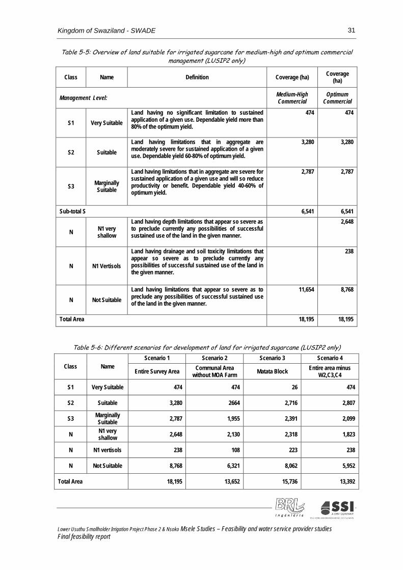
Kingdom of Swaziland - SWADE 31
Table 5-5: Overview of land suitable for irrigated sugarcane for medium-high and optimum commercial management (LUSIP2 only)
Class Name Definition Coverage (ha) Coverage (ha)
Management Level: Medium-High Commercial
Optimum Commercial
S1 Very Suitable Land having no significant limitation to sustained application of a given use. Dependable yield more than 80% of the optimum yield.
474 474
S2 Suitable Land having limitations that in aggregate are moderately severe for sustained application of a given use. Dependable yield 60-80% of optimum yield.
3,280 3,280
S3 Marginally Suitable
Land having limitations that in aggregate are severe for sustained application of a given use and will so reduce productivity or benefit. Dependable yield 40-60% of optimum yield.
2,787 2,787
Sub-total S 6,541 6,541
N N1 very shallow
Land having depth limitations that appear so severe as to preclude currently any possibilities of successful sustained use of the land in the given manner.
2,648
N N1 Vertisols
Land having drainage and soil toxicity limitations that appear so severe as to preclude currently any possibilities of successful sustained use of the land in the given manner.
238
N Not Suitable Land having limitations that appear so severe as to preclude any possibilities of successful sustained use of the land in the given manner.
11,654 8,768
Total Area 18,195 18,195
Table 5-6: Different scenarios for development of land for irrigated sugarcane (LUSIP2 only)
Class Name Scenario 1 Scenario 2 Scenario 3 Scenario 4
Entire Survey Area Communal Area without MOA Farm Matata Block Entire area minus
W2,C3,C4
S1 Very Suitable 474 474 26 474
S2 Suitable 3,280 2664 2,716 2,807
S3 Marginally Suitable 2,787 1,955 2,391 2,099
N N1 very shallow 2,648 2,130 2,318 1,823
N N1 vertisols 238 108 223 238
N Not Suitable 8,768 6,321 8,062 5,952
Total Area 18,195 13,652 15,736 13,392
Lower Usuthu Smallholder Irrigation Project Phase 2 & Nsoko Msele Studies – Feasibility and water service provider studies Final feasibility report

Kingdom of Swaziland - SWADE 32
For the recommended scenario this would result in the availability of a total of approximately 4,700ha realistic area, of which 3,400ha below the canal and 1,300ha above the canal. In terms of suitability, half of this is S2 suitable land, a quarter S3 marginally suitable land, with the remainder either very suitable S1 or conditionally suitable N1. In order to obtain a realistic overview of the hectarage available of the various land suitability categories, the following modifications need to be made considering the position of the land, in particular the height above the canal:
1. eliminate all marginally suitable and suitable land when situated higher than 210m, with exception of the very suitable land;
2. eliminate all marginally suitable land above the canal at 190m;
3. select not more than 50% of land classified as N1 very shallow (subject to survey) only below canal (Lower than 190m); and
4. select all land classified as N1 Vertisols below 210m.
Table 5-7: Scenario 4, maximum area for development of irrigated sugarcane (LUSIP2 only)
Class
Name
Scenario 4: Entire Area minus W2, C3, C4
Total Below Canal Between canal and 210m contour
Between 210 and 230m contours
Above 230m contour
S1 Very Suitable 474 0 216 215 43 S2 Suitable 2,807 1,582 796 384 46
S3 Marginally Suitable 2,099 1,238 468 250 142
N N1 Very Shallow 1,823 873 492 246 211 N N1 Vertisol 238 194 44 0 0 N Not Suitable 5,952 2,823 1,261 609 1,258
Total Area 13,392 6,711 3,277 1,704 1,700
Table 5-8: Scenario 4, area for sustainable development of irrigated sugarcane (LUSIP2 only)
Class
Name
Scenario 4: Entire Area minus W2, C3, C4
Total Below Canal Between canal and 210m contour
Between 210 and 230m contours
Above 230m contour
S1 Very Suitable 474 0 216 215 43 S2 Suitable 2,377 1,582 796
S3 Marginally Suitable 1,238 1,238
N N1 Very Shallow 400 400 N N1 Vertisol 238 194 44 0 0
Total Realistic Area 4,727 3,414 1,056 215 43
Lower Usuthu Smallholder Irrigation Project Phase 2 & Nsoko Msele Studies – Feasibility and water service provider studies Final feasibility report

Kingdom of Swaziland - SWADE 33
6 AGRICULTURE AND LIVESTOCK
6.1 GENERAL The sections below for LUSIP2 present a summary of Annex D Agriculture and Livestock of the LUSIP2 Feasibility Study. No such annex was prepared for the LUSIP2ext area, as this was not included in the scope of work of the Consultants.
6.2 AGRICULTURE
6.2.1 General
Agriculture is the backbone of Swaziland’s economy contributing 13% to GDP. Major agricultural activities include sugar cane production, citrus fruit, maize and other cereal crops, forestry and livestock. The overall share of GDP by agriculture is actually much higher due to the processing of products based on sugar and timber. Sugar and wood pulp are the main foreign exchange earners. Threats to the sector derive from the impact of HIV/AIDS and the exposure to the global market coupled with the gradual removal of tariffs. Climatic change, erratic rainfall, trans-border animal diseases, overgrazing, soil depletion, droughts and floods have become persistent problems. The LUSIP project is expected to make a positive contribution to the development of the agricultural sector. One fifth of the population are said to be dependent on remittances and food aid. Moreover, people depend on off-farm income making productivity increases in agriculture imperative in order to ensure that people can feed themselves and can sell their surplus production. Increased yields, the expansion of national storage facilities especially at farm level, diversification and developing the agro-processing sector are high priority areas for a robust agricultural sector. The livestock sector is to be advanced, reviving the poultry industry and encouraging the cattle livestock holders to enter the commercial market. The production of own fodder will be a challenge substituting for the imports at constantly raising costs.
6.2.2 Land use and land tenure system
At national level only 11% of available land is arable. 56% of land is Swazi Nation Land (SNL), which is communal land held by the King in trust for the nation and administered by chiefs. It accounts for about 20% of total agricultural production. Title Deed Land (TDL) represents 43% of total land and is owned by government, companies and individuals and accounts for 80% of agricultural output. The remaining 1% is devoted for urban development. The low productivity of SNL land is linked to issues arising from the land tenure system as discussed below, but it is also a result of the dependence on rain-fed agriculture. With access to water and irrigation productivity will substantially increase and thus become a source of growth, income generation and empowerment of smallholder producers.
Lower Usuthu Smallholder Irrigation Project Phase 2 & Nsoko Msele Studies – Feasibility and water service provider studies Final feasibility report

Kingdom of Swaziland - SWADE 34
The land tenure system is an issue of concern for a number of reasons such as low productivity, resettlements, non-productive farms, environmental management, discrimination against women and youth, landlessness, access to water to mention some. The way land is allocated is questioned. The size of house holds farm size reportedly diminished from 3ha to only 1.8ha. It is realized that communal ownership does not provide incentive enough to invest in the land and to safeguard nor conserve its quality. Thus, overgrazing and deforestation has become a problem. SNL land cannot be used as collateral nor can it be traded. A problem exists for youth and women in having access to SNL land, although they are often responsible for tilling the land and food production.
TDL land often lies idle when owned by government, by foreigners or by somebody living outside the country. Women cannot inherit SNL land rights. Due to HIV/AIDS a sizeable amount of land remains unused. A national land policy (NLP) has been developed addressing the problems of having access to SNL land, giving security of tenure to residents and stressing the change from traditional subsistence farming to commercialization. While the protection of constitutional rights of citizens, and in particular of the poor is uncertain, TDL is secured, highly mechanized, irrigated, market oriented and thus generating good incomes to producers. All persons can access TDL, but it is costly and not affordable by the poor.
Most of government owned land has still to be redistributed and is so far underutilized. A land use plan has been established demarcating land use for agriculture, housing and other uses. However, the plan was never implemented. Instead, most or much of the agricultural land is diverted to housing purposes. Yield levels during rainy seasons compared to yields during years of droughts provides a clear indication of the importance of irrigation for increased production. Only 15% of SNL homestead irrigate their lands. Main crops grown on SNL are maize, cotton, pumpkins, beans and groundnuts. On TDL sugar cane, citrus fruits, pineapple, bananas and vegetables are grown for commercial purposes.
The Nsoko Msele area is predominantly utilised for commercial agriculture, mainly sugarcane. High levels of management result in very good yields; on the highly fertile and well managed estates up to 160 tonnes of cane per hectare have been reported at a field level, indicating its suitability for expansion of sugarcane production. The Nsoko Msele development plans to develop 4,000 ha of sugarcane, 2,000 ha of which will be dedicated to Title Deed land being donated by commercial farmers to the local communities as determined by SWADE.
6.2.3 Production and Processing of Major Crops
Sugar has been the principal cash crop of the Swazi economy. Both primary production of sugar cane and processing to raw sugar and sugar based manufacturing represents about 50% of GDP 35% of private sector wages and 11% of public wage employment originates from the sugar crop. National sugar cane production of annually about 5 million tons has slightly declined over the past years. The production of sugar in form of sucrose followed the decline in cane production. Yield and sucrose content have been declining to 96t/ha and 13.9% respectively. Smallholder farmers have only recently started to grow sugarcane. They are organizing in Farmers’ Associations, harvesting groups, etc and have realized that through cooperation economies of scale can be enhanced.
Lower Usuthu Smallholder Irrigation Project Phase 2 & Nsoko Msele Studies – Feasibility and water service provider studies Final feasibility report

Kingdom of Swaziland - SWADE 35
In support of the LUSIP project and in anticipation of increased production the milling capacity at Ubombo has been increased to a crushing capacity level of 2.6 million tons, of which to-date the capacity of only up to 2.1 million is utilized. The expansion was prompted by the expected output from initially LUSIP1 and later LUSIP2. Delays in the LUSIP1 implementation - as a result of lack of funding and partly unsuitable soils- is only attributable for 0.1 million tons of the shortfall. Available capacity is estimated to be fully utilized by about 2015 if dependent on the LUSIP sugar cane only. In the meantime, the loan-financed expansion and underutilization may make debt servicing for the mill problematic. Growers need a quota permit from the SSA’s Quota Board prior to the uptake of cane production ensuring availability of land and water. SSA is thus regulating and supervising that mills can meet demanded capacity requirements and that the produced sugar can be sold. Proceeds from sales are distributed via the millers to the growers and are shared on a 31.9% (millers) / 68.1% (growers) basis. The strategic choice where to market sugar is made by SSA. The main target markets are the EU (44% of sales in 2010/11) and SACU (53%). The balance is sold to the U.S. (2%) and COMESA (1%). Contrary to what was expected, the sugar prices on the international markets have risen during the past 2-3 years.
Maize is an important crop to be grown in Swaziland as the staple food for its people. Maize is to a lesser extent grown large scale, but rather by smallholder farmers for subsistence purpose under rain-fed conditions and always dependent on the erratic climate conditions.The project area is currently not suitable for maize production as erratic yields are low at 1 – 3 tons per hectare.
Good seed is available easily but the biggest problem, apart from water, is the lack of tractors or rather that only few subsidized government tractors are available. The National Milling Corporation regulates the cereal market. NMC encourages local production by paying prices above gazetted floor prices. and has in 2010 purchased from farmers 6,000 t of maize at a price of E 1,960/ton delivered to the silos in Matsapha. At the same time almost 40,000 t of maize have been imported annually from South Africa often at prices that are below the price paid by NMC to farmers. Farmers’ estimated production costs under irrigation are considered competitive with S.A. maize. White maize is imported, while yellow maize is produced locally and mainly used for animal feed. Prices in South Africa have gone up substantially amounting in December 2011 to R 2,800 – 3,000 (landed cost Matsapha NMC). Reportedly, South Africa will not be able to deliver the quantities needed in Swaziland for 2011/12 and NMC is presently looking for other suppliers. As maize is rich in energy, maize is an important ingredient in animal feed, which also needs to be considered, as a more commercial approach to livestock keeping requires improved feeding systems. Sorghum is encouraged as an alternative food source, but production is low and other cereals are preferred. Trials are made with foreign assistance to increase rice production.
Cotton has been a major cash crop in Swazi agriculture. The production has been given much support by Government, but has simply not performed well. Drought, lack of finance and low cotton prices have discouraged cotton production. Operations of two ginneries had been halted until the activity of one ginnery in Big Bend owned by the Cotton Board has been renewed. Earlier production levels of 70-80,000 tons have been reported. Cotton has so far been grown under rain-fed conditions. Yields are about 800 kg/ha and there are high expectations for yields to increase substantially when produced under irrigation conditions. Prices to farmers have increased to E 4.00 – E 4.50 depending on the cotton grade. There are reportedly 200 cotton grower associations. Cotton prices began heavily falling on the international market, as larger cotton arrivals have put some strong pressure on domestic prices in China and Pakistan. With global yarn consumption being currently depressed, cotton use could be lower than expected. Cotton prices have settled into a lower, but tighter, trading range, which has decreased volatility and created some marketing opportunities for producers. According to experts and analysts, world cotton consumption may be constrained on dull economic conditions’ (National Cotton Council, US).
Lower Usuthu Smallholder Irrigation Project Phase 2 & Nsoko Msele Studies – Feasibility and water service provider studies Final feasibility report

Kingdom of Swaziland - SWADE 36
Other mixed crops and vegetables. Irrigation offers plenty of opportunities to grow other mixed crops, fruits and vegetables that could find a market. Overall 75% of these crops are imported. The import share of potatoes is even 90%. Fruit such as avocados, bananas, grenadillas, guavas, mangos and litchis are already grown and exported. Baby vegetables are also successfully marketed. SNL farmers grow vegetables such as cabbage, onions, potatoes, sorghum, yellow maize, beans, tomatoes and beet roots mainly for local consumption. The gross margins look promising, yet proper markets with established trading, credit and marketing mechanisms are not in place despite market potentials exist as the high import figures suggest. The National Agricultural Marketing Board (NAMBOARD) is or could be an important market player as regulator, developer and marketing agent.
It may be easier to import vegetables from South Africa than to organize farmers and a local market. Farmers, also when it comes to vegetables are not very keen to organize themselves, avoid assessing the best timing for delivery when the crops are demanded by the market. Constant supplies are demanded and in quantities which the market can absorb. Incentives of paying higher prices which are substantially above imports from nearby S.A. are nor sustainable. Supplies from farmers are at times not available when there is a shortage and they are available when supply by far exceeds demand. The message from the extension agents is for farmers to get organized, find a market and then to produce.
The Nsoko Msele area is planned entirely for the production of sugarcane for milling in local sugar mills.
6.2.4 Institutional support to the farming sector
The Government supports the agricultural sector through the provision of subsidized services for tractor hire, soil testing and extension services on crop and livestock production and animal health. The cost of tractor hire is unaffordable to the majority of homesteads. When demanded available tractors are too few to meet the demand when it is required. Delays in planting and ploughing reduce yield outputs. The adoption rate of new technologies by farmers is poor and the lack of agricultural education and unwillingness by the youth to embrace agriculture as an attractive occupation harms development. Access to credit is a thorny undertaking and not easy to succeed in. The marketing system is said to be poor (except for sugar) and likewise, there are poor linkages between agricultural production and the processing sector. There is a shortage of storage capacity at private farm level. SWADE is actively engaged in mobilizing farmers, but does not have adequate resources to develop and promote production systems suitable for farmers on a large scale who have a weak resource base. Increasing production would also require that the lease of unused or underutilized SNL land is facilitated for the use implementing viable agricultural activities.
A strong body of organized farmers’ organisations or cooperatives is missing. A central cooperative union established 30 years ago was liquidated due to its poor financial standing. Whatever its name, but there will be a need for farmers to cooperate and to pool resources. It has proven in other parts of the world to be an important vehicle for development. Farmers could and should solve and manage the problems they experience to enhance extension and advisory services capabilities, organize their marketing of produce, make storage facilities available and assist with and administer needed credit schemes. The Nsoko Msele will be managed with support from the existing commercial farmers at Nsoko.
Lower Usuthu Smallholder Irrigation Project Phase 2 & Nsoko Msele Studies – Feasibility and water service provider studies Final feasibility report

Kingdom of Swaziland - SWADE 37
6.3 YIELDS OF MAJOR CROPS Yields differ according to the soil class on which sugarcane is grown. Sugarcane yields used in the feasibility evaluation have been determined as follows:
Very suitable soil S1 110-120 t/ha, average 115 tons/ha Suitable S2 100-110 t/ha, average 105 tons/ha Marginally suitable S3 90-100 t/ha, average 95 tons/ha Very shallow soils N1 80-90 t/ha, average 85 tons/ha
It is the opinion of the soils investigation that in the extension area yields of between 86 and 157 t/ha are possible on a field basis. Over the 4,000 ha identified for development an average of 119 t/ha is reported to be attainable, if management is of a very high standard.
Farm gate prices for maize have been around E 2,000/ton by the end of 2011. At that time the National Maize Corporation imported Maize from South Africa at a price of E 2,800, equivalent to E 2,600 after making an allowance for transport costs.Maize yields used in the feasibility assessment are as follows. Two crops can be grown per year.
Soil class S1 S2 S3 N1 t/ha t/ha t/ha t/ha 1st crop 10 8 7 6 2nd crop 8 6.5 5.5 4.8
For other crops the following yields and prices apply: Beans Onion Potatoes Tomatoes Yield/ha 2.4 15 25 30 Farm gate price/ha 7,500 3,000 2,650 4,500
Lower Usuthu Smallholder Irrigation Project Phase 2 & Nsoko Msele Studies – Feasibility and water service provider studies Final feasibility report

Kingdom of Swaziland - SWADE 38
7 IRRIGATION, DRAINAGE, DAMS AND LAND DEVELOPMENT
7.1 DEVELOPMENT SCENARIO'S At the start of the LUSIP2 studies, the Consultant concentrated on defining the development scenario's comprising LUSIP2 only, as extension of LUSIP1, as stipulated in the TOR. These scenario's are part of the 'base case'. Hence, with the results of the soils and land suitability survey the LUSIP2 base case is defined as having 5,750 ha net, covering 5,295ha net new land and 455ha net existing irrigated land.
Rehabilitation of infrastructure was planned at the existing Poortzicht Scheme of 700 ha net, managed by the Poortzicht Supply Company (PSC). This scheme borders the LUSIP2 command area at the north east and could be technically integrated in the main supply infrastructure of the LUSIP2 scheme. A major argument to study the inclusion of the PSC scheme is the prospect that the production of sugarcane in this area does not remain feasible because of the expected large increase in pumping costs, which are already high because of topographical conditions. In the scenario's below this option is named 'PSC, 700 ha net' which was increased to 750 ha net during the LUSIP2ext study.
To the south of the LUSIP2 command area there was a plan to develop a scheme of 4,000ha, comprising 2,000 ha existing commercial sugar farms and 2,000ha to be developed for small holder sugarcane production south of Ngavuma River. The plan envisages the transfer of Ngwavuma water rights of the existing farms to the 2,000ha smallholder operation, in exchange for water to be delivered by the LUSIP infrastructure. In the framework of this study this option is named 'LUSIP2 extension with 4,000 ha net'.
With the Nsoko Msele studies, a number of changes in the areas covered were introduced because of recent developments. These are shown underlined in the development scenario’s and the additional scenario 3U. Therefore, the following development scenario's were defined and studied:
During LUSIP2 FS:
• Base case: Matata block with 5,750 ha net, Qpeak = 4.72 m3/s
• Scenario 1: LUSIP2 + Poortzicht scheme (700ha net), with a total area of 6,500ha net, Qdesign = 5.29 m3/s
• Scenario 2: LUSIP2 + 4,000ha, with a total area of 9,750 ha net, Qdesign = 6.72 m3/s
• Scenario 3: LUSIP2 + 4,000ha at LUSIP2ext and Poortzicht (700ha net), with a total area of 10,500 ha net, Qdesign = 7.3 m3/s
1. During the LUSIP2 and LUSIP2ext FS:
• Scenario 3Ubase: LUSIP2 + 4,090ha at LUSIP2ext, Poortzicht scheme (750ha), with a total area of 10,512ha net, Qdesign = 7.3 m3/s
• Scenario 3U1: LUSIP2 less 1,000ha new land+ 4,090ha at LUSIP2ext, Poortzicht scheme (750ha) and riverside farms (1,000ha net), with a total area of 10,512 ha net, Qdesign = 7.3 m3/s
• Scenario 3U2: LUSIP2 + 4,090ha at LUSIP2ext, Poortzicht scheme (750ha) and riverside farms (1,000ha net), with a total area of 11,512 ha net, Qdesign = 7.3 m3/s
Lower Usuthu Smallholder Irrigation Project Phase 2 & Nsoko Msele Studies – Feasibility and water service provider studies Final feasibility report

Kingdom of Swaziland - SWADE 39
The changes in the areas shown above do not have any influence on the design, because the latter is fixed. The adapted areas are potentially available. The extension development from the outlet of LUSIP2 utilizes surplus water from the scheme and ensures its year-round availability for new development by creating storage in Nsoko Msele . It has been calculated that on the basis of 7.3 m³/s supply into the LUSIP2 scheme, and after upstream deductions of irrigation water, there is sufficient water to irrigate 4,000ha in the Nsoko Msele area. This can be achieved by diverting at least 3m³/s through a lined canal to a storage dam of 9.2million m³ on the south bank of the Ngwavuma River. Further distribution of water is required for water to be available at field edge in the southern area of the development which has largely been identified as the community farmer area (NEWCO), in addition to a small area to the north of Nisela Farm.
7.2 IRRIGATION LAYOUT AND POSSIBLE IMPROVEMENTS In Phase1 the design has been prepared for a dragline irrigation system. The design adopted an area called a block, which forms the smallest common denominator for the irrigation system. The layout used was basically an option that has been adopted to enable the secondary distribution system to be defined. The difference in Phase2 is that instead of a dragline system, a semi-permanent/semi-solid configuration is recommended. The experience gained in Phase1 when using dragline is enough not to recommend this system in Phase2. In LUSIP1, the irrigation blocks were at most 100ha in size and the only irrigation system type was dragline sprinkler system. Each irrigation block had a balancing reservoir. These reservoirs had been found to cause serious drainage problems because most were not constructed as per their design requirements. Each block had a pump house and its own electricity supply. This had proved to be a very expensive option and had been avoided in Phase2. In Phase 2 the irrigation blocks will range from 100 to 500ha. Each irrigation block will have one pump houseto accommodate different farmers’ associations/companies. The internal arrangements will be defined at detailed design stage. This will make supplying both water and electricity easy. Reservoirs have been avoided and irrigation blocks will be supplied directly from the main pipeline and hence gaining some head.
The same design philosophy has been adopted for the community farm areas on LUSIP2 Extension. The primary storage facility to cater for annual irrigation requirements (known as Dam E) will provide sufficient balancing storage year-round for the irrigation of 4,000 ha of sugarcane. Half of the Extension will be commercial agriculture, which will include for centre pivots, drip irrigation and in some places possibly “hop-along” irrigation. The community area will comprise irrigation blocks of between 24 and 225ha.
The feasibility design of the 2,000ha community scheme includes for the delivery of water to block’s edge, known as tertiary irrigation supply. The concept is to provide water at a positive pressure at block’s edge. However, for areas located above the terminal point of bulk water supply (Dam F), this will require pumping and a simple positive pressure will necessitate additional pumping. This would result in additional capital, operation and maintenance costs. It is recommended therefore that a minimum pressure sufficient to satisfy infield irrigation through a semi-solid system is adopted. In this study a field edge pressure of 35m has been adopted. In the final design this value must be verified as being adequate in each field.
In this study, tertiary supply of water therefore represents a cost of pressurised water supply to the blocks, to which the unit development cost of infield irrigation can be added to obtain a representative development cost of irrigated fields in those development areas. Further optimisation of an integrated system design is possible, subject to adopted irrigation methods, level of management and capital availability.
Lower Usuthu Smallholder Irrigation Project Phase 2 & Nsoko Msele Studies – Feasibility and water service provider studies Final feasibility report

Kingdom of Swaziland - SWADE 40
7.3 IRRIGATION WATER REQUIREMENTS NSOKO MSELE AREA Irrigation requirements for Nsoko Msele were calculated on the same basis as LUSIP2, as presented below for a “dry year.” Bulk conveyance losses are estimated at 7% and an in-field irrigation efficiency of 77% is adopted. The LUSIP2 irrigation requirements which are based on Big Bend climatic data were compared with the modelled irrigation requirements for the SA Sugar Research Institute (SASRI) site at Pongola (27:24’31”S, 31:35’E, altitude 308m), some 40 km away. Data available at Nsoko weather station will be used to update irrigation requirements prior to detailed design after evaluation and processing of records.
As the Nsoko Msele is halfway between Big Bend and Pongola, it was decided to adopt the average of the figures calculated for LUSIP2 and Pongola. (see following table). This resulted in a net irrigation requirement of 10,735m³/ha/year and gross of 14,991m³/ha/year. Simulation from 1997 to 2013 indicated an annual average irrigation requirement of 8,940 m³/ha. In the absence of rain, 12,820 m³/ha crop water requirement was indicated over this period.
Table 7-1: Monthly Sugarcane Irrigation Requirements(dry year)
Description A
pril
May
June
July
Aug
Sept
Oct
Nov
Dec
Jan
Feb
Mar
Nett Irr. Req. (dry year) m3 78
1
655
413
424
665
849
897
910
1,14
5
1,39
6
1,27
7
1,32
7
Gross Irr. Req. (dry year) m3 1,
057
875
541
553
891
1,14
8
1,21
7
1,24
4
1,56
2
1,90
2
1,75
0
1,81
1
7.4 FIELD IRRIGATION SYSTEMS NSOKO MSELE AREA It is recommended that the 2,000 ha community irrigation area is planned to take advantage of semi-permanent/semi-solid configurations (also known as hop-along) or centre pivots if practical. Latest trends in commercial production of sugarcane show an increasing uptake of primarily centre pivot, followed by drip irrigation and hop-along. Dragline irrigation is widely being phased out. The reason for this is both the energy advantage and the low labour requirements of centre pivot and drip systems. The advantage of hop-along systems is that it can suit irregular shaped blocks, it has a relatively low labour intensity and is reasonable power efficient, depending on its design.
Hop-along irrigation is defined as one that has permanent laterals (either buried our surface) with regularly spaced hydromatic valves. These valves allow for the systematic placement of sprinklers in a daily and weekly cycle such that the only component being moved is the sprinkler. The advantage of this system is that sprinklers are placed at precisely the correct position and that it is simpler to check that a sprinkler movement has taken place. The capital costs are somewhat higher than dragline schemes, but the distribution uniformity advantages and labour savings far outweigh the capital cost increase.
It is estimated that no more than 50% of the community development area could viably be covered by centre pivot. The remainder is covered by hop-along systems that are better suited to smaller areas. This does not have major impacts on efficiency of water use and O&M costs.
Should the area be developed to be managed as a commercial enterprise with experienced management, then the centre pivot in combination with hop-along may be suitable. In any case,
Lower Usuthu Smallholder Irrigation Project Phase 2 & Nsoko Msele Studies – Feasibility and water service provider studies Final feasibility report

Kingdom of Swaziland - SWADE 41
“outfall” areas and irregular blocks would utilise hop-along systems. Drip irrigation is not recommended for a community scheme unless it is being managed entirely by a team that is experienced in large scale drip irrigation, such as at Simunye in northern Swaziland.
7.5 IRRIGATION BLOCKSLUSIP2 AREA Concept. The irrigation blocks will range from about 100 ha to 500 ha sizes. Only three types of irrigation systems are favoured since they are ideally suited for beginning farmers. These are centre pivots, semi-solid sprinkler and possibly drip. Furrow irrigation, though cheaper and easy to operate is considered to be inefficient and therefore wastes much water. It could be a viable option but only if the tail water is recycled. A dragline system, although cheap to install, is very difficult to manage, particularly to move the sprinkler with a long hose pipe. The productivity of irrigators under a dragline system is greatly reduced. Irrigators tend to cheat and not move the sprinklers. The design will be such that blocks above the main supply line will be pressurized and those below will be fed by gravity. Irrigation blocks have been subdivided for the five major areas in the three main chiefdoms.
The irrigation blocks will range in area from about 100ha to 500ha. Each irrigation block will be subdivided into individual fields for ease of management and flexibility. This will depend on the topography of the area. The size of the fields range from a minimum 11ha to a maximum of 230ha.
Most of the area is under the 230 m contour except all of Lusabeni which is above the 230 m contour. Areas above the 230 m contour will create problems due to lifting of water and as the costs of electricity is escalating, it is unlikely that such areas will be included for planting. The blocking had only concentrated on the good and marginal soils. It is important to note that the final blocking should take into account the allowable distance of between 20 to 35 meters from waterways and other riparian areas and must adhere to the EIA regulations. Details of the individual chieftaincy blocks are summarised below. Blocks have been confined within chieftancy boundaries to avoid disputes. It is assumed that 5-6% of the gross area is covered by roads and structures and is hence excluded from the net irrigated area.
Table 7-2 : Summary of the irrigation blocks per chiefdom
Chiefdom Gross area (ha) Net area (ha)
Ngcamphalala (Mahlabaneni) 682 641 Ngamphalala (Pfafeni) 424 399
Ngamphalala (Lusabeni) 400 376 Matsenjwa 937 881
Mngometulu 2,453 2,306 MOA Farm 1,138 1,069
Total 6,033 5,671
The LUSIP2 area will have a gross area of 6,033 ha and a net area of 5,671 ha. Note that 454ha net are already equipped and irrigated, so the proposed on-farm development works will include 5,217 ha of irrigation blocks covering new area.
Lower Usuthu Smallholder Irrigation Project Phase 2 & Nsoko Msele Studies – Feasibility and water service provider studies Final feasibility report

Kingdom of Swaziland - SWADE 42
7.6 IRRIGATION BLOCKS NSOKO MSELE AREA As discussed for the LUSIP2 area above, irrigation blocks for community land will be finalised at implementation based on agreed irrigation technologies. The areas located on arable land are summarised in Table 7-3 below, as being located on three commercial farms. Nisela is expected to abstract water from the LUSIP2 canal via a typical LUSIP offtake structure. The southern areas of Richmond and Lismore will abstract water from the terminal point of the bulk water scheme, at Dam F. These southern areas are known as NEWCO West and East respectively.
Table 7-3: Summary of the Irrigation blocks per farm Farm Name Gross Area
(ha) Nett Area
(ha) Nisela 172.2 162.4
Richmond (NEWCO W) 895.3 844.7
Lismore (NEWCO E) 972.0 917.1
Total 2,039.5 1,924.2
7.7 PROPOSED STORAGE FACILITIES AND IRRIGATION AND DRAINAGE NETWORK
7.7.1 Proposed schemeLUSIP2
The proposed scheme will have the following components:
Remodelling Main Canal South (MCS) to allow increase in conveyance capacity.
Main conveyance system • Double DN 2,200 pressurizedsteel pipe (6,259m) • Lined main canal (28,187 m)
Offtakes Secondary pipe network, 3 for the Matata blocks and 1 for PSC
Road network
Drainage system
On-farm distribution and irrigation systems
Details are presented in Annex E of the LUSIP2 feasibility study.
7.7.2 Proposed scheme Nsoko Msele
The proposed Nsoko Msele scheme will have the following components taking into account that the initial point is the national road (see figure 1 below):
Main conveyance system • Lined main canal (7,934m) (designed for 5.3 m3/s, conveying 3.0 m3/s) • Single DN 1,800 mm pressurized steel or GRP pipe and siphon through the Ngwavuma
River (1,025m) (designed for 5.3 m3/s, conveying 3.0 m3/s)
Bulk storage reservoirs (Dam E and balancing F)
Lower Usuthu Smallholder Irrigation Project Phase 2 & Nsoko Msele Studies – Feasibility and water service provider studies Final feasibility report

Kingdom of Swaziland - SWADE 43
Bulk pump station and DN 1,200mm pipeline (1,081m) to lift water from canal into Dam E (capacity of 3.0 m3/s. To be phased for later expansion to 5.3 m3/s)
Bulk pumpstation and rising mainline DN 1,200 mm (5,000m) (capacity of 2.05 m3/s)
Lined secondary canal (4,020m) (capacity of 2.05 m3/s)
Tertiary pumps and pipe network serving 4,000ha
Canal access roads, bridge and fences
Canal drainage system
Lower Usuthu Smallholder Irrigation Project Phase 2 & Nsoko Msele Studies – Feasibility and water service provider studies Final feasibility report

Kingdom of Swaziland - SWADE 44
Figure 3: Overview of Nsoko Msele (with Dam E at 9.18 million m3)
Lower Usuthu Smallholder Irrigation Project Phase 2 & Nsoko Msele Studies – Feasibility and water service provider studies Final feasibility report

Kingdom of Swaziland - SWADE 45
7.7.3 Selection of Conveyance Infrastructure Routes and Alternatives
Desktop analysis of old orthophotos initially highlighted the difficulty of traversing from Canterbury dam to the area south of the Ngwavuma River. Initial inception plans looked at the possibility of the following three routes:
Abstraction from the LUSIP canal at the head of Canterbury dam along an alignment running to the west of the Ngwavuma River and joining up with the existing siphon built across the Ngwavuma River. From there following a route through high ground towards the dam site recognised as Dam E. This resulted in a conveyance infrastructure of approximately 19.8 km.
A route to the East, starting from above Canterbury dam and passing via siphon through the gorge on the Ngwavuma River and running alongside the toes of the mountains. This route was approximately 8.2 km long but included some extremely difficult topography amid significant rocky outcrops on steeply sloping foothills. Site inspection of the gorge showed it to be a very technically demanding and costly option not worthy of further consideration.
A more direct route was discussed with Nisela management, which would follow a contour until reaching the main road MR8, at which point the canal would deviate alongside the road and pass over or under the Ngwavuma River either through an inverted siphon or above ground utilising the existing old road bridge piers. With data available at the time it looked like a reasonable concept, however, when better elevation data was available the levels precluded it from being a viable option.
Details are presented in Volume III - Annex E3: Irrigation, Drainage and Dams
7.8 REGULATION OF FLOWS IN THE LUSIP2 AND NSOKO MSELE CONVEYANCE SYSTEM
The need to avoid possible losses from excess flows emanating from the LUSIP canal system has been evaluated and it is concluded that the proposed Nsoko Msele arrangements (capacity of system to Dam E and volume of excess spill to Canterbury Dam) provide adequate capacity and storage to minimize losses in the main conveyance system. Assumptions and design parameters are presented as follows:
1) Any excess flow from Main Canal South (LUSIP1) will be diverted via the St Phillips canal
to the dam at the end of the canal. 2) Without rain off takes along the Matata Canal will provide water 24 hours/day because
farmers’ companies will irrigate 24 hours/day with their centre pivots and semi-solid sprinkler systems. There is no reason to stop irrigation during the night and the weekend.
3) During the rainy season irrigators might reduce or stop irrigation all together when rain starts to fall, but the general practice is that irrigation continues for some time especially during the night because the irrigators first have to evaluate how much rain has fallen, which intensity can be expected and for how long the showers will last. Therefore, demand at the offtakes from the main canal will not go down suddenly.
4) Reduction of demand and possible excess flow at the end of the Matata Canal only has to be taken into account for the LUSIP2 area.
5) Delivery of water is programmed according to a schedule that is based on requests submitted by the irrigators. Therefore, the main system is not operated according to on-demand parameters.
6) If it is assumed that: a. Irrigators reduce demand instantaneously to zero at the start of a rain shower, b. All irrigators practice this behaviour simultaneously throughout the whole LUSIP2
command area, and
Lower Usuthu Smallholder Irrigation Project Phase 2 & Nsoko Msele Studies – Feasibility and water service provider studies Final feasibility report

Kingdom of Swaziland - SWADE 46
c. Delivery of water equals the maximum demand of 0.82 l/s/ha which occurs in January
the instantaneous excess to be evacuated to Nsoko Msele is 6.1 m3/s. Prior to this moment 7.3 m3/s was being delivered to LUSIP2+ Nsoko Msele with the Nsoko Msele receiving 1.2 m3/s flowing to the empty dam E which has a capacity of 9.2 MCM.
7) During this time the volume of the excess amounts to 549,000m3, rounded for ease of reference to 0.6 MCM.
8) The flow of 7.3 m3/s is distributed during max 25 hours between canal C with a max capacity of 3m3/s and the spill facility to Canterbury dam. Hence, the volume to Canterbury dam amounts to max 0.4 MCM at the time that this dam is not yet filled from Ngavuma River.This might happen several times during the rainy season.
9) In reality the parameter values in the hypotheses shown above are not as severe as assumed so excess flow and volume will be less.
10) The excess volumes flowing into the Canterbury Dam will be measured and costs would be charged to the private company owning this dam. The company will welcome filling by gravity because in general the dam is filled with water from the Ngwavuma River by pumping. However, if Canterbury dam is full all excess flow has to be conveyed to Dam E.
7.9 COST ASPECTS NSOKO MSELE
7.9.1 Capital Costs
The calculation of Capital, Operation and Maintenance costs have been carried out on the quantities extracted from feasibility design. The quantities are presented in Annex E3 and in Annex H for the following aspects:
Canal C1
Siphon
Canal C2
General Canal:
Canal F1
Storage Dams E and F
Bulk Conveyance to 2,000 ha
Tertiary Development 2,000 ha, including pumpstations and pipelines
Costs were determined on the basis of a comparison of rates from various sources, namely;
The Ludeke Dam project in South Africa; 40m high rockfill, clay-core dam (in progress)
The Imvutshane Dam project in South Africa; 32m zoned earth embankment dam (in progress)
BRL rates as per document “LUSIP2-Detailed Design – Main Conveyance System,” 13/08/2013
Quotes from suppliers in South Africa.
These rates were applied and adjusted based on experience in order to determine what is considered to be a representative capital cost. Preliminary and General costs, Detailed Design and Project Management, Geotechnical, Survey, Construction Management, Contingencies and VAT have all been added as global costs.The total CAPEX for LUSIP2ext amounts to E 446 million, including 15% physical contingencies. Volume III - Annex E3 presents details.
Lower Usuthu Smallholder Irrigation Project Phase 2 & Nsoko Msele Studies – Feasibility and water service provider studies Final feasibility report

Kingdom of Swaziland - SWADE 47
7.9.2 Cost Sensitivity
Some rates are more sensitive towards the overall capital cost than others, as noted in the sensitivity table below where the cost of inputs were adjusted 15% lower and higher to determine the effect on Total Capital Cost. It is clear that the largest effect is caused by a variation in prices on pipes, followed by the cost of earthworks. These factors are driven largely by macro factors such as exchange rate and cost of oil. Details are presented in Volume III - Annex E3.
7.9.3 Operation and Maintenance Costs
Annual maintenance costs were derived for the system on the basis of percentage of Capital Costs per annum provided by the Department of Water Affairs South Africa. These costs are in the range of 0.5 – 1.0% per annum for different aspects of constructed infrastructure and represent an average cost for annual maintenance over the expected lifespan. Annual maintenance and operational costs amount to E 4.0 million and E15.6 million respectively.
Annual operation costs are based on electrical consumption within the pump stations. A base average rate of R1,10/kWh has been used as a reasonable approximation of the consumptive cost (based on personal communication with Mr T Minne, 24 Feb 2014). The bulk water pump station to Dam F has been sized to allow for pumping during off-peak periods utilising the Time of Use (TOU) structure that is based on approximately 19 hours per day for pumping. This factor must be considered in greater detail during detailed design to ensure that pumping costs are minimised. Pumping hours were calculated as the time required to meet the irrigation demand in the “dry year.” Details are presented in Volume III- Annex E3.
7.10 TECHNICAL RISK ASSESSMENT – NSOKO MSELE Particular areas of concern where technical risks may impact on the Project are analysed in Volume III - Annex E3. Mitigation measures are described as well.
Lower Usuthu Smallholder Irrigation Project Phase 2 & Nsoko Msele Studies – Feasibility and water service provider studies Final feasibility report

Kingdom of Swaziland - SWADE 48
8 INSTITUTIONAL ARRANGEMENTS
8.1 LUSIP2 The successful and sustainability of the farms will require the establishment of new organizations and the use of existing ones required to provide agricultural and non-agricultural support services. These will be expected to provide training, agricultural inputs, services and links to markets as well as the essential non-agricultural services (water management supplies, literacy, health etc.) -and some important project components such as livestock husbandry. The institutional framework for the planning and implementation of LUSIP consists of the following categories of institutions:
Traditional Authority
Public sector institutions
Agricultural organizations and agribusinesses
Community-based/informal organizations
8.2 WATER SERVICE PROVIDER STUDY The study for defining a water service provider for the LUSIP project (see Volume A) has developed a set of recommendations in order to define a proper institutional setting for this service, compliant with the Water Act of 2003, and in financing and realizing the extension of the current scheme. This note summarizes the project, the recommendations and the arguments that support them.
8.2.1 Institutional setting
Currently, the scheme is operated and maintained by SWADE. A letter from the Minister of Natural Resources instructing it to do so constitutes the sole legal basis for its operations. As SWADE has a national role in promoting rural poverty alleviation and operates under the jurisdiction of the Ministry of Agriculture, this solution has been criticized by the community of donors who required a permanent water service provider to ensure sustainability to the investment before considering any extension or any additional funding.
In order to address this issue, the study recommends regulating the scheme as a "project board" in accordance with the Water Act legislation instead of relying on irrigation districts with elected boards. Project boards can receive public financing, and have a governing board that is selected by the Minister of Natural Resources – allowing the Government to have a say on its investments and operations. The study recommends that the main stakeholders be to be represented on the board.
The study proposed to contract with a private partner the operation and maintenance of the current scheme. It considered developing the extension through a concession. There are many arguments for a public-private partnership to operate and maintain or to realize the extension. A contract with a private operator permits a better control of the costs, it allows to set key performance indicators and to link the payments to their fulfillments. It insulates the government from political pressures from the farmers to reduce irrigation service charges or to keep them too low to ensure a sustainable operation and maintenance of the scheme. If the Government realizes the extension through a concession, it will benefit from the partial funding of the private operator and will be insulated from any overrun and delays in completion – therefore increasing economical benefits.
Lower Usuthu Smallholder Irrigation Project Phase 2 & Nsoko Msele Studies – Feasibility and water service provider studies Final feasibility report

Kingdom of Swaziland - SWADE 49
The study raised the question of dam safety in terms of liability risks. A private water service provider would have to insure himself to cover for potential damages that could result from a breach in the dam. The increase in irrigation service charge that would follow could reduce the attractiveness of the project for the private sector and weigh on agricultural incomes of the users. Therefore, it is recommended that the government will keep overall responsibility for dam safety, eventually involving KOBWA in managing the dam. In this way, the water service provider would be responsible for the management (operation and maintenance) of the irrigation scheme and the Government will retain the responsibility of dam safety.
In the current scheme as well as in the projected extension, the question of providing local communities with water is not solved in a satisfactory manner. Many investments are not properly maintained and some are not even used. The study recommends that a private water service provider will provide the services required to operate properly these investments through contracts with local communities. The demands and constraints of these communities are not uniform. Some will need a full rehabilitation; some just proper maintenance and others will continue to run by themselves this service. So, instead of a uniform solution, the water service provider will negotiate with the local communities the proper level of involvement and the corresponding fees. The government will retain the right of approval on these contracts, and could intervene by providing subsidies if the need arises.
The remaining institutional issues are related to the contract with the water service provider. The study recommends that the delegating authority (representing the Government in the contract) is the office of the Prime Minister. This way, the Government would be committed on all dimensions of the contract (financial, fiscal, right of way, etc.) by its highest authority. The regulation of the contract, its supervision and modification should be delegated to the board. The board will make suggestions to be adopted by the delegating authority (the office of the Prime Minister).
8.2.2 The Project
The Project can be separated in three components. The current scheme and its management concern the first one. The second is concerned about the projected LUSIP2 phase of the irrigation project and the third comprises the full LUSIP2 area, with the inclusion of LUSIP2extension, covering the private venture Nsoko Msele. The management of the current scheme has to be changed as SWADE has taken this role as a provisional solution. The recommended solution is to hire a private water service provider for operating and maintaining the current scheme. Two solutions were considered in the study. The first one is a management contract where the private operator will collect irrigation service charges on behalf of the delegating authority, but will be paid according to key performance indicators by the delegating authority according to the contractual clauses. The second one is a lease contract where the private operator will be paid by the users (the operator will collect and retain all irrigation service charges). The extension, as initially planned, could be realized as the current scheme with SWADE supervising the construction. The operation and management, once commissioned, could be contracted to a private operator on the same basis as the first component. An innovative solution would be to concede the construction to a private operator and to make him share the burden of financing it. These three solutions were analyzed in the report. From the point of view of the government, the least costly option would be a concession. But, it would have the highest irrigation service charge to pay back the investments realized by the private operator.
Lower Usuthu Smallholder Irrigation Project Phase 2 & Nsoko Msele Studies – Feasibility and water service provider studies Final feasibility report

Kingdom of Swaziland - SWADE 50
The Nsoko Msele concern approached the Government to submit a proposal to enhance the economic benefits of the initial extension project. This private group intends to realize a sugarcane mill and to extend the irrigated area by 8,000 ha. Half of this area will be allocated to small-scale farmers and devoted to poverty alleviation. The concern will be managed as a single entity. It will realize its investment in irrigation, manage and maintain it. If the Government agrees on this project, it will have to increase the capacity of the main canal and deliver water to the concern on a take or pay basis. The financial conditions are to be negotiated with this concern before any decision on the extension of the current scheme. Two factors are to be set: the tariff to be used and a possible participation of the Government in the project.
8.2.3 Decisions needed
First, a decision on the institutional setting is needed. It includes the establishment of the project board and its composition. Second, the validation of a private operator as the most suitable solution is needed. In view of the extension, an agreement with Nsoko Msele is required. It will pave the way for selecting the most appropriate solution to realize the project, as a public venture or a concession.
8.2.4 Steps forward
Once the Government is committed to the institutional setting and the extension project, it will have to hire the service of the transaction advisor in order to prepare the negotiation with Nsoko Msele and the documentation for the bidding to hire the water service provider and to prepare the bidding for the eventual concession.
Lower Usuthu Smallholder Irrigation Project Phase 2 & Nsoko Msele Studies – Feasibility and water service provider studies Final feasibility report

Kingdom of Swaziland - SWADE 51
8.3 NEWCO MILLING / NSOKO MSELE OPERATING BUSINESS MODEL Set out below is a graphic representation of the current beneficiaries of NEWCO milling (the 2,000ha full title land donated by the Commercial farmers to 3 chiefdoms):
Both the strategic operating partner for the mill and the current commercial farmers have identified key operational deficiencies in current out growers schemes currently being implemented in SADC
In addition the 2,000ha NEWCO milling land will incur an additional electricity due to an additional [120]m lift based on the pumping requirement
To cover these financial and structural operating model deficiencies Nsoko Msele has rather proposed that the 3 chiefdom beneficiaries of NEWCO Milling (these chiefdoms are not currently beneficiaries of the LUSIP 2 scheme) will obtain “equity” in the mill based on the value of land injected relative to the total project equity value (The final split will be calculated based on the final Mill / agric peak funding and the associated capital / debt requirements). This incremental 4,000ha of land will be “farmed” on a commercial large scale leveraging off the existing farming infrastructure and fixed overhead costs. This allows this land to operate at an incremental higher return (on a stand-alone IRR basis) and offset the slightly higher pumping costs
COMMUNITY PARTICIPATION WITHIN NSOKO MSELE
Equity share %
Beneficiaries of the investment in the Mill and associated Agricultural development
NEWCO Milling
NSOKO MSELE PROJECT COMPANY
MngometuluCOMMUNITY
TRUST
Mamba?COMMUNITY
TRUST
Gasa ka NgwaneCOMMUNITY
TRUST
MyeniCOMMUNITY
TRUST
Ngcampalala?COMMUNITY
TRUST
Matsenjwa? COMMUNITY
TRUST
Lower Usuthu Smallholder Irrigation Project Phase 2 & Nsoko Msele Studies – Feasibility and water service provider studies Final feasibility report

Kingdom of Swaziland - SWADE 52
9 ECONOMIC AND FINANCIAL ASSESSMENT
9.1 SCOPE OF THE FEASIBILITY STUDY The economic and financial analysis was supposed to update an earlier study of 2005, which had centred mainly on sugarcane. The overall aim of the LUSIP project is poverty alleviation. Water is an avenue for economic growth and development benefitting the whole south east region of Swaziland. Without water no development and the goal of transforming the local economy from rain-fed subsistence farming into sustainable irrigated agriculture with its forward and backward linkages stimulating growth would be difficult to be realized.
The LUSIP Project has completed most of its first phase (LUSIP1) providing water from an off-river storage reservoir for irrigation to an area of 6,500 ha. A second phase of the project (LUSIP2) would supply water to another 5,200 ha by extending the south main canal and irrigation networks for on-farm development .
At a very advanced stage of LUSIP2 project preparation, a commercial agricultural and industrial beneficiation project company (Nsoko Msele) had obtained water rights for the Usuthu river outside the LUSIP2 scheme. The major aim is in addition to the production of raw and refined sugar & cogeneration power is to ascertain the secured and increased production of sugarcane for a new integrated E 2.5 billion milling plant to be set up producing sugar, ethanol and electricity for supply to the national grid. The significance of this project is driven by high transport costs of delivery to mills outside a 20km economic distances and increasing trends of energy costs for the irrigated cane.
The company would require for the LUSIP2 water canal and conveyance system to be extended allowing another 4,000ha of sugarcane to be planted and produced for the new mill. The 4,000ha of land is private title land of which half of the land would be transferred to three chiefdoms which current existing legal entity shareholding would be allocated to the community trusts. The chiefdoms and commercial farmers will be owners of the NEWCO milling company which together with other strategic investors will become shareholders of the Nsoko Msele Holding Company. The value of the land given to the farmers of the participating chiefdoms will represent paid-in equity capital if farmers so decide. Dividend is paid according to the paid-in share capital split.
The feasibility study assesses thus the financial and economic viability of the LUSIP2 and Nsoko Msele projects. Without the LUSIP2 project there would be no NSOKO MSELE project and without the water supplied by the NSOKO MSELE water conveyance system there would be no new integrated mill and farmers would not be given any land as the land transfer is linked to the development of the sugar mill. Water becomes thus the catalyst for agricultural production and economic development in the south eastern part of Swaziland. The focus is still on sugarcane due to the fact that so far developments have still been affirmative and an industry infrastructure is in place, which for the production and marketing of other mixed crops has still to emerge. Environmental benefits derive from the reduced burning of cane, the generation of renewable energy offsetting coal based power supplies from South Africa which account for 90% of the current Swaziland power generation mix.
Lower Usuthu Smallholder Irrigation Project Phase 2 & Nsoko Msele Studies – Feasibility and water service provider studies Final feasibility report

Kingdom of Swaziland - SWADE 53
9.2 BASIC ASSUMPTIONS Farmers’ companies under LUSIP2 will be established who are eligible to access water for irrigation. The feasibility study looked at different farm sizes, but focused on 500ha communally operated farms attracting good management and thus improved outcomes. Households receive SNL land which they contribute each with 3 – 3.5ha to the communal farming activity.Nsoko Msele is expected to be operated as a large scale commercial farm managing both the large scale farmers owned share of 2,000ha and the community farm of the same size.
A similar business operation model could also be extended to the LUSIP2 smallholder farm scheme in terms of farm management and even becoming shareholders in the mill operation. Under LUSIP2 new production areas have been identified for smallholder production schemes incl. land owned by the Ministry of Agriculture totalling initially 5,217ha.
Existing commercial farm areas of 455 ha and 1,000 ha (the latter established since 2012) have been under sugarcane production and would benefit from the project by saving energy from reduced pumping costs. The project would benefit from operation and maintenance costs for the canal infrastructure to be shared with the existing farm area. The discontinuation of a private large scale sugarcane production scheme (Poortzicht) has been considered imminent due to high operating costs unless water could be provided from LUSIP2 sources reducing energy costs. This would ensure the continued operation of the farm and impact beneficially on the project feasibility by absorbing some of the canal maintenance costs and possibly also contributing with water fees for which a cost recovery system still has to be worked out.
Table 9-1: Initial feasibility study area
LUSIP 2 + Nsoko Msele Total ha Small holder Large scale
1. New development area 5,217 5,217 2. Existing area 1 455 455 3. Existing 2 (established 2012) 1,000 1,000 4.Existing 3 (Poortzicht) 750 750 Sub-total 7,422 5,672 1,750 5. New Nsoko Msele 4,090 2,045 2,045 Total LUSIP 2 + NSOKO MSELE 11,512 7,717 3,795
The total project to be analysed comprise cash flows covering all investments for the canal construction of both systems (LUSIP2 and NSOKO MSELE), for the water supply and sanitation component, as well as revenues, benefits and cost streams for farm operations, resettlements, environmental rehabilitation and the costs for operation and maintenance of the canal and water supply systems. The capital expenditures for the main and secondary water supply system and other miscellaneous expenditures have been available from detailed design studies. Investments for the provision of the potable water supply and sanitation facilities have also been included.
It must be questioned to what extent the investment costs have to be assessed solely against the benefits arising from the direct outputs from LUSIP2 and NSOKO MSELE. The supply of water will benefit the development of the whole south east region of the country. This is a very poor region with the highest unemployment in the country due the lack of sustainable industrial development outside of the current existing sugar mill (some 40kms from the beneficiaries of the NSOKO MSELE water)
Lower Usuthu Smallholder Irrigation Project Phase 2 & Nsoko Msele Studies – Feasibility and water service provider studies Final feasibility report

Kingdom of Swaziland - SWADE 54
This needs to be reflected in the outcome of the study as the main water supply investment is aimed at complying with the commitment to alleviate poverty and redistribute resources towards less well-off population groups and areas. Infrastructure-based capital projects are prerequisites for generating economic growth. There is a public commitment driven by returns on investment but also by a social commitment articulated as public policy to the benefit of the poor and a firm commitment to meet the Millennium Goal of reducing poverty. At the same time, it is imperative that agricultural production based on irrigation must generate returns to service debts, allow a reasonable payment to farmers (dividend) and allow funds to be retained for financial consolidation.
In order to reflect the impact of the capital investment costs on regional development exceeding what could be attributed to the LUSIP project and to simplify the thorny computations of future benefits deriving from smaller and medium enterprise developments and other spin-off activities total capital investment costs have been reduced by 30%. This appears to be less than that considered in LUSIP1 feasibility study assessed in early 2000.The project feasibility will focus on the feasibility of commercial farming, in particular on the production of sugarcane as a well-established crop. The concern for the diversification of Swaziland’s agricultural economy has been noted and alternative mixed crops analysed as a potential option for future activities.
However, the nature of diversification will be determined by the organisational capability of stakeholders and market opportunities to make best use of available natural resources. Government can play an important role, but ultimately it will be the farmers, smallholders and large-scale farmers, who will determine which crops to grow.
The existing sugar mill (Ubombo) and the new mill (Nsoko Msele) have an interest in securing and even increasing the production of sugarcane to make best use of available capacities and Swaziland competitive advantages over other similar sized developing countries.. It is said that the Ubombo mill is not relying on sugarcane from LUSIP2 as Ubombo has expanded sugarcane production on own and other commercial land and based on LUSIP1 expansions. The distance of most of the future LUSIP2 produced sugarcane is outside the economic feasibility zone (currently considered to be 20 kms in Swaziland) justifying the establishment of the new Nsoko integrated sugar mill (the potential 4th sugar mill in Swaziland with community participation)
The project is also of importance for its provision of water to households and sanitation improving hygienic and health conditions and allowing additional subsistence farming to supplement communal farming activities. Implementation of the infrastructure project is planned to take place during the years 2015-2018. Agricultural production and farm establishment will subsequently start in 2018 until full production level is achieved by 2020.
As long as Farmers’ Associations/Companies have to be formed they can only operate when all administrative steps have been overcome such as registration, obtaining water rights, having access to funds, etc. The time span from registration to the start of production can take two years. The inclusion of large scale farms was not done by design but rather the outcome of considerations that additional beneficiaries would be able to improve the economy of the project and take part in the sharing of the operating and maintenance costs and the cost recovery of the investment. Successful models for the integration of out grower / community type investments and large scale commercial farmers have been seen in South Africa with synergistic benefits.
Lower Usuthu Smallholder Irrigation Project Phase 2 & Nsoko Msele Studies – Feasibility and water service provider studies Final feasibility report

Kingdom of Swaziland - SWADE 55
9.3 DEMAND AND SUPPLY OF SUGARCANE, MAIZE, AND OTHER MIXED CROPS
A distinction has to be made between the production of sugar cane and the production of other crops. Sugarcane production is well established in the area supplying sugarcane so far mainly to the Ubombo mill. However, transport costs are high and are a key determining factor for crop selection and location of sugar milling facilities. Swaziland enjoys preferential access to markets in mainly the EU and regional markets (SACU). Subsidies and financial aid helped to facilitate the adaptation to a new world market sugar regime, but may so far have prevented farmers and rural areas to look for alternative development paths, different cropping patterns and the strengthening of their self-organisation.
Assessing the feasibility of the production of sugar cane and other crops, the study will give an indicative answer as to the potential for generating required farm incomes and returns to invested capital. An acceptable return must also allow for debts to be serviced and dividend payments made to farmers facilitating the decision-making by government and potential DIF’s and donors to financially assist while the final decisions have to emerge at the local level and have to be made by the farmers and investors involved. The Sugar Authority (SSA) is marketing all sugar produced in Swaziland. Payment is made to millers, who pay to the farmers on the basis of the sucrose content of the sugar. As far as NSOKO MSELE is concerned potable, industrial or fuel grade ethanol would be sold in the EU and SADC markets (South Africa has recently gazette subsidy for ethanol), while the surplus power would be sold to Swaziland Electric Company (SEC) – which requires alternative forms of power generation as its primary supplier – Eskom of South Africa) has provided SEC with notice to discontinue due to South Africa’s own energy issues.
In the previous year 20% of all sugar produced came from smallholder sugarcane growers (SSGs). The majority of the SSGs produce on SNL land forming companies which are said to be plagued by conflicts, poor farm management, high indebtedness and poor ratoon management. A different business model relying on the management capabilities of the integrated milling company would positively impact smallholder farm operations.
Sugar has been the principal cash crop of the Swazi economy with sugar cane production, processing and manufacturing representing almost 50% of GDP. The production of sugar in Swaziland in relation to the size of the world market is relatively small. Therefore, despite of the sugar market reform until end of 2014, all sugar could and can be sold to established markets in the EU and the SACU region. With growing population and income growth as drivers, the demand for sugar and sugar products is continuously expected to rise. The reform of the EU sugar regime has the potential to erode the value of preferential access as from 2015. Reduced returns can then be expected and threaten the sustainability of the sugar industry. No tariff protection is presently in place applicable to the local SACU market exposing the sugar industry to what is claimed to be unfair competition from other international market places. Efforts are ongoing to make a tariff adjustment protecting the SACU market, while the EU is targeted to postpone the lifting of the ceiling on EU beet sugar production from 2015 to 2020. However, preferential treatment would cease by October 2014 and the EU’s production quota system would be abolished by 2017 making the EU to become a potential net exporter. The only cure for Swaziland is to sign the still unsigned European Partnership Agreement which would maintain its preferential status after 2015.
Lower Usuthu Smallholder Irrigation Project Phase 2 & Nsoko Msele Studies – Feasibility and water service provider studies Final feasibility report

Kingdom of Swaziland - SWADE 56
While sugar is a well-established crop, any other crops produced commercially would require longer periods of adaptation to and acquisition of suitable agricultural techniques and practices, as well as periods of organisational development and strengthening. A few crops qualify to replace sugarcane because of substituting imports needs and the huge unsatisfied demand. Maize could be a good alternative to sugarcane with plenty of reservations. Substantial quantities are imported yearly from South Africa. Import data are a good indicator what could be produced locally. There is a shortage of about 30,000 – 40,000 tons of maize a year. Lately, in South Africa, the main supplier of maize, maize production and yields have dropped forcing both S.A. and Swaziland to look for other sources offsetting supply deficits. This is also reflected in the prices which are normally lower in the S.A. as rain fed agriculture is practiced on large scale farms and prices are competitive against those for irrigated maize. Reportedly, already in early 2012 maize prices were said to be double their level of a year earlier and were in Jan-March 2014 between R 3,100- 3,600 affected by haphazard rains experienced during the past 2 years.
It is a government objective to increase local production. 50% of local production of maize (white or green maize) is used for own consumption. The other 50% (grain maize) is dried and sold mainly at informal markets (20kg bag at E 70 or at E 3.50/kg).
Demand figures for a selected number of crops have been established (but not recently updated) based on data provided earlier by NAMBOARD, import data from the Ministry of Agriculture, data from a Commonwealth Secretariat report on diversification and data by the Swaziland Milling Company. The data are suggestive enough to invite farmers to constantly review production options according to best obtainable margins. Margins for some mixed crops such as potatoes, onions, beans are substantially higher than what sugar and maize can achieve, but demand is too small to replace sugarcane. The shortage of sugar beans and seed beans has reportedly driven prices up to as much as E 14,000/ton paid to farmers. For a number of other crops only a limited area of available land is required to meet market demands. Bigger land areas can only be set aside when better market forecasts are available and when a post-harvest and marketing function is able to serve farmers making these important decisions. Beans, potatoes, maize, onions are major import crops.
The expected demand determines production possibilities. Options to produce high-value crops are in terms of volume more limited than originally expected. However, these crops can contribute to better farm returns when complementing sugar or maize production on a limited scale. Demand and margins of other crops need more study which farmers together with agricultural extension staff need to undertake in order to optimise the use of land and water.
9.4 FARM AND OFF-FARM CAPITAL EXPENDITURES FOR BASE LUSIP2+PSC+NSOKO MSELE
The feasibility study covers the period from 2015 – 2037 allowing a full ratoon cycle of 10 years for sugarcane and the gradual implementation of all farmers associations over a 3 year period and the production forecasts over a 20 year period. According to the estimated lifetime of assets exceeding the period covered by the feasibility study, the residual value of the cost item has been recorded as a cash inflow in the final year of the period of analysis. Costs have been assessed by the Consultant based on own findings and/or according to available data from local sources. Reportedly, organising the tendering process through the sugar mill rather than through the boards of the farmer associations/companies could bring some savings to the farm.
Lower Usuthu Smallholder Irrigation Project Phase 2 & Nsoko Msele Studies – Feasibility and water service provider studies Final feasibility report
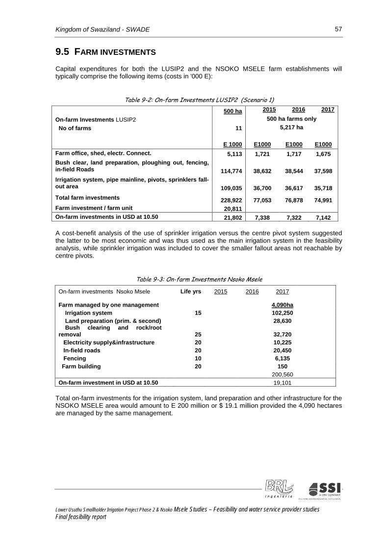
Kingdom of Swaziland - SWADE 57
9.5 FARM INVESTMENTS Capital expenditures for both the LUSIP2 and the NSOKO MSELE farm establishments will typically comprise the following items (costs in '000 E):
Table 9-2: On-farm Investments LUSIP2 (Scenario 1)
500 ha 2015 2016 2017
On-farm Investments LUSIP2 500 ha farms only No of farms 11 5,217 ha E 1000 E1000 E1000 E1000 Farm office, shed, electr. Connect. 5,113 1,721 1,717 1,675 Bush clear, land preparation, ploughing out, fencing, in-field Roads 114,774 38,632 38,544 37,598 Irrigation system, pipe mainline, pivots, sprinklers fall-out area 109,035 36,700 36,617 35,718 Total farm investments 228,922 77,053 76,878 74,991 Farm investment / farm unit 20,811 On-farm investments in USD at 10.50 21,802 7,338 7,322 7,142
A cost-benefit analysis of the use of sprinkler irrigation versus the centre pivot system suggested the latter to be most economic and was thus used as the main irrigation system in the feasibility analysis, while sprinkler irrigation was included to cover the smaller fallout areas not reachable by centre pivots.
Table 9-3: On-farm Investments Nsoko Msele
On-farm investments Nsoko Msele Life yrs 2015 2016 2017 Farm managed by one management 4,090ha Irrigation system 15 102,250 Land preparation (prim. & second) 28,630 Bush clearing and rock/root removal 25 32,720 Electricity supply&infrastructure 20 10,225 In-field roads 20 20,450 Fencing 10 6,135 Farm building 20 150 200,560 On-farm investment in USD at 10.50 19,101
Total on-farm investments for the irrigation system, land preparation and other infrastructure for the NSOKO MSELE area would amount to E 200 million or $ 19.1 million provided the 4,090 hectares are managed by the same management.
Lower Usuthu Smallholder Irrigation Project Phase 2 & Nsoko Msele Studies – Feasibility and water service provider studies Final feasibility report

Kingdom of Swaziland - SWADE 58
9.6 WORKING CAPITAL REQUIREMENTS Working capital under availability of grant conditions for start-ups reduces its requirements. At this stage no grant inflows have been assumed. Sales proceeds from sugar cane will only materialize after approximately 12 months. The estimation of working capital requirements will thus be based on a 12 months production cycle which will materialize gradually suggesting working capital requirements of 6 months. For mixed crops with three production cycles during one year working capital requirements are only 4 months.
9.7 CAPITAL EXPENDITURES – MAIN AND SECONDARY SUPPLY SYSTEM - LUSIP2 AND NSOKO MSELE
The second phase of the LUSIP2 project will extend the Main Canal southwards to bring a further 6,422 ha under irrigation. This will allow an additional extension to be added to further extend the canal also providing water to the 4,090 ha Nsoko MSele area. The irrigable land developed already is mainly planted with sugar cane, and with crops aiming to increase food security in the country. Increases in investment costs of the LUSIP 2 canal resulting from the requirements of the Nsoko Msele have been reallocated from the first to the latter. Off-farm investments include:
Table 9-4: Capital Expenditures – Main and Secondary Supply System – LUSIP2 (scenario 1) Main Supply and Secondary Supply System 2015 2016 2017 Total Main Supply System Life yr E 000 E 000 E 000 E000 Upgrading main canal 50 42,000 42,000 Siphon 1, 2 pipes (5,99 km) 25 50,000 60,000 63,000 173,000 Main Canal incl. siphon 2 50 68,000 68,000 70,000 206,000 Secondary Supply System Pipe Network 25 55,000 64,000 65,000 184,000 Pump stations 15 40,000 40,000 80,000 Transformer 15 27,000 27,000 Other works(roads, drainage 25 21,000 40,000 61,000 SCADA system 15 10,000 10,000 Total Capital Expenditures(new area) 215,000 253,000 315,000 783,000 In USD at 10.50 20,476 24,095 30,000 74,571 Poortzicht upgrade 43,000 In USD at 10.50 4,095 Riverside Farm 0 In USD at 10.50 0 Miscellaneous expenditures: Resettlements, project administration, Impact mitigation (cattle troughs) Project Management/Co-ordination Construction supervision Support to farmers and training Resettlement, project management 30,000 35,000 35,000 100,000 In USD at 10.50 2,857 3,333 3,333 9,524 Total Capital Expenditures 245,000 288,000 350,000 883,000 In USD at 10.50 23,333 27,429 33,333 84,095
Reduced Capex allocated to project In USD at 10.50
70%
171,500 16,333
201,600 19,200
245,000 23,333
618,100 58,867
Lower Usuthu Smallholder Irrigation Project Phase 2 & Nsoko Msele Studies – Feasibility and water service provider studies Final feasibility report

Kingdom of Swaziland - SWADE 59
Total capital expenditures for LUSIP 2 total E 883 million or USD 84 million. 70% of the capital expenditures are directly allocated to the project while the remaining 30% represent an expenditure which will also benefit other future projects and is considered seed money for regional development for which water is a prerequisite. LUSIP1 appeared to use a split of 56%.
Table 9-5: Capital Expenditures – Main and Secondary Supply System – Nsoko Msele Capital Expenditures Nsoko Msele Extension of Main Supply Syst. 2015 2016 2017 Total Life yrs E 1000 E 1000 E 1000 E 1000 Preliminary & General costs 0 19,000 19,000 19,456 57,456 Extension of Main Supply Syst. 50 62,000 62,000 62,480 186,480 Pipe and syphon 25 49,000 48,409 97,409 Dam E 50 8,000 8,000 7,546 23,546 Dam F 50 1,700 1,774 3,474 Bulk Pump Station 2000 ha 15 4,000 8,183 12,183 Bulk Pipeline to Dam F 25 38,311 4,000 42,311 F1 Canal (Dam E to F) ) 0 + Drainage Culverts (Canal F) ) 50 9,000 10,334 19,334 Pump Station 2x2000 ha 15 4,500 10,862 15,362 Pipelines 2x2000 ha 25 38,000 38,072 76,072 Pump station C2 to Dam E 15 16,062 16,062 Bulk pipeline pump station to E 25 9,875 9,875 Project Management, surveys 0 16,000 16,000 17,092 49,092 Contingency 0 10,000 20,000 21,711 51,711 Total 115,000 285,573 259,794 660,367 In USD at 10.50 10,952 27,197 24,742 62,892 Allocated directly to project 80,500 199,901 181,856 462,257 In USD at 10,50 7,667 19,038 17,320 44,024
Total capital expenditures for Nsoko Msele total E 666 million or USD 63 million. 70% of the capital expenditures are directly allocated to the project while the remaining 30% represent an expenditure which will also benefit other future project and is considered seed money for regional development for water is a prerequisite.
9.8 FARM INCOME – PRICES AND YIELDS The farm gross income depends on yields and obtainable prices. Farm gate prices for sugarcane are based on the output of sucrose calculated at a 13.8% or 13.6% extraction rates. Prices have gone up tremendously over the past few years. The final 2011/12 price for sucrose was E 2,252/ton.
The budget price for the 2012/13 season was E 2,621/ton ending up in a final price of E 3,300/ton, while the budget price for 2013/14 is presently at E 2,900 and expected to end up at a level of about E 3,100/ton. This development is contrary to the development of world market prices. Being able to operate in preferential markets makes the reference to world market prices often irrelevant and offers at present a price mark-up of 40% over world market prices. This situation will still last up to September 2014, after which date the EU preferential trade agreements will cease.
Lower Usuthu Smallholder Irrigation Project Phase 2 & Nsoko Msele Studies – Feasibility and water service provider studies Final feasibility report

Kingdom of Swaziland - SWADE 60
An Economic Partnership Agreement (EPA) between Swaziland and the EU is supposed to replace past preferential trading arrangements. This agreement is not yet signed and for example for raw sugar a tariff of € 339 plus some € 100 for refining and the same amount for shipping would make it difficult to sell sugar to the EU market. However, there is a conviction that the EPA will be signed in time. This would confirm the local position that long-term developments of farm gate prices would not weaken. So far, the sugar world market price (No.11 Sugar Futures Contract) was 26.41 c/lb in November 2011 and has gradually been declining to the present March 2014 price of 17.67 cts/lb. Declining world market prices can be a result of global sugar production rising faster than consumption or simply due to recessionary trends affecting demand. The final implementation of the EU sugar market reform will point towards a downward direction of sugar prices while in general, prices in agriculture tend to rise. One should still remember that much of the sugar has so far been and will most likely continue to be traded with trading blocs (SADC and EU).
This makes world market prices not the most appropriate benchmark for determining the ‘right’ economic price. In the base case of the feasibility study the price of E3,100 has been applied. As a matter of interest the LUSIP I study considered a long term sugar price of E1,710.
The proceeds from sugar sales are shared between growers and millers with 68.1% and 31.9% respectively.
Yields differ according to the soil class on which sugarcane is grown and on management practices. Sugarcane yields used in the feasibility evaluation have been determined as follows:
Table 9-6: Adopted yields Yields - LUSIP2 Communal Commercial
Very suitable soil: S1 115 tons/ha 127 tons/ha Suitable: S2 105 tons/ha 116 tons/ha Marginally suitable: S3 95 tons/ha 105 tons/ha Very shallow soils: N1 85 tons/ha 94 tons/ha
Yields – Nsoko Msele
Very suitable soil: S1 130 tons/ha Suitable: S2 120 tons/ha Marginally suitable: S3 110 tons/ha Very shallow soils: N1 90 tons/ha
A selective number of mixed crops could be envisaged as alternative options for making best use of the available water sources. Sugarcane is a well-established crop and with good yields can generate a reasonable to good income to farmers. Maize and beans may qualify for such potential alternative crops.
Farm gate prices for maize range from E 2,800 to E 3,000/ton. The National Maize Corporation (NMC) is presently offering E 2,435/ton and asking for permission to raise the price to E 2,735/ton. However, only 7% of the maize sold is marketed through NMC. Better prices are obtained at the informal market and considering that maize cops are sold at E 2/cob (30,000 – 37,000 cops/ha during a very short period after harvesting)) farm gate prices would by far exceed prices offered by NMC. Maize is harvested in April/May and prices will drop also due to rain-fed produced maize supplies from S.A. to below E 3,000. Available data on the economics of maize are promising but require more research and much more specific tested gross margin calculations taking into account the requirements for a more sophisticated marketing organisation, transport and storage facilities presently not available. Also the economics of mixed crop production needs to consider losses from planting to the post-harvesting stage. At a workshop held with staff from SWADE and the Ministry of Agriculture interesting data for the production and marketing of mixed crops emerged based on two production cycles of beans and one cycle of maize. However, yields and prices were projected in very optimistic terms, but have invited further studies and implementation strategies.
Lower Usuthu Smallholder Irrigation Project Phase 2 & Nsoko Msele Studies – Feasibility and water service provider studies Final feasibility report

Kingdom of Swaziland - SWADE 61
9.9 O & M COSTS
Table 9-7: Annual O&M cost for LUSIP 2 and Nsoko Msele
Annual O&M E 1000 E 1000 E 1000 E 1000 Charged to
Old New Reallocate O&M Project
LUSIP 2 + LUSIP2ext 70%
Management service provider 12,000 64% 7,680 -7,680 0
Water Board 1250 64% 800 -800 0
Nsoko Msele: CAPEX 0
Nsoko Msele 0.6% of E 454,671 454,671 1.00% 4,547
Nsoko Msele 3% of E 53,485 53,485 3% 1,605
350,664 6,151 2376 8,527 5,969
Lusip 2: 0
LUSIP 2 0.6% of 706,000 706,000 1.00% 7,060
LUSIP 2 3% of 77,000 77,000 3% 2,310
783,000 9,370 6419 15,789 11,052
Contingency 10% 3,150 10% 315 -315 0
Total 24,316 0 24,316 17,021 In USD at 10,50 LUSIP 2 Nsoko Msele Total annual O&M expenditures
‘000 USD 1,052 568 1,620
Total annual O & M expenditures have been calculated to amount to E 11 million for LUSIP2 and E 6 million for NSOKO MSELE based on 0.6% of infrastructure investments and 3% for pumping stations and electrical works.
The feasibility study assumes that a management provider will be appointed to be in charge of the operation and maintenance work of the canal system for all phases of the LUSIP project. Thus only 64% of the management costs have been allocated to LUSIP 2 and Nsoko Msele . The same rationale applies also for O&M costs in terms of attributing benefits and costs of the bulk water carrier also to other beneficiaries and society in general in the project area. This suggested to reduce the O&M costs to an estimated 70% of the total costs.
Lower Usuthu Smallholder Irrigation Project Phase 2 & Nsoko Msele Studies – Feasibility and water service provider studies Final feasibility report

Kingdom of Swaziland - SWADE 62
9.10 DETERMINATION OF FARM INCOMES WITHOUT PROJECT Sample assessments have not been conclusive, as the data available were insufficient. The farm income that is generated in the project area at present has therefore been estimated globally as follows:
Table 9-8: Assessment of farm income without project
Income/ha without project
Estimated income
Project area incl. existing schemes ha Available new area 5,217 0 MoA 1,145 0 Grazing area 470 23,500 (1LSU/ha x E 50 Remaining area 3,602 hereof not in use 50% 1,801 0 Presently extensive agr.production 1,801 1,080,600 (E 600 x 1801ha Income without project 1,104,100 Income losses with project
2018: E 331 million, 2019: E 662 million From 2020 annually E 1,104 million
The area of the MoA farm planned to be made available for crop production rather than for animal grazing is not expected to affect the farm economics as livestock is moved to other areas. The income of the remaining part of the new area has been estimated from existing grazing areas according to the number of livestock units (LSU). Only half of the remaining new area is used for extensive agricultural production estimated to E 600/ ha. The total income that would have been generated without the project has thus been assessed to E 1104 million annually. As the planting in the new area will take place over 3 years income losses have also been phased in gradually ( 2018: E 331 million, 2019: E 662 million, 2020 and onwards: E 1,014 million)
9.11 WATER AND SANITATION LUSIP2 The project will provide potable water to an initial 3,000 households covering the water supply system and sanitation facilities. This implies implementing technical and managerial improvements to existing water supplies and services and training facility managers, technical staff and pump mechanics, as well the construction of new water supply systems and/or rehabilitation/extension to existing systems as new water sources. The sanitation component comprises the construction of household latrines to cover the whole project area with improved sanitation facilities which according to the Ministry of Health should reach coverage of 100% in the target communities prior to starting water supply activities.
Capital expenditures for the water supply system and 3,000 sanitation units have been calculated at E 17.5 million and E 25.8 million respectively. Six water user units are planned to be established which will maintain the water supply system, manage the pumps and which will be responsible for collection of water fees. The affordability for water fees to be paid has been assessed at 5% of household incomes which has to be matched by a feasible tariff structure still to be designed. Future water users will have to pay to be connected to the supply system, while for sanitation units households have to contribute about 10% of total costs with own labour and partly material.
Lower Usuthu Smallholder Irrigation Project Phase 2 & Nsoko Msele Studies – Feasibility and water service provider studies Final feasibility report

Kingdom of Swaziland - SWADE 63
9.12 THE FINANCIAL AND ECONOMIC FEASIBILITY OF THE PROJECT
9.12.1 Financial evaluation
Sugarcane and as potential alternating crops, maize and beans have been tested for their feasibility. The mixed crop calculations were still very rudimentary as experiences from production under irrigation conditions are limited. The focus will therefore be on the production of sugarcane only. This does not mean other crops cannot be produced. However, it requires much more testing and adoption of good practices by farmers, as well as different and better systems of self-organisation and marketing intelligence for the commercialised production and marketing to be feasible. For sugarcane three scenarios have been established (see table 8.2)
The FIRR calculations are based on 2014 constant prices and cover a 20 year operating period post the initial investment. The financial feasibility and returns derive from:
Net income from irrigated farm operations of the new areas to be developed,
Energy savings made to existing areas by providing water from LUSIP2,
Energy savings enabling existing schemes to survive (PSC scheme),
Capital expenditures for the main and secondary water conveyance system,
Costs for resettlement of farmers, project management, impact mitigation, etc.,
Assessment of foregone farm incomes without the LUSIP2 project, and
Investments and operations from the water and sanitation project
While there is a clear linkage between the capital investment for the main canal, dams and feeder canals and the other project components it will be argued that the bulk water carrier is to be considered as a much broader support for and as catalyst for regional development. It is suggested that the water supply should be considered as a public good provided and financed by the government for which an appropriate cost recovery policy has to be developed. Cost recovery could for example be achieved by affordable water fees and future taxes receipts from project beneficiaries. While still presenting the FIRR rate for the project as a whole the feasibility of farming should not depend on the full cost recovery of the canal investment but rather produce returns which would allow debts to be serviced, fees for investment cost recovery to be considered and a reasonable household income to be attained. The project area is poverty stricken and financial returns must not be the only measure to determine the delivery of some essential services.
Above considerations suggests that only 70% of capital costs and O&M costs are attributed to the project and that three FIRR figures would determine the feasibility of the project. These are the FIRR for farming with its on-farm investments only, the FIRR for on-and off-farm investments at original costs, as well as the FIRR for the reduced capital costs considered allocated to the project.
FIRR rates are computed for the LUSIP 2 new area, for all farming areas including commercial farmers and for the extended LUSIP 2 project with its milling and cogeneration activities. FIRR rates for the two options are presented:
existence of one mill in project area (Ubombo mill)
existence of two mills in the project area (Ubombo and Nsoko) (three scenarios are assessed)
Lower Usuthu Smallholder Irrigation Project Phase 2 & Nsoko Msele Studies – Feasibility and water service provider studies Final feasibility report

Kingdom of Swaziland - SWADE 64
The Nsoko Msele agricultural scheme will not be developed without the milling and cogeneration activities. The feasibility study takes account of this interdependence and both the cash flow for the farm and the mill operation will provide the basis for determining the viability of the project. Cash flow data from the mill have been taken from the mill feasibility study prepared during April 2014. Dividends are paid to both the shareholders of the mill (92%) and of the farm (8%), but only including the dividends would not take into account the capital investment costs from which the dividends originate. Cash flows including investments, revenues and operating costs reflect in a more appropriate manner the overall viability of the project. As with other capital investments with a lifetime longer than 20 years, their residual values have been recorded as income in year 3+20 (2037). In the case of the mill with an initial investment cost of E 2.5 billion, the residual value in 2037 has been accounted for with E 1.5 billion. The new mill is dependent on and at the same time an important contributor to the outcome of the feasibility of the LUSIP project and thus treated as an income / benefit to the project. Other key assumptions are presented in table 8.8. LUSIP2 would be operated by approximately 11 bigger farm companies, while NSOKO MSELE is assumed to be operated as a commercial farming entity which details have to be agreed between milling company and the chiefdoms. In case all sugarcane has to be delivered only to the Ubombo mill, transport rates would be E 45/ton and E 66/ton for cane delivered from LUSIP 2 and existing NSOKO MSELE production areas. When two mills are in operation, transport rates would decline to E 24/ton and E0 20/ton respectively due to shorter average distances – which has a material impact on the long term profitability.
Table 9-9: Basic assumptions (Base case) – sugarcane only
Item LUSIP 2 Nsoko Msele Sucrose price (E/t) 3,100 3,100 Sucrose content (%) 13.8 13.6 Yield (ton/ha) 104 118 Farm size 11 x500 ha 2x 2,000 ha Haulage (all deliveries to Ubombo) E 45/tc E 66/tc Haulage (shared between Ubombo and Nsoko) E 24tc E 20 tc
Option 1 and 2 as well the three scenarios for the Nsoko Msele (Nsoko mill) scheme will be assessed optimizing land use, costs of capacity limitations and of logistics.
Table 9-10: Scenarios of feasibility study area
Existing farms Scenario base 1 2 LUSIP2 ha 455 455 455
PSC ha 750 750 750 Riverside ha 0 1,000 1,000 sub-total ha 1,205 2,205 2,205
New farming area LUSIP2 ha 5,217 4,217 5,217
Nsoko Msele ha 4,090 4,090 4,000
sub-total ha 9,307 8,307 9,217 Total 10,512 10,512 11,422
Lower Usuthu Smallholder Irrigation Project Phase 2 & Nsoko Msele Studies – Feasibility and water service provider studies Final feasibility report

Kingdom of Swaziland - SWADE 65
Scenario 1 covers a production area of 10,512 ha. Scenario 2 reduces the LUSIP 2 area above 180m of class 2 and 3 soils at the account of the inclusion of the Riverside farm and additional costs for pipe network. Scenario 3 adopts almost the original area size , reduces the Nsoko Msele area slightly because of capacity limitations and increases the investment for a water volume increase of one dam (Dam E) from 3 to 9.7 MCM.
Table 9-11: IRR for sugar cane production for one mill and two mill options
FIRR LUSIP 2+ Nsoko Msele Ubombo
Mill Ubombo and Nsoko Mills Scenario base base 1 2 Ha 10,512 10,512 10,512 11,422 IRR IRR IRR IRR On-farm operation New area 39.0 47.2% 45.8% 48.8% New area + exist+ Poortzicht 47.2 56.0% 40.8% 43.7% Nsoko Msele 29.7% 29.7% 29.4% All area IRR 38.2% 34.0% 35.5% On-off farm after original Capex New area 3.7 4.9% 2.8% 5.1% New area + exist+ Poortzicht 5.3 6.4% 4.4% 6.4% Nsoko Msele 13.2% 13.2% 13.0% All area IRR 11.8% 11.4% 11.6% On-off farm after reduced Capex New area 6.9 8.2% 6.1% 8.4% New area + exist+ Poortzicht 8.0 9.4% 7.1% 9.3% Nsoko Msele 13.9% 13.9% 13.8% All area IRR 13.1% 12.8% 13.0% Note: Ubombo mill scenario is comparable to the Ubombo/Nsoko mill scenario (scenario 1)
The FIRR rates are based on cash flows before financing costs, before dividend payment to farmers from operational incomes and before making any significant contribution to the cost recovery for the water supply system.
Farm operations are feasible when an appropriate cost recovery policy is in place. This means that surplus from operations should be able to cover debt service and payment to farmers, but only to a certain extent the costs of the bulk water carrier in order to jeopardize the economy of the farmers. Poortzicht farm operations become highly profitable when pipe networks are not required. The lower FIRR of 39.0% for the new area (LUSIP 2) and the 47.2% for the extended area including commercial farmers (Nsoko Msele ) compare with the two-mill option rates of 47.2% and 56.0% less favourably because of higher transport costs. The one-mill option excludes the implementation of the Nsoko Msele option, as no farm would be established without the new mill due to the economic distances to the existing mill.
Taking into account the cash flow including the original capital investment costs then the IRR for only the one-mill option is 5.3% compared to the two-mill option amounting to 11.8%- 11.4%. IRR differences between the three two-mill scenarios are not very significant.
Lower Usuthu Smallholder Irrigation Project Phase 2 & Nsoko Msele Studies – Feasibility and water service provider studies Final feasibility report

Kingdom of Swaziland - SWADE 66
The case has been made for considering the canal investment costs also as a cost benefitting regional development and as catalyst for other projects reducing the original capital investment by 30%. The IRR of the two-mill option being between 13.1% and 12.8% exceeds the one-mill option being only 8%.The two mill option reduces transport costs, improves returns on the total infrastructure investment, will result in a E2.5 billion new 4th sugar mill and will have a great development impact on the whole south east of Swaziland with all the potential spin-off activities and other indirect but also additional direct impacts emerging
An approximate household income for 2,000 households in the LUSIP 2 area ( the number is constantly rising) would in the beginning generate an income from dividends and also from farm and maintenance labour after on-farm debts have been serviced of E 10,000-20,000 quickly rising to E 40,000 after 4-5 years of operations. The household income in the Nsoko Msele would be much higher due to the number of fewer households in the chiefdoms rising from E 60,000 to E 100,000 within the first five years. In total about 4,500 direct job opportunities would materialize from on-farm labour (on average 9 months/job), from maintenance activities of the canal and dams as well as from the mill operation (500- 600). This will be a significant project for the region with large significant poverty alleviation impacts.
9.12.2 Economic evaluation
Economic analysis adjusts benefits and costs streams of the financial analysis by excluding all taxes, customs duties and other transfer payments. Traded goods are converted to border prices; non-traded goods are valued at shadow prices or at a conversion factor and labour costs are valued at opportunity costs.
Table 9-12: EIRR for sugar cane by farming area (base case – two mills in operation)
Summary EIRR-rates One mill Two mills
Sensitivity Sucrose Price –EIRR (two mills)
On-Farm EIRR EIRR -20% -10% 10% 20% New Area 27.6% 34.8% 15.0% 24.4% 46.9% 61.2% New Area+Exist+PSC 32.6% 40.1% 17.2% 27.9% 54.5% 72.0% Nsoko Msele 21.5% 8.1% 15.0% 28.0% 34.6% All On-Farm 28.2% 12.2% 20.2% 36.6% 45.2% On+Off Farm Original New Area 2.1% 3.6% -1.8% 1.1% 5.8% 7.8% New Area+Exist+PSC 3.5% 4.9% -0.9% 2.3% 7.3% 9.4% Nsoko Msele 12.9% 12.1% 12.5% 13.3% 13.7% All On+off farm Original 11.5% 10.0% 10.7% 12.2% 12.9% On+Off Farm Reduced New Area 5.1% 6.8% 1.0% 4.1% 9.2% 11.4% New Area+Exist+PSC 5.8% 7.5% 0.6% 4.4% 10.3% 12.9% Nsoko Msele 13.6% 12.8% 13.2% 14.0% 14.4% All On+off farm Reduced 12.7% 11.1% 11.9% 13.4% 14.2%
It has been argued above why the application of world market prices for the economic evaluation may not be relevant. On the other hand the future of any market protection is until further notice (possibly by end of 2014) rather uncertain. The world market price for sugar was as of 14th March, 2014 at $ 0,175/lbs, which would correspond to a converted farm gate price of E 2,029. As the SACU price may keep its value a blended border price would be about E 2,465 (blended prices of estimated E 2, 900 SACU-price + E 2,029 world price converted to farm gate price considering sharing of proceeds between the farmers and the mill).
Lower Usuthu Smallholder Irrigation Project Phase 2 & Nsoko Msele Studies – Feasibility and water service provider studies Final feasibility report

Kingdom of Swaziland - SWADE 67
Considering the poverty incidence and high unemployment in the area labour costs have been revalued at opportunity costs with a factor 0.2 – 0.3. No other price distortions could be accounted for, as taxes and subsidies are not applied for most of the cost items affecting this project and most financial prices thus are close to or equal to economic prices.
The proposed reduction of the original capital expenditure costs by 30% attributable to other regional development aspects may be also considered as a compensation for the difficulty in pretending to be able to identify in monetary terms the indirect benefits and job creation opportunities which undoubtedly will arise from the project.
Adjusting mainly labour costs and farm gate prices the EIRR has been established at 12.7% which compares favourably with an opportunity cost of capital of 7%-8%. The impact of establishing the opportunity cost of labour and the border price for sugar are offsetting each other and produce thus an EIRR which is close to the FIRR. The two-mill option is also in economic terms better than the one-mill option and is considered to make an important contribution to the development of the region.
9.12.3 Funding considerations
Different project components will require different types of funding as set out in the table below.
Table 9-13: Funding considerations
Project component Beneficiaries Type of funding
1. Canal (LUSIP2 + Nsoko Msele )
Growers of 10,000 ha of land and communities of south east Swaziland
Direct Bilateral Government funding through Swaziland Ministry of Finance
2. LUSIP 2 Agricultural operations
LUSIP 2 communities Development finance funding. Where applicable possible equity investment of operator Possible EIA for irrigation component
3. Nsoko Msele agricultural operations
3 Chiefdoms not currently benefitting from LUSIP 2 4 commercial farmers
Combination of development finance funding with possible equity investment of operator Possible EIA for irrigation component and private commercial bank funding
4. Nsoko Msele Integrated Sugar Mill
Split shareholding: International Strategic opera-ting partner, 3 Chiefdoms Commercial farmers Tibiyo / Other land
Private limited recourse project funding:
1) Export Credits 2) Commercial banks 3) DFIs
The financing of all project components are based on a detailed feasibility study process and a subsequent finance raising process.
Lower Usuthu Smallholder Irrigation Project Phase 2 & Nsoko Msele Studies – Feasibility and water service provider studies Final feasibility report

Kingdom of Swaziland - SWADE 68
For the Canal (LUSIP2 + Nsoko Msele ) Investment at least 20 years finance is required with 5 year capital moratoriums at ‘preferred interest rates’. (Swaziland Ministry of Finance).
For the LUSIP2 agricultural operations 8 year finance plus 18 months moratorium at low and/or subsidized rates would be required, possibly with leverage of Euro exposure (Development bank or legal entity to be set up).
For the Nsoko Msele agricultural operations as for LUSIP2 above.
For Nsoko Msele Integrated Sugar Mill 10 year finance, 30 months capital moratorium in both Euro and local currency.
9.13 CONCLUSIONS AND RECOMMENDATIONS The LUSIP project area has a high poverty incidence, assists an area that suffers from the lack of economic opportunities, high unemployment and reflects notably the high income inequality of the country. The project aims subsequently to address the issue of poverty alleviation by means of supplying water to transform the local economy from poor rain-fed subsistence farming into a sustainable commercialised agricultural subsector – based on an agricultural sub sector for which Swaziland has a proven and sustainable track record of delivery in the international markets.
Apart from implementing the LUSIP2 scheme of over 5,000 hectares and extending the LUSIP1 phase water supply system, another scheme (Nsoko Msele ) is planned to be implemented with an additional extension of the water supply system and another 4,000 hectares for irrigation. The Nsoko Msele scheme will only materialise when also a mill producing sugar, ethanol and energy can be established. Major justifications for the mill are the substantially reduced transportation costs. The inclusion of the Nsoko Msele and the associated benefits from the new mill provide significant increased benefits to the overall project analysis/viability.
Sugarcane is a well-established crop in the area and is a well organised and functioning agricultural sub-sector in Swaziland. Despite many arguments for diversification the production of sugarcane remains a reliable source of income generation. Closer cooperation between smallholders and commercial farmers could improve productivity of an otherwise underperforming agricultural sector. The large scale farmers of the Nsoko Msele scheme would offer farmers of three chiefdoms both land and the use of land as paid-in equity capital, as well as benefitting from commercial farm management. Other mixed crops have been tested for their feasibility. There are promising opportunities, but to exploit them requires improved extension services, better farmers’ self-organisation and development of marketing systems. Total capital investment both direct and indirect from this project are shown in the table below.
Table 9-14: Capital Investment (direct and indirect) Capex in E million LUSIP 2 Nsoko Msele On-farm investment 299 275 574 Canal, dams 891 660 1,551 LUSIP Agriculture 1,190 935 2,125 Mill 2,500 2,500
On-farm investment will amount to E 574 million. E 1.5 billion are investments into the main and secondary water supply system, while from other investors a E 2.5 billion cogeneration mill will be constructed. The FIRR for the project is promising when implementing both the LUSIP 2 and the Nsoko Msele schemes jointly. LUSIP 2 on its own would be reliant on haulage to the Ubombo sugar mill (over 40 kms average), while a new mill would reduce transport costs for part of the Ubombo transports and for all new area production in the Nsoko Msele scheme (circa 10 kms average trip).
Lower Usuthu Smallholder Irrigation Project Phase 2 & Nsoko Msele Studies – Feasibility and water service provider studies Final feasibility report

Kingdom of Swaziland - SWADE 69
Recognizing the importance of the capital investment to the development of the south east region of Swaziland a 30% share of the water supply capital investment costs and their maintenance has been apportioned to the general development agenda of the region reducing total costs allocated to the project. The FIRR for the LUSIP2 project only depending on one mill in view of the original investment costs is 5.3% compared to 11.8% when two mills are in operation. Taking into account the wider development impact of the project and reducing thus the capital costs allocated to the project the FIRR is 8.0% if depending on one mill only, and 13.1% if two mills were in operation in the region.
Table 9-15: Original and reduced CAPEX
Case Original Reduced Capex FIRR Ubombo mill only 5.3% 8.0% Ubombo and Nsoko 11.8% 13.1% EIRR Ubombo mill only 3.5% 5.8% Ubombo and Nsoko 11.5% 12.7%
This is a reasonable level of return for this type of investment along with the associated impacts for the region. Subsequent developments should have higher incremental returns due to the leverage off the existing infrastructure. Labour costs have been valued at opportunity costs and an economic price for sucrose has been established using a blend price of SACU and world prices in order to arrive at the EIRR of 12.7% for the two- mill option.
There are risks involved. The sugar market is volatile and long-term sugar price developments are uncertain. Swaziland supplies sugar to the SACU block countries and the EU. Preferential market treatments with the EU will cease and sugar production quotas in the EU abolished. The EU may even turn out to become a sugar net-exporter. Local long-term forecasts are less fearful of any price collapse. One condition would be for the Swaziland Government to sign the Economic Partnership Agreement with the EU, mitigating the cessation of present preferential trading arrangements. It is said that the agreement will be signed in time.
The FIRR for the on-farm operation indicate that farmers will be able to service their debts and to obtain dividends from their sugarcane production. It is strongly recommended that the Swazi government takes responsibility for the infrastructure investment and determines a cost recovery policy which ensures that project beneficiaries participate in the cost recovery through water fees and taxes according to affordability.
Many farmers are farmers by default. Some would qualify to be good farmers, while others may wish to leave for other professions which would be important to develop and diversify the economy. Therefore a system needs to emerge which allows farmers to sell their share of land facilitating the commercialisation of agriculture. Previous loan facilities accessible to community farms have been too costly and not helpful as well as relating to sub-optimal scale farming operations and long distances to the existing mills. While all other stakeholders in the supply chain have been paid their dues, farmers often had no other options than to incur debts. This must at any price be avoided. An apex organisation providing professional assistance to farms could assist in channelling professional advice and supervision to farmers companies.
The LUSIP2 and Nsoko Msele project would have a significant impact on the region. Innovative new approaches would durably benefit including communities/out grower schemes in long term sustainable projects. (See also Chapter 8.2).
Lower Usuthu Smallholder Irrigation Project Phase 2 & Nsoko Msele Studies – Feasibility and water service provider studies Final feasibility report

Kingdom of Swaziland - SWADE 70
10 ESIA/EIA
10.1 LUSIP2 The ESIA component of the LUSIP2 Feasibility Study presented the following conclusions and recommendations:
Strategic Environment Assessment: there is a need for the Swaziland Government to conduct a Strategic Environment Assessment on Agricultural development in the country. This needs to done to ensure that as agricultural development is planned in the country, this is done in line with other competing land uses, and taking into account food security issues. This would also ensure that natural flora and fauna are not lost, as a mapping of biodiversity rich areas would be preserved and conservation related income generation activities are also implemented.
Crop Diversity and access to food: with the challenges of climate change, which impacts on crop water requirements, there is need to investigate the commercialization of other crops, which may also be mixed with the sugarcane, while gradually finding new channels of commercialization of other crops. This way, adaptation to the effects of climate change would be easier as there would be other options that had been tried over time. Another threat that needs to be addressed is the issue of sugar prices, which may affect the profitability of sugar cane farming if there is increase in global sugar supply.
Livestock management: livestock commercialisation also requires policy initiatives that would make the livestock industry to be attractive in terms of prices and those to control overstocking problems.
Training: the sustainability of the commercial farming in the community is highly dependent on the level of preparation and training of the farmers on business management, forming farmers associations, conflict resolutions, and cost management. In addition there is a need for farmers on environmental management in the farms.
Climate change and Water Conservation and Demand Management: there is need for a climate change national framework as it is difficult to implement/plan for adaptation. Sugarcane will be less vulnerable to climate change due to irrigation but the predicted reduction in precipitation and increased temperatures will affect the crop.
Finance and Funding: considering the fact that the farms are developed under 100% loans from banks, it is important that the current funding mechanism is revised to be able to realise the intended objective of poverty alleviation and for the sustainability of these farms. The Government can look into other options such grants or loans at lower interest rates. The above situation suggests that there is a strong and urgent need for financial restructuring of both seasonal loans and capital investment loans. Financial restructuring of existing loans is essential, since without it smallholder farmers will see no personal benefit from the implementation of measures to improve yields, increase sucrose content and reduce seasonal costs.
Poverty alleviation: such a picture indicates that development should not just be viewed as a matter of growth in per capita income since it is possible to record a high growth rate in per capita income while the masses of the people continue to be in abject poverty and lacking in the basic necessities of life. An important objective of the projects and programmes therefore must be to spread the benefits of economic development such that the Swazi farmers experience a marked improvement in their standard of living.
Lower Usuthu Smallholder Irrigation Project Phase 2 & Nsoko Msele Studies – Feasibility and water service provider studies Final feasibility report

Kingdom of Swaziland - SWADE 71
Operational Phase Farmer’s Environmental Management: after the formation of the farmer associations, it is critical for each farmer association to develop its Comprehensive Mitigation Plan. This will be specific to the issues relevant to the environmental management of the association, and allocation of responsibilities in each organization’s specific set up. SWADE should help facilitate this, as part of its training, so that issues of environmental management, health and safety are not left behind.
10.2 NSOKO MSELE The EIA studies for Nsoko Msele are implemented under a contract between Nsoko Msele and SIVEST, an EIA consulting firm with office in SA and Swaziland. The studies are ongoing. Below is a detailed account of the EIA process and the communication with the Swaziland Environmental Authority (SEA) undertaken to date by SIVEST, the EIA consultant for Nsoko Msele.
A Project Brief for the proposed project was submitted to the Swaziland Environmental Authority (SEA) by IC Development Consultants on the 9th July 2012.
The SEA responded to the Project Brief on the 30th July 2012, stating that the proposed project was in fact a Category 3 project in accordance with the Environmental Audit, Assessment and Review Regulations, 2000. As such, Nsoko Msele were requested to prepare and submit an environmental impact assessment and a comprehensive mitigation plan (EIA/CMP). The reference number for the project was allocated (SEA/PRJ/5.03)
The Scoping Phase for the proposed development commenced in March 2013 and SIVEST were appointed
The initiation meeting with the project specialists was conducted on the 06th March 2013. This was an introductory meeting with the Swaziland specialist, as it was agreed with the client that it would be best to use local specialists in Swaziland as they are familiar with the Swaziland legislation. This was duly undertaken.
Between the 21st March 2013 and 5th April 2013, newspaper advertisements and radio broadcast were done, this was aimed to notify all Interested and Affected Parties (I&APs) of the proposed development and to inform all I&APs of the public meeting the public meeting. The public meeting was conducted on the 06th April 2013 with an attendance of approximately 250 people.
Subsequent to meetings with Nsoko Msele, it was indicated that the proponent wished, at that stage, to increase the agricultural area to be included in the study area. A discussion was held between IC Development Consultants and with the SEA, Mr. Mboni Dlamini (the Director of Environmental Assessment). He stated that such a development will be treated separately from that of the sugarcane processing mill due to the fact that the growing of sugarcane in the area is an ongoing practice which would not present new impacts on the receiving environment. The environmental impacts of growing sugarcane and those of processing the crop are totally different thus should be treated separately.
A Draft Scoping Report (DSR) was compiled and submitted to the client for review and comment on the 25th June 2013.
Then the Final Scoping Report (FSR) was submitted to SEA on the 16th July 2013. This FSR included a map of the entire study area, including all of the agricultural areas. SEA have been fully aware of the agricultural areas and activities included in the proposed project.
The response from SEA was received on the 14th August 2013 stating that FSR was accepted and further stipulated conditions which the EIA phase needed to adhere to, none of these conditions referred to additional Agricultural specialist studies. The SEA requested that the proposed EIA be split into five (5) EIA’s
Lower Usuthu Smallholder Irrigation Project Phase 2 & Nsoko Msele Studies – Feasibility and water service provider studies Final feasibility report

Kingdom of Swaziland - SWADE 72
A meeting following the above SEA correspondence was held between the consultants (SiVEST and IC Developments) and SEA on the 29th August 2013. The meeting aimed to request SEA that the proponent conducts at only one EIA, and SEA requested a motivation report supporting such request be submitted.
At the meeting on the 29th August 2013, the SEA confirmed that the Agricultural activities in the area are not of a major concern in terms of Environmental impacts. This being due to the fact that the area is currently under existing agricultural (sugarcane) practices and that the Agricultural activities may not need Environmental Authorisations and these may already be in place. Hence the farms that have Environmental Authorisations need only an updated CMP. See minutes of this meeting attached.
On the 3rd October 2013, a Motivation Report was submitted to SEA. Motivation Report, this included the presentation that was made to SEA during the meeting on the 29th August 2013, the maps including the entire study area and the minutes of the meeting held with SEA. In these minutes it clearly stated that the agricultural areas would only require an updated CMP.
The SEA responded to this the motivation report on the 09th October 2013 stating that the EIA/ CMP must be split into three (3) EIAs/CMPs, namely:
One (1) EIA/CMP for the Factory and Ancillary operations
One (1) EIA/CMP for the Distillery and Waste Water Treatment facility; and
One (1) EIA/CMP for the Irrigation Canal (NSOKO MSELE) and Agricultural Activities.
SIVEST have subsequently compiled and submitted a proposal to Nsoko Msele to undertake the above mentioned EIA/CMPs.
Proof of all documentation and communication undertaken between the consultants and the SEA to date is available and can be shown by Nsoko Msele upon request.
Lower Usuthu Smallholder Irrigation Project Phase 2 & Nsoko Msele Studies – Feasibility and water service provider studies Final feasibility report