
LundSnee_Miller_of2015-2_text
42
Text and references accompanying Nevada Bureau of Mines and Geology Open File 15-2 Preliminary geologic map of Cenozoic units of the central Robinson Mountain volcanic field and northwestern Huntington Valley, Elko County, Nevada by Jens-Erik Lund Snee and Elizabeth L. Miller Department of Geological Sciences, Stanford University 2015 Disclaimer: NBMG open-file reports are preliminary. They have not been thoroughly edited or peer reviewed. INTRODUCTION The mapped area is located in the northwestern part of Huntington Valley and the eastern Piñon Range, northeast Nevada (Figure 1). This area includes volcanic, subvolcanic, sedimentary, and metasedimentary rocks ranging in age from Mississippian to Quaternary. The geologic setting is imme- diately east of the east-vergent Antler thrust front and con- tains Paleozoic deposits of the Antler foreland basin (Di- amond Peak and Chainman Formations) and the overlying Antler overlap sequence (Moleen Formation and undifferen- tiated limestone of Pennsylvanian–Permian age) (Smith and Ketner, 1975, 1978; Colgan and Henry, 2009). Paleozoic units have previously been described by Smith and Ketner (1975), Stewart (1980), and Coats (1987), and include quartzite and chert conglomerates of the Mississip- pian–Pennsylvanian Diamond Peak Formation; silty, cliff- forming, cherty limestones of the Pennsylvanian Moleen For- mation; shale and sandstone of the Mississippian Chainman Shale; and undivided platy siltstones and sandstones of Penn- sylvanian–Permian age. Although pre-Cenozoic rocks record important geologic history, particularly of Paleozoic–Mesozoic contraction that took place during the Antler and Sevier orogenies (e.g. Ketner and Smith, 1963; Smith and Ketner, 1975; Trexler and Nitch- man, 1990; Ketner, 1998; Trexler et al., 2004; Dickinson, 2006), detailed mapping of these units was not the focus of the present research. This geologic map focuses on Cenozoic units for their ability to reveal important information about Cenozoic extensional tectonics near the Ruby Mountains– East Humboldt Range (RMEH) metamorphic core complex (Figure 1). The following section describes Cenozoic units within the map area (Figure 1). The results of geochronologic and geo- chemical analyses conducted on these rocks are used here to establish unit ages, relationships, and names, but detailed an- alytical methods, results, and implications are discussed in Lund Snee (2013) and Lund Snee et al. (submitted). The ge- ologic map is based on field mapping conducted during the summers of 2010, 2011, and 2012. UNIT DESCRIPTIONS The mapped area (Figure 1) includes an impressively complete succession of Late Cretaceous(?) to Quaternary sedimentary, volcanic, and subvolcanic rocks (Figure 2). Ge- ologic unit descriptions are drawn from Lund Snee (2013) and are also summarized in Lund Snee et al. (submitted). The results of geochronologic and geochemical analyses con- ducted on these units are mentioned when they help con- strain stratigraphic relationships, but are discussed in detail in Lund Snee (2013) and Lund Snee et al. (submitted). Ref- erenced sample localities are indicated on the map. Where possible, unit names and map symbols have been preserved from Smith and Ketner (1978), but modifications have been made to simplify interpretations and accommodate more re- cent data. Late Cretaceous(?)–Eocene(?) conglom- erate, sandstone, siltstone, and limestone (TKcs) Conglomerate, sandstone, siltstone, and limestone make up the lowest Cenozoic deposits above the unconformity with Paleozoic rocks, where they are often exposed as “redbeds.” Smith and Ketner (1976) differentiated “limestone 1
-
Upload
jens-erik-lund-snee -
Category
Documents
-
view
239 -
download
1
Transcript of LundSnee_Miller_of2015-2_text

Text and references accompanying Nevada Bureau of Mines and Geology Open File 15-2
Preliminary geologic map of Cenozoic units of the central
Robinson Mountain volcanic field and northwestern Huntington Valley, Elko County, Nevada
by
Jens-Erik Lund Snee and Elizabeth L. Miller
Department of Geological Sciences, Stanford University
2015
Disclaimer: NBMG open-file reports are preliminary. They have not been thoroughly edited or peer reviewed.
INTRODUCTION
The mapped area is located in the northwestern part ofHuntington Valley and the eastern Piñon Range, northeastNevada (Figure 1). This area includes volcanic, subvolcanic,sedimentary, and metasedimentary rocks ranging in age fromMississippian to Quaternary. The geologic setting is imme-diately east of the east-vergent Antler thrust front and con-tains Paleozoic deposits of the Antler foreland basin (Di-amond Peak and Chainman Formations) and the overlyingAntler overlap sequence (Moleen Formation and undifferen-tiated limestone of Pennsylvanian–Permian age) (Smith andKetner, 1975, 1978; Colgan and Henry, 2009).
Paleozoic units have previously been described by Smithand Ketner (1975), Stewart (1980), and Coats (1987), andinclude quartzite and chert conglomerates of the Mississip-pian–Pennsylvanian Diamond Peak Formation; silty, cliff-forming, cherty limestones of the Pennsylvanian Moleen For-mation; shale and sandstone of the Mississippian ChainmanShale; and undivided platy siltstones and sandstones of Penn-sylvanian–Permian age.
Although pre-Cenozoic rocks record important geologichistory, particularly of Paleozoic–Mesozoic contraction thattook place during the Antler and Sevier orogenies (e.g. Ketnerand Smith, 1963; Smith and Ketner, 1975; Trexler and Nitch-man, 1990; Ketner, 1998; Trexler et al., 2004; Dickinson,2006), detailed mapping of these units was not the focus ofthe present research. This geologic map focuses on Cenozoicunits for their ability to reveal important information aboutCenozoic extensional tectonics near the Ruby Mountains–East Humboldt Range (RMEH) metamorphic core complex(Figure 1).
The following section describes Cenozoic units within the
map area (Figure 1). The results of geochronologic and geo-chemical analyses conducted on these rocks are used here toestablish unit ages, relationships, and names, but detailed an-alytical methods, results, and implications are discussed inLund Snee (2013) and Lund Snee et al. (submitted). The ge-ologic map is based on field mapping conducted during thesummers of 2010, 2011, and 2012.
UNIT DESCRIPTIONS
The mapped area (Figure 1) includes an impressivelycomplete succession of Late Cretaceous(?) to Quaternarysedimentary, volcanic, and subvolcanic rocks (Figure 2). Ge-ologic unit descriptions are drawn from Lund Snee (2013)and are also summarized in Lund Snee et al. (submitted).The results of geochronologic and geochemical analyses con-ducted on these units are mentioned when they help con-strain stratigraphic relationships, but are discussed in detailin Lund Snee (2013) and Lund Snee et al. (submitted). Ref-erenced sample localities are indicated on the map. Wherepossible, unit names and map symbols have been preservedfrom Smith and Ketner (1978), but modifications have beenmade to simplify interpretations and accommodate more re-cent data.
Late Cretaceous(?)–Eocene(?) conglom-erate, sandstone, siltstone, and limestone(TKcs)Conglomerate, sandstone, siltstone, and limestone makeup the lowest Cenozoic deposits above the unconformitywith Paleozoic rocks, where they are often exposed as“redbeds.” Smith and Ketner (1976) differentiated “limestone
1
B
115.5°116° W
40.75°N
40.5°
40.25°
0 10 20km
CR
RS
RU
BY
M
OU
N
T AI N
S
SMHR
Jiggs
Elko
CarlinLamoilleE LK
O H
I LL S
D I A M O N DH I L L S
WF
DF
? ?
L amo i l l
e Va l l e
y
“Eastern Elko Basin”
“Western Elko Basin”
E A S TH U M B O L D T
R A N G E
CA
RL
I N- P
IÑO
N R
AN
GE
CC
RM
CO
RT
EZ
MO
UN
TA
I NS
Pi n
e V
al l e
y
Hu
nt i
ng
t on
Va
l le
y
Mappedarea
ADO BE RA N
GE
ES
RR IW
S U L P H U RS P R I N G R A N G E
A
OR
CA NV
ID
MT
WY
UT
AZ
116°
44°N
112°W
40°N
SnakeRange
ARG
RMEH
??
Fig. 1B
<36.0 Ma
<29.5 Ma<23.2 Ma
<17.0 Ma
Mar
g in o f S
e v ier
thru
st b
elt
RMA
GA
LFTB
120°
Legend for A
Great Basin(modified from Dickinson, 2006)
Isochrons for southward-sweeping magmatism (modified from Konstantinou et al., 2012)
Eocene–Oligocene continental divide (modified from Henry, 2012 and sources therein)
Challisvolcanicsuite
Idahobatholith
Ye l l ow s t o n e H o t sp o t p
a t h
<43.4 Ma
Clan Alpine& Desatoyamountains
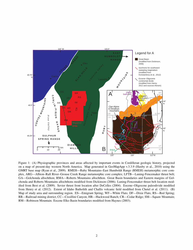
Figure 1: (A) Physiographic provinces and areas affected by important events in Cordilleran geologic history, projectedon a map of present-day western North America. Map generated in GeoMapApp v.3.3.9 (Haxby et al., 2010) using theGMRT base map (Ryan et al., 2009). RMEH—Ruby Mountains–East Humboldt Range (RMEH) metamorphic core com-plex, ARG—Albion–Raft River–Grouse Creek Range metamorphic core complex; LFTB—Luning-Fencemaker thrust belt;GA—Golchonda allochthon; RMA—Roberts Mountains allochthon. Great Basin boundaries and Eastern margins of Gol-chonda and Roberts Mountains allochthons modified from Dickinson (2006). Luning-Fencemaker thrust belt location mod-ified from Best et al. (2009). Sevier thrust front location after DeCelles (2004). Eocene–Oligocene paleodivide modifiedfrom Henry et al. (2012). Extent of Idaho Batholith and Challis volcanic field modified from Chetel et al. (2011). (B)Map of study area and surrounding region. ES—Emigrant Spring; WF—White Flats; DF—Dixie Flats; RS—Red Spring;RR—Railroad mining district; CC—Cissillini Canyon; HR—Hackwood Ranch; CR—Cedar Ridge; SM—Squaw Mountain;RM—Robinson Mountain. Eocene Elko Basin boundaries modified from Haynes (2003).
2
and limestone-clast conglomerate (Tcl)” from “conglomer-ate, sandstone, siltstone, and limestone (Tcs).” Noting greaterangularity of cobbles in conglomerates and lower amountsof silt relative to limestone in their unit Tcl, Smith and Ket-ner (1976) proposed that clasts in this limestone unit weretransported shorter distances than those in the conglomeraticsandstone and siltstone unit (their Tcs). However, the twounits are likely contemporaneous, at least in part (Smith andKetner, 1976). Outcrops of conglomerate are grayer in colorand clasts are more limestone-rich nearer exposures of similarrocks in the underlying Paleozoic sequence, suggesting thatPaleozoic source units are a major contributor to the differentappearances of this unit in outcrop.
For these reasons, it is proposed that Tcl and Tcs of Smithand Ketner (1976) are simply different facies of the same unit,and that differentiating them is counterproductive for strati-graphic purposes. These units are now combined into unitTKcs, which refers to conglomerate, sandstone, siltstone, andlimestone at the base of the Cenozoic section, and includesthe grey limestone clast conglomerates.
Smith and Ketner (1976) determined a maximum thick-ness of 760 m for their Tcs, and 195 m thickness for their Tclbased on map measurements, due to the lack of continuouscoverage of these units. We estimate a total thickness for thisnew combined unit (TKcs) of about 580 m (Figure 2), basedalso on map measurement, which is thinner than previous es-timates. This could be accounted for by differing coverageof bedding readings between the two studies. The best expo-sures of this unit area in the map area are east of Red Spring(e.g. 40.581646°N, 115.764059°W, WGS84; Figure 1B). Beddip is variable, ranging from gentle (~20°) to steep (>60°),and it is gently folded and faulted in places.
TKcs is clearly older than the Elko Formation, based onits stratigraphic position below the Elko Formation and thepresence of dated Cenozoic volcanic material in the Elko For-mation that are not detected in TKcs. This basal unit TKcsmay be correlated with other basal Cenozoic clastic units inthe region, such as the Sheep Pass Formation (Fouch et al.,1979; Moore et al., 1983; Ketner and Alpha, 1992; Druschkeet al., 2009, 2011). Smith and Ketner (1976) found no con-temporaneous volcanic material in these deposits, and detritalzircon analyses (Lund Snee, 2013) likewise detect no Tertiaryage zircons in this unit. Speculative age constraints based onsnail and clam fossils in TKcs are reported to be of Creta-ceous to early Tertiary age (Smith and Ketner, 1976).
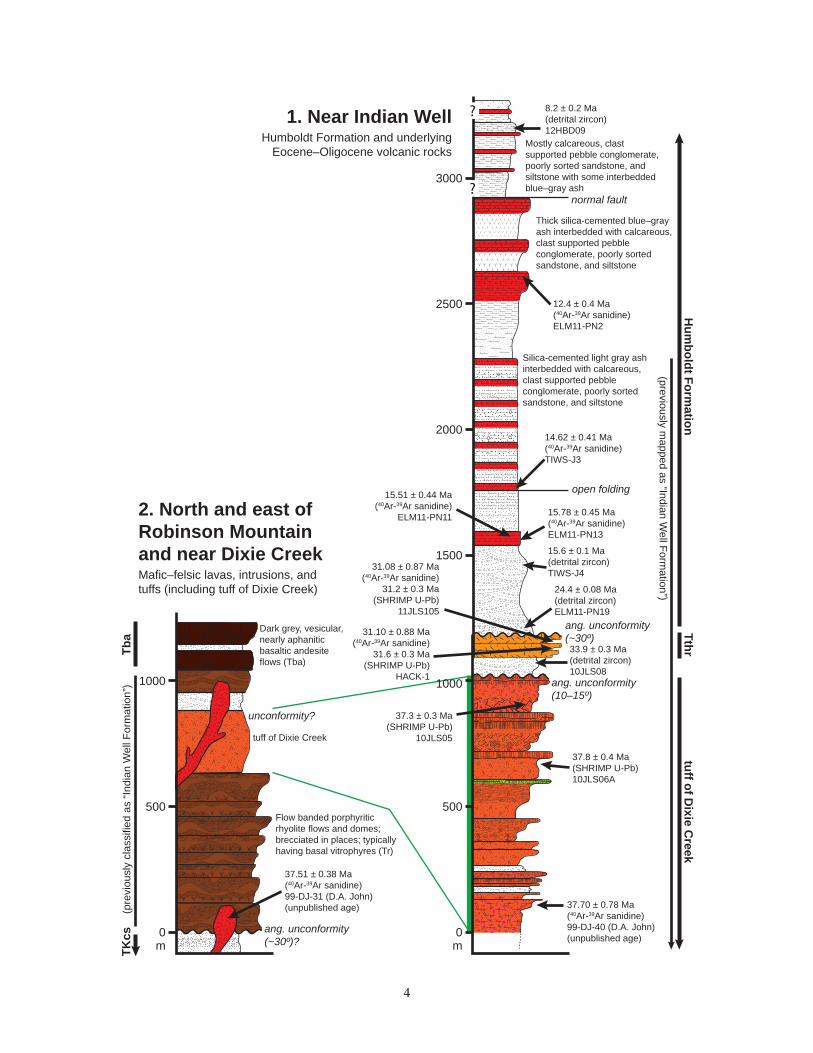
In some places, this unit can be readily identified by redboulder outcrops or exposures of strongly red or orange soil,but it also forms brown, tan, and grey outcrops, predom-inantly of limestone clast conglomerate or platy siltstone,which weather to tan and brown soil (Figures 3A and 3B).Conglomerates often form resistant, bedded outcrops thatrange from clast- to matrix-supported, with a rust-red–orangematrix of sand and silt (Figure 3A). The exteriors of manyclasts are weathered rust-red. Clasts range in size from peb-
bles to cobbles, are derived from local Paleozoic rocks, andinclude siltstone, quartzite, chert, and limestone. Degree ofrounding varies within beds from rounded to angular, sug-gesting varied transport distances. Elongate clasts are oftenaligned and plunge shallowly to the south or southeast.
Outcrop-scale fining upward sequences are observed inconglomerates, with upper layers composed of centimeter- tomillimeter-scale laminations of small pebble to coarse sandclasts in a silt- to coarse sand-sized matrix. Lenses of sand-stone and siltstone, with average grain sizes ranging from siltto coarse sand, are interlayered with conglomerates.
Siltstone and sandstone facies are less resistant than con-glomerates and are typically exposed as platy, angular chipsof tan-, orange-, or brown-weathering float (Figure 3B). Finesandstones and siltstones are more commonly observed at up-per stratigraphic levels in this unit, suggesting rapid erosionof local slopes and transition from alluvial fan (conglomer-ates) to shallow lacustrine (siltstone) settings. A thick succes-sion of TKcs siltstone is exposed east of Red Spring, whereplaty, finely laminated beds dip up to ~70°E (Figure 1B).
In a thin section of pebbly sandstone (sample ELM11-PN16), limestone and minor clay and mud comprise the ma-trix between rounded to angular (mostly subrounded) sandgrains (Figure 3C), and calcite partly fills rare pore spaces.Rust-red staining mantles grain boundaries and forms patcheswithin the calcareous matrix. Volcanic rock clasts are notablyabsent.
Late Cretaceous(?)–Eocene(?) limestone(TKl)
Lower Tertiary limestone (TKl) is exposed east of RedSpring, where it is generally tan, brownish purple, or elephantgrey and contains chert nodules. Smith and Ketner (1976)and Smith and Ketner (1978) previously applied a symbolof Tcl to this unit. We assume that this unit was depositedduring Late Cretaceous(?)–Eocene(?) time because it lacksCenozoic volcanic detritus and appears to overlie basal Ceno-zoic redbeds (TKcs) thought to have a similar depositionalage.
We thus apply the “limestone” (TKl) name to any lime-stone of Late Cretaceous or early Cenozoic age that lies strati-graphically below the Elko Formation. We estimate a totalthickness for this unit of ~600 m, but true thickness is dif-ficult to accurately measure because this unit is folded andyields generally inconsistent bedding measurements.
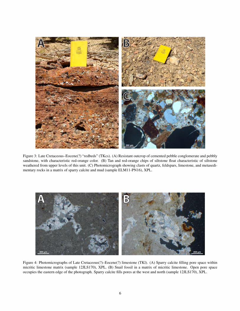
A dark brown–purple-weathering limestone with small(<1 cm long), dark streaks of chert (sample 12JLS170) wascollected immediately above the contact with underlying con-glomerate–siltstone “redbeds” (TKcs). In thin section, a mi-critic calcite matrix comprises the majority of the rock (Fig-ure 4A) and narrow pore spaces up to 1 cm long fill the restof the sample. Approximately 60% of pore space has beenfilled with sparry calcite (Figures 4A–B). Bioclasts including
3
ang. unconformity(10–15º)
ang. unconformity (~30º)
31.08 ± 0.87 Ma(40Ar-39Ar sanidine)
31.2 ± 0.3 Ma(SHRIMP U-Pb)
11JLS105
31.10 ± 0.88 Ma(40Ar-39Ar sanidine)
31.6 ± 0.3 Ma(SHRIMP U-Pb)
HACK-1
normal fault
open folding
33.9 ± 0.3 Ma(detrital zircon)10JLS08
37.3 ± 0.3 Ma(SHRIMP U-Pb)
10JLS05
37.8 ± 0.4 Ma(SHRIMP U-Pb)10JLS06A
8.2 ± 0.2 Ma(detrital zircon)12HBD09
12.4 ± 0.4 Ma(40Ar-39Ar sanidine)ELM11-PN2
14.62 ± 0.41 Ma(40Ar-39Ar sanidine)TIWS-J3
15.51 ± 0.44 Ma(40Ar-39Ar sanidine)
ELM11-PN11 15.78 ± 0.45 Ma(40Ar-39Ar sanidine)ELM11-PN13
15.6 ± 0.1 Ma(detrital zircon)TIWS-J4
24.4 ± 0.08 Ma(detrital zircon)ELM11-PN19
37.70 ± 0.78 Ma(40Ar-39Ar sanidine)99-DJ-40 (D.A. John)(unpublished age)
ang. unconformity (~30º)?
unconformity?
37.51 ± 0.38 Ma(40Ar-39Ar sanidine)99-DJ-31 (D.A. John)(unpublished age)
(previously mapped as “Indian W
ell Formation”)
tuff of Dixie Creek
Silica-cemented light gray ash interbedded with calcareous, clast supported pebble conglomerate, poorly sorted sandstone, and siltstone
Thick silica-cemented blue–grayash interbedded with calcareous, clast supported pebble conglomerate, poorly sorted sandstone, and siltstone
Dark grey, vesicular,nearly aphanitic basaltic andesite flows (Tba)
Flow banded porphyritic rhyolite flows and domes;brecciated in places; typically having basal vitrophyres (Tr)
Hum
boldt Formation
2. North and east of Robinson Mountainand near Dixie CreekMafic–felsic lavas, intrusions, and tuffs (including tuff of Dixie Creek)
1. Near Indian WellHumboldt Formation and underlying
Eocene–Oligocene volcanic rocks
tuff of Dixie C
reekTthr
Mostly calcareous, clast supported pebble conglomerate, poorly sorted sandstone, and siltstone with some interbeddedblue–gray ash
Tba
1000
0m
500
1000
0m
500
1500
2000
2500
3000
TKcs
(pre
viou
sly
clas
sifie
d as
“Ind
ian
Wel
l For
mat
ion”
)
?
?
4

Cherty limestone with smallclasts and crystals. Containssnail shells. Weakly bedded.Dark grey, brown, tan, or light grey in color.
Calcareous claystone and shale—marl
ang. unconformity
unconformity?
ang. unconformity
0m
500
1000
1500
Th
Mostly platy fine sand and siltstoneat the top of this unit
3. East of Red SpringLate Cretaceous–Eocene(?) sedimentary rocks
PZTe
Tert
iary
(?) l
imes
tone
(TK
l)TK
cs
Calcareous sandstone and siltstonewith interbedded clast-supported pebble conglomerate and blue–greyash horizons. Rare black ash flecksin sandstone.
37.70 ± 0.06 Ma(40Ar-39Ar sanidine)H10-47 (C.D. Henry)(unpublished age)
38.48 ± 0.15 Ma(40Ar-39Ar sanidine)H10-45 (C.D. Henry)(unpublished age)
37.9 ± 0.5 Ma(detrital zircon)ELKO-245.9 ± 1.0 Ma(detrital zircon)ELKO-1
ang. unconformity0m
500
5. South of Robinson MtnTuff of Robinson Mountain (Ttrm)
PZTe
(pre
viou
sly
Tiw
)
Dark grey–black ignimbrite with light pumices and smoky quartz
Light grey, densely welded tuff with smoky quartz and vapor phase altered cap
Light grey, densely welded tuff with smoky quartz and vapor phase altered cap
0m
500
4. Near Cissillini CanyonTuff of Cissillini Canyon (Ttcc)
Porphyritic and flow-banded rhyolite flows and domes, and subvolcanic intrusionsTc
s(p
revi
ousl
y Ti
w)
No Cenozoic zirconELM11-PN16
Sandstone, siltstone, and conglomer-ate “redbeds.” Clast-supported conglomerate interbedded with poorly sorted sandstone and siltstone. Clastsmostly or entirely resemble locally exposed Paleozoic rocks
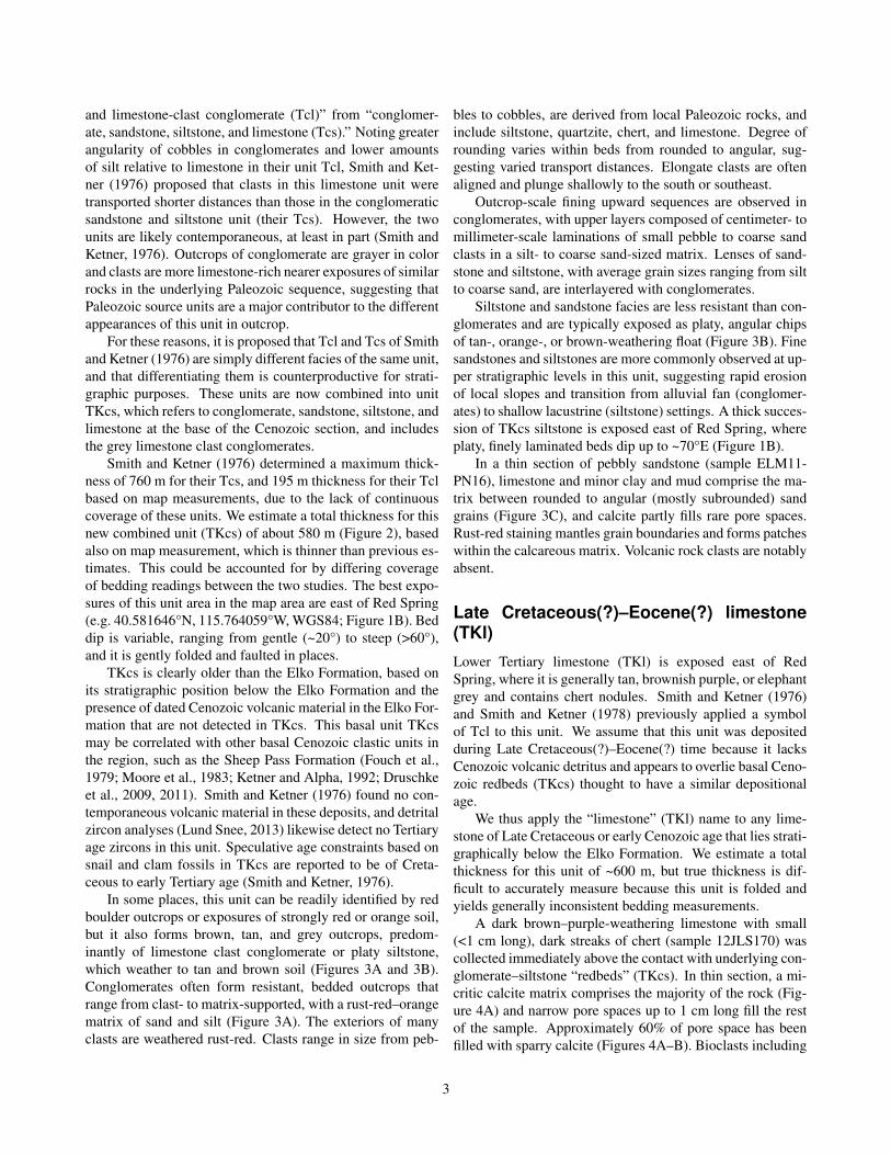
Figure 2: Stratigraphy in the mapped area (Figure 1). Section locations correspond to landmarks shown on the map. Manythicknesses were measured from the map and are hence approximate. Abbreviations: Th—Humboldt Formation; Tthr—tuffof Hackwood Ranch; Tiw—“Indian Well Formation”; Te—Elko Formation; TKcs—Late Cretaceous(?)—Eocene(?) con-glomerate, sandstone, siltstone, and limestone; PZ—Paleozoic strata. See Lund Snee (2013) for geochronologic results.
5
A B
C
Figure 3: Late Cretaceous–Eocene(?) “redbeds” (TKcs). (A) Resistant outcrop of cemented pebble conglomerate and pebblysandstone, with characteristic red-orange color. (B) Tan and red-orange chips of siltstone float characteristic of siltstoneweathered from upper levels of this unit. (C) Photomicrograph showing clasts of quartz, feldspars, limestone, and metasedi-mentary rocks in a matrix of sparry calcite and mud (sample ELM11-PN16), XPL.
A B
Figure 4: Photomicrographs of Late Cretaceous(?)–Eocene(?) limestone (TKl). (A) Sparry calcite filling pore space withinmicritic limestone matrix (sample 12JLS170), XPL. (B) Snail fossil in a matrix of micritic limestone. Open pore spaceoccupies the eastern edge of the photograph. Sparry calcite fills pores at the west and north (sample 12JLS170), XPL.
6

small snail fossils are visible in thin section (Figure 4B).
Eocene Elko Formation (Te)
The Elko Formation is a roughly fining-upward succession ofboulder to pebble conglomerate, sandstone, siltstone, lime-stone (often with chert nodules), paper shale, and clay-stone deposited in a fluvial-lacustrine environment (includingstream channel, floodplain, deltaic, mudflat, and lacustrinesettings), and it contains tuffaceous horizons (Smith and Ket-ner, 1976; Solomon et al., 1979; Moore et al., 1983; Serverand Solomon, 1983; Ketner, 1990; Ketner and Alpha, 1992;Haynes, 2003; Cline et al., 2005; Henrici and Haynes, 2006).Rocks of the Elko Formation in the map area were originallyassigned to the Eocene Green River group of Hague and Em-mons (1877) and King (1878).
Regionally, the Elko Formation is divided into a lowermember (coarse clastics including boulder conglomerate andsandstone with horizons of silty shale and tuff), middle mem-ber (cherty limestone), and upper member (lacustrine silt-stone, shale, claystone, and tuff) (Solomon et al., 1979;Server and Solomon, 1983; Ketner and Alpha, 1992; Haynes,2003). Ostracode and gastropod fossils are abundant in la-custrine limestones (Solomon et al., 1979).
Haynes (2003) differentiated deposits of the eastern andwestern portions of the Eocene Elko Basin (Figure 1B),which are characterized by different facies. The study area iswithin the eastern Elko Basin, which experienced sedimen-tation from ~46.1–38.9 Ma and predominantly contains de-posits having a lacustrine origin (Haynes, 2003; Henrici andHaynes, 2006). The Elko Basin may have been fault-bound,and paleoflow directions in the basal conglomerates are pre-dominantly to the west and northwest (Haynes, 2003).
In the study area, the Elko Formation is characterized bylaminated shale, siltstone, limestone, and claystone that arelight tan, light yellow, light grey, or black (Smith and Ket-ner, 1976; Haynes, 2003). The Elko Formation rests on LateCretaceous(?)–Eocene(?) conglomerate, sandstone, siltstone,and limestone (TKcs) and limestones (TKl) but also uncon-formably overlies Paleozoic rocks elsewhere (stratigraphicsections 3 and 5 of Figure 2).
In the study area, this unit is ~180 m thick (section 5 ofFigure 2) and the lower portion contains a roughly upward-fining sequence of calcareous pebble conglomerate, sand-stone, siltstone, limestone, shale, and interbedded tuff hori-zons, but paper shale and claystone are also interbeddedwithin the lower coarse clastics (Figure 5). The clastic por-tions of the succession appear to become less calcite-rich up-ward. Boulder conglomerate is not exposed in the map areaand pebble conglomerate is exposed only immediately abovethe contact with Paleozoic rocks (section 5 of Figure 2).
We dated zircons from detrital sample ELKO-1, taken im-mediately above the unconformable contact with Paleozoicrocks (section 5 of Figure 2). A maximum depositional age
of 45.92 ± 0.48 Ma was obtained for this sample by takingthe weighted mean of the youngest coherent group of ages.A second sample (ELKO-3), taken from slightly higher in theElko Formation (section 5 of Figure 2), yielded a maximumdepositional age of 45.00 ± 0.95 Ma. A third sample (ELKO-2), taken from near the contact with overlying Eocene tuffs(section 5 of Figure 2), yielded a maximum depositional ageof 37.89 ± 0.46 Ma.
In thin section, sandstones of the lower Elko Formationare cemented by calcite and contain limestone clasts (Fig-ure 6A), which distinguishes this unit from less carbonate-rich sediments that are interbedded within overlying Eocenevolcanic rocks (section 5 of Figure 2). A sandstone sample(ELKO-1) taken from pebbly sandstone and pebble conglom-erate at the base of the section (section 5 of Figure 2) alsocontains abundant moderately- to well-sorted and roundedclasts of quartz, quartzite, chert, potassium feldspar, siltstone,and shale, suggesting significant input from nearby exposedPaleozoic sources (Figure 6A). Small fossil fragments arealso present in this sample. Consistent with outcrop obser-vations, significantly less calcite cement is observed slightlyhigher in the lower clastic succession (sample ELKO-3; Fig-ures 6B and 6C), where clasts are dominantly quartzite, chert,and siltstone.
The succession fines upward to calcareous sandstone andthinly bedded siltstone, and contains horizons of silty chert.Tuffaceous interbedded sandstones and pebble conglomer-ates (sample ELKO-2) are exposed immediately beneath thecontact with the overlying Eocene tuff of Robinson Moun-tain (unit Ttrm; section 5 of Figure 2). In thin section, tuffa-ceous horizons are very rich in felsic to intermediate com-position volcanic lithics (~80%), as well as clasts of plagio-clase, potassium feldspar, quartz, and kinked biotite (Figures6D–E). Siltstone clasts are rarely observed (~2%).
Limestone, siltstone, and claystone are also exposed eastof Red Spring (section 3 of Figure 2) and immediately north-east of Cedar Ridge (Figure 1B). Because it is not certainwhether these deposits are part of the Elko Formation, theyhave been marked as queried on the map, but they resem-ble the upper member of the Elko Formation described byHaynes (2003). These deposits are weakly bedded in placesand finely laminated elsewhere, and are distinguished by theirtypically light tan to light yellow color (Smith and Ketner,1976). Claystones often fracture in a conchoidal pattern.Northeast of Cedar Ridge (Figure 1B), finely laminated (1–3mm scale), light-tan to yellow claystone is exposed near lighttan limestone clast conglomerates (sample 12JLS228) con-taining dark grey, well rounded pebble-sized clasts of lime-stone and chert (≤2 cm) in a silt–mud-sized matrix. In thinsection, the limestone clast conglomerates contain roundedlithics of silty limestone, quartzite, and siltstone, as well asshell fragments and sparse angular to subangular clasts of pla-gioclase and quartz (Figure 6F).
The Elko Formation is overlain by volcanic rocks of the
7

Figure 5: Photograph of Elko Formation mudstone (light tan middle and uppermost strata) and thinly laminated paper shale(blue-grey lower strata and tan upper–middle strata) south of Robinson Mountain.
8

A B
C D
E F
qtz
fos
ls
ch
pl
sh
ls
qtzite
Figure 6: Photomicrographs of samples from the Elko Formation. (A) Photomicrograph of sandstone within pebble conglom-erate near the base of the Elko Formation (sample ELKO-1), XPL. Rounded and subrounded quartz (qtz) and limestone (ls)grains are cemented by calcite, and angular fragments of fossils (fos) and chert (ch) are also present. (B) Photomicrographof sandstone from a sample (ELKO-3) taken slightly above ELKO-1 but near the base of the Elko Formation (Figure 2).Siltstone, chert, and quartzite clasts are cemented mostly by silica. (C) Zircon crystal (sample ELKO-3), XPL. Field of viewis ~360 µm. (D) Shattered feldspar crystals and kinked biotite in a tuffaceous horizon (sample ELKO-2) near the contact withthe overlying Eocene tuff of Robinson Mountain, XPL (Figure 2). (E) Shattered plagioclase crystals in volcanic lithics in atuff horizon (sample ELKO-2) near the contact with the overlying Eocene tuff of Robinson Mountain, XPL. (F) Limestoneclast conglomerate containing shell fragments (sh), clasts of plagioclase (pl) and quartz, and lithics of limestone (ls) andquartzite (qtzite) (sample 12JLS228), XPL.
9

Robinson Mountain volcanic field. Some workers have pro-posed that the volcanic rocks are in contact with the ElkoFormation across an unconformity in the study area (Smithand Ketner, 1976), but others suggest that the lower partsof thick overlying Paleogene tuffs interfinger with the upperElko Formation in the Elko Hills (Figure 1B), where it rep-resents the end of Eocene lacustrine deposition in the ElkoBasin (Haynes, 2003).
Our mapping found no evidence for an unconformity atthe contact between these units, and the similarity of dips andages on both sides of the contact supports a conformable re-lationship. Andesite flows are exposed between the Elko For-mation and overlying silicic volcanic rocks in places outsidethe map area (Server and Solomon, 1983; Haynes, 2003) butnone are exposed at this stratigraphic position in the studyarea (section 5 of Figure 2).
Eocene rocks of the Robinson Mountainvolcanic field
Eocene and Oligocene volcanic rocks in the map area werefirst named the Dixie Group by Hague and Emmons (1877)and King (1878). The “Indian Well Formation” name (nowdiscontinued) was first applied by Smith and Ketner (1976) totuffs and tuffaceous sedimentary rocks near the Piñon Rangethat were originally thought to be Oligocene in age, aftera water well of that name in what is now mapped as latestOligocene–Miocene Humboldt Formation (this study).
Smith and Ketner (1978) divided the “Indian Well For-mation” into members containing primarily tuffs (“Tiwt”),>1000 m tuffaceous sedimentary rocks (“Tiws”), and basaltuffs and tuffaceous sedimentary rocks (“Tiwb”). The “IndianWell Formation” name was abandoned by Lund Snee (2013)because of the discovery that nearly all sedimentary rocksoriginally assigned to it are actually Miocene in age. Theyhave accordingly been re-assigned to the Miocene HumboldtFormation.
The Eocene rocks of the Robinson Mountain volcanicfield were previously included within the Indian Well Forma-tion but we instead subdivide them in this section on the basisof age, composition, and map extent. Minor Paleogene agetuffaceous sediments have been classified as undifferentiatedEocene–Oligocene sedimentary rocks (Ts).
Tuff of Cissilini Canyon and associated subvolcanicand sedimentary rocks (Ttcc)
The tuff of Cissilini Canyon is exposed at the northwest cor-ner of the field area (Figure 1B) and further north. Basedon field relations, including apparent contact with underlyingLate Cretaceous(?)–Eocene(?) redbeds (TKcs), these crystalvitric ignimbrites and rhyolite flows and domes (transitionalto subvolcanic intrusive rocks) are likely among the oldestrocks in the Robinson Mountain volcanic field and may be
coeval with the tuff of Robinson Mountain. The CissiliniCanyon deposits are at least 400 m thick.
In the mapped area, these volcanic units form mostlyisolated exposures but are more voluminous to the north.There are no ages for these rocks in the field area. Sanidinesfrom a biotite quartz-feldspar intrusion on Bunker Hill, out-side of the mapped area to the northwest, yielded a sanidine40Ar/39Ar age of 37.38 ± 0.16 Ma (Ressel and Henry, 2006).
Rhyolite lavas and transitional subvolcanic intru-sive rocks Flow-banded rhyolite flows and domes ex-posed near the tuff of Cissilini Canyon are dark to mediumgrey on a fresh surface but weather red-brown. The flows aremoderately crystal rich, with felsic phenocrysts up to 4 mmset in a dark, glassy matrix. Rhyolite flows are often brec-ciated, containing clasts of identical flow-banded rhyolite, aswell as some entrained clasts of tuff.
Flow-banded, crystal-rich rhyolite domes, transitionalwith subvolcanic intrusions, are exposed as prominent, iso-lated hills. Color, texture, and phenocryst compositionvary between two similar endmembers: (1) very feldspar-rich (~30% of total rock), medium “elephant” grey, biotite-rich, and strongly flow-banded; (2) vaguely flow-banded andmedium-grey with tan–yellow–green tint, having abundantbiotite phenocrysts up to ~5 mm and indeterminate quartz.In addition, a strikingly white, vaguely flow-banded subvol-canic intrusion (Tsviw) whose subvertical, tabular form sug-gests a stock or dike (sample 12JLS149), is exposed in the farnorthwestern corner of the Robinson Mountain quadrangle.
Ignimbrites The tuff of Cissilini Canyon is typiclly dis-tinguished by smoky quartz. Most cooling units (Ttcc) areashy, poorly to densely welded, and white, light grey, tan, orlight pink in color. This tuff is rich in phenocrysts of euhe-dral biotite, smoky quartz (≤3 mm), and feldspars (≤2 mmbut some exposures are crystal-poor), as well as light-coloredpumice. These crystal vitric tuff flows resemble the tuff ofDixie Creek but generally contain smokier quartz and are oc-casionally more densely welded. At least two separate flowsare in stratigraphic contact at the northwestern corner of themapped area; each has a columnar jointed and vapor phase-altered cap with light green tint (section 4 of Figure 2). Sim-ilar tuff is exposed in isolated patches nearby, perhaps indi-cating more than two flows.
In thin section (sample 12JLS146) quartz (35% of phe-nocrysts), biotite (15%), and plagioclase (40%) phenocrystsare resorbed, but sanidine (~10%) is generally fresh (Figure8A). Lithics (~10%) include angular volcanic rocks and sub-rounded siltstone and chert. The degree of welding varieswith stratigraphic level within each flow (section 4 of Figure2) but it is typically densely welded.
A second cooling unit (sample 12JLS148) is lithic- andcrystal-rich and poorly to densely welded, with a glassy, darkgrey matrix that strongly contrasts with light grey, unflat-
10
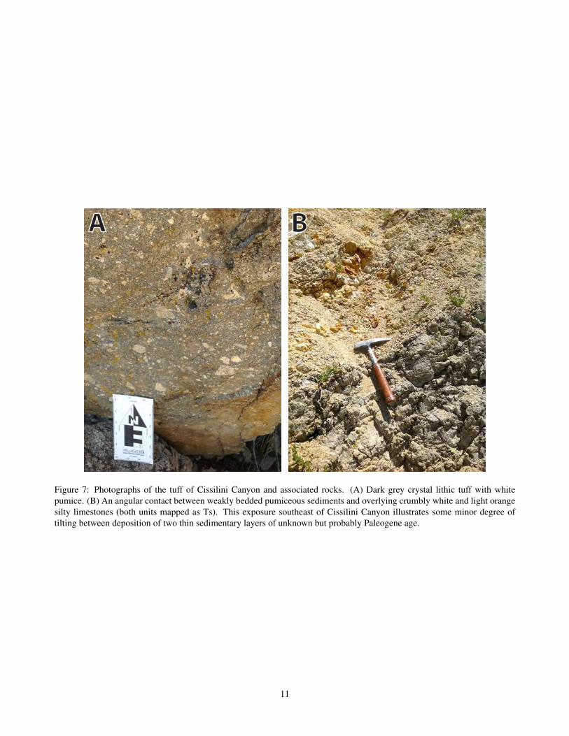
A B
Figure 7: Photographs of the tuff of Cissilini Canyon and associated rocks. (A) Dark grey crystal lithic tuff with whitepumice. (B) An angular contact between weakly bedded pumiceous sediments and overlying crumbly white and light orangesilty limestones (both units mapped as Ts). This exposure southeast of Cissilini Canyon illustrates some minor degree oftilting between deposition of two thin sedimentary layers of unknown but probably Paleogene age.
11

A B
C D
fiampl
qtz
Figure 8: Photomicrographs of samples from the tuff of Cissilini Canyon. (A) Fiamme (fiam) and glassy matrix in a light-grey crystal vitric tuff (sample 12JLS146), PPL. Phenocrysts are mostly plagioclase (pl) and quartz (qtz), with minor biotite.(B) Fiamme in a dark grey crystal lithic tuff cooling unit (sample 12JLS148), PPL. (C) Lithics of porphyritic volcanic rocksin dark grey crystal lithic tuff (sample 12JLS148), PPL. Aligned brown material is glassy matrix and a small pumice is atthe N edge. (D) Clasts of quartzite (SW corner) and chert (NW corner) in dark grey crystal lithic tuff (Ttcc), with a biotitecrystal enclosing a zircon crystal (sample 12JLS148), XPL.
12
tened to fiamme-shaped pumice (section 4 of Figure 2; Fig-ure 7B). Lithics are mostly volcanic and up to ~15 cm, andphenocrysts of smoky quartz, plagioclase, and biotite are vis-ible in hand sample. In thin section, phenocrysts (~24%) areup to 5 mm and include quartz (55% of phenocrysts; usuallywith embayed margins), biotite (10%), plagioclase (30%),and sanidine (~10%). Lithics comprise ~50% (Figure 8A–D).
Sedimentary rocks Isolated exposures of tuffaceoussedimentary rocks are exposed in the northwest corner of themapped area, near exposures of the tuff of Cissilini Canyon,and appear to be synchronous with or to slightly postdatethe volcanic rocks. Most sediments are white to mediumgrey and vaguely bedded and form outcrops that are crumbly,rounded masses. The matrix is generally ashy and containsbiotite, feldspars, and quartz. Quartz is often moderatelysmoky to light pink (rosy). White to light yellow, generallyunflattened ashy pumice is common.
In one location (Figure 7B; 40.485676°N,115.958083°W, WGS84), weakly bedded, grey pumiceoussedimentary rocks (Ts) are overlain across a gentle angularunconformity by crumbly white and light orange silty lime-stones with wavy laminations that contain no obvious pumice(sample 12JLS141). The overlying sediments are interpretedto represent the existence of a shallow lacustrine setting fol-lowing (or during a long lull in) volcanic activity.
Tuff of Robinson Mountain (Ttrm)
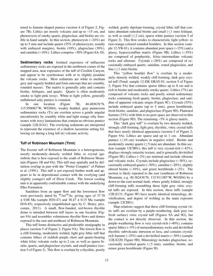
The Eocene tuff of Robinson Mountain is a heterogeneous,mostly moderately–densely welded lithic to crystal ign-imbrite that is best exposed to the south of Robinson Moun-tain (Figures 1B and 9A). This tuff may spatially and by def-inition overlap in part with the “Porter Complex” of Palmeret al. (1991). This tuff is not exposed further north and ap-pears to be in depositional contact with the overlying (andslightly younger) tuff of Dixie Creek. The lowest coolingunit is in apparently conformable contact with the underlyingElko Formation.
Sanidines from an upper flow and the lowermost flowwere previously dated by 40Ar/39Ar, giving ages of 37.70± 0.06 Ma (sample H10-47) and 38.47 ± 0.15 Ma (sampleH10-45), respectively (unpublished ages by C. Henry, pers.comm., 2011). A small, flow-banded, red-brown rhyolitedome is intruded between tuff layers in one location (Fig-ure 9A) and resembles voluminous rhyolite flows and domesexposed to the east and northeast of Robinson Mountain.
This tuff forms distinctive and predictable stratigraphy inplaces (section 5 of Figure 2; Figure 9A). The lowest flow isa cliff-forming, moderately welded, light grey lithic tuff thatcontains lithics of reddish–purple chert and quartz-bearingwhite felsic volcanic rocks up to 2 cm, as well as sparse bi-otite, quartz, and plagioclase crystals, and small pumice (sec-tion 5 of Figure 2). This flow is overlain by a rhyolitic, poorly
welded, gently dipslope-forming, crystal lithic tuff that con-tains abundant euhedral biotite and small (≤1 mm) feldspar,as well as small (≤2 cm), sparse white pumice (section 5 ofFigure 2). This flow erodes to characteristic light yellow- torust-orange-colored rounded boulders. In thin section (sam-ple 12-YB-01), it contains abundant pore space (~15%) and aglassy, hypocrystalline matrix (Figure 9B). Lithics (~35%)are composed of porphyritic, felsic–intermediate volcanicrocks and siltstone. Crystals (~28%) are composed of oc-casionally embayed quartz, sanidine, zoned plagioclase, andfine (≤1 mm) biotite.
This “yellow boulder flow” is overlain by a moder-ately–densely welded, weakly cliff-forming, dark grey crys-tal tuff (Trmd; sample 12-DK GRAY-01; section 5 of Figure2; Figure 9A) that contains sparse lithics up to 8 cm and isrich in biotite and moderately smoky quartz. Lithics (7%) arecomposed of volcanic rocks and poorly sorted sedimentaryrocks containing fresh quartz, biotite, plagioclase, and sani-dine of apparent volcanic origin (Figure 9C). Crystals (55%)include embayed quartz (up to 5 mm), green hornblende,fresh biotite, sanidine, and plagioclase (Figure 9D). Flattenedfiamme (33%) with little to no pore space are observed in thinsection (Figure 9D). The remaining ~5% is glassy matrix.
This “dark grey tuff” is overlain by two densely welded,strongly cliff-forming, light grey, rhyolitic, vitric crystal tuffsthat have nearly identical appearance (section 5 of Figure 2;Figure 9A). Lithics are sparse and up to 1 cm. Abundantpumice (≤10 cm) weathers in negative relief. Biotite andmoderately smoky quartz (≤5 mm) are abundant. In thin sec-tion (sample 12CH01), this tuff is very crystal-rich (~42%),displays strongly eutaxitic texture, and is generally devitrified(Figure 9E). Lithics (~2%) are minimal and include siltstoneand volcanic rocks. Crystals include plagioclase (~38%), oc-casionally embayed quartz (~30%), sanidine (~20%), slightlyaltered biotite (~10%), and green hornblende (~2%). Thesection is likely repeated to the east (southeast of RobinsonMountain, e.g. 40.382436°N, 115.911385°W, WGS84) by adown-to-the-east normal fault, where gently folded, stronglycliff-forming tuffs resembling these light grey vitric crys-tal tuffs are exposed. In thin section, these tuffs (sample12JLS131; Figure 9F) have nearly identical mineralogy, de-vitrification, and degree of welding as the main exposure(sample 12CH01).
Map relations suggest that these cliff-forming crystal vit-ric tuffs are overlain by a purple-weathering, dark grey (onfresh surface) vitric crystal tuff (Figures 9A and 9G), butthe contact is not directly observed. In thin section, thepurple-weathering flow is very crystal-rich (~40%), containssparse lithics (~5%) of metasedimentary rocks and devitrifiedrhyolitic subvolcanic intrusion or lava, and contains crystal-rich fiamme (~25%) and a devitrified matrix (~30%) (sample12JLS220; Figure 9H). Mineralogy includes plagioclase, oc-casionally resorbed quartz (≤5 mm), sanidine, biotite, andminor green hornblende (Figure 9I).
13
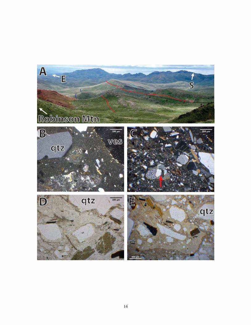
E S
Robinson Mtn
A
B C
D E
qtzves
qtzqtz
14
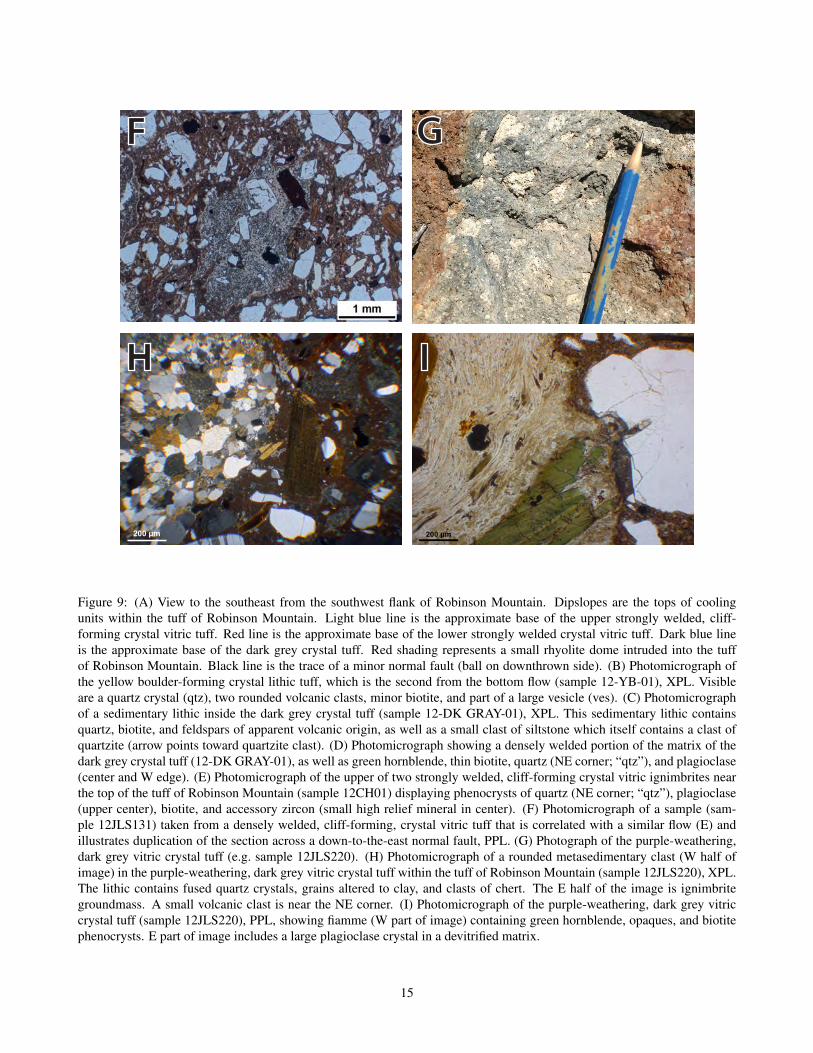
200 µm
F G
H I
Figure 9: (A) View to the southeast from the southwest flank of Robinson Mountain. Dipslopes are the tops of coolingunits within the tuff of Robinson Mountain. Light blue line is the approximate base of the upper strongly welded, cliff-forming crystal vitric tuff. Red line is the approximate base of the lower strongly welded crystal vitric tuff. Dark blue lineis the approximate base of the dark grey crystal tuff. Red shading represents a small rhyolite dome intruded into the tuffof Robinson Mountain. Black line is the trace of a minor normal fault (ball on downthrown side). (B) Photomicrograph ofthe yellow boulder-forming crystal lithic tuff, which is the second from the bottom flow (sample 12-YB-01), XPL. Visibleare a quartz crystal (qtz), two rounded volcanic clasts, minor biotite, and part of a large vesicle (ves). (C) Photomicrographof a sedimentary lithic inside the dark grey crystal tuff (sample 12-DK GRAY-01), XPL. This sedimentary lithic containsquartz, biotite, and feldspars of apparent volcanic origin, as well as a small clast of siltstone which itself contains a clast ofquartzite (arrow points toward quartzite clast). (D) Photomicrograph showing a densely welded portion of the matrix of thedark grey crystal tuff (12-DK GRAY-01), as well as green hornblende, thin biotite, quartz (NE corner; “qtz”), and plagioclase(center and W edge). (E) Photomicrograph of the upper of two strongly welded, cliff-forming crystal vitric ignimbrites nearthe top of the tuff of Robinson Mountain (sample 12CH01) displaying phenocrysts of quartz (NE corner; “qtz”), plagioclase(upper center), biotite, and accessory zircon (small high relief mineral in center). (F) Photomicrograph of a sample (sam-ple 12JLS131) taken from a densely welded, cliff-forming, crystal vitric tuff that is correlated with a similar flow (E) andillustrates duplication of the section across a down-to-the-east normal fault, PPL. (G) Photograph of the purple-weathering,dark grey vitric crystal tuff (e.g. sample 12JLS220). (H) Photomicrograph of a rounded metasedimentary clast (W half ofimage) in the purple-weathering, dark grey vitric crystal tuff within the tuff of Robinson Mountain (sample 12JLS220), XPL.The lithic contains fused quartz crystals, grains altered to clay, and clasts of chert. The E half of the image is ignimbritegroundmass. A small volcanic clast is near the NE corner. (I) Photomicrograph of the purple-weathering, dark grey vitriccrystal tuff (sample 12JLS220), PPL, showing fiamme (W part of image) containing green hornblende, opaques, and biotitephenocrysts. E part of image includes a large plagioclase crystal in a devitrified matrix.
15

0
5
10
15
35 40 45 50 55 60 65 70 75 80
Na 2O
+ K
2O (w
t%)
Phonolite
Tephri-phonolite
Trachy-andesite
Basaltictrachy-
andesite
Phono-tephrite
Tephritebasanite
Trachy-basalt
Picro-basalt
BasaltBasalticandesite
Andesite Dacite
Rhyolite
Trachydacite
Trachyte
ALKALINE SERIES
SUB-ALKALINE SERIES
SiO2 (wt%)
Miocene ash fall (Humboldt Fmn; ELM11-PN13 & ELM11-PN2)Basaltic trachyandesite intrusion (Tbta; 12JLS125)Miocene(?) andesite cinder cone (Ta; 12JLS225)Aphanitic black basaltic andesite flow (Tba; 12JLS124) Tuffs of Hackwood Ranch (Tth; 11JLS105 & HACK-1)Tuffs of Dixie Creek -- Dark pumices (12JLS210)Tuffs of Dixie Creek -- Papery pumices (12JLS211)Tuffs of Dixie Creek (Ttdc; 10JLS05 & 10JLS06A)Subvolcanic intrusives (Tsvi; 10JLS11A; JLS-PLUG1)Rhyolite flows and domes (Tr; 10JLS10; 10JLS11B)
Figure 10: Total alkali versus silica (TAS) plot for the samples analyzed by Lund Snee (2013). Volcanic rock classificationboundaries are from Le Bas et al. (1986). Alkaline–sub-alkaline series boundary after Rickwood (1989).
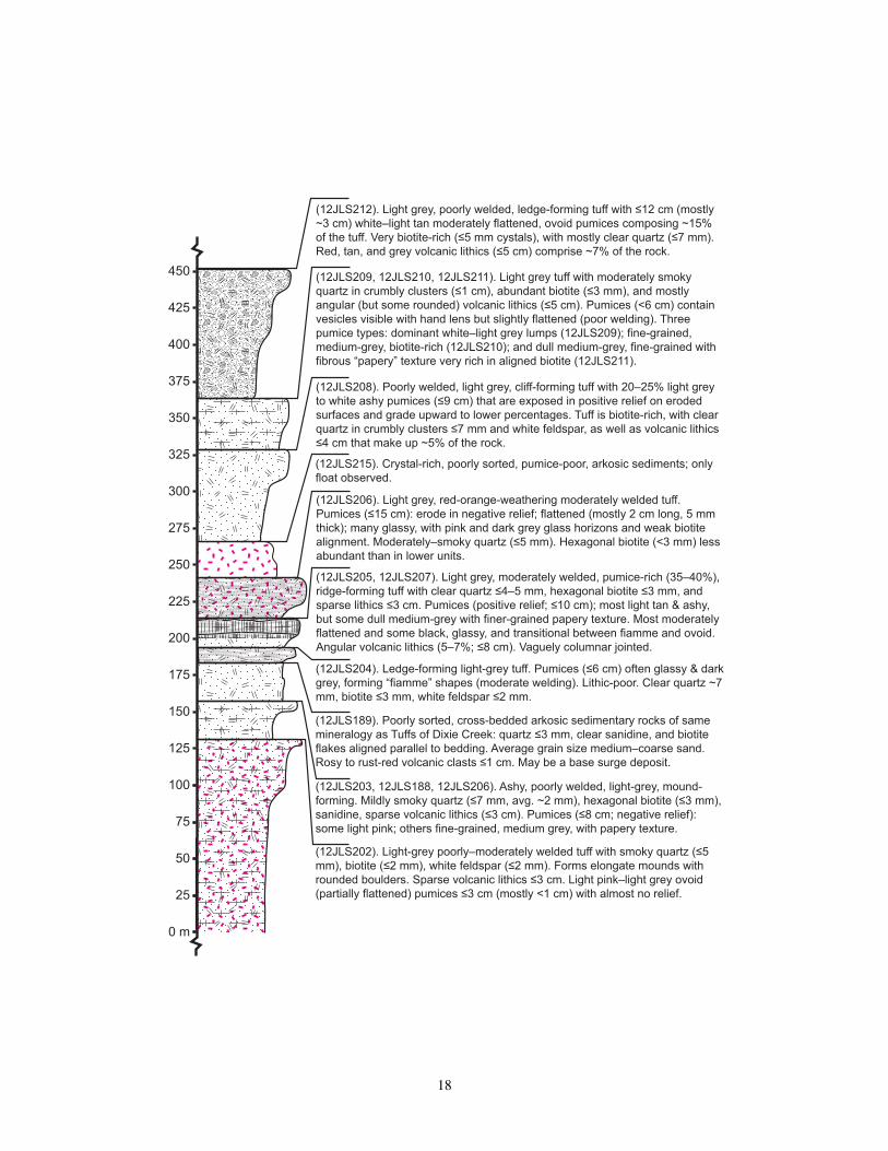
Figure 11: Stratigraphic column of ignimbrites composing the tuff of Dixie Creek.
16

(12JLS213). Light grey, poorly–moderately welded tuff with slight yellow hue that forms prominent cliffs and dipslopes with columnar jointing: vapour-phase alteration at upper levels. Welding poor at top; increasing downward. Contains clear quartz (≤6 mm), biotite (≤2 mm), white ovoid pumices (≤15 cm; 15%) in negative relief that decrease downward, and volcanic lithics (≤3 cm; ~1%).
(10JLS06A, 10JLS06B). Strongly cliff-forming, light grey, poorly welded, ashy tuff with resistant, columnar-jointed, likely vapour-phase altered upper level. White pumices (≤10 cm; ~20%) are flattened and ovoid with moderately aligned biotite. Tuff is very quartz-rich (≤8 mm crystals), with visible biotite and almost no lithics (volcanic; <1%).
(12JLS217). Light grey tuff. Crystal-rich matrix and pumices with clear quartz (≤5 mm), hexagonal biotite (≤5 mm), and clear feldspar. Strongly cliff-forming cap: poorly welded, vapour-phase altered, and columnar jointed; sparse lithics (1–2%, ≤3 cm, volcanic); abundant crystals (25–30% of matrix and pumices); abundant (~30%), flattened, white–light grey ovoid pumices (≤6 cm, ~30%, vesicular, negative relief on eroded surfaces).
(10JLS05). White–light grey, poorly welded tuff containing biotite (≤3 mm) and slightly smoky quartz ≤7 mm. Pumices are ≤12 cm (mostly ≤1 cm) and display light pink coloration that suggests higher temperatures than many other flow units. At upper levels, pumices are flattened but retain vesicles.
Base is white, with barely flattened pumices, forms rounded boulders ~7 m tall, and is composed of ~10% angular clasts of other Tuffs of Dixie Creek and subvolcanic intrusions. Resistant cap is exposed above.
Below cap, less vapour-phase alteration; outcrop is more rounded but still ledge-forming. Lithics increase to >3% below cap and welding is moderate, with fiamme-shaped glassy pumices mostly lacking vesicles and relief.
At lower levels, color whitens, welding poorer (ashy, vesicular pumices barely flattened), and lithics 7%. Outcrop less resistant, forming rounded boulders.
Bottom of unit is very lithic-rich (≤50 cm) and mostly clast-supported. Lithics are of other Tuffs of Dixie Creek flows and rare, smaller dacite lavas or Tsvi with ≤1 cm sanidine phenocrysts. Could also be a base surge or avalanche deposit but no crossbeds nor graded pumices visible.
475
500
525
550
575
600
625
650
675
700
725
750
775
800
825
850
900
875
925
950
975
1025
1000
450(m)
17
0 m
25
50
75
100
125
150
175
200
225
250
275
300
325
350
375
425
400
450
(12JLS202). Light-grey poorly–moderately welded tuff with smoky quartz (≤5 mm), biotite (≤2 mm), white feldspar (≤2 mm). Forms elongate mounds with rounded boulders. Sparse volcanic lithics ≤3 cm. Light pink–light grey ovoid (partially flattened) pumices ≤3 cm (mostly <1 cm) with almost no relief.
(12JLS203, 12JLS188, 12JLS206). Ashy, poorly welded, light-grey, mound-forming. Mildly smoky quartz (≤7 mm, avg. ~2 mm), hexagonal biotite (≤3 mm), sanidine, sparse volcanic lithics (≤3 cm). Pumices (≤8 cm; negative relief): some light pink; others fine-grained, medium grey, with papery texture.
(12JLS204). Ledge-forming light-grey tuff. Pumices (≤6 cm) often glassy & dark grey, forming “fiamme” shapes (moderate welding). Lithic-poor. Clear quartz ~7 mm, biotite ≤3 mm, white feldspar ≤2 mm.
(12JLS205, 12JLS207). Light grey, moderately welded, pumice-rich (35–40%), ridge-forming tuff with clear quartz ≤4–5 mm, hexagonal biotite ≤3 mm, and sparse lithics ≤3 cm. Pumices (positive relief; ≤10 cm); most light tan & ashy, but some dull medium-grey with finer-grained papery texture. Most moderately flattened and some black, glassy, and transitional between fiamme and ovoid. Angular volcanic lithics (5–7%; ≤8 cm). Vaguely columnar jointed.
(12JLS206). Light grey, red-orange-weathering moderately welded tuff. Pumices (≤15 cm): erode in negative relief; flattened (mostly 2 cm long, 5 mm thick); many glassy, with pink and dark grey glass horizons and weak biotite alignment. Moderately–smoky quartz (≤5 mm). Hexagonal biotite (<3 mm) less abundant than in lower units.
(12JLS208). Poorly welded, light grey, cliff-forming tuff with 20–25% light grey to white ashy pumices (≤9 cm) that are exposed in positive relief on eroded surfaces and grade upward to lower percentages. Tuff is biotite-rich, with clear quartz in crumbly clusters ≤7 mm and white feldspar, as well as volcanic lithics ≤4 cm that make up ~5% of the rock.
(12JLS209, 12JLS210, 12JLS211). Light grey tuff with moderately smoky quartz in crumbly clusters (≤1 cm), abundant biotite (≤3 mm), and mostly angular (but some rounded) volcanic lithics (≤5 cm). Pumices (<6 cm) contain vesicles visible with hand lens but slightly flattened (poor welding). Three pumice types: dominant white–light grey lumps (12JLS209); fine-grained, medium-grey, biotite-rich (12JLS210); and dull medium-grey, fine-grained with fibrous “papery” texture very rich in aligned biotite (12JLS211).
(12JLS212). Light grey, poorly welded, ledge-forming tuff with ≤12 cm (mostly ~3 cm) white–light tan moderately flattened, ovoid pumices composing ~15% of the tuff. Very biotite-rich (≤5 mm cystals), with mostly clear quartz (≤7 mm). Red, tan, and grey volcanic lithics (≤5 cm) comprise ~7% of the rock.
(12JLS189). Poorly sorted, cross-bedded arkosic sedimentary rocks of same mineralogy as Tuffs of Dixie Creek: quartz ≤3 mm, clear sanidine, and biotite flakes aligned parallel to bedding. Average grain size medium–coarse sand. Rosy to rust-red volcanic clasts ≤1 cm. May be a base surge deposit.
(12JLS215). Crystal-rich, poorly sorted, pumice-poor, arkosic sediments; only float observed.
18

Eocene tuff of Dixie Creek (Ttdc) and associatedrhyolite flows and domes (Tiwr)
Ignimbrites The tuff of Dixie Creek is a package of lightgray, poorly to moderately welded crystal vitric ignimbrites(Figure 11), which appears to contain at least ~12 flow units,and is best exposed at Dixie Creek near Hackwood Ranch(e.g. 40.8232°N, 115.9122°W, WGS84; Figure 1B). Majorelement geochemistry of pumice identifies these ignimbritesas weakly peraluminous, calc-alkaline trachydacites (Figure10). Previous workers have referred to this group as the “tuffof Jiggs” (Palmer et al., 1991), but its proximity to DixieCreek, rather than the town of Jiggs, warrants the new name.The ignimbrites have a measured thickness of ~1045 m (Fig-ure 11) but are likely thicker and may contain more flowsabove and below the measured section. The tuff of DixieCreek thins southward toward Robinson Mountain. The tuffof Dixie Creek were erupted between 37.8 ± 0.4 Ma (sam-ple 10JLS06A; Lund Snee, 2013) and 37.3 ± 0.3 Ma (sample10JLS05; Lund Snee, 2013).
The tuff of Dixie Creek provides an excellent view ofcompositional and textural changes that occur during erup-tion of a single ignimbrite, particularly where multiple cool-ing units are well exposed in a canyon of Dixie Creek slightlysouthwest of Hackwood Ranch (Figures 1B and 11). A re-sistant, poorly welded, typically vapor-phase altered, andweakly columnar jointed cap often forms dipslopes at thetops of individual cooling units (Figure 12A). This cap usu-ally overlies a moderately welded, somewhat less resistant,ashy middle layer that contains slightly more lithic mate-rial (~2–5%) than the lithic-poor cap. The lower parts ofmany flows, where exposed, are usually very lithic-rich andoccasionally lithic-supported, with a poorly welded, ashy,pumice-poor matrix. Weathering of the tuff of Dixie Creek,particularly of areas below the resistant upper cap, forms dis-tinctive light grey, rounded boulders, which are often weath-ered to be slightly overhanging.
The tuffs are quartz- and biotite-rich, with clear to mod-erately smoky phenocrysts ranging from 2–8 mm in diame-ter. In some flows, quartz crystals form crumbly clusters ≤1cm diameter. There is little variation between the constituenttuffs, but flow thickness varies significantly (Figure 11) andsome flows contain moderately smoky quartz while quartz isclear in others, likely indicating variation in the U composi-tion of the magma chamber with time. In addition, pumice islight pink in some flows, indicating relatively elevated erup-tion temperatures, while pumice is white–light grey–light tanin others (Figure 11).
Most flows are pumice-rich, particularly at middle toupper levels (e.g. sample 12JLS202; Figure 12B). Pumicelumps are typically ashy and white, light gray, light tan, orlight pink in color and often form moderately flattened ovoidshapes (e.g. 10JLS06A) that range in size from <1–20 cm andweather out in negative to positive relief (Figure 12A–D). In
thin section (Figure 13A–D), typical poorly welded pumicelumps (e.g. 10JLS06A) are crystal-rich and contain ~35%phenocrysts, ranging from <0.1–8 mm, of quartz (~20% ofphenocrysts), sanidine (~22%), biotite (~25%), plagioclase(~30%), and minor green–brown hornblende (~3%).
By phenocryst content, this tuff is a rhyodacite. Thegroundmass is composed of microcrystalline plagioclase(lath-shaped to nearly equant), minor biotite, and glass dis-playing aligned flow textures. Biotite phenocrysts are gener-ally euhedral, display very minor to no textural evidence ofresorption, and range from weakly to strongly aligned, de-pending in part on the degree of welding. Biotite phenocrystsare occasionally kinked around other phenocrysts. Quartzphenocrysts are large and euhedral to subhedral but are typi-cally fractured.
In thin section, the tuff of Dixie Creek has characteris-tic clusters of sometimes complexly zoned plagioclase (upto ~1 cm). These phenocryst clusters are distinct from thesimply zoned and generally monocrystalline plagioclase typ-ically observed in the tuff of Robinson Mountain. Similarclusters of zoned plagioclase are observed in thin section inthe most common type of subvolcanic intrusions and rhyo-lite domes or flows in the study area, suggesting a sharedmagmatic source that is somewhat distinct from the otherwisecompositionally similar tuff of Robinson Mountain.
Some flows, particularly at lower to middle stratigraphiclevels, contain minor amounts of pumice having differentcomposition and appearance. One less common pumicetype is medium grey and has distinct fibrous or “papery”texture, unusually fine grain size, and abundant aligned bi-otite (12JLS211). Most phenocrysts of this “papery” pumicetype are ≤200 µm and consist of quartz (occasionally re-sorbed and sometimes as large as 2 mm), plagioclase (mostlyfresh; some zoned; one phenocryst was observed with a thickrim of hornblende), biotite (generally fresh), sanidine (freshand sometimes zoned), and rare green hornblende (Figure13E–G). Pores are smaller (<200 µm) than in the more com-mon white–light grey pumice, and both biotite and the glassymatrix are strongly aligned. By geochemistry, this pumicetype is transitional between trachydacite and dacite but onlyslightly less alkali and silica rich than the more commonwhite to light-grey pumice (Figure 10).
A third type of pumice is medium grey in color, richin hornblende and biotite, and also unusually fine-grained(12JLS210; Figure 12D). In thin section, this pumice typeis unusually rich in euhedral brown hornblende (~35% ofphenocrysts; up to ~1 mm) and moderately aligned biotite(~25%), with euhedral sanidine and plagioclase making upmost of the remainder of phenocrysts (Figure 13H–I). Quartzis a minor phase, but rare large (~1 mm) shattered and em-bayed phenocrysts are present and are often at the marginsof pores, suggesting that their origin may be from the sur-rounding more quartz rich tuff. Other than quartz, the onlyphenocrysts >1 mm are heavily resorbed plagioclase crystals
19

A B
C D
Figure 12: Photographs of the tuff of Dixie Creek. (A) Resistant, vapor-phase altered cap of one flow, with flattened pumiceeroding in negative relief. (B) Ashy, poorly welded part of one flow, with pumice and lithics eroding in positive relief. Thisis the characteristic appearance of the lower parts of thick flows. (C) Example of fiamme in more densely welded part of aflow. (D) Example of fine-grained, medium grey, biotite- and hornblende-rich pumice (e.g. sample 12JLS210) occasionallyfound as a minor component in some flows. This type of pumice contrasts with the typical light grey–white, ashy, crystal-richpumice characteristic of the tuff of Dixie Creek (e.g. sample 10JLS06A). A third kind of pumice that is fine-grained, hasmedium grey color, contains aligned biotite, and has a “papery” texture (e.g. sample 12JLS211) is not displayed here.
20

Figure 13: Photomicrographs of the tuff of Dixie Creek. (A) A typical light grey pumice lump containing quartz (qtz) andbiotite (bt) phenocrysts (sample 10JLS06A), PPL. (B) Closer view of sample 10JLS06A, showing weak eutaxitic texturewith biotite and quartz phenocrysts, PPL. (C) Plagioclase (pl) with sieved inner zone and small crystals of plagioclase withinsieved areas in typical ashy, white pumice (10JLS06A), XPL. (D) Typical ashy, white pumice (10JLS06A) with fresh (NWcorner) and sieved (center) plagioclase, XPL. (E) Aligned, finer-grained biotite with sanidine and plagioclase in mediumgrey “papery” pumice (12JLS211), XPL. Southwest corner is normal, coarser-grained matrix of tuff of Dixie Creek, out-side the pumice. (F) Reaction rim around a rare large plagioclase phenocryst in medium grey, fine-grained “papery” pumice(12JLS211), XPL. (G) Additional view of fine-grained, medium grey “papery” pumice (12JLS211), XPL. Moderately alignedorange crystals are biotite; grey crystals are plagioclase and sanidine. (H) Matrix of a third type of pumice found in someignimbrites of the tuff of Dixie Creek, which is medium grey and fine-grained (12JLS210), XPL. Phenocrysts are mostlyhornblende (hbl), biotite, plagioclase, and sanidine. (I) Large zoned and resorbed plagioclase phenocryst in the rare mediumgrey, fine-grained, hornblende and biotite rich pumice type (12JLS210; “dark pumice”), XPL. (J) Cross-bedded sedimen-tary rock between ignimbrites that may represent a base surge deposit (sample 12JLS189), XPL. Mostly angular grains ofresorbed and unresorbed quartz, as well as plagioclase, sanidine (s), and biotite, are visible. (K) Pumice taken from a weldedportion of the uppermost exposed flow (10JLS05), PPL. (L) Resorbed quartz crystal in a pumice taken from the uppermostexposed flow (10JLS05), XPL.
that are typically situated near vesicles. By geochemistry,this pumice type is more mafic, with a composition transi-tional between trachydacite and trachyandesite (Figure 10).All three types of pumice occur together in some flows (Fig-ure 11).
A poorly consolidated, cross-bedded, crystal-rich sand-stone is observed between two ignimbrites near stratigraphi-cally low parts of the tuff of Dixie Creek (12JLS189). Clastsof siltstone and felsic volcanic rocks are present in smallamounts and rarely exceed 5 mm. In thin section, poorlysorted angular grains (average ~0.5 mm) are almost entirelycomposed of well preserved crystals having nearly the samecomposition as the surrounding tuff of Dixie Creek, includingquartz, sanidine, plagioclase, biotite, and green-brown horn-blende (Figure 13J). The matrix (10%) is composed of clay-and silt-sized particles, and an additional ~5% is pore space.The cross-bedding, very high proportion of angular crystals,and relative scarcity of matrix material support the interpre-tation that these sediments represent a base surge deposit.Another exposure of sedimentary rocks as float between twoother ignimbrites (sample 12JLS215) suggests possible basesurge deposits at other levels in the section.
Rhyolite flows and domes (Tiwr) Rhyolite (by geo-chemistry) flows and domes locally overlie and underlie thetuff of Dixie Creek but their timing of eruption remainspoorly constrained and they may have been erupted in multi-ple stages. Whole-rock geochemical analysis on vitropheresindicates a peraluminous and calc-alkaline chemistry (Fig-ure 10). Rhyolite flows and domes (Figure 14) are reddish-brown, light grey, medium grey, or red-purple in color andrange from glassy and crystal-poor to phenocryst-rich andtransitional in some places by phenocryst size (up to ~6 mm)and content with subvolcanic intrusive rocks. Flows anddomes commonly display cm-scale flow bands, which formsystematic and consistent map patterns in places, but chaotic
orientations elsewhere. Phenocrysts include biotite, quartz,and clear feldspars.
At least 7 separate flows or domes are exposed east ofRobinson Mountain (Figures 1B and 2), representing a sec-tion ~630 m thick (the unreliability of flow banding as astrike and dip indicator in lava flows requires that this thick-ness is determined from less precise attitude orientationstaken on dipslopes). Vitrophere and/or breccia mantle mostflows and provide a means for differentiating events. Brec-cia zones contain angular clasts up to ~1 m, typically resem-bling the surrounding rhyolite. Vitropheres are usually flow-banded and range from vitreous black to devitrified (micro-crystalline) white, light grey, or dusty purple in appearance.
In thin section (sample 10JLS13, a vitrophere), fracturedsanidine, quartz, plagioclase, and biotite phenocrysts (Fig-ures 15A–B) comprise ~5% of this sample, but phenocrystcontent is variable. Where glass is unaltered, flow banding isvisible as trails of dark inclusions (Figures 15A–C).
Thin Eocene sedimentary horizons (Ts)
Thin sandstone, siltstone, and shale layers (Ts) are locallyexposed between the Dixie Creek tuff cooling units and over-lying rhyolite domes, as well as in horizons within the over-lying rhyolite (Figure 2). These horizons, which are typically20–50 m thick, are light grey to light yellow and poorly con-solidated, forming crumbly, rounded outcrops.
Strong layering and moderate sorting differentiate thesesediments from the tuff of Dixie Creek, which often has simi-lar mineralogy and appearance. The sediments generally con-tain clear quartz (≤4 mm) and biotite, as well as ashy, lightgrey to light yellow pumice that appears to represent air falland is preferentially concentrated in some layers. Some lay-ers are weakly cross-bedded but the intact pumice and generalabsence of cross-bedding in others suggest intermittent shal-low lacustrine and fluvial environments. This indicates that
21

A B
C D
E F
qtz qtz
pl pl
pl
pl
hbl
btbt
pl
22

G H
I J
K L
hbl
bt
plqtz
qtz
sbtpl
23
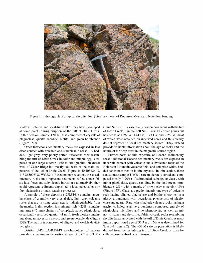
Figure 14: Photograph of a typical rhyolite flow (Tiwr) northeast of Robinson Mountain. Note flow banding.
shallow, isolated, and short-lived lakes may have developedat some points during eruption of the tuff of Dixie Creek.In thin section, sample 12JLS130 is composed of crystals ofplagioclase, quartz, sanidine, biotite, and green hornblende(Figure 15D).
Other tuffaceous sedimentary rocks are exposed in lessclear contact with volcanic and subvolcanic rocks. A bed-ded, light gray, very poorly sorted tuffaceous rock resem-bling the tuff of Dixie Creek in color and mineralogy is ex-posed in one large outcrop (>60 m stratigraphic thickness)west of Cedar Ridge but mostly southeast of the main ex-posures of the tuff of Dixie Creek (Figure 1; 40.405226°N,115.865007°W, WGS84). Based on map relations, these sed-imentary rocks may represent sediments rafted above fel-sic lava flows and subvolcanic intrusions; alternatively, theycould represent sediments deposited in local paleovalleys byfluviolacustrine or mass wasting processes.
A sample of these deposits (12JLS161) contains angu-lar clasts of crumbly, very crystal-rich, light grey volcanicrocks that are in some cases nearly indistinguishable fromthe matrix. In thin section, it is mineral-rich (~25%), contain-ing large (≤5 mm) clusters of complexly zoned plagioclase,occasionally resorbed quartz (<4 mm), fresh biotite contain-ing abundant accessory zircon, and green hornblende (Figure15E). The matrix is composed of aligned and weakly devitri-fied glass.
Detrital U-Pb LA-ICP-MS geochronology of zirconsprovides a maximum depositional age of 37.7 ± 0.3 Ma
(Lund Snee, 2013), essentially contemporaneous with the tuffof Dixie Creek. Sample 12JLS161 lacks Paleozoic grains buthas peaks at 1.26 Ga, 1.41 Ga, 1.73 Ga, and 2.26 Ga, mostof which were obtained on inherited cores and thus clearlydo not represent a local sedimentary source. They insteadprovide valuable information about the age of rocks and thenature of the deep crust in the magmatic source region.
Further north of this exposure of Eocene sedimentaryrocks, additional Eocene sedimentary rocks are exposed inuncertain contact with volcanic and subvolcanic rocks of theRobinson Mountain volcanic field, and comprise white, bed-ded sandstones rich in biotite crystals. In thin section, thesesandstones (sample TIWB-1) are moderately sorted and com-posed mostly (~90%) of subrounded–subangular clasts, withminor plagioclase, quartz, sanidine, biotite, and green horn-blende (~2%), with a matrix of brown clay minerals (~8%)(Figure 15F). Clasts are predominantly one type of volcanicrock having aligned plagioclase and biotite microlites in aglassy groundmass with occasional phenocrysts of plagio-clase and quartz. Rarer clasts include volcanic rocks having atrachytic, holocrystalline groundmass composed entirely ofplagioclase microlites and no phenocrysts, as well as mi-nor siltstones and devitrified felsic volcanic rocks resemblingrhyolite lavas associated with the tuff of Dixie Creek. A max-imum depositional age of 37.3 ± 0.1 Ma was determined forTIWB-1 (Figure 2). The ~37 Ma zircon population is likelyderived from the underlying tuff of Dixie Creek or from lo-cally exposed subvolcanic intrusions.
24

pl
bthbl
A B
C D
E F
Figure 15: (A) Photomicrograph of a sample from a rhyolite dome containing plagioclase and biotite phenocrysts in aweakly devitrified groundmass (sample 10JLS13), PPL. (B) Same view as (A) in crossed polars. (C) Photomicrograph ofglassy groundmass of rhyolite vitrophere, with dark biotite phenocrysts (sample 10JLS13), PPL. (D) Photomicrograph ofsedimentary rock collected north of Robinson Mountain, stratigraphically above the tuff of Dixie Creek (sample 12JLS130),PPL. (E) Tuffaceous sedimentary rocks (unit Ts) having clusters of plagioclase (“pl;” E side of image) characteristic of thetuff of Dixie Creek in a glassy matrix, with biotite (bt), hornblende (hbl), and opaque oxide phenocrysts (sample 12JLS161),XPL. (F) Volcanic clast-rich pebbly sandstone (unit Ts; sample TIWB-1), PPL.
25

Subvolcanic intrusions (Tsvi)
Rhyolitic (by geochemistry), weakly calc-alkaline subvol-canic intrusions are voluminous in the study area. In mostexposures, these rocks are porphyritic and typically light tomedium grey, medium brown, rust-red, or purple in outcrop,and contain large sanidine phenocrysts and euhedral biotite.Most notably, they form the tall edifices of Robinson Moun-tain (e.g. sample JLS-PLUG-1) and Squaw Mountain (e.g.sample 11JLS104; Figure 1B), which were likely large vol-canic necks that intruded local ignimbrites.
Subvolcanic intrusions are often flow-banded and aretransitional in some cases with rhyolite domes and flows,making the two rock types occasionally difficult to distin-guish. Subvolcanic intrusions were identified in the field onthe basis of their large sanidine phenocrysts (usually >0.8cm) and high crystal content. These intrusions appear tomostly post-date and intrude other Eocene volcanic rocks ofthe Robinson Mountain volcanic field, including the tuff ofDixie Creek and Robinson Mountain. In one location, how-ever, a brown–purple–red subvolcanic intrusion may be ap-proximately synchronous with voluminous rhyolite flows tothe east of Robinson Mountain that are exposed near the tuffof Dixie Creek. In this case, the intrusive rocks are exposedin a steeply east-dipping tabular body (e.g. 40.410014°N,115.895854°W, WGS84) with north-northeast-trending mappattern that is in contact with the east side (bottom) of gentlywest-dipping rhyolite domes and flows. These intrusive rocksmay represent a partially exhumed conduit that fed eruptionof the domes. A sanidine 40Ar/39Ar age of 37.51 ± 0.38 Mawas previously obtained from this intrusion in the map area(sample 98-DJ-31 of Ressel and Henry, 2006).
A single exposure of moderately west-dipping yellowish-tan claystone (40.402144°N, 115.894151°W, WGS84) inpossible contact with the bottom (eastern side) of the tabu-lar body (but possibly surrounded by subvolcanic intrusiverocks) has not been dated. However, its stratigraphic positionsupports the inference that it is a thin, interbedded or raftedsedimentary rock horizon (Ts) of likely Eocene age associ-ated with the Robinson Mountain volcanic field, and there-fore younger than the Elko Formation, as it was originallymapped by Smith and Ketner (1978).
All subvolcanic intrusions are likely younger than theEocene tuff of Dixie Creek, based on map relations,geochronologic analysis of some intrusions (Lund Snee,2013), and very similar mineral assemblage to the Eocenevolcanic rocks. U-Pb zircon ages were obtained from a sub-volcanic intrusion immediately east of Robinson Mountain(sample 10JLS11A), which returned an age of 36.8 ± 0.3 Ma,and a subvolcanic intrusion on Squaw Mountain (11JLS104),which returned an age of 37.6 ± 0.7 Ma (Figure 1). Theseages are within error of one another but could equally indi-cate protracted intrusion of these mineralogically and textu-rally similar intrusive rocks.
In thin section of a characteristic sample of subvolcanicintrusive rocks (10JLS11A), phenocrysts (~35%) compriseplagioclase (~50%), biotite (25%), sanidine (18%), quartz(10%), and green hornblende (2%). Disequilibrium tex-tures are evident in most phenocryst phases. Weak reactionrims are observed around quartz and sanidine phenocrystsbut the interiors are generally fresh (Figure 16A). Reactionrims typically mantle hornblende and biotite, and the interiorsare sieved and altered (Figure 16B). Plagioclase phenocrystshave typically experienced preferential alteration of what arelikely relatively Ca-rich zones (Figure 16C).
A vaguely flow-banded, strikingly white subvolcanic in-trusion (Tsviw) is exposed in a small area at the northwestcorner of the field area (12JLS149), representing a notable ex-ception to the generally monotonous character of these rocks.At that location, map patterns indicate that this unit formsa tabular, nearly vertical feature that is likely a dike. Theunit contains large (≤5–6 mm) smoky quartz, abundant bi-otite, and clear feldspar. In thin section, the white subvol-canic intrusion (Tsviw) is distinguished from the more com-mon brown–purple–red–grey subvolcanic intrusions (Tsvi)by higher quartz content (~40% of phenocrysts and typicallyembayed and surrounded by reaction rims) and less biotite(~10% of phenocrysts), and having a glassier matrix that con-tains finer and more elongate microlites (Figure 16D).
Another exception to the general brown–purple–red–greyappearance of subvolcanic intrusions is a flow-banded, lightgrey to light pink subvolcanic unit that weathers to an unusu-ally light rust-red color, is devitrified in places, and is exposedonly in a small area west of Robinson Mountain (12JLS119).This subvolcanic intrusion (Tsvip) contains biotite, large (≤6mm) smoky quartz, and large feldspar phenocrysts (some>6 mm). In thin section (Figure 16E–F), it is very crystal-rich (~40%). Quartz (20% of phenocrysts) is usually roundand resorbed but occasionally euhedral (hexagonal). Biotite(10%) is euhedral but red and somewhat altered, and resem-bles the large amount of oxyhornblende (20%) in color. Sani-dine content is low (~5%) and plagioclase phenocrysts (45%)are often zoned, are clustered, and range from strongly re-sorbed to fresh. The groundmass is composed mostly of glasswith lesser amounts of very fine plagioclase microlites. Porespace is unusually abundant and occasionally surrounded bydevitrified areas of groundmass, and suggests emplacementvery near the surface, perhaps near a vent.
Additional subvolcanic intrusive rocks including dikeswere mapped as “silicic intrusive rocks” (Ti) by Smith andKetner (1978) and are exposed in the Bailey Mountain quad-rangle at the southwestern corner of the map area (e.g.40.373013°N, 115.968833°W, WGS84), and in the westernpart of the Robinson Mountain quadrangle. These rocks in-trude Paleozoic rocks of the Piñon Range.
26

A B
C D
E F
qtz
qtz
qtz
pl
s
hbl
hbl
hbl
bt
Figure 16: Photomicrographs of subvolcanic intrusive rocks (Tsvi). (A) Reaction rims around quartz (qtz) and sanidine (s)phenocrysts in a typical subvolcanic intrusion (sample 10JLS11A), XPL. (B) Resorption textures (reaction rims and sievedinteriors) affecting green hornblende (hbl) and biotite (bt) in a typical subvolcanic intrusion (10JLS11A), PPL. (C) Calcitereplacement of resorbed zones in a large plagioclase phenocryst (pl), surrounded by microcrystalline matrix in a typical sub-volcanic intrusion (10JLS11A), XPL. (D) Resorbed quartz and microcrystalline groundmass in a tabular, strikingly whitesubvolcanic intrusion (Tsviw) sampled at the northwest corner of the map area (12JLS149), XPL. (E) Fractured quartz andsmaller biotite phenocrysts in microcrystalline groundmass of a light grey to light pink subvolcanic intrusion (unit Tsvip,sample 12JLS149), XPL. (F) Light grey to pink subvolcanic intrusion (unit Tsvip, sample 12JLS149), XPL. View is of aresorbed (sieved and with reaction rims) oxyhornblende crystal.
27

Cenozoic mafic–intermediate compositionrocks
Aphanitic basaltic andesite flows (Tba)
Platy, vesicular (≤1 cm openings), dark grey to black, nearlyaphanitic lava flows are exposed to the northwest of RobinsonMountain, where they overlie reddish-brown to medium-greyrhyolite flows (Figure 2). Smith and Ketner (1976) assigned aLate Miocene age to these flows on the basis of 1) their strati-graphic position above the tuff of Dixie Creek, and 2) the lackof obvious clasts of these rocks in the Humboldt Formationto the east. Dates for andesite flows outside the study area,in the Sulphur Spring Range and the Elko Hills, range from~31–38 Ma (Solomon et al., 1979; Haynes, 2003; Ryskampet al., 2008). It is unclear from map relations whether thebasaltic andesite (Tba) in the map area is of comparable ageto the tuff of Dixie Creek (i.e. 36–37 Ma) or significantlyyounger (i.e. Late Miocene), but there is little to no angularunconformity separating these units, which suggests that theyare older than Middle Miocene age. The difficulty determin-ing dip of these flows also contributes to uncertainty aboutthe thickness estimate of at least 150 m for 2 or more flows.
In thin section, a sample (12JLS124) of this unit is com-posed of a hypocrystalline groundmass of weakly alignedplagioclase laths (avg. ~150 µm long) with minor (~5%) phe-nocrysts (mostly ≤1 mm). Phenocrysts include clinopyrox-ene (often occurring in clusters), plagioclase with preferen-tially altered interiors, and altered red biotite (Figure 17A).Differences in texture, grain size, and mineralogy are ob-served in thin section between different samples, likely re-flecting the exposure of multiple flows in the map area. Adifferent sample (10J3.5) contains sparse phenocrysts of re-sorbed quartz up to ~3 mm with alteration rims, clusters ofclinopyroxene, and extensively altered sanidine and biotitein a trachytic groundmass of much smaller plagioclase laths(avg. ~50 µm) and opaque oxides (Figures 17B–D).
Aphanitic basaltic trachyandesite intrusion (Tbta)
A small (≤0.2 km2), black, isolated intrusion of basaltic an-desite composition (by whole-rock geochemistry), is exposedin the Robinson Mountain quadrangle (e.g. 40.411642°N,115.965216°W, WGS84), at the western edge of the maparea, to the west of the east-dipping normal fault system thatbounds the Piñon Range. In thin section (sample 12JLS125;Figures 17E–F), this intrusion is composed of a holocrys-talline groundmass of interlocking plagioclase (~49%), al-tered green hornblende (~30%), biotite (~4%), and opaques(~2%). A portion of the reported plagioclase may be quartzbut the grain size of these crystals is too small to obtain anoptic axis figure. The rock has been extensively replaced bycalcite (~15% of total rock). The age of this intrusion is un-certain but its similar mineralogy and texture to the nearbyaphanitic basaltic andesite flows (Tba) suggests that it may
be of similar age to those flows.
Oligocene tuff of Hackwood Ranch (Tthr)
Ignimbrites
The tuff of Hackwood Ranch comprises three (or more) cool-ing events of strongly cliff-forming, poorly welded, reddish-brown, tan, or green ignimbrite (Figures 2 and 18A). It waspreviously named the “tuff of Hackwood” by Palmer et al.(1991), but our new name better reflects its exposure nearHackwood Ranch (Figure 1B).
The tuff of Hackwood Ranch is crystal poor and containsonly small phenocrysts (≤3 mm) of mostly biotite that arevisible in hand sample. It is pervasively silicified and typ-ically has conchoidal fracture and vitreous luster that dis-guises vitreous silicate phenocrysts in hand sample. Eruptionoccurred at ~31.1 Ma, which is within the age span of calderaeruptions near the Desatoya and Clan Alpine Mountains, cen-tral Nevada (Figure 1A), some of which were deposited hun-dreds of kilometers from their eruptive centers (Faulds et al.,2005; Henry et al., 2012; Henry and John, 2013). The tuff ofRattlesnake Canyon appears to be the most correlative tuff,based on its similar 31.2 Ma eruptive age (Henry and John,2013). If instead erupted from nearby, the tuff of HackwoodRanch may represent the last eruptions of the general Robin-son Mountain volcanic field.
In thin section, some pore space is filled with secondarymicrocrystalline quartz (Figures 19A–B). The matrix is com-posed chiefly of moderately aligned glass shards, togetherwith secondary microcrystalline quartz. Rare lithic frag-ments (5%) are siltstone or volcanic rocks resembling the un-derlying tuff of Dixie Creek and rhyolite flows and domes.Phenocrysts are ≤3 mm and include quartz (~5% of phe-nocrysts), sanidine (>50%), plagioclase (~30%), and biotite(~15%), which is occasionally sieved and embayed. Someplagioclase is heavily resorbed but most is fresh. By phe-nocryst content, this tuff is transitional between quartz latiteand latite, but resorption textures in some phenocrysts sug-gest that they may be xenocrystic. Whole-rock (sample11JLS105) and pumice-only (sample HACK-1) geochemicalanalysis indicates that this tuff is a high-silica rhyolite (Fig-ure 10), but outcrop and thin section evidence for secondarysilicification suggests that it may have artificially high silica(and artificially low alkali) content.
Underlying sandstones
Thin (~35 m), poorly consolidated, cross-bedded silty sand-stone and pebble conglomerate underlie the ignimbrites (Fig-ure 2) and are mapped together with the tuff of HackwoodRanch due to map resolution and their infrequent exposure.Clasts, including crystals, form ~75% of the rock, and areangular and up to 2 cm (Figures 18A–C). In thin section(sample 10JLS08), clasts consist of sanidine, plagioclase,
28

A B
C D
E F
qtz s
cpxbt
qtz
btcpx
Figure 17: Photomicrographs of mafic-intermediate composition volcanic rocks overlying the tuff of Dixie Creek. (A)Aphanitic black andesite flow (Tba, sample 12JLS124), XPL. The large phenocryst is likely altered clinopyroxene (cpx), ina matrix of glass, plagioclase laths, and smaller clinopyroxene. (B) Aphanitic basaltic andesite flow sampled in a differentlocation (Tba; sample 10J3.5), XPL. The groundmass is finer and visible resorbed phenocrysts include quartz (qtz), clinopy-roxene, and biotite (bt). (C) Resorbed quartz (qtz) and fresh plagioclase in a finer-grained aphanitic basaltic andesite flowsampled from the second location (Tba, 10J3.5), XPL. (D) Probable sanidine (s) phenocryst that has been strongly altered(Tba, 10J3.5), XPL. (E) Fine-grained matrix of altered, aphanitic basaltic trachyandesite, showing plagioclase and likelyaugite (cpx), with brightly colored secondary calcite (sample 12JLS125), XPL. (F) Biotite and opaque crystals in altered,aphanitic basaltic trachyandesite (sample 12JLS125), XPL.
29
quartz, biotite, hornblende, and occasional pyroxene crys-tals, as well as lithics of siltstone, felsic pumice, intermedi-ate–mafic composition volcanic rocks containing clinopyrox-ene (Figures 19C–D), and felsic volcanic rocks resemblingthe tuff of Dixie Creek and locally exposed subvolcanic in-trusions. The remaining matrix material is composed of clay-and silt-size particles, some of which are fine-grained biotite,as well as minor volcanic ash.
A maximum depositional age of 33.9 ± 0.4 Ma was de-termined from U-Pb detrital zircon analysis of the sedimen-tary rocks (sample 10JLS08). The ~34 Ma zircon populationcould represent reworked air fall from the ~33.8 Ma CaetanoTuff or the older and less aerially extensive 34.2 Ma tuff ofCove Mine also erupted from the Caetano caldera ~75 kmsouthwest of the map area (John et al., 2008).
The presence of cross-bedded sandstones between the tuffof Hackwood Ranch and the tuff of Dixie Creek (10JLS08)suggests a fluvial environment between deposition of thetuffs. This, together with the presence of a gentle angular un-conformity (~10–15°) that is developed between these sedi-mentary rocks and the underlying tuff of Dixie Creek (Palmeret al., 1991; Gordee et al., 2000; Lund Snee, 2013), indicatesthat tilting of rocks to the west-northwest occurred betweenabout 37.3 Ma and 33.9 Ma.
Other Eocene or Oligocene tuffs or tuffa-ceous sedimentary rocks (Tt)
Orange-weathering tuffs or tuffaceous sedimentary rocks (Tt)are exposed in a small area (<0.2 km2) at the northernedge of the map area. This unit (samples 11JLS101 and11JLS102), which is bedded and devitrified and/or signifi-cantly hydrothermally altered in places, resembles the tuff ofHackwood Ranch in its low content of crystals (~3%; mostlysanidine, plagioclase, and quartz), pumice (~5%), and lithics(~1%) (Figure 20A). However, it differs from the tuff ofHackwood Ranch by its composition of mostly glass shards,which are weakly to moderately aligned and completely un-flattened. Clast alignment, low prevalence of pumice, bed-ding, and alteration (Figure 20B) suggest a water-laid air-fall tuff or gently reworked terrestrially-deposited air-fall tuff.High amounts of ash shards and sparse pumice and lithicssuggest deposition distal from a large silicic eruption. Thesedeposits are not easily correlated with the four main tuffs de-scribed here in part because they are exposed in an isolatedarea. They are therefore mapped as undifferentiated Tertiarytuffs or tuffaceous sedimentary rocks (unit Tt).
Miocene Humboldt Formation (Th)
Miocene Humboldt Formation (Th) sedimentary rocks in themapped area were originally divided into a Pliocene Hum-boldt Group and Eocene Green River Group by Hague andEmmons (1877) and King (1878). The Humboldt Formation
name has since been applied to diverse sedimentary rocks ofMiocene age deposited in a lacustrine–fluvial environment innortheastern Nevada (Sharp, 1939; Smith and Ketner, 1976;Smith and Howard, 1977; Smith and Ketner, 1978; Solomonet al., 1979; Stewart, 1980; Wallace et al., 2008; Colgan et al.,2010). Sharp (1939) initially measured ~1800 m thickness ofthis unit east of Huntington Creek (Figure 1B), and noted anupward progression from a lacustrine to fluvial depositionalenvironment.
Smith and Ketner (1978) later restricted the HumboldtFormation to include 560 m of the middle and part of theupper members of Sharp (1939)’s section. Their defini-tion included upper Miocene conglomerate, sandstone, silt-stone, and claystone with beds of limestone, tuff, and ash,represented by part of the same type section at the eastside of Huntington Creek (e.g. 40.610500°N, 115.691400°W,WGS84), immediately east of the eastern edge of the presentstudy area (Figure 1B). To the west of this type section, inan area including Indian Well and Crane Springs (Figure1B), Smith and Ketner (1978) mapped a large portion of thepresent study area as Eocene–Oligocene (Walker et al., 2012,time scale) “Indian Well Formation” sedimentary rocks (Fig-ure 2). Subsequent workers have adopted this naming forthose sediments in Huntington Valley (Solomon et al., 1979;Satarugsa and Johnson, 2000; Haynes, 2003; Horton et al.,2004; Horton and Chamberlain, 2006; Chamberlain et al.,2012).
This more recent mapping study, which was supported bydetrital zircon and sanidine 40Ar/39Ar geochronology as out-lined by Lund Snee (2013) and Lund Snee et al. (submitted),found that most of the sediments previously associated withthe (now abandoned) “Indian Well Formation” in the studyarea are significantly younger than that unit and are likely partof the mostly Miocene Humboldt Formation. For this rea-son the Humboldt Formation has been expanded to includelatest Oligocene to Miocene conglomerate, sandstone, silt-stone, claystone, marl, and interbedded limestone, ash, andtuff (Figure 2). In general, the Humboldt Formation is char-acterized by the vitric ash beds (Figure 2).
Our expanded definition for the Humboldt Formation in-cludes strata at the base of this unit (west of Cedar Ridgeand Red Spring) that were formerly grouped with the (aban-doned) “Indian Well Formation,” making the total thicknessof the Humboldt Formation ~2130 m (Figure 2). About 1740m of the total represents the lower and middle parts of the for-mation that are exposed west of Red Spring and Cedar Ridge.Unlike at Sharp’s (1939) type section to the east of Hunt-ington Creek, these newly incorporated Humboldt Formationstrata further west generally grade upward from fluvial to la-custrine depositional settings (Figure 1B). About 1100 m ofthis western section was previously mapped as “Indian WellFormation” sedimentary rocks by Smith and Ketner (1978).
The total thickness of the Humboldt Formation is com-plicated by open folds and a normal fault system that partly
30
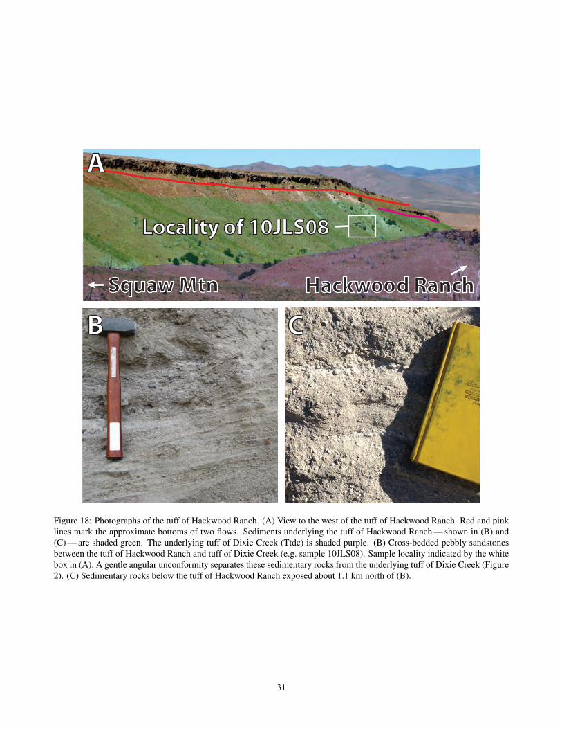
Hackwood RanchSquaw Mtn
B C
A
Locality of 10JLS08
Figure 18: Photographs of the tuff of Hackwood Ranch. (A) View to the west of the tuff of Hackwood Ranch. Red and pinklines mark the approximate bottoms of two flows. Sediments underlying the tuff of Hackwood Ranch — shown in (B) and(C) — are shaded green. The underlying tuff of Dixie Creek (Ttdc) is shaded purple. (B) Cross-bedded pebbly sandstonesbetween the tuff of Hackwood Ranch and tuff of Dixie Creek (e.g. sample 10JLS08). Sample locality indicated by the whitebox in (A). A gentle angular unconformity separates these sedimentary rocks from the underlying tuff of Dixie Creek (Figure2). (C) Sedimentary rocks below the tuff of Hackwood Ranch exposed about 1.1 km north of (B).
31

A B
C D
pl
s
ves
pl
s
ves
plpl
qtzvc
bthbl
Figure 19: Photomicrographs of the tuff of Hackwood Ranch and underlying sedimentary rocks. (A) Ashy matrix and phe-nocrysts of plagioclase (pl) and sanidine (s) in the tuff of Hackwood Ranch (sample 11JLS105). (B) Same view as (A) incrossed polars. (C) Pebbly sandstone below the tuff of Hackwood Ranch (sample 10JLS08), XPL. (D) Pebbly sandstonebelow the tuff of Hackwood Ranch (sample 10JLS08), PPL. A volcanic clast (vc), likely from a subvolcanic intrusion, is onthe W side, and quartz (qtz), biotite (bt), and hornblende (hbl) crystals are visible.
A B
Figure 20: Photomicrographs of Eocene or Oligocene age tuffaceous sedimentary rocks (unit Tt). (A) Altered reddish glassshards, sparse phenocrysts, and glassy matrix in what are likely tuffs or tuffaceous sedimentary rocks exposed at the northernedge of the map area (sample 11JLS101), PPL. (B) Less altered ash and glassy matrix in what may be the same tuffs ortuffaceous sediments as (A) (sample 11JLS102), PPL.
32

repeat the section, but bedding attitudes and geochronologylimit error associated with this measurement (Figure 2). Wal-lace et al. (2008) estimate that the fault slipped ~700 m andcuts the Humboldt Formation. It is difficult to constrain theamount of offset precisely because movement along this faultsystem appears to have occurred both during and after de-position of the Humboldt Formation. Older Cenozoic units,including what may be the Eocene Elko Formation, are ex-posed east of the fault, and the Humboldt Formation is ~1740m thick to the west of the fault, indicating that the 700 mvalue is likely a low estimate.
At least 90 m of section overlie the locality of theyoungest Humboldt Formation sample analyzed (12HBD09),which is exposed east of the Cedar Ridge fault system, so forthese reasons we cautiously add 390 m to the 1740 m mea-sured for the lower part of the section to give a final strati-graphic thickness measurement of ~2130 m in the mappedarea. This is probably a minimum value and does not countadditional overlying strata that are poorly exposed furthereast in the map area, nor those exposed east of the map areatoward the RMEH (Figure 2).
The Humboldt Formation (expanded) overlies theOligocene tuff of Hackwood Ranch across a moderate angu-lar unconformity (~30°) that is never directly exposed in themap area (Figure 2). However, a grey tuff resembling the tuffof Hackwood Ranch is exposed ~60 m (map distance) froman outcrop of the basal Humboldt Formation at 40.508581°N,115.881708°W, WGS84.
The lowest (and furthest west) exposures of the Hum-boldt Formation in the map area (e.g. 40.508581°N,115.881708°W, WGS84, sample 12HBD03; 40.492278°N,115.884230°W, WGS84, sample ELM11-PN19) are peb-ble conglomerates and poorly sorted, often cross-beddedsandstone and siltstone. Tuffaceous material is present inpoorly consolidated pebble conglomerate and sandstone atone exposure of conglomeratic sandstone at the base of theHumboldt Formation (sample ELM11-PN19; 40.492278°N,115.884230°W, WGS84). At this location, clasts include un-flattened, ashy white to light grey tephra (≤2 cm) lackingobvious biotite, as well as sparse subrounded to subangularclasts (≤2 cm) resembling local felsic volcanic rocks. Siltto fine sand layers are situated in a poorly sorted, light greysandstone.
In a thin section of the sandstone, the unwelded ma-trix between clasts is composed of ash, pumice, and sparsefine to medium sand grains (Figure 21A). Glass fragmentsare tightly packed but appear unflattened, and scant mate-rial is observed between clasts; minor primary or secondary(possible devitrification) clay minerals surround glass frag-ments, but little to no calcite is observed. Crystal-poor tephraare unflattened, angular, and strongly vesicular, indicatingno welding of the deposit. Grains are mostly single crys-tals of quartz, plagioclase, and potassium feldspars, but somepolycrystalline quartz and subrounded clasts of siltstone are
present, suggesting sources from both Paleozoic metasedi-mentary rocks and volcanic rocks of probable Cenozoic age.Glass shards and tephra were likely deposited as air fall or re-worked by rivers and streams into a lacustrine environment.
Zircons separated from the tuffaceous sandstone at thebase of the section (ELM11-PN19; Figure 2) and dated byU-Pb LA-ICP-MS returned an Oligocene maximum deposi-tional age of 24.4 ± 0.8 Ma. This is significantly younger thanthe ~31.1 Ma tuff of Hackwood Ranch and the underlyingEocene volcanic rocks of the Robinson Mountain volcanicfield, and provides direct evidence that this exposure (andthose stratigraphically above it) is of the Humboldt Forma-tion, rather than representing sediments of the “Indian WellFormation,” as previously mapped (Smith and Ketner, 1978).This age of ~24 Ma is significantly older than previous esti-mates of ~15.4 Ma for the beginning of deposition in Hunt-ington Valley (Perkins et al., 1998; Wallace et al., 2008), but itrepresents a maximum depositional age, so deposition couldhave occurred later.
Clasts resembling local Paleozoic sedimentary rocks andEocene volcanic rocks are more prevalent in conglomeraticsandstones at other locations near the base of the HumboldtFormation (e.g. 40.508581°W, 115.881708°W, WGS84, sam-ple 12HBD03; 40.505784°N, 115.870215°W, WGS84, sam-ple TIWS-J4; Figure 2). At these locations, rounded to sub-angular clasts (up to 6 cm) of local Eocene volcanic rocks (es-pecially subvolcanic intrusions and the tuff of Dixie Creek),as well as tan siltstone and orange, red, purple, brown, andtan chert and quartzite, are likely derived from local Pale-ozoic rocks. Conglomerate horizons are typically interbed-ded with sandstone and siltstone. In thin section (sample12HBD03), the matrix is composed of clay and silt, with lowproportions of carbonate (Figures 21B–C). Few to no looseglass shards are observed in this basal sample (but it doescontain rounded clasts of welded ignimbrite, which them-selves contain glass shards); it is composed instead mostlyof subrounded to subangular clasts of felsic, biotite-rich vol-canic rocks, minor amounts of microcystalline volcanic rocksthat appear to be of intermediate to mafic composition, silt-stone, and fragments of quartz, plagioclase, biotite, and sani-dine (Figures 21B–C). This sample contains clusters of com-plexly zoned plagioclase that are characteristic of the tuff ofDixie Creek and related subvolcanic intrusions and rhyolitelavas. Thus, these lower exposures of the Humboldt Forma-tion contain significant amounts of detrital material that re-semble rocks eroded from the nearby exposed Eocene Robin-son Mountain volcanic field.
The proportion of glass shards increases stratigraphicallyabove these exposures. For example, a moderate propor-tion (15%) of glass shards is observed in thin section in thestratigraphically higher sandstone sample TIWS-J4 (Figure21D). This sample contains similar mineralogy, but also mi-nor clinopyroxene crystals (<1% of total). A Miocene max-imum depositional age of 15.6 ± 0.1 Ma was determined
33
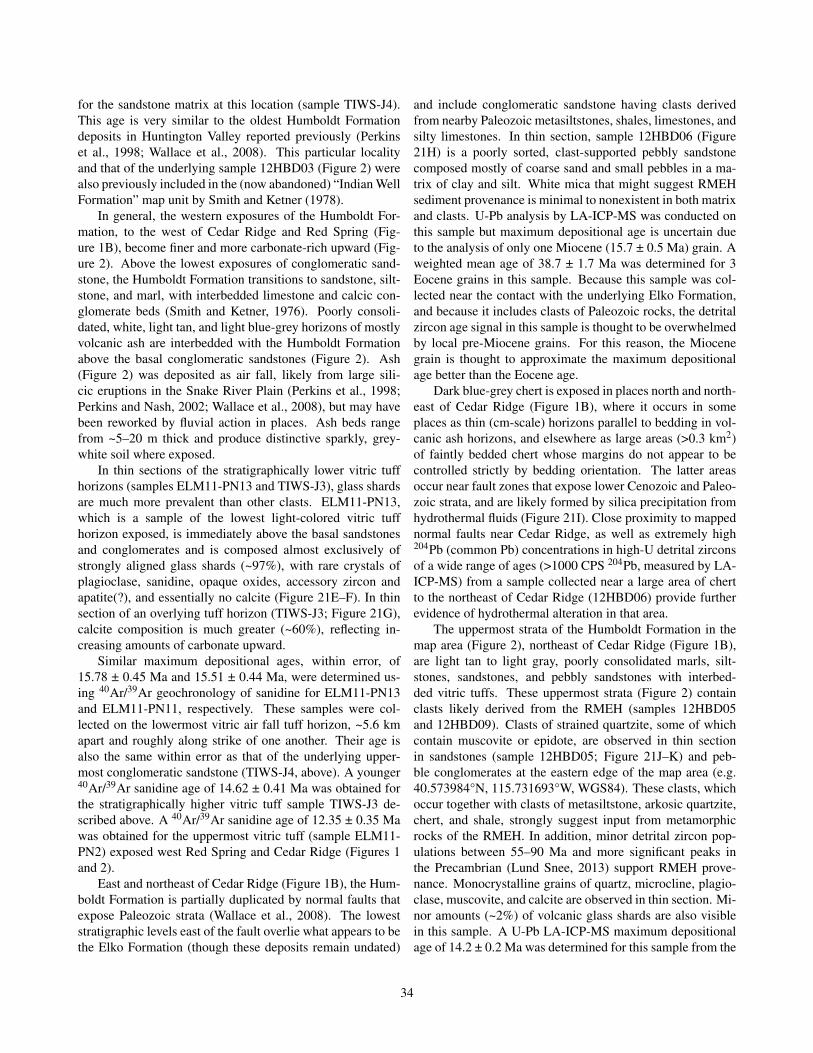
for the sandstone matrix at this location (sample TIWS-J4).This age is very similar to the oldest Humboldt Formationdeposits in Huntington Valley reported previously (Perkinset al., 1998; Wallace et al., 2008). This particular localityand that of the underlying sample 12HBD03 (Figure 2) werealso previously included in the (now abandoned) “Indian WellFormation” map unit by Smith and Ketner (1978).
In general, the western exposures of the Humboldt For-mation, to the west of Cedar Ridge and Red Spring (Fig-ure 1B), become finer and more carbonate-rich upward (Fig-ure 2). Above the lowest exposures of conglomeratic sand-stone, the Humboldt Formation transitions to sandstone, silt-stone, and marl, with interbedded limestone and calcic con-glomerate beds (Smith and Ketner, 1976). Poorly consoli-dated, white, light tan, and light blue-grey horizons of mostlyvolcanic ash are interbedded with the Humboldt Formationabove the basal conglomeratic sandstones (Figure 2). Ash(Figure 2) was deposited as air fall, likely from large sili-cic eruptions in the Snake River Plain (Perkins et al., 1998;Perkins and Nash, 2002; Wallace et al., 2008), but may havebeen reworked by fluvial action in places. Ash beds rangefrom ~5–20 m thick and produce distinctive sparkly, grey-white soil where exposed.
In thin sections of the stratigraphically lower vitric tuffhorizons (samples ELM11-PN13 and TIWS-J3), glass shardsare much more prevalent than other clasts. ELM11-PN13,which is a sample of the lowest light-colored vitric tuffhorizon exposed, is immediately above the basal sandstonesand conglomerates and is composed almost exclusively ofstrongly aligned glass shards (~97%), with rare crystals ofplagioclase, sanidine, opaque oxides, accessory zircon andapatite(?), and essentially no calcite (Figure 21E–F). In thinsection of an overlying tuff horizon (TIWS-J3; Figure 21G),calcite composition is much greater (~60%), reflecting in-creasing amounts of carbonate upward.
Similar maximum depositional ages, within error, of15.78 ± 0.45 Ma and 15.51 ± 0.44 Ma, were determined us-ing 40Ar/39Ar geochronology of sanidine for ELM11-PN13and ELM11-PN11, respectively. These samples were col-lected on the lowermost vitric air fall tuff horizon, ~5.6 kmapart and roughly along strike of one another. Their age isalso the same within error as that of the underlying upper-most conglomeratic sandstone (TIWS-J4, above). A younger40Ar/39Ar sanidine age of 14.62 ± 0.41 Ma was obtained forthe stratigraphically higher vitric tuff sample TIWS-J3 de-scribed above. A 40Ar/39Ar sanidine age of 12.35 ± 0.35 Mawas obtained for the uppermost vitric tuff (sample ELM11-PN2) exposed west Red Spring and Cedar Ridge (Figures 1and 2).
East and northeast of Cedar Ridge (Figure 1B), the Hum-boldt Formation is partially duplicated by normal faults thatexpose Paleozoic strata (Wallace et al., 2008). The loweststratigraphic levels east of the fault overlie what appears to bethe Elko Formation (though these deposits remain undated)
and include conglomeratic sandstone having clasts derivedfrom nearby Paleozoic metasiltstones, shales, limestones, andsilty limestones. In thin section, sample 12HBD06 (Figure21H) is a poorly sorted, clast-supported pebbly sandstonecomposed mostly of coarse sand and small pebbles in a ma-trix of clay and silt. White mica that might suggest RMEHsediment provenance is minimal to nonexistent in both matrixand clasts. U-Pb analysis by LA-ICP-MS was conducted onthis sample but maximum depositional age is uncertain dueto the analysis of only one Miocene (15.7 ± 0.5 Ma) grain. Aweighted mean age of 38.7 ± 1.7 Ma was determined for 3Eocene grains in this sample. Because this sample was col-lected near the contact with the underlying Elko Formation,and because it includes clasts of Paleozoic rocks, the detritalzircon age signal in this sample is thought to be overwhelmedby local pre-Miocene grains. For this reason, the Miocenegrain is thought to approximate the maximum depositionalage better than the Eocene age.
Dark blue-grey chert is exposed in places north and north-east of Cedar Ridge (Figure 1B), where it occurs in someplaces as thin (cm-scale) horizons parallel to bedding in vol-canic ash horizons, and elsewhere as large areas (>0.3 km2)of faintly bedded chert whose margins do not appear to becontrolled strictly by bedding orientation. The latter areasoccur near fault zones that expose lower Cenozoic and Paleo-zoic strata, and are likely formed by silica precipitation fromhydrothermal fluids (Figure 21I). Close proximity to mappednormal faults near Cedar Ridge, as well as extremely high204Pb (common Pb) concentrations in high-U detrital zirconsof a wide range of ages (>1000 CPS 204Pb, measured by LA-ICP-MS) from a sample collected near a large area of chertto the northeast of Cedar Ridge (12HBD06) provide furtherevidence of hydrothermal alteration in that area.
The uppermost strata of the Humboldt Formation in themap area (Figure 2), northeast of Cedar Ridge (Figure 1B),are light tan to light gray, poorly consolidated marls, silt-stones, sandstones, and pebbly sandstones with interbed-ded vitric tuffs. These uppermost strata (Figure 2) containclasts likely derived from the RMEH (samples 12HBD05and 12HBD09). Clasts of strained quartzite, some of whichcontain muscovite or epidote, are observed in thin sectionin sandstones (sample 12HBD05; Figure 21J–K) and peb-ble conglomerates at the eastern edge of the map area (e.g.40.573984°N, 115.731693°W, WGS84). These clasts, whichoccur together with clasts of metasiltstone, arkosic quartzite,chert, and shale, strongly suggest input from metamorphicrocks of the RMEH. In addition, minor detrital zircon pop-ulations between 55–90 Ma and more significant peaks inthe Precambrian (Lund Snee, 2013) support RMEH prove-nance. Monocrystalline grains of quartz, microcline, plagio-clase, muscovite, and calcite are observed in thin section. Mi-nor amounts (~2%) of volcanic glass shards are also visiblein this sample. A U-Pb LA-ICP-MS maximum depositionalage of 14.2 ± 0.2 Ma was determined for this sample from the
34

A B
C Dqtz
ch
msvc
qtzs
s
s
vc
vc
vc
E F
35
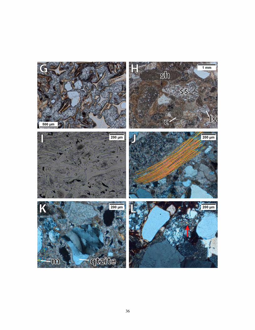
G H
I J
K L
c ls
sssh
m qtzite
36

Figure 21: Photomicrographs of the Humboldt Formation and associated rocks. (A) Ash-rich sample at the base of the Hum-boldt Formation (sample ELM11-PN19), PPL. (B) Pebble conglomerate at a different exposure near the base of the Hum-boldt Formation (sample 12HBD03), XPL. The matrix is mostly mud and silt, with scarce carbonate. Lithics of metasiltstone(ms), chert (ch), porphyritic volcanics (vc), and quartz are visible. (C) An additional view of silt- and sand-sized clastsof quartz, sanidine (s), and volcanic clasts in basal Humboldt Formation pebbly sandstone (sample 12HBD03), XPL. (D)Clast-supported sandstone (sample TIWS-J4) from an exposure of pebbly sandstone and pebble conglomerate near the baseof the Humboldt Formation but stratigraphically above samples ELM11-PN19 and 12HBD03, and immediately below thelowest vitric tuff layer, PPL. (E) The lowest Miocene vitric tuff in the Humboldt Formation exposed in the map area (sampleELM11-PN13), PPL. The matrix is almost exclusively ash shards, with minor crystals. (F) Accessory zircon and apatite(?)surrounded by glass shards in the lowest Miocene vitric tuff (sample ELM11-PN13), PPL. (G) Sparry calcite in the matrixof a Miocene vitric tuff in the Humboldt Formation (sample TIWS-J3; Figure 2), PPL. (H) Pebbly sandstone at the loweststratigraphic level of the Humboldt Formation northeast of Cedar Ridge (sample 12HBD06), PPL. Subrounded to roundedclasts of limestone (ls), siltstone (ss), and shale (sh) lithics, as well as subangular–angular crystals and ovoid concretions (c).(I) Silicified volcanic glass shards and opaque oxides make up dense, vaguely bedded chert (sample 12JLS227), PPL. (J)A large muscovite crystal (bright interference colors), along with clasts of limey shale, quartzite, limestone, and monocrys-talline quartz, calcite, and feldspars (sample 12HBD05), XPL. Muscovite and strained quartzite suggest a sediment sourcefrom metamorphic rocks in the RMEH. (K) Clasts of quartzite (qtzite) with strain textures in a limestone matrix (sample12HBD05), XPL. Detrital muscovite (m) and calcite are also present in this pebbly sandstone near the stratigraphically high-est Humboldt Formation deposits exposed in the map area (Figure 2). (L) Clast-supported pebbly sandstone of the HumboldtFormation with the youngest maximum depositional age obtained in this study, indicating the uppermost stratigraphic levelof the Humboldt Formation dated (sample 12HBD09), XPL. Muscovite is minor and is observed in quartzite clasts (indicatedby the arrow). Other clasts are shale and monocrystalline quartz and calcite. The matrix is mostly muds and silt.
weighted mean of 9 zircon grains.Other samples at upper stratigraphic levels do not contain
abundant muscovite. In thin section, a poorly sorted, poorlycemented pebbly sandstone (12HBD09) contains lithics com-posed of porphyritic volcanic rocks, metasiltstone, limestone,chert, and deformed quartzite (Figure 21L). Only very mi-nor amounts (<<1%) of white mica are observed, and theseare typically found within metasedimentary clasts. Despitethe lack of abundant white mica, the occurrence of strainedquartzites and large monocrystalline potassium feldspar sug-gest input from the RMEH. This sample (12HBD09) con-tains few shards of volcanic glass and has a U-Pb LA-ICP-MS maximum depositional age of 8.2 ± 0.2 Ma. This is theyoungest maximum depositional age for the Humboldt For-mation measured in the region (Wallace et al., 2008; Colganet al., 2010). The youngest age previously obtained in Hunt-ington Valley (east of Huntington Creek) was 9.9 Ma (Wal-lace et al., 2008), and the youngest age obtained by Colganet al. (2010) west of the Harrison Pass Pluton (in Toyn Creek)using 40Ar/39Ar (sanidine) was 11.6 ± 0.05 Ma.
Associated andesite volcanic rocks (Ta)
Platy, columnar jointed, dark grey andesite (by whole rockgeochemistry; “Ta”) is exposed in the northeastern part of thestudy area (Figure 22B) in ~3 dome-shaped structures (e.g.40.598131°N, 115.746121°W, WGS84). These rocks mayrepresent flow deposits or near-surface dikes or sills. Theserocks may intrude adjacent Eocene sedimentary rocks includ-ing what appears to be the Elko Formation, suggesting that
they may be Eocene or younger in age. These rocks are notin direct map contact with the Miocene Humboldt Forma-tion, so their timing cannot be constrained more precisely atpresent. Smith and Howard (1977) labeled this unit “Andesiteand basaltic andesite and basalt” (Tb) of Upper Miocene age,but Smith and Ketner (1978) apply the Tb label to “andesiteand basaltic andesite” elsewhere in the map area (here desig-nated Tba).
In thin section (sample 12JLS225), phenocrysts (~20%)are small (≤1 mm) and reside in a trachytic groundmass ofplagioclase laths (≤200 µm long), clinopyroxene, opaque ox-ides, and glass. Phenocrysts include clinopyroxene, plagio-clase, and small amounts of a green mineral that is proba-bly altered hornblende (Figures 22B–C). Most phenocrystshave minor reactions rims and some have shallow embay-ments (Figures 22B–C), indicating minor to moderate meltdisequilibrium.
Pliocene–Pleistocene Hay Ranch Forma-tion (QThr)The Hay Ranch Formation (Regnier, 1960; Smith and Ket-ner, 1976) consists of very shallowly dipping tan, poorlyconsolidated conglomerate, sandstone, and siltstone. It isbest exposed on the western flanks of Cedar Ridge (e.g.40.441936°N, 115.841840°W, WGS84; Figure 1B), where itrecords deposition of angular and subangular clasts of silt-stone, grey limestone, and quartzite eroded from Paleozoicrocks exposed on Cedar Ridge (Smith and Ketner, 1976,1978). The poorly sorted deposits are composed of clast-
37

supported conglomerate lenses interlayered with sandstoneand siltstone.
Fossils and zircon fission-track dating indicate a maxi-mum depositional age of middle Pliocene to middle Pleis-tocene (Smith and Ketner, 1976). It likely that the HayRanch Formation was deposited during slip on the west-dipping fault along the west side of Cedar Ridge, becauseslip on this fault system occurred in part after depositionof the Miocene Humboldt Formation (Wallace et al., 2008;Lund Snee, 2013). Nevertheless, the shallow dips of this unitin the mapped area indicate that any syn- or post-depositionalfault slip was minor.
Quaternary older gravels (Qog) and allu-vium (Qal)Quaternary gravel deposits often cap hillsides and are cut bystreams whose bottoms are filled with younger Quaternarysediments. The gravels are extremely poorly sorted, consist-ing of pebbles, cobbles, and boulders ~1 cm–10 m in diam-eter. Where clearly exposed, only boulders are visible, butassociated sand and silt have likely been washed away byyounger fluvial action. Clasts predominantly include recog-nizable Paleozoic and Cenozoic lithologies, especially Dia-mond Peak Formation conglomerates and Cenozoic subvol-canic intrusive rocks, ignimbrites, dacite lavas, and dark greybasalts or basaltic andesites. The deposits appear crudelybedded in aerial photographs and form broad, flat slopes thatlikely covered a Quaternary pediment surface that is presentlybeing incised. In other places, particularly on steep slopes,the gravels are overlain by a veneer of younger alluvium.
SUMMARY AND REGIONAL IMPLICATIONS
Huntington Valley is situated east of the Piñon Range,in the hanging wall of a shallowly west-dipping detachmentsystem bounding the west side of the Ruby Mountains–EastHumboldt Range (RMEH) metamorphic core complex. Thisgeologic map of Cenozoic sedimentary, volcanic, and sub-volcanic rocks of the central Robinson Mountain volcanicfield and northwestern Huntington Valley provides impor-tant information about the history of Cenozoic crustal exten-sion, magmatism, sedimentation, and paleogeography nearthe RMEH.
Depositional rates in the Elko Basin were minor fromCretaceous to Oligocene time, and became rapid in the Mid-dle Miocene. Late Cretaceous(?)–Eocene(?) conglomerate,sandstone, siltstone, and limestone “redbeds” (TKcs) andlimestone (TKl) are exposed at the base of the Cenozoic sec-tion in places, where they each reach thicknesses of ~600 m,but they are not exposed at all in other locations. The overly-ing Eocene Elko Formation is only ~180 m thick at its great-est in the map area. Detrital zircon geochronology conductedon two samples collected near its base yields a maximum de-
positional age of ~45.9 ± 1.0 Ma, and a third sample collectednear the top of this unit yields a maximum depositional ageof 37.9 ± 0.5 Ma.
The calcic to calc-alkalic Robinson Mountain volcanicfield records early peraluminous to weakly metaluminous“ignimbrite flare-up” volcanism of basaltic andesite to tra-chydacite and rhyolite composition, which occurred mostlybetween about 38.5–36.8 Ma. Early eruptions were roughlysynchronous with the end of deposition of the Elko Forma-tion, and no significant unconformity is observed beneaththe volcanic units. The only Eocene–Oligocene sedimen-tary rocks exposed above the Eocene Elko Formation arethin, fluviolacustrine deposits interbedded within the volcanicrocks. For this reason, the “Indian Well Formation” name forEocene–Oligocene volcanic and sedimentary rocks has beenabandoned. The rhyolitic, Oligocene-age tuff of HackwoodRanch is significantly younger than the Eocene deposits ofthe Robinson Mountain volcanic field. This tuff was eruptedat ~31.1 Ma, which coincides with a lull in regional volcan-ism, but could represent far-traveled deposits from a distantvolcanic center.
Significant, approximately westward tilting developeda shallow angular unconformity between ~37.3–33.9 Ma(10–15°). Subsequently, between ~31.1 Ma and 24.4 Maor later (10–15°additional westward tilting occurred. Thesewestward tilting events were likely associated with slip oneast-dipping normal faults in the Piñon Range. Following thesecond episode of westward tilting, a basin rapidly developednear the present-day RMEH, as recorded by thick depositsof the mostly Miocene Humboldt Formation that dip gentlyeastward toward the RMEH. Greater than 1 km of the sedi-mentary strata previously mapped as Eocene–Oligocene agehas been reassigned to the Miocene Humboldt Formation asa result of our geologic mapping and supporting geochronol-ogy.
Detrital zircon geochronology yielded a coherent agegroup at ~24.4 Ma for one tuffaceous pebble conglomerateand sandstone sample at the base of the Humboldt Forma-tion, but it is unlikely that this maximum depositional ageconstrains the timing of the start of basin sedimentation. De-position accelerated at ~16–15 Ma, when most of HumboldtFormation pebble conglomerate, sandstone, siltstone, marl,and air-fall tuff were deposited in Huntington Valley. Lo-cally, pre-Tertiary rocks were exposed by faulting by ~16 Ma(although this depositional age is not well constrained), andRMEH provenance is not detected until ~14 Ma, suggestingthat the metamorphic core complex was not exposed untilabout this time. Greater than 2100 m of Humboldt Forma-tion strata were deposited in the study area alone (thickeningfurther eastward toward the RMEH), and deposition contin-ued until at least ~8.2 Ma, but the rate apparently decreasedbefore ~12 Ma.
Miocene or later fault slip occurred along a well-preserved, east-dipping normal fault system exposed at the
38
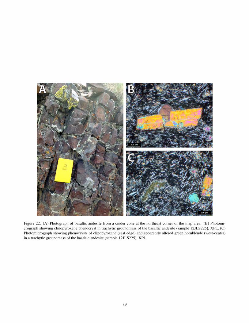
A B
C
Figure 22: (A) Photograph of basaltic andesite from a cinder cone at the northeast corner of the map area. (B) Photomi-crograph showing clinopyroxene phenocryst in trachytic groundmass of the basaltic andesite (sample 12JLS225), XPL. (C)Photomicrograph showing phenocrysts of clinopyroxene (east edge) and apparently altered green hornblende (west-center)in a trachytic groundmass of the basaltic andesite (sample 12JLS225), XPL.
39
east side of the Piñon Range, partially synchronous withfaulting at the RMEH. Uplift and erosion of Eocene- toQuaternary-age sedimentary and volcanic deposits on thewest side of Huntington Valley support a significant magni-tude of slip on west-dipping normal faults west of the studyarea during or after Miocene time. Open folding of the Hum-boldt Formation occurred during or after the Middle–LateMiocene, perhaps due to normal fault slip offsetting under-lying Paleozoic basement.
This geologic mapping study thus supports the hypothe-sis that surface-breaking extensional faulting in and near themapped area was minor from the Late Cretaceous(?) throughthe Early Miocene, and that most surface-breaking extensionand sediment deposition occurred in Middle Miocene time.
ACKNOWLEDGEMENTS
Mapping was funded by Stanford University and U.S.Geological Survey EdMap award number G12AC20189 toLund Snee and Miller and NSF grant Tectonics 1322084 toMiller. We thank Joe Colgan, Dave John, and Chris Henryfor contributing their extensive knowledge about the region(and unpublished data) and helping launch this project. Wealso thank Hunter Dudley, Monica Erviti, Jeff Knox, MarkRaftrey, and the students of GES 190 for their able assistancein the field. Beti Girma and Samuel Xiao helped digitize themap. We are grateful for NBMG editorial and cartographicassistance by Kathryn E. Ryan.
REFERENCES
Best, M. G., Barr, D. L., Christiansen, E. H., Gromme, S.,Deino, A. L., and Tingey, D. G. 2009. The Great BasinAltiplano during the middle Cenozoic ignimbrite flareup:insights from volcanic rocks. International Geology Re-view, 51(7-8):589–633.
Chamberlain, C. P., Mix, H. T., Mulch, A., Hren, M. T., Kent-Corson, M. L., Davis, S. J., Horton, T. W., and Graham,S. A. 2012. The Cenozoic climatic and topographic evolu-tion of the western North American Cordillera. AmericanJournal of Science, 312:213–262.
Chetel, L. M., Janecke, S. U., Carroll, A. R., Beard, B. L.,Johnson, C. M., and Singer, B. S. 2011. Paleogeographicreconstruction of the Eocene Idaho River, North AmericanCordillera. GSA Bulletin, 123(1/2):71–88.
Cline, J. S., Hofstra, A. H., Muntean, J. L., Tosdal, R. M., andHickey, K. A. 2005. Carlin-type gold deposits in Nevada:Critical geologic characteristics and viable models. Eco-nomic Geology, 100th anniversary volume:451–484.
Coats, R. R. 1987. Geology of Elko County, Nevada. NevadaBureau of Mines and Geology Bulletin 101, pages 1–112.
Colgan, J. P. and Henry, C. D. 2009. Rapid middle Miocenecollapse of the Mesozoic orogenic plateau in northcentralNevada. International Geology Review, 51(9):920–961.
Colgan, J. P., Howard, K. A., Fleck, R. J., and Wooden,J. L. 2010. Rapid middle Miocene extension and unroof-ing of the southern Ruby Mountains, Nevada. Tectonics,29(TC6022):38 p.
DeCelles, P. G. 2004. Late Jurassic to Eocene evolution of theCordilleran thurst belt and foreland basin system, westernU.S.A. American Journal of Science, 304:105–168.
Dickinson, W. R. 2006. Geotectonic evolution of the GreatBasin. Geosphere, 2(7):358–368.
Druschke, P., Hanson, A. D., Wells, M. L., Gehrels, G. E.,and Stockli, D. 2011. Paleogeographic isolation of the Cre-taceous to Eocene Sevier hinterland, east-central Nevada:Insights from U-Pb and (U-Th)/He detrital zircon ages ofhinterland strata. GSA Bulletin, 123(5–6):1141–1160.
Druschke, P., Hanson, A. D., Wells, M. L., Rasbury, T.,Stockli, D. F., and Gehrels, G. 2009. Synconvergentsurface-breaking normal faults of Late Cretaceous agewithin the Sevier hinterland, east-central Nevada. Geol-ogy, 37(5):447–450.
Faulds, J. E., Henry, C. D., and Hinz, N. H. 2005. Kinematicsof the northern Walker Lane: An incipient transform faultalong the Pacific–North American plate boundary. Geol-ogy, 33(6):505–508.
Fouch, T. D., Hanley, J. H., and Forester, R. M. 1979. Prelim-inary correlation of Cretaceous and Paleogene lacustrineand related nonmarine sedimentary and volcanic rocks inparts of the eastern Great Basin of Nevada and Utah.In Basin and Range Symposium, pages 305–312. RockyMountain Association of Geologists.
Gordee, S. M., Dettloff, C. L., and Burton, B. R. 2000.Geologic and geochemical comparison of Late Eocene–Oligocene volcanic and intrusive rocks, Carlin-PiñonRange and central Ruby Mountains, Elko County, Nevada.Geological Society of America Abstracts with Programs,32(7):159.
Hague, A. and Emmons, S. F. 1877. Descriptive geology: Ge-ological exploration of the Fortieth Parallel, Vol. II. Pro-fessional Papers of the Engineering Dept, US Army, 18.
Haxby, W. F., Melkonian, A. K., Coplan, J., Chan, S. M.,and Ryan, W. B. F. 2010. GeoMapApp freewaresoftware, v. 2.3. Lamont-Doherty Earth Observatory,Palisades, http://jgs. geoscienceworld. org/cgi/content/-full/168/2/333.
40
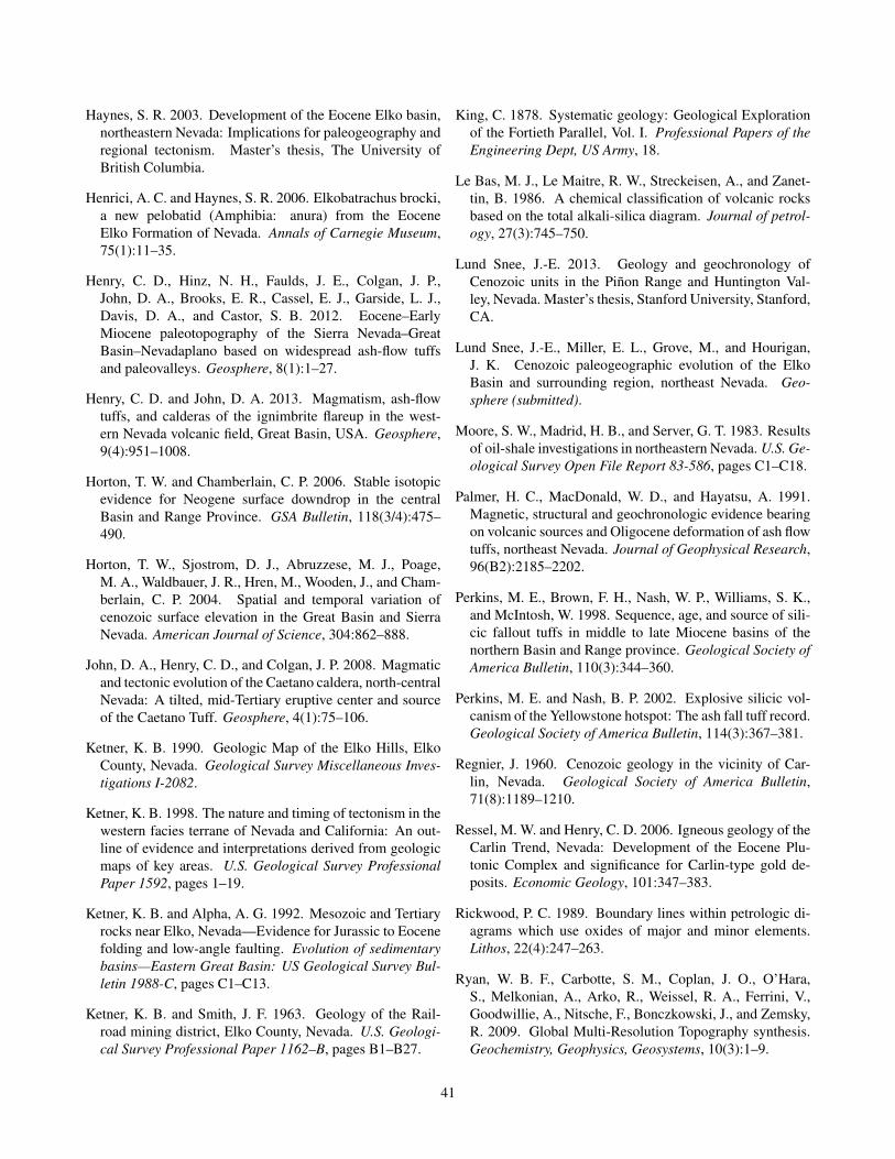
Haynes, S. R. 2003. Development of the Eocene Elko basin,northeastern Nevada: Implications for paleogeography andregional tectonism. Master’s thesis, The University ofBritish Columbia.
Henrici, A. C. and Haynes, S. R. 2006. Elkobatrachus brocki,a new pelobatid (Amphibia: anura) from the EoceneElko Formation of Nevada. Annals of Carnegie Museum,75(1):11–35.
Henry, C. D., Hinz, N. H., Faulds, J. E., Colgan, J. P.,John, D. A., Brooks, E. R., Cassel, E. J., Garside, L. J.,Davis, D. A., and Castor, S. B. 2012. Eocene–EarlyMiocene paleotopography of the Sierra Nevada–GreatBasin–Nevadaplano based on widespread ash-flow tuffsand paleovalleys. Geosphere, 8(1):1–27.
Henry, C. D. and John, D. A. 2013. Magmatism, ash-flowtuffs, and calderas of the ignimbrite flareup in the west-ern Nevada volcanic field, Great Basin, USA. Geosphere,9(4):951–1008.
Horton, T. W. and Chamberlain, C. P. 2006. Stable isotopicevidence for Neogene surface downdrop in the centralBasin and Range Province. GSA Bulletin, 118(3/4):475–490.
Horton, T. W., Sjostrom, D. J., Abruzzese, M. J., Poage,M. A., Waldbauer, J. R., Hren, M., Wooden, J., and Cham-berlain, C. P. 2004. Spatial and temporal variation ofcenozoic surface elevation in the Great Basin and SierraNevada. American Journal of Science, 304:862–888.
John, D. A., Henry, C. D., and Colgan, J. P. 2008. Magmaticand tectonic evolution of the Caetano caldera, north-centralNevada: A tilted, mid-Tertiary eruptive center and sourceof the Caetano Tuff. Geosphere, 4(1):75–106.
Ketner, K. B. 1990. Geologic Map of the Elko Hills, ElkoCounty, Nevada. Geological Survey Miscellaneous Inves-tigations I-2082.
Ketner, K. B. 1998. The nature and timing of tectonism in thewestern facies terrane of Nevada and California: An out-line of evidence and interpretations derived from geologicmaps of key areas. U.S. Geological Survey ProfessionalPaper 1592, pages 1–19.
Ketner, K. B. and Alpha, A. G. 1992. Mesozoic and Tertiaryrocks near Elko, Nevada—Evidence for Jurassic to Eocenefolding and low-angle faulting. Evolution of sedimentarybasins—Eastern Great Basin: US Geological Survey Bul-letin 1988-C, pages C1–C13.
Ketner, K. B. and Smith, J. F. 1963. Geology of the Rail-road mining district, Elko County, Nevada. U.S. Geologi-cal Survey Professional Paper 1162–B, pages B1–B27.
King, C. 1878. Systematic geology: Geological Explorationof the Fortieth Parallel, Vol. I. Professional Papers of theEngineering Dept, US Army, 18.
Le Bas, M. J., Le Maitre, R. W., Streckeisen, A., and Zanet-tin, B. 1986. A chemical classification of volcanic rocksbased on the total alkali-silica diagram. Journal of petrol-ogy, 27(3):745–750.
Lund Snee, J.-E. 2013. Geology and geochronology ofCenozoic units in the Piñon Range and Huntington Val-ley, Nevada. Master’s thesis, Stanford University, Stanford,CA.
Lund Snee, J.-E., Miller, E. L., Grove, M., and Hourigan,J. K. Cenozoic paleogeographic evolution of the ElkoBasin and surrounding region, northeast Nevada. Geo-sphere (submitted).
Moore, S. W., Madrid, H. B., and Server, G. T. 1983. Resultsof oil-shale investigations in northeastern Nevada. U.S. Ge-ological Survey Open File Report 83-586, pages C1–C18.
Palmer, H. C., MacDonald, W. D., and Hayatsu, A. 1991.Magnetic, structural and geochronologic evidence bearingon volcanic sources and Oligocene deformation of ash flowtuffs, northeast Nevada. Journal of Geophysical Research,96(B2):2185–2202.
Perkins, M. E., Brown, F. H., Nash, W. P., Williams, S. K.,and McIntosh, W. 1998. Sequence, age, and source of sili-cic fallout tuffs in middle to late Miocene basins of thenorthern Basin and Range province. Geological Society ofAmerica Bulletin, 110(3):344–360.
Perkins, M. E. and Nash, B. P. 2002. Explosive silicic vol-canism of the Yellowstone hotspot: The ash fall tuff record.Geological Society of America Bulletin, 114(3):367–381.
Regnier, J. 1960. Cenozoic geology in the vicinity of Car-lin, Nevada. Geological Society of America Bulletin,71(8):1189–1210.
Ressel, M. W. and Henry, C. D. 2006. Igneous geology of theCarlin Trend, Nevada: Development of the Eocene Plu-tonic Complex and significance for Carlin-type gold de-posits. Economic Geology, 101:347–383.
Rickwood, P. C. 1989. Boundary lines within petrologic di-agrams which use oxides of major and minor elements.Lithos, 22(4):247–263.
Ryan, W. B. F., Carbotte, S. M., Coplan, J. O., O’Hara,S., Melkonian, A., Arko, R., Weissel, R. A., Ferrini, V.,Goodwillie, A., Nitsche, F., Bonczkowski, J., and Zemsky,R. 2009. Global Multi-Resolution Topography synthesis.Geochemistry, Geophysics, Geosystems, 10(3):1–9.
41
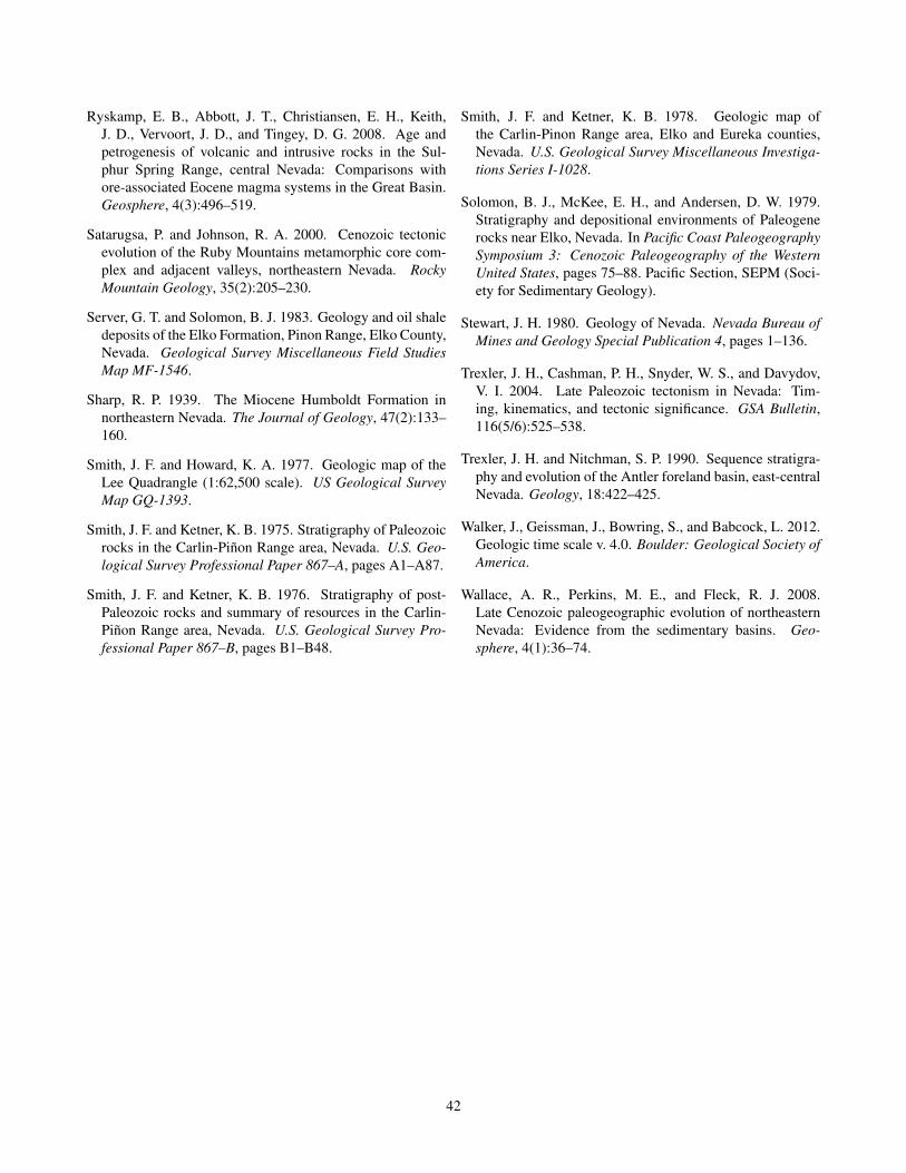
Ryskamp, E. B., Abbott, J. T., Christiansen, E. H., Keith,J. D., Vervoort, J. D., and Tingey, D. G. 2008. Age andpetrogenesis of volcanic and intrusive rocks in the Sul-phur Spring Range, central Nevada: Comparisons withore-associated Eocene magma systems in the Great Basin.Geosphere, 4(3):496–519.
Satarugsa, P. and Johnson, R. A. 2000. Cenozoic tectonicevolution of the Ruby Mountains metamorphic core com-plex and adjacent valleys, northeastern Nevada. RockyMountain Geology, 35(2):205–230.
Server, G. T. and Solomon, B. J. 1983. Geology and oil shaledeposits of the Elko Formation, Pinon Range, Elko County,Nevada. Geological Survey Miscellaneous Field StudiesMap MF-1546.
Sharp, R. P. 1939. The Miocene Humboldt Formation innortheastern Nevada. The Journal of Geology, 47(2):133–160.
Smith, J. F. and Howard, K. A. 1977. Geologic map of theLee Quadrangle (1:62,500 scale). US Geological SurveyMap GQ-1393.
Smith, J. F. and Ketner, K. B. 1975. Stratigraphy of Paleozoicrocks in the Carlin-Piñon Range area, Nevada. U.S. Geo-logical Survey Professional Paper 867–A, pages A1–A87.
Smith, J. F. and Ketner, K. B. 1976. Stratigraphy of post-Paleozoic rocks and summary of resources in the Carlin-Piñon Range area, Nevada. U.S. Geological Survey Pro-fessional Paper 867–B, pages B1–B48.
Smith, J. F. and Ketner, K. B. 1978. Geologic map ofthe Carlin-Pinon Range area, Elko and Eureka counties,Nevada. U.S. Geological Survey Miscellaneous Investiga-tions Series I-1028.
Solomon, B. J., McKee, E. H., and Andersen, D. W. 1979.Stratigraphy and depositional environments of Paleogenerocks near Elko, Nevada. In Pacific Coast PaleogeographySymposium 3: Cenozoic Paleogeography of the WesternUnited States, pages 75–88. Pacific Section, SEPM (Soci-ety for Sedimentary Geology).
Stewart, J. H. 1980. Geology of Nevada. Nevada Bureau ofMines and Geology Special Publication 4, pages 1–136.
Trexler, J. H., Cashman, P. H., Snyder, W. S., and Davydov,V. I. 2004. Late Paleozoic tectonism in Nevada: Tim-ing, kinematics, and tectonic significance. GSA Bulletin,116(5/6):525–538.
Trexler, J. H. and Nitchman, S. P. 1990. Sequence stratigra-phy and evolution of the Antler foreland basin, east-centralNevada. Geology, 18:422–425.
Walker, J., Geissman, J., Bowring, S., and Babcock, L. 2012.Geologic time scale v. 4.0. Boulder: Geological Society ofAmerica.
Wallace, A. R., Perkins, M. E., and Fleck, R. J. 2008.Late Cenozoic paleogeographic evolution of northeasternNevada: Evidence from the sedimentary basins. Geo-sphere, 4(1):36–74.
42


