
Lucchesi Plaza ISMND · 10. CMI Engineering & Construction. Stormwater Control Plan for Acorn Self...
76
California Environmental Quality Act (CEQA) Initial Study for Lucchesi Plaza (GPA 02-17, RZ 03-17) March 2018 Prepared by 1501 Sports Drive, Suite A, Sacramento, CA 95834
Transcript of Lucchesi Plaza ISMND · 10. CMI Engineering & Construction. Stormwater Control Plan for Acorn Self...

California Environmental Quality Act (CEQA)
Initial Study
for
Lucchesi Plaza (GPA 02-17, RZ 03-17)
March 2018
Prepared by
1501 Sports Drive, Suite A, Sacramento, CA 95834

[THIS PAGE INTENTIONALLY LEFT BLANK]

1 March 2018
INITIAL STUDY/MITIGATED NEGATIVE DECLARATION
A. BACKGROUND 1. Project Title: Lucchesi Plaza 2. Lead Agency Name and Address: City of Oakley
3231 Main Street Oakley, CA 94561
3. Contact Person and Phone Number: Joshua McMurray Planning Manager (925) 625-7004
4. Project Location: 422 Laurel Road Oakley, CA 94561 Assessor’s Parcel Number (APN): 035-230-002
5. Project Sponsor: Allen and Julie Lucchesi 100 Kessler Lane Oakley, CA 94561 6. Existing General Plan: Single-Family Residential, Medium Density (SM) 7. Proposed General Plan: Single-Family Residential, High Density (SH) 8. Existing Zoning: Single-Family Residential (R-10) 9. Proposed Zoning: Planned Development (P-1)
10. Project Description Summary:
The Lucchesi Plaza Project (proposed project) would require approval of: 1) a General Plan Amendment (GPA 02-17) to amend the land use designation from Single-Family Residential, Medium Density (SM) to Single-Family Residential, High Density (SH) and 2) a Rezone (RZ 03-17) from Single-Family Residential (R-10) to Planned Development (P-1) to allow for up to 52 for single-family homes or an approximately 1,800 square-foot (sf) wine tasting facility. It should be noted that development plans are not included at this time.

2 March 2018
B. SOURCES All technical reports and modeling results prepared for the project analysis are available upon request at the City of Oakley City Hall, located at 3231 Main Street, Oakley, CA 94561. The following documents are referenced information sources utilized by this analysis: 1. Bay Area Air Quality Management District. CEQA Air Quality Guidelines. (updated
May 2017). 2. California Department of Fish and Wildlife. California Natural Diversity Database.
Available at http://www.dfg.ca.gov/biogeodata/cnddb/mapsanddata.asp. Accessed June 2016.
3. California Emissions Estimator Model. CalEEMod. Version 2011.1. Accessed on June 2016.
4. California Environmental Protection Agency, California Air Resources Board. Air Quality and Land Use Handbook: A Community Health Perspective. Published April 2005.
5. City of Oakley, Oakley 2020 General Plan, December 2002 (Amended 2016). 6. City of Oakley, Oakley 2020 General Plan Background Report, September 2001. 7. City of Oakley, Oakley 2020 General Plan Environmental Impact Report, December
2002. 8. City of Oakley. Oakley Commercial & Industrial Design Guidelines. February 2005. 9. City of Oakley. Oakley Municipal Code. Accessible at
http://www.codepublishing.com/CA/Oakley/. Passed May 10, 2016. 10. CMI Engineering & Construction. Stormwater Control Plan for Acorn Self Storage
Facility – Oakley. March 2016. 11. Contra Costa Transportation Authority. 2011 Contra Costa Congestion Management
Program [page 62]. Adopted November 16, 2011. 12. Diablo Water District. Final 2010 Urban Water Management Plan. June 2011. 13. East Contra Costa County Habitat Conservation Plan Association. Final East Contra
Costa County Habitat Conservation Plan/Natural Community Conservation Plan. Published October 2006.
14. Federal Emergency Management Agency, National Flood Insurance Program. Flood Insurance Rate Map Number 06013C0355F Effective June 16, 2009.
15. Institute of Transportation Engineers. Trip Generation Handbook – 9th Edition. September 2012.
16. Northwest Information Center, California Historical Resources Information System. Record Search Results for the Proposed Acorn Self-Storage Project; 4275 Neroly Road, Oakley, CA 94561. June 27, 2016.
17. State of California, Natural Resources Agency, Department of Conservation. Contra Costa County Important Farmland 2012. Published April 2014.
18. United States Department of Agriculture, Natural Resources Conservation Service. Web Soil Survey. Available at: http://websoilsurvey.nrcs.usda.gov/app/WebSoilSurvey.aspx. Accessed on January 2018.

3 March 2018
19. Federal highway Administration, Noise, Updated June 28, 2017, Available at: http://www.fhwa.dot.gov/environment/noise/noise_barriers/design_construction/design/design03.cfm. Accessed on June 6, 2016.
20. City of Oakley, Residential Design Guidelines, December 2003, Available at: http://www.ci.oakley.ca.us/wp-content/uploads/2015/07/Final-Residential-Design-Guideline-1203.pdf. Accessed on February 2018.

4 March 2018
C. ENVIRONMENTAL FACTORS POTENTIALLY AFFECTED The environmental factors checked below would be potentially affected by this project, involving at least one impact that is “Less Than Significant With Mitigation Incorporated” as indicated by the checklist on the following pages. Aesthetics Agriculture and
Forestry Resources Air Quality
Biological Resources Cultural Resources Greenhouse Gas Emissions
Geology and Soils Hazards and Hazardous Materials
Hydrology and Water Quality
Land Use and Planning Mineral Resources Noise
Population and Housing Public Services Recreation
Transportation/Circulation Tribal Cultural Resources
Utilities and Service Systems
Mandatory Findings of Significance

5 March 2018
D. DETERMINATION On the basis of this Initial Study: I find that the Proposed Project COULD NOT have a significant effect on the
environment, and a NEGATIVE DECLARATION will be prepared. I find that although the Proposed Project could have a significant effect on the
environment, there will not be a significant effect in this case because revisions in the project have been made by or agreed to by the applicant. A MITIGATED NEGATIVE DECLARATION will be prepared.
I find that the Proposed Project MAY have a significant effect on the
environment, and an ENVIRONMENTAL IMPACT REPORT is required. I find that the proposed project MAY have a “potentially significant impact” or
“potentially significant unless mitigated” on the environment, but at least one effect 1) has been adequately analyzed in an earlier document pursuant to applicable legal standards, and 2) has been addressed by mitigation measures based on the earlier analysis as described on attached sheets. An ENVIRONMENTAL IMPACT REPORT is required, but it must analyze only the effects that remain to be addressed.
I find that although the proposed project could have a significant effect on the
environment, because all potentially significant effects (a) have been analyzed adequately in an earlier EIR pursuant to applicable standards, and (b) have been avoided or mitigated pursuant to that earlier EIR, including revisions or mitigation measures that are imposed upon the proposed project, nothing further is required.
______________________________ Signature Date Joshua McMurray City of Oakley _ Printed Name For

6 March 2018
E. BACKGROUND AND INTRODUCTION This Initial Study/Mitigated Negative Declaration (IS/MND) provides an environmental analysis pursuant to the California Environmental Quality Act (CEQA) for the proposed project. The applicant has submitted this application to the City of Oakley, which is the Lead Agency for the purposes of CEQA review. The IS/MND contains an analysis of the environmental effects of construction and operation of the proposed project. In December 2002, the City of Oakley adopted the Oakley General Plan and the Oakley General Plan Environmental Impact Report (EIR). The General Plan EIR was a program-level EIR, prepared pursuant to Section 15168 of the CEQA Guidelines (Title 14, California Code of Regulations, Sections 15000 et seq.). The General Plan EIR analyzed full implementation of the Oakley General Plan and identified measures to mitigate the significant adverse project and cumulative impacts associated with the General Plan. Pursuant to CEQA Guidelines Section 15150(a), the City of Oakley General Plan and General Plan EIR are incorporated by reference. Both documents are available at the City of Oakley, 3231 Main Street, Oakley, CA 94561. The impact discussions for each section of this IS/MND have been largely based on information in the Oakley General Plan and the Oakley General Plan EIR. The mitigation measures prescribed for environmental effects described in this IS/MND would be implemented in conjunction with the project, as required by CEQA, and the mitigation measures would be incorporated into the project. In addition, findings and a project Mitigation Monitoring and Reporting Program (MMRP) would be adopted in conjunction with approval of the project. F. PROJECT DESCRIPTION The following Section includes a description of the project’s location and surrounding land uses, as well as a discussion of the project components and discretionary actions requested of the City of Oakley by the project. Project Location and Surrounding Land Uses The project site is located in the City of Oakley at 422 Laurel Road (APN: 035-230-002). The project site is approximately 9.5 acres with a vineyard and single-family home that was built in 1920 (see Figure 1). The single-family home is located on the eastern side of the property while the vineyard occupies the remaining 80 percent of the parcel. Surrounding existing land uses include residential development bordering the site to the north and east, vacant land to the west, and a residential development currently under construction to the south. The City of Oakley 2020 General Plan designates the site as Single-Family Residential, Medium Density and the site is zoned as Single-Family Residential (R-10).

7 March 2018
Figure 1 Project Vicinity Map
N
Project Site Boundary

8 March 2018
Project Components The proposed project includes a General Plan Amendment from Single-Family Residential, Medium Density (3.8 dwelling units per acre maximum density) to Single-Family Residential, High Density (5.5 dwelling units per acre maximum density), which would allow for development of up to 52 units. In addition, the proposed project would include a rezone from Single-Family Residential (R-10) District to Planned Development (P-1). The proposed project site is anticipated to buildout in the future in one of two ways: 1) up to 52 single-family homes or 2) an approximately 1,800-sf wine tasting facility. While a specific application or development plans have not been submitted to the City, the applicant is seeking approval of both scenarios. The proposed project site is accessed from Laurel Road, Rose Ave, and Loren Lane. If developed as a wine tasting facility, the main access to the tasting facility would remain on Laurel Road. Utility connections occur at the existing water and sewer lines on Laurel Road.
Discretionary Actions Implementation of the proposed project would require the following discretionary actions by the City of Oakley:
Adoption of the Initial Study/Mitigated Negative Declaration; Adoption of the Mitigation Monitoring and Reporting Program; Approval of a General Plan Amendment (GPA 02-17) to amend the land use
designation from Single-Family Residential, Medium Density (SM) to Single-Family Residential, High Density (SH);
Approval of a Rezone (RZ 03-17) from Single-Family Residential (R-10) to Planned Development (P-1).
9 March 2018
G. ENVIRONMENTAL CHECKLIST The following checklist contains the environmental checklist form presented in Appendix G of the CEQA Guidelines. The checklist form is used to describe the impacts of the proposed project. A discussion follows each environmental issue area identified in the checklist. Included in each discussion are project-specific mitigation measures required, where necessary, as part of the proposed project. For this checklist, the following designations are used: Potentially Significant Impact: An impact that could be significant, and for which mitigation has not been identified. If any potentially significant impacts are identified, an EIR must be prepared. Less Than Significant With Mitigation Incorporated: An impact that requires mitigation to reduce the impact to a less-than-significant level. Less-Than-Significant Impact: Any impact that would not be considered significant under CEQA relative to existing standards. No Impact: The project would not have any impact.

10 March 2018
Issues
Potentially Significant
Impact
Less-Than-Significant
With Mitigation
Incorporated
Less-Than-Significant
Impact
No
Impact
I. AESTHETICS. Would the project:
a. Have a substantial adverse effect
on a scenic vista?
b. Substantially damage scenic
resources, including, but not limited to, trees, rock outcroppings, and historic buildings within a State scenic highway?
c. Substantially degrade the existing
visual character or quality of the site and its surroundings?
d. Create a new source of substantial
light or glare which would adversely affect day or night-time views in the area?
Discussion a. Scenic resources in Oakley, as defined in the City’s General Plan, include
predominant natural landscape features such as the Delta, Dutch Slough, Marsh Creek, the Contra Costa Canal, agricultural and other open space lands, as well as views of Mount Diablo to the west. The City of Oakley does not specifically identify scenic vistas within the City’s planning area, but the conclusion could be drawn that any development which would impact views of any of the aforementioned landscape features would result in an impact to scenic vistas. The proposed project site does not afford views of the Delta, Dutch Slough, or Marsh Creek. A portion of the Contra Costa Canal is located approximately five miles north-west of the proposed project site. Potential views of the canal from the project site are blocked by the topography of the intervening landscape. Additionally, Mount Diablo is visible from portions of the project site along Laurel Road, and presumably from many of the existing single-family residences as well as drivers along Laurel Road. Development of the site with single-family homes could potentially obstruct views of Mount Diablo from travelers along Laurel Road and the adjacent residences to the east. However, if a wine tasting facility is built, the existing site characteristics would not change. Therefore, the vineyards would not be changed and the wine tasting facility would not obstruct or alter views of Mount Diablo.
The project site is currently designated by the City of Oakley General Plan as
Single-Family Residential, Low Density. Therefore, buildout of the project site

11 March 2018
with single-family residences was anticipated by the City. Such residences could have been one- or two-story buildings and would have similarly impacted views of Mount Diablo from Laurel Road. As a result, the project would not create a significant impact not already anticipated by the General Plan or the General Plan EIR. Therefore, because the proposed project is not in an area designated as a scenic vista by the City of Oakley, the project would result in a less-than-significant impact in having a substantial adverse effect on the scenic vista.
b. According to the California Scenic Highway Mapping System, administered by
Caltrans, a portion of SR 4, from the intersection of SR 4 with SR 160, west toward the Contra Costa County line is eligible for State Scenic Highway designation. The proposed project is located approximately two and a half miles east of SR 4 within the section of the roadway eligible for state designation. However, a large barrier wall along SR 4 blocks all views of the project site from SR 4. Because the project site is not visible from SR 4, the proposed project would not damage scenic resources within a State Scenic Highway and consequently result in a less-than-significant impact.
c. The project site is bordered by Laurel Road, Rose Ave and Loren Lane with
single-family residences to the north, and SR 4 to the west. The visual character of the site would not change if developed as a wine tasting facility, but if developed as a single-family development, the visual character would be changed. However, single-family development would be consistent with the type of use contemplated in the General Plan and General Plan EIR. In addition, the City has adopted Residential Design Guidelines, which are intended to integrate new single-family development into the existing fabric of Oakley, and preserve the City’s human scale and sense of place. Future development applications will be reviewed for consistency with the Residential Design Guidelines, which ensures that the proposed project would be compatible with the surrounding area and the visual quality would not be substantially degraded. Therefore, the impact would be considered less than significant.
d. Currently, the proposed project site consists of a vineyard with a single-family
home, all of which emits minimal amounts of light and glare. If the proposed project is developed as a wine tasting facility, the structure would not change significantly enough such that a substantially greater amount of light would be emitted than currently occurs. The development of single-family homes would add substantial new light and glare to the site. However, compliance with the City’s Residential Design Guidelines and lighting standards, would ensure that the proposed project would not result in light trespass onto adjacent properties. Therefore, any creation of new sources of light and glare by the future project would be considered a less-than-significant impact.

12 March 2018
Issues
Potentially Significant
Impact
Less-Than-Significant
With Mitigation
Incorporated
Less-Than-
Significant Impact
No
Impact
II. AGRICULTURE RESOURCES.
In determining whether impacts to agricultural resources are significant environmental effects, lead agencies may refer to the California Agricultural Land Evaluation and Site Assessment Model (1997) prepared by the California Dept. of Conservation as an optional model to use in assessing impacts on agriculture and farmland. In determining whether impacts to forest resources, including timberland, are significant environmental effects, lead agencies may refer to information compiled by the California Department of Forestry and Fire Protection regarding the state’s inventory of forest land, including the Forest and Range Assessment Project and the Forest Legacy Assessment project; and forest carbon measurement methodology provided in Forest Protocols adopted by the California Air Resources Board. Would the project:
a. Convert Prime Farmland, Unique Farmland, or Farmland of Statewide Importance (Farmland), as shown on the maps prepared pursuant to the Farmland Mapping Program of the California Resources Agency, to non-agricultural use?
b. Conflict with existing zoning for agricultural use, or a Williamson Act contract?
c. Conflict with existing zoning for, or cause rezoning of, forest land (as defined in Public Resources Code section 12220(g)), timberland (as defined by Public Resources Code section 4526), or timberland zoned Timberland Production (as defined by Government Code section 51104(g))?
d. Result in the loss of forest land or conversion of forest land to non-forest use?
e. Involve other changes in the existing environment which, due to their location or nature, could individually or cumulatively result in loss of Farmland to non-agricultural use?

13 March 2018
Discussion a,e. The proposed project site is designated as “Farmland of Statewide Importance”
on the Contra Costa County Important Farmland Map 2014 published by the Department of Conservation. Farmland of Statewide Importance is similar to Prime Farmland but with minor shortcomings. Land must have been used for irrigated agricultural production during the four years prior to the mapping date. Therefore, any future development of the project site would convert Farmland of Statewide Importance to a non-agricultural use. Although the site is considered Farmland of Statewide Importance, the site has been designated for urban development in the General Plan and development of the site as single-family residential was contemplated and evaluated in the General Plan EIR. Therefore, the project would not result in additional impacts not already anticipated by the General Plan EIR, and the proposed project would result in a less-than-significant impact, consistent with the General Plan EIR.
b. The project site is currently zoned as Single-Family Residential, Low Density and
consequently the project would not conflict with any agricultural zoning use for the project site. Additionally, the site is not under a Williamson Act contract. Thus, the proposed project would not conflict with existing zoning for agricultural use and would not conflict with a Williamson Act contract, and no impact would occur.
c,d. The project site is not considered forest land (as defined in Public Resources
Code section 12220[g]), timberland (as defined by Public Resources Code section 4526), and is not zoned Timberland Production (as defined by Government Code section 51104[g]). Therefore, the proposed project would have no impact with regard to conversion of forest land or any potential conflict with forest land, timberland, or Timberland Production zoning.

14 March 2018
Issues
Potentially Significant
Impact
Less-Than-Significant
With Mitigation
Incorporated
Less-Than-Significant
Impact
No
Impact
III. AIR QUALITY. Where available, the significance criteria established by the applicable air quality management or air pollution control district may be relied upon to make the following determinations. Would the project:
a. Conflict with or obstruct implementation
of the applicable air quality plan?
b. Violate any air quality standard or
contribute substantially to an existing or projected air quality violation?
c. Result in a cumulatively considerable net
increase of any criteria pollutant for which the project region is non-attainment under an applicable federal or state ambient air quality standard (including releasing emissions which exceed quantitative thresholds for ozone precursors)?
d. Expose sensitive receptors to substantial
pollutant concentrations?
e. Create objectionable odors affecting a
substantial number of people?
Discussion a-c. The City of Oakley is located in the San Francisco Bay Area Air Basin (SFBAAB),
which is under the jurisdiction of the Bay Area Air Quality Management District (BAAQMD). The SFBAAB area is currently designated as a nonattainment area for the State and federal ozone, State and federal fine particulate matter 2.5 microns in diameter (PM2.5), and State respirable particulate matter 10 microns in diameter (PM10) ambient air quality standards (AAQS). The SFBAAB is designated attainment or unclassified for all other AAQS. It should be noted that on January 9, 2013, the U.S. Environmental Protection Agency (USEPA) issued a final rule to determine that the Bay Area has attained the 24-hour PM2.5 federal AAQS. Nonetheless, the Bay Area must continue to be designated as nonattainment for the federal PM2.5 AAQS until such time as the BAAQMD submits a redesignation request and a maintenance plan to the USEPA, and the USEPA approves the proposed redesignation. The USEPA has not yet approved a request for redesignation of the SFBAAB; therefore, the SFBAAB remains in nonattainment for 24-hour PM2.5.
In compliance with regulations, due to the nonattainment designations of the area, the BAAQMD periodically prepares and updates air quality plans that

15 March 2018
provide emission reduction strategies to achieve attainment of the AAQS, including control strategies to reduce air pollutant emissions through regulations, incentive programs, public education, and partnerships with other agencies. The current air quality plans are prepared in cooperation with the Metropolitan Transportation Commission (MTC) and the Association of Bay Area Governments (ABAG).
The most recent federal ozone plan is the 2001 Ozone Attainment Plan, which was adopted on October 24, 2001 and approved by the California Air Resources Board (CARB) on November 1, 2001. The plan was submitted to the USEPA on November 30, 2001 for review and approval. The most recent State ozone plan is the 2017 Clean Air Plan (CAP), adopted on April 19, 2017. The 2017 CAP was developed as a multi-pollutant plan that provides an integrated control strategy to reduce ozone, PM, toxic air contaminants (TACs), and greenhouse gases (GHGs). Although a plan for achieving the State PM10 standard is not required, the BAAQMD has prioritized measures to reduce PM in developing the control strategy for the 2017 CAP. The control strategy serves as the backbone of the BAAQMD’s current PM control program.
The aforementioned air quality plans contain mobile source controls, stationary source controls, and transportation control measures to be implemented in the region to attain the State and federal AAQS within the SFBAAB. Adopted BAAQMD rules and regulations, as well as the thresholds of significance, have been developed with the intent to ensure continued attainment of AAQS, or to work towards attainment of AAQS for which the area is currently designated nonattainment, consistent with applicable air quality plans. For development projects, BAAQMD establishes significance thresholds for emissions of the ozone precursors reactive organic gases (ROG) and oxides of nitrogen (NOX), as well as for PM10, and PM2.5, expressed in pounds per day (lbs/day) and tons per year (tons/yr). The thresholds are listed in Table 1. Thus, by exceeding the BAAQMD’s mass emission thresholds for operational emissions of ROG, NOX, or PM10, a project would be considered to conflict with or obstruct implementation of the BAAQMD’s air quality planning efforts.
Table 1 BAAQMD Thresholds of Significance
Pollutant
Construction Operational Average Daily
Emissions (lbs/day) Average Daily
Emissions (lbs/day) Maximum Annual
Emissions (tons/year) ROG 54 54 10 NOx 54 54 10 PM10 82 82 15 PM2.5 54 54 10
Source: BAAQMD, CEQA Guidelines, May 2017.

16 March 2018
Operational Emissions As discussed previously, the proposed project does not currently include development plans for the project site. However, given that project operations could consist of future development of either up to 52 single-family residential units or a wine tasting facility, operational emissions would not be substantial. Furthermore, development of the project site with 52 single-family residences would be below the BAAQMD’s operational-related criteria pollutant and ozone precursor screening level size of 325 single-family dwelling units.1 Similarly, development of the site with an 1,800-sf wine tasting facility would be below the BAAQMD’s screening level sizes for quality restaurants (47,000 sf) and high-turnover restaurants (33,000 sf). Projects that do not exceed the BAAQMD’s screening levels would not result in the generation of emissions that would exceed the BAAQMD’s established thresholds of significance for operations. Construction Emissions With regard to construction emissions, all projects under the jurisdiction of the BAAQMD are required to implement all of the BAAQMD’s Basic Construction Mitigation Measures, which include the following:
1. All exposed surfaces (e.g., parking areas, staging areas, soil piles, graded
areas, and unpaved access roads) shall be watered two times per day. 2. All haul trucks transporting soil, sand, or other loose material off-site shall
be covered. 3. All visible mud or dirt track-out onto adjacent public roads shall be
removed using wet power vacuum street sweepers at least once per day. The use of dry power sweeping is prohibited.
4. All vehicle speeds on unpaved roads shall be limited to 15 mph. 5. All roadways, driveways, and sidewalks to be paved shall be completed as
soon as possible. Building pads shall be laid as soon as possible after grading unless seeding or soil binders are used.
6. Idling times shall be minimized either by shutting equipment off when not in use or reducing the maximum idling time to 5 minutes (as required by the California airborne toxics control measure Title 13, Section 2485 of California Code of Regulations [CCR]). Clear signage shall be provided for construction workers at all access points.
7. All construction equipment shall be maintained and properly tuned in accordance with manufacturer‘s specifications. All equipment shall be checked by a certified visible emissions evaluator.
8. Post a publicly visible sign with the telephone number and person to contact at the lead agency regarding dust complaints. This person shall respond and take corrective action within 48 hours. The Air District‘s
1 Bay Area Air Quality Management District. CEQA Guidelines [pg. 3-2]. May 2017.

17 March 2018
phone number shall also be visible to ensure compliance with applicable regulations.
The proposed project would implement the BAAQMD’s Basic Construction Mitigation Measures listed above, to the extent that the measures are feasible for the future project’s construction activities. Per the BAAQMD CEQA Guidelines, projects that are below the BAAQMD’s construction screening level sizes, implement the BAAQMD’s Basic Construction Mitigation Measures, and do not include atypical construction activities, such as extensive material transport, would result in a less-than-significant construction impacts related to criteria air pollutant and precursor emissions. The BAAQMD’s construction screening level sizes applicable to the project are 114 unit for single-family development and 277,000 sf for a restaurant land use. BAAQMD does not provide a screening size for wine tasting facility land uses; however, of the land use types for which screening sizes are provided, the restaurant land use types were determined to be most representative of uses that could occur with implementation of the proposed project, as restaurants and wine tasting facilities include relatively similar operational characteristics and development footprints. The proposed General Plan Amendment and rezone would allow for development of the site with either up to 52 residential units or an 1,800-sf wine tasting facility and, thus, would be below the applicable BAAQMD screening level sizes. Because the project would meet the aforementioned BAAQMD criteria, the proposed project would be considered to result in a less-than-significant air quality impact during construction. Furthermore, construction activities associated with development of the site have been previously analyzed in the City’s General Plan EIR. Cumulative Emissions
Past, present and future development projects contribute to the region’s adverse air quality impacts on a cumulative basis. By nature, air pollution is largely a cumulative impact. A single project is not sufficient in size to, by itself, result in nonattainment of AAQS. Instead, a project’s individual emissions contribute to existing cumulatively significant adverse air quality impacts. If a project’s contribution to the cumulative impact is considerable, then the project’s impact on air quality would be considered significant. In developing thresholds of significance for air pollutants, BAAQMD considered the emission levels for which a project’s individual emissions would be cumulatively considerable. The thresholds of significance presented in Table 1 represent the levels at which a project’s individual emissions of criteria air pollutants or precursors would result in a cumulatively considerable contribution to the SFBAAB’s existing air quality conditions. If a project exceeds the significance thresholds presented in Table 1, the proposed project’s emissions would be cumulatively considerable, resulting in

18 March 2018
significant adverse cumulative air quality impacts to the region’s existing air quality conditions. Because the proposed project would be below the BAAQMD’s applicable screening level sizes, the proposed project would not result in the generation of emissions that would exceed the BAAQMD’s established thresholds of significance for operations, and the project would not be expected to result in a cumulatively considerable contribution to the region’s existing air quality conditions.
Conclusion
As stated previously, the applicable regional air quality plans include the 2001 Ozone Attainment Plan and the 2010 CAP. According to BAAQMD, if a project would not result in significant and unavoidable air quality impacts, after the application of all feasible mitigation, the project may be considered consistent with the air quality plans. Because the proposed project would result in emissions below the applicable thresholds of significance, the project would not be considered to conflict with or obstruct implementation of regional air quality plans.
Because the proposed project would not conflict with or obstruct implementation of the applicable air quality plans, violate any air quality standards or contribute substantially to an existing or projected air quality violation, or result in a cumulatively considerable net increase in any criteria air pollutant, impacts would be considered less than significant.
d. Some land uses are considered more sensitive to air pollution than others, due to
the types of population groups or activities involved. Heightened sensitivity may be caused by health problems, proximity to the emissions source, and/or duration of exposure to air pollutants. Children, pregnant women, the elderly, and those with existing health problems are especially vulnerable to the effects of air pollution. Accordingly, land uses that are typically considered to be sensitive receptors include residences, schools, childcare centers, playgrounds, retirement homes, convalescent homes, hospitals, and medical clinics. The nearest existing sensitive receptors to the project site would be the single-family residences located adjacent to the site’s northern boundary.
The major pollutant concentrations of concern are localized carbon monoxide (CO) emissions and Toxic Air Contaminants (TAC) emissions, which are addressed in further detail below.
Localized CO Emissions
Localized concentrations of CO are related to the levels of traffic and congestion along streets and at intersections. High levels of localized CO concentrations are only expected where background levels are high, and traffic volumes and congestion levels are high. Emissions of CO are of potential concern, as the pollutant is a toxic gas that results from the incomplete combustion of carbon-

19 March 2018
containing fuels such as gasoline or wood. CO emissions are particularly related to traffic levels.
In order to provide a conservative indication of whether a project would result in localized CO emissions that would exceed the applicable threshold of significance, the BAAQMD has established screening criteria for localized CO emissions. According to BAAQMD, a proposed project would result in a less-than-significant impact related to localized CO emission concentrations if all of the following conditions are true for the project:
The project is consistent with an applicable congestion management
program established by the county congestion management agency for designated roads or highways, regional transportation plan, and local congestion management agency plans;
The project traffic would not increase traffic volumes at affected intersections to more than 44,000 vehicles per hour; and
The project traffic would not increase traffic volumes at affected intersections to more than 24,000 vehicles per hour where vertical and/or horizontal mixing is substantially limited (e.g., tunnel, parking garage, underpass, etc.).
According to the Contra Costa Transportation Authority (CCTA) Congestion
Management Program (CMP), any land development application generating more than 100 peak hour trips is required to prepare a study of the project’s traffic impacts on the CMP network.2 As discussed in the Transportation/Traffic section of this IS/MND, development of the project site with 52 residences would result in 495 total daily trips, 39 AM peak hour trips, and 52 PM peak hour trips. Trips associated with development of a wine tasting facility would be fewer.
The main roadways in the project vicinity are Loren Lane and Rose Avenue. The proposed project’s increase of a maximum of 52 new peak hour trips, would not increase traffic volumes at nearby intersections to more than the hourly traffic volumes set forth in the BAAQMD’s localized CO screening criteria. Additionally, the CCTA CMP was drafted using demand projections based on General Plan land use designations for the area. Although the project includes a General Plan Amendment (GPA 02-17) to amend the site’s current land use designation from SM to SH, the project would not be expected to significantly increase the traffic demand in the area. Unlike industrial land uses or heavy commercial uses, the proposed land uses would generate relatively few daily trips (as discussed above and in further depth in the Transportation/Traffic section of this IS/MND), and would be generally comparable to the previously anticipated residential uses. As a result, the project would be generally consistent with the applicable CMP because the land use would not be significantly different than what was expected for the proposed project site. Therefore, the proposed project would not be
2 Contra Costa Transportation Authority. 2015 Update of the Contra Costa Congestion Management Program [pg.
v]. Adopted December 16, 2015.

20 March 2018
expected to result in substantial levels of localized CO at surrounding intersections or generate localized concentrations of CO that would exceed standards. TAC Emissions
Another category of environmental concern is TACs. The CARB’s Air Quality and Land Use Handbook: A Community Health Perspective (Handbook) provides recommended setback distances for sensitive land uses from major sources of TACs, including, but not limited to, freeways and high traffic roads, distribution centers, and rail yards. The CARB has identified diesel particulate matter (DPM) from diesel-fueled engines as a TAC; thus, high volume freeways, stationary diesel engines, and facilities attracting heavy and constant diesel vehicle traffic are identified as having the highest associated health risks from DPM. Health risks associated with TACs are a function of both the concentration of emissions and the duration of exposure, where the higher the concentration and/or the longer the period of time that a sensitive receptor is exposed to pollutant concentrations would correlate to a higher health risk. The proposed project would not involve any land uses or operations that would be considered major sources of TACs, including DPM. As such, the proposed project would not generate any substantial pollutant concentrations during operations. However, short-term, construction-related activities could result in the generation of TACs, specifically DPM, from on-road haul trucks and off-road equipment exhaust emissions. Construction is temporary and occurs over a relatively short duration in comparison to the operational lifetime of the proposed project. The exposure period typically analyzed in health risk assessments is 30 years or greater, which is substantially longer than the construction period associated with the development of the project site. All construction equipment and operation thereof would be regulated per the BAAQMD’s In-Use Off-Road Diesel Vehicle Regulation, which is intended to help reduce emissions associated with off-road diesel vehicles and equipment, including DPM. In addition, project construction would be required to comply with all other applicable BAAQMD rules and regulations, particularly associated with permitting of air pollutant sources. In addition, per the City of Oakley Municipal Code, construction activities would be limited to daytime hours only.
Because construction equipment on-site would not operate for any long periods of time and would be used at varying locations within the site, associated emissions of DPM would not occur at the same location (or be evenly spread throughout the entire project site) for long periods of time. Health risks associated with TACs are a function of the concentration of emissions, the proximity of receptors to the emissions, and the duration of exposure, where the higher the concentration, closer the receptor is to the emission, and/or the longer the period of time that a sensitive receptor is exposed to pollutant concentrations would

21 March 2018
correlate to a higher health risk. Due to the temporary nature of construction and the relatively short duration of potential exposure to associated emissions, sensitive receptors in the area would not be exposed to pollutants for a permanent or substantially extended period of time. Due to the varying distances from working construction areas and equipment usage to any one nearby sensitive receptor, any one nearby sensitive receptor would be exposed to varying concentrations of DPM emissions throughout the construction period. According to BAAQMD, research conducted by CARB indicates that DPM is highly dispersive in the atmosphere and is reduced by 70 percent at a distance of approximately 500 feet. Thus, emissions at the project site would be substantially dispersed at the nearest sensitive receptor.
Considering the short-term nature of construction activities, the regulated and intermittent nature of the operation of construction equipment, and the highly dispersive nature of DPM, the likelihood that any one sensitive receptor would be exposed to high concentrations of DPM for any extended period of time would be low. In addition, the proposed project does not include plans for physical development of the site, and the site has been previously planned for single-family residential development per the City’s General Plan. For the aforementioned reasons, project construction would not be expected to expose sensitive receptors to substantial pollutant concentrations.
Conclusion
Based on the above considerations, the proposed project would not cause sensitive receptors to be exposed to substantial pollutant concentrations, including localized CO or TACs, and impacts related to such would be less than significant.
e. Due to the subjective nature of odor impacts, the number of variables that can influence the potential for an odor impact, and the variety of odor sources, quantitative methodologies to determine the presence of a significant odor impact do not exist. Typical odor-generating land uses include, but are not limited to, wastewater treatment plants, landfills, and composting facilities. The proposed project would not introduce any such land uses and is not located in the vicinity of any such existing or planned land uses.
Construction activities often include diesel-fueled equipment and heavy-duty
diesel trucks, which can create odors associated with diesel fumes, which could be found to be objectionable. However, as discussed above, construction activities would be temporary, and operation of construction equipment would be regulated and intermittent. Project construction would also be required to comply with all applicable BAAQMD rules and regulations, particularly associated with permitting of air pollutant sources. The aforementioned regulations would help to minimize air pollutant emissions as well as any associated odors. Accordingly,

22 March 2018
substantial objectionable odors would not occur during construction activities or affect a substantial number of people.
It should be noted that BAAQMD regulates objectionable odors through Regulation 7, Odorous Substances, which does not become applicable until the Air Pollution Control Officer (APCO) receives odor complaints from ten or more complainants within a 90-day period. Once effective, Regulation 7 places general limitation on odorous substances and specific emission limitations on certain odorous compounds, which remain effective until such time that citizen complaints have been received by the APCO for one year. The limits of Regulation 7 become applicable again when the APCO receives odor complaints from five or more complainants within a 90-day period. Thus, although not anticipated, if odor complaints are made after the proposed project site is developed, the BAAQMD would ensure that such odors are addressed and any potential odor effects reduced to less than significant.
For the aforementioned reasons, implementation of the proposed project would not create objectionable odors, nor would the project site be affected by any existing sources of substantial objectionable odors, and a less-than-significant impact related to objectionable odors would result.

23 March 2018
Issues
Potentially Significant
Impact
Less-Than-Significant
With Mitigation
Incorporated
Less-Than-Significant
Impact
No
Impact
IV. BIOLOGICAL RESOURCES. Would the project:
a. Have a substantial adverse effect, either
directly or through habitat modifications, on any species identified as a candidate, sensitive, or special status species in local or regional plans, policies, or regulations, or by the California Department of Fish and Game or U.S. Fish and Wildlife Service?
b. Have a substantial adverse effect on any
riparian habitat or other sensitive natural community identified in local or regional plans, policies, and regulations or by the California Department of Fish and Game or US Fish and Wildlife Service?
c. Have a substantial adverse effect on
federally protected wetlands as defined by Section 404 of the Clean Water Act (including, but not limited to, marsh, vernal pool, coastal, etc.) through direct removal, filling, hydrological interruption, or other means?
d. Interfere substantially with the movement
of any resident or migratory fish or wildlife species or with established resident or migratory wildlife corridors, or impede the use of wildlife nursery sites?
e. Conflict with any local policies or
ordinances protecting biological resources, such as a tree preservation policy or ordinance?
f. Conflict with the provisions of an
adopted Habitat Conservation Plan, Natural Conservation Community Plan, or other approved local, regional, or state habitat conservation plan?

24 March 2018
Discussion a. Special-status species are plants and animals that are legally protected under
the State and/or Federal Endangered Species Act (FESA) or other regulations. The FESA of 1973 declares that all federal departments and agencies shall utilize their authority to conserve endangered and threatened plant and animal species. The California Endangered Species Act (CESA) of 1984 parallels the policies of FESA and pertains to native California species. Special-status species also include other species that are considered rare enough by the scientific community and trustee agencies to warrant special consideration, particularly with regard to protection of isolated populations, nesting or denning locations, communal roosts, and other essential habitat. The presence of species with legal protection under the Endangered Species Act often represents a major constraint to development, particularly when the species are wide-ranging or highly sensitive to habitat disturbance and where proposed development would result in a take of these species. The California Department of Fish and Wildlife Natural Diversity Database (CNDDB) was used to determine what special-status species are known to have occurred within a five-mile radius of the project site. The CNDDB query returned 42 total species that we have the potential to occur in the project area, 18 of which are plants and 24 of which are animals. The habitat requirements of all the identified species were subsequently compared to the habitat on the project site to determine the likelihood of each special-status species occurring at the project site. According to Final East Contra Costa County Habitat Conservation Plan/ Natural Community Conservation Plan (ECCC HCP/NCCP), the entire 9.5-acre project site is classified as Irrigated Agricultural Land. The Physical and Biological Resources Chapter of the ECCC HCP/NCCP defines Irrigated Agriculture as all areas where the native vegetation has been cleared for agricultural use. This land cover type was classified into four subtypes: pasture, cropland, orchard, and vineyard. In some cases, it was not possible to distinguish between these categories. For example, newly planted orchards resemble row crops on aerial photographs. In such instances, the area was mapped as cropland. Vineyard was identified on the basis of its row production pattern and canopy characteristics. Vineyards appeared similar to orchards on the aerial photographs but were characterized by more closely spaced rows with a smaller, less dense vegetation canopy. Generally, vineyards support a far higher abundance of nonnative predators such as red fox and feral cats than do adjacent natural habitats. Other common wildlife species found in most vineyards include California ground squirrel, European starling, and Brewer’s blackbird. As in other forms of agriculture, site-specific production methods are directly correlated with wildlife use. Some vineyard practices may encourage habitat use by birds of prey such as American kestrel and great-horned owl. Wildlife use of vineyards may be related to the timing and intensity of pesticide application with great pesticide use decreasing wildlife use

25 March 2018
and reproductive success. Vineyards occupy 2,031 acres in scattered areas in and around Oakley and Brentwood, generally surrounded by cropland or orchard. Vineyards south of Byron are surrounded by cropland and rangland.
Of the 18 special-status plant species which are known to have occurred within a five-mile radius of the project site, all of the 18 species have been removed from further consideration due to the project site’s lack of key habitat features for each of the 18 species. Habitat requirements for the 18 species removed from consideration included the presence of wetland habitats (see the discussion for questions b and c below for a further discussion of wetlands), aquatic areas, serpentine soils, interior dunes, slopes, valley and foothill grassland, cismontane woodland, and coastal salt marsh. The project site does not contain any of the aforementioned key habitat requirements, and therefore the project site was only considered to be potential habitat for any of the special-status plants. Heavy site disturbance caused by disking and the isolation of the site from other grassland habitats makes the presence of the 18 special-status plants unlikely. Therefore, it is unlikely for any of the 18 special-status plants to survive on-site. The proposed project site meets the habitat requirements for five of the 42 animal species identified by the CNDDB. The project site’s Irrigated Agricultural vegetation provides marginal foraging habitat for the State threatened the Swainson’s hawk (Buteo swainsoni), California Department of Fish and Wildlife (CDFW) species of special concern the American badger (Taxidea taxus), Burrowing Owl (Athene Cunicularia), San Joaquin Kit Fox (Vulpes Macrotis), and the CDFW fully protected species the white-tailed kite (Elanus leucurus). In addition, the project site may provide habitat, because there are several tall on-site trees, for the Swainson’s hawks and white-tailed kites. Although the project site does have tall nesting trees for the white-tailed kite, the proposed project does not meet other habitat requirements. In addition, disturbance activities, such as activities related to project construction, within 1,000 feet of an active Swainson’s hawk nest could induce nest abandonment and impact the species. The CDFW species of special concern, the American badger (Taxidea taxus), uses many habitat types, including Irrigated Agriculture, and their main requirement is that their habitat provide adequate amounts of food, typically in the form of ground squirrels. The project site may provide habitat to American badgers; however, the site’s history of disking could have disturbed any existing mammal burrows and could have reduced the amount of food available to American badgers at the project site. Nonetheless, the project site could provide potential foraging and denning habitat for American badgers. Additionally, the project site may provide habitat for burrowing owls. Similar to the American badger, a primary habitat requirement for burrowing owls is small mammal burrows, which burrowing owls use for nesting, but in urban areas burrowing owls have been known to use artificial burrows including pipes, culverts and piles of concrete pieces. The nearest known occurrence of burrowing owls is 0.5-mile to the west. Although the site’s small size and proximity to nearby residences and roadways reduce the quality of potential habitat provided by the project site, the

26 March 2018
potential remains for Swainson’s hawks, American badgers, white-tailed kites, and burrowing owls to use the site for foraging, nesting and/ or denning if appropriate burrows exist. Therefore, the proposed project would result in a potential impact to the remaining species. Another special-status species that could be present in the area is the federally endangered and state threatened San Joaquin kit fox. The CNDDB recorded 32 recent occurrences in the nine-quadrant radius of study and the San Joaquin Kit Fox Modelled Habitat Distribution map from the ECCC HCP/NCCP shows the project site as being Suitable Low Use Habitat.3 Because of the potential suitability of the project site as habitat for the San Joaquin kit fox, the possibility exists that the species could occur on the project site. Some special status species, Swainson’s hawks, white-tailed kites, American badgers, burrowing owls, and/or San Joaquin kit foxes may exist on-site, site surveys would be required to determine whether any special-status plant or wildlife species are present on the project site, prior to initiating on-site ground disturbance and vegetation removal. The purpose of the ECCC HCP/NCCP is to preserve high quality habitat for species of concern throughout the plan area. The ECCC HCP/NCCP accomplishes habitat protection through the establishment of preserves and the collection of development fees. Fees are collected based on established fee zones and land cover types, with developments placed in higher quality habitat land cover types incurring higher development fee rates, and developments placed in low quality habitats or urban areas incurring lower development fees or no development fees. Fee zones and land cover types are presented in the East Contra Costa County HCP/NCCP Development Fee Zones figure.4 The fee zones figure designates the proposed project site as Zone 1, which indicates that the ECC HCP/NCCP requires a $12,457 fee per acre. It should be noted that plans for development do not exist at this time. However, if at the time of development, the necessary preconstruction surveys are not carried out, the project could result in a potentially significant adverse effect on species identified as a candidate, sensitive, or special-status species in local or regional plans, policies, or regulations, or by the USFWS, or the California Department of Fish and Wildlife (CDFW). Mitigation Measure(s) Implementation of the following mitigation measures would reduce the impact to a less-than-significant level.
3 East Contra Costa County Conservancy. Prepared by Jones & Stokes. App. D-02c San Joaquin Kit Fox Modelled Habitat Distribution – East Contra Costa County HCP/NCCP. Prepared on February 15, 2006.
Land designation – East Contra Costa County HCP/NCCP [Chapter 3].
4 East Contra Costa County Conservancy. High Resolution Development Fee Zone Map. Accessible at http://www.co.contra-costa.ca.us/depart/cd/water/HCP/project-permitting.html. Accessed on June 2016.

27 March 2018
IV-1. Prior to any ground disturbance related to covered activities that occurs during the nesting season (March 15 – September 15), a qualified biologist will conduct a preconstruction survey no more than one month prior to construction to establish whether Swainson’s hawk nests within 1,000 feet of the project site are occupied. If potentially occupied nests within 1,000 feet are off the project site, then their occupancy will be determined by observation from public roads or by observations of Swainson’s hawk activity (e.g., foraging) near the project site. If nests are occupied, minimization measures and construction monitoring are required (see below). A written summary of the survey results shall be submitted to the City of Oakley Planning Division.
During the nesting season (March 15 – September 15), covered activities within 1,000 feet of occupied nests or nests under construction will be prohibited to prevent nest abandonment. If site-specific conditions or the nature of the covered activity (e.g., steep topography, dense vegetation, limited activities) indicate that a smaller buffer could be used, the Implementing Entity will coordinate with CDFW/USFWS to determine the appropriate buffer size.
If young fledge prior to September 15, covered activities can proceed normally. If the active nest site is shielded from view and noise from the project site by other development, topography, or other features, the project applicant can apply to the City of Oakley Planning Division for a waiver of this avoidance measure. Any waiver must also be approved by USFWS and CDFW. While the nest is occupied, activities outside the buffer can take place.
IV-2. A qualified biologist shall conduct pre-construction surveys for American
badger in the project area two weeks prior to initiation of ground disturbance activities. If an American badger or active burrow, indicated by the presence of badger sign (i.e. suitable shape and burrow-size, scat) is found within the construction area during pre-construction surveys, the CDFW shall be consulted to obtain permission for animal relocation. A written summary of the survey results shall be submitted to the City of Oakley Planning Division.
If the qualified biologist determines that potential dens are inactive, the biologist shall excavate these dens by hand with a shovel to prevent badgers from re-using them during construction.
If the qualified biologist determines that potential dens may be active, the entrances of the dens shall be blocked with soil, sticks, and debris for three to five days to discourage use of these dens prior to project disturbance. The den entrances shall be blocked to an incrementally greater degree over the three to five-day period. After the qualified

28 March 2018
biologist determines that badgers have stopped using active dens within the project boundary, the dens shall be hand-excavated with a shovel to prevent re-use during construction.
IV-3. Prior to any ground disturbance related to covered activities, a United
States Fish and Wildlife Service (USFWS)/CDFW-approved biologist shall conduct a preconstruction survey of the project site. The survey shall establish the presence or absence of western burrowing owl and/or habitat features and evaluate use by owls in accordance with CDFW survey guidelines (California Department of Fish and Game 1995).
On the parcel where the activity is proposed, the biologist shall survey the
proposed disturbance footprint and a 500-foot radius from the perimeter of the proposed footprint to identify burrows and owls. Adjacent parcels under different land ownership will not be surveyed. Surveys should take place near sunrise or sunset in accordance with CDFW guidelines. All burrows or burrowing owls shall be identified and mapped. Surveys shall take place no more than 30 days prior to construction. During the breeding season (February 1 – August 31), surveys will document whether burrowing owls are nesting in or directly adjacent to disturbance areas. During the nonbreeding season (September 1 – January 31), surveys shall document whether burrowing owls are using habitat in or directly adjacent to any disturbance area. Survey results shall be valid only for the season (breeding or nonbreeding) during which the survey is conducted. A written summary of the survey results shall be submitted to the City of Oakley Planning Division.
If burrowing owls and/or suitable burrows are not discovered, then further mitigation is not necessary. If burrowing owls are found during the breeding season (February 1 – August 31), the project proponent shall avoid all nest sites that could be disturbed by project construction during the remainder of the breeding season or while the nest is occupied by adults or young. Avoidance shall include establishment of a non-disturbance buffer zone (described below). Construction may occur during the breeding season if a qualified biologist monitors the nest and determines that the birds have not begun egg-laying and incubation or that the juveniles from the occupied burrows have fledged. During the nonbreeding season (September 1 – January 31), the project proponent should avoid the owls and the burrows they are using, if possible. Avoidance shall include the establishment of a buffer zone.
During the breeding season, buffer zones of at least 250 feet in which no construction activities can occur shall be established around each occupied burrow (nest site). Buffer zones of 160 feet shall be established around each burrow being used during the nonbreeding season. The

29 March 2018
buffers shall be delineated by highly visible, temporary construction fencing. If occupied burrows for burrowing owls are not avoided, passive relocation will be implemented. Owls should be excluded from burrows in the immediate impact zone and within a 160-foot buffer zone by installing one-way doors in burrow entrances. These doors should be in place for 48 hours prior to excavation. The project area should be monitored daily for one week to confirm that the owl has abandoned the burrow. Whenever possible, burrows should be excavated using hand tools and refilled to prevent reoccupation (California Department of Fish and Game 1995). Plastic tubing or a similar structure should be inserted in the tunnels during excavation to maintain an escape route for any owls inside the burrow.
IV-4. Prior to any ground disturbance related to covered activities, a
USFWS/CDFW-approved biologist will conduct a preconstruction San Joaquin Kit Fox survey over the entire project site. The surveys will establish the presence or absence of San Joaquin kit foxes and/or suitable dens and evaluate use by kit foxes in accordance with USFWS survey guidelines (U.S. Fish and Wildlife Service 1999). A written summary of the survey results shall be submitted to the City of Oakley Planning Division.
Preconstruction surveys will be conducted within 30 days of ground disturbance. On the parcel where the activity is proposed, the biologist will survey the proposed disturbance footprint and a 250-foot radius from the perimeter of the proposed footprint to identify San Joaquin kit foxes and/or suitable dens. Adjacent parcels under different land ownership will not be surveyed. The status of all dens will be determined and mapped. Written results of preconstruction surveys will be submitted to USFWS within 5 working days after survey completion and before the start of ground disturbance. Concurrence is not required prior to initiation of covered activities. If San Joaquin kit foxes and/or suitable dens are identified in the survey area, the measures described below will be implemented.
If a San Joaquin kit fox den is discovered in the proposed
development footprint, the den will be monitored for 3 days by a USFWS/CDFW– approved biologist using a tracking medium or an infrared beam camera to determine if the den is currently being used.
Unoccupied dens should be destroyed immediately to prevent subsequent use.
If a natal or pupping den is found, USFWS and CDFW will be notified immediately. The den will not be destroyed until the pups and adults have vacated and then only after further consultation with USFWS and CDFW.

30 March 2018
If kit fox activity is observed at the den during the initial monitoring period, the den will be monitored for an additional 5 consecutive days from the time of the first observation to allow any resident animals to move to another den while den use is actively discouraged. For dens other than natal or pupping dens, use of the den can be discouraged by partially plugging the entrance with soil such that any resident animal can easily escape. Once the den is determined to be unoccupied it may be excavated under the direction of the biologist. Alternatively, if the animal is still present after 5 or more consecutive days of plugging and monitoring, the den may have to be excavated when, in the judgment of a biologist, it is temporarily vacant (i.e., during the animal’s normal foraging activities).
If dens are identified in the survey area outside the proposed disturbance footprint, exclusion zones around each den entrance or cluster of entrances will be demarcated. The configuration of exclusion zones should be circular, with a radius measured outward from the den entrance(s). Covered activities shall not occur within the exclusion zones. Exclusion zone radii for potential dens will be at least 50 feet and will be demarcated with four to five flagged stakes. Exclusion zone radii for known dens will be at least 100 feet and will be demarcated with staking and flagging that encircles each den or cluster of dens but does not prevent access to the den by kit fox.
b,c. Riparian habitats are described as the land and vegetation that is situated along
the bank of a stream or river. Wetlands are areas where water covers the soil, or is present either at or near the surface of the soil all year or for varying periods of time during the year. Wetlands usually must possess hydrophytic vegetation (i.e., plants adapted to inundated or saturated conditions), wetland hydrology (e.g., topographic low areas, exposed water tables, stream channels), and hydric soils (i.e., soils that are periodically or permanently saturated, inundated or flooded). Vernal pools are seasonal depressional wetlands that are covered by shallow water for variable periods from winter to spring, but may be completely dry for most of the summer and fall. Vernal pools range in size from small puddles to shallow lakes and are usually found in a gently sloping plain of grassland.
The project site is highly disturbed, is well drained by on-site soils, and is
relatively level. Cultivated land with vineyards currently dominates the project site, and drainage features, hydrophytic vegetation, or other wetland features are not known to occur on the project site. Additionally, the USWFS National Wetlands Inventory Wetlands Mapper does not identify any wetlands on the project site. Therefore, impacts to wetlands and riparian habitat would be considered less than significant.

31 March 2018
d. The project site is surrounded by urban and developed land and the project site is currently designated by the City of Oakley General Plan as Single-Family Residential, Low Density. Therefore, buildout of the project site with single-family residences was anticipated by the City. As a result, the project site does not support a wildlife corridor and does not contain any watercourses that would support migratory fish. Therefore, the development of the project site would result in a less-than-significant impact.
e. The development of the site is guided by the tree preservation ordinance. The
site has several trees on the perimeter, including an oak tree. If the project is developed as a tasting facility, the construction would not remove any large trees. If the project is developed as single-family homes, then the trees on the property would be subject for removal. Before removal of the existing site trees the applicant must comply with the Section 9.1.1112, for any possible Heritage and Protected Trees, of the City of Oakley Municipal Code, which requires an application for a tree removal permit to be submitted to the Community Development Department prior to the removal of the trees. Subsequent to the submittal of the tree removal application the applicant would be required to comply with any findings or conditions imposed by the Community Development Department. By complying with the Heritage and Protected Trees Section of the City of Oakley Municipal Code, the proposed project would not conflict with any local policies or ordinances protecting biological resources, such as a tree preservation policy or ordinance and a less-than-significant impact would occur.
f. The ECCC HCP/NCCP was approved in August 2007 and the City of Oakley
approved the implementing ordinance on November 13, 2007. The project is located within the City; therefore, the project is included in the ECCC HCP/NCCP. Mitigation Measures IV-1 through IV-4 would ensure that the proposed project has no direct impact on special status species. As discussed earlier in this document, the project site is concurrently classified as Irrigated Agriculture in the Landcover in the Inventory Area figure of the ECCC HCP/NCCP and Zone 1 in the East Contra Costa County HCP/NCCP Development Fee Zones figure (see the discussion for question a of this section for a further analysis of the two figures). Because the proposed project is designated as Zone 1 in the East Contra Costa County HCP/NCCP Development Fee Zones figure, the project would be subject to a development fees. Additionally, the surveys required of the proposed project by Mitigation Measures IV-1 through IV-5 would meet the survey requirements of areas designated as Zone 1 in the East Contra Costa County HCP/NCCP Development Fee Zones figure while also reducing the possibility of special-status species impacts that could result from development in an area classified as Irrigated Agriculture in the Landcover in the Inventory Area figure of the ECCC HCP/NCCP. Therefore, the proposed project would not be in conflict with the provisions of an adopted Habitat Conservation Plan for the area and would result in a less-than-significant impact.
32 March 2018
Issues
Potentially Significant
Impact
Less-Than-Significant
With Mitigation
Incorporated
Less-Than-Significant
Impact
No
Impact
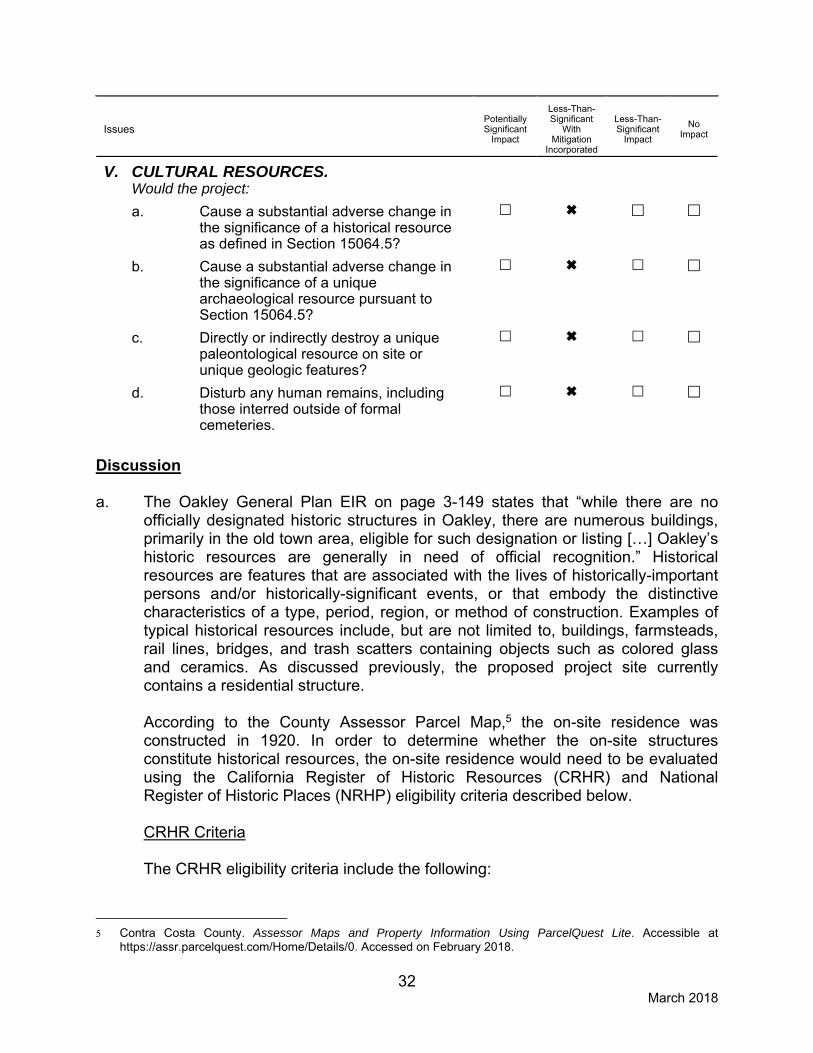
V. CULTURAL RESOURCES. Would the project:
a. Cause a substantial adverse change in
the significance of a historical resource as defined in Section 15064.5?
b. Cause a substantial adverse change in
the significance of a unique archaeological resource pursuant to Section 15064.5?
c. Directly or indirectly destroy a unique
paleontological resource on site or unique geologic features?
d. Disturb any human remains, including
those interred outside of formal cemeteries.
Discussion a. The Oakley General Plan EIR on page 3-149 states that “while there are no
officially designated historic structures in Oakley, there are numerous buildings, primarily in the old town area, eligible for such designation or listing […] Oakley’s historic resources are generally in need of official recognition.” Historical resources are features that are associated with the lives of historically-important persons and/or historically-significant events, or that embody the distinctive characteristics of a type, period, region, or method of construction. Examples of typical historical resources include, but are not limited to, buildings, farmsteads, rail lines, bridges, and trash scatters containing objects such as colored glass and ceramics. As discussed previously, the proposed project site currently contains a residential structure.
According to the County Assessor Parcel Map,5 the on-site residence was
constructed in 1920. In order to determine whether the on-site structures constitute historical resources, the on-site residence would need to be evaluated using the California Register of Historic Resources (CRHR) and National Register of Historic Places (NRHP) eligibility criteria described below.
CRHR Criteria The CRHR eligibility criteria include the following:
5 Contra Costa County. Assessor Maps and Property Information Using ParcelQuest Lite. Accessible at
https://assr.parcelquest.com/Home/Details/0. Accessed on February 2018.

33 March 2018
(1) It is associated with events that have made a significant contribution to the broad patterns of local or regional history, or the cultural heritage of California or the U.S.;
(2) It is associated with the lives of persons important to local, California, or national history;
(3) It embodies the distinctive characteristics of a type, period, region, or method of construction, or represents the work of a master or possesses high artistic values; or
(4) It has yielded, or has the potential to yield, information important to the prehistory or history of the local area, California, or the nation.
In addition, the resource must retain integrity. Integrity is evaluated with regard to the retention of location, design, setting, materials, workmanship, feeling, and association.
NRHP Criteria
The NRHP eligibility criteria include the following: “The quality of significance in American history, architecture, archaeology, and culture is present in districts, sites, buildings, structures, and objects of state and local importance that possess aspects of integrity of location, design, setting, materials, workmanship, feeling, association, and
(a) is associated with events that have made a significant contribution to the broad patterns of our history;
(b) is associated with the lives of a person or persons significance in our past; (c) embodies the distinctive characteristics of a type, period or method of
construction, or represents the work of a master, or possesses high artistic value, or represents a significant and distinguishable entity whose components may lack individual distinction; or
(d) has yielded or may be likely to yield information important in prehistory or history.
In addition, the resource must be at least 50 years old, except in exceptional circumstances.
As stated above, the proposed project site contains an existing residential structure built in 1920, and, therefore, meets the typical 50-year age threshold for listing in the NRHP. In addition to meeting the age thresholds, under Section 15064.5 of the CEQA Guidelines, a resource is considered “historically significant” if the resource meets on or more of the CRHR or NRHP criterial outlined above. A resource must be considered historically significant and possess “integrity in order to qualify for listing in the NRHP and CRHR. Because the on-site residence has not been evaluated using CRHR or NRHP criteria, the on-site residence could potentially be considered a historical resource.

34 March 2018
Development and construction activities related to the proposed project has the potential to cause a substantial adverse change in the significance of a potential historical resource. Therefore, alteration to the house and demolition would have a potentially significant impact related to damaging or destroying such a historic cultural resource. Mitigation Measure(s) Implementation of the following mitigation measures would reduce the potential construction-related impact to a less-than-significant level. V-1. If future applications for development on the site would involve
disturbance of the existing on-site structure, in conjunction with the application for development, the applicant shall submit a historic resource evaluation prepared by a qualified archeologist that determines whether the existing structure is historic. If the structure is determined not to be historic, further mitigation is not necessary. If the structure is determined to be historic, demolition cannot occur until further CEQA analysis is conducted.
b-d. According to the Oakley General Plan EIR (p. 3-148), few archeological or
paleontological finds have occurred in the City of Oakley. However, the City’s General Plan EIR states that given the rich history of the Planning Area and region, the City will continue to require site evaluation prior to development of undeveloped areas, as well as required procedures if artifacts are unearthed during construction. The project site is currently planted with grapes and is developed with a residential structure, and, thus, is highly disturbed. In addition, adjoining areas to the north and east consist of residential neighborhoods. Due to the disturbed nature of the site and the surrounding area, the discovery of archeological and paleontological resources is not expected. However, unknown archaeological resources, including human bone, have the potential to be uncovered during ground-disturbing construction activities if the proposed project site were to be developed as single-family development. As a result, a potentially significant impact would occur.
Mitigation Measure(s Implementation of the following mitigation measures would reduce the potential construction-related impact to a less-than-significant level. V-2. If buried historic and/or cultural resources are encountered during
site grading or other site work, all such work shall be halted immediately within 100 feet of the discovery and the developer shall immediately notify the Planning Division of the discovery. In such case, the developer shall be required, at their own expense, to retain the services of a qualified archaeologist for the purpose of recording, protecting, or curating the discovery, as appropriate. The archaeologist shall be required to submit to the City of Oakley

35 March 2018
Planning Division for review and approval a report of the findings and method of curation or protection of the resources. Further grading or site work within the area of discovery would not be allowed until the preceding work has occurred.
V-3. Pursuant to State Health and Safety Code §7050.5 (c) State Public
Resources Code §5097.98, if human bone or bone of unknown origin is found during construction, all work shall stop within 100 feet of the find and the Contra Costa County Coroner shall be contacted immediately. If the remains are determined to be Native American, the Coroner shall notify the Native American Heritage Commission, who shall notify the person believed to be the most likely descendant. The most likely descendant shall work with the contractor to develop a program for re-internment of the human remains and any associated artifacts. Additional work is not to take place within 100 feet of the find until the identified appropriate actions have been implemented.

36 March 2018
Issues
Potentially Significant
Impact
Less-Than-Significant
With Mitigation
Incorporated
Less-Than-Significant
Impact
No
Impact
VI. GEOLOGY AND SOILS. Would the project:
a. Expose people or structures to potential
substantial adverse effects, including the risk of loss, injury, or death involving:
i. Rupture of a known earthquake
fault, as delineated on the most recent Alquist - Priolo Earthquake Fault Zoning Map issued by the State Geologist for the area based on other substantial evidence of a known fault?
ii. Strong seismic ground shaking?
iii. Seismic-related ground failure,
including liquefaction?
iv. Landslides?
b. Result in substantial soil erosion or the
loss of topsoil?
c. Be located on a geologic unit or soil that
is unstable, or that would become unstable as a result of the project, and potentially result in on- or off-site landslide, lateral spreading, subsidence, liquefaction or collapse?
d. Be located on expansive soil, as defined
in Table 18-1B of the Uniform Building Code?
e. Have soils incapable of adequately
supporting the use of septic tanks or alternative waste water disposal systems where sewers are not available for the disposal of waste water?
Discussion a,c. The site is located in an area of moderate to high seismicity. Known active faults
are not mapped across the property and the site is not located within an Alquist-Priolo Earthquake Fault Zone; however, the Oakley 2020 General Plan Background Report states that the San Francisco Bay area is an area of high seismic risk. As shown in Figure 8-1 of the City’s General Plan, Faults and Seismic Stability, three active faults are in the Oakley area, with the Brentwood Fault directly underlying the City, and the Davis and Antioch Faults to the west of the City.
37 March 2018
Potential seismic hazards resulting from a nearby moderate to major earthquake can generally be classified as primary and secondary. The primary effect is ground rupture, also called surface faulting. The common secondary seismic hazards include ground rupture, ground shaking, liquefaction, and ground lurching. Ground Rupture Figure 8-1 of the City’s General Plan shows fault traces for all known and inferred faults in the area. The proposed project is not underlain by any faults known to the City and as a result, ground rupture is unlikely at the project site. Ground Shaking An earthquake of moderate to high magnitude generated within the region could cause considerable ground shaking at the site, similar to that which has occurred in the past. To mitigate the shaking effects, structures should be designed using sound engineering judgment and the California Building Code (CBC) requirements, as a minimum. Seismic design provisions of current building codes generally prescribe minimum lateral forces, applied statically to the structure, combined with the gravity forces. The code-prescribed lateral forces are generally considered to be substantially smaller than the comparable forces that would be associated with a major earthquake. Therefore, structures should be able to: (1) resist minor earthquakes without damage, (2) resist moderate earthquakes without structural damage but with some nonstructural damage, and (3) resist major earthquakes without collapse but with some structural as well as nonstructural damage. Conformance to the current building code recommendations does not constitute any kind of guarantee that significant structural damage would not occur in the event of a maximum magnitude earthquake; however, a well-designed and well-constructed structure can be reasonably expected to resist collapse thus reducing loss of life in a major earthquake. Landslides The project area is relatively flat; therefore, landslides do not represent a likely hazard. Ground Lurching Ground lurching is a result of the rolling motion imparted to the ground surface during energy released by an earthquake. Such rolling motion can cause ground cracks to form in weaker soils. The potential for the formation of these cracks is considered greater at contacts between deep alluvium and bedrock. Figure 8-1 of the City’s General Plan indicates the project site is designated as being comprised of Younger Alluvium. According to the Oakley 2020 General Plan EIR,

38 March 2018
such soils are described as slowly to very slowly permeable, highly expansive and corrosive with slight erosion hazard. Therefore, the proposed project is located in an area with moderate damage susceptibility to potential ground lurching. As a result, foundation and pavement must be designed to reduce the potential for adverse impacts from possible lurch cracking. Liquefaction Soil liquefaction results from loss of strength during cyclic loading, such as imposed by earthquakes. Soils most susceptible to liquefaction are clean, loose, saturated, uniformly graded and fine-grained sands. Empirical evidence indicates that loose to medium-dense gravels, silty sands, and low- to moderate-plasticity silts and clays may be susceptible to liquefaction. In addition, sensitive high-plasticity soils may be susceptible to significant strength loss (cyclic softening) as a result of significant cyclic loading. As shown in Figure 8-2, of the City of Oakley General Plan 2020, Estimated Liquefaction Potential, most of the City’s planning area is within an area of generally high liquefaction potential, which includes the project site. Although, the United States Department of Agriculture, Natural Resource Conservation Service’s Web Soil Survey identifies 100 percent of the project site as being composed of the Delhi sand soil series, which is characterized as somewhat excessively drained soil,6 the City of Oakley General Plan (p. 8-3) Policy 8.1.9 requires all public and private development to conduct a geologic engineering study. The geologic engineering study must define and delineate potential hazardous geologic and/or soils conditions, recommend means of mitigating any adverse conditions, and provide implementation of the mitigation measures. Because the proposed project would be sited in an area of generally high liquefaction potential, the project would be subject to Policy 8.1.9, and would require a design-level geologic engineering study. Without completion of a design-level geotechnical report and implementation of relevant recommendations therein, the proposed project could expose people or structures to potential risk of loss, injury, or death by the project’s location on an unstable geologic or soil unit. Conclusion The project site is not within an Alquist-Priolo Special Studies Zone; however, the City of Oakley General Plan, General Plan Background Report, and General Plan EIR indicate that the Oakley area is located in a seismically active zone. Development of the proposed project in this seismically active zone could expose people or structures to substantial adverse effects, including the risk of loss, injury, or death involving strong seismic ground shaking, ground lurching, liquefaction, or the location of the project on an unstable geologic unit or soil. Therefore, a potentially significant impact could result.
6 United States Department of Agriculture, Natural Resources Conservation Service. Web Soil Survey.
Accessible at http://websoilsurvey.nrcs.usda.gov/app/WebSoilSurvey.aspx. Accessed in January 2018.

39 March 2018
Mitigation Measure(s) Implementation of the following mitigation measures would reduce the above impacts related to liquefiable soils, and ground lurching to a less-than-significant level.
VI-1. Prior to issuance of a grading permit, the applicant/developer shall
incorporate the recommendations of a design-level geotechnical report into the Improvement Plans for approval by the City Engineer. The following measures include, but are not limited to, the options available to reduce site liquefaction potential and/or adverse effects to structures located above potentially liquefiable soils. Once final grading plans are designed, the project’s geotechnical engineers shall determine the appropriate methods of mitigating the effects of liquefaction, such as:
Remove and replace potentially liquefiable soils; Strengthen foundations (e.g., post-tensioned slab, reinforced mat or
grid foundation, or other similar system) to resist excessive differential settlement associated with seismically-induced liquefaction;
Support the proposed structures on an engineered fill pad (minimum of 5 feet thick) in order to reduce differential settlement resulting from seismically-induced liquefaction and post-seismic pore pressure dissipation; and/or
Densify potentially liquefiable soils with an in situ ground improvement technique such as deep dynamic compaction, vibro-compaction, vibro-replacement, compaction grouting, or other similar methods.
VI-2. All grading and foundation plans for the development shall be designed by a Civil and Structural Engineer and reviewed and approved by the Director of Public Works/City Engineer, Chief Building Official, and a qualified Geotechnical Engineer prior to issuance of grading and building permits to ensure that all geotechnical recommendations specified in the geotechnical report required by mitigation measure VI-1 are properly incorporated and utilized in the project design.
b. The City of Oakley General Plan Background Report (Section 9, p. 9-3) indicates
that the project site is characterized by soils grouped within the lowland soil association. According to the General Plan EIR, such soils are described as slowly to very slowly permeable, highly expansive and corrosive with slight erosion hazard (3-160). Because the soils on the site possess little erosion hazard, the project site is not likely to suffer substantial soil erosion or loss of topsoil. However, any disturbance of the soil, such as surface grading, relocates topsoil and breaks the soil into easily transported particles, rendering earth surfaces susceptible to erosion from wind and water. As part of standard City

40 March 2018
requirements, preparation of an Erosion Control Plan and Stormwater Pollution Prevention Plan (SWPPP) prior to construction activities and implementation of BMPs during construction is required. The erosion control measures required for implementation on the proposed project by both the SWPPP and the Erosion Control Plan would ensure that the proposed project would not result in substantial soil erosion or the loss of topsoil. Therefore, impacts from soil erosion resulting from grading of the project area would be considered less than significant.
d. The project site is within a region that is identified in the Oakley General Plan EIR
as possessing soils that are very slowly permeable and highly expansive. Highly expansive soils are prone to shrink/swell activity, which could have adverse affects on structures constructed on such soils. Mitigation Measure VI-2 requires compliance with recommendations in a geotechnical report which would ensure that the foundations and pavements are designed in order to reduce the impact of the proposed project from expansive soils to a less-than-significant level.
e. The proposed project will not involve the use of septic tanks or alternative
wastewater disposal systems; therefore, no impact would occur.

41 March 2018
Issues
Potentially Significant
Impact
Less Than Significant
With Mitigation
Incorporated
Less-Than-Significant
Impact
No
Impact
VII. GREENHOUSE GAS EMISSIONS. Would the project:
a. Generate greenhouse gas emissions, either
directly or indirectly, that may have a significant impact on the environment?
b. Conflict with an applicable plan, policy or
regulation adopted for the purpose of reducing the emissions of greenhouse gasses?
Discussion a,b. Emissions of greenhouse gases (GHGs) contributing to global climate change
are attributable in large part to human activities associated with the industrial/manufacturing, utility, transportation, residential, and agricultural sectors. Therefore, the cumulative global emissions of GHGs contributing to global climate change can be attributed to every nation, region, and city, and virtually every individual on earth. An individual project’s GHG emissions are at a micro-scale level relative to global emissions and effects to global climate change; however, an individual project could result in a cumulatively considerable incremental contribution to a significant cumulative macro-scale impact. As such, impacts related to emissions of GHG are inherently considered cumulative impacts. Implementation of the proposed project would cumulatively contribute to increases of GHG emissions. Estimated GHG emissions attributable to future development would be primarily associated with increases of carbon dioxide (CO2) and, to a lesser extent, other GHG pollutants, such as methane (CH4) and nitrous oxide (N2O) associated with area sources, mobile sources or vehicles, utilities (electricity and natural gas), water usage, wastewater generation, and the generation of solid waste. The common unit of measurement for GHG is expressed in terms of annual metric tons of CO2 equivalents (MTCO2e/yr). A number of regulations currently exist related to GHG emissions, predominantly Assembly Bill (AB 32), Executive Order S-3-05, and Senate Bill (32). AB 32 sets forth a statewide GHG emissions reduction target of 1990 levels by 2020. Executive Order S-3-05 sets forth a transitional reduction target of 2000 levels by 2010, the same target as AB 32 of 1990 levels by 2020, and further builds upon the AB 32 target by requiring a reduction to 80 percent below 1990 levels by 2050. SB 32 also builds upon AB 32 and sets forth a transitional reduction target of 40 percent below 1990 levels by 2030. In order to implement the statewide GHG emissions reduction targets, local jurisdictions are encouraged to prepare

42 March 2018
and adopt area-specific GHG reduction plans and/or thresholds of significance for GHG emissions. The proposed project is located within the jurisdictional boundaries of the BAAQMD. BAAQMD’s approach to developing a threshold of significance for GHG emissions is to identify the emissions level for which a project would not be expected to substantially conflict with existing California legislation adopted to reduce statewide GHG emissions needed to move towards climate stabilization. If a project would generate GHG emissions above the threshold level, the project would be considered to generate significant GHG emissions and conflict with applicable GHG regulations. In addition, the BAAQMD has developed screening criteria for operational GHG emissions.7 Projects below the applicable screening criteria would not exceed the BAAQMD’s 1,100 MTCO2e/yr threshold of significance for projects other than stationary sources. For single-family land uses, BAAQMD’s recommended operational GHG screening level size is 56 dwelling units. For quality restaurants and high-turnover restaurants, which are commercial uses with higher trip generation rates relative to a wine tasting facility, the screening level sizes are 9,000 sf and 7,000 sf, respectively. Because a wine tasting facility would result in fewer trips, use of the screening level sizes for quality restaurants and high-turnover restaurants provides a conservative analysis of GHG emissions associated with the proposed project.
The proposed General Plan amendment and rezone would allow for development of the project site with either up to 52 for single-family homes or an approximately 1,800 sf wine tasting facility. Under either development scenario, the proposed project would be below the applicable BAAQMD screening level sizes. As such, the project would not be considered to generate substantial operational GHG emissions. Construction GHG emissions are a one-time release and are, therefore, not typically expected to generate a significant contribution to global climate change. Neither the City of Oakley nor BAAQMD have adopted a threshold of significance for construction-related GHG emissions. Furthermore, given that the project would be below BAAQMD’s recommended GHG screening level sizes, construction-related GHG emissions associated with development of the project site would not be substantial. As discussed throughout this IS/MND, the City’s General Plan has previously anticipated development of the site with single-family residential uses. Construction activities associated with future development of the site per the proposed land use changes would be substantially similar to what is currently considered for the site by the City; thus, project-related construction GHG emissions have been previously analyzed in the City’s General Plan EIR.
7 Bay Area Air Quality Management District. CEQA Guidelines [Table3-1]. May 2017.

43 March 2018
Based on the above, the proposed project would not be considered to generate GHG emissions, either directly or indirectly, that may have a significant impact on the environment, or conflict with any applicable plan, policy, or regulation adopted for the purpose of reducing the emissions of GHGs; and impacts would be considered less than significant.

44 March 2018
Issues
Potentially Significant
Impact
Less-Than-Significant
With Mitigation
Incorporated
Less-Than-Significant
Impact
No
Impact
VIII. HAZARDS AND HAZARDOUS MATERIALS. Would the project:
a. Create a significant hazard to the public
or the environment through the routine transport, use, or disposal of hazardous materials?
b. Create a significant hazard to the public or the environment through reasonably foreseeable upset and accident conditions involving the likely release of hazardous materials into the environment?
c. Emit hazardous emissions or handle hazardous or acutely hazardous materials, substances, or waste within one-quarter mile of an existing or proposed school?
d. Be located on a site which is included on a list of hazardous materials sites compiled pursuant to Government Code Section 65962.5 and, as a result, would it create a significant hazard to the public or the environment?
e. For a project located within an airport
land use plan or, where such a plan has not been adopted, within two miles of a public airport or public use airport, would the project result in a safety hazard for people residing or working in the project area?
f. For a project within the vicinity of a
private airstrip, would the project result in a safety hazard for people residing or working in the project area?
g. Impair implementation of or physically
interfere with an adopted emergency response plan or emergency evacuation plan?
h. Expose people or structures to the risk of
loss, injury or death involving wildland fires, including where wildlands are adjacent to urbanized areas or where residences are intermixed with wildlands?

45 March 2018
Discussion a. The proposed project would allow for development of the project site with up to
52 single-family homes or an approximately 1,800-sf wine tasting facility. Such land uses are not typically associated with the routine transport, use, disposal, or generation of substantial amounts of hazardous materials. Future operations on the project site could involve the use of common household cleaning products, fertilizers, and herbicides on-site, any of which could contain potentially hazardous chemicals; however, such products would be expected to be used in accordance with label instructions. Due to the regulations governing use of such products and the amount utilized on the site, routine use of such products would not represent a substantial risk to public health or the environment. Therefore, the project would not create a significant hazard to the public or the environment through the routine transport, use, or disposal of hazardous materials, and a less-than-significant impact would occur.
b. Construction activities associated with the proposed project would involve the use of heavy equipment, which would contain fuels and oils, and various other products such as concrete, paints, and adhesives. Small quantities of potentially toxic substances (e.g., petroleum and other chemicals used to operate and maintain construction equipment) would be used at the project site and transported to and from the site during construction. However, the project contractor would be required to comply with all California Health and Safety Codes and local ordinances regulating the handling, storage, and transportation of hazardous and toxic materials. Should an accidental release of hazardous materials occur during construction, the City (or City crews) and/or contractor, is required to notify the East Contra Costa Fire Protection District (ECCFPD), who would then monitor the conditions and recommend appropriate remediation measures. Existing hazardous materials that could potentially occur on the proposed project site, including soil contaminants, asbestos-containing materials (ACM), and lead-based paint (LBP) are discussed below. Soil Contamination As discussed previously, the proposed project site has historically been used for agricultural purposes. As such, pesticides and herbicides may have been used on the site, and the potential exists for on-site soils to be contaminated with organochloride pesticides. Prior to development of the project site, analysis of on-site soils would be required in order to ensure that any existing soil contaminant concentrations are below the direct exposure Environmental Screening Level (ESLs) for residential development, which measures potential hazards to human health.

46 March 2018
Asbestos-Containing Materials and Lead-Based Paint Asbestos is the name for a group of naturally occurring silicate minerals that are considered to be “fibrous” and, through processing, can be separated into smaller and smaller fibers. The fibers are strong, durable, chemical resistant, and resistant to heat and fire. They are also long, thin, and flexible, such that they can be woven into cloth. Because of the above qualities, asbestos was considered an ideal product and has been used in thousands of consumer, industrial, maritime, automotive, scientific, and building products. However, later discoveries found that, when inhaled, the material caused serious illness. For buildings constructed prior to 1980, the Code of Federal Regulations (29 CFR 1926.1101) states that all thermal system insulation (boiler insulation, pipe lagging, and related materials) and surface materials must be designated as “presumed asbestos-containing material (ACM)” unless proven otherwise through sampling in accordance with the standards of the Asbestos Hazard Emergency Response Act. Because the existing structure was built prior to 1980, the potential exists that asbestos-containing materials was used in the construction of the existing on-site structure. LBP is defined by federal guidelines as any paint, varnish, stain, or other applied coating that has one milligram of lead per square centimeter or greater. Lead is a highly toxic material that may cause a range of serious illnesses, and in some cases death. In buildings constructed after 1978, the presence of LBP is unlikely. Structures built prior to 1978, and especially prior to the 1960s, are expected to contain LBP. The existing residential structure on the proposed project site was constructed before the phase-out of LBPs in the 1970s. Therefore, the potential exists that LBPs are present in the structure. Based on the age of the existing on-site structure, ACM and LBP are presumed to be present. The proposed project could include demolition of all on-site structures. Therefore, without implementation of the appropriate safety measures, the proposed project could potentially expose construction workers during structure demolition to LBP and ACM. Conclusion Based on the above, implementation of the proposed project could create a significant hazard to the public or the environment through reasonably foreseeable upset and accident conditions involving the likely release of hazardous materials into the environment, particularly associated with contaminated soils, ACM, and LBP. Therefore, a potentially significant impact would occur.
Mitigation Measure(s) Implementation of the following mitigation measures would reduce the above impact to a less-than-significant level.

47 March 2018
VIII-1. Prior to initiation of future demolition or construction activities on the proposed project site, the project applicant shall complete an analysis of on-site soils to determine whether substantial concentrations of organochloride pesticides or other soil contaminants are present above the applicable direct exposure Environmental Screening Levels (ESLs) set by the Regional Water Quality Control Board. If contaminants are not detected above applicable ESLs, then further mitigation is not required. If contaminants are detected above the applicable ESLs, then the soils shall be remediated by off-hauling to a licensed landfill facility. Such remediation activities shall be performed by a licensed hazardous waste contractor (Class A) and contractor personnel that have completed 40-hour OSHA hazardous training. The results of soil sampling and analysis, as well as verification of proper remediation and disposal, shall be submitted to the Planning Division for review and approval.
VIII-2. Prior to issuance of a demolition permit for any on-site structures,
the project applicant shall consult with certified Asbestos and/or Lead Risk Assessors to complete and submit for review to the Planning Division an asbestos and lead survey. If asbestos-containing materials or lead-containing materials are not discovered during the survey, further mitigation related to asbestos-containing materials or lead containing materials shall not be required. If asbestos-containing materials and/or lead-containing materials are discovered by the survey, the project applicant shall prepare a work plan to demonstrate how the on-site asbestos-containing materials and/or lead-containing materials shall be removed in accordance with current California Occupational Health and Safety (Cal-OSHA) Administration regulations and disposed of in accordance with all CalEPA regulations, prior to the demolition and/or removal of the on-site structures. The plan shall include the requirement that work shall be conducted by a Cal-OSHA registered asbestos and lead abatement contractor in accordance with Title 8 CCR 1529 and Title 8 CCR 1532.1 regarding asbestos and lead training, engineering controls, and certifications. The applicant shall submit the work plan to the Planning Division for review and approval. Materials containing more than one (1) percent asbestos that is friable are also subject to BAAQMD regulations. Removal of materials containing more than one (1) percent friable asbestos shall be completed in accordance with BAAQMD Section 11-2-303.
c. The proposed project would not be located within one-quarter mile of a school.
Therefore, the project would have no impact related to hazardous emissions or the handling of hazardous or acutely hazardous materials, substances, or waste within one-quarter mile of an existing or proposed school.

48 March 2018
d. The proposed project is not located on a site that is included on a list of hazardous materials sites compiled pursuant to Government Code Section 65962.5,8 and would not create a significant hazard to the public or the environment. Therefore, no impact would occur.
e,f. The proposed project is not located in the vicinity of a private airstrip or within an
airport land use plan. The City of Oakley 2020 General Plan EIR identifies the closest airports as Buchanan Field and Byron Airport, located 19 miles and 11 miles from the project site, respectively. As such, the proposed project site is not located within two miles of any public airports or private airstrips and does not fall within an airport land use plan area. Therefore, no impact related to a safety hazard for people residing or working in the project area would occur related to such.
g. The proposed project does not include any modifications to the surrounding
roadways or circulation networks. Therefore, the project would not construct barriers that would impede the implementation of an emergency response plan. As a result, the proposed project would not impair or physically interfere with an adopted emergency response plan and no impact would occur.
h. According to the California Department of Forestry and Fire Protection (CAL
FIRE) Fire and Resource Assessment Program, the proposed project site is not located within a Very High Fire Hazard Severity Zone.9 In addition, the site is surrounded by existing development to the north and east and is not located adjacent to wildlands. Therefore, the proposed project would not expose people or structures to the risk of loss, injury or death involving wildland fires, including where wildlands are adjacent to urbanized areas or where residences are intermixed with wildlands, and a less-than-significant impact would occur.
8 California Department of Toxic Substances Control. EnviroStor. Available at: http://www.envirostor.dtsc.ca.gov.
Accessed February 2018. 9 California Department of Forestry and Fire Protection. Contra Costa County, Very High Fire Hazard Severity
Zones in LRA. January 7, 2009.

49 March 2018
Issues
Potentially Significant
Impact
Less-Than-Significant
With Mitigation
Incorporated
Less-Than-Significant
Impact
No
Impact
IX. HYDROLOGY AND WATER QUALITY. Would the project:
a. Violate any water quality standards or waste
discharge requirements?
b. Substantially deplete groundwater supplies or interfere substantially with groundwater recharge such that there would be a net deficit in aquifer volume or a lowering of the local groundwater table level (i.e., the production rate of pre-existing nearby wells would drop to a level which would not support existing land uses or planned uses for which permits have been granted)?
c. Substantially alter the existing drainage pattern of
the site or area, including through the alteration of the course of a stream or river, in a manner which would result in substantial erosion or siltation on- or off-site?
d. Substantially alter the existing drainage pattern of
the site or area, including through the alteration of the course of a stream or river, or substantially increase the rate or amount of surface runoff in a manner which would result in flooding on- or off-site?
e. Create or contribute runoff water which would
exceed the capacity of existing or planned stormwater drainage systems or provide substantial additional sources of polluted runoff?
f. Otherwise substantially degrade water quality? g. Place housing within a 100-year floodplain, as
mapped on a federal Flood Hazard Boundary or Flood Insurance Rate Map or other flood hazard delineation map?
h. Place within a 100-year floodplain structures which
would impede or redirect flood flows?
i. Expose people or structures to a significant risk of
loss, injury or death involving flooding, including flooding as a result of the failure of a levee or dam.
j. Inundation by seiche, tsunami, or mudflow?

50 March 2018
Discussion a-f. During project construction, topsoil would be exposed due to grading of the site.
After grading and prior to overlaying the ground surface with impervious surfaces and structures, the potential exists for wind and water erosion to discharge sediment and/or urban pollutants into stormwater runoff, which could adversely affect water quality. Therefore, the proposed project would require compliance with the Contra Costa County Flood Control and Water Conservation District (CCCFCWCD) in order to not result in a construction related degradation of water quality. The City’s National Pollutant Discharge Elimination System (NPDES) permit requires that any projects that would create or replace 10,000 square feet or more of impervious surfaces must submit a Stormwater Control Plan (SWCP) with their development permit. The City of Oakley’s Municipal Code Section 6.11, Stormwater Management and Discharge Control, requires that the SWCP include appropriate design measures to treat runoff from all proposed impervious surfaces. In addition, according to the Oakley 2020 General Plan EIR, increased development may lead to an increase in impervious surfaces being created where permeable soils currently exist. With approval and implementation of the proposed project as a single-family subdivision, new streets, sidewalks, driveways, and rooftops would convert the project site’s undeveloped, primarily pervious surfaces to impervious surfaces. Whereas open space allows precipitation to infiltrate into the ground, impervious surfaces cause water to pond or runoff. Stormwater runoff from impervious areas may concentrate and cause increases in runoff volume for the area. Discharge of the concentrated runoff may cause localized flooding at storm drain connections or downstream of the discharge location. Therefore, the future residential development would be subject to the requirements included in the C.3 Standards to ensure that development would not result in changes to stream stability and geomorphology. As a result, the future development of up to 52 single-family units would require a SWCP that conforms with the most recent Contra Costa Clean Water Program Stormwater C.3 Guidebook. If the proposed project is developed as a wine tasting facility, the existing site characteristics would not change. Therefore, a substantial change in the overall drainage pattern of the site would not occur. In addition, the project site is within the CCCFCWCD. The CCCFCWCD requires a drainage fee in accordance with Flood Control Ordinance Numbers 2007-07 and 2007-06. Pursuant to the fee collection agreement between the Contra Costa County Board of Supervisors and the City of Oakley, the applicant is required to pay the fee at the time of building permit issuance or as otherwise determined by the Contra Costa County Board of Supervisors. Therefore, project compliance with the City of Oakley’s NPDES and C.3 regulations, and payment of drainage fees would ensure that the project would not substantially violate

51 March 2018
water quality standards, degrade water quality, directly alter or lead to the alteration of existing drainage features leading to erosion, flooding or siltation, nor would the project contribute runoff water which would exceed the capacity of existing or planned stormwater drainage systems. As a result, a less-than-significant impact would occur.
g-i. Based on the FEMA Flood Insurance Rate Map (FIRM) (Map Number ID
06013C0355G), the project site is within Zone X, which is described by FEMA as an area determined to be outside the 0.2 percent annual chance floodplain (see Figure 2). Thus, development of the proposed project would not place structures within a 100-year floodplain or expose people or structures to a risk of loss, injury, or death involving flooding. Additionally, Figure 8-6 of the City of Oakley General Plan 2020 outlines all areas that could be flooded due to dam failures. The proposed project site is not identified as being within an area of possible inundation as a result of a failure of a levee or dam. Accordingly, restrictions on development or special requirements associated with flooding are not required for the project. Therefore, the proposed project would result in a less-than-significant impact related to flooding.
j. Tsunamis are defined as sea waves created by undersea fault movement. A
tsunami poses little danger away from shorelines; however, when a tsunami reaches the shoreline, a high swell of water breaks and washes inland with great force. Waves may reach 50 feet in height on unprotected coasts. Historic records of the Bay Area used by one study indicate that nineteen tsunamis were recorded in San Francisco Bay during the period of 1868-1968. Maximum wave height recorded at the Golden Gate tide gauge (where wave heights peak) was 7.4 feet. The available data indicate a standard decrease of original wave height from the Golden Gate to about half original wave height on the shoreline near Richmond, and to nil at the head of the Carquinez Strait. As the project site is approximately 20 miles east of the Carquinez straight and approximately two miles away from the nearest body of water, the project site is not exposed to flooding risks from tsunamis and adverse impacts would not result. A seiche is a long-wavelength, large-scale wave action set up in a closed body of water such as a lake or reservoir, whose destructive capacity is not as great as that of tsunamis. Seiches are known to have occurred during earthquakes, but none have been recorded in the Bay Area. In addition, the project is not located near a closed body of water. Therefore, risks from seiches and adverse impacts would not result. Mudflows typically occur in mountainous or hilly terrain. Given the existing and proposed flat topography of the project site, risks from mudflows and adverse impacts would not result. Therefore, potential impacts resulting from tsunamis, seiches, or mudslides would be less than significant.

52 March 2018
Figure 2 FEMA Flood Insurance Rate Map
Project Site

53 March 2018
Issues
Potentially Significant
Impact
Less-Than-Significant
With Mitigation
Incorporated
Less-Than-
Significant Impact
No
Impact
X. LAND USE AND PLANNING. Would the project:
a. Physically divide an established community?
b. Conflict with any applicable land use plans,
policies, or regulations of an agency with jurisdiction over the project (including, but not limited to the general plan, specific plan, local coastal program, or zoning ordinance) adopted for the purpose of avoiding or mitigating on environmental effect?
c. Conflict with any applicable habitat conservation
plan or natural communities conservation plan?
Discussion a. The proposed project includes a request for a General Plan Amendment (GPA
02-17) to amend to amend the land use designation from SM (3.8 dwelling units per acre maximum density) to SH (5.5 dwelling units per acre maximum density) and a Rezone (RZ 03-17) from R-10 to P-1, which would allow for development of up to 52 single-family units or an approximately 1,800 square-foot wine tasting facility. The approximately 9.5-acre project site is located at 422 Laurel Road. The proposed project would not include any improvements that would alter circulation or create a barrier between parts of the community. The project site currently consists of a vineyard and single-family home that was built in 1920, which has been planned for single-family development in the Oakley 2020 General Plan. Therefore, the proposed project would not be located between communities in such a way as to create a barrier or divide established communities. As a result, the proposed project would have a less-than-significant impact.
b. The proposed project includes a request for a General Plan Amendment (GPA
02-17) to amend to amend the land use designation from SM to SH and a Rezone (RZ 03-17) from R-10 to P-1. While the proposed project is requesting a General Plan Land Use amendment the project site has been previously anticipated for development in the Oakley 2020 General Plan. Should the City Council amend the land use designation to SH, the proposed project would not conflict with any applicable land use plans, policies, or regulations and would result in a less-than-significant impact.
c. The ECC HCP/NCCP was approved in August 2007 and the City of Oakley
approved the implementing ordinance on November 13, 2007. The project is within the City and, therefore, is included in the HCP. In compliance with the

54 March 2018
implementing ordinance, the proposed project would be required to comply with the HCP conservation strategies. Mitigation Measures IV-1 through IV-5 would ensure that the proposed project fulfills all requirements of the ECCC HCP/NCCP. Therefore, the proposed project would not conflict with the adopted HCP and a less-than-significant impact would occur.

55 March 2018
Issues
Potentially Significant
Impact
Less-Than-Significant
With Mitigation
Incorporated
Less-Than-Significant
Impact
No
Impact
XI. MINERAL RESOURCES. Would the project:
a. Result in the loss of availability of a known
mineral resource that would be of value to the region and the residents of the state?
b. Result in the loss of availability of a locally-
important mineral resource recovery site delineated on a local general plan, specific plan or other land use plan?
Discussion a,b. The City of Oakley General Plan Background Report states that the only mineral
resource currently mined in the City of Oakley is sand. Currently mining of sand does not occur at the project site and much of the adjacent land is developed for residential uses, which would be incompatible with mining activities. Thus, proposed project would not result in the loss of availability of a known mineral resource or a locally important mineral recovery site; therefore, the proposed project would have no impact to mineral resources.

56 March 2018
Issues
Potentially Significant
Impact
Less-Than-Significant
With Mitigation
Incorporated
Less-Than-Significant
Impact
No
Impact
XII. NOISE. Would the project result in:
a. Exposure of persons to or generation of noise
levels in excess of standards established in the local general plan or noise ordinance, or applicable standards of other agencies?
b. Exposure of persons to or generation of
excessive groundborne vibration or groundborne noise levels?
c. A substantial permanent increase in ambient
noise levels in the project vicinity above levels existing without the project?
d. A substantial temporary or periodic increase in
ambient noise levels in the project vicinity above levels existing without the project?
e. For a project located within an airport land use
plan or, where such a plan has not been adopted, within two miles of a public airport or public use airport, would the project expose people residing or working in the project area to excessive noise levels?
f. For a project within the vicinity of a private
airstrip, would the project expose people residing or working in the project area to excessive noise levels?
Discussion a,c. The project site contains vineyards and one-single-family residence. Operation of
the vineyard would produce noises common for agricultural operations, such as the operation of agricultural machinery, the delivery and distribution of goods, maintenance, and vegetation clearing or fruit harvesting. The existing residence would involve limited noise sources such as resident vehicle use, and mechanical equipment such as heating and cooling equipment. The proposed project consists of a General Plan Amendment and rezone of the project site; however, the proposed project does not include any plans for development of the project site at this time. Nevertheless, a General Plan Amendment and rezone the project site would allow for future development of the project site with an 1,800-sf wine tasting facility or up to 52 residential units. Operations of the wine tasting facility would involve noise from the delivery of goods, vehicle use from

57 March 2018
employees and patrons, as well as operational noise related to wine tasting activities. Development of the site with 52 residential units would involve sources of noise that would be similar to the existing residence and surrounding neighborhoods, such as resident vehicle usage, operation of mechanical equipment, and other limited sources of noise.
The City of Oakley General Plan Policy 9.1.5 states that noise levels resulting from transportation noise sources shall be maintained at or below 65 dBA Ldn at residential outdoor use areas and noise levels between 50 and 60 dBA Ldn are considered normally acceptable with noise levels from 55 to 70 dBA Ldn considered conditionally acceptable. Furthermore, noise levels between 50 and 70 dBA Ldn are considered normally acceptable for commercial areas per Figure 9-1 of the City’s General Plan.10 Table 9-6 of the City’s General Plan demonstrates that noise levels along Laurel Road near the project site vary from a maximum of 70 dB six feet from the roadway, diminishing to 65 dB 13 feet away from Laurel Road, and 60 dB 28 feet away from Laurel Road.11 Considering the noise levels presented in the City’s General Plan, noise levels throughout the project site would be considered generally acceptable for commercial uses. However, noise levels within 13 feet from Laurel Road would exceed the City’s General Plan standard for residential outdoor use areas. Thus, while operations of potential future developments on the project site are not anticipated to generate significant amounts of noise, nor would such developments result in an increase in ambient noise levels, future residents of the project site could be exposed to noise levels in excess of the City’s standard. Exposure of future residents to noise levels in excess 65 dB at residential outdoor use areas or in excess of 70 dBA Ldn due to noise levels at or exceeding 70 dB within six feet of Laurel Road would be considered a potentially significant impact related to future development of the project site for residential uses. Mitigation Measure(s) The following mitigation measure would ensure that should the project site be developed for residential uses in the future, future residents would not be exposed to noise levels in excess of the City’s standards, and the project would result in a less-than-significant impact.
XII-1 If the project site is developed for use as a wine tasting facility,
mitigation is not required. If the project site is to be developed for residential land uses, prior to approval of any Tentative Maps for such developments, an environmental noise analysis shall be conducted for the project site. The environmental noise analysis shall include analysis regarding the potential for residential development of the project site to expose future receptors to
10 City of Oakley. City of Oakley 2020 General Plan [Figure 9-1]. Amended February 2, 2016. 11 City of Oakley. City of Oakley 2020 General Plan [Table 9-6]. Amended February 2, 2016.

58 March 2018
excess noise levels. Should residential development of the project site be found to have the potential to expose future receptors to noise levels in excess of the City’s adopted standards, the environmental noise analysis shall recommend design measures to reduce such exposure below the City’s adopted thresholds. Measures may include, but are not limited to, the following options:
Development plans shall include a setback from Laurel Road
to ensure that noise levels at proposed residences are below the City’s noise standards;
Residential outdoor use areas shall not be permitted to front onto Laurel Road; and/or
Prior to approval of Improvement Plans a sound wall must be included on the plans along Laurel Road sufficient to reduce sound levels at proposed locations for residential development within the project site below the City’s noise standards.
b. Groundborne vibration would be generated during potential future construction of
residences or a wine tasting facility. Residential land uses surrounding the project site would be sensitive to excessive vibrations caused by construction. For structural damage, the California Department of Transportation (Caltrans) uses a vibration limit of 0.5 inches/second, peak particle velocity (in/sec, PPV), for buildings structurally sound and designed to modern engineering standards; 0.2 in/sec PPV for buildings that are found to be structurally sound but where structural damage is a major concern; and a conservative limit of 0.08 in/sec PPV for historic buildings or buildings that are documented to be structurally weakened. All surrounding structures are assumed to be structurally sound, but damage would be a concern so the 0.2 in/sec PPV will be used as a threshold of significance for structural damage. The threshold of 0.2 in/sec PPV is also used by Caltrans as the threshold for human annoyance caused by vibration. Therefore, activities creating vibrations exceeding 0.2 in/sec PPV would impact sensitive receptors in nearby residences.12 Table 2 presents typical vibration levels that could be expected from construction equipment at a distance of 25 feet.
Potential future construction activities, such as drilling, the use of jackhammers, and other high-power or vibratory tools, and rolling stock equipment (tracked vehicles, compactors, etc.), may generate groundborne vibration in the immediate vicinity. As shown in Table 2, jackhammers typically generate vibration levels of 0.035 in/sec PPV, while drilling typically generates vibration levels of 0.09 in/sec PPV, and the strongest source of vibrations, vibratory rollers, generates vibration levels of 0.21 in/sec PPV all at a distance of 25 feet.
12 Caltrans. Transportation and Construction Vibration Guidance Manual. September 2013.

59 March 2018
Table 2
Vibration Source Levels for Construction Equipment Equipment PPV at 25 ft (in/sec)
Vibratory Roller 0.210 Large Bulldozer 0.089 Caisson drilling 0.089 Loaded trucks 0.076 Jackhammer 0.035
Small bulldozer 0.003 Source: Caltrans, Transportation and Construction Vibration: Guidance Manual. September
2013. Vibration levels would vary depending on soil conditions, construction methods,
and equipment used. It is important to note that groundborne vibrations dissipate with distance. The closest accessory structure to the project site is approximately 10 feet away while the closest residential structure is approximately 50 feet away. Although the closest accessory structure is approximately 10 feet from the nearest point of the project site, an accessory structure would not be considered a sensitive receptor as the structure is not used as a residence, and is anticipated to be constructed to modern standards; thus, only the nearby residences are considered sensitive to groundborne vibrations from potential future development of the site. Because the closest residence is at least 50 feet away, the PPV experienced at the nearest residences would be reduced from the PPV’s reported in Table 2. The Caltrans Transportation and Construction Vibration Guidance Manual provides a formula for estimating vibration dissipation with distance.13 Calculations were completed to determine the maximum vibration caused by the construction activities using the Caltrans formula. Because the Vibratory Roller would be the most intense possible source of vibrations, the reference PPV of 0.210 in/sec was used for the calculations. At a distance of 50 from the project site any sensitive receptors would receive 0.091 in/sec PPV from the use of a Vibratory Roller, which is well below the 0.2 in/sec PPV significance threshold used for this analysis. Consequently, vibration generated by construction activities associated with the proposed project are not expected to be perceptible at nearby residences, and the construction-generated vibrations would not be expected to result in structural damage to such residences. Furthermore, construction is temporary and construction equipment would operate intermittently throughout the course of a day, would be restricted to daytime hours per the City of Oakley Municipal Code Section 4.2.208, and would likely only occur over portions of the improvement area at a time.
13 PPVEquipment=PPVReference(25/D)1.1
Where: D = distance from equipment to the receiver in feet (assumed to be 75 feet)
PPVRef = reference PPV at 25 feet (from Table 2)
Source: Caltrans. Transportation and Construction Vibration Guidance Manual [p. 37]. September 2013.

60 March 2018
Therefore, the project would not involve the exposure of persons to or generation of excessive groundborne vibration or groundborne noise levels resulting in a less-than-significant impact.
d. Potential future construction within the project site would result in temporarily
increased noise levels from grading, and other construction activities on the project site. Construction noise from potential future site development would include mechanical equipment such as earthmovers, dump trucks, and similar equipment during grading, the delivery of construction materials, construction of foundations, framing, roofing, and similar operations. Construction activity would likely only occur over portions of the improvement area at a time. Because noise levels dissipate with distance from the source, noise levels received by the surrounding sensitive receptors would fluctuate depending on the distance of the noise source on the project site from the fixed location of the receptor. Although construction activities would only occur for a limited duration, project construction activities could generate noise that would result in temporary increases in noise levels in the project vicinity. Potential future construction activity within the project site would be subject to the City of Oakley Municipal Code’s Noise Control Chapter. Specifically, construction near residential areas is limited to between 7:30 AM and 7:00 PM Monday through Friday, and between 9:00 AM and 7:00 PM on Saturdays, Sundays, and holidays. Because the proposed project would adhere to the City of Oakley Municipal Code Noise Control Chapter, noise generated by the project would be allowable under the Municipal Code and the project would not result in a substantial increase in the ambient noise levels existing without the project. Therefore, the proposed project would result in a less-than-significant impact.
e,f. The project site is not located near an existing airport or private airstrip and is not
within an area covered by an existing airport land use plan. Therefore, the proposed project would have no impact.

61 March 2018
Issues
Potentially Significant
Impact
Less-Than-Significant
With Mitigation
Incorporated
Less-Than-Significant
Impact
No
Impact
XIII. POPULATION AND HOUSING. Would the project:
a. Induce substantial population growth in an area,
either directly (for example, by proposing new homes and businesses) or indirectly (e.g., through projects in an undeveloped area or extension of major infrastructure)?
b. Displace substantial numbers of existing housing,
necessitating the construction of replacement housing elsewhere?
c. Displace substantial numbers of people,
necessitating the construction of replacement housing elsewhere?
Discussion a. The proposed project includes a request for a General Plan Amendment (GPA
02-17) to amend to amend the land use designation from SM (3.8 dwelling units per acre maximum density) to SH (5.5 dwelling units per acre maximum density) and a Rezone (RZ 03-17) from R-10 to P-1, which would allow for development of up to 52 single-family units or an approximately 1,800-sf wine tasting facility. As a result, the proposed project could include 16 additional single-family units from what was previously anticipated for the 9.5-acre site in the Oakley 2020 General Plan EIR. The increase of 16 single-family units would not be considered a substantial increase in population growth for the area, and therefore, impacts would be considered less than significant.
b,c. The future single-family development project could require the demolition of the
existing single-family home and associated outbuildings located on the eastern side of the property. The removal of one residential structure on-site, would not be considered displacement of a substantial number of existing housing units or people. In addition, the project could include development of up to 52 single-family units, allowing for additional home ownership in the City of Oakley. Therefore, the approval and implementations of the proposed project would not require the construction of replacement housing. As a result, the project would have a less-than-significant impact regarding the displacement of substantial numbers of housing or people.

62 March 2018
Issues
Potentially Significant
Impact
Less-Than-Significant
With Mitigation
Incorporated
Less-Than-Significant
Impact
No
Impact
XIV. PUBLIC SERVICES.
Would the project result in substantial adverse physical impacts associated with the provision of new or physically altered governmental facilities, need for new or physically altered governmental facilities, the construction of which could cause significant environmental impacts, in order to maintain acceptable service ratios, response times or other performance objectives for any of the public services:
a. Fire protection? b. Police protection? c. Schools? d. Parks? e. Other Public Facilities?
Discussion a. Fire protection is currently provided to the City of Oakley by the ECCCFPD. A
new fire station was built to accommodate increased demand, staffing and equipment in 2010. With the completion of the new fire station the City of Oakley General Plan anticipates fire service to be adequate for buildout of the City. The proposed project would be subject to the fire facilities impact fees established by the City of Oakley Municipal Code Section 9.2.502. Payment of the required impact fee would mitigate any potential impacts caused by increased demands on fire services that may result from the proposed project, and ensure that the project conforms with the City of Oakley’s General Plan Policy 4.4.2. Additionally, the proposed project does not include any alterations to the circulation system of the surrounding area, which could conflict with the City of Oakley’s General Plan Policy 4.4.4, or lead to a degradation in response times. Given the payment of fees in accordance with City of Oakley Municipal Code guidelines the proposed project is not expected to cause significant degradation to response times or service ratios, which would induce the need for physically altered or expanded governmental facilities and the project would, therefore, result in a less-than-significant impact.
b. Police protection is currently provided to the City of Oakley by the Oakley Police
Department and the Contra Costa County Sheriff’s Office. The Oakley 2020 General Plan Background Report indicated that in 2000-2001 the Police Department had an officer-to-population ratio of .07 officers per 1,000 residents.14 As previously discussed, the proposed project could potentially involve the construction and operation of either up to 52 single-family residential units or a
14 City of Oakley. Oakley 2020 General Plan Background Report. [p. 5-6]. September 2001.

63 March 2018
wine tasting facility. A wine tasting facility would not be expected to generate a significant increase in police service demand, given the nature of the use, nor would the project significantly alter the officer to resident ratio. However, if the project site is developed with single-family residential uses, the increase in demand for police services would occur, because residences typically generate a higher demand for police. Nevertheless, police service demand from residential development at the project site would have been included in City of Oakley’s demand predictions based on anticipated General Plan buildout. In addition, development fees would be applied to the proposed project, as well as a Police Services levy. Based on the above, the proposed project would create a demand equal to or less than that anticipated for the site and would not induce the need for physically altered or expanded governmental facilities. Therefore, the proposed project would result in a less-than-significant impact.
c. The Oakley Union School District and the Antioch Unified School District provide
public educational services to the City of Oakley. The project site is within the limits of the Oakely Union School District, and as a result, any required development fees would be paid to the Oakely Union School District, pursuant to Government Code Section 65995 et. seq. and Education Code Section 17620 et. seq. Payment of the impact fees would sufficiently mitigate any potential impacts on public schools in the area. Upon future development of the proposed project, the project applicant would be required to pay the applicable school impact fees, and, thus, the proposed project would result in a less-than-significant impact regarding an increase in demand for schools.
d. The proposed project could result in the future construction and operation of
either up to 52 single-family residential units or a wine tasting facility. A proposed wine tasting facility would not be expected to generate impacts on parks. However, if the project site is developed with single-family residences, the increase in residents would lead to a slight increase in park use in the area. The City of Oakley identifies the population rate of 3.26 residents per single-family dwelling unit. Using the population generation rate, maximum buildout of the proposed project site would be increased by 170 new residents to the City. The City of Oakley Municipal Code Section 9.2.2.08 requires five acres of parkland per 1,000 residents. As a result, 0.85 acres of parkland would be required. Oakley resolution 19-03 requires subdividers of land within the City to dedicate land and/or pay in-lieu fees to fund improvements to and expansion of park facilities. Nevertheless, development fees would be applied to the proposed project in accordance with the City of Oakley Municipal Code Section 9.2.2.08 Dedication of parkland or payment of required in-lieu fees would ensure that the proposed project would not reduce performance objectives requiring new or expanded park facilities resulting in a less-than-significant impact on public parks.
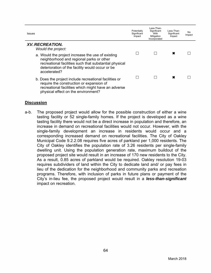
64 March 2018
Issues
Potentially Significant
Impact
Less-Than-Significant
With Mitigation
Incorporated
Less-Than-Significant
Impact
No
Impact
XV. RECREATION. Would the project:
a. Would the project increase the use of existing
neighborhood and regional parks or other recreational facilities such that substantial physical deterioration of the facility would occur or be accelerated?
b. Does the project include recreational facilities or
require the construction or expansion of recreational facilities which might have an adverse physical effect on the environment?
Discussion a-b. The proposed project would allow for the possible construction of either a wine
tasting facility or 52 single-family homes. If the project is developed as a wine tasting facility there would not be a direct increase in population and therefore, an increase in demand on recreational facilities would not occur. However, with the single-family development an increase in residents would occur and a corresponding increased demand on recreational facilities. The City of Oakley Municipal Code 9.2.2.08 requires five acres of parkland per 1,000 residents. The City of Oakley identifies the population rate of 3.26 residents per single-family dwelling unit. Using the population generation rate, maximum buildout of the proposed project site would result in an increase of 170 new residents to the City. As a result, 0.85 acres of parkland would be required. Oakley resolution 19-03 requires subdividers of land within the City to dedicate land and/ or pay fees in lieu of the dedication for the neighborhood and community parks and recreation programs. Therefore, with inclusion of parks in future plans or payment of the City’s in-lieu fee, the proposed project would result in a less-than-significant impact on recreation.

65 March 2018
Issues
Potentially Significant
Impact
Less-Than-Significant
With Mitigation
Incorporated
Less-Than-Significant
Impact
No
Impact
XVI. TRANSPORTATION/TRAFFIC. Would the project:
a. Cause an increase in traffic which is substantial
in relation to the existing traffic load and capacity of the street system (i.e., result in a substantial increase in either the number of vehicle trips, the volume to capacity ratio on roads, or congestion at intersections)?
b. Exceed, either individually or cumulatively, a
level of service standard established by the county congestion management agency for designated roads or highways?
c. Result in a change in air traffic patterns,
including either an increase in traffic levels or a change in location that results in substantial safety risks?
d. Substantially increase hazards due to a design
features (e.g., sharp curves or dangerous intersections) or incompatible uses (e.g., farm equipment)?
e. Result in inadequate emergency access?
f. Conflicts with adopted policies supporting
alternative transportation (e.g., bus turnouts, bicycle racks)?
Discussion a,b. Under existing General Plan land use and zoning designations for the project
site, the site could be redeveloped with up to 36 residential housing units. The proposed project would include a rezone and a General Plan Amendment of the site to allow for the development of up to 52 residential units or 1,800 sf of wine tasting facility. It should be noted that the proposed project consists of the rezone and a General Plan Amendment, but does not include any physical changes to the project site. However, for the purpose of analyzing the potential transportation and traffic related impacts of the project, future buildout of the site under the proposed land use and zoning designations is assumed to occur.
Vehicle trips to and from the project site currently consist of trips related to the
existing single-family residence and the vineyard operations within the site. Vineyard operations are anticipated to involve the delivery and distribution of agricultural goods and equipment, as well as employee commutes to and from the site. Future buildout of the project for an 1,800-sf wine tasting facility would result in vehicle trips to the project site related to the delivery of goods, employee

66 March 2018
commutes, and patrons of the tasting facility. While most commercial and residential type developments result in vehicle trip peaks during the morning (AM) and evening (PM) weekday commute hours, a tasting room would likely generate a greater volume of trips during the evening and on weekends. Furthermore, reuse of the site for wine tasting would be considered a less intense use than redevelopment of the site with 52 residential units. Considering that the wine tasting facility would be a relatively less intensive land use and would primarily contribute vehicle trips outside of the typical AM and PM peak hours, development of the project site with 52 residential uses would be considered to have a greater potential to result in impacts to the City’s circulation network or conflict with applicable plans. Therefore, the following discussion will focus on the potential impacts resulting from potential future development of the project site with single-family residences, as such development would represent the environmental worst-case scenario.
To assess the potential for future development of the project site to result in
conflicts with applicable plans or impacts to the City’s circulation network, the Institute of Traffic Engineer’s (ITE) Trip Generation Handbook was used to estimate the potential number of vehicle trips that would result from development of the site. Development and operation of 52 residential units would be anticipated to result in 39 vehicle trips in the AM peak hour and 52 vehicle trips during the PM peak hour from the project site. According to the Contra Costa Transportation Authority (CCTA) Congestion Management Plan (CMP), any land development application generating more than 100 peak hour trips is required to prepare a study of the project’s traffic impacts on the CMP network. The CCTA does not require projects generating fewer than 100 peak hour trips to prepare a traffic study because the CCTA has concluded that projects generating fewer than 100 peak hour trips are unlikely to result in impacts to circulation networks. As discussed above, the proposed project is anticipated to generate a maximum of 52 peak hour trips, which would be below CCTA’s 100 peak hour trip threshold for preparing a traffic study. Consequently, the proposed project would not be anticipated to result in impacts to the circulation network of the project area.
Future developments within the project site would be required to comply with all
relevant goals and policies within the City’s General Plan. For instance, Policy 3.2.2, and 3.2.5 are designed to promote the incorporation of bicycle and pedestrian facilities into new developments. Furthermore, General Plan Program 3.2.A requires site plan reviews for new developments to encourage the incorporation of bicycle and pedestrian facilities such as bicycle racks, continuous sidewalks and internal pedestrian circulation plans.
Although the proposed project would not result in direct redevelopment of the
project site, as discussed above, development of the project site for either a wine tasting facility or residential uses would not be anticipated to result in impacts to the City’s circulation system. Furthermore, future development of the project site would be required to comply with the City’s General Plan goals and policies

67 March 2018
related to alternative transportation and vehicle transportation. Therefore, the proposed project would result in a less-than-significant impact.
c. The project site is not located near an airport; therefore, the proposed project
would not require any changes to existing regional air traffic activity and no impact would occur.
d,e. The proposed project would include a General Plan Amendment and rezone of
the project site, but would not include physical development of the project site. Therefore, implementation of the proposed project would not alter emergency access to the site, which is currently provided by a driveway from Laurel Lane. The existing driveway would be anticipated to provide sufficient emergency access to the project site should the site be redeveloped with a wine tasting facility. If instead the project site is developed for residential uses in the future, additional access to the project site would be provided to allow for adequate emergency access. Potential future development of the site would not be anticipated to include any significant changes to the existing circulation network in the project area that would introduce hazards. Furthermore, potential future development would not include incompatible uses that could increase hazards. As such, the project would result in a less-than-significant impact.
f. The proposed project would have access to the Tri Delta Transit system. Line
383 provides the closest service to the project site, with multiple stops within the City of Oakley, and major regional access would be provided by the Antioch Park & Ride (Hillcrest). The proposed project would not include alterations to the surrounding circulation system of the area, nor would the project interfere with current transit options available for the area. Additionally, the proposed project would not interfere with existing bicycle infrastructure. As discussed in responses to question “a,b.” above, potential future development of the project site would be required to comply with the city’s General Plan goals and policies related to the use of alternative modes of transportation. Therefore, the proposed project would not conflict with alternative transportation routes or policies resulting in a less-than-significant impact.

68 March 2018
XVII. TRIBAL CULTURAL RESOURCES. Would the project cause a substantial adverse change in the significance of a tribal cultural resource, defined in Public Resources Code section 21074 as either a site, feature, place, cultural landscape that is geographically defined in terms of the size and scope of the landscape, sacred place, or object with cultural value to a California Native American Tribe, and that is:
Potentially Significant
Impact
Less-Than-Significant
with Mitigation
Incorporated
Less-Than-Significant
Impact
No Impact
a. Listed or eligible for listing in the California Register of Historical Resources, or in a local register of historical resources as defined in Public Resources Code section 5020.1(k)?
b. A resource determined by the lead agency, in its discretion and supported by substantial evidence, to be significant pursuant to criteria set forth in subdivision (c) of Public Resources Code Section 5024.1? In applying the criteria set forth in subdivision (c) of Public Resources Code Section 5024.1, the lead agency shall consider the significance of the resource to a California Native American tribe.
Discussion a,b. As discussed in Section V, Cultural Resources, of this IS/MND, the proposed
project site contains a 1920 residence that could potentially be eligible for listing in the CRHR, NRHP, or in a local register of historical resources as defined in Public Resources Code section 5020.1(k), and may contain known resources that could be considered historic pursuant to the criteria set forth in subdivision (c) of Public Resources Code Section 5024.1. The potential for unrecorded Native American resources to exist within the project site is relatively low based on the highly-disturbed nature of the site. Implementation of Mitigation Measure V-2., described in detail in Section V. (Cultural Resources), would reduce any potential impacts related to unknown resources to less-than-significant levels Based on a record search of the Native American Heritage Commission (NAHC) Sacred Land files, known tribal resources do not exist for the project area or adjacent lands. Additionally, in compliance with Assembly Bill (AB) 52 (Public Resources Code Section 21080.3.1), a project notification letter was distributed by the City to those Native American tribes who have previously requested notification under AB 52 of projects within the City subject to CEQA. The letters were distributed on November 1, 2017, explaining the nature of the project and soliciting comments and any additional information the individuals might have regarding tribal resources in the project area. The City did not receive any responses within the mandatory 30-day response period for consultation under AB 52/Public Resources Code Section 21080.3.1(b). Given that the project would be required to comply with the City’s standard conditions of approval regarding cultural resources, as well as mitigation measures in Section V. (Cultural

69 March 2018
Resources), construction of the proposed project would not result in a substantial adverse change in the significance of a tribal cultural resource, and a less-than-significant impact to tribal cultural resources could occur.

70 March 2018
Issues
Potentially Significant
Impact
Less-Than-Significant
With Mitigation
Incorporated
Less-Than-Significant
Impact
No
Impact
XVII. UTILITIES AND SERVICE SYSTEMS. Would the project:
a. Exceed wastewater treatment requirements of
the applicable Regional Water Quality Control Board?
b. Require or result in the construction of new
water or wastewater treatment facilities or expansion of existing facilities, the construction of which could cause significant environmental effects?
c. Require or result in the construction of new
storm water drainage facilities or expansion of existing facilities, the construction of which could cause significant environmental effects?
d. Have sufficient water supplies available to serve
the project from existing entitlements and resources, or are new or expanded entitlements needed?
e. Result in a determination by the wastewater
treatment provider which serves or may serve the project that it has adequate capacity to serve the project’s projected demand in addition to the provider’s existing commitments?
f. Be served by a landfill with sufficient permitted
capacity to accommodate the project’s solid waste disposal needs?
g. Comply with federal, state, and local statutes
and regulations related to solid waste?
Discussion a,b,e. The Ironhouse Sanitary District (ISD) provides wastewater service to Oakley and
unincorporated areas of Bethel Island and Sandmound. The City of Oakley is entirely within ISD’s boundary. The wastewater services involve the transmission of wastewater from residential, commercial and light industry to a treatment facility and the final disposal of the wastewater and residual waste solids. ISD owns and operates the wastewater collection, treatment, storage, and effluent recycling facilities that serve the City of Oakley. The proposed project would tie into the existing sanitary sewer line along the property within Laurel Road. Although the project includes a General Plan Amendment from SM to SH increasing the single-family development potential

71 March 2018
from 36 to 52 units, the minimal increase in wastewater use associated with the proposed project could be accommodated within the existing ISD systems. In addition, the project would be required to pay the necessary sewer connection and capacity fees. Therefore, the proposed project would not require the construction of new wastewater treatment facilities or expansion of existing facilities. Therefore, a less-than-significant impact to wastewater treatment facilities would occur.
c. According to the Oakley 2020 General Plan EIR, increased development may
lead to an increase in impervious surfaces being created where permeable soils currently exist. With approval and implementation of the proposed project, new residential development, streets, and sidewalks would convert the project site’s undeveloped, primarily pervious surfaces to impervious surfaces. Whereas open space allows precipitation to infiltrate into the ground, impervious surfaces cause water to pond or runoff. Stormwater runoff from impervious areas may concentrate and cause increases in runoff volume for the area. Discharge of the concentrated runoff may cause localized flooding at storm drain connections or downstream of the discharge location. The proposed project is subject to the requirements included in the C.3 Standards to ensure that development does not result in changes to stream stability and geomorphology. The applicant is required to develop a stormwater control plan SWCP in compliance with C.3 standards. In addition, the project site is within the CCCFCWCD. The CCCFCWCD requires a drainage fee in accordance with Flood Control Ordinance Numbers 2007-07 and 2007-06. Pursuant to the fee collection agreement between the Contra Costa County Board of Supervisors and the City of Oakley, the applicant is required to pay the fee at the time of building permit issuance or as otherwise determined by the Contra Costa County Board of Supervisors. Therefore, project compliance with the City of Oakley’s C.3 regulations and payment of drainage fees would ensure that the construction of new storm water drainage facilities or expansion of existing facilities, the construction of which could cause significant environmental effects, would not be required. As a result, impacts would be less than significant.
d. Water is provided to the project site by the Diablo Water District (DWD).
According to the DWD Final 2010 Urban Water Management Plan, water demand and connection projections for DWD are based on buildout land uses in current adopted general plans. Over the period from 2010 to 2035, DWD’s demand is estimated to increase from 1,815 MG per year to 5,572 MG per year. DWD’s primary water supply for its distribution system is treated surface water from the Bureau of Reclamation’s Central Valley Project (CVP) purchased from the Contra Costa Water District (CCWD). CVP water is conveyed through the Contra Costa Canal and treated at the Randall-Bold Water Treatment Plant in Oakley, which is jointly owned by DWD and CCWD. DWD has developed a groundwater supply system that provides additional supply reliability. The first

72 March 2018
groundwater well came online in 2006. When fully implemented, groundwater may comprise up to 20 percent of DWD’s total supply. As indicated in the Urban Water Management Plan, DWD has adequate supply sources to meet future needs under normal year, single year and multi-year drought conditions. The proposed project would tie into the water main along the property in Laurel Road. Although the project includes a General Plan Amendment from SM to SH increasing the single-family development potential from 36 to 52 units, the minimal increase in water use associated with the proposed project could be accommodated within the existing DWD systems. In addition, the project would be required to pay the necessary water connection and capacity fees. Therefore, the proposed project would result in a less-than-significant impact.
f,g. Solid waste collected by Oakley Disposal in the City limits of Oakley is hauled to the recycling Center and Transfer Station in Pittsburg, which is operated by Contra Costa Waste Service. Residential, commercial, and industrial waste is processed at this transfer facility and the residual material is hauled to Potrero Hills Landfill (PHLF) outside Suisun City. PHLF is permitted to accept waste through 2048. Oakley Disposal Service provides weekly curbside recycling service whereby each residential customer is provided two 12-gallon crates for discarding recyclables. Green waste service is provided on a bi-weekly basis. The curbside material is transported to the Concord Facility (Mt. Diablo Recycling) where the recyclables are sorted and moved to the appropriate markets for processing, composting, etc. The potential future 52-unit single-family development or approximately 1,800-sf wine tasting facility would be able to be accommodated within the existing solid waste facilities and would comply with all the required local and State regulations; therefore, a less-than-significant impact would result.
73 March 2018
Issues
Potentially Significant
Impact
Less-Than-Significant
With Mitigation
Incorporated
Less-Than-Significant
Impact
No
Impact
XVIII. MANDATORY FINDINGS OF SIGNIFICANCE.
a. Does the project have the potential to degrade the quality of the environment, substantially reduce the habitat of a fish or wildlife species, cause a fish or wildlife population to drop below self-sustaining levels, threaten to eliminate a plant or animal community, reduce the number or restrict the range of a rare or endangered plant or animal or eliminate important examples of the major periods of California history or prehistory?
b. Does the project have impacts that are individually
limited, but cumulatively considerable? ("Cumulatively considerable" means that the incremental effects of a project are considerable when viewed in connection with the effects of past projects, the effects of other current projects, and the effects of probable future projects)?
c. Does the project have environmental effects which
will cause substantial adverse effects on human beings, either directly or indirectly?
Discussion a. Although relatively unlikely, based upon the current land cover types found on-
site, special-status wildlife species and/or federally- or state-protected birds not covered under the ECCCHCP could be occupying the site. In addition, although unlikely, the possibility exists for subsurface excavation of the site during grading and other construction activities to unearth deposits of cultural significance. However, this IS/MND includes mitigation measures that would reduce any potential impacts to less-than-significant levels. Therefore, the proposed project would have less-than-significant impacts related to degradation of the quality of the environment, reduction of habitat, threatened species, and/or California’s history or prehistory.
b. The proposed project in conjunction with other development within the City of Oakley could incrementally contribute to cumulative impacts in the area. However, mitigation measures for all potentially significant project-level impacts identified for the proposed project in this IS/MND have been included that would reduce impacts to less-than-significant levels. As such, the project’s incremental contribution towards cumulative impacts would not be considered significant. In addition, all future discretionary development projects in the area would be required to undergo the same environmental analysis and mitigate any potential impacts, as necessary. In addition, the site has been anticipated by the City for residential development. Thus, buildout of the site with residential uses was

74 March 2018
considered in the cumulative analysis of buildout of the General Plan. Therefore, the proposed project would not have any impacts that would be cumulatively considerable, and impacts would be less than significant.
c. The potential impacts identified in this study are minor and would be mitigated to a less-than-significant level with implementation of required mitigation measures. The proposed project would not result in a substantial adverse effect on human beings, either directly or indirectly. Therefore, impacts related to environmental effects that could cause adverse effects on human beings would be less than significant.