LTO FORM C CHARGE (V25)
66
___________________________________________ LAND TITLE ACT FORM C (Section 233) CHARGE GENERAL INSTRUMENT - PART 1 Province of British Columbia PAGE OF PAGES Your electronic signature is a representation that you are a designate authorized to certify this document under section 168.4 of the Land Title Act, RSBC 1996 c.250, that you certify this document under section 168.41(4) of the act, and that an execution copy, or a true copy of that execution copy, is in your possession. 1. APPLICATION: (Name, address, phone number of applicant, applicant's solicitor or agent) Deduct LTSA Fees? Yes 2. PARCEL IDENTIFIER AND LEGAL DESCRIPTION OF LAND: [PID] [LEGAL DESCRIPTION] STC? YES 3. NATURE OF INTEREST CHARGE NO. ADDITIONAL INFORMATION 4. TERMS: Part 2 of this instrument consists of (select one only) (a) Filed Standard Charge Terms D.F. No. (b) Express Charge Terms Annexed as Part 2 A selection of (a) includes any additional or modified terms referred to in Item 7 or in a schedule annexed to this instrument. 5. TRANSFEROR(S): 6. TRANSFEREE(S): (including postal address(es) and postal code(s)) 7. ADDITIONAL OR MODIFIED TERMS: 8. EXECUTION(S): This instrument creates, assigns, modifies, enlarges, discharges or governs the priority of the interest(s) described in Item 3 and the Transferor(s) and every other signatory agree to be bound by this instrument, and acknowledge(s) receipt of a true copy of the filed standard charge terms, if any. Officer Signature(s) Execution Date Transferor(s) Signature(s) Y M D OFFICER CERTIFICATION: Your signature constitutes a representation that you are a solicitor, notary public or other person authorized by the Evidence Act, R.S.B.C. 1996, c.124, to take affidavits for use in British Columbia and certifies the matters set out in Part 5 of the Land Title Act as they pertain to the execution of this instrument.
Transcript of LTO FORM C CHARGE (V25)

___________________________________________
LAND TITLE ACT FORM C (Section 233) CHARGE GENERAL INSTRUMENT - PART 1 Province of British Columbia PAGE OF PAGES
Your electronic signature is a representation that you are a designate authorized to certify this document under section 168.4 of the Land Title Act, RSBC 1996 c.250, that you certify this document under section 168.41(4) of the act, and that an execution copy, or a true copy of that execution copy, is in your possession.
1. APPLICATION: (Name, address, phone number of applicant, applicant's solicitor or agent)
Deduct LTSA Fees? Yes 2. PARCEL IDENTIFIER AND LEGAL DESCRIPTION OF LAND:
[PID] [LEGAL DESCRIPTION]
STC? YES
3. NATURE OF INTEREST CHARGE NO. ADDITIONAL INFORMATION
4. TERMS: Part 2 of this instrument consists of (select one only)(a) Filed Standard Charge Terms D.F. No. (b) Express Charge Terms Annexed as Part 2A selection of (a) includes any additional or modified terms referred to in Item 7 or in a schedule annexed to this instrument.
5. TRANSFEROR(S):
6. TRANSFEREE(S): (including postal address(es) and postal code(s))
7. ADDITIONAL OR MODIFIED TERMS:
8. EXECUTION(S): This instrument creates, assigns, modifies, enlarges, discharges or governs the priority of the interest(s) described in Item 3 andthe Transferor(s) and every other signatory agree to be bound by this instrument, and acknowledge(s) receipt of a true copy of the filed standardcharge terms, if any.
Officer Signature(s) Execution Date Transferor(s) Signature(s)Y M D
OFFICER CERTIFICATION: Your signature constitutes a representation that you are a solicitor, notary public or other person authorized by the Evidence Act, R.S.B.C. 1996, c.124, to take affidavits for use in British Columbia and certifies the matters set out in Part 5 of the Land Title Act as they pertain to the execution of this instrument.

LAND TITLE ACT FORM D EXECUTIONS CONTINUED PAGE of PAGES
Officer Signature(s) Execution Date Transferor / Borrower / Party Signature(s)
_____________________________________________
_____________________________________________
_____________________________________________
Y M D
OFFICER CERTIFICATION: Your signature constitutes a representation that you are a solicitor, notary public or other person authorized by the Evidence Act, R.S.B.C. 1996, c.124, to take affidavits for use in British Columbia and certifies the matters set out in Part 5 of the Land Title Act as they pertain to the execution of this instrument.

LAND TITLE ACTFORM E
NATURE OF INTEREST CHARGE NO. ADDITIONAL INFORMATION
NATURE OF INTEREST CHARGE NO. ADDITIONAL INFORMATION
NATURE OF INTEREST CHARGE NO. ADDITIONAL INFORMATION
NATURE OF INTEREST CHARGE NO. ADDITIONAL INFORMATION
NATURE OF INTEREST CHARGE NO. ADDITIONAL INFORMATION
NATURE OF INTEREST CHARGE NO. ADDITIONAL INFORMATION
SCHEDULE PAGE OF PAGES

Page 4
TERMS OF INSTRUMENT - PART 2
COVENANT (Section 219 Land Title Act)
THIS Agreement made the 25th of May 2020
BETWEEN: Greenlane Homes Ltd., Inc. No. BC1085102
1200 Waterfront Centre 200 Burrard St., P.O. Box 48800 Vancouver, BC V7X 1T2
(hereinafter called the “Grantor”)
AND:
TOWN OF GIBSONS, a municipal corporation having an address at 474 South Fletcher Road Box 340 Gibsons BC V0N 1V0
(hereinafter called the “Town”)
WHEREAS:
A. The Grantor is the owner of those certain lands and premises located within the Town of Gibsons in the Province of British Columbia, and more particularly known and described as:
PID: 010-827-200
BLOCK 7 DISTRICT LOT 842 PLAN 6755
(the “Lands”);
B. The Grantor proposes to build upon the Lands;
C. The Grantor and the Town agree that in order to preserve wildlife habitat and other ecological values a portion of the Lands should, in perpetuity, be protected from development, disturbance or other alteration, except to the extent that disturbance or alteration may be specifically recommended by a suitably qualified professional, to ameliorate previous disturbances, or promote or enhance habitat and other ecological values, or both;

Page 5
D. Section 219 of the Land Title Act provides, inter alia, that a covenant, whether of a negative or positive nature, may be registered as a charge against the title to land in favour of a municipality or the Crown.
NOW THEREFORE THIS AGREEMENT WITNESSES that pursuant to Section 219 of the Land Title Act, and in consideration of the premises and the mutual covenants and agreements contained herein and the sum of One ($1.00) Dollar now paid to the Grantor by the Town (the receipt and sufficiency of which is hereby acknowledged), the parties hereto covenant and agree each with the other as follows:
1. In this Covenant:
(a) the areas shown outlined in heavy black line and labelled “Covenant” on survey plan EPP102323, a reduced copy of which attached to this Covenant as Schedule A shall be referred to in this Covenant as “Preservation Areas” and the following documents, which are attached as Schedules B, C, D and E to this Covenant, shall collectively be referred to as the “Environmental Reports”:
i. Schedule B – Report titled “Environmentally Sensitive Development Permit Area No. 2 – Gospel Rock Subdivision Block 7” prepared by Diamond Head and dated April 29, 2019 updated October 28, 2019
ii. Schedule C – Report titled “Environmentally Sensitive Development Permit Area No. 2 – 6‐Lot Subdivision” prepared by Diamond Head and dated February 27, 2019 updated October 25, 2019
iii. Schedule D – Letter titled “Gospel Rock Memo ‐ Review of development documents to ensure compatibility with the Town of Gibsons Environmentally Sensitive Area (ESA) Development Permit Area #2” prepared by Diamond Head dated October 28, 2019
iv. Schedule E – Letter titled “Gospel Rock Memo ‐ Review of Geotechnical Addendum Letter 02 to ensure compatibility with the Town of Gibsons Environmentally Sensitive Area (ESA) Development Permit Area (DPA) #2” prepared by Diamond Head and dated February 12, 2020
2. The Grantor Covenants and Agrees with the Town that:
(a) the Grantor shall, at all times from and after the date this Covenant is entered into, maintain the Preservation Area in accordance with the Environmental Reports;
(b) the Grantor shall not construct, place or locate any building or structure, or part thereof, on or in the Preservation area or any portion of the Preservation Area;
Page 6
(c) except as specifically required to comply with section 1(a) of this Covenant, any alteration or disturbance of the Preservation Area is prohibited;
(d) without limiting section 1 of this Covenant, the Grantor shall not use the Lands in any manner that might reasonably be expected to cause any disturbance, alteration or contamination of the Preservation Area.
3. The Grantor shall do or cause to be done, at the expense of the Grantor, all actsreasonably necessary to grant priority to this Agreement over all charges andencumbrances which may have been registered against the title to the Lands in the NewWestminster Land Title Office, save and except those specifically approved in writing bythe Town or in favour of the Town.
4. The Grantor shall reimburse the Town for any expenses that it may incur as a result of abreach of section 2 by the Grantor, on a solicitor and own client basis in the case ofexpenses for legal services.
5. It is mutually understood, agreed and declared by and between the parties hereto that:
(a) the Town has made no representations, covenants, warranties, guarantees,promises or agreements (oral or otherwise) with the Grantor other than thosecontained in this Agreement;
(b) nothing contained or implied herein shall obligate the Town to enforce theprovisions of this Agreement;
(c) if the Town in its sole discretion elects to enforce against any breach of thisagreement by an application for an order for specific performance the Grantorshall not resist such an order on the basis that damages would be an adequateremedy;
(d) nothing contained or implied herein shall prejudice or affect the rights andpowers of the Town in the exercise of its functions under any public and privatestatutes, by‐laws, orders and regulations, all of which may be fully andeffectively exercised in relation to the Lands as if this Agreement had not beenexecuted and delivered by the Grantor;
(e) the covenants set forth herein shall run with the Lands and each and every partinto which the Lands may be subdivided or consolidated by any means (includingsubdivision plan, reference or explanatory plan, strata plan, bare land strata planor lease), but no part of the fee of the Lands passes to or is vested in the Townunder or by this Agreement. It is further expressly agreed that the benefit of allcovenants made by the Grantor herein shall accrue solely to the Town and thatthis Agreement may be modified by agreement of the Town with the Grantor, ordischarged by the Town, pursuant to the provisions of Section 219(9) of the LandTitle Act;

Page 7
(f) wherever the singular or masculine is used herein, the same shall be construed as meaning the plural, feminine or the body corporate or politic where the context or the parties so require;
(g) this Agreement shall enure to the benefit of and be binding upon the parties hereto and their respective heirs, executors, administrators, successors and assigns;
(h) the parties hereto shall do and cause to be done all things and execute and cause to be executed all documents which may be necessary to give proper effect to the intention of this Agreement;
(i) this Agreement shall be governed and construed in accordance with the laws of the Province of British Columbia;
(j) no waiver of default by either party is effective unless expressed in writing by the party waiving default, and no condoning, overlooking or excusing by either party of a previous default of the other is to be taken to operate as a waiver of any subsequent default or continuing default, or to in any way defeat or affect the rights and remedies of the non‐defaulting party; and
(k) if any section, subsection, sentence, clause or phrase in this Agreement is for any reason held to be invalid by decision of a court of competent jurisdiction, the invalid portion shall be severed and the decision that it is invalid shall not affect the validity of the remainder of this Agreement.
As evidence of their agreement to be bound by the above terms, the parties each have executed and delivered this Agreement by executing Part 1 of the Land Title Act Forms C and D to which this Agreement is attached and which forms part of this Agreement.

Page 8
SCHEDULE A
SURVEY PLAN EPP 102323 - PRESERVATION AREA

PLAN 6755
1
1
6
°
2
4
' 3
3
"
4
8
0
.7
7
6
(
8
2
H
4
8
4
5
T
O
9
4
H
1
2
0
9
)
1
6
6
°
2
0
' 0
5
" 5
5
.6
7
1
G O
W
E
R
P
O
I N
T
R
O
A
D
D L 6 8 5 A
D L
8
4
2
1
6
94H1209
15.401
15.400
15.395
15.400
15.400
14.985
17.252
B
E
A
R
IN
G
D
E
R
IV
A
T
IO
N
14.000
7.490
88° 41' 13"
2
1
2
7
°
1
1
'
4
3
"
1
1
.
6
4
8
14.000
14.000
14.000
14.000
14.000
14.000
3
15.400
15.400
15.400
15.400
15.397
178°
23'
15"
EPP90951
5
4
22.443
82H4845
CIP (CAP DESTROYED)
178°
23'
15"
1
9
3
°
4
9
'
2
6
"
4
1
7
.
4
6
0
23.303
26.003
26.003
26.003
25.703
26.003
23'
30"
13"
88°
41'
9.437
Wt
Wt
0.300
88°
23'
31"
88°
23'
31"
88°
23'
05"
88°
23'
05"
88°
23'
26"
88°
EPP90951
EPP90951
EPP90951
EPP90951
EPP90951
C
O
V
E
N
A
N
T
2.700
PLAN 7495
REMAINDER
BLOCK 7
B k 7
178°
23'
15"
22.371
15.400
15.400
15.398
15.400
15.399
0
ALL DISTANCES ARE IN METRES AND DECIMALS THEREOF.
55 10
THE INTENDED PLOT SIZE OF THIS PLAN IS 560mm IN
WIDTH BY 864mm IN HEIGHT (D SIZE) WHEN PLOTTED AT
A SCALE OF 1:200
D:\A0010-GIBSONS FOLDERS\90009.00-GOSPEL-ROCK-GIBSONS_NV_(LEGAL)\90009.00-DRAWINGS\90009.00-LEGAL PLANS\R90009.DWG
PURSUANT TO SECTION 99(1)(e) OF THE LAND TITLE ACT.
PLAN EPP102323
TOWN OF GIBSONS
BCGS 92G.033
FOR COVENANT PURPOSES
FB4005 P136-140 (AR-SQ)
bennett
LAND SURVEYING
(COASTAL) LTD.
BC LAND SURVEYORS
634 FARNHAM ROAD
GIBSONS, BC
V0N 1V8
TEL 604-886-2531
www.bennettsurveys.com
V2020-05-13
REFERENCE PLAN OVER PART OF LOTS 1 TO 6
BLOCK 7 DISTRICT LOT 842 G1 NWD PLAN EPP90951
THIS PLAN LIES WITHIN THE
SUNSHINE COAST REGIONAL DISTRICT
THE FIELD SURVEY REPRESENTED BY THIS PLAN WAS
COMPLETED ON THE 5TH DAY OF MAY,2020.
JAVIER SIU, BCLS 934
Bk
- DENOTES STANDARD IRON POST FOUND
- DENOTES STANDARD IRON POST PLACED
- DENOTES LEAD PLUG FOUND
- DENOTES GEODETIC CONTROL MONUMENT
- DENOTES BLOCK
LEGEND
THIS PLAN LIES WITHIN INTEGRATED SURVEY AREA NUMBER 52,
TOWN OF GIBSON, NAD83 (CSRS) 4.0.0.BC.1
THIS PLAN SHOWS HORIZONTAL GROUND LEVEL DISTANCES,
UNLESS OTHERWISE SPECIFIED. TO COMPUTE GRID DISTANCES,
MULTIPLY GROUND LEVEL DISTANCES BY THE AVERAGE COMBINED
FACTOR OF 0.9996163. THE AVERAGE COMBINE FACTOR HAS BEEN DETERMINED
BASED ON GEODETIC CONTROL MONUMENTS 94H1209 AND 82H4845.
GRID BEARINGS ARE DERIVED FROM OBSERVATIONS BETWEEN
GEODETIC CONTROL MONUMENTS 94H1209 AND 82H4845 AND
ARE REFERRED TO CENTRAL MERIDIAN OF UTM ZONE 10.
DATUM: NAD83 (CSRS) 4.0.0.BC.1, UTM ZONE 10.
GCM NORTHING EASTING
NOTE: FOR MAPPING PURPOSES ONLY.
ESTIMATED ABSOLUTE
ACCURACY
COMBINED
FACTOR
THE UTM COORDINATES AND ESTIMATED ABSOLUTE ACCURACY ACHIEVED ARE
DERIVED FROM THE MASCOT PUBLISHED COORDINATES AND STANDARD DEVIATIONS
FOR GEODETIC CONTROL MONUMENTS 94H1209 AND 82H4845.
NOTE: FOR MAPPING PURPOSES ONLY.
5470685.595 462660.538 0.99961620.0282H4845
5471146.612 462796.303 0.99961630.0294H1209
NOTE:
THIS PLAN SHOWS ONE OR MORE WITNESS POSTS
WHICH ARE NOT SET ON THE TRUE CORNER(S).
SOME LINES ARE EXAGGERATED FOR CLARITY.
AREA
BOOK OF REFERENCE
LEGAL DESCRIPTION
LOT 1 PLAN EPP90951 313.7 m²
TOTAL AREA
0.139 ha
LOT 2 PLAN EPP90951 215.6 m²
LOT 3 PLAN EPP90951 215.6 m²
LOT 4 PLAN EPP90951
LOT 5 PLAN EPP90951
215.6 m²
215.6 m²
LOT 6 PLAN EPP90951 215.6 m²

Page 9
SCHEDULE B
Report titled “Environmentally Sensitive Development Permit Area No. 2 – Gospel Rock Subdivision Block 7” prepared by Diamond Head and dated April 29, 2019 updated October 28, 2019

Environmentally Sensitive Development Permit Area No. 2 – Gospel Rock Subdivision Block 7
Gospel Rock
Gibsons, BC
April 29th, 2019
Updated October 28th, 2019
Submitted to:
Yijin Wen
Greenlane Homes Ltd.
9031 Briar Road, Burnaby, BC
C/O JYWA Architects

Environmentally Sensitive Development Permit Area Report – Block 7 Gospel Rock, Gibsons
3559 Commercial Street, Vancouver B.C. V5N 4E8 | T 604‐733‐4886 i
The following Diamond Head Consulting staff performed the site visit and prepared the report. All
general and professional liability insurance and individual accreditations have been provided below for
reference.
If there are any questions or concerns as to the contents of this report, please contact us at any time.
Contact Information
Phone: 604‐733‐4886
Fax: 604‐733‐4879
Email: [email protected], [email protected]
Website: www.diamondheadconsulting.com
Insurance Information
WCB: # 657906 AQ (003)
General Liability: Northbridge General Insurance Corporation ‐ Policy #CBC1935506, $5,000,000
Errors & Omissions: Lloyds Underwriters – Policy #1010615D, $1,000,000
Cassandra Cummings, R.P.Bio
Biologist, Planner
MSc. Biology, MSc. Planning
Mike Coulthard, R.P.Bio., R.P.F.
Senior Forester, Biologist
Certified Tree Risk Assessor (46)

Environmentally Sensitive Development Permit Area Report – Block 7 Gospel Rock, Gibsons
3559 Commercial Street, Vancouver B.C. V5N 4E8 | T 604‐733‐4886 ii
Table of Contents
1.0 INTRODUCTION ........................................................................................................................ 1
2.0 ENVIRONMENTALLY SENSITIVE DEVELOPMENT PERMIT AREA NO.2 ......................................... 1
2.1 Douglas Fir‐Arbutus Coastal Dryland Forest ................................................................................................ 1
2.2 Marine Shore Areas ...................................................................................................................................... 2
3.0 PROJECT DESCRIPTION .............................................................................................................. 3
3.1 Project location ............................................................................................................................................ 3
3.2 Construction Work Plan ............................................................................................................................... 4
4.0 SITE DESCRIPTION ..................................................................................................................... 6
4.1 Topography .................................................................................................................................................. 6
4.2 Climate and Soils .......................................................................................................................................... 6
4.3 Plant Communities ....................................................................................................................................... 7
4.4 Aquatic Habitat ............................................................................................................................................ 8
4.5 Wildlife Habitat ............................................................................................................................................ 8
4.6 Species at Risk ............................................................................................................................................ 10
4.7 Invasive Species .......................................................................................................................................... 10
5.0 REVISED LOCATION OF ENVIRONMENTALLY SENSITIVE AREA BOUNDARY .............................. 11
6.0 PROTECTION OF ESA AREAS .................................................................................................... 12
6.1 Douglas Fir‐Arbutus Coastal Dryland Forest .............................................................................................. 12
6.2 Tree Root Protection Zones ....................................................................................................................... 14
6.3 Marine Shore Areas .................................................................................................................................... 14
6.4 Geotechnical reports .................................................................................................................................. 15
7.0 HABITAT BALANCE & COMPENSATION OPTIONS..................................................................... 15

Environmentally Sensitive Development Permit Area Report – Block 7 Gospel Rock, Gibsons
3559 Commercial Street, Vancouver B.C. V5N 4E8 | T 604‐733‐4886 iii
List of Figures
Figure 1. Project location – Gospel Rock is located in the southwestern edge of the Town of Gibsons, BC. ............... 3
Figure 2: Overlay map illustrating the location of the DPA areas as mapped by Gibsons. Provided by Modus. DF =
Dryland Forest DPA; MA = Marine Shore DPA; NA = Natural Clearing; Wt = Wildlife Tree Buffer. ............................... 4
Figure 3: The proposed division of Gospel Rock Block 7. Shades of green represent parkland and conservation
areas, blue and purple represent single and two family residential, shades of pink orange and peach represent
multi‐family residential. Provided by Webster Engineering. ......................................................................................... 5
Figure 4: Topography of Block 7, Gospel Rock, Gibsons ................................................................................................ 6
Figure 5: Approximate location of the original ESA as mapped in the OCP (pink) and the refined boundary after field
work by DHC (blue). ..................................................................................................................................................... 11
Figure 6: Location of ESA areas that extend into private lots and will be removed (red hatch), as well as potential
areas for restoration that will be protected under the covenant with The Land Conservancy (TLC) (green hatch).
The majority (6.3 ha) of the ESA will be protected under the covenant with TLC. ..................................................... 12
Figure 7: Approximate location of areas to be protected (green) and the 5m buffer for tree root protection
(yellow). ....................................................................................................................................................................... 14

Environmentally Sensitive Development Permit Area Report – Block 7, Gospel Rock, Gibsons
3559 Commercial Street, Vancouver B.C. V5N 4E8 | T 604‐733‐4886 1
1.0 Introduction
This property, colloquially called Gospel Rock, is one of the largest undeveloped areas in the Town of Gibsons. Greenlane Homes is planning to protect 49% of the property through the use of park land donations and a covenant with The Land Conservancy (TLC) and develop the other 51%. The property will be developed in stages and includes single family homes, townhouses and apartment buildings. The northeast section of the property will be the first stage of development and consists of a 6‐lot subdivision. The northwest portion of the property will be developed over a number of phases. The Town of Gibson’s Environmentally Sensitive Development Permit Area (DPA), which is applicable to all residential, industrial and commercial uses, covers approximately half the property. It affects the 6‐Lot subdivision in the northeast as well as the lots in the north west that interface with the future park area. Diamond Head Consulting Ltd. (DHC) was retained to prepare an Environmentally Sensitive DPA Assessment for this site. The 6‐Lot subdivision has been evaluated in a separate ESA DP Report; this report will focus on the rest of the development interface in the northwest of the property.
Civic address: No Address. Gospel Rock, Town of Gibsons, BC Legal description: Block 7, District Lot 842 Plan VAP6755; PID 010‐827‐200 Client name: Yijin Wen Date of site visit: February 7th, 2019; April 3rd, 2019, April 16th, 2019
2.0 Environmentally Sensitive Development Permit Area No.2
This Development Permit Area (DPA) applies to properties that contain environmentally sensitive areas (ESAs). The objective of this DPA as stated in the Official Community Plan (OCP) is to protect ESAs from development. Four general areas of environmental concern were identified. The Gospel Rock property is located within two of these. The first is described as “environmentally sensitive lands in the Gospel Rock area, including forested lands, wildlife corridors and wetlands”. The second is “environmentally sensitive marine shore areas”.
2.1 Douglas Fir‐Arbutus Coastal Dryland Forest
This ESA is designated due to the existing unique forest type and habitat values. The natural coastal dryland forest in steep exposed areas with poor, rocky soils comprises only 0.3% of the land are of BC, and <5% of mature dryland forest remains undisturbed on the Sunshine Coast due to development. This ESA DPA was developed to protect the steeply sloped dryland forest while confining development to the mixed coniferous‐deciduous forest landward of the ESA. The DPA also recommends the protection of eagles’ nests, scenic and cultural values, possible alligator lizard habitat, as well as connectivity between these habitat areas and Charman Creek ravine to the north. Currently, habitat connectivity is maintained by continuous forest cover at the western edge of the 6‐lot subdivision.

Environmentally Sensitive Development Permit Area Report – Block 7, Gospel Rock, Gibsons
3559 Commercial Street, Vancouver B.C. V5N 4E8 | T 604‐733‐4886 2
2.1.1 ESA DP Guidelines Douglas Fir‐Arbutus Coastal Dryland Forest Areas
No buildings, structures, or uses permitted on the land shall be sited within the following areas:
Areas with grades steeper than 25% in order to protect soil cover and drainage patterns
The area within 100 m of the wildlife tree buffer shown on schedule D
The natural clearings shown on schedule D Any other development within the identified Gospel Rock sensitive areas shall be designed to:
Avoid the removal/modification of native vegetation
Avoid the introduction of non‐native invasive vegetation
Avoid impacts to the protected root zones of trees
Avoid disturbance to wildlife and habitat
Minimize the use of fill
Minimize soil disturbance
Minimize blasting
Minimize changes in hydrology
Avoid run‐off of sediments and construction‐related contaminants Measures may be required to prevent and mitigate any damage to the environmentally‐sensitive area, including:
Temporary or permanent fencing
Environmental monitoring during construction
Demarcation of wildlife corridors, wildlife trees, and significant trees
Restricting development activities during sensitive life‐cycle times
Registration of a natural state covenant
2.2 Marine Shore Areas
This ESA is designated to protect marine shore areas, which are considered an integral part of the marine environment that provides essential fish habitat. This includes the nearshore subtidal seabed, intertidal foreshore, and adjacent backshore areas. Disturbance and alteration of foreshore, nearshore areas or adjacent backshore upland, including removal of upland vegetation, can result in significant adverse environmental effects. To protect these, an appropriate setback/leave strip along the shore is supported. These should be left undisturbed and naturally vegetated and should be maintained in perpetuity. 2.2.1 ESA DP Guidelines for Marine Foreshore Areas
Prior to any new development, an environmental assessment must be undertaken by a Qualified Environmental Professional (QEP). The environmental assessment will identify:
The extent and type of potential impact on fish habitat
The circumstances and conditions under which development permits may be issued to manage development that potentially has a significant impact on the natural marine shore and fish habitat
The measures of remediation required to minimize the impacts. The following may be required to prevent and mitigate any damage to the riparian area:
Temporary or permanent fencing

Environmentally Sensitive Development Permit Area Report – Block 7, Gospel Rock, Gibsons
3559 Commercial Street, Vancouver B.C. V5N 4E8 | T 604‐733‐4886 3
Environmental monitoring during construction
Restricting development activities during sensitive life‐cycle times
Registration of a natural state covenant Re‐vegetation and restoration may be required as mitigation or compensation.
3.0 Project Description
3.1 Project location
This site is located in the southwestern edge of the Town of Gibsons on the Sunshine Coast, BC. (Figure 1). This site is zoned for Comprehensive Development Area Zone (CDA‐4). The area surrounding the site consists primarily of single‐family residences and corresponding amenities, with some parkland and natural areas. There are no known watercourses on site, however, Seaward Creek (non‐fish bearing) and Charman Creek (fish‐bearing) are to the west and north respectively.
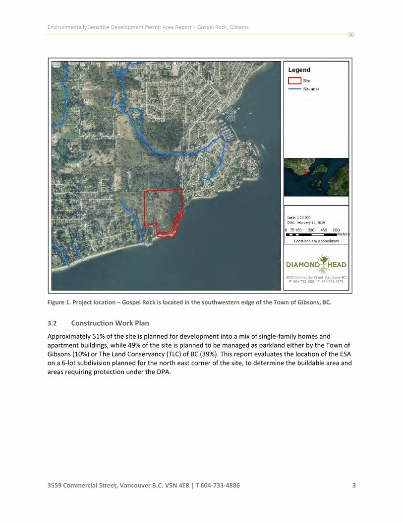
Figure 1. Project location – Gospel Rock is located in the southwestern edge of the Town of Gibsons, BC.

Environmentally Sensitive Development Permit Area Report – Block 7, Gospel Rock, Gibsons
3559 Commercial Street, Vancouver B.C. V5N 4E8 | T 604‐733‐4886 4
3.2 Construction Work Plan
Approximately 51% of the site is planned for development into a mix of single‐family homes, townhouses, and apartment buildings (Figure 3), while 49% of the site is planned to be managed as parkland either by the Town of Gibsons (10%) or The Land Conservancy (TLC) of BC (39%). This report evaluates the location of the ESA and provides management recommendations. Figure 2 represents the location of the DPA in relation to the development plan. A separate ESA report has been developed for this 6‐lot subdivision; however, the requirements for the 6‐lot subdivision planned for the northeast corner are also included when discussing overall habitat offsets. This assessment will help determine the buildable area and areas requiring protection under the DPA, as well as potential areas for habitat compensation, as necessary.
Figure 2: Overlay map illustrating the location of the DPA areas as mapped by Gibsons. Provided by Modus. DF =
Dryland Forest DPA; MA = Marine Shore DPA; NA = Natural Clearing; Wt = Wildlife Tree Buffer.

Environmentally Sensitive Development Permit Area Report – Block 7, Gospel Rock, Gibsons
3559 Commercial Street, Vancouver B.C. V5N 4E8 | T 604‐733‐4886 5
Figure 3: The proposed division of Gospel Rock Block 7. Shades of green represent parkland and conservation
areas, blue and purple represent single and two family residential, shades of pink orange and peach represent
multi‐family residential. Provided by Webster Engineering.

Environmentally Sensitive Development Permit Area Report – Block 7, Gospel Rock, Gibsons
3559 Commercial Street, Vancouver B.C. V5N 4E8 | T 604‐733‐4886 6
4.0 Site Description
The site is located in the southwest corner of the Town of Gibsons. Most of the site is forested. The areas south of the natural slope break support a mature forest while the areas above have been cleared more recently and support a mixed younger forest. Gower Point Road runs through the south and south eastern part of the site following the marine foreshore before turning north.
4.1 Topography
The south end of the site is located at sea level (Figure 4). The northwestern section of the site is at the highest elevation, approximately 100 m ASL. This section of the site has a gentle slope, before a steep drop on the south and east sides of the site (Figure 4). Development is planned to be concentrated on flatter areas adjacent to Gower Point Road, and along the north western half of the site, as development is not permitted on slopes >25%.
Figure 4: Topography of Block 7, Gospel Rock, Gibsons
4.2 Climate and Soils
This site is situated within the Coastal Western Hemlock Very Dry Maritime (CWHxm1) subzone of the Biogeoclimatic Ecosystem Classification (BEC) System of BC. This subzone occurs at low elevations on the mainland, between sea level to approximately 700 m. It is associated with warm, dry summers and moist, mild winters with relatively little snowfall. Growing seasons are long, and feature water deficits on zonal sites.

Environmentally Sensitive Development Permit Area Report – Block 7, Gospel Rock, Gibsons
3559 Commercial Street, Vancouver B.C. V5N 4E8 | T 604‐733‐4886 7
The ESA boundary extends along the north and west edge of the proposed park area and generally follows the terrain’s natural slope break. The ESA area that will be the park has moderate to steep slopes. There are exposed bedrock outcrops as well as colluvial parent materials consisting of large rocks and boulders. The soils are generally sandy loams, with ~50‐60% coarse fragments. Humus type is moder. Soil depth is generally shallow due to the presence of bedrock. Soil moisture is generally dry and soil nutrients are poor to moderate. Ecology is classified as a complex of site series 03 and 02 supporting a dryland forest dominated by Douglas‐fir and arbutus.
4.3 Plant Communities
Plant communities are defined as units of vegetation with a relatively uniform plant species composition and physical structure. The forested plant community in this ESA is generally consistent along the ESA boundary. Its character is consistent with the those intended to be protected by the ESA DP area referred to as a Douglas‐fir Arbutus Dryland Forest. The areas to the north and west of the ESA boundary were cleared of mature trees within the last 10‐15 years. This clearing extends to the natural terrain slope break. Below this break there are mature stands. Trees have a relatively even spatial distribution. There are however some small canopy openings where outcrops of bedrock have prevented tree growth. Stands generally consist of trees with relatively high crown‐base heights. The main treed canopy consists mainly of Douglas‐firs (Pseudotsuga menziesii) with the presence of western redcedar (Thuja plicata) and Bigleaf maple (Acer macrophyllum). The Intermediate layer contains mostly Douglas‐fir, with scattered western redcedar and arbutus (Arbutus menziesii). The suppressed and regenerating layers are mostly Douglas‐fir and arbutus and some western redcedar. There are some older trees expected to be older than 150 years and have signs of historic wildfire scars. Scattered dead standing trees are found throughout the stand showing signs of wildlife use.
Table 1 – Stand characteristics in the ESA
STAND CHARACTERISTICS
Canopy Layer Main Canopy Trees Intermediate Trees Suppressed Trees Regeneration
Species1 (% by volume; + denotes <10%)
Fd90Cw10Mb+ Fd80Cw10Ra10 Fd70Ra20Cw10 Fd870Ra10Cw10
Density (stems/ha) 250 300 150 10
Tree diameter at breast height (cm)
55 25 5
Tree height (m) 32 19 4
Live crown ratio 70 50 60
Crown closure (%) 50
Age 135
1 Species codes: Fd (Douglas‐fir), Hw (western hemlock), Cw (western redcedar), Act (black cottonwood), Mb (bigleaf maple), Dr
(red alder), Pr (bitter cherry), Ra (Arbutus)

Environmentally Sensitive Development Permit Area Report – Block 7, Gospel Rock, Gibsons
3559 Commercial Street, Vancouver B.C. V5N 4E8 | T 604‐733‐4886 8
Views of the dryland forest typical of the ESA area
Understory vegetation is variable, averaging 50% coverage. Native understory vegetation in the ESA includes: 25‐50% salal (Gaultheria shallon), 2‐5% Licorice fern (Polypodium glycyrrhiza), 2‐5% oceanspray (Holodiscus discolor), 1‐2% Red huckleberry (Vaccinium parvifolium), 2‐5% Sword fern (Polystichum munitum), 2‐5% snowberry (Symphocarpos albus), 2‐5% baldhip rose (Rosa gymnocarpa), 2‐5% honeysuckle (Lonicera ciliosa) and 2‐5% Dull Oregon grape (Mahonia nervosa). There are bedrock outcrop areas and bluffs found throughout the ESA area that are dominated by moss, lichens and grasses with little tree or shrub cover.
Views of bedrock outcrop areas
4.4 Aquatic Habitat
There are no known or found watercourses, lakes, ponds or wetlands on Gospel Rock Block 7. There are however two watercourses found in adjacent areas; Charman Creek to the north and Seaward Creek to the west in Block 6.
4.5 Wildlife Habitat
The natural area on site continues north and connects to Charman Creek ravine. This corridor is wide and continuous, providing a travel corridor for wildlife. A section of this connection is protected under

Environmentally Sensitive Development Permit Area Report – Block 7, Gospel Rock, Gibsons
3559 Commercial Street, Vancouver B.C. V5N 4E8 | T 604‐733‐4886 9
the ESA DPA, and is planned to be protected under development. The corridor is wide and provides a variety of high value habitat features that supports a diversity of wildlife, including mammals and birds. Disturbance caused by the presence of nearby residential development and well used trails should be minimal, as they are mostly located either offsite or south of the proposed 6‐lot subdivision. The wildlife community that inhabits this area includes mostly birds and small to medium mammals that are more tolerant of urban disturbance. Larger mammals are likely to use this area as part of a more extensive home range.
4.5.1 Bird Species
Bird surveys were not completed during this study. The ESA map shows an eagle’s nesting area in the south edge of the site, just north of Gower Point road. Biologists from DHC searched but did not find a nest. There is a large stick nest in this area however it appears too small to be that of an eagle and is suspected to be a Ravens nest.
The site visits were conducted prior to the beginning of nesting season; however, the following bird species were identified: Bald eagle, black capped chickadees, northwestern crow, common raven, pileated woodpecker, spotted towhee, red breasted nuthatch and pacific winter wren.
The site provides terrestrial habitat for a wide variety of resident and migratory birds. A diversity of habitat features is present to support nesting, foraging, and roosting. Bird species groups likely present include swallows, hummingbirds, warblers, woodpeckers, flycatchers, jays, crows, chickadees, nuthatches, thrushes, sparrows, wrens, kinglets, and finches.
4.5.2 Mammal Species
Mammal surveys were not completed during this study. The forest and shrub communities provide habitat to support a diversity of small mammals including squirrels, voles, shrews, and mice. Medium and large sized mammals likely to inhabit this area (as part of a larger range) include raccoon (Procyon lotor), skunk (Mephitis mephitis), coyote (Canis latrans), black‐tailed deer (Odocoileus hemionus), Roosevelt elk (Cervus elaphus roosevelti) and black bear (Ursus americanus). 4.5.3 Amphibian and Reptile Species
The ESA area is relatively dry and does not contain any known watercourses or wetlands. This limits the species of amphibians and reptiles expected on site. The Environmentally Sensitive DPA includes the potential for alligator lizard habitat. The northern alligator lizard (Elgaria coerulea) is widely distributed along the west coast of North America, with British Columbia coast being the northernmost limit of its range1. Given their need for open, rocky spaces for basking, it is likely that if there is alligator lizard habitat it is located on the rocky outcrops that are proposed to be protected under park and covenant designation and within the ESA area. It is currently provincially yellow‐listed, and considered not at risk under COSEWIC. 4.5.4 Fish Species
There are no known watercourses on site; therefore, there are no fish species expected on site.
1 British Columbia Conservation Data Centre. 2019. Species Summary: Northern Alligator Lizard. Retrieved October 1st , 2019 from http://a100.gov.bc.ca/pub/eswp/speciesSummary.do?id=18752.

Environmentally Sensitive Development Permit Area Report – Block 7, Gospel Rock, Gibsons
3559 Commercial Street, Vancouver B.C. V5N 4E8 | T 604‐733‐4886 10
4.6 Species at Risk
The BC Conservation Data Centre (CDC) records BC’s most vulnerable vertebrate animals and vascular plants, each of which is assigned to a provincial Red or Blue list according to their provincial conservation status rank. Species or populations at high risk of extinction or extirpation are placed on the Red list and are candidates for formal endangered species status. Blue‐listed species are considered vulnerable to human activity and natural events. No known species at risk were described in the CDC database Gospel Rock; however, there is habitat for marbled murrelet (Brachyramphus marmoratus) identified in 2014 located southwest of the site. No other species or habitats were identified by the CDC within a 5km radius. No habitat critical for any species at risk that is not found in the adjacent natural areas was identified during the site visit.
4.7 Invasive Species
Invasive species found in the park area to be protected is isolated mainly to the edges of Gower Point road. Species identified include Himalayan blackberry (Rubus armeniacus), English Ivy (Hedera helix), Spurge laurel (Daphne laureola), scotch broom (Cytisus scoparius) and periwinkle (Vinca minor).
The property edge along the road contains higher concentrations of invasives including blackberry.
English Ivy growing below Gower Point Road.
Scotch Broom along the southern edge of Gower Point Road, facing south.

Environmentally Sensitive Development Permit Area Report – Block 7, Gospel Rock, Gibsons
3559 Commercial Street, Vancouver B.C. V5N 4E8 | T 604‐733‐4886 11
5.0 Revised location of Environmentally Sensitive Area Boundary
Field visits to the site by two biologists from Diamond Head Consulting refined the location of the ESA boundary on site. This boundary follows the dry and sloped areas which are dominated by Mature Douglas‐fir stands. The area above the steeper slopes was previously cleared of mature trees. The boundary to the mature forest type is for this reason distinct. It has been located with flagging and the boundary was located by GPS while in the field. It has not been surveyed to confirm its location. This new boundary, along with the original ESA boundary contained within DPA 2, is displayed in Figure 5.
Figure 5: Approximate location of the original ESA as mapped in the OCP (pink) and the refined boundary after field work by DHC (blue).
1:3,000Date: April 17, 2019
Scale:
0 25 50 75 100Meters
3559 Commercial Street, Vancouver BCP: 604-733-4886 | F: 604-733-4879
Locations are approximate
LegendGospel Rock Site
Updated ESA (field survey)
DPA 2 - Dryland Forest
CAD legal lots
5 m Contours
Gospel Rock - Block 7Environmentally Sensitive AreasExisting and Proposed

Environmentally Sensitive Development Permit Area Report – Block 7, Gospel Rock, Gibsons
3559 Commercial Street, Vancouver B.C. V5N 4E8 | T 604‐733‐4886 12
6.0 Protection of ESA areas
6.1 Douglas Fir‐Arbutus Coastal Dryland Forest
The refined ESA boundary is mostly contained within the area that will be protected as park, with 6.4 ha protected under the covenant with The Land Conservancy (TLC). There are, however, areas where the ESA extends into private lots. Unprotected areas of conflict between the location of the ESA and development are highlighted in red hatch in Figure 6. This area is approximately 0.4 ha and is not part of the protected ESA. It is likely most of this area will be lost during development.
Figure 6: Location of ESA areas that extend into private lots and will be removed (red hatch), as well as potential areas for restoration that will be protected under the covenant with The Land Conservancy (TLC) (green hatch). The majority (6.3 ha) of the ESA will be protected under the covenant with TLC.
A setback of 10 m from the back property line of lots 56 and 57 is recommended to be placed under a private covenant. Lots 1 through 6 will have a setback of 14 m from the back property line which will also be placed under a private covenant. For more details on these lots see the 6‐Lot subdivision report by Diamond Head Consulting. A summary of site‐specific recommendations and requirements for these areas are found in Table 2.

Environmentally Sensitive Development Permit Area Report – Block 7, Gospel Rock, Gibsons
3559 Commercial Street, Vancouver B.C. V5N 4E8 | T 604‐733‐4886 13
An additional 0.69 ha of non‐ESA natural areas are to be preserved under the covenant within the TLC to compensate for the ESA areas to be lost on the designated lots. In these areas there are opportunities to enhance the existing ecology to offset the ESA encroachment. Additional details on potential habitat compensation and enhancement can be found in section 7.0.
Table 2 – Summary of site‐specific recommendations for individual lots.
Lot # Site‐Specific Recommendations 1, 2, 3, 4, 5, 6 A 14 m setback downslope from the western property line will be placed under a
restrictive covenant for each of these 6 properties.
10 This lot is planned to be used for a townhouse development. It will require geotechnical measures at the top of slope. Some of the ESA extends into this lot but may be cleared for development. During subsequent detailed planning of this lot, it is recommended that opportunities be explored to retain some of these trees as natural forested backyard. At this point, this area is being treated as loss to ensure the viability of the townhouse development. A 5 m tree root protection buffer measured from the protected covenant parkland extends into the eastern edge of this lot, as described in section 6.2.
16 There is a small conflict between the ESA and development on the southern corner of this lot. Due to the nature of the townhouse development planned for this lot, this area is being treated as loss, with compensation planned in other parts of the protected parkland. A buffer of 5 m off of the protected ESA covenant area will be needed to protect tree root zones, as described in section 6.2.
56, 57 A 10 m setback west from the eastern property line will be placed under a restrictive covenant for each of these 2 properties. This setback will protect the ESA that exists while allowing the development to proceed as planned. For these two lots, this setback will be outside of the Stat Right‐of‐Way and planned utility works A buffer of 5 m off of the protected ESA covenant area will be needed to protect tree root zones, as described in section 6.2.
All covenant ESA areas will be protected through construction to ensure that the integrity of these plant communities is not compromised. Measures described in the DPA to prevent and mitigate any damage to the environmentally sensitive area include:
Temporary or permanent fencing
Environmental monitoring during construction
Demarcation of wildlife corridors, wildlife trees, and significant trees
Restricting development activities during sensitive life‐cycle times
Registration of a natural state covenant Development is to occur in a way that minimizes damage to the ESA including the removal or modification of native vegetation, introduction of invasive plant species, impacting root zones of trees, and disturbing wildlife and habitat. In addition, development is to minimize the use of fill, disturbance of soil, blasting, changing hydrology and avoid run‐off of sediments and contaminants. Any work that is to occur in covenant areas needs to be reviewed by a QEP and approved by the Township to ensure minimal damage to the protected ESA. While a raptors nest was not found during initial field visits, subsequent surveys are required prior to the upgrade works beginning on the section of Gower Point Road that goes through the protected ESA area.

Environmentally Sensitive Development Permit Area Report – Block 7, Gospel Rock, Gibsons
3559 Commercial Street, Vancouver B.C. V5N 4E8 | T 604‐733‐4886 14
6.2 Tree Root Protection Zones
A minimum 5.0 m buffer measured from the protected ESA DP area shall be maintained to protect the trees in the protected ESA area (Figure 7). This area may be reduced if an arborist is retained to identify a more specific root protection zone in an arborist report and is onsite during construction to ensure the tree roots of protected trees are not damaged. Vegetation may be removed in this area under the direction and supervision of an arborist to ensure roots of the protected ESA trees are not damaged. It will be the responsibility of the Town of Gibsons to ensure that homeowners are informed of this requirement when applying for building permits.
Figure 7: Approximate location of areas to be protected (green) and the 5m buffer for tree root protection
(yellow).
6.3 Marine Shore Areas
The entirety of the marine foreshore along this property is to be protected as parkland under a natural state covenant with The Land Conservancy (TLC) and the Town of Gibsons. This area is to be protected in perpetuity from development, including the removal of native vegetation. This includes the nearshore subtidal seabed, intertidal foreshore, and adjacent backshore areas. This will protect the marine shore areas, which are considered an integral part of the marine environment. The rest of Block 7 is dry, and no watercourses were found on site. Development of the northwestern side of the site should not impact water flow to the ocean and therefore should not have an impact on fish habitat.

Environmentally Sensitive Development Permit Area Report – Block 7, Gospel Rock, Gibsons
3559 Commercial Street, Vancouver B.C. V5N 4E8 | T 604‐733‐4886 15
6.4 Geotechnical reports
Three geotechnical reports have been produced by Kontur Geotechnical Consultants Inc. for this development. All three were reviewed for this report, including:
1. Kontur Geotechnical Consultants Inc. Matthew Yip and Evan Sykes. Preliminary Geotechnical Assessment: Proposed Residential Development – Gospel Rock Village, Block 7 DL 842 Group 1 NWD Plan 6755. December 27th, 2018 (Revised September 19th, 2019).
2. Kontur Geotechnical Consultants Inc. Matthew Yip and Evan Sykes. Geotechnical Exploration and Report: Proposed Residential Development – Gospel Rock Village, Block 7 DL 842 Group 1 NWD Plan 6755. January 31st, 2019.
3. Kontur Geotechnical Consultants Inc. Matthew Yip and Evan Sykes. Geotechnical Addendum Letter: Proposed Residential Development – Gospel Rock Village, Block 7 DL 842 Group 1 NWD Plan 6755. September 18th, 2019.
Ideally, under the ESA DP, no soil will be removed or fill added within the identified ESA areas. However, the design as proposed will require some geotechnical measures in the 6‐lot subdivision along Gower Point Rd, and along the top of slope on Lot 10. Additional geotechnical measures may also be required for other lots. The extent of these requirements will be determined on a site‐by‐site basis as geotechnical reports are produced for future building permits. Detailed design will require that no soil be disturbed, or fill placed, in the Protected (i.e covenanted) ESA areas. For more details on lots 1‐6, please refer to section 5.1 in Diamond Head Consulting’s report Environmentally Sensitive Development Permit Area No. 2 – 6‐Lot Subdivision, updated October 17th, 2019. Four additional lots have been identified as overlapping with the ESA, Lots 10, 16, 56 and 57. A minimum of a 5.0 m buffer off of the protected ESA DP areas shall be maintained to protect the roots of trees growing within the covenant areas. For more details of this buffer and its requirements, see section 6.2. Additional information will be needed for the building permit, confirming the protected ESA area will not be directly harmed by the development of these lots. No development can occur within the protected ESA, and all geotechnical features will need to be contained within the building lots. Lots 10 and 16 will be developed as townhouse complexes. Lot 10 has steep slopes and contains the largest area of conflict between the ESA, steep slopes, and planned development. Geotechnical measures will be required to develop this lot, and it is likely that all of the ESA area in this lot will need to be removed for these geotechnical measures. Lot 16 has a small area of conflict between the ESA location and development area. This area should be protected if possible, however, at this point it is assumed that this area will be a loss. Lots 56 and 57 will be able to protect an environmental setback off of the back of the lots, however, some areas at the edge of the ESA in these lots will need to be cleared for the site servicing. It is recommended that no tree clearing take place downslope of this servicing which is estimated to be 15 m from the property line. This includes a 10 m covenant area, and a 5 m buffer to protect the tree roots. Enhancement areas are discussed in Section 7 to compensate for the ESA loss associated with these sites.
7.0 Habitat Balance & Compensation Options

Environmentally Sensitive Development Permit Area Report – Block 7, Gospel Rock, Gibsons
3559 Commercial Street, Vancouver B.C. V5N 4E8 | T 604‐733‐4886 16
The development of the 6‐lot subdivision as planned in the northeast portion of the site requires that some of the ESA be impacted. A 14m setback covenant is proposed from the back of these lots. This setback will protect most of the ESA on the 6‐lot subdivision; however, 0.05 hectares of the ESA will be impacted. The ESA also extends within the proposed townhouse development lot that is along the northeastern edge of the development (Lot 10). The ESA follows the mature trees that are growing along a natural slope break. It is expected that most of this ESA area will be impacted by the development of the proposed townhouses. This impact will be determined in detail at a later date during detailed site planning. For the habitat balance calculation, it was assumed the entire area will be impacted, which would be an ESA loss of 0.29 ha. Lot 16 has an ESA loss of 0.01 ha, and Lots 56 and 57 have a combined loss of 0.04 ha. This leads to a total anticipated loss of 0.39 ha of ESA. There are areas on the southwestern edge of the site to be protected under a natural state covenant with the TLC that are not currently considered an ESA. These areas are about 0.69 ha and can be restored and enhanced to help compensate for the areas of ESA loss. A detailed restoration plan will be required for these sites when applying for a building permit. There are also invasive plant species that have established mostly along Gower Point Road. These include Himalayan blackberry (Rubus armeniacus), English Ivy (Hedera helix), Spurge laurel (Daphne laureola), Scotch broom (Cytisus scoparius) and common periwinkle (Vinca minor). These are concentrated along the road and eastern edge of the site, with English Ivy growing up some of the trees. These should be removed and replanted with ecologically suitable native species as enhancement of ESA areas. The overall site plan includes up to 0.4 ha of ESA that will be impacted or lost; however, the protected covenant area provides 0.69 ha of area to be restored and enhanced to compensate for this loss. Habitat should be restored/enhanced by at least a 1:1 habitat compensation ratio for the lost area. Plant species used should be native and selected by a QEP based on the site series and current growing conditions.

Environmentally Sensitive Development Permit Area Report – Block 7, Gospel Rock, Gibsons
3559 Commercial Street, Vancouver B.C. V5N 4E8 | T 604‐733‐4886 17
Appendix A: General Environmental Construction Specifications
The Contractor shall conduct all operations in a manner which minimizes disturbances to environmental resources, and which complies with the requirements of all authorities having jurisdiction, including federal and provincial legislation, regulations, permits, approvals, authorizations, and guidelines applicable to the Project. In undertaking the Work, the Contractor shall be responsible for the actions of its agents, employees, subcontractors and everyone else engaged by or through the Contractor. Accordingly, the Contractor shall undertake all reasonable actions to ensure that environmental protection measures are in place and working effectively throughout all areas affected by the Project. In the event that an activity which contravenes these Environmental Construction Specifications occurs, the Owner may issue a Stop Work Order directing the immediate suspension of all or a portion of the activity(ies) causing the environmental impact and may order or at the Contractor's cost undertake remedial measures to be conducted as deemed necessary. The Contractor shall be solely responsible for all costs of all work stoppages and/or remedial works necessary, which result from the foregoing. The Contractor shall notify the Owner in writing, immediately upon discovery, of the existence of any hazardous conditions, property, or equipment within or immediately adjacent to the Site. However, it shall be the Contractor’s responsibility to take all necessary precautions against injury to the environment and to persons or damage to property from such hazards until corrected by the responsible party. The Contractor shall comply with all applicable law, including all federal and provincial legislation. In the event of a discrepancy between any of the clauses of these Environmental Construction Specifications and the provisions of any applicable law, including any legislation, regulations, or municipal bylaws, the more stringent provisions resulting in the higher protection of the environment, the lower discharges of contaminants and the higher degree of environmental protection and safety shall prevail. Impacts from construction activities to the existing riparian habitat will be minimized through the use of best management practices (BMP) and guidelines, including those found in the following documents:
“Users’ Guide to working In and Around Water” 2005 ‐ B.C. Ministry of Environment http://www.env.gov.bc.ca/wsd/water_rights/cabinet/working_around_water_v5_2013.pdf
“Standards and Best Practices for Instream Works” 2004 ‐ B.C. Ministry of Water, Land and Air Protection
http://env.gov.bc.ca/wld/documents/bmp/iswstdsbpsmarch2004.pdf
“Land Development Guidelines for the Protection of Aquatic Habitat” 1993 ‐ Department of Fisheries and Oceans, http://www.landfood.ubc.ca/sxd/9_resources/fed_ files/fed land development guidelines.pdf ‐ search=%2211.%09Land%20Development%20Gui
Develop with Care: Environmental Guidelines for Urban and Rural Land Development in British Columbia. 2014 ‐ B.C. Ministry of Environment http://www.env.gov.bc.ca/wld/documents/bmp/devwithcare/
These BMP will be implemented to avoid, limit or mitigate impacts to water quality and quantity, aquatic and riparian habitats. The following is a summary of BMPs to be implemented that will ensure that practices comply with legislation. These are not comprehensive, however a qualified environmental

Environmentally Sensitive Development Permit Area Report – Block 7, Gospel Rock, Gibsons
3559 Commercial Street, Vancouver B.C. V5N 4E8 | T 604‐733‐4886 18
monitor will use adaptive management to monitor construction activities and implemented additional measures where necessary. Mitigation measures recommended for this project to ensure minimal or no impacts to aquatic resources and no net loss of habitat include but are not limited to the following:
Ensure equipment and machinery are in good operating condition (power washed), free of leaks, excess oil, and grease. No equipment refuelling or servicing should be undertaken within 30m of any watercourse or surface water drainage.
All construction materials must be clean, non‐eroding and non‐toxic to aquatic life. Ensure that all works involving the use of concrete, cement, mortars, and other Portland cement or lime‐containing construction materials will not deposit, directly or indirectly, sediments, debris, concrete, concrete fines, wash or contact water into or about any watercourse. Concrete materials cast in place must remain inside sealed formed structures.
Any materials that inadvertently fall into the stream or the ocean must be removed immediately.
Sediment control measures are to be put in place prior to any work activities and remain in place until work is complete and the site is stable.
Environmental Monitoring
It is recommended that a qualified Environmental Monitor inspect, oversee, and report on the project with respect to environmental legislation, regulatory approvals, and best management practices (BMPs). During Construction, the Environmental Monitor will have the primary responsibility to evaluate the effectiveness of the environmental mitigation measures to achieve compliance with the terms and conditions of all regulatory permits, approvals, and environmental legislation. Environmental monitoring reports will be completed to document construction activities, mitigation measures, problems encountered, if any, and how they were managed. Following construction, the Environmental Monitor will prepare and submit an environmental monitoring completion report. The role of the Environmental Monitor will be to inspect, evaluate and report on the performance of the construction activities and effectiveness of environmental control methods and mitigation measures with respect to applicable legislation, permits and approvals, and BMPs. The key responsibilities of the Environmental Monitor include:
Liaison with regulatory agencies, and other key stakeholders;
Holding a pre‐construction meeting with the Contractor to review and discuss the project approvals and the required environmental BMPs;
Providing technical assistance on environmental matters to construction personnel and regulatory agencies;
Inspecting activities during construction to evaluate and report on compliance with terms and conditions of environmental approvals and permits;
Providing recommendations for modifying and/or improving environmental mitigation measures, as necessary;
Documenting construction activities by field notes and photographs;
Suspending construction activities that are causing, or potentially causing, risk of environmental damage;

Environmentally Sensitive Development Permit Area Report – Block 7, Gospel Rock, Gibsons
3559 Commercial Street, Vancouver B.C. V5N 4E8 | T 604‐733‐4886 19
Preparing factual environmental monitoring summary reports throughout the duration of construction, to summarize activities and actions taken to minimize potential effects during each of the construction activities;
Monitoring levels of turbidity and/or total suspended solids (TSS) relative to criteria established in the Land Development Guidelines for the Protection of Aquatic Habitat (25 mg/L above background levels and 75 mg/L above background levels during storm events); and
Monitoring levels of pH to relative to criteria established by the Canadian Council of Ministers of the Environment for the protection of aquatic habitat.
The Environmental Monitor will have the authority to suspend construction activities if, in their opinion, the Contractor’s actions contravene, or potentially contravene, the recommended BMPs or applicable legislation, permits, and approvals.

Environmentally Sensitive Development Permit Area Report – Block 7, Gospel Rock, Gibsons
3559 Commercial Street, Vancouver B.C. V5N 4E8 | T 604‐733‐4886 20
Appendix B: Statement of Limitations
This document was prepared by Diamond Head Consulting Ltd. Should this report contain an error or omission then the liability, if any, of Diamond Head Consulting Ltd. should be limited to the fee received by Diamond Head Consulting Ltd. for the preparation of this document. Recommendations contained in this report reflect Diamond Head Consulting Ltd.’s judgment in light of information available at the time of study. The accuracy of information provided by Diamond Head Consulting Ltd. is not guaranteed. This report is valid for 6 months from the date of submission. Additional site visits and report revisions are required after this point to ensure accuracy of the report. Neither all nor part of the contents of this report should be used by any party, other than the client, without the express written consent of Diamond Head Consulting Ltd. This report was prepared for the client for the client’s own information and for presentation to the approving government agencies. The report may not be used or relied upon by any other person unless that person is specifically named by Diamond Head Consulting Ltd as a beneficiary of the report, in which case the report may be used by the additional beneficiary Diamond Head Consulting Ltd has named. If such consent is granted, a surcharge may be rendered. The client agrees to maintain the confidentiality of the report and reasonably protect the report from distribution to any other person. If the client directly or indirectly causes the report to be distributed to any other person, the client shall indemnify, defend and hold Diamond Head Consulting Ltd harmless if any third party brings a claim against Diamond Head Consulting Ltd relating to the report.

Page 10
SCHEDULE C
Report titled “Environmentally Sensitive Development Permit Area No. 2 – 6‐Lot Subdivision” prepared by Diamond Head and dated February 27, 2019 updated October 25, 2019

Environmentally Sensitive Development Permit Area No. 2 – 6‐Lot Subdivision
Gospel Rock
Gibsons, BC
February 27, 2019
Updated: Oct. 25th, 2019
Submitted to:
Yijin Wen
Greenlane Homes Ltd.
9031 Briar Road, Burnaby, BC
C/O JYWA Architects

Environmentally Sensitive Development Permit Area Report – 6‐Lot Subdivision, Gospel Rock, Gibsons
3559 Commercial Street, Vancouver B.C. V5N 4E8 | T 604‐733‐4886 i
The following Diamond Head Consulting staff performed the site visit and prepared the report. All
general and professional liability insurance and individual accreditations have been provided below for
reference.
If there are any questions or concerns as to the contents of this report, please contact us at any time.
Contact Information
Phone: 604‐733‐4886
Fax: 604‐733‐4879
Email: [email protected], [email protected]
Website: www.diamondheadconsulting.com
Insurance Information
WCB: # 657906 AQ (003)
General Liability: Northbridge General Insurance Corporation ‐ Policy #CBC1935506, $5,000,000
Errors & Omissions: Lloyds Underwriters – Policy #1010615D, $1,000,000
Cassandra Cummings, R.P.Bio
Biologist, Planner
MSc. Biology, MSc. Planning
Mike Coulthard, R.P.Bio., R.P.F.
Senior Forester, Biologist
Certified Tree Risk Assessor (46)

Environmentally Sensitive Development Permit Area Report – 6‐Lot Subdivision, Gospel Rock, Gibsons
3559 Commercial Street, Vancouver B.C. V5N 4E8 | T 604‐733‐4886 ii
Table of Contents
1.0 INTRODUCTION ........................................................................................................................ 1
2.0 ENVIRONMENTALLY SENSITIVE DEVELOPMENT PERMIT AREA NO.2 ......................................... 1
2.1 Douglas Fir‐Arbutus Coastal Dryland Forest ................................................................................................ 1
3.0 PROJECT DESCRIPTION .............................................................................................................. 2
3.1 Project location ............................................................................................................................................ 2
3.2 Construction Work Plan ............................................................................................................................... 3
4.0 SITE DESCRIPTION ..................................................................................................................... 5
4.1 Topography .................................................................................................................................................. 5
4.2 Climate and Soils .......................................................................................................................................... 5
4.3 Plant Communities ....................................................................................................................................... 6
4.4 Aquatic Habitat .......................................................................................................................................... 10
4.5 Wildlife Habitat .......................................................................................................................................... 10
4.6 Species at Risk ............................................................................................................................................ 11
4.7 Invasive Species .......................................................................................................................................... 11
5.0 PROTECTION OF ENVIRONMENTALLY SENSITIVE AREAS .......................................................... 12
5.1 Geotechnical Reports ................................................................................................................................. 14
6.0 INVASIVE SPECIES MANAGEMENT .......................................................................................... 15
List of Figures
Figure 1. Project location – Gospel Rock is located in the southwestern edge of the Town of Gibsons, BC. ............... 3
Figure 2: The proposed division of the northeast section of the site into 6‐lots.. ........................................................ 4
Figure 3: Topography of Gospel Rock, Gibsons ............................................................................................................. 5
Figure 4: Approximate location of the Douglas‐Fir Arbutus Dryland Forest Ecotype (green). ...................................... 6
Figure 5: Approximate location of the original ESA location as mapped in the OCP (pink) and the refined boundary
after field work by DHC (blue). .................................................................................................................................... 12

Environmentally Sensitive Development Permit Area Report – Gospel Rock, Gibsons
3559 Commercial Street, Vancouver B.C. V5N 4E8 | T 604‐733‐4886 1
1.0 Introduction
This property, colloquially called Gospel Rock, is one of the largest undeveloped areas in the Town of Gibsons. Greenlane Homes is planning to protect 49% of the property through the use of park land donations and a covenant with The Land Conservancy (TLC), and develop the other 51%. The property will be developed in stages and includes single family homes and apartment buildings. The northeast section of the property will be the first stage of development and will consist of a 6‐lot subdivision. The Town of Gibson’s Environmentally Sensitive Development Permit Area (DPA), which is applicable to all residential, industrial and commercial uses, covers approximately half the property. This area overlaps with the 6‐Lot subdivision. Diamond Head Consulting Ltd. (DHC) was retained to prepare an Environmentally Sensitive DPA Assessment for this site.
Civic address: No Address. Gospel Rock, Town of Gibsons, BC Legal description: Block 7, District Lot 842 Plan VAP6755; PID 010‐827‐200 Client name: Yijin Wen Date of site visit: February 7th, 2019
2.0 Environmentally Sensitive Development Permit Area No.2
This Development Permit Area (DPA) applies to properties that contain environmentally sensitive areas (ESAs). The objective of this DPA as stated in the Official Community Plan (OCP) is to protect ESAs from development. Four general areas of environmental concern were identified. The Gospel Rock property is located within two of these. The first is described as “environmentally sensitive lands in the Gospel Rock area, including forested lands, wildlife corridors and wetlands”. The second is “environmentally sensitive marine shore areas”. The proposed 6‐lot subdivision which is the focus of this report is located only within the former ESA.
2.1 Douglas Fir‐Arbutus Coastal Dryland Forest
This ESA is designated due to the existing unique forest type and habitat values. The natural coastal dryland forest in steep exposed areas with poor, rocky soils comprises only 0.3% of the land are of BC, and <5% of mature dryland forest remains undisturbed on the Sunshine Coast due to development. This ESA was developed to protect the steeply sloped dryland forest while confining development to the mixed coniferous‐deciduous forest landward of the ESA. The DPA also recommends the protection of eagles’ nests, scenic and cultural values, possible alligator lizard habitat, as well as connectivity between these habitat areas and Charman Creek ravine to the north. Currently, habitat connectivity is maintained by continuous forest cover at the western edge of the 6‐lot subdivision. 2.1.1 ESA DP Guidelines
No buildings, structures, or uses permitted on the land shall be sited within the following areas:
Areas with grades steeper than 25% in order to protect soil cover and drainage patterns
The area within 100 m of the eagle nest shown on schedule D
The natural clearings shown on schedule D

Environmentally Sensitive Development Permit Area Report – Gospel Rock, Gibsons
3559 Commercial Street, Vancouver B.C. V5N 4E8 | T 604‐733‐4886 2
Any other development within the identified Gospel Rock sensitive areas shall be designed to:
Avoid the removal/modification of native vegetation
Avoid the introduction of non‐native invasive vegetation
Avoid impacts to the protected root zones of trees
Avoid disturbance to wildlife and habitat
Minimize the use of fill
Minimize soil disturbance
Minimize blasting
Minimize changes in hydrology
Avoid run‐off of sediments and construction‐related contaminants Measures may be required to prevent and mitigate any damage to the environmentally‐sensitive area, including:
Temporary or permanent fencing
Environmental monitoring during construction
Demarcation of wildlife corridors, wildlife trees, and significant trees
Restricting development activities during sensitive life‐cycle times
Registration of a natural state covenant
3.0 Project Description
3.1 Project location
This site is located in the Town of Gibsons on the Sunshine Coast, BC. (Figure 1). This site is zoned for Comprehensive Development Area Zone (CDA‐4). The area surrounding the site consists primarily of single‐family residences and corresponding amenities, with some parkland and natural areas. There are no known watercourses on site, however, Seaward Creek and Charman Creek are to the west and north respectively.
Environmentally Sensitive Development Permit Area Report – Gospel Rock, Gibsons
3559 Commercial Street, Vancouver B.C. V5N 4E8 | T 604‐733‐4886 3
Figure 1. Project location – Gospel Rock is located in the southwestern edge of the Town of Gibsons, BC.
3.2 Construction Work Plan
Approximately 51% of the site is planned for development into a mix of single‐family homes and apartment buildings, while 49% of the site is planned to be managed as parkland either by the Town of Gibsons (10%) or The Land Conservancy (TLC) of BC (39%). This report evaluates the location of the ESA on a 6‐lot subdivision planned for the north east corner of the site, to determine the buildable area and areas requiring protection under the DPA.

Environmentally Sensitive Development Permit Area Report – Gospel Rock, Gibsons
3559 Commercial Street, Vancouver B.C. V5N 4E8 | T 604‐733‐4886 4
Figure 2: The proposed division of the northeast section of the site into 6‐lots. The inner dotted lines represents the potential building envelope. The larger
dotted line represents the 14 m natural state covenant setback. Provided by Webster Engineering.

Environmentally Sensitive Development Permit Area Report – Gospel Rock, Gibsons
3559 Commercial Street, Vancouver B.C. V5N 4E8 | T 604‐733‐4886 5
4.0 Site Description
The site is located in the southwest corner of the Town of Gibsons. Most of the site is forested, with some cleared pathways from the north to central site. The section of the property to be subdivided is a forested area located on the north east edge of the site off of Gower Point Road. This road continues south and west through the southern end of the property.
4.1 Topography
The south end of the site is located at sea level. The northwestern section of the site is at the highest elevation, approximately 100 m ASL. This section of the site has a gentle slope, before a steep drop on the south and east sides of the site (Figure 3). Development is planned to be concentrated on flatter areas adjacent to Gower Point Road, as development is not permitted on slopes >25%.
Figure 3: Topography of Gospel Rock, Gibsons
4.2 Climate and Soils
This site is situated within the Coastal Western Hemlock Very Dry Maritime (CWHxm1) subzone of the Biogeoclimatic Ecosystem Classification (BEC) System of BC. This subzone occurs at low elevations on the mainland, between sea level to approximately 700 m. It is associated with warm, dry summers and moist, mild winters with relatively little snowfall. Growing seasons are long, and feature water deficits on zonal sites.

Environmentally Sensitive Development Permit Area Report – Gospel Rock, Gibsons
3559 Commercial Street, Vancouver B.C. V5N 4E8 | T 604‐733‐4886 6
The site contains exposed bedrock outcrops as well as colluvial parent materials. The soils on the 6‐lot subdivision area are generally sandy loams, with ~50‐60% coarse fragments. Humus type is moder, ranging from 3 to 6cm deep. The downslope area has moderate moisture and rich nutrient regime and is classified as site series 05. Upslope areas on the slopes are generally thin soils over bedrock or colluvial rocks and have low moisture and moderate nutrient regimes. These areas are a complex of 03 and 01 site series supporting a dryland forest dominated by Douglas‐fir and arbutus.
4.3 Plant Communities
Plant communities are defined as units of vegetation with a relatively uniform plant species composition and physical structure. Two distinct plant communities were identified within the study area. The first is a Douglas‐fir dominated dryland forest with scattered Arbutus located on the steep sloping west side of the 6‐lot subdivision. This forest is the type of ecosystem that is intended to be protected by the ESA. The second is along the eastern edge of the subdivision below the toe of the slope and is a mixed deciduous coniferous forest. The following sections detail the trees and plants found on site; however, plant ID was limited due to snow cover during the site visit.
Figure 4: Approximate location of the Douglas‐Fir Arbutus Dryland Forest Ecotype (green).

Environmentally Sensitive Development Permit Area Report – Gospel Rock, Gibsons
3559 Commercial Street, Vancouver B.C. V5N 4E8 | T 604‐733‐4886 7
4.3.1 Douglas Fir‐Arbutus Dryland Forest
The forest stand within the ESA boundary is referred to as a Douglas‐fir Arbutus Dryland Forest. Trees have an even spatial distribution and relatively high crown‐base heights. The co‐dominant layer of the canopy consists mainly of Douglas‐firs (Pseudotsuga menziesii) with the presence of western redcedar (Thuja plicata) and Bigleaf maple (Acer macrophyllum). The Intermediate layer contains mostly Douglas‐fir, with scattered western redcedar and arbutus (Arbutus menziesii). The suppressed layer is equal parts Douglas‐fir and western redcedar, with 20% arbutus. The regenerating layer consists of western redcedar. Slopes in this area are steep with scattered bedrock outcrops and colluvial fields.
STAND CHARACTERISTICS
Canopy Layer Dominant Trees Co‐Dominant Trees Intermediate Trees Suppressed Trees Regeneration
Species1 (% by volume; + denotes <10%)
‐ Cw+Fd10Mb+ Fd9Cw1Ra+ Fd4Ra2Cw4 Cw
Density (stems/ha) ‐ 300 250 50‐100 10
Tree diameter at breast height (cm)
‐ 65 25‐30 10
Tree height (m) ‐ 30 20‐25 8
Live crown ratio ‐ 50 40 60
Crown closure (%) 50
Age 135
1 Species codes: Fd (Douglas‐fir), Hw (western hemlock), Cw (western redcedar), Act (black cottonwood), Mb (bigleaf maple), Dr
(red alder), Pr (bitter cherry), Ra (Arbutus)
View of the dryland forest from below, facing west There are scattered arbutus trees throughout the
forest stand.

Environmentally Sensitive Development Permit Area Report – Gospel Rock, Gibsons
3559 Commercial Street, Vancouver B.C. V5N 4E8 | T 604‐733‐4886 8
Understory vegetation is variable, averaging 50% coverage. Native understory vegetation in the ESA includes: 25‐50% salal (Gaultheria shallon), 2‐5% Licorice fern (Polypodium glycyrrhiza), 2‐5% oceanspray (Holodiscus discolor), 2% Red huckleberry (Vaccinium parvifolium), 2‐5% Sword fern (Polystichum munitum), and 2‐5% trailing blackberry (Rubus ursinus).
Licorice ferns growing on exposed rocks Sword fern
Salal, oceanspray and other native understory species
There are steep slopes along the western half of the
proposed lots.

Environmentally Sensitive Development Permit Area Report – Gospel Rock, Gibsons
3559 Commercial Street, Vancouver B.C. V5N 4E8 | T 604‐733‐4886 9
4.3.2 Mixed Coniferous/Deciduous Forest
The area along the eastern edge of the proposed 6‐lot subdivision is a flatter, younger forest stand. It has an uneven distribution with large canopy gaps, with evidence of hydro pruning of the stand along the road. The co‐dominant layer of the canopy consists of western redcedar, bigleaf maple, and western hemlock (Tsuga heterophylla), with scattered Douglas‐firs. Intermediate trees consist of western redcedar, bigleaf maple, and western hemlock. The suppressed layer is composed mainly of Western red cedars with some Bigleaf Maple. The regenerating layer consists of western redcedar.
STAND CHARACTERISTICS
Canopy Layer Dominant Trees Co‐Dominant Trees Intermediate Trees Suppressed Trees Regeneration
Species1 (% by volume; + denotes <10%)
Cw7Mb2Hw1Fd+ Cw8Mb2Hw+ Cw8Mb2 Cw
Density (stems/ha)
150 150 200 25
Tree diameter at breast height (cm)
65 30 10‐15
Tree height (m) 32 20 6
Live crown ratio 70 50 80
Crown closure (%) 45
Age 90
1 Species codes: Fd (Douglas‐fir), Hw (western hemlock), Cw (western redcedar), Act (black cottonwood), Mb (bigleaf maple), Dr
(red alder), Pr (bitter cherry), Ep – (Paper birch), W (willow)
Understory vegetation covers ~50‐60% of the ground. Invasive species are present here with higher concentrations along the road edge. Native understory vegetation includes: 25‐50% sword fern, 10‐25% oceanspray (Holodiscus discolor), 5‐10% dull Oregon grape (Mahonia nervosa), 2‐5% baldhip rose (Rosa gymnocarpa), 2% hazelnut (Corylus cornuta), 2‐5% red huckleberry, 2‐5% salal, and 1‐2% trailing blackberry. Invasive species include 2‐5% Himalayan blackberry (Rubus armeniacus), 2‐5% English ivy (Hedera helix), and 2‐5% spurge laurel (Daphne laureola).
Representative understory species in an open area.
Snow coverage made it difficult to comprehensively ID all understory species.

Environmentally Sensitive Development Permit Area Report – Gospel Rock, Gibsons
3559 Commercial Street, Vancouver B.C. V5N 4E8 | T 604‐733‐4886 10
View of the edge of the ESA and developable area. View of the development area, facing east
4.4 Aquatic Habitat
There are no known or found watercourses, lakes, ponds or wetlands in the 6‐lot subdivision area.
4.5 Wildlife Habitat
The natural area on site continues north and connects to Charman Creek ravine. This corridor is wide and continuous, providing a travel corridor for wildlife. A section of this connection is protected under the ESA DPA, and is planned to be protected under development. The corridor is wide and provides a variety of high value habitat features that supports a diversity of wildlife, including mammals and birds. Disturbance caused by the presence of nearby residential development and well used trails should be minimal, as they are mostly located either offsite or south of the proposed 6‐lot subdivision. The wildlife community that inhabits this area includes mostly birds and small to medium mammals that are more tolerant of urban disturbance. Larger mammals are likely to use this area as part of a more extensive home range.
4.5.1 Bird Species
Bird surveys were not completed during this study. However, there is a known eagle’s nest in the south edge of the site, just north of the road. Vegetative and noise buffers from this nest are south of the proposed subdivision. The site visit was conducted prior to the beginning of nesting season; however, the following bird species were identified: Bald eagle, black capped chickadees, northwestern crow, pileated woodpecker, and pacific winter wren.
The site provides terrestrial habitat for a variety of birds. A diversity of habitat features is present to support nesting, foraging, and roosting. Bird species groups likely present include swallows, hummingbirds, warblers, woodpeckers, flycatchers, jays, crows, chickadees, nuthatches, thrushes, sparrows, wrens, kinglets, and finches.
4.5.2 Mammal Species
Mammal surveys were not completed during this study. The forest and shrub communities provide habitat to support a diversity of small mammals including squirrels, voles, shrews, and mice. Medium and large sized mammals likely to inhabit this area (as part of a larger range) include raccoon (Procyon

Environmentally Sensitive Development Permit Area Report – Gospel Rock, Gibsons
3559 Commercial Street, Vancouver B.C. V5N 4E8 | T 604‐733‐4886 11
lotor), skunk (Mephitis mephitis), coyote (Canis latrans), black‐tailed deer (Odocoileus hemionus) and black bear (Ursus americanus). 4.5.3 Amphibian and Reptile Species
The 6‐lot subdivision site is relatively dry and does not contain any known watercourses or wetlands. The Environmentally Sensitive DPA includes the potential for alligator lizard habitat on site. Given their need for open, rocky spaces for basking, it is likely that if there is alligator lizard habitat it is located on the rocky outcrops that are proposed to be protected under park and covenant designation and within the ESA on this 6‐lot subdivision. 4.5.4 Fish Species
There are no known watercourses on site; therefore, there are no fish species expected on site.
4.6 Species at Risk
The BC Conservation Data Centre (CDC) records BC’s most vulnerable vertebrate animals and vascular plants, each of which is assigned to a provincial Red or Blue list according to their provincial conservation status rank. Species or populations at high risk of extinction or extirpation are placed on the Red list and are candidates for formal endangered species status. Blue‐listed species are considered vulnerable to human activity and natural events. No known species at risk were described in the CDC database Gospel Rock; however, there is habitat for marbled murrelet (Brachyramphus marmoratus) identified in 2014 located southwest of the site. No other species or habitats were identified by the CDC within a 5km radius. No habitat critical for any species at risk that is not found in the adjacent natural areas was identified during the site visit.
4.7 Invasive Species
Invasive species found in the proposed 6‐lot subdivision site includes Himalayan blackberry (Rubus armeniacus), English Ivy (Hedera helix), and Spurge laurel (Daphne laureola). They are mostly concentrated along the road and eastern edge of the site. English Ivy is growing up some of the trees along the roadway and into the property.
The property edge along the road contains higher concentrations of invasives including blackberry.
English Ivy is growing up trees near the roadway.

Environmentally Sensitive Development Permit Area Report – Gospel Rock, Gibsons
3559 Commercial Street, Vancouver B.C. V5N 4E8 | T 604‐733‐4886 12
5.0 Protection of Environmentally Sensitive Areas
Field visits to the site by two biologists from Diamond Head Consulting refined the location of the ESA boundary on site. This boundary generally follows the dry and sloped areas which are dominated by Mature Douglas‐fir stands. This boundary was located by GPS while in the field and flagged; however, it has not been surveyed to confirm its location. This new boundary, along with the original ESA boundary contained within DPA 2, is displayed in Figure 5.
Figure 5: Approximate location of the original ESA location as mapped in the OCP (pink) and the refined boundary after field work by DHC (blue).
To meet the intent of the Town of Gibson’s ESA DPA 2, development of the 6‐lot subdivision should be contained along the roadside to the east end of the lots. To ensure the lots are developable while protecting the majority of the ESA on site, a 14 m setback has been proposed off of the western (upslope) end of the lot (Figure 6). This area should be protected by the registration of a natural state covenant. A fence is required to be erected at this 14 m setback, and along the southern edge of the 6‐lot subdivision area to protect the ESA from the development. This will restrict access to the ESA and reduce the likelihood of the introduction of invasive species. No disturbance to trees or understory vegetation should occur within the protected ESA. There is a healthy diversity of important habitat features such as wildlife trees, woody debris, areas with dense shrub cover, and large diameter trees. Nesting surveys are required to be completed prior to removal of any trees on site during the nesting season (approximately March 15‐September 1). Additional protections may be required at the request of the Town of Gibsons.

Environmentally Sensitive Development Permit Area Report – Gospel Rock, Gibsons
3559 Commercial Street, Vancouver B.C. V5N 4E8 | T 604‐733‐4886 13
Figure 6: Location of the recommended 14 m ESA setback off of the rear (west) property lot line.

Environmentally Sensitive Development Permit Area Report – Gospel Rock, Gibsons
3559 Commercial Street, Vancouver B.C. V5N 4E8 | T 604‐733‐4886 14
5.1 Geotechnical Reports
Due to the steep slopes that extend up to the west of the 6‐lot subdivision, additional geotechnical requirements are proposed for development of these 6 lots. A Geotechnical report completed by Kontur Geotechnical Consultants provides two sets of recommendations for this subdivision. The first is for Lots 1, 2, and 3 (northern 3 lots) and a second set for Lots 4, 5, and 6 (southern 3 lots). For lots 4, 5, and 6 the following is required:
“rockfall mitigation measures, in the form of a rockfall fence or berm, may be constructed at either the west property line, or along the environmental setback boundary”1.
For Lots 1, 2, and 3 the following is required: “rockfall mitigation measures, in the form of rock anchors, other rock stabilization measures, or a catchment barrier, should be installed to protect the proposed buildings constructed the lots against potential rockfall. It should be noted that the recommended rockfall mitigation works may be located within the environmental setback zone. A rockfall protection fence should also be installed at the west property boundary at the top of the steep bluff to act as a barrier from potential rockfall from above.”1
Where possible, construction impacts should be limited to the downslope area of the property boundary to ensure the ESA area remains undisturbed. However, for these 6 lots some geotechnical work will need to occur within the protected ESA area in order for the site to be developed safely. At this time, a rockfall protection fence has been planned along the property line of all 6‐lots as a required measure. This rockfall protection fence should run approximately north to south, and remain open to the east and west. This will protect the connection to Seaward Creek and its use of the area as a wildlife corridor. Other specific rockfall protection and mitigation measures required within the ESA were not provided in the geotechnical reports. However, further discussions with project engineers has stated that rock anchoring will be required on Lots 1, 2 and 3. All geotechnical work required upslope of the 14m setback to stabilize rock should be designed to minimize the impact on the ESA. To comply with the ESA guidelines, no trees can be removed within the protected ESA area. All work must be completed without the use of heavy machinery. When the plan for the rock anchors is finalized, and if additional measures are required in this setback area, they should be submitted and reviewed by a QEP to ensure the ESA and its use as a wildlife corridor is not adversely affected. Care should be used for all works in and adjacent to the ESA area to minimize the introduction of invasive species in this sensitive area. Fencing and other measures should be placed away from trees, and minimize impact to native understory vegetation. The final fence alignment should be done in consultation with a QEP to minimize impact to the tree roots and native vegetation, to minimize the impact to the ESA by the installation of the fence. All works undertaken within the protected ESA area are to be completed by hand and under the supervision of a QEP.
1 Kontur. Matthew Yip and Evan Sykes. Geotechnical Addendum Letter: Proposed Residential Development – Gospel Rock Village. September 18, 2019.

Environmentally Sensitive Development Permit Area Report – Gospel Rock, Gibsons
3559 Commercial Street, Vancouver B.C. V5N 4E8 | T 604‐733‐4886 15
6.0 Invasive Species Management
Avoiding the introduction of non‐native invasive vegetation into environmentally sensitive areas is included as a guideline in the Town of Gibsons ESDPA 2. Development of the site should be done in a way as to limit the introduction of any new invasive species on site and manage existing invasive species to limit their spread. Currently, the most environmentally sensitive areas, namely the dryland Douglas‐fir & Arbutus forest appear to be free of common invasive species and efforts should be made to maintain this. Invasive species found in the proposed 6‐lot subdivision site includes Himalayan blackberry (Rubus armeniacus), English Ivy (Hedera helix), and Spurge laurel (Daphne laureola). They are concentrated along the road and eastern edge of the site, with English Ivy growing up some of the trees. These invasives should be removed with the development. If any of these trees are to remain, the ivy should be cut from the base of the trees. It is recommended that an invasive species management plan be included as part of the upcoming park management plan for the Gospel Rock development. Briefly, mechanical removal is recommended for all 3 species found in the 6‐lot subdivision area. The most common and cost‐efficient method is manually removing the plants and the associated root structure. Above ground growth can be cut and root structures can be dug out using a shovel or other machinery. All removed plant materials should be properly disposed of in an appropriate green waste facility that accepts invasive vegetation. Care must be taken during transportation to ensure that no plant or root fragments are lost, as these can spread the plants to other areas. Follow up monitoring is strongly recommended for all removed species as regrowth can commonly occur if some plants or roots are missed in the initial treatment.

Environmentally Sensitive Development Permit Area Report – Gospel Rock, Gibsons
3559 Commercial Street, Vancouver B.C. V5N 4E8 | T 604‐733‐4886 16
Appendix A: General Environmental Construction Specifications
The Contractor shall conduct all operations in a manner which minimizes disturbances to environmental resources, and which complies with the requirements of all authorities having jurisdiction, including federal and provincial legislation, regulations, permits, approvals, authorizations, and guidelines applicable to the Project. In undertaking the Work, the Contractor shall be responsible for the actions of its agents, employees, subcontractors and everyone else engaged by or through the Contractor. Accordingly, the Contractor shall undertake all reasonable actions to ensure that environmental protection measures are in place and working effectively throughout all areas affected by the Project. In the event that an activity which contravenes these Environmental Construction Specifications occurs, the Owner may issue a Stop Work Order directing the immediate suspension of all or a portion of the activity(ies) causing the environmental impact and may order or at the Contractor's cost undertake remedial measures to be conducted as deemed necessary. The Contractor shall be solely responsible for all costs of all work stoppages and/or remedial works necessary, which result from the foregoing. The Contractor shall notify the Owner in writing, immediately upon discovery, of the existence of any hazardous conditions, property, or equipment within or immediately adjacent to the Site. However, it shall be the Contractor’s responsibility to take all necessary precautions against injury to the environment and to persons or damage to property from such hazards until corrected by the responsible party. The Contractor shall comply with all applicable law, including all federal and provincial legislation. In the event of a discrepancy between any of the clauses of these Environmental Construction Specifications and the provisions of any applicable law, including any legislation, regulations, or municipal bylaws, the more stringent provisions resulting in the higher protection of the environment, the lower discharges of contaminants and the higher degree of environmental protection and safety shall prevail. Impacts from construction activities to the existing riparian habitat will be minimized through the use of best management practices (BMP) and guidelines, including those found in the following documents:
“Users’ Guide to working In and Around Water” 2005 ‐ B.C. Ministry of Environment http://www.env.gov.bc.ca/wsd/water_rights/cabinet/working_around_water_v5_2013.pdf
“Standards and Best Practices for Instream Works” 2004 ‐ B.C. Ministry of Water, Land and Air Protection
http://env.gov.bc.ca/wld/documents/bmp/iswstdsbpsmarch2004.pdf
“Land Development Guidelines for the Protection of Aquatic Habitat” 1993 ‐ Department of Fisheries and Oceans, http://www.landfood.ubc.ca/sxd/9_resources/fed_ files/fed land development guidelines.pdf ‐ search=%2211.%09Land%20Development%20Gui
Develop with Care: Environmental Guidelines for Urban and Rural Land Development in British Columbia. 2014 ‐ B.C. Ministry of Environment http://www.env.gov.bc.ca/wld/documents/bmp/devwithcare/
These BMP will be implemented to avoid, limit or mitigate impacts to water quality and quantity, aquatic and riparian habitats. The following is a summary of BMPs to be implemented that will ensure that practices comply with legislation. These are not comprehensive, however a qualified environmental monitor will use adaptive management to monitor construction activities and implemented additional measures where necessary.

Environmentally Sensitive Development Permit Area Report – Gospel Rock, Gibsons
3559 Commercial Street, Vancouver B.C. V5N 4E8 | T 604‐733‐4886 17
Mitigation measures recommended for this project to ensure minimal or no impacts to aquatic resources and no net loss of habitat include but are not limited to the following:
Ensure equipment and machinery are in good operating condition (power washed), free of leaks, excess oil, and grease. No equipment refuelling or servicing should be undertaken within 30m of any watercourse or surface water drainage.
All construction materials must be clean, non‐eroding and non‐toxic to aquatic life. Ensure that all works involving the use of concrete, cement, mortars, and other Portland cement or lime‐containing construction materials will not deposit, directly or indirectly, sediments, debris, concrete, concrete fines, wash or contact water into or about any watercourse. Concrete materials cast in place must remain inside sealed formed structures.
Any materials that inadvertently fall into the stream or the ocean must be removed immediately.
Sediment control measures are to be put in place prior to any work activities and remain in place until work is complete and the site is stable.
6.1 Environmental Monitoring
It is recommended that a qualified Environmental Monitor inspect, oversee, and report on the project with respect to environmental legislation, regulatory approvals, and best management practices (BMPs). During Construction, the Environmental Monitor will have the primary responsibility to evaluate the effectiveness of the environmental mitigation measures to achieve compliance with the terms and conditions of all regulatory permits, approvals, and environmental legislation. Environmental monitoring reports will be completed to document construction activities, mitigation measures, problems encountered, if any, and how they were managed. Following construction, the Environmental Monitor will prepare and submit an environmental monitoring completion report. The role of the Environmental Monitor will be to inspect, evaluate and report on the performance of the construction activities and effectiveness of environmental control methods and mitigation measures with respect to applicable legislation, permits and approvals, and BMPs. The key responsibilities of the Environmental Monitor include:
Liaison with regulatory agencies, and other key stakeholders;
Holding a pre‐construction meeting with the Contractor to review and discuss the project approvals and the required environmental BMPs;
Providing technical assistance on environmental matters to construction personnel and regulatory agencies;
Inspecting activities during construction to evaluate and report on compliance with terms and conditions of environmental approvals and permits;
Providing recommendations for modifying and/or improving environmental mitigation measures, as necessary;
Documenting construction activities by field notes and photographs;
Suspending construction activities that are causing, or potentially causing, risk of environmental damage;
Preparing factual environmental monitoring summary reports throughout the duration of construction, to summarize activities and actions taken to minimize potential effects during each of the construction activities;

Environmentally Sensitive Development Permit Area Report – Gospel Rock, Gibsons
3559 Commercial Street, Vancouver B.C. V5N 4E8 | T 604‐733‐4886 18
Monitoring levels of turbidity and/or total suspended solids (TSS) relative to criteria established in the Land Development Guidelines for the Protection of Aquatic Habitat (25 mg/L above background levels and 75 mg/L above background levels during storm events); and
Monitoring levels of pH to relative to criteria established by the Canadian Council of Ministers of the Environment for the protection of aquatic habitat.
The Environmental Monitor will have the authority to suspend construction activities if, in their opinion, the Contractor’s actions contravene, or potentially contravene, the recommended BMPs or applicable legislation, permits, and approvals.

Environmentally Sensitive Development Permit Area Report – Gospel Rock, Gibsons
3559 Commercial Street, Vancouver B.C. V5N 4E8 | T 604‐733‐4886 19
Appendix B: Statement of Limitations
This document was prepared by Diamond Head Consulting Ltd. Should this report contain an error or omission then the liability, if any, of Diamond Head Consulting Ltd. should be limited to the fee received by Diamond Head Consulting Ltd. for the preparation of this document. Recommendations contained in this report reflect Diamond Head Consulting Ltd.’s judgment in light of information available at the time of study. The accuracy of information provided by Diamond Head Consulting Ltd. is not guaranteed. This report is valid for 6 months from the date of submission. Additional site visits and report revisions are required after this point to ensure accuracy of the report. Neither all nor part of the contents of this report should be used by any party, other than the client, without the express written consent of Diamond Head Consulting Ltd. This report was prepared for the client for the client’s own information and for presentation to the approving government agencies. The report may not be used or relied upon by any other person unless that person is specifically named by Diamond Head Consulting Ltd as a beneficiary of the report, in which case the report may be used by the additional beneficiary Diamond Head Consulting Ltd has named. If such consent is granted, a surcharge may be rendered. The client agrees to maintain the confidentiality of the report and reasonably protect the report from distribution to any other person. If the client directly or indirectly causes the report to be distributed to any other person, the client shall indemnify, defend and hold Diamond Head Consulting Ltd harmless if any third party brings a claim against Diamond Head Consulting Ltd relating to the report.
Page 11
SCHEDULE D
Letter titled “Gospel Rock Memo ‐ Review of development documents to ensure compatibility with the Town of Gibsons Environmentally Sensitive Area (ESA) Development Permit Area #2”
prepared by Diamond Head dated October 28, 2019

October 28th, 2019
Odete Pinto Agora Planning Inc. Re: Gospel Rock Memo ‐ Review of development documents to ensure compatibility with the Town of Gibsons Environmentally Sensitive Area (ESA) Development Permit Area #2 As part of the development permit process, the Town of Gibsons requested a QEP from Diamond Head Consulting review several development documents to ensure compatibility with the ESA protection requirements. Areas of concern identified by the Town of Gibsons are highlighted in Figure 1. Reports reviewed for this memo include:
1. Kontur Geotechnical Consultants Inc. Matthew Yip and Evan Sykes. Preliminary Geotechnical Assessment: Proposed Residential Development – Gospel Rock Village, Block 7 DL 842 Group 1 NWD Plan 6755. December 27th, 2018 (updated September 19th, 2019).
2. Kontur Geotechnical Consultants Inc. Matthew Yip and Evan Sykes. Geotechnical Exploration and Report: Proposed Residential Development – Gospel Rock Village, Block 7 DL 842 Group 1 NWD Plan 6755. January 31st, 2019.
3. Kontur Geotechnical Consultants Inc. Matthew Yip and Evan Sykes. Geotechnical Addendum Letter: Proposed Residential Development – Gospel Rock Village, Block 7 DL 842 Group 1 NWD Plan 6755. September 18th, 2019.
4. Webster Engineering, Erosion, Sediment Control & Interim Stormwater Management Plan for Excacation. August 30th, 2018 (updated August 9th, 2019).
5. Webster Engineering. Tree Retention Plan TR‐1. May 2nd, 2019. The following sections summarizes our responses to questions from the Town of Gibsons.
Geotechnical Reports 6‐lot subdivision A more detailed geotechnical report (Sept 18, 2019) was available for the 6‐lot subdivision in the northeast corner of Block 7 (report #3). As such, more detailed environmental recommendations were available for these 6 lots. Please see section 5.1 of the report by Diamond Head Consulting titled “Environmentally Sensitive Development Permit Area No. 2 – 6‐Lot Subdivision”, updated Oct. 17th, 2019 for a review of environmental recommendations.

Block 7 subdivision Detailed geotechnical requirements are not available at this time. As such, our recommendations remain high level and err on the side of caution to provide additional protection for the ESA areas. Please see the report by Diamond Head consulting titled “Environmentally Sensitive Development Permit Area No. 2 – Gospel Rock Subdivision Block 7”, updated October 17th, 2019. This report includes recommendations for ensuring the compatibility of the geotechnical and environmental reports.
Figure 1: Areas of concern identified by the Town of Gibsons.

Town of Gibsons Questions
The following questions were sent to Diamond Head from Odete Pinho, on behalf of the Town of Gibsons.
Question 1: “Can mapping be provided that integrates geotechnical and environmental recommendations. Mapping would be required for DP issuance and covenant purposes.”
Since detailed geotechnical reports and site earthworks and infrastructure design are not available at this point, a compiled map could not be produced. Geotechnical setbacks will be confirmed at the building permit stage of each specific lot. Additional environmental setback requirements may be provided at that time upon review of the detailed geotechnical requirements.
Question 2: “The Diamond Head reports (dated April 23 and April 29, 2019 did not include fish, bird or mammal surveys and were also silent on the following aspects of DPA 2 guidelines”:
a. Minimize soil disturbance and use of fill. Ideally, no soil will be removed or fill added within the identified ESA areas. However, the design as proposed will require some geotechnical measures on the lower slopes in the 6‐lot subdivision along Gower Point Rd, and along the top of slope on Lot 10. The extent of this will be determined on a site‐by‐site basis as geotechnical reports are produced for future building permits. Detailed design will require that no soil be disturbed, or fill placed, in the Protected (i.e covenanted) ESA areas. The one exception to this is the need for a rockfall fence along the property line at the back of Lots 1 to 6 (aka the 6‐lot subdivision) and rock anchors for lots 1, 2 and 3. Details of how this fence may be installed are found section 5.1 in the updated “Environmentally Sensitive Development Permit Area No. 2 – 6‐Lot Subdivision” report. No fill will be allowed in the Protected ESA covenant area, and soil disturbance will be minimal and restricted to geotechnical measures.
b. Minimize changes to hydrology. There are no watercourses, wetlands or ponds present in the ESA on Block 7. Therefore, any changes in hydrology will not negatively impact any surface water features. Some minor changes will likely occur from rerouting the north flat area of Block 7; however, precipitation in the ESA should continue to be conferred similarly to how it currently flows. Discharging the surface flow from the western half of the site into Seaward Creek should help maintain base flows as the onsite ditch is filled in. This will increase flow higher up the channel, but will lead to similar discharge flows downstream.
c. Eagle nesting trees and alligator lizard habitats that should be protected and connectivity maintained between habitat areas and Charman Creek ravine to the north. 1. Eagle Nesting Trees: As mentioned in the “Environmentally Sensitive Development Permit Area No. 2 – Gospel Rock Subdivision Block 7“ report, no eagles’ nest was found on site. One area is included in the ESA DPA and referred to as a Wildlife Tree Buffer on the mapping, and as an eagle nesting area in the ESA DPA 2 guidelines. This nest was not found on site. It is however located at least 100 m away from the rest of the development of Block 7, which would meet a minimum vegetation buffer for an eagles’ nest if a nest does exist. When improvements are made to Gower Point Road, additional surveys will be required to confirm if there is an eagles’ nest, and if it is active. An inactive raptors nest is still protected from removal; however, additional vegetative and noise buffers will be necessary if a nest is found to be active. If found,

a management plan will need to be created by a QEP. 2. Alligator Lizards: Given their need for open, rocky spaces for basking, it is likely that if there is alligator lizard habitat on site it is located on the rocky outcrops that are proposed to be protected under park and covenant designation and within the ESA on this 6‐lot subdivision. This is currently a provincially yellow‐listed species. As such, no additional protections are required at this time. 3. Connectivity between habitat areas and Charman Creek Ravine: The northeast section of the site is identified as an important wildlife corridor connecting to Charman Creek ravine. The geotechnical report recommends placing rockfall fencing along the property line for Lots 1 to 6. In addition, rock anchors are needed for Lots 1, 2 and 3 along the property line. These geotechnical measures will need to be placed without the use of any heavy machinery. Trees can not be removed for access or fence placement, and the fencing will need to be placed to minimize understory vegetation removal. The fencing will also need to remain open in order to facilitate wildlife movement. It shall be placed parallel along the western property edges, but should not go along the northern or southern property lines, in order to maintain wildlife access and movement corridors. For more details, see section 5.1 in the updated “Environmentally Sensitive Development Permit Area No. 2 – 6‐Lot Subdivision” report.
Question 3: “Can you please comment on the Webster Engineering, Erosion Sediment Control and Stormwater Management Plan, dated August 30, 2019. Proposed plan is to locate overland Big O pipe for discharge near Seward Creek. Are there conditions for environmental monitoring and sediment control required during works?
Minimal impact is expected to Seaward Creek, if the plan is followed as described. This includes the operation and maintenance schedule. However, a notification under section 11 of the Water Sustainability Act (WSA) is required to build an outlet that discharges into the creek. Notifications need to be submitted 45 days in advance of the works beginning for review by the province. A notification was submitted on October 8th, 2019. As part of the requirements under the WSA, a QEP is required to monitor any instream work that occurs and impacts to water quality.
Concerns related to the placement of the BIG‐O pipe discharging into Seaward Creek relate to sedimentation and water quality. The ESC plan requires that water run through a sediment control pond prior to releasing the water into Seaward Creek. This pond will reduce total suspended solids in the water prior to discharge. Discharge should be tested occasionally and after high precipitation events to confirm that TSS is not more than 25 mg/L above background levels normally, and 75 mg/L above background levels during storm events. The pipe will be brought down the banks to the edge of the highwater mark of Seaward Creek. Where the pipe discharges into the creek will be lined with rip rap to protect against erosion. If installed without heavy machinery, the BIG‐O pipe should not have a significant impact on understory vegetation.
There are 2 areas that have been identified that are downslope of clearing areas and do not require the installation of a silt fence or other sediment control measures. These include the lots at the south end of Prospect Place and Cross Rock Way as well as the downhill side of the north end of Road E. It is recommended that silt fencing be added as a protection measure to these areas. Webster Engineering has been informed of this and will be updating the ESC plan to address this.
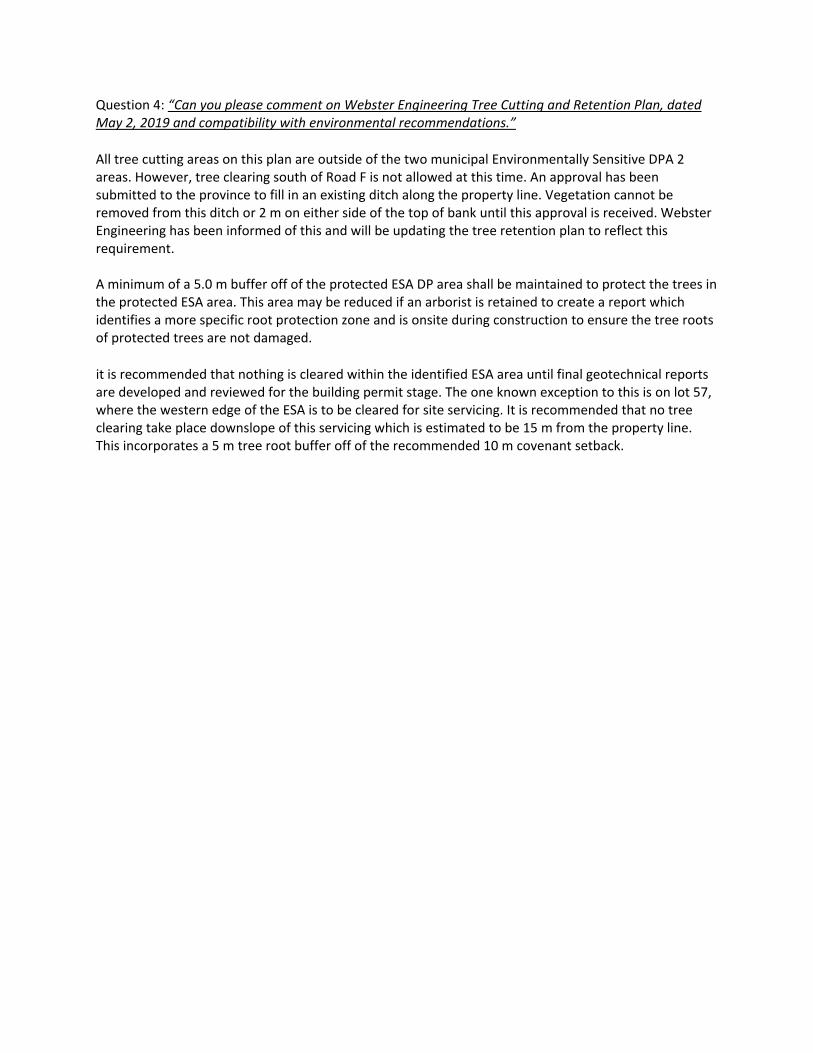
Question 4: “Can you please comment on Webster Engineering Tree Cutting and Retention Plan, dated May 2, 2019 and compatibility with environmental recommendations.”
All tree cutting areas on this plan are outside of the two municipal Environmentally Sensitive DPA 2 areas. However, tree clearing south of Road F is not allowed at this time. An approval has been submitted to the province to fill in an existing ditch along the property line. Vegetation cannot be removed from this ditch or 2 m on either side of the top of bank until this approval is received. Webster Engineering has been informed of this and will be updating the tree retention plan to reflect this requirement. A minimum of a 5.0 m buffer off of the protected ESA DP area shall be maintained to protect the trees in the protected ESA area. This area may be reduced if an arborist is retained to create a report which identifies a more specific root protection zone and is onsite during construction to ensure the tree roots of protected trees are not damaged.
it is recommended that nothing is cleared within the identified ESA area until final geotechnical reports are developed and reviewed for the building permit stage. The one known exception to this is on lot 57, where the western edge of the ESA is to be cleared for site servicing. It is recommended that no tree clearing take place downslope of this servicing which is estimated to be 15 m from the property line. This incorporates a 5 m tree root buffer off of the recommended 10 m covenant setback.

Page 12
SCHEDULE E
Letter titled “Gospel Rock Memo ‐ Review of Geotechnical Addendum Letter 02 to ensure compatibility with the Town of Gibsons Environmentally Sensitive Area (ESA) Development Permit Area (DPA) #2” prepared by Diamond Head and dated February 12, 2020
END OF DOCUMENT

February 12th, 2020
Odete Pinto Agora Planning Inc. Re: Gospel Rock Memo ‐ Review of Geotechnical Addendum Letter 02 to ensure compatibility with the Town of Gibsons Environmentally Sensitive Area (ESA) Development Permit Area (DPA) #2 As part of the development permit process, the Town of Gibsons requested a QEP from Diamond Head Consulting to review geotechnical recommendations to ensure compatibility with the ESA protection requirements of ESA DPA #2. Reports reviewed for this memo include:
1. Kontur Geotechnical Consultants Inc. Matthew Yip and Evan Sykes. Geotechnical Addendum Letter 02. Building Setbacks for Proposed Residential Development – Gospel Rock Village, Block 7 DL 842 Group 1 NWD Plan 6755, Gibsons, BC. February 5th, 2020.
The geotechnical measures outlined in this memo are focused on the lots identified and reviewed during a site visit on November 29th, 2019 with the Town of Gibsons, Diamond Head Consulting, Kontur Geotechnical Consultants, Webster Engineering, and the landowner and project manager. The following table summarizes the expected compatibility of environmental recommendations with geotechnical recommendations. Previous recommendations from the Environmentally Sensitive Development Permit Area No. 2 Gospel Rock Subdivision Block 7 report last dated October 28th, 2019, and previous memos to the Town of Gibsons should be reviewed and implemented to be compliant with the ESA DPA #2. Lot # Site‐Specific Recommendations
Lots 1‐6 A 14 m setback eastward from the western property line will be placed under a restrictive covenant for each of these 6 properties. However, an exception is required for the installation and maintenance of geotechnical measures, to ensure the safety of these 6‐lots. For details on these potential measures, see the geotechnical memos and report. These measures must be contained within the property, and with minimal impact to the on‐site ESA. No trees may be removed in these protected areas.
Lots 10, 56‐58 The 15 m horizontal setback from the top of steep slope/bluff recommended by the geotechnical engineer is compliant with the ESA DPA#2. With additional geotechnical measures, this can be reduced to 3‐5 m from the top of the steep bedrock slope/bluff. A setback of 3‐5 m would still comply with the ESA DPA #2. A 10 m setback west from the eastern property line has been agreed to be placed under a restrictive covenant for lots 56 and 57, therefore, no geotechnical measures can be placed within this area. On‐site discussions confirmed the viability of this approach.

Lot # Site‐Specific Recommendations
Lots 16, 24, and 25 The area of these lots identified in the memo that require additional geotechnical measures do not contain known ESAs; therefore, these measures are not expected to conflict with the ESA DPA #2.
Please don’t hesitate to call if you have any questions regarding the material discussed in this memo.
Sincerely,
Project Staff:
Cassandra Cummings, R.P.Bio Biologist, Planner MSc. Biology, MSc. Planning
Contact Information:
Phone: 604‐733‐4886 Email: [email protected] Website: www.diamondheadconsulting.com Insurance Information:
WCB: # 657906 AQ (003) General Liability: Northbridge General Insurance Corporation ‐ Policy #CBC1935506, $10,000,000 Errors and Omissions: Lloyds Underwriters – Policy #1010615D, $1,000,000