LTBA (Ataturk) JeppView 3.7.5 - pht-formation.frpht-formation.fr/ops/SID STAR/LTBA -...
95
JEPPESEN JeppView 3.7.5.0 LTBA (Ataturk) Airport Information General Info Istanbul, TUR N 40° 58.6' E 28° 48.8' Mag Var: 3.6°E Elevation: 163' Public, IFR, Control Tower, Rotating Beacon, Customs, Landing Fee Fuel: 100-130, Jet A-1 Repairs: Minor Airframe, Minor Engine Time Zone Info: GMT+2:00 uses DST Runway Info Runway 05-23 8465' x 197' asphalt Runway 17L-35R 9843' x 148' concrete Runway 17R-35L 9843' x 148' concrete Runway 05 (55.0°M) TDZE 93' Lights: Edge, ALS, Centerline, REIL, TDZ Right Traffic Displaced Threshold Distance 427' Runway 17L (174.0°M) TDZE 157' Lights: Edge, ALS, Centerline, REIL, TDZ Right Traffic Runway 17R (174.0°M) TDZE 163' Lights: Edge, ALS, Centerline, REIL, TDZ Runway 23 (235.0°M) TDZE 90' Lights: Edge, ALS, Centerline, REIL, TDZ Runway 35L (354.0°M) TDZE 118' Lights: Edge, ALS, Centerline, REIL, TDZ Runway 35R (354.0°M) TDZE 124' Lights: Edge, ALS, Centerline, REIL, TDZ
Transcript of LTBA (Ataturk) JeppView 3.7.5 - pht-formation.frpht-formation.fr/ops/SID STAR/LTBA -...

J E P P E S E NJeppView 3.7.5.0LTBA (Ataturk)
Airport Information
General InfoIstanbul, TURN 40° 58.6' E 28° 48.8' Mag Var: 3.6°EElevation: 163'
Public, IFR, Control Tower, Rotating Beacon, Customs, Landing FeeFuel: 100-130, Jet A-1Repairs: Minor Airframe, Minor Engine
Time Zone Info: GMT+2:00 uses DST
Runway InfoRunway 05-23 8465' x 197' asphaltRunway 17L-35R 9843' x 148' concreteRunway 17R-35L 9843' x 148' concrete
Runway 05 (55.0°M) TDZE 93' Lights: Edge, ALS, Centerline, REIL, TDZ Right Traffic Displaced Threshold Distance 427'Runway 17L (174.0°M) TDZE 157' Lights: Edge, ALS, Centerline, REIL, TDZ Right TrafficRunway 17R (174.0°M) TDZE 163' Lights: Edge, ALS, Centerline, REIL, TDZRunway 23 (235.0°M) TDZE 90' Lights: Edge, ALS, Centerline, REIL, TDZRunway 35L (354.0°M) TDZE 118' Lights: Edge, ALS, Centerline, REIL, TDZRunway 35R (354.0°M) TDZE 124' Lights: Edge, ALS, Centerline, REIL, TDZ

J E P P E S E NJeppView 3.7.5.0LTBA (Ataturk)
Airport Information
Communications InfoATIS 128.2Yesilkoy Ground South Tower 121.8Yesilkoy Ground North/Sou Tower 126.8Yesilkoy Ground North Tower 122.325Yesilkoy Delivery Tower 121.7Yesilkoy Tower 123.525Yesilkoy Tower 118.375 Departure ServiceYesilkoy Tower 118.1 Arrival ServiceYesilkoy Tower 257.80Yesilkoy Approach Control 127.825Yesilkoy Approach Control 127.1Yesilkoy Approach Control 126.425Yesilkoy Approach Control 122.675Yesilkoy Approach Control 121.25Yesilkoy Approach Control 121.1Yesilkoy Approach Control 120.7Yesilkoy Approach Control 120.5Yesilkoy Approach Control 119.475Yesilkoy Approach Control 362.30
Notebook Info

Licensed to SMA. Printed on 03 Oct 2013.
Notice: After 4 Oct 2013 0901Z, this chart may no longer be valid. Disc 19-2013JEPPESENJeppView 3.7.5.0
ISTANBUL, TURKEYLTBA/ISTATATURK .AIRPORT.BRIEFING.
+ JEPPESEN
1.1. ATISATIS 128.2
1.2. SURFACE MOVEMENT GUIDANCE AND CONTROL SYSTEM1.2.1. A-SMGCS UTILISING MODE S
ACFT operators should ensure that Mode S transponders are able to operate whenACFT is on the ground.Flight crew should select XPNDR or equivalent according to specific installation,AUTO if available, not OFF or STDBY, and the assigned Mode A code.Just after receiving the ATC clearance, after landing, continuously until ACFT isfully parked on stand, the Mode A code 2000 must be set before selecting OFF orSTDBY.Flight crew of ACFT equipped with Mode S having an ACFT identification featureshould also set the ACFT ident.This setting is the ACFT ident specified in item 7 of the flight plan.ACFT ident should be entered just after the ATC clearance through FMS or trans-ponder control panel.Traffic whose transponder is not on and active shall not be instructed for push-back.
1.3. LOW VISIBILITY PROCEDURES (LVP)During CAT II and III operations, special ATC Low Visibility Procedures will beapplied. Pilots will be informed when these procedures are in operation via ATISand RTF.
1.4. TAXI PROCEDURES1.4.1. GENERAL
Caution:Due to dense ground movement flight crew shall strictly obey ATCinstructions and follow signs/markings on aprons and TWYs. Never crossRWYs unless clear permission is granted or instruction is given by ATC.Comply with the readback and hearback procedures.
ACFT ready for departure must start taxiing as soon as taxi-clearance isreceived.The traffic having clearance to "line up to proceed to RWY 35R" are required toproceed to the line up position 2 point where available psn-2 sign 200m insidefrom THR RWY 35R unless otherwise authorized by ATC.Heavy traffic departing from RWY 35R can cause jet wash impact for traffic toland RWY 05.ACFT taxiing from West to East on TWY G shall stop on hotspot located at back-ward side of T4 parking area, and resume taxiing by ATC instruction.Entering/Departing parking areas on Apron V and entering of stand 104 under lowthrust level only.Unless otherwise specified by TWR, taxiing speed is 20 kt in TWYs and 10 kt inTWYs D, D1, G and V apron.Whenever RWY 17R Take-off / RWY 17L Landing or RWY 35R Landing / RWY 35LTake-off configurations are utilized, due to the insufficient distance between thesubject RWYs 17/35, no aircraft can wait along TWYs A1, A2, A3, A5 and A6.
Due to the situation of aircraft parking positions, ACFT must use push-back toleave the parking areas.Unless otherwise specified by ATC, the following standard taxi-routes shall beused.
10-1P17 MAY 13 .Eff.30.May.
1. GENERAL
| JEPPESEN, 2011, 2013. ALL RIGHTS RESERVED.

Licensed to SMA. Printed on 03 Oct 2013.
Notice: After 4 Oct 2013 0901Z, this chart may no longer be valid. Disc 19-2013JEPPESENJeppView 3.7.5.0
ISTANBUL, TURKEYLTBA/ISTATATURK .AIRPORT.BRIEFING.
+ JEPPESEN
1.4.2. STANDARD TAXI ROUTES FOR ARRIVAL1.4.2.1. RWY 05
1G: Vacate RWY from E5, E6, E7 and E8 and use TWY G.1F: Vacate RWY from E5, E6, E7 and E8 and use TWYs F and D and hold before B9
for ATC instructions.
1.4.2.2. RWY 17L3D: Vacate RWY from B8, B9, A5 and B11 and use TWYs C, F and D and hold
before B9 for ATC instructions.3F: Vacate RWY from B8, B9, A5 and B11 and use TWYs C, F, E5 and G.
1.4.2.3. RWY 232D: Vacate RWY from E1, E2, E3 and E4 and use TWYs F and D and hold before B9
for ATC instructions.2F: Vacate RWY from E1, E2, E3 and E4 and use TWYs F, E5 and G.
1.4.3. STANDARD TAXI ROUTES FOR DEPARTURE1.4.3.1. RWY 17R
2A: Use TWYs D, B9, C and B1 and hold on RWY 17L holding position.3A: Use TWYs D, B8, C and B1 and hold on RWY 17L holding position.
1.4.3.2. RWY 35L/R1A: Use TWYs B8, C and B12 and hold on RWY 35R holding position.1B: Use TWYs B9, C and B12 and hold on RWY 35R holding position.1C: Use TWYs D, B5, C and B12 and hold on RWY 35 holding position.1D: Use TWYs D, B5, C and B11 and hold on RWY 35 holding position.1G: Use TWYs G, B9, C and B11 and hold on RWY 35 holding position.
1.5. PARKING INFORMATIONAprons L, M, N, R & T not visible from Tower.Stands 101 thru 105 on Terminal B Apron not visible from Tower.Automatic guidance system available on stands 101 thru 112 and 201 thru 226.All ACFT should obtain tow-bar, except general aviation ACFT.ACFT pushed-back from T4, T5 and T6 parking area on Apron T shall be towedWest beyond hotspot line located at backward side of T4 parking area on TWY G.Pilots shall ask ATC for instruction to start engines and taxi on standby position.
1.6. OTHER INFORMATION1.6.1. GENERAL
RWYs 05 and 17L right-hand circuit.
Birds.
1.6.2. ENGINE TESTINGBefore an engine test contact YESILKOY Ground on 121.8 or 122.32.Engine testing shall be performed on Motor Test Apron.In case the testing could not be performed on Motor Test Apron for any reason,engine testing in coordination with the relevant ATC unit, will be carried outwithin RWY 17R/35L, taking into consideration the current airport movement areatraffic.
10-1P117 MAY 13 .Eff.30.May.
1. GENERAL
| JEPPESEN, 2011, 2013. ALL RIGHTS RESERVED.

Licensed to SMA. Printed on 03 Oct 2013.
Notice: After 4 Oct 2013 0901Z, this chart may no longer be valid. Disc 19-2013JEPPESENJeppView 3.7.5.0
ISTANBUL, TURKEYLTBA/ISTATATURK .AIRPORT.BRIEFING.
+ JEPPESEN
2.1. COMMUNICATION FAILURE PROCEDURE2.1.1. RF FOR IFR FLIGHTS OUTSIDE TMA
Select transponder code 7600. Follow the flight plan route using last assigned andacknowledged FL. For 3 minutes execute relevant STAR. Then, descending 6000’proceed to IST VOR. Leave IST VOR at 6000’. Proceed to relevant IAF, executeInstrument Approach Procedure (IAP) and land.
2.1.2. RF FOR IFR FLIGHTS INSIDE TMAIf available call telephone number 0090 212 465 0121.
ACFT at or above 6000’Select transponder code 7600. For 3 minutes execute last assigned and acknowl-edged ATC instructions. Then, descending 6000’ proceed to IST VOR. Leave ISTVOR at 6000’. Proceed to relevant IAF, execute Instrument Approach Procedureand land.Note: Traffic via 112.2 KFK is not allowed to descend below 10000’ before pass-
ing DEKEK Int or beyond IST 40 DME.
ACFT below 6000’, at or above 3000’Select transponder code 7600. Proceed to relevant IAF, descend or maintain lastassigned and acknowledged altitude. Execute Instrument Approach Procedure andland. The Instrument Approach Procedures for RWYs 17 and 23 are to be executedvia IAFs VURAL and KOFUN.Note: ACFT on downwind legs shall execute this procedure regardless of alti-
tude or FL.
ACFT below 3000’Select transponder code 7600. Proceed to relevant Final Approach Fix and land.
2.2. GNSS BASED RNAV STARSThe altitudes/FLs depicted on the arrival procedures are for operational purposes.They do not represent permission to descend to those altitudes/FLs unless other-wise authorized by ATC.When an arriving ACFT on a STAR is cleared to descend to an altitude/FL lowerthan the altitudes/FLs specified in a STAR, the ACFT shall follow the publishedvertical profile of a STAR, unless such restrictions are explicitly cancelled byATC.The cancellation of the level restrictions depicted on the STARs will be subject tothe ATC clearance by the phrase: "OPEN DESCEND TO ... (ALT./FL.)".
2.3. CAT II/III OPERATIONSRWY 05 approved for CAT II/III operations and RWY 35R approved for CAT IIoperations, special aircrew and ACFT certification required.
10-1P217 MAY 13 .Eff.30.May.
2. ARRIVAL
| JEPPESEN, 2011, 2013. ALL RIGHTS RESERVED.

Licensed to SMA. Printed on 03 Oct 2013.
Notice: After 4 Oct 2013 0901Z, this chart may no longer be valid. Disc 19-2013JEPPESENJeppView 3.7.5.0
ISTANBUL, TURKEYLTBA/ISTATATURK .AIRPORT.BRIEFING.
+ JEPPESEN
2.4. LANDINGSDue to conditions of the relevant RWY, Pilots should adjust their landings in away to make them use of the high speed taxi-route turn-offs as stated in thetable below so as not to occupy the RWY more than required.
To provide the least optimum duration of RWY occupation in landing operations,pilots, during the Approach phase, are strongly advised to make computations ina way to make them use of the preferred high speed taxi-route turn-offs.When precision approach procedures are applied for landing operations, becauseof the speed restrictions, non-precision approach procedures regarding trainingpurposes cannot be applied.When RWY 35L is preferred for landing, the landing aircraft shall not crossRWY35R without taking ATC instruction/permission.All traffic landing to RWY 05/23 or 17L immediately after vacating the RWY(crossing RWY holding points) shall contact with YESILKOY Ground South withoutwaiting any instruction from TWR.All traffic landing to RWY 35R immediately after vacating the RWY (crossingRWY holding points) shall contact with YESILKOY Ground North without waitingany instruction from TWR. After landing to RWY 17R/35L traffic shall beinstructed by ATC for frequency change.The requests regarding usage of the opposite RWYs shall not be accepted. Eventhe Optional RWY operations are concerned, those traffic persistently willing touse opposite RWYs for landing should take into consideration the very likelihoodof being exposed to long duration of delay on holding position due to the intensityof air traffic operations within the vicinity.Delays on holding position if happen to exceed 20 minutes, EXPECTED APPROACHTIME shall be informed accordingly.In case of low fuel level condition, the situation shall be promptly declared to theATC through using only the following statements whichever suit best to thedescribed condition: "Minimum Diversion Fuel", "Low on Fuel", "MinimumFuel".
2.5. OTHER INFORMATIONCaution:On apch to RWY 17L/35R expect momentary distortions or interruptions
of GS signal.GS fluctuations depending on taxiing of departing ACFT possible. ATC will clearlanding ACFT for ILS apch without GS.Phraseology will be "Cleared for ILS approach, glide path unreliable".
RWY ACFT Turn off intersection Dist from THR ft(m)05 heavy E7 6726’(2050m)
medium E6 5840’(1780m)light E5 4593’(1400m)
17L heavy/medium/light B9 6562’(2000m)17R heavy/medium/light A5 7054’(2150m)23 heavy E3 6398’(1950m)
medium/light E4 5249’(1600m)35L heavy A2 7054’(2150m)
medium/light A3 5577’(1700m)35R heavy/medium B4 6562’(2000m)
light B5 5364’(1635m)
10-1P317 MAY 13 .Eff.30.May.
2. ARRIVAL
| JEPPESEN, 2011, 2013. ALL RIGHTS RESERVED.

Licensed to SMA. Printed on 03 Oct 2013.
Notice: After 4 Oct 2013 0901Z, this chart may no longer be valid. Disc 19-2013JEPPESENJeppView 3.7.5.0
ISTANBUL, TURKEYLTBA/ISTATATURK .AIRPORT.BRIEFING.
+ JEPPESEN
3.1. CLEARANCE DELIVERYPilots shall contact with Clearance Delivery as follows:Call Sign / Stand Position / Code confirming ATIS message received.
3.2. DE-ICING3.2.1 GENERAL
De-icing can be handled at the park area; however, in case anti-icing has beenstarted at the designated areas, de-icing in the parking area shall not bepermitted.
3.2.2 ANTI-ICING AREAFor all Airline Companies:In case the CAT-III conditions duly sustained render the usage of RWY 05/23obligatory, F1 and F2 anti-icing application area shall be used by both TurkishAirlines and ACFT of all other airline companies. As a line-up area for anti-icingapplication TWY D (between TWYs B9 and F) shall be used firstly. In case thisarea has become insufficient TWY C (between TWYs B9 and B8) shall be used.
For all Airline Companies other than Turkish Airlines:When the use of RWY 17L or RWY 17R is concerned, for all airlines other thanTurkish Airlines, turning path from TWY D to TWY B4 is anti-icing applicationarea whereas TWY D (between TWY B4 and B5) shall be utilized as line-uplocation.When the use of RWY 35R or 35L is concerned, all along TWY F shall be used asline-up area whereas the intersection of TWY F, E3 and E4 TWYs are to be utilizedas anti-icing application areas.
3.3. START-UP & PUSH BACK PROCEDUREDeparting traffic willing to use RWY 35R (normally designated for landing opera-tions) instead of RWY 35L (normally designated for take-off operations) have tonotify their request via Clearance Delivery frequency to ATC 35 minutes inadvance of the estimated engine start-up time at the latest. The requests regard-ing usage of the opposite RWYs shall not be accepted. Nevertheless, whileconducting optional RWY operations, those traffic persistently requesting to useopposite RWYs for take-off operations should be aware of the fact that theywould most likely be exposed to long duration of delay due to the intensity ofboth ground and air traffic.Request to start engines shall be made approximately 15 min prior to plannedtime of departure.When requesting start-up clearance the planned time of departure shall bestarted.Start-up clearance or later taxi clearance can be based on the planned time ofdeparture, therefore, the planned time of departure shall be made good.Acft departing from stands 101, 102 and R4 by pushback shall take clearance ofATC to proceed to the line of stand 103 (via TWY D1) where they are allowed tostart their engines.ACFT leaving stands 101,102, 103, 104, 105, 106, R1, R2, R3 and R4 shall do push-back first, and subsequently start-up their engines when reached at start-up posi-tion PSN-1, PSN-2 or PSN-3.The requests of any traffic to make Cross Bleed Start-up shall not be accepted inas much as such an operation can affect Apron traffic safety adversely and causeextra noise pollution. Only those ACFT having APU failure are allowed to makeCross Bleed Start-Up provided that required measures were taken in advance.ACFT at parking positions of ACFT maintenance apron 1 shall continue their push-back until TWY D and then start-up their engines. ACFT shall enter the ACFTmaintenance apron 1 by towing from the parking position.
10-1P417 MAY 13 .Eff.30.May.
3. DEPARTURE
| JEPPESEN, 2011, 2013. ALL RIGHTS RESERVED.

Licensed to SMA. Printed on 03 Oct 2013.
Notice: After 4 Oct 2013 0901Z, this chart may no longer be valid. Disc 19-2013JEPPESENJeppView 3.7.5.0
ISTANBUL, TURKEYLTBA/ISTATATURK .AIRPORT.BRIEFING.
+ JEPPESEN
TWYs K and K1 are classified for ACFT with wing span up to 118’ (36m). The ACFTcan start-up their engines and do taxiing on these TWYs.ACFT with wing span up to 171’ (52m) and 213’ (65m) shall pass TWYs K and K1 bypush-back without starting-up their engines.Traffic granted with push-back and engine start-up permissions must start push-back within 1 minute at the latest, otherwise estimated start-up time shall beinstructed by ATC.Pilots must have accomplished all required cockpit checks for take-off beforeentering the RWY, and hence restrained their final checks only to minimum fortake-off when entered the RWY. Pilots are deemed to react to the take-off clear-ances within 10 seconds at the latest. Otherwise ATC, in order to prevent theredundant RWY occupation, has the authority to withdraw the aircraft from thetake-off course and re-direct it to the end of departure sequence.
3.4. NOISE ABATEMENT PROCEDURESFor departures, any ACFT having compliance with the noise category ICAOAnnex16 Chapter 3 and 4 shall apply NADP-2 whereas all other ACFT whose noisecategory are in compliance with ICAO Annex 16 Chapter 2 shall only apply NADP-1.Pilots shall apply Noise Abatement Departure Procedure 1 or 2 (NADP-1 or NADP-2) which has been explained in ICAO Doc 8168 Vol 1 until passing 3000’.Engine test operations must be conducted between 0700 - 2100 LT.In parking area, APU must be switched-off within 5 minutes after parking. APU isallowed to be switched on 15 minutes before the estimated start-up.
3.5. GNSS BASED RNAV SIDSWhen a departing ACFT on a SID is cleared to climb to an altitude/FL higher thanthe initially cleared altitude/FL or the altitudes/FLs specified in a SID, the ACFTshall follow the published vertical profile of a SID, unless such restrictions areexplicitly cancelled by ATC.The cancellation of the level restrictions depicted on the SIDs will be subject tothe ATC clearance by the phrase: "OPEN CLIMB TO ... (ALT./FL.)".
3.6. OTHER INFORMATION3.6.1. CALCULATED TAKE-OFF TIME (CTOT)
Pilots, while requesting for engine start-up clearance, should be ready for depar-ture at the CTOT, taking into consideration the estimated TWY crossoverdurations which are approximately 26 minutes for RWY 17L/R, 20 minutes forRWY 35L/R and RWY 05/23.Pilots not able to comply with the instructed CTOT, shall get in contact with theircompany representatives or authorized agencies to apply for and have a newCTOT.As a precautionary measure for RWY usage capacity augmentation, TWR canchange the departure sequence at any time so as to ensure all aircraft ready fortake-off do not miss their CTOT.
10-1P517 MAY 13 .Eff.30.May.
3. DEPARTURE
| JEPPESEN, 2011, 2012. ALL RIGHTS RESERVED.

Licensed to SMA. Printed on 03 Oct 2013.
Notice: After 4 Oct 2013 0901Z, this chart may no longer be valid. Disc 19-2013JEPPESENJeppView 3.7.5.0
40NM
40NM
Istanbul(Ataturk)
Tekirdag
Bursa
Istanbul(SabihaGokcen)
LT(P)-7
010
2030
4050
10
Apt Elev163'
LTBA/IST.RADAR.MINIMUM.ALTITUDES.10-1RATATURK
ISTANBUL, TURKEY
YESILKOYRADAR
60NM
60NM
20NM
60NM
40NM
20NM
30NM
50NM
39-30
40-00
40-30
41-00
41-30
42-00
28-00 28-30 29-00 29-30 30-00
North
120.5
8343'
20NM
103^
YESILKOY Approach/Radar
| JEPPESEN, 2006, 2013. ALL RIGHTS RESERVED.
Alt Set:hPaTrans level: By ATCTrans alt: 10000'
SouthEast West
JEPPESEN
25 JAN 13 .Eff.7.Feb.
119.47 127.1120.7 126.42
Approach/Radar frequencies.
121.1 127.82
BULGARIATURKEY
LT(P)-5
CONTOURINTERVALS
2000
4000
6000
8000
10000
074^
204^
120̂
250^
186^
145̂
3000
3000
23002000
2500
4500
5500
6000
10000
4000
CHANGES:
ISTANBUL
LTBB F
IR
2700
3500
SOFIA LBS
R FIR (C/G)
2300

Licen
sed to
SM
A. P
rinted
on
03 Oct 2013.
No
tice: After 4 O
ct 2013 0901Z, th
is chart m
ay no
lon
ger b
e valid. D
isc 19-2013J
EP
PE
SE
NJep
pV
iew 3.7.5.0
N41 07.9E029 45.2 PA
ZAR
1A
DEKEK1A
MHA7000
LTBA/ISTA
TATU
RKISTANBUL, TURKEY
128.2
163'
RNAV (GNSS)
BA582N40 52.9 E028 52.9BA583BA584
N40 47.6 E028 41.5
BA585N40 46.0 E028 38.1
BA586N40 44.4 E028 34.7
BA587N40 42.9 E028 31.4
BA588N40 41.3 E028 28.0
BA58~N40 37.1 E029 05.6
BA581
EKDAM
PIMAV
YALOVA117.7 YAAYAA
N40 28.5 E029 12.5
D
DEKEK
PAZAR
GAYEMN41 02.8 E029 37.8
BA~44
VATOMN40 59.1 E029 06.4
ERKAL
BA~46
MAX
MAX
33
33
5
5
14.29.8
8.6
7.6
16.3
18.915.6
10
DISTANBUL112.5 ISTIST
N40 57.7 E028 48.6
PIMAV 1A
ERKAL 1A
273^
324̂R144^
278^
224^
257^
234̂
235̂
R093^
324^
MAX 220 KT
JEPPESEN
MAX 250 KT
Apt Elev
ATIS
Alt Set: hPa Trans level: By A
TC Trans alt: 10000'1. RA
DAR required. 2. P-RNA
V approval required otherwise advise A
TC.3. O
n downw
ind expect vectors to final. 4. At first contact w
ith IST RADA
Rreport if unable to com
ply RNAV STA
R. At first contact w
ith YESILKOY
RADA
R report only callsign. 5. Descend as cleared.
.RNAV.STAR.
15.0
12.0
10.0
10.0
BA582 (K220-) - BA583 - BA584 (OPERATIONAL 4000') - BA585 -BA586 - BA587 - BA588.
PAZAR - BA046 - GAYEM (K250-) - BA044 - VATOM(OPERATIONL FL130) - BA582 (K220-).
ERKAL - GAYEM (K250-) - BA044 - VATOM (OPERA-TIONAL FL130) - BA582 (K220-).
DEKEK - YAA (K250-) - BA580 (OPERATIONAL FL120) -BA581 - BA582 (K220-).
PIMAV - EKDAM - YAA (K250-) - BA580 (OPERATIONALFL120) - BA581 - BA582 (K220-).
N40 26.1E029 37.0
N40 59.2E029 58.8
N41 00.7E029 19.2
FL130OPERATIONALAt
N40 45.6E028 58.8
N40 50.3E028 47.3
N40 20.1E029 19.4
N40 24.0E029 57.2
| JEP
PESEN
, 2013. A
LL RIG
HTS R
ESERV
ED.
(H)
(H)
10-216 A
UG
13.Eff.22.Aug.
MAX 250 KT
N41 17.9 E030 00.0
4000'OPERATIONALAt
FL120OPERATIONALAt
Holding over G
AYEM
revised; Holding over ERK
AL &
DEK
EK established.
MSAIST VOR
3500'
5000'
3000'
180^
360^
270^
DEKEK 1A[D
EKE1A],
ERKAL 1A[ERK
A1A
]PAZAR 1A
[PAZA
1A],
PIMAV 1A
[PIMA
1A]
RWY 05 RNAV ARRIVALS
CHA
NG
ES:
STAR ROUTING
NOT TO SCALE
SPEED RESTRICTION
ROUTING (CONTD)
DEKEK1A
ERKAL1A
PAZAR1A
PIMAV1A
- 200 KT on base leg/closing heading to final approach up to 12 NM to touchdown.- 180 KT on final approach course within 12 NM to 6 NM to touchdown.- 160 KT within 6 NM to 4 NM to touchdown.These speeds are for ATC purposes and aremandatory and have to be flown as accuratelyas possible. If unable to comply inform ATCand state what speed to be used.
Direct distance from BA588to Ataturk Apt: 23 NM
077^
257^MHA 9000
144^
324̂
FL150
FL150
098^
278^

Licensed to SMA. Printed on 03 Oct 2013.
Notice: After 4 Oct 2013 0901Z, this chart may no longer be valid. Disc 19-2013JEPPESENJeppView 3.7.5.0
LTBA/ISTATATURK
ISTANBUL, TURKEY10-2A
RNAV (GNSS)
JEPPESEN
N41 07.9E029 45.2
DEKEK1B
MHA7000
D
EKDAM
PIMAV
YALOVA117.7 YAAYAA
N40 28.5 E029 12.5
D
DEKEK
PAZAR
GAYEMN41 02.8 E029 37.8
ERKAL
BA~46
7.6
16.3
18.9 15.6
10
PIMAV 1B
ERKAL 1B
273^324^R144̂
278^
224^
R093^
ISTANBUL112.5 ISTIST
N40 57.7 E028 48.6
MAX 250 KT
265^264^
330^
354^3
33
33
6.8
13.4
8.8
12.8
14.8
BA858BA~21
BA~2~
BA876N41 08.9 E028 56.1
BA877N41 11.9 E028 56.0
BA878N41 14.9 E028 55.9
BA879N41 17.9 E028 55.8
BA880N41 20.9 E028 55.7
BA881N41 23.9 E028 55.6
N41 02.6E029 20.1N41 02.3
E029 06.9
BA859N41 02.2 E028 56.4
BA875N40 41.8 E029 04.0
128.2
163'Apt Elev
ATIS Alt Set: hPa Trans level: By ATC Trans alt: 10000'1. RADAR required. 2. P-RNAV approval required otherwise advise ATC.3. On downwind expect vectors to final. 4. At first contact with IST RADARreport if unable to comply RNAV STAR. At first contact with YESILKOYRADAR report only callsign. 5. Descend as cleared.
.RNAV.STAR.
8.0 10.0
15.0
BA859 (K220-) - BA876 (OPERATIONAL 4000') - BA877 - BA878 - BA879 - BA880 - BA881.
DEKEK - YAA (K250-) - BA875 (OPERATIONAL FL140) - BA020 - BA859 (K220-).
N41 17.9E030 00.0
N40 59.2E029 58.8
FL150OPERATIONALAt
N40 53.3E028 56.7
FL140OPERATIONALAt
N40 26.1E029 37.0
N40 24.0E029 57.2
N40 20.1E029 19.4
ERKAL - GAYEM (OPERATIONAL FL150; K250-) - BA858 - BA021 -BA859 (K220-).PAZAR - BA046 - GAYEM (OPERATIONAL FL150; K250-) - BA858 - BA021 -BA859 (K220-).PIMAV - EKDAM - YAA (K250-) - BA875 (OPERATIONAL FL140) - BA020 -BA859 (K220-).
(H)
(H)
| JEPPESEN, 2013. ALL RIGHTS RESERVED.
16 AUG 13 .Eff.22.Aug.
MAX 250 KT4000'OPERATIONALAt
Holding over GAYEM revised; Holding over DEKEK & ERKAL established.
220 KTMAX
PAZA
R 1B
MSAIST VOR
3500'
5000'
3000'
180^
360^
270^
SPEED RESTRICTION- 200 KT on base leg/closing heading to final approach up to 12 NM to touchdown.- 180 KT on final approach course within 12 NM to 6 NM to touchdown.- 160 KT within 6 NM to 4 NM to touchdown.These speeds are for ATC purposes and aremandatory and have to be flown as accuratelyas possible. If unable to comply inform ATCand state what speed to be used.
CHANGES:
STAR ROUTINGDEKEK 1BERKAL 1B
PAZAR 1B
PIMAV 1B
NOT TO SCALE
ROUTING (CONTD)
RNAV ARRIVALSRWYS 17L/R
DEKEK 1B [DEKE1B][ERKA1B]ERKAL 1B
PAZAR 1B [PAZA1B][PIMA1B]PIMAV 1B
Direct distance from BA881to Ataturk Apt: 26 NM
144̂
324^
FL150
077^
257^MHA 9000
FL150
098^
278^
Licensed to SMA. Printed on 03 Oct 2013.
Notice: After 4 Oct 2013 0901Z, this chart may no longer be valid. Disc 19-2013JEPPESENJeppView 3.7.5.0
N41 07.9E029 45.2
DEKEK1C
MHA7000
LTBA/ISTATATURK
ISTANBUL, TURKEY10-2B
RNAV (GNSS)
EKDAM
PIMAV
YALOVA117.7 YAAYAA
N40 28.5 E029 12.5
D
DEKEK
GAYEMN41 02.8 E029 37.8
BA~46
7.6
18.9 15.6
10
PIMAV 1C273^324^
R144^
R093^
DISTANBUL112.5 ISTIST
N40 57.7 E028 48.6
241^
332^
324^
BA852
BA853N40 54.5 E028 56.4
BA854
BA855N41 00.2 E029 08.8
BA856N41 01.8 E029 12.2
BA857
BA86~N41 04.9 E029 18.9
BA861N41 06.4 E029 22.3
BA862
JEPPESEN
MAX 250 KT
N41 03.3E029 15.6
N41 08.0E029 25.7
33
33
33
054^31.3
22.8
6.0
MAX 250 KT
8.0
128.2
163'Apt Elev
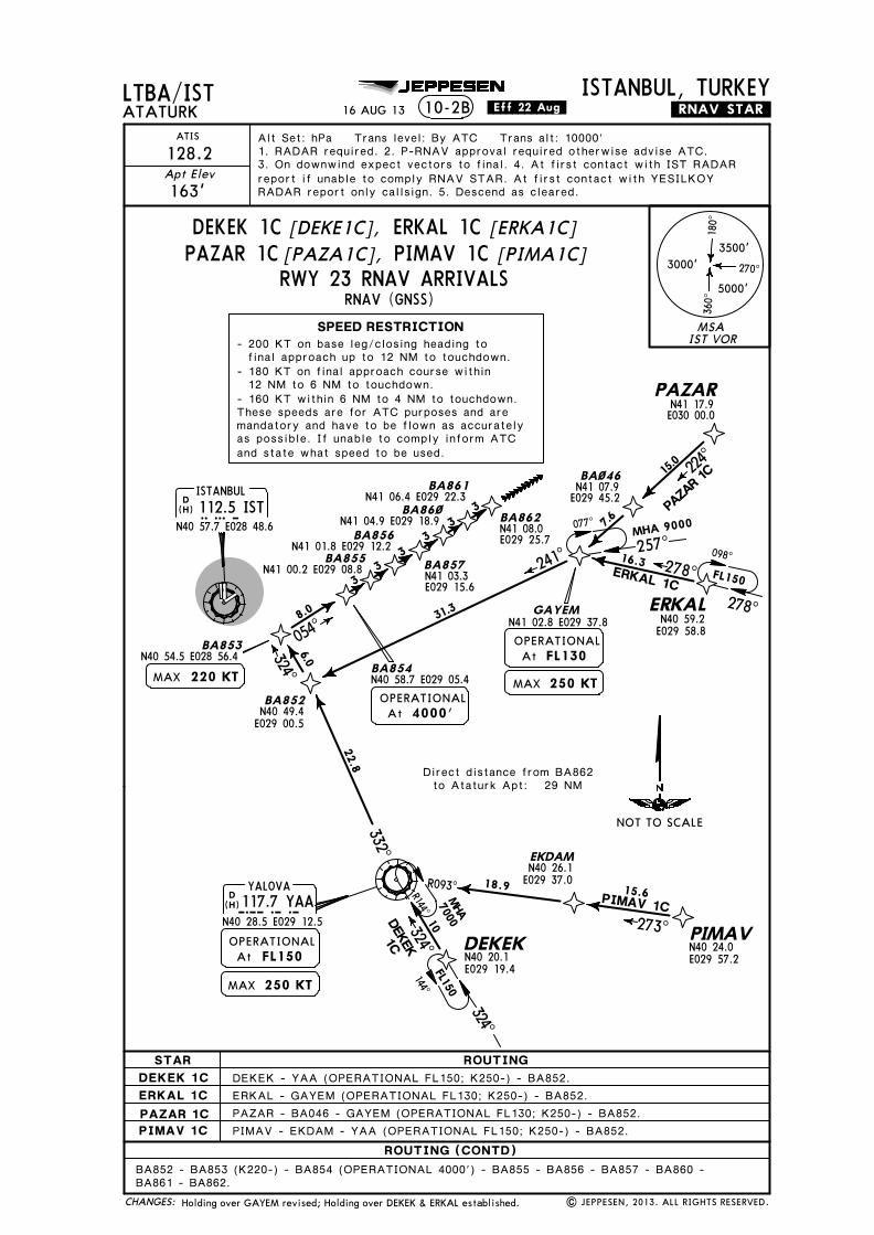
ATIS Alt Set: hPa Trans level: By ATC Trans alt: 10000'1. RADAR required. 2. P-RNAV approval required otherwise advise ATC.3. On downwind expect vectors to final. 4. At first contact with IST RADARreport if unable to comply RNAV STAR. At first contact with YESILKOYRADAR report only callsign. 5. Descend as cleared.
.RNAV.STAR.
DEKEK - YAA (OPERATIONAL FL150; K250-) - BA852.
PIMAV - EKDAM - YAA (OPERATIONAL FL150; K250-) - BA852.
ERKAL - GAYEM (OPERATIONAL FL130; K250-) - BA852.PAZAR - BA046 - GAYEM (OPERATIONAL FL130; K250-) - BA852.
BA852 - BA853 (K220-) - BA854 (OPERATIONAL 4000') - BA855 - BA856 - BA857 - BA860 -BA861 - BA862.
N40 49.4E029 00.5
N40 26.1E029 37.0
N40 24.0E029 57.2N40 20.1
E029 19.4FL150
OPERATIONALAt
FL130OPERATIONALAt
N40 58.7 E029 05.4
4000'OPERATIONALAt
(H)
(H)
| JEPPESEN, 2013. ALL RIGHTS RESERVED.
16 AUG 13 .Eff.22.Aug.
ERKAL
ERKAL 1C278^
N40 59.2E029 58.8
16.3
PAZAR
224^
15.0
N41 17.9E030 00.0
PAZA
R 1C
220 KTMAX
Holding over GAYEM revised; Holding over DEKEK & ERKAL established.
MSAIST VOR
3500'
5000'
3000'
180^
360^
270^
SPEED RESTRICTION- 200 KT on base leg/closing heading to final approach up to 12 NM to touchdown.- 180 KT on final approach course within 12 NM to 6 NM to touchdown.- 160 KT within 6 NM to 4 NM to touchdown.These speeds are for ATC purposes and aremandatory and have to be flown as accuratelyas possible. If unable to comply inform ATCand state what speed to be used.
DEKEK 1C [DEKE1C], ERKAL 1C [ERKA1C]PAZAR 1C [PAZA1C], PIMAV 1C [PIMA1C]
RWY 23 RNAV ARRIVALS
CHANGES:
STAR ROUTINGDEKEK 1CERKAL 1CPAZAR 1CPIMAV 1C
NOT TO SCALE
ROUTING (CONTD)
Direct distance from BA862to Ataturk Apt: 29 NM
077^
257^MHA 9000
144^
324̂
FL150
FL150
278^
098^

Licensed to SMA. Printed on 03 Oct 2013.
Notice: After 4 Oct 2013 0901Z, this chart may no longer be valid. Disc 19-2013JEPPESENJeppView 3.7.5.0
LTBA/ISTATATURK
ISTANBUL, TURKEY10-2C
RNAV (GNSS)
JEPPESEN
N41 07.9E029 45.2
DEKEK1D
GAYEMN41 02.8 E029 37.8
BA~46
7.6
MHA7000
EKDAM
PIMAV
YALOVA117.7 YAAYAA
N40 28.5 E029 12.5
D
DEKEK
18.9 15.6
10
PIMAV 1D273^324̂
R144^
R093^
MAX 250 KT
BA57~N40 57.9 E028 56.5
BA571N40 49.3 E028 56.8
BA572N40 46.3 E028 56.9
BA573N40 43.3 E028 57.0
BA574N40 40.3 E028 57.1
BA575N40 37.3 E028 57.2
BA576N40 34.3 E028 57.3
BA577N40 31.3 E028 57.4
DISTANBUL112.5 ISTIST
N40 57.7 E028 48.6
257^
347^
174^
14.29.8
7.68.6
33
33
33
BA~44VATOMN40 59.1E029 06.4
N41 00.7E029 19.2
128.2
163'Apt Elev
ATIS Alt Set: hPa Trans level: By ATC Trans alt: 10000'1. RADAR required. 2. P-RNAV approval required otherwise advise ATC.3. On downwind expect vectors to final. 4. At first contact with IST RADARreport if unable to comply RNAV STAR. At first contact with YESILKOYRADAR report only callsign. 5. Descend as cleared.
.RNAV.STAR.
31.0
DEKEK - YAA (OPERATIONAL FL130; K250-) - VATOM.ERKAL - GAYEM (OPERATIONAL FL150; K250-) - BA044 - VATOM.PAZAR - BA046 - GAYEM (OPERATIONAL FL150; K250-) - BA044 - VATOM.PIMAV - EKDAM - YAA (OPERATIONAL FL130; K250-) - VATOM.
VATOM - BA570 (K220-) - BA571 (OPERATIONAL 5000') - BA572 - BA573 - BA574 - BA575 -BA576 - BA577.
At FL130OPERATIONAL
N40 26.1E029 37.0
N40 24.0E029 57.2N40 20.1
E029 19.4
MAX 250 KT
At FL150OPERATIONAL
(H)
(H)
| JEPPESEN, 2013. ALL RIGHTS RESERVED.
16.3
ERKAL
ERKAL 1D278^
N40 59.2E029 58.8
PAZAR
224^
15.0
N41 17.9E030 00.0
PAZA
R 1D
At 5000'OPERATIONAL
220 KTMAX
16 AUG 13 .Eff.22.Aug.
Holding over GAYEM revised; Holding over DEKEK & ERKAL established.
MSAIST VOR
3500'
5000'
3000'
180^
360^
270^
SPEED RESTRICTION- 200 KT on base leg/closing heading to final approach up to 12 NM to touchdown.- 180 KT on final approach course within 12 NM to 6 NM to touchdown.- 160 KT within 6 NM to 4 NM to touchdown.These speeds are for ATC purposes and aremandatory and have to be flown as accuratelyas possible. If unable to comply inform ATCand state what speed to be used.
DEKEK 1D [DEKE1D], ERKAL 1D [ERKA1D]PAZAR 1D [PAZA1D], PIMAV 1D [PIMA1D]
RWYS 35L/R RNAV ARRIVALS
CHANGES:
STAR ROUTINGDEKEK 1DERKAL 1DPAZAR 1DPIMAV 1D
NOT TO SCALE
ROUTING (CONTD)
Direct distance from BA577to Ataturk Apt: 28 NM
144^
324̂
FL150
FL150
278^
098^
077^
257^MHA 9000

Licen
sed to
SM
A. P
rinted
on
03 Oct 2013.
No
tice: After 4 O
ct 2013 0901Z, th
is chart m
ay no
lon
ger b
e valid. D
isc 19-2013J
EP
PE
SE
NJep
pV
iew 3.7.5.0
RNAV (GNSS)
LTBA/ISTA
TATU
RKISTANBUL, TURKEY
10-2DJEPPESEN
BA791N41 00.4 E028 38.8BA792
BA793N40 56.2 E028 29.8
BA794N40 54.7 E028 26.5
BA795N40 53.1 E028 23.1
BA796N40 51.5 E028 19.7
BA797N40 49.9 E028 16.4
BA798ZEMBAN40 57.0 E027 51.4
BA611N41 03.9 E028 06.0
GELBUN40 56.1 E027 08.4
ENESU
TETSAN41 44.8 E028 46.8
RIMBON41 22.9 E028 33.1
UNTUTN41 35.6 E028 41.0
D TEKIRDAG116.3 EKIEKI
N40 57.1 E027 25.6
D CORLU114.8 CRLCRL
N41 09.1 E027 56.1MAX 250 KT
TURKON40 39.0 E027 35.2
R262^082^
086^
266^
030̂
054^
121^
121^
144^
201^
021^
234^
D ISTANBUL112.5 ISTIST
N40 57.7 E028 48.6
5
33
33
33
33.6
19.6
21.9
19.3
10.2
9.7
ENESU 1A
TURK
O 1A
GELBU 1A 9000
9000
BA612N41 14.1 E028 27.7
ERLEB
220 KTMAX
N41 07.3E028 33.3
TETS
A1A
R301̂
.RNAV.STAR.
128.2
163'A
pt Elev
ATIS
Alt Set: hPa Trans level: By A
TC Trans alt: 10000'1. RA
DAR required. 2. P-RNA
V approval required otherwise advise A
TC.3. O
n downw
ind expect vectors to final. 4. At first contact w
ith IST RADA
Rreport if unable to com
ply RNAV STA
R. At first contact w
ith YESILKOY
RADA
R report only callsign. 5. Descend as cleared.
14.0
8.0
8.0
13.0
9.0
13.0
N41 28.5E027 19.8
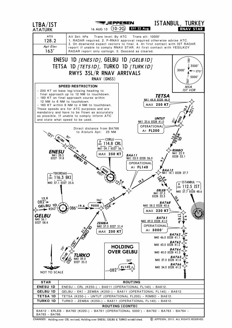
ENESU - CRL (K250-) - BA611 (OPERATIONAL FL120) - BA612.GELBU - EKI - ZEMBA (K250-) - BA611 (OPERATIONAL FL120) - BA612.TETSA (K250-) - UNTUT (OPERATIONAL FL190) - RIMBO - BA612.TURKO - ZEMBA (K250-) - BA611 (OPERATIONAL FL120) - BA612.
BA612 - ERLEB - BA791 (K220-) - BA792 (OPERATIONAL 4000') - BA793 - BA794 -BA795 - BA796 - BA797 - BA798.
N40 57.8 E028 33.2
At 4000'OPERATIONAL
N40 48.4E028 13.0MAX 250 KT
AtOPERATIONAL
FL120
| JEP
PESEN
, 2013. A
LL RIG
HTS R
ESERV
ED.
(H)(H)
(H)
16 AUG
13.Eff.22.Aug.
At FL190OPERATIONAL
MAX 250 KT
Holding over C
RL revised; Holding over EN
ESU, G
ELBU &
TURK
O established.
MSAIST VOR
3500'
5000'
3000'
180^
360^
270^
SPEED RESTRICTION
ENESU 1A[EN
ES1A],
GELBU 1A[G
ELB1A]
TETSA 1A[TETS1A
],TURKO 1A[TU
RK1A
]RW
Y 05 RNAV ARRIVALS
STAR ROUTINGENESU 1AGELBU 1ATETSA 1ATURKO 1A
NOT TO SCALE
CHA
NG
ES:
ROUTING (CONTD)
- 200 KT on base leg/closing heading to final approach up to 12 NM to touchdown.- 180 KT on final approach course within 12 NM to 6 NM to touchdown.- 160 KT within 6 NM to 4 NM to touchdown.These speeds are for ATC purposes and aremandatory and have to be flown as accu-rately as possible. If unable to comply in-form ATC and state what speed to be used.
Direct distance from BA798to Ataturk Apt: 29 NM
9000
121^
301̂FL180030
^
210̂FL1
40
082^
262^
FL140

Licen
sed to
SM
A. P
rinted
on
03 Oct 2013.
No
tice: After 4 O
ct 2013 0901Z, th
is chart m
ay no
lon
ger b
e valid. D
isc 19-2013J
EP
PE
SE
NJep
pV
iew 3.7.5.0
RNAV (GNSS)
LTBA/ISTA
TATU
RKISTANBUL, TURKEY
10-2EJEPPESEN
ZEMBAN40 57.0 E027 51.4
TETSAN41 44.8 E028 46.8
UNTUT
266^
201^
021^
DISTANBUL112.5 ISTIST
N40 57.7 E028 48.610
.2
9000
9000
MAX
BA613
GEVLA
BA623N41 00.5 E028 40.6
BA646N41 08.6 E028 40.3
BA647N41 11.6 E028 40.1
BA648N41 14.6 E028 40.0
BA649N41 17.6 E028 39.9
BA65~N41 20.6 E028 39.8
BA651N41 23.6 E028 39.7
CEKMECE
N41 00.4 E028 31.7328 CEKCEK
N40 59.4E028 20.2
138^
079^ 080^084^
163^
354^13.6
12.29.8 8.7 6.7
14.1
23.7
TETS
A 1B
BA612N41 14.1 E028 27.7
33
33
3
.RNAV.STAR.
128.2
163'A
pt Elev
ATIS
Alt Set: hPa Trans level: By A
TC Trans alt: 10000'1. RA
DAR required. 2. P-RNA
V approval required otherwise advise A
TC.3. O
n downw
ind expect vectors to final. 4. At first contact w
ith IST RADA
Rreport if unable to com
ply RNAV STA
R. At first contact w
ith YESILKOY
RADA
R report only callsign. 5. Descend as cleared.
8.1
N41 35.6E028 41.0
ENESU - CRL (K250-) - BA613 (OPERATIONAL FL130) - GEVLA - CEK.GELBU - EKI - ZEMBA (K250-) - BA613 (OPERATIONAL FL130) - GEVLA - CEK.
TURKO - ZEMBA (K250-) - BA613 (OPERATIONAL FL130) - GEVLA - CEK.TETSA (OPERATIONAL FL160; K250-) - UNTUT - BA612 - CEK.
At
CEK - BA623 (K220-) - BA646 (OPERATIONAL 4000') - BA647 - BA648 - BA649 - BA650 -BA651.
OPERATIONALAt 4000'
N40 58.4 E028 07.4
MAX 250 KTOPERATIONALAt FL130
220 KTMAX
(H)
| JEP
PESEN
, 2013. A
LL RIG
HTS R
ESERV
ED.
GELBUN40 56.1 E027 08.4
D
N40 57.1 E027 25.6
TEKIRDAG116.3 EKI
R262^082^
086^ 19.6GELBU 1B
13.0
EKI(H)
D CORLU114.8 CRLCRL
N41 09.1 E027 56.1MAX 250 KT
R301̂
(H)
33.6ENESU 1B
121^N41 28.5E027 19.8
ENESU
N40 39.0 E027 35.2TURKO
030̂21
.9TU
RKO
1B
16 AUG
13.Eff.22.Aug.
MAX 250 KT
OPERATIONALAt
OPERATIONALAt
OPERATIONALAt FL160
Holding over C
RL revised; Holding over EN
ESU, G
ELBU &
TURK
O established.
MSAIST VOR
3500'
5000'
3000'
180^
360^
270^
SPEED RESTRICTION- 200 KT on base leg/closing heading to final approach up to 12 NM to touchdown.- 180 KT on final approach course within 12 NM to 6 NM to touchdown.- 160 KT within 6 NM to 4 NM to touchdown.These speeds are for ATC purposes and aremandatory and have to be flown as accu-rately as possible. If unable to comply in-form ATC and state what speed to be used.
RWYS 17L/R RNAV ARRIVALS
ENESU 1B[EN
ES1B],GELBU 1B
[GELB1B]
TETSA 1B[TETS1B],
TURKO 1B[TU
RK1B
]
STAR ROUTINGENESU 1BGELBU 1BTETSA 1BTURKO 1B
CHA
NG
ES:
NOT TO SCALE
ROUTING (CONTD)
Direct distance from BA651to Ataturk Apt: 26 NM
082^
262^
FL140
9000
FL180121^301̂
030̂
210̂FL1
40

Licen
sed to
SM
A. P
rinted
on
03 Oct 2013.
No
tice: After 4 O
ct 2013 0901Z, th
is chart m
ay no
lon
ger b
e valid. D
isc 19-2013J
EP
PE
SE
NJep
pV
iew 3.7.5.0
N40 59.4E028 20.2
N41 13.6E029 07.3
LTBA/ISTA
TATU
RKISTANBUL, TURKEY
10-2F
201^
021^
DISTANBUL112.5 ISTIST
N40 57.7 E028 48.610
.290
00
GEVLA
CEKMECE
N41 00.4 E028 31.7328 CEKCEK
138^
079^ 080^163^
13.6
12.29.8
8.714.1
23.7
TETS
A 1C
BA612N41 14.1 E028 27.7
.RNAV.STAR.
BA614
BA615N41 08.9 E028 57.1
BA616
BA617
BA618
BA625
BA626
BA627RNAV (GNSS)
7.8
13.6
33
33
33
JEPPESEN
075^054^
128.2
163'A
pt Elev
ATIS
Alt Set: hPa Trans level: By A
TC Trans alt: 10000'1. RA
DAR required. 2. P-RNA
V approval required otherwise advise A
TC.3. O
n downw
ind expect vectors to final. 4. At first contact w
ith IST RADA
Rreport if unable to com
ply RNAV STA
R. At first contact w
ith YESILKOY
RADA
R report only callsign. 5. Descend as cleared.TETSAN41 44.8 E028 46.8
MAX 250 KT
OPERATIONALAt FL160
N41 35.6E028 41.0
UNTUT
ENESU - CRL (K250-) - BA613 (OPERATIONAL FL170) - GEVLA - CEK.GELBU - EKI - ZEMBA (K250-) - BA613 (OPERATIONAL FL170) - GEVLA - CEK.
TURKO - ZEMBA (K250-) - BA613 (OPERATIONAL FL170) - GEVLA - CEK.TETSA (OPERATIONAL FL160; K250-) - UNTUT - BA612 - CEK.
CEK - BA614 (K220-) - BA615 (OPERATIONAL 4000') - BA616 - BA617 - BA618 - BA625 -BA626 - BA627.
ZEMBAN40 57.0 E027 51.4
BA613
MAX 250 KT
N40 58.4 E028 07.4OPERATIONALAt FL170
N41 01.8 E028 41.8MAX 220 KT
N41 10.5E029 00.5
N41 16.7E029 14.1
N41 18.3E029 17.5
N41 12.0E029 03.9
N41 15.1E029 10.7
| JEP
PESEN
, 2013. A
LL RIG
HTS R
ESERV
ED.
(H)
16 AUG
13.Eff.22.Aug.
266^
9000
GELBUN40 56.1 E027 08.4
R262^082^
086^ 19.6GELBU 1C
13.0
D
N40 57.1 E027 25.6
TEKIRDAG116.3 EKIEKI(H)
N40 39.0 E027 35.2TURKO
030̂21
.9TU
RKO
1C
D CORLU114.8 CRLCRL
N41 09.1 E027 56.1
R301̂
(H)
33.6ENESU 1C
121̂N41 28.5E027 19.8
ENESU
MAX 250 KT
OPERATIONALAt 4000'
Holding over C
RL revised; Holding over EN
ESU, G
ELBU &
TURK
O established.
MSAIST VOR
3500'
5000'
3000'
180^
360^
270^
STAR ROUTINGENESU 1CGELBU 1CTETSA 1CTURKO 1C
CHA
NG
ES:
RWY 23 RNAV ARRIVALS
ENESU 1C
TURKO 1C[TURK1C
]
GELBU 1C[G
ELB1C]
[ENES1C
]
TETSA 1C[TETS1C
]
NOT TO SCALE
ROUTING (CONTD)
SPEED RESTRICTION- 200 KT on base leg/closing heading to final approach up to 12 NM to touchdown.- 180 KT on final approach course within 12 NM to 6 NM to touchdown.- 160 KT within 6 NM to 4 NM to touchdown.These speeds are for ATC purposes and aremandatory and have to be flown as accu-rately as possible. If unable to comply in-form ATC and state what speed to be used.
Direct distance from BA627 to:Ataturk Apt 29 NM
082^
262^
FL140
030̂
210̂FL1
40
9000
FL180121^301^
Licensed to SMA. Printed on 03 Oct 2013.
Notice: After 4 Oct 2013 0901Z, this chart may no longer be valid. Disc 19-2013JEPPESENJeppView 3.7.5.0
N41 07.3E028 33.3
TETS
A1D
ZEMBAN40 57.0 E027 51.4
BA611
GELBU
ENESU
TETSAN41 44.8 E028 46.8
RIMBO
UNTUT
D TEKIRDAG116.3 EKIEKI
N40 57.1 E027 25.6
TURKO
R262^082^
086^
266^
030̂
054^
121^
121^
144^
201^
021^
D ISTANBUL112.5 ISTIST
N40 57.7 E028 48.6
33.6
19.6
21.9
19.310
.2
9.7
ENESU 1D
TURK
O 1D
GELBU 1D 9000
9000
BA612N41 14.1 E028 27.7
ERLEB
BA76~N40 58.2 E028 40.6
BA761N40 49.0 E028 41.0
BA762N40 46.0 E028 41.1
BA763N40 43.0 E028 41.2
BA764N40 40.0 E028 41.3
BA765N40 37.0 E028 41.4
BA766N40 34.0 E028 41.5
N41 28.5E027 19.8
10.6
9.2
174^3
33
33
13.0
8.0
13.0
9.0
R301̂
D CORLU114.8 CRLCRL
N41 09.1 E027 56.1MAX 250 KT
N40 39.0E027 35.2
220 KTMAX
14.0
RNAV (GNSS)
LTBA/ISTATATURK
ISTANBUL, TURKEY10-2G
JEPPESEN
128.2
163'Apt Elev
ATIS Alt Set: hPa Trans level: By ATC Trans alt: 10000'1. RADAR required. 2. P-RNAV approval required otherwise advise ATC.3. On downwind expect vectors to final. 4. At first contact with IST RADARreport if unable to comply RNAV STAR. At first contact with YESILKOYRADAR report only callsign. 5. Descend as cleared.
.RNAV.STAR.
ENESU - CRL (K250-) - BA611 (OPERATIONAL FL140) - BA612.GELBU - EKI - ZEMBA (K250-) - BA611 (OPERATIONAL FL140) - BA612.
TURKO - ZEMBA (K250-) - BA611 (OPERATIONAL FL140) - BA612.TETSA (K250-) - UNTUT (OPERATIONAL FL200) - RIMBO - BA612.
BA612 - ERLEB - BA760 (K220-) - BA761 (OPERATIONAL 5000') - BA762 - BA763 - BA764 -BA765 - BA766.
N41 03.9 E028 06.0
MAX 250 KT
N41 22.9E028 33.1
N40 56.1E027 08.4
OPERATIONALAt FL140
OPERATIONALAt 5000'
MAX 250 KT
OPERATIONALAt FL200
N41 35.6 E028 41.0
(H)
(H)
(H)
| JEPPESEN, 2013. ALL RIGHTS RESERVED.
16 AUG 13 .Eff.22.Aug.
HOLDINGOVER GELBU
Holding over CRL revised; Holding over ENESU, GELBU & TURKO established.
3500'
5000'
3000'
180^
360^
270^
MSAIST VOR
SPEED RESTRICTION- 200 KT on base leg/closing heading to final approach up to 12 NM to touchdown.- 180 KT on final approach course within 12 NM to 6 NM to touchdown.- 160 KT within 6 NM to 4 NM to touchdown.These speeds are for ATC purposes and aremandatory and have to be flown as accuratelyas possible. If unable to comply inform ATCand state what speed to be used.
STAR ROUTINGENESU 1DGELBU 1DTETSA 1DTURKO 1D
ROUTING (CONTD)
NOT TO SCALE
CHANGES:
RWYS 35L/R RNAV ARRIVALS
ENESU 1D [ENES1D], GELBU 1D [GELB1D]TETSA 1D [TETS1D], TURKO 1D [TURK1D]
Direct distance from BA766to Ataturk Apt: 25 NM
FL180
121̂ 301̂
030^
210̂FL1
40
9000
082^
262^
FL140

Licen
sed to
SM
A. P
rinted
on
03 Oct 2013.
No
tice: After 4 O
ct 2013 0901Z, th
is chart m
ay no
lon
ger b
e valid. D
isc 19-2013J
EP
PE
SE
NJep
pV
iew 3.7.5.0
D45
155^
D
ISTD10R050̂
ISTR239^D9
R354^IST
D17
D28102^
D
COMMSLOST COMMSLOST
COMMS LOSTCOMMS LOSTCOMM
S
LOST
COMMSLOST
COMMS
LOST
175^D10
N40 40.7E028 49.1
IMREN SADIK
090^270^
MHA 4000MAX 90005000
175000
20
25
6000
6000
MARMA
038^
BIG 1A
LTBA/ISTA
TATU
RKISTANBUL, TURKEY
Apt Elev
163'A
TIS
128.2
.STAR.
D
N40 17.1 E027 21.9BIG116.9 BIG
BIGA
CEKN41 00.4 E028 31.7
328 CEK
5000
DTEKIRDAG116.3 EKIEKI
N40 57.1 E027 25.6
N40 49.9E028 01.3
DENIZ
10000
DISTANBUL112.5 ISTIST
N40 57.7 E028 48.6
23500
0
R235^
055^
039^
55600
0
500018
BIG 1F
BIG 1C
FATIHN41 13.7 E028 48.0
VURAL
88
30005000
047^
68600
0
BIG 1C
074^062^
BIG 1Y
BIG 1Z37
255000
5000
234^054̂
050̂10600
0KOFUN
R252^
BIG 1Y29
6000
072^
R254^
BIG
1A,
1B, 1
Y, 1Z
DBEYKOZ
117.3 BKZBKZN41 07.6 E029 08.6
BIG 1Z
BIG 1F
ATCOSN40 53.7E028 38.0
BIG
1F
N40 31.6E027 38.9
5000
039^ 219̂
3000 230^
2600059^
HOLDINGS OVERATCOS KOFUNBIG
(IAF RWYS 05, 35L/R)
MHA
5000M
AX 9000
174^
HOLDINGOVERFATIH
(IAF RWY 23)
(IAFRWY 05)
BIG1A, 1B
(IAF RWYS 17L/R) (IAF RWYS 17L/R, 23)
2
N41 05.7 E028 48.3
(IAF RWYS 17L/R) 2BIG 1C, BIG 1F
1
RWY 23 ARRIVALS
BIG 1A
BIG 1BRW
YS 17L/R ARRIVALSRW
YS 35L/R ARRIVAL
RWY 05 ARRIVAL
BIG 1Y, BIG 1Z
282^
1
N41 03.6E028 59.3
JEPPESEN
282^
282^ 102^
BIG 1B14
354^
174^
(H)
MAX
MAX
250 KT
220 KT
BIG 1A:
BIG 1B:
N40 45.9E028 23.0
BIG 1F
MAX 250 KT For Lost Comms Procedure,see Airport Briefing Pages.
(IAFRWYS 35L/R)ERMANN40 47.7E028 48.9
355^2700
7
BIG 1C:MAX 220 KT
BIG 1Y:MAX 250 KT
CEKMECE114.6 CEKCEKD
(H)
N41 00.4 E028 31.7(H)
(H)
(H)
Alt Set: hPa
Trans level: By ATC Trans alt: 10000'
17 MA
Y 13
.Eff.30.May.
10-2
H
Speed restriction; chart reindexed.|
JEPPESEN
, 2013. A
LL RIG
HTS R
ESERV
ED.
500020
1
354^
4000
1
1
8000
MSAIST VOR
3500'
5000'
3000'
180^
360^
270^
NOT TO SCALE
CHA
NG
ES:
SPEED RESTRICTION
BIG 1F subject to priorapproval by ATC.In case of military activity,use BIG 1C by ATC.
MAX 250 KT at or below FL150.MAX 220 KT at or below 10000'.MAX 180 KT on final approach course within12 NM to 6 NM to touchdown.MAX 160 KT within 6 NM to 4 NM to touchdown.These speeds are applied for ATC separationand are mandatory. All speed restrictions areto be flown as accurately as possible. Aircraftunable to conform to these speeds shouldinform ATC and state what speeds to be used.

Licen
sed to
SM
A. P
rinted
on
03 Oct 2013.
No
tice: After 4 O
ct 2013 0901Z, th
is chart m
ay no
lon
ger b
e valid. D
isc 19-2013J
EP
PE
SE
NJep
pV
iew 3.7.5.0
D45
D8
ISTD10R050̂
R239^
D9
R354^IST
DR354^
COMMSLOST COMMSLOST
COMMS LOSTCOMMS LOSTCOMM
S
LOST
COMMSLOST
COMMS
LOST
D17
175^D10
IMREN
SADIK
090^270^
MHA 4000MAX 90005000
175000
EKI 1A
LTBA/ISTA
TATU
RKISTANBUL, TURKEY
Apt Elev
163'A
TIS
128.2
.STAR.
5000
102^
DTEKIRDAG116.3 EKIEKI
N40 57.1 E027 25.6
DENIZ
10000
102^28
6000EKI 1A, 1B
N40 45.9 E028 23.0
DISTANBUL112.5 ISTIST
N40 57.7 E028 48.6
600050
083^
039^
500018
EKI 1
C
FATIHN41 13.7 E028 48.0
VURAL3000 N41 05.7E028 48.3
EKI 1C, 1Y
234^054^
KOFUN
R252^
EKI 1Y29
6000072^
DBEYKOZ
117.3 BKZBKZN41 07.6 E029 08.6
ATCOS
3000 230^
2600059^
KOFUN
(IAF RWYS 05, 35L/R)
MHA
5000M
AX 9000
174^
(IAF RWY 23)
N41 03.6 E028 59.3
HOLDINGS OVERFATIH
10-2J
(IAF RWYS 17L/R, 23)
(IAF RWYS17L/R)
N40 40.7 E028 49.1
N40 49.9 E028 01.3
N40 53.7 E028 38.0
(IAF RWY 05)
174^
282^
JEPPESEN
282^
For Lost Comms Procedure,see Airport Briefing Pages.
EKI 1C:
EKI 1Y:
MAX
MAX 250 KT
220 KT
EKI 1A:
EKI 1B:
MAX
MAX
250 KT
220 KT
EKI 1B14
(H)
355^2700
(IAFRWYS 35L/R)ERMANN40 47.7E028 48.9
7
282^
282^102^
CEKN41 00.4 E028 31.7
328 CEK
(IAF RWYS 17L/R)CEKMECE114.6 CEKCEKD
(H)
N41 00.4 E028 31.7
Alt Set: hPa
Trans level: By ATC Trans alt: 10000'
(H)
(H)
17 MA
Y 13
.Eff.30.May.
Speed restriction; chart reindexed.|
JEPPESEN
, 2013. A
LL RIG
HTS R
ESERV
ED.
500020
6000
4000
MSAIST VOR
3500'
5000'
3000'
180^
360^
270^
SPEED RESTRICTIONMAX 250 KT at or below FL150.MAX 220 KT at or below 10000'.MAX 180 KT on final approach course within12 NM to 6 NM to touchdown.MAX 160 KT within 6 NM to 4 NM to touchdown.These speeds are applied for ATC separationand are mandatory. All speed restrictions areto be flown as accurately as possible. Aircraftunable to conform to these speeds shouldinform ATC and state what speeds to be used.
NOT TO SCALE
CHA
NG
ES:
EKI 1ARW
YS 35L/R ARRIVALEKI 1B
RWY 05 ARRIVAL
EKI 1CRW
YS 17L/R ARRIVALEKI 1Y
RWY 23 ARRIVAL

Licen
sed to
SM
A. P
rinted
on
03 Oct 2013.
No
tice: After 4 O
ct 2013 0901Z, th
is chart m
ay no
lon
ger b
e valid. D
isc 19-2013J
EP
PE
SE
NJep
pV
iew 3.7.5.0
D
D
R354^
EKI116.3EKI
102D̂45
ISTD10R050̂
ISTR239^D9
COMMSLOST COMMSLOST
COMMS LOSTCOMMS LOSTCOMM
S
LOST
COMMSLOST
COMMS
LOST
R354^IST D8
ERMAN
234^
GAYEM
R098^7000
23
278^
2700
233̂18 6000
355^175^
R053̂
10
LTBA/ISTA
TATU
RKISTANBUL, TURKEY
Apt Elev163'
ATIS
128.2
.STAR.10-2K
DISTANBUL112.5 ISTIST
N40 57.7 E028 48.6
DBEYKOZ
117.3 BKZBKZN41 07.6 E029 08.6
KOFUN(IAF RWY 23)
GA
YEM
1A
093^33
6000 R273^
ULMARN41 12.7E027 11.2
DCORLU
114.8 CRLCRLN41 09.0 E027 56.1
R267^
546000087^ ULMAR 1A
ULMAR1A, 1B
FATIHN41 13.7 E028 48.0
079^ 287^
40 166000 6000GAYEM 1F
MHA
5000M
AX 9000
174^
ULMAR 1B
GAYEM1A, 1B, 1C,1E, 1F500
0
IMREN
SADIK
MHA 4000MAX 90005000
239^9
207^
5000
GAYE
M 1C
N40 40.7E028 49.1
GAYEM 1C
N40 45.9E028 23.0
500030
N41 03.6E028 59.3
N40 47.7E028 48.9
3000 230^
2600059^
HOLDINGS OVERATCOS VURALKOFUN
244^064^
175^
355^
054^
(IAFRWYS 35L/R)
(IAF RWYS 05, 35L/R)
GAYEM 1A
:
GAYEM 1B
:
(IAF RWYS 17L/R, 23)
282^
282^
HOLDINGSOVER IST
282^
(IST R-175/D17)
TMA
JEPPESEN
For Lost Comms Procedure,see Airport Briefing Pages.
ATCOSN40 53.7E028 38.0
(IAFRWY 05)
(H)
MAX 250 KT
N41 02.8 E029 37.8GAYEM 1A, 1B, 1C, 1F:
GAYEM 1E:
MAX
MAX
250 KT
220 KT
GAYEM1B
1
VURALN41 05.7 E028 48.3
(IAF RWYS 17L/R) 1
174^ 3000
102^
(H)
14
Alt Set: hPa
Trans level: By ATC Trans alt: 10000'
(H)
17 MA
Y 13
.Eff.30.May.
Speed restriction; chart reindexed.|
JEPPESEN
, 2013. A
LL RIG
HTS R
ESERV
ED.
4000
500022
3000
3000
MSAIST VOR
3500'
5000'
3000'
180^
360^
270^
SPEED RESTRICTIONMAX 250 KT at or below FL150.MAX 220 KT at or below 10000'.MAX 180 KT on final approach course within12 NM to 6 NM to touchdown.MAX 160 KT within 6 NM to 4 NM to touchdown.These speeds are applied for ATC separationand are mandatory. All speed restrictions areto be flown as accurately as possible. Aircraftunable to conform to these speeds shouldinform ATC and state what speeds to be used.
NOT TO SCALE
CHA
NG
ES:
GAYEM 1A
[GA
YE1A]
GAYEM 1B [G
AYE1B]
GAYEM 1C [G
AYE1C
]
GAYEM 1E [G
AYE1E]
GAYEM 1F [GA
YE1F]
ULMAR 1A
[ULM
A1A
]
ULMAR 1B [ULM
A1B]
RWYS 35L/R ARRIVAL
RWY 05 ARRIVALS
RWY 23 ARRIVALS
RWYS 17L/R ARRIVALS
Licensed to SMA. Printed on 03 Oct 2013.
Notice: After 4 Oct 2013 0901Z, this chart may no longer be valid. Disc 19-2013JEPPESENJeppView 3.7.5.0
D45
DEKI116.3
EKI102^
D31
320^
ISTD10R050̂
ISTR239
^D9
COMMSLOST COMMSLOST
COMMS LOSTCOMMS LOSTCOMMS
LOST
COMMSLOST
COMMS
LOST
N40 45.9E028 23.0
IMREN
UNSAV
174^
234̂
090^270^
8000
MHA 4000MAX 9000
200^ 174^
141̂
202^
233^
R354^20
16
15
26
18
7000 7000
7000
6000
5000
R321̂
175^
R053^
10
UNSAV 1A
LTBA/ISTATATURK
ISTANBUL, TURKEYApt Elev163'
ATIS
128.2
.STAR.10-2L
5000
DISTANBUL112.5 ISTIST
N40 57.7 E028 48.6
DBEYKOZ
117.3 BKZBKZN41 07.6 E029 08.6
244^064^
KOFUN(IAF RWY 23)
N41 03.6E028 59.3
UNSAV1C
ERMAN2700 355^
SADIK
5000
N40 40.7E028 49.1
(IST R-175/D17)
UNSA
V1B
, 1C
87000
239^95000
UNSAV 1F
UNSA
V 1A
, 1E
ATCOS(IAF RWY 05)
N40 53.7E028 38.0
FATIH
107^
R287^
167000
N41 13.7E028 48.0
UNSAV 1C, 1J
MHA
5000M
AX 9000
UNSA
V1B, 1F
5000
UNSAV 1H
N40 47.7 E028 48.9
054̂
UNSA
V 1G
:
UN
SA
V1B
, 1F, 1H:
(IAF RWYS 05, 35L/R)
(IAF RWYS 35L/R)
N41 28.7E028 47.4
HOLDINGS OVERATCOS
KOFUN
(IAF RWYS 17L/R, 23)
SLP
1170
00
282^
282^
3000 230̂
2600059^
TMA
JEPPESEN
For Lost Comms Procedure,see Airport Briefing Pages.
14
UNSAV 1
E
UNSAV 1G:
ALL OTHERS:
MAX
MAX
220 KT
250 KT
354^175^
102^
77000
83000
VURAL
(IAFRWYS 17L/R)
N41 05.7E028 48.3
(H)
CEKN41 00.4 E028 31.7
328 CEK
(IAF RWYS 17L/R)CEKMECE114.6 CEKCEKD
(H)
N41 00.4 E028 31.7
Alt Set: hPaTrans level: By ATC Trans alt: 10000'
(H)
17 MAY 13 .Eff.30.May.
Speed restriction; chart reindexed. | JEPPESEN, 2013. ALL RIGHTS RESERVED.
4000
3000
500020
(116.3 EKI R-060)
3000
MSAIST VOR
3500'
5000'
3000'
180^
360^
270^
SPEED RESTRICTION
NOT TO SCALE
CHANGES:
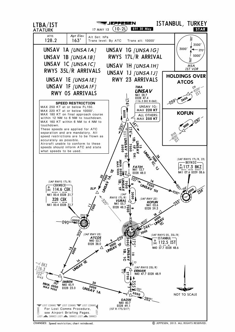
UNSAV 1A
UNSAV 1C
UNSAV 1F
[UNSA1A]
[UNSA1C]
[UNSA1F]
UNSAV 1B [UNSA1B]
UNSAV 1E [UNSA1E]
UNSAV 1G [UNSA1G]
[UNSA1H]UNSAV 1HUNSAV 1J [UNSA1J]RWYS 35L/R ARRIVALS
RWY 05 ARRIVALS
RWY 23 ARRIVALS
RWYS 17L/R ARRIVAL
MAX 250 KT at or below FL150.MAX 220 KT at or below 10000'.MAX 180 KT on final approach coursewithin 12 NM to 6 NM to touchdown.MAX 160 KT within 6 NM to 4 NM totouchdown.These speeds are applied for ATCseparation and are mandatory. Allspeed restrictions are to be flown asaccurately as possible.Aircraft unable to conform to thesespeeds should inform ATC and statewhat speeds to be used.

Licensed to SMA. Printed on 03 Oct 2013.
Notice: After 4 Oct 2013 0901Z, this chart may no longer be valid. Disc 19-2013JEPPESENJeppView 3.7.5.0
EKI116.3
EKI
D45
R354^
D10
R050̂
R239^
D9
EKI 102^D45
R175^ D10
R102^
COMMSLOST COMMSLOST
COMMS LOSTCOMMS LOSTCOMMS
LOST
COMMSLOST
COMMS
LOST234^
600022
LTBA/ISTATATURK
ISTANBUL, TURKEYApt Elev163'
ATIS
128.2 Trans level: By ATC Trans alt: 10000'Alt Set: hPa
.STAR.10-2M
D YALOVA117.7 YAAYAA
N40 28.5 E029 12.5
D BEYKOZ117.3 BKZBKZ
N41 07.6 E029 08.6
DISTANBUL112.5 ISTIST
N40 57.7 E028 48.6
ERMAN2700 355^
SADIK
5000
N40 40.7E028 49.1
(IST R-175/D17)
N40 47.7 E028 48.9
YAA 1B
IMREN
ATCOS(IAF RWY 05)
N40 53.7 E028 38.0
YAA 1A, 1B
600039
KOFUN
E028 59.3N41 03.6
054^
YA
A 1R
, 1T
MHA
5000M
AX 9000
174^FATIHN41 13.7 E028 48.0
166000
287^
352^
(IAF RWY 23)
(IAF RWYS 35L/R)
3000 230^
2600
059^
MHA 4000MAX 9000
(IAF RWYS 17L/R, 23)
(IAF RWYS 05, 35L/R)
282^282^
300^
352^
R172^
YAA 1R
282^
HOLDING OVERIMREN
172^
JEPPESEN
(H)
(H)
N40 45.9E028 23.0
14
7YAA 1A102^
For Lost Comms Procedure,see Airport Briefing Pages.
VURALN41 05.7
E028 48.3
3000
174^
(IAF RWYS 17L/R)
MAX 250 KT
17 MAY 13 .Eff.30.May.
Speed restriction; chart reindexed. | JEPPESEN, 2013. ALL RIGHTS RESERVED.
(H)
4000
500022
6000
MSAIST VOR
3500'
5000'
3000'
180^
360^
270^
SPEED RESTRICTIONMAX 250 KT at or below FL150.MAX 220 KT at or below 10000'.MAX 180 KT on final approach course within12 NM to 6 NM to touchdown.MAX 160 KT within 6 NM to 4 NM to touchdown.These speeds are applied for ATC separationand are mandatory. All speed restrictions areto be flown as accurately as possible. Aircraftunable to conform to these speeds shouldinform ATC and state what speeds to be used.
NOT TO SCALE
CHANGES:
YAA 1ARWYS 35L/R ARRIVAL
YAA 1BRWY 05 ARRIVAL
YAA 1RRWYS 17L/R ARRIVAL
YAA 1TRWYS 17L/R, 23 ARRIVAL
Licen
sed to
SM
A. P
rinted
on
03 Oct 2013.
No
tice: After 4 O
ct 2013 0901Z, th
is chart m
ay no
lon
ger b
e valid. D
isc 19-2013J
EP
PE
SE
NJep
pV
iew 3.7.5.0
D
DEKI116.3EKI
D45
ISTD10R050̂
ISTR239
^D9
R102^
COMMSLOST COMMSLOST
COMMS LOSTCOMMS LOSTCOMM
S
LOST
COMMSLOST
COMMS
LOST
R354^
234^
YASEN
R071^700017
251^
233^
18
LTBA/ISTA
TATU
RKISTANBUL, TURKEY
Apt Elev
163'A
TIS
128.2Trans level: By A
TC Trans alt: 10000'Alt Set: hPa
.STAR.10-2N
N41 11.9 E029 31.0
D BEYKOZ117.3 BKZBKZ
N41 07.6 E029 08.6
6000
175^
R053̂
10
DISTANBUL112.5 ISTIST
N40 57.7 E028 48.6 244^064^
ERMAN
2700 355^SADIK
5000
N40 40.7E028 49.1
N40 47.7 E028 48.9
YA
SEN1A
239^9
3050
00
207^
5000
YASE
N 1C
YASEN 1B
YASEN 1C
IMREN
MHA 4000MAX 9000
N40 45.9E028 23.0
ATCOS(IAF RWY 05)
N40 53.7 E028 38.0
5000
KOFUN
E028 59.3N41 03.6
054^
YASEN 1A, 1B,
1C, 1E, 1F
MHA
5000M
AX 9000
174^
FATIHN41 13.7 E028 48.0
166000
287^(IAF RWY 23)
YASEN
1B:
YASEN
1A:
(IAF RWYS 35L/R)
(IAF RWYS 05, 35L/R)
3000 230
^
2600059^
HOLDINGS OVERATCOS KOFUN
YASEN 1F
(IAF RWYS 17L/R, 23)
282^
282^
JEPPESEN
For Lost Comms Procedure,see Airport Briefing Pages.
VURALN41 05.7E028 48.3
3000
174^
(IAF RWYS 17L/R)
(H)
14
282^
102^
175^
YASEN 1E:
ALL OTHERS:
MAX
MAX
220 KT
250 KT
17 MA
Y 13
.Eff.30.May.
Speed restriction; chart reindexed.|
JEPPESEN
, 2013. A
LL RIG
HTS R
ESERV
ED.
(H)
4000
3000
3000
500022
MSAIST VOR
3500'
5000'
3000'
180^
360^
270^
SPEED RESTRICTIONMAX 250 KT at or below FL150.MAX 220 KT at or below 10000'.MAX 180 KT on final approach course within12 NM to 6 NM to touchdown.MAX 160 KT within 6 NM to 4 NM to touchdown.These speeds are applied for ATC separationand are mandatory. All speed restrictions areto be flown as accurately as possible. Aircraftunable to conform to these speeds shouldinform ATC and state what speeds to be used.
NOT TO SCALE
CHA
NG
ES:
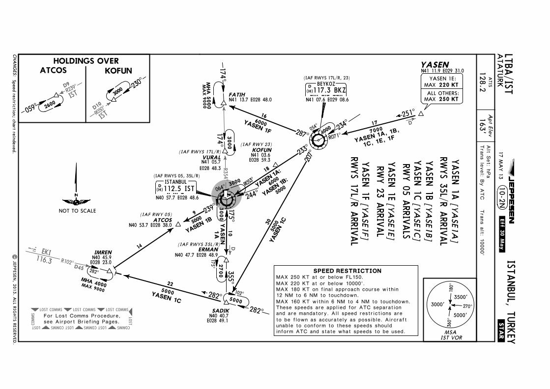
[YASE1A
]
YASEN 1C [YASE1C
] [YA
SE1B]
RWY 05 ARRIVALS
[YASE1F]
[YASE1E]
YASEN 1A
YASEN 1BRW
YS 35L/R ARRIVAL
YASEN 1F
YASEN 1E
RWYS 17L/R ARRIVAL
RWY 23 ARRIVAL

Licensed to SMA. Printed on 03 Oct 2013.
Notice: After 4 Oct 2013 0901Z, this chart may no longer be valid. Disc 19-2013JEPPESENJeppView 3.7.5.0
JEPPESENLTBA/ISTATATURK
ISTANBUL, TURKEY.RNAV.SID.25 MAY 12 .Eff.31.May.10-3
10-3F10-3G
EDASA 1N, PIMAV 1NEDASA 1E, PIMAV 1E
REFER TO CHART10-3B10-3C10-3D10-3E
10-3H10-3J10-3K10-3L
10-3Q110-3Q2
10-3M10-3N10-3P10-3Q
10-3Q310-3Q410-3S10-3T
10-3T510-3T6
10-3T110-3T210-3T310-3T4
10-3T710-3T810-3U10-3V
10-3V510-3V6
10-3V110-3V210-3V310-3V4
FOR SID DESIGNATION REFER TO PAGE 10-3A| JEPPESEN, 2012. ALL RIGHTS RESERVED.New text page (RNAV SIDs transferred).
MAKOL 1E, MOPIN 1EERSEN 1P, MAKOL 1P, MOPIN 1PERSEN 1R, MAKOL 1R, MOPIN 1RERSEN 1S, MAKOL 1S, MOPIN 1SERSEN 1T, MAKOL 1T, MOPIN 1TERSEN 1U, MAKOL 1U, MOPIN 1UERSEN 1V, MAKOL 1V, MOPIN 1V
MAKOL 1X, MOPIN 1XERSEN 1Y, MAKOL 1Y, MOPIN 1YERSEN 1Z, MAKOL 1Z, MOPIN 1Z
EDASA 1P, PIMAV 1PEDASA 1Q, PIMAV 1Q
EDASA 1R, 1T, PIMAV 1R, 1TEDASA 1S, 1U, PIMAV 1S, 1U
EDASA 1V, PIMAV 1VEDASA 1X, PIMAV 1XEDASA 1Y, PIMAV 1YEDASA 1Z, PIMAV 1ZGOLDO 1E, MARMA 1EGOLDO 1P, MARMA 1P
GOLDO 1R, 1T, MARMA 1R, 1TGOLDO 1S, 1U, MARMA 1S, 1U
GOLDO 1V, MARMA 1VGOLDO 1X, MARMA 1XGOLDO 1Y, MARMA 1YGOLDO 1Z, MARMA 1ZIBLAL 1E, VADEN 1EIBLAL 1P, VADEN 1P
IBLAL 1R, 1T, VADEN 1R, 1TIBLAL 1S, 1U, VADEN 1S, 1U
IBLAL 1V, VADEN 1VIBLAL 1X, VADEN 1XIBLAL 1Y, VADEN 1YIBLAL 1Z, VADEN 1Z
RNAV SID DESIGNATION
CHANGES:

Licensed to SMA. Printed on 03 Oct 2013.
Notice: After 4 Oct 2013 0901Z, this chart may no longer be valid. Disc 19-2013JEPPESENJeppView 3.7.5.0
JEPPESEN
.SID.
10-3X2
10-3X410-3X5
10-3X3
10-3X6
10-3X1
REFER TO CHART10-3V710-3V810-3W10-3X
SID DESIGNATION
LTBA/ISTATATURK
ISTANBUL, TURKEY10-3A25 MAY 12 .Eff.31.May.
ERTAS 1M, 1N, GAYEM 1N, MOPIN 1N, YALOVA 1NBIGA 1M, 1N, CORLU 1N, FENER 1N, TEKIRDAG 1NERTAS 1S, 1T, GAYEM 1S, MOPIN 1A, YALOVA 2S
ERTAS 1G, 1J, GAYEM 1G, MOPIN 1G, YALOVA 2G
ERTAS 1D, 1U, GAYEM 1D, MOPIN 1D, YALOVA 1DBIGA 1D, CORLU 1D, FENER 1D, 1U, TEKIRDAG 1DERTAS 1K, 1L, GAYEM 1K, MOPIN 1B, YALOVA 1KBIGA 1K, CORLU 1K, FENER 1K, 1L, TEKIRDAG 1K
BIGA 2S, CORLU 2S, FENER 2S, TEKIRDAG 2S
BIGA 2G, CORLU 2G, FENER 2H, TEKIRDAG 2G
New text page (RNAV SIDs transferred). | JEPPESEN, 2012. ALL RIGHTS RESERVED.CHANGES:

Licensed to SMA. Printed on 03 Oct 2013.
Notice: After 4 Oct 2013 0901Z, this chart may no longer be valid. Disc 19-2013JEPPESENJeppView 3.7.5.0
JEPPESEN
163'
LTBA/ISTTrans level: By ATC Trans alt: 10000'
ATATURKISTANBUL, TURKEY
Apt ElevYESILKOY Radar
126.42
10-3B .RNAV.SID.
D ISTANBUL112.5 ISTIST
N40 57.8 E028 48.6
MOPINN41 27.9 E029 42.6
BA010 (2200'+; K220) - BA040 (4000'-) - BA012 - BA047 - ERTAS - MAKOL.
(H)
25 MAY 12 .Eff.31.May.
BA010 (2200'+; K220) - BA040 (4000'-) - BA012 - BA047 - ERTAS - MOPIN.RNAV SIDs transferred & established. | JEPPESEN, 2012. ALL RIGHTS RESERVED.
These SIDs require a minimum climb gradientof304' per NM (5%) up to 5000'.
ERTASN41 27.7 E029 08.8
BA~1~N41 04.8 E028 48.3
BA~12
BA~4~N41 10.6 E028 48.1
BA~47N41 22.5 E028 58.7
MAKOLN42 10.2 E029 08.6
5.0354^
At or above
220 KT
At or above2200'
At or below4000'
N41 16.8E028 47.8
5.86.2
051̂10.0
9.2
43
25.4
MA
KO
L 1E
MOPIN 1E
356^
085^
Contact YESILKOY Radar immediately after take-off with call signonly, check ATIS for current frequency.RADAR required.P-RNAV approval required otherwise advise ATC.
1. 2.3.
MSAIST VOR
3500'
5000'
3000'
180^
360^
270^
CHANGES:
MAKOL 1EMOPIN 1E
SID ROUTINGInitial climb clearance 5000'
[MAKO1E][MOPI1E]
RNAV (GNSS)
75 100 150 200 250 300304' per NM 380 506 760 1013 1266 1519Gnd speed-KT
NOT TO SCALE
RWY 35R RNAV DEPARTURES
MAKOL 1EMOPIN 1E
EXECUTED WITH RNAV STARS RWY 23

Licensed to SMA. Printed on 03 Oct 2013.
Notice: After 4 Oct 2013 0901Z, this chart may no longer be valid. Disc 19-2013JEPPESENJeppView 3.7.5.0
JEPPESEN
N41 06.1E029 51.5
N41 11.9E029 31.0
N41 07.9E029 45.2
N41 03.9E029 59.0
163'
LTBA/ISTTrans level: By ATC Trans alt: 10000'
ATATURKISTANBUL, TURKEY
Apt ElevYESILKOY Radar
126.42
.RNAV.SID.
BA~35
MAKOLN42 10.2 E029 08.6
ERSENN40 51.9 E030 40.0
KUBAP
BA~46
YASEN
ERTASN41 27.7 E029 08.8
PEMETN41 18.7 E029 04.3
EMPOPN41 14.9 E029 02.3
DISTANBUL112.5 ISTIST
N40 57.8 E028 48.6
D BEYKOZ117.3 BKZBKZ
N41 07.6 E029 08.6
R233̂071^
106^
017^14
.54.
19.
6
BEBEG
11.5
6.17.9
11.7
356^
N41 01.3E028 55.5At or above
220 KT
At or above1600'
ERSEN 1P
MA
KO
L 1P
5.1
5.0
TEMGO
MOPINN41 27.9 E029 42.6
N41 10.0E029 20.8
9.5
038^
24.3
MOPIN 1
P
These SIDs require a minimum climb gradientof304' per NM (5%) up to 5000'.
BA035 (1600'+; K220) - BKZ - YASEN - BA046 - KUBAP - BEBEG - ERSEN.BA035 (1600'+; K220) - EMPOP - PEMET - ERTAS - MAKOL.BA035 (1600'+; K220) - BKZ - TEMGO - MOPIN.
43
33
(H)
(H)
25 MAY 12 .Eff.31.May.
Procedure notes; chart reindexed. | JEPPESEN, 2012. ALL RIGHTS RESERVED.
10-3C
Contact YESILKOY Radar immediately after take-off with call signonly, check ATIS for current frequency.RADAR required.P-RNAV approval required otherwise advise ATC.
1. 2.3.
MSAIST VOR
3500'
5000'
3000'
180^
360^
270^
CHANGES:
75 100 150 200 250 300304' per NM 380 506 760 1013 1266 1519Gnd speed-KT
RWY 05 RNAV DEPARTURES
[ERSE1P]ERSEN 1P[MAKO1P]MAKOL 1P[MOPI1P]MOPIN 1P
SID ROUTINGInitial climb clearance 5000'
ERSEN 1PMAKOL 1PMOPIN 1P
RNAV (GNSS)
053̂
NOT TO SCALE

Licensed to SMA. Printed on 03 Oct 2013.
Notice: After 4 Oct 2013 0901Z, this chart may no longer be valid. Disc 19-2013JEPPESENJeppView 3.7.5.0
JEPPESEN
163'
LTBA/ISTTrans level: By ATC Trans alt: 10000'
ATATURKISTANBUL, TURKEY
Apt ElevYESILKOY Radar
126.42
10-3D .RNAV.SID.
MAKOL.
BA046 - BEBEG - ERSEN.
MOPIN.
N41 03.9E029 59.0
MAKOLN42 10.2 E029 08.6
ERSENN40 51.9 E030 40.0
ERTASN41 27.7 E029 08.8
D ISTANBUL112.5 ISTIST
N40 57.8 E028 48.6
BEBEG
356^
BA~46N41 07.9 E029 45.2
LIVSO
BA~22N41 12.3 E029 07.7
BA~2~
BA~15
N40 53.3E028 56.7
N40 53.2E028 48.7
N41 14.1E029 23.4
BA~21N41 02.3 E029 06.9
1
1
5174^
084^
036^
359^
077^ 106^
6
11.9
1015
.4
17.6
11.1
At or above
220 KT
At or above1400'
At or below8000'
12.0
MA
KO
L 1R
ERSEN 1R
240 KT
MOPINN41 27.9 E029 42.6
042^
20.0
MOPIN1R
These SIDs require a minimum climb gradientof261' per NM (4.3%) up to 5000'.
BA015 (1400'+; K220) - BA020 (K240) - BA021 (8000'-) - BA022 - LIVSO -
BA015 (1400'+; K220) - BA020 (K240) - BA021 (8000'-) - BA022 - ERTAS -
BA015 (1400'+; K220) - BA020 (K240) - BA021 (8000'-) - BA022 - LIVSO -
43
33
(H)
25 MAY 12 .Eff.31.May.
Procedure notes; chart reindexed. | JEPPESEN, 2012. ALL RIGHTS RESERVED.
Contact YESILKOY Radar immediately after take-off with call signonly, check ATIS for current frequency.RADAR required.P-RNAV approval required otherwise advise ATC.
1. 2.3.
MSAIST VOR
3500'
5000'
3000'
180^
360^
270^
CHANGES:
ERSEN 1RMAKOL 1RMOPIN 1R
SID ROUTINGInitial climb clearance 5000'
EXECUTED WITH RNAV STARS RWYS 17L/R
[ERSE1R][MAKO1R][MOPI1R]
RNAV (GNSS)
75 100 150 200 250 300261' per NM 327 435 653 871 1089 1306Gnd speed-KT
NOT TO SCALE
RWY 17L RNAV DEPARTURES
ERSEN 1R
MAKOL 1R
MOPIN 1R
Licensed to SMA. Printed on 03 Oct 2013.
Notice: After 4 Oct 2013 0901Z, this chart may no longer be valid. Disc 19-2013JEPPESENJeppView 3.7.5.0
JEPPESEN
163'
LTBA/ISTTrans level: By ATC Trans alt: 10000'
ATATURKISTANBUL, TURKEY
Apt ElevYESILKOY Radar
126.42
10-3E .RNAV.SID.
N41 03.9E029 59.0
MAKOLN42 10.2 E029 08.6
ERSENN40 51.9 E030 40.0
ERTASN41 27.7 E029 08.8
D ISTANBUL112.5 ISTIST
N40 57.8 E028 48.6
BEBEG
356^
BA~46N41 07.9 E029 45.2
LIVSO
BA~22N41 12.3 E029 07.7
BA~2~
BA~15
N40 53.3E028 56.7
N40 53.2E028 48.7
N41 14.1E029 23.4
BA~21N41 02.3 E029 06.9
1
1
5173^
084^
036^
359^
077^ 106^
6
11.9
1015
.4
17.6
11.1
At or above
220 KT
At or above1400'
At or below8000'
12.0
MOPINN41 27.9 E029 42.6
042^
20.0
MOPIN1S
MA
KO
L 1S
ERSEN 1S
240 KT
MAKOL.
BA046 - BEBEG - ERSEN.
MOPIN.
BA015 (1400'+; K220) - BA020 (K240) - BA021 (8000'-) - BA022 - LIVSO -
BA015 (1400'+; K220) - BA020 (K240) - BA021 (8000'-) - BA022 - ERTAS -
BA015 (1400'+; K220) - BA020 (K240) - BA021 (8000'-) - BA022 - LIVSO -
These SIDs require a minimum climb gradientof261' per NM (4.3%) up to 5000'.
43
33
(H)
25 MAY 12 .Eff.31.May.
Procedure notes; chart reindexed. | JEPPESEN, 2012. ALL RIGHTS RESERVED.
Contact YESILKOY Radar immediately after take-off with call signonly, check ATIS for current frequency.RADAR required.P-RNAV approval required otherwise advise ATC.
1. 2.3.
MSAIST VOR
3500'
5000'
3000'
180^
360^
270^
CHANGES:
EXECUTED WITH RNAV STARS RWYS 17L/R
[ERSE1S]ERSEN 1S[MAKO1S]MAKOL 1S[MOPI1S]MOPIN 1S
RNAV (GNSS)
NOT TO SCALE
RWY 17R RNAV DEPARTURES
SID ROUTINGInitial climb clearance 5000'
ERSEN 1S
MAKOL 1S
MOPIN 1S
75 100 150 200 250 300261' per NM 327 435 653 871 1089 1306Gnd speed-KT

Licensed to SMA. Printed on 03 Oct 2013.
Notice: After 4 Oct 2013 0901Z, this chart may no longer be valid. Disc 19-2013JEPPESENJeppView 3.7.5.0
JEPPESEN
163'
LTBA/ISTTrans level: By ATC Trans alt: 10000'
ATATURKISTANBUL, TURKEY
Apt ElevYESILKOY Radar
126.42
10-3F .RNAV.SID.
UBEXA - MOPIN.
ERTAS - MAKOL.
UBEXA - BA046 - BEBEG - ERSEN.
1 5174^
N41 03.9E029 59.0
ERSENN40 51.9 E030 40.0
BEBEG
MAKOLN42 10.2 E029 08.6
ERTASN41 27.7 E029 08.8
356^
D ISTANBUL112.5 ISTIST
N40 57.8 E028 48.6
BA~15
1
At or above
220 KT
At or above1400'
BA~3~N40 52.7 E028 41.2
ROBLON41 01.6 E028 40.6
SOMEP
N40 53.2 E028 48.7
7000'At or below
N41 10.6E028 40.1
ELKEPN41 16.8 E028 50.5
UBEXA
261^
353^
047^
084^ 106^
5.8
8.99.0
17.5
16.3
26.7
240 KT
BA~46N41 07.9
E029 45.2
11.1
10.0
At or aboveAt or above1400'
MOPINN41 27.9 E029 42.6
N41 17.2E029 12.1 061^
25.3
MOPIN 1T
These SIDs require a minimum climb gradientof261' per NM (4.3%) up to 5000'.
BA015 (1400'+; K220) - BA030 (K240) - ROBLO (7000'-) - SOMEP - ELKEP -
BA015 (1400'+; K220) - BA030 (K240) - ROBLO (7000'-) - SOMEP - ELKEP -
BA015 (1400'+; K220) - BA030 (K240) - ROBLO (7000'-) - SOMEP - ELKEP -
MA
KO
L 1T
ERSEN 1T
43
33(H)
25 MAY 12 .Eff.31.May.
Procedure notes; chart reindexed. | JEPPESEN, 2012. ALL RIGHTS RESERVED.
Contact YESILKOY Radar immediately after take-off with call signonly, check ATIS for current frequency.RADAR required.P-RNAV approval required otherwise advise ATC.
1. 2.3.
MSAIST VOR
3500'
5000'
3000'
180^
360^
270^
CHANGES:
ERSEN 1TMAKOL 1TMOPIN 1T
SID ROUTINGInitial climb clearance 5000'
[ERSE1T][MAKO1T][MOPI1T]
EXECUTED WITH RNAV STARS RWY 23
75 100 150 200 250 300261' per NM 327 435 653 871 1089 1306Gnd speed-KT
NOT TO SCALE
RNAV (GNSS)RWY 17L RNAV DEPARTURES
MOPIN 1T
ERSEN 1T
MAKOL 1T

Licensed to SMA. Printed on 03 Oct 2013.
Notice: After 4 Oct 2013 0901Z, this chart may no longer be valid. Disc 19-2013JEPPESENJeppView 3.7.5.0
JEPPESEN
163'
LTBA/ISTTrans level: By ATC Trans alt: 10000'
ATATURKISTANBUL, TURKEY
Apt ElevYESILKOY Radar
126.42
10-3G .RNAV.SID.
UBEXA - MOPIN.
ERTAS - MAKOL.
UBEXA - BA046 - BEBEG - ERSEN.
1 5173^
N41 03.9E029 59.0
ERSENN40 51.9 E030 40.0
BEBEG
MAKOLN42 10.2 E029 08.6
ERTASN41 27.7 E029 08.8
356^
D ISTANBUL112.5 ISTIST
N40 57.8 E028 48.6
BA~15
1
At or above
220 KT
At or above1400'
BA~3~N40 52.7 E028 41.2
ROBLON41 01.6 E028 40.6
SOMEP
N40 53.2 E028 48.7
7000'At or below
N41 10.6E028 40.1
ELKEPN41 16.8 E028 50.5
UBEXA
261^
353^
047^
084^ 106^
5.8
8.99.0
17.5
16.3
26.7
240 KT
BA~46N41 07.9
E029 45.2
11.1
10.0
At or aboveAt or above1400'
MOPINN41 27.9 E029 42.6
N41 17.2E029 12.1 061^
25.3
MOPIN 1U
These SIDs require a minimum climb gradientof261' per NM (4.3%) up to 5000'.
BA015 (1400'+; K220) - BA030 (K240) - ROBLO (7000'-) - SOMEP - ELKEP -
BA015 (1400'+; K220) - BA030 (K240) - ROBLO (7000'-) - SOMEP - ELKEP -
BA015 (1400'+; K220) - BA030 (K240) - ROBLO (7000'-) - SOMEP - ELKEP -
MA
KO
L 1U
ERSEN 1U
43
33(H)
| JEPPESEN, 2011, 2012. ALL RIGHTS RESERVED.
25 MAY 12 .Eff.31.May.
Procedure notes; chart reindexed.
Contact YESILKOY Radar immediately after take-off with call signonly, check ATIS for current frequency.RADAR required.P-RNAV approval required otherwise advise ATC.
1. 2.3.
MSAIST VOR
3500'
5000'
3000'
180^
360^
270^
CHANGES:
SID ROUTINGInitial climb clearance 5000'
[ERSE1U]ERSEN 1U[MAKO1U]MAKOL 1U[MOPI1U]MOPIN 1U
EXECUTED WITH RNAV STARS RWY 23
75 100 150 200 250 300261' per NM 327 435 653 871 1089 1306Gnd speed-KT
NOT TO SCALE
RNAV (GNSS)RWY 17R RNAV DEPARTURES
MOPIN 1U
ERSEN 1U
MAKOL 1U
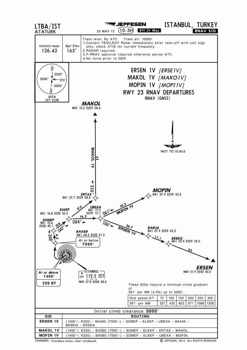
Licensed to SMA. Printed on 03 Oct 2013.
Notice: After 4 Oct 2013 0901Z, this chart may no longer be valid. Disc 19-2013JEPPESENJeppView 3.7.5.0
JEPPESEN
N41 10.6E028 40.1
163'
LTBA/ISTTrans level: By ATC Trans alt: 10000'
ATATURKISTANBUL, TURKEY
Apt ElevYESILKOY Radar
126.42
10-3H .RNAV.SID.
BEBEG - ERSEN.
MAKOLN42 10.2 E029 08.6
ERTASN41 27.7 E029 08.8
356^
D ISTANBUL112.5 ISTIST
N40 57.8 E028 48.6
SOMEP
ELKEPN41 16.8 E028 50.5
UBEXA
047^
084^ 106^
17.5
16.3
26.7 BA~46N41 07.9 E029 45.2
BEBEG11.1
ERSENN40 51.9 E030 40.0
BA06~N41 04.2 E028 41.3
N41 03.9 E029 59.0
ERSEN 1V
MA
KO
L 1V
348^6.4
7000'At or below
10.0
At or above
220 KT
At or above1400'
(1400'+; K220) - BA060 (7000'-) - SOMEP - ELKEP - UBEXA - BA046 -
(1400'+; K220) - BA060 (7000'-) - SOMEP - ELKEP - ERTAS - MAKOL.(1400'+; K220) - BA060 (7000'-) - SOMEP - ELKEP - UBEXA - MOPIN.
These SIDs require a minimum climb gradientof261' per NM (4.3%) up to 5000'.
MOPINN41 27.9 E029 42.6
061^25.3
MOPIN 1VN41 17.2E029 12.1
43
33
(H)
25 MAY 12 .Eff.31.May.
Procedure notes; chart reindexed. | JEPPESEN, 2012. ALL RIGHTS RESERVED.
Contact YESILKOY Radar immediately after take-off with call signonly, check ATIS for current frequency.RADAR required.P-RNAV approval required otherwise advise ATC.No turns prior to DER.
1. 2.3.4.
MSAIST VOR
3500'
5000'
3000'
180^
360^
270^
CHANGES:
RWY 23 RNAV DEPARTURES
[ERSE1V]ERSEN 1V[MAKO1V]MAKOL 1V[MOPI1V]MOPIN 1V
SID ROUTINGInitial climb clearance 5000'
ERSEN 1V
MAKOL 1VMOPIN 1V
RNAV (GNSS)
75 100 150 200 250 300261' per NM 327 435 653 871 1089 1306Gnd speed-KT
234^
NOT TO SCALE

Licensed to SMA. Printed on 03 Oct 2013.
Notice: After 4 Oct 2013 0901Z, this chart may no longer be valid. Disc 19-2013JEPPESENJeppView 3.7.5.0
JEPPESEN
163'
LTBA/ISTTrans level: By ATC Trans alt: 10000'
ATATURKISTANBUL, TURKEY
Apt ElevYESILKOY Radar
126.42
10-3J .RNAV.SID.
D ISTANBUL112.5 ISTIST
N40 57.8 E028 48.6
MOPINN41 27.9 E029 42.6
BA010 (2200'+; K220) - BA040 (4000'-) - BA012 - BA047 - ERTAS - MAKOL.
(H)
25 MAY 12 .Eff.31.May.
BA010 (2200'+; K220) - BA040 (4000'-) - BA012 - BA047 - ERTAS - MOPIN.RNAV SIDs transferred & established. | JEPPESEN, 2012. ALL RIGHTS RESERVED.
ERTASN41 27.7 E029 08.8
BA~1~N41 04.8 E028 48.3
BA~12
BA~4~N41 10.6 E028 48.1
BA~47N41 22.5 E028 58.7
MAKOLN42 10.2 E029 08.6
5.0355^
At or above
220 KT
At or above2200'
At or below4000'
N41 16.8E028 47.8
5.86.2
051̂10.0
9.2
43
25.4
MA
KO
L 1X
MOPIN 1X
356^
085^
These SIDs require a minimum climb gradientof413' per NM (6.8%) up to 5000'.
Contact YESILKOY Radar immediately after take-off with call signonly, check ATIS for current frequency.RADAR required.P-RNAV approval required otherwise advise ATC.
1. 2.3.
MSAIST VOR
3500'
5000'
3000'
180^
360^
270^
CHANGES:
MAKOL 1XMOPIN 1X
SID ROUTINGInitial climb clearance 5000'
[MAKO1X][MOPI1X]
RNAV (GNSS)
75 100 150 200 250 300413' per NM 516 689 1033 1377 1722 2066Gnd speed-KT
NOT TO SCALE
RWY 35L RNAV DEPARTURES
MAKOL 1XMOPIN 1X
EXECUTED WITH RNAV STARS RWY 23

Licensed to SMA. Printed on 03 Oct 2013.
Notice: After 4 Oct 2013 0901Z, this chart may no longer be valid. Disc 19-2013JEPPESENJeppView 3.7.5.0
JEPPESEN
N41 06.1E029 51.5
N41 11.9E029 31.0
N41 07.9E029 45.2
N41 03.9E029 59.0
163'
LTBA/ISTTrans level: By ATC Trans alt: 10000'
ATATURKISTANBUL, TURKEY
Apt ElevYESILKOY Radar
126.42
10-3K .RNAV.SID.
MAKOLN42 10.2 E029 08.6
ERSENN40 51.9 E030 40.0
KUBAP
BA~46
YASEN
ERTASN41 27.7 E029 08.8
D ISTANBUL112.5 ISTIST
N40 57.8 E028 48.6
D BEYKOZ117.3 BKZBKZ
N41 07.6 E029 08.6
071^106^
BEBEG
11.5
6.1
356^
BA~1~
R255^
075^
030^
17.3
10.3
BA~45N41 19.1 E029 01.1
15.6
9000'At or below
5.17.9
TEMGO
MOPINN41 27.9 E029 42.6
N41 10.0E029 20.8
9.5
038^
24.3
MOPI
N 1Y
5.0
355^
At or aboveAt or above2200'
At or aboveAt or above2200'220 KT
N41 04.8E028 48.3
These SIDs require a minimum climb gradientof413' per NM (6.8%) up to 5000'.
BA010 (2200'+; K220) - BKZ - YASEN - BA046 - KUBAP - BEBEG - ERSEN.BA010 (2200'+; K220) - BA045 (9000'-) - ERTAS - MAKOL.
MA
KO
L 1Y
ERSEN 1Y
43
33
BA010 (2200'+; K220) - BKZ - TEMGO - MOPIN.
(H)
(H)
25 MAY 12 .Eff.31.May.
Procedure notes; chart reindexed. | JEPPESEN, 2012. ALL RIGHTS RESERVED.
Contact YESILKOY Radar immediately after take-off with call signonly, check ATIS for current frequency.RADAR required.P-RNAV approval required otherwise advise ATC.
1. 2.3.
MSAIST VOR
3500'
5000'
3000'
180^
360^
270^
CHANGES:
75 100 150 200 250 300Gnd speed-KT
ERSEN 1YMAKOL 1YMOPIN 1Y
SID ROUTINGInitial climb clearance 5000'
[ERSE1Y][MAKO1Y][MOPI1Y]
413' per NM 516 689 1033 1377 1722 2066
RNAV (GNSS)RWY 35L RNAV DEPARTURES
NOT TO SCALE
ERSEN 1YMAKOL 1YMOPIN 1Y

Licensed to SMA. Printed on 03 Oct 2013.
Notice: After 4 Oct 2013 0901Z, this chart may no longer be valid. Disc 19-2013JEPPESENJeppView 3.7.5.0
JEPPESEN
163'
LTBA/ISTTrans level: By ATC Trans alt: 10000'
ATATURKISTANBUL, TURKEY
| JEPPESEN, 2012. ALL RIGHTS RESERVED.
Apt ElevYESILKOY Radar
126.42
10-3L .RNAV.SID.
MAKOLN42 10.2 E029 08.6
ERTASN41 27.7 E029 08.8
D ISTANBUL112.5 ISTIST
N40 57.8 E028 48.6
356^
R255^
075^
030^
17.3
10.3
BA~45N41 19.1 E029 01.1
15.6
9000'At or below
N41 06.1E029 51.5
N41 11.9E029 31.0
N41 07.9E029 45.2
N41 03.9E029 59.0
ERSENN40 51.9 E030 40.0
KUBAP
BA~46
YASEN
D BEYKOZ117.3 BKZBKZ
N41 07.6 E029 08.6
071^106^
BEBEG
11.5
6.1
BA~1~
5.17.9
MOPINN41 27.9 E029 42.6
N41 10.0E029 20.8
9.5
038^
24.3
MOPI
N 1Z
N41 04.8E028 48.3
ERSEN 1Z
5.0
354^
At or aboveAt or above1600'
At or aboveAt or above
220 KT
MA
KO
L 1Z
These SIDs require a minimum climb gradientof304' per NM (5%) up to 5000'.
BA010 (1600'+; K220) - BKZ - YASEN - BA046 - KUBAP - BEBEG - ERSEN.BA010 (1600'+; K220) - BA045 (9000'-) - ERTAS - MAKOL.
43
33
TEMGO
BA010 (1600'+; K220) - BKZ - TEMGO - MOPIN.
(H)
(H)
25 MAY 12 .Eff.31.May.
Procedure notes; chart reindexed.
Contact YESILKOY Radar immediately after take-off with call signonly, check ATIS for current frequency.RADAR required.P-RNAV approval required otherwise advise ATC.
1. 2.3.
MSAIST VOR
3500'
5000'
3000'
180^
360^
270^
CHANGES:
75 100 150 200 250 300Gnd speed-KT
[ERSE1Z]ERSEN 1Z[MAKO1Z]MAKOL 1Z[MOPI1Z]MOPIN 1Z
304' per NM 380 506 760 1013 1266 1519
RNAV (GNSS)RWY 35R RNAV DEPARTURES
NOT TO SCALE
SID ROUTINGInitial climb clearance 9000'
ERSEN 1ZMAKOL 1ZMOPIN 1Z
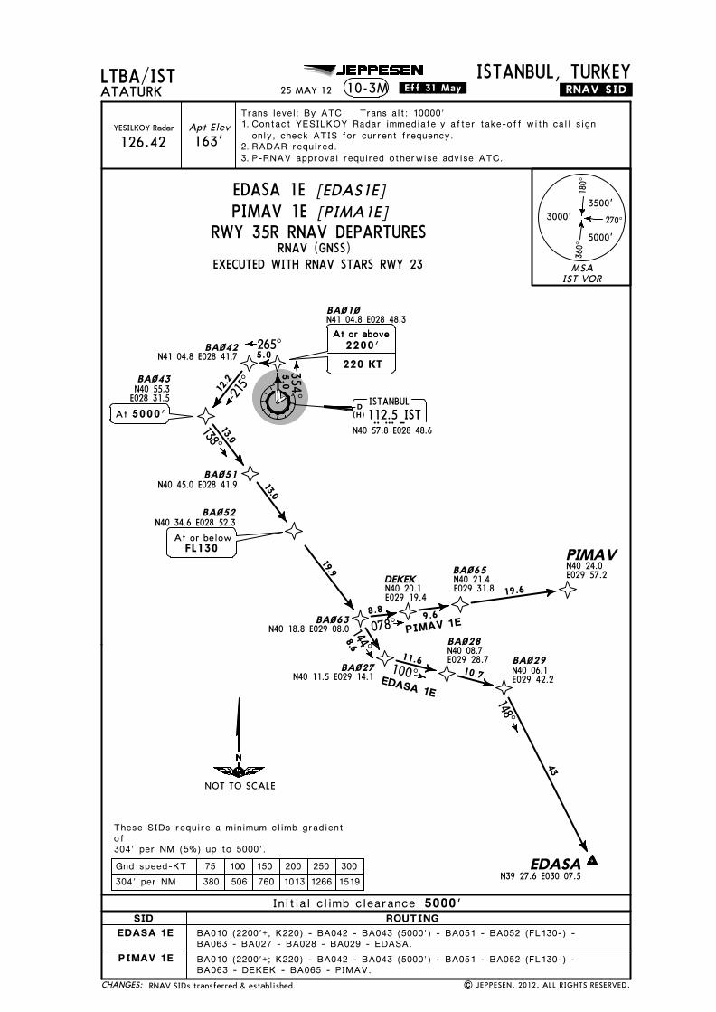
Licensed to SMA. Printed on 03 Oct 2013.
Notice: After 4 Oct 2013 0901Z, this chart may no longer be valid. Disc 19-2013JEPPESENJeppView 3.7.5.0
JEPPESEN
163'
LTBA/ISTTrans level: By ATC Trans alt: 10000'
ATATURKISTANBUL, TURKEY
Apt ElevYESILKOY Radar
126.42
10-3M .RNAV.SID.
D ISTANBUL112.5 ISTIST
N40 57.8 E028 48.6(H)
25 MAY 12 .Eff.31.May.
RNAV SIDs transferred & established. | JEPPESEN, 2012. ALL RIGHTS RESERVED.
These SIDs require a minimum climb gradientof304' per NM (5%) up to 5000'.
BA~1~N41 04.8 E028 48.3
5.0354^
PIMAV
EDASAN39 27.6 E030 07.5
BA~29
BA~42N41 04.8 E028 41.7
BA~43
BA~63N40 18.8 E029 08.0
BA~27N40 11.5 E029 14.1
BA~28
BA~65DEKEK
BA~51N40 45.0 E028 41.9
BA~52N40 34.6 E028 52.3
BA010 (2200'+; K220) - BA042 - BA043 (5000') - BA051 - BA052 (FL130-) -BA063 - DEKEK - BA065 - PIMAV.
BA010 (2200'+; K220) - BA042 - BA043 (5000') - BA051 - BA052 (FL130-) -BA063 - BA027 - BA028 - BA029 - EDASA.
265^5.0
At or above
220 KT
At or above2200'
N40 55.3E028 31.55000'At
12.2
215^
At or belowFL130
13.0
13.0
19.9
138^
N40 20.1E029 19.4
N40 21.4E029 31.8
N40 24.0E029 57.2
078^8.8 9.6
19.6
144^
100^
148^
8.6
11.610.7
43
EDASA 1E
PIMAV 1E
N40 08.7E029 28.7
N40 06.1E029 42.2
Contact YESILKOY Radar immediately after take-off with call signonly, check ATIS for current frequency.RADAR required.P-RNAV approval required otherwise advise ATC.
1. 2.3.
MSAIST VOR
3500'
5000'
3000'
180^
360^
270^
CHANGES:
EDASA 1EPIMAV 1E
SID ROUTINGInitial climb clearance 5000'
[EDAS1E][PIMA1E]
RNAV (GNSS)
75 100 150 200 250 300304' per NM 380 506 760 1013 1266 1519Gnd speed-KT
NOT TO SCALE
RWY 35R RNAV DEPARTURES
EDASA 1E
PIMAV 1E
EXECUTED WITH RNAV STARS RWY 23

Licensed to SMA. Printed on 03 Oct 2013.
Notice: After 4 Oct 2013 0901Z, this chart may no longer be valid. Disc 19-2013JEPPESENJeppView 3.7.5.0
JEPPESEN
BA~48N41 20.5 E029 13.6
BA~49N41 11.6 E029 19.6
BA~5~N41 02.7 E029 25.6
163'
LTBA/ISTTrans level: By ATC Trans alt: 10000'
ATATURKISTANBUL, TURKEY
Apt ElevYESILKOY Radar
126.42
10-3N .RNAV.SID.25 MAY 12 .Eff.31.May.
RNAV SIDs transferred & established. | JEPPESEN, 2012. ALL RIGHTS RESERVED.
These SIDs require a minimum climb gradientof304' per NM (5%) up to 5000'.
D ISTANBUL112.5 ISTIST
N40 57.8 E028 48.6(H)
ERTASN41 27.7 E029 08.8
BA~1~N41 04.8 E028 48.3
BA~12
BA~4~N41 10.6 E028 48.1
BA~47
5.0354^
At or above
220 KT
At or above2200'
At or below4000'
N41 16.8E028 47.8
5.86.2
051̂10.
0
9.2
BA010 (2200'+; K220) - BA040 (4000'-) - BA012 - BA047 - ERTAS - BA048(FL160+) - BA049 - BA050 - BAVUL - ULPER - PIMAV.
BA010 (2200'+; K220) - BA040 (4000'-) - BA012 - BA047 - ERTAS - BA048(FL160+) - BA049 - BA050 - BAVUL - ULPER - EKDAM - BRY - EDASA.
N41 22.5E028 58.7
BAVULN40 51.8 E029 32.8
ULPERN40 41.8 E029 39.1
PIMAVN40 24.0 E029 57.2
EKDAMN40 26.1 E029 37.0
11.1
22.415.7
10.3
150^
138^
182^
R002
^
EDA
SA 1
N
YENISEHIR115.3 BRYBRY
N40 15.8 E029 35.7
D
EDASA
149^
54PIMAV1N
(H)
At or aboveFL160
149^8.0
10.010.0
12.2
N39 27.6E030 07.5
Contact YESILKOY Radar immediately after take-off with call signonly, check ATIS for current frequency.RADAR required.P-RNAV approval required otherwise advise ATC.
1. 2.3.
MSAIST VOR
3500'
5000'
3000'
180^
360^
270^
CHANGES:
EDASA 1NPIMAV 1N
SID ROUTINGInitial climb clearance 5000'
[EDAS1N][PIMA1N]
RNAV (GNSS)
75 100 150 200 250 300304' per NM 380 506 760 1013 1266 1519Gnd speed-KT
NOT TO SCALE
RWY 35R RNAV DEPARTURES
EDASA 1N
PIMAV 1N
EXECUTED WITH RNAV STARS RWY 23

Licensed to SMA. Printed on 03 Oct 2013.
Notice: After 4 Oct 2013 0901Z, this chart may no longer be valid. Disc 19-2013JEPPESENJeppView 3.7.5.0
JEPPESEN
163'
LTBA/ISTTrans level: By ATC Trans alt: 10000'
ATATURKISTANBUL, TURKEY
Apt ElevYESILKOY Radar
126.42
10-3P .RNAV.SID.
BA~35
D ISTANBUL112.5 ISTIST
N40 57.8 E028 48.6
D BEYKOZ117.3 BKZBKZ
N41 07.6 E029 08.6
R233^11.7
YENISEHIR115.3 BRYBRY
N40 15.8 E029 35.7
D
BAVULN40 51.8 E029 32.8
ULPERN40 41.8 E029 39.1
PIMAVN40 24.0 E029 57.2
EKDAMN40 26.1 E029 37.0
BA~44N41 00.7 E029 19.2
N41 01.3 E028 55.5
At or belowAt or belowFL120
PIMAV 1P
10.7
13.6
11.1
22.415.7
10.3
126^
150^138^18
2^R0
02^
At or above
220 KT
At or above1600'
EDA
SA
1P
EDASAN39 27.6 E030 07.5
149^
54
BA035 (1600'+; K220) - BKZ - BA044 (FL120-) - BAVUL - ULPER - PIMAV.
These SIDs require a minimum climb gradientof304' per NM (5%) up to 5000'.
BA035 (1600'+; K220) - BKZ - BA044 (FL120-) - BAVUL - ULPER - EKDAM -BRY - EDASA.
(H)
(H)
(H)
25 MAY 12 .Eff.31.May.
Procedure notes; chart reindexed. | JEPPESEN, 2012. ALL RIGHTS RESERVED.
Contact YESILKOY Radar immediately after take-off with call signonly, check ATIS for current frequency.RADAR required.P-RNAV approval required otherwise advise ATC.
1. 2.3.
MSAIST VOR
3500'
5000'
3000'
180^
360^
270^
CHANGES:
75 100 150 200 250 300304' per NM 380 506 760 1013 1266 1519Gnd speed-KT
RWY 05 RNAV DEPARTURES[PIMA1P]PIMAV 1P
SID ROUTINGInitial climb clearance 5000'
PIMAV 1P
RNAV (GNSS)
NOT TO SCALE
053^5.0
EDASA 1P [EDAS1P]
EDASA 1P

Licensed to SMA. Printed on 03 Oct 2013.
Notice: After 4 Oct 2013 0901Z, this chart may no longer be valid. Disc 19-2013JEPPESENJeppView 3.7.5.0
JEPPESEN
BA~48N41 20.5 E029 13.6
BA~49N41 11.6 E029 19.6
BA~5~N41 02.7 E029 25.6
163'
LTBA/ISTTrans level: By ATC Trans alt: 10000'
ATATURKISTANBUL, TURKEY
Apt ElevYESILKOY Radar
126.42
10-3Q .RNAV.SID.25 MAY 12 .Eff.31.May.
RNAV SIDs transferred & established. | JEPPESEN, 2012. ALL RIGHTS RESERVED.
D ISTANBUL112.5 ISTIST
N40 57.8 E028 48.6(H)
ERTASN41 27.7 E029 08.8
BA~1~N41 04.8 E028 48.3
BA~12
BA~4~N41 10.6 E028 48.1
BA~47
5.0355^
At or above
220 KT
At or above2200'
At or below4000'
N41 16.8E028 47.8
5.86.2
051̂10.
0
9.2
BA010 (2200'+; K220) - BA040 (4000'-) - BA012 - BA047 - ERTAS - BA048(FL160+) - BA049 - BA050 - BAVUL - ULPER - PIMAV.
BA010 (2200'+; K220) - BA040 (4000'-) - BA012 - BA047 - ERTAS - BA048(FL160+) - BA049 - BA050 - BAVUL - ULPER - EKDAM - BRY - EDASA.
N41 22.5E028 58.7
BAVULN40 51.8 E029 32.8
ULPERN40 41.8 E029 39.1
PIMAVN40 24.0 E029 57.2
EKDAMN40 26.1 E029 37.0
11.1
22.415.7
10.3
150^
138^
182^
R002
^
EDA
SA
1Q
YENISEHIR115.3 BRYBRY
N40 15.8 E029 35.7
D
EDASA
149^
54PIMAV1Q
(H)
At or aboveFL160
149^8.0
10.010.0
12.2
N39 27.6E030 07.5
These SIDs require a minimum climb gradientof413' per NM (6.8%) up to 5000'.
Contact YESILKOY Radar immediately after take-off with call signonly, check ATIS for current frequency.RADAR required.P-RNAV approval required otherwise advise ATC.
1. 2.3.
MSAIST VOR
3500'
5000'
3000'
180^
360^
270^
CHANGES:
EDASA 1QPIMAV 1Q
SID ROUTINGInitial climb clearance 5000'
[EDAS1Q][PIMA1Q]
RNAV (GNSS)
NOT TO SCALE
RWY 35L RNAV DEPARTURES
EDASA 1Q
PIMAV 1Q
EXECUTED WITH RNAV STARS RWY 23
75 100 150 200 250 300413' per NM 516 689 1033 1377 1722 2066Gnd speed-KT
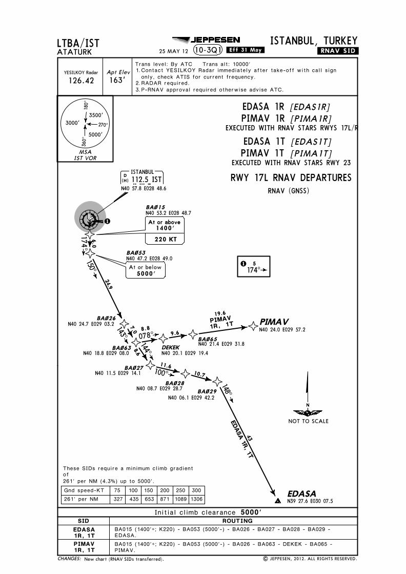
Licensed to SMA. Printed on 03 Oct 2013.
Notice: After 4 Oct 2013 0901Z, this chart may no longer be valid. Disc 19-2013JEPPESENJeppView 3.7.5.0
JEPPESEN
163'
LTBA/ISTTrans level: By ATC Trans alt: 10000'
ATATURKISTANBUL, TURKEY
Apt ElevYESILKOY Radar
126.42
10-3Q1 .RNAV.SID.
EDASA.
PIMAV.
D ISTANBUL112.5 ISTIST
N40 57.8 E028 48.6
1
BA~53N40 47.2 E028 49.0
BA~26N40 24.7 E029 03.2
BA~63N40 18.8 E029 08.0
BA~27N40 11.5 E029 14.1
BA~28N40 08.7 E029 28.7 BA~29
N40 06.1 E029 42.2
EDASAN39 27.6 E030 07.5
DEKEKN40 20.1 E029 19.4
BA~65N40 21.4 E029 31.8
PIMAVN40 24.0 E029 57.2
BA~15
At or below5000'
N40 53.2 E028 48.7
1 5174^
174^150^
143^
144^
100^
078^
148^
24.9
8.6
11.610.7
8.89.6
19.66.0
7.0
At or above
220 KT
At or above1400'
These SIDs require a minimum climb gradientof261' per NM (4.3%) up to 5000'.
BA015 (1400'+; K220) - BA053 (5000'-) - BA026 - BA027 - BA028 - BA029 -
BA015 (1400'+; K220) - BA053 (5000'-) - BA026 - BA063 - DEKEK - BA065 -
PIMAV1R, 1T
EDASA 1R, 1T43
(H)
25 MAY 12 .Eff.31.May.
New chart (RNAV SIDs transferred). | JEPPESEN, 2012. ALL RIGHTS RESERVED.
Contact YESILKOY Radar immediately after take-off with call signonly, check ATIS for current frequency.RADAR required.P-RNAV approval required otherwise advise ATC.
1. 2.3.
MSAIST VOR
3500'
5000'
3000'
180^
360^
270^
CHANGES:
SID ROUTINGInitial climb clearance 5000'
EXECUTED WITH RNAV STARS RWYS 17L/R
RNAV (GNSS)
75 100 150 200 250 300261' per NM 327 435 653 871 1089 1306Gnd speed-KT
EDASA 1TPIMAV 1T
[EDAS1T]
EXECUTED WITH RNAV STARS RWY 23
NOT TO SCALE
[PIMA1T]
EDASA 1RPIMAV 1R
[EDAS1R][PIMA1R]
RWY 17L RNAV DEPARTURES
EDASA1R, 1TPIMAV1R, 1T
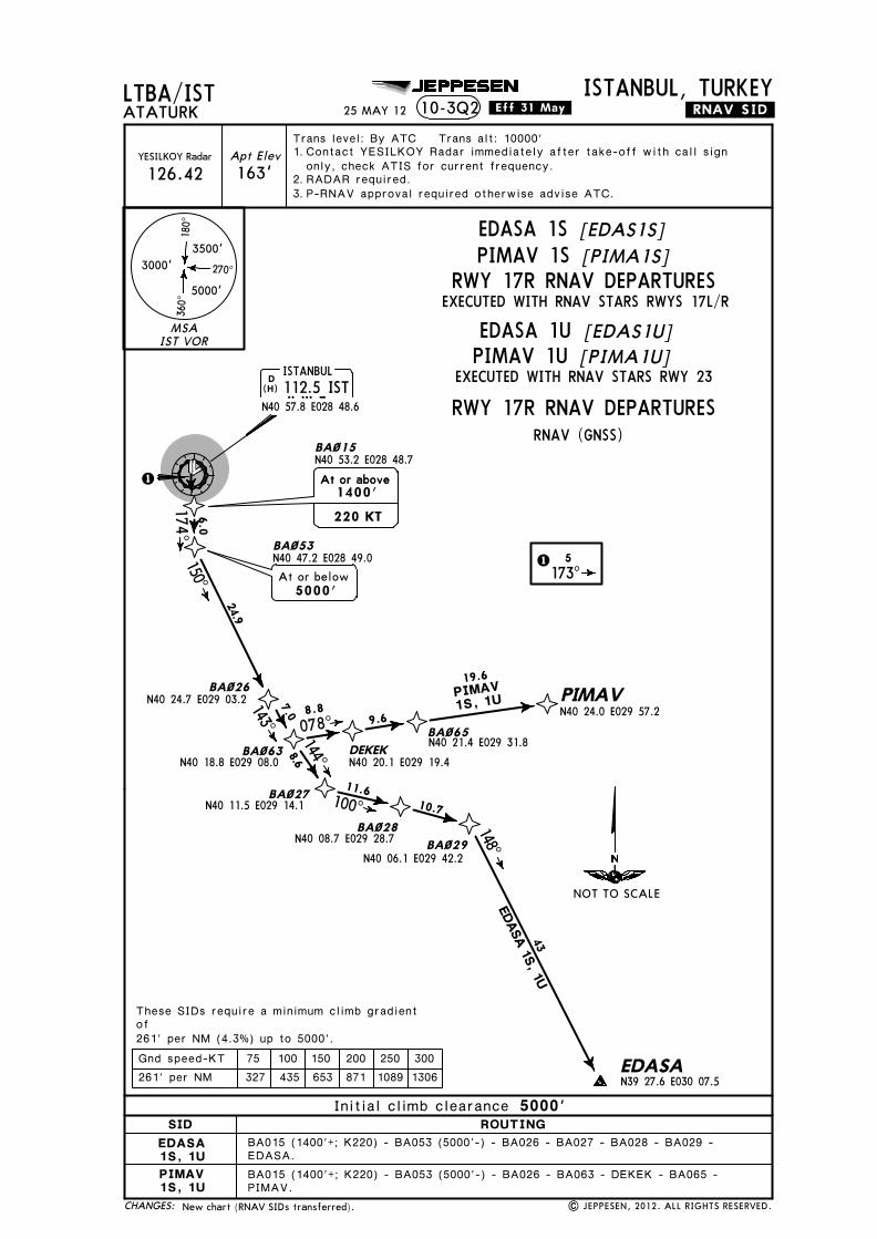
Licensed to SMA. Printed on 03 Oct 2013.
Notice: After 4 Oct 2013 0901Z, this chart may no longer be valid. Disc 19-2013JEPPESENJeppView 3.7.5.0
JEPPESEN
163'
LTBA/ISTTrans level: By ATC Trans alt: 10000'
ATATURKISTANBUL, TURKEY
Apt ElevYESILKOY Radar
126.42
10-3Q2 .RNAV.SID.
EDASA.
PIMAV.
D ISTANBUL112.5 ISTIST
N40 57.8 E028 48.6
1
BA~53N40 47.2 E028 49.0
BA~26N40 24.7 E029 03.2
BA~63N40 18.8 E029 08.0
BA~27N40 11.5 E029 14.1
BA~28N40 08.7 E029 28.7 BA~29
N40 06.1 E029 42.2
EDASAN39 27.6 E030 07.5
DEKEKN40 20.1 E029 19.4
BA~65N40 21.4 E029 31.8
PIMAVN40 24.0 E029 57.2
BA~15
At or below5000'
N40 53.2 E028 48.7
1 5173^
174^150^
143^
144^
100^
078^
148^
24.9
8.6
11.610.7
8.89.6
19.66.0
7.0
At or above
220 KT
At or above1400'
These SIDs require a minimum climb gradientof261' per NM (4.3%) up to 5000'.
BA015 (1400'+; K220) - BA053 (5000'-) - BA026 - BA027 - BA028 - BA029 -
BA015 (1400'+; K220) - BA053 (5000'-) - BA026 - BA063 - DEKEK - BA065 -
PIMAV1S, 1U
EDASA 1S, 1U43
(H)
25 MAY 12 .Eff.31.May.
New chart (RNAV SIDs transferred). | JEPPESEN, 2012. ALL RIGHTS RESERVED.
Contact YESILKOY Radar immediately after take-off with call signonly, check ATIS for current frequency.RADAR required.P-RNAV approval required otherwise advise ATC.
1. 2.3.
MSAIST VOR
3500'
5000'
3000'
180^
360^
270^
CHANGES:
SID ROUTINGInitial climb clearance 5000'
EXECUTED WITH RNAV STARS RWYS 17L/R
[EDAS1S]EDASA 1SPIMAV 1S
RNAV (GNSS)
75 100 150 200 250 300261' per NM 327 435 653 871 1089 1306Gnd speed-KT
[EDAS1U]EDASA 1U[PIMA1U]PIMAV 1U
EXECUTED WITH RNAV STARS RWY 23
NOT TO SCALE
[PIMA1S]RWY 17R RNAV DEPARTURES
RWY 17R RNAV DEPARTURES
EDASA1S, 1UPIMAV1S, 1U
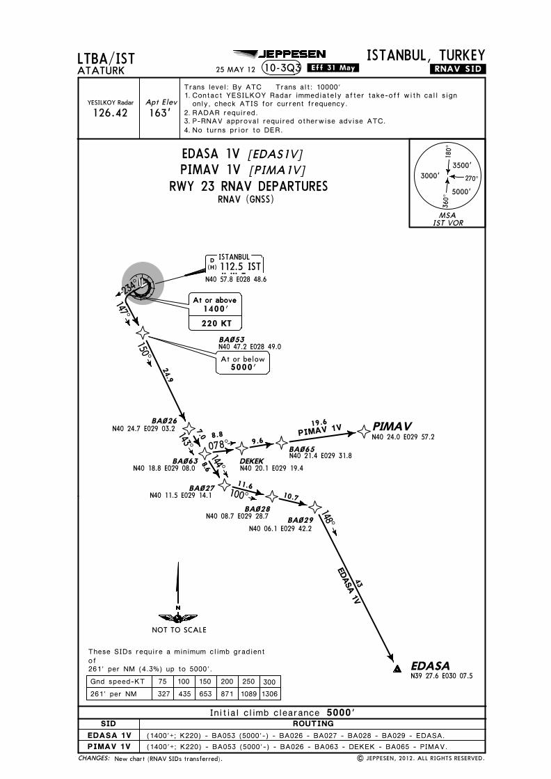
JEPPESEN
163'
LTBA/ISTTrans level: By ATC Trans alt: 10000'
ATATURKISTANBUL, TURKEY
Apt ElevYESILKOY Radar
126.42
10-3Q3 .RNAV.SID.
BA~26N40 24.7 E029 03.2
BA~63N40 18.8 E029 08.0
BA~27N40 11.5 E029 14.1
BA~28N40 08.7 E029 28.7 BA~29
N40 06.1 E029 42.2
EDASAN39 27.6 E030 07.5
DEKEKN40 20.1 E029 19.4
BA~65N40 21.4 E029 31.8
PIMAVN40 24.0 E029 57.2
150^
143^
144̂
100^
078^
148^
24.9
8.6
11.610.7
8.89.6
19.6
D ISTANBUL112.5 ISTIST
N40 57.8 E028 48.6
BA~53N40 47.2 E028 49.0
EDASA 1V
PIMAV 1V
At or below5000'
147^
7.0
At or above
220 KT
At or above1400'
These SIDs require a minimum climb gradientof261' per NM (4.3%) up to 5000'.
(1400'+; K220) - BA053 (5000'-) - BA026 - BA063 - DEKEK - BA065 - PIMAV.(1400'+; K220) - BA053 (5000'-) - BA026 - BA027 - BA028 - BA029 - EDASA.
43
(H)
25 MAY 12 .Eff.31.May.
New chart (RNAV SIDs transferred). | JEPPESEN, 2012. ALL RIGHTS RESERVED.
Contact YESILKOY Radar immediately after take-off with call signonly, check ATIS for current frequency.RADAR required.P-RNAV approval required otherwise advise ATC.No turns prior to DER.
1. 2.3.4.
MSAIST VOR
3500'
5000'
3000'
180^
360^
270^
CHANGES:
RWY 23 RNAV DEPARTURES
[EDAS1V]EDASA 1V[PIMA1V]PIMAV 1V
SID ROUTINGInitial climb clearance 5000'
EDASA 1VPIMAV 1V
RNAV (GNSS)
75 100 150 200 250 300261' per NM 327 435 653 871 1089 1306Gnd speed-KT
234^
NOT TO SCALE
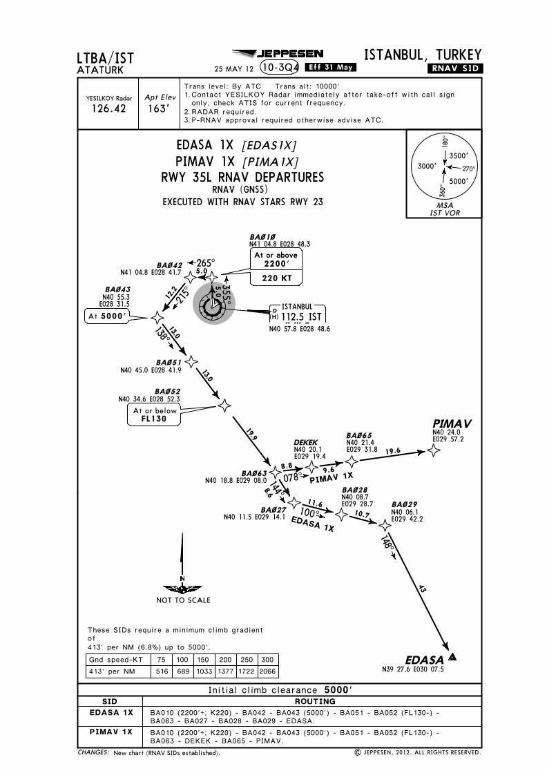
Licensed to SMA. Printed on 03 Oct 2013.
Notice: After 4 Oct 2013 0901Z, this chart may no longer be valid. Disc 19-2013JEPPESENJeppView 3.7.5.0
JEPPESEN
163'
LTBA/ISTTrans level: By ATC Trans alt: 10000'
ATATURKISTANBUL, TURKEY
Apt ElevYESILKOY Radar
126.42
10-3Q4 .RNAV.SID.
D ISTANBUL112.5 ISTIST
N40 57.8 E028 48.6(H)
25 MAY 12 .Eff.31.May.
| JEPPESEN, 2012. ALL RIGHTS RESERVED.
BA~1~N41 04.8 E028 48.3
5.0355^
PIMAV
EDASAN39 27.6 E030 07.5
BA~29
BA~42N41 04.8 E028 41.7
BA~43
BA~63N40 18.8 E029 08.0
BA~27N40 11.5 E029 14.1
BA~28
BA~65DEKEK
BA~51N40 45.0 E028 41.9
BA~52N40 34.6 E028 52.3
BA010 (2200'+; K220) - BA042 - BA043 (5000') - BA051 - BA052 (FL130-) -BA063 - DEKEK - BA065 - PIMAV.
BA010 (2200'+; K220) - BA042 - BA043 (5000') - BA051 - BA052 (FL130-) -BA063 - BA027 - BA028 - BA029 - EDASA.
265^5.0
At or above
220 KT
At or above2200'
N40 55.3E028 31.55000'At
12.2
215^
At or belowFL130
13.0
13.0
19.9
138^
N40 20.1E029 19.4
N40 21.4E029 31.8
N40 24.0E029 57.2
078^8.8 9.6
19.6
144^
100^
148^
8.6
11.610.7
43
EDASA 1X
PIMAV 1X
N40 08.7E029 28.7
N40 06.1E029 42.2
These SIDs require a minimum climb gradientof413' per NM (6.8%) up to 5000'.
New chart (RNAV SIDs established).
Contact YESILKOY Radar immediately after take-off with call signonly, check ATIS for current frequency.RADAR required.P-RNAV approval required otherwise advise ATC.
1. 2.3.
MSAIST VOR
3500'
5000'
3000'
180^
360^
270^
CHANGES:
EDASA 1XPIMAV 1X
SID ROUTINGInitial climb clearance 5000'
[EDAS1X][PIMA1X]
RNAV (GNSS)
NOT TO SCALE
RWY 35L RNAV DEPARTURES
EDASA 1X
PIMAV 1X
EXECUTED WITH RNAV STARS RWY 23
75 100 150 200 250 300413' per NM 516 689 1033 1377 1722 2066Gnd speed-KT
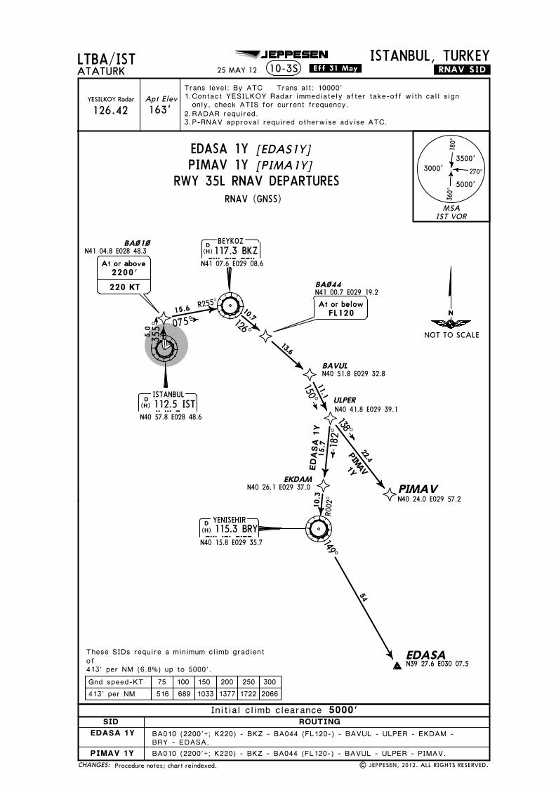
Licensed to SMA. Printed on 03 Oct 2013.
Notice: After 4 Oct 2013 0901Z, this chart may no longer be valid. Disc 19-2013JEPPESENJeppView 3.7.5.0
JEPPESEN
163'
LTBA/ISTTrans level: By ATC Trans alt: 10000'
ATATURKISTANBUL, TURKEY
Apt ElevYESILKOY Radar
126.42
10-3S .RNAV.SID.
D BEYKOZ117.3 BKZBKZ
N41 07.6 E029 08.6
BAVULN40 51.8 E029 32.8
ULPERN40 41.8 E029 39.1
PIMAVN40 24.0 E029 57.2
EKDAMN40 26.1 E029 37.0
BA~44N41 00.7 E029 19.2At or below10.7
13.6
11.1
22.415.7
10.3
126^
150^
138̂
182^
R002
^
At or belowFL120
D ISTANBUL112.5 ISTIST
N40 57.8 E028 48.6
075^15.6 R255^
BA~1~N41 04.8 E028 48.3
At or aboveAt or above2200'220 KT
EDA
SA
1Y
YENISEHIR115.3 BRYBRY
N40 15.8 E029 35.7
D
EDASAN39 27.6 E030 07.5
149^
54PIMAV1Y
5.0
355^
BA010 (2200'+; K220) - BKZ - BA044 (FL120-) - BAVUL - ULPER - EKDAM -
BA010 (2200'+; K220) - BKZ - BA044 (FL120-) - BAVUL - ULPER - PIMAV.
413' per NM (6.8%) up to 5000'.
These SIDs require a minimum climb gradientof
BRY - EDASA.
(H)
(H)
(H)
25 MAY 12 .Eff.31.May.
Procedure notes; chart reindexed. | JEPPESEN, 2012. ALL RIGHTS RESERVED.
Contact YESILKOY Radar immediately after take-off with call signonly, check ATIS for current frequency.RADAR required.P-RNAV approval required otherwise advise ATC.
1. 2.3.
MSAIST VOR
3500'
5000'
3000'
180^
360^
270^
CHANGES:
75 100 150 200 250 300Gnd speed-KT
SID ROUTINGInitial climb clearance 5000'
RNAV (GNSS)
413' per NM 516 689 1033 1377 1722 2066
NOT TO SCALE
PIMAV 1Y [PIMA1Y]RWY 35L RNAV DEPARTURES
EDASA 1Y [EDAS1Y]
PIMAV 1Y
EDASA 1Y

Licensed to SMA. Printed on 03 Oct 2013.
Notice: After 4 Oct 2013 0901Z, this chart may no longer be valid. Disc 19-2013JEPPESENJeppView 3.7.5.0
JEPPESEN
163'
LTBA/ISTTrans level: By ATC Trans alt: 10000'
ATATURKISTANBUL, TURKEY
| JEPPESEN, 2012. ALL RIGHTS RESERVED.
Apt ElevYESILKOY Radar
126.42
10-3T .RNAV.SID.
D ISTANBUL112.5 ISTIST
N40 57.8 E028 48.6
BA~1~N41 04.8 E028 48.3
BA010 (1600'+; K220) - BKZ - BA044 (FL120-) - BAVUL - ULPER - EKDAM -
BA010 (1600'+; K220) - BKZ - BA044 (FL120-) - BAVUL - ULPER - PIMAV.
At or aboveAt or above1600'220 KT
D BEYKOZ117.3 BKZBKZ
N41 07.6 E029 08.6
BAVULN40 51.8 E029 32.8
ULPERN40 41.8 E029 39.1
PIMAVN40 24.0 E029 57.2
EKDAMN40 26.1 E029 37.0
BA~44N41 00.7 E029 19.2At or below10.7
13.6
11.1
22.415.7
10.3
126^
150^
138^
182^
R002
^
At or belowFL120
075^15.6 R255^
EDA
SA 1
Z
YENISEHIR115.3 BRYBRY
N40 15.8 E029 35.7
D
EDASAN39 27.6 E030 07.5
149^
54PIMAV1Z
5.0
354^
304' per NM (5%) up to 5000'.
These SIDs require a minimum climb gradientof
BRY - EDASA.
(H)
(H)
(H)
25 MAY 12 .Eff.31.May.
Procedure notes; chart reindexed.
Contact YESILKOY Radar immediately after take-off with call signonly, check ATIS for current frequency.RADAR required.P-RNAV approval required otherwise advise ATC.
1. 2.3.
MSAIST VOR
3500'
5000'
3000'
180^
360^
270^
CHANGES:
75 100 150 200 250 300Gnd speed-KT304' per NM 380 506 760 1013 1266 1519
NOT TO SCALE
SID ROUTINGInitial climb clearance 9000'
PIMAV 1Z
EDASA 1Z
RNAV (GNSS)
PIMAV 1Z [PIMA1Z]RWY 35R RNAV DEPARTURES
EDASA 1Z [EDAS1Z]

Licen
sed to
SM
A. P
rinted
on
03 Oct 2013.
No
tice: After 4 O
ct 2013 0901Z, th
is chart m
ay no
lon
ger b
e valid. D
isc 19-2013J
EP
PE
SE
NJep
pV
iew 3.7.5.0
JEPPESEN
163'
LTBA/ISTTrans level: By A
TC Trans alt: 10000'
ATA
TURK
ISTANBUL, TURKEY
Apt Elev
YESILKO
Y Radar
126.42
10-3T1.RNAV.SID.
D ISTANBUL112.5 ISTIST
N40 57.8 E028 48.6(H)
25 MA
Y 12
.Eff.31.May.
| JEP
PESEN
, 2012. A
LL RIG
HTS R
ESERV
ED.
These SIDs require a minimum climb gradientof304' per NM (5%) up to 5000'.
BA~1~N41 04.8 E028 48.3
5.0354^
BA~42BA~43 265^5.0
At or above
220 KT
At or above2200'N40 55.3
E028 31.5
12.2
215^
GOLDO1E
MARM
A1E
OKBAL
BEDELN40 50.0 E027 30.1
GELBUN40 56.1 E027 08.4
GOLDON40 52.9 E026 15.0
MARMAN40 31.6 E027 38.9
212̂
266^286^
261^ 17.5
22.7
20.0
41
BA010 (2200'+; K220) - BA042 - BA043 (5000') - OKBAL - BEDEL - GELBU - GOLDO.BA010 (2200'+; K220) - BA042 - BA043 (5000') - OKBAL - MARMA.
N40 50.0E027 56.5
N41 04.8E028 41.7
5000'At
254^27.1
New
chart (RNA
V SID
s established).
Contact YESILKO
Y Radar immediately after take-off w
ith call signonly, check A
TIS for current frequency.RA
DAR required.
P-RNAV approval required otherw
ise advise ATC.
1. 2.3.
MSAIST VOR
3500'
5000'
3000'
180^
360^
270^
CHA
NG
ES:
GOLDO 1EMARM
A 1E
SID ROUTINGInitial climb clearance 5000'
[GO
LD1E]
[MA
RM1E]
RNAV (GNSS)
75 100 150 200 250 300304' per NM 380 506 760 1013 1266 1519Gnd speed-KT
NOT TO SCALERW
Y 35R RNAV DEPARTURES
GOLDO 1EMARMA 1E
EXECUTED WITH RNAV STARS RW
Y 23

Licen
sed to
SM
A. P
rinted
on
03 Oct 2013.
No
tice: After 4 O
ct 2013 0901Z, th
is chart m
ay no
lon
ger b
e valid. D
isc 19-2013J
EP
PE
SE
NJep
pV
iew 3.7.5.0
JEPPESEN
GOLDO1P
MARM
A1P
163'
LTBA/ISTTrans level: By A
TC Trans alt: 10000'
ATA
TURK
ISTANBUL, TURKEY
Apt Elev
YESILKO
Y Radar
126.42
10-3T2.RNAV.SID.
BA~35
D ISTANBUL112.5 ISTIST
N40 57.8 E028 48.6
OKBAL
BEDELN40 50.0 E027 30.1
GELBUN40 56.1 E027 08.4GOLDO
N40 52.9 E026 15.0
MARMAN40 31.6 E027 38.9
ERLEBN41 07.3 E028 33.3 BA~24
N41 09.2 E028 47.4
N41 01.3 E028 55.5
At or below
318^
256^234̂
212^266^
286^
261^ 17.510
10.8
32.8
22.7
At or below8000'
5.0
20.0
At or above
220 KT
At or above1600'
These SIDs require a minimum climb gradientof304' per NM (5%) up to 5000'.
BA035 (1600'+; K220) - BA024 - ERLEB (8000'-) - OKBAL -BEDEL - GELBU - GOLDO.BA035 (1600'+; K220) - BA024 - ERLEB (8000'-) - OKBAL -MARMA.
41(H)
25 MA
Y 12
.Eff.31.May.
N40 50.0E027 56.5
New
chart (RNA
V SID
s transferred).|
JEPPESEN
, 2012. A
LL RIG
HTS R
ESERV
ED.
Contact YESILKO
Y Radar immediately after take-off w
ith call signonly, check A
TIS for current frequency.RA
DAR required.
P-RNAV approval required otherw
ise advise ATC.
1. 2.3.
MSAIST VOR
3500'
5000'
3000'
180^
360^
270^
CHA
NG
ES:
75 100 150 200 250 300304' per NM 380 506 760 1013 1266 1519Gnd speed-KT
RWY 05 RNAV DEPARTURES
[GO
LD1P]
GOLDO 1P[M
ARM
1P]MARMA 1P
SID ROUTINGInitial climb clearance 5000'
GOLDO 1P
MARMA 1P
RNAV (GNSS)
053^
NOT TO SCALE

Licen
sed to
SM
A. P
rinted
on
03 Oct 2013.
No
tice: After 4 O
ct 2013 0901Z, th
is chart m
ay no
lon
ger b
e valid. D
isc 19-2013J
EP
PE
SE
NJep
pV
iew 3.7.5.0
JEPPESEN
163'
LTBA/ISTTrans level: By A
TC Trans alt: 10000'
ATA
TURK
ISTANBUL, TURKEY
Apt Elev
YESILKO
Y Radar
126.42
10-3T3.RNAV.SID.
1
BA~15N40 53.2 E028 48.7
ABLEM
OKBAL
BEDELN40 50.0 E027 30.1
GELBUN40 56.1 E027 08.4GOLDO
N40 52.9 E026 15.0
MARMA
212̂
266^286^
261^17.5
22.7
BEDEL - GELBU - GOLDO.
MARMA.
N40 51.9E028 27.9
261^15.9
23.9
D ISTANBUL112.5 ISTIST
N40 57.8 E028 48.61 5
174^
These SIDs require a minimum climb gradientof261' per NM (4.3%) up to 5000'.
At or above
220 KT
At or above1400'
BA015 (1400'+; K220) - ABLEM- OKBAL -
BA015 (1400'+; K220) - ABLEM- OKBAL -
20.0
N40 31.6E027 38.9
GOLDO1R, 1T
N40 50.0E027 56.5
MARM
A1R
, 1T
41
(H)
25 MA
Y 12
.Eff.31.May.
New
chart (RNA
V SID
s transferred).|
JEPPESEN
, 2012. A
LL RIG
HTS R
ESERV
ED.
Contact YESILKO
Y Radar immediately after take-off w
ith call signonly, check A
TIS for current frequency.RA
DAR required.
P-RNAV approval required otherw
ise advise ATC.
1. 2.3.
MSAIST VOR
3500'
5000'
3000'
180^
360^
270^
CHA
NG
ES:
SID ROUTINGInitial climb clearance 5000'
75 100 150 200 250 300261' per NM 327 435 653 871 1089 1306Gnd speed-KT
NOT TO SCALE
GOLDO 1RMARMA 1R
EXECUTED WITH RNAV STARS RW
YS 17L/R
EXECUTED WITH RNAV STARS RW
Y 23
[GO
LD1R]
[MA
RM1R]
GOLDO 1TMARMA 1T
RWY 17L RNAV DEPARTURES
[GO
LD1T]
[MA
RM1T]
RNAV (GNSS)
GOLDO1R, 1TMARMA1R, 1T
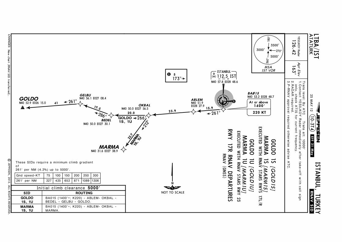
Licen
sed to
SM
A. P
rinted
on
03 Oct 2013.
No
tice: After 4 O
ct 2013 0901Z, th
is chart m
ay no
lon
ger b
e valid. D
isc 19-2013J
EP
PE
SE
NJep
pV
iew 3.7.5.0
JEPPESEN
163'
LTBA/ISTTrans level: By A
TC Trans alt: 10000'
ATA
TURK
ISTANBUL, TURKEY
Apt Elev
YESILKO
Y Radar
126.42
10-3T4.RNAV.SID.
1
BA~15N40 53.2 E028 48.7
ABLEM
OKBALN40 50.0 E027 56.5
BEDELN40 50.0 E027 30.1
GELBUN40 56.1 E027 08.4GOLDO
N40 52.9 E026 15.0
MARMAN40 31.6 E027 38.9
212̂
266^286^
261^17.5
22.7
BEDEL - GELBU - GOLDO.
MARMA.
N40 51.9E028 27.9
261^15.9
23.9
D ISTANBUL112.5 ISTIST
N40 57.8 E028 48.6
These SIDs require a minimum climb gradientof261' per NM (4.3%) up to 5000'.
At or above
220 KT
At or above1400'
BA015 (1400'+; K220) - ABLEM- OKBAL -
BA015 (1400'+; K220) - ABLEM- OKBAL -
20.0GOLDO1S, 1U
MARM
A1S
, 1U
41
1 5173^ (H)
25 MA
Y 12
.Eff.31.May.
New
chart (RNA
V SID
transferred).|
JEPPESEN
, 2012. A
LL RIG
HTS R
ESERV
ED.
Contact YESILKO
Y Radar immediately after take-off w
ith call signonly, check A
TIS for current frequency.RA
DAR required.
P-RNAV approval required otherw
ise advise ATC.
1. 2.3.
MSAIST VOR
3500'
5000'
3000'
180^
360^
270^
CHA
NG
ES:
SID ROUTINGInitial climb clearance 5000'
75 100 150 200 250 300261' per NM 327 435 653 871 1089 1306Gnd speed-KT
NOT TO SCALE
GOLDO 1SMARMA 1S
[GO
LD1S]
[MA
RM1S]
EXECUTED WITH RNAV STARS RW
YS 17L/R
RWY 17R RNAV DEPARTURES
GOLDO 1UMARM
A 1U[G
OLD
1U]
[MA
RM1U
]EXECUTED W
ITH RNAV STARS RWY 23
RNAV (GNSS)
GOLDO1S, 1UMARMA1S, 1U

Licen
sed to
SM
A. P
rinted
on
03 Oct 2013.
No
tice: After 4 O
ct 2013 0901Z, th
is chart m
ay no
lon
ger b
e valid. D
isc 19-2013J
EP
PE
SE
NJep
pV
iew 3.7.5.0
JEPPESEN
163'
LTBA/ISTTrans level: By A
TC Trans alt: 10000'
ATA
TURK
ISTANBUL, TURKEY
Apt Elev
YESILKO
Y Radar
126.42
10-3T5.RNAV.SID.
BA061 - ABLEM- OKBAL - BEDEL - GELBU - GOLDO.BA061 - ABLEM- OKBAL - MARMA.
D ISTANBUL112.5 ISTIST
N40 57.8 E028 48.6
ABLEM
OKBALN40 50.0 E027 56.5
BEDELN40 50.0 E027 30.1
GELBUN40 56.1 E027 08.4GOLDO
N40 52.9 E026 15.0
MARMAN40 31.6 E027 38.9
212̂
266^286^
261^17.5
22.7
N40 51.9E028 27.9
23.9BA~61N40 52.5 E028 36.8
10.5
261^6.8
MARM
A1V
20.0GOLDO
1V
41
These SIDs require a minimum climb gradientof261' per NM (4.3%) up to 5000'.
(H)
25 MA
Y 12
.Eff.31.May.
New
chart (RNA
V SID
s transferred).|
JEPPESEN
, 2012. A
LL RIG
HTS R
ESERV
ED.
Contact YESILKO
Y Radar immediately after take-off w
ith call signonly, check A
TIS for current frequency.RA
DAR required.
P-RNAV approval required otherw
ise advise ATC.
No turns prior to D
ER.
1. 2.3.4.
MSAIST VOR
3500'
5000'
3000'
180^
360^
270^
CHA
NG
ES:
RWY 23 RNAV DEPARTURES
[GO
LD1V
]GOLDO 1V
[MA
RM1V
]
SID ROUTINGInitial climb clearance 5000'
GOLDO 1VMARMA 1V
RNAV (GNSS)
MARM
A 1V
234̂
NOT TO SCALE
75 100 150 200 250 300261' per NM 327 435 653 871 1089 1306Gnd speed-KT
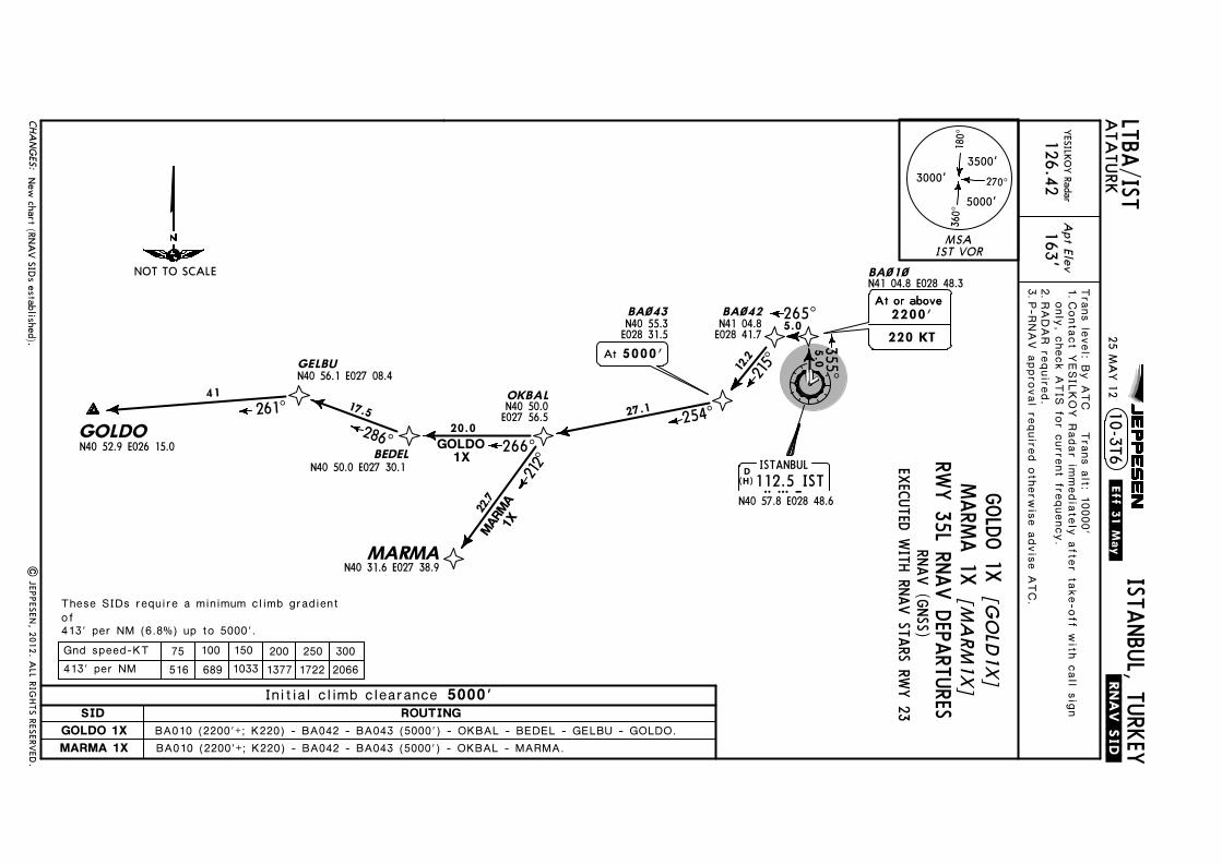
Licen
sed to
SM
A. P
rinted
on
03 Oct 2013.
No
tice: After 4 O
ct 2013 0901Z, th
is chart m
ay no
lon
ger b
e valid. D
isc 19-2013J
EP
PE
SE
NJep
pV
iew 3.7.5.0
JEPPESEN
163'
LTBA/ISTTrans level: By A
TC Trans alt: 10000'
ATA
TURK
ISTANBUL, TURKEY
Apt Elev
YESILKO
Y Radar
126.42
10-3T6.RNAV.SID.
D ISTANBUL112.5 ISTIST
N40 57.8 E028 48.6(H)
25 MA
Y 12
.Eff.31.May.
| JEP
PESEN
, 2012. A
LL RIG
HTS R
ESERV
ED.
BA~1~N41 04.8 E028 48.3
5.0355^
BA~42BA~43 265^5.0
At or above
220 KT
At or above2200'N40 55.3
E028 31.5
12.2
215^
GOLDO1X
MARM
A1X
OKBAL
BEDELN40 50.0 E027 30.1
GELBUN40 56.1 E027 08.4
GOLDON40 52.9 E026 15.0
MARMAN40 31.6 E027 38.9
212̂
266^286^
261^ 17.5
22.7
20.0
41
BA010 (2200'+; K220) - BA042 - BA043 (5000') - OKBAL - BEDEL - GELBU - GOLDO.BA010 (2200'+; K220) - BA042 - BA043 (5000') - OKBAL - MARMA.
N40 50.0E027 56.5
N41 04.8E028 41.7
5000'At
254^27.1
These SIDs require a minimum climb gradientof413' per NM (6.8%) up to 5000'.
New
chart (RNA
V SID
s established).
Contact YESILKO
Y Radar immediately after take-off w
ith call signonly, check A
TIS for current frequency.RA
DAR required.
P-RNAV approval required otherw
ise advise ATC.
1. 2.3.
MSAIST VOR
3500'
5000'
3000'
180^
360^
270^
CHA
NG
ES:
GOLDO 1XMARMA 1X
SID ROUTINGInitial climb clearance 5000'
[GO
LD1X
][M
ARM
1X]
RNAV (GNSS)
NOT TO SCALERW
Y 35L RNAV DEPARTURES
GOLDO 1XMARMA 1X
EXECUTED WITH RNAV STARS RW
Y 23
75 100 150 200 250 300413' per NM 516 689 1033 1377 1722 2066Gnd speed-KT

Licen
sed to
SM
A. P
rinted
on
03 Oct 2013.
No
tice: After 4 O
ct 2013 0901Z, th
is chart m
ay no
lon
ger b
e valid. D
isc 19-2013J
EP
PE
SE
NJep
pV
iew 3.7.5.0
JEPPESEN
163'
LTBA/ISTTrans level: By A
TC Trans alt: 10000'
ATA
TURK
ISTANBUL, TURKEY
Apt Elev
YESILKO
Y Radar
126.42
10-3T7.RNAV.SID.
D ISTANBUL112.5 ISTIST
N40 57.8 E028 48.6
BA~1~N41 04.8 E028 48.3
OKBALN40 50.0 E027 56.5BEDEL
N40 50.0 E027 30.1
GELBUN40 56.1 E027 08.4
GOLDON40 52.9 E026 15.0
MARMAN40 31.6 E027 38.9
ERLEBN41 07.3 E028 33.3
At or belowAt or below8000'
234̂
212̂
266^286^
261^ 17.5
32.8
22.7
278^11.6
20.0
413' per NM (6.8%) up to 5000'.
BA010 (2200'+; K220) - ERLEB (8000'-) - OKBAL - BEDEL - GELBU - GOLDO.BA010 (2200'+; K220) - ERLEB (8000'-) - OKBAL - MARMA.
At or aboveAt or aboveAt or above2200'220 KT
At or aboveAt or above2200'
At or aboveAt or above2200'
5.0
355^
These SIDs require a minimum climb gradientof
GOLDO1Y
MARM
A1Y
41
(H)
25 MA
Y 12
.Eff.31.May.
New
chart (RNA
V SID
s transferred).|
JEPPESEN
, 2012. A
LL RIG
HTS R
ESERV
ED.
Contact YESILKO
Y Radar immediately after take-off w
ith call signonly, check A
TIS for current frequency.RA
DAR required.
P-RNAV approval required otherw
ise advise ATC.
1. 2.3.
MSAIST VOR
3500'
5000'
3000'
180^
360^
270^
CHA
NG
ES:
75 100 150 200 250 300Gnd speed-KT
SID ROUTINGInitial climb clearance 5000'
413' per NM 516 689 1033 1377 1722 2066
NOT TO SCALE
RNAV (GNSS)RW
Y 35L RNAV DEPARTURES
GOLDO 1YMARM
A 1Y[G
OLD
1Y][M
ARM
1Y]
GOLDO 1Y
MARMA 1Y
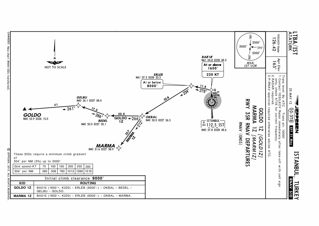
Licen
sed to
SM
A. P
rinted
on
03 Oct 2013.
No
tice: After 4 O
ct 2013 0901Z, th
is chart m
ay no
lon
ger b
e valid. D
isc 19-2013J
EP
PE
SE
NJep
pV
iew 3.7.5.0
JEPPESEN
163'
LTBA/ISTTrans level: By A
TC Trans alt: 10000'
ATA
TURK
ISTANBUL, TURKEY
| JEP
PESEN
, 2012. A
LL RIG
HTS R
ESERV
ED.
Apt Elev
YESILKO
Y Radar
126.42
10-3T8.RNAV.SID.
D ISTANBUL112.5 ISTIST
N40 57.8 E028 48.6
BA~1~N41 04.8 E028 48.3
OKBALN40 50.0 E027 56.5BEDEL
N40 50.0 E027 30.1
GELBUN40 56.1 E027 08.4
GOLDON40 52.9 E026 15.0
MARMAN40 31.6 E027 38.9
ERLEBN41 07.3 E028 33.3
At or belowAt or below8000'
234̂
212^266^
286^261^ 17.5
32.8
22.7
278^11.6
20.0
304' per NM (5%) up to 5000'.
BA010 (1600'+; K220) - ERLEB (8000'-) - OKBAL - BEDEL - GELBU - GOLDO.BA010 (1600'+; K220) - ERLEB (8000'-) - OKBAL - MARMA.
At or aboveAt or aboveAt or above1600'220 KT
At or aboveAt or aboveAt or aboveAt or above
GOLDO1Z
MARM
A1Z
These SIDs require a minimum climb gradientof
354^5.0
41
(H)
25 MA
Y 12
.Eff.31.May.
New
chart (RNA
V SID
s transferred).
Contact YESILKO
Y Radar immediately after take-off w
ith call signonly, check A
TIS for current frequency.RA
DAR required.
P-RNAV approval required otherw
ise advise ATC.
1. 2.3.
MSAIST VOR
3500'
5000'
3000'
180^
360^
270^
CHA
NG
ES:
75 100 150 200 250 300Gnd speed-KT304' per NM 380 506 760 1013 1266 1519
NOT TO SCALE
RNAV (GNSS)RW
Y 35R RNAV DEPARTURES
[GO
LD1Z]
GOLDO 1Z[M
ARM
1Z]MARM
A 1Z
SID ROUTINGInitial climb clearance 9000'
GOLDO 1Z
MARMA 1Z
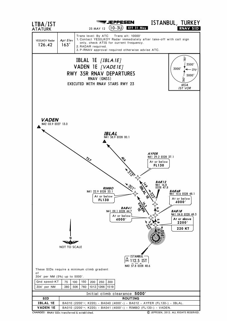
Licensed to SMA. Printed on 03 Oct 2013.
Notice: After 4 Oct 2013 0901Z, this chart may no longer be valid. Disc 19-2013JEPPESENJeppView 3.7.5.0
JEPPESEN
163'
LTBA/ISTTrans level: By ATC Trans alt: 10000'
ATATURKISTANBUL, TURKEY
Apt ElevYESILKOY Radar
126.42
10-3U .RNAV.SID.
D ISTANBUL112.5 ISTIST
N40 57.8 E028 48.6(H)
25 MAY 12 .Eff.31.May.
RNAV SIDs transferred & established. | JEPPESEN, 2012. ALL RIGHTS RESERVED.
These SIDs require a minimum climb gradientof304' per NM (5%) up to 5000'.
BA~1~N41 04.8 E028 48.3
BA~12
BA~4~N41 10.6 E028 48.1
5.0 354^
N41 16.8E028 47.8
5.86.2
VADENN42 03.9 E027 13.0
RIMBON41 22.9 E028 33.1
301^
72.7
AYFERN41 29.2 E028 37.1
IBLALN41 58.9 E028 00.1
At or belowFL130
40.6
BA010 (2200'+; K220) - BA040 (4000'-) - BA012 - AYFER (FL130-) - IBLAL.BA010 (2200'+; K220) - BA041 (4000'-) - RIMBO (FL130-) - VADEN.
At or above
220 KT
At or above2200'
At or below4000'
BA~41N41 09.1 E028 44.7
14.85.0
16.3323̂
323^
IBLAL 1E
313^
At or belowFL130
At or below4000'
VADEN1E
Contact YESILKOY Radar immediately after take-off with call signonly, check ATIS for current frequency.RADAR required.P-RNAV approval required otherwise advise ATC.
1. 2.3.
MSAIST VOR
3500'
5000'
3000'
180^
360^
270^
CHANGES:
IBLAL 1E
SID ROUTINGInitial climb clearance 5000'
[IBLA1E][VADE1E]
RNAV (GNSS)
75 100 150 200 250 300304' per NM 380 506 760 1013 1266 1519Gnd speed-KT
NOT TO SCALE
RWY 35R RNAV DEPARTURES
IBLAL 1EVADEN 1E
EXECUTED WITH RNAV STARS RWY 23
VADEN 1E

Licensed to SMA. Printed on 03 Oct 2013.
Notice: After 4 Oct 2013 0901Z, this chart may no longer be valid. Disc 19-2013JEPPESENJeppView 3.7.5.0
JEPPESEN
163'
LTBA/ISTTrans level: By ATC Trans alt: 10000'
ATATURKISTANBUL, TURKEY
Apt ElevYESILKOY Radar
126.42
10-3V .RNAV.SID.
BA~35
D ISTANBUL112.5 ISTIST
N40 57.8 E028 48.6
VADENN42 03.9 E027 13.0
RIMBON41 22.9 E028 33.1
BA~24N41 09.2 E028 47.4
318^
301^
72.7
17.4
10
5.0
These SIDs require a minimum climb gradientof304' per NM (5%) up to 5000'.
BA035 (1600'+; K220) - BA013 - AYFER (FL130-) - IBLAL.BA035 (1600'+; K220) - BA024 - RIMBO (FL130-) - VADEN.
AYFERN41 29.2 E028 37.1
IBLALN41 58.9 E028 00.1
VADEN 1P
IBLAL 1P N41 01.3
E028 55.5At or above
220 KT
At or above1600'
15.2348^
BA~13N41 16.3E028 52.8
At or belowFL130
At or belowFL130
313^
17.5
40.6
(H)
25 MAY 12 .Eff.31.May.
Procedure notes; chart reindexed. | JEPPESEN, 2012. ALL RIGHTS RESERVED.
Contact YESILKOY Radar immediately after take-off with call signonly, check ATIS for current frequency.RADAR required.P-RNAV approval required otherwise advise ATC.
1. 2.3.
MSAIST VOR
3500'
5000'
3000'
180^
360^
270^
CHANGES:
75 100 150 200 250 300304' per NM 380 506 760 1013 1266 1519Gnd speed-KT
RWY 05 RNAV DEPARTURES
[IBLA1P]IBLAL 1P[VADE1P]VADEN 1P
SID ROUTINGInitial climb clearance 5000'
IBLAL 1PVADEN 1P
RNAV (GNSS)
053^
NOT TO SCALE
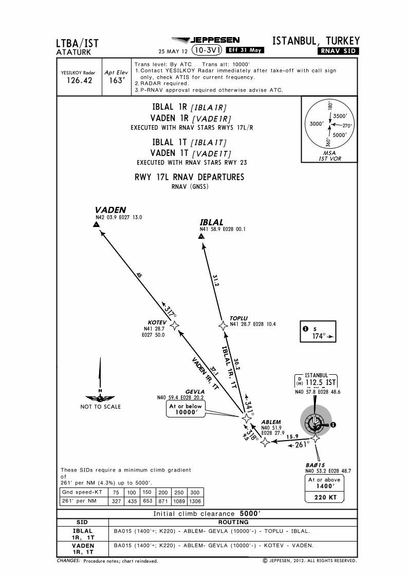
Licensed to SMA. Printed on 03 Oct 2013.
Notice: After 4 Oct 2013 0901Z, this chart may no longer be valid. Disc 19-2013JEPPESENJeppView 3.7.5.0
JEPPESEN
163'
LTBA/ISTTrans level: By ATC Trans alt: 10000'
ATATURKISTANBUL, TURKEY
Apt ElevYESILKOY Radar
126.42
10-3V1 .RNAV.SID.
1
BA~15N40 53.2 E028 48.7
VADENN42 03.9 E027 13.0
ABLEM
GEVLAN40 59.4 E028 20.2
KOTEV
N40 51.9E028 27.9
At or belowAt or below10000'
261^15.99.5
37.1
D ISTANBUL112.5 ISTIST
N40 57.8 E028 48.6
318^
317^
N41 28.7E027 50.0
These SIDs require a minimum climb gradientof261' per NM (4.3%) up to 5000'.
IBLALN41 58.9 E028 00.1
TOPLUN41 28.7 E028 10.4
BA015 (1400'+; K220) - ABLEM- GEVLA (10000'-) - KOTEV - VADEN.
BA015 (1400'+; K220) - ABLEM- GEVLA (10000'-) - TOPLU - IBLAL.
220 KT
At or above1400'
30.2
31.2IBLA
L 1R, 1T
341^
1 5174^
VADEN 1R, 1T
45
(H)
25 MAY 12 .Eff.31.May.
Procedure notes; chart reindexed. | JEPPESEN, 2012. ALL RIGHTS RESERVED.
Contact YESILKOY Radar immediately after take-off with call signonly, check ATIS for current frequency.RADAR required.P-RNAV approval required otherwise advise ATC.
1. 2.3.
MSAIST VOR
3500'
5000'
3000'
180^
360^
270^
CHANGES:
SID ROUTINGInitial climb clearance 5000'
75 100 150 200 250 300261' per NM 327 435 653 871 1089 1306Gnd speed-KT
NOT TO SCALE
VADEN1R, 1T
IBLAL1R, 1T
VADEN 1RIBLAL 1R
EXECUTED WITH RNAV STARS RWYS 17L/R
EXECUTED WITH RNAV STARS RWY 23
[IBLA1R][VADE1R]
VADEN 1T
RWY 17L RNAV DEPARTURES
[VADE1T]
RNAV (GNSS)
IBLAL 1T [IBLA1T]

Licensed to SMA. Printed on 03 Oct 2013.
Notice: After 4 Oct 2013 0901Z, this chart may no longer be valid. Disc 19-2013JEPPESENJeppView 3.7.5.0
JEPPESEN
1 5173^
163'
LTBA/ISTTrans level: By ATC Trans alt: 10000'
ATATURKISTANBUL, TURKEY
Apt ElevYESILKOY Radar
126.42
10-3V2 .RNAV.SID.
1
BA~15N40 53.2 E028 48.7
VADENN42 03.9 E027 13.0
ABLEM
GEVLAN40 59.4 E028 20.2
KOTEV
N40 51.9E028 27.9
At or belowAt or below10000'
261^15.99.5
37.1
D ISTANBUL112.5 ISTIST
N40 57.8 E028 48.6
318^
317^
N41 28.7E027 50.0
These SIDs require a minimum climb gradientof261' per NM (4.3%) up to 5000'.
IBLALN41 58.9 E028 00.1
TOPLUN41 28.7 E028 10.4
BA015 (1400'+; K220) - ABLEM- GEVLA (10000'-) - KOTEV - VADEN.
BA015 (1400'+; K220) - ABLEM- GEVLA (10000'-) - TOPLU - IBLAL.
220 KT
At or above1400'
30.2
31.2IBLA
L 1S, 1U
341^
VADEN 1S, 1U
45
(H)
25 MAY 12 .Eff.31.May.
Procedure notes; chart reindexed. | JEPPESEN, 2012. ALL RIGHTS RESERVED.
Contact YESILKOY Radar immediately after take-off with call signonly, check ATIS for current frequency.RADAR required.P-RNAV approval required otherwise advise ATC.
1. 2.3.
MSAIST VOR
3500'
5000'
3000'
180^
360^
270^
CHANGES:
SID ROUTINGInitial climb clearance 5000'
75 100 150 200 250 300261' per NM 327 435 653 871 1089 1306Gnd speed-KT
NOT TO SCALE
VADEN1S, 1U
IBLAL1S, 1U
VADEN 1S [VADE1S]EXECUTED WITH RNAV STARS RWYS 17L/R
RWY 17R RNAV DEPARTURES
VADEN 1U [VADE1U]EXECUTED WITH RNAV STARS RWY 23
RNAV (GNSS)
IBLAL 1S [IBLA1S]
IBLAL 1U [IBLA1U]

Licensed to SMA. Printed on 03 Oct 2013.
Notice: After 4 Oct 2013 0901Z, this chart may no longer be valid. Disc 19-2013JEPPESENJeppView 3.7.5.0
JEPPESEN
163'
LTBA/ISTTrans level: By ATC Trans alt: 10000'
ATATURKISTANBUL, TURKEY
Apt ElevYESILKOY Radar
126.42
10-3V3 .RNAV.SID.
D ISTANBUL112.5 ISTIST
N40 57.8 E028 48.6
VADENN42 03.9 E027 13.0
ABLEM
GEVLAN40 59.4 E028 20.2
KOTEVN41 28.7 E027 50.0
N40 51.9E028 27.9
At or belowAt or below10000'
9.5
37.1
318^
317^
BA~61N40 52.5 E028 36.8
10.5
261^6.8
VADEN 1V
IBLALN41 58.9 E028 00.1
TOPLUN41 28.7 E028 10.4
30.2
31.2
341^
These SIDs require a minimum climb gradientof261' per NM (4.3%) up to 5000'.
IBLAL 1V
BA061 - ABLEM- GEVLA (10000'-) - KOTEV - VADEN.BA061 - ABLEM- GEVLA (10000'-) - TOPLU - IBLAL.
45
(H)
25 MAY 12 .Eff.31.May.
Procedure notes; chart reindexed. | JEPPESEN, 2012. ALL RIGHTS RESERVED.
Contact YESILKOY Radar immediately after take-off with call signonly, check ATIS for current frequency.RADAR required.P-RNAV approval required otherwise advise ATC.No turns prior to DER.
1. 2.3.4.
MSAIST VOR
3500'
5000'
3000'
180^
360^
270^
75 100 150 200 250 300261' per NM 327 435 653 871 1089 1306Gnd speed-KT
CHANGES:
RWY 23 RNAV DEPARTURES
[IBLA1V][VADE1V]VADEN 1V
SID ROUTINGInitial climb clearance 5000'
IBLAL 1VVADEN 1V
RNAV (GNSS)
IBLAL 1V
234^
NOT TO SCALE

Licensed to SMA. Printed on 03 Oct 2013.
Notice: After 4 Oct 2013 0901Z, this chart may no longer be valid. Disc 19-2013JEPPESENJeppView 3.7.5.0
JEPPESEN
163'
LTBA/ISTTrans level: By ATC Trans alt: 10000'
ATATURKISTANBUL, TURKEY
Apt ElevYESILKOY Radar
126.42
10-3V4 .RNAV.SID.
D ISTANBUL112.5 ISTIST
N40 57.8 E028 48.6(H)
25 MAY 12 .Eff.31.May.
RNAV SIDs transferred & established. | JEPPESEN, 2012. ALL RIGHTS RESERVED.
BA~1~N41 04.8 E028 48.3
BA~12
BA~4~N41 10.6 E028 48.1
5.0 355^
N41 16.8E028 47.8
5.86.2
VADENN42 03.9 E027 13.0
RIMBON41 22.9 E028 33.1
301^
72.7
AYFERN41 29.2 E028 37.1
IBLALN41 58.9 E028 00.1
At or belowFL130
40.6
BA010 (2200'+; K220) - BA040 (4000'-) - BA012 - AYFER (FL130-) - IBLAL.BA010 (2200'+; K220) - BA041 (4000'-) - RIMBO (FL130-) - VADEN.
At or above
220 KT
At or above2200'
At or below4000'
BA~41N41 09.1 E028 44.7
14.85.0
16.3323̂
323^
IBLAL 1X
313^
At or belowFL130
At or below4000'
VADEN1X
These SIDs require a minimum climb gradientof413' per NM (6.8%) up to 5000'.
Contact YESILKOY Radar immediately after take-off with call signonly, check ATIS for current frequency.RADAR required.P-RNAV approval required otherwise advise ATC.
1. 2.3.
MSAIST VOR
3500'
5000'
3000'
180^
360^
270^
CHANGES:
IBLAL 1X
SID ROUTINGInitial climb clearance 5000'
[IBLA1X][VADE1X]
RNAV (GNSS)
NOT TO SCALE
RWY 35L RNAV DEPARTURES
IBLAL 1XVADEN 1X
EXECUTED WITH RNAV STARS RWY 23
75 100 150 200 250 300413' per NM 516 689 1033 1377 1722 2066Gnd speed-KT
VADEN 1X

Licensed to SMA. Printed on 03 Oct 2013.
Notice: After 4 Oct 2013 0901Z, this chart may no longer be valid. Disc 19-2013JEPPESENJeppView 3.7.5.0
JEPPESEN
AYFERN41 29.2 E028 37.1
IBLALN41 58.9 E028 00.1
At or belowFL130
163'
LTBA/ISTTrans level: By ATC Trans alt: 10000'
ATATURKISTANBUL, TURKEY
Apt ElevYESILKOY Radar
126.42
10-3V5 .RNAV.SID.
D ISTANBUL112.5 ISTIST
N40 57.8 E028 48.6
RIMBON41 22.9 E028 33.1
301^
72.7
At or belowFL130
323^21.4
VADENN42 03.9 E027 13.0
BA010 (2200'+; K220) - RIMBO (FL130-) - VADEN.
413' per NM (6.8%) up to 5000'.
These SIDs require a minimum climb gradientof
5.0
355^
BA~1~N41 04.8 E028 48.3
BA012
BA010 (2200'+; K220) - BA012 - AYFER (FL130-) - IBLAL.
At or aboveAt or aboveAt or above2200'220 KT
At or aboveAt or above2200'
At or aboveAt or above2200'
40.6
14.812.0
313^
323̂354^
N41 16.8E028 47.8
VADEN1Y
IBLAL1Y
(H)
| JEPPESEN, 2011, 2012. ALL RIGHTS RESERVED.
25 MAY 12 .Eff.31.May.
Procedure notes.
Contact YESILKOY Radar immediately after take-off with call signonly, check ATIS for current frequency.RADAR required.P-RNAV approval required otherwise advise ATC.
1. 2.3.
MSAIST VOR
3500'
5000'
3000'
180^
360^
270^
CHANGES:
SID ROUTINGInitial climb clearance 5000'
RNAV (GNSS)RWY 35L RNAV DEPARTURES
IBLAL 1YVADEN 1Y
[IBLA1Y][VADE1Y]
75 100 150 200 250 300Gnd speed-KT413' per NM 516 689 1033 1377 1722 2066
VADEN 1YIBLAL 1Y
NOT TO SCALE

Licensed to SMA. Printed on 03 Oct 2013.
Notice: After 4 Oct 2013 0901Z, this chart may no longer be valid. Disc 19-2013JEPPESENJeppView 3.7.5.0
JEPPESEN
AYFERN41 29.2 E028 37.1
IBLALN41 58.9 E028 00.1
At or belowFL130
163'
LTBA/ISTTrans level: By ATC Trans alt: 10000'
ATATURKISTANBUL, TURKEY
Apt ElevYESILKOY Radar
126.42
10-3V6 .RNAV.SID.
D ISTANBUL112.5 ISTIST
N40 57.8 E028 48.6
RIMBON41 22.9 E028 33.1
301^
72.7
At or belowFL130
323^21.4
VADENN42 03.9 E027 13.0
BA010 (1600'+; K220) - RIMBO (FL130-) - VADEN.
BA~1~N41 04.8 E028 48.3
BA012
BA010 (1600'+; K220) - BA012 - AYFER (FL130-) - IBLAL.
40.6
14.812.0
313^
323̂354^
N41 16.8E028 47.8
VADEN1Z
IBLAL1Z
354^5.0
At or aboveAt or aboveAt or above1600'220 KT
At or aboveAt or aboveAt or aboveAt or above
304' per NM (5%) up to 5000'.
These SIDs require a minimum climb gradientof
(H)
25 MAY 12 .Eff.31.May.
| JEPPESEN, 2011, 2012. ALL RIGHTS RESERVED.Procedure notes.
Contact YESILKOY Radar immediately after take-off with call signonly, check ATIS for current frequency.RADAR required.P-RNAV approval required otherwise advise ATC.
1. 2.3.
MSAIST VOR
3500'
5000'
3000'
180^
360^
270^
CHANGES:
SID ROUTINGInitial climb clearance 9000'
RNAV (GNSS)RWY 35R RNAV DEPARTURES
IBLAL 1ZVADEN 1Z
[IBLA1Z][VADE1Z]
VADEN 1ZIBLAL 1Z
NOT TO SCALE
75 100 150 200 250 300Gnd speed-KT304' per NM 380 506 760 1013 1266 1519

Licensed to SMA. Printed on 03 Oct 2013.
Notice: After 4 Oct 2013 0901Z, this chart may no longer be valid. Disc 19-2013JEPPESENJeppView 3.7.5.0
024̂
051^
D
D
D
GAYEM
098^172^
R352^
23
39
14
D4.5 IST
GAYEM 1N
YA
A 1N
ERTA
S 1M
ERTAS 1
N, GAYEM
1N
MOPIN 1N
, YAA 1N
Apt Elev
.SID.
163'
LTBA/IST
Trans level: By ATC Trans alt: 10000'
ATATURKISTANBUL, TURKEY
ERTAS 1MSID
ERTAS 1NGAYEM 1NMOPIN 1NYAA 1N
D ISTANBUL112.5 ISTIST
N40 57.7 E028 48.6
At or above1000'
DBEYKOZ
117.3 BKZBKZN41 07.6 E029 08.6
N41 02.8 E029 37.8
D YALOVA117.7 YAAYAA
N40 28.5 E029 12.5
356^
20ER
TA
S 1N
ERTASN41 27.7 E029 08.8
JEPPESEN
10-3V7
MOPINN41 27.9 E029 42.6
047^
33
MOPIN
1N
These SIDs require a minimum climb gradientof304' per NM (5%) up to 5000'.
(H)
(H)
(H)
| JEPPESEN, 2011, 2012. ALL RIGHTS RESERVED.
30 NOV 12 .Eff.13.Dec.
None.
MSAIST VOR
3500'
5000'
3000'
180^
360^
270^
NOT TO SCALE
75 100 150 200 250 300304' per NM 380 506 760 1013 1266 1519
CHANGES:
RWY 05 DEPARTURESYALOVA ONE NOVEMBER (YAA 1N)
ERTAS ONE MIKE (ERTAS 1M) [ERTA1M]ERTAS ONE NOVEMBER (ERTAS 1N) [ERTA1N]
GAYEM ONE NOVEMBER (GAYEM 1N) [GAYE1N]
Intercept IST R-051 to D4.5 IST, turn LEFT, intercept IST R-024 to ERTAS.
Gnd speed-KT
INITIAL CLIMB/ROUTING
Intercept IST R-051 to D4.5 IST, to BKZ, BKZ R-356 to ERTAS.Intercept IST R-051 to D4.5 IST, to BKZ, BKZ R-098 to GAYEM.
Intercept IST R-051 to D4.5 IST, to BKZ, BKZ R-172 to YAA.Intercept IST R-051 to D4.5 IST, to BKZ, BKZ R-047 to MOPIN.
MOPIN ONE NOVEMBER (MOPIN 1N) [MOPI1N]
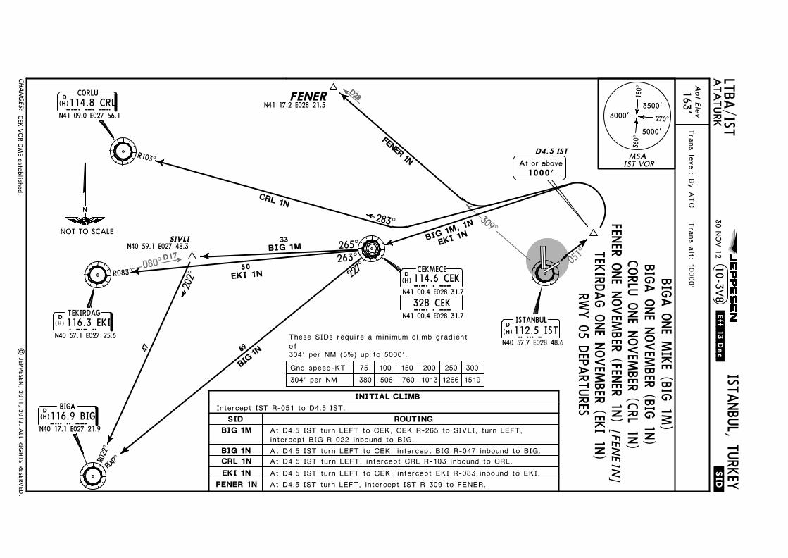
051^
309^
D28
080^D17
SIVLI
R047̂R022^
202^ 227
^
265^BIG 1M
47 69
33
R103^
FENER
263^R083^
50
BIG 1N
283^
Apt Elev
.SID.
163'
LTBA/ISTTrans level: By ATC Trans alt: 10000'
ATA
TURK
ISTANBUL, TURKEY
SID
FENER 1NEKI 1N
10-3V8
BIG 1M
BIG 1NCRL 1N
D4.5 ISTAt or above
1000'
D ISTANBUL112.5 ISTIST
N40 57.7 E028 48.6
N41 17.2 E028 21.5
N40 59.1 E027 48.3
D
N40 17.1 E027 21.9BIG116.9 BIG
BIGA
D TEKIRDAG116.3 EKIEKI
N40 57.1 E027 25.6
D CORLU114.8 CRLCRL
N41 09.0 E027 56.1
BIG 1M, 1N
EKI 1N
JEPPESEN
These SIDs require a minimum climb gradientof304' per NM (5%) up to 5000'.
(H)
(H)
(H)
(H)
| JEP
PESEN
, 2011, 2
012. A
LL RIG
HTS R
ESERV
ED.
CEK
VO
R DM
E established.
CEKN41 00.4 E028 31.7
328 CEK
CEKMECE114.6 CEKCEKD
(H)
N41 00.4 E028 31.7
30 NO
V 12
.Eff.13.Dec.
FENER 1N
CRL 1N
EKI 1N
MSAIST VOR
3500'
5000'
3000'
180^
360^
270^
NOT TO SCALE
75 100 150 200 250 300304' per NM 380 506 760 1013 1266 1519
CHA
NG
ES:
RWY 05 DEPARTURES
ROUTING
Gnd speed-KT
BIGA ONE MIKE (BIG 1M
)BIGA ONE NOVEM
BER (BIG 1N)CORLU ONE NOVEM
BER (CRL 1N)
TEKIRDAG ONE NOVEMBER (EKI 1N)
[FENE1N
]FENER ONE NOVEM
BER (FENER 1N)Intercept IST R-051 to D4.5 IST.INITIAL CLIMB
At D4.5 IST turn LEFT, intercept IST R-309 to FENER.At D4.5 IST turn LEFT to CEK, intercept EKI R-083 inbound to EKI.At D4.5 IST turn LEFT, intercept CRL R-103 inbound to CRL.At D4.5 IST turn LEFT to CEK, intercept BIG R-047 inbound to BIG.
At D4.5 IST turn LEFT to CEK, CEK R-265 to SIVLI, turn LEFT,intercept BIG R-022 inbound to BIG.

Licen
sed to
SM
A. P
rinted
on
03 Oct 2013.
No
tice: After 4 O
ct 2013 0901Z, th
is chart m
ay no
lon
ger b
e valid. D
isc 19-2013J
EP
PE
SE
NJep
pV
iew 3.7.5.0
D D
D
356^
047^
098^
20 33
23
MOPIN 1A
GAYEM 1S
ERT
AS 1
T
D5 IST
R207̂
140^
YAA 2S
177^ ER
TAS
1TGA
YEM
1SMO
PIN 1A
.SID.LTBA/ISTA
TATU
RKISTANBUL, TURKEY
10-3W
ERTASN41 27.7 E029 08.8
GAYEMD
ISTANBUL112.5 ISTIST
N40 57.7 E028 48.6
D BEYKOZ117.3 BKZBKZ
N41 07.6 E029 08.6
D YALOVA117.7 YAAYAA
N40 28.5 E029 12.5
At or above1400'
SID
MOPIN 1A
YAA 2S
ERTAS 1SERTAS 1T
GAYEM 1S
Apt Elev
163'Trans level: By A
TC Trans alt: 10000'
N41 02.8 E029 37.8
R320^
JEPPESEN
These SIDs require a minimum climb gradientof261' per NM (4.3%) up to 5000'.
MOPINN41 27.9 E029 42.6
(H)
(H)
(H)
| JEP
PESEN
, 2011, 2
012. A
LL RIG
HTS R
ESERV
ED.
CEKN41 00.4 E028 31.7
328 CEK
CEKMECE114.6 CEKCEKD
(H)
N41 00.4 E028 31.7
30 NO
V 12
.Eff.13.Dec.
CEK
VO
R DM
E established.
042̂
ERTAS 1S
39
027̂
MSAIST VOR
3500'
5000'
3000'
180^
360^
270^
CHA
NG
ES:
YALOVA TWO SIERRA (YAA 2S)
GAYEM ONE SIERRA (GAYEM
1S)[G
AYE1S]
ERTAS ONE TANGO (ERTAS 1T)[ERTA
1T]ERTAS ONE SIERRA (ERTAS 1S)
[ERTA1S]
NOT TO SCALE
75 100 150 200 250 300261' per NM 327 435 653 871 1089 1306Gnd speed-KT
ROUTING
INITIAL CLIMBIntercept IST R-177 to D5 IST.
At D5 IST turn LEFT, intercept YAA R-320 inbound to YAA.
At D5 IST turn LEFT, intercept BKZ R-207 inbound to BKZ,BKZ R-356 to ERTAS.At D5 IST turn LEFT, intercept BKZ R-207 inbound to BKZ,BKZ R-098 to GAYEM.At D5 IST turn LEFT, intercept BKZ R-207 inbound to BKZ,BKZ R-047 to MOPIN.
RWYS 17L/R DEPARTURES [M
OPI1A
]MOPIN ONE ALFA (MOPIN 1A)
At D5 IST turn RIGHT to CEK, CEK R-042 to ERTAS.

Licen
sed to
SM
A. P
rinted
on
03 Oct 2013.
No
tice: After 4 O
ct 2013 0901Z, th
is chart m
ay no
lon
ger b
e valid. D
isc 19-2013J
EP
PE
SE
NJep
pV
iew 3.7.5.0
267^
254^
309^
D28
D36.7
218^
R038̂
45
333^19
R087^
R110^
290^
BIG 2S
EKI 2S
CRL 2S
FENER 2S
.SID.LTBA/ISTA
TATU
RKISTANBUL, TURKEY
10-3X
D
N40 17.1 E027 21.9BIG116.9 BIG
BIGA
177^
D ISTANBUL112.5 ISTIST
N40 57.7 E028 48.6
D5 ISTAt or above
1400'
FENERN41 17.2 E028 21.5
SIDBIG 2S
CRL 2SEKI 2S
FENER 2S
Apt Elev163'
Trans level: By ATC Trans alt: 10000'
DENIZN40 49.9E028 01.3D TEKIRDAG
116.3 EKIEKIN40 57.1 E027 25.6
D CORLU114.8 CRLCRL
N41 09.0 E027 56.1
JEPPESEN
These SIDs require a minimum climb gradientof261' per NM (4.3%) up to 5000'.
(H)
(H)
(H)
(H)
| JEP
PESEN
, 2011, 2
012. A
LL RIG
HTS R
ESERV
ED.
CEKN41 00.4 E028 31.7
328 CEK
CEKMECE114.6 CEKCEKD
(H)
N41 00.4 E028 31.7
30 NO
V 12
.Eff.13.Dec.
CEK
VO
R DM
E established.
MSAIST VOR
3500'
5000'
3000'
180^
360^
270^
CHA
NG
ES:
BIGA TWO SIERRA (BIG 2S)
CORLU TWO SIERRA (CRL 2S)
TEKIRDAG TWO SIERRA (EKI 2S)
[FENE2S]
FENER TWO SIERRA (FENER 2S)
75 100 150 200 250 300261' per NM 327 435 653 871 1089 1306Gnd speed-KT
NOT TO SCALE
ROUTING
INITIAL CLIMBIntercept IST R-177 to D5 IST.
At D5 IST turn RIGHT, intercept CRL R-110 inbound to CRL.At D5 IST turn RIGHT, intercept IST R-267 to EKI.
At D5 IST turn RIGHT, intercept IST R-254 to DENIZ, turnLEFT, intercept BIG R-038 inbound to BIG.
RWYS 17L/R DEPARTURES
At D5 IST turn RIGHT to CEK, CEK R-333 to FENER.
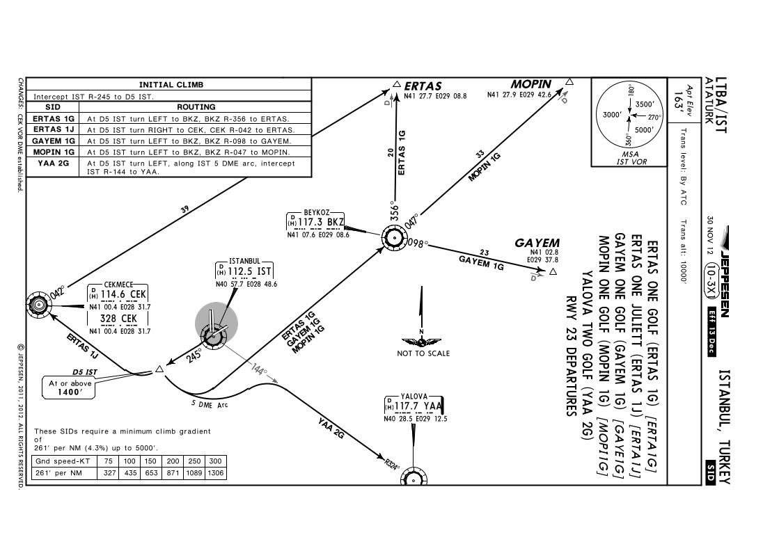
Licen
sed to
SM
A. P
rinted
on
03 Oct 2013.
No
tice: After 4 O
ct 2013 0901Z, th
is chart m
ay no
lon
ger b
e valid. D
isc 19-2013J
EP
PE
SE
NJep
pV
iew 3.7.5.0
144̂D D
D
R324̂
YAA 2G
245^
5 DME Arc
ERTA
S 1G
GAYE
M 1G
MOPIN
1G
356^
047^
098^
20 33
23
MOPIN
1G
GAYEM 1G
ERTA
S 1G
ERTASN41 27.7 E029 08.8
.SID.LTBA/ISTA
TATU
RKISTANBUL, TURKEY
DISTANBUL112.5 ISTIST
N40 57.7 E028 48.6
D YALOVA117.7 YAAYAA
N40 28.5 E029 12.5
10-3X1
D5 ISTAt or above
1400'
GAYEMN41 02.8
E029 37.8
SID
MOPIN 1GYAA 2G
ERTAS 1GERTAS 1JGAYEM 1G
D BEYKOZ117.3 BKZBKZ
N41 07.6 E029 08.6
Apt Elev
163'Trans level: By A
TC Trans alt: 10000'
JEPPESEN
These SIDs require a minimum climb gradientof261' per NM (4.3%) up to 5000'.
MOPINN41 27.9 E029 42.6
| JEP
PESEN
, 2011, 2
012. A
LL RIG
HTS R
ESERV
ED.
(H)
(H)
(H)
CEKN41 00.4 E028 31.7
328 CEK
CEKMECE114.6 CEKCEKD
(H)
N41 00.4 E028 31.7
30 NO
V 12
.Eff.13.Dec.
CEK
VO
R DM
E established.
ERTAS 1J
042̂
39
MSAIST VOR
3500'
5000'
3000'
180^
360^
270^
NOT TO SCALE
CHA
NG
ES:
RWY 23 DEPARTURES
YALOVA TWO GOLF (YAA 2G)
ERTAS ONE GOLF (ERTAS 1G)[ERTA
1G]
ERTAS ONE JULIETT (ERTAS 1J)[ERTA
1J]GAYEM ONE GOLF (GAYEM 1G)
[GA
YE1G]
75 100 150 200 250 300261' per NM 327 435 653 871 1089 1306Gnd speed-KT
ROUTING
INITIAL CLIMBIntercept IST R-245 to D5 IST.
At D5 IST turn LEFT to BKZ, BKZ R-356 to ERTAS.
At D5 IST turn LEFT to BKZ, BKZ R-098 to GAYEM.At D5 IST turn LEFT to BKZ, BKZ R-047 to MOPIN.At D5 IST turn LEFT, along IST 5 DME arc, interceptIST R-144 to YAA.
MOPIN ONE GOLF (MOPIN 1G)[M
OPI1G
]
At D5 IST turn RIGHT to CEK, CEK R-042 to ERTAS.

Licen
sed to
SM
A. P
rinted
on
03 Oct 2013.
No
tice: After 4 O
ct 2013 0901Z, th
is chart m
ay no
lon
ger b
e valid. D
isc 19-2013J
EP
PE
SE
NJep
pV
iew 3.7.5.0
267^
254^
283^
309^
D28
D36.7
R038̂
FENER
333^
19
R087^
R103^
BIG 2G
EKI 2G
CRL 2G
FENER 2H
245^
.SID.LTBA/ISTA
TATU
RKISTANBUL, TURKEY
10-3X2
218^
DENIZ
45
D
N40 17.1 E027 21.9BIG116.9 BIG
BIGA
D CORLU114.8 CRLCRL
N41 09.0 E027 56.1
D TEKIRDAG116.3 EKIEKI
N40 57.1 E027 25.6
D ISTANBUL112.5 ISTIST
N40 57.7 E028 48.6
D5 IST
N41 17.2 E028 21.5
SIDBIG 2G
CRL 2GEKI 2G
FENER 2H
At or above1400'
Apt Elev163'
N40 49.9E028 01.3
Trans level: By ATC Trans alt: 10000'
JEPPESEN
These SIDs require a minimum climb gradientof261' per NM (4.3%) up to 5000'.
| JEP
PESEN
, 2011, 2
012. A
LL RIG
HTS R
ESERV
ED.
(H)
(H)
(H)
(H)
CEKN41 00.4 E028 31.7
328 CEK
CEKMECE114.6 CEKCEKD
(H)
N41 00.4 E028 31.7
30 NO
V 12
.Eff.13.Dec.
CEK
VO
R DM
E established.
MSAIST VOR
3500'
5000'
3000'
180^
360^
270^
CHA
NG
ES:
RWY 23 DEPARTURES
NOT TO SCALE
75 100 150 200 250 300261' per NM 327 435 653 871 1089 1306Gnd speed-KT
ROUTING
INITIAL CLIMBIntercept IST R-245 to D5 IST.
At D5 IST turn RIGHT, intercept IST R-267 to EKI.At D5 IST turn RIGHT, intercept IST R-283 to CRL.
At D5 IST turn RIGHT, intercept IST R-254 to DENIZ,turn LEFT, intercept BIG R-038 inbound to BIG.
BIGA TWO GOLF (BIG 2G)
CORLU TWO GOLF (CRL 2G)
TEKIRDAG TWO GOLF (EKI 2G)
FENER TWO HOTEL (FENER 2H)
[FENE2H
]
At D5 IST turn RIGHT to CEK, CEK R-333 to FENER.

Licensed to SMA. Printed on 03 Oct 2013.
Notice: After 4 Oct 2013 0901Z, this chart may no longer be valid. Disc 19-2013JEPPESENJeppView 3.7.5.0
JEPPESEN
024^
D
D
D076^
R256^
356^15
356^
047^
098^172^R352^
20
39
ERT
AS 1
D
YA
A 1D
ERTA
S 1U
ERTASN41 27.7 E029 08.8
ERTAS 1D
GAYEM 1DMOPIN 1D
YAA 1D
.SID.LTBA/ISTATATURK
ISTANBUL, TURKEY10-3X3
D7 IST
D ISTANBUL112.5 ISTIST
N40 57.8 E028 48.6
33MO
PIN 1
D
GAYEMN41 02.8 E029 37.8
23GAYEM 1D
SID
MOPIN 1DYAA 1D
ERTAS 1DERTAS 1UGAYEM 1D
D YALOVA117.7 YAAYAA
N40 28.5 E029 12.5
D BEYKOZ117.3 BKZBKZ
N41 07.6 E029 08.6
Apt Elev163'
Trans level: By ATC Trans alt: 10000'
At or above1600'
MOPINN41 27.9 E029 42.6
These SIDs require a minimum climb gradientof413' per NM (6.8%) up to 5000'.
N41 04.8 E028 48.6
25 MAY 12 .Eff.31.May.
Procedure notes. | JEPPESEN, 2011, 2012. ALL RIGHTS RESERVED.
(H)
(H)
(H)
MSAIST VOR
3500'
5000'
3000'
180^
360^
270^
CHANGES:
RWY 35L DEPARTURES
ROUTING
INITIAL CLIMBIntercept IST R-356 to D7 IST.
At D7 IST turn RIGHT, intercept IST R-024 to ERTAS.
NOT TO SCALE
75 100 150 200 250 300413' per NM 516 689 1033 1377 1722 2066Gnd speed-KT
YALOVA ONE DELTA (YAA 1D)
[GAYE1D]GAYEM ONE DELTA (GAYEM 1D)ERTAS ONE UNIFORM (ERTAS 1U) [ERTA1U]ERTAS ONE DELTA (ERTAS 1D) [ERTA1D]
At D7 IST turn RIGHT, intercept BKZ R-256 inbound to BKZ, BKZ R-356 to ERTAS.
At D7 IST turn RIGHT, intercept BKZ R-256 inbound to BKZ, BKZ R-098 toGAYEM.
At D7 IST turn RIGHT, intercept BKZ R-256 inbound to BKZ, BKZ R-172 to YAA.At D7 IST turn RIGHT, intercept BKZ R-256 inbound to BKZ, BKZ R-047 to MOPIN.
MOPIN ONE DELTA (MOPIN 1D) [MOPI1D]

Licen
sed to
SM
A. P
rinted
on
03 Oct 2013.
No
tice: After 4 O
ct 2013 0901Z, th
is chart m
ay no
lon
ger b
e valid. D
isc 19-2013J
EP
PE
SE
NJep
pV
iew 3.7.5.0
JEPPESEN
283^ 117.3BKZ BZKD28
309^
D
FENER 1U
R022^
202^
FENER
356^
R103^
FENER 1D
260^
R080^
47
283^
.SID.LTBA/ISTA
TATU
RKISTANBUL, TURKEY
10-3X4
D CORLU114.8 CRLCRL
N41 09.1 E027 56.3
D TEKIRDAG116.3 EKIEKI
N40 57.1 E027 25.6
N41 17.2 E028 21.5
SID
FENER 1U
EKI 1D
BIG 1D
CRL 1D
FENER 1D
D
N40 17.1 E027 21.9BIG116.9 BIG
BIGA
D7 IST
D ISTANBUL112.5 ISTIST
N40 57.8 E028 48.6
At or above1600'
Apt Elev
163'
SIVLIN40 59.1E027 48.3
17
Trans level: By ATC Trans alt: 10000'
These SIDs require a minimum climb gradientof413' per NM (6.8%) up to 5000'.
N41 04.8 E028 48.6 25 MA
Y 12
.Eff.31.May.
Procedure notes.|
JEPPESEN
, 2011, 2
012. A
LL RIG
HTS R
ESERV
ED.
(H)
(H)
(H)
(H)
CRL 1D
BIG 1D, EKI 1D
EKI 1D
BIG
1D
MSAIST VOR
3500'
5000'
3000'
180^
360^
270^
CHA
NG
ES:
RWY 35L DEPARTURES
CORLU ONE DELTA (CRL 1D)
ROUTING
INITIAL CLIMBIntercept IST R-356 to D7 IST.
At D7 IST turn LEFT, intercept EKI R-080 inbound to SIVLI, turn LEFT,intercept BIG R-022 inbound to BIG.At D7 IST turn LEFT, intercept CRL R-103 inbound to CRL.At D7 IST turn LEFT, intercept EKI R-080 inbound to EKI.
At D7 IST turn LEFT, intercept IST R-309 to FENER.At D7 IST straight ahead, turn LEFT, intercept BKZ R-283 to FENER.
NOT TO SCALE
BIGA ONE DELTA (BIG 1D)
TEKIRDAG ONE DELTA (EKI 1D)
FENER ONE DELTA (FENER 1D)[FEN
E1D]
75 100 150 200 250 300413' per NM 516 689 1033 1377 1722 2066Gnd speed-KT
FENER ONE UNIFORM (FENER 1U)
[FENE1U]

Licensed to SMA. Printed on 03 Oct 2013.
Notice: After 4 Oct 2013 0901Z, this chart may no longer be valid. Disc 19-2013JEPPESENJeppView 3.7.5.0
JEPPESEN
024̂
D
D
D
076^
R256^
356^15
356^
047^
098^172^R352^
20
39
ERT
AS 1
K
YA
A 1K
ERTA
S 1L
ERTASN41 27.7 E029 08.8
ERTAS 1KGAYEM 1KMOPIN 1B
YAA 1K
.SID.LTBA/ISTATATURK
ISTANBUL, TURKEY10-3X5
D7 IST
D ISTANBUL112.5 ISTIST
N40 57.8 E028 48.6
33MO
PIN 1
B
GAYEMN41 02.8 E029 37.8
23GAYEM 1K
SID
MOPIN 1BYAA 1K
ERTAS 1KERTAS 1LGAYEM 1K
D YALOVA117.7 YAAYAA
N40 28.5 E029 12.5
D BEYKOZ117.3 BKZBKZ
N41 07.6 E029 08.6
Apt Elev163'
Trans level: By ATC Trans alt: 10000'
At or above1600'
These SIDs require a minimum climb gradientof304' per NM (5%) up to 5000'.
MOPINN41 27.9 E029 42.6
N41 04.8 E028 48.6
25 MAY 12 .Eff.31.May.
(H)
(H)
(H)
Procedure notes. | JEPPESEN, 2011, 2012. ALL RIGHTS RESERVED.
MSAIST VOR
3500'
5000'
3000'
180^
360^
270^
CHANGES:
RWY 35R DEPARTURESYALOVA ONE KILO (YAA 1K)
GAYEM ONE KILO (GAYEM 1K) [GAYE1K]ERTAS ONE LIMA (ERTAS 1L) [ERTA1L]ERTAS ONE KILO (ERTAS 1K) [ERTA1K]
ROUTING
INITIAL CLIMBIntercept IST R-356 to D7 IST.
At D7 IST turn RIGHT, intercept IST R-024 to ERTAS.
NOT TO SCALE
75 100 150 200 250 300304' per NM 380 506 760 1013 1266 1519Gnd speed-KT
At D7 IST turn RIGHT, intercept BKZ R-256 inbound to BKZ, BKZ R-356 to ERTAS.
At D7 IST turn RIGHT, intercept BKZ R-256 inbound to BKZ, BKZ R-098 toGAYEM.
At D7 IST turn RIGHT, intercept BKZ R-256 inbound to BKZ, BKZ R-172 to YAA.At D7 IST turn RIGHT, intercept BKZ R-256 inbound to BKZ, BKZ R-047 to MOPIN.
[MOPI1B]MOPIN ONE BRAVO (MOPIN 1B)

Licen
sed to
SM
A. P
rinted
on
03 Oct 2013.
No
tice: After 4 O
ct 2013 0901Z, th
is chart m
ay no
lon
ger b
e valid. D
isc 19-2013J
EP
PE
SE
NJep
pV
iew 3.7.5.0
JEPPESEN
283^ 117.3BKZ BZKD28
309^
D
FENER 1L
SIVLI
R022^
202^
FENER
356^
R103^
FENER 1K
260^
17R080^
N40 59.1E027 48.3
47
283^
.SID.LTBA/ISTA
TATU
RKISTANBUL, TURKEY
10-3X6
D CORLU114.8 CRLCRL
N41 09.1 E027 56.3
D TEKIRDAG116.3 EKIEKI
N40 57.1 E027 25.6
N41 17.2 E028 21.5
SID
FENER 1L
EKI 1K
BIG 1K
CRL 1K
FENER 1K
D
N40 17.1 E027 21.9BIG116.9 BIG
BIGA
D7 IST
D ISTANBUL112.5 ISTIST
N40 57.8 E028 48.6
At or above1600'
Apt Elev
163'Trans level: By A
TC Trans alt: 10000'
These SIDs require a minimum climb gradientof304' per NM (5%) up to 5000'.
N41 04.8 E028 48.6 25 MA
Y 12
.Eff.31.May.
(H)
(H)
(H)
(H)
Procedure notes.|
JEPPESEN
, 2011, 2
012. A
LL RIG
HTS R
ESERV
ED.
CRL 1K
BIG 1K, EKI 1K
EKI 1K
BIG
1K
MSAIST VOR
3500'
5000'
3000'
180^
360^
270^
CHA
NG
ES:
RWY 35R DEPARTURES
TEKIRDAG ONE KILO (EKI 1K)
BIGA ONE KILO (BIG 1K)CORLU ONE KILO (CRL 1K)
75 100 150 200 250 300304' per NM 380 506 760 1013 1266 1519
ROUTING
Gnd speed-KT
INITIAL CLIMBIntercept IST R-356 to D7 IST.
At D7 IST turn LEFT, intercept EKI R-080 inbound to SIVLI, turn LEFT,intercept BIG R-022 inbound to BIG.At D7 IST turn LEFT, intercept CRL R-103 inbound to CRL.At D7 IST turn LEFT, intercept EKI R-080 inbound to EKI.
At D7 IST turn LEFT, intercept IST R-309 to FENER.At D7 IST straight ahead, turn LEFT, intercept BKZ R-283 to FENER.
[FENE1K]
FENER ONE KILO (FENER 1K)FENER ONE LIM
A (FENER 1L)[FEN
E1L]
NOT TO SCALE

Licensed to SMA. Printed on 03 Oct 2013.
Notice: After 4 Oct 2013 0901Z, this chart may no longer be valid. Disc 19-2013JEPPESENJeppView 3.7.5.0
LEGEND
Apron
Taxiway
A
Apt Elev 10-9ATIS
128.2 121.7
28-48
40-59
41-00
28-49
28-49
28-50
28-50
28-48
163'ISTANBUL, TURKEY
ATATURKN40 58.6 E028 48.8
LTBA/IST
Elev 93'
9843' 3000m
40-58
40-599843' 3000m
2580m
Elev
40-58
H
YESILKOY Delivery
B8
C
C
8465'
ARP90'
04^E
| JEPPESEN, 2000, 2013. ALL RIGHTS RESERVED.
For AIRPORT BRIEFING refer to 10-1P pages
JEPPESEN
126.8121.8 122.32 118.37121.9South North
121.8Ground
South
122.32Ground
North
Ground
126.8
A5HPA
A5HPB
B11HPB12HP
K1HP
4 5
23
H1
Tower (DEP)
De-icingarea
FOR DETAILSSEE 10-9B
3
1
2
Elev 100'
A6HPA
A6HPB45
Line up position 1
Line up position 2
HOT SPOTS
15 MAR 13
VOR
Lctr
Lctr
05055^
174^
354^
TERMINAL
J1
CHANGES:
TERMINAL B
17L
35R
B1A1K
C
E1
B5
B8
B9
B4K2
A6
K1
A2
A5
E8T
E5
SA
GA
354^35L
23235^
Elev157'
Elev163'
253'
240'
170'
173'
165'
195'177'
297'296' B4
D
B5
D
C
D
B9
C
N
R
M
J2
J1
J
J3
B
F
E4
D
D
S
AIS+MET
AA
L
0
0 200 400 600 800 1000
1000 2000 3000 4000
1200
Feet
Meters
E5
G
G
F
F
A2B
A5B
E7
E6
E3
E2
B11
B12
D1
TERMINAL A
174^17R
P
N
N
V
TML
CARGO
MOTOR TESTAPRON
ACFT MAINTENANCEAPRON
E1HP1E2HP
E1HP2
E3HPFIHP1
E4HP
FIHP2
K1
K1
ACFTMAINT
APRON 2
B2
B3
A3B
A3
F1F2
230'
243'
213'255'
266'
243'249'
285'
322'
ControlTower
FOR DETAILS SEE 10-9C
1
FOR DETAILS SEE 10-9D
Hot Spots.
258'
280'
128'
213'213'
197'
Elev102'
HS
HS
HS
HS
HS
HS
HS
HS
HS

Licensed to SMA. Printed on 03 Oct 2013.
Notice: After 4 Oct 2013 0901Z, this chart may no longer be valid. Disc 19-2013JEPPESENJeppView 3.7.5.0
RWY
ADDITIONAL RUNWAY INFORMATION
ThresholdLANDING BEYOND
USABLE LENGTHS
WIDTHTAKE-OFFGlide Slope05
236884' 2098m 197'
60m
45m148'8932' 2722m
7493' 2284m
ISTANBUL, TURKEY ATATURK10-9A
17L
35R
4 spacing 60m.
4 5
5
LTBA/IST
45m148'
(60m)HIRL CL
17R
35L 8932' 2722m
HIRL(60m)(60m)HIRL CL
CL
9
RVRRVR9
0
| JEPPESEN, 2000, 2012. ALL RIGHTS RESERVED.
JEPPESEN
TAKE-OFF
ABCD
RCLM (DAY only)
250m
300m
400m 500m
NIL(DAY only)
1
1
RCLM (DAY only)RL & CL
200m
250m
& mult. RVR req
125m
150m
LVP must be in force
or RL or RL& mult. RVR req
150m
200m
RL, CLHIRL, CL
ApprovedOperators
.Standard.
8038'2450m(15m)
RVR6
6
HIALS-II SFL TDZ REIL
12
12
spacing 15m.
(15m)(15m)
HIALS-II SFL TDZ REILHIALS-II SFL TDZ REIL
3RVRRVR
Operators applying U.S. Ops Specs: CL required below 300m; approved HUD required below 150m.
!
8
(60m)HIRL CL(15m) HIALS-II SFL TDZ REIL
HIRL CL HIALS-II SFL TDZ REIL
PAPI-R (3.0^) HSTIL-E5, E6 & E7.PAPI-L (3.2^) HSTIL-E4, E3 & E2.
4 5 RVR7HIRL CL HIALS-II SFL TDZ REIL
PAPI(3.0^) HSTIL-B8 & B9.
7 PAPI(3.0^) HSTIL-B5, B4 & B3.
PAPI (3.5^) HSTIL-A5.PAPI (3.0^) HSTIL-A3 & A2.
None.
15 MAR 13
CHANGES:
3 TAKE-OFF RUN AVAILABLERWY 05:from rwy head
twy E2 int8465' (2580m)8038' (2450m)
! TAKE-OFF RUN AVAILABLERWY 35L:
from rwy headtwy K1 int
9843' (3000m)6890' (2100m)
8 TAKE-OFF RUN AVAILABLERWY 35R:
9843' (3000m)9186' (2800m)
from line up position 1line up position 2
8038' (2450m)8038' (2450m)
twy A5 inttwy A5B int
0

Licen
sed to
SM
A. P
rinted
on
03 Oct 2013.
No
tice: After 4 O
ct 2013 0901Z, th
is chart m
ay no
lon
ger b
e valid. D
isc 19-2013J
EP
PE
SE
NJep
pV
iew 3.7.5.0
RWY 17L/35R RW
Y 05/2
3
B8
B8
TERMINAL B
C
TERMINAL A
101102
S1
N
B
D
103
S2 S3 S4 S5 S6 S7 S8 S9
T6T5T4T3T2T1
217215213
211210209
206204
203
202
201
208212 214
216207
B9
TERMINALCARGO
C
D E5
T
S
H
106
108
110111
D
M
109
107
C
B9
E8
R
B
A
A
SA
L4
L3
L2
L1
218205
223222221220219
L
40-59
40-58.9
40-58.8
40-58.7
40-58.6
40-58.4
40-58.5
40-58.3
28-49 28-49.1 28-5028-49.3 28-49.4 28-49.5 28-49.6 28-49.7 28-49.8 28-49.9 28-50.1 28-50.228-48.928-48.828-48.728-48.6
10-9B
28-48.6 28-5028-49.3 28-49.4 28-49.5 28-49.6 28-49.7 28-49.8 28-49.9 28-50.128-49.2
D
A5
G
G
E5
F
F
| JEP
PESEN
, 2001, 2
013. A
LL RIG
HTS R
ESERV
ED.
JEPPESEN
104105
112
AIS+MET Control
Tower
D1
S17
224 225 226
B11
A5B
E6
E7
South
121.8Ground
122.32GroundNorth
R4R3R2R1
N6
N5
N4
N3
N2
N1
N
M1
M2
M3
M4
M5
M6
M7
N7
N8
N9
N10
N11
S10S11S12
S13 S14S15 S16
FIHP3
FIHP4
FIHP5
E8HP
E5HP
E6HP
E7HP
HHPA5BHP
H1H1HP1
H1HP2
B9IHP1
B8IHP1
HOT SPOTS
Start-up position
None.
10 MA
Y 13
CHA
NG
ES:
ISTANBUL, TURKEY A
TATU
RKLTBA/IST
PSN2
LEGEND
PSN2
PSN3
HS
HS
HS

Licensed to SMA. Printed on 03 Oct 2013.
Notice: After 4 Oct 2013 0901Z, this chart may no longer be valid. Disc 19-2013JEPPESENJeppView 3.7.5.0
C
28-48.6 28-48.8 28-49 28-49.2 28-49.4 28-49.6
N1228-48.6 28-49 28-49.2 28-49.4 28-49.6
28-48.4
40-59.6
40-59.7
40-59.8
40-59.5
40-59.4
40-59.3
40-59.2
40-59.6
40-59.7
40-59.5
40-59.1
RWY 17L/35R
LTBA/IST
RWY 17R/35L
40-59.3
40-59.1
| JEPPESEN, 2000, 2013. ALL RIGHTS RESERVED.
JEPPESEN
122.32Ground
North
P1
P2
P3
P4
N13
N14
N15
N16
A1HPA
A1HPB
B1HP
B4IHP1
B2HP
B2IHP
B3IHP
A2HP
A3HP
B5IHP1
LEGEND
De-icingarea
HOT SPOTS
Start-up position
10 MAY 13 ATATURKISTANBUL, TURKEY
CHANGES:
10-9C
COORDINATES COORDINATESINS COORDINATES
STAND No. STAND No.
A1
B4
B5
C
B4
D
B5
DC
J2
J1
J
HANGAR
J3
A2
A2B
B1
P
N
N40 58.9 E028 49.0N40 58.9 E028 48.9N40 58.8 E028 48.9N40 58.8 E028 49.0N40 58.7 E028 49.0
N40 58.7 E028 49.0N40 58.6 E028 49.0N40 58.6 E028 48.9N40 58.6 E028 49.0N40 58.6 E028 49.1
N40 58.6 E028 49.2N40 58.6 E028 49.3N40 58.6 E028 49.4N40 58.6 E028 49.5N40 58.7 E028 49.6
N40 58.3 E028 48.8N40 58.4 E028 48.8 N40 58.5 E028 48.8N40 58.6 E028 48.8 N40.58.7 E028 48.8
N40.58.7 E028 48.8N40 58.8 E028 48.8N40 58.9 E028 48.8N40 59.0 E028 48.8N40 59.1 E028 48.8
N40 59.2 E028 48.8N40 59.3 E028 48.8N40 59.4 E028 48.8N40 59.0 E028 48.9N40 59.0 E028 49.0
N40 58.5 E028 49.0N40 58.5 E028 49.1N40 58.5 E028 49.2N40 58.5 E028 49.3N40 58.5 E028 49.4
N40 58.5 E028 49.5N40 58.5 E028 49.6N40 58.6 E028 49.6N40 58.7 E028 49.7N40 58.7 E028 49.8
N40 58.7 E028 49.9
MOTOR TESTAPRON
ACFT MAINTENANCEAPRON
B2
B3
A3B
A3
101 thru 104105 thru 107108 thru 110
111112
201 thru 203204
205 thru 209210, 211
212 thru 214
215 thru 217218, 219220, 221
222 thru 224225, 226
L1
L2 thru L4M1
M2 thru M6M7
N1N2 thru N4N5 thru N8N9 thru N11N12 thru N14
PSN1
PSN1
N15, N16P1
P2 thru P4R1, R2R3, R4
S1
S2 thru S4S5 thru S7
S8, S9S10 thru S12
S13 thru S15
S16S17
T1 thru T3T4, T5
T6
Parking postions on apron N.
HS
HS
HS
HS

Licensed to SMA. Printed on 03 Oct 2013.
Notice: After 4 Oct 2013 0901Z, this chart may no longer be valid. Disc 19-2013JEPPESENJeppView 3.7.5.0
122.32Ground
North
HOT SPOTS
VIHP1
VIHP2
KHP
V1
V2
V3
V4
V5
V6
RWY 17R/35L
LTBA/IST JEPPESEN
30 NOV 12
40-59.9
40-59.8
40-59.7
40-59.6
28-48 28-48.1 28-48.2 28-48.3
28-48 28-48.1 28-48.2 28-48.3
40-59.9
40-59.8
| JEPPESEN, 2012. ALL RIGHTS RESERVED.
K
V
ATATURKISTANBUL, TURKEY
CHANGES:
10-9D
COORDINATESINS COORDINATES
STAND No.
V1 thru 3V4 thru 6
N40 59.9 E028 48.2N40 59.8 E028 48.2
New chart.
HS
HS
HS

Licensed to SMA. Printed on 03 Oct 2013.
Notice: After 4 Oct 2013 0901Z, this chart may no longer be valid. Disc 19-2013JEPPESENJeppView 3.7.5.0
JEPPESEN
LT(R)-4
LT(R)-10 LT(R)-15
LT(R)-19
LT(R)-12
LT(R)-18
LT(R)-11
LT(R)-13LT(R)-14
LT(R)-20
LT(R)-17
LT(R)-21
LT(R)-16
LT(R)-22
270^
180^
360^
3000'
5000'
3500'
MSA IST VOR
MISSED APCH:BRIE
FING
STR
IPTM
Gnd speed-Kts 70 90 100 120 140 160
ISTANBUL, TURKEYATATURK ILS DME Rwy 0511-1
LOC
*110.3IIST
FinalApch Crs055^
GS
1500'(1407')
ILSDA(H)
293'(200')D4.5 IIST
STRAIGHT-IN LANDING RWY
A
B
C
D
ILS
ALS out ALS out
05 CIRCLE-TO-LAND
MDA(H)
LOC (GS out)DA(H) MDA(H)293' 470'(200') (377')
MaxKts100
135
180
205
055^2600'
1500'LOC
1.3 3.2
RVR 750m RVR 1200m 1000mRVR
1700mRVR
1500mRVR (937')
(937')
3600m
4400m1100'
VIS
Apt Elev 163'
MISSED APCH CLIMBGRAD MIM 3.5%
R-053112.5IST BKZ
3.5
1100'
LTBA/IST
GS1500'
Alt Set: hPa Trans level: By ATCRwy Elev: 3 hPa
RWY 93'
ATCOSD9.0 IST
234̂054̂
954'
958'
1076'
942'
40-50
41-00
41-10
28-30 28-40 28-50 29-00 29-10
055^
053^
1329'
659'
059^
239^260
0
(IAF)
Missed apch climb gradient mim 3.5%
B K ZD
1450'
| JEPPESEN, 2000, 2012. ALL RIGHTS RESERVED.
470'GS
0.9
YESILKOY Tower
128.2
GroundATIS YESILKOY Approach/Radar
127.1 126.42120.5South
121.1North West East
118.1 121.8 121.9 122.32
.Standard.
605'
692'
816'
958'
627'
127.82
PAPI
hold.Climb on R-053 IST to cross BKZ VOR at 4000' and
117.34000'
on
LimitedFULL
RVR 550m
REIL
TCH displthresh 57'
HIALS-II
27 JAN 12
600'
836'
671'
Trans alt: 10000'
MAP at LMM3.00^ 377 484 538 646 753 861
PANS
OPS
3
CHANGES:
93'RWY 0500.4
C912'
570' 4000
817'
843'
LMMD4.2 IST
D8.0 IISTD7.7 IST D4.5 IIST
ATCOS
ILS DME
055^ *110.3 IIST
340 STS TD8.0 IISTD7.7 IST
D9.0/R-239 IST
649'
BEYKOZ117.3 BKZ
D 112.5 ISTISTANBUL I S T
D1.3 IISTD1.0 IST
D1.0 ISTD1.3 IIST
ILS GS orLOC Descent Angle
757'
815'667'
I I S T 718'
D4.5 IISTD4.2 IST
TO DISPLACED THRESHOLD
Communications. Minimums.
759'
1181'
1398'

Licensed to SMA. Printed on 03 Oct 2013.
Notice: After 4 Oct 2013 0901Z, this chart may no longer be valid. Disc 19-2013JEPPESENJeppView 3.7.5.0
JEPPESEN
LT(R)-4
LT(R)-10 LT(R)-15
LT(R)-19
LT(R)-12
LT(R)-18
LT(R)-11
LT(R)-13LT(R)-14
LT(R)-20
LT(R)-17
LT(R)-21
LT(R)-16
LT(R)-22
270^
180^
360^
3000'
5000'
3500'
MSA IST VOR
MISSED APCH:BRIE
FING
STR
IPTM
Gnd speed-Kts 70 90 100 120 140 160
ISTANBUL, TURKEYATATURK
LOC
*110.3IIST
FinalApch Crs055^
GS
1500'(1407')D4.5 IIST
055^2600'
1.3 3.2
Apt Elev 163'
MISSED APCH CLIMBGRAD MIM 3.5%
R-053112.5IST BKZ
3.5
LTBA/IST
GS1500'
Alt Set: hPa Trans level: By ATCRwy Elev: 3 hPa
RWY 93'
ATCOSD9.0 IST
234̂054̂
954'
958'
1076'
942'
40-50
41-00
41-10
28-30 28-40 28-50 29-00 29-10
055^
053^
1329'
659'
059^
239^260
0
(IAF)
B K ZD
1450'
470'GS
0.9
YESILKOY Tower
128.2
GroundATIS YESILKOY Approach/Radar
127.1 126.42120.5South
121.1North West East
118.1 121.8 121.9 122.32
605'
692'
816'
958'
627'
127.82
PAPI
hold.Climb on R-053 IST to cross BKZ VOR at 4000' and
117.34000'
on
11-1A
REIL
1
1
TCH displthresh 57'
HIALS-II
| JEPPESEN, 2011, 2012. ALL RIGHTS RESERVED.
27 JAN 12
STRAIGHT-IN LANDING RWY 05
Missed apch climb gradient mim 3.5%
CAT II/III ILS DME Rwy 05
CAT II &IIIA ILSRefer to
Minimums
600'
671'
836'
Trans alt: 10000'
3.00^ 377 484 538 646 753 861
PANS
OPS
3
CHANGES:
93'RWY 0500.4
C912'
570' 4000
817'
843'
LMMD4.2 IST
D8.0 IISTD7.7 IST D4.5 IIST
ATCOS
ILS DME
055^ *110.3 IIST
340 STS TD8.0 IISTD7.7 IST
D9.0/R-239 IST
649'
BEYKOZ117.3 BKZ
D 112.5 ISTISTANBUL I S T
D1.3 IISTD1.0 IST
D1.0 ISTD1.3 IIST
757'
815'667'
I I S T 718'
D4.5 IISTD4.2 IST
TO DISPLACED THRESHOLD
GS
Communications. Minimums.
1181'
1398'
759'
CAT II ILS
RVR 300m
DA(H) (100')
CAT IIIA ILS
DH 50'
RVR 200m
193'RA 103'
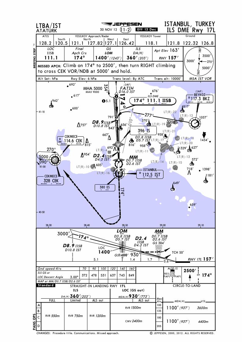
Licensed to SMA. Printed on 03 Oct 2013.
Notice: After 4 Oct 2013 0901Z, this chart may no longer be valid. Disc 19-2013JEPPESENJeppView 3.7.5.0
LT(R)-4
010^
LT(R)-10
LT(R)-16
LT(R)-15
LT(R)-19
LT(R)-12
LT(R)-18
LT(R)-11
LT(R)-13
LT(R)-14
LT(R)-20LT(R)-17
LT(R)-21
LT(R)-22
617'
942'
676'
958'
1057'
1434'
659'
380 ESE S
1329'
TCH 50'
174^3000'
1400'
384'
GS
GSLOC1400'
5.1
270^
180^
360^
3000'
5000'
3500'
MSA IST VOR
MISSED APCH:BRIE
FING
STR
IPTM
Gnd speed-Kts 70 90 100 120 140 160
ISTANBUL, TURKEYATATURK 11-2
LOC
111.1IISB
FinalApch Crs174^
GS
1400'(1243')
ILSDA(H)
360'(203')
Apt Elev 163'
RWY 157'
REILPAPI PAPI
2500'on 174^
Climb on 174^ to 2500', then turn RIGHT climbing
LOM
IISB
354^
115.1
(IAF)
40-50
41-00
41-10
28-30 28-40 28-50 29-00 29-10
(IAF)
LTBA/IST
ALSF-II
Rwy Elev: 6 hPaAlt Set: hPa Trans level: By ATC
MHA 5000
| JEPPESEN, 2000, 2012. ALL RIGHTS RESERVED.
MAX 9000
JEPPESEN
YESILKOY Tower
128.2
GroundATIS YESILKOY Approach/Radar
127.1 126.42120.5South
121.1North West East
118.1 121.8 126.8
STRAIGHT-IN LANDING RWY
A
B
C
D
ILS
ALS out ALS out
CIRCLE-TO-LAND
MDA(H)
LOC (GS out)DA(H) MDA(H)360' 930'(203') (773')
MaxKts100
135
180
205
RVR 550m RVR 1200m2400mCMV
1500mRVR (937')
(937')
3600m
4400m1100'
VIS
1100'
.Standard. 17L
FULL Limited
RVR 750m
757'
815'
954'
605'
843'
667'
692'816'
958'
627'
D10.8 ISTD8.9
D0.7 IISBD2.6 IST
D3.8 IISBD5.7 IST
D4.3 IST
D2.4IISB
930'
IISBD0.7 IISBD2.6 IST
D4.3 IST
D3.8 IISBD5.7 IST
IISBD10.8 IST
127.82
30 NOV 12 .Eff.13.Dec. ILS DME Rwy 17L
122.32
to cross CEK VOR/NDB at 5000' and hold.
CEKMECE114.6 CEKD
(H)C E K
3.00^ 372 478 531 637 743 849
692'
600'
1181'
656'
Trans alt: 10000'
117.3 BKZBEYKOZ
D 112.5 ISTISTANBUL
MM
396 IS
3000
277^
174^ 111.1 IISBi i s b
174^
B K Z
I S T
157'0.61.7
MMCM
D
CHANGES:
570'
I S174^
FATIH
RWY 17L
649'
817'
791'
D16.0 ISTILS DME
ILS GS orLOC Descent Angle
718'
1.4
LOM
D2.4
D8.9
MAP at MM/D0.7 IISB/D2.6 IST
328 CEKC E K
090^
270^5000
CEKMECE
PANS
OPS
Procedure title. Communications. Missed approach.
1398'
572'

Licensed to SMA. Printed on 03 Oct 2013.
Notice: After 4 Oct 2013 0901Z, this chart may no longer be valid. Disc 19-2013JEPPESENJeppView 3.7.5.0
LT(R)-4
LT(R)-10
LT(R)-16
LT(R)-14LT(R)-15
LT(R)-13
LT(R)-18
LT(R)-17
LT(R)-19
LT(R)-21 LT(R)-12
LT(R)-11
LT(R)-22
MM
i a t a
055^235^
KOFUN
235^ 111.9 IATA
TCH 57'
235^
1430'4.7RWY 23 90'
GS 297' GS
3000'
1425'
270^
180^
360^
3000'
5000'
3500'
MSA IST VOR
MISSED APCH:BRIE
FING
STR
IPTM
Gnd speed-Kts 70 90 100 120 140 160
ISTANBUL, TURKEYATATURK ILS DME Rwy 2311-3
LOC
111.9IATA
FinalApch Crs235^
GS
1425'(1335')
ILSDA(H)
290'(200')
Apt Elev 163'
RWY 90'Climb on 235^ to 2500', then turn RIGHT climbing
on2500'
235^
OM
OM
ILS DME
40-50
41-00
41-10
28-30 28-40 28-50 29-00 29-10
D10.0 IST
0.1
D8.6 IATA
KOFUND10.0 IST
LTBA/IST
Rwy Elev: 3 hPaAlt Set: hPa Trans level: By ATC
LOC
235^
| JEPPESEN, 2000, 2012. ALL RIGHTS RESERVED.
JEPPESEN
STRAIGHT-IN LANDING RWY
A
B
C
D
ILS
ALS out ALS out
23 CIRCLE-TO-LAND
MDA(H)
LOC (GS out)DA(H) MDA(H)290' 710'(200') (620')
MaxKts100
135
180
205
RVR 750m RVR 1200m2400mCMV
1500mRVR (937')
(937')
3600m
4400m1100'
VIS
1100'
FULL/Limited
.Standard.
YESILKOY Tower
128.2
GroundATIS YESILKOY Approach/Radar
127.1 126.42120.5South
121.1North West East
118.1 121.8 126.8127.82
PAPI
HIALS-II
D0.6 IATAD2.0 IST
D3.9 IATAD5.3 IST
D9.9 IST
D0.6 IATAD2.0 IST
D3.9 IATAD5.3 IST
D8.6 IATAD9.9 IST
REIL
30 NOV 12 .Eff.13.Dec.
122.32
to cross CEK VOR/NDB at 4000' and hold.
396 510 566 679 793 906
CEKMECE114.6 CEKD
(H)C E K
Trans alt: 10000'
LT(R)-20
D 112.5 ISTISTANBUL235̂
235^
I S T
3.3
MHA3000
CHANGES:
(IAF)
CMM MOM
0.5
4000
ILS GS orLOC Descent Angle 3.20^MAP at MM/D0.6 IATA/D2.0 IST
958'
1329'692'
570'
659'
649'
817'
843'757'
667'816'815'
954'
958'
627'
605'572'
718' 1398'
600'
617'676'
942'817'
692'
623'
817'
1057'
795'
1434'
1181'
270^
328 CEK
090^
C E KCEKMECE
PANS
OPS
Communications. Missed approach.

Licensed to SMA. Printed on 03 Oct 2013.
Notice: After 4 Oct 2013 0901Z, this chart may no longer be valid. Disc 19-2013JEPPESENJeppView 3.7.5.0
LT(R)-10
LT(R)-4
LT(R)-19
LT(R)-21LT(R)-22
LT(R)-12
LT(R)-17
LT(R)-16
LT(R)-13
LT(R)-15LT(R)-14
LT(R)-11
LT(R)-18
MM
i a t a235^ 111.9 IATA
270^
180^
360^
3000'
5000'
3500'
MSA IST VOR
MISSED APCH:BRIE
FING
STR
IPTM
Gnd speed-Kts 70 90 100 120 140 160
ISTANBUL, TURKEYATATURK 11-4
LOC
111.9IATA
FinalApch Crs235^
GS
1425'(1335')
ILSDA(H)
290'(200')
Apt Elev 163'
RWY 90'Climb on 235^ to 2500', then turn RIGHT climbing
on2500'
235^
ILS Rwy 23
OM
OM
(IAF)
ILS DME
40-50
41-00
41-10
28-30 28-40 28-50 29-00 29-10
LTBA/IST
TCH 57'
235^
1430'12.7RWY 23 90'
GS 297'GS 4000'1425'
Rwy Elev: 3 hPaAlt Set: hPa Trans level: By ATC
BKZ VOR
| JEPPESEN, 2000, 2012. ALL RIGHTS RESERVED.
JEPPESEN
STRAIGHT-IN LANDING RWY
A
B
C
D
ILS
ALS out ALS out
23 CIRCLE-TO-LAND
MDA(H)
LOC (GS out)DA(H) MDA(H)290' 710'(200') (620')
MaxKts100
135
180
205
RVR 750m RVR 1200m2400mCMV
1500mRVR (937')
(937')
3600m
4400m1100'
VIS
1100'
FULL/Limited
.Standard.
YESILKOY Tower
128.2
GroundATIS YESILKOY Approach/Radar
127.1 126.42120.5South
121.1North West East
118.1 121.8 126.8127.82
PAPI
HIALS-II
REIL
30 NOV 12 .Eff.13.Dec.
122.32
to cross CEK VOR/NDB at 4000' and hold.
396 510 566 679 793 906
Communications. Missed approach.
CEKMECE114.6 CEKD
(H)C E K
Trans alt: 10000'
LT(R)-20
117.3 BKZBEYKOZ
235^
D 112.5 ISTISTANBULI S T
D
235̂
M
MAP at MM
CHANGES:
B K Z
0.5 3.83.3
MMC
16.5
OM
0
ILS GS orLOC Descent Angle 3.20^
757'
600'
617'942'
692'
815'
954'
605'
843'
667'816'
692'
570'
817'
676'
817'
623'
817' 795'
1434'
659'
649'
1181'
1398'718'
572'
958'
958'
627'1329'
090^
270^4000
328 CEKC E KCEKMECE
PANS
OPS
1057'

Licensed to SMA. Printed on 03 Oct 2013.
Notice: After 4 Oct 2013 0901Z, this chart may no longer be valid. Disc 19-2013JEPPESENJeppView 3.7.5.0
LT(R)-10LT(R)-15LT(R)-16
LT(R)-12
LT(R)-18
LT(R)-13LT(R)-14
LT(R)-20
LT(R)-17
LT(R)-21
LT(R)-19
LT(R)-4LT(R)-11
LT(R)-22
D 112.5 ISTISTANBUL
ILS DME
354^ 111.5 ISEF
380 ES
102'
I S T
I S E F
E S
I S
D3.9
TCH 54'LOC1360'
2.5 4.2
2700'354^
ISEF
D8.1ISEFD7.5 IST
1360'GS
D3.9 ISEFD3.3 IST
D3.3 IST354^
D8.1D7.5 IST
ISEF
ERMAN
396 IS
1 355^2.5 2700
270^
180^
360^
3000'
5000'
3500'
MSA IST VOR
MISSED APCH:
BRIE
FING
STR
IPTM
Gnd speed-Kts 70 90 100 120 140 160
ISTANBUL, TURKEYATATURK 11-5
LOC
111.5ISEF
FinalApch Crs354^
GS
1360'(1258')
ILSDA(H)
360'(258')
Apt Elev 163'
RWY 102'D3.9 ISEF
ILS DME Rwy 35L
(IAF)
RWY 35L
40-40
40-50
41-00
28-30 28-40 28-50 29-00 29-10
LTBA/IST
Rwy Elev: 4 hPaAlt Set: hPa Trans level: By ATC
1500'396
MIMIS
D0.8 ISTD1.4 ISEF
0.6
Climb STRAIGHT AHEAD to cross IS NDB at or above
and hold.
D1.4D0.8 IST
ISEF
D10.6 ISEFD10.0 IST
MM
cMM
0.60
PAPI PAPI
HIALS-II
2700
1
175^ 355^
GS 550'
| JEPPESEN, 2005, 2012. ALL RIGHTS RESERVED.
JEPPESEN
STRAIGHT-IN LANDING RWY
A
B
C
D
ILS
ALS out ALS out
CIRCLE-TO-LAND
MDA(H)
LOC (GS out)DA(H) MDA(H)360' 550'(258') (448')
MaxKts100
135
180
205
RVR 800m RVR 1300m2100mCMV
1500mRVR (937')
(937')
3600m
4400m1100'
VIS
1100'
FULL/Limited
.Standard. 35L
1700mRVR
YESILKOY Tower
128.2
GroundATIS YESILKOY Approach/Radar
127.1 126.42120.5South
121.1North West East
118.1 121.8 126.8122.32127.82
REIL
30 NOV 12 .Eff.13.Dec.
1500', then turn LEFT climbing to cross CEK VOR/NDB at 5000'
CEKMECE114.6 CEKD
(H)C E K
372 478 531 637 743 849
Communications. Missed approach.
Trans alt: 10000'
1063'
958'
1057'
1434'
1329'
692'
570'
659'
649'
843'757'
667'912' 816'815'
954'
958'
627'
605'
718'
CHANGES:
MAP at D1.4 ISEF/D0.8 IST
D15.0 IST
ILS GS orLOC Descent Angle 3.00^
328 CEK
090^
C E K
270^5000
CEKMECE
PANS
OPS
572'
1398'
1181'

Licensed to SMA. Printed on 03 Oct 2013.
Notice: After 4 Oct 2013 0901Z, this chart may no longer be valid. Disc 19-2013JEPPESENJeppView 3.7.5.0
LT(R)-10
LT(R)-20
LT(R)-15LT(R)-16
LT(R)-12
LT(R)-18
LT(R)-13LT(R)-14
LT(R)-17
LT(R)-21
LT(R)-19
LT(R)-4LT(R)-11
LT(R)-22
D 112.5 ISTISTANBUL
ILS DME
354^ 111.3 IYES
380 ES
100'0
C
I S T
I Y E S
E S
D3.9
2700
TCH 52'LOC1340'
0.62.5 4.3
2700'354^LMM
IYES
D8.2IYESD7.6 IST
1335'GS
D3.9 IYESD3.3 IST
D3.3 IST354^
D8.2D7.6 IST
IYES
ERMAN
1 1 355^2.4 2700
270^
180^
360^
3000'
5000'
3500'
MSA IST VOR
MISSED APCH:
BRIE
FING
STR
IPTM
Gnd speed-Kts 70 90 100 120 140 160
ISTANBUL, TURKEYATATURK 11-6
LOC
111.3IYES
FinalApch Crs354^
GS
1335'(1235')
ILSDA(H)
313'(213')
Apt Elev 163'
RWY 100'D3.9 IYES
ILS DME Rwy 35R
(IAF)
RWY 35R
40-40
40-50
41-00
28-30 28-40 28-50 29-00 29-10
ILS affected by FM radio broadcasting stations.
LTBA/IST
Rwy Elev: 4 hPaAlt Set: hPa Trans level: By ATC
1500'396
MIMIS
D1.4D0.8 IST
IYES
D0.8 ISTD1.4 IYES
0.6
D10.6 IYESD10.0 IST
PAPI PAPI
ALSF-II
355^
175^
GS 550'
| JEPPESEN, 2000, 2012. ALL RIGHTS RESERVED.
JEPPESEN
STRAIGHT-IN LANDING RWY
A
B
C
D
ILS
ALS out ALS out
CIRCLE-TO-LAND
MDA(H)
LOC (GS out)DA(H) MDA(H)313' 550'(213') (450')
MaxKts100
135
180
205
RVR 550m RVR 1200m2100mCMV
1500mRVR (937')
(937')
3600m
4400m1100'
VIS
1100'
.Standard. 35R
FULL Limited
RVR 750m RVR 1400m
I S396 IS
128.2
GroundATIS YESILKOY Approach/Radar
127.1 126.42120.5South
121.1North West East
118.1 121.8 126.8122.32127.82
REIL
YESILKOY Tower
30 NOV 12 .Eff.13.Dec.
Climb STRAIGHT AHEAD to cross IS NDB at or above 1500,then turn LEFT climbing to cross CEK VOR/NDB at 5000' and hold.
CEKMECE114.6 CEKD
(H)C E K
372 478 531 637 743 849
Communications. Missed approach.
Trans alt: 10000'
CHANGES:
MAP at D1.4 IYES/D0.8 IST
D15.0 IST
ILS GS orLOC Descent Angle 3.00^
328 CEK
090^
C E K
270^5000
CEKMECE
PANS
OPS
958'
1329'
692'
570'
659'
649'
843'757'
667'912' 816'815'
954'
958'
627'
605'
718'
572'
1398'
1181'
1063'
1057'
1434'
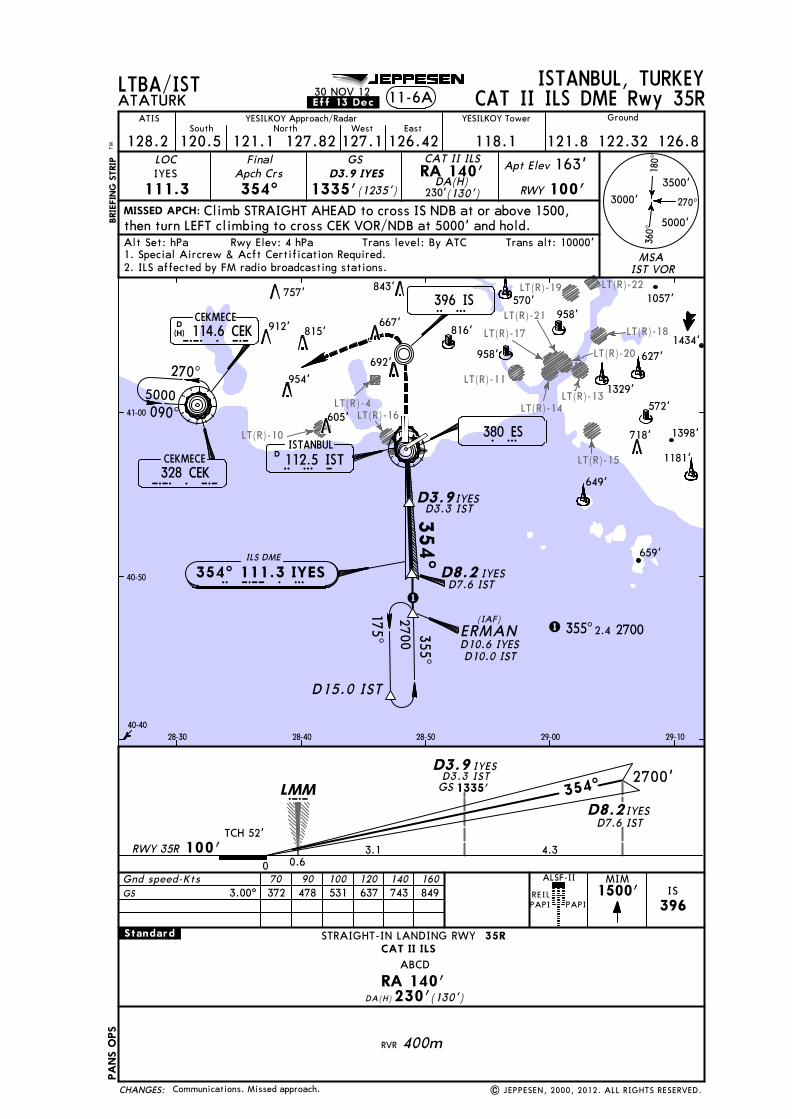
Licensed to SMA. Printed on 03 Oct 2013.
Notice: After 4 Oct 2013 0901Z, this chart may no longer be valid. Disc 19-2013JEPPESENJeppView 3.7.5.0
LT(R)-10
LT(R)-20
LT(R)-15
LT(R)-16
LT(R)-18
LT(R)-13LT(R)-14
LT(R)-17
LT(R)-21
LT(R)-19
LT(R)-4
LT(R)-11
LT(R)-22
D 112.5 ISTISTANBUL
ILS DME
354^ 111.3 IYES
380 ES
100'0
C
I S T
I Y E S
E S
I S
TCH 52'
0.63.1 4.3
2700'354^LMM
D8.2IYESD7.6 IST
1335'GS
D3.9 IYESD3.3 IST
354^
D8.2D7.6 IST
IYES
396 IS
270^
180^
360^
3000'
5000'
3500'
MISSED APCH:
BRIE
FING
STR
IPTM
Gnd speed-Kts 70 90 100 120 140 160
ISTANBUL, TURKEYATATURK
LOC
111.3IYES
FinalApch Crs354^
GS
DA(H)(130')
Apt Elev 163'
RWY 100'
11-6A CAT II ILS DME Rwy 35R
STRAIGHT-IN LANDING RWYCAT II ILS
DA(H) 230'(130')RA 140'
CAT II ILSRA 140'230'
ABCD
RVR 400m
35R
RWY 35R
40-40
40-50
41-00
28-30 28-40 28-50 29-00 29-10
LTBA/IST
Alt Set: hPa Trans level: By ATCRwy Elev: 4 hPaMSA
IST VOR2. ILS affected by FM radio broadcasting stations.1. Special Aircrew & Acft Certification Required.
D3.9IYESD3.3 IST
ERMAN(IAF)
1 355^2.4 2700
1500'396
MIMIS
D3.9 IYES(1235')1335'
D10.6 IYESD10.0 IST
2700
1175^ 355^
PAPI PAPI
ALSF-II
| JEPPESEN, 2000, 2012. ALL RIGHTS RESERVED.
JEPPESEN
.Standard.
128.2
GroundATIS YESILKOY Approach/Radar
127.1 126.42120.5South
121.1North West East
118.1 121.8 126.8122.32127.82
REIL
YESILKOY Tower.Eff.13.Dec.30 NOV 12
Climb STRAIGHT AHEAD to cross IS NDB at or above 1500,then turn LEFT climbing to cross CEK VOR/NDB at 5000' and hold.
CEKMECE114.6 CEKD
(H)C E K
3.00^ 372 478 531 637 743 849
Communications. Missed approach.
Trans alt: 10000'
CHANGES:
GS
D15.0 IST
328 CEK
090^
C E K
270^5000
CEKMECE
PANS
OPS
958'
1329'
692'
570'
659'
649'
843'757'
667'912' 816'815'
954'
958'
627'
605'
718'
572'
1398'
1181'
1057'
1434'

Licensed to SMA. Printed on 03 Oct 2013.
Notice: After 4 Oct 2013 0901Z, this chart may no longer be valid. Disc 19-2013JEPPESENJeppView 3.7.5.0
JEPPESEN
LT(R)-4
LT(R)-15
LT(R)-11
LT(R)-13LT(R)-14
LT(R)-20
LT(R)-17LT(R)-21
LT(R)-18
LT(R)-16
LT(R)-19
LT(R)-10
[FD~5]
[FD~5]
RWY 05
3000'
93'4.54.5
D4.5
1600'059^
MISSED APCH:BRIE
FING
STR
IPTM
ISTANBUL, TURKEYATATURK VORTAC Rwy 0513-1
VOR
112.5IST
FinalApch Crs059^ 1600'
Minimum Alt
MAP at IST VOR
IST
3000
059^ATCOS
ISTD4.5
0.2
1500'on
R-053112.5
ISTD5.5
IST
MISSED APCH CLIMBGRAD MIM 3.5%
D4.5 IST
D9.0 IST
ATCOSD9.0 IST
0
40-50
41-00
28-40 28-50 29-00
(IAF)
Climb on R-053 IST to cross D5.5 IST at or above
LTBA/IST
270^
180^
3000'
3500'(1507')
MDA(H)
470'(377')
Apt Elev 163'
RWY 93'
053^
D5.5 IST
649'380 ESE S
5000'
360^
MSA IST VOR
1329'
Rwy Elev: 3 hPaAlt Set: hPa Trans level: By ATC
MIM
1500'. Proceed to cross BKZ VOR at 4000' and hold.
059^
239^
| JEPPESEN, 2002, 2011. ALL RIGHTS RESERVED.
Gnd speed-Kts 70 90 100 120 140 160Descent Angle 372 478 531 637 743 849
3.00^
3.00^
470'(377')
1500m (937') 3600m
4400m
VIS
1100'1000m
1800m1400m
A
B
C
D
CIRCLE-TO-LANDSTRAIGHT-IN LANDING RWY 05
ALS out MDA(H)MaxKts100
135
180
205
MDA(H)
Missed apch climb gradient mim 3.5%
(937')1100'
.Standard.
TO DISPLACED THRESHOLD
YESILKOY Tower
128.2
GroundATIS YESILKOY Approach/Radar
127.1 126.42120.5South
121.1North West East
118.1 118.37121.8 121.9 122.32127.82
PAPI
HIALS-II
11 MAR 11
TCH displthresh 57'
REIL
Trans alt: 10000'
IST VOR
PANS
OPS
3
CHANGES:
340 STS T
234^4000
NOT TO SCALE
BEYKOZ054̂
117.3 BKZDB K Z
D 112.5 ISTISTANBULI S T
757'
912'815'
667'
843'
816'
692'
954'
605'
Communications. Descent Angle.

Licensed to SMA. Printed on 03 Oct 2013.
Notice: After 4 Oct 2013 0901Z, this chart may no longer be valid. Disc 19-2013JEPPESENJeppView 3.7.5.0
JEPPESEN
LT(R)-4
[FS~5]
4.1
[FS~5]
LT(R)-16LT(R)-10
LT(R)-15
LT(R)-11
LT(R)-13LT(R)-14
LT(R)-20
LT(R)-17LT(R)-21
LT(R)-18
and hold.
Start turn at2 Min
RWY 05
239^1500'3000'
93'
270^
180^
360^
3000'
5000'
3500'
MISSED APCH:BRIE
FING
STR
IPTM
ISTANBUL, TURKEYATATURK 13-2
VOR
112.5IST
FinalApch Crs059^
MDA(H)
470'(377')
Apt Elev 163'
RWY 93'Minimum Alt
VOR Rwy 05
No FAF
053̂
059^
244^064^ 300
0
239^
onR-053112.5
IST4000'
MISSED APCH CLIMBGRAD MIM 3.5%
0.2 0
(IAF)
40-50
41-00
28-40 28-50 29-00
380 ESE S
LTBA/IST
Gnd speed-Kts 70 90 100 120 140 160
059^
Rwy Elev: 3 hPaAlt Set: hPa Trans level: By ATC
Climb on R-053 IST to cross BKZ VOR at 4000'
Procedure turn restricted to MAX 185 KT.
| JEPPESEN, 2000, 2011. ALL RIGHTS RESERVED.
Descent Angle 3.00^ 372 478 531 637 743 849
3.00^
STRAIGHT-IN LANDING RWY
A
B
C
D
CDFA
ALS out ALS out
05 CIRCLE-TO-LAND
MDA(H)
MDA(H) MDA(H)470' 470'(377') (377')MaxKts100
135
180
205
1500m (937')
(937')
3600m
4400m1100'
VIS
1100'
Missed apch climb gradient mim 3.5%.Standard.
non-CDFA
1000m
1800m1400m
1900m1200m
2100m1400m
1329'
TO DISPLACED THRESHOLD
PAPI
HIALS-II
11 MAR 11
YESILKOY Tower
128.2
GroundATIS YESILKOY Approach/Radar
127.1 126.42120.5South
121.1North West East
118.1 118.37 121.8 121.9 122.32127.82
MSAIST VOR
TCH displthresh 57'
REIL
Trans alt: 10000'
IST VOR
PANS
OPS
3
CHANGES:
MAP at IST VOR
340 STS T
649'
NOT TO SCALE
234̂054^
4000
656'
117.3 BKZDBEYKOZ
B K Z
D 112.5 ISTISTANBULI S T
912'815'
954'
605'
692'
667'816'
Communications. Descent Angle.

Licensed to SMA. Printed on 03 Oct 2013.
Notice: After 4 Oct 2013 0901Z, this chart may no longer be valid. Disc 19-2013JEPPESENJeppView 3.7.5.0
3.1 NMto MD17L
[MD17L]
[MD17L]
LT(R)-10
LT(R)-4
LT(R)-16
LT(R)-11
380 ESE S
174^
354^270^
180^
360^
3000'
5000'
3500'
MSA IST VOR
MISSED APCH:
BRIE
FING
STR
IPTM
ISTANBUL, TURKEYATATURK 13-3
VOR
112.5IST
FinalApch Crs174^
Apt Elev 163'
157'Climb on 174^ to 2500', then turn RIGHT climbing
Minimum Alt
MAP at D4.0on
2500'174^
(IAF)
41-00
41-10
28-30 28-40 28-50
VURAL1800'(1643')
340 STS T
LTBA/IST
Rwy Elev: 6 hPaAlt Set: hPa Trans level: By ATC
090^
270^
MDA(H)
(853')
REILPAPI PAPI
ALSF-II
1010' RWY
VORTAC Rwy 17L
| JEPPESEN, 2000, 2012. ALL RIGHTS RESERVED.
Gnd speed-Kts 70 90 100 120 140 160Descent Angle 372 478 531 637 743 849
JEPPESEN
TCH 50'3.00^
3.00^
STRAIGHT-IN LANDING RWY
A
B
C
D
ALS out
CIRCLE-TO-LAND
MDA(H)MaxKts100
135
180
205
3400m (937')
(937')
3600m
4400m1100'
VIS
1100'
.Standard.
2700m
4200m3500m
17L
MDA(H) (853')1010'
Racetrack MAX 185 KT.
YESILKOY Tower
128.2
GroundATIS YESILKOY Approach/Radar
127.1 126.42120.5South
121.1North West East
118.1 121.8 126.8122.32127.82
30 NOV 12 .Eff.13.Dec.
to cross CEK VOR/NDB at 5000' and hold.
CEKMECE114.6 CEKD
(H)C E K
Trans alt: 10000'
D4.0
D12.0 D12.0
174^
MHA 3000
VURAL
ISTANBUL112.5 ISTD I S T
CHANGES:
1800'
4.0 4.0
D12.03000'
D4.0354^174^
VURALD8.0 VOR
328 CEKC E K5000
D8.0
157'1.9 RWY 17L
CEKMECE
958'
942'
692'
570'
843'
757'
667'912' 816'815'
954'
605'
600'
PANS
OPS
Communications. Missed approach.
656'
791'

Licensed to SMA. Printed on 03 Oct 2013.
Notice: After 4 Oct 2013 0901Z, this chart may no longer be valid. Disc 19-2013JEPPESENJeppView 3.7.5.0
LT(R)-22
LT(R)-10
LT(R)-4 LT(R)-11
LT(R)-16
LT(R)-19
LT(R)-21
LT(R)-12
LT(R)-18LT(R)-17
LT(R)-13
LT(R)-15
LT(R)-14
1800'
2.0RWY 23 90'
4000'BKZ
270^
180^
360^
3000'
5000'
3500'
MISSED APCH:BRIE
FING
STR
IPTM
ISTANBUL, TURKEYATATURK
VOR
117.3BKZ
233^ 2500'(2410')
MDA(H)
800'(710')
Apt Elev 163'
RWY 90'
Climb on 235^ to 2500', then turn RIGHT climbing
STRAIGHT-IN LANDING RWY
A
B
C
D
23 CIRCLE-TO-LAND
MDA(H)
MDA(H) 800'(710')MaxKts100
135
180
205
on2500'
235^
13-4
BEYKOZ117.3 BKZD
D9.0
D13.0D15.0
233^
BKZ
BKZ
BKZ BKZ
Minimum Alt
D11.0BKZD13.0
BKZD15.0
BKZ
D9.0
2.0 9.0
MSAIST VOR
ALS out
2500'
1200'
VIS
(IAF)
233^
B K Z
40-50
41-00
41-10
28-30 28-40 28-50 29-00 29-10
D9.0 BKZ
340 STS T
380 ESE S
LTBA/IST
Alt Set: hPa Trans level: By ATCRwy Elev: 3 hPa
VOR DME Rwy 23
FinalApch Crs
(937')
(937')1100'
1100'
| JEPPESEN, 2000, 2012. ALL RIGHTS RESERVED.
JEPPESEN
.Standard.
PAPI
HIALS-II
YESILKOY Tower
128.2
GroundATIS YESILKOY Approach/Radar
127.1 126.42120.5South
121.1North West East
118.1 121.8 126.8122.32127.82
REIL
30 NOV 12 .Eff.13.Dec.
to cross CEK VOR/NDB at 4000' and hold.
CEKMECE114.6 CEKD
(H)C E K
Trans alt: 10000'
LT(R)-20
D 112.5 ISTISTANBUL235̂
I S T
0 16.52.0
CHANGES:
D11.0
1.5
3300m 3700m
3600m
4400m
MAP at D15.0 BKZ
BKZ VOR
3100m 3500m
600'
617'942'
757'
815'
843'
667'
676'623'
817'817'817' 795'
954'
605'
692'
816'958'
570'
1434'
1329'627'
572'
718' 1398'
1181'
649'
659'
958'
328 CEK
090^
C E K
270^4000
CEKMECE
PANS
OPS
Communications. Missed approach.
1057'

Licensed to SMA. Printed on 03 Oct 2013.
Notice: After 4 Oct 2013 0901Z, this chart may no longer be valid. Disc 19-2013JEPPESENJeppView 3.7.5.0
[MD23]
[FD23]
[MD23]
[FD23]
[4~VOR]
[4~VOR]
LT(R)-4
LT(R)-16
LT(R)-11
LT(R)-17
LT(R)-21
LT(R)-20LT(R)-14
LT(R)-13
LT(R)-15
LT(R)-18LT(R)-19
LT(R)-22
230^
235^
050^
D2.5
D4.0
D7.0 KOFUN
230^
3000
270^
180^
360^
3000'
5000'
3500'
MSA IST VOR
MISSED APCH:BRIE
FING
STR
IP
ISTANBUL, TURKEYATATURK VORTAC Rwy 2313-5
VOR
112.5IST
FinalApch Crs230^ 2000'(1910')
MDA(H)
710'(620')
Apt Elev 163'
RWY 90'
Minimum AltD7.0
3000'
1.090'RWY 23
VOR
1000'
1.5 3.0 3.0
D2.5D4.0
D7.0 KOFUN
230^
D10.0
Climb on 235^ to 2500', then turn RIGHT climbing
2500'on 235^
(IAF)
41-10
28-40 28-50 29-00
2000'
380 ESE S
D10.0
LTBA/IST
090^
270^
328 CEK
NOT TO SCALE
41-00
Gnd speed-Kts 70 90 100 120 140 160
Rwy Elev: 3 hPaAlt Set: hPa Trans level: By ATC
4000
| JEPPESEN, 2000, 2012. ALL RIGHTS RESERVED.
JEPPESEN
3.24^
TCH 57'
710'(620')
2600m (937') 3600m
4400m
VIS
1100'2200m
3100m2700m
A
B
C
D
CIRCLE-TO-LANDSTRAIGHT-IN LANDING RWY 23
ALS out MDA(H)MaxKts100
135
180
205
MDA(H)
(937')1100'
.Standard.
PAPI
HIALS-II
YESILKOY Tower
128.2
GroundATIS YESILKOY Approach/Radar
127.1 126.42120.5South
121.1North West East
118.1 121.8 126.8122.32127.82
REIL
30 NOV 12 .Eff.13.Dec.
to cross CEK VOR/NDB at 4000' and hold.
CEKMECE114.6 CEKC E K
Descent Angle 3.24^ 401 516 573 688 803 917
Trans alt: 10000'
112.5 ISTI S TISTANBUL
D
CHANGES:
MAP at D2.5
S T340 ST
c e kCEKMECE
958'
692'
570'
649'
843'757'
667'912' 816'815'
958'
1329'
600' 764'
PANS
OPS
Communications. Missed approach.

Licensed to SMA. Printed on 03 Oct 2013.
Notice: After 4 Oct 2013 0901Z, this chart may no longer be valid. Disc 19-2013JEPPESENJeppView 3.7.5.0
[MD35L]
[FD35L]
[MD35L]
[FD35L]
LT(R)-16
LT(R)-10
LT(R)-4 LT(R)-11
LT(R)-211
LT(R)-17 1
LT(R)-20LT(R)-14
I S396 IS
328 CEKC E K380 ESE S
270^
180^
360^
3000'
5000'
3500'
MSA IST VOR
MISSED APCH:BRIE
FING
STR
IPTM
ISTANBUL, TURKEYATATURK 13-6
VOR
112.5IST
FinalApch Crs004^ 1890'(1788')
MDA(H)
550'(448')
Apt Elev 163'
RWY102'
Minimum AltD5.0
00.5
3500'
1890'
004^
4.15.0
D5.0
40-50
41-00
28-30 28-40 28-50 29-00
340 STS T
LTBA/IST
Alt Set: hPa Trans level: By ATC
D5.0
1500'396
MIMIS
270^5000
D10.0D0.9
0.9
D0.9
004^
004^
184^ D10.0
3500
(IAF)
Gnd speed-Kts 70 90 100 120 140 160
PAPI PAPI
HIALS-II
VORTAC-1 Rwy 35L
| JEPPESEN, 2005, 2012. ALL RIGHTS RESERVED.
JEPPESEN
TCH 54'3.00^
NOT TO SCALE
550'(448')
2000m (937') 3600m
4400m
VIS
1100'1600m
2500m2100m
A
B
C
D
CIRCLE-TO-LANDSTRAIGHT-IN LANDING RWY
ALS out MDA(H)MaxKts100
135
180
205
MDA(H)
(937')1100'
.Standard. 35L
YESILKOY Tower
128.2
GroundATIS YESILKOY Approach/Radar
127.1 126.42120.5South
121.1North West East
118.1 121.8 126.8122.32127.82
REIL
30 NOV 12 .Eff.13.Dec.
Climb STRAIGHT AHEAD to cross IS NDB at or above 1500,then turn LEFT climbing to cross CEK VOR/NDB at 5000' and hold.
CEKMECE114.6 CEKD
(H)C E K
Descent Angle 3.00^ 372 478 531 637 743 849
Rwy Elev: 4 hPa Trans alt: 10000'
D I S TISTANBUL112.5 IST
CHANGES:
102'
VOR
RWY 35L
MAP at D0.9
CEKMECE
D15.0
958'
692'
867'
954'
605'
912' 815' 816'
PANS
OPS
Communications. Missed approach.
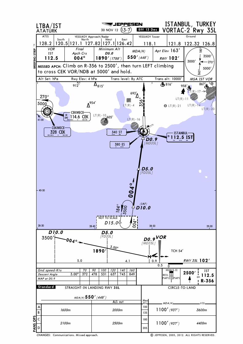
Licensed to SMA. Printed on 03 Oct 2013.
Notice: After 4 Oct 2013 0901Z, this chart may no longer be valid. Disc 19-2013JEPPESENJeppView 3.7.5.0
LT(R)-4
[MD35L]
[FD35L]
[MD35L]
[FD35L]
LT(R)-10LT(R)-16
LT(R)-11
LT(R)-14LT(R)-20
LT(R)-17
LT(R)-21
1
1
328 CEKC E K380 ESE S
270^
180^
360^
3000'
5000'
3500'
MSA IST VOR
MISSED APCH:BRIE
FING
STR
IPTM
ISTANBUL, TURKEYATATURK 13-7
VOR
112.5IST
FinalApch Crs004^ 1890'(1788')
MDA(H)
550'(448')
Apt Elev 163'
RWY 102'
Minimum AltD5.0
40-50
41-00
28-30 28-40 28-50 29-00
340 STS T
LTBA/IST
Alt Set: hPa
R-356
270^5000
004^
004^
184^ D10.0
3500
(IAF)
356^
2500'on
Gnd speed-Kts 70 90 100 120 140 160
D0.9
D5.0
3500'
1890'
004^
4.15.0
D5.0D10.0D0.9
0.90.5 0
PAPI PAPI
HIALS-II IST112.5
| JEPPESEN, 2005, 2012. ALL RIGHTS RESERVED.
VORTAC-2 Rwy 35L
Climb on R-356 to 2500', then turn LEFT climbing
JEPPESEN
TCH 54'3.00^
NOT TO SCALE
550'(448')
2000m (937') 3600m
4400m
VIS
1100'1600m
2500m2100m
A
B
C
D
CIRCLE-TO-LANDSTRAIGHT-IN LANDING RWY
ALS out MDA(H)MaxKts100
135
180
205
MDA(H)
(937')1100'
.Standard. 35L
YESILKOY Tower
128.2
GroundATIS YESILKOY Approach/Radar
127.1 126.42120.5South
121.1North West East
118.1 121.8 126.8122.32127.82
REIL
30 NOV 12 .Eff.13.Dec.
to cross CEK VOR/NDB at 5000' and hold.
CEKMECE114.6 CEKD
(H)C E K
Descent Angle 3.00^ 372 478 531 637 743 849
958'
D I S TISTANBUL112.5 IST
CHANGES:
102'
VOR
RWY 35L
CEKMECE
D15.0
MAP at D0.9
PANS
OPS
Communications. Missed approach.
692'
867'
954'
605'
912' 815' 816'
Trans level: By ATCRwy Elev: 4 hPa Trans alt: 10000'

Licensed to SMA. Printed on 03 Oct 2013.
Notice: After 4 Oct 2013 0901Z, this chart may no longer be valid. Disc 19-2013JEPPESENJeppView 3.7.5.0
LT(R)-4
[FD35R]4.7 NMto VOR
[FD35R]
LT(R)-10LT(R)-16
LT(R)-11
LT(R)-14LT(R)-20
LT(R)-17LT(R)-21
1
1
ERMAN3000
I S396 IS
328 CEKC E K380 ESE S
355^
270^
180^
360^
3000'
5000'
3500'
MSA IST VOR
MISSED APCH:
BRIE
FING
STR
IPTM
ISTANBUL, TURKEYATATURK 13-8
VOR
112.5IST
FinalApch Crs355^ 1800'(1700')
MDA(H)
550'(450')
Apt Elev 163'
RWY 100'
Minimum AltD5.0
0 0.5
3000'1800' 355^
5.0 5.0
D5.0ERMAN
D10.0
40-50
41-00
28-30 28-40 28-50 29-00
340 STS T
(IAF)
LTBA/IST
Alt Set: hPa
Gnd speed-Kts 70 90 100 120 140 160372 478 531 637 743 849
D5.0
1500'396
MIMIS
355^
175^
270^5000
D10.0
PAPI PAPI
ALSF-II
| JEPPESEN, 2002, 2012. ALL RIGHTS RESERVED.
VORTAC Rwy 35R
Climb STRAIGHT AHEAD to cross IS NDB at or
5000' and hold.
692'
606'912' 816'815'
867'
954'
605'
JEPPESEN
NOT TO SCALE
3.00^TCH 52'
Descent Angle 3.00^
STRAIGHT-IN LANDING RWY
A
B
C
D
ALS out
CIRCLE-TO-LAND
MDA(H)MaxKts100
135
180
205
1800m (937')
(937')
3600m
4400m1100'
VIS
1100'
.Standard.
1400m
2300m1600m
35R
MDA(H) (450')550'
YESILKOY Tower
128.2
GroundATIS YESILKOY Approach/Radar
127.1 126.42120.5South
121.1North West East
121.8127.82
REIL
118.1 122.32 126.8
CEKMECE114.6 CEKD
(H)
30 NOV 12 .Eff.13.Dec.
above 1500', then turn LEFT climbing to cross CEK VOR/NDB at
C E K
D I S TISTANBUL112.5 IST
CHANGES:
MAP at VOR
100'
VOR
RWY 35R
CEKMECE
958'
D15.0
Communications. Missed approach.
PANS
OPS
Trans level: By ATCRwy Elev: 4 hPa Trans alt: 10000'

Licensed to SMA. Printed on 03 Oct 2013.
Notice: After 4 Oct 2013 0901Z, this chart may no longer be valid. Disc 19-2013JEPPESENJeppView 3.7.5.0
LT(R)-4
3.8
[FS35R]
[FS35R]
LT(R)-10LT(R)-16
LT(R)-11
LT(R)-14
LT(R)-17
LT(R)-21
I S396 IS
328 CEKC E K
270^
180^
360^
3000'
5000'
3500'
MSA IST VOR
MISSED APCH:
BRIE
FING
STR
IPTM
ISTANBUL, TURKEYATATURK 13-9
VOR
112.5IST
FinalApch Crs355^
MDA(H)
550'(450')
Apt Elev 163'
RWY 100'
Minimum Alt
3000'
1500'
355^
VOR Rwy 35R
380 ESE S
175^
355^
(IAF)
175^
2 Min
No FAF
MHA3000
0 0.5
40-50
41-00
28-30 28-40 28-50 29-00
340 STS T
LTBA/IST
Gnd speed-Kts 70 90 100 120 140 160372 478 531 637 743 849
Rwy Elev: 4 hPaAlt Set: hPa Trans level: By ATC
270^5000
1500'396
MIMIS
PAPI PAPI
ALSF-II
| JEPPESEN, 2000, 2012. ALL RIGHTS RESERVED.
JEPPESEN
TCH 52'
3.00^
Descent Angle 3.00^
STRAIGHT-IN LANDING RWY
A
B
C
D
CDFA
ALS out ALS out
CIRCLE-TO-LAND
MDA(H)MaxKts100
135
180
205
1800m (937')
(937')
3600m
4400m1100'
VIS
1100'
.Standard.non-CDFA
1400m
2300m1600m
2300m1600m
2500m1800m
35R
MDA(H) (450')550' MDA(H) 550'(450')
Racetrack MAX 185 KT.
YESILKOY Tower
128.2
GroundATIS YESILKOY Approach/Radar
127.1 126.42120.5South
121.1North West East
118.1 121.8 126.8122.32127.82
REIL
CEKMECE114.6 CEKD
(H)
Climb STRAIGHT AHEAD to cross IS NDB at or above 1500,then turn LEFT climbing to cross CEK VOR/NDB at 5000' and hold.
30 NOV 12 .Eff.13.Dec.
C E K
Trans alt: 10000'
D I S TISTANBUL112.5 IST
CHANGES:
100'
VOR
RWY 35R
958'
570'
CEKMECE
MAP at VOR
757'
815'912'
954'
605'
843'
667'
692'
816'
958'
PANS
OPS
Communications. Missed approach.
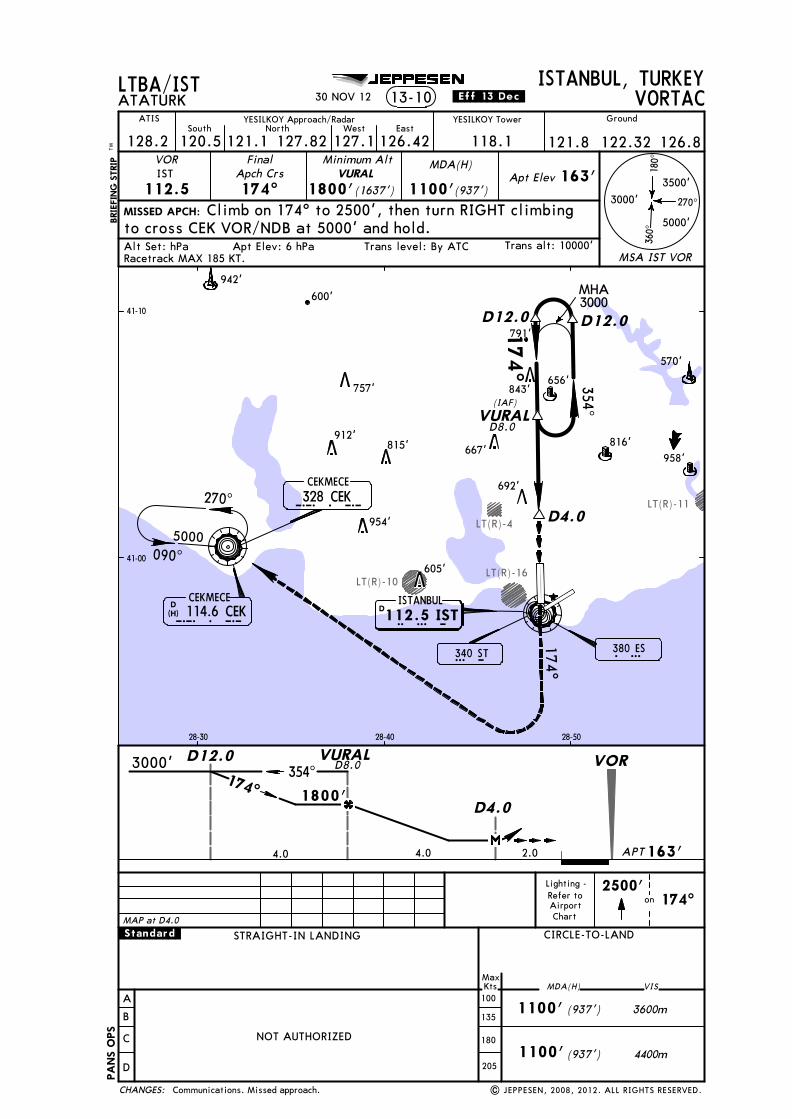
Licensed to SMA. Printed on 03 Oct 2013.
Notice: After 4 Oct 2013 0901Z, this chart may no longer be valid. Disc 19-2013JEPPESENJeppView 3.7.5.0
LT(R)-4
LT(R)-10LT(R)-16
LT(R)-11
380 ESE S
174^
354^270^
180^
360^
3000'
5000'
3500'
MSA IST VOR
MISSED APCH:
BRIE
FING
STR
IPTM
ISTANBUL, TURKEYATATURK
VOR
112.5IST
FinalApch Crs174^
Apt Elev 163'
Climb on 174^ to 2500', then turn RIGHT climbing
Minimum Alt
on2500'
174^
(IAF)
41-00
41-10
28-30 28-40 28-50
1800'(1637')
LTBA/IST
Apt Elev: 6 hPaAlt Set: hPa Trans level: By ATC
090^
270^
MDA(H)
(937')
(937')1100'
(937')1100'
1100'
13-10 VORTAC
VURAL
NOT AUTHORIZED
Lighting -Refer toAirportChart
| JEPPESEN, 2008, 2012. ALL RIGHTS RESERVED.
JEPPESEN
.Standard.
340 STS T
Racetrack MAX 185 KT.
YESILKOY Tower
128.2
GroundATIS YESILKOY Approach/Radar
127.1 126.42120.5South
121.1North West East
118.1 121.8 126.8122.32127.82
30 NOV 12 .Eff.13.Dec.
to cross CEK VOR/NDB at 5000' and hold.
CEKMECE114.6 CEKD
(H)C E K
Trans alt: 10000'
D4.0
D12.0
174^
MHA 3000
VURAL
958'
942'
570'
CHANGES:
A
B
C
D
CIRCLE-TO-LAND
MaxKts MDA(H)100
135
180
205
1800'
4.0 4.0
D12.03000'
D4.0
354^174^
VURAL VOR
4400m
3600m
VIS
328 CEKC E K
656'
5000
163'2.0
D12.0
APT
STRAIGHT-IN LANDING
D8.0
D8.0
MAP at D4.0
CEKMECE
757'
912'815'
954'
605'
816'667'
692'
843'
ISTANBUL112.5 ISTD I S T
PANS
OPS
Communications. Missed approach.
600'
791'
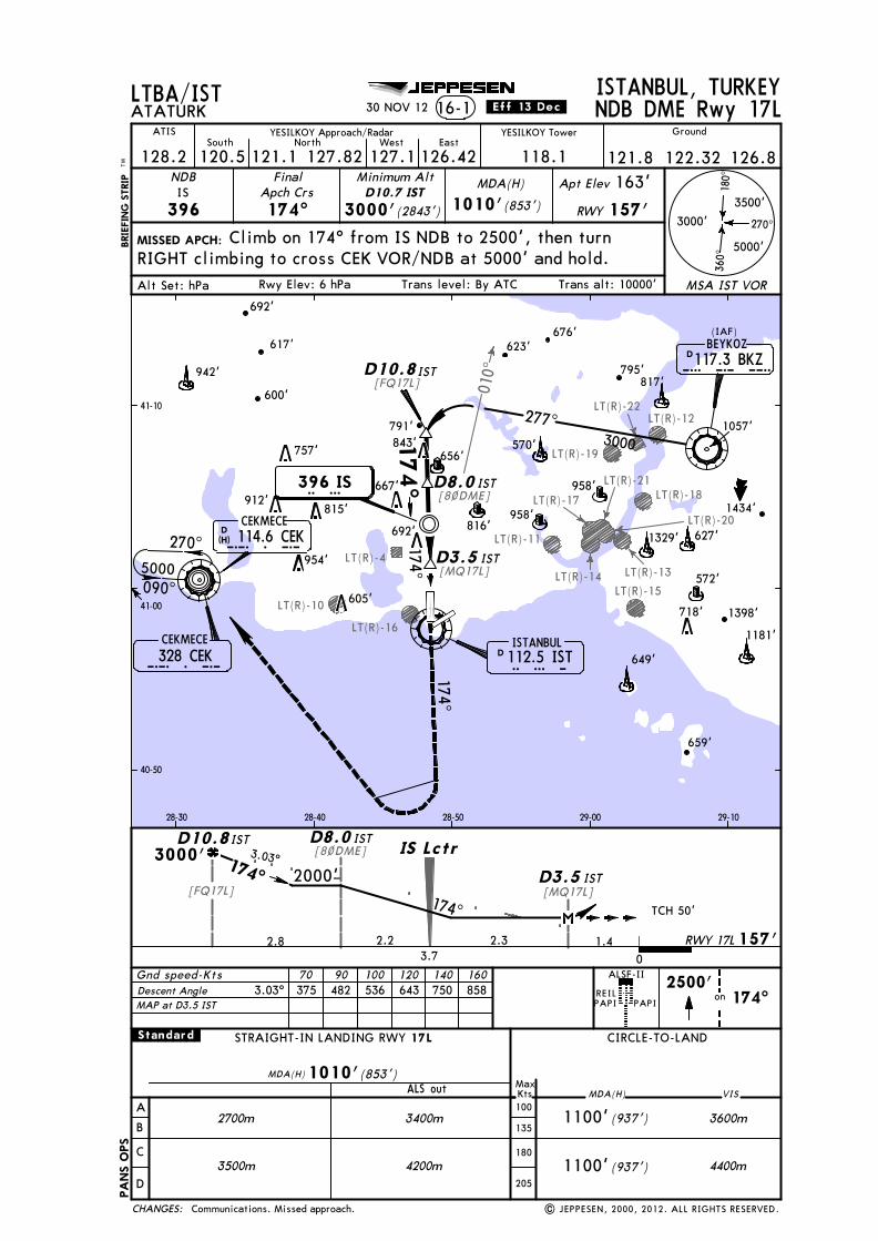
Licensed to SMA. Printed on 03 Oct 2013.
Notice: After 4 Oct 2013 0901Z, this chart may no longer be valid. Disc 19-2013JEPPESENJeppView 3.7.5.0
LT(R)-4
010^
[8~DME]
[MQ17L]
[MQ17L]
[FQ17L]
[FQ17L]
[8~DME]
LT(R)-10
LT(R)-16
LT(R)-15
LT(R)-19
LT(R)-12
LT(R)-18
LT(R)-11
LT(R)-13LT(R)-14
LT(R)-17
LT(R)-21
LT(R)-22
LT(R)-20
2000'
D10.8
2.8
676'
958'
396 IS
2.2 2.33.7
D3.5
1329'
D8.0174^
270^
180^
360^
3000'
5000'
3500'
MSA IST VOR
MISSED APCH:BRIE
FING
STR
IPTM
Gnd speed-Kts 70 90 100 120 140 160
ISTANBUL, TURKEYATATURK 16-1
NDB FinalApch Crs174^
MDA(H)
(853')
Apt Elev 163'
RWY 157'
REILPAPI PAPI
2500'on 174^
IS
396
Minimum Alt
Climb on 174^ from IS NDB to 2500', then turn
IST
IST
IST
IST
IST
IST
174^
NDB DME Rwy 17L
(IAF)
40-50
41-00
41-10
28-30 28-40 28-50 29-00 29-10
D10.7 IST3000'(2843')
LTBA/IST
Alt Set: hPa Trans level: By ATC
ALSF-II
Rwy Elev: 6 hPa
1010'
| JEPPESEN, 2000, 2012. ALL RIGHTS RESERVED.
JEPPESEN
MDA(H) (853')1010'
3.03^
TCH 50'
942'
617'
757'
912'815'
954'
605'
843'
667'
692'
958'
816'627'
3400m (937') 3600m
4400m
VIS
1100'2700m
4200m3500m
A
B
C
D
CIRCLE-TO-LANDSTRAIGHT-IN LANDING RWY
ALS out MDA(H)MaxKts100
135
180
205
(937')1100'
.Standard. 17L
YESILKOY Tower
128.2
GroundATIS YESILKOY Approach/Radar
127.1 126.42120.5South
121.1North West East
118.1 121.8 126.8127.82
30 NOV 12 .Eff.13.Dec.
122.32
RIGHT climbing to cross CEK VOR/NDB at 5000' and hold.
CEKMECE114.6 CEKD
(H)C E K
623'
795'
1181'
Descent Angle 3.03^ 375 482 536 643 750 858
1057'
1434'
3000'
Trans alt: 10000'
117.3 BKZBEYKOZ
D 112.5 ISTISTANBUL
328 CEK
174^
157'
090^
C E K
270^
3000
277^174^
D10.8 B K Z
I S T
I S174^ D3.5
D8.0
1.4
IS Lctr
0
D
659'
CHANGES:
MAP at D3.5 IST
RWY 17L
570'
649'
656'
817'
791'
5000
CEKMECE
718'
PANS
OPS
Communications. Missed approach.
692'
600'
1398'
572'