LQ 6RIWZDUH 'HÀQHG ,QWHJUDWHG Terrestrial-Satellite … · information about network statistics,...
11
China Communications • August 2018 11 Keywords: Integrated terrestrial-satellite net- ZRUNV VRIWZDUH GH¿QHG QHWZRUNLQJ VRIWZDUH GH¿QHG VDWHOOLWH QHWZRUNV GHOD\ HVWLPDWLRQ 1752'8&721 In traditional satellite communication net- works the infrastructure is composed of sat- ellites, ground stations, and ground terminals developed ad-hoc by each satellite operator. Proprietary hardware and software compo- nents have always limited the integration with terrestrial networks and also among satellite networks managed by different operators. The main principles of the next generation of wireless communication (5G) are involving deep changes in the network infrastructure and management. An expansion of the classical Internet is foreseen in order to incorporate heterogeneous portions based on different technologies, including satellite communi- cations, in a multi-layer network where the physical implementation is transparent to the users. There are several key areas where sat- ellites can contribute [1]. Their wide coverage allows extending network access in rural and remote areas where there is no kind of com- munication infrastructure. Satellites can be exploited in case of emergency and disaster situations where the terrestrial infrastructure is Abstract: Satellite communication networks have been evolving from standalone net- works with ad-hoc infrastructures to possibly interconnected portions of a wider Future Internet architecture. Experts belonging to the ¿IWKJHQHUDWLRQ * VWDQGDUGL]DWLRQ FRPPLW- tees are considering satellites as a technology to integrate in the 5G environment. Software 'H¿QHG 1HWZRUNLQJ 6'1 LV RQH RI WKH SDU- adigms of the next generation of mobile and ¿[HG FRPPXQLFDWLRQV ,W FDQ EH HPSOR\HG WR perform different control functionalities, such DV URXWLQJ EHFDXVH LW DOORZV WUDI¿F ÀRZ LGHQ- tification based on different parameters and WUDI¿F ÀRZ PDQDJHPHQW LQ D FHQWUDOL]HG ZD\ A centralized set of controllers makes the de- cisions and sends the corresponding forward- LQJ UXOHV IRU HDFK WUDI¿F ÀRZ WR WKH LQYROYHG intermediate nodes that practically forward data up to the destination. The time to perform this process in integrated terrestrial-satellite networks could be not negligible due to sat- ellite link delays. The aim of this paper is to introduce an SDN-based terrestrial satellite network architecture and to estimate the mean time to deliver the data of a new traffic flow from the source to the destination including the time required to transfer SDN control actions. The practical effect is to identify the maximum performance than can be expected. 7KH ,PSDFW RI 'HOD\ LQ 6RIWZDUH'HÀQHG ,QWHJUDWHG Terrestrial-Satellite Networks Luca Boero, Mario Marchese, Fabio Patrone* Department of Electrical, Electronics and Telecommunication Engineering, and Naval Architecture (DITEN) University of Genoa, Via All’Opera Pia 13, 16145, Genoa, Italy * The corresponding author, e-mail: [email protected] Received: Feb. 24, 2018 Revised: Jun. 1, 2018 Editor: Linling Kuang INTEGRATED TERRESTRIAL-SATELLITE NETWORKS
Transcript of LQ 6RIWZDUH 'HÀQHG ,QWHJUDWHG Terrestrial-Satellite … · information about network statistics,...
China Communications • August 2018 11
Keywords: Integrated terrestrial-satellite net-
In traditional satellite communication net-works the infrastructure is composed of sat-ellites, ground stations, and ground terminals developed ad-hoc by each satellite operator. Proprietary hardware and software compo-nents have always limited the integration with terrestrial networks and also among satellite networks managed by different operators.
The main principles of the next generation of wireless communication (5G) are involving deep changes in the network infrastructure and management. An expansion of the classical Internet is foreseen in order to incorporate heterogeneous portions based on different technologies, including satellite communi-cations, in a multi-layer network where the physical implementation is transparent to the users. There are several key areas where sat-ellites can contribute [1]. Their wide coverage allows extending network access in rural and remote areas where there is no kind of com-munication infrastructure. Satellites can be exploited in case of emergency and disaster situations where the terrestrial infrastructure is
Abstract: Satellite communication networks have been evolving from standalone net-works with ad-hoc infrastructures to possibly interconnected portions of a wider Future Internet architecture. Experts belonging to the
-tees are considering satellites as a technology to integrate in the 5G environment. Software
-adigms of the next generation of mobile and
perform different control functionalities, such -
tification based on different parameters and
A centralized set of controllers makes the de-cisions and sends the corresponding forward-
intermediate nodes that practically forward data up to the destination. The time to perform this process in integrated terrestrial-satellite networks could be not negligible due to sat-ellite link delays. The aim of this paper is to introduce an SDN-based terrestrial satellite network architecture and to estimate the mean time to deliver the data of a new traffic flow from the source to the destination including the time required to transfer SDN control actions. The practical effect is to identify the maximum performance than can be expected.
Terrestrial-Satellite Networks
Luca Boero, Mario Marchese, Fabio Patrone*
Department of Electrical, Electronics and Telecommunication Engineering, and Naval Architecture (DITEN)University of Genoa, Via All’Opera Pia 13, 16145, Genoa, Italy* The corresponding author, e-mail: [email protected]
Received: Feb. 24, 2018Revised: Jun. 1, 2018 Editor: Linling Kuang
INTEGRATED TERRESTRIAL-SATELLITE NETWORKS
China Communications • August 201812
exploiting general-purpose, instead of ad-hoc, hardware components over which standard virtualized functions are deployed.The paper is organized as follows. Section
II highlights the role of SDN within the in-tegration of 5G and satellite communication and focuses on the aim of the paper. The intro-duced SDN-based terrestrial satellite network is reported in Section III, followed by the description of the time estimation model in Section IV. The results obtained with different network topologies are reported in Section V. Conclusions are summarized in SectionVI.
5G AND S CR SDN
Different studies have investigated in details -
os, and challenges that the 5G paradigm brings to satellite communications [4-7].
In this paper, we focus on the SDN [8] in order to better understand which are the con-sequences of its employment in satellite net-works. The main principle of SDN is to cen-tralize the intelligence of the network decou-pling control and Data Planes. The network infrastructure is abstracted in three different planes:• Data/Forwarding Plane: it contains the
nodes called SDN switches whose aim is to forward the received packets following the instructions contained in the flow ta-ble. If SDN switches do not have a rule for the new incoming traffic flow, they send a request to an SDN controller for indi-cation about the next hop that the packet must follow by using standard Application Programming Interfaces (APIs) identified as southbound APIs. SDN switches also periodically send network statistics to SDN controllers.
• Control Plane: the nodes belonging to this Plane are called SDN controllers. Their aim is to compute forwarding rules for SDN switches in order to guarantee the required
information about network statistics, such
damaged. A satellite temporary network could be quickly deployed to help collect informa-tion and spread news. Satellite integration in 5G may imply higher network availability and reliability, two of the 5G Key Performance
the 5G-PPP activity [2]. Another task where satellites can help, due to their broadcasting capability, is to bring application content clos-er to users located far from the content sourc-es, which eases the achievement of the 5G KPI target of “zero perceived delay” and “1000 higher wireless area capacity in access”. Con-tent caching to the edge can be employed in conjunction with Edge Computing (EC) para-digm in order to improve the end-user Quality of Experience (QoE). Lower energy consump-tion is another major concern related to the 5G evolution, which can be achieved by satellites again owing to their broadcasting capability. Summarizing, satellite networks can be inte-grated with terrestrial networks and exploited as a backhaul technology to help achieve some
higher service availability, higher reliability, lower latency caching the content closer to the users, and lower energy consumption [3].
Network programmability and virtualiza-tion are other keywords of the today’s network evolution. Software Defined Radio (SDR), Software Defined Networking (SDN), and Network Functions Virtualization (NFV) are the paradigms which should be exploited also in satellite networks in order to:• employ the intelligent delivery of services
and smart routing strategies;• allow the deployment of new services in a
• give the satellite operators the ability to charge customers according to the real us-age of the satellite resources;
• reduce the energy consumption by virtual-izing the functions performed by the ground components of the satellite infrastructure (satellite gateways/hubs/terminals) and consolidating/activating/deactivating their action on remote datacenters;
• reduce Capital Expenditure (CAPEX) by

China Communications • August 2018 13
most interesting use cases and perspectives: the used network infrastructure is composed of a Geostationary (GEO) satellite including the SDN controller, Satellite Gateways acting as SDN switches, and a terrestrial Network Management Centre (NMC) implementing the Management Plane. Almost the same network architecture is considered in [11], where an SDN-based Information-Centric Networking (ICN) architecture for an integrated satel-lite-terrestrial network is proposed. [10] also suggests that a network composed of a Low Earth Orbit (LEO) satellite constellation in addition to a GEO satellite system could bring benefits. A novel software-defined satellite network architecture, called OpenSAN, is proposed in [12]: the satellite ground segment infrastructure acts as the Data Plane, a GEO satellite includes the Control Plane, while the Management functionalities are performed by a terrestrial Network Operation and Control Centre (NOCC). An architecture which ex-ploits LEO inter-satellite links (ISLs) for data forwarding and GEO broadcasting capabilities for rapid network deployment is described in [13]. Other studies have considered a hierar-chical multi-layer satellite network where the Data Plane is included both in LEO and Medi-um Earth Orbit (MEO) satellites [14-16].
Only [13] considers the computation of the time required to establish a new forwarding rule and to route and deliver the first packet of the new data. The rest of the packets will follow the same forwarding rule. The required time is in the order of few milliseconds in ter-
affect the application data delivery time. In in-tegrated terrestrial-satellite networks, it could be not negligible, especially considering sat-ellite link delays together with the strict per-formance requirements of some applications. The aim of this paper is to estimate the mean value of this time in a software-defined inte-grated terrestrial-satellite network, in order to identify which are the maximum performance requirements a certain application can get if its data are forwarded through satellites.
as traffic flows, link status, queue status, -
policies stored in the Management Plane nodes.
• Management Plane: information about net-work statistics, traffic flow identification parameters, and user/application perfor-mance policies are stored in the nodes of this Plane. The Management Plane is a sort of database containing all the information needed by SDN controllers and exchanged
-bound APIs.SDN can be employed for different pur-
poses. The most common is routing, but also congestion control, flow control, and even security, allowing novel control and manage-ment strategies based on fine-grained traffic
The most commonly used communication protocol between SDN switches and control-lers is OpenFlow [9]. It is used to manage the flow tables inside the SDN switches to forward packets. These tables consist of lists of flow entries which include matching rules and corresponding actions. Each matching
of parameters to identify a traffic flow, such as source and destination Ethernet addresses, source and destination IP addresses, source and destination TCP/UDP ports, among others.
there is a match between received packets and matching rules, the packets are forwarded by using the corresponding actions. If there is no match, SDN switches ask for a new forward-ing rule which is computed and sent back by the SDN controllers.
Several studies have already investigated the employment of SDN in integrated terres-trial-satellite networks. The main difference among them is how the different authors have decided to locate the different SDN Planes and their functionalities within the satellite network components. [10] investigates the use of the SDN paradigm in High-Through-put Satellite (HTS) networks, identifying the

China Communications • August 201814
be based on different technologies, such as 5G cells, Local Area Networks, LTE cells, linked together by a terrestrial infrastructure but also by a LEO satellite constellation, which is com-
flows with given performance requirements, especially the delay-tolerant ones, can be forwarded through the satellite constellation, partially offloading the terrestrial infrastruc-ture. Alternatively, the satellite route could be selected in case of fault of the terrestrial infra-structure.
In details, the overall terrestrial portion is composed of:• Ground stations: terrestrial stations linked,
on the one hand, with terrestrial terminals through terrestrial communication means (wired or wireless) and, on the other hand, equipped with a satellite antenna to send/receive data to/from satellites.
• Terrestrial hosts: they are all kind of nodes
• Network Management and Control Centres (NMCCs): three terrestrial centres which manage network resources and user re-quirements.The satellite portion includes three GEO
satellites. Each GEO satellite covers a third of the shared LEO constellation. LEO satel-lites are linked with the ground stations and, through ISLs, among them. The considered LEO satellite constellation is a multi-orbit polar constellation where orbital planes are circular and equally spaced among them. Sat-ellites are equally spaced within each orbit. Its
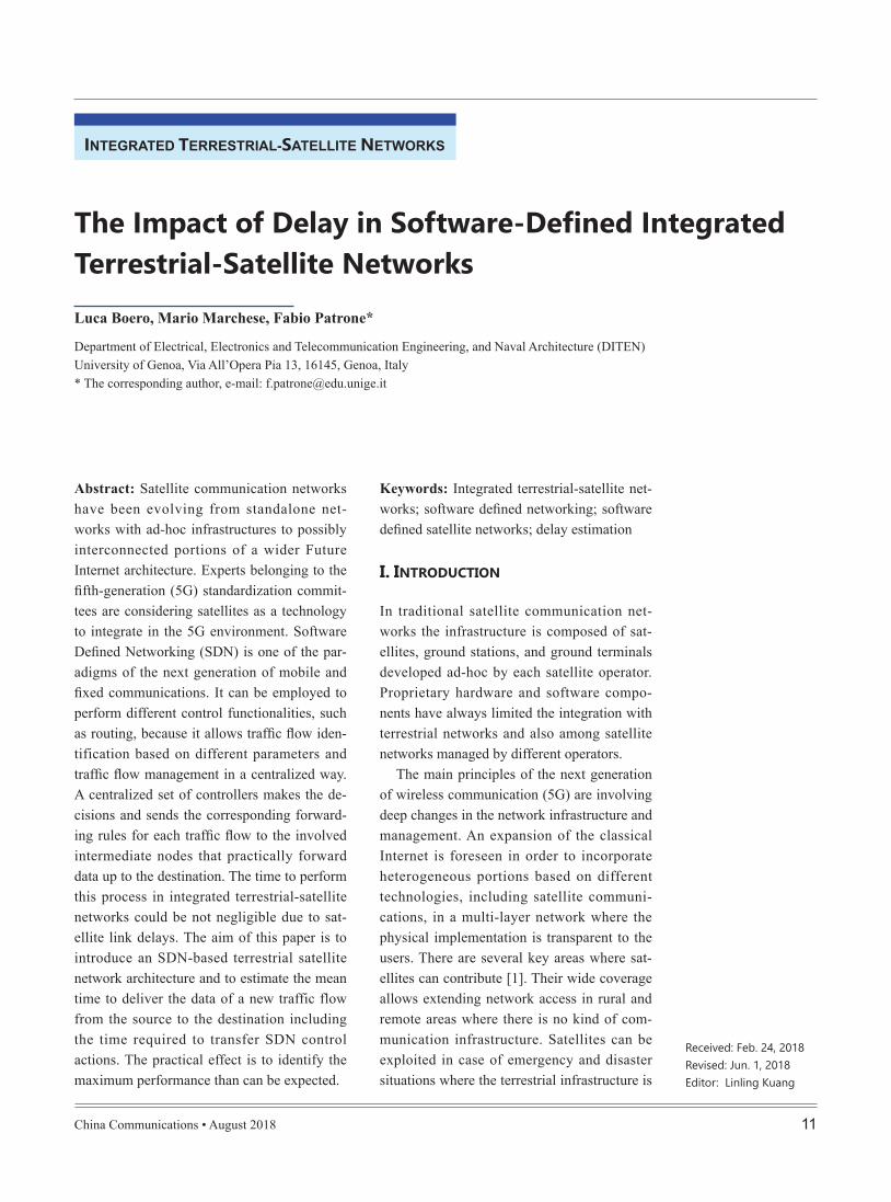
There are two types of ISLs: intra-orbit ISLs (ia-ISLs), which are the links between adjacent LEO satellites belonging to the same orbit; and inter-orbit ISLs (ie-ISLs), which are the links between adjacent LEO satellites belonging to different and adjacent orbits. In this way, each satellite has four bidirectional ISLs. However, in this kind of constellation, satellites which are travelling at high latitude are not able to keep ISLs active due to their speed and consequent Doppler effect. Another
SDN-BASED TS NETWORK
The introduced integrated terrestrial-satellite network shown in figure 1, is composed of three portions. The network is very challeng-ing, in particular for the delay, because it in-volves GEO satellites, which have a main role also concerning the SDN control architecture, as explained below.
Each portion is composed of a set of het-erogeneous terrestrial networks which could
Fig. 1. Considered terrestrial-satellite network with focus on one of the three equal portions.
Fig. 2. Polar LEO satellite constellation.
China Communications • August 2018 15
to apply the Management Plane on terrestrial nodes in order to reduce the time to install and
-ing a huge amount of information and tackling a high computational effort on-board GEO satellites that have storage, energy, and com-putational power constraints.
Taking into account all these steps, the time required to route a new traffic flow could be quite large, especially considering the delay
issue which could affect ISL status is the pres-ence of the so-called “Seam”. Orbital planes
there are two adjacent orbits whose satellites travel in opposite direction (as shown in fig-
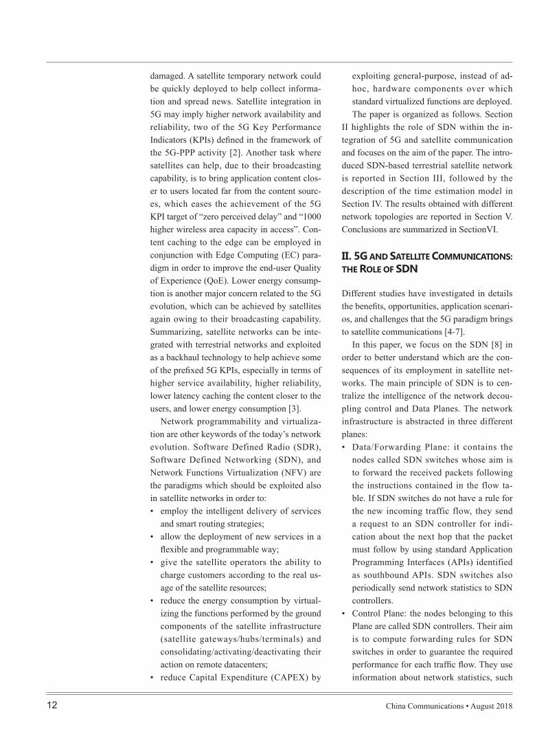
north and the other ones from north to south. Communications through the ie-ISL of these satellites could not be possible for the same reason of the high latitude ISLs. In our net-work all ISLs are always active except for the ones operating at high latitudes. Besides, we assume a “W” ISL pattern (Figure 22.3(a) of [17]). Figure 3 illustrates our considered ISL model: the horizontal size is two times the number of orbits and the vertical size is half the number of satellites per orbit.LEO satel-lites constitute the Data Plane and act as SDN switches. Their only purpose is to forward the data received from ground stations through the constellation following the routing instruc-tions stored in their memory and previously received by the GEO satellites. GEO satellites act as SDN controllers. Their aim is twofold: each of them periodically collects and sends information about the statistics of the under-lying LEO satellite constellation to the related NMCC; every time a GEO receives a new
rules exploiting the data management strate-gies received from the NMCC and then sends
NMCCs collect and keep updated the informa-tion about the network statistics received from
-mance requirements (policies) received from the terrestrial hosts. When NMCCs receive a strategy request from the GEO satellites, they establish a data management strategy exploit-ing these information and send it back to the GEO satellites. We opt for a distributed Man-agement Plane in order to reduce the access time between NMCCs and GEO satellites, even though, in this case, a protocol to keep the consistency of this information is required, as also mentioned in [12]. In some cases, Control and Management Planes can be im-plemented in the same node. We have decided
Fig. 3. LEO satellite constellation ISL model.
Fig. 4. SDN Planes and functionalities scheme.

China Communications • August 201816
considered negligible compared to the satel-lite link propagation delays for traffic flows characterized by short durations. We assume that there is no handoff during the overall described process, i.e. the topology does not change. Consequently, the mean time T re-quired to compute and establish a new set of
-tion may be structured into 9 components:
1) propagation time between THS and GSS for data packets;
2) propagation time between GSS and LES for data packets;
3) propagation time between LES and GES
4) propagation time between GES and NM S for policy and network statis-tics request;
5) propagation time between NM S and GES for policy and network statistics reply;
6) propagation time between GES and LES
7) propagation times of all ISLs from LES to LED for data packets;
8) propagation time between LED and GSD for data packets;
9) propagation time between GSD and THD for data packets;
The values of all these components depend on the distances between the involved node pairs. The distances among adjacent LEO sat-ellites belonging to the same orbit is almost constant, therefore the propagation delay of ia-ISLs may be considered as a constant (part of component 7). The distances among GEO satellites and related NMCCs is constant, and, opportunely setting NMCCs positions, is the same for each of the three pairs (GEO, NMCC). Therefore the propagation delay of the (GEO, NMCC) link is constant (compo-nents 4 and 6). The distances related to the other elements range between a minimum and a maximum value. In this way, we can esti-mate the possible range of T from a lower to
of GEO satellite links. In the next section, we will estimate the mean value of this time, in order to quantify its impact on the expected performances and identify the maximum per-formance requirements that allow the use of the satellites.
T E M
We consider a terrestrial host THS generating data packets destined to another terrestrial host THD located in areas covered by two dif-ferent ground stations GSS and GSD , respec-tively. THS sends its packets to GSS which uploads them to the LEO satellite LES (which is an SDN switch) in contact in that moment. THS LES that requires a specific forwarding rule to the GEO satellite GES (an SDN controller) which is covering the LEO constellation por-tion where LES is located. GES contacts the related NMCC NM S asking for information about the current status of the network and the performance policy related to the identified traffic flow. A routing path from LES to the LEO satellite LED (also an SDN switch) in contact with GSD is computed by GES . Prop-er forwarding rules are sent to each involved LEO satellite\slash SDN switch. If LED is located in an area covered by another GEO satellite\slash SDN controller GED , a portion of the routing path includes the LEO satellites inside GED ’s coverage area. In this case, the required information will be sent also to GED through its related NMCC NM D . When LES receives its forwarding rule, the packets are sent through the SDN-based LEO network un-til they reach LED . Finally, LED downloads them to GSD and then to their final destina-tion THD .
To ease the model always keeping the con-sidered scenario as close as possible to a real one, we consider only propagation delays. We ignore transmission, queuing, and forward-ing delays in this paper, because they may be

China Communications • August 2018 17
arccos cos cos[ ( ) ( )]S PL L
(14)
Equations (4) and (7) are obtained from Equation (2.2) in [18], Equation (8) is de-
and Equations (10), (11), (12), and (14) are
an upper bound considering, respectively, the minimum and maximum values of these dis-tances, and, consequently, the minimum and maximum values of the related propagation delays. Hence, T can be obtained as in Equa-
T t t t t
h k
N NL L
1 1
2 ( )q H t ia H t ie
TH GS LE NMGS LE GE GE
h k h k LE h k LE, , ,[ ]ia LE ie LE (1)
where: t min t t maxGS GS GS
LE LE LE (2)
t minGSLE d minGS
LE
c chLE (3)
t max minGS GSLE LE
h h R R minLE LE E E GS2 2 2
d maxGSLE
2 sin
c c cRE sin
LE
1
(4) t min t t maxLE LE LE
GE GE GE (5)
t minLEGE d minLE
GE
c ch hGE LE (6)
t max minLE LEGE GE
1c
h h R h h RGE GE E LE LE E
cos sin
2 2
d max R h
2 2 2
LE E LEGE
2 ( 2 )
c c
LE E LEGE GEmin R min
sin
(7)
t
[ ( ) ]NMGE
h RLE E
d
R
NMGE
c c
E
R
2 2
E
cos sinNM NMGE GE
(8)
NMGE arctan[ ]cos( ) cos 1512
1 cos ( ) cosGE NM NM
2 2GE NM NM
(9)
t iaLELE d iaLE
LE
c c S2 sinR he LE ( )
L (10)
t ie min t ie t ie maxLE LE LELE LE LE (11)
t ie minLE
LE d ie min
2 sin
LELE
R hce LE
c S( )
2 L
(12)
t ie maxLE
LE
2 sin
d ie maxLELE
R he LE
c
c
(13)
Table I.
tTHGS mean propagation delay of TH GS links
tGSLE mean propagation delay of GS LE links
tLEGE mean propagation delay of LE GE links
tNMGE propagation delay of NM GE links
NL overall number of LEO satellites
qh k,
probability that LES and LED are the hth and kth LEO satellite re-
spectively
Hh kia, number of ia-ISL in the path between LEh and LEk
t iaLELE propagation delay of ia-ISLs
Hh kie, number of ie-ISL in the path between LEh and LEk
t ieLELE mean propagation delay of ie-ISLs
dGSLE distance between ground stations and LEO satellites
c speed of light in vacuum
hLE LEO satellite altitude
RE mean Earth radius
GSLE min minimum elevation angle between ground stations and LEO satellites
dLEGE distance between LEO and GEO satellites
LEGE min minimum elevation angle between LEO and GEO satellites
hGE GEO satellite altitude
dNMGE distance between NMCCs and GEO satellites
NMGE elevation angle between NMCCs and GEO satellites
GE GEO satellite longitude
NM NMCC longitude
NM NMCC latitude
d iaLELE distance between two LEO satellites linked through an ia-ISL
SL number of LEO satellites per orbital plane
d ieLELE distance between two LEO satellites linked through an ie-ISL
PL number of LEO satellite orbital planes

China Communications • August 201818
To the purpose of computing the mean overall time to establish the routing path be-tween THS and THD , we need to set the po-
latitude and longitude coordinates, the altitude of geostationary satellites and their positions in terms of longitude. The longitude of the NMCCs and GEO satellites are always consid-ered equal ( GE NM ), so that the elevation angle between them, reported in Equation 9, depends only on the latitude of the NMCCs. Other parameters to be set for the experiments are GS
LE min and LEGE min , which, respective-
ly, are the minimum elevation angle between a ground station and a LEO satellite and the minimum elevation angle between a LEO and GEO satellite, respectively. These parameters are set to a value of 10 in order to avoid the presence of obstacles inside the communica-tion path between the involved entities.
To take into account the effects of differ-ent paths in the simulations, the parameters qh k, , Hh k
ia, , and Hh k
ie, , defined in table 1, are
introduced. Assuming each couple of LEO satellites ( , )h k having the same probability of being the end points of the routing path’s
satellite portion, we assign the value of N1
L2
to the parameter qh k, . Concerning the number of hops in the considered paths, we derive the values by using the build-in function of the python library networkx which returns all the possible paths between two nodes in a selected graph, thus allowing to compute both Hh k
ia,
and Hh kie, .
The set of parameters used in the simula-tions is reported in table 2.
Figure 5 shows the minimum and maximum values of T with respect to the LEO satellite altitude hLE which influences the number of satellites and orbital planes considered in the model, as reported in [18]. Since the aim is that LEO satellites completely cover the Earth surface independently of their altitude, a spe-
needed: table 3 shows the number of orbital
obtained from simple trigonometric computa-tions.
RC
To perform computations we use the python library math. To model the considered LEO satellite constellation we exploit the python library networkx that allows the creation of a connected graph and the association of weights to its edges. In our case, the weights represent the communication delays of the ISLs.
Table II. Set of initial parameters used for the experiments.
Parameter Value
RE 6371 [km]
hGE 35790 [km]
hLE 400 1500 [km]
NM 45
GSLE min 10
LEGE min 10
qh k, N1
L2
c 299792.458 [km/s]
400 600 800 1000 1200 1400
hLE(km)
0.60
0.62
0.64
0.66
0.68
0.70
0.72
T(s)
Fig. 5. Minimum and maximum T.

China Communications • August 2018 19
them. It includes SDN, SDR, and NFV which have been developed for terrestrial networks. Their employment in satellite networks is not straightforward. This paper investigates the employment of the SDN paradigm in an inte-grated terrestrial-satellite network where three GEO satellites act as SDN controllers and the Data Plane is embedded in a LEO satellite constellation. A model to estimate the mean time required to complete the SDN control
-sults allow understanding which is the lower bound of the required mean delivery time. This value should be used by a user\slash ap-
in case the satellite component is used or by the network management to decide if traffic may be forwarded through the satellite in a
network.In the proposed time estimation model,
we have only considered propagation delays and assumed there is no handoff, i.e. the to-pology is unchanged during the traffic flow data delivery. Even if the assumptions seem
-mission, queuing and forwarding delays must be considered for wider and possibly congest-ed scenarios. The aspects neglected here will be investigated in future research. Other open issues to be tackled are: alternative integrat-ed terrestrial-satellite network architectures,
planes and LEO satellites necessary in order to cover the entire Earth with respect to the altitude of LEO satellites. From table 3 we can notice that increasing the altitude, the number of orbital planes and satellites per orbital plane decreases.
In figure 5, as expected, T globally ex-hibits an ascending trend, since the end-to-end-delay grows with the satellite altitude. We can also notice that, every time there is a decrease in the number of orbital planes, and, consequently, a reduction of the number of satellites involved in the complete Earth cov-erage, T slightly decreases. This reduction is due to the fact that a lower number satellites is needed in order to obtain a complete cov-erage of the Earth and, as a consequence, the
in order to reach the destination decreases. In any case, this small decrease is balanced when the distance between two satellites increases due to the growing altitude. Consequently, the behaviour of T keeps an ascending trend. It is worth noting that, considering a maximum al-titude equal to 1500km , the maximum end to end delay is about 0.709s . This type of com-putation is essential to decide if a future 5G service can be forwarded to satellite portions or not. The time required to route and forward
network is not excessive but, of course, is in contrast with demanding delay sensitive appli-cations.
C
Traditional and currently operating satellite communication networks often rely on ad-hoc hardware components and proprietary soft-ware solutions. This hinders the integration of satellite and terrestrial networks and also of different satellite networks. New solutions are arising to ease the integration and allow satellites to be part of an overall Internet com-posed of heterogeneous networks, according to the network evolution envisioned in the 5G environment. New paradigms and key-words are proposed. Virtualization is one of
Table III. Number of PL and SL needed for the complete coverage of the Earth.
Altitude km SL PL
400 15 8450 14 7500 13 7550 13 7600 12 6650 11 6700 11 6
750 - 850 10 5900 - 1050 9 51100 - 1350 8 41400 - 1500 7 4

China Communications • August 201820
in campus networks,” ACM SIGCOMM Comput-er Communication Review, vol. 38, no. 2, pp. 69–74, 2008.
[10] T. Rossi, M. De Sanctis, E. Cianca, C. Fragale, M. Ruggieri, and H. Fenech, “Future space-based communications infrastructures based on high throughput satellites and software defined networking,” IEEE International Symposium on Systems Engineering (ISSE), pp. 332–337, 2015.
[11] Y. Zhang and Y. Wang, “SDN based ICN ar-chitecture for the future integration network,” 16th International Symposium on Communica-tions and Information Technologies (ISCIT), pp. 474–478, 2016.
[12] J. Bao, B. Zhao, W. Yu, Z. Feng, C. Wu, and Z. Gong, “Opensan: a software-defined sat-ellite network architecture,” ACM SIGCOMM Computer Communication Review, vol. 44, no. 4, pp. 347–348, 2014.
[13] Z. Tang, B. Zhao, W. Yu, Z. Feng, and C. Wu, “Soft-ware defined satellite networks: Benefits and challenges,” IEEE Computing, Communications and IT Applications Conference (ComComAp), pp. 127–132, 2014.
[14] T. Li, H. Zhou, H. Luo, and S. Yu, “Service: A software defined frame- work for integrated space-terrestrial satellite communication,” IEEE Transactions on Mobile Computing, vol. 17, no. 3, pp. 703–716, 2017.
[15] T. Li, H. Zhou, H. Luo, W. Quan, and S. Yu, “Modeling software using queueing theory,” IEEE International Conference on Communications (ICC), pp. 1–6, 2017.
[16] J. Feng, L. Jiang, Y. Shen, W. Ma, and M. Yin, “A scheme for software defined ors satellite net-working,” IEEE Fourth International Conference on Big Data and Cloud Computing (BdCloud), pp. 716–721, 2014.
[17] A. Ferreira, J. Galtier, and P. Penna, “Topologi-cal design, routing and handover in satellite networks,” Handbook of wireless networks and mobile computing, vol. 473, p. 493, 2002.
[18] F. Long, Satellite Network Constellation Design. Berlin, Heidelberg: Springer Berlin Heidelberg, 2014, pp. 21–40. [Online]. Available: https://doi.org/10.1007/978-3-642-54353-1 2
[19] S. Cakaj, B. Kamo, A. Lala, and A. Rakipi, “The coverage analysis for low earth orbiting satel-lites at low elevation,” International Journal of Advanced Computer Science and Applications (IJACSA), vol. 5, no. 6, 2014.
[20] R. L. Douglas, Satellite communications tech-nology NJ, USA: Prentice Hall, 1988.
including, for example, Medium Earth Orbit (MEO) satellites; the study of a different dis-tribution of the SDN Planes inside the network nodes; the impact of the overhead introduced by using the OpenFlow protocol for communi-cation between SDN controller and switches; the synchronization problems due to the rapid movement of satellites; and the issues related to the migration of LEO satellites from one controller to another.
References[1] B. G. Evans, “The role of satellites in 5g,” 7th Ad-
vanced Satellite Multimedia Systems Conference and 13th Signal Processing for Space Commu-nications Workshop (ASMS/SPSC), pp. 197–202, 2014.
[2] W. NetWorld2020s-SatCom, “The role of satel-lites in 5G,” white paper, 2014. [Online]. Avail-able: https://www.networld2020.eu/wp-content/ uploads/2014/02/SatCom-in-5G v5.pdf
[3] X. Artiga, J. Nunez-Martinez, A. Perez-Neira, G. J. L. Vela, J. M. F. Garcia, and G. Ziaragkas, “Terrestrial-satellite integration in dynamic 5g backhaul networks,” 8th Advanced Satellite Multimedia Systems Conference and 14th Signal Processing for Space Communications Workshop (ASMS/SPSC), pp. 1–6, 2016.
[4] R. Ferrus, H. Koumaras, O. Sallent, G. Aga-piou, T. Rasheed, M.-A. Kourtis, C. Boustie, P. Gelard, and T. Ahmed, “Sdn/nfv-enabled satel-lite communications networks: Opportunities, scenarios and challenges,” Physical Communi-cation, vol. 18, pp. 95–112, 2016.
[5] L. Bertaux, S. Medjiah, P. Berthou, S. Abdel-latif, A. Hakiri, P. Gelard, F. Planchou, and M. Bruyere, “Software defined networking and vir- tualization for broadband satellite net-works,” IEEE Communications Magazine, vol. 53, no. 3, pp. 54–60, 2015.
[6] Y. Miao, Z. Cheng, W. Li, H. Ma, X. Liu, and Z. Cui, “Software -al network: A survey,” International conference on space information network, pp. 16–25, 2016.
[7] S. Xu, X.-w. Wang, and M. Huang, “Soft-ware-defined next-generation satellite net-works: Architecture, challenges, and solutions,” IEEE Access, 2018.
[8] D. Kreutz, F. M. Ramos, P. E. Verissimo, C. E. Rothenberg, S. Azodol- molky, and S. Uhlig, “Software-defined networking: A comprehen-sive survey,” Proceedings of the IEEE, vol. 103, no. 1, pp. 14–76, 2015.
[9] N. McKeown, T. Anderson, H. Balakrishnan, G. Parulkar, L. Peterson, J. Rexford, S. Shenker, and J. Turner, “Openflow: enabling innovation

China Communications • August 2018 21
cations (CNIT), by the University of Genoa Research Unit, where he was Head of Research. From February 2005 to January 2016 he was Associate Professor at the University of Genoa. Since February 2016 he has been Full Professor at the University of Genoa. He authored/co-authored more than 300 scientific works, including international magazines, interna-tional conferences and book chapters. His main re-search activity concerns: Networking, Quality of Ser-
Networking, Satellite DTN and Nanosatellite Net-works, Network Security. Email: [email protected]
Fabio Patrone, got his B.Sc. and his M.Sc. in Telecommuni-cation Engineering in 2010 and 2013 at the University of Ge-noa. He got his Ph.D. at the Satellite Communications and Networking Laboratory (SCNL) with a thesis on routing and
scheduling algorithms in Satellite Delay and Disrup-tion Tolerant Networks (DTNs). He is currently a Post-Doc research fellow at the SCNL. His main research activity concerns Satellite Networks, in particular de-sign of Routing, Scheduling, and Congestion Control algorithms for Satellite Networks.
Luca Boero, got his B.Sc. in Telecommunication Engineer-ing in 2012 and his M.Sc. in Multimedia Signal Processing and Telecommunication Net-works at the University of Ge-noa with a thesis on Software
-veloped at the Satellite Communications and Net-working Laboratory (SCNL) in March 2015. He is cur-rently a Ph.D. Student at the SCNL, and his main re-search activity concerns SDN, in particular Routing and Resource Allocation algorithms and Network Se-curity for SDN Networks. Email: [email protected]
Mario Marchese (S’94M’97SM’04), was born in Genoa, Italy in 1967. He got his “Laurea” de-gree cum laude at the Universi-ty of Genoa, Italy in 1992, and his Ph.D. (Italian “Dottorato di Ricerca”) degree in “Telecom-munications” at the University
of Genoa in 1997. From 1999 to January 2005, he worked with the Italian Consortium of Telecommuni-