Low-Volume Roads Engineering - Bureau of Land Management volume engineering/B_Preface... ·...
24
Low-V Low-V Low-V Low-V Low-Volume R olume R olume R olume R olume Roads oads oads oads oads Engineering Engineering Engineering Engineering Engineering Best Management Practices Field Guide By Gordon Keller, PE Geotechnical Engineer USDA, Forest Service Plumas National Forest, California and James Sherar, PE Logging Engineer USDA, Forest Service National Forests of North Carolina Produced for US Agency for International Development (USAID) In Cooperation with USDA, Forest Service, International Programs & Conservation Management Institute, Virginia Polytechnic Institute and State University July 2003
Transcript of Low-Volume Roads Engineering - Bureau of Land Management volume engineering/B_Preface... ·...
LOW-VOLUME ROADS BMPS: i
Low-VLow-VLow-VLow-VLow-Volume Rolume Rolume Rolume Rolume RoadsoadsoadsoadsoadsEngineeringEngineeringEngineeringEngineeringEngineering
Best Management PracticesField Guide
By
Gordon Keller, PEGeotechnical EngineerUSDA, Forest Service
Plumas National Forest, California
and
James Sherar, PELogging Engineer
USDA, Forest ServiceNational Forests of North Carolina
Produced forUS Agency for International Development (USAID)
In Cooperation withUSDA, Forest Service, International Programs
&Conservation Management Institute,
Virginia Polytechnic Institute and State University
July 2003

LOW-VOLUME ROADS BMPS: ii
photo here
Information contained in this document has been developed for the guidance of road builders, roadmanagers, and resource specialists in most geographic areas to help build better, more cost-effectiveroads, and roads that minimize adverse environmental impacts and protect water quality. The U.S.Department of Agriculture (USDA) or U.S. Agency for International Development (USAID) assumesno responsibility for the interpretation or use of this information. The use of trade, firm, or corporationnames is for the information and convenience of the reader. Such use does not constitute an officialevaluation, conclusion, recommendation, endorsement, or approval of any product or service to theexclusion of others that may be suitable.
The U.S. Department of Agriculture and U.S. Agency for International Development prohibit discrimi-nation in all their programs and activities on the basis of race, color, national origin, sex, religion, age,disability, political beliefs, sexual orientation, or marital or family status. (Not all prohibited bases applyto all programs.) Persons with disabilities who require alternative means for communication of pro-gram information (braille, large print, audiotape, etc.) should contact USDA’s TARGET Center at(202)-720-2600 (voice and TDD).
To file a complaint of discrimination, write USDA, Director, Office of Civil Rights, Room 326-W,Whitten Building, 1400 Independence Avenue, SW, Washington, D.C. 20250-9410, or call (202)720-5964 (voice and TDD). USDA is an equal opportunity provider and employer.
LOW-VOLUME ROADS BMPS: iii
LOW-VOLUME ROADS ENGINEERINGBest Management Practices Field Guide
FOREWORD
The Conservation Management Institute (CMI) in the College of Natural Resources atVirginia Tech is dedicated to helping apply sound scientific principles to the managementof renewable natural resources around the world. Access is an important consideration in
many settings — not only to facilitate utilization of natural resources, but also to enable people toreach markets for their products and health services. However, it is vital that roads constructedprovide adequate access while following sound practices for environmental protection whereverpossible. Improperly constructed roads can negatively impact everything from terrestrial plantpopulations and soil conservation efforts to water quality and populations of aquatic organisms inreceiving waters.
This manual was originally published in Spanish as “Practicas Mejoradas de Caminos Forestales”by the U.S. Agency for International Development (USAID) for use throughout Latin America, andhas proven valuable in helping to protect forest-based resources. It became clear that the practicaladvice offered in this manual could be of value to resource managers throughout the world. So, toreach this broader audience and inspired by the original Spanish work, CMI and the USDA ForestService have collaborated to produce this updated version in English. We hope that the materialspresented here are useful to you.
This project grew from our collaboration with Gerald Bauer, of the US Forest Service, on naturalresource education programs in Latin America. Mr. Bauer was a contributor to the original manualand found the publication in great demand. This collaboration exemplifies our involvement withUSAID and the Forest Service on many natural resource projects. We encourage you to contactUSFS or CMI if we can be of assistance in your conservation efforts. Finally, we acknowledge thenotable efforts of Julie McClafferty of CMI, who was instrumental in preparing this manual forpublication.
B. R. Murphy, PhD., Director, CMI ([email protected])A.L. Hammett, PhD., Faculty Fellow, CMI and Coordinator of International Programs, College of
Natural Resources ([email protected])Gordon Keller, PE, Geotechnical Engineer, USFS ([email protected])James Sherar, PE, Logging Engineer, USFS ([email protected])

LOW-VOLUME ROADS BMPS: iv
LOW-VOLUME ROADS BMPS: v
ACKNOWLEDGMENTS
A LARGE NUMBER OF INDIVIDUALS have been involved in the developmentof the MinimumImpact Low-Volume Roads Manual and this subsequent Low-Volume RoadsEngineering Best Management Practices Field Guide. These individuals have had the vision
and commitment to preserving and enhancing the quality of our environment, while also recognizing theneed for good roads. Futhermore, they recognize the planning, design, maintenance, and overallmanagement necessary to have good roads. Funding for this project has principally been pro-vided by the US Agency for International Development (USAID), the Global Bureau, andthe Forestry Team, with contributions from the USDA, Forest Service, Office of Interna-tional Programs, the Pacific Southwest Region, and the Plumas National Forest.
The original Spanish version of this document was produced with the help of Ramon Alvarez, RobertoMedina, and Atilio Ortiz with USAID, Honduras. The authors are particularly grateful for the supportof Jerry Bauer, Alex Moad, and Michelle Zweede with the International Programs office of the U.S.Forest Service; Jim Padgett and Nelson Hernandez from the Washington Office, USFS; Scott Lampman,Paul DesRosiers, and Mike Benge with the U.S. Agency for International Development; and thesteadfast support from our Plumas National Forest colleagues.
The drawings presented in this document come from a variety of sources, as indicated, and most havebeen redrawn or adapted with the artistic talent of Jim Balkovek, Illustrator, and Paul Karr, a retiredForest Service Engineer. Scanning, labeling, and computer manipulation of figures for this field guidehave been accomplished with the skill and patience of Lori Reynolds of Reynolds Graphics in Quincy,California. Translation of portions of this Field Guide and the original Minimum Impact Low-VolumeRoads Manual was skillfully accomplished by Alejandra Medina of the Virginia Tech TransportationInstitute.
A sincere thanks to the many professionals and laymen who gave their time in reviewing and editing thedocument, as well as making valuable suggestions regarding the form and content of this Field Guide.Particular thanks to Jill Herrick, U.S. Forest Service, for her valuable contributions and assistance withediting this guide, assistance with the Definition of Terms and References, and overall content review,as well as to Michael Furniss, Charlie Carter, Jerry Short, Tim Dembosz, and Ozzie Cummins for theirnumerous suggestions and ideas on drainage and other issues. Thanks to Richard Wiest, author of “ALandowner’s Guide to Building Forest Access Roads”, for his inspiration and ideas on format andlayout. Other individuals involved in review and editing include Leslie Lingley of Leslie GeologicalServices; Marty Mitchell of Clear Water West; Alfred Logie with the International Programs office ofthe Federal Highway Administration (FHWA); Mike Benge and Eric Peterson with U. S. Agency forInternational Development; Dr John Metcalf from LSU/PIARC World Roads Association; Dr. FrancisGreulich, Forest Engineer at the University of Washington; Dr. Allen Hathaway, Geologic Engineer atthe University of Missouri-Rolla; David Orr, PE with the Cornell University Local Roads Program;Prof. Raymond Charles, University of West Indes; Art Klassen, Tropical Forestry Foundation; James
LOW-VOLUME ROADS BMPS: vi
Schenck and Wilson Castaneda, Cooperative Housing Foundation-Guatemala; Harold Tarver withAfricare; Wes Fisher with Tellus Institute; and Sandra Wilson-Musser, Corky Lazzarino, ArmandoGarza, Gary Campbell, Ken Heffner, Terry Benoit, Allen King, John Heibel, William Vischer, andGreg Watkins, U.S. Forest Service employees dedicated to watershed protection and building goodroads.
Most of the photos used in this manual either belong to the authors, Gordon Keller and JamesSherar, or to Jerry Bauer, co-author on the “Minimum Impact Low-Volume Roads” Manual. Othersbelong to individuals as indicated on the specific photo. The retaining wall photo on the cover wasprovided by Michael Burke.
Finally, the authors wish to give special thanks to Tom Hammett at Virginia Tech for his connectionsand facilitation of this project and Julie McClafferty of the Conservation Management Institute andPatty Fuller of Poplar Hill Studios in Blacksburg, Virginia, for their magic in layout and publication ofthis guide and making it look the way it does. Last, and by no means least, a big hug to our wives,Jeanette and Julie, and families for their patience and support during this project!

LOW-VOLUME ROADS BMPS: vii
PREFACE
THE AUTHORS ARE GRATEFUL for the opportunity to develop this guide for the US Agency forInternational Development (USAID) with the cooperation of the USDA, the Forest Service,the Office of International Programs, and the International Programs Department at Virginia
Polytechnic Institute and State University. The original development of this Roads Best ManagementPractices (BMP) Field Guide was funded by USAID/Honduras, in support of their ForestryDevelopment Program (FDP) and their National Forestry School (ESNACIFOR). It has since beenrevised and expanded to be consistent with and complement the training manual titled “MinimumImpact Low-Volume Roads” for roads work in developing regions.
This Low-Volume Roads Engineering Best Management Practices Field Guide is intended to providean overview of the key planning, location, design, construction, and maintenance aspects of roads thatcan cause adverse environmental impacts and to list key ways to prevent those impacts. Best Man-agement Practices are general techniques or design practices that, when applied and adapted to fitsite specific conditions, will prevent or reduce pollution and maintain water quality. BMPs for roadshave been developed by many agencies since roads often have a major adverse impact on waterquality, and most of those impacts are preventable with good engineering and management practices.Roads that are not well planned or located, not properly designed or constructed, not well maintained,or not made with durable materials often have negative effects on water quality and the environment.
This Guide presents many of those desirable practices. Fortunately, most of these “Best ManagementPractices” are also sound engineering practices and ones that are cost-effective by preventing failuresand reducing maintenance needs and repair costs. Also keep in mind that “best” is relative and soappropriate practices depend to some degree upon the location or country, degree of need for im-provements, and upon local laws and regulations. Best practices are also constantly evolving with time.
This guide tries to address most basic roads issues in as simple a manner as possible. Complex issuesshould be addressed by experienced engineers and specialists. Included are key “DO’s” (RECOM-MENDED PRACTICES) and “DON’Ts” (PRACTICES TO AVOID) in low-volume roads ac-tivities, along with some relevant basic design information. These fundamental practices apply to roadsworldwide and for a wide range of road uses and standards. Often recommended practices have to beadapted to fit local conditions and available materials. Additional information on how to do the work isfound in other Selected References, such as the “Minimum Impact Low-Volume Roads Manual”.
Most practices apply to a wide range of road standards, from native surfaced, single-lane roads todouble-lane paved roads. Desirable general practices include good road planning and location, per-forming environmental analysis, recognizing the need for positive surface drainage, ensuring adequately

LOW-VOLUME ROADS BMPS: viii
sized drainage crossing structures, using stable cut and fill slopes, using erosion control measures,developing good materials sources, and reclaiming sites once work has been completed.
Certain design practices, such as use of rolling dips, outsloped roads, or low-water stream crossings,are very cost-effective and practical but typically apply to low-volume, low-speed roads because ofsafety concerns, vertical alignment issues, or unacceptable traffic delays. Other issues, such as the useof log stringer bridges, are very desirable for stream crossings in developing regions to avoid drivingthrough the water, yet their use is now discouraged by some agencies, such as the U.S. Forest Service,because of their short design life and potentially unpredictable performance. Thus the informationpresented herein must be considered in terms of local conditions, available materials, road standards,project or resource priorities, and then applied in a manner that is practical and safe.
Local rules, agency policies or regulations, or laws may conflict with some of this information or mayinclude more specific information than that included herein. Thus, good judgment should be used in theapplication of the information presented in this guide, and local regulations and laws should be fol-lowed or modified as needed.
You may reproduce or copy any portion of this Guide. However, please acknowledge this Guide asthe source of information.
Reproduction Of This Field Guide is Encouraged!
Disclaimer
This Field Guide does not constitute a standard, specification, or regulation from or bound on anyprofessional group, agency, or political entity. It is intended only as a guide for good roads engineeringand sound environmental management in developing countries based upon the professional judgmentand experience of the authors.

LOW-VOLUME ROADS BMPS: ix
LOW-VOLUME ROADS ENGINEERING Best Management Practices Field Guide
TABLE OF CONTENTS
Foreword iii
Acknowledgments v
Preface vii
Definition of Terms xi
Chapter 1 Introduction 1
Chapter 2 Environmental Analysis 5
Chapter 3 Planning Issues and Special Applications 11Key Road IssuesReducing Vulnerability of Roads to Natural DisastersStreamside Management ZonesTimber Harvesting
Chapter 4 Low-Volume Roads Engineering 21Road PlanningRoad LocationRoad Survey, Design, and ConstructionRoad CostsRoad MaintenanceRoad Closure
Chapter 5 Hydrology for Drainage Crossing Design 37
Chapter 6 Tools for Hydraulic and Road Design 43
Chapter 7 Drainage of Low-Volume Roads 53Roadway Surface Drainage ControlControl at Inlets and Outlets of Cross-Drains and DitchesNatural Stream CrossingsWet Areas and Meadow Crossings, Use of Underdrains
Chapter 8 Culvert Use, Installation, and Sizing 75

LOW-VOLUME ROADS BMPS: x
Chapter 9 Fords and Low-Water Crossings 91
Chapter 10 Bridges 97
Chapter 11 Slope Stabilization and Stability of Cuts and Fills 103
Chapter 12 Roadway Materials and Material Sources 115
Chapter 13 Erosion Control 129
Chapter 14 Stabilization of Gullies 141
Selected References 147

LOW-VOLUME ROADS BMPS: xi
I. ROAD COMPONENTS
Figure (I.1): Terms Used to Define Low-Volume Roads
DefDefDefDefDefinition ofinition ofinition ofinition ofinition of T T T T TermsermsermsermsermsArranged by Topic:
Section I Road Components ixSection II Road Structural Section and Materials xiiSection III Surface Drainage xiiiSection IV Culverts and Drainage Crossings xvSection V Fords and Low Water Crossings xviiSection VI Erosion Control xviiiSection VII Miscellaneous Terms xx
De
fD
ef
De
fD
ef
De
finitio
n o
fin
ition
of
initio
n o
fin
ition
of
initio
n o
f T T T T Term
se
rms
erm
se
rms
erm
s

LOW-VOLUME ROADS BMPS: xii
Figure (I.2) Terms Used to Define Low-Volume Roads (Cross-Section)
Base Course - See Section II below.
Berm - A ridge of rock, soil, or asphalt, typically along the outside edge of the road shoulder, used to controlsurface water. It directs surface runoff to specific locations where water can be removed from the road surfacewithout causing erosion.
Buttress - A structure designed to resist lateral forces. It is typically constructed of large riprap rock, gabions, ordrained soil to support the toe of a slope in an unstable area.
Cross-Section - A drawing depicting a section of the road sliced across the whole width of the road (See FigureI.2 above). Can also apply to a stream, a slope, or a slide.
Cut Slope (Back Slope or Cut Bank) - The artificial face or slope cut into soil or rock along the inside edge ofthe road.
Cut-and-fill - A method of road construction in which a road is built by cutting into the hillside and spreading thespoil materials in adjacent low spots and as compacted or side-cast fill slope material along the route. A “balancedcut-and-fill” utilizes all of the “cut” material to generate the “fill”. In a balanced cut-and-fill design there is no excesswaste material and there is no need for hauling additional fill material. Thus cost is minimized.
Ditch (Side Drain) - A channel or shallow canal along the road intended to collect water from the road and adja-cent land for transport to a suitable point of disposal. It is commonly along the inside edge of the road. It also can bealong the outside edge or along both sides of the road.End Haul - The removal and transportation of excavated material off-site to a stable waste area (rather than placingthe fill material near the location of excavation).
Embankment (Fill) - Excavated material placed on a prepared ground surface to construct the road subgrade androadbed template.
LOW-VOLUME ROADS BMPS: xiii
Fill Slope (Embankment Slope) - The inclined slope extending from the outside edge of the road shoulder to thetoe (bottom) of the fill. This is the surface formed where material is deposited to build the road.
Full Bench Cut and End Haul - A method of road construction in which a road is built entirely by cutting away theslope, and the excess material is hauled away (end hauled) to an off-site disposal area.
Grade (Gradient) - The slope of the road along its alignment. This slope is expressed in percent - the ratio ofelevation change compared to distance traveled. For example, a +4% grade indicates a gain of 4 units of measure inelevation for every 100 units of measure traveled.
Low-Volume Road - A type of transportation system typically constructed to manage or extract resources fromrural or undeveloped areas. These unique systems are designed to accommodate low traffic volumes with potentiallyextreme axle loads. They are commonly defined as having less than 400 ADT (Average Daily Traffic).
Natural Ground (Original Ground Level) - The natural ground surface of the terrain that existed prior to distur-bance and/or road construction.Plan View (Map View) - View seen when looking from the sky towards the ground. A drawing with this view issimilar to what a bird would see when flying over a road.
Reinforced Fill - A fill that has been-provided with tensile reinforcement through frictional contact with the sur-rounding soil for the purpose of greater stability and load carrying capacity. Reinforced fills are comprised of soil orrock material placed in layers with reinforcing elements to form slopes, walls, embankments, dams or other struc-tures. The reinforcing elements range from simple vegetation to specialized products such as steel strips, steel grids,polymeric geogrids and geotextiles.Retaining Structure - A structure designed to resist the lateral displacement of soil, water, or any other type ofmaterial. It is commonly used to support a roadway or gain road width on steep terrain. They are often constructedof gabions, reinforced concrete, timber cribs, or mechanically stabilized earth.Right-of-Way (ROW) - The strip of land over which facilities such as roads, railroads, or power lines are built.Legally, it is an easement that grants the right to pass over the land of another.
Road Center Line - An imaginary line that runs longitudinally along the center of the road.
Roadbed - Width of the road used by vehicles including the shoulders, measured at the top of subgrade.
Roadway (Construction Limits or Formation Width) - Total horizontal width of land affected by the construc-tion of the road, from the top of cut slope to the toe of fill or graded area.
Side-Cast Fill - Excavated material pushed on a prepared or unprepared slope next to the excavation to constructthe roadbed. The material is usually not compacted.
Slope Ratio (Slope) - A way of expressing constructed slopes as a ratio of horizontal distance to vertical rise, suchas 3:1 (3 m horizontal for every 1 m vertical rise or fall).
Shoulder - The paved or unpaved strip along the edge of the traveled way of the road. An inside shoulder isadjacent to the cut slope. An outside shoulder is adjacent to an embankment slope.
Subgrade - See Section II below.Surface Course (Surfacing) - See Section II below.Traveled Way (Carriageway) - That portion of the road constructed for use by moving vehicles including trafficlanes and turnouts (excluding shoulders).

LOW-VOLUME ROADS BMPS: xiv
Through Cut - A road cut through a hill slope or, more commonly, a ridge, in which there is a cut slope on bothsides of the road.
Through Fill - Opposite of a through cut, a through fill is a segment of road that is entirely composed of fill material,with fill slopes on both sides of the road.
II. ROAD STRUCTURAL SECTION AND MATERIALS
Figure (II): Road Structural Section
Base Course (Base) - This is the main load-spreading layer of the traveled way. Base course material normallyconsists of crushed stone or gravel or of gravelly soils, decomposed rock, sands and sandy clays stabilized withcement, lime or bitumen.Borrow Pit (Borrow Site) - An area where excavation takes place to produce materials for earthwork, such as afill material for embankments. It is typically a small area used to mine sand, gravel, rock, or soil without furtherprocessing.Quarry - A site where stone, riprap, aggregate, and other construction materials are extracted. The material oftenhas to be excavated with ripping or blasting, and the material typically needs to be processed by crushing or screen-ing to produce the desired gradation of aggregate.Raveling - A process where coarse material on the road surface comes loose and separated from the roadbedbecause of lack of binder or poor gradation of material. The term also applies to a slope where rock or coarsematerial comes loose and falls down the cut or fill slope.Sub-Base - This is the secondary load-spreading layer underlying the base. It normally consists of a material thathas lower strength and durability than that used in the base, e.g. unprocessed natural gravel, gravel/sand or gravel/sand/clay.Subgrade - The surface of roadbed upon which sub base, base, or surface course are constructed. For roadswithout base course or surface course, this portion of the roadbed becomes the finished wearing surface. Thesubgrade is typically at the level of the in-place material.Surface Course (Surfacing) - The top layer of the road surface, also called the wearing course. Rock, cobble-stone, crushed aggregate and paving, such as Bituminous Surface Treatments and Asphalt Concrete, are types ofsurfacing used to improve rider comfort, provide structural support, and weatherproof the road surface for wetseason use.
LOW-VOLUME ROADS BMPS: xv
Washboarding (Corrugations) - A series of ridges and depressions across the road caused in soil and aggregateroad surfaces by the lack of surface cohesion. This is typically a result of the loss of fines in the road surface causedby dry conditions or poorly graded material. These conditions worsen with excessive vehicle speeds and high trafficvolumes.Wearing Course (Wearing Surface) –The top layer of the road surface that is driven upon. It should be durable,may have a high resistance to skidding, and it typically should be impervious to surface water. Wearing surfaces maybe the native soil, aggregate, seal coats, or asphalt.
III. SURFACE DRAINAGE
Figure (III.1): Road Surface Drainage
Armor - Rocks or other material placed on headwalls, on soil, or in ditches to prevent water from eroding andundercutting or scouring the soil.Catch Water Ditch (Intercept Drain) - A flat-bottomed excavation or ditch located above a cut slope that isdesigned to intercept, collect and drain away surface runoff water before it goes over the cut slope, to protect thecut slope and roadway from erosion.Check Dam (Scour Check, or Dike) - A small dam constructed in a gully or ditch to decrease flow velocity,minimize channel scour, and to trap sediment.Cross-Drain (X-Drain) - Installed or constructed structures such as culverts and rolling dips that move water fromone side of the road to the other.
Crown - A crowned surface has the highest elevation at centerline (convex) and slopes down on both sides. Crownis used to facilitate draining water off a wide road surface.Debris - Organic material, rocks and sediment (leaves, brush, wood, rocks, rubble, etc.) often mixed, that isundesirable (in a channel or drainage structure).Drainage Structure - A structure installed to control, divert, or move water off or across a road, including but notlimited to culverts, bridges, ditch drains, fords, and rolling dips.
LOW-VOLUME ROADS BMPS: xvi
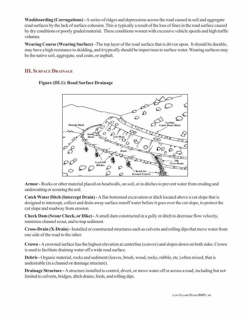
French Drain (Underdrain) - A buried trench, filled with coarse aggregate, and typically placed in the ditch linealong the road, which acts to drain subsurface water from a wet area and discharge it a safe and stable location.French drains may use variable sizes of rock but do not have a drain pipe in the bottom of the trench.
Figure (III.2): Rolling Grade with Rock-Armored Rolling Dips
Inside/Outside - Reference to a feature on the inside of the road, which is typically the cutslope (back slope) sideof the road/ Reference to a feature on the outside of a road, typically on the fill slope side.Inslope - The inside cross-slope of a road subgrade or surface, typically measured in percentage. Inslope is used tofacilitate the draining of water from a road surface to an inside ditch. An insloped road has the highest point on theoutside edge of the road and slopes downward to the ditch at the toe of the cut slope, along the inside edge of road.Lead-Off Ditches (Turnouts, Outside Ditch, or Mitre Drains) - Excavations designed to divert water awayfrom the ditch and roadway (at a point where this doesn’t occur naturally) in order to reduce the volume andvelocity of roadside ditch water.Outslope - The outside cross-slope of a road subgrade or surface, typically measured in percentage. Outslope isused to facilitate the draining of water from a road directly off the outside edge of the road. An outsloped road hasthe highest point on the uphill or inside of the road and slopes down to the outside edge of the road and the fillslope.Riprap - Well-graded, durable, large rock, ideally with fractured surfaces, sized to resist scour or movement bywater and installed to prevent erosion of native soil material.Rolling Dip (Dip, Broad-Based Dip) - A surface drainage structure, with a constructed break in the road grade,specifically designed to drain water from an inside ditch or across the road surface, while vehicles travel speed issomewhat reduced (see lower photo on the cover of this Guide).Underdrain (Subsurface Drain) - A buried trench, filled with coarse aggregate, coarse sand, or gravel, andtypically placed in the ditch line along the road, which acts to drain subsurface water from a wet area and dischargeit a safe and stable location. Underdrains may use a uniform size of rock, be wrapped in geotextile, and have aperforated drain pipe in the bottom of the trench.Waterbar - A frequently spaced, constructed drainage device, using soil mounds in the road surface, that interruptthe flow of water and that diverts water off the road surface. They may be drivable by high clearance vehicles orimpassable.
LOW-VOLUME ROADS BMPS: xvii
IV. CULVERTS AND DRAINAGE CROSSINGS
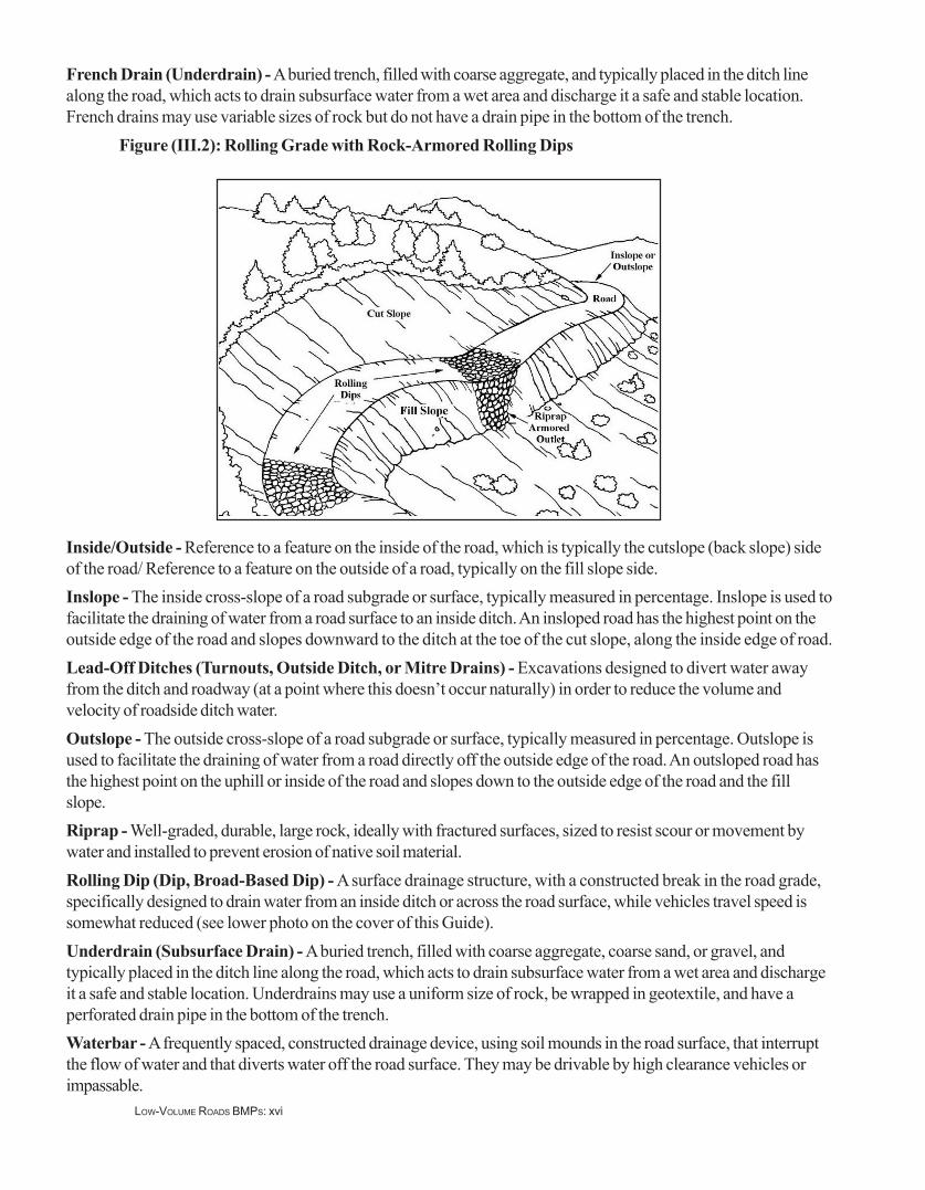
Figure (IV.1): Culvert Components
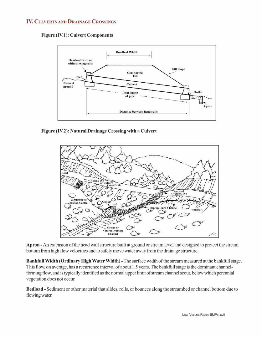
Figure (IV.2): Natural Drainage Crossing with a Culvert
Apron - An extension of the head wall structure built at ground or stream level and designed to protect the streambottom from high flow velocities and to safely move water away from the drainage structure.
Bankfull Width (Ordinary High Water Width) - The surface width of the stream measured at the bankfull stage.This flow, on average, has a recurrence interval of about 1.5 years. The bankfull stage is the dominant channel-forming flow, and is typically identified as the normal upper limit of stream channel scour, below which perennialvegetation does not occur.
Bedload - Sediment or other material that slides, rolls, or bounces along the streambed or channel bottom due toflowing water.

LOW-VOLUME ROADS BMPS: xviii
Catch Basin - The excavated or constructed basin at the inlet of a culvert cross-drain pipe, used to store water anddirect it into the culvert pipe.Culvert - A drainage pipe, usually made of metal, concrete, or plastic, set beneath the road surface, to move waterfrom the inside of the road to the outside of the road, or under the road. Culverts are used to drain ditches, springs,and streams that cross the road. The invert is the floor or the bottom of the structure at its entrance.Drop Inlet - A masonry or concrete basin, or a vertical riser on a metal culvert inlet, usually of the same diameter asthe culvert, and often slotted, to allow water to flow into the culvert as water flow rises around the outside. Dropinlets are often used on ditch relief culverts where sediment or debris would plug the pipe. A drop inlet also helpscontrol the elevation of the ditch.Flood Plain - A level or gently sloping area on either side of a river or stream active (main) channel that is sub-merged at times during high water or periods of flooding. Silt and sand are deposited and accumulate in this areaalong the main channel.Freeboard - The additional height of a structure above design high water level to prevent overflow or overtopping.Also freeboard, at any given time, is the vertical distance between the water level and the bottom of the bridge slab,girders, or structure.Headwall - A concrete, gabion, masonry, or timber wall built around the inlet or outlet of a drainage pipe or struc-ture to increase inlet flow capacity, reduce risk of debris damage, retain the fill material and minimize scour aroundthe structure.High Water Mark - The line on a bank or shore established by the highest level of the water. This is usuallyidentified by physical evidence such as a natural impression (small bench) on the bank, changes in the character ofsoil, destruction of most vegetation, or presence of litter and debris.Inlet - The opening in a drainage structure or pipe where the water first enters the structure.Metal End Section - A manufactured headwall/wing wall, usually made from the same type of metal as the culvert,to enhance inlet flow capacity.Outlet - The opening in a drainage structure or pipe where the water leaves the structure. The outlet is usually lowerthan the inlet to ensure that water flows through the structure.Outlet Protection - Devices or material, such as a headwall or riprap, placed at the outlet of pipes or drainagestructures to dissipate the energy of flowing water, reduce its flow velocity, and prevent channel or bank scour.Perennial Stream - A stream that typically has running water all year long.Piping - The movement of fine soil under a pipe, embankment, or structure, caused by seepage forces and movingwater, that can cause a structure to be undermined and fail.Rootwad - The ball of tree roots and dirt that is pulled from the ground when a tree is uprooted.Scour - Erosion or soil movement in a stream bed, stream bank, channel, or behind a structure, typically caused byincreased water velocity or lack of protection.
Stream Barb (Jetty) - Typically low rock sills that project away from a steam bank and out into the stream channelto redirect flow away from an eroding bank.Wing Walls - Masonry or concrete structures built onto the side of culvert inlet and outlet headwalls, designed toretain the roadway fill and direct water into and out of the drainage structure while protecting the road and fill fromerosion.

LOW-VOLUME ROADS BMPS: xix
V. FORDS AND LOW-WATER CROSSINGS
Figure (V.1) Simple Ford
Figure (V.2) Improved, Vented Ford
Ford (Low-Water Crossing) (Drift); Simple - A rock or other hardened structure that is built across the bottomof a swale, gully, or stream channel that is usually dry, to allow improved vehicle passage during periods of lowwater or no flow.Ford (Low-Water Crossing) (Drift); Improved - A masonry, concrete, gabion, or other hardened surfacestructure built across the bottom of an intermittent or live stream that improves vehicle passage during low flowperiods and minimizes channel disturbance or sediment production.Vented Ford - A structure designed to allow normal or low water flow in a stream channel or watercourse to passsafely through the structure (e.g., culverts) below a hardened or reinforced roadway surface. During periods of highwater or flooding, the flow passes over the structure and typically prevents vehicle passage.

LOW-VOLUME ROADS BMPS: xx
VI. EROSION CONTROL
Figure (VI.1): Use of Vegetation, Woody Material and Rock for Erosion Control
Figure (VI.2): Biotechnical Erosion Control Measures-A Wall with Live Stakes
Biotechnical Erosion Control - A combination of vegetative and structural measures used to prevent erosion orstabilize slopes and stream banks. The term “biotechnical” describes several methods of establishing vegetativecover by embedding a combination of live, dormant, and/or decaying plant materials into banks and shorelines in astructure-like manner or in conjunction with riprap or physical structures such as cribs or gabions.Brush Barrier - A sediment control structure created using live brushy vegetation or slash piled at the toe of a filllope, on contour along a slope, along the road, or at the outlet of culverts, leadoff ditches, dips, or water bars totrap sediment.

LOW-VOLUME ROADS BMPS: xxi
Brush Layers - The biotechnical practice of digging shallow terraces into the surface of a slope, laying in layers ofa vegetative cuttings that will resprout, and backfilling (burying) the cuttings with soil. Cuttings are placed perpen-dicular to the slope contour.Erosive Soils - Soils that are relatively prone to erosion and movement by rain drop impact and surface runoff.Fine granular, non-cohesive soils, such as fine sandy sand derived from decomposed granite, silts, or fine sands, areknown to be very erosive.Erosion - The process by which the surface of the earth is worn away and soil moved by the actions of wind orwater in the form of raindrops, surface runoffs, and waves.Erosion Control - The act of reducing or eliminating on-going erosion caused by raindrop impact, rilling, gullying,raveling, and other surface processes.Erosion Prevention - Preventing erosion before it occurs. Erosion prevention is typically less expensive and moreeffective than erosion control. Erosion prevention is intended to protect a road, including its drainage structures, cutand fill slopes, and disturbed areas, and to protect water quality.Live Stakes - Sections of woody plants that are cut into lengths (stakes) and placed or driven into the slope. Theplant material is installed during the fall or spring when the original plant (and consequently cuttings from it) is dor-mant. The plant materials used for stakes are usually hardy species which will root from cuttings easily and eventu-ally grow into mature woody shrubs that reinforce the soil structure of the slope.Mulch - Material placed or spread on the surface of the ground to protect it from raindrop, rill, and gully erosion,and to retain moisture to promote the growth of vegetation. Mulches include cut vegetation, grasses, wood chips,rock, straw, wood fiber, and variety of other natural and synthetic materials and mats.Mulching - Providing a loose covering on exposed soil areas using materials such as grass, straw, bark, or woodfibers to help control erosion and protect exposed soil.Native Species - Occurring or living naturally in an area (indigenous), such as locally grown native plants.Physical Erosion Control Measures - Non-vegetative measures used to control erosion, such as armoring thesoil with riprap, building silt fences, using woven mats, using gabions, spreading or windrowing logging slash orwoody material, etc., and controlling water with settlement ponds, armored drainage ditches, etc.Scarification - The act of ripping or stripping the forest floor or a road surface and mixing it with mineral soil,typically with mechanical equipment, to loosen the soil, reduce compaction, and prepare the area for planting withgrasses or trees.Sedimentation (Sediment) - Soil, most commonly clay, silt and sand, which is eroded from the land or poorlyconstructed roads and reaches a stream or water course, commonly reducing water quality in rivers, streams andlakes.Sediment Catchment Basin - A constructed basin designed to slow water velocity and trap sediment as it settlesout of the water.Slash - Any treetops, limbs, bark, abandoned forest products, windfalls or other debris left on the ground aftertimber or other forest products have been cut.Silt Fence - A temporary barrier used to intercept sediment-laden runoff from slopes. It is typically made of porousgeotextile material.Vegetative Erosion Control Measures - The use of live cuttings or stakes, seed, sod, and transplants to establishvegetation (grass, brush, trees) for erosion control and slope protection work.Vegetative Contour Hedgerow - Rows of trees and shrubs, typically planted on contour across slopes, that forma border and can provide erosion control protection against sheet flow, as well as provide food and cover forwildlife.

LOW-VOLUME ROADS BMPS: xxii
Vetiver Grass - Any of several varieties of a non-invasive, large bunch grass widely used for erosion control andmoisture conservation. When planted as a contour hedgerow, it slows runoff and filters sediment. The curtain-likeroot system helps anchor soil and competes minimally with adjacent crop roots.Wattles (Live Fascine) - Long bundles of brush or branch cuttings, bound together into sausage shaped struc-tures, which are buried or staked on contour along a slope, preferably to sprout, and form a sediment trap or breakup sheet flow on the slope.Windrow - Logging debris and woody vegetation that has been piled in rows to trap sediment, as well as decom-pose or eventually be burned; the act of building windrows.
VII. MISCELLANEOUS TERMS
Angle of Repose - The maximum slope or angle at which a granular material, such as loose rock or soil, will standand remain stable.Best Management Practices (BMPs) - Practical guidelines that can be used to reduce the environmental impactof roads and forest management activities (such as the construction of roads, skid trails and log landings) andprotect water quality. BMPs address the key planning, location, design, construction, and maintenance aspects ofroads or other activities that can cause adverse environmental impacts and suggest methods to prevent thoseimpacts.Buffer Area - A designated zone along a stream or around a water body or area with sufficient width to minimizethe entrance of forestry chemicals, sediment, or other pollution into the water body or protect the area.Contour - Lines drawn on a plan that connect points having the same elevation. Contour lines represent an evenvalue, with the contour interval being selected consistent with terrain, scale, and intended use of the plan. Contoursare level.Environmental Impact - An action or series of actions that have an effect on the environment. An EnvironmentalImpact Assessment predicts and evaluates these effects, both positive and negative, and the conclusions are used asa tool in planning and decision-making.Gabions - Baskets (usually made of wire) filled with rocks (or broken pieces of concrete) about 10-20 cm in size,used for building erosion control structures, weirs, bank protection, or retaining structures.Geotextile (Filter Fabric) - Textile made from synthetic “plastic” fibers, usually non-biodegradable, to form ablanket-like product. Geotextiles can be woven or non-woven and have varying degrees of porosity, open area, andstrength properties. They are used as moisture barriers, for separation or reinforcement of soils, filtration, and fordrainage.Habitat - The natural environment that forms a home for native plants and animals. For example, riverbanks arehabitat for insects that are the primary source of food for many fish.Logging (Harvesting) - Logging is the process of harvesting timber from trees. This includes felling, skidding,loading, and transporting forest products, particularly logs.Landing (Log Deck) - Any place on or adjacent to the logging site where logs are assembled after being yarded,awaiting subsequent handling, loading, and transport. This is typically a relatively flat area, commonly about 20 to 50meters in diameter.Mitigation - The act of or a specific item used to reduce or eliminate an adverse environmental impact.Native Soil - Natural, in-place or in-situ soil that has formed on site and has not been artificially imported to thesite.

LOW-VOLUME ROADS BMPS: xxiii
Reclamation (Rehabilitation) - Activities that reclaim, repair, or improve part or all of an existing road, borrowpit, or disturbed area and restore it to its original or some desired final condition.Road Closure (Temporary) - Closing vehicular access to a road through the use of barricades such as gates, logbarriers, earthen mounds, or other temporary structures. The end result is to restrict the use of the road for someperiod of time.Road Decommissioning - Permanently closing a road through techniques that include blocking the entrance,scattering limbs and brush on the roadbed, replanting vegetation, adding waterbars, removing fills and culverts, orreestablishing natural drainage patterns. However the basic road shape, or template, is still in place. The end result isto terminate the function of the road and mitigate the adverse environmental impacts of the road.Road Obliteration - A form of road closure that refills cut areas, removes fills and drainage structures, restoresnatural contours, revegetates the area, and ultimately attempts to restore the natural ground shape and condition.Thus, most adverse environmental impacts of the road are eliminated.Road Management Objectives - Objectives that establish the intended purpose of an individual road based onmanagement direction and access management objectives. Road management objectives contain design criteria,operation criteria, and maintenance criteria.Skid Trail (Skidding) - A temporary, nonstructural pathway over forest soil used for dragging felled trees or logs toa log landing.Streamside Management Zone (SMZ) - The land, together with the vegetation that grows there, immediately incontact with the stream and sufficiently close to have a major influence on the total ecological character and functionof the stream. It is a buffer area along a stream where activities are limited or prohibited.Upgrading - The process by which the standard of an existing road is improved or altered to allow for increasedcapacity and safe use by a greater volume of traffic.

LOW-VOLUME ROADS BMPS: xxiv