
Louisiana Coastal Hazard Mitigation Guidebook
261
Transcript of Louisiana Coastal Hazard Mitigation Guidebook


Louisiana Coastal Hazard MitigationGuidebook
by
James G. WilkinsRodney E. Emmer
Dennis HwangGeorge Paul Kemp
Barrett KennedyHassan Mashriqui
Bruce Sharky
May 2008


Acknowledgments
Many thanks to Barry Bleichner, research associate, Louisiana Sea Grant College Program; Pat Skinner, disaster programs coordinator, Louisiana Sea Grant College Program and LSU AgCenter; Lisa Schiavinato, North Carolina Sea Grant College Program coastal law policy and community development specialist; and Louisiana Sea Grant Communications for their assistance with producing this guidebook. Also thanks to Gordon Grau, director of the Hawaii Sea Grant College Program, for assisting the Louisiana Sea Grant College Program in the development of the Louisiana Coastal Hazard Mitigation Guidebook.
About the authors:
James G. Wilkins, J.D., is an associate professor and the director of the Louisiana Sea Grant College Program’s Law and Policy Program. His research interests include environmental law, fisheries and wildlife law, and ocean and coastal resources law.
Rodney E. Emmer, Ph.D., is an associate research professor with the Louisiana Sea Grant College Program at Louisiana State University and executive director of the Louisiana Floodplain Management Association.
Dennis Hwang, J.D., is an affiliate faculty member at the University of Hawaii Sea Grant College Program and counsel at the law office of Reinwald O’Connor & Playdon. He authored the Hawaii Coastal Hazard Mitigation Guidebook and has helped Indonesia put similar materials together after the 2004 tsunami.
George Paul Kemp, Ph.D., is vice president for the Gulf Coast Initiative of the National Audubon Society, and served as founder and the first executive director of the Coalition to Restore Coastal Louisiana, a nongovernmental organization influential in developing legislation at the state and federal levels to start coastal restoration in Louisiana.
Barrett Kennedy, Ph.D., serves as associate dean of the Louisiana State University College of Art and Design and director of the CADGIS Research Laboratory, a multi-disciplinary collaborative for the advancement of GIS sciences and visualization studies.
Hassan Mashriqui, Ph.D., is an assistant professor with the Louisiana State University AgCenter and the Louisiana Sea Grant College Program. He is a licensed professional engineer in civil engineering and most recently was involved in developing coastal hydrologic and hydraulic modeling capabilities for the LSU School of the Coast and Environment and LSU Hurricane Center.
Bruce Sharky, FASLA, is a professor in the Robert S. Reich School of Landscape Architecture at Louisiana State University and a licensed Landscape Architect and Fellow of the American Society of Landscape Architecture. His research has focused on adapting strategies for mitigating tropical storm flooding for communities in southern Louisiana including New Orleans, St. Bernard Parish and Lake Charles.

The guidebook is funded in part by grants/cooperative agreements from the Federal Emergency Management Agency, the Louisiana Department of Natural Resources and the Louisiana Sea Grant College Program. The contents of this document do not necessarily represent the views of the Louisiana Sea Grant College Program or Louisiana State University nor do the contents of this document necessarily present the views or policies of individuals or agencies represented herein. The mention of trade names or commercial products does not in any way constitute an endorsement or recommendation for use.
2,000 copies of this public document were printed at a cost of $30,723. To obtain copies of this document, contact:
Louisiana Sea Grant Law and Policy Program227-B Sea Grant BuildingLouisiana State UniversityBaton Rogue, LA 70803225/578-5936Attention: Jim [email protected] Suggested citation:Wilkins, J. G., Emmer, R. E., Hwang, D. J., Kemp, G. P., Kennedy, B., Hassan, M., Sharky; Louisiana Coastal Hazard Guidebook; Louisiana Sea Grant College Program; 2008
Guidebook available at: http://www.lsu.edu/sglegal/

Table of Contents
Introduction..........................................................................................................................1
Chapter 1: Natural Hazards of the Louisiana Coastal Zone.................................................7
1.1 Natural Hazards in Louisiana......................................................................................7
1.1.1 Flooding................................................................................................................7
1.1.2 Subsidence............................................................................................................8
1.1.3 Sea Level Rise.......................................................................................................9
1.1.4 Coastal Erosion.....................................................................................................9
1.1.5 Tornadoes..............................................................................................................9
1.1.6 Windstorms.........................................................................................................10
1.1.7 Hurricanes...........................................................................................................10
1.1.8 Storm Surge.........................................................................................................14
1.2 Effects of the Coast on Storm Surge.........................................................................18
1.3 Wetland and Lake Effects on Storm Surge...............................................................26
1.4 Coastal Wetland Loss and Restoration......................................................................30
1.5 Continuing Challenges: Sea Level Rise and Land Subsidence.................................31
Chapter 2: Existing Regulatory Programs..........................................................................37
2.1 The Coastal Zone Management Act..........................................................................37
2.2 The Coastal Barrier Resources Act...........................................................................38
2.3 Section 404 of the Clean Water Act..........................................................................39
2.4 The National Pollutant Discharge Elimination System.............................................40
2.5 The National Flood Insurance Program.....................................................................40
Chapter 3: The Role of Coastal Restoration and Protection...............................................49
3.1 Louisiana’s Comprehensive Master Plan..................................................................49
3.2 Wetlands Restoration and Levees.............................................................................50
3.3 History of Hurricane Flood Protection on the Gulf Coast........................................50
3.4 Future of Hurricane Flood Protection in the Wake of Katrina and Rita...................53
3.5 Nonstructural Measures............................................................................................56
Chapter 4: Hazard Mitigation Planning and Government Implementation.......................61
4.1 No Adverse Impact in the Coastal Zone...................................................................61
4.1.1 Hazard Identification and Mapping.....................................................................63
i

4.1.2 Planning...............................................................................................................64
4.1.3 Regulations and Development Standards............................................................65
4.1.4 Mitigation............................................................................................................65
4.1.5 Infrastructure.......................................................................................................66
4.1.6 Outreach: Public Awareness and Education........................................................67
4.2 Implementation Strategy: A Model Methodology for Parishes
and Communities......................................................................................................68
4.2.1 Knowledge..........................................................................................................70
4.2.2 Information for Planning.....................................................................................70
4.2.3 Guidance.............................................................................................................71
4.2.4 Policy...................................................................................................................71
4.2.5 Industry Standards...............................................................................................72
4.2.6 Existing Regulation.............................................................................................72
4.2.7 New Regulation...................................................................................................73
4.3 Summary on Implementation....................................................................................75
Chapter 5: Land Use and Development Planning..............................................................77
5.1 Comprehensive Planning..........................................................................................80
5.1.1 List of Objectives and Policies Related to Hazard Mitigation............................81
5.1.2 Assesment of Natural Hazards............................................................................82
5.1.3 Participation by all Stakeholders.........................................................................83
5.1.4 Discussion or Decision on Implementation Measures........................................83
5.2 Zoning.......................................................................................................................83
5.2.1 Identification of Hazard Zones............................................................................84
5.2.2 Identification of Hazard Mitigation Measures.....................................................84
5.2.3 Creation of Appropriate Low- or No-Density Use Zones...................................84
5.2.4 Avoid Down Zoning............................................................................................85
5.2.5 Coordination with Comprehensive Plans............................................................85
5.2.6 Coordination with other Zoning Mechanisms....................................................86
5.2.7 Zoning with Conditions......................................................................................86
5.2.8 Investigation of Open Space Initiatives..............................................................86
5.2.9 Planned Unit Developments (PUDs)..................................................................86
5.3 Subdivision Process and Regulations........................................................................87
5.3.1 Identification of Hazard Zones............................................................................87
5.3.2 Identification of Mitigation Measures (Siting or Construction)..........................87
5.3.3 Follow Existing Subdivision Regulations...........................................................88
ii
5.3.4 Enhance Subdivision Regulations.................................................................88
5.4 Subdivision Design to Minimize the Risk of Natural Hazards...........................89
5.4.1 Guidelines Applicable to the Subdivision of Land for Residential,
Commercial and other Allowable Uses.........................................................90
5.4.2 Guidelines for Subdividing Land, Primarily Privately Owned, but
Including Land to be Developed for Government Uses and Facilities.........91
5.4.3 A Real-Life Glimpse of Subdivisions that Have Successfully Integrated
a Series of Storm and Flood Mitigation Measures........................................94
5.5 Infrastructure Improvements................................................................................99
5.6 Lot Transfer or Purchase...................................................................................103
Chapter 6: Construction Practices..............................................................................105
6.1 Hurricane Threats and Effects...........................................................................105
6.2 Hurricane Forces at Work.................................................................................106
6.2.1 Air Pressure.................................................................................................106
6.2.2 Uplift...........................................................................................................107
6.2.3 Detached Elements.......................................................................................107
6.2.4 Lateral Loads...............................................................................................107
6.2.5 Projectiles....................................................................................................108
6.3 Design Considerations......................................................................................108
6.4 The Louisiana State Uniform Construction Code.............................................109
6.5 Design Loads.....................................................................................................113
6.5.1 Water or Flood Loads..................................................................................113
6.5.2 Wind Loads.................................................................................................115
6.5.3 Continous Load Path...................................................................................115
6.5.4 Window Protection......................................................................................117
6.6 Louisiana House and other Educational Tools.................................................119
6.7 Landscaping......................................................................................................121
6.8 Inspecting the Building and Yard for Hurricane Preparedness.........................122
6.8.1 Roof.............................................................................................................122
6.8.2 Exterior Walls..............................................................................................123
6.8.3 Windows and Doorways..............................................................................123
6.8.4 Yard.............................................................................................................123
6.9 Interiors.............................................................................................................124
6.9.1 Before the Hurricane...................................................................................124
6.9.2 After the Hurricane......................................................................................125
iii

6.10 Streetscapes and Landscapes................................................................................126
6.10.1 Before the Hurricane.......................................................................................126
6.10.2 After the Hurricane..........................................................................................127
Chapter 7: Legal Issues....................................................................................................131
7.1 Government Liability in Louisiana.........................................................................132
7.2 Professional Liability..............................................................................................133
7.3 See No Evil?...........................................................................................................133
7.4 Takings....................................................................................................................134
7.5 What is an Actionable Regulatory Taking?.............................................................135
7.5.1 Regulatory Takings under Federal Law............................................................135
7.5.2 Regulatory Takings under Louisiana Law........................................................136
7.6 How Much Compensation Is Due?.........................................................................139
Chapter 8: Summary and Conclusions.............................................................................145
Appendices.......................................................................................................................149
Appendix 1: Glossary....................................................................................................151
Appendix 2: Historic Hurricanes...................................................................................159
Appendix 3: Science Article..........................................................................................163
Appendix 4: Louisiana Master Plan – Executive Summary..........................................169
Appendix 5: Team Louisiana Report to Louisiana Department of
Transportation and Development – Executive Summary.........................185
Appendix 6: Advantages and Disadvantages of Nonstructural Measures
for Mitigating Flood Loss........................................................................201
Appendix 7: Summary of Coastal Construction Requirements and
Recommendations....................................................................................215Appendix 8: Louisiana House Brochure.......................................................................225Appendix 9: Louisiana Revised Statutes Title 33.........................................................235Appendix 10: Additional References............................................................................245
iv
Figures
Chapter 1
Figure 1-1. Paths of severe hurricanes in Louisiana.....................................................12
Figure 1-2. Hurricane and tropical storm return periods..............................................13
Figure 1-3. Storm surge diagram..................................................................................14
Figure 1-4. Hurricane Rita storm surge measurements in
southwest Louisiana...................................................................................15
Figure 1-5. Image of New Orleans metro area.............................................................16
Figure 1-6. Map of flooding extent in Lake Okeechobee, 1928...................................17
Figure 1-7. ADCIRC simulation of Hurricane Katrina storm surge.............................19
Figure 1-8. ADCIRC simulation of predicted storm surge from
Hurricane Rita............................................................................................21
Figure 1-9. Observed storm surge from Hurricane Rita...............................................21
Figure 1-10. ADCIRC simulation of water circulation during
Hurricane Katrina......................................................................................22
Figure 1-11. Terms used to describe storm surge...........................................................23
Figure 1-12. Storm surge measurements at Grand Isle from
Hurricane Katrina......................................................................................24
Figure 1-13. Storm surge measurements at Lake Pontchartrain from
Hurricane Katrina......................................................................................24
Figure 1-14. Storm surge and overtopping.....................................................................26
Figure 1-15. Transmission of surge from coast to Lake Charles from
Hurricane Rita............................................................................................28
Figure 1-16. Transmission of surge from coast across marsh from
Hurricane Rita............................................................................................28
Figure 1-17. Maximum storm surge measurements from Hurricane Rita......................29
Figure 1-18. southeast Louisiana land loss.....................................................................30
Figure 1-19. Constance Beach, Louisiana.......................................................................32
Chapter 2
Figure 2-1. Map of Louisiana coastal zone..................................................................38
Figure 2-2. NFIP structure elevation requirements in V zones.....................................44
Figure 2-3. NFIP structure elevation requirements in A zones.....................................45
Chapter 3
Figure 3-1. Depiction of Multiple Lines of Defense Strategy.......................................54
v

Figure 3-2. Examples of lines of defense in southeast Louisiana.................................55
Chapter 4
Figure 4-1. Types of flood zones in coastal floodplain.................................................63
Figure 4-2. Government implementation continuum...................................................69
Figure 4-3. Government implementation continuum for parishes...............................76
Chapter 5
Figure 5-1. Generalized stages in development and hazard
mitigation planning.....................................................................................77
Figure 5-2. Development stages versus siting and building practices..........................78
Figure 5-3. Development stages versus value, investment, community
and government impacts.............................................................................80
Figure 5-4A. Hazard mitigation through building design................................................90
Figure 5-4B. Hazard mitigation through land or subdivision planning...........................90
Figure 5-5A. Existing conditions.....................................................................................93
Figure 5-5B. Proposed areas for subdivision development.............................................94
Figure 5-5C. Rural town with new subdivisions.............................................................94
Figure 5-6. Location of various design guidelines.......................................................95
Figure 5-7. Subdivision lot buffers...............................................................................98
Figure 5-8. Subdivision lot design................................................................................99
Figure 5-9. Subdivision design in Nags Head, North Carolina...................................100
Figure 5-10. Subdivision design for feeder roads.........................................................101
Figure 5-11. Cluster development.................................................................................102
Chapter 6
Figure 6-1. Effects of wind loads on a structure.........................................................106
Figure 6-2. Photo of roof detached from structure......................................................107
Figure 6-3. Photo of structure forced off foundation from later loading....................108
Figure 6-4. Design/elevation standards for improved homes.....................................110
Figure 6-5. Louisiana wind speed map.......................................................................111
Figure 6-6. Photo of hurricane clip.............................................................................112
Figure 6-7. Hydrostatic loads......................................................................................114
Figure 6-8. Hydrodynamic loads................................................................................114
Figure 6-9. Negative pressure increases on structure.................................................115
Figure 6-10. Key components of continuous load path connections............................116
Figure 6-11. Important links in continuous load path design.......................................117
vi

Figure 6-12. Different types of window shutters..........................................................119
Figure 6-13. Photo of Bahama shutters.........................................................................119
Figure 6-14. Photo of LaHouse demonstration home...................................................120
Figure 6-15. Photo of hurricane strap...........................................................................121
Figure 6-16. Photo of hurricane strap...........................................................................121
Figure 6-17. Photo of stud to single plate connector.....................................................121
Figure 6-18. Photo of home with healthy surrounding trees........................................128
Figure 6-19. Photo of home damaged from falling tree...............................................128
Tables
Chapter 2Table 2-1. Flood hazard zones in coastal areas...........................................................42
Chapter 4
Table 4-1. Seven strategies to implement No Adverse Impact....................................62
Table 4-2. Summary of elements of government implementation..............................74
Chapter 6
Table 6-1. Screw size and spacing for wood panel window protection.....................118
Table 6-2. Advantages and disadvantages of different types of
window shutters.......................................................................................118
vii


�
Introduction
“... the roaring of the sea and wind, fiery meteors flying about in the air, the prodigious glare of almost perpetual lightening, the crash of falling houses, ... the ear-piercing shrieks of the distressed were sufficient to strike astonishment into Angels.” –– Alexander Hamilton, in his firsthand account of a West Indies
hurricane in 1772
If you live in Louisiana, history indicates that you have a 1-in-10 chance of
being affected by a hurricane, which means that you have a far greater chance of
experiencing a hurricane every year than winning the Louisiana Lottery. Even so,
while many residents make regular “investments” in the lottery, few attend to the
fundamental and often simple precautions that could greatly reduce their exposure
to hurricane risks. Careful planning can enable residents to adequately prepare for
and recover from hurricane threats and can minimize potential property damage,
economic loss and emotional distress.
The recent experiences of Hurricanes Katrina and Rita are costly reminders of the
physical impact that coastal storms have on the landscape of south Louisiana. Even
though Hurricane Katrina was the most destructive and costliest tropical cyclone
in the history of the United States, it is important to remember that many previous
storms were likely more powerful. Records show that, since the French Colonial
Period, a hurricane has affected Louisiana at an average rate of once every three
years.1 In fact, the Grand Isle area is among the 10 most likely hurricane landfalls in
the United States, and storm damage in Louisiana has become bitter testimony to the
risks of coastal living.2
Katrina and Rita certainly won’t be the last hurricanes to strike south Louisiana, and
the next hurricane season may bring storms that are even more destructive. Along
with the physical hardships and financial losses left in the wake of a storm comes
an opportunity to plan and build more effectively to mitigate the effects of the next
one. The intent of this guidebook is to present basic strategies that can help planners,
managers and property owners in coastal communities better prepare for and recover
from hurricanes.
The historical hurricanes that have struck Louisiana have greatly affected human
behavior. Early accounts describe attempts to defend against the storms and
the permanent abandonment of hazardous areas left in their wake. In modern
2
times, residents have employed numerous devices and strategies, both structural and
nonstructural, to deal with hurricane impacts and other flooding events. The effectiveness
of various defenses has been inconsistent, as demonstrated during Hurricanes Katrina
and Rita. Government efforts in building flood control projects and encouraging hazard
mitigation through incentives have left many people unprotected from those storms,
either through failure of engineering or miscalculation of risk on their part.
The 2005 storms reminded us that, try as we might, we will never be fully protected from
the forces of nature and we are indeed much more vulnerable to certain disasters than we
allow ourselves to admit. At the same time, we love our homes, our culture and the places
of our ancestors, so the idea of removing ourselves from hazardous areas often carries
with it as much trepidation and anxiety as staying to face the next disaster. We are, of
course, free to take the risks that are justified by our own personal calculations and that
we are individually willing to pay for, both emotionally and monetarily. Problems arise
when we ask the greater society to shoulder our burdens time and again from the same
unwinnable positions and the same untenable strategies. With continued destruction,
government aid will become harder to acquire, and private sector resources such as
insurance and banking will not be available to fuel growth. It is up to us, as individuals
and local governments, to take the lead in protecting our lives and property and to
establish resilient and sustainable communities. Some areas may no longer be suitable for
human occupation due to changed environments and natural forces. Serious discussion
is needed to determine a prudent course of action for coastal development that allows as
much individual autonomy as possible while conserving society’s resources.
Since the storms of 2005, calls have arisen for a “great wall of Louisiana,” a levee or a
combination of levees with floodgates that will protect all or most of the inhabited areas
of coastal Louisiana and allow us to conduct business as usual with few worries about
future natural disasters. This guidebook assumes no extensive structural protection, and
even if such a gargantuan project was built, its effectiveness would be limited. The cost of
such a project, including perpetual maintenance, is well beyond the resources of the State
of Louisiana, and it will be difficult to justify as a national effort when compared to other
less costly protection measures, such as safer development. Even if we can convince the
federal government to participate in building a massive levee system, the time horizon for
authorizations, appropriations and construction will take several decades, during which
coastal residents remain vulnerable to storms. Once a levee system is built, those living
inside it will still be vulnerable because levees fail and people will still remain in low-
lying areas naturally prone to flooding.

�
Coastal Louisiana is a dynamic system, built and maintained by forces that are constantly
changing. Building large structures will alter hydrologic and sediment processes,
hastening the demise of the landscape, increasing the vulnerability of the levee system
to the open sea and exacerbating subsidence inside the system. We cannot “fix” coastal
Louisiana in time to make it static to correspond to our notions of property and territory
while retaining the very qualities that attracted us in the first place and that we value so
much. If we are to live and thrive in coastal Louisiana, we must be as dynamic as the
natural environment by adapting to its rhythms and changes. The information in the
Louisiana Coastal Hazard Mitigation Guidebook is designed to allow us such adaptation.
The impetus for the guidebook came in part from the Presidents’ Forum on Meeting
Coastal Challenges series held at Louisiana State University. Those seminars were
designed to assist coastal parish and municipal officials in addressing serious threats
posed by land loss, sea level rise and storms. During the forums, parish officials
expressed frustration with the lack of planning tools they could use to bring about safer
development. From that request came a study by the Louisiana Sea Grant Law and
Policy Program titled “Hazard Mitigation and Land Use Planning in Coastal Louisiana:
Recommendations for the Future,”3 which determined the status of natural hazards land
use planning in coastal Louisiana and made recommendations for improvements to
hazard mitigation measures. This guidebook draws on parts of that study.
The strategies put forth herein will reduce, but not eliminate, the risks from coastal
natural hazards such as storm surge, other flooding, subsidence and sea level rise,
and are meant to serve as an extra layer of protection or another line of defense. The
strategies and techniques may be implemented by local governments and individuals
without dependence on state or federal governments. In other words, this is a “self-help”
guidebook.
The guidebook brings together tools, techniques and policies that are available or could
be developed by local governments to mitigate natural hazards. The guidebook does not
attempt to discuss all or most of these mitigation measures in great detail because many
of them are covered exhaustively by other sources. For example, the FEMA Coastal
Construction Manual4 is a thorough treatise on building techniques designed to reduce
property damage. The guidebook uses examples from the Coastal Construction Manual,
but the reader should go to that source to derive the full benefits of the information it
offers.

�
This guidebook demonstrates how communities can adopt a flexible approach to hazard
planning, allowing them to accommodate a wide range of attitudes toward restrictions on
the use of property to mitigate hazards. Landowners, developers and architects can use
it to design stronger and safer projects with increased value because of their increased
safety and resiliency to hazards.
The public may use the guidebook in two ways. First, interested citizens can use it to
provide input into the development process of their communities and to advocate for
safer development. Second, the public may use the guide to become better informed
consumers of property. Important questions to ask before buying land, a home or business
might include: Is the property in a floodway or storm surge path? What is the rate of
subsidence and relative sea level rise in the area? Do improvements on the property meet
any standards for hazard mitigation? This guide will provide some of the answers, as well
as sources of more detailed information to assist with the disclosure of possible defects.
Information empowers consumers rather than leaving them to the mercy of “buyer
beware” transactions.

�
Chapter References
1 J.T.KelleyeTal.,livingwiThThelouisianashore9 (Duke University Press 1984).2 Id.3 r.e.emmer,J.wilKins,l.schiavinaTo,m.Davis,&m.wascom,louisianaseagranT
collegeProgram,hazarDmiTigaTionanDlanDusePlanningincoasTallouisiana:recommenDaTionsforThefuTure (2007), available at http://www.lsu.edu/sglegal/pdfs/ CompPlanningReport.pdf.
4 feD.emergencymgmT.agency,femacoasTalconsTrucTionmanual,fema55(3rDeD.,2000).

�
CHAPTER 1Natural Hazards of the Louisiana Coastal Zone
Natural hazards are geologic, atmospheric or hydrologic events that adversely affect
human life, property or activity.1 Scientists describe natural hazards in terms of risk
and vulnerability. Risk is the probability of an event or condition occurring2 that will
result in injury or damage.3 Vulnerability is the susceptibility of an area or structure to
damage.4 For example, two houses are at risk because they are in the Special Flood
Hazard Area (meaning the area that has a 1 percent chance of flood in a given year),
but the slab-on-grade house is more vulnerable to damage from flooding than the
house elevated on piers.
The presence of chronic and episodic natural hazards makes Louisiana’s coastal
zone a high-risk place in which to live and work. The state’s location, between the
Mississippi River deltaic plain and the chenier plain along the north-central Gulf of
Mexico, heightens the likelihood of experiencing hurricanes, storm surge and record-
breaking precipitation, and many of the state’s people live on a landscape that is
subsiding as sea level rises. Consequently, development is at risk no matter where
or how it takes place. New and upgraded levees and river diversions offer potential
protection, but these are long-term solutions that will take 50 to 70 years to build.
Today and in the foreseeable future, Louisiana’s coastal zone residents and businesses
are in a situation in which they must take action to reduce damage from floods and
other hazards. If state and local governments are to operate for the next several
decades with virtually no enhanced levee protection, they must initiate comprehensive
planning and give greater attention to nonstructural measures for hazard loss
reduction.
1.1 Natural Hazards in LouisianaFifteen types of natural hazards affect all or parts of the United States.5 Eight of
these hazards have a significant impact on the Louisiana coastal zone –– flooding,
subsidence, sea level rise, coastal erosion, tornadoes, windstorms, hurricanes and
storm surge.
1.1.1 Flooding
Flooding of yards, roads and uplands occurs because of persistent south and southeast
winds. A secondary effect of onshore winds is backwater flooding, when higher

8
water in bays and lakes prevents runoff from coastal watersheds from discharging into
estuaries.6 Precipitation results from the storm’s accompanying weather fronts, squall
lines, thunderstorms and tropical weather systems. For example, a thunderstorm may
release rain on New Orleans at a rate of 12 inches per hour.7 Fortunately, thunderstorms
are of short duration and rarely approach these estimates. However, an extreme event
did occur in 1995 when persistent rain and thunderstorms along a stalled front dumped
almost 16 inches of rainfall on Slidell in less than 24 hours. The entire event exceeded 20
inches, causing millions of dollars of damage in southeastern Louisiana.8
In the years leading up to Hurricane Katrina, inland flooding caused more storm-related
deaths than any other hazard associated with tropical cyclones. Rainfall up to 24 inches
in a single day can be expected during hurricanes and tropical storms. Flooding of homes
and businesses from hurricanes and tropical storms can occur if the capacity of natural or
pumped drainage systems is exceeded, as occurred in parts of New Orleans that were not
inundated directly by levee breaks during Hurricane Katrina. Local streams and rivers
may receive water in a greater volume than can be carried safely within channels, leading
them to overflow their banks.
1.1.2 Subsidence
Subsidence, which refers to “the loss of surface elevation due to removal of subsurface
support,”9 is caused by crustal deformation; sediment compaction; withdrawal of
groundwater, hydrocarbons, geothermal fluids or minerals (sulphur); and dewatering of
organic soils.10 Alternatively, regional subsidence could be the result of south Louisiana
slowly sliding into the deeper waters of the Gulf of Mexico, a process several orders
of magnitude greater than the offshore slumps that threaten pipelines and drilling
platforms.11 The contribution of faulting, whether naturally occurring or human-caused,
is being debated and investigated.12 Most subsidence problems in south Louisiana
result from the dewatering of unstable soils.13 When wetland soils — which are poorly
drained, of low strength and have a mucky surface and underlying organic material — are
drained, the surface subsides.14 Initial subsidence takes place during the three years after
drainage, when approximately 50 percent of the thickness of the organic material above
the groundwater will be lost.15 For example, in some areas of Jefferson Parish, the total
subsidence potential is 144 inches,16 placing severe limitations on urban uses. Pilings
must be used to support foundations, driveways and other hard surfaces to prevent them
from cracking and/or tilting.17
�
1.1.3 Sea Level Rise
Complicating the impact of subsidence on coastal Louisiana is sea level rise. Sea level
rise is gaining attention as international scientists publish their findings on climate
change.18 A significant rise in sea level combined with geosyncline downwarping,
compaction of sediments, consolidation of materials and fluid withdrawal will have a
devastating effect on the state’s low-lying coastal zone.19 These impacts will include
the inundation of communities, an increase in the frequency and severity of storms and
storm surge, accelerated shoreline erosion, drowning of wetlands and their subsequent
loss, modification of coastal processes and damage to shoreline structures and land uses.20
Even if sea level rises only 1 foot over the next 100 years, coastal Louisiana will lose vast
acres of wetlands, and people will need to relocate inland.21
1.1.4 Coastal Erosion
Coastal erosion is a continual process along the Louisiana shoreline.22 The barrier islands
and beaches from the Mississippi state line to Atchafalaya Bay are eroding, except for
two sections, one at the eastern end of Grand Isle and the second at the western end of
Timbalier Island.23 Along the chenier plain, accretion is occurring from the vicinity of
Marsh Island west approximately 25 miles into Vermilion Parish, and in Cameron Parish
from the Mermantau River to west of the Calcasieu River.24 Retreating shorelines threaten
development on Grand Isle, Fourchon, Rutherford Beach and Holly Beach –– the only
Louisiana communities that abut the Gulf of Mexico.25
1.1.5 Tornadoes
Tornadoes are small (300 to 1,500 feet in diameter) but intense and destructive low-
pressure centers with winds in excess of 250 mph.26 Tornadoes that cross the coastal zone
can uproot trees, demolish sturdy structures such as schools and churches and devastate
manufactured homes. They are most frequent during the spring and summer in advance
of cold fronts or in association with hurricanes.27 During hurricanes, tornadoes are most
likely to occur in the right-front quadrant of the storm, which has the highest-velocity
winds. While some hurricanes produce no tornadoes, more than half of hurricanes making
landfall produce at least one tornado. Tornadoes in hurricanes and tropical storms
develop with little warning and can be hard to detect, as they are often wrapped in rain,
making them invisible to radar.
�0
1.1.6 Windstorms
Windstorms result from the migration of weather fronts and the presence of
thunderstorms.28 These straight-line winds can be highly destructive and have been
mistaken for tornadoes.29
1.1.7 Hurricanes
A hurricane in the northern hemisphere is a type of tropical cyclone, which is a generic
term for a weather system characterized by counter-clockwise rotation around a center
of low barometric pressure that generally forms in the tropical belt near the equator.
Such storms typically develop between late May and early November off the coast of
Africa and move thousands of miles over oceans and seas before striking Louisiana.
Alternatively, a storm may form in the Gulf and come ashore as a powerful hurricane
a day or two later. Hurricanes, which pack winds of 74 mph or greater, top the list of
natural hazards affecting Louisiana. They are most likely to strike from June through
November.30
Hurricane winds and storm surge destroy most of what lies in their paths, with the most
intense damage occurring in the forward-right quadrant of the storm.31 The cyclone is
accompanied by thunderstorms, and the counter-clockwise rotation results in strong
winds near the sea surface.32 A tropical cyclone draws energy from warm ocean water
but weakens when moving onshore (making landfall).33 While maximum sustained wind
speeds may drop relatively rapidly after landfall, a weakening hurricane system can
be a source of tornadoes, destructive winds and extraordinarily intense rainstorms for
hundreds of miles inland. Storms are classified by meteorologists based on the maximum
sustained wind speed (1 minute average velocity) at about 30 feet above ground level.34
Storm Classifications35
Tropical Depression: An organized system of clouds and thunderstorms with a defined surface circulation and maximum sustained winds of 38 mph or less.
Tropical Storm: An organized system of strong thunderstorms with a defined surface circulation and maximum sustained winds of 39 to 73 mph.
Hurricane: An intense tropical weather system of strong thunderstorms with a well-defined surface circulation and maximum sustained winds of 74 mph or greater.
Hurricane Watch: Issued when a hurricane may threaten a specified land area within 24 to 36 hours.

��
Hurricane Warning: Issued when a hurricane is expected in a specified land area within 24 hours.
Tornado Watch: Issued when conditions are favorable for a tornado.
Tornado Warning: Issued when a tornado has been sighted or detected by radar.
Hurricane Classifications36
Hurricane strength is commonly based on the Saffir-Simpson Scale. This is a
classification system for hurricanes, ranging from Category 1 up to the maximum
Category 5, and relates wind speeds to the potential for damage on land. For example,
a Category 4 hurricane has maximum sustained winds between 131 and 155 mph and,
on average, can be expected to cause 100 times the damage of a Category 1 storm.
Depending on circumstances, however, gusts greater than the sustained winds in less
intense storms may still be strong enough to cause severe damage, particularly in areas
that have not prepared in advance.
Category 1: Winds 74 to 95 mph; storm surge 4 to 5 feet (minimal threat of structural damage to most buildings; some loss of tree branches; minor flooding)
Category 2: Winds 96 to 110 mph; storm surge 6 to 8 feet (moderate threat of damage to buildings; loss of large tree branches; local flooding)
Category 3: Winds 111 to 130 mph; storm surge 9 to 12 feet (extensive damage to buildings; extensive loss of trees; levees breached; widespread flooding)
Category 4: Winds 131 to 155 mph; storm surge 13 to 18 feet (extreme damage to structures and roofs; extreme loss of trees; levees topped; extensive flooding)
Category 5: Winds exceed 155 mph; storm surge exceeds 18 feet (catastrophic loss of buildings; catastrophic landscape losses; major flooding)

�2
Figure 1-1. Paths of severe hurricanes (Category 3 or higher) making landfall in Louisiana, 1851-2006 (Map by J. Farrell based on data courtesy of the National Oceanic and Atmospheric Administration (NOAA) Tropical Prediction Center/National Hurricane Center & the NOAA Coastal Services Center).
The National Oceanic and Atmospheric Administration (NOAA) hurricane track
database reveals approximately 80 landfalls of tropical storms or hurricanes on or near
the Louisiana coast since 1899.37 Of these, 14 have been severe storms – Category 3 or
higher (Figure 1-1).38 Thus, a severe hurricane of Category 3 or higher comes ashore
on the Louisiana coast every seven or eight years, on average. Cameron and Vermilion
parishes in southwest Louisiana, and Plaquemines and St. Bernard parishes in southeast
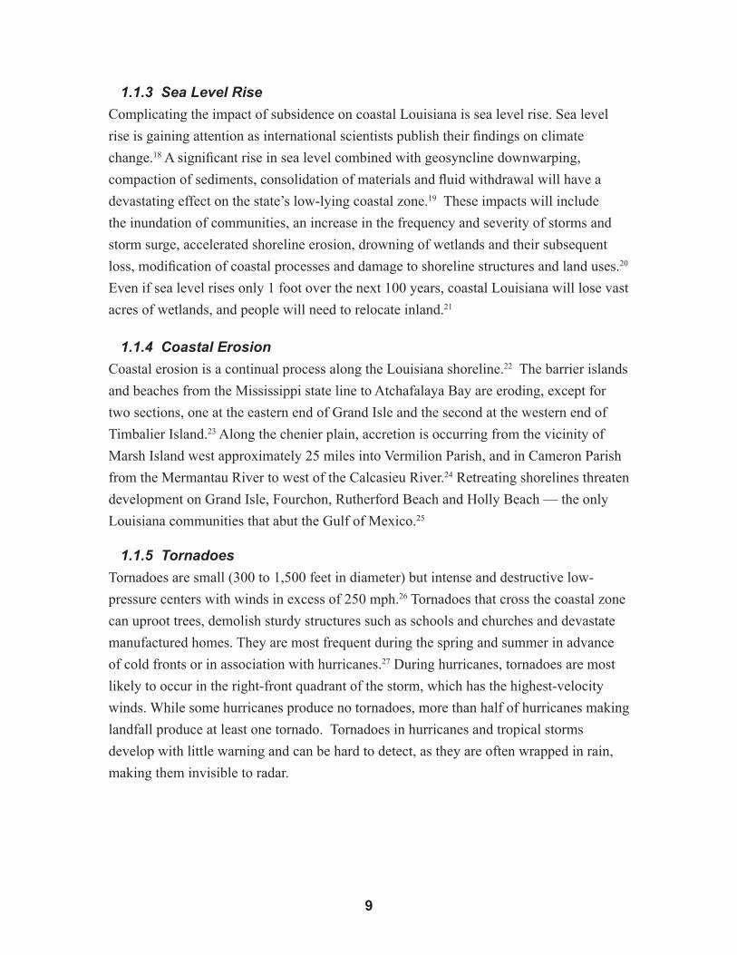
Louisiana, have the highest potential for hurricane landfall (Figure 1-2).39 Historically
significant Louisiana storms are listed in Appendix 2.
��
Figure 1-2. Average return periods (expressed in years) for tropical storms, hurricanes and severe hurricanes, 1901-2005 (From B.D. Keim, R.A. Muller and G.W. Stone. 2007. “Spatiotemporal Patterns and Return Periods of Tropical Storm and Hurricane Strikes from Texas to Maine.” Journal of Climate 20).
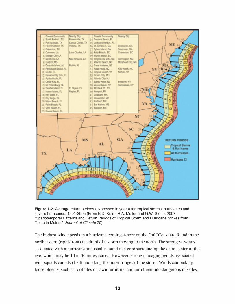
The highest wind speeds in a hurricane coming ashore on the Gulf Coast are found in the
northeastern (right-front) quadrant of a storm moving to the north. The strongest winds
associated with a hurricane are usually found in a core surrounding the calm center of the
eye, which may be 10 to 30 miles across. However, strong damaging winds associated
with squalls can also be found along the outer fringes of the storm. Winds can pick up
loose objects, such as roof tiles or lawn furniture, and turn them into dangerous missiles.

��
Hurricane- and tropical storm-force winds are often felt hundreds of miles from the
center.
Hurricanes may be compact, with a diameter under 100 miles, measured from the outer
fringes of tropical storm force winds. In other cases, hurricane- and tropical storm-force
winds extend out from the eye for a radius of 200 miles or more, creating a system more
than 400 miles across.
1.1.8 Storm Surge
Of the range of hazards associated with hurricanes and tropical storms, the surge threat is
most important for coastal planning purposes. Usually, storm surge is the greatest cause
of destruction in a Gulf of Mexico hurricane, though flooding due to rainfall and swollen
streams also causes localized problems. It is vital that Louisiana’s citizens and leaders
understand the basics of storm surge so they can assess the level of threat posed by surge
when they are asked to evacuate or take other preparatory actions.
Figure 1-3. Storm surge as a hurricane moves ashore (From FEMA. 2006. Recommended Resi-dential Construction on the Gulf Coast, FEMA 550).
Hurricane storm surge is the rapid rise of water above mean sea level.40 Shoreline retreat
may exceed 65 feet per year as a result of storm surge and natural processes.41 Because
of storm surge, wetlands become open waterbodies; homes and businesses that are not
entirely demolished may float miles from their foundations; floodwalls fail; levees are
overtopped; and cities are flooded. Lives are lost when people fail to evacuate in a timely
manner before a hurricane.42 Highways and bridges are undermined or washed away.
��
Storm surge is the bulge of ocean water set in motion offshore by the cyclonic winds
and low barometric pressure of the hurricane. The bulge is driven ahead of a hurricane
or tropical storm as it approaches the coast and results in a rapid rise in sea level
accompanied by large battering waves (Figure 1-3). The surge is caused initially by
strong onshore winds that push ocean water onto the shallow continental shelf offshore,
and then against higher coastal landscape features as water flows rapidly onshore, both in
channels and over low-lying land.
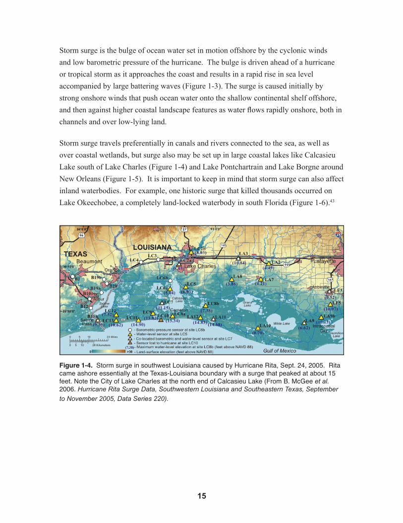
Storm surge travels preferentially in canals and rivers connected to the sea, as well as
over coastal wetlands, but surge also may be set up in large coastal lakes like Calcasieu
Lake south of Lake Charles (Figure 1-4) and Lake Pontchartrain and Lake Borgne around
New Orleans (Figure 1-5). It is important to keep in mind that storm surge can also affect
inland waterbodies. For example, one historic surge that killed thousands occurred on
Lake Okeechobee, a completely land-locked waterbody in south Florida (Figure 1-6).43
Figure 1-4. Storm surge in southwest Louisiana caused by Hurricane Rita, Sept. 24, 2005. Rita came ashore essentially at the Texas-Louisiana boundary with a surge that peaked at about 15 feet. Note the City of Lake Charles at the north end of Calcasieu Lake (From B. McGee et al. 2006. Hurricane Rita Surge Data, Southwestern Louisiana and Southeastern Texas, September
to November 2005, Data Series 220).

�6
Figure 1-5. The New Orleans metro area is surrounded by large estuarine lakes, including Lake Pontchartrain to the north and Lake Borgne to the east. Significant storm surge was experienced for these lakes during Hurricane Katrina, with estimated heights of 11 feet for areas along Lake Pontchartrain and 18 feet for areas along Lake Borgne (Modified from U.S. Army Corps of Engineers. Interagency Performance Evaluation Team. 2006. Performance Evaluation of the New Orleans and Southeast Louisiana Hurricane Protection System).

��
Figure 1-6. Areas in south Florida inundated by storm surge in the 1928 Okeechobee storm. Okeechobee is an inland lake that experienced significant storm surge. Louisiana’s many coastal lakes and bays are vulnerable to the same effects from hurricanes and are high-risk areas (From Eric L. Gross. 1995. Somebody Got Drowned, Lord: Florida and the Great Okeechobee Hurricane Disaster of 1928, Vols. I and II (Ph.D. dissertation)).
As a hurricane moves inland, the initially onshore (southerly) and easterly winds shift
suddenly to northerly and westerly, so that shorelines with differing orientations are
sequentially affected before the surge relaxes and water rushes back out to sea. The
whole hurricane surge sequence is typically completed within 12 hours, though flood
effects often last longer, particularly if water is trapped behind inland barriers or the
storm is accompanied by intense rainfall. During this relatively brief period, however,
surge can destroy and carry away levees and buildings, cut new inlets through barrier
islands and impose great hardships on people living in an affected city or region.

�8
The size of the storm as it approaches the coast affects the volume of water pushed
ashore and the length of coastline that is impacted. Hurricane Katrina made landfall as
a Category 3 storm on the Louisiana-Mississippi state line, but caused damaging storm
surge more than 250 miles to the east in the panhandle of Florida.44 While the greatest
surge associated with Katrina occurred on the Mississippi coast, east of the point of
landfall, New Orleans was still flooded despite being on the western, weaker side of the
storm track.
The track a hurricane follows is important, as is its forward speed. Some storms may
follow the coast a distance offshore, while others take a track that crosses the coast more
perpendicularly. If water can escape alongshore ahead of the storm, then surge buildup
may be limited. If a storm comes ashore fast enough, it may not have time to build-up
surge. All other things being equal, a slower-moving storm (less than 10 miles per hour)
following a track perpendicular to the coast has more potential to cause a damaging surge
than one moving faster or at a greater angle to the shoreline.
Meteorologists have developed increasingly sophisticated models for predicting
hurricane track and intensity, but hurricanes continue to surprise them with erratic and
unpredictable behavior. Specially equipped hurricane-hunter aircraft and satellites
gather useful information about approaching storms, and this data has greatly improved
the accuracy of forecasts. But even the best models rarely can predict the location of
landfall to within a 100 miles more than 24 hours before a storm comes ashore. For this
reason, coastal residents must regard all forecasts with great caution and heed warnings to
evacuate.
1.2 Effects of the Coast on Storm SurgeStorm surge height at any point along the coast is not a simple function of the size
and velocity of storm winds. Surge also is affected by peculiarities of the coast. The
bathymetry (underwater topography offshore) as well as the shape and character of the
shoreline, dramatically influence the height and duration of storm surge. Wind stress
creates higher storm surges in relatively shallow water, which is one reason large, shallow
inland lakes can generate big surges. Wide expanses of shallow seabed extend more than
a 100 miles seaward for much of the Louisiana coast, and this tends to increase the peak
of the storm surge that eventually comes ashore. Hurricane winds directed toward the
coast raise surge, while those blowing offshore can produce a lowering of water at the
coast or within coastal bays and estuaries.

��
Figure 1-7. ADCIRC simulation of Hurricane Katrina surge sequence from Aug. 29, 2005 - 7 a.m. (top left), 8 a.m. (top right), 9 a.m. (bottom left), 10 a.m. (bottom right). Surge is negative (blue) west of Mississippi River and up to more than 7 meters (25 feet) on the Mississippi Coast (red). The vectors indicate wind direction, with the center of circulation (eye) visible in the top right and bottom left panels. Flow over levees begins before 8 a.m. Note surge buildup in coastal indentations and against levees (From Ivor Ll. Van Heerden et al. Team Louisiana. 2006. The Failure of the New Orleans Levee System during Hurricane Katrina).
Most surge dynamics are quite accurately reproduced in the most recent generation of
mathematical storm surge models run on supercomputers. They simulate the wind stress
generated by a hurricane and the complex way in which surge builds on the particular
shorelines. The Advanced CIRCulation model (ADCIRC) was run by scientists at the
LSU Hurricane Center during the 2005 hurricane season.45 ADCIRC computes the ever-
changing wind stresses associated with a storm moving across the ocean and the effect of
this stress on ocean circulation and the water surface elevation at hundreds of thousands
of locations or nodes (Figure 1-8). The Sea, Lake and Overland Surge from Hurricanes
model (SLOSH) is an older model still widely used for the same purpose.46 ADCIRC
and SLOSH are provided with parameters issued by the National Hurricane Center that
describe the likely track and characteristics of an incoming hurricane.
Figures 1-8 and 1-9 show the predicted and actual storm surge from Hurricane Rita in
southwest Louisiana. An examination of these figures shows that the ADCIRC model is
capable of predicting storm surge with a high degree of accuracy. This capability gives
parish governments extremely valuable tools with which to protect their citizenry from

20
natural hazards, but it also may impose on governments a higher level of responsibility
to those citizens. The models are able to compute surge within any area, like coastal
Louisiana, for which the configuration of the seabed and landscape has previously been
input. It quickly becomes apparent, when looking at a number of hurricane simulations,
that certain parts of the coast are inherently more susceptible to high surge and damage
because of the geometry of the coastal landscape. Where the coastline takes an abrupt
turn seaward, as on the east side of the peninsula formed by the Mississippi River, the
embayment or “bight” can trap water, causing it to rise up against levees and other higher
features. The Lake Borgne funnel on the east side of New Orleans is one such area
(Figure 1-10).

2�
Figure 1-8. ADCIRC simulation of predicted storm surge from Hurricane Rita –– Note that the predicted extent of storm surge simulated by the ADCIRC model nearly mirrors the observed storm surge, which is shown in Figure 1-9 for comparison (Image courtesy of M. Wolcott, based on ADCIRC modeling by H. Mashriqui).
Figure 1-9. Observed storm surge from Hurricane Rita (Image courtesy of M. Wolcott, based on ADCIRC modeling by H. Mashriqui).

22
Figure 1-10. ADCIRC simulation of water circulation generated by Hurricane Katrina around New Orleans and over the tops of levees at the onset of flooding -- Note that the triangular “funnel” opening to the east includes flows along and across the levees and floodwalls shown in pink (From Ivor Ll. Van Heerden et al. Team Louisiana. 2006. The Failure of the New Orleans Levee System during Hurricane Katrina).
Scientists and engineers talk about storm surge elevation or storm surge depth, which
are related but different. The elevation of the surge is the height of the water surface
above mean sea level, usually without including the contribution of waves. Wave peaks
extend above what is euphemistically called the “still water line,” while the troughs dip
below this line. Mean sea level is an oceanographic term based on long-term tide gage
measurements, but it can be related to the reference system or datum generally used
by surveyors to map land elevations, now the North American Vertical Datum of 1988
(NAVD88). Storm surge depth is more meaningful to coastal residents and more closely
related to the degree of damage caused. It is calculated by subtracting land elevation
from water elevation (Figure 1-11).
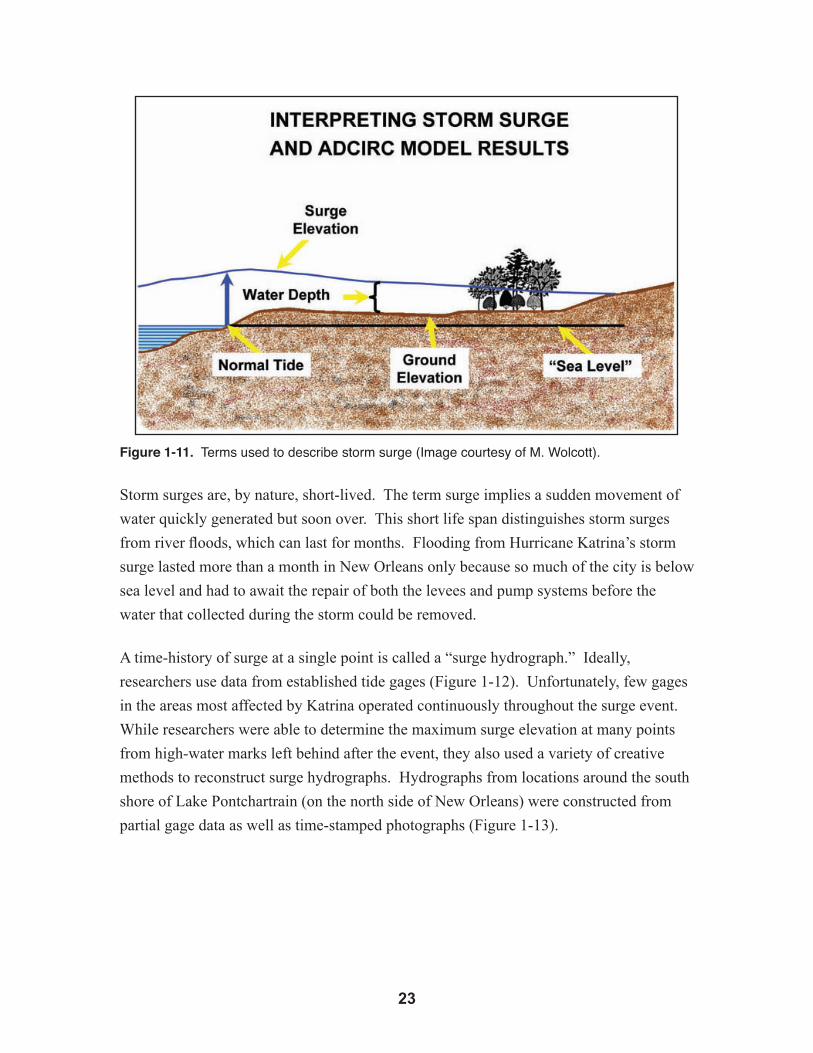
2�
Figure 1-11. Terms used to describe storm surge (Image courtesy of M. Wolcott).
Storm surges are, by nature, short-lived. The term surge implies a sudden movement of
water quickly generated but soon over. This short life span distinguishes storm surges
from river floods, which can last for months. Flooding from Hurricane Katrina’s storm
surge lasted more than a month in New Orleans only because so much of the city is below
sea level and had to await the repair of both the levees and pump systems before the
water that collected during the storm could be removed.
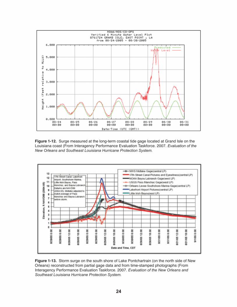
A time-history of surge at a single point is called a “surge hydrograph.” Ideally,
researchers use data from established tide gages (Figure 1-12). Unfortunately, few gages
in the areas most affected by Katrina operated continuously throughout the surge event.
While researchers were able to determine the maximum surge elevation at many points
from high-water marks left behind after the event, they also used a variety of creative
methods to reconstruct surge hydrographs. Hydrographs from locations around the south
shore of Lake Pontchartrain (on the north side of New Orleans) were constructed from
partial gage data as well as time-stamped photographs (Figure 1-13).
2�
Figure 1-12. Surge measured at the long-term coastal tide gage located at Grand Isle on the Louisiana coast (From Interagency Performance Evaluation Taskforce. 2007. Evaluation of the New Orleans and Southeast Louisiana Hurricane Protection System.
Figure 1-13. Storm surge on the south shore of Lake Pontchartrain (on the north side of New Orleans) reconstructed from partial gage data and from time-stamped photographs (From Interagency Performance Evaluation Taskforce. 2007. Evaluation of the New Orleans and Southeast Louisiana Hurricane Protection System.

2�
Typically, the surge hydrograph will include a relatively slow initial rise while the storm
is still some distance offshore (Figure 1-12). This phase lasted about a day and resulted
in a rise in Lake Pontchartrain to about 3 feet above sea level (Figure 1-13). This was
followed by a much more rapid ascent to a peak of about 12 feet over nine hours as the
storm came onshore to the east. The subsequent drop may be rapid or slower, depending
on how quickly natural outlets and channels can convey water seaward. At the Grand
Isle gage located at the coast, the fall and return to normal tide level occurred over about
a day. Because Lake Pontchartrain has relatively constricted connections to the Gulf
of Mexico, lake levels took nearly three days to return to 3 feet above normal sea level
(Figure 1-13). This slow drop contributed greatly to the flooding of New Orleans through
failed floodwalls. The maximum elevation for storm surge recorded in the United States was documented at
about 30 feet above sea level for the Mississippi coast during Katrina. The last hurricane
to cause similar storm surge damage was Hurricane Camille, which came ashore in the
same area in August 1969. Although much smaller in diameter than Katrina, Camille’s
record 190-mph winds generated a storm surge measuring as much as 24 feet along a
shorter reach of the Mississippi coast.47 The layout or geometry of the coast can cause surge elevation to be higher or lower
in different places, as can be seen in the surge simulation from Katrina (Figure 1-7).
Generally, however, the surge depth is greatest at the coast because land elevations are
lowest there and because the surge loses elevation as it spreads out and travels over land
(Figure 1-11). Another important factor comes into play that makes property near the coast more
vulnerable than inland property, even if the land elevation is similar in both places.
Waves generated offshore ride the top of the surge, but tend to lose energy quickly when
they shoal and break in shallow water. Therefore, while the surge may roll tens of miles
inland in low-lying coastal estuaries and river bottoms, waves greater than about 3 feet
rarely make it more than a mile or two inland, except in large coastal lakes. Breaking
waves generate extremely high-velocity flows that rush upward beyond the surge
elevation and have the potential to cause great damage to hurricane protection structures
like earthen levees, particularly if they cause “overtopping” (Figure 1-14). Accordingly,
engineers must consider the likelihood of wave attack when deciding where to locate
such structures and whether to armor them with resistant materials like rock or concrete.
Structures located adjacent to large waterbodies are more exposed to waves than those
located farther inland or behind expanses of wetlands.

26
Figure 1-14. Hurricane-generated waves ride on top of the surge and turn levees and inland bluffs into beaches that can be eroded by the high-velocity flows that occur when waves break and water rushes uphill beyond the surge elevation. Overtopping raises the potential for erosion on the back side of levees (Adapted from FEMA. 2003. Guidelines and Specifications for Flood Hazard Mapping Partners).
1.3 Wetland and Lake Effects on Storm SurgeWhile the size and orientation of coastal lakes and bays can increase both the severity and
duration of the surge event, low-lying wetland landscapes can have the opposite effect.
The wetland effect has been observed in most storms affecting the Louisiana coast. This
phenomenon was also noted by scientists documenting damage from the December 2004
Indian Ocean tsunami, who reported reduced damage in areas sheltered by intact coastal
wetlands and an inverse effect where there were no wetlands or where wetlands had been
destroyed by man.48 This effect was appreciated by observers on the ground, but the
physics that cause it remain poorly understood. In fact, prior to Hurricane Katrina, many
surge modelers unfamiliar with the field data believed that once a surge submerged tidal
wetlands, marshes had no predictable continuing effect on surge, and, therefore, could be
treated in the same way as any other portion of the non-vegetated seabed.
2�
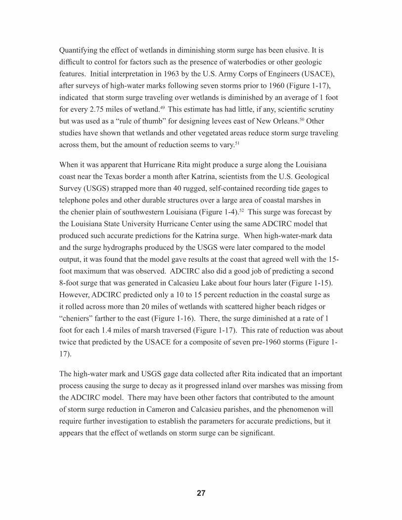
Quantifying the effect of wetlands in diminishing storm surge has been elusive. It is
difficult to control for factors such as the presence of waterbodies or other geologic
features. Initial interpretation in 1963 by the U.S. Army Corps of Engineers (USACE),
after surveys of high-water marks following seven storms prior to 1960 (Figure 1-17),
indicated that storm surge traveling over wetlands is diminished by an average of 1 foot
for every 2.75 miles of wetland.49 This estimate has had little, if any, scientific scrutiny
but was used as a “rule of thumb” for designing levees east of New Orleans.50 Other
studies have shown that wetlands and other vegetated areas reduce storm surge traveling
across them, but the amount of reduction seems to vary.51
When it was apparent that Hurricane Rita might produce a surge along the Louisiana
coast near the Texas border a month after Katrina, scientists from the U.S. Geological
Survey (USGS) strapped more than 40 rugged, self-contained recording tide gages to
telephone poles and other durable structures over a large area of coastal marshes in
the chenier plain of southwestern Louisiana (Figure 1-4).52 This surge was forecast by
the Louisiana State University Hurricane Center using the same ADCIRC model that
produced such accurate predictions for the Katrina surge. When high-water-mark data
and the surge hydrographs produced by the USGS were later compared to the model
output, it was found that the model gave results at the coast that agreed well with the 15-
foot maximum that was observed. ADCIRC also did a good job of predicting a second
8-foot surge that was generated in Calcasieu Lake about four hours later (Figure 1-15).
However, ADCIRC predicted only a 10 to 15 percent reduction in the coastal surge as
it rolled across more than 20 miles of wetlands with scattered higher beach ridges or
“cheniers” farther to the east (Figure 1-16). There, the surge diminished at a rate of 1
foot for each 1.4 miles of marsh traversed (Figure 1-17). This rate of reduction was about
twice that predicted by the USACE for a composite of seven pre-1960 storms (Figure 1-
17).
The high-water mark and USGS gage data collected after Rita indicated that an important
process causing the surge to decay as it progressed inland over marshes was missing from
the ADCIRC model. There may have been other factors that contributed to the amount
of storm surge reduction in Cameron and Calcasieu parishes, and the phenomenon will
require further investigation to establish the parameters for accurate predictions, but it
appears that the effect of wetlands on storm surge can be significant.
28
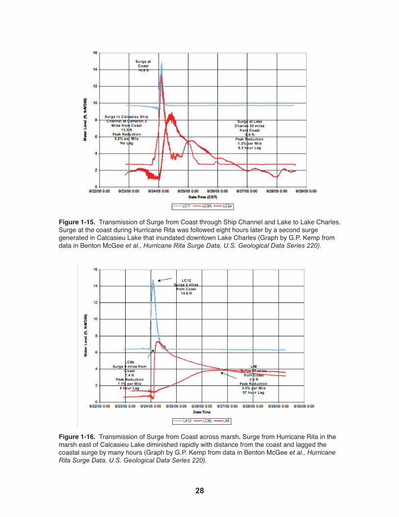
Figure 1-15. Transmission of Surge from Coast through Ship Channel and Lake to Lake Charles. Surge at the coast during Hurricane Rita was followed eight hours later by a second surge generated in Calcasieu Lake that inundated downtown Lake Charles (Graph by G.P. Kemp from data in Benton McGee et al., Hurricane Rita Surge Data, U.S. Geological Data Series 220).
Figure 1-16. Transmission of Surge from Coast across marsh. Surge from Hurricane Rita in the marsh east of Calcasieu Lake diminished rapidly with distance from the coast and lagged the coastal surge by many hours (Graph by G.P. Kemp from data in Benton McGee et al., Hurricane Rita Surge Data, U.S. Geological Data Series 220).

2�
While the Rita surge at the coast adjacent to Calcasieu Lake and adjacent to Grand
Chenier 15 miles to the east were identical, a hurricane surge buffer of intact tidal
marshes 25 to 30 miles wide made a great difference in the way the surge behaved
(Figure 1-4). Some marshes are found outside the New Orleans hurricane protection
levees in the funnel area (Figure 1-10). Many levees that faced the Katrina surge and
failed were fronted by open water or, in some places, degraded marsh remnants instead of
the wide expanses of healthy tidal wetlands that existed 50 years earlier. What has been
termed the “wetland effect” is a more rapid drop-off in storm surge inland from the coast
than can be explained simply by interaction with the topography of the landscape. The
USGS gage data shows that the wetlands do more than simply reduce the maximum surge
elevation. They also delay the peak and slow the rate at which water level drops after
reaching its zenith (Figure 1-16).
Figure 1-17. Maximum surge from Hurricane Rita in marsh (blue) and lake (yellow) -- Analysis of FEMA high-water marks collected after Hurricane Rita in the Calcasieu Lake and Grand Chenier marsh transects showing a 1-foot drop in surge for every 1.4 miles of marsh (black line), and a comparison with the earlier USACE pre-1960 estimate of 1 foot for every 2.8 miles (purple line). USGS gage maxima are also shown (Graph by G.P. Kemp from data in Benton McGee et al. 2006. Hurricane Rita Surge Data, U.S. Geological Data Series 220 and FEMA. 2006. Louisiana Coastal & Riverine High Water Mark Collection).

�0
1.4 Coastal Wetland Loss and RestorationSurge model developers are only now beginning to incorporate wetlands into post-
2005 models by experimentally introducing added “roughness” or “drag” into the
interaction between surge-induced flow and the wetland beneath.53 The Hurricane Rita
data developed by FEMA and the USGS are being used to include wetland effects in the
next generation of surge models. This has become very important to the development of
effective hurricane protection for the 2 million people who live in coastal Louisiana. It is
apparent that the catastrophic loss of coastal wetlands –– some 1,900 square miles since
the 1930s54 –– is increasing the risk of hurricane flooding due to surge (Figure 1-18).
Figure 1-18. The southeast Louisiana Mississippi River deltaic plain, showing land either already lost or projected to be lost by 2050, if more substantial remediation efforts now planned are not successful. Land loss has been most severe in the central part of this system west of the Mississippi River where inland levees are becoming part of the exposed Gulf shoreline (From U.S. Geological Survey. 2005. Depicting Louisiana Land Loss, Fact Sheet 2005-3101).
��
A multi-billion dollar restoration program is now in progress to stop or reverse wetland
loss by reattaching the Mississippi River to coastal wetlands through controlled
diversions and extensive use of dredged material to rebuild wetlands and barrier islands.55
This work was initiated in the late 1980s to re-establish the ecological integrity of this
once-vast system of deltaic estuaries after nearly a century of damage brought about by
leveeing the Mississippi River and dredging more than 15,000 miles of canals to facilitate
oil and gas exploration and ship navigation.56 Since the hurricanes of 2005, however, a
new urgency has infused this effort and focused it on rebuilding high-priority wetlands
that can augment hurricane protection for developed areas.57
Land loss rates have fluctuated over the years, and recent studies show the rates have
been reduced from 39 square miles per year between 1956 and 1978 to 24 square miles
per year from 1990 to 2000.58 But it is clear that much more aggressive and expensive
projects are still required to turn the tide. The Multiple Lines of Defense Strategy
(MLODS), discussed in Chapter 3, proposes to take advantage of lessons learned during
Hurricanes Katrina and Rita by moving levees inland and rebuilding marshes in front of
them.59 One particularly interesting concept is to use river diversions to create freshwater
conditions in currently brackish marshes to allow replanting of swamp tree species like
cypress and tupelo. Thick swamp forests are particularly resistant to storm damage and
are more effective in reducing surge and waves than marsh.60
1.5 Continuing Challenges: Sea Level Rise and LandSubsidence
Scientists expect sea level to rise 1 to 2 feet globally by the year 2100, though these
estimates could increase if grounded ice in Greenland and Antarctica melts more quickly
than expected.61 But global sea level rise has historically contributed only about 10
percent of observed “relative” sea level rise in coastal Louisiana. The difference is a
consequence of the contribution of subsidence –– the sinking of the land in a process
that varies throughout the coast plain. This is believed to result in part from geological
processes like the compaction of relatively young deltaic sediments near the surface and
from deeper movement along fault lines. Generally, these regional processes have greater
effect closer to the seaward margin, but human-induced activities like pumped drainage,
withdrawal of subsurface fluids during oil and gas production, and depressurization of
shallow gas fields have also greatly enhanced subsidence more locally.62

�2
It is clear that all of these factors, in addition to the reduction of river-borne sediment
delivery to the coast, have played a role in the catastrophic land loss documented for
coastal Louisiana. Most of the regional subsidence processes are beyond human control,
so adaptation has focused on re-establishing the connection between the Mississippi
River and the coastal wetlands that it once built. The river carries over 200 million tons
of sediment every year and could carry more if dams upstream were reconfigured, but
today most of this sediment either flows or is dumped by dredges into more than 1,000
feet of water in the Gulf of Mexico.63 Diversions on the Mississippi will carry that
sediment to shallower water where it can rebuild coastal land and barrier islands.
Figure 1-19. Constance Beach, Cameron Parish, Louisiana, after Hurricane Rita. While the house in the foreground was washed away by Rita’s storm surge, the structure behind escaped destruction because it was properly elevated (Photo courtesy of D. Dartez, 2005).

��
Chapter References
1 J.f.lanDereTal.,naT’loceanicanDaTmosPhericaDmin.anDgeologicalsurvey,invenToryofnaTuralhazarDs:DaTaresourcesinThefeDeralgovernmenT (1979); Org. of Am. States, Natural Hazards Risk Assessment and Disaster Mitigation Pilot Project in Latin America and the Caribbean Basin, in courseonTheuseofnaTuralhazarDsinformaTioninThePreParaTionofinvesTmenTProJecTs,manual (1987); g.f.whiTe, Natural Hazards Research: Concepts, Methods, and Policy Implications, in naTuralhazarDs:local,naT’l,global 3-16 (G.F. White ed., 1974).
2 D.s.mileTi,DisasTersbyDesign:areassessmenTofnaTuralhazarDsinTheuniTeDsTaTes 106 (Joseph Henry Press, 1999).
3 feD.emergencymgmT.agency,unDersTanDingyourrisKs,iDenTifyinghazarDsanDesTimaTinglosses,sTaTeanDlocalmiTigaTionPlanninghow-ToguiDes,FEMA 386-2 (2001) [hereinafter FEMA 2001].
4 L.A. Larson & R.E. Emmer, Floodplain Mgmt., at 9 (Module 4, Session 16, Emergency Mgmt. Institute, 2004), available at http://training.fema.gov/emiweb/edu/fmc/ Session%2016%20-%20Power%20Point%20Slides.ppt#277; FEMA 2001, supra note 3.
5 r.e.emmer,J.wilKins,l.schiavinaTo,m.Davis,&m.wascom,louisianaseagranTcollegeProgram,hazarDmiTigaTionanDlanDusePlanningincoasTallouisiana:recommenDaTionsforThefuTure (2007), available at http://www.lsu.edu/sglegal/pdfs/ CompPlanningReport.pdf.
6 s.a.hsu&b.w.blancharD,flooDingalongTheloweramiTeriverbasin:asTuDyofThecauseanDeffecTofrain-inDuceDanDwinD-DrivenflooDs (prepared for the Coastal Studies Institute for the Amite River Basin Commission, La. State Univ., 2000).
7 r.a.muller&J.e.willis,neworleansweaTher1961-1980:aclimaTologybymeansofsynoPTicweaTherTyPes(School of Geoscience Miscellaneous Publication 83-1, La. State Univ., 1983).
8 feD.emergencymgmT.agency,naTionalflooDinsuranceProgram,louisianaflooDfacTsheeT (March 2007).
9 naT’lresearchcouncil,miTigaTinglossesfromlanDsubsiDenceinTheuniTeDsTaTes at 3 (1991).
10 Id.11 A. gowen,m.goeTz,&i.waiTsman,u.s.environmenTalProTecTionagency,
choosingoffshorePiPelinerouTes:ProblemsanDsoluTions(EPA/600/7-80/114 2004), available at http://oaspub.epa.gov/eims/eimsapi.dispdetail?deid=38846; M.C. Nodine, S.G. Wright, R.B. Gilbert, & E.G. Ward, Mudflows and Mudslides During Hurricane Ivan (Offshore Technology Conference, Houston, Tex., May 1-4, OTC 18328, 2006).
12 R.A. Morton, N.A. Buster, & M.D. Krohn, Subsurface Controls on Historical Subsidence Rates and Associated Wetland Loss in Southcentral Louisiana, 52 TransacTionsgulfcoasTass’nofgeologicalsocieTies 767-778 (2002), available at http://coastal.er.usgs.gov/gc-subsidence/gcags-paper/; R.A. Morton, G. Tiling, & N.F. Ferina, Causes of Hot-spot Wetland Loss in the Mississippi Delta Plain, 10 environmenTalgeosciences 71-80 (2003).
13 naTionalresearchcouncil,commiTTeeongrounDfailurehazarDsmiTigaTionresearch,miTigaTinglossesfromlanDsubsiDenceinTheuniTeDsTaTes(National Academy Press 1991).
14 soilconservaTionservice,DeP’TofagriculTure,soilsurveyofJeffersonParishlouisiana, at 44 (1983).
15 Id.

��
16 Id.17 Id.18 U.S. Environmental Protection Agency, Climate Change, at http://www.epa.gov/
climatechange/ (last visited April 21, 2008).19 S. PenlanDet al.,relaTivesealevelriseanDsubsiDenceinlouisianaanDThegulfof
mexico(Coastal Geology Tech. Rept. No. 3 1989); K.E. Ramsey & S. Penland, Sea-Level Rise and Subsidence in Louisiana and the Gulf of Mexico, 39 TransacTions,gulfcoasTass’nofgeologicalsocieTies491-500 (1990).
20 P. Klarin & M. Hershman, Response of Coastal Zone Mgmt. Programs to Sea Level Rise in the United States, 18coasTalmgmT.143-156(1990).
21 PenlanDet al., supra note 19.22 See J.m.coleman,recenTcoasTalseDimenTaTion:cenTrallouisianacoasT(La.
State Univ. Coastal Studies Inst. Tech. Rept. No. 29, 1966);D.R. Frazier, Recent Deltaic Deposits of the Mississippi River: Their Development and Chronology, 17 TransacTions,gulfcoasTass’nofgeologicalsocieTies297-311(1967);i.a.menDelssohn eTal.,la.DeP’TofnaTuralres.,barrierislanDsanDbeachesofThelouisianaDelTaicPlain(1987); J.P. morganeTal.,morPhologicaleffecTsofhurricaneauDreyonThelouisianacoasT(La. State Univ. Coastal Studies Inst. Tech. Rept. No. 10, 1958); D. Nummedal et al.,Shoreline Evolution Along the Northern Coast of the Gulf of Mexico, 52shoreanDbeach11-17 (1984); J.R. vanloPicK,recenTgeologyanDgeomorPhichisToryofcenTralcoasTallouisiana,(La. State Univ. Coastal Studies Inst. Tech. Rept. No. 7, 1955); K.M. wicKer,eTal.,ocsStudy mms89-0052,ananalysisofouTerconTinenTalshelfimPacTs:PiPelines,navigaTionchannels,anDfaciliTiesinsensiTivecoasTalhabiTaTs,coasTalgulfofmexico,TechnicalnarraTive(ocTober1989).
23 coleman, supra note 22.24 Id.25 Id.26 R. Edwards, Nat’l Oceanographic and Atmospheric Admin., Storm Prediction Center, The
Online Tornado FAQ (2007), at http://www.spc.noaa.gov/faq/tornado/#The%20Basics.27 Id.28 Fed. Emergency Mgmt. Agency, Thunderstorms and Lighting, at http://www.fema.gov/
hazard/thunderstorm/index.shtm (last visited October 21, 2007).29 americanmeTeorologysocieTy,glossaryofmeTeorology, at 105 (2007).30 Nat’l Hurricane Ctr., Glossary of NHC Terms, at http://www.nhc.noaa.gov/aboutgloss.
shtml (last visited April 22, 2008).31 Simpson & Riehl, supra note 31, at 215; Nat’l Weather Service, Tropical Cyclone
Hazards, at http://www.srh.noaa.gov/srh/jetstream/tropics/tc_hazards.htm (last visited April 22, 2008).
32 Nat’l Hurricane Ctr., supra note 30.33 Nat’l Weather Service, Tropical Cyclone Introduction, at http://www.srh.noaa.gov/srh/
jetstream/tropics/tc.htm (last visited April 22, 2008).34 C. Landsea, Nat’l Oceanographic and Atmospheric Admin., Hurricane Research Div.,
Frequently Asked Questions, at http://www.aoml.noaa.gov/hrd/tcfaq/D4.html (last visited April 22, 2008).
35 Nat’l Hurricane Ctr., supra note 30; R. Edwards, supra note 26.36 Nat’l Hurricane Ctr., The Saffir-Simpson Hurricane Scale, at http://www.nhc.noaa.gov/
aboutsshs.shtml (last visited April 22, 2008).37 Nat’l Oceanographic and Atmospheric Admin., Coastal Services Ctr., Historical
Hurricane Tracks, at http://maps.csc.noaa.gov/hurricanes/index.jsp (last visited April 23,

��
2008).38 Id.39 R.H. simPson&h.riehl,ThehurricaneanDiTsimPacT, at 272, fig. 124 (La. State Univ.
Press, 1981).40 A.N. sTrahler&a.h.sTrahler,elemenTsofPhysicalgeograPhy (3d ed. 1984).41 A. Sallenger, U.S. Geological Survey, Hurricane Impacts on the Coastal Environment
(USGS Fact Sheet, 2007), at http://marine.usgs.gov/fact-sheets/hurricane/hurricane-txt.html.
42 u.s.senaTe.hurricaneKaTrina.anaTionsTillunPrePareD.sPecialrePorTofThecommiTTeeonhomelanDsecuriTyanDgovernmenTalaffairs,s.reP.no.109-322 (2006).
43 Eric L. Gross, Somebody Got Drowned, Lord: Florida and the Great Okeechobee Hurricane Disaster of 1928, Vols. I and II (Ph.D. dissertation, Florida State University, 1995).
44 Jeffery Medlin et al., National Weather Service, Extremely Powerful Hurricane Katrina leaves a Historic Mark on the Northern Gulf Coast, July, 7, 2006, at http://www.srh.noaa.gov/mob/0805Katrina.
45 Adcirc.org, Coastal Circulation and Storm Surge Model, at http://adcirc.org/index.htm (last updated Feb. 13, 2008).
46 Nat’l Hurricane Center, Slosh Model, at http://www.nhc.noaa.gov/HAW2/english/surge/slosh.shtml (last visited April 4, 2008).
47 u.s.armycorPsofengineers,rePorTonhurricanecamille,14-22augusT1969,no.311, at Exhibit 22 (1970).
48 Finn. Danielsen et al., The Asian Tsunami: A Protective Role for Coastal Vegitation, 310 Science 643 (2005).
49 u.s.armycorPsofengineers,hurricanesTuDyformorganciTy,louisianaanDviciniTy,neworleansDisTricT(1963).
50 Id.51 John W. Day, Jr. et al., Restoration of the Mississippi Delta: Lessons From Hurricanes
Katrina and Rita, 315 science 1681 (2007).52 Benton McGee et al., U.S. Geological Survey, Hurricane Rita Surge Data, Southwestern
Louisiana and Southeastern Texas, September to November 2005, U.S. Geological Data Series 220 (October 2006), at http://pubs.water.usgs.gov/ds220.
53 Adcirc.org, supra note 45.54 H.J. Walker et al., Wetland Loss in Louisiana,69ageografisKaannaler1(1987); J.
barraseTal.,hisToricalanDProJecTeDlanDchanges–1978-2050:u.s.geologicalsurveyoPen-filerePorT2003-334(2003);U.S. Geological Survey, Depicting Coastal Louisiana Land Loss, Fact Sheet 2005-3101 (2005), at http://www.nwrc.usgs.gov/factshts/ 2005-3101.pdf.
55 louisianacoasTalProTecTionanDresToraTionauThoriTy, InTegraTeDecosysTemresToraTionanDhurricaneProTecTion:louisiana’scomPrehensivemasTerPlanforasusTainablecoasT (2007).
56 Day et al., supra note 51.57 u.s.armycorPsofengineers,louisianacoasTalProTecTionanDresToraTionrePorT
[DrafT] (2008), available at http://lacpr.usace.army.mil/ Report/Draft%20LACPR%20Technical%20Report.pdf.
58 barraseTal., supra note 54; D. Boesch et al., Scientific Assessment of Coastal Wetland Loss Restoration and Management in Louisiana, JournalofcoasTalresearch,sPecialissueno.20(1994); r.DeaneTal.,commiTTeeonTheresToraTionanDProTecTion

�6
ofcoasTallouisiana,naTionalresearchcouncil,Drawinglouisiana’snewmaP:aDDressinglanDlossincoasTallouisiana (2006).
59 Johna.loPez,laKePoncharTrainbasinfounDaTion,ThemulTiPlelinesofDefensesTraTegyTosavesouThernlouisiana(2006), http://www.saveourlake.org/pdfs/JL/MLODSfullpt2-06.pdf.
60 Id.61 inTergovernmenTalPanelonclimaTechange,climaTechange2007-imPacTs,
aDaPTaTionanDvulnerabiliTy(2007).62 roberTa.morTon,anoverviewofcoasTallanDloss:wiThemPhasisonThe
souTheasTernuniTeDsTaTes,oPenfilerePorT2003-337(2003),at http://pubs.usgs.gov/of/2003/of03-337/landloss.pdf.
63 u.s.geologicalsurvey,conTaminanTsinThemississiPPiriver,1987-1992,usgscircular1133 (Robert Meade, ed., 1995), available at http://pubs.usgs.gov/circ/circ1133/.

��
Chapter 2Existing Regulatory Programs
Planning officials, developers and land owners should be aware that there are laws
and regulations that control certain aspects of how land is used and developed.
These conservation and environmental rules indirectly affect local or state planning
for hazard mitigation. There are also laws and regulations that provide incentives
to encourage hazards planning. However, none of these regulatory programs is
as effective as, or takes the place of, directed planning for hazard mitigation. The
following is a brief description of the major federal regulatory programs that can
affect land use and hazard planning.
2.1 The Coastal Zone Management ActThe Coastal Zone Management Act (CZMA) authorizes coastal and Great Lakes
states to establish their own coastal zone management programs, with the federal
government retaining oversight responsibility.1 State participation in the CZMA is
voluntary, but significant incentives and a recognition of the need for coastal zone
management have induced almost all the coastal and Great Lakes states, including
Louisiana, to develop their own coastal management programs. The Louisiana State
and Local Coastal Resources Management Act (SLCRMA) of 1978, as amended,2 is
Louisiana’s approved CZMA program that sets criteria and establishes guidelines for
protecting, developing and restoring the natural resources of the delineated coastal
zone (Figure 2.1) while allowing for adequate economic development and growth.3
A coastal use permit4 is required for certain activities in the coastal zone, including,
but not limited to, dredging or discharges of dredged or fill material; levee siting,
construction, operation and maintenance; hurricane and flood protection facilities;
urban developments; energy and mining activities; shoreline modification; and
recreational and industrial development.5 Louisiana allows coastal zone parishes that
have developed approved local coastal management plans6 to regulate “uses of local
concern”7 within their boundaries. These uses directly and significantly affect coastal
waters and are in need of coastal management, but are not uses of state concern.8
Reducing the risks from coastal hazards is a key component of the Louisiana Local
Coastal Resources Program (LCRP).9 However, the LCRP has never addressed
storm risk exposure in the placement of single-family homes in the coastal zone
because the SLCRMA specifically exempts single-family homes from regulation.10
Although subdivisions must be responsive to the LCRP guidelines, developers often

�8
Figure 2-1. Map of the Louisiana Coastal Zone (courtesy of Louisiana Department of Natural Resources).
subdivide property (which is not regulated by the LCRP) and sell individual lots. The lot
owners then apply for building permits for a single-family home thereby piecemealing
subdivisions and avoiding LCRP oversight concerning coastal hazards. In the aftermath
of the 2005 hurricanes, the Coastal Management Division of the Louisiana Department
of Natural Resources (LDNR) is supporting efforts to reduce coastal hazards through
educational programs.11 It is our opinion that educational efforts will have a limited
effect in reducing exposure to coastal hazards. To allow for a more aggressive coastal
management program, the Legislature must amend the SLCRMA to allow regulation or
oversight of single-family homes for hazard mitigation purposes.
2.2 The Coastal Barrier Resources Act Barrier islands and beaches are dynamic, ever-changing features that erode and fill along
their unconsolidated length.12 Because of their low elevation and relief, these barrier
systems are subject to overtopping by storm surge and wind-driven high tides on a regular
��
basis. As such, they are hazardous places, but this does not keep people from wanting
to live and rebuild on them after storms.13 Until recently, federal and state programs
encouraged development of barrier islands and beaches.14 Consequently, people died and
property was flooded or demolished when hazards struck, and valuable renewable habitat
was destroyed by development.15 With increasing development on barrier islands and
beaches and with growing pressure to confront the problem, Congress passed the Coastal
Barrier Resources Act (CBRA) in 1982 to restrict federal subsidies that promote growth
where none existed at the time. However, CBRA does not affect subsidies to identified
existing communities.16 Under the CBRA, the federal government no longer provides
assistance on certain barrier islands for the construction of sewer and water supply
systems, airports, highways, bridges, jetties, seawalls and piers. CBRA also restricts the
availability of flood insurance, U.S. Army Corps of Engineers structural development
projects and federal loans from agencies such as the Veterans Administration or the
Federal Housing Administration.17 The law does not prohibit private financial transactions
or the construction of facilities and structures using private, state or local funds.18 Parts
of Louisiana’s coastal barrier formations are exempt from the restrictions of the CBRA
because they were inhabited before the law was enacted. For example, Grand Isle and
parts of the Cameron Parish shore are not included in the designated Coastal Barrier
System.19 Other private areas of Louisiana shorelines that would qualify as a coastal
barrier are likely subject to CBRA’s restrictions on federal financial assistance.
2.3 Section 404 of the Clean Water ActIn 1972, Congress revised the nation’s water quality program by including the protection
of wetlands adjacent to navigable waters through Section 404 of the Clean Water Act
(CWA).20 The Corps of Engineers was authorized to implement a separate permit program
for the placement of dredge and fill material in waters of the United States. Recently the
definition of the “waters of the United States,” and thus the extent of CWA Section 404’s
jurisdiction, has been challenged and is in a state of flux.21 However, the federal agencies
that administer the law still use the definition “waters of the United States” to include
most waters, especially those in coastal areas.22
Although the Corps administers the Section 404 permit program, the Environmental
Protection Agency (EPA) has authority through Section 404(c) to veto a Corps permit
if the proposed action has unacceptable adverse impacts on municipal water supplies;
shellfish beds; or fishery, wildlife or recreation areas.23 Decisions on whether to accept
or deny a permit are based on the Section 404(b)(1) guidelines.24 When properly
administered, this permit process helps mitigate the impact of natural hazards on
�0
development in coastal Louisiana.25 The Section 404 permit program helps reduce the
loss of wetlands that buffer communities from storm surge. Limiting the destruction and
use of wetlands directs development away from the more exposed and dangerous parts of
the coast. This can limit suburban expansion onto wetlands that will ultimately subside
when they are drained.26
2.4 The National Pollutant Discharge Elimination SystemThe other facet of the Clean Water Act27 that can affect hazard mitigation is Section 402,
which establishes the National Pollutant Discharge Elimination System (NPDES)28 to
regulate polluting discharges from point sources (discrete conveyances such as pipes) into
the waters of the United States.29 The EPA is the regulatory agency responsible for setting
effluent limits that ensure the quality of the nation’s surface water.30
The NPDES includes provisions for permitting operators of municipal separate storm
sewer systems to discharge pollutants.31 Municipal separate storm sewer systems (MS4)
carry storm water and pollution to rivers and streams without treatment.32 Louisiana has
been delegated authority to administer the storm water phase of the NPDES.33 The state
has a storm water management program to reduce the quantity of pollutants reaching the
nation’s waterways during storms to the “maximum extent practicable.”34 The program
includes the development, implementation and enforcement of erosion and sediment
control programs for construction activities that are one acre or larger, as well as
programs for post-construction runoff control from new or redeveloped areas.35 The MS4
program also seeks to eliminate the illegal discharges and improper disposal of waste,
such as the filling of fish and wildlife habitat.36
Sediment from construction sites is a common pollutant that can impair the capacity of
a watercourse to transfer storm water, thus increasing floods.37 Similarly, pollutants may
interfere with fish and wildlife habitat and wetlands –– environments that serve as natural
storm water detention or retention areas and thereby buffer storm surge.38 If the capacity
of these areas is decreased, then flood elevations will peak sooner and at higher levels,
inundating parts of the floodplain and shore that would not normally be affected during
an event.39
2.5 The National Flood Insurance ProgramIn 1968, Congress enacted the National Flood Insurance Program (NFIP) in response to
the cycle of building, destruction, disaster relief and rebuilding that was being repeated
as populations encroached onto riverine and coastal floodplains.40 At first, participation

��
in the NFIP was voluntary.41 Even though this subsidized insurance was available,
communities did not join the program and people would not purchase insurance.42
In 1973, community participation became mandatory to receive any form of federal
financial assistance for acquisition or construction purposes in a Special Flood Hazard
Area (SFHA).43 “Financial assistance” means loans guaranteed, insured or secured by
the Department of Veterans Affairs, the Federal Housing Administration or the Rural
Housing Service and federal disaster assistance for the permanent repair or reconstruction
of buildings damaged or destroyed by flooding in a SFHA.44 So while participation in
the NFIP is technically voluntary, there will be few instances where communities or
individuals can afford to forego these financial services and benefits. Additionally, even
in purely private transactions, lending institutions will require that mortgaged properties
in flood hazard areas be insured against flooding, and such insurance is only available at
an affordable cost through the NFIP.45 The federal government supplies flood insurance
rate maps that identify the elevation of areas susceptible to inundation from the 100-year
flood.46 More than 20,000 communities now participate in the NFIP and have permit
programs that ensure that proposed developments comply with minimal standards, such
as the use of construction materials that are resistant to flood damage.47 Residential
structures must be raised above the 1 percent level of flooding.48 Commercial structures
can be floodproofed to, or elevated above, the 1 percent level of flooding.49 Building
designs must be resistant to water damage, flotation, collapse or lateral movement.50 In
addition, water supplies must be protected from contamination, while sanitary systems
must not have a release that may pose a health risk.51 In other words, although the NFIP is
not a land use directive, it is intended to encourage the wise use of floodplains at the local
level in order to reduce losses.52 The NFIP is implemented by communities, counties and
parishes through floodplain regulations. These regulations create a special or “overlay”
zone in which structures must be built to withstand flood or wave action.53

�2
Flood Hazard Zones in Coastal Areas• V zones are those areas closest to the shoreline and subject to wave action, high-velocity flow, and erosion during the 100-year flood.• A zones are areas subject to flooding during the 100-year flood, but where flood conditions are less severe than those in V zones.• AO zones are areas subject to shallow flooding or sheet flow during the 100-year flood. If they appear on a coastal FIRM, they will most likely occur on the landward slopes of coastal dunes. Flood depths, rather than BFEs, are shown for AO zones.• X zones are areas that are not expected to flood during the 100-year flood.• Newer FIRMs label zones as “VE” (V zone with BFE determined) and “AE” (A zone with BFE determined).• Older FIRMs label zones with a letter and number (e.g., A1, A10, V10). Ignore the number and look at the letter.• Older FIRMs label X zones as zone “B” or zone “C.” Treat the old zone and new zone designations the same.
Table 2-1. Premiums and building requirements are determined according to flood zones under the National Flood Insurance Program. This table delineates the different types of zones found in the NFIP’s Flood Insurance Rate Maps (From FEMA. 2005. Home Builder’s Guide to Coastal Construction, Fact Sheet No. 26, FEMA 499-CD).
The Flood Disaster Mitigation Act of 2000 (DMA 2000) amended the NFIP.54 In response
to DMA 2000, Louisiana has prepared a statewide Hazard Mitigation Plan.55 The plan
is organized to parallel the structure provided in the Interim Final Rules (IFR), which
set forth the guidance and regulations under which DMA 2000-compliant state hazard
mitigation plans are to be developed.56 The IFR provides detailed descriptions of the
planning process that states and localities are required to observe, as well as descriptions
of the contents of the resulting plan.57 The state must propose goals “to guide the
selection of activities to mitigate and reduce potential losses.”58 Also, the state is required
to identify, evaluate and prioritize cost-effective, environmentally sound and technically
feasible “mitigation actions and activities the state is considering and an explanation of
how each activity contributes to the overall mitigation strategy.”59
According to the Louisiana Office of Homeland Security and Emergency Management,
the state hazard mitigation plan supports local hazard mitigation planning by improving
outreach and education, collecting data, improving interagency coordination and
facilitating cooperation on construction projects.60 Although the plan will provide
information and technical assistance regarding best practices for mitigation, it does not
include land use decisions or requirements.61

��
As a result of DMA 2000, the Federal Emergency Management Agency (FEMA) was
able to provide state and local governments with grants to develop plans and implement
long-term hazard mitigation measures after a presidentially declared disaster.62 This
financial assistance is used for safer building practices that permanently reduce or
eliminate future damage to property and loss of life from natural hazards and improve
existing structures and supporting infrastructure.63 Examples of projects that may be
eligible include, but are not limited to:
• Acquisition of real property from willing sellers and the demolition or relocation of buildings to convert the property to open space use; • Retrofitting structures and facilities to minimize damage from high winds, earthquakes, floods, wildfires or other natural hazards; • Elevation of flood-prone structures;• Development and initial implementation of vegetative management programs;• Minor flood control projects that do not duplicate the flood prevention activities of other federal agencies;• Localized flood control projects that are designed specifically to protect critical facilities; • Post-disaster building codes related to activities that support building code officials during the reconstruction process.64
Although the NFIP has been successful in many ways, it is designed to address a 100-
year flood, that is, the 1 percent annual chance flood event.65 The risks are calculated
using the best available historical data and current technology to predict the likelihood
of flooding and its severity in a given area.66 The Flood Insurance Rate Maps (FIRMs)
are only statistical representations of potential flood events and must be updated as
additional data become available and the models are refined.67 Unfortunately, the public
too often believes that the floodplain boundaries shown on the FIRMs accurately predict
the ultimate extent and depth of flooding.68 The 2005 hurricanes demonstrated the danger
of over-reliance on the FIRMs for guiding development. Storm surges from Hurricanes
Rita and Katrina swept across the coast at depths never considered possible and extended
inland to areas once thought to be high and safe – according to NFIP criteria. 69
Most communities participating in the NFIP do no more than the minimum required for
compliance with the federal program, and there are always problems with enforcement.
In the wake of the new data provided by studies of Hurricanes Katrina and Rita, FEMA
has revised the elevation requirements in the Advisory Base Flood Elevations (ABFE)
that will form the basis for the new FIRMs.70 However, even structures that are built to
the ABFE standards and ultimately the new FIRM elevations will quite often be below

��
the storm surge elevations reached by the 2005 hurricanes.71 Also, the FEMA flooding
models do not take into account a dynamic global climate that could drastically change
the conditions in flood-prone areas and produce significantly higher risk.72 Thus, it should
be considered that while building to the ABFE is good, building to the storm surge of
record is safer, although likely more expensive. Indeed FEMA recommends that instead
of building just to the Base Flood Elevation (see Figures 2-2 and 2-3 for examples of
NFIP elevation requirements), to be safer, homeowners should build above the BFE or
provide what is called freeboard (extra space above the BFE).
Figure 2-2. NFIP requires that structures located in V Zones be elevated above the BFE and built on an open foundation. Ideally, elevation should include freeboard (From FEMA. 2000. Coastal Construction Manual, FEMA 55).

��
Figure 2-3. NFIP requires that structures located in A Zones be elevated at or above BFE. As in V Zones, elevation should include freeboard to decrease risk of damage (From FEMA. 2000. Coastal Construction Manual, FEMA 55).

�6
Chapter References
1 16 U.S.C. §§ 1454-1455 (2000).2 la.rev.sTaT. §§ 49:214.21 to 214.42 (2006).3 Id. § 49:214.22.4 Id. § 49:214.30.5 Id. § 49:214.25.6 Id. § 49:214.28.7 Id. § 49.214.28(C)(3)(b).8 Id. § 49:214.25(A)(2).9 Id. § 49:214.28.10 Id. § 49:214.34(A)(9).11 Id. §§ 49:214.21 to 214.42; coasTalmanagemenTDivision,louisianacoasTal
managemenTProgram,reviseDassessmenTanDsTraTegy, 2006-2011 (Louisiana Dept. of Natural Resources, 2008).12 U.S.C. § 3501.
13 Id.14 Id.15 Id.16 Id.17 Id. §§ 3504(a), 3505(d).18 Id. §§ 3501-3510.19 16 U.S.C. § 3501.20 Id. § 1344.21 See, e.g., Rapanos v. United States, 126 S. Ct. 2208 (2006); Carabell v. U.S. Army Corps
of Engineers, 126 S. Ct. 415 (2005); Solid Waste Agency of Northern Cook County v. U.S. Army Corps of Engineers, 531 U.S. 159 (2001).
22 See, e.g., environmenTalProTecTionagency&DeParTmenTofThearmy,cleanwaTeracTJurisDicTionfollowingTheu.s.suPremecourT’sDecisioninraPanosv.uniTeDsTaTes&carabellv.uniTeDsTaTes(2007),available at http://www.epa.gov/owow/wetlands/pdf/RapanosGuidance6507.pdf.
23 33 U.S.C. § 1344(c).24 Id. § 1344(b)(1).25 Id. § 1344(c).26 Id.27 33 u.s.c.§§ 1251-1387; Environmental Protection Agency, National Pollutant
Discharge Elimination System, NPDES Frequently Asked Questions, http://cfpub.epa.gov/npdes/faqs.cfm?program_id=0 (last visited October 21, 2007) [hereinafter EPA].
28 33 u.s.c.§ 1342.29 Id. 30 33 u.s.c.§ 1311. 31 33 u.s.c.§ 1342; EPA, supra note 27. 32 La.aDmin.coDetit. 33, § IX.2515 (1990). 33 Id. § IX.2511. 34 Id. § IX.2523. 35 Id. § IX.2511. 36 Id. 37 33 U.S.C. §§ 1251-1387; EPA, supra note 27.38 33 U.S.C. §§ 1251-1387; EPA, supra note 27.39 33 U.S.C. §§ 1251-1387; EPA, supra note 27.

��
40 FeD.emergencymgmT.agency,Answers to Questions about the NFIP, in naT’lflooDinsuranceProgram (2004) [hereinafter FEMA 2004].
41 Id.42 Id.43 Id.44 Id.45 See President’s Forum on Meeting Coastal Challenges, http://laseagrant.org/forum (last
visited Oct. 30, 2007).46 FEMA 2004, supra note 40.47 Id.48 feD.emergencymgmT.agency,coasTalconsTrucTionmanual,fema55,at 6-10 (3d
ed. 2000).49 Id. at 6-11.50 Id. at 6-9.51 Id. at 6-10.52 FEMA 2004, supra note 40.53 Id.54 Pub. L. No.106-390, 114 Stat. 1552 (2000). 55 louisianaofficeofhomelanDsec.anDemergencyPrePareDness,sTaTeoflouisiana
hazarDmiTigaTionsTraTegy,sTaTeoflouisianahazarDmiTigaTionPlan (2005).56 Id. at 1.3.57 Id. at 1.4.58 44 c.f.r. § 201.4(c)(3)(i) (2006). 59 Id. § 201.4(c)(3)(iii).60 Id.61 Id.62 Hazard Mitigation Grant, Catalog of Fed. Domestic Assistance, No. 97.039 (transferred
from No. 83.548, 2003), available at http://12.46.245.173/cfda/cfda.html (follow Search for Assistance Program, follow Search by Program Number, search “97.039”) (last visited May 21, 2007).
63 Louisiana Recovery Authority, Hazard Mitigation Grant Program FAQs, http://www.lra.louisiana.gov/haz_mit.html (last visited May 16, 2007).
64 Id.65 FEMA 2004, supra note 40.66 Id.67 Id.68 feD.emergencymgmT.agencyanDlouisianaDePT.ofTransPorTaTionanD
DeveloPmenT,louisianaflooDPlainmgmT.DesKreference 30-1 (2004).69 u.s.senaTe.hurricaneKaTrina.anaTionsTillunPrePareD.sPecialrePorTofThe
commiTTeeonhomelanDsecuriTyanDgovernmenTalaffairs,s.reP.no.109-322 (2006).
70 Fed. Emergency Mgmt. Agency, Flood Recovery Guidance, Frequently Asked Questions for Jefferson, Orleans, St. Bernard, and Portions of St. Charles and Plaquemines Parishes (2006), available at http://fema.gov/pdf/hazard/flood/recoverydata/ abfe_faqs_la_leveeparishes.pdf.
71 Millie Ball, Uplifting Story: Owner Works to Save the House He Loves by Raising it 8 Feet,TheTimes-Picayune, Feb. 18, 2006, at The Real Estate Section, 18-19.
72 feD.emergencymgmT.agency,ProJecTeDimPacTofrelaTivesealevelriseonThenaT’lflooDinsuranceProgram(Fed. Insurance Admin. 1991).

��
Chapter 3 The Role of Coastal Restoration and Protection
3.1 Louisiana’s Comprehensive Master PlanLong before Katrina and Rita, there was serious debate on how to restore Louisiana’s
coastal wetlands to some sustainable level, recognizing that full restoration could
not be accomplished. The debates revolved mostly around technical feasibility and
economic justification.1 The arguments for coastal restoration included the assertion
that healthy, extensive wetlands buffered inhabited areas from hurricane impacts.2
Those assertions were looked upon somewhat skeptically by some, and, for the most
part, coastal restoration and flood protection efforts proceeded on parallel tracks
with little coordination.3 The hurricanes of 2005 changed the way many Louisianans
thought about these issues and brought about a fundamental change in the state’s
approach to coastal restoration and the protection of humans living in coastal areas.
Act 8 of the 2005 First Extraordinary Session of the Louisiana Legislature established
the Coastal Protection and Restoration Authority (CPRA), which was given the
responsibility of coordinating the efforts of local, state and federal agencies to
accomplish coastal restoration and flood control.4 As a vehicle for coordination,
CPRA developed the “Integrated Ecosystem Restoration and Hurricane Protection:
Louisiana’s Comprehensive Master Plan for a Sustainable Coast” (Master Plan).5
The Master Plan contains recommendations for comprehensive hurricane protection
and coastal restoration measures based on the best available information. One of the
goals of the Master Plan is to “Integrate flood control projects and coastal restoration
initiatives to help both human and natural communities thrive over the long term.”6
An inherent concept in this goal is that flood protection measures do not appreciably
diminish the opportunities or ability to restore coastal wetlands that, in themselves,
have considerable flood protection value. It is an inescapable fact that structural flood
protection, such as levees, is not always compatible with restoring or maintaining
healthy wetland ecosystems. It is also evident from past experiences that structural
flood control measures have a spotty record and have at times failed abysmally. There
are several good reasons why coastal residents should not depend heavily on levees
and other structural measures to protect them from flooding. These include technical
and funding issues.

�0
3.2 Wetlands Restoration and LeveesFlooding has always been a part of life in south Louisiana and throughout the Gulf Coast,
whether caused by rivers, by intense local rainfall events or by a combination of storm
surge and rainfall associated with hurricanes. After the great Mississippi River flood of
1927, the federal government was given a new mission to protect the Lower Mississippi
Valley, including Louisiana, from a recurrence of that event.7 The U.S. Army Corps of
Engineers (USACE) designed and constructed a vast system of levees and spillways as
part of the Mississippi River and Tributaries Project (MR&T), one of the largest and most
forward-looking protection systems ever authorized anywhere.8 The Corps was given
continuing authority to maintain protection against a Mississippi flooding event estimated
to occur only once in a thousand years. This commitment has been funded from the
beginning without requiring a state or local cost-share.
3.3 History of Hurricane Flood Protection on the Gulf CoastThe MR&T has successfully prevented damage due to flooding along the Lower
Mississippi in several significant tests since the 1930s. Flood damage has continued to
occur periodically along the Upper Mississippi and Missouri River –– areas that have
not received the same level of federal commitment.9 Within Louisiana and the Gulf
Coast, the greatest loss of life and property damage since 1927 has been associated with
flooding caused by hurricanes and tropical storms, typically aggravated by the movement
of people into vulnerable areas protected by inadequate flood control systems. Like the
1927 Mississippi River flood, these disasters also engendered a federal commitment to
improving protection against hurricane flooding, as did Hurricane Betsy when it flooded
much of eastern New Orleans 40 years later. But while some of the Congressional
language authorizing these projects echoed that of the MR&T mandate, which called
for protection “against the worst combination of meteorological conditions reasonably
expected,” the performance of coastal hurricane protection systems constructed
throughout the United States has proven to be disappointing.10
Coastal protection systems developed in the United States have been dogged by dramatic
failures, with the flooding of New Orleans following Hurricane Katrina in 2005 just the
most recent and most costly example. First, these protection systems differed from the
MR&T in that they all required a significant cost-share from the local community being
protected (30 percent or more). Consequently, work tended to proceed in fits and starts
as funds were made available, and urgency was sacrificed for other more attractive local
or federal economic development priorities.11 Second, they tended not to be conceived

��
or funded as integrated systems of protection, but as a series of separate projects, each
moving – or not – at its own pace, and not necessarily attached well at the seams.12
The economy of coastal Louisiana is tightly linked to port activities, whether related to
ocean-going trade, local support for oil and gas development or fishing.13 This is why
more than 50 percent of Louisiana’s population lives in the coastal zone, where the
risk of flooding by hurricanes has now eclipsed the danger once posed by flooding of
the Mississippi River.14 Ports in Louisiana, as elsewhere in the world, must exist at the
coastal margin, and like many others around the world, have tried to provide dry land for
development by expanding levees and drainage systems into the surrounding wetlands.
Many of these areas have responded to years of pumped drainage by subsiding below sea
level, which became apparent to the rest of the world as New Orleans flooded when the
hurricane protection system failed in 2005.15
The 2007 consensus Intergovernmental Panel on Climate Change (IPCC) report
ominously concluded that there is a greater than 66 percent chance that the current
century will experience an increased number of severe hurricanes.16 This means that all
calculations of probable return frequencies, including the 100-year surge estimates now
guiding hurricane system construction around New Orleans, will likely change in the
future. Thus an event now considered a 200-year surge may become a 100-year event.
Another factor that south Louisiana has found particularly difficult to address is the
hurricane surge consequences of navigation canals dredged during the past 60 years.
Navigation interests want to reach inland ports with vessels that are as big and fast as
possible. Drainage districts want large canals that will convey rainwater away from
communities as quickly as possible. Although some canals are necessary, many make
coastal Louisiana unacceptably vulnerable to storm surge. Floodgates currently under
construction on metro New Orleans drainage canals are a good start, as is the closure
of the Mississippi River Gulf Outlet (MRGO) because the waterway contributed to the
flooding of the city. It is likely that many more channels will require floodgates or locks
to correct defects that limit the effectiveness of hurricane defenses.
Clearly, the flood protection system that existed in New Orleans and the surrounding area
before Hurricane Katrina was woefully inadequate.17 Levees and floodwalls were under-
designed and under-funded. The configuration of canals without floodgates channeled
storm surge into the city.

�2
The Louisiana Coastal Protection and Restoration Authority (CPRA) is required
to integrate hurricane protection levee building with efforts to rebuild and sustain
disappearing coastal wetlands in the Master Plan. The two parts of the mission are not
inherently compatible, as poorly placed levees have the potential to isolate tidal wetlands
from the rest of an estuary. Coastal wetlands depend upon tidal exchange and flushing
to bring in suspended sediments, nutrients and oxygenated water.18 Similarly, the health
of the estuary depends upon organic matter export from the marshes and upon access
for larval fish and many other organisms.19 But the openings that the wetlands need are
potential avenues for surge intrusion during hurricanes and must be fitted with expensive,
controllable structures. And landowners will always seek to include undeveloped areas,
often wetlands in coastal Louisiana, inside flood control levees to allow for future
development and the resulting appreciation in value.
On the other hand, the coast is already intensely dissected by 15,000 miles of canals and
spoil banks.20 These canals and banks create an intricate pattern of destruction that has
profoundly altered estuarine hydrology throughout much of coastal Louisiana.21 These
channels allow higher-salinity waters to reach farther inland into formerly freshwater
wetlands and swamps, causing them to convert to open water, or, if they are high enough,
to transition to more salt-tolerant marshes.22 In the past, landowners have tried to
preserve and restore the freshwater marshes by building more levees and barriers to keep
salt water out and reduce marine influences.23 But this strategy has never been successful
in the long term, particularly on a coast that regularly experiences storm surges.24
Diverting river water into the marsh is a restoration strategy that offers more hope
of undoing some of the damage, but it requires concerted government action at great
expense and cannot be accomplished by individual landowners.25 While all agree that
these diversions are necessary in the long term to provide a sustainable wetland buffer
against hurricane surge, the expenditures needed in the short term to protect long-
established communities with 100-year levee protection are already beyond anything
anticipated before the 2005 hurricanes.26 CPRA is faced with an almost impossible
political task of balancing between short- and long-term needs, and what is often seen as
a choice between people and nature. This is a preview of what will be increasingly faced
on other coasts as sea level rises.27

��
3.4 Future of Hurricane Flood Protection in the Wake of Katrina and RitaThe hurricane season of 2005 demonstrated the catastrophic impact that tropical cyclones
can have. Hurricane Katrina claimed about 1,500 lives and caused $81 billion in
damage. Hurricane Rita, despite few deaths, resulted in $11.3 billion in damage. Both
storms caused extreme disruptions to normal life on the Gulf Coast that will continue
for at least a decade. The level of federal and private spending for humanitarian relief
was unprecedented following these disasters, yet the flood protection goal for New
Orleans three years after the storm remains relatively modest.28 The goal is to provide
protection for the city against the 100-year storm surge –– an event that has a 30 percent
chance of occurring during the term of a typical 30-year mortgage. This is essentially
the minimal level of protection required to restart a sustainable local economy in
coastal U.S. areas protected by levees and floodwalls, and is less than what East Bank
New Orleans residents were told existed prior to Katrina.29 Residents and business
owners with certified 100-year protection from surge and rainfall flooding are eligible
to buy subsidized federal flood insurance, but they remain vulnerable to flooding by the
inevitable larger storm.
The cost to provide 100-year surge protection to the Greater New Orleans area is
currently estimated at $14 billion and is not expected to be fully in place until 2011.30
If history is any guide, that date will recede into the future as rapidly as memories of
Katrina dim. One reason that it appears unlikely that the current federal commitment
to New Orleans will be extended to other vulnerable Gulf Coast communities is that
the fundamental pre-Katrina approach to hurricane flood protection has not changed.
The federal government is willing to assist in providing protection up to the 100-
year level only if states and local governments agree to pay for a substantial portion
of the construction costs (now set at 35 percent) and virtually all of the long-term
maintenance.31 Currently, recovering communities are expected to ante up the full
amount of the local cost-share at the time of construction, rather than allowing that
amount to be amortized over time.32 As was discussed, this partnership model has not
worked well in the past, leaving behind poorly engineered projects that cost far more than
anticipated, fell decades behind schedule and failed when tested by a severe storm.
Federal flood protection plans like the MR&T, or those adopted more recently by several
western European governments, are designed to counter threats likely to recur no more
than once in a millennium. Such levels of protection currently seem unlikely in the
United States for anything other than a few key military, industrial or hospital complexes

��
(e.g.. Texas Medical Center in Houston) on the Gulf Coast. Now that this realization has
set in, residents and planners throughout the area are increasingly interested in taking
action to improve community survivability and resilience beyond simply funding the
USACE to build a new generation of higher, but possibly equally unreliable, levees and
floodwalls.
Fortunately, there are practical flood damage reduction measures that can be used to
supplement the raising of levees. Measures range from restoring coastal wetlands
and barrier islands to elevating homes, businesses and other critical structures, as will
be discussed in more detail later. Collectively, this integration of “hard” structural
measures, e.g. levees, and “soft” nonstructural and ecological measures has been called
the “Multiple Lines of Defense Strategy” (MLODS) and was originally developed by the
Lake Pontchartrain Basin Foundation, a New Orleans environmental organization (Figure
3-1).33 The MLODS approach has been endorsed in concept by the State of Louisiana
in the Master Plan adopted in 2007 and by the USACE in reports submitted for the
Louisiana Coastal Protection and Restoration Project (LACPR).34
Figure 3-1. The Multiple Lines of Defense Strategy consists of natural and manmade features that contribute to the abatement of storm damage by reducing storm surge in south Louisiana. One through five are natural landscape Lines of Defense. Six through 11 are manmade Lines of Defense, which may, through design or incidentally, provide a measure of reduction in storm damage. All 11 Lines of Defense may be influenced by human activities. Note that elevated homes are recommended both outside and inside levees (From J.A. Lopez. 2006. The Multiple Lines of Defense Strategy to Sustain Coastal Louisiana. Lake Pontchartrain Basin Foundation, available at http://www.saveourlake.org).
benefits extend well beyond the coastal zone. This report focuses on the flood protection benefit of wetlands but does not intend to undervalue these other services.
Without Surge
With Surge
Figure 7: The Lines of Defense Profile Illustration is a diagrammatic profile of the general coast of south Louisiana indicating the eleven types of Lines of Defense. Lines of Defense are natural or manmade features that contribute to the abatement of storm damage by reducing storm surge. One through five are natural landscape Lines of Defense. Six through eleven are manmade Lines of Defense which may, through design or incidentally, provide a measure of reduction in storm damage. All eleven Lines of Defense may be influenced by human activities. Note that elevated homes are recommended both outside and inside levees.
The Line of Defense advocating elevating businesses and homes should be applied both inside and outside levees. Even after Hurricane Katrina not all areas of the coast have adjusted their approaches to implementing home elevation for new homes or existing homes. Base flood elevations required by FEMA are often not an acceptable minimum elevation for adequate protection of homes. FEMA base flood elevations have risen in the past and will continue to rise in the future. The standardized formulas do not consider all variables that might affect vulnerability to surge over time. Too often, home elevation is driven by local architectural styles and not by the actual need for home elevation over the life cycle of the home. Home elevation is the only line of defense which can be done individually (assuming they have the financial assets to do so). Since home elevating can be done individually and raising homes can be done in months, this is the most immediately implementable line of defense. Home elevation and subsidized home elevation programs are essential to the sustainability of our coast and are strongly recommended throughout this report.
The Multiple Lines of Defense Strategy involves management of the hydrology of the coast under two fundamentally different meteorological conditions, that is, “fair weather” and “hurricane”. In fair weather, normal rainfall, tidal, and riverine processes are operative. During a hurricane, the coastal hydrology is dominated by surge effects and often higher rainfall amounts. Under the

��
Figure 3-2. Example distribution of lines of defense in southeast Louisiana: (1) Gulf of Mexico shelf, (2) barrier islands, (3) sounds, (4) marsh land bridges, (5) natural ridges, (6) highway foundations, (7) flood gates, (8) levees, (9) pumping stations, (10) elevated homes and buildings within levees and outside levees and (11) evacuation routes (From J.A. Lopez. 2006. The Multiple Lines of Defense Strategy to Sustain Coastal Louisiana. Lake Pontchartrain Basin Foundation, available at http://www.saveourlake.org).
The hazard problems in Louisiana’s coastal zone are too large and too complex to be
solved by any single strategy other than complete retreat, an unrealistic option given
social and political realities. The MLODS is one tool that may be effective in reducing
the susceptibility of human habitation to flooding, but the most effective measures will be
those that result in development taking place away from risk-prone areas. The concepts of
zoning and land use planning are discussed in Chapters 5 and 6 and are the primary focus
of this guidebook. MLODS can be an integral part of both coastal restoration and flood
protection, but effective hazard mitigation will not be achieved without zoning and land
use planning.
All of these issues must be considered in future planning for coastal communities and
commercial facilities. Successful strategies will harness processes, like the land-building
capacity of rivers, that are now virtually unused. Resilient communities will also prepare
for extreme events by taking steps to reduce the number of homes and buildings in harm’s

�6
way and by creating facilities designed to withstand some flooding. In the past, it was
expected that perimeter levees and floodwalls would prevent flooding, but future defenses
must be augmented by measures that improve survivability when levees are overtopped.
Adoption of internal measures to prepare for and manage the inevitable failures are
also critical. Internal measures include elevation of structures, compartmentalization to
confine flood damage, creation of internal storage areas to absorb water introduced by
overtopping, and flexible pumped drainage systems that can both continue operating and
adapt to meet short-term needs during emergencies.
3.5 Nonstructural MeasuresA major component of floodplain management focuses on the human adjustment to
floods. Flood damages may be reduced through structural measures and nonstructural
measures. Whereas structural measures incorporate an engineering approach,
nonstructural measures are founded upon a people approach. Within the nonstructural
approach, “corrective measures” are those that address existing problems and “preventive
measures” are those that seek to avoid creating new problems. Preventive/corrective
measures either (1) address the susceptibility of people to flooding or (2) modify the
impacts of flooding on the individual and the community.
Nonstructural measures restrict placement of individuals or development in flood
hazard areas or make such activities more resistant to damage. Along these same
lines, nonstructural measures can reduce the financial and social impacts of flooding
through programs that involve little or no construction and have a low capital cost.35
Nonstructural measures are traditionally grouped into two categories:36 (1) those that
modify susceptibility to flooding and include floodplain regulations, development and
redevelopment, warning and preparedness and floodproofing and (2) those that modify
the impact of flooding and include flood insurance and relief and recovery
List of Nonstructural Measures:37
1. Floodplain Regulations (See discussion of planning and zoning in Chapters 4 and 5). 2. Development and Redevelopment Policies (See discussion of planning and zoning in Chapters 4 and 5).3. Warning and Preparedness
a. Forecast and warning models help the National Weather Service, River Forecast Centers, local governments and private companies estimate the projected severity and schedule of a flood. Flood warnings and preparedness give communities and individuals time to take action in anticipation of rising waters.

��
b. Flood warnings give potential victims a chance to reduce or prevent flood damages to their property by (1) removing or elevating a home’s contents or commercial inventories or (2) protecting valuables by sand bagging, installing temporary walls, closing openings or patrolling levees. c. Information gets to the general public from local sources, such as TV weather segments during the regularly scheduled news time, interrupted broadcasts and newspapers.
4. Floodproofing (See discussion of design considerations for flood hazard areas in Chapter 6.) 5. Flood Insurance (See discussion of National Flood Insurance Program in Chapter 5.)6. Relief and Recovery
a. Relief and recovery measures include cleanup, resumption of services andapplication of federal and state disaster aid. b. In addition, tax adjustments may allow credits or deductions for the costs of repairs and rehabilitation. Creative governments can use tax adjustments to influence how one rebuilds or uses flood-prone areas.
Furthermore, the federal government provides loans and grants through several programs.
c. Communities with a recovery and mitigation plan are more effective in implementing post-flood recovery in the shortest possible time. Important elements in this plan are provisions to mitigate structures at risk and eliminate unwise redevelopment on flood-prone lands, thereby minimizing future flood losses.
d. Organized response and recovery initiatives minimize interruption of businesses and disruption of utilities and transportation networks. During and after a flood, many federal and state programs and nonprofit organizations, e.g. Red Cross, can assist with debris removal, sheltering
and feeding victims, and rehabilitation of public services.
While nonstructural measures may be beneficial, there are some general concerns about
using these types of measures.38 For one, elevation and floodproofing projects still leave
buildings surrounded by water during a flood. Frequently, occupants attempt to ride out
the flood or move to or from their properties during high water, which in turn requires
significant police and fire protection costs. The building also may be isolated and without
utilities and thus temporarily unusable. Owner-designed measures (if allowed), such as
dry floodproofing, may not adequately account for all forces that floodwaters place on
a building and could result in severe structural damage to the building. Lastly, streets,
utilities and other infrastructure that serve an elevated or floodproofed building remain
exposed to both flood damage and public costs for those damages.
�8
For additional information, please see the Emergency Management Institute’s Coastal
Hazards Management Web site, http://www.training.fema.gov/EMIWeb/edu/chm.asp, and
the FEMA Floodplain Management Course, http://www.training.fema.gov/EMIWeb/edu/
fmgl.asp.
Chapter References
1 See John W. Day Jr. et al., Restoration of the Mississippi Delta: Lessons from Hurricanes Katrina and Rita, 315 science 1681, 1691 (2007); Donald F. Boesch et al., Scientific Assessment of Coastal Wetland Loss Restoration and Management in Louisiana, JournalofcoasTalresearch,sPecialissueno.20(1994);r.DeaneTal.,commiTTeeonTheresToraTionanDProTecTionofcoasTallouisiana,naTionalresearchcouncil,Drawinglouisiana’snewmaP:aDDressinglanDlossincoasTallouisiana (2006).
2 u.s.armycorPsofengineers,louisianacoasTalProTecTionanDresToraTion,PreliminaryTechnicalrePorTTou.s.congress (July 2006), available at http://lacpr.usace.army.mil/default.aspx?p=report.
3 See Governor’s Advisory Commission on Coastal Protection, Restoration and Conservation, Saving America’s Wetland: 2006 Report on Progress Made and Future Challenges (2006), available at http://www.goca.state.la.us/commission-pdf/2006Report.pdf.
4 Acts 2005, 1st Ex. Sess., No. 8, la.rev.sTaT.ann. §49:213.1 et seq. (2006).5 louisianacoasTalProTecTionanDresToraTionauThoriTy,inTegraTeDecosysTem
resToraTionanDhurricaneProTecTion:louisiana’scomPrehensivemasTerPlanforasusTainablecoasT (2007) [hereinafter masTerPlan].
6 Id. at Executive Summary.7 See generally Johnm.barry,risingTiDe:ThegreaTmississiPPiflooDof1927anD
howiTchangeDamerica (Simon & Schuster 1998); c.camilloanDm.Pearcy,forThemississiPPirivercommission,uPonTheirshoulDers:ahisToryofThemississiPPirivercommissionfromiTsincePTionThroughTheaDvenTofThemoDernmississiPPiriveranDTribuTariesProJecT142 (2004).
8 Id.9 barry, supra note 7.10 Id.11 Id.12 Id.13 masTerPlan, supra note 5, at Chapter One 7-11.14 Id.15 ivorll.vanheerDeneTal.,Teamlouisiana,ThefailureofTheneworleanslevee
sysTemDuringhurricaneKaTrina,sTaTeProJecTno. 704-92-0022, 20, at 13 (2006), available at http://www.dotd.louisiana.gov/ administration/teamlouisiana. [hereinafter, Team Louisiana Report].
16 inTergovernmenTalPanelonclimaTechange,synThesisrePorT46 (2007), available at http://www.ipcc.ch/ipccreports/ar4-syr.htm.
17 TeamlouisianarePorT, supra note 15, at 95-96.18 J. Day et al., supra note 1.19 Id.20 Id.

��
21 E. M. Swenson & R. E. Turner, Spoil Banks: Effects on a coastal marsh water level regime, 24 esTuarine,coasTalanDshelfscience 599 (1987).
22 John W. Day, Jr. et al., Pattern and process of land loss in the Mississippi Delta: A spatial and temporal analysis of wetland habitat change, 23esTuaries 425 (2000).
23 See u.s.DeParTmenTofTheinTeriormineralsmanagemenTservice,gulfofmexicoregion,asTuDyofmarshmanagemenTPracTiceincoasTallouisiana, ocssTuDyms 90-0075 (1990).
24 Id.; D. Reed et al., Effect of Hydrologic Management on Marsh Surface Sediment Deposition in Coastal Louisiana, 20 esTuaries 301 (1997).
25 See Day et al., supra note 1; Boesch et al., supra note 1; DeaneTal., supra note 1.26 u.s.armycorPsofengineers,louisianacoasTalProTecTionanDresToraTionrePorT
[DrafT] (2008), available at http://lacpr.usace.army.mil/ default.aspx?p=LACPR_Draft_Technical_Report.
27 Day et al., supra note 1.28 See Mark Schleifstein, Corps releases levee height needs; Some sections may go 11 feet
higher, Times-Picayune, February 15, 2008 at National 1.29 TeamlouisianarePorT,supra note 15, at 95-137.30 u.s.armycorPsofengineers,louisianacoasTalProTecTionanDresToraTionrePorT
[DrafT] (2008), available at http://lacpr.usace.army.mil/ default.aspx?p=LACPR_Draft_Technical_Report.
31 Meghan Gordon, Broussard: La.’s storm protection bill too high; He’ll lobby Congress to reduce 35% share, Times-Picayune, March 8, 2008, at Metairie 1.
32 Id.33 Mlods.org, Multiple Lines of Defense Strategy, http://www.mlods.org (last visited April 1,
2008).34 masTerPlan, supra note 5, at 18.35 flooDlossreDucTionassociaTes,forTheuniTeDsTaTeswaTerresourcescouncil,
flooDPlainmanagemenThanDbooK69, aPPenDix (1981).36 Id. at 30.37 Adapted from L.A. Larson & R.E. Emmer, Floodplain Mgmt. (Module 4, Session 19,
Emergency Mgmt. Institute, 2005), available at http://training.fema.gov/EMIweb/edu/fmc/Session%2019%20-%20%20Mitigation%20Flood%20Losses%20122005.doc.
38 ass’nofsTaTeflooDPlainmanagers,noaDverseimPacT:aToolKiTforcommonsenseflooDPlainmanagemenT 62 (Larry A. Larson, Michael J. Klitzke, & Diane A. Brown, eds., 2003).


6�
Chapter 4Hazard Mitigation Planning and Government Implementation
A significant reduction in risk to lives and property can be expected with proper
natural hazards planning. This means that impacts from natural forces are anticipated,
mapped and understood before development takes place in order to minimize
potential damage. Any effort to reduce damage, whether structural or nonstructural,
is referred to as mitigation.
Planning has a general meaning, which applies to any process to anticipate potential
damage and reduce risk, and a formal meaning, which refers to the comprehensive
planning process, which is often a parish’s first step in the development procedure.
Both are important and distinct. Comprehensive planning often requires drafting
formal plans that are reviewed and adopted by parish councils, police juries and the
public. Suitable planning topics include siting and land use issues, proper zoning
for hazard risk areas and other large-scale issues. However, there may be many
small-scale decisions outside the normal purview of comprehensive plans that should
be considered. This may include anything from landscaping of individual lots to
subdivision drainage design.
Since each parish is different, implementation of hazard mitigation strategies should
be flexible and adaptive to the characteristics of each community. What works in St.
Tammany Parish, for example, may not be applicable to Cameron Parish.
4.1 No Adverse Impact in the Coastal Zone “No Adverse Impact” (NAI) is a philosophy proposed by the Association of State
Floodplain Managers. It is essentially a “do no harm” policy based on the concept
that everyone benefits when the actions of every community and property owner do
not adversely affect others.1 The approach is simple: Think ahead, recognizing that
it is usually better and cheaper to avoid problems than to have to correct or remediate
them. By employing NAI, the impact on property rights is minimized because
landowners can use what belongs to them as long as they do not injure others.
NAI means reaching beyond the minimum measures expressed in federal regulations
and guidelines. As a consequence, communities gain greater resilience, thereby
recovering more quickly from disasters and achieving long-term sustainability.

62
The benefits to the community from adopting No Adverse Impact include:2
• Saving money because of less damage, cleanup costs and strain on public resources; • Decreased litigation concerning property rights issues; • Reduced conflicts with property owners; • Reduced damage to public and private property and reduced loss of life through better planning and design; • Lower flood insurance rates through the Community Rating System; • Quicker recovery after an event; • Clarification of a community’s land use objectives through articulated goals that give consistency and predictability to government decisions; • Preserve the quality of life and have a safer community; and • NAI works on diverse landscapes.
Seven NAI implementation strategies are summarized in Table 4.13:
Implementation Strategies
Comment
1. Hazard Identification and Mapping
Flood Insurance Rate Maps show the zones subject to flooding and high-velocity wave action. Also important are maps that show coastal erosion, subsidence rates and impacts of sea level rise. Through hazard mapping, dangerous areas to avoid can be identified and plans prepared.
2. Planning Hazards should be planned for in the community planning process and during creation or amendment of the comprehensive general plan. There may be other additional opportunities to plan for natural hazards in the development process.
3. Regulations and Development Standards
Hazard mitigation measures are implemented through regulations, development standards and other measures.
4. Mitigation Mitigation refers to any step taken to reduce, eliminate or avoid damage from a natural hazard. All measures for mitigation should be identified, including those relating to how to build (construction) and those for where to build (siting).
5. Infrastructure How infrastructure is placed plays an important part in the risk a homeowner or a community faces from natural hazards. For example, roads, sewer, water and other infrastructure can lead a development toward a hazard area or away from the area. Through hazard mapping, planning and developing mitigation measures (Steps 1 through 4), overall danger to the public can be reduced.
6. Outreach, Public Awareness and Education
Educating the public is a key strategy in implementing No Adverse Impact. If the community is aware of all potential risks, as well as the options for mitigating future risks and damage, then informed decisions can be made, leading to safer development.
7. Emergency Services
Emergency services go beyond the scope of this book, so they are not discussed here. They are federal, state and local government responsibilities.
Table 4-1 – Seven Strategies to Implement No Adverse Impact

6�
4.1.1 Hazard Identification and Mapping
Information, particularly in the form of maps, is critical for effectively reducing or
eliminating flood damage in the watershed as well as the coastal zone. Natural hazard
data on geologic faults, floods, floodplains and the location of erosion and subsidence
zones generally are available from the U.S. Geological Survey, the U.S. National
Weather Service, the Federal Emergency Management Agency, the Natural Resources
Conservation Service, the U.S. Army Corps of Engineers, the Environmental Protection
Agency, the Louisiana Geological Survey and parish or local departments of public works
or streets/highways.
The Flood Insurance Rate Map (FIRM) is the basic tool available for reducing flood
damages. The flood zones (A, B, C, shaded X, unshaded X, plus the floodway)
delineated on the FIRMs distinguish the areas of flooding, expressed as a probability. For
example, the A Zone is the area that has a 1 percent chance of flooding in any given year,
a.k.a., the Special Flood Hazard Area (SFHA). The information extracted from the FIRM
guides construction of the first habitable floor to the Base Flood Elevation (BFE) and
away from the floodway. In addition, critical facilities such as police and fire stations,
hospitals, sewerage and water plants and evacuation centers should be relocated outside
the A Zone and away from high-water marks when these marks exceed the BFE.
Figure 4-1. The floodplain along an open coast showing different types of zones designated in FEMA Flood Insurance Rate Maps. See Chapter 2.5 for a discussion of the National Flood Insurance Program and Table 2-1 for definitions of zone types (From FEMA. 2007. Design Guide for Improving Critical Facility Safety from Flooding and High Winds: Providing Protection to People and Buildings, FEMA 543).

6�
To have better information for decision making, the community can contract for the
development of updated topographic maps and new flood maps that show the range
of natural hazards (faults, subsidence, poor soils) that affect a watershed. While the
topography is being prepared, the contractor can determine zones of erosion and rates of
erosion and subsidence. A significant amount of information is available in the Coastal
Management Division permit files for the southern extent of some coastal watersheds.
Additional studies may be obtained from the U.S. Geological Survey, the U.S. Army
Corps of Engineers and others.4 Environmentally sensitive areas, such as submerged
aquatic vegetation, critical habitat for endangered species and wetlands, should be
mapped and used as part of the evaluation process.
4.1.2 Planning
Planning is a methodology parishes and municipalities use to define preferred
development in specified parts of a community. Planners can direct vulnerable activities
away from hazardous areas such as the 100-year floodplain. Planning for natural hazards
can occur formally during the comprehensive general planning stage of development
or informally during subsequent stages of development when many smaller, more
detailed decisions are made that can affect a project’s susceptibility to hazards. Both are
important and recommended.
The comprehensive plan is the most common expression of community likes and dislikes.
Elements of the comprehensive plan are implemented through regulatory authority and
appear in zoning, subdivision, building standards and development decisions (Chapters
5 and 6). However, there are also many small-scale decisions made during zoning,
subdivision and building that require planning for natural hazards but are not normally
found in the comprehensive plan.
Communities should also consider working in cooperation with their neighbors.
Several approaches are possible through existing programs. Special Area Management
Plans (SAMPs) exist as part of the Coastal Zone Management Act “to encourage the
preparation of special area management plans which provide for increased specificity in
protecting significant natural resources, reasonable coastal-dependent economic growth,
improved protection of life and property in hazardous areas, including those areas likely
to be affected by land subsidence, sea level rise, or fluctuating water levels of the Great
Lakes, and improved predictability in governmental decision making.”
6�
Multi-objective management addresses planning in the context of the entire community
and the numerous programs that can be applied to solving problems. For example,
flood damages may be reduced by building nonpoint-source pollution swales and ponds
to detain extra runoff or implementing agricultural and forestry practices that keep the
water on the land, reduce erosion and trap sediment before it fills wetlands and channels.
Additionally, recreational fields and other open spaces can be designed to hold excessive
runoff for an extended period and still retain the value for which they were originally
intended.
4.1.3 Regulations and Development Standards
The most basic vehicle for reducing damages in the coastal zone, in fact anywhere
in Louisiana, is the minimum floodplain management requirements for communities
participating in the National Flood Insurance Program. NFIP requirements can be
integrated into zoning laws, subdivision regulations, building codes and other ordinances.
Some communities choose to be more stringent and actively discourage habitation in V
Zones. “The V Zone (also known as the velocity zone or the coastal high-hazard area) is
more hazardous because structures located there are exposed to the most severe flood and
wind forces, including wave action, high-velocity flow and erosion.”5 Other regulations
and development standards can be found in the building codes, various parish ordinances,
or in federal statutes such as the Coastal Barrier Resources Act.
4.1.4 Mitigation
Mitigation is a simple approach to confronting a problem and developing a solution. It
means taking action to eliminate damage from a natural hazard or taking action to reduce
damages to an acceptable level.
Mitigation measures may be either structural or nonstructural. Structural measures keep
hazards away from people and their property and may include dams, levees, floodwalls,
retaining walls, floodwater diversions, river diversions for coastal wetlands restoration,
channel alterations, seawalls, revetments, onsite detention, barrier island restoration
and safe rooms (for a description of these structural measures and their beneficial and
detrimental attributes, see Appendix).
Nonstructural measures modify susceptibility to flood damage and disruption by keeping
people, property and development away from hazard areas. Nonstructural measures
include setbacks, hazard buffer zones, green space, open space, conservation districts and
numerous land use tools that allow development in safe areas while reducing density of

66
development in hazardous areas (for a description of these nonstructural measures and
their beneficial and detrimental attributes, see Appendix 6).
4.1.5 Infrastructure
Infrastructure includes roads, sanitary systems, water supplies, power grids, bridges,
drainage systems and other elements of the built environment that may affect the quality
of life. Within the category of infrastructure are crucial services, without which the
community cannot operate or recover effectively. Infrastructure also includes hospitals,
city hall, police and fire stations, communication networks and evacuation shelters.
Communities traditionally do what is necessary to maintain infrastructure at some level
of service they can afford, which all too often results in minimal attention. Day-to-day
concerns such as filling potholes, paying school employees or building a new jail are the
priority issues that receive the community’s available time and money. Most of the time,
there is little forethought to consequences arising from the inevitable “greater event.”
For example, after a hurricane, communities replace what was destroyed with a project
that returns the bridge, road or building to its pre-storm condition. Future damage could
be avoided if the parish or municipality would build better by managing the location of
the damaged structure and factoring in eroding shorelines, flood areas or zones of high
subsidence. Federal, state and local governments can set good examples by not placing
public buildings in areas known to flood or within zones affected by the storm surge of
record, even if it is outside the mapped Special Flood Hazard Area. Communities should
rebuild better –– not just to pre-storm conditions.
If the goal is to reduce damages from natural hazards, then one must take a more
aggressive approach through infrastructure management. First, a community should
inventory and document the natural hazards risk to existing facilities in anticipation of
implementing mitigation measures. Opportunities for taking action often occur after
a flood or in response to new federal programs. In response to destruction of bridges,
replacements are now built to elevations above the new storm surge of record. In
some cases, this means raising the clearance from 8 feet above bay or lake levels
to 30 feet above the normal water level, as in the example of the I-10 twin bridges
across the eastern part of Lake Pontchartrain. Other actions that are possible include
enlarging culverts, clearing and better maintaining drainage canals, and floodproofing
nonresidential structures (sewerage treatment facilities, water plants, power stations).
Second, all governments should carry flood insurance on public buildings rather than
remain self-insured. Third, a community should prepare a hazard audit6 to document
problems and to provide a focus for developing solutions. Fourth, the community

6�
should undertake a “liability audit” to determine its exposure to paying damages for the
failure of infrastructure. Fifth, the community should acquire parcels for parks, natural
areas (wetlands), storm water detention ponds, grassy swales and riparian buffer strips.
These open spaces reduce the exposure of individuals and government to inundation by
barring uses that will suffer flood damages. Sixth, local governments should rethink
the placement of critical facilities. New construction should be located outside the
boundaries of the Special Flood Hazard Area or outside the maximum extent of the storm
surge of record. If the storm surge of record is not recent, the community may add a
freeboard and prohibit the placement of critical facilities within a zone defined by the
storm surge of record plus 50 percent increase in elevation.
4.1.6 Outreach: Public Awareness and Education
Local governments, businesses and nonprofit organizations have an important role in
promoting awareness and educating the public on natural hazards and mitigation. The
basic message is “YOU ARE AT RISK” if you live or work in this location and are more
susceptible to greater damages unless you build or retrofit correctly. Local governments,
businesses and nonprofit organizations can provide facts, information and suggestions
on structure siting, smarter design, and better construction practices that will result in
facilities better able to withstand the impacts of natural hazards.
Communities can initiate efforts to contact property owners and residents by hosting fairs
and special events, distributing fact sheets, giving workshops in conjunction with other
agencies and nonprofit organizations, providing free Web-based programs and links to
other materials, and involving businesses by offering classes on the correct ways to build
and meet building codes. Community newspapers such as the free tabloids frequently
will work with communities on safety stories. Communities may elect to supplement
the information depicted on Flood Insurance Rate Maps (FIRMs) by showing rates of
shoreline erosion, projected future shorelines, storm surges of record (as mapped the
Corps of Engineers, the Federal Emergency Management Agency, the U.S. Geological
Survey or the Natural Resources Conservation Service) and depths of flooding at known
locations throughout the community. Finally, agencies may prepare newspaper or utility
billing inserts that commemorate historic events or remind people of the upcoming storm
season.
Much of this information is already available from the Federal Emergency Management
Agency (www.fema.gov), the National Oceanic and Atmospheric Administration (NOAA)
(www.noaa.gov), Coastal Services Center (www.csc.noaa.gov), the Environmental
68
Protection Agency (www.epa.gov), the Natural Resources Conservation Service (www.
nrcs.gov), the state Office of Emergency Preparedness (www.ohsep.louisiana.gov),
the state Office of Floodplain Management (www.dotd.la.gov/lafloods), or the county
agent located in each parish and a part of the LSU AgCenter Extension Service and the
Louisiana Sea Grant College Program. Sources of information in the not-for-profit arena
include the Association of State Floodplain Managers (www.floods.org) and the Institute
for Business and Home Safety (www.ibhs.org).
In addition to protecting property and saving lives, this extra effort helps the community
gain Community Rating System (CRS) credits. Consequently, National Flood Insurance
Program premiums are reduced relative to the effort by communities.
Training and education directly benefit the community as well. This may include having
officials who are certified floodplain managers to ensure they are knowledgeable about
the best practices for reducing flood damages and stay up-to-date on programs. A second
option is attending classes online (www.training.fema.gov/EMIweb/) or in person at
the Emergency Management Institute in Emmitsburg, Md., where students learn from
professors and recognized leaders about the latest techniques and mitigation measures for
addressing natural hazards. Third, the community, or a group of communities, can work
through the NOAA Coastal Services Center in Charleston, S.C., to train elected officials,
surveyors, insurance and real estate agents and the public.
4.2 Implementation Strategy: A Model Methodology for Parishes
and CommunitiesA flexible approach for implementation is needed so that it can be adapted to the
particular characteristics of each parish, taking into consideration factors such as
protecting life and property from coastal hazards, preserving the environment, promoting
business and respecting private property rights.
The strategy recommended is a light-handed, flexible approach that can easily be
adopted for each parish (Figure 4-2). This approach recognizes that government can
implement programs through numerous mechanisms such as knowledge, information,
guidance, policy, industry standards, existing authority and even new regulations. These
elements form a continuum. So, instead of having only two options for implementation
(for example, no regulation versus new regulation), there could be hundreds of options,
depending on the mix of elements.

6�
Figure 4-2. Government decisions are based on a continuum of elements. Knowledge of an existing natural hazard risk forms the basis for taking action. Collecting information on planning for the hazard is the next step. Guidance on how to deal with the hazard is also necessary. This guidance can then turn into policy, form the basis for an industry standard, or be used within existing regulatory authority. As a last resort, new regulations may be needed (Adapted from D.J. Hwang. 2005. Hawaii Coastal Hazard Mitigation Guidebook).
Some characteristics of this light-handed approach include:
• Recognizing that the implementation elements form a continuum can greatly increase the number of mitigation options.
• The approach is flexible, so a parish can decide how far along the continuum it wishes to be.
• What one parish decides does not affect the choices of another parish. Naturally, some parishes will take the lead in implementing mitigation measures and others will follow once the benefits are demonstrated elsewhere.
• Each element in the continuum is important, and an effective hazard mitigation program should rely on components of all.
• No one element is more important than the other.• Each element has many sub-elements. For example, guidance can be purely
voluntary and in the form of a “how to” brochure, or it can be in the form of a guidance document that explains an existing regulation or ordinance and could have regulatory authority. The latter is further along the right side (Fig. 4-3) of the continuum. Again, each element forms part of the continuum, as do the sub-elements.
• The elements are not mutually exclusive and work more effectively in combination. For example, guidance and policy can lead to the creation of an industry standard. Guidance and informal policy can lead to formal policy or an industry standard.
• It is recommended that local communities utilize all the elements in their program to reduce natural hazards risk. The mix will vary depending on the characteristics and makeup of each parish.

�0
At this point, it is important to explain the different program elements in more detail so
that steps to implement such a strategy can be taken.
4.2.1 Knowledge
The first step in reducing the risks from natural hazards is knowing there is a problem.
For example, is an area subject to flooding, sea level rise, subsidence, coastal erosion or
wave inundation risks? Has the area flooded before or experienced damage from other
natural hazards? Surprisingly, many development decisions are made with no knowledge
or consideration of these factors. It is a logical progression that if these factors are
recognized (e.g., knowledge of flood risk) then an attempt will be made to quantify the
risks and implement measures to reduce future damage. Thus, recognizing the problem is
key, and knowledge of the problem is a first step.
Knowledge can come from analyzing historical hazard events and documenting their
occurrence to ascertain the risk for an area. This information can come from studies by
universities or government agencies. The knowledge can be disseminated by fact sheets,
workshops, publications and other outreach activities.
4.2.2 Information for Planning
Information refers to material that can be used for planning. For example, while
historical studies may provide knowledge of a hazard risk such as flooding, if the
study is carried further to map the inland extent of flooding and the depth of water, that
information can be used for planning and to guide future development decisions. It may
be determined that a proposed structure needs to be elevated 5 feet to avoid flood damage
from the most recent storm.
An example of planning information includes the National Flood Insurance Program
FIRMs, which show the depth of the 100-year flood. Other examples are maps that detail
erosion, subsidence rates and wetland loss. Again, these items may be obtained from
universities or government agencies such as FEMA, the U.S. Army Corps of Engineers,
the U.S. Geological Survey or other organizations. If unavailable from these sources, the
information may be obtained from a consultant hired to do a study. Having information
for planning relates to one of the strategies to implement the No Adverse Impact Concept
by mapping natural hazard risks in the area.

��
4.2.3 Guidance
Guidance provides “how to” information for the implementation of certain hazard
mitigation measures. For example, if the flooding in an area is expected to be a certain
depth, guidance can show how to build to reduce damage, whether the risk is from simple
flooding or high-velocity wave action. An example of guidance is this book, where the
major purpose is to provide homeowners, land owners and government agencies with
information on ways to avoid/reduce damage from high winds, flooding, storm/coastal
erosion and other natural hazards, as well as provide strategies on ways to implement the
measures. The measures can generally be classified as those related to construction (how
to build) and siting (where to build). Other examples of guidance include the FEMA
Coastal Construction Manual7 and several brochures published by the Louisiana Sea
Grant College Program in conjunction with the Louisiana Coastal Hazard Mitigation
Guidebook. Guidance is critical in a hazard mitigation program because it takes what is known about
natural hazards one step further by offering technical, scientific or professional advice on
how to deal with the problem. Guidance is a key component of implementation because
it provides solutions in a form that is readily available for use and bridges the gap
between educational elements (knowledge, information) and implementation elements
(policy, industry standards, existing authority and new regulation).
4.2.4 Policy
Policy reflects the general principles that are followed in management of the
government’s public affairs. Policy often reflects the desires and wishes of the
community or public, since policy commonly originates from leaders elected by the
community. Policies can come in numerous forms. Written policy can be incorporated
into existing regulatory programs through a formal rule-making procedure, or it can be
stand-alone policy within an administrative office.
Besides formal policy, there can be informal policy that is reflected in actions of the local
government. For example, an informal policy to encourage building a safety margin
above the Base Flood Elevation (i.e., freeboard) can be advanced by:
• Distributing brochures on the benefits of building higher;• Conducting outreach through workshops or seminars on building better; • Creating incentives within the parish to build higher, such as property tax credits
or regulatory initiatives such as a streamlined permit process; or • Structuring the community’s flood insurance program so that maximum credits
are provided for building higher.

�2
Whether formal or informal, policy will be more effective if it is recognized that it is
on the continuum between guidance and standards (Figure 4-2). Policy should serve as
a link between guidance and standards, rather than being created at random. This will
result in a higher percentage of users implementing the measures. Policy also can help
to bridge the gap between guidance and existing authority and can supplement existing
regulation or new regulations.
4.2.5 Industry Standards
Industry standards are followed by companies, even though there may be no requirement
to do so. The standard could be initiated from: (1) the practices of a few leaders in the
industry, (2) policy or encouragement of the government, (3) input or public opinion
of the community or (4) the legal system and lawsuits. It is advantageous to implement
measures through industry actions, since there would be little new regulation, yet the
safety measures would be implemented at a high rate providing additional protection to
the public.
Industry standards develop over time, and there is no guarantee they will develop, despite
efforts to do so. Nevertheless, it is possible that guidance on how to build safer, along
with effective policy from the local government, can help to create industry standards.
This is one alternative to passing new regulation, especially if a parish is particularly
against new regulation.
4.2.6 Existing Regulation
It is possible that many hazard mitigation measures for siting and construction can be
implemented within the authority of existing laws and regulations. This depends upon
whether permits are discretionary or ministerial in nature. Ministerial acts allow no
discretion or judgment and are usually for approvals that require absolute compliance
with all details and standards specifically outlined in the rules. A good example is the
new building code for Louisiana, which is a legal requirement.
Conversely, approvals can be discretionary when the goals of a permit are mentioned
in the rules but the methodology is not (for example, it is an expressed objective in a
subdivision regulation to reduce flooding risk, but the rules do not detail how this goal
should be accomplished). When the permit is discretionary and the methodology for
reducing hazard risk is open, guidance documents, along with government policy, can
often result in the implementation of safety measures for a project. The effectiveness
depends on the amount of discretion available. For example, land use permits or
��
approvals high in the development process are more discretionary in nature. Also, the
specific language in the rule plays a role, as measures related to public safety and natural
hazard mitigation may offer more discretion.
4.2.7 New Regulation
New regulation or law is an important element of government implementation but not the
most popular or easy to enact. Parishes that are averse to government intervention or fear
that regulations will hurt business would resist new regulatory requirements. Yet, new
regulation plays an important role in hazard protection. For example, the new Louisiana
Uniform Construction Code8 will result in significantly less wind damage from future
hurricanes, thereby making communities more resilient.
Despite the importance of new regulation, it is sometimes wrongly viewed as the only
option for implementation. As explained earlier, new regulation is just one component
of a complete hazard mitigation program for a community. Using the latest building
code as an example, if a homeowner wishes to build stronger than the new requirements
(e.g., adding stronger window protection than required by the Louisiana building code),
then guidance or handbooks can explain how to install the additional protection, while
local policy in the form of incentives can encourage its use. Some jurisdictions offer tax
credits on property or grants to encourage building stronger as part of an overall policy to
protect the community. A jurisdiction also can explore discounts on hurricane insurance
premiums for mitigation measures taken as part of a policy to make the community more
resilient.

��
Elements of ImplementationExamples
Knowledge is the first step in planning for natural hazards. Recognizing that there is a risk, or having knowledge of past incidents, should lead to action to gather more information so that the problem can be avoided.
Is the area subject to erosion, flooding, high-velocity wave action, subsidence or sea level rise? What has happened in the past? Is there knowledge of a problem?
Information for Planning has enough detail that decisions on where to build and how to build can be made. For example, if the magnitude of a hazard event is placed on a map, it may be decided that one area is at risk from simple flooding while another area is at risk from flooding and high-velocity wave action. Planning information quantifies the risk.
If there is a risk of flooding, what is the areal extent and depth of flooding? Information for planning can come from FEMA Flood Insurance Rate Maps (FIRMS) or maps detailing the extent of coastal erosion, subsidence and inundation based on information prepared by universities, government agencies or studies by a consultant hired by an applicant.
Guidance provides information on “how to” avoid a problem or implement a mitigation measure. For example, how to minimize risk from flooding, wave action, subsidence or hurricane winds during building or siting of a structure or ways to implement a hazard mitigation strategy that is flexible for the different parishes.
If the depth of flooding is 3 feet, how do we build to reduce damage from the flood waters during construction? Examples of guidance include this guidebook and the FEMA Coastal Construction Manual, which provides detailed information on building to avoid damage from natural hazards.
Policy refers to the general principles followed by a government in making its decisions. Policy can support and encourage the implementation of the hazard mitigation measures described in guidance documents by reflecting the desires of the community. Policy can be in many forms, for example, (1) formal or informal, (2) written or in actions, (3) regulatory based or incentive based.
If an effective means of flood control is identified, the parishes or community can encourage their use through policy. Policies could include: (1) distributing brochures or guidebooks on risk reduction measures, (2) providing incentive for their use, (3) holding workshops to encourage their use or (4) interpreting existing programs with discretion to address flood control.
Industry Standards are followed by companies and developers, even if it is not required by law. This can be initiated by the policy of government agencies, public opinion or the legal system.
A guidebook on flood control, plus a community’s policy to implement the measures, can result in the implementation of safety measures, such as an industry standard to build a safety margin above the Base Flood Elevation (BFE).
Existing Authority can be used to implement hazard mitigation measures, especially for regulatory programs that are discretionary in nature. Guidance, policy and notice would be important.
By combining (1) a guidebook on avoiding flood damage, (2) a policy by the parish to reduce flood damage and (3) a subdivision regulation that requires flood damage reduction, but does not mention how to achieve it, mitigation measures in the guidebook can often be implemented using existing rules.
New Regulation may be needed but is not always popular. The need for new law should be balanced with the other approaches listed above. All elements are important and should form the complete hazard mitigation program for a parish.
Louisiana State Building Code is new law providing minimum standards to reduce wind damage from hurricanes. Some communities or individuals may want to build even stronger and can do so through guidance, policy, existing authority or making their own local laws.
Table 4-2. Summary of Elements of Government Implementation

��
4.3 Summary on Implementation By combining all elements and sub-elements of implementation, hundreds of new
mitigation options are available to communities. This flexible approach is especially
useful if (1) a jurisdiction is averse to regulation, or (2) there is a desire by some to build
stronger, yet it is not politically or financially feasible to make a requirement that 100
percent of the population must follow.
Even more options are available if the strategy for applying the continuum can be
adjusted for different stages of development (Chapter 5). For example, existing
regulation or new regulation can be emphasized during the home construction stage,
while guidance, policy and existing regulation govern new zoning or subdivision
decisions.
The strategies presented can be adopted differently in each parish. A parish that is averse
to new regulation can emphasize knowledge, planning information, guidance and policy
as one means to advance its hazard mitigation efforts. Another parish that is proactive
and strongly in favor of increased protection for the community may emphasize guidance,
policy, existing regulation and new regulation (Fig. 4-3). This is the flexible approach,
and each parish can decide what is suitable and how it wishes to proceed.
It should be noted that this guidebook forms part of the lowest common denominator
that all parishes in Louisiana hopefully can decide is important. Even if there are no
additional actions by the parish, the guidebook can be used as a resource to form the
basis for a stronger program of hazard risk reduction by educating the public on natural
hazards and showing how the risks can be reduced through better construction and siting.
Some parishes can take the lead and attempt to implement the measures to a greater
degree. Other parishes may use the book only as guidance and may choose to follow
other parishes only after the success of the mitigation measures and strategies can be
demonstrated.
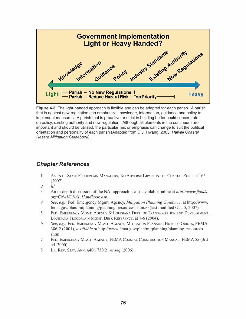
�6
Figure 4-3. The light-handed approach is flexible and can be adapted for each parish. A parish that is against new regulation can emphasize knowledge, information, guidance and policy to implement measures. A parish that is proactive or strict in building better could concentrate on policy, existing authority and new regulation. Although all elements in the continuum are important and should be utilized, the particular mix or emphasis can change to suit the political orientation and personality of each parish (Adapted from D.J. Hwang. 2005. Hawaii Coastal Hazard Mitigation Guidebook).
Chapter References
1 ass’nofsTaTeflooDPlainmanagers,noaDverseimPacTinThecoasTalzone, at 165 (2007).
2 Id.3 An in-depth discussion of the NAI approach is also available online at http://www.floods.
org/CNAI/CNAI_Handbook.asp.4 See, e.g., Fed. Emergency Mgmt. Agency, Mitigation Planning Guidance, at http://www.
fema.gov/plan/mitplanning/planning_resources.shtm#0 (last modified Oct. 5, 2007).5 feD.emergencymgmT.agency&louisianaDePT.ofTransPorTaTionanDDeveloPmenT,
louisianaflooDPlainmgmT.DesKreference, at 7-6 (2004). 6 See, e.g., feD.emergencymgmT.agency,miTigaTionPlanninghow-ToguiDes,fema
386-2(2001),available at http://www.fema.gov/plan/mitplanning/planning_resources.shtm.
7 feD.emergencymgmT.agency,femacoasTalconsTrucTionmanual,fema 55 (3rd ed. 2000).
8 la.rev.sTaT.ann. §40:1730.21 et seq.(2006).
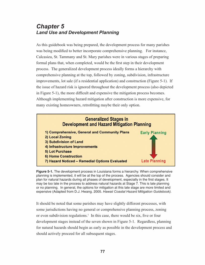
��
Chapter 5Land Use and Development Planning
As this guidebook was being prepared, the development process for many parishes
was being modified to better incorporate comprehensive planning. For instance,
Calcasieu, St. Tammany and St. Mary parishes were in various stages of preparing
formal plans that, when completed, would be the first step in their development
process. The generalized development process ideally forms a hierarchy with
comprehensive planning at the top, followed by zoning, subdivision, infrastructure
improvements, lot sale (if a residential application) and construction (Figure 5-1). If
the issue of hazard risk is ignored throughout the development process (also depicted
in Figure 5-1), the more difficult and expensive the mitigation process becomes.
Although implementing hazard mitigation after construction is more expensive, for
many existing homeowners, retrofitting maybe their only option.
Figure 5-1. The development process in Louisiana forms a hierarchy. When comprehensive planning is implemented, it will be at the top of the process. Agencies should consider and plan for natural hazards during all phases of development, especially in the first stages. It may be too late in the process to address natural hazards at Stage 7. This is late planning or no planning. In general, the options for mitigation at this late stage are more limited and expensive (Adapted from D.J. Hwang. 2005. Hawaii Coastal Hazard Mitigation Guidebook).
It should be noted that some parishes may have slightly different processes, with
some jurisdictions having no general or comprehensive planning process, zoning
or even subdivision regulations.1 In this case, there would be six, five or four
development stages instead of the seven shown in Figure 5-1. Regardless, planning
for natural hazards should begin as early as possible in the development process and
should actively proceed for all subsequent stages.
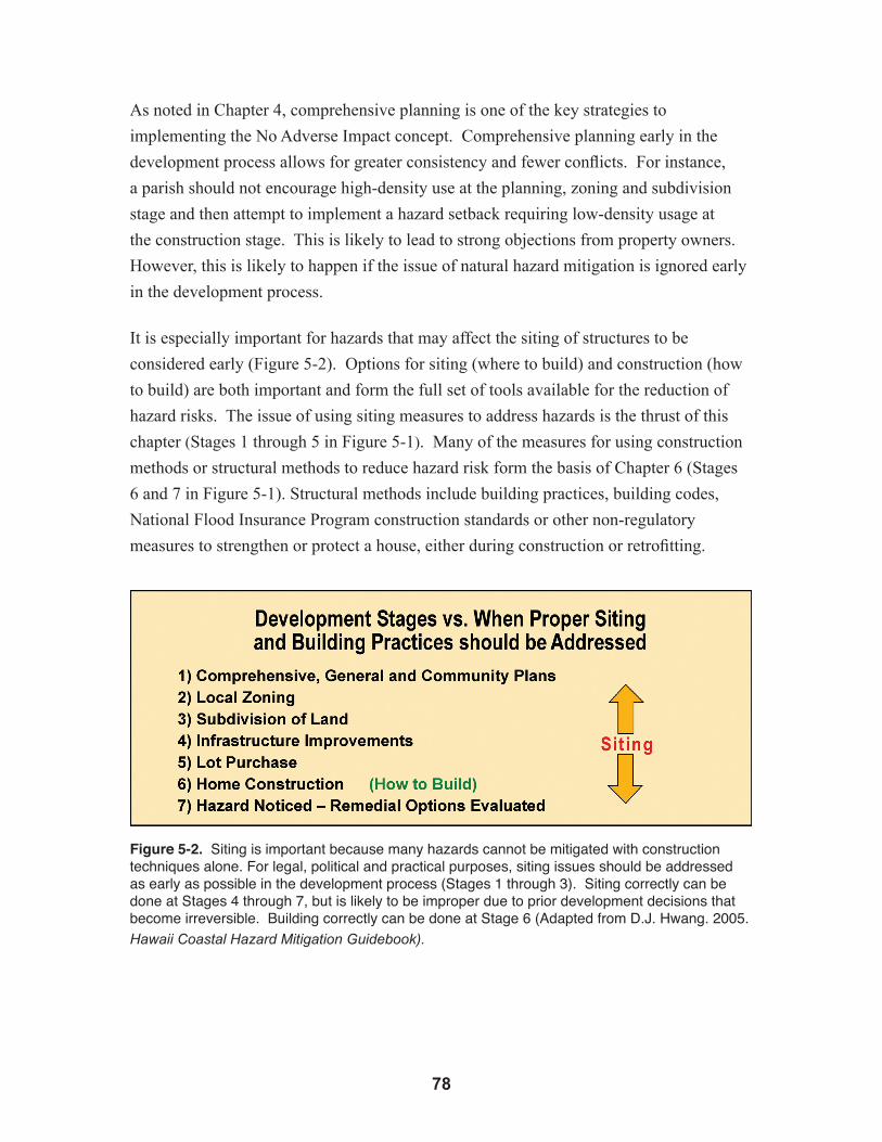
�8
As noted in Chapter 4, comprehensive planning is one of the key strategies to
implementing the No Adverse Impact concept. Comprehensive planning early in the
development process allows for greater consistency and fewer conflicts. For instance,
a parish should not encourage high-density use at the planning, zoning and subdivision
stage and then attempt to implement a hazard setback requiring low-density usage at
the construction stage. This is likely to lead to strong objections from property owners.
However, this is likely to happen if the issue of natural hazard mitigation is ignored early
in the development process.
It is especially important for hazards that may affect the siting of structures to be
considered early (Figure 5-2). Options for siting (where to build) and construction (how
to build) are both important and form the full set of tools available for the reduction of
hazard risks. The issue of using siting measures to address hazards is the thrust of this
chapter (Stages 1 through 5 in Figure 5-1). Many of the measures for using construction
methods or structural methods to reduce hazard risk form the basis of Chapter 6 (Stages
6 and 7 in Figure 5-1). Structural methods include building practices, building codes,
National Flood Insurance Program construction standards or other non-regulatory
measures to strengthen or protect a house, either during construction or retrofitting.
Figure 5-2. Siting is important because many hazards cannot be mitigated with construction techniques alone. For legal, political and practical purposes, siting issues should be addressed as early as possible in the development process (Stages 1 through 3). Siting correctly can be done at Stages 4 through 7, but is likely to be improper due to prior development decisions that become irreversible. Building correctly can be done at Stage 6 (Adapted from D.J. Hwang. 2005. Hawaii Coastal Hazard Mitigation Guidebook).
��
The issue of hazard mitigation should be addressed as early as possible in the
development process because, with each stage of development, a landowner is likely to
invest significant time and money to prepare a project for construction. With such an
investment, the value of the project increases substantially (Figure 5-3). Therefore, if the
government needs to purchase property for a public purpose, it is better if the purchase is
made early rather than after the property has appreciated considerably.
Concurrent with the increase in market value will be a rise in the “reasonable investment-
backed expectations” of the landowner (Figure 5-3). This concept, derived from property
law, relates to the rights of the landowner to use his or her property and the ability of the
government to regulate it. By investing more time and money into a project to obtain
approvals, the landowner may assert that he or she has a vested right to develop to a
certain level. This is true to a degree, but the government still has the right to prevent the
harm to life and property that could result from poorly designed development projects.
However, waiting until the end of the development process makes it more difficult for
government to assert this right.
While the market value of the property and investment-backed expectations of the
landowner are increasing with every development stage, the ability of the community
to provide input on the project diminishes (Figure 5-3). This would be expected, since
numerous prior decisions for the property become almost irreversible, and the community
can do little to change a project late in the process.
Finally, the full range of options available for governments to mitigate natural hazard
damage or reduce risk diminishes later in the process (Figure 5-3). For instance, if the
land has already been subdivided, buying the property or creating a scientifically based
hazard buffer zone could be precluded.

80
Figure 5-3. As more time and money are spent for each stage of the development process, the land will grow in market value, and the investment-backed expectations of the landowner will increase. At the same time, the ability of the community to provide input and the range of government options to reduce natural hazard risk will diminish. Generally, natural hazards should be addressed at the earliest land use opportunity (i.e., the earliest development stage for which a project is up for approval). (Adapted from D.J. Hwang. 2005. Hawaii Coastal Hazard Mitigation Guidebook).
At this point, it is necessary to discuss each of the stages in the development process
to show how they can be used to reduce hazard risk.
5.1 Comprehensive PlanningFor some parishes and communities, the comprehensive plan will be the first stage in the
development process and the best time to plan for natural hazards, especially if mitigation
efforts are related to siting. It is prudent to address not only issues such as environmental
management, housing, economic development, transportation, education and human
services, but also natural hazards risk and proper mitigation. Comprehensive plans can
then guide future zoning, subdivision, infrastructure and building decisions.
By addressing natural hazards, a plan provides public notice about the design goals
and desires for a community. Because comprehensive plans are addressed early in the
development process, they reduce the chance of conflicts within other development
stages. At the time of this writing, Louisiana parishes were in various stages of using
comprehensive plans. Some did not have any plans, while others were in the process of
updating or introducing new plans.2
The format for a plan can vary significantly. Some plans may be general and cover
just the basics, such as where growth should occur, the types of land use for each area

8�
and growth projections or population targets. Other plans may be more detailed, even
covering components related to landscape and infrastructure design and street layout.
Models and guidelines, however, have been proposed for what a comprehensive plan
should include.3
Communities should consider the following important aspects when developing
a comprehensive plan that considers risk reduction for natural hazards: (1) list of
objectives and policies related to hazard mitigation, (2) assessment of natural hazards,
(3) participation by all stakeholders and (4) discussion or decision on implementation
measures. These points are discussed below.
5.1.1 List of Objectives and Policies Related to Hazard Mitigation
A hazard mitigation element within the comprehensive plan is important to reduce
natural resource degradation, property damage, economic loss and injury or death. It
is necessary for the plan to include specific policies, objectives and goals for hazard
mitigation to guide future development decisions.
The comprehensive plan should be carefully drafted by each community. If there is no
statement of the desired objectives, policies or goals, then planning for natural hazards
is likely to receive little attention during subsequent development stages, such as in
zoning or subdivision design. Once land is subdivided, the chances of addressing hazards
through proper siting diminish significantly because of the factors in Figure 5-3. This
will reduce or eliminate a significant number of options for hazard mitigation. The
objectives and policies are also important to guide future amendments or improvements
to existing master or community plans.
Plan objectives and policies can be general or specific. Sample policies and objections
can be found in many federal laws, such as the National Flood Insurance Act or the
Coastal Zone Management Act. There is no harm in reiterating a federal policy to reduce
hazard damage and placing it in a local comprehensive plan because these laws already
apply to parishes. By doing so, the need to plan for natural hazards is reinforced from the
federal level to the local level. For example, in the Coastal Zone Management Act, one
policy is to provide for
the management of coastal development to minimize the loss of life and property caused by improper development in flood-prone, storm surge, geological hazard, and erosion-prone areas and in areas likely to be affected by or vulnerable to sea level rise, land subsidence, and saltwater intrusion, and by the destruction of natural protective features such as beaches, dunes, wetlands, and barrier islands4
82
Sample objectives and policies also can come from local floodplain regulations for the
various parishes. For instance, one objective found in the St. Mary Parish flood damage
regulation is to “minimize public and private losses due to flood conditions in specific
areas” by several methods including “development of floodplain areas in such a manner
as to minimize future flood blight areas.”5 In the floodplain management regulations for
Calcasieu Parish, it is a policy to “restrict or prohibit uses which are dangerous to health,
safety, or property in times of flood, or which cause excessive increases in flood heights
or velocities.”6
If the above policies are not suitable, for whatever reason, other policies and objectives
can be drafted that are in line with the local community. The key is to establish that
hazard mitigation design and planning is important to protect life and property and
should be considered in: (1) creation of the community’s comprehensive plan, (2) any
amendments or updates to the plan and (3) for any subsequent development stages.
5.1.2 Assessment of Natural Hazards
The effectiveness of a comprehensive plan can be enhanced if the community conducts a
risk review that identifies and assesses the potential impacts of known and unanticipated
events. The assessment to determine hazards for a community can be derived from
existing regional studies conducted by the federal government or universities, or it can
come from a hired consultant. An important source of information is the Federal Flood
Insurance Rate Maps (FIRMs). FEMA’s Hazards United States (HAZUS) is another
approach that will result in communities having a better understanding of the risks they
must address. FEMA has available a hazards mitigation planning process.7 The resulting
mitigation strategy can be protective and reflect the community’s values, judgments and
costs.
The importance of the hazard assessment at this stage of development depends on the
detail of the comprehensive plan. If the plan is very general, amounting to simply a
broad policy statement, then the assessment could possibly be deferred until the zoning
stage. However, if the comprehensive plan is detailed and directly or indirectly alludes
to the location of new buildings and roads and covers project or community design, then
the assessment should be conducted before the plan so that risky areas can be identified,
planned for and avoided. In general, the assessment should be done as early as possible
and be available for the formal planning process.

8�
5.1.3 Participation by all Stakeholders
To encourage compliance, the comprehensive plan should be prepared with the input of
all major parties in the community. Businesses and landowners should participate so
that their point of view is considered and economic impact is diminished to the greatest
possible extent, while any unreasonable measures are removed. As an added benefit,
participation puts these entities on notice of their need to address natural hazards early in
the development process.
Public and government agencies also should be involved to emphasize the importance
of protecting life and property through proper planning during development. In the long
run, the community will be better off physically and economically if it is resistant to
future natural hazards.
5.1.4 Discussion or Decision on Implementation Measures
The utility of the comprehensive plan is greatly increased if there is some discussion or
decision on how natural hazards mitigation will be implemented. For instance, it may
be possible to address many flooding issues or even high-velocity wave action through
building methods versus siting. The plan also may indicate for certain hazards that siting
through a setback or hazard buffer is the preferable alternative. Areas where this could
apply include river or channel floodways; erosion zones; or areas near the shoreline
especially susceptible to subsidence, wetland loss, sea level rise or high-velocity wave
action. These are issues that should be decided, or at least discussed,
in the comprehensive plan.
An example of how measures can be implemented is found in the St. Mary Parish flood
regulations, which permit the government to, “restrict or prohibit uses that are dangerous
to health, safety, or property in times of flood or excessive increases in flood heights or
velocities.”8 These restrictions could come in the form of setbacks, hazard buffer zones,
green zones, open space buffers or other methods.
5.2 Zoning Through late 2007, several parishes had zoning regulations, while a few did not.9
Nevertheless, the trend was for more parishes to institute zoning because of the benefits
to the community. Zoning prevents incompatible uses, such as placing a residential
subdivision near a pig farm, resulting in complaints and a reduction in property values.
Zoning can significantly enhance an area by ensuring there is a good mix of commercial,
residential and open space that is in harmony with the environment, meets the social
needs of the community and fits with the character of the neighborhood.10

8�
Zoning can significantly reduce risk from natural hazards by placing structures in safer
areas where they are less vulnerable. When properly planned and zoned, a community
is more hazard resistant, more in concert with its surroundings and more valuable
because all of the elements in the community are planned to support each other, thereby
minimizing conflicts while enhancing viewplanes and promoting efficiency within
existing infrastructure.
With regard to the use of zoning for hazard mitigation, several key points are provided
below.
5.2.1 Identification of Hazard Zones
It is important to have planning information on the hazards to be addressed. If a hazard
assessment has not been conducted during the comprehensive planning stage, it may
be necessary to conduct one prior to zoning. This will prevent locating a high-density
residential project in a hazard zone. The goal of the assessment is to identify and map
– through existing data, or newly developed data – the location of zones prone to flood,
erosion, subsidence, high-wave velocity or other zones of concern. Once mapped, they
can be used to design the community, through zoning, to ensure the best use and safe
development. The hazard zones could be identified, for example, from the National
Flood Insurance Program Flood Insurance Rate Maps (FIRMs) or erosion or subsidence
maps from government agencies, university departments and other sources.
5.2.2 Identification of Hazard Mitigation Measures
Once hazard zones are identified, it must be determined if the risk can be addressed
through structural measures (how to build) or nonstructural measures (where to build).
Structural measures are generally cheaper and easier to implement. If structural measures
are not technically possible, then siting measures become an important factor and zoning
comes into play. In this case, the identification of the hazard zones should influence
the placement of high- and low-density uses. High-density residential use should
not be placed in a hazard zone, especially if is not possible to mitigate the risks with
construction techniques.
5.2.3 Creation of Appropriate Low- or No-Density Use Zones
If zoning is used to mitigate potential hazard damages, it would be helpful to create
different levels of low- or no-density use zones. These zones may include: •Open11
•Conservation – if protection of natural resources is a priority12
•Preservation – for areas where there should be minimal change

8�
•Hazard – if detailed mapping of hazard zones is conducted, a zonation scheme for certain hazards can be created•Parks – if green space is to be integrated in the community•Agriculture – farming activities can be considered a low-density use•Rural – while allowing housing, this designation would be of lower density use than a residential or commercial designation.13
The categories for no- or low-density uses can serve the dual purpose of conserving
resources, protecting the environment and enhancing scenic and social utility, while
reducing the risk from natural hazards. The parishes have different options for
implementation. One option is to create specific zones that have a hazard designation.
The second option is to amend existing zones in the zoning ordinances so that the issue of
natural hazards can be specifically considered as criteria. The advantage of creating low-
or no-density zones with a specific hazard designation is that it provides additional notice
to landowners.
The ability of parishes to designate zones has been provided by the Louisiana Legislature
through the passage of legislation that allows the parishes and communities to conduct
planning, zoning and subdivision activities.14 Without this enabling legislation, such
police power would be reserved for the state.
5.2.4. Avoid Down Zoning
It is not recommended that land designated for high-density use be down zoned to low-
density use. This is likely to create a regulatory takings issue. If it is too late to address
hazards through zoning, then it is recommended that the issues be addressed at the next
lower stage in the development process, which would be during subdivision.
It is recommended that hazards be considered in the zoning process for land that is
currently in low-density use and about to change to a higher-density use. In this case, the
use of zoning is a legitimate tool to reduce risks from natural hazards.
5.2.5 Coordination with Comprehensive Plans
The comprehensive plans for an area should be consistent with the zoning designations
and vice versa. Zoning and planning go hand in hand, but it is not always possible
that zoning will follow planning, especially for those parishes that are in the process of
developing their comprehensive plan. In this case, the comprehensive plans will need
to design and adjust around existing zoning while creating plans for areas that have yet
to be developed. Future zoning can then follow the general guidelines espoused in the
86
comprehensive plans to ensure the required consistency. Police juries and parish councils
should work with planning and zoning commissions to ensure consistency between the
comprehensive plan and the zoning regulations and maps.
5.2.6 Coordination with other Zoning Mechanisms
Existing zoning does not preclude the creation of natural hazard zones for siting purposes.
For example, specific zones under the National Flood Insurance Program may govern if a
house is built for floods (elevated on walls with venting of water) or high-velocity wave
action (elevated on columns with breakaway walls). This flood zone can overlay the land
use designations, whose primary purpose is to influence where building occurs and not
how something is constructed. The parishes have several choices. One is to modify the
floodplain regulations to include a land use component. The other is to create a land use
component for natural hazards in the zoning regulations, then the current flood regulation
program would overlay the land use zones.
5.2.7 Zoning with Conditions
A parcel may fall into a natural hazard zone in which the risks cannot be addressed
through construction techniques. The parish may either keep the parcel as a low- or no-
density zone or change it to a higher density zone with a safety buffer or setback as a
condition for the zoning change. The later option should be checked because the zoning
regulations for each parish differ, and they should be evaluated on a case-by-case basis.
5.2.8 Investigation of Open Space Initiatives
Parishes and communities can create initiatives or incentives to build in safer locations.
For example, an incentive to build larger than normally allowed in a specific zone can be
provided for building away from a natural hazard area such as an erosion, subsidence or
flood zone. These strategies or tools can be especially useful if it is hard for a jurisdiction
to pass new regulations.
5.2.9 Planned Unit Developments (PUDs)
Some jurisdictions in Louisiana have zoning that allows for Planned Unit Developments
(PUDs) for tracts of land greater than a certain size (for example, 10 acres). PUDs are
a land use tool that gives a developer flexibility to design a community, since there is
leeway to mix lot sizes and geometries. In addition, the mix of uses, such as recreational,
residential, commercial or even industrial can be designed into the PUD. PUDs can be
abused because considerable discretion is provided to the developer. This concern can
be addressed with appropriate standards. Nevertheless, PUDs can also be a useful tool

8�
for hazard mitigation, since the hazard zones, setbacks or buffers can be designed into a
development project and, with the increased flexibility of the PUD, the economic impact
of these safety measures is greatly minimized.
PUDs should continue to be encouraged, but the issue of hazard mitigation should be
required in the zoning regulations so that the great advantage in the flexibility of the
PUD is not lost during project design. A percent of the land area can be designated for
green space, with priority given to locating the green space along hazard zones to buffer
buildings from natural forces.
5.3 Subdivision Process and Regulations During the subdivision process, a large tract of land is divided to create many smaller
parcels. From a purely physical point of view, many siting measures for hazard
mitigation can be addressed during subdivision. However, because of issues with
property rights and investment-backed expectations, it is better that siting for hazard
mitigation be addressed earlier in the development process during the comprehensive
planning or zoning stages (Figure 5-3).
Ideally, the subdivision process follows the decisions, requirements and direction found
in the comprehensive plan and the zoning regulations. However, in 2007, some parishes
had subdivision regulations while others did not. Moreover, many parishes were in
various stages of creating comprehensive plans or a zoning regime. As these tools are
implemented, there are a number of actions communities should consider regarding
subdivision laws. They are discussed below.
5.3.1 Identification of Hazard Zones
As with planning and zoning, it is important to identify or assess the location of natural
hazards before subdividing land. If this information is readily available, then a new
assessment is unnecessary. It will be needed in order to prevent inadvertent placement of
a house in a hazard zone where people or property may be put in danger.
5.3.2 Identification of Mitigation Measures (Siting or Construction)
It is also important to determine what hazard risks can be addressed through construction
and which risks need to be addressed with siting measures through the subdivision
process (see the mitigation measures for this section). Mitigation measures covered in
this section include subdivision and infrastructure design.

88
5.3.3 Follow Existing Subdivision Regulations
A parish or community should have standards for subdivisions that address natural
hazards. If there are no standards, there is a missed opportunity to mitigate natural hazard
risk during this critical stage of development. Many of the measures for design shown
later in this section would have little chance of being implemented without subdivision
standards.
Most parishes have simple, helpful standards in the floodplain management regulations.
For example, in Calcasieu Parish, the subdivision must have a plat that shows base flood
elevations and ground elevations15 and should not allow buildings in the floodway.16
These provisions have a siting component that supplements the construction standards
also in the rules. Additional conditions can be added to the subdivision17 to protect
life and property.18 The last two provisions provide some discretion for the planning
department to reduce hazard risk under the existing authority of the rules (Figure 4-2).
In addition, some parishes have subdivision regulations that define the multi-step process
for subdivision approval19 and provide an additional opportunity for hazard mitigation.
However, not all parishes will have specific subdivision standards independent of those
in the NFIP. Many parishes have existing authority under their rules to implement the
guidelines that are presented in this chapter.
5.3.4 Enhance Subdivision Regulations
For parishes that lack subdivision standards or wish to enhance those that already exist,
two possibilities are offered to reduce the hazard risk to life and property.
A simple provision can be added that all subdivisions must be suitable for their intended
use and that no resident or homeowner will be placed at undue risk from erosion,
subsidence, high-velocity wave action or flooding. This provision gives the applicant for
a subdivision notice that hazard mitigation in design is vital. In addition, considerable
authority is given to the local community to mitigate potential damage. Finally, this
effective provision distinguishes between the developer-subdivider and the homeowner-
purchaser. The homeowner-purchaser needs to be protected as a consumer, but will be
in poor position to do so if the house is inadvertently placed in a hazard zone by the
developer-subdivider. Generally, it is easier to address hazards before design than after
a house is built. Implementation of this requirement could be through certification by a
licensed engineer within the agency or by one hired by the applicant.

8�
A second provision addresses the subdivision procedure and the multi-step process for
subdivision, which may include: (1) application, (2) conceptual plan, (3) preliminary
plan, (4) engineering plan and (5) final plan.20 Each of these steps can take considerable
time and money for the applicant-subdivider, so it is important that the issue of hazard
mitigation and siting be addressed as early as possible in the subdivision process to avoid
expensive redesigns.
5.4 Subdivision Design to Minimize the Risk of NaturalHazards
One of the goals of proposed subdivision guidelines is to harness the inherent mitigation
attributes of the natural environment by better positioning buildings and property
out of harm’s way. This approach promotes subdivision plans that result in creating
neighborhoods and whole communities that are more resilient to naturally occurring
hazardous forces. In essence, the guidelines, when incorporated with sound subdivision
design, enable neighborhoods and communities to protect themselves against future
disasters. There are countless examples where poor subdivision planning has exacerbated
the disastrous impacts of seasonal tropical storms. Researchers have analyzed these
examples and have shown that these subdivisions could have been made more resistant
to the effects of natural hazards by considering the natural features of the land and by
rearranging the location and geometry of subdivision parcels. This section will focus
on the potentially life-saving and property damage-reducing application of subdivision
guidelines for parcels of land subject to tropical storms in low-lying coastal areas. The
guidelines adapt lessons learned in neighborhood and subdivision planning elsewhere in
the coastal United States and other low-lying coastal regions and countries.
By incorporating hazard mitigation guidelines presented in this section into a
community’s subdivision ordinance and design, a community takes preemptive action and
preventive steps in addressing the potentially damaging effects on future development. It
is preferable to take action before a hazardous event occurs to reduce potential damage
and loss, rather than taking action as part of recovery, when the damages and losses
might be much higher, and perhaps devastating, to the community. The application of
these guidelines represents how best to guide land development in order to achieve the
following objectives:
• Protect the safety of the population.
• Reduce private property loss and loss of lives.
• Minimize economic losses.
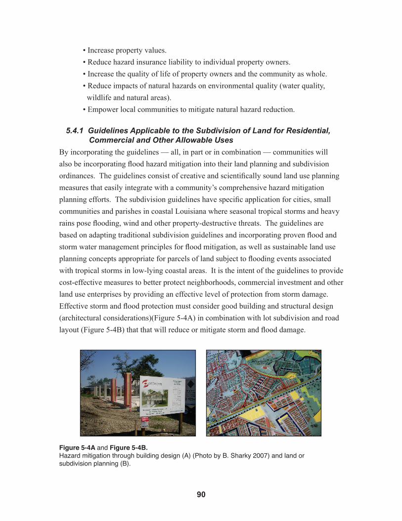
�0
• Increase property values.
• Reduce hazard insurance liability to individual property owners.
• Increase the quality of life of property owners and the community as whole.
• Reduce impacts of natural hazards on environmental quality (water quality,
wildlife and natural areas).
• Empower local communities to mitigate natural hazard reduction.
5.4.1 Guidelines Applicable to the Subdivision of Land for Residential,Commercial and Other Allowable Uses
By incorporating the guidelines — all, in part or in combination — communities will
also be incorporating flood hazard mitigation into their land planning and subdivision
ordinances. The guidelines consist of creative and scientifically sound land use planning
measures that easily integrate with a community’s comprehensive hazard mitigation
planning efforts. The subdivision guidelines have specific application for cities, small
communities and parishes in coastal Louisiana where seasonal tropical storms and heavy
rains pose flooding, wind and other property-destructive threats. The guidelines are
based on adapting traditional subdivision guidelines and incorporating proven flood and
storm water management principles for flood mitigation, as well as sustainable land use
planning concepts appropriate for parcels of land subject to flooding events associated
with tropical storms in low-lying coastal areas. It is the intent of the guidelines to provide
cost-effective measures to better protect neighborhoods, commercial investment and other
land use enterprises by providing an effective level of protection from storm damage.
Effective storm and flood protection must consider good building and structural design
(architectural considerations)(Figure 5-4A) in combination with lot subdivision and road
layout (Figure 5-4B) that that will reduce or mitigate storm and flood damage.
Figure 5-4A and Figure 5-4B.Hazard mitigation through building design (A) (Photo by B. Sharky 2007) and land or subdivision planning (B).

��
5.4.2 Guidelines for Subdivding Land, Primarily Privately Owned, but Including Land to be Developed for Governmental Uses and Facilities
Subdivision can be broadly defined as a parcel of land that has been divided into two or
more smaller lots, with each lot of sufficient size to accommodate one or more building
units for residential or commercial use. A subdivision map will be produced that shows
each lot, roadway, servitude, infrastructure and other features proposed and/or required
by the subdivision ordinances established by the city or parish.
In the case of the subdivision guidelines proposed in this section, an overlay with parcel
and infrastructure design measures are presented that will mitigate and provide an
improved level of protection from flooding and storms. This overlay of flood mitigation
design measures considers consumer protection and provides value-added features that
could benefit the economic return on investment for the land owner and developer. The
goals of these subdivision guidelines are to lessen the impact of storm flooding and to
reduce property damage and loss of lives in storm-prone southern Louisiana.
The motive of a landowner for developing a parcel of land is to maximize the return
on investment. The product may be individual lots or developed lots including
structures such as the houses, multi-unit residences or commercial units. A subdivision
map describes the size, location, geometry (shape) and the required infrastructure
improvements (roads, sidewalks, parking lots, access and possibly park and open space
elements).
Since the landowner or developer of the parcel to be subdivided is in a better position
to provide for safety and mitigation from flooding and storms than the individual
homeowners or purchasers of the lots, it is recommended that the appropriate government
agency require or encourage proper mitigation from the landowner or developer. It
would follow that proper design safety features be a part of a community’s subdivision
ordinances and building codes. By incorporating sound and appropriate design guidelines
in a subdivision ordinance that considers coastal hazards from storms and flooding, it
is possible to protect inhabitants and their property from damage or loss. These design
guidelines may also ensure economic return on the investment of the landowner through
creative subdivision design that employs many of the land use measures presented in
the chapter. The guidelines proposed here are not new and have been used in some
form in many coastal, storm-prone regions in the United States and around the world.
When properly followed and applied, these guidelines have produced neighborhoods
and whole communities that are not only safe but also a desirable place to live and
�2
work. The value added by creating safe and desirable living and working environments
maintains and enhances the value of the properties. With all landowners and developers
in a city or parish developing their land following the same set of subdivision and
building guidelines, all are competing on a level, often competitive playing field. All
stand to profit with no one having an unfair advantage except for the land developers
whose product is understood to be safer than the subdivisions not adequately applying
the guidelines. Given two properties of equal size, shape and location in a community,
the property incorporating a higher level of flooding safety is generally perceived as the
more valuable and, hence, more desirable for purchase by consumers. Properties having
greater storm protection features generally enjoy lower flood insurance premiums.
Subdivisions can be small parcels of land of one or a few acres or large tracts with
thousands of acres. They are part of a neighborhood, small town or city, consisting of
individual lots, connected by streets, often with sidewalks, and containing infrastructure
– a system of utilities, drainage servitudes and perhaps small parks, parking, schools and
other community facilities in the case of large developments. The answer to questions
as to what are the physical requirements of a subdivision can be found in the local town,
city or parish subdivision ordinances. The size and number of lots allowed, requirements
for road design and layout, utilities and other improvements are also described in the
subdivision ordinance. The location, shape and geometry of the lots, as well as the
alignment of the road system and other improvements in a proposed subdivision, are
determined by one or more professional consultants hired by the landowner to prepare
the subdivision map. This map would need to be approved by the local governing
authority (planning or engineering department). A process, sometimes referred to as the
subdivision planning process, would be the responsibility of a certified professional (land
surveyor, civil engineer or landscape architect). The process consists of the following
general steps:
1. Research subdivision regulations, subdivision design guidelines and other legal requirements including:
a. Wetland designations and 100-year floodplain or FEMA Base Flood Elevation requirementsb. Hurricane and other natural climate events and environmental conditionsc. Local and area surface drainage patterns.
2. Prepare a legal survey of the property.3. Consult with governing authority to identify local restrictions, guidelines and concerns.4. Analyze existing physical conditions of the property including:
a. Existing tree and vegetative cover

��
b. Surface drainage patternsc. Topography and land forms –– consider potential occurrence, frequency and intensity of flooding due to seasonal rain or natural hazards such as tropical stormsd. Soil properties (percolation and soil bearing capacities)e. Traffic circulation patternsf. Land use of adjoining propertiesg. Existing utilities and servitudesh. Local government and state building codesi. Marketing studies.
5. Programming: establish land use (residential, commercial, etc.), lot and/or building densities.6. Develop one or more preliminary subdivision plans based on above research and analysis for client and/or governing agency review. Select optimum plan.7. Submit plan for review and approval by governing authority (planning and/or engineering department).8. Begin subdivision development activities after plan has been approved and financing secured.
Figure 5-5A represents an “existing conditions” map of a town or neighborhood within
a city. Figure 5-5B shows a planning framework that identifies existing drainage and
vegetative patterns, roadway system and land use. Figure 5-5C illustrates the integration
of the existing natural drainage and greenway system in creating storm-resilient
subdivisions with flood detention areas and positive drainage.
Figure 5-5A. Existing Conditions.

��
Figure 5-5B. Proposed Areas for Subdivision Development.
Figure 5-5C. Rural Town with New Subdivisions.
5.4.3 A Real-Life Glimpse of Subdivisions that have Successfully Integrated a Series of Storm and Flood Mitigation Measures (Figure 5.6)
The measures work together in mitigating impacts from storm and flood events. A system
of flood drainage and detention areas are physically linked, producing greater storage and
drainage capacity than could be achieved with each subdivision designed independently.
The greenway system allows for an integrated trail and recreation system that links
schools, libraries and other public facilities to enhance quality of life and economic
values.

��
Figure 5-6. Location of various design guidelines, numbered 1-7, which illustrate the points on the map (Photos by B. Sharky, 2007).
1. Store and detain floodwater.
Incorporate pre-existing low-lying
areas, natural drainage swales
or streams into the layout of a
subdivision or whole neighborhood.
These areas are used to store or
detain flood water in the event of
heavy rain or storm. The area may
be seasonally dry in the case of low-
lying ground depression, or the area
can be excavated and shaped to serve a water storage function. In this example, the area
is part of a greenway system set aside for floodwater mitigation, as well as trail and park
functions.
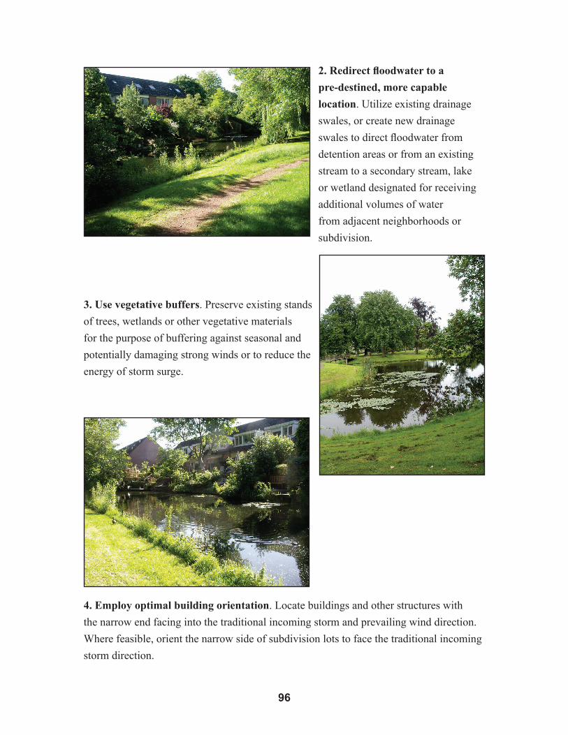
�6
2. Redirect floodwater to a
pre-destined, more capable
location. Utilize existing drainage
swales, or create new drainage
swales to direct floodwater from
detention areas or from an existing
stream to a secondary stream, lake
or wetland designated for receiving
additional volumes of water
from adjacent neighborhoods or
subdivision.
3. Use vegetative buffers. Preserve existing stands
of trees, wetlands or other vegetative materials
for the purpose of buffering against seasonal and
potentially damaging strong winds or to reduce the
energy of storm surge.
4. Employ optimal building orientation. Locate buildings and other structures with
the narrow end facing into the traditional incoming storm and prevailing wind direction.
Where feasible, orient the narrow side of subdivision lots to face the traditional incoming
storm direction.

��
5. Retain the connections of
greenway fragments. Attempt
to retain the interconnectedness
of naturally occurring greenway
corridors and natural drainage
systems. A healthy and cohesive
greenway system is one of the
least costly means for subdivision
protection and for mitigating
flooding from storms and heavy
rains.
6. Retain soils that promote
percolation. Maintain open space,
minimizing covering the ground
with impervious materials (asphalt,
concrete, buildings). Leave soils
that have better water percolation
characteristics unpaved, or if
pavement is required, use porous
materials. Soils with water
percolation values can be integrated
into a larger strategy of floodwater
mitigation.
7. Reduce potential blockage and
barriers. Selectively clear existing
and potential blockages along
drainage systems to allow wind
and water to move quickly through
without impediment. Remove
any barriers that would stop or
dramatically slow drainage and the
movement of floodwater. Implement
annual or bi-annual inspection of the
system and provide resources for its
maintenance.

�8
The above guidelines for subdivision design point out that landowners, developers and
local communities should determine the location of hazards that need to be avoided and
design subdivisions that place buildings in a safe location. This can be on high ground
if the concern is flooding. If the area needs to be avoided completely, the use of hazard
buffers, green space or setbacks can be utilized. This may be necessary for coastal
erosion zones, high-subsidence areas, floodways or high-velocity zones. Two examples
of subdivision lots designed to avoid hazards are provided from the FEMA Coastal
Construction Manual (Figures 5-7 to 5-8).
Figure 5-7. Subdivision Lot Buffers – It is up to each parish to determine which hazards can be addressed through construction and which require a buffer or setback. Then, in the subdivision process, deep enough lots can be created to accommodate storm events, long-term erosion and road setbacks. For effective mitigation, the size of the hazard buffer determines the lot size. This differs from the traditional method of subdivision in which the size of the lot determines the buffer. The traditional method may be necessary if the issue of hazards is addressed too late in the development process (From FEMA. 2000. Coastal Construction Manual, FEMA 55).

��
Figure 5-8. Subdivision Lot Design – In this example, the use of flag lots forces the placement of three houses seaward of a future shoreline. The shoreline may be migrating due to erosion, sea level rise, subsidence or wetland loss. The recommended lot design creates long, narrow lots that allow placement of all the houses landward of the future shoreline. Note that the lower example allows the same density of construction (six units) while providing significantly greater protection from future hazards (From FEMA. 2000. Coastal Construction Manual, FEMA 55).
These examples are just some of the many ways to avoid hazards during subdivision
design. The keys are to know the location of hazards and to design the subdivision
to mitigate potential damage through creativity and flexibility in the land use process.
The Planned Unit Developments noted in the section for zoning, provide the necessary
flexibility by allowing the developer leeway to determine the size and geometry of
individual lots. This can result in creating a greater hazard buffer, while allowing almost
the same number of units to minimize adverse economic impacts.
5.5 Infrastructure Improvements
Subdivision design and infrastructure design go hand in hand, and it is common for
subdivision regulations to cover both of these issues. It would be difficult to create a
conceptual plan, preliminary plan, engineering plan or final plan of a subdivision without
including both the infrastructure and the location of buildings on the design plats. It is
important that hazard mitigation be addressed for both of these development stages.

�00
The placement of infrastructure is critical for the purposes of hazard mitigation.
Infrastructure can lead development toward a hazard area, thereby increasing the risk
for inhabitants, or guide it away from a hazard area, which would serve as a form of
mitigation.
The FEMA Coastal Construction Manual provides good examples how the layout of
roads can influence the placement of habitable structures and their susceptibility to
natural hazards. Three additional figures are provided (Figures 5-9 to 5-11).
Figure 5-9. Nags Head, N.C. - Early subdivision design in North Carolina had an arterial road that forced the creation of small lots seaward of the road, exposing homeowners to future hazards. New design creates deep, narrow lots by eliminating the feeder road. Note that the new design has almost the same density of construction, while being significantly safer since coastal hazards can be more easily accommodated (From FEMA. 2000. Coastal Construction Manual, FEMA 55 and M. Morris. 1997. American Planning Association, Subdivision Design in Flood Hazard Areas: Planning Advisory Service Report Number 473).

�0�
Figure 5-10. Subdivision Design for Feeder Roads – Feeder roads that are parallel to the coastline may restrict lot size, thereby reducing the size of the hazard buffer and necessitating the placement of utilities where they are subject to storm erosion or flooding (Top). The alternative is to eliminate the shore-parallel road and serve coastal lots with roads perpendicular to the coastline (Bottom). This will facilitate the creation of deeper, narrower lots along the coastline and will protect the utilities. Shut-off valves for utilities can be placed on the feeder roads. Smaller lots along the shoreline in the lower configuration may be redesigned for ocean access, public use or to accommodate a smaller house. Regulatory flexibility is key (From FEMA. 2000. Coastal Construction Manual, FEMA 55).

�02
Figure 5-11. Cluster Development – This figure is a comparison of a conventional lot layout with a modified lot layout and a cluster layout to create a safety buffer zone. The placement of roads determines the type of layout and the degree of protection from natural hazards. Clustering development of streets, utilities and houses is an efficient and common land use tool to create the necessary hazard buffer zones (From FEMA. 2000. Coastal Construction Manual, FEMA 55 and M. Morris. 1997. American Planning Association, Subdivision Design in Flood Hazard Areas: Planning Advisory Service Report Number 473).

�0�
5.6 Lot Transfer or Purchase
After land is zoned for residential use in accordance with the comprehensive plan,
subdivided according to the applicable zoning rules and the comprehensive plan, and
supported with the appropriate infrastructure, the next step for the developer is either (1)
start construction of new residences and then sell the lot and home or (2) sell empty lots
where the lot purchaser will construct a new house.
The transfer of property is important to hazard mitigation for several reasons. First,
with any sale, a buyer-seller relationship is established and consumer protection issues
come into place, such as notice and fair practices. Parishes and local communities can
ensure that purchasers of lots or new houses have the proper notice of any potential
hazards. In the floodplain management regulations for St. Mary Parish, a key objective
is to ensure potential buyers are notified that property is in a flood area.21 Parishes and
local communities can require notification requirements in their floodplain, subdivision
or development permit regulations. All key hazards, especially those involving siting
measures, should be material issues with required disclosure during sale of a property.
Disclosure should be for past hazard events causing property damage, as well as
identified future risks (e.g., location within in a flood zone or existing erosion and
subsidence risks).
Second, with the sale of property, there are two parties involved – the developer and
homeowner. The concerns of each must be addressed. On one hand, the concern of the
developer is maximizing profit while creating a well-designed product. The concern for
the homeowner is acquiring a safe residence and protection from the elements. It is the
developer who is in the best position to address hazard mitigation dealing with siting of
structures during the design stage of a subdivision. The homeowner or lot purchaser will
not be in a position to provide this necessary mitigation. If the issue is not addressed
upfront, the homeowner could be placed at risk and suffer a greater financial and
emotional burden than if the landowner were required to mitigate risks up front. Thus,
the local community should provide protection to future homeowners by requiring the
necessary mitigation from those who propose large projects.
Finally, local communities and parishes can use principles grounded in consumer
protection to advance, in an accelerated manner, the principles of hazard mitigation and
building stronger. When safe building and hazard mitigation become a selling point of
lots and houses, the developers and builders that are the most progressive and innovative
will gain a competitive advantage. Local communities and parishes can advance this

�0�
trend, thereby encouraging hazard mitigation with a minimum of new regulation. In
this way, market forces can be utilized to advance implementation of hazard mitigation
measures.
Chapter References
1 r.e.emmer,J.wilKins,l.schiavinaTo,m.Davis,&m.wascom,louisianaseagranTcollegeProgram,hazarDmiTigaTionanDlanDusePlanningincoasTallouisiana:recommenDaTionsforThefuTure (2007), available at http://www.lsu.edu/sglegal/pdfs/ CompPlanningReport.pdf.
2 Id.3 americanPlanningassociaTion,growingsmarTlegislaTiveguiDebooK:moDel
sTaTuTesforPlanninganDmanagemenTofchange (Stuart Meck, ed., 2002).4 16 U.S.C. § 1452(2)(B) (2000).5 sT.maryParish,la.,coDeoforDinances § 9-3 (2004).6 calcasieuParish,la.,coDeoforDinances § 9-5 (1985).7 feD.emergencymgmT.agency,miTigaTionPlanninghow-ToguiDes,fema386-1To
-8(2002),available at http://www.fema.gov/plan/mitplanning/ planning_resources.shtm. See also, Nat’l Oceanographic and Atmospheric Admin., Coastal Services Center, Risk and Vulnerability Assessment Tool (2007), at http://www.csc.noaa.gov/rvat/rvat.htm.
8 sT.maryParish,la.,coDeoforDinances § 9-3.9 emmereTal., supra note 1, at 21-27.10 See, e.g., ciTyofnewiberia,lanDuseanDenhancemenTmasTerPlan (2004). 11 See, e.g., ciTyofnewiberia,coDeoforDinances,aPPenDixa § 3.2 (1994).12 sT.maryParish,la.,coDeoforDinances § 15-161.13 See sT.maryParish,la., coDeoforDinances § 15-144(d) (the rural character of St.
Mary Parish represents a valuable property right to the residents of the parish).14 emmereTal., supra note 1, at 21-27.15 calcasieuParish,la.,coDeoforDinances § 9-117(a) (1985).16 Id. at § 9-118(f).17 Id. at § 9-40.18 Id. at § 9-5.19 Id. at § 23-5.20 Id.21 sT.maryParish,la.,coDeoforDinances § 9-3.
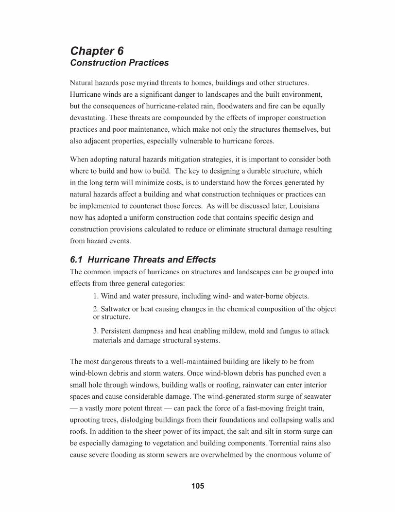
�0�
Chapter 6 Construction Practices
Natural hazards pose myriad threats to homes, buildings and other structures.
Hurricane winds are a significant danger to landscapes and the built environment,
but the consequences of hurricane-related rain, floodwaters and fire can be equally
devastating. These threats are compounded by the effects of improper construction
practices and poor maintenance, which make not only the structures themselves, but
also adjacent properties, especially vulnerable to hurricane forces.
When adopting natural hazards mitigation strategies, it is important to consider both
where to build and how to build. The key to designing a durable structure, which
in the long term will minimize costs, is to understand how the forces generated by
natural hazards affect a building and what construction techniques or practices can
be implemented to counteract those forces. As will be discussed later, Louisiana
now has adopted a uniform construction code that contains specific design and
construction provisions calculated to reduce or eliminate structural damage resulting
from hazard events.
6.1 Hurricane Threats and EffectsThe common impacts of hurricanes on structures and landscapes can be grouped into
effects from three general categories:
1. Wind and water pressure, including wind- and water-borne objects.
2. Saltwater or heat causing changes in the chemical composition of the object or structure.
3. Persistent dampness and heat enabling mildew, mold and fungus to attack materials and damage structural systems.
The most dangerous threats to a well-maintained building are likely to be from
wind-blown debris and storm waters. Once wind-blown debris has punched even a
small hole through windows, building walls or roofing, rainwater can enter interior
spaces and cause considerable damage. The wind-generated storm surge of seawater
–– a vastly more potent threat –– can pack the force of a fast-moving freight train,
uprooting trees, dislodging buildings from their foundations and collapsing walls and
roofs. In addition to the sheer power of its impact, the salt and silt in storm surge can
be especially damaging to vegetation and building components. Torrential rains also
cause severe flooding as storm sewers are overwhelmed by the enormous volume of

�06
water. Drainage systems become clogged with debris, causing water to backup in gutters,
downspouts and yard drains. As this water saturates and softens the soil, the likelihood
increases for trees to uproot and foundations to fail. When wind and water forces move
buildings and uproot trees, natural gas pipes and electrical lines can be damaged. The
dangerous mixture of gas and sparks dramatically increases fire hazards at a time when
fire fighting effectiveness is compromised by tree-blocked roadways and incapacitated
community water systems.
6.2 Hurricane Forces at Work 6.2.1 Air Pressure
Since interior air pressure can be dramatically higher than exterior air pressure during
a hurricane, there is temptation to open windows on the downwind or leeward side of
the building to equalize the air pressure. However, the National Institute of Business
and Home Safety recommends against equalizing pressure by opening windows. The
key is to keep the wind- and rain-resistant envelope of the structure intact by protecting
windows and doors. Once there is an opening in the house, debris, water and hurricane-
force winds can enter and make the home more hazardous. Also, there is no guarantee
that opening windows will equalize pressure. Furthermore, it is hard to determine the
leeward side because a storm’s wind direction may change if the eye passes over. To
relieve internal roof pressures, however, make sure attic space is adequately vented.
Figure 6-1. Effects of Wind Loads on a Structure – It is important to maintain the building enve-lope to avoid the types of internal wind loads show in the house on the right (From FEMA. 2000. Coastal Construction Manual, FEMA 55).
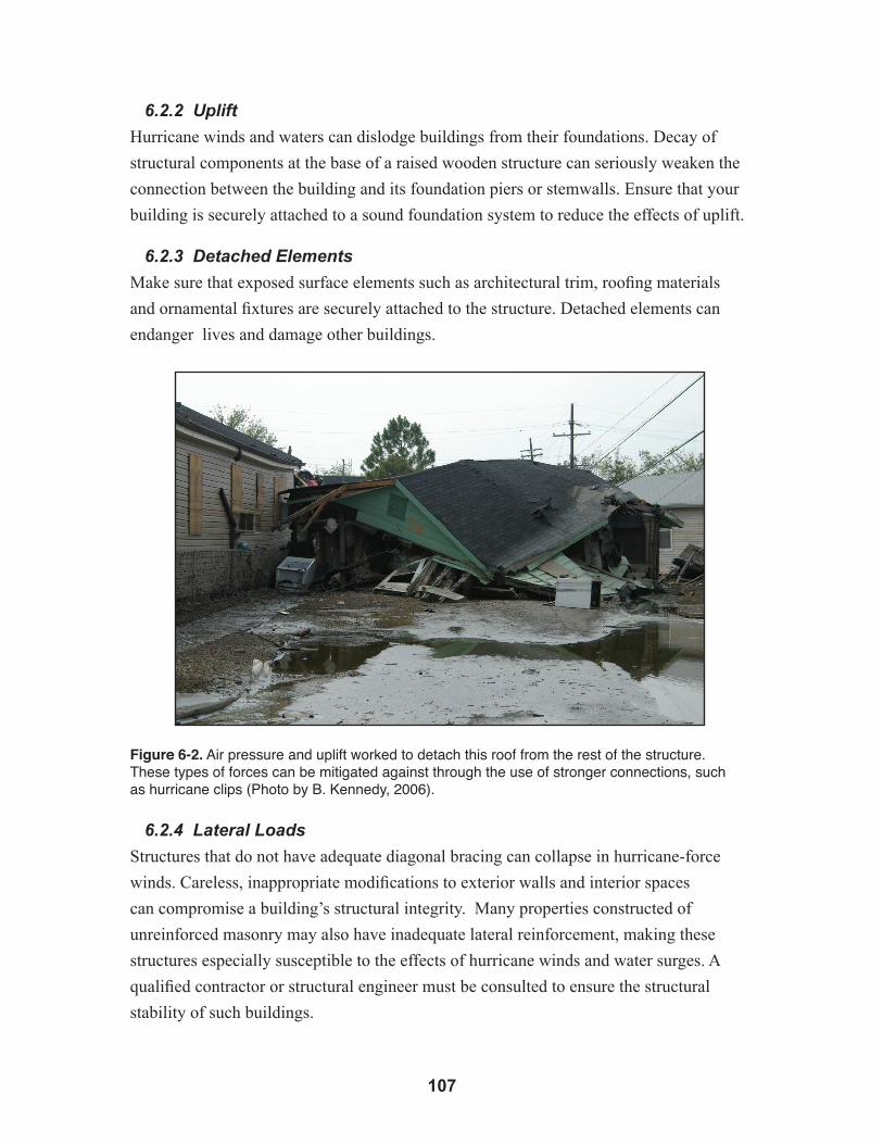
�0�
6.2.2 Uplift
Hurricane winds and waters can dislodge buildings from their foundations. Decay of
structural components at the base of a raised wooden structure can seriously weaken the
connection between the building and its foundation piers or stemwalls. Ensure that your
building is securely attached to a sound foundation system to reduce the effects of uplift.
6.2.3 Detached Elements
Make sure that exposed surface elements such as architectural trim, roofing materials
and ornamental fixtures are securely attached to the structure. Detached elements can
endanger lives and damage other buildings.
Figure 6-2. Air pressure and uplift worked to detach this roof from the rest of the structure. These types of forces can be mitigated against through the use of stronger connections, such as hurricane clips (Photo by B. Kennedy, 2006).
6.2.4 Lateral Loads
Structures that do not have adequate diagonal bracing can collapse in hurricane-force
winds. Careless, inappropriate modifications to exterior walls and interior spaces
can compromise a building’s structural integrity. Many properties constructed of
unreinforced masonry may also have inadequate lateral reinforcement, making these
structures especially susceptible to the effects of hurricane winds and water surges. A
qualified contractor or structural engineer must be consulted to ensure the structural
stability of such buildings.

�08
Figure 6-3. This home was forced off of its foundation by lateral loading (Photo by B. Kennedy, 2006).
6.2.5 Projectiles
Debris propelled by hurricane winds or waters can easily puncture the exterior envelope
(or skin) of a building. Use shutters or pre-cut plywood panels to protect windows and
doors, and make sure that roofing and siding are properly installed and well-maintained to
serve as a protective envelope.
6.3 Design ConsiderationsPost-hurricane damage assessments often reveal that older, well-maintained buildings
can fare better than buildings that were constructed more recently. Louisiana building
traditions were based on high-quality wood and masonry construction materials. Builders
understood that structures had to withstand difficult climate conditions, including
hurricane forces. Many of the oldest residential and commercial structures in south
Louisiana have hipped roofs, extended eaves and generous porches. Steep-pitched roofs
effectively shed both wind and water; deep overhangs protect sidewalls and windows
from rain and sun; and a deep porch provides shade while acting as lateral reinforcement
for the building’s structure. Buildings were typically placed on piers or columns to
promote ventilation and to raise living quarters above damp soils and floodwaters. A
raised building on an open foundation of piers reduces wind resistance by allowing air to
circulate under the structure instead of becoming trapped at the intersection of wall and
ground.
�0�
The older structures that suffered significant damage in storms were those that were
already in an advanced state of decay, due primarily to poor maintenance. Similarly,
inadequately supervised construction practices exacerbate the destructive forces of a
hurricane and provide graphic evidence of the need for enactment and enforcement of
appropriate construction codes for hurricane-prone areas.
In remodeling or expansion projects, it is important to evaluate not only the visual
appearance and exterior envelope of existing buildings, but also the integrity of structural
systems before making changes. Structures that are basically rectilinear generally fare
better in hurricanes. Excessive appendages (such as dormers), complicated building
footprints and excessive areas of exposed surfaces (high vertical walls and gable ends)
conspire to make the structure a more effective wind catcher, increasing the probability
of damage.
6.4 The Louisiana State Uniform Construction Code As previously noted, many of the structural damages caused by natural hazards can be
mitigated through the implementation of stronger construction methods. Accordingly,
in 2005, the Louisiana Legislature adopted a statewide uniform building code in order to
“maintain reasonable standards of construction in buildings and other structures in the
state consistent with the public health, safety and welfare of its citizens.”1 The Louisiana
State Uniform Construction Code (LSUCC), based largely upon codes developed by the
International Code Council (ICC), went into effect statewide in January 2007.2 Although
“uniform,” the LSUCC prescribes different standards based upon various factors, such
as building use, construction method and the geography of the building site. With some
exceptions, the ICC standards apply to:3
• New construction• Reconstruction • Additions to homes previously built to the International Residential Code (IRC)• Extensive alterations (where value of new work exceeds 50 percent of total
value of structure)• Repair of buildings and other structures

��0
Figure 6-4. When an owner makes substantial improvements or additions to an existing home, the LSUCC mandates that the entire structure meet IRC standards. This may require that an entire structure be raised above BFE (From FEMA. 2005. Home Builder’s Guide to Coastal Construction, Fact Sheet No. 30, FEMA 499-CD).
The requirements for building a home to code can differ from one site to another,
depending on the expected hazards. Homes in hurricane-prone regions in Louisiana4
must withstand reasonably anticipated wind and flood hazards (including surge, waves
and scour, where applicable). “Reasonably anticipated” has been determined for wind
and flood hazards throughout Louisiana. For flood hazards, the International Building
Code specifically references FEMA’s flood insurance studies and maps produced as part
of the National Flood Insurance Program.5 For flood hazard areas, the IRC dictates that
the lowest floors of a structure shall be elevated to or above design flood elevation.6 The
design flood elevation shall accommodate the base flood elevation, which the IRC defines
as “the depth of peak elevation of flooding (including wave height) which has a 1 percent
(100-year flood) or greater chance of being equaled or exceeded in any given year.”7
Thus, under the LSUCC, a house on a site that has a reasonable chance of flooding to a
depth of 3 feet will be required to have its first floor 3 feet above natural ground; a house
in an area not likely to flood can be at-grade. The IRC also advocates the use of flood-
resistant materials.8
Homes in hurricane-prone regions must be able to endure high winds.9 The wind-
resistance performance standards for coastal construction are defined in terms of basic
wind speed, which is the minimum the home must be designed to withstand.10 The wind

���
speed map (Figure 6-5) indicates that homes along the coast should anticipate Category
3 hurricane conditions (110-130 mph winds) in the southwest and Category 4 conditions
(131-155 mph winds) in the southeast. Significantly, all parishes fronting the Gulf of
Mexico fall within wind zones at or above 110 mph. The LSUCC Web site contains the
applicable wind speeds for each parish, listed according to the ZIP code + 4.11 Homes
designed in these hazard areas should be built using wind-resistant designs, including:
• Stronger materials• Stronger connections between materials• Metal straps and clips• Wood that bridges joints• Anchors• Cables
Figure 6-5. Louisiana Wind Speed Map (Courtesy of the Institute for Home & Business Safety).
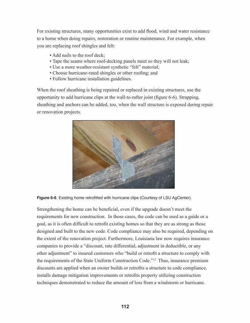
��2
For existing structures, many opportunities exist to add flood, wind and water resistance
to a home when doing repairs, restoration or routine maintenance. For example, when
you are replacing roof shingles and felt:
• Add nails to the roof deck;• Tape the seams where roof-decking panels meet so they will not leak;• Use a more weather-resistant synthetic “felt” material;• Choose hurricane-rated shingles or other roofing; and• Follow hurricane installation guidelines.
When the roof sheathing is being repaired or replaced in existing structures, use the
opportunity to add hurricane clips at the wall-to-rafter joint (figure 6-6). Strapping,
sheathing and anchors can be added, too, when the wall structure is exposed during repair
or renovation projects.
Figure 6-6. Existing home retrofitted with hurricane clips (Courtesy of LSU AgCenter).
Strengthening the home can be beneficial, even if the upgrade doesn’t meet the
requirements for new construction. In those cases, the code can be used as a guide or a
goal, as it is often difficult to retrofit existing homes so that they are as strong as those
designed and built to the new code. Code compliance may also be required, depending on
the extent of the renovation project. Furthermore, Louisiana law now requires insurance
companies to provide a “discount, rate differential, adjustment in deductible, or any
other adjustment” to insured customers who “build or retrofit a structure to comply with
the requirements of the State Uniform Construction Code.”12 Thus, insurance premium
discounts are applied when an owner builds or retrofits a structure to code compliance,
installs damage mitigation improvements or retrofits property utilizing construction
techniques demonstrated to reduce the amount of loss from a windstorm or hurricane.

���
The benefits of building to code are numerous and include:
• Providing reasonable safeguards for health, safety, welfare, comfort and security• Balancing durability with affordability• Lower long-term costs due to use of durable construction materials• Greater storm resistance• Reduced insurance premiums
6.5 Design LoadsOne of the key elements of the LSUCC is adoption of the construction standards designed
to fortify structures against the various physical forces associated with natural hazards.13
Land use planning, zoning and other siting strategies seek to avoid or minimize these
destructive forces by locating structures and infrastructure out of harm’s way. Since it
is difficult to avoid all natural hazards, especially in coastal Louisiana, there is a need to
implement and promote stronger building methods. Construction standards are based upon the type and strength of physical forces that
structures in a given location can expect to encounter. The force exerted on a structure is
termed a “load” and forms the basis of the resistance calculations. In coastal Louisiana,
the primary loads are wind and water (or flood) loads. For wind and flood loads, the
LSUCC incorporates the wind- and flood-resistant provisions of the International
Building Code, which in turn specifically adopts other recognized construction standards
such as the ASCE 7, ASCE 24 and SSTD 10.14 The FEMA Coastal Construction Manual
(CCM) contains excellent discussions of the different site-specific loads and includes
formulas for calculating those loads.15 The manual also summarizes the load-resistance
techniques detailed in the various construction standards mentioned above.
6.5.1 Water or Flood Loads
Water loads are those forces exerted on a structure and its components by flood waters
(figures 6-7 and 6-8). The FEMA Coastal Construction Manual specifies four different
types of flood loads:
• Hydrostatic, including buoyancy or flotation effects (from standing water, slowly moving water and non-breaking waves) • Breaking wave• Hydrodynamic (from rapidly moving water, including broken waves and tsunami runup) • Debris impact (from waterborne objects)16

���
Figure 6-7. Hydrostatic loads on buildings (From FEMA. 2007. Design Guide for Improving Critical Facility Safety from Flooding and High Winds, FEMA 543).
The best method for avoiding flood loads is to place key components of the structure
several feet above the Base Flood Elevation (BFE). Still, a structure’s supporting
elements, such as columns, piers and walls must be designed to withstand flood loads.
The integrity of the supporting structures can be weakened by flood loads and by storm
erosion, scour and long-term erosion, thereby decreasing the foundation’s load-bearing
capacity and “resistance to lateral and vertical movements.”17 To design a flood-resistant
structure, the builder must incorporate the force of all flood loads into the calculations.18
In V Zones, the calculations will include the wave impact load.19 The tables in Chapter
11 of the FEMA Coastal Construction Manual contain formulas and examples of how to
calculate flood loads for a given structure.
Figure 6-8. Hydrodynamic loads on buildings (From FEMA. 2000. Coastal Construction Manual,
FEMA 55).

���
6.5.2 Wind Loads
Structures throughout Louisiana are subject to the high winds associated with hurricanes
and tornadoes. When designing a wind-resistant structure, it is necessary to calculate
wind loads for the structural frame and for building components and cladding.20 The
FEMA CCM notes that “many building failures start because a component or piece of
cladding is blown off the building, allowing wind and rain to enter the building.”21
When wind is allowed to enter the building, the external and internal pressures working
on the structure can create a situation where the structure essentially may be blown apart
(figure 6-9). This is why openings need to be protected with windows that are impact
resistant or covered with shutters or other devices that are impact resistant. This will
help to create a wind- and rain-resistant envelope. If opening protection is not in place,
the building needs to be designed for higher internal pressure than required for enclosed
buildings.
Figure 6-9. Increases in negative pressure from wind entering the building envelope (From FEMA. 2000. Coastal Construction Manual, FEMA 55).
6.5.3 Continuous Load Path
A hazard-resistant structure must withstand all of the different types of loads that may
be encountered, which often occur at the same time. Consequently, the design should
include calculations for all the various loads and for each component of the building.
The FEMA CCM notes that, ultimately, all loads will be “transferred to the foundation,”
so each connection “must be strong enough to transfer the load without breaking.”22 The
concept is known as the “continuous load path connection” and is crucial to an effective
design.

��6
The continuous load path connection ensures that each component of a building is
connected through a series of links, similar to a chain (figure 6-10 and 6-11). For
example, the “chain” will “run from the roof covering, to the roof support, to the top
plate of the exterior wall, to the wall studs, to the window frame, to the exterior wall, to
the floor frame, to the support beam or column.”23 Each component is linked to another,
and structural integrity is maintained as long as each connection in the load path does not
break or fail.
The integrity of the building envelope is largely dependent on the type, strength and
location of fasteners that hold the structural frame, components and cladding together.
The building codes contain tables of fastener size and spacing for the various elements.24
Furthermore, the building should incorporate “hurricane clips” or other similar fasteners,
which hold together key components of the structure and are crucial to building a wind-
resistant structure.
Figure 6-10. Key components of continuous load path connections (Courtesy of Simpson Strong-Tie).
Rafter-to-Top Plate Connections:Transfer forces from the roof to the top plate
Floor-to-Floor Connections:Transfer forces from the second story to the first story
Sill Plate-to-Foundation Connections:Transfer forces from the mudsill into the foundation
Top Plate-to-Stud Connections:Transfer forces from the top plate to the stud
Stud-to-Sill Plate Connections:Transfer forces from wall studs to the mudsill
©2008 Simpson Strong-Tie Company Inc.

���
Figure 6-11. Diagram depicting important links in continuous load path design (From FEMA. 2005. Home Builder’s Guide to Coastal Construction, Fact Sheet No. 10, FEMA 499-CD).
6.5.4 Window Protection
Designing a structure to withstand wind and flood loads is partially dependent on
maintaining the integrity of the building envelope, which in turn may depend upon a
structure’s window protection. Thus, windows in buildings located in windborne-debris
regions must have their glazed openings protected from flying debris. In Louisiana, the
windborne-debris region is the area south of the 120-mph line on the basic wind speed
map (Figure 6-5).25 Window protection systems have to meet the requirements of the
large-missile test of an approved impact-resisting standard. For one- and two-story
buildings, the code allows wood panels, such as plywood, to be used for protection of
windows if they meet certain minimum specifications.26 The panels must be at least 7/16-
inch thick, and they must span no more than 8 feet.27 Panels must be precut and large
enough to attach to the framing that surrounds the window – not to the window frame
itself. Screw sizes and spacing (see Table 6-1) are provided in the code for buildings with

��8
a mean roof height of 33 feet or less and where wind speeds do not exceed 130 miles per
hour.28
Fastener Spacing (in Inches)
Fastener Type Panel span < 4 feet 4 feet < panel span < 6 feet
6 feet < panel span < 8 feet
No.6 Screws 16” 12” 9”
No.8 Screws 16” 16” 12”
Table 6-1. Screw size and spacing for wood panels (Adapted from International Code Council. 2006. International Residential Code).
Shutter Type Cost Advantages Disadvantages
Temporary plywood panels
Low Inexpensive Must be installed and taken down every time they are needed; must be adequately anchored to prevent blow off; difficult to install on upper levels
Temporary manufactured panels
Low/Medium Easily installed on lower levels
Must be installed and taken down every time they are needed; difficult to install on upper levels
Permanent, manual-closing
Medium/High Always in place ready to be closed
Must be closed manually from the outside; difficult to access on upper levels
Permanent, motor-driven High Easily opened and closed from the inside
Expensive
Table 6-2. Advantages and disadvantages of different types of window shutters (From FEMA. 2005. Home Builder’s Guide to Coastal Construction, Fact Sheet No. 26, FEMA 499-CD).
Quality window shutters (Figure 6-12 and 6-13) can be effective protection against
hurricane wind and water (Table 6-2). Make sure that hinges, frames and louvers are in
good working order. Taping window glass prior to a storm affords little protection, and
your efforts should be invested on more productive preparation tasks.

���
Figure 6-12. Different types of shutters used for window protection (From FEMA. 2005. Home
Builder’s Guide to Coastal Construction, Fact Sheet No. 26, FEMA 499-CD).
Figure 6-13. Permanently installed Bahama shutters provide light and shade when opened and protection from wind-borne debris when closed (Photo by D. Hwang, 2007).
6.6 Louisiana House and other Educational Tools29
LaHouse on Louisiana State University’s Baton Rouge campus is a good example of
home construction that incorporates hazard-resistant design standards advanced in
the building codes (figure 6-14). The demonstration home features current building
technologies and systems. One of the primary goals for LaHouse is to educate the public
on ways to reduce damages from hurricanes and floods. LaHouse addresses a wide range
of current issues including: National energy independence Formosan subterranean termitesHurricanes and floods Warm, humid climatePollution prevention Threatened drinking water suppliesWaste management Aging populationAsthma, mold and other indoor air hazards Economic vitalityBarriers to technology transfer Unstable fuel costs
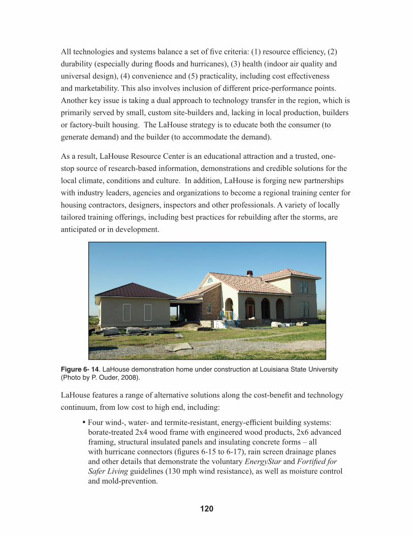
�20
All technologies and systems balance a set of five criteria: (1) resource efficiency, (2)
durability (especially during floods and hurricanes), (3) health (indoor air quality and
universal design), (4) convenience and (5) practicality, including cost effectiveness
and marketability. This also involves inclusion of different price-performance points.
Another key issue is taking a dual approach to technology transfer in the region, which is
primarily served by small, custom site-builders and, lacking in local production, builders
or factory-built housing. The LaHouse strategy is to educate both the consumer (to
generate demand) and the builder (to accommodate the demand).
As a result, LaHouse Resource Center is an educational attraction and a trusted, one-
stop source of research-based information, demonstrations and credible solutions for the
local climate, conditions and culture. In addition, LaHouse is forging new partnerships
with industry leaders, agencies and organizations to become a regional training center for
housing contractors, designers, inspectors and other professionals. A variety of locally
tailored training offerings, including best practices for rebuilding after the storms, are
anticipated or in development.
Figure 6- 14. LaHouse demonstration home under construction at Louisiana State University (Photo by P. Ouder, 2008).
LaHouse features a range of alternative solutions along the cost-benefit and technology
continuum, from low cost to high end, including:
•Four wind-, water- and termite-resistant, energy-efficient building systems: borate-treated 2x4 wood frame with engineered wood products, 2x6 advanced framing, structural insulated panels and insulating concrete forms – all with hurricane connectors (figures 6-15 to 6-17), rain screen drainage planes and other details that demonstrate the voluntary EnergyStar and Fortified for Safer Living guidelines (130 mph wind resistance), as well as moisture control and mold-prevention.

�2�
•A low-cost, severe-weather safe room suitable for Louisiana risk level•Three elevated foundation systems for flood zones and dry-floodproofing and wet-floodproofing demonstrations •Two long-life, hail- and hurricane-resistant cool roofing systems with upgraded underlayments for secondary moisture protection •Three heating, cooling, ventilation and dehumidification systems for high comfort, efficiency and indoor air quality•Nine types of energy-efficient windows and a variety of impact-resistant protections are planned•Universal design and family-friendly features•Advanced, energy-efficient appliances, lighting, controls and structured wiring•Lo- maintenance, long-life, green and locally produced products•High-performance, water-saving fixtures and strategies are planned
Figures 6-15, 6-16 and 6-17. In the LaHouse model home, hurricane straps are used to com-plete the continuous load path connection. The stud to single plate connector helps secure the house frame to its foundations and helps the home better withstand uplift. For new construction, the additional cost of implementing stronger connections may be minimal (Figures 6-15 and 6-16, photos by D. Hwang, 2007; Figure 6-17, photo courtesy of LSU AgCenter).
6.7 LandscapingLandscape features are especially important in considering protection strategies. Well-
cared-for trees of appropriate, native species can help mitigate the impact of hurricane
winds on buildings. Poorly placed and poorly maintained trees and other landscape
elements will likely be the greatest cause of property damage (figures 6-18 and 6-19).
Think of a well-conceived and maintained landscape as not only a valuable esthetic asset,
but also the first line of defense in a hurricane.
Unfortunately, landscape features are typically inadequately maintained, making them
especially susceptible to hurricane damage. In spite of damage caused to buildings
by wind-thrown trees and limbs, some native tree species contribute to the protection
of buildings by breaking the force of hurricane winds. The Louisiana Department of
Agriculture and Forestry is a source of information on native tree and plant species that
are conditioned to meet the challenges of Louisiana’s climate and soils. Also note that as

�22
a rule of thumb, FEMA recommends that a tree be placed a distance away from a building
equal to the height of a full-grown tree.
The Urban Forestry Program supports efforts that promote the planting and maintenance
of trees in Louisiana communities. Information concerning urban forest planning, tree
ordinances, planting recommendations and tree care is available from the program, as
are grant funds for developing urban forest initiatives and acquiring “Tree City USA”
standing.30
6.8 Inspecting the Building and Yard for Hurricane Preparedness 6.8.1 Roof
• Roof sheathing and shingles must be securely fastened to the roof structure (rafters) using hurricane clips and appropriate carpentry techniques. Most roof failures in hurricanes occur due to improper installation of roofing systems or because of poor maintenance practices.
• Roof flashings around vent pipes are often sources of water leaks, andinappropriate maintenance responses typically involve thick coats of roofing mastic or other sealants. A good roof will significantly prolong a building’s useful life. Fixing leaks right the first time is the most cost-effective approach to damage control and mitigation. Flashing and counter-flashing must be properly installed at all through-roof fixtures such as ventilators and chimneys, and at all roof/wall joints. The liberal use of roofing cement, tar and other sealants is not an acceptable substitute for good roofing practices.
• Ensure that components such as parapet copings and cornices are securelyattached and that roofing joints are properly sealed against water penetration.
• Make sure all roof drains and scuppers are clear and working properly. Water that finds its way into wall cavities through leaky drainage systems is a major cause of damage to building systems.
• Properly installed drip edges on roofs help keep sheathing, trim and side walls dry and sound.
• Check masonry chimneys for deteriorating mortar joints and loose or broken bricks. Repoint joints with an appropriate mortar mix and maintain flashing and counter-flashing at the roof line.
• Failures in the roofing system not only lead to extensive water damage to a structure’s interior, but failed roof components such as shingles and sheathing become potent missiles that cause significant damage to other structures when propelled by hurricane-force winds.

�2�
6.8.2 Exterior Walls
• Make sure that all exterior siding and trim are securely attached to the building frame.While increasing energy efficiency, a well-maintained building skin also reduces the threat of costly interior damage from wind-driven rain.
• Failures in mortar joints will permit water to penetrate masonry walls and damage interior insulation, structural systems and finishes. Carefully clean deteriorated mortar out of joints and repoint with a mortar mix that is softer than the surrounding masonry units.
• Check ornamental trim to ensure that it is in good repair and securely attached to the building. The loss of ornamental wood or cast iron elements such as scrollwork, finials, grilles, screens and fretwork can be expensive, and replacements are likely to be difficult to locate or fabricate.
• In addition, substitute materials are often inferior in performance and appearance to the original fabric.
• Loose ornamental objects such as lighting fixtures can cause extensive damage as they flail against the building in hurricane winds, and detached objects become dangerous projectiles that threaten both structures and human lives.
6.8.3 Windows and Doorways
• In anticipation of a storm, protect windows with storm shutters or cover them with pre-fitted plywood sheathing. Windows are usually broken by wind-blown debris, and the popular precaution of applying tape to the glass is of negligible value.
• A common cause of water penetration is the incorrect installation or failure of flashing at the joint between a porch roof or sidewalk canopy and the facade. Make sure that this joint has proper flashing and counter-flashing.
• Fabric window awnings should be removed from their frames as a hurricane approaches. Bare frames that are securely attached to the building structure are more likely to survive hurricane-force winds. Large sidewalk awnings are particularly susceptible to uplift forces from hurricane winds, and the joint between the building and awning or canopy should be checked for soundness. Steel chain or cable hangers also should be checked for signs of wear or weakness.
6.8.4 Yard
• Clean all walk and yard drains, and make sure that drainage lines are working properly. Even minor flooding caused by blocked drainage systems can cause costly damage to landscaping and on-grade installations of air-conditioning and heating systems.

�2�
• Fences must be structurally sound, and fence posts must be solidly anchored to the ground. Gates should be tied or wired shut to secure them from hurricane winds.
• Make sure that potential hurricane projectiles such as mail or newspaper boxes are securely attached to fences or exterior walls. When a hurricane approaches, remove any unsecured objects such as potted plants, benches and chairs from porches, yards and patios.
6.9 InteriorsA building’s interior finishes and furnishings are especially at risk to hurricane rain
and flood damage. Their security depends on the protective functions of roofing, walls,
doors and windows. In a hurricane, the building will be assaulted by tree limbs and
other airborne projectiles such as ripped shingles, siding, lawn furniture or recreational
equipment that has been left in the yard. Once the building envelope has been penetrated,
water can quickly ruin surface finishes, plaster, drywall, paneling, flooring, furniture, wall
hangings, and mechanical and electrical systems.
6.9.1 Before the Hurricane
• Close and lock windows and glassed areas before boarding them up. Draw drapes and window blinds across windows and glass doors to protect against flying glass if shattering occurs.
• Remove loose objects from balconies, porches and terraces. Secure any moveable objects such as benches, shutters, doors or gates.
• Move all furniture or merchandise away from windows and toward the middle of the room in the highest location possible in the building. Cover furnishings with plastic sheets or tarps, and secure coverings with tape.
• Remove objects such as pictures, paintings, bric-a-brac and clocks from walls. Pack breakables in padded cartons or wrap in securely taped plastic and place in the center of the room. If there is a threat of flooding, the easily movable objects should be placed in second-story rooms or attic spaces.
• Remove all bulbs, lamps, mirrors and glass furniture. Put them in the bathtub or in boxes in the middle of the room.
• In cases of evacuation, disconnect sewer and water lines where practical. Shut off the gas supply at the meter. Disconnect all electric appliances except for the freezer and refrigerator. Their controls should be turned to the coldest setting to preserve food as long as possible.
�2�
6.9.2 After the Hurricane
• First make sure the electricity is turned off.
• Immediately examine the exterior and interior of the structure for evidence of water penetration, and secure reinforced tarps and plastic sheeting over any damaged areas of the roof and exterior walls.
• A sagging plaster or drywall ceiling can be evidence of severe water leaks. Be cautious, since saturated plaster-based products are extremely heavy and hazardous. Carefully drain all water trapped in ceilings and completely remove all saturated drywall or failed plaster walls and ceilings. Wet drywall will continue to deteriorate and harbor mildew and must be replaced. Saturated plaster may not need replacement, but will take a long time to dry. Do not repaint plaster until it is completely dry. Monitor plaster walls and ceilings as they dry to ensure that the plaster remains securely attached to the lath that supports it. Make sure that plaster lath has not detached from its structural supports.
• Water may be trapped in wall cavities and must be drained. Remove the baseboard and use a hand or cordless drill (for plaster), or a knife (for drywall), to make holes about 2 inches above the floor. Each cavity between wall studs will require a drain hole (every 16 to 24 inches depending on stud spacing). After the water has drained, leave the holes uncovered to ventilate the cavity and promote drying.
• Water-saturated fiberglass and cellulose insulation in walls and ceilings that are part of the thermal envelope must be removed and replaced.
• If water is standing in your building, it will be difficult to tell whether the structure is safe. Use extreme caution, and even if there has been a power outage, make sure the electricity is disconnected at your building’s main breaker box before you enter the structure.
• Severe wind and water disasters can cause buildings to flex and move, increasing the possibility of damage to water supply, waste and natural gas lines. Be on the lookout for any signs of gas leaks, and immediately shut off the gas supply at the meter if leaks are detected.
• Check the building foundation and exterior steps for cracks or other evidence that the storm wind or water has moved the structure or damaged foundation components. Look at the roof for signs that structural walls have shifted or failed. Sags in the roof ridge at the middle or the gable ends of the building are indications of possibly severe structural problems. Check porches and overhanging roofs to ensure that structural supports are still in place. Other indications of possible structural damage are doors and windows that cannot be opened after the storm because of structural distortions.
• To prevent additional damage by post-storm rains, use plastic sheeting and duct tape to cover damaged chimneys and through-roof vents as quickly as practical. Damaged roof, wall and window openings can also be protected with plastic

�26
sheeting or tarps held in place by wooden nailer strips at the edges of the opening. Check all plumbing for water leaks that will continue to damage to your building.
• Only hire professional contractors who have the necessary expertise and appropriate credentials. Make sure that the contractors you hire are bonded and insured. Remember, both property and lives are endangered when unqualified contractors are hired. If hurricane damage is such that a building requires prompt repairs to prevent additional damage, and qualified contractors cannot get to the project immediately, make temporary repairs to protect the building.
6.10 Streetscapes and LandscapesIn recent years, many south Louisiana communities have initiated streetscape
improvements in their business and residential districts. Landscaping, benches, tables
and chairs, trash receptacles, canopies, awnings, banners, signs and street lights are
often installed or upgraded as part of community revitalization efforts. Such streetscape
furnishings, if improperly designed or installed, can become destructive projectiles in
hurricane-force winds. Specifications for selection, installation and maintenance of such
elements should reflect an understanding of hurricane effects as well as principles of good
design. Additionally, there are clear indications that healthy trees can mitigate the effects of
hurricane winds and reduce storm damage to south Louisiana structures. However,
even a minor storm can cause a tremendous amount of damage to the trees themselves,
especially those that have systemic defects, are diseased or are poorly maintained.
Property owners should seek the advice of a qualified arborist in identifying and
removing hazard trees before the next storm strikes. Moreover, placing trees too close
to buildings or placing buildings too close to mature trees can result in damage to root
systems and foundations, making both the tree and the structure more vulnerable to
hurricane forces. Site improvements such as concrete sidewalks or driveways can also
weaken or cut root systems and make a tree more likely to uproot in storm winds.
6.10.1 Before the Hurricane
• Prior to the storm, exterior banners, signs, flower baskets and other decorative elements should be removed or secured.
• Such elements can cause extensive damage as they flail about in hurricane winds, and they become dangerous projectiles that threaten structures and lives.
• Fabric awnings should be removed from their frames prior to a hurricane. Bare frames that are securely attached to the building structure are more likely to survive hurricane-force winds.

�2�
• Street furniture, such as waste cans, planter boxes and benches, and vending machines that are not anchored to the pavement should be removed from the street to an area protected from wind.
• Carefully select appropriate native or adapted species for landscape enhancements.
• Avoid ground trenching near trees or placing improvements such as sidewalks and driveways too close to established trees.
• Avoid planting large trees near utility lines or too close to buildings.
• Remove structurally unsound limbs from densely canopied trees.
• Prune vegetation and remove limbs that threaten building roofs. Notify the utility company for removal of limbs that threaten power or phone lines.
• Annually inspect your landscape to identify hazard trees that have been weakened by disease, utilities work or construction activities. Check for trees whose roots may threaten gas, water and sewer lines. Consult with an arborist about hazard trees and vegetation.
• Strengthen or reinforce vulnerable limbs of valuable trees by having an arborist install flexible cabling or rigid bracing.
• Keep trees healthy and vigorous by watering, fertilizing and protecting surrounding soil from compaction.
• Reduce the risk of lightning damage for large, prominent trees with an appropriately grounded halo of lightning rods.
6.10.2 After the Hurricane
• Carefully assess landscape damage and ongoing threats. Many hurricane-related injuries occur during post-storm cleanup activities.
• Healthy trees can serve as a protective buffer against storm forces, so avoid making hasty or inadequately informed decisions about tree removal.
• Consult with a qualified arborist to determine what landscape recovery and management actions need to be taken to preserve and protect landscape assets.

�28
Figures 6-18 and 6-19. Healthy, well-maintained trees can help mitigate the effects of hurricanes and help protect nearby structures by reducing wind flow. However, poorly maintained or diseased trees located too close to a home can cause serious damage (Photos by B. Kennedy, 2006).

�2�
Chapter References
1 la.rev.sTaT.ann. §40:1730.21 (2006).2 The LSUCC that went into effect January 2007 is based on the 2006 IRC, with a hold-over of the
2003 IRC provision that set 110 mph as the wind speed below which the code is to be used as a prescriptive guide for design. In January 2009, that limit will drop to 100 mph (the boundary set in the 2006 IRC).
3 la.rev.sTaT.ann. §40:1730.28(3)(a) (2006)4 Hurricane-prone regions are those areas along the Gulf coast where the basic wind speed is greater
than 90 mph.5 See generally, inT’lcoDecouncil,inTernaTionalbuilDingcoDe §1612 (2006)
[hereinafter IBC 2006].6 inT’lcoDecouncil,inTernaTionalresiDenTialcoDe §R324.2.1 (2006) [hereinafter IRC
2006].7 Id. at §R324.1.3.8 Id. at §R324.1.7.9 See generally,ibc2006,at §1609 (2006).10 Id. at §1609.1.11 http://www.dps.louisiana.gov/lsuccc/windspeed.html.12 la.rev.sTaT.ann. §22:1426 (2006). 13 la.rev.sTaT.ann. §40:1730:28 (2006).14 See generally, IBC 2006, supra note 5, at §1609.1 et seq. and §1612.4; IRC 2006, supra
note 6, at §R301.2.1.115 feD.emergencymgmT.agency,femacoasTalconsTrucTionmanual,fema 55 (3rd
ed. 2000).16 Id. at 11-6.17 Dennishwang,hawaiicoasTalhazarDmiTigaTionguiDebooK159(2005).18 fema(2000)Supra note 15,aT12-3.19 Id. at 11-14.20 Id.aT11-37.21 Id.22 Id. at 12-14.23 hwang,supra note17,at163.24 See generally, IRC 2006, supra note 6; IBC 2006, supra note 5.25 IBC 2006, supra note 5, at §1609.2.26 IRC 2006, supra note 6, at §R301.2.1.2.27 Id.28 Id.29 Section is excerpted from Showcase Unit Meets Post-Hurricane Crisis Needs. LSU AgCenter’s
LaHouse: Providing Research-based Housing Systems for the 21st Century (2007).30 The Urban Forestry Program Coordinator can be reached through the Louisiana
Department of Agriculture and Forestry in Baton Rouge by calling (225) 925-4500.

���
CHAPTER 7Legal Issues1
When government exercises its “police power” to protect the safety and welfare of its
citizens, conflicts can occur when the use of private property is affected. On the other
hand, government can act, or fail to act, in such a way that the risk of natural hazards
is created or increased. There are legal issues associated with both of these situations,
and the perception of these issues can affect the interaction between government
and the public and, ultimately, may inhibit governments in performing their proper
functions.
Government action or inaction that creates or increases natural hazards, specifically
flooding has been studied by the Association of State Floodplain Managers (ASFPM),
a professional organization that works to reduce the loss of human life and damage to
property resulting from flooding and works to preserve the natural and cultural values
of floodplains.2 ASFPM has conducted extensive research into the legal aspects of
local government involvement in floodplain management3 and has concluded that an
approach to flooding problems called “No Adverse Impact” (NAI) is the best way
for local governments to both mitigate flood hazards and avoid legal pitfalls.4 NAI
floodplain management is “an approach that ensures that the action of one property
owner does not adversely impact the properties and rights of other property owners,
as measured by increased flood peaks, flood stage, flood velocity, and erosion and
sedimentation in public works projects, development permitting and other activities.”5
NAI floodplain management measures undertaken by a state or local government can
and should, when necessary, go beyond minimum federal floodplain management
requirements. The ASFPM maintains that: “Communities which adhere to a No Adverse Impact approach in community decision-making and activities that affect the floodplains will decreasethe potential for successful liability suits from a broad range of activities, such as road and bridge building, installation of storm water management facilities, construction of flood control works, grading, construction of public buildings, approving subdivisions and accepting dedications of public works, and issuing permits.”6
The report on NAI floodplain management recently released by the ASFPM discusses
in detail a wide spectrum of case law in which communities were sued for their roles
in contributing to flood damage.7 Many of these suits were successful. The report

��2
also discusses the implications of NAI floodplain management in property rights law,
including takings claims against governmental entities. The NAI report concludes that
“from a Constitutional law perspective, courts are very likely to uphold community
regulations which adopt a No Adverse Impact performance standard against claims of
unreasonableness or ‘taking’ of private property without payment of just compensation.”8
That is not to say that there will be no successful challenges to community floodplain
regulations under takings or other theories, but courts are generally willing to uphold the
regulations when it is clear that public safety is at stake. It would behoove Louisiana’s
local government leaders and regulators to examine the NAI report closely for general
guidance on floodplain regulation issues available at http://www.floods.org/PDF/ASFPM_
NAI_Legal_Paper_1107.pdf.
7.1 Government Liability in LouisianaLouisiana case law has established some parameters for local government responsibility
in floodplain management. Undoubtedly, these parameters will change under the
onslaught of serious disasters such as Hurricanes Katrina and Rita, probably establishing
a higher standard for government’s role in preventing its citizens from placing themselves
in harm’s way. In the case of Eschete v. City of New Orleans, the plaintiff sued the city
for authorizing the building of new subdivisions in an area that the city knew was subject
to flooding and which resulted in the flooding of the plaintiff’s home.9 The City of New
Orleans asserted that the plaintiffs had no cause of action. The Louisiana Supreme Court
disagreed:
The City of New Orleans seeks to avoid the effect of these allegations by asserting that it has no control over drainage and that, under LSA-R.S. 33:4071, such drainage is the sole responsibility of the Sewerage and Water Board. Assuming that the statute does vest the responsibility for drainage in the Sewerage and Water Board, the cause of action against the City is unaffected. The plaintiffs are seeking to hold the City, not for failing to provide adequate drainage, but for fault in adding new subdivisions, thus increasing the volume of water in the drainage area. In effect, according to the petition, the power to grant or withhold consent for new subdivisions in the Pines Village drainage area effectively controlled the volume of water being discharged in that area.10
For its fault, the City may be held liable.11
The reasoning in Eschete has been followed in several other Louisiana cases for such
actions as failing to conduct building code inspections,12 approving new subdivisions with

���
the knowledge that they would “overtax” the drainage system and cause flood damage,13
approving new subdivisions and performing public works projects that increased surface
runoff,14 and faulty design or improper operation of a municipal sewerage system.15
Adherence to the NFIP’s minimum 100-year flood standards can be a defense,16 but if
the government knows these standards will not offer sufficient protection, then the NFIP
standards may not be an absolute defense.17
Louisiana case law makes it clear that local governments can be found liable in Louisiana
for actions that cause or increase the severity of flooding. Fine factual distinctions and
expert evidence will be important in these situations. Most local governments in coastal
Louisiana have assumed responsibility for protecting their residents from flooding
through levee and drainage boards,18 thereby making implied assurances that their actions
will not exacerbate flooding. If followed at the parish and community level, the NAI
principles laid out by the Association of State Floodplain Managers can help protect local
governments from liability for flooding.19
7.2 Professional Liability Governments are not the only parties that need to be concerned with liability resulting
from failure to account for the effects of hazards in their actions. Professionals such
as architects, engineers and surveyors have also been increasingly held responsible for
damages from natural hazards when their actions in some way caused or exacerbated the
damage by design, siting, etc.20 This exemplifies the increasing tendency of courts to cast
a wider net in finding parties liable for damage from natural hazards.
7.3 See No Evil?A question that has yet to be answered definitively in Louisiana is whether governments
may be held liable for allowing development in hazardous areas when they know the
extent of the risk but have not assumed responsibility for preventing the hazard. For
example, after Hurricanes Katrina and Rita, detailed maps were produced that clearly
defined the extent of the storm surge from both storms.21 That data were conveyed to
the affected local governments (or is readily available to them) for planning purposes.22
If those governments have control over development in the hazardous areas and do not
prevent development that threatens life and property, are they liable for damage resulting
from well-known and documented hazards? The debate regarding government’s duty to
protect people from themselves is ongoing nationwide and spans many activities.23 The
NAI research found, in general, that courts have been reluctant to impose an affirmative
duty on governments to protect people from entirely natural flooding.24 However, the

���
report stated that there are exceptions and that courts are moving in the direction of
finding governments liable more often.25 Increased knowledge and predictive capabilities
are likely to change the legal equation, especially as major disasters continue.
Of course, minimum compliance with the NFIP standards will be used as a defense by
governments, but in light of the massive amounts of information available on storm
surge, subsidence, sea level rise and other factors that tend to exacerbate flood hazards,
it will become increasingly difficult for governments to claim they are doing all they can
do to foster public safety when it is well known that compliance with the NFIP does not
necessarily protect the public adequately.26 At a minimum, express warnings of the flood
hazard should be mandated, and property owners should be required to acknowledge
in a legally binding document that they understand and accept the consequences of
disregarding the options available to protect themselves from flooding. Full disclosure
of the true risks and hold harmless agreements should be required for all real estate,
financing and insurance transactions affecting the subject property.
7.4 TakingsThe other legal issue that concerns governments is takings claims for interference with
private property. Governments often must place restrictions on the use of private property
in order to advance legitimate public goals, such as making people safer from flooding.
If the level of interference with private property use is great, there is a possibility that the
property owner can successfully sue the government for compensation for his loss.
The prohibition against governmental taking of private property is rooted in both the
federal and state constitutions. The Fifth Amendment to the U.S. Constitution, made
applicable to the states via the Fourteenth Amendment, provides: “No person shall … be
deprived of life, liberty or property without due process of law; nor shall private property
be taken for public purpose, without just compensation.”27
The Louisiana Constitution states:
Every person has the right to acquire, own, use, enjoy, protect and dispose of private property. This right is subject to reasonable statutory restrictions and the reasonable exercise of the police power.
Property shall not be taken or damaged by the state or its political subdivisions except for public purposes and with just compensation paid to the owner or into court for his benefit.
���
In every expropriation or action to take property pursuant to the provisions of this Section … the owner shall be compensated to the full extent of his loss. Except as otherwise provided in this Constitution, the full extent of the loss shall include, but not be limited to, the appraised value of the property and all costs of relocation, inconvenience and any other damages actually incurred by the owner because of the expropriation.28
This provision makes three things very clear. First, there is an affirmative right to own
property. Second, property owners are entitled to compensation if their property is taken
or damaged by the state or its political subdivisions. Third, the right to own property is
subject to reasonable statutory restrictions and exercises of police powers.
Generally speaking, there are two types of governmental takings that would give rise
to a legal action on the part of the property owner: (1) those that involve the physical
dispossession of the private property owner and (2) those that reduce the value and use of
the property so as to constructively constitute dispossession.29 This latter class of takings
is referred to as “regulatory takings,” “inverse condemnation” or (at least in Louisiana in
certain circumstances) “appropriation.”30 This is the category of takings that arises from
land use controls and regulations of the sort being considered here.31 For purposes of this
discussion, these types of takings are referred to as “regulatory takings.”Since it is clear
that a regulatory land use program can sometimes trigger compensable takings,32 the key
questions become:
(1) When does a given program effect a compensable taking?
(2) What amount of compensation is due?
7.5 What Is an Actionable Regulatory Taking? 7.5.1 Regulatory Takings under Federal Law
The basic elements of a regulatory takings claim under federal law are well established
if not entirely clear.33 Two discrete categories of regulatory takings have been recognized
that give rise to a categorical obligation to compensate without requiring any specific
factual inquiries about the particular case.34 The first category comprises regulations that
require a landowner to suffer a permanent “physical invasion,” and the second consists of
regulations that deny all economically beneficial or productive use of the land.35 In these
two sorts of cases, the government is clearly obligated to compensate the landowner,
except in limited circumstances.36
While there are instances where regulations deny the landowner all economic value of the land, the usual scenario under the second category of takings involves situations in

��6
which some, but not all, of the beneficial or productive use of the land has been denied.
In such cases, compensation may be due to the property owner based upon a balancing of
the public interest involved, the economic impact of the regulation on the property owner,
and the extent to which the regulation interferes with the property owner’s investment-
backed expectations.37
In general, the sort of land use measures being considered here would fall under the
second category. Despite the apparent clarity of these rules, they are anything but precise
in their application.38 Questions about the nature and extent of the property interest at
issue continue to arise, as do the source and nature of the “police power” being asserted
through the land use regulation. Compensation for interference with the use of property
may not be due if the property interest at stake is subject to a constraint that is based on
a traditional public interest, such as protection from a nuisance or the necessity to protect
public welfare.39 In such cases there is no abridgment of a private property right because,
when the private property right was created, the government effectively reserved the right
to act in certain situations.40
The concept of reasonable-investment backed expectations is important in the approach
to land use controls taken by this guidebook in Chapters 4 and 5. It encourages that
a flexible, light-handed approach to planning and zoning be used first, followed by
gradually stronger measures, leading to new laws and regulations if necessary to achieve
the goals of public safety. This guidebook also urges the institution of the chosen
approach in the earliest possible stage of development. These strategies help avoid
successful takings claims in two ways. First, the light-handed, voluntary approach will
not trigger takings claims because it does not require the property owner to alter the
use of his or her property and, therefore, is not state action. Second, even when new
regulations are necessary, starting at the earliest possible stage of development prevents
the buildup of expectations and acceleration of property value. It is also, of course, a
fairer way to deal with property owners.
The ASFPM’s research uncovered very few successful takings claims under the Fifth
Amendment of the U.S. Constitution for government regulations designed to protect
against flooding. The report also found that when takings claims are made, courts have
widely upheld state and local flood protection regulations that exceed the NFIP minimum
standards.41
���
7.5.2 Regulatory Takings under Louisiana Law
Until recently, regulatory takings under Louisiana law usually have been controlled by
the distinctive standards of the Louisiana Constitution that govern land use and regulatory
actions by the state and its political subdivisions.42 In 2003 and 2006, the Louisiana
Constitution and statutes were amended to provide that, in the case of property rights
“affected by coastal wetlands conservation, management, preservation, creation, or
restoration” or “lands and improvements actually used or destroyed in the construction,
enlargement, improvement, or modification of federal or non-federal hurricane protection
projects, including mitigation related thereto,” compensation shall not exceed that
required under the Fifth Amendment to the U.S. Constitution.43
A compensable taking may arise under Louisiana law, whether or not expropriation
proceedings have been initiated, when government restrictions interfere with the free use
and enjoyment of property.44 It is clear that such regulatory land use actions as zoning
or rezoning may result in a taking.45 It also is clear that a compensable taking does not
result merely because a property owner is unable to develop his property to its maximum
economic potential.46 Whether a taking has occurred in a given case depends on three
factors:
(1) Is a legally recognized private property right affected?
(2) Has that property right been taken or damaged?
(3) Was the taking or damaging for a public purpose?
The answer to each of these questions must be “yes” for a compensable taking or
damaging to have occurred.47 Assume for discussion that a property interest exists. Under
federal law, there is a requirement that the property interest be supported by a “distinct
investment-backed expectation,” but that is generally not the case under Louisiana law.48
This can (and does) lead to takings cases being pursued under Louisiana law that would
not be allowed under federal law.49 This disparity is one of the reasons for the recent
changes to the Louisiana Constitution, designed to bring Louisiana and federal takings
law into harmony for hurricane protection and coastal conservation and restoration
projects –– the types of initiatives increasingly likely to be undertaken in partnership with
the federal government.50
Although investment-backed expectations are not required for a successful takings
claim under the Louisiana Constitution such expectations may still play a role in state
takings law. The distinction between Louisiana and federal law is that investment-
backed expectations come in more at the damages level rather than as an element of a

��8
takings claim itself. Of course with Louisiana now having adopted, however inartfully,
the federal approach to handling takings claims in the area of coastal restoration,
conservation and protection, we should expect a bout of confusion in our jurisprudence
as we sort out where the lines are drawn and try to figure out the rules and trends under
federal law. The important point is that whichever way investment-backed expectations
are factored into takings claims, the strategies in Chapters 4 and 5 will assist governments
in avoiding successful claims for the reasons discussed above under federal takings law.
The second prong is a question of fact, based on whether the government’s act “destroyed
a major portion of the property’s value or eliminated the practical economic uses of the
property.”51 Louisiana jurisprudence indicates that actions taken to reduce flooding risk
are “manifestly evident” to be a valid public purpose. In a recent case, the court’s holding
seemed to leave little doubt that regulatory actions taken to avoid or abate flooding or
other risks would be evident as a public purpose, even though the case actually involved
a drainage project.52 This conclusion is supported by the well-established principle
that the authority to zone flows from the government’s police power and that there is
a presumption that zoning ordinances are valid.53 Given the statements made in the
State Coastal Master Plan about the importance of land use planning and nonstructural
approaches to managing risk in coastal Louisiana, it seems apparent that the enhanced
use of zoning and similar development controls (under the Coastal Zone Management
program for the purpose of safeguarding life and property and for facilitating the
conservation and restoration of the coastal landscape) would be a manifestly evident
public purpose.54
Louisiana courts have generally upheld zoning regulations against takings claims,
especially when those regulations are related to public safety. However, a landowner who
is deprived of all economic value of the property affected by the regulation will have a
much stronger argument for a taking.55
Some longstanding principles of Louisiana law coincide quite closely with federal takings
law. As noted above, Article I section 4 of the Louisiana Constitution expressly notes
that private property rights are not absolute but subject to reasonable exercises of police
power and to statutory restrictions.56 Further, the notion that some property rights have
been reserved by the state, at least in some situations, is fully consistent with Louisiana’s
doctrine of appropriation, which has been explained as “the exercise of a pre-existing but
previously unexercised public right.”57

���
In coastal Louisiana, the application of hazard mitigation-driven zoning laws would fall
largely on the wetter regions of the coast – its swamps and marshes. In that context, the
potential for triggering compensable takings claims seems very limited for three reasons.
First, it seems doubtful that such rules would result in a complete denial of the economic
uses of the land. Since most of these areas are not readily amenable to residential or
commercial development without extensive leveeing and drainage, their economic value
has been rooted more in hunting, fishing, timbering, mineral extraction and eco-tourism
— all of which are activities that, within certain boundaries, would still be pursuable.
Second, most of this area is already pervasively regulated under the Clean Water Act, the
Rivers and Harbors Act of 1899 and the Coastal Zone Management Act.58 Therefore, the
degree to which there is a reasonable investment-backed development expectation would
be limited.
Finally, there is a strong case that the importance of reducing risk exposure and restoring
the coast has become a matter of such pressing urgency that hazard mitigation-driven
land use controls are a matter of public necessity under Louisiana’s police power.59 In at
least one case, the Louisiana Supreme Court told private property owners affected by the
Caernarvon freshwater diversion that even if a coastal restoration project “did entirely
deprive them of all economically beneficial and productive use of their property rights,”
they were not entitled to compensation because the project “was a valid exercise of the
state’s police power under federal law.”60 In the context of state and federal efforts to
develop comprehensive programs to restore the coast and protect lives, property and vital
infrastructure, there seems to be no basis for distinguishing between a river reintroduction
project and land use controls that are part and parcel of the same program.
7.6 How Much Compensation Is Due? Assuming that a land use regulation has caused a taking, the question becomes one of
how much compensation is due to the property owner. The answer depends on whether
Louisiana is applying its general takings law or federal law, and on the facts of each case.
The difference can be significant.61
In general, federal law requires only that “just compensation” be paid, which has come to
mean the fair market value of the “taken” property right.62 Louisiana law is different and
has changed over time. At present, state law provides not only for “just compensation,”
but also for the affected property owner to be compensated to the “full extent of his
��0
loss.”63 As noted earlier, the Louisiana Constitution makes it clear that this is more
than just the fair market value of the property. It also includes all costs of relocation,
inconvenience, and any other damages actually incurred, and this has been supported in
the courts.64 This clearly goes beyond what is required by the U.S. Constitution and even
beyond what would be recoverable under Louisiana tort law.65
Recent amendments to the Louisiana Constitution have established exceptions to
the general constitutional requirement of compensation to the full extent of the loss.
Government actions in the course of coastal restoration or hurricane protection that
take or damage property rights have been determined to warrant compensation only
to the extent of fair market value. Therefore, whether land use controls will be judged
under the federal standard or the general Louisiana standard really depends on whether
those controls are found to be an integral part of the state’s hurricane protection efforts
or its coastal wetlands conservation, management, preservation, creation or restoration
program. If either of these is the case, then the federal standard would be used, through
the application of Louisiana Constitution Articles 1 Section 4 (F) and (G) and 6 Section
42, and R.S. 49:213.10.66 Given the priority Louisiana has placed on reducing risk to life
and property in its coastal region, and on preserving and restoring its coastal environment
as set forth in the Coastal Master Plan (adopted unanimously by the Legislature), a
strong case exists for concluding that hazard mitigation-focused land use regulations
are to be analyzed under the federal standard. A strong case also could be made that,
in some instances, the need for such regulation is a matter of public necessity so that
compensation is not required, regardless of which standard is applied. Of course, the facts
of each case will be largely determinative.

���
Chapter References
1 Adapted from r.e.emmer,J.wilKins,l.schiavinaTo,m.Davis,&m.wascom,louisianaseagranTcollegeProgram,hazarDmiTigaTionanDlanDusePlanningincoasTallouisiana:recommenDaTionsforThefuTure (2007), available at http://www.lsu.edu/sglegal/pdfs/CompPlanningReport.pdf.
2 Ass’n of State Floodplain Managers, What is ASFPM?, at http://www.floods.org/ TheOrganization/aboutasfpm.asp (last visited May 21, 2007).
3 JonKusler&eDwarDa.Thomas,ass’nofsTaTeflooDPlainmanagers,noaDverseimPacTanDThecourTs:ProTecTingTheProPerTyrighTsofall (2007), available at http://www.floods.org/PDF/ASFPM_NAI_Legal_Paper_1107.pdf.
4 Id. at 4.5 Id. at 6; see ass’nofsTaTeflooDPlainmanagers,noaDverseimPacT:aToolKiTfor
commonsenseflooDPlainmgmT. (2003), at http://www.floods.org/NoAdverseImpact/ NAI_Toolkit_2003.pdf; see also eDwarDa.Thomas,ass’nofsTaTeflooDPlainmanagers,liabiliTyforwaTerconTrolsTrucTurefailureDueToflooDing (2006), available at http://www.floods.org/PDF/NAI_Liability_Failure_Facilities_0906.pdf.
6 Kusler&Thomas, supra note 3, at 4.7 Id. at 9.8 Id. at 4.9 Eschete v. City of New Orleans, 245 So. 2d 383 (La. 1971).10 Id. at 385.11 Id.12 Stewart v. Schmieder, 386 So. 2d 1351 (La. 1980).13 McCloud v. Jefferson Parish, 383 So. 2d 477 (La. App. 4th Cir. 1980), Keich v. Barkley
Place, Inc., 424 So. 2d 1194 (La. App. 1st Cir. 1982).14 Pennerbaker v. Jefferson Parish, 383 So. 2d 484 (La. App. 4th Cir. 1980).15 Sharon v. Connecticut Fire Ins. Co., 270 So. 2d 900 (La. App. 1st Cir. 1972), writ denied,
275 So. 2d 788 (La. 1973). 16 Kemper v. Don Coleman, Jr., Builder, Inc., 746 So. 2d 11 (La. App. 2 Cir. 07/29/99).17 746 So. 2d at 15 &16.18 See la.consT.arT. VI, § 38(A) (2006); la.rev.sTaT. § 49:220.4(A)(1) (2006).19 Kusler&Thomas, supra note 3. 20 JonKusler,ass’nofsTaTeflooDPlainmanagers,ProfessionalliabiliTyfor
consTrucTioninflooDhazarDareas (2007), available at http://www.floods.org/ PDF/ASFPM_Professional_Liability_Construction.pdf.
21 See Fed. Emergency Mgmt. Agency, Hurricane Maps, http://www.fema.gov/hazard/map/ hurricane.shtm (last visited Oct. 8, 2007).
22 See id.23 See, generally, Kusler&Thomas,supra note 3.24 Kusler&Thomas, supra note 3, at 17.25 Id. at 12.26 Kusler&Thomas,supra note 3, at 13.27 u.s.consT.amenD. V.28 laconsT.arT.1,sec 4.29 See Avenal v. State, 99-0127 (La. 2004), 886So.2d1085,1108n.28 [hereinafter Avenal
III];Lucas v. South Carolina Coastal Council, 505 U.S. 1003 (1992).30 Although it might not be clear from the language of Section 4 of the Louisiana
Constitution, the jurisprudence leaves no doubt that in cases when governmental bodies

��2
take or damage private property without first exercising eminent domain they can be sued to recover compensation for that taking. Such situations are called “inverse condemnation” or “appropriation” to distinguish them from direct expropriation via eminent domain. It is this aspect of the law that often comes into play when zoning or other governmental land use controls are put to use.
The authority of government (and certain corporations and limited liability companies) to take or expropriate property is implicit in the Louisiana Constitution (art. 1 § 4) and explicit in statute, (la.rev.sTaT. § 19:2) and specific procedures are set forth for exercising that authority (la.rev.sTaT. § 19.2.2; la.rev.sTaT. § 48: 442, 441). Because there are instances in which public bodies in fact take or damage private property without having first gone through an expropriation proceeding, the courts have created the concept of inverse condemnation to ensure that there is some procedure by which the affected property owner may seek redress. See State, Through the DOTD v. Chambers Inv. Co., 595 So. 2d. 598, 602 (La. 1992); Reymond v. State DOTD, 231 So. 2d 375,383 (La. 1970); Roy v. Belt, 868 So. 2d 209 (2004).
Despite the fact that inverse condemnation is not defined or expressly provided for in either the Civil Code or the Louisiana Revised Statutes, it is clear that the right of action is not a mere judicial construction. Rather, state courts have recognized that the action for inverse condemnation is an attribute of the self-executing nature of the Louisiana Constitution’s requirement that the government pay just compensation when it takes or damages private property. See State, Through the DOTD v. Chambers Inv. Co., 595 So. 2d. 598, 602 (La. 1992); St. Tammany Parish Hospital Service Dist. No. 2 v. Schnieder, 808 So. 2d 576 (2001). It is also clear that the elements of an inverse condemnation (or appropriation) case are the same as those in an expropriation case. These are: (1) a recognized species of property right must have been affected; (2) the property right must have been taken or damaged in a constitutional sense; and (3) the taking or damaging must be incidental to acts by the public body in pursuit of a public purpose. See Chambers and Holzenthal v. Sewerage and Water Board of New Orleans, 950 So.2d 55 (La. App. 4 Cir 2007).
31 See supra text accompanying note 30.32 Lucas, 505 U.S. 1003.33 See Lucas, 505 U.S. at 1015.34 See id.35 See id. 36 See id at 1027.37 See id.at 1019; Layne v. City of Mandeville, 633 So. 2d 608, 611 (La. App. 1st Cir. 1993)
[hereinafter Layne I].38 The majority opinion in Lucas admitted as much. In a footnote, Justice Scalia noted,
“Regrettably the rhetorical force of our ‘deprivation of all economically feasible use’ rule is greater than its precision” and that “Unsurprisingly, this uncertainty … has produced inconsistent pronouncements by the Court.” Id. at 1016 n.7.
39 Lucas, 505 U.S. at 1027.40 See id.41 Kusler&Thomas, supra note 3, at 36.42 la.consT.arT. I § 4; see Avenal III, 886 So.2d 1085.43 See Article 1 §4(F) and (G), Article 6 §42, and la.rev.sTaT. 49:213.10. Although
the effect of these changes is largely the same, they are not identically created. The

���
requirement that compensation arising in the hurricane protection levees “not exceed the compensation required by the Fifth Amendment …” is made explicit in Article 6 §42 (adopted in 2006) and Article I §4(G). The compensation limits for coastal restoration, etc., are enabled by Article I §4(F) but spelled out in la.rev.sTaT. 49:213.10 (adopted in 2003), which provides that “Compensation … shall be governed by and strictly limited to the amount and circumstances required by the Fifth Amendment.”
44 State, Through the DOTD v. Chambers Inv. Co., 595 So. 2d 598, 602 (La. 1992).45 See Layne I, 633 So. 2d 608; Standard Materials Inc. v. City of Slidell, 96-0684, at 21
(La. App. 1 Cir. 09/23/97), 700 So. 2d 975, 984.46 See State, Dep’t of Social Services v. City of New Orleans, 676 So. 2d 149, 154 (La. App.
1 Cir. 1996); Standard Materials, 700 So. 2d at 984, citing Dolan v. City of Tigard, 512 U.S. 374, 385 (1994).
47 Chambers, 595 So.2d at 603.48 Cf. Penn Central Transportation Co. v. City of New York, 438 U.S. 104 (1978); Avenal v.
State of Louisiana, 757 So. 2d 1 (La. App. 4 Cir. 03/03/99) [hereinafter Avenal I].49 See Avenal I, 757 So. 2d 1.50 la.consT.arT. I, § 4(F), (G), arT. VI § 42 (2006); la.rev.sTaT. § 49:213.10 (2006).51 See Layne I, 633 So. 2d at 612, citing Lakeshore Harbor Condominium v. City of New
Orleans, 603 So.2d 192 (La. App 4 Cir. 1992).52 See Hozenthal v. Sewerage and Water Board of New Orleans, 06-0796, at 17-18 (La.
App. 4 Cir. 01/10/07), 950 So. 2d 55, at 66.53 See Palermo Land Co. v. Planning Commission of Calcasieu Parish, 561 So. 2d 482, 491
(1990).54 See, e.g., louisianacoasTalProTecTionanDresToraTionauThoriTy,inTegraTeD
ecosysTemresToraTionanDhurricaneProTecTion:louisiana’scomPrehensivemasTerPlanforasusTainablecoasT 68, 105 (2007).
55 See Lucas, 505 U.S. 1003.56 la.consT. arT. I, § 4 (2006).57 See Vela v. Plaquemines Parish Gov’t, 811 So. 2d 1263, 1268 (La. App 4 Cir 2002).58 Coastal Zone Mgmt. Act of 1972, 16 U.S.C. § 1451 et seq. (2000); Rivers and Harbors
Act of 1899, 33 U.S.C. § 403; Clean Water Act, 33 U.S.C. § 1344 (2000).59 Avenal III, 886 So. 2d 1085, 1108 n.28.60 Avenal III, 886 So. 2d at 1108 (applying Lucas, 505 U.S. 1003). 61 See, e.g., Chambers, 595 So.2d 598; Avenal III, 886 So.2d 1085; Vela, 811 So.2d 1263.62 u.s.consT.amenD. V; see, e.g., Mugler v. Kansas, 123 U.S. 623 (1887); Keystone
Bituminous Coal Ass’n v. DeBenedictis, 480 U.S. 470 (1987).63 la.consT. arT. I §4;see Avenal III, 886 So. 2d 1085.64 See, e.g., West Jefferson Levee Dist. v. Coast Quality Constr. Corp., 93-1718, at 30, n.20
(La. 5/23/94), 640 So. 2d 1258, 1271, n.20; State ex rel. Dep’t of Highways v. Constant, 369 So. 2d 699, 702 (La. 1979); Avenal v. State of Louisiana, 01-0843, at 8-9 (La. App. 4 Cir. 10/15/03), 858 So.2d 697, 702; See, e.g., State Through the Dep’t of Transp. & Dev. v. Chambers Inv. Co., 595 So. 2d 598,602 (La. 1992).
65 See State, Through the DOTD v. Chambers Inv. Co., 595 So. 2d 598, 602 (La. 1992) (for a discussion of this shifting standard and the intention of the framers of the 1974 Constitution to increase the level and scope of compensation in takings cases).
66 la.consT.arT. I, § 4(F),(G), arT. VI § 42 (2006); la.rev.sTaT.§ 49:213.10 (2006).


���
CHAPTER 8Summary and Conclusions
A major adjustment is needed in how people live in Louisiana’s coastal areas. Changing
environmental conditions are increasing the risk of storm hazards.
Experience tells us that while structural storm protection such as levees can play an
important role, it will never afford the level of security desired or necessary to sustain
coastal communities over generations. The same can be said of coastal restoration efforts.
Failures will always occur, and the effort and expense for construction and perpetual
maintenance are prohibitive. Louisiana’s coastal zone is a dynamic system, built over
millennia by constant changes, expansions and contractions. Attempting to make that
system static with structural barriers and other alterations will change and even destroy
its basic character, and likely make it a more dangerous place for humans to occupy.
The goal of sustainable habitation in Louisiana’s coastal zone would be better served by
planning for and adapting to the inevitable changes. The advantages to this approach are
that it can be done now without waiting for the federal or state government to act, and it
affords known protection and a last line of defense should other measures fail.
This guidebook discusses land use planning and construction techniques that can be used
at every stage of the development process to steer people toward safer decisions about
where and how to build. It also discusses existing regulatory programs, both federal and
state, that can compliment and assist local governments in planning for hazards. The
techniques described may be used individually or as part of comprehensive planning.
They may be adopted in a number ways, from merely providing knowledge of the hazard
risks to promulgating new regulations to address the risks. In between these two extremes
there are a number of other measures governments can employ.
Local governments will have to decide how aggressively they will act to protect their
citizens. The decision of whether or not to be more paternalistic in protecting the public
should be made in light of the real possibility of governments incurring liability for
causing or exacerbating hazards by failing to control risky development. That concern
should, of course, be balanced against the possibility of owing compensation to property
owners for interference with property rights. However, the paramount government
function of protecting public health and safety is often a successful defense against claims
for compensation by property owners.

��6
One of the key strategies of hazard mitigation planning discussed in this guidebook is
involvement at the earliest possible stage of development, which has advantages for
property owners, builders and government agencies.
When landowners know early-on of the development potential of their property, they
can make better decisions on how to maximize their investment and make best use of
their land. Local governments benefit from early planning by having more options to
accommodate property interests while still protecting public safety and welfare. And the
community also benefits when allowed input into land use decisions early in the process.
For example, a community’s desire to turn vulnerable areas into open space or parks to
serve the dual purpose of preventing risky development and providing public recreational
opportunities is much more feasible at the earlier stages when the price of land is lower,
making expropriation, land swaps or property controls fairer and less costly.
Since consumers ultimately bear the brunt of the consequences of poor planning, they
should be informed about the true hazard risks and characteristics of property they are
buying or developing. Often this is not the case because there are no requirements for
disclosure to purchasers of extreme or long-term risks, even though those risks are known
to be frequent and inevitable. Laws requiring disclosure of known hazards would go a
long way toward fostering personal responsibility for the avoidance of bad decisions that
increases exposure to natural hazards.
Recommendations• State, parish and local decision makers should consider the guidebook a reference
on how to accomplish the concepts presented. Local governments should attempt the flexible, light-handed approach before adopting a regulatory approach.
• Local, parish and state planning commissions should become familiar with the ideas and concepts presented in the guidebook and include them in their comprehensive planning processes and decisions.
• Local and state governments should prepare comprehensive plans that include and address natural hazards mitigation as well as rebuilding after an event.
• Local and state planners should rely on information and studies from the scientific community with the same level of confidence they give engineering studies.
• Elevation of structures and nonstructural measures are viable options for flood damage reduction, as an alternative to structural measures such as levees and floodgates.
• Sea level rise and subsidence should be factored into establishing first-floor

���
elevations. The first floor should be set using the sum of: Base Flood Elevation (BFE) + Sea Level Rise (SLR) + Subsidence + Free Board. SLR and subsidence should be based on the best science for a 50-year horizon.
• Anyone rebuilding or rehabilitating structures in flood-affected areas should use the information, ideas and concepts noted in this guidebook, FEMA Coastal Construction Manual, and FEMA Recommended Residential Construction for the Gulf Coast. These publications are available from www.fema.gov, through the state floodplain management office in the Louisiana Department of Transportation and Development and from parish and local floodplain offices.
• Developers in the Louisiana coastal zone should avoid high-risk areas, such as eroding shorelines, regions of rapid and prolonged subsidence and zones of historic storm surge.
• In the event voluntary measures are not successful, local and state governments should revise their ordinances and laws to require mitigation above the minimum federal standards.
• The Louisiana Legislature should revise the State and Local Coastal Resources Management Act to give greater attention to natural hazards within the state’s permit process.
• State, parish and community decision makers should understand their community and personal legal liabilities and responsibilities as they address natural hazards and the requirements of the National Flood Insurance Program.


���
Appendices
Appendix 1: Glossary.......................................................................................................151
Appendix 2: Historic Hurricanes.....................................................................................159
Appendix 3: Science Article............................................................................................163
Appendix 4: Louisiana Master Plan – Executive Summary.............................................169
Appendix 5: Team Louisiana Report to Louisiana Department of Transportation and Development – Executive Summary............................185
Appendix 6: Advantages and Disadvantages of Nonstructural Measures for Mitigating Flood Losses.........................................................................201
Appendix 7: Summary of Coastal Construction Requirements and Regulations...........................................................................................215
Appendix 8: Louisiana House Brochure..........................................................................225
Appendix 9: Louisiana Revised Statutes Title 33............................................................235
Appendix 10: Additional References...............................................................................245


���
Appendix 1: Glossary

��2
The majority of the definitions included below are taken directly from the FEMA Coastal Construction Manual. The terms and concepts are also described in further detail in relevant chapters of this guidebook.
100-year flood – See base flood.
500-year flood – Flood that has as 0.2-percent probability of being equaled or exceeded in any given year.
A Zone – Under the National Flood Insurance Program, area subject to inundation by the 100-year flood where wave action does not occur or where waves are less than 3 feet high, designated Zone A, AE, A1-A30, A0, AH or AR on a Flood Insurance Rate Map (FIRM).
Base flood – Flood that has as 1-percent probability of being equaled or exceeded in any given year. Also known as the 100-year flood.
Base Flood Elevation (BFE) – Elevation of the base flood in relation to a specified datum, such as the National Geodetic Vertical Datum or the North American Vertical Datum. The Base Flood Elevation is the basis of the insurance and floodplain management requirements of the National Flood Insurance Program.
Breakaway wall – Under the National Flood Insurance Program, a wall that is not part of the structural support of the building and is intended through its design and construction to collapse under specific lateral loading forces, without causing damage to the elevated portion of the building or supporting foundation system. Breakaway walls are required by the National Flood Insurance Program regulations for any enclosures constructed below the Base Flood Elevation beneath elevated buildings in Coastal High Hazard Areas (also referred to as V Zones). In addition, breakaway walls are recommended in areas where floodwaters flow at high velocities or contain ice or other debris.
Building code – Regulations adopted by local governments that establish standards for construction, modification and repair of buildings and other structures.
Coastal A Zone – For the purposes of this guidebook, the portion of the Special Flood Hazard Area landward of a V Zone or landward of an open coast without mapped V Zones (e.g., shorelines of the Great Lakes), in which the principal sources of flooding are astronomical tides, storm surge, seiches or tsunamis, not riverine sources. The flood forces in coastal A Zones are highly correlated with coastal winds or coastal seismic activity. Coastal A Zones may, therefore, be subject to wave effects, velocity flows, erosion, scour, or combinations of these forces. See A Zone and non-coastal A Zone. (Note: the National Flood Insurance Program regulations do not differentiate between coastal A Zones and non-coastal A Zones.)
Coastal barrier – Depositional geologic feature such as a bay barrier, tombolo, barrier spit or barrier island that consists of unconsolidated sedimentary materials; is subject to wave, tidal and wind energies; and protects landward aquatic habitats from direct wave attack.
Coastal Barrier Resources Act of 1982 (CBRA) – Act (Pub. L. 97-348) that established the Coastal Barrier Resources System (CBRS). The act prohibits the provision of new flood insurance coverage on or after Oct. 1, 1983, for any new construction or substantial improvements of structures located on any designated undeveloped coastal barrier within the CBRS. The CBRS was expanded by the Coastal Barrier Improvement Act of 1991. The date on which an area is added to the CBRS is the date of CBRS designation for that area.
Coastal flood hazard area – Area, usually along an open coast, bay or inlet, that is subject to inundation by storm surge and, in some instances, wave action caused by storms or seismic forces.
Coastal High Hazard Area – Under the National Flood Insurance Program, an area of special flood hazard extending from offshore to the inland limit of a primary frontal dune along an open coast and any other area subject to high-velocity wave action from storms or seismic sources. On a Flood Insurance Rate

���
Map, the Coastal High Hazard Area is designated Zone V, VE, or V1-V30. These zones designate areas subject to inundation by the base flood where wave heights or wave runup depths are greater than or equal to 3 feet.
Comprehensive Plan – Large-scale plan developed by a community that encompasses all aspects related to development within the community and guides future development decisions. Creation of the plan is often the first step in the development process and covers topics such as siting, land use issues and proper zoning for hazard risk areas. Connector – Mechanical device for securing two or more pieces, parts or members together. Examples include anchors, wall ties and fasteners.
CPRA (Coastal Protection and Restoration Authority) – State agency given the responsibility of coordinating efforts of local, state and federal agencies to accomplish coastal restoration and flood control in Louisiana.
CWPPRA (Coastal Wetlands Planning, Protection and Restoration Act) – Passed in 1990, federal statute that provides funds for projects that create, protect, restore and enhance wetlands in coastal Louisiana. Also known as the “Breaux Act.”
Debris – Solid objects or masses carried by or floating on the surface of moving water.
Debris impact loads – Loads imposed on a structure by the impact of flood-borne debris. These loads are often sudden and large. Though difficult to predict, debris impact loads must be considered when structures are designed and constructed.
Design flood – The greater of either (1) the base flood or (2) the flood associated with the flood hazard area depicted on a community’s flood hazard map or otherwise legally designated.
Design Flood Elevation (DFE) – Elevation of the design flood, or the flood protection elevation required by a community, including wave effects, relative to the National Geodetic Vertical Datum, North American Vertical Datum or other datum.
Design flood protection depth – Vertical distance between the eroded ground elevation and the Design Flood Elevation.
Development – Under the National Flood Insurance Program, any manmade change to improved or unimproved real estate, including but not limited to buildings or other structures, mining, dredging, filling, grading, paving, excavation or drilling operations or storage of equipment or materials.
Eminent domain – The right of a government, under its police power, to acquire private property for public use. If the government fails to pay just compensation to the property owner, the acquisition of the property is termed a taking.
EPA (Environmental Protection Agency) – Federal agency charged with administration and enforcement of various environmental statutes, such as the National Environmental Policy Act, Clean Water Act, Clean Air Act and Ocean Pollution Act.
Erosion – Under the National Flood Insurance Program, the process of the gradual wearing away of land masses. In general, erosion involves the detachment and movement of soil and rock fragments, during a flood or storm or over a period of years, through the action of wind, water or other geologic processes.
���
Federal Emergency Management Agency (FEMA) – Independent agency created in 1979 to provide a single point of accountability for all federal activities related to disaster mitigation and emergency preparedness, response and recovery. FEMA administers the National Flood Insurance Program.
Flood – Under the National Flood Insurance Program, either: (a) a general and temporary condition or partial or complete inundation of normally dry land areas from:
(1) the overflow of inland or tidal waters,(2) the unusual and rapid accumulation or runoff of surface waters from any source, or(3) mudslides (i.e., mudflows), which are proximately caused by flooding as defined in (2) and are akin to a river of liquid and flowing mud on the surfaces of normally dry land areas, as when earth is carried by a current of water and deposited along the path of the current; or
(b) the collapse or subsidence of land along the shore of a lake or other body of water as a result of erosion or undermining caused by waves or currents of water exceeding anticipated cyclical levels or suddenly caused by an unusually high water level in a natural body of water, accompanied by a severe storm, or by an unanticipated force of nature, such as flash flood or abnormal tidal surge or by some similarly unusual and unforeseeable event which results in flooding as defined in (1), above.
Flood-damage-resistant material – Any construction material capable of withstanding direct and prolonged contact (i.e., at least 72 hours) with floodwaters without suffering significant damage (i.e., damage that requires more than cleanup or low-cost cosmetic repair, such as painting).
Flood elevation – Height of the water surface above an established elevation datum such as the National Geodetic Vertical Datum, North American Vertical Datum, or mean sea level.
Flood hazard area – The greater of the following: (1) the area of special flood hazard, as defined under the National Flood Insurance Program, or (2) the area designated as a flood hazard area on a community’s legally adopted flood hazard map or otherwise legally designated.
Flood insurance – Insurance coverage provided under the National Flood Insurance Program.
Flood Insurance Rate Map (FIRM) – Under the National Flood Insurance Program, an official map of a community on which the Federal Emergency Management Agency has delineated both the special hazard areas and the risk premium zones applicable to the community. (Note: The latest FIRM issued for a community is referred to as the effective FIRM for that community.)
Flood Insurance Study (FIS) – Under the National Flood Insurance Program, an examination, evaluation, and determination of flood hazards and, if appropriate, corresponding water surface elevations, or an examination, evaluation, and determination of mudslide (i.e., mudflow) and/or flood-related erosion hazards in a community or communities. (Note: The National Flood Insurance Program regulations refer to Flood Insurance Studies as “flood elevation studies.”)
Flood of record – The highest observed or recorded flood in a given area.
Floodplain – Under the National Flood Insurance Program, any land area susceptible to being inundated by water from any source.
Floodplain management – Operation of an overall program of corrective and preventive measures for reducing flood damage, including but not limited to emergency preparedness plans, flood control works, and floodplain management regulations.
���
Floodplain management regulations – Under the National Flood Insurance Program, zoning ordinances, subdivision regulations, building codes, health regulations, special-purpose ordinances (such as floodplain ordinance, grading ordinance and erosion control ordinance) and other applications of police power. The term describes such state or local regulations, in any combination thereof, which provide standards for the purpose of flood damage prevention and reduction.
Freeboard – Under the National Flood Insurance Program, a factor of safety, usually expressed in feet above a flood level, for the purposes of floodplain management. Freeboard tends to compensate for the many unknown factors that could contribute to flood heights greater than the heights calculated for a selected size flood and floodway conditions, such as the hydrological effect of urbanization of the watershed.
Hazards planning – The process through which public entities anticipate the possible effects from natural hazards and then develop and implement measures to reduce or eliminate potential damage to life and property.
High-velocity wave action – Condition in which wave heights or wave runup depths are greater than or equal to 3 feet.
Hurricane – Tropical cyclone, formed in the atmosphere over warm ocean areas, in which wind speeds reach 74 miles per hour or greater and blow in a large spiral around a relatively calm center or “eye.” Hurricane circulation is counter-clockwise in the Northern Hemisphere and clockwise in the Southern Hemisphere.
Hurricane clip or strap – Structural connector, usually metal, used to tie roof, wall, floor and foundation members together so that they can resist wind forces.
Hydrodynamic loads – Loads imposed on an object, such as a building, by water flowing against and around it. Among these loads are positive frontal pressure against the structure, drag effect along the sides and negative pressure on the downstream side.
Hydrostatic loads – Loads imposed on a surface, such as a wall or floor slab, by a standing mass of water. The water pressure increases with the square of the water depth.
Investment-backed expectations – Broadly refers to the benefits a purchaser, developer or investor expects to derive from a real estate acquisition or development project beyond the mere value of the land itself. The reasonable investment-backed expectations are taken into consideration when a court determines whether an appropriation of property or land use regulation amounts to an unlawful taking.
Loads – Forces or other actions that result from the weight of all building materials, occupants and their possessions, environmental effects, differential movement and restrained dimensional changes. Permanent loads are those in which variations over time are rare or of small magnitude. All other loads are variable loads.
Lowest floor – Under the National Flood Insurance Program, the lowest floor of the lowest enclosed area (including basement) of a structure. An unfinished or flood-resistant enclosure, usable solely for parking of vehicles, building access or storage in an area other than a basement is not considered a building’s lowest floor, provided that the enclosure is not built so as to render the structure in violation of National Flood Insurance Program regulatory requirements.
Marsh – Wetland dominated by herbaceous or non-woody plants often developing in shallow ponds or depressions, river margins, tidal areas and estuaries.
��6
Master Plan – Common term used to refer to the “Integrated Ecosystem Restoration and Hurricane Protection: Louisiana’s Comprehensive Master Plan for a Sustainable Coast Plan” developed by CPRA. The plan’s objectives are to achieve comprehensive hurricane protection and coastal restoration.
Mean sea level (MSL) – Average height of the sea for all stages of the tide, usually determined from hourly height observations over a 19-year period on an open coast or in adjacent waters having free access to the sea.
Mitigation – Any action taken to reduce or permanently eliminate the long-term risk to life and property from natural hazards.
National Flood Insurance Program (NFIP) – Federal program created by Congress in 1968 that makes flood insurance available in communities that enact and enforce satisfactory floodplain management regulations.
Natural hazards – Term used to denote physical phenomena that threaten or adversely affect people and property. Hurricanes, tornadoes and floods are types of natural hazards.
New construction – For the purpose of determining flood insurance rates under the National Flood Insurance Program, structures for which the start of construction commenced on or after the effective date of the initial Flood Insurance Rate Map, or after Dec. 31, 1974, whichever is later, including any subsequent improvements to such structures. (See Post-FIRM structure.) For floodplain management purposes, new construction means structures for which the start of construction commenced on or after the effective date of a floodplain management regulation adopted by a community and includes any subsequent improvements to such structures.
Non-coastal A Zone – For the purposes of this manual, the portion of the Special Flood Hazard Area in which the principal source of flooding is runoff from rainfall, snowmelt, or a combination of both. In non-coastal A Zones, floodwaters may move slowly or rapidly, but waves are usually not a significant threat to buildings. See A Zone and coastal A Zone. (Note: the National Flood Insurance Program regulations do not differentiate between non-coastal A Zones and coastal A Zones.)
Nonpoint source pollution – Pollution that cannot be traced to a specific source or discharge point. Nonpoint source pollution may result from various types of land use practices, such as agriculture and mining, and frequently enters the water system as runoff or drainage. See also point source pollution.
Nonstructural measures – Flood protection measures that focus on the human component of mitigating damage from floods, as opposed to structural or “hard” measures. Nonstructural measures include zoning, hazard forecasting and flood insurance. See also structural measures.
Point source pollution – Pollution that can be traced or attributed to a single identifiable source, such as a pipe, culvert, sewer, ditch, channel or well. See also nonpoint source pollution.
Police power – The right of a government to enact legislation that regulates conduct or property in order to promote public health, safety and welfare. Zoning ordinances and building codes are examples of legislation enacted under a state’s police power.
Retrofit – Any change made to an existing structure to reduce or eliminate damage to that structure from flooding, erosion, high winds, earthquakes or other hazards.
Scour – Removal of soil or fill material by the flow of flood waters. The term is frequently used to describe storm-induced, localized, conical erosion around pilings and other foundation supports where the obstruction of flow increases turbulence. See erosion.

���
Shoreline retreat – Progressive movement of the shoreline in a landward direction caused by the composite effect of all storms, sea level rise, subsidence and sediment deficit considered over decades and centuries (expressed as an annual average erosion rate). Shoreline retreat considers the horizontal component of erosion and is relevant to long-term land use decisions and the siting of buildings.
Special Flood Hazard Area (SFHA) – Under the National Flood Insurance Program, an area having special flood, mudslide (i.e., mudflow) and/or flood-related erosion hazards, and shown on a Flood Hazard Boundary Map or Flood Insurance Rate Map as Zone A, AO, A1-A30, AE, A99, AH, V, V1-V30, VE, M or E.
State Coordinating Agency – Under the National Flood Insurance Program, the agency of the state government or other office designated by the governor of the state or by state statute to assist in the implementation of the National Flood Insurance Program in that state.
Storm surge – Rise in the water surface above normal water level on the open coast due to the action of wind stress and atmospheric pressure on the water surface.
Storm tide – Combined effect of storm surge, existing astronomical tide conditions and breaking wave setup.
Structure – A walled and roofed building. For floodplain management purposes under the National Flood Insurance Program, the definition may include a gas or liquid storage tank that is principally above ground, as well as a manufactured home. For insurance coverage purposes under the NFIP, structure means a walled and roofed building other than a gas or liquid storage tank that is principally above ground and affixed to a permanent site, as well as a manufactured home on a permanent foundation. For the latter purpose, the term includes a building while in the course of construction, alteration or repair, but does not include building materials or supplies intended for use in such construction, alteration or repair, unless such materials or supplies are within an enclosed building on the premises.
Structural measures – Flood protection measures that incorporate an engineered component, such as levees, flood gates, and pumping stations. See also nonstructural measures.
Substantial damage – Under the National Flood Insurance Program, damage of any origin sustained by a structure, whereby the cost of restoring the structure to its before-damaged condition would equal or exceed 50 percent of the market value of the structure before the damage occurred.
Substantial improvement – Under the National Flood Insurance Program, any reconstruction, rehabilitation, addition or other improvement of a structure, the cost of which equals or exceeds 50 percent of the market value of the structure before the start of construction of the improvement. This term includes structures which have incurred substantial damage, regardless of the actual repair work performed. The term does not, however, include either (1) any project for improvement of a structure to correct existing violations of state or local health, sanitary or safety code specifications which have been identified by the local code enforcement official and which are the minimum necessary to assure safe living conditions or (2) any alteration of a “historic structure,” provided that the alteration will not preclude the structure’s continued designation as a “historic structure.”
Taking – Appropriation of property, or restriction on the use or enjoyment of property, by the government without just compensation. The government may be liable to the property owner.
Tropical depression – Tropical cyclone with some rotary circulation at the water surface. With maximum sustained wind speeds of up to 39 miles per hour, it is the second phase in the development of a hurricane.

��8
Tropical disturbance – Tropical cyclone that maintains its identity for at least 24 hours and is marked by moving thunderstorms and with slight or no rotary circulation at the water surface. Winds are not strong. It is a common phenomenon in the tropics and is the first discernable stage in the development of a hurricane.
Uplift – Hydrostatic pressure caused by water under a building. It can be strong enough to lift a building off its foundation, especially when the building is not properly anchored to its foundation.
V Zone – See Coastal High Hazard Area.
Variance – Under the National Flood Insurance Program, grant of relief by a community from the terms of a floodplain management regulation. Generally, a variance is an authorization by the relevant regulating authority to depart from a zoning or land use law.
Violation – Under the National Flood Insurance Program, the failure of a structure or other development to be fully compliant with the community’s floodplain management regulations. A structure or other development without the elevation certificate, other certifications, or other evidence of compliance required in Sections 60.3(b)(5), (c)(4), (c)(10), (d)(3), (e)(2), (e)(4), or (e)(5) of the NFIP regulations is presumed to be in violation until such time as that documentation is provided.
Water surface elevation – Under the National Flood Insurance Program, the height, in relation to the National Geodetic Vertical Datum of 1929 (or other datum, where specified), of floods of various magnitudes and frequencies in the floodplains of coastal or riverine areas.
Wave – Ridge, deformation or undulation of the water surface.
Wave crest elevation – Elevation of the peak of a wave.
Wave height – Vertical distance between the wave crest and wave trough.
Wave runup – Rush of wave water up a slope or structure.
Wave runup depth – Vertical distance between the maximum wave runup elevation and the eroded ground elevation.
Wave runup elevation – Elevation, referenced to the National Geodetic Vertical Datum or other datum, reached by wave runup.
Wave setup – Increase in the still water surface near the shoreline due to the presence of breaking waves.
X Zone – Under the National Flood Insurance Program, areas where the flood hazard is less than that in the Special Flood Hazard Area. Shaded X Zones shown on recent Flood Insurance Rate Maps (B Zones on older maps) designate areas subject to inundation by the 500-year flood. Unshaded X Zones (C Zones on older Flood Insurance Rate Maps) designate areas where the annual probability of flooding is less than 0.2 percent.
���
Appendix 2: Historic Hurricanes

�60
Louisiana Hurricane Timeline:
1722 Many French Colonial officials used the devastation of New Orleans in the “Great Hurricane of 1722” as testimony to that city’s unsuitability as capital of Louisiana.
1779 In assessing the devastation of the recent hurricane, the Governor reported: “There are but few houses that have not been destroyed, and there are so many wrecked to pieces; the fields have been leveled; the houses of the near villages, which are the only ones from which I have heard at this time, are all on the ground, ...in one word, crops, stock, provisions, are all lost.”
1780 A storm of such intensity hit the New Orleans area that it destroyed many buildings and reportedly sank every vessel afloat on the Mississippi River and Lake Pontchartrain.
1831 The Great Barbados Hurricane kills 1500 people and wreaks devastation all along its path from Barbados to New Orleans.
1837 “Racer’s Storm” moves from west to east across the entire coast of Louisiana, causing widespread flooding and considerable damage to agriculture and shipping.
1856 A hurricane strikes Isle Derniere, a vacation resort on the Louisiana coast southwest of New Orleans. Storm waters washed over the entire island, destroying the hotel even as gentlemen danced with their ladies. More than 200 lives were lost and the denuded island was split in half.
1893 An October hurricane destroyed settlements at Grand Terre and Cheniere Caminada, killing an estimated 2000 people and stripping islands of vegetation and buildings.
1909 A hurricane swept along a track through New Orleans and Baton Rouge, killing 350 people and inundating much of South Louisiana.
1915 Passing Grand Isle and New Orleans with winds of 140 miles per hour, a hurricane killed 275 people and leveled numerous communities in its path up the Mississippi River. In Leesville, only 1 building out of 100 survived the storm.
1918 With winds of 100 miles per hour, a hurricane passed across southwest Louisiana killing 34 people.
1926 As a hurricane followed a diagonal track across Louisiana from Houma to Shreveport, it took 25 lives and caused approximately $4 million in building damages.
1947 A hurricane packing more than 100 mph winds passed directly over New Orleans claiming 34 victims, flooding many parts of the city and causing an estimated $100 million in damages.
1956 The storm surges of Hurricane Flossy completely submerged Grand Isle and caused extensive coastal erosion and flooding.
�6�
1957 The 15-foot storm surge created by Hurricane Audrey on its path from Calcasieu Pass through Louisiana was responsible for the deaths of 390 people. Damage estimates exceeded $150 million.
1961 Hurricane Carla killed 46 people and caused an estimated $410 million in estimated damages.
1964 Hurricane Hilda claimed 39 victims and caused severe coastal erosion and local flooding.
1965 Hurricane Betsy came ashore at Grand Isle as a Category 5 storm, packing winds in excess of 160 mph. The accompanying 10-foot storm surge caused New Orleans to suffer its worst flooding in decades. Damage throughout southeast Louisiana totaled $1.4 billion and 81 lives were lost.
1969 With sustained winds exceeding 200 mph and a 15- to 25-foot storm surge, Camille left a trail of devastation and death across southeast Louisiana and the Mississippi Gulf Coast. Damages amounted to $1.4 billion, with 262 deaths reported. One survivor recalled, “...Before the water came over the river, I saw three house trailers blown away and my big garage blown away. The wind blew tin off the roof of the store, broke rafters in the store and warehouse. I was holding on to save my life... Tin, rooftops of my neighbor’s buildings, and everything was blowing away. About 7:30 the water came over the Mississippi River levee and eventually reached 16 feet.”
1971 Hurricane Edith took a northeasterly track across Louisiana after striking the coast of southwest Louisiana. Gusts near 100 mph are reported in Cameron Parish and tornadoes spawned by the hurricane cause extensive damage in and around Baton Rouge. Sugar crops along the coast are severely damaged.
1974 Hurricane Carmen struck the central Louisiana coast after passing through the Yucatan peninsula. Up to six inches of rainfall was reported. Damages from the hurricane are estimated at $150 million, with approximately $90 million attributed to crop damage. Carmen also results in losses among the oil and gas and shrimping industries.
1985 Hurricanes Danny, Elena and Juan battered South Louisiana in quick succession. Aggregate damages exceeded $2.5 billion with 19 dead.
1988 The storm surge and surf generated by Hurricane Gilbert caused extensive coastal erosion and local flooding throughout south Louisiana.
1992 Hurricane Andrew passed through south Louisiana after devastating south Florida, causing an estimated $25 billion in total losses. Thousands of commercial structures are destroyed or suffered damage, and more than 80,000 households are affected. A few people described their experiences as follows:
• "...we stayed here in what we considered a strong brick home. About halfway through Andrew, we actually felt the house move. Was I afraid? You bet! Would I stay again? Never for a Category 4 hurricane!"
• "...it's hard to really describe the helpless feeling in the dark, with winds howling, the house shaking, and things flying all around. When it got daylight and we got to see about damage, you got scared all over again because some houses had been destroyed and you realized it could have been yours."

• "...Hurricane Audrey came during the first year of my employment, and I remember Hilda very well. Andrew was definitely the worst."
1995 Hurricane Opal passed through the Florida panhandle as a Category 4 hurricane in October 1995. Impacts to Louisiana were limited but did include tropical storm force winds in Lafourche, Jefferson and St. Bernard parishes, as well as some minor flooding in low-lying areas.
1996 Hurricane Josephine caused flooding of homes and roads in Orleans and St. Bernard parishes. Damage estimates totaled approximately $5.5 billion.
1997 Although only a small Category 1 hurricane, slow-moving Danny drops more than nine inches of rainfall near the extreme southeastern tip of Louisiana at the mouth of the Mississippi River. The Alabama Gulf Coast would bear the brunt of the storm, as more than 30 inches of rain are recorded at Dauphin Island and other areas along the coast.
1998 Hurricane Frances caused extensive flooding and beach erosion along coastal Louisiana due to storm surge and heavy rainfall. Tornadoes associated with Frances cause widespread damage in south central Louisiana. A few weeks later, Hurricane Georges produces storm surge from 5- to 9-feet along the Louisiana coast and levees are overtopped in eastern New Orleans. The Louisiana Superdome is used as a shelter for the first time.
2002 Hurricane Lili moved ashore along the central Louisiana coast as a Category 1 hurricane. Storm surge and rainfall contributed to several levee failures and damage from flooding and winds totalrd approximately $860 million.
2005 Hurricane Katrina would become one of the deadliest and costliest hurricanes to impact the United States after wreaking devastation through Louisiana, Mississippi and other parts of the Gulf Coast in August 2005. Fatalities from Katrina exceed 1800 and damage estimates top $80 billion. Fully 80 percent of the City of New Orleans was flooded, requiring a massive rebuilding effort on the part of families and businesses seeking to return. Hurricane Rita ravaged southwest Louisiana and southeast Texas a few weeks later as a Category 3 hurricane. Storm surge, rainfall, winds and tornadoes would result in heavy flooding and other damage across the area. Rita would cause at least seven deaths and more than $10 billion worth of damage.
2007 Hurricane Humberto causes minor river flooding in parts of southwest Louisiana and some damage to structures from falling trees and downed power lines.

�6�
Appendix 3: Science Article
John W. Day, Jr., Shirley B. Laska, William J. Mitsch, Kenneth Orth, Hassan Mashriqui, Denise J. Reed, Leonard Shabman, Charles A. Simenstad, Bill J. Streever, Robert R. Twilley, Chester C. Watson, John T. Wells, Dennis F. Whigham. Restoration of the Mississippi Delta: Lessons from Hurricanes Katrina and Rita. 315 Science 1679 (2007).
Reprinted with permission from AAAS.
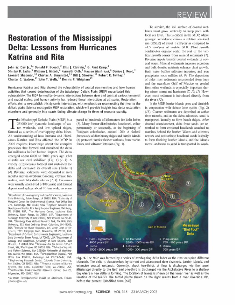


�6�
Appendix 4: Louisiana Master Plan – Executive Summary
From LouiSiana coaStaL Protection and reStoration authority, Integrated ecoSyStem reStoration and hurricane Protection: LouiSiana’S comPrehenSive maSter PLan for a
SuStainabLe coaSt (2007).

��0

���

��2

���

���

���

��6

���

��8

���

�80

�8�
�82

�8�


�8�
Appendix 5: Team Louisiana Report – Executive Summary
From ivor LL. van heerden, g. PauL KemP, haSSan maShriqui, radhey Sharma, biLLy ProchaSKa, Lou caPozzoLi, art theiS, ahmet binSeLam, Kate Streva, and ezra boyd, team LouiSiana, the faiLure of the new orLeanS Levee SyStem during hurricane Katrina, State Project no. 704-92-0022, 20 (2006), available at http://www.dotd.louisiana.gov/
administration/teamlouisiana/.

�86

�8�

�88

�8�
��0

���
��2

���

���

���
��6

���

��8

���


20�
Appendix 6: Advantages and Disadvantages of Non-Structural Measures for Mitigating Flood Losses
Adapted from L.A. Larson & R.E. Emmer, Floodplain Management – Mitigating Flood Losses (Emergency Mgmt. Institute, 2005), available at http://training.fema.gov/EMIweb/edu/fmc/ Session%2019%20-%20%20Mitigation%20Flood%20Losses%20122005.doc.

202
ADVANTAGES AND DISADVANTAGES OF STRUCTURAL
AND NONSTRUCTURAL MEASURES
I. Beneficial and detrimental attributes of structural mitigation practices
A. Levees and walls
1. Functions
a. Levees along the Mississippi River and walls such as in the French Quarter of New Orleans reduce the size of the floodplain or floodway by confining flow.
b. Using sheet piles or concrete walls allows for narrower rights-of-way. (Explanation note: Sheet pile is 3/8 in. x 18 in. x 40 +/- ft lengths of sculptured steel or plastic designed to interlock and prevent seepage.)
2. Beneficial Attributes
a. In contrast to levees, a floodwall requires less right-of-way in developed areas and reduced seepage under or through the structure.
b. Depending on the location, levees may be less expensive to build than floodwalls. However, consideration must be given to the cost of rights-of-way.
c. Levees and floodwalls can be located and built to protect specific areas and groups of structures.
d. Levees can be designed as multipurpose facilities allowing construction of roads, trails, or bike or jogging paths on their crest or within their right-of-way. Such multiple uses are amenities for the community.
3. Detrimental Attributes
a. Levees are mostly used along larger rivers where space is available for rights-of-way. Floodwalls in the same location would be more expensive.
b. Earthen levees usually require wide rights-of-way because their bases must be broad and in proportion to their height.
c. Similar to dams and reservoirs, levees and walls encourage a false sense of security in those who live within the system. When failure such as overtopping occurs, the resultant damages can be catastrophic.
d. Unless they are made part of a watershed or comprehensive community plan that includes mitigation, flood frequency, depths and erosion are simply shifted to other areas of the floodplain or along the channel.
e. Secondary consequences of these structures include:
1) Loss of access to adjacent lands, essentially isolating the community from the watercourse.
2) Modification of habitats due to fill, excavation, ponding or drainage.
3) A need for pump systems to remove internal runoff.

20�
4) An obstruction of views.
5) Limiting access to the natural functions of the river.
B. Channel alterations
1. Function
a. Channel alterations such as straightening, deepening, widening, removing debris, paving, raising or enlarging the bridges and culverts, and removing dams can increase the carrying capacity of watercourse (U.S. Water Resources Council, 1981).
b. Channel alterations also lower flood elevations.
2. Beneficial Attributes
a. Channel alterations reduce the extent and duration of floods.
b. Channel alterations can protect specific sites of localized flooding in developed areas.
c. Channel alterations may be designed as part of a multipurpose project that not only serves for flood reduction but also navigation and recreation.
d. Removing dams can restore natural ecosystems, including fish migration and canoeing.
3. Detrimental Attributes
a. Changing the natural regime and storage capacity of the watercourse will accelerate runoff that may cause added flooding downstream.
b. Channel deepening of larger streams must include a dredge maintenance component in order to maintain the capacity of the channel, an expensive action for the local sponsors.
c. Modified channels will try to return to their original meandering configuration, requiring ongoing maintenance to keep the channel in the project location.
d. Channel alteration results in habitat modification such as loss of wetlands, covering of shellfish beds, removal of submerged aquatic vegetation, forced relocation of fish and shellfish, and changed migration routes.
C. Diversions
1. Functions
a. Diversions, sometimes called spillways, capture a predetermined flow from the watercourse, such as 50 percent of the 100-year-flood discharge, and route the water through an artificial channel to receiving bodies (lakes, estuaries, larger rivers, adjourning watersheds) (U.S. Water Resources Council, 1981). In the example of the Bonnet Carré Spillway, it can divert 250,000 cfs from the Mississippi River into Lake Pontchartrain, thereby reducing flood stage at New Orleans.
b. The placement of diversions is dependent on the landscape, topography (the flatter the better), geology and similar physical and biological factors, as well as the ability of a receiving body to handle the additional flow.
2. Beneficial Attributes
20�
a. Diversions can reduce flood levels affecting developed areas that are immediately downstream from the project.
b. Diversion structures may use parcels of land that are less expensive than the highly urbanized area that might otherwise be protected with a levee.
3. Detrimental Attributes
a. Like dams, levees and floodwalls, diversions give that false sense of security in the “protected area.”
b. Although the diversion structure may be small, the right-of-way for the channel (canal) may require significant land to allow for maintenance roads, account for bank erosion and stabilization, and safety fencing.
c. State laws may prohibit interbasin transfer of water.
D. Land treatment
1. Functions
a. Land treatments are improvement practices to reduce runoff from throughout a watershed (uplands as well as floodplains). This requires modifying the landscape (physical, biological and socioeconomic systems) to reduce flooding downstream.
b. Land treatment practices include, but are not limited to protecting forests and the under story, planting vegetative cover, terracing, slope stabilization, grass waterways, contour plowing and strip farming (U.S. Water Resources Council, 1981).
2. Beneficial Attributes
a. Land treatments are most commonly used on agricultural lands to slow runoff, improve infiltration of precipitation into the soil, and help maintain or recharge aquifers.
b. Land treatment reduces erosion and subsequent sediment that fills streams and reservoirs.
c. Selected land treatments (no till or minimum tillage) result in little or no additional costs to the agricultural community. In fact, technical and financial assistance are available through federal programs and the Cooperative Extension Service.
3. Detrimental Attributes
a. Individual actions have limited impacts. On a watershed basis, a comprehensive program must be developed and implemented.
b. Land treatment works best on smaller, upland watersheds rather than in larger river basins.
E. Onsite detention
1. Functions
a. Onsite detentions are typically small impoundments with uncontrolled outlets that are created by building a dam/embankment, by excavation, or by a combination of these.

20�
b. Onsite detention systems prevent or retard excessive runoff from lands stripped of vegetation or covered by impervious surfaces (buildings, parking lots, roads, sidewalks, etc.) from reaching a watercourse.
c. In part, the runoff problem can be addressed by restricting land clearing and providing for temporary storage of runoff from a property (U.S. Water Resources Council, 1981).
2. Beneficial Attributes
a. Onsite detention captures runoff to streams while at the same time trapping pollutants (i.e., improving water quality).
b. When properly planned, onsite detention systems can be multipurpose, providing habitat for wildlife or serving as recreation fields during non-flood periods.
c. Many communities can easily integrate onsite detention systems into existing and proposed development by using rooftops, employing low-lying areas, and as a part of a parking lot.
d. When developers account for onsite detention early in the planning process, costs can be kept to a minimum.
e. Communities can assess the developer for the needed additional services such as drainage systems or pumps.
f. Onsite detention means the developer does not profit at the expense of others by passing excess runoff to flood downstream land uses and require public works projects to reduce this flooding.
3. Detrimental Attributes
a. In some instances, initial costs fall on the landowner who simply passes the costs on to the buyer or developer. On the other hand, the public pays for the detention system when it is part of a multipurpose project, such as using a recreation field to temporarily hold excessive runoff. Of course, when integrated into a development or community program, the public and private sectors share land treatment costs.
b. Maintenance may be costly if not factored into the design and performed regularly. Consequently, without proper care, a detention system loses its effectiveness.
c. To maximize benefits and to reduce additional flooding, project design must be designed and coordinated with similar actions in the watershed. Improper design (usually an undersized basin) can actually increase runoff by combining peak flows with other runoff.
d. Some communities require onsite detention systems be fenced or screened to reduce liability. However, some detention basins are dry, except during flood (recreation fields or water features), and are integrated into the land use plan. Communities may not require fencing for such features.
II. Nonstructural mitigation practices - specific categories
A. Floodplain regulations
1. Functions
a. Floodplain regulations usually designate mapped flood-prone areas and limit their uses to those activities that are compatible with the degree of flood risk, such as restricting parking along flood-prone streets.

206
b. In other words, development of flood-prone lands is made more compatible with natural processes and systems (U.S. Water Resources Council, 1981).
2. For local governments to implement floodplain regulations, they must:
a. Build on existing enabling statutes or home rule powers similar to what is used for zoning regulations or building codes;
b. Implement practical and reasonable regulations for attaining their goals;
c. Employ maps and regulations that are based on technical data that will satisfy a court;
d. Not discriminate between similarly situated landowners; and
e. Not “take” private property without payment of just compensation (U.S. Water Resources Council, 1981).
3. Beneficial Attributes
a. Floodplain regulations are flexible and allow for integrating economic, environmental and social values.
b. Floodplain regulations can become effective quickly, thereby reducing the potential for loss of life and property damage almost immediately.
c. Federal, state and local agencies can usually provide technical information needed for floodplain regulations.
d. Floodplain regulations can prevent unwise development and stop or slow actions as the community plans for other activities. At the same time, they protect buyers when they purchase property and structures in floodplains.
e. The community’s cost of floodplain regulations is minimal when compared to the impacts of a flood.
f. Floodplain regulations protect the ability of floodplains to carry floodwaters, to prevent increases in flood heights, or to not otherwise contribute to flooding problems.
g. Flood regulations help contain the costs of emergency operations, relief, evacuation and restoration.
h. Government action reduces the need for future expenditures for construction, operation and maintenance of reservoirs, levees and other flood control measures.
i. When structures are damaged by a flood or other disaster or have been remodeled (including expansion), the structure must be brought into compliance with the most recent statutes or codes.
j. Finally, natural floodplain values and functions are preserved.
4. Detrimental Attributes
a. This is not the best method for correcting existing problems because regulations usually exempt existing development from immediate compliance.
b. Unfortunately, local floodplain regulations may be easily changed. Federal programs such as the National Flood Insurance Act will not be as readily modified.

20�
c. Landowners may experience monetary losses if the regulations prevent the land from being used for development. Research indicates that the loss in value, however, is the greatest from actual flooding.
d. Floodplain regulations have little impact in areas of slow or no growth.
e. Communities adopt the minimum requirements of the NFIP and assume they have a good program. They should design a flood damage reduction program that both fits their location and is in compliance with the NFIP.
B. Development and Redevelopment Policies
1. Functions
a. Local governments can encourage and direct development and redevelopment away from floodways and floodplains (U.S. Water Resources Council, 1981).
b. For example, placing schools, government buildings and critical facilities outside of flood-prone areas draws associated, dependent businesses away from floodplains.
c. Development policies can tie future development to comprehensive community plans and require that adverse impacts be mitigated before the development can proceed.
d. To address flooding, local governments may:
1) Place signs identifying floodplains and giving depths of previous floods.
2) Require that deeds give the floodplain designation of the property, such as an A zone or a V zone;
3) Tax floodplains in a way that encourages their use as open space or for low-density development.
4) Offer tax credits for mitigation activities, such as floodproofing, elevating or relocating.
5) Buy properties as either a part of their mitigation plan when a community locates a flood servitude or as part of another project such as upgrading a thoroughfare.
2. Beneficial Attributes
a. Local governments can control the construction of utilities, sewer service, and highways onto floodplains and establish lines that restrict encroaching into channels and floodways, thereby, reducing the need for repair and replacement after a flood.
b. When comprehensive community plans are developed, acquired land can be used as open space for parks and storm water detention ponds.
c. Acquisition and relocation removes structures from the floodplain, making them no longer is subject to damage.
d. Comprehensive planning should prevent adverse impacts and losses resulting from future development, while reducing the community’s liability for actions that might allow development that results in adverse impacts on other properties.
3. Detrimental Attributes

208
a. Cultural enclaves may lose their identity if individuals are dispersed to sites outside the floodplain. Once they leave, they may no longer associate with traditional symbols of the community, such as churches, fraternal/social halls, cemeteries, etc.
b. People may leave the community even if the cultural enclave maintains its identity.
c. This option can be expensive if the property is simply cleared for open space. Coordinating with other community programs and goals can reduce costs.
C. Warning and preparedness
1. Functions
a. Forecast and warning models help the National Weather Service, River Forecast Centers, local governments and private companies estimate the projected severity and schedule of a flood. Much of the basic data needed for these models are from USGS river stage gauging stations located throughout a watershed.
b. Flood warnings and preparedness give communities and individuals time to take action in anticipation of rising waters. For example, when exceptional precipitation is anticipated or in regions characterized by flash floods, people may evacuate from the most dangerous locations to escape high-velocity flows that have a history of causing loss of life.
c. Flood warnings give potential victims a chance to reduce or prevent flood damages to their property by:
1) Removing or elevating a home’s contents (furniture, appliances, personal possessions) or commercial inventories, or
2) Protecting valuables by sand bagging, installing temporary walls, closing openings, or patrolling levees.
d. Warning systems for entire watersheds are getting more common and now give real-time information from gauging stations over the Internet.
e. Information gets to the general public from local sources, such as TV weather segments during the regularly scheduled news time, interrupted broadcasts and newspapers.
2. Beneficial Attributes
a. By giving communities and individuals time to prepare, warnings help save lives and reduce property damage.
b. Early information guides decision makers when distributing sand, sandbags and other emergency protection materials.
c. Dam and levee boards use this information for the safe operation and protection of their structure.
d. However, collecting needed information on precipitation, river stage readings and duration can be expensive, unless an agency organizes volunteers to record and transmit information. Although new automatic recording instruments are in place at some locations, the volunteer may never be replaced.
3. Detrimental Attributes

20�
a. Vandalism of real- time gauges is a problem. Stealing or using them as targets can eliminate an important source of data when they are most needed. Consequently, the stations may be inoperable during a critical period, as they are expensive to install, update, operate and replace.
b. Because the initial costs for a system (setup, gauge acquisition and installation, monitoring networks) are expensive, federal budgets are restricted, and local matches are almost impossible to obtain, only a limited number of watersheds have sufficient stations to provide needed data for models. Budget woes are resulting in a decrease in gauges.
c. Storms may interrupt the power and telephone networks. As a result, even through volunteers have collected much-needed data, they cannot transmit it during or immediately after a storm.
d. Operating and testing a warning system and forecast model can be expensive and time consuming.
D. Floodproofing (U.S. Water Resources Council, 1981)
1. Functions
a. Floodproofing may be viewed in two ways:
1) As a group of techniques used to keep water out of buildings or to reduce damages caused by water, and
2) As techniques that require human intervention, i.e., permanent measures, contingent or standby measures, or emergency measures.
b. Existing buildings and facilities can be retrofitted with watertight doors and water-resistant materials. However, it is usually more cost effective to floodproof during initial construction.
c. Dry floodproofing (watertight closures, sealant on walls, plastic sheeting) keeps the water away from people or out of a building.
d. On the other hand, wet floodproofing allows water to enter a building. It includes using water-resistant materials and practices, removal of contents, raising appliances (furnace, water heater, washer/dryer) above the flood level, or limiting the use of space reduce flood damages.
e. Permanent floodproofing measures can be integrated into a structure in ways that obscure their visual impact.
1) Examples include sealing openings with bricks or other flood- resistant materials, elevation, relocation or acquisition.
2) These usually do not require any human intervention for them to be effective.
f. Floodproofing is more appropriate for structures on floodplains where inundation is shallow, infrequent and has low velocity.
g. Contingent or standby measures are installed before an expected event and are ready for use during a flood.
1) Examples: panels across doors or openings, window coverings, walls and pumps. However, to be effective, someone must operate them.
h. Emergency measures are implemented during a flood and are most effective when operated according to a plan.

2�0
1) Examples: sandbags, temporary walls and pumps, removal of contents, raising contents. Major efforts by individuals or communities are necessary for these to be effective.
2. Beneficial Attributes
a. Floodproofing is more applicable to commercial structures. Businesses can afford engineers or architects to design a project that is professionally installed.
b. Generally, commercial structures are better able to withstand floodwaters. In addition, the potential benefits are high relative to the costs of floodproofing.
c. Damages can be prevented to a prescribed level and on a selective basis, such as a specific structure or activity (relocating or elevating a water heater or A/C unit).
d. In some instances floodproofing is easy, inexpensive and quick, such as elevating a washer and dryer on cement blocks.
e. Floodproofing also reduces the disruption of activities, helps maintain essential services during and after a flood, and contributes to faster post-flood recovery.
f. Floodproofing is applicable to individual units, one building or a small cluster of structures, unlike projects such as dams and levees that protect large areas.
3. Detrimental Attributes
a. Similar to dams and levees, floodproofing can instill a false sense of security, thereby, encouraging inappropriate or unwise uses of buildings or floodplains.
b. When floodwaters exceed the level of protection (dry floodproofed to 2 feet, but the flood is 2.5 feet), costs can be significant. In fact, dry floodproofing of residential structures is only recommended to 2 feet of flooding.
c. If floodproofing techniques are improperly applied, water pressure against the structure may cause its collapse.
d. Even though floodproofing can protect critical facilities (hospitals, fire stations, police stations), these facilities may not be operable during an emergency when they are most critical if they cannot be reached because the roads are impassable.
e. Finally, floodproofing can be costly. For example, it may be better to demolish and rebuild a structure rather than elevate a slab-on-grade foundation.
f. Only the structure is protected. As people move to or from the structure, they must cross flooded lands.
E. Flood insurance
1. Functions
a. The Federal government provides property owners anywhere within the limits of a participating community the opportunity to purchase flood insurance for structures and contents (Catalog of Federal Domestic Assistance, 97.022).
b. Flood insurance is available through the National Flood Insurance Program at FEMA, now a division within the Department of Homeland Security.
2��
c. To participate, the community must adopt and enforce floodplain management measures applicable to the Special Flood Hazard Area. An approved regulatory program is designed to reduce future flood damages. Flood insurance is obtained through private property insurance agents.
2. Beneficial Attributes
a. As of 2003, over 19,500 of 22,000 communities with identified floodplains nationally participated in the National Flood Insurance Program.
b. Congress has established the NFIP as a self-supporting program. Consequently, administrative costs, mapping and other NFIP expenses are paid through insurance premiums and fees from map revision requests. This reduces the cost to taxpayers for disaster assistance.
c. Insurance claims, unlike loans (principle plus interest), do not have to be repaid.
d. As of 2004, total building coverage available on a single-family dwelling is $250,000 plus contents (insurance coverage limits of $100,000), while grants are very small (sometimes only $10,000).
e. Similar to all insurance programs, the NFIP spreads the cost of insurance through time and over and across a large number of properties that are at risk.
3. Detrimental Attributes
a. To be eligible for flood insurance, a property owner must maintain his or her flood insurance policy and pay the premiums.
b. Communities must enforce floodplain regulations on how properties within the Standard Flood Hazard Area may be used, constructed or reconstructed.
c. Insurance does not reduce damages. To obtain lower premiums, owners are encouraged to reduce their exposure. The Community Rating System does the same thing for communities.
F. Relief and recovery
1. Functions
a. Relief and recovery efforts from the public and private sectors help the individual, business owner and community after a flood.
b. Relief and recovery measures include cleanup, resumption of services and the application of federal and state disaster aid.
c. In addition, tax adjustment may allow credits or deductions for the cost of repairs and rehabilitation. Creative governments can use tax adjustments to influence how one rebuilds or uses flood-prone areas.
d. The federal government provides loans and grants through several programs.
e. Communities with a recovery and mitigation plan are more effective in implementing post-flood recovery in the shortest possible time. Important elements in this plan are provisions to mitigate structures at risk and eliminate unwise redevelopment on flood-prone lands, thereby minimizing future flood losses.
2. Beneficial Attributes

2�2
a. Organized response and recovery initiatives minimize interruption of businesses and disruption of utilities and transportation networks.
b. During and after a flood, many federal and state programs and nonprofit organizations, e.g. Red Cross, can assist with debris removal, sheltering and feeding victims, and rehabilitation of public services.
c. During recovery, the local government may be presented an opportunity to eliminate flood-damaged development by elevating them, floodproofing them or buying them and relocating the victims. Finally, structures can be rebuilt in ways that minimize future flood losses.
3. Detrimental Attributes
a. Unless government takes the time to use tax credits and deductions to guide redevelopment of floodplains, these potential incentives will not provide protection against future flood damages. Redevelopment of property without proper mitigation simply allows for the continuation of the damage-rebuild-damage cycle of the past.
b. In fact, poorly structured tax adjustments may encourage continued unwise use of floodplains or even more development.
c. Effective recovery requires forethought as expressed in a plan. Unless the community has a strategy for debris clearance and restoration of utilities, infrastructure and public services, victims face a protracted period of recovery.
G. General concerns about nonstructural measures (ASFPM, 2001, p. 50)
1. Acquisition and relocation are often done piecemeal, leaving what is called a “checkerboard” pattern of vacant lots and buildings that either didn’t qualify for the program or whose owners did not want to move.
2. Elevation and floodproofing projects still leave buildings surrounded by water during a flood.
a. Occupants often try to ride out the flood or get to or from their properties during high water, requiring significant police and fire protection costs.
b. The building may be isolated and without utilities and, therefore, temporarily unusable.
3. Owner-designed measures (if allowed), especially dry floodproofing, may not adequately account for all forces that floodwaters place on a building.
a. This can result in severe structural damage to the building.
4. The streets, utilities and other infrastructure that serve an elevated or floodproofed building are still exposed to flood damage and public costs for those damages.
References
The Federal Interagency Floodplain Management Task Force. 1994. A Unified National Program for Floodplain Management 1994. FEMA 248/June.
The Federal Interagency Floodplain Management Task Force. 1996. Protecting Floodplain Resources. A Guidebook for Communities. FEMA 268/June. 2nd Edition.

2��
Federal Emergency Management Agency. 2002. Getting Started. Building Support for Mitigation Planning. State and Local Mitigation Planning How-to Guide. FEMA 386-1. September.
Federal Emergency Management Agency and the National Park Service. 1994. A Multi-Objective Flood Mitigation Plan. Vermillion River Basin, South Dakota. FEMA, Region VIII and the Rivers, Trails and Conservation Assistance Program of the National Park Service, Rocky Mountain Region. Denver, CO.
Federal Emergency Management Agency and the National Park Service. 1994. A Multi-Objective Planning Process for Mitigating Natural Hazards. FEMA, Region VIII and the Rivers, Trails and Conservation Assistance Program of the National Park Service, Rocky Mountain Region. Denver, CO.
Godschalk, D.R., T. Beatley, P. Berke, D.J. Brower, E.J. Kaiser, C.C. Bohl, R.M. Goebel. 1999. “Chapter 13. Mitigating Natural Hazards: Planning for Sustainable Communities.” IN: Natural Hazard Mitigation. Recasting Disaster Policy and Planning. Washington, D.C.: Island Press. Pp. 525-552.
National Science Foundation. 1980. A Report on Flood Hazard Mitigation. Washington, D.C. September. 253 p.
Paterson, R.G. 1998. “The Third Sector: Evolving Partnerships in Hazard Mitigation.” IN: R.J. Burby (ed.) Cooperating with Nature. Confronting Natural Hazards with Land-Use Planning for Sustainable Communities. Washington, D.C.: Joseph Henry Press. Pp. 203-230.
The Task Force on the Natural and Beneficial Function of the Floodplain. 2002. The Natural and Beneficial Functions Of Floodplains, Reducing Flood Losses by Protecting and Restoring the Floodplain Environment. A Report for Congress. FEMA 409, June.
United States Army Corps of Engineers. 1983. Seminar Proceedings. Implementation of Nonstructural Measures. Civil Works Directorate, Ft. Belvoir, VA, November 15-17, 1982. Policy Study 83-G520.

2��
Appendix 7: Summary of Coastal Construction Requirements and Recommendations
federaL emergency management agency, home buiLder’S guide to coaStaL conStruction, fema 499, technicaL fact Sheet no. 2 (2005).

Summary of Coastal Construction Requirements and RecommendationsHOME BUILDER’S GUIDE TO COASTAL CONSTRUCTION FEMA 499/August 2005 Technical Fact Sheet No. 2
Purpose: To summarize National Flood Insurance Program (NFIP) regulatory requirements concerning coastal construction and provide recommendations for exceeding those requirements in some instances.
Key Issues• New construction* in coastal flood hazard areas (V zones and A zones) must meet minimum NFIP and community requirements.
Repairs, remodeling, and additions must meet community requirements and may also be subject to NFIP requirements.
• NFIP design and construction requirements are more stringent in V zones than in A zones, in keeping with the increased flood, wave, floodborne debris and erosion hazards in V zones.
• Some coastal areas mapped as A zones may be subject to damaging waves and erosion (these areas are often referred to as Coastal A Zones). Buildings in these areas constructed to minimum NFIP A-zone requirements may sustain major damage or be destroyed during the Base Flood. It is strongly recommended that buildings in A zones subject to breaking waves and erosion be designed and constructed to V-zone standards.
• Buildings constructed to minimum NFIP A-zone standards and subject solely to shallow flooding without the threat from breaking waves and erosion will generally sustain only minor damage during the Base Flood.
• Following the recommendations in the table below will result in lower damage to the building and reduced flood insurance premiums (see the V-Zone Risk Factor Rating Form in FEMA's Flood Insurance Manual (http://www.fema.gov/nfip/manual.shtm).
* For floodplain management purposes, new construction means structures for which the start of construction began on or after the effective date of a floodplain management regulation adopted by a community. Substantial improvements, repairs of substantial damage, and some enclosures must meet most of the same requirements as new construction.
The following tables summarize NFIP regulatory requirements and recommendations for exceeding those requirements for both (1) new construction and (2) repairs, remodeling, and additions.
Requirements and Recommendations for New Constructiona

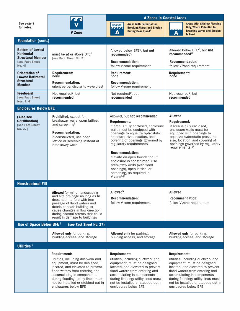


Notesa “Prohibited” and “Allowed” refer to the minimum NFIP regulatory requirements; individual states and communities may
enforce more stringent requirements that supersede those summarized here. Exceeding minimum NFIP requirements will provide increased flood protection and may result in lower flood insurance premiums.
b In these areas, buildings are subject to flooding conditions similar to, but less severe than, those in V zones. These areas can be subject to breaking waves ≥ 1.5 feet high (which can destroy conventional wood-frame and unreinforced masonry wall construction) and erosion (which can undermine shallow foundations).
c In these areas, buildings are subject to flooding conditions similar to those in riverine A zones.
d Some coastal communities require open foundations in A zones.
e State or community may require freeboard or regulate to a higher elevation (e.g., Design Flood Elevation (DFE)).
f Some coastal communities prohibit breakaway walls and allow only open lattice or screening.
g If an area below the BFE in an A-zone building is fully enclosed by breakaway walls, the walls must meet the requirement for openings that allow equalization of hydrostatic pressure.
h Placement of nonstructural fill adjacent to buildings in coastal AO zones is not recommended.
i There are some differences between what is permitted under floodplain management regulations and what is covered by NFIP flood insurance. Building designers should be guided by floodplain management requirements, not by flood insurance policy provisions. For more information, see Section 9.3.1.1 in Chapter 9 of FEMA’s Coastal Construction Manual (FEMA 55).
j Walls below BFE must be designed and constructed as breakaway walls that meet the minimum requirements of the NFIP regulations. For more information, see Section 6.4.3.3 in Chapter 6 of FEMA’s Coastal Construction Manual (FEMA 55).
k Consult with authority having jurisdiction (AHJ) regarding more restrictive requirements for repairs, remodeling, and additions.
l NFIP requirements for new construction in V zones include those pertaining to Design and Construction, Flood-Resistant Materials, Siting, Foundations, Lowest Floor Elevation, Enclosures Below the BFE, Free of Obstructions, Utilities, and Certifications.
m NFIP requirements for new construction in A zones include those pertaining to Design and Construction, Flood-Resistant Materials, Siting, Foundations, Foundation Openings, Lowest Floor Elevation, Enclosures Below the BFE, Utilities, and Certifications.
n An addition in the form of an attached garage would not have to be elevated to or above the BFE, because its use (parking) would be allowed below the BFE; however, it would have to meet other NFIP requirements for new construction in V zones.
o An addition in the form of an attached garage would not have to be elevated to or above the BFE, because its use (parking) would be allowed below the BFE; however, it would have to meet other NFIP requirements for new construction in A zones.


22�
Appendix 8: Louisiana House Brochure
Courtesy of Louisiana State University Agricultural Center
226
22�

228
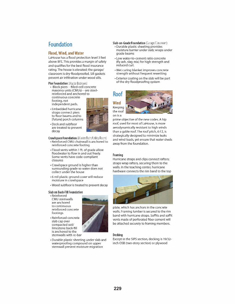
22�
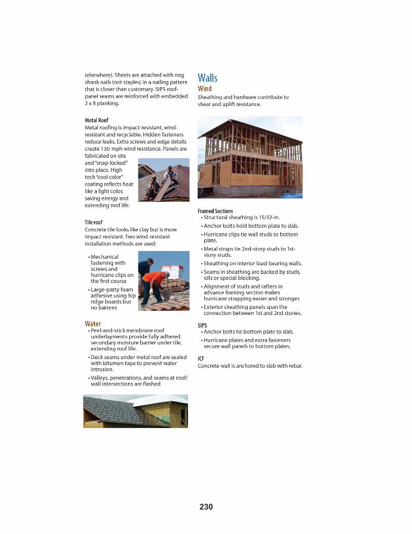
2�0

2��

2�2

2��


2��
Appendix 9: Louisiana Revised Statutes Title 33
Part IV. Physical Development of Parishes and Municipalities La. Rev. Stat. 33:101 et seq.

2�6
LOUISIANA REVISED STATUTES TITLE 33PART IV. PHYSICAL DEVELOPMENT OF PARISHES AND MUNICIPALITIES
SUBPART A. PLANNING COMMISSIONS
§101. Definitions
For the purpose of this Subpart, the following terms are defined as follows:
(1) “Master plan” means a statement of public policy for the physical development of a parish or municipality adopted by a parish or municipal planning commission.
(2) With regard to municipalities, certain terms are defined as follows:
(a) “Municipality” includes any incorporated city, town, or village.
(b) “Chief executive” means the mayor or corresponding officer of a municipality, whatever his title.
(c) “Local legislative body” means the mayor and board of aldermen, the commission council, or other governing body of a municipality.
(3) “Planning commission” means an official planning commission appointed in accordance with the provisions of this Subpart. It shall denote either a parish planning commission, or a municipal planning commission, as the case may be. The term “parish or municipality as the case may be”, when appropriate to the context, relates to the respective jurisdictions or functions of a parish planning commission with regard to the parish for which it is established and of a municipal planning commission with regard to the municipality for which it is established; or, when appropriate to the context, relates to the rights and remedies which the respective parish or municipality may exercise to enforce the provisions of this Subpart.
(4) “Streets” and “roads” includes streets, avenues, boulevards, roads, lanes, alleys, viaducts, and other ways.
(5)(a) “Subdivision” means the division of a lot, tract, or parcel of land into two or more lots, plats, sites or other divisions of land for the purpose, whether immediate or future, of sale or of building development, and, with regard to parishes, for the purpose of sale or of building development for purposes other than agricultural. It includes resubdivision and, when appropriate to the context, relates to the process of subdividing or to the land or territory subdivided.
(b) “Resubdivision”, in addition to being synonymous with “subdivision”, means and shall also include the consolidation of two or more lots, plats, tracts, parcels, or other divisions of land into one or more lots, plats, tracts, parcels, or other divisions of land.§101.1. Subdivision approval a legislative function
Except as otherwise provided in this Subpart, the act of approving or disapproving a subdivision plat is hereby declared a legislative function involving the exercise of legislative discretion by the planning commission, based upon data presented to it; provided that any subdivision ordinance enacted by the governing authority of a parish or municipality or the acts of the planning commission, or planning administrator shall be subject to judicial review on the grounds of abuse of discretion, unreasonable exercise of police powers, an excessive use of the power herein granted, or denial of the right of due process. The right of judicial review of a subdivision ordinance shall not be limited by the foregoing, however, nothing contained in this Subpart or in any subdivision ordinance adopted by a parish or municipality shall be construed as imposing upon such parish or municipality a duty, special or otherwise, to or for the benefit of any individual person or group of persons.
2��
§102. Grant of power to parishes and municipalities
Every parish and every municipality may make, adopt, amend, extend, add to, or carry out official plans as provided in this Subpart, and may create by ordinance a planning commission with the powers and duties as provided by this Subpart, and may appropriate funds for the commission.
§§103 – 105 (deleted by editors)
§106. General powers and duties
A.(1) A parish planning commission shall make and adopt a master plan for the physical development of the unincorporated territory of a parish.
(2) A municipal planning commission shall make and adopt a master plan for the physical development of the municipality.
B.(1) Any such plan shall provide a general description or depiction of existing roads, streets, highways, and publicly controlled corridors, along with a general description or depiction of other public property within the jurisdiction that is subject to the authority of the commission.
(2) Any such plan, with the accompanying maps, plats, charts, and descriptive matter may include a commission’s recommendations for the development of the parish or municipality, as the case may be, including, among other things, the general location, character, and extent of railroads, highways, streets, viaducts, subways, bus, street car and other transportation routes, bridges, waterways, lakes, water fronts, boulevards, parkways, playgrounds, squares, parks, aviation fields, and other public ways, grounds, and open spaces; the general location of public buildings, schools, and other public property; the general character, extent and layout of public housing and of the replanning of blighted districts and slum areas; the general location and extent of public utilities and terminals, whether publicly or privately owned or operated, for water, light, sanitation, communication, power, transportation, and other purposes; and the removal, relocation, widening, narrowing, vacating, abandonment, change of use, or extension of any of the foregoing ways, grounds, open spaces, buildings, property, utilities, or terminals.
C. As the work of making the whole master plan progresses, a commission may from time to time adopt and publish a part or parts thereof, any such part to cover one or more major sections or divisions of the parish or municipality, as the case may be, or one or more of the aforesaid or other functional matters to be included in the plan. A commission may from time to time amend, extend, or add to the plan.
D. Where a municipal planning commission has been established under the authority of this Subpart, it shall also serve as a municipal zoning commission, and when acting as such, it shall hold separate meetings with separate minutes and records.
§106.1. Planning commissions; exempt subdivisions; septic tanks and field drains permitted
A. Notwithstanding any other provision in this Chapter to the contrary, no parish, regional, or other planning commission, except those of the parishes of Bossier, Cameron, St. Charles, St. James, Lincoln, Plaquemines, St. Tammany, Washington, Allen, Tangipahoa, Jefferson Davis, Evangeline, Sabine, St. John the Baptist, West Baton Rouge, and Caddo, and those of any city or municipality within said parishes, and except those covering a jurisdiction with a population greater than three hundred thousand, shall have jurisdiction over the following subdivisions of land except with respect to requirements for utilities, drainage, including sewerage disposal and street planning dimensions, composition, and alignment:
(1) Any parcel of land situated outside an incorporated area which is owned wholly by one owner or co-owners and is divided into single-family lots of a minimum square footage of twenty-two thousand five hundred square feet, with a minimum width of one hundred twenty-five feet of frontage, except those
2�8
lots that are nonrectangular with less than a minimum of one hundred twenty-five feet of frontage have an average width of one hundred twenty-five feet, provided said lots have a frontage of at least sixty feet, and provided that the size of the lots can support sewage disposal systems and individual water systems which meet the requirements of the office of preventive and public health services after consideration of recognized standards of suitability. However, the provisions of this Section and those of R.S. 33:106 shall not apply to any rural subdivision residence constructed prior to January 1, 1980, if the builder on or buyer of such residence installs a septic tank with an absorption field, or, as alternative method, an individual mechanical sewage treatment plant for individual single-family homes, either of which must qualify as an acceptable sewage treatment system as determined by the office of preventive and public health services of the Department of Health and Hospitals, and which would be acceptable to the local health authority of the parish in which the residence is located. Furthermore, no parish, municipality, or planning commission shall enact a sewerage permit ordinance or similar regulation authorizing the installation of individual sewage treatment and disposal systems without written approval by the office of preventive and public health services of the Department of Health and Hospitals.
(2) Any parcel of land, wherever located, upon which a servitude of passage is created for ingress or egress which does not create a through passage and is used exclusively as a driveway need not meet any street planning dimensions, except said servitude must be adequate in dimensions to provide for ingress and egress by service and emergency vehicles.
B. On the tracts excepted from planning commission regulation in this Section, the utilization of individual sewage disposal systems shall be permitted and the utilization of any other sewage disposal system shall not be required, provided such sewage disposal systems meet requirements of the office of preventive and public health services.
§107. Purposes in view
In the preparation of such plan, a parish planning commission shall make careful and comprehensive surveys and studies of present conditions and future growth of the parish, with due regard to its relation to neighboring territory and to the relation of unincorporated territory in the parish to incorporated territory therein.
In the preparation of such plan a municipal planning commission shall make careful and comprehensive surveys and studies of present conditions and future growth of the municipality and its environs.
A plan shall be made with the general purpose of guiding and accomplishing a co-ordinated, adjusted, and harmonious development of the parish or municipality, as the case may be, and its environs which will, in accordance with present and future needs, best promote health, safety, morals, order, convenience, prosperity, and general welfare, as well as efficiency and economy in the process of development; including, among other things, adequate provision for traffic, the promotion of safety from fire and other dangers, adequate provision for light and air, the promotion of the healthful and convenient distribution of population, the promotion of good civic design and arrangement, wise and efficient expenditure of public funds, the adequate provision of public utilities and other public requirements, and in the case of a municipal planning commission, vehicular parking.
§108. Procedure of commission; adoption of plan
A. A commission may adopt a plan as a whole by a single resolution or may by successive resolutions adopt successive parts of a plan, said parts corresponding with major geographical sections or divisions of the parish, in the case of a parish planning commission, or of the municipality, in the case of a municipal planning commission, or with functional subdivisions of the subject matter of the plan, and may adopt any amendment or extension thereof or addition thereto.

2��
B. Before the adoption of a plan or any such part, amendment, extension, or addition, a commission shall hold at least one public hearing thereon. A parish planning commission shall give notice of the purpose, time, and place of the public hearing by one publication in a newspaper of general circulation throughout the parish at least ten days prior to the date set for the hearing. A municipal planning commission shall give notice of the purpose, time, and place of the public hearing by one publication in a newspaper of general circulation in the municipality at least ten days prior to the date set for the hearing.
C. The adoption of a plan or of any such part or amendment or extension or addition shall be by resolution of a commission. The resolution shall refer expressly to the maps and descriptive and other matter intended by a commission to form the whole or part of a plan, and the action taken shall be recorded on the map and plan and descriptive matter by the identifying signature of the chairman or secretary of the commission.
D. Certified copies of the plan or part thereof shall be filed with the division of administration, with the local legislative body and with the clerk of court of the parish, except in the parish of Orleans where certified copies of said plan shall be filed with the Commission Council of the city of New Orleans and recorded with the register of conveyances for the parish of Orleans.
§109. Legal status of official plan
A. Whenever a commission has adopted a master plan of a parish or municipality, as the case may be, or one or more major sections or districts thereof and has filed certified copies thereof as provided in R.S. 33:108, no street, square, park or other public way, ground, or open space, or public building or structure, or public utility, whether publicly or privately owned, shall be constructed or authorized in the parish or municipality, as the case may be, or in such planned section or district until the location, character, and extent thereof has been submitted to and approved by the commission. In case of disapproval, the commission shall communicate its reasons to the local legislative body which shall have the power to overrule such disapproval by a recorded vote of not less than two-thirds of its entire membership. However, if the public way, ground, space, building, structure, or utility is one the authorization or financing of which does not, under the law or charter provisions governing same, fall within the province of the local legislative body, then the submission to a planning commission shall be by the board, commission, or body having such jurisdiction, and a planning commission’s disapproval may be overruled by such board, commission, or body by a vote of not less than two-thirds of its membership. The failure of a commission to act within sixty days from and after the date of official submission to a commission shall be deemed approval.
B. Whenever a parish or municipal planning commission has adopted a master plan, the governing authority of such parish or municipality shall consider such adopted master plan before adopting, approving, or promulgating any local laws, ordinances, or regulations which are inconsistent with the adopted elements of the master plan.
§109.1. Relationship between local master plans and the plans of the state and other political subdivisions
Whenever a parish or municipal planning commission has adopted a master plan, state agencies and departments shall consider such adopted master plan before undertaking any activity or action which would affect the adopted elements of the master plan.
§110. Miscellaneous powers and duties of commission
A commission may promote public interest in and understanding of a plan and to that end may publish and distribute copies of a plan or of any report and may employ such other means of publicity and education as it may determine. Members of a commission, when duly authorized by a commission, may attend planning conferences or meetings of planning institutes or hearings upon pending planning legislation, and a commission may, by resolution spread upon its minutes, pay the reasonable traveling expenses incident

2�0
to such attendance. A commission shall, from time to time, recommend to the appropriate public officials programs for public structures and improvements and for the financing thereof. It shall consult and advise with public officials and agencies, public-utility companies, civic, education, professional, and other organizations, and with citizens with relation to the protecting or carrying out of a plan. A commission may accept and use gifts for the exercise of its functions. All public officials shall, upon request, furnish to a commission, within a reasonable time, such available information as it may require for its work. A commission, its members, officers, and employees, in the performance of their functions, may enter upon any land and make examinations and surveys and place and maintain necessary monuments and marks thereon. In general, a commission shall have such powers as may be necessary to enable it to fulfill its functions, promote planning, and in all respects carry out the purposes of this Sub-part.
§111. Scope of control of subdivision
Whenever a planning commission has adopted a major street or road plan of the territory unincorporated, in the case of a parish planning commission, within its jurisdiction or part thereof and has filed certified copies of such plan with the local legislative body and with the clerk of court of the parish, it shall be incumbent upon any individual or corporation prior to filing or recording such plat to first obtain approval by such planning commission and the approval entered in writing on the plat by the chairman or secretary of the commission and failure to so do shall constitute the right of the governing authority wherein said land is located not to accept same as a duly accepted and dedicated subdivision. Nothing contained herein shall be construed to prohibit the respective clerks of court and recorder of records of the various parishes from recording surveys and/or plats of land presented to them for recording or filing as a public record.
§112. Subdivision regulations
A. Before exercising the powers referred to in R.S. 33:110, a parish planning commission shall adopt regulations governing the subdivision of land within unincorporated territory within its jurisdiction for purposes other than agricultural.
B. Before exercising the powers referred to in R.S. 33:110 a municipal planning commission shall adopt regulations governing the subdivision of land within its jurisdiction.
C.(1)(a) Within those parishes or municipalities with a population in excess of four hundred twenty-five thousand which have a recreation plan officially adopted in accordance with R.S. 33:108, the governing body may enact or may authorize its appropriate agency to enact, as a part of the municipality’s or parish’s subdivision control regulations, requirements that a subdivider of land dedicate such land areas, sites, and locations for park, playground, and public school purposes as are reasonably necessary to service the proposed subdivision and the future residents thereof, but in no case more than five percent of the gross area of the proposed subdivision. The regulations may provide that the dedication shall be a condition precedent to the approval of any subdivision plat. They shall set forth the standards to be applied in determining the amount of land that is required to be dedicated. These standards shall be based upon the number and type of dwelling units or structures to be included in each subdivision. These standards shall also be based upon studies and surveys conducted by the municipality or parish through its appropriate agency in order to determine the need, if any, for park, playground, and public school sites generated by existing subdivisions within the municipality or parish containing various types of dwelling units or structures.
(b) When the municipality or parish through its appropriate agency adopts regulations requiring a subdivider to dedicate park, playground, and public school sites, as authorized by this Subpart, it may also adopt as part of the municipality’s or parish’s regulations governing the subdivision of land, provisions requiring a subdivider, in lieu of dedicating the sites, to pay to the municipality or parish, a sum of money or a combination of money and sites equal to the value of land that would otherwise be required to be dedicated for park, playground, and public school purposes, whenever the local governmental body through its appropriate agency determines that it would not be in the public interest to accept the dedication in
2��
connection with a particular proposed subdivision. The provisions shall enumerate the standards to be applied in determining when it is not in the public interest to accept the dedication and shall provide for the manner of making payment.
(c) All funds so received shall be held by the municipality or parish or a designated department or agency thereof, in a special account, and shall be applied and used by the municipality or parish to acquire park, playground, and public school sites for the benefit of the residents of the subdivision for which the payment was made. Provisions may be adopted establishing standards for the application and use of the funds in accordance with the foregoing limitation. The provisions may also provide that the payment in lieu of dedication shall be a condition precedent to the approval of any subdivision plat, or may provide that the payment be deferred or made in installments following approval of a subdivision plat, upon the subdivider’s posting good and sufficient surety bond guaranteeing the payment. The parish or municipality, as the case may be, may enforce such bond by all appropriate legal remedies.
(2) Such regulations may provide for the proper arrangement and width of streets in relation to other existing or planned streets and to the master plan, for adequate and convenient open spaces for traffic, vehicular parking, utilities, access of firefighting apparatus, recreation, light and air, and for the avoidance of congestion of population, including minimum width and area of lots.
D. Such regulations may include provisions as to the extent to which roads, streets, and other ways shall be graded and improved and to which water and sewer and other utility mains, piping, or other facilities shall be installed as a condition precedent to the approval of the plat. The regulations or practice of a commission may provide for a tentative approval of the plat previous to such installations; but any such tentative approval shall be revocable and shall not be entered on the plat. In lieu of the completion of such improvements and utilities prior to the final approval of the plat, a commission may accept a bond with surety to secure to the parish or municipality, as the case may be, the actual construction and installation of such improvements or utilities at a time and according to specifications fixed by or in accordance with the regulations of the commission. The parish or municipality, as the case may be, may enforce such bond by all appropriate legal remedies.
E. All such regulations shall be published as provided by law for the publication of ordinances, and, before adoption, a public hearing shall be held thereon. A parish planning commission shall give notice of the purpose, time, and place of the hearing by one publication in a newspaper of general circulation in the parish at least ten days prior to the date set. A municipal planning commission shall give notice of the purpose, time and place of the hearing by one publication in a newspaper of general circulation in the municipality at least ten days prior to the date set. Certified copies of such regulations shall be filed by a commission with the local legislative body and the clerk of court of the parish. Regulations governing the subdivision of land may be amended from time to time, subject to the requirements governing original adoption with respect to notice, hearing, and filing with local authorities.
F. Whenever pursuant to R.S. 33:4562-4566 two or more parishes or parts thereof have been combined by agreement into a single recreation district such that the parish boundaries do not coincide with the recreation district, the local governing body through its appropriate agency shall refer the standards required by this subpart to the recreation district commission in which the proposed subdivision is located. The standards shall not be effective until the recreation district commission certifies, pursuant to procedures set forth in the interlocal agreement, that they are the same as those prevailing throughout the jurisdiction of the recreation district. The foregoing section may be applicable to all federally assisted housing programs whether or not a subdivision of land would be required.
§113. Procedure; legal effect of approval of plat
A planning commission shall approve or disapprove a plat within sixty days after the submission thereof to it; otherwise such plat shall be deemed to have been approved, and a certificate to that effect shall be issued by such commission on demand. The applicant for a commission’s approval may, however, waive
2�2
this requirement and consent to an extension of such period. The ground of disapproval of any plat shall be stated upon the records of such commission. Any plat submitted to such commission shall contain the name and address of a person to whom notice of a hearing shall be sent; and no plat shall be acted on by such commission without affording a hearing thereon. Notice shall be sent to the said address by certified mail of the time and place of such hearing not less than five days before the date fixed therefor. A planning commission shall give notice of such hearings, including the purpose, time, and place, by at least one publication in a newspaper of general circulation in the area surrounding the proposed subdivision, not less than five days prior to the hearing date; provided, however, that in parishes or municipalities with a population in excess of one hundred fifty thousand, the public hearing may be waived by the planning commission or planning authority for subdivisions creating five or less lots not involving the creation of any new streets, and provided further that the provisions in such waivers shall be clearly set forth in the official subdivision regulations. Every plat approved by a planning commission shall, by virtue of such approval, be deemed to be an amendment of or an addition to or a detail of the official plan and a part thereof. Approval of a plat shall not be deemed to constitute or effect an acceptance by the public of any street or other open space shown upon the plat. A planning commission may, from time to time, recommend to the local legislative body amendments to the zoning ordinance or map or additions thereto to conform to such commission’s recommendations for the zoning regulation of the territory comprised within approved subdivisions.
In the case of a parish planning commission, such requirements or restrictions shall be stated upon the plat prior to the approval and recording thereof and shall have the same force of law and be enforceable in the same manner and with the same sanctions and penalties and subject to the same power of amendment or repeal as though set out as a part of a zoning ordinance or map.
§113.1. Administrative procedure
A. Notwithstanding other provisions of this Subpart or other law to the contrary, the governing authority may adopt an ordinance establishing administrative procedures for approving or certifying certain plats involving minor modifications of existing parcels of land. The categories of such modifications qualifying for such administrative approval or certification are:
(1) The realignment or shifting of lot boundary lines, including removal, addition, alignment, or shifting of interior lot boundary lines, or the redesignation of lot numbers provided the application meets the following requirements:
(a) Does not involve the creation of any new street or other public improvement except as otherwise provided in this Section.
(b) Does not involve more than two acres of land or ten lots of record.
(c) Does not reduce a lot size below the minimum area or frontage requirements established by ordinance.
(d) Otherwise meets all the requirements of the subdivision regulations and zoning ordinances.
(2) Parcels of land where a portion has been expropriated or has been dedicated, sold, or otherwise transferred to the parish or municipality, thereby leaving a severed portion of the original property which requires a redesignation of lot number and establishment of new lot boundary lines.
B. Notwithstanding the provisions of Paragraph (1) of Subsection A of this Section, such administrative procedures may provide for the dedication, acceptance, relocation, or deletion of public utility servitudes, other than streets, or the deletion of gas, electric, or telephone utility servitudes acquired by private act or pursuant to the provisions of R.S. 19:1 et seq. on the property being resubdivided.

2��
C. All plats approved or certified by an administrative procedure provided for herein shall designate such fact on the plat and the plats shall be recorded in the conveyance records of the parish. Any plat so approved shall have the same force and effect and legal status of a subdivision application approved by the established legislative process.
§114. Transfer of lots in unapproved subdivisions
A. Whoever, being the owner or agent of the owner of any land located within a subdivision, transfers or sells or agrees to transfer or sell any land by reference to or exhibition of or by other use of a plat of a subdivision, before such plat has been approved by a planning commission and recorded or filed in the office of the clerk of court of the parish, shall make the instrument of transfer subject to compliance with laws, ordinances, and regulations relative to the development of subdivisions.
B.(1) Whoever, being the owner or agent of the owner of any land located within a subdivision, transfers or sells or agrees to sell any land by reference to or exhibition of or by other use of a plat of a subdivision, before such plat has been approved by a planning commission and recorded or filed in the office of the clerk of court of the parish, without making the instrument of transfer subject to compliance with laws, ordinances, and regulations relative to the development of subdivisions, shall pay a penalty of five hundred dollars for each lot or parcel so transferred or sold or agreed or negotiated to be sold.
(2) The description of such lot or parcel by metes and bounds in the instrument of transfer or other document used in the process of selling or transferring shall not exempt the transaction from such penalties or from the remedies herein provided.
(3) The parish or municipality, as the case may be, may enjoin such transfer or sale or agreement by suit for injunction brought in any court of competent jurisdiction or may recover the penalty by a civil action in any court of competent jurisdiction.
§115. Improvements in unapproved streets
The parish or municipality, as the case may be, shall not accept, lay out, open, improve, grade, pave, curb, or light any street, or lay or authorize water mains or sewers or connections to be laid in any street, within any portion of territory for which a planning commission has adopted a major street plan, unless the street has been accepted or opened as or has otherwise received the legal status of a public street prior to the adoption of such plan, or unless the street corresponds with a street shown on the official master plan or with a street on a subdivision plat approved by a planning commission or with a street on a street plat made by and adopted by a commission, copies of which plat have been duly filed as provided in R.S. 33:108. The local legislative body may, however, accept any street not shown on or not corresponding with a street on the official master plan or on an approved subdivision plat or an approved street plat, if the ordinance or other measure accepting such street is first submitted to the planning commission for its approval and, if approved by the commission, is enacted or passed by not less than a majority of the entire membership of the local legislative body or, if disapproved by the commission, is enacted or passed by not less than two-thirds of the entire membership of the local legislative body. A street approved by a planning commission upon submission by the local legislative body, or a street accepted by a two-thirds vote after disapproval by the planning commission, shall thereupon have the status of an approved street as fully as though it had been originally shown on the official master plan or on a subdivision plat approved by the commission or had been originally platted by the commission.
§116. Erection of structures
When a planning commission has adopted a major street plan, no structure shall be erected on any lot within the affected area, nor shall a building permit be issued therefor unless the street giving access to the lot upon which such structure is proposed to be placed has been accepted or opened as or has otherwise received the legal status of a public street prior to that time, or unless such street corresponds with a
2��
street shown on the official master plan or with a street on a subdivision plat approved by the planning commission or with a street on a street plat made by and adopted by the commission or with a street accepted by the local legislative body, after submission to the planning commission, by a favorable vote required in R.S. 33:115.
Where a municipality has a planning commission, any structure erected in violation of this Section shall be deemed an unlawful structure, and the municipality may bring suit for a mandatory injunction in any court of competent jurisdiction to compel its removal. Where a parish has a planning commission, any structure erected in violation of this Section shall be deemed an unlawful structure, and the legislative body can bring an action to remove.
§117. Status of existing platting statutes
When a planning commission has control over subdivisions as provided in R.S. 33:111, the jurisdiction of the planning commission over plats shall be exclusive within the territory under its jurisdiction, and all statutory control over plats or subdivisions of land granted by other laws shall, in so far as in harmony with the provisions of this Sub-part, be deemed transferred to the planning commission of the parish or municipality, as the case may be.
§118. Designation of parish planning commission as municipal commission
In any municipality located in a parish which has a parish planning commission, the legislative body of the municipality may designate the parish commission as the municipal planning commission. Upon such designation the planning commission shall have all the powers and functions relating to making, adopting, amending, and adding to the master plan of the municipality or part thereof, or relating to the planning of the municipality as provided or granted by this Sub-part or by other laws to the municipal planning commission of the municipality; and the master plan, its parts, amendments, and additions made and adopted by the designated commission for the municipality shall have the same force and effect in the municipality as though made and adopted by a municipal planning commission appointed by the municipality. In acting as the planning commission of the municipality, the designated parish commission shall follow the procedure specified by the provisions of this Sub-part and other laws relating to municipal planning commissions. Any municipality so designating a parish planning commission as its planning commission shall pay to the designated commission that portion of the expenses of the designated commission which is properly chargeable to the planning service rendered to the municipality.
§119. Coordination with parish planning
In any parish where there exist separate parish and municipal planning commissions, every municipal planning commission shall consult and co-operate with the parish planning commission for the purpose of guiding and accomplishing a co-ordinated, adjusted, and harmonious development of the parish, of zoning districts and of public improvements and utilities and of subdivisions which do not begin and terminate within the boundaries of any single municipality.

2��
Appendix 10: Additional References
2�6
Donald F. Boesch, Michael N. Josselyn, Ashish J. Mehta, James T. Morris, William K. Nuttle, Charles A. Simenstad, Donald J.P. Swift, Scientific Assessment of Coastal Wetland Loss, Restoration and Management in Louisiana, journaL of coaStaL reSearch, SPeciaL iSSue no. 20 (1994).
LouiSiana coaStaL Protection and reStoration authority, Integrated ecoSyStem reStoration and hurricane Protection: LouiSiana’S comPrehenSive maSter PLan for a SuStainabLe coaSt (2007).
federaL emergency management agency, coaStaL conStruction manuaL, PrinciPLeS and PracticeS of PLanning, Siting, deSigning, conStructing, and maintaining reSidentiaL buiLdingS in coaStaL areaS, fema 55 (2000), available at www.fema.gov/rebuild/mat/fema55.shtm.
federaL emergency management agency, high water marK coLLection for hurricane Katrina in LouiSiana, fema-1603-dr-La, taSK orderS 412 and 419 (2006), at www.fema.gov/pdf/hazard/flood/recoverydata/katrina/
katrina_la_hwm_public.pdf.
federaL emergency management agency, recommended reSidentiaL conStruction for the guLf coaSt: buiLding on Strong and Safe foundationS, fema 550 (2006), available at www.fema.gov/library/ viewRecord.do?id=1853
intergovernmentaL PaneL on cLimate change, cLimate change 2007 - imPactS, adaPtation and vuLnerabiLity (2007).
Benton D. McGee, Burl B. Goree, Roland W. Tollett, Brenda K. Woodward, and Wade H. Kress, U.S. Geological Survey, Hurricane Rita Surge Data, Southwestern Louisiana and Southeastern Texas, September to November 2005, U.S. Geological Data Series 220 (October 2006), at http://pubs.usgs.gov/ds/2006/220/.
nationaL reSearch counciL, drawing LouiSiana’S new maP: addreSSing Land LoSS in coaStaL LouiSiana (2006).
ivor LL. van heerden, g. PauL KemP, haSSan maShriqui, radhey Sharma, biLLy ProchaSKa, Lou caPozzoLi, art theiS, ahmet binSeLam, Kate Streva, and ezra boyd, team LouiSiana, the faiLure of the new orLeanS Levee SyStem during hurricane Katrina, State Project no. 704-92-0022, 20 (2006), available at www.dotd.louisiana.gov/administration/teamlouisiana/.
u.S. army corPS of engineerS, rePort on hurricane camiLLe, 14-22 auguSt 1969, rePort no. 311 (1970).

Notes

Notes


