Lot Index Plan A Quick Reference for Identification of Lots
4
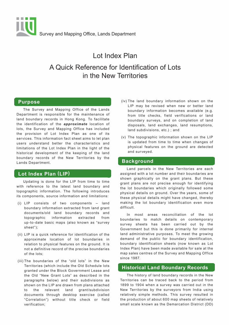
Lot Index Plan A Quick Reference for Identification of Lots in the New Territories Survey and Mapping Office, Lands Department Purpose The Survey and Mapping Office of the Lands Department is responsible for the maintenance of land boundary records in Hong Kong. To facilitate the identification of the approximate location of lots, the Survey and Mapping Office has included the provision of Lot Index Plan as one of its services. This information fact sheet aims to let plan users understand better the characteristics and limitations of the Lot Index Plan in the light of the historical development of the keeping of the land boundary records of the New Territories by the Lands Department. Lot Index Plan ( LIP ) Updating is done for the LIP from time to time with reference to the latest land boundary and topographic information. The following introduces its components, source information and limitations: (i) LIP consists of two components – land boundary information extracted from land grant documents/old land boundary records and topographic information extracted from up-to-date basic maps (also known as “survey sheet”); (ii) LIP is a quick reference for identification of the approximate location of lot boundaries in relation to physical features on the ground. It is not a definitive record of the precise boundaries of the lots; (iii) The boundaries of the “old lots” in the New Territories (which include the Old Schedule lots granted under the Block Government Lease and the Old “New Grant Lots” as described in the paragraphs below) and their subdivisions as shown on the LIP are drawn from plans attached to the relevant land grant/subdivision documents through desktop exercise (called “Correlation”) without title check or field verification; (iv) The land boundary information shown on the LIP may be revised when new or better land boundary information becomes available (e.g. from title checks, field verifications or land boundary surveys, and on completion of land disposals, land exchanges, land resumptions, land subdivisions, etc.) ; and (v) The topographic information shown on the LIP is updated from time to time when changes of physical features on the ground are detected and surveyed. Background Land parcels in the New Territories are each assigned with a lot number and their boundaries are shown graphically on the grant plans. But these grant plans are not precise enough for identifying the lot boundaries which originally followed some physical details on ground. Over the years, some of these physical details might have changed, thereby making the lot boundary identification even more difficult. In most areas reconciliation of the lot boundaries to match details on contemporary survey sheets has been carried out by the Government but this is done primarily for internal land administrative purposes. To meet the growing demand of the public for boundary identification, boundary identification sheets (now known as Lot Index Plan) have been made available for sale at the map sales centres of the Survey and Mapping Office since 1987. Historical Land Boundary Records The history of land boundary records in the New Territories can be traced back to the period from 1899 to 1904 when a survey was carried out in the New Territories by the surveyors from India using relatively simple methods. This survey resulted in the production of about 600 map sheets of relatively small scale known as the Demarcation District (DD)
Transcript of Lot Index Plan A Quick Reference for Identification of Lots
Lot Index Plan
A Quick Reference for Identification of Lotsin the New Territories
Survey and Mapping Office, Lands Department
Purpose The Survey and Mapping Of f ice of the Lands Depar tment is responsible for the maintenance of land boundary records in Hong Kong. To facil i tate the identif ication of the approximate location of lots, the Survey and Mapping Of f ice has included the provision of Lot Index Plan as one of its services. This information fact sheet aims to let plan users understand bet ter the character ist ics and limitations of the Lot Index Plan in the light of the histor ical development of the keeping of the land boundary records of the New Terr itor ies by the Lands Depar tment.
Lot Index Plan (LIP) Updating is done for the LIP from time to t ime with reference to the latest land boundary and topographic information. The following introduces its components, source information and limitations:
(i) LIP consists of two components – land boundary information extracted from land grant documents/old land boundary records and topographic information extracted from up-to-date basic maps (also known as “survey sheet ”);
(i i) LIP is a quick reference for identif ication of the approximate location of lot boundaries in relation to physical features on the ground. It is not a def init ive record of the precise boundaries of the lots;
(i i i) The boundaries of the “old lots” in the New Terr itor ies (which include the Old Schedule lots granted under the Block Government Lease and the Old “New Grant Lots” as described in the paragraphs below) and their subdivisions as shown on the LIP are drawn from plans at tached to the relevant land grant /subdivision documents through desktop exercise (called “Correlation”) without t it le check or f ield ver if ication;
(iv) The land boundary information shown on the LIP may be revised when new or bet ter land boundary information becomes available (e.g. from tit le checks, f ield ver if ications or land boundary surveys, and on completion of land disposals, land exchanges, land resumptions, land subdivisions, etc.) ; and
(v) The topographic information shown on the LIP is updated from time to t ime when changes of physical features on the ground are detected and surveyed.
Background Land parcels in the New Terr itor ies are each assigned with a lot number and their boundaries are shown graphically on the grant plans. But these grant plans are not precise enough for identifying the lot boundaries which or iginally followed some physical details on ground. Over the years, some of these physical details might have changed, thereby making the lot boundary identif ication even more dif f icult.
In most areas reconcil iat ion of the lot boundaries to match details on contemporary survey sheets has been carr ied out by the Government but this is done pr imarily for internal land administrative purposes. To meet the growing demand of the public for boundary identif ication, boundary identif ication sheets (now known as Lot Index Plan) have been made available for sale at the map sales centres of the Survey and Mapping Of f ice since 1987.
Historical Land Boundary Records The history of land boundary records in the New Terr itor ies can be traced back to the period from 1899 to 1904 when a survey was carr ied out in the New Terr itor ies by the surveyors from India using relatively simple methods. This survey resulted in the production of about 600 map sheets of relatively small scale known as the Demarcation Distr ict (DD)
Sheets. These sheets show individual lot boundaries but without any gr id reference to facil i tate locating them on the ground. In the late 1950s, surveys using bet ter methods produced a series of survey sheets which showed the ground features but without any land boundary information. These two sources of information have to be reconciled so as to enable the identif ication of the boundaries of land parcels in relation to the up-to-date ground features. This exercise is known as “Correlation”. An extract from a DD sheet, the corresponding area as shown on an old survey sheet, the correlated sheet representation and changes as ref lected on the LIP are shown on next page.
The following paragraphs detail the at tr ibutes of these land boundary records that explain the limitations of the LIP.
DD Sheets These were record sheets prepared at a scale of 16 inches or 32 inches to the mile (i.e. 1/3960 or 1/1980 respectively) to depict the situation of land occupation at the t ime of survey. The survey was carr ied out pr imarily for the purpose of land ownership identif ication and rent assessment. Boundaries were shown graphically without any dimension. The accuracy of these sheets was relatively low, as a higher order of accuracy was not required for the or iginal purpose.
Areas of lots were scaled of f the DD sheets and the smallest unit of 0.01 acre was adopted for recording purposes. Even disregarding the possible scaling of f error in the area determination, the rounding of f error itself would amount to a cer tain degree of discrepancy, par ticular ly in the case of land parcels smaller than 0.01 acre where areas were sti l l recorded as 0.01 acre. It follows that any at tempt to conver t such unit area of 0.01 acre to 435.6 square feet (or the equivalent in square metres) is bound to create false accuracy in the area measurement.
Old “New Grant Lots” Subsequent to the survey in the period 1899-1904, all unclaimed land was declared to be Crown Land (now known as Government Land) and later selected areas were disposed of by public auction or direct sale as New Grant Lots. Of ten no survey was carr ied out for these land grants nor were these lots recorded properly on the record sheets. The boundary information and the areas of these lots could be even less accurate than those lots granted under Block Government Lease (formerly known as Block Crown Lease). This method of land grant continued unti l the ear ly 1960s. An example of a grant plan of an old “New Grant Lot ” is shown on next page.
Section Boundaries In the past, many of the lots were subdivided according to the wish of the owners. The usual practice was to ef fect the subdivision purely on paper and therefore any error inherent in the or iginal lot would be perpetuated in the subdivision plan. The situation was fur ther complicated through the recording of these subdivision areas to the smallest unit of 0.01 acres. This gave r ise to cases where a small lot with a recorded area of 0.01 acre could be split into two or more subdivisions, each of which would then be given a recorded area of 0.01 acre. Such situation continued unti l the Land Survey Ordinance came into operation in 1996.
Correlation Exercise and Correlated Boundaries The exercise is to correlate those less precise and even uncer tain lot boundaries in graphical form with the properly surveyed lots and map features so as to produce a set of LIP for the identif ication of the general location of land parcels. In no way can the correlation exercise improve upon the accuracy and precision or rectify the error, i f any, of the graphical lot boundaries of these old lots.
Correlated boundaries and in par ticular subdivision boundaries, must not be interpreted as def init ive. They are both subject to survey. Fur thermore, areas of lots should also be treated with similar caution. Areas scaled of f from these boundaries can be signif icantly dif ferent from the registered areas.
The only way to determine lot boundary is by conducting a proper land boundary survey.
Note : The Lands Depar tment reserves the r ight to revise the
correlated boundar ies shown on Lot Index Plan when
bet ter boundary evidences are avai lable. A disclaimer is
pr inted on Lot Index Plan to make its users aware that the
information on Lot Index Plan may be revised without
pr ior not i f icat ion. Author ized Land Surveyors registered
under the Land Survey Ordinance should be employed to
def ine the precise boundar ies of lots or be consulted on
problems relat ing to lot boundar ies.
Issued in Apr i l 2013

8. See overleaf for a Lot Index Plan
1. D.D. Sheet
2. New Grant Lot
3. D.D. Enlargement 4. Survey Sheet
5. Correlated Sheet
6. Updated Boundary Information
7. Updated Map Information
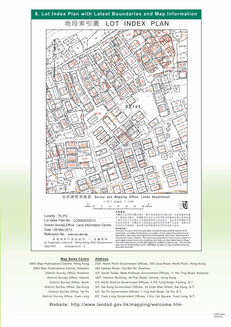
8. Lot Index Plan with Latest Boundaries and Map Information
Website: ht tp: / /www.landsd.gov.hk/mapping/welcome.htm
Address23/F, North Point Government Offices, 333 Java Road, North Point, Hong Kong
382 Nathan Road, Yau Ma Tei, Kowloon
3/F, South Tower, West Kowloon Government Offices, 11 Hoi Ting Road, Kowloon
18/F, Harbour Building, 38 Pier Road, Central, Hong Kong
5/F, North District Government Offices, 3 Pik Fung Road, Fanling, N.T.
3/F, Sai Kung Government Offices, 34 Chan Man Street, Sai Kung, N.T.
5/F, Tai Po Government Offices, 1 Ting Kok Road, Tai Po, N.T.
8/F, Yuen Long Government Offices, 2 Kiu Lok Square, Yuen Long, N.T.
Map Sales CentreSMO Map Publications Centre, Hong Kong
SMO Map Publications Centre, Kowloon
District Survey Office, Kowloon
District Survey Office, Islands
District Survey Office, North
District Survey Office, Sai Kung
District Survey Office, Tai Po
District Survey Office, Yuen Long
LDPM_0044(04/2013)