lorigalorica.files.wordpress.com · Loriga Civil parish Location in Portugal Coordinates: 40.324°N...
179
Loriga Civil parish Location in Portugal Coordinates: 40.324°N 7.691°W Country Portugal Region Centro Intermunic. comm. Beiras e Serra da Estrela District Guarda Municipality Seia Area • Total 36.25 km 2 (14.00 sq mi) Elevation 750 m (2,460 ft) Loriga Loriga (Portuguese pronunciation: [loˈɾiɡɐ]) is a civil parish ( Portuguese: freguesia) and town in south- central part of the municipality of Seia, in central Portugal. Part of the district of Guarda, it is 20 km away from the city of Seia, 40 km away from Viseu, 80 km away from Guarda and 320 km from Lisbon, nestled in the Serra da Estrela mountain range. The population in 2011 was 1,053, [1] in an area of 36.25 km², [2] including the two localities, the town of Loriga and the village of Fontão. History Middle Ages Monarchy Geography Economy References External links Loriga was founded along a column between ravines where today the historic centre exists. The site was ostensibly selected more than 2000 years ago, owing to its defensibility, the abundance of potable water Coordinates: 40.324°N 7.691°W Contents History The remaining Roman-era bridge crossing the Ribeira de Loriga 1 of 4
Transcript of lorigalorica.files.wordpress.com · Loriga Civil parish Location in Portugal Coordinates: 40.324°N...

LorigaCivil parish
Location in PortugalCoordinates: 40.324°N 7.691°W
Country PortugalRegion CentroIntermunic.comm.
Beiras e Serra daEstrela
District GuardaMunicipality Seia
Area • Total 36.25 km2
(14.00 sq mi)
Elevation 750 m (2,460 ft)
LorigaLoriga (Portuguese pronunciation: [loˈɾiɡɐ]) is a civilparish (Portuguese: freguesia) and town in south-central part of the municipality of Seia, in centralPortugal. Part of the district of Guarda, it is 20 kmaway from the city of Seia, 40 km away from Viseu,80 km away from Guarda and 320 km from Lisbon,nestled in the Serra da Estrela mountain range. Thepopulation in 2011 was 1,053,[1] in an area of36.25 km²,[2] including the two localities, the townof Loriga and the village of Fontão.
HistoryMiddle AgesMonarchy
GeographyEconomyReferencesExternal links
Loriga was founded along a column between ravineswhere today the historic centre exists. The site wasostensibly selected more than 2000 years ago, owingto its defensibility, the abundance of potable water
Coordinates: 40.324°N 7.691°W
Contents
History
The remaining Roman-era bridgecrossing the Ribeira de Loriga
1 of 4

Population (2011) • Total 1,053 • Density 29/km2 (75/sq mi)
Time zone UTC±00:00 (WET) • Summer (DST) UTC+01:00 (WEST)
Postal code 6270Area code 238
Patron Santa Maria Maior
and pasturelands, and lowlands that providedconditions to practice both hunting andgathering/agriculture.
When the Romans arrived in the region, thesettlement was concentrated into two areas. Thelarger, older and principal agglomeration wassituated in the area of the main church and Rua deViriato, fortified with a wall and palisade. Thesecond group, in the Bairro de São Ginês, were somesmall homes constructed on the rocky promintory, which were later appropriated by theVisigoths in order to construct a chapel. The 1st century Roman road and two bridges (thesecond was destroyed in the 16th century after flooding in the Ribeira de Loriga) connected theoutpost of Lorica to the rest of their Lusitanian province. The São Ginês' neighbouhood (SãoGens), a local ex-libris, is the location of the chapel of Nossa Senhora do Carmo, an ancientVisigothic chapel.
Loriga was the municipal seat since the 12th century, receiving Forals in 1136 (João Rhânia,master of the Terras de Loriga for over two decades, during the reign of Afonso Henriques),1249 (during the reign of Afonso III), 1474 (under King Afonso V) and finally in 1514 (by KingManuel I).
Loriga was an ecclesiastical parish of the vicarage of the Royal Padroado and its Matriz Churchwas ordered to construct in 1233, by King Sancho II. This church, was to the invocation of SantaMaria Maior, and constructed over the ancient small Visigothic chapel (there is a lateral blockwith Visigoth inscriptions visible). Constructed in the Romanesque-style it consists of a three-nave building, with hints of the Old Cathedral of Coimbra. This structure was destroyed duringthe 1755 earthquake, and only portions of the lateral walls were preserved.
The 1755 earthquake resulted in significant damage to the town of Loriga, destroying homesand the parochial residence, in addition to opening-up cracks and faults in the town's largerbuildings, such as the historic municipal council hall (constructed in the 13th century). Anemissary of the Marquess of Pombal visited Loriga to evaluate the damage (something that didnot happen in other nearby biggest parishes, like Covilhã) and provide support.
The residents of Loriga supported the Asolutionist forces of the Infante Miguel of Portugalagainst the Liberals, during the Portuguese Liberal Wars. It ceased to be the seat of amunicipality in 1855 after the application of a territorial planning carried out during the XIXcentury, interestingly the same plan that gave rise to the Districts.
At the time of its municipal demise (October 1855), the municipality of Loriga included theparishes of Alvoco da Serra, Cabeça, Sazes da Beira, Teixeira, Valezim and Vide, as well as thirtyother disincorporated villages.
Loriga was an industrial centre for textile manufacturing during the 19th century. It was one of
Middle Ages
Monarchy
2 of 4
the few industrialized centres of the region, even supplanting Seia until the middle of the 20thcentury. Only Covilhã out-performed Loriga in terms of businesses operating from its lands;companies such as Regato, Redondinha, Fonte dos Amores, Tapadas, Fândega, Leitão &Irmãos, Augusto Luís Mendes, Lamas, Nunes Brito, Moura Cabral and Lorimalhas, amongothers. The main roadway in Loriga, Avenida Augusto Luís Mendes, is named for one of thevillages most illustrious industrialists. The wool industry started to decline during the lastdecades of the 20th century, a factor that aggravated and accelerated the decline of the region.
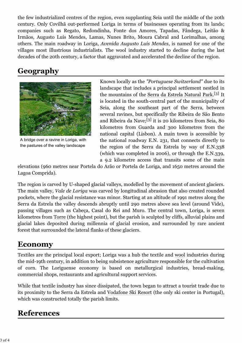
Known locally as the "Portuguese Switzerland" due to itslandscape that includes a principal settlement nestled inthe mountains of the Serra da Estrela Natural Park.[3] Itis located in the south-central part of the municipality ofSeia, along the southeast part of the Serra, betweenseveral ravines, but specifically the Ribeira de São Bentoand Ribeira da Nave;[3] it is 20 kilometres from Seia, 80kilometres from Guarda and 300 kilometres from thenational capital (Lisbon). A main town is accessible bythe national roadway E.N. 231, that connects directly tothe region of the Serra da Estrela by way of E.N.338(which was completed in 2006), or through the E.N.339,a 9.2 kilometre access that transits some of the main
elevations (960 metres near Portela do Arão or Portela de Loriga, and 1650 metres around theLagoa Comprida).
The region is carved by U-shaped glacial valleys, modelled by the movement of ancient glaciers.The main valley, Vale de Loriga was carved by longitudinal abrasion that also created roundedpockets, where the glacial resistance was minor. Starting at an altitude of 1991 metres along theSerra da Estrela the valley descends abruptly until 290 metres above sea level (around Vide),passing villages such as Cabeça, Casal do Rei and Muro. The central town, Loriga, is sevenkilometres from Torre (the highest point), but the parish is sculpted by cliffs, alluvial plains andglacial lakes deposited during millennia of glacial erosion, and surrounded by rare ancientforest that surrounded the lateral flanks of these glaciers.
Textiles are the principal local export; Loriga was a hub the textile and wool industries duringthe mid-19th century, in addition to being subsistence agriculture responsible for the cultivationof corn. The Loriguense economy is based on metallurgical industries, bread-making,commercial shops, restaurants and agricultural support services.
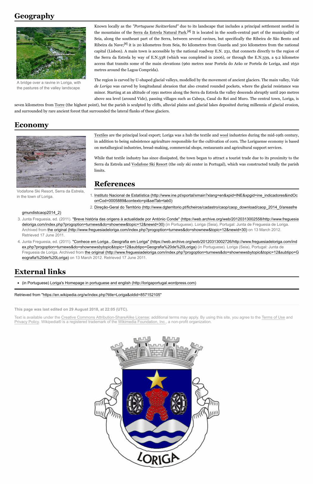
While that textile industry has since dissipated, the town began to attract a tourist trade due toits proximity to the Serra da Estrela and Vodafone Ski Resort (the only ski center in Portugal),which was constructed totally the parish limits.
Geography
A bridge over a ravine in Loriga, withthe pastures of the valley landscape
Economy
References
3 of 4

1. Instituto Nacional de Estatística (http://www.ine.pt/xportal/xmain?xlang=en&xpid=INE&xpgid=ine_indicadores&indOcorrCod=0005889&contexto=pi&selTab=tab0)
2. Áreas das freguesias, concelhos, distritos e país (http://www.dgterritorio.pt/cartografia_e_geodesia/cartografia/carta_administrativa_oficial_de_portugal_caop_/caop__download_/carta_administrativa_oficial_de_portugal___versao_2017__em_vigor_/)
3. Junta Freguesia, ed. (2011). "Conhece emLoriga...Geografia em Loriga" (https://web.archive.org/web/20120313002726/http://www.freguesiadeloriga.com/index.php?progoption=turnews&do=shownewsbytopic&topic=12&subtipo=Geografia%20de%20Loriga) (inPortuguese). Loriga (Seia), Portugal: Junta de Freguesia
de Loriga. Archived from the original (http://www.freguesiadeloriga.com/index.php?progoption=turnews&do=shownewsbytopic&topic=12&subtipo=Geografia%20de%20Loriga) on 13March 2012. Retrieved 17 June 2011.
Loriga's Homepage (http://lorigaportugal.wordpress.com)
Retrieved from "https://en.wikipedia.org/w/index.php?title=Loriga&oldid=946044125"
This page was last edited on 17 March 2020, at 18:43 (UTC).
Text is available under the Creative Commons Attribution-ShareAlike License; additional terms may apply. Byusing this site, you agree to the Terms of Use and Privacy Policy. Wikipedia® is a registered trademark of theWikimedia Foundation, Inc., a non-profit organization.
Vodafone Ski Resort, Serra da Estrela,in the town of Loriga.
External links
4 of 4

LorigaCivil parish
Coordinates: 40.324°N 7.691°W
Country PortugalRegion CentroIntermunic.comm.
Beiras e Serra da Estrela
District GuardaMunicipality Seia
Area
LorigaLoriga (Portuguese pronunciation: [loˈɾiɡɐ]) is a civil parish
(Portuguese: freguesia) and town in south-central part
of the municipality of Seia, in central Portugal. Part of
the district of Guarda, it is 20 km away from the city of
Seia, 40 km away from Viseu, 80 km away from Guarda
and 320 km from Lisbon, nestled in the Serra da Estrela
mountain range. The population in 2011 was 1,053,[1] in
an area of 36.25 km²,[2] including the two localities, the
town of Loriga and the village of Fontão.
HistoryMiddle AgesMonarchy
GeographyEconomyReferencesExternal links
Loriga was founded along a column between ravines
where today the historic centre exists. The site was
ostensibly selected more than 2600 years ago, owing to
its defensibility, the abundance of potable water and
pasturelands, and lowlands that provided conditions to
practice both hunting and gathering/agriculture.[3]
Loriga
Coordinates: 40.324°N 7.691°W
Contents
History
The remaining Roman-era bridgecrossing the Ribeira de Loriga

• Total 36.25 km2 (14.00 sq mi)
Elevation 750 m (2,460 ft)
Population (2011) • Total 1,053 • Density 29/km2 (75/sq mi)
Postal code 6270Area code 238
Patron Santa Maria Maior
Website http://lorigaportugal.wordpress.com
When the Romans arrived in the region, the settlement
was concentrated into two areas. The larger, older and
principal agglomeration was situated in the area of the
main church and Rua de Viriato, fortified with a wall
and palisade.[3] The second group, in the Bairro de SãoGinês, were some small homes constructed on the rocky
promintory, which were later appropriated by the
Visigoths in order to construct a chapel.[3] The 1st
century Roman road and two bridges (the second was
destroyed in the 16th century after flooding in the
Ribeira de São Bento) connected the outpost of Lorica to
the rest of their Lusitanian province.[3] The barrio of São Ginês (São Gens), a local ex-libris, is the location of the
chapel of Nossa Senhora do Carmo, an ancient Visigothic chapel. São Gens, a Celtic saint, martyred in Arles na Gália,
during the reign of Emperor Diocletian, and over time the locals began to refer to this saint as São Ginês, due to its
easy of pronunciation.[3]
Loriga was the municipal seat since the 12th century, receiving forals in 1136 (João Rhânia, master of the Terras deLoriga for over two decades, during the reign of Afonso Henriques), 1249 (during the reign of Afonso III), 1474 (under
King Afonso V) and finally in 1514 (by King Manuel I).[3]
Loriga was an ecclesiastical parish of the vicarage of the Royal Padroado and its Matriz Church was ordered
constructed in 1233, by King Sancho II.[3] This church, was to the invokation of Santa Maria Maior, and constructed
over the ancient small Visigothic chapel (there is a lateral block with Visigoth inscriptions visible).[3] Constructed in
the Romanesque-style it consists of a three-nave building, with hints of the Sé Velha of Coimbra. This structure was
destroyed during the 1755 earthquake, and only portions of the lateral walls were preserved.[3]
The 1755 earthquake resulted in significant damage to the town of Loriga, destroying homes and the parcochial
residence, in addition to opening-up cracks and faults in the town's larger buildings, such as the historic municipal
council hall (constructed in the 13th century).[3] An emissary of the Marquess of Pombal actually visited Loriga to
evaluate the damage (something that did not happen in other mountainous parishes, even Covilhã) and provide
support.[3]
The residents of Loriga supported the Asolutionist forces of the Infante Miguel of Portugal against the Liberals, during
the Portuguese Liberal Wars, which resulted in Loriga being abandoned politically after Miguel's expulsion by his
brother King Peter.[3] In 1855, as a consequence of its support, it was stripped of municipal status during the
municipal reforms of the 19th century.[3] At the time of its municipal demise (October 1855), the municipality of Loriga
included the parishes of Alvoco da Serra, Cabeça, Sazes da Beira, Teixeira, Valezim and Vide, as well as thirty other
disincorporated villages.[3]
Loriga was an industrial centre for textile manufacturing during the 19th century. It was one of the few industrialized
centres in the Beira Interior region, even supplanting Seia until the middle of the 20th century.[3] Only Covilhã out-
performed Loriga in terms of businesses operating from its lands; companies such as Regato, Redondinha, Fonte dos
Amores, Tapadas, Fândega, Leitão & Irmãos, Augusto Luís Mendes, Lamas, Nunes Brito, Moura Cabral and
Lorimalhas, among others.[3] The main roadway in Loriga, Avenida Augusto Luís Mendes, is named for one of the
villages most illustrious industrialists. The wool industry started to decline during the last decades of the 20th century,
a factor that aggravated and accelerated the decline of the region.[3]
Middle Ages
Monarchy

Known locally as the "Portuguese Switzerland" due to its landscape that
includes a principal settlement nestled in the mountains of the Serra da
Estrela Natural Park.[4] It is located in the south-central part of the
municipality of Seia, along the southeast part of the Serra, between
several ravines, but specifically the Ribeira de São Bento and Ribeira da
Nave;[4] it is 20 kilometres from Seia, 80 kilometres from Guarda and
300 kilometres from the national capital (Lisbon). A main town is
accessible by the national roadway E.N. 231, that connects directly to the
region of the Serra da Estrela by way of E.N.338 (which was completed
in 2006), or through the E.N.339, a 9.2 kilometre access that transits
some of the main elevations (960 metres near Portela do Arão or Portela
de Loriga, and 1650 metres around the Lagoa Comprida).
The region is carved by U-shaped glacial valleys, modelled by the movement of ancient glaciers. The main valley, Valede Loriga was carved by longitudanal abrasion that also created rounded pockets, where the glacial resistance was
minor. Starting at an altitude of 1991 metres along the Serra da Estrela the valley descends abruptly until 290 metres
above sea level (around Vide), passing villages such as Cabeça, Casal do Rei and Muro. The central town, Loriga, is
seven kilometres from Torre (the highest point), but the parish is sculpted by cliffs, alluvial plains and glacial lakes
deposited during millennia of glacial erosion, and surrounded by rare ancient forest that surrounded the lateral flanks
of these glaciers.
Textiles are the principal local export; Loriga was a hub the textile and
wool industries during the mid-19th century, in addition to being
subsistence agriculture responsible for the cultivation of corn. The
Loriguense economy is based on metallurgical industries, bread-making,
commercial shops, restaurants and agricultural support services.
While that textile industry has since dissipated, the town began to
attract a tourist trade due to its proximity to the Serra da Estrela and
Vodafone Ski Resort (the only ski center in Portugal), which was
constructed totally the parish limits.
1. Instituto Nacional de Estatística (http://www.ine.pt/xportal/xmain?xlang=en&xpid=INE&xpgid=ine_indicadores&indOcorrCod=0005889&contexto=pi&selTab=tab0)
2. Áreas das freguesias, concelhos, distritos e país (http://www.dgterritorio.pt/cartografia_e_geodesia/cartografia/carta_administrativa_oficial_de_portugal_caop_/caop__download_/carta_administrativa_oficial_de_portugal___versao_2017__em_vigor_/)
3. Junta Freguesia, ed. (2011). "Breve história das origens à actualidade por António Conde" (https://web.archive.org/web/20120313002558/http://www.freguesiadeloriga.com/index.php?progoption=turnews&do=shownew&topic=12&newid=30) (in Portuguese). Loriga (Seia), Portugal: Junta de Freguesia de Loriga. Archived from the original (http://www.freguesiadeloriga.com/index.php?progoption=turnews&do=shownew&topic=12&newid=30) on 13 March2012. Retrieved 17 June 2011.
4. Junta Freguesia, ed. (2011). "Conhece em Loriga...Geografia em Loriga" (https://web.archive.org/web/20120313002726/http://www.freguesiadeloriga.com/index.php?progoption=turnews&do=shownewsbytopic&topic=12&subtipo=Geografia%20de%20Loriga) (in Portuguese). Loriga (Seia), Portugal: Junta de Freguesia de Loriga. Archived
Geography
A bridge over a ravine in Loriga, withthe pastures of the valley landscape
Economy
Vodafone Ski Resort, Serra da Estrela,in the town of Loriga.
References

from the original (http://www.freguesiadeloriga.com/index.php?progoption=turnews&do=shownewsbytopic&topic=12&subtipo=Geografia%20de%20Loriga) on 13 March 2012. Retrieved 17 June 2011.
(in Portuguese) Loriga's Homepage in portuguese and english (http://lorigaportugal.wordpress.com)
Retrieved from "https://en.wikipedia.org/w/index.php?title=Loriga&oldid=871988084"
This page was last edited on 4 December 2018, at 16:21 (UTC).
Text is available under the Creative Commons Attribution-ShareAlike License; additional terms may apply. By usingthis site, you agree to the Terms of Use and Privacy Policy. Wikipedia® is a registered trademark of the WikimediaFoundation, Inc., a non-profit organization.
External links

LorigaCivil parish
Coordinates: 40.324°N 7.691°W
Country PortugalRegion CentroSubregion Serra da EstrelaIntermunic.comm.
Beiras e Serra daEstrela
District GuardaMunicipality Seia
Area • Total 36.25 km2 (14.00 sq mi)
Elevation 750 m (2,460 ft)
Population (2011) • Total 1,053 • Density 29/km2 (75/sq mi)
Postal code 6270Area code 238
Patron Santa Maria Maior
Website http://www.loriga.info
LorigaLoriga (Portuguese pronunciation: [luˈɾiɡɐ]) is a civil parish (Portuguese: freguesia) and town in south-
central part of the municipality of Seia, in central Portugal. Part of the district of Guarda, it is 20 km away
from the city of Seia, 40 km away from Viseu, 80 km away from Guarda and 320 km from Lisbon, nestled
in the Serra da Estrela mountain range. The population in 2011 was 1,053,[1] in an area of 36.25 km²,[2]
including the two localities/villages of Loriga and Fontão.
HistoryMiddle AgesMonarchy
GeographyEconomyReferencesExternal links
Loriga was founded along a column between ravines where
today the historic centre exists. The site was ostensibly
selected more than 2600 years ago, owing to its
defensibility, the abundance of potable water and
pasturelands, and lowlands that provided conditions to
practice both hunting and gathering/agriculture.[3]
When the Romans arrived in the region, the settlement was
concentrated into two areas. The larger, older and principal
agglomeration was situated in the area of the main church
and Rua de Viriato, fortified with a wall and palisade.[3] The
second group, in the Bairro de São Ginês, were some small
homes constructed on the rocky promintory, which were
later appropriated by the Visigoths in order to construct a chapel.[3] The 1st century Roman road and two
bridges (the second was destroyed in the 16th century after flooding in the Ribeira de São Bento)
connected the outpost of Lorica to the rest of their Lusitanian province.[3] The barrio of São Ginês (SãoGens), a local ex-libris, is the location of the chapel of Nossa Senhora do Carmo, an ancient Visigothic
chapel. São Gens, a Celtic saint, martyred in Arles na Gália, during the reign of Emperor Diocletian, and
over time the locals began to refer to this saint as São Ginês, due to its easy of pronunciation.[3]
Loriga was the municipal seat since the 12th century, receiving forals in 1136 (João Rhânia, master of the
Terras de Loriga for over two decades, during the reign of Afonso Henriques), 1249 (during the reign of
Afonso III), 1474 (under King Afonso V) and finally in 1514 (by King Manuel I).[3]
Loriga was an ecclesiastical parish of the vicarage of the Royal Padroado and its Matriz Church was
ordered constructed in 1233, by King Sancho II.[3] This church, was to the invokation of Santa MariaMaior, and constructed over the ancient small Visigothic chapel (there is a lateral block with Visigoth
inscriptions visible).[3] Constructed in the Romanesque-style it consists of a three-nave building, with
hints of the Sé Velha of Coimbra. This structure was destroyed during the 1755 earthquake, and only
portions of the lateral walls were preserved.[3]
The 1755 earthquake resulted in significant damage to the town of Loriga, destroying homes and the
parcochial residence, in addition to opening-up cracks and faults in the town's larger buildings, such as
the historic municipal council hall (constructed in the 13th century).[3] An emissary of the Marquess of
Pombal actually visited Loriga to evaluate the damage (something that did not happen in other mountainous parishes, even Covilhã) and provide support.[3]
The residents of Loriga supported the Asolutionist forces of the Infante Miguel of Portugal against the Liberals, during the Portuguese Liberal Wars, which resulted
in Loriga being abandoned politically after Miguel's expulsion by his brother King Peter.[3] In 1855, as a consequence of its support, it was stripped of municipal
status during the municipal reforms of the 19th century.[3] At the time of its municipal demise (October 1855), the municipality of Loriga included the parishes of
Alvoco da Serra, Cabeça, Sazes da Beira, Teixeira, Valezim and Vide, as well as thirty other disincorporated villages.[3]
Loriga was an industrial centre for textile manufacturing during the 19th century. It was one of the few industrialized centres in the Beira Interior region, even
supplanting Seia until the middle of the 20th century.[3] Only Covilhã out-performed Loriga in terms of businesses operating from its lands; companies such as
Regato, Redondinha, Fonte dos Amores, Tapadas, Fândega, Leitão & Irmãos, Augusto Luís Mendes, Lamas, Nunes Brito, Moura Cabral and Lorimalhas, among
others.[3] The main roadway in Loriga, Avenida Augusto Luís Mendes, is named for one of the villages most illustrious industrialists. The wool industry started to
decline during the last decades of the 20th century, a factor that aggravated and accelerated the decline of the region.[3]
Loriga
Coordinates: 40.324°N 7.691°W
Contents
History
The remaining Roman-era bridgecrossing the Ribeira de Loriga
Middle Ages
Monarchy
Known locally as the "Portuguese Switzerland" due to its landscape that includes a principal settlement nestled in
the mountains of the Serra da Estrela Natural Park.[4] It is located in the south-central part of the municipality of
Seia, along the southeast part of the Serra, between several ravines, but specifically the Ribeira de São Bento and
Ribeira da Nave;[4] it is 20 kilometres from Seia, 80 kilometres from Guarda and 300 kilometres from the national
capital (Lisbon). A main town is accessible by the national roadway E.N. 231, that connects directly to the region of
the Serra da Estrela by way of E.N.338 (which was completed in 2006), or through the E.N.339, a 9.2 kilometre
access that transits some of the main elevations (960 metres near Portela do Arão or Portela de Loriga, and 1650
metres around the Lagoa Comprida).
The region is carved by U-shaped glacial valleys, modelled by the movement of ancient glaciers. The main valley, Valede Loriga was carved by longitudanal abrasion that also created rounded pockets, where the glacial resistance was
minor. Starting at an altitude of 1991 metres along the Serra da Estrela the valley descends abruptly until 290 metres
above sea level (around Vide), passing villages such as Cabeça, Casal do Rei and Muro. The central town, Loriga, is
seven kilometres from Torre (the highest point), but the parish is sculpted by cliffs, alluvial plains and glacial lakes deposited during millennia of glacial erosion,
and surrounded by rare ancient forest that surrounded the lateral flanks of these glaciers.
Textiles are the principal local export; Loriga was a hub the textile and wool industries during the mid-19th century,
in addition to being subsistence agriculture responsible for the cultivation of corn. The Loriguense economy is based
on metallurgical industries, bread-making, commercial shops, restaurants and agricultural support services.
While that textile industry has since dissipated, the town began to attract a tourist trade due to its proximity to the
Serra da Estrela and Vodafone Ski Resort (the only ski center in Portugal), which was constructed totally the parish
limits.
1. Instituto Nacional de Estatística (http://www.ine.pt/xportal/xmain?xlang=en&xpid=INE&xpgid=ine_indicadores&indOcorrCod=0005889&contexto=pi&selTab=tab0)
2. Direção-Geral do Território (http://www.dgterritorio.pt/ficheiros/cadastro/caop/caop_download/caop_2014_0/areasfregmundistcaop2014_2)
3. Junta Freguesia, ed. (2011). "Breve história das origens à actualidade por António Conde" (https://web.archive.org/web/20120313002558/http://www.freguesiadeloriga.com/index.php?progoption=turnews&do=shownew&topic=12&newid=30) (in Portuguese). Loriga (Seia), Portugal: Junta de Freguesia de Loriga.Archived from the original (http://www.freguesiadeloriga.com/index.php?progoption=turnews&do=shownew&topic=12&newid=30) on 13 March 2012.Retrieved 17 June 2011.
4. Junta Freguesia, ed. (2011). "Conhece em Loriga...Geografia em Loriga" (https://web.archive.org/web/20120313002726/http://www.freguesiadeloriga.com/index.php?progoption=turnews&do=shownewsbytopic&topic=12&subtipo=Geografia%20de%20Loriga) (in Portuguese). Loriga (Seia), Portugal: Junta deFreguesia de Loriga. Archived from the original (http://www.freguesiadeloriga.com/index.php?progoption=turnews&do=shownewsbytopic&topic=12&subtipo=Geografia%20de%20Loriga) on 13 March 2012. Retrieved 17 June 2011.
(in Portuguese) Loriga's Homepage in portuguese and english (http://lorigaportugal.wordpress.com)
Retrieved from "https://en.wikipedia.org/w/index.php?title=Loriga&oldid=857152105"
This page was last edited on 29 August 2018, at 22:05 (UTC).
Text is available under the Creative Commons Attribution-ShareAlike License; additional terms may apply. By using this site, you agree to the Terms of Use andPrivacy Policy. Wikipedia® is a registered trademark of the Wikimedia Foundation, Inc., a non-profit organization.
Geography
A bridge over a ravine in Loriga, withthe pastures of the valley landscape
Economy
Vodafone Ski Resort, Serra da Estrela,in the town of Loriga.
References
External links

LorigaCivil parish
Coordinates: 40.324°N 7.691°W
Country PortugalRegion CentroSubregion Serra da EstrelaIntermunic.comm.
Beiras e Serra daEstrela
District GuardaMunicipality Seia
Area• Total 36.25 km2
(14.00 sq mi)
LorigaFrom Wikipedia, the free encyclopediaLoriga (Portuguese pronunciation: [lッˈɾiɡɐ]) is a civil parish(Portuguese: freguesia) in southcentral part of the municipality ofSeia, in central Portugal. Part of the district of Guarda, it is 20 kmaway from Seia, 40 km away from Viseu, 80 km awayfrom Guarda and 320 km from Lisbon, nestled in the Serra daEstrela mountain range. The population in 2011 was 1,053,[1] in anarea of 36.25 km²,[2] including the two localitiesL@エエッ of Loriga and エ Fontão.
Contents
1 History1.1 Middle Ages1.2 Monarchy
2 Geography3 Economy4 References5 External links
History
Loriga was foundedalong a column betweenravines where today thehistoric centre exists.The site was ostensiblyselected more than 2600years ago, owing to itsdefensibility, theabundance of potablewater and pasturelands,and lowlands thatprovided conditions topractice both hunting andgathering/agriculture.[3]
When the Romans arrived in the region, the settlement wasconcentrated into two areas. The larger, older and principalagglomeration was situated in the area of the main church and Ruade Viriato, fortified with a wall and palisade.[3] The second group,in the Bairro de São Ginês, were some small homes constructed onthe rocky promintory, which were later appropriated by theVisigoths in order to construct a chapel.[3] The 1st century Romanroad and two bridges (the second was destroyed in the 17th centuryafter flooding) connected the outpost of Lorica to the rest of theirLusitanian province.[3] The barrio of São Ginês (São Gens), a localexlibris, is the location of the chapel of Nossa Senhora do Carmo,an ancient Visigothic chapel. São Gens, a Celtic saint, martyred in
Loriga
The remaining Romanera bridge crossingthe Ribeira de lッイゥァ。
Edited with the trial version of
Foxit Advanced PDF Editor
To remove this notice, visit:
www.foxitsoftware.com/shopping

ElevationWWPュ@Population (2011)• Total
1,053• Density 29/km2 (75/sq mi)
Postal code 6270Area code 238
Patron Santa Maria Maior
Website http://ヲイ・ァオ・ウゥ。、・loriga.」oュ
Arles na Gália, during the reign of Emperor Diocletian, and overtime the locals began to refer to this saint as São Ginês, due to itseasy of pronunciation.[3]
Middle Ages
Loriga was the municipal seat since the 12th century, receivingforals in 1136 (João Rhânia, master of the Terras de Loriga forover two decades, during the reign of Afonso Henriques), 1249(during the reign of Afonso III), (underNing Afonso V) andfinally in 1514 (by King Manuel I)[3]
Ooriga was an ecclesiastical parish of the vicarage of the Royal Padroado and its Matriz Church was orderedconstructed in 1233, by King Sancho II[3] This church, was to the invokation of Santa Maria Maior, andconstructed over the ancient small Visigothic chapel (there is a lateral block with Visigoth inscriptionsvisible).[3] Constructed in the Romanesquestyle it consists of a threenave building, with hints of the Sé Velhaof Coimbra. This structure was destroyed during the 1755 earthquake, and only portions of the lateral wallswere preserved.[3]
Monarchy
The 1755 earthquake resulted in significant damage to the エッキョ of Loriga, destroying homes and theparcochial residence, in addition to openingup cracks and faults in the エッキョ's larger buildings, such as thehistoric municipal council hall (constructed in the 13th century).[3] An emissary of the Marquess of Pombalactually visited Loriga to evaluate the damage (something that did not happen in other mountainous parishes,even Covilhã) and provide support.[3]
The residents of Loriga supported the Asolutionist forces of the InfanteMiguel of Portugal against the Liberals,during the Portuguese Liberal Wars, which resulted in Loriga being abandoned politically after Miguel'sexpulsion by his brother King Peter.[3] In as aconsequence ofits support, it was stripped of municipalstatus during the municipal reforms of the 19th century.[3] At the time of its municipal demise (October 1855),the municipality of Loriga included the parishes of Alvoco da Serra, Cabeça, Sazes da Beira, Teixeira, Valezimand Vide, as well as thirty other disincorporated villages.[3]
Loriga was an industrial centre for textile manufacturing during the 19th century. It was one of the fewindustrialized centres in the Beira Interior region, even supplanting Seia until the middle of the 20th century.[3]Only Covilhã outperformed Loriga in terms of businesses operating from its lands; companies such as Regato,Redondinha, Fonte dos Amores, Tapadas, Fândega, Leitão & Irmãos, Augusto Luís Mendes, Lamas, NunesBrito, Moura Cabral and Lorimalhas, among others.[3] The main roadway in Loriga, Avenida Augusto LuísMendes, is named for one of the エッキョ⦆s most illustrious industrialists. The wool industry started to declineduring the last decades of the 20th century, a factor that aggravated and accelerated the decline of the region.[3]
Geography
Known locally as the "Portuguese Switzerland" due to its landscape that includes a principal settlement nestledin the mountains of the Serra da Estrela Natural Park.[4] It is located in the southcentral part of themunicipality of Seia, along the southeast part of the Serra, between several ravines, but specifically the Ribeirade São Bento and Ribeira d・@lッイゥァ。;[4] it is 20 kilometres from Seia, 80 kilometres from Guarda and 300kilometres from the national capital (Lisbon). A main tッキョ is accessible by the national roadway E.N. 231,that connects directly to the region of the Serra da Estrela by way of E.N.338 (which was completed in 2006),or through the E.N.339, a 9.2 kilometre access that transits some of the main elevations (960 metres nearPortela do Arão or Portela de Loriga, and 1650 metres around the Lagoa Comprida).
Edited with the trial version of
Foxit Advanced PDF Editor
To remove this notice, visit:
www.foxitsoftware.com/shopping

The region is carved by Ushaped glacial valleys, modelled by themovement of ancient glaciers. The main valley, Vale de Loriga wascarved by longitudanal abrasion that also created rounded pockets,where the glacial resistance was minor. Starting at an altitude of 1991metres along the Serra da Estrela the valley descends abruptly until290 metres above sea level (around Vide), passing villages such asCabeça, Casal do Rei and Muro. The central village, Loriga, is sevenkilometres from Torre (the highest point), but the parish is sculptedby cliffs, alluvial plains and glacial lakes deposited during millenniaof glacial erosion, and surrounded by rare ancient forest thatsurrounded the lateral flanks of these glaciers.
Economy
Textiles are the principal local export; Loriga was a hub the textileand wool industries during the mid19th century, in addition to beingsubsistence agriculture responsible for the cultivation of corn. TheLoriguense economy is based on metallurgical industries, breadmaking, commercial shops, restaurants and agricultural supportservices.While that textile industry has since dissipated, the town began toattract a tourist trade due to its proximity to the Serra da Estrela andVodafone Ski Resort (the only ski center in Portugal), which wasconstructed within the parish limits.
References
1. Instituto Nacional de Estatística (http://www.ine.pt/xportal/xmain?xlang=en&xpid=INE&xpgid=ine_indicadores&indOcorrCod=0005889&contexto=pi&selTab=tab0)
2. DireçãoGeral do Território (http://www.dgterritorio.pt/ficheiros/cadastro/caop/caop_download/caop_2014_0/areasfregmundistcaop2014_2)
3. Junta Freguesia, ed. (2011). "Breve história das origens à actualidade@ H「ケ@ aョエ " (http://www.freguesiadeloriga.co m/index.php?progoption=turnews&do=shownew&topic=12&newid=30) (in Portuguese). Loriga (Seia),Portugal: Junta de Freguesia de Loriga. Retrieved 17 June 2011.
4. Junta Freguesia, ed. (2011). "Conhece em Loriga...Geografia em Loriga" (http://www.freguesiadeloriga.com/index.php?progoption=turnews&do=shownewsbytopic&topic=12&subtipo=Geografia%20de%20Loriga) (in Portuguese). Loriga (Seia), Portugal: Junta de Freguesia de Loriga. Retrieved 17 June 2011.
External links(in Portuguese@。ョ、@・ョァャゥウィ) Loriga's HomepageL@
ュオョゥ」ゥー。ャゥエケ (http://lッイゥァ。ーッイエオァ。ャNキッイ、ーイ・ウウN」ッュOヲゥ」ィ・ゥイッウMー、ヲMヲゥャ・ウ)
Retrieved from "https://en.wikipedia.org/w/index.php?title=Loriga&oldid=783751553"
This page was last edited on 4 June 2017, at 12:22.Text is available under the Creative Commons AttributionShareAlike License; additional terms mayapply. By using this site, you agree to the Terms of Use and Privacy Policy. Wikipedia® is a registeredtrademark of the Wikimedia Foundation, Inc., a nonprofit organization.
A bridge over a ravine in Loriga, with thepastures of the valley landscape
Vodafone Ski Resort, Serra da Estrela, inthe エッキョ of lッイゥァ。.
Edited with the trial version of
Foxit Advanced PDF Editor
To remove this notice, visit:
www.foxitsoftware.com/shopping
town

LorigaCivil Parish (Freguesia)
The valley parish of Loriga in the shadow of the Serra
da Estrela
Official name: Freguesia de Loriga
Country Portugal
Region Centro, Portugal
Subregion Serra da Estrela
District Guarda
Municipality Seia
Localities Fontão, Loriga
Landmark Torre (Serra da Estrela)
Rivers Ribeira de São Bento,
Ribeira de Loriga
Center Loriga
- elevation 1,293 m (4,242 ft)
- coordinates 40°19′13.69″N 7°39′58.15″W
Length 4.21 km (3 mi), Northwest-
Southeast
Width 13.78 km (9 mi), Southwest-
Northeast
Area 36.25 km² (14 sq mi)
Population 1,367 (2005)
Density 37.71 / km² (98 / sq mi)
LAU Freguesia/Junta Freguesia
- location Largo da Fonte do Mouro,
Loriga, Seia
President Junta António Mauricio Moura
Mendes
President Assembleia António Brito Aparício
Timezone WET (UTC0)
- summer (DST) WEST (UTC+1)
ISO 3166-2 code PT-
The remaining Roman-era bridge
crossing the Ribeira de São Bento
LorigaFrom Wikipedia, the free encyclopedia
Loriga (Portuguese pronunciation: [loˈɾiɡɐ]) is a
civil parish (Portuguese: freguesia) in south-central part of the municipality of Seia, in central Portugal. Part of the district of Guarda, it is 20 km away from the city of Seia, 40 km away from Viseu, 80 km away from Guarda and 320 km from Lisbon, nestled in the Serra da Estrela mountain range. In 2005, estimates have the resident population at about 1367 inhabitants, in an area of 36.25 km² that includes the two localities/villages of Loriga and Fontão.
Contents
1 History
1.1 Middle Ages
1.2 Monarchy
2 Geography
3 Economy
4 References
5 External links
History
Loriga was founded originally along a column between ravines where today the historic centre exists. The site was ostensibly selected more than 2600 years ago, owing to its defensibility, the abundance of potable water
Coordinates: 40°19′13.69″N 7°39′58.15″W
Página Web 1 de 4
26-07-2011http://en.wikipedia.org/wiki/Loriga
Vila
Vila
Loriga
Vila
Postal Zone 6270-073 Loriga
Area Code & Prefix (+351) 238 XXX XXX
Demonym Loriguense
Patron Saint Santa Maria Maior
Parish Address Largo da Fonte do Mouro,
1019
6270-073 Loriga
Wikimedia Commons: Loriga
Website: http://www.freguesiadeloriga.com/
Statistics from INE (2001); geographic detail from
Instituto Geográfico Português (2010)
and pasturelands, and lowlands that provided conditions to practice both hunting and
gathering/agriculture.[1]
When the Romans arrived in the region, the settlement was concentrated into two areas. The larger, older and principal agglomeration was situated in the area of the main church and Rua de Viriato, fortified with a wall and
palisade.[1]
The second group, in the Bairro de São Ginês, were some small homes constructed on the rocky promintory, which were later appropriated by the Visigoths in
order to construct a chapel.[1]
The 1st century Roman road and two bridges (the second was destroyed in the 17th century after flooding) connected the outpost of Lorica to the rest of their
Lusitanian province.[1] The barrio of São Ginês (São Gens), a local ex-libris, is the location of the chapel of Nossa Senhora do Carmo, an ancient Visigothic chapel. São Gens, a Celtic saint, martyred in Arles na Gália, during the reign of Emperor Diocletian, and over time the locals began to refer to
this saint as São Ginês, due to its easy of pronunciation.[1]
Middle Ages
Loriga was the municipal seat since the 12th century, receiving forals in 1136 (João Rhânia, master of the Terras de Loriga for over two decades, during the reign of Afonso Henriques), 1249 (during
the reign of Afonso III), 1474 (under King Afonso V) and finally in 1514 (by King Manuel I).[1]
Loriga was an ecclesiastical parish of the vicarage of the Royal Padroado and its Matriz Church was
ordered constructed in 1233, by King Sancho II.[1]
This church, was to the invokation of Santa Maria Maior, and constructed over the ancient small Visigothic chapel (there is a lateral block with
Visigoth inscriptions visible).[1] Constructed in the Romanesque-style it consists of a three-nave building, with hints of the Sé Velha of Coimbra. This structure was destroyed during the 1755
earthquake, and only portions of the lateral walls were preserved.[1]
Monarchy
The 1755 earthquake resulted in significant damage to the village of Loriga, destroying homes and the parcochial residence, in addition to opening-up cracks and faults in the village's larger buildings,
such as the historic municipal council hall (constructed in the 13th century).[1]
An emissary of the Marquess of Pombal actually visited Loriga to evaluate the damage (something that did not happen
in other mountainous parishes, even Covilhã) and provide support.[1]
The residents of Loriga supported the Asolutionist forces of the Infante Miguel of Portugal against the Liberals, during the Portuguese Liberal Wars, which resulted in Loriga being abandoned
politically after Miguel's explusion by his brother King Peter.[1]
In 1855, as a consequence of its
support, it was stripped of municipal status during the municipal reforms of the 19th century.[1] At the time of its municipal demise (October 1855), the municipality of Loriga included the parishes of Alvoco da Serra, Cabeça, Sazes da Beira, Teixeira, Valezim and Vide, as well as thirty other
disincorporated villages.[1]
Página Web 2 de 4
26-07-2011http://en.wikipedia.org/wiki/Loriga
or Loricense

A bridge over a ravine in Loriga, with
the pastures of the valley landscape
Vodafone Ski Resort, Serra da Estrela,
in Loriga.
Loriga was an industrial centre for textile manufacturing during the 19th century. It was one of the few industrialized centres in the Beira Interior region, even supplanting Seia until the middle of the
20th century.[1] Only Covilhã out-preformed Loriga in terms of businesses operating from its lands; companies such as Regato, Redondinha, Fonte dos Amores, Tapadas, Fândega, Leitão & Irmãos,
Augusto Luís Mendes, Lamas, Nunes Brito, Moura Cabral and Lorimalhas, among others.[1] The main roadway in Loriga, Avenida Augusto Luís Mendes, is named for one of the villages most illustrious industrialists. The wool industry started to decline during the last decades of the 20th
century, a factor that aggravated and accelerated the decline of the region.[1]
Geography
Known locally as the "Portuguese Switzerland" due to its landscape that includes a principal settlement nestled in the
mountains of the Serra da Estrela Natural Park.[2] It is located in the south-central part of the municipality of Seia, along the southeast part of the Serra, between several ravines, but specifically the Ribeira de São Bento and
Ribeira de Loriga;[2] it is 20 kilometres from Seia, 80 kilometres from Guarda and 300 kilometres from the national capital (Lisbon). A main village is accessible by the national roadway E.N. 231, that connects directly to the region of the Serra da Estrela by way of E.N.338 (which was completed in 2006), or through the E.N.339, a 9.2 kilometre access that transits some of the main elevations (960 metres near Portela do Arão or Portela de Loriga, and
1650 metres around the Lagoa Comprida).
The region is carved by U-shaped glacial valleys, modelled by the movement of ancient glaciers. The main valley, Vale de Loriga was carved by longitudanal abrasion that also created rounded pockets, where the glacial resistance was minor. Starting at an altitude of 1991 metres along the Serra da Estrela the valley descends abruptly until 290 metres above sea level (around Vide), passing villages such as Cabeça, Casal do Rei and Muro. The central village, Loriga, is seven kilometres from Torre (the highest point), but the parish is sculpted by cliffs, alluvial plains and glacial lakes deposited during millennia of glacial erosion, and surrounded by rare ancient forest that surrounded the lateral flanks of these glaciers.
Economy
Textiles are the principal local export; Loriga was a hub the textile and wool industries during the mid-19th century, in addition to being subsistence agriculture responsible for the cultivation of corn. The Loriguense economy is based on metallurgical industries, bread-making, commercial shops, restaurants and agricultural support services.
While that textile industry has since dissipated, the town began to attract a tourist trade due to its proximity to the Serra da Estrela and Vodafone Ski Resort (the only ski center in Portugal), which was constructed within the parish limits.
Página Web 3 de 4
26-07-2011http://en.wikipedia.org/wiki/Loriga

References
Notes
^ a b c d e f g h i j k l m n o p q Junta Freguesia, ed (2011). "Breve história das origens à actualidade" (http://www.freguesiadeloriga.com/index.php?progoption=turnews&do=shownew&topic=12&newid=30) (in Portuguese). Loriga (Seia), Portugal: Junta de Freguesia de Loriga. http://www.freguesiadeloriga.com/index.php?progoption=turnews&do=shownew&topic=12&newid=30. Retrieved 17 June 2011.
1.
^ a b Junta Freguesia, ed (2011). "Conhece em Loriga...Geografia em Loriga" (http://www.freguesiadeloriga.com/index.php?progoption=turnews&do=shownewsbytopic&topic=12&subtipo=Geografia%20de%20Loriga) (in Portuguese). Loriga (Seia), Portugal: Junta de Freguesia de Loriga. http://www.freguesiadeloriga.com/index.php?progoption=turnews&do=shownewsbytopic&topic=12&subtipo=Geografia%20de%20Loriga. Retrieved 17 June 2011.
2.
External links
(Portuguese) Loriga's Homepage (http://lorigaportugal.multiply.com)
Retrieved from "http://en.wikipedia.org/wiki/Loriga"Categories: Parishes of Seia | Towns in Portugal
This page was last modified on 26 July 2011 at 21:02.
Text is available under the Creative Commons Attribution-ShareAlike License; additional terms may apply. See Terms of use for details. Wikipedia® is a registered trademark of the Wikimedia Foundation, Inc., a non-profit organization.
Página Web 4 de 4
26-07-2011http://en.wikipedia.org/wiki/Loriga
http://www.lorica.no.sapo.pt
http://www.lorica.no.sapo.pt
http://www.lorica.no.sapo.pt
http://www.lorica.no.sapo.pt
http://viriathus.multiply.com

LorigaCivil Parish (Vila)
The valley parish of Loriga in the shadow of the Serra
da Estrela
Official name: Freguesia de Loriga
Country Portugal
Region Centro, Portugal
Subregion Serra da Estrela
District Guarda
Municipality Seia
Localities Fontão, Loriga
Landmark Torre (Serra da Estrela)
Rivers Ribeira de São Bento,
Ribeira de Loriga
Center Loriga
- elevation 1,293 m (4,242 ft)
- coordinates 40°19′13.69″N 7°39′58.15″W
Length 4.21 km (3 mi), Northwest-
Southeast
Width 13.78 km (9 mi), Southwest-
Northeast
Area 36.25 km² (14 sq mi)
Population 1,367 (2005)
Density 37.71 / km² (98 / sq mi)
LAU Freguesia/Junta Freguesia
- location Largo da Fonte do Mouro,
Loriga, Seia
President Junta António Mauricio Moura
Mendes
President Assembleia António Brito Aparício
Timezone WET (UTC0)
- summer (DST) WEST (UTC+1)
The remaining Roman-era bridge
crossing the Ribeira de Loriga
LorigaFrom Wikipedia, the free encyclopedia
You have new messages (last change).
Loriga (Portuguese pronunciation: [loˈɾiɡɐ]) is a
civil parish (Portuguese: freguesia) in south-central part of the municipality of Seia, in central Portugal. Part of the district of Guarda, it is 20 km away from the city of Seia, 40 km away from Viseu, 80 km away from Guarda and 320 km from Lisbon, nestled in the Serra da Estrela mountain range. In 2005, estimates have the resident population at about 1367 inhabitants, in an area of 36.25 km² that includes the two localities/villages of Loriga and Fontão.
Contents
1 History
1.1 Middle Ages
1.2 Monarchy
2 Geography
3 Economy
4 References
5 External links
History
Loriga was founded originally along a column between ravines where today the historic centre exists. The site was ostensibly selected more than 2600 years ago, owing to its
Coordinates: 40°19′13.69″N 7°39′58.15″W
Página Web 1 de 4
02-10-2011http://en.wikipedia.org/wiki/Loriga
........................
........................

ISO 3166-2 code PT-
Postal Zone 6270-073 Loriga
Area Code & Prefix (+351) 238 XXX XXX
Demonym Loriguense or Loricense
Patron Saint Santa Maria Maior
Parish Address Largo da Fonte do Mouro,
1019
6270-073 Loriga
Wikimedia Commons: Loriga
Website: http://www.freguesiadeloriga.com/
Statistics from INE (2001); geographic detail from
Instituto Geográfico Português (2010)
defensibility, the abundance of potable water and pasturelands, and lowlands that provided conditions to practice both hunting and
gathering/agriculture.[1]
When the Romans arrived in the region, the settlement was concentrated into two areas. The larger, older and principal agglomeration was situated in the area of the main church and Rua de Viriato, fortified with a wall and
palisade.[1] The second group, in the Bairro de São Ginês, were some small homes constructed on the rocky promintory, which were later appropriated by the Visigoths in
order to construct a chapel.[1] The 1st century Roman road and two bridges (the second was destroyed in the 17th century after flooding) connected the outpost of Lorica to the rest of their
Lusitanian province.[1]
The barrio of São Ginês (São Gens), a local ex-libris, is the location of the chapel of Nossa Senhora do Carmo, an ancient Visigothic chapel. São Gens, a Celtic saint, martyred in Arles na Gália, during the reign of Emperor Diocletian, and over time the locals began to refer to
this saint as São Ginês, due to its easy of pronunciation.[1]
Middle Ages
Loriga was the municipal seat since the 12th century, receiving forals in 1136 (João Rhânia, master of the Terras de Loriga for over two decades, during the reign of Afonso Henriques), 1249 (during
the reign of Afonso III), 1474 (under King Afonso V) and finally in 1514 (by King Manuel I).[1]
Loriga was an ecclesiastical parish of the vicarage of the Royal Padroado and its Matriz Church was
ordered constructed in 1233, by King Sancho II.[1] This church, was to the invokation of Santa Maria Maior, and constructed over the ancient small Visigothic chapel (there is a lateral block with
Visigoth inscriptions visible).[1] Constructed in the Romanesque-style it consists of a three-nave building, with hints of the Sé Velha of Coimbra. This structure was destroyed during the 1755
earthquake, and only portions of the lateral walls were preserved.[1]
Monarchy
The 1755 earthquake resulted in significant damage to the village of Loriga, destroying homes and the parcochial residence, in addition to opening-up cracks and faults in the village's larger buildings,
such as the historic municipal council hall (constructed in the 13th century).[1] An emissary of the Marquess of Pombal actually visited Loriga to evaluate the damage (something that did not happen
in other mountainous parishes, even Covilhã) and provide support.[1]
The residents of Loriga supported the Asolutionist forces of the Infante Miguel of Portugal against the Liberals, during the Portuguese Liberal Wars, which resulted in Loriga being abandoned
politically after Miguel's explusion by his brother King Peter.[1] In 1855, as a consequence of its
support, it was stripped of municipal status during the municipal reforms of the 19th century.[1]
At the time of its municipal demise (October 1855), the municipality of Loriga included the parishes of Alvoco da Serra, Cabeça, Sazes da Beira, Teixeira, Valezim and Vide, as well as thirty other
disincorporated villages.[1]
Página Web 2 de 4
02-10-2011http://en.wikipedia.org/wiki/Loriga

A bridge over a ravine in Loriga, with
the pastures of the valley landscape
Vodafone Ski Resort, Serra da Estrela,
in Loriga.
Loriga was an industrial centre for textile manufacturing during the 19th century. It was one of the few industrialized centres in the Beira Interior region, even supplanting Seia until the middle of the
20th century.[1] Only Covilhã out-preformed Loriga in terms of businesses operating from its lands; companies such as Regato, Redondinha, Fonte dos Amores, Tapadas, Fândega, Leitão & Irmãos,
Augusto Luís Mendes, Lamas, Nunes Brito, Moura Cabral and Lorimalhas, among others.[1] The main roadway in Loriga, Avenida Augusto Luís Mendes, is named for one of the villages most illustrious industrialists. The wool industry started to decline during the last decades of the 20th
century, a factor that aggravated and accelerated the decline of the region.[1]
Geography
Known locally as the "Portuguese Switzerland" due to its landscape that includes a principal settlement nestled in the
mountains of the Serra da Estrela Natural Park.[2] It is located in the south-central part of the municipality of Seia, along the southeast part of the Serra, between several ravines, but specifically the Ribeira de São Bento and
Ribeira da Nave;[2] it is 20 kilometres from Seia, 80 kilometres from Guarda and 300 kilometres from the national capital (Lisbon). A main village is accessible by the national roadway E.N. 231, that connects directly to the region of the Serra da Estrela by way of E.N.338 (which was completed in 2006), or through the E.N.339, a 9.2 kilometre access that transits some of the main elevations (960 metres near Portela do Arão or Portela de Loriga, and
1650 metres around the Lagoa Comprida).
The region is carved by U-shaped glacial valleys, modelled by the movement of ancient glaciers. The main valley, Vale de Loriga was carved by longitudanal abrasion that also created rounded pockets, where the glacial resistance was minor. Starting at an altitude of 1991 metres along the Serra da Estrela the valley descends abruptly until 290 metres above sea level (around Vide), passing villages such as Cabeça, Casal do Rei and Muro. The central village, Loriga, is seven kilometres from Torre (the highest point), but the parish is sculpted by cliffs, alluvial plains and glacial lakes deposited during millennia of glacial erosion, and surrounded by rare ancient forest that surrounded the lateral flanks of these glaciers.
Economy
Textiles are the principal local export; Loriga was a hub the textile and wool industries during the mid-19th century, in addition to being subsistence agriculture responsible for the cultivation of corn. The Loriguense economy is based on metallurgical industries, bread-making, commercial shops, restaurants and agricultural support services.
While that textile industry has since dissipated, the town began to attract a tourist trade due to its proximity to the Serra da Estrela and Vodafone Ski Resort (the only ski center in Portugal), which was constructed within the parish limits.
Página Web 3 de 4
02-10-2011http://en.wikipedia.org/wiki/Loriga

References
Notes
^ a b c d e f g h i j k l m n o p q Junta Freguesia, ed (2011). "Breve história das origens à actualidade" (http://www.freguesiadeloriga.com/index.php?progoption=turnews&do=shownew&topic=12&newid=30) (in Portuguese). Loriga (Seia), Portugal: Junta de Freguesia de Loriga. http://www.freguesiadeloriga.com/index.php?progoption=turnews&do=shownew&topic=12&newid=30. Retrieved 17 June 2011.
1.
^ a b Junta Freguesia, ed (2011). "Conhece em Loriga...Geografia em Loriga" (http://www.freguesiadeloriga.com/index.php?progoption=turnews&do=shownewsbytopic&topic=12&subtipo=Geografia%20de%20Loriga) (in Portuguese). Loriga (Seia), Portugal: Junta de Freguesia de Loriga. http://www.freguesiadeloriga.com/index.php?progoption=turnews&do=shownewsbytopic&topic=12&subtipo=Geografia%20de%20Loriga. Retrieved 17 June 2011.
2.
External links
(Portuguese) Loriga's Homepage (http://viriathus.multiply.com)
Retrieved from "http://en.wikipedia.org/wiki/Loriga"Categories: Parishes of Seia | Towns in Portugal
This page was last modified on 2 October 2011 at 14:14.
Text is available under the Creative Commons Attribution-ShareAlike License; additional terms may apply. See Terms of use for details. Wikipedia® is a registered trademark of the Wikimedia Foundation, Inc., a non-profit organization.
Página Web 4 de 4
02-10-2011http://en.wikipedia.org/wiki/Loriga
História concisa de Loriga, por António Conde

Loriga From Wikipedia, the free encyclopedia
You have new messages (last change).
Jump to: navigation, search
For the Spanish writer and filmmaker, see Ray Loriga.
Coordinates: 40°19'13.69?N 7°39'58.15?W? / ?40.3204694°N 7.6661528°W? / 40.3204694;
-7.6661528
Loriga
Civil Parish (Vila)
The valley parish of Loriga in the shadow of the Serra da Estrela
Official name: Vila de Loriga
Coat of arms
Country Portugal
Region Centro, Portugal
Subregion Serra da Estrela
District Guarda
Municipality Seia
Localities Fontão, Loriga
Landmark Torre (Serra da Estrela)
Rivers Ribeira de São Bento, Ribeira de Loriga
Center Loriga
- elevation 1,293 m (4,242 ft)
- 1 -

- coordinates40°19'13.69?N 7°39'58.15?W? / ?40.3204694°N
7.6661528°W? / 40.3204694; -7.6661528
Length 4.21 km (3 mi), Northwest-Southeast
Width 13.78 km (9 mi), Southwest-Northeast
Area 36.25 km² (14 sq mi)
Population 1,367 (2005)
Density 37.71 / km² (98 / sq mi)
LAU Freguesia/Junta Freguesia
- location Largo da Fonte do Mouro, Loriga, Seia
President Junta - - - - - - - - - - - - - -
President Assembleia - - - - - - - - - - - - - -
Timezone WET (UTC0)
- summer (DST) WEST (UTC+1)
ISO 3166-2 code PT-
Postal Zone 6270-073 Loriga
Area Code & Prefix (+351) 238 XXX XXX
Demonym Loriguense or Loricense
Patron Saint Santa Maria Maior
Parish AddressLargo da Fonte do Mouro, 1019
6270-073 Loriga
Wikimedia Commons: Loriga
Website: http://www.freguesiadeloriga.com/
Statistics from INE (2001); geographic detail from Instituto Geográfico Português (2010)
Loriga (Portuguese pronunciation: [lo'?ig?]) is a civil parish (Portuguese: freguesia) in south-central part
of the municipality of Seia, in central Portugal. Part of the district of Guarda, it is 20 km away from the
city of Seia, 40 km away from Viseu, 80 km away from Guarda and 320 km from Lisbon, nestled in the
Serra da Estrela mountain range. In 2005, estimates have the resident population at about 1367
inhabitants, in an area of 36.25 km² that includes the two localities, city of Loriga and village of Fontão.
Contents• 1 History
o 1.1 Middle Ages
o 1.2 Monarchy
• 2 Geography
• 3 Economy
• 4 References
• 5 External links
- 2 -

[edit] History
The remaining Roman-era bridge crossing the Ribeira de Loriga
Loriga was founded originally along a column between ravines where today the historic centre exists. The
site was ostensibly selected more than 2600 years ago, owing to its defensibility, the abundance of
potable water and pasturelands, and lowlands that provided conditions to practice both hunting and
gathering/agriculture.[1]
When the Romans arrived in the region, the settlement was concentrated into two areas. The larger,
older and principal agglomeration was situated in the area of the main church and Rua de Viriato,
fortified with a wall and palisade.[1] The second group, in the Bairro de São Ginês, were some small
homes constructed on the rocky promintory, which were later appropriated by the Visigoths in order to
construct a chapel.[1] The 1st century Roman road and two bridges (the second was destroyed in the
17th century after flooding) connected the outpost of Lorica to the rest of their Lusitanian province.[1]
The barrio of São Ginês (São Gens), a local ex-libris, is the location of the chapel of Nossa Senhora do
Carmo, an ancient Visigothic chapel. São Gens, a Celtic saint, martyred in Arles na Gália, during the
reign of Emperor Diocletian, and over time the locals began to refer to this saint as São Ginês, due to its
easy of pronunciation.[1]
[edit] Middle Ages
Loriga was the municipal seat since the 12th century, receiving forals in 1136 (João Rhânia, master of
the Terras de Loriga for over two decades, during the reign of Afonso Henriques), 1249 (during the
reign of Afonso III), 1474 (under King Afonso V) and finally in 1514 (by King Manuel I).[1]
Loriga was an ecclesiastical parish of the vicarage of the Royal Padroado and its Matriz Church was
ordered constructed in 1233, by King Sancho II.[1] This church, was to the invokation of Santa Maria
Maior, and constructed over the ancient small Visigothic chapel (there is a lateral block with Visigoth
inscriptions visible).[1] Constructed in the Romanesque-style it consists of a three-nave building, with
hints of the Sé Velha of Coimbra. This structure was destroyed during the 1755 earthquake, and only
portions of the lateral walls were preserved.[1]
[edit] Monarchy
The 1755 earthquake resulted in significant damage to the village of Loriga, destroying homes and the
parcochial residence, in addition to opening-up cracks and faults in the village's larger buildings, such as
the historic municipal council hall (constructed in the 13th century).[1] An emissary of the Marquess of
Pombal actually visited Loriga to evaluate the damage (something that did not happen in other
mountainous parishes, even Covilhã) and provide support.[1]
The residents of Loriga supported the Asolutionist forces of the Infante Miguel of Portugal against the
- 3 -

Liberals, during the Portuguese Liberal Wars, which resulted in Loriga being abandoned politically after
Miguel's explusion by his brother King Peter.[1] In 1855, as a consequence of its support, it was
stripped of municipal status during the municipal reforms of the 19th century.[1] At the time of its
municipal demise (October 1855), the municipality of Loriga included the parishes of Alvoco da Serra,
Cabeça, Sazes da Beira, Teixeira, Valezim and Vide, as well as thirty other disincorporated villages.[1]
Loriga was an industrial centre for textile manufacturing during the 19th century. It was one of the few
industrialized centres in the Beira Interior region, even supplanting Seia until the middle of the 20th
century.[1] Only Covilhã out-preformed Loriga in terms of businesses operating from its lands;
companies such as Regato, Redondinha, Fonte dos Amores, Tapadas, Fândega, Leitão & Irmãos,
Augusto Luís Mendes, Lamas, Nunes Brito, Moura Cabral and Lorimalhas, among others.[1] The main
roadway in Loriga, Avenida Augusto Luís Mendes, is named for one of the villages most illustrious
industrialists. The wool industry started to decline during the last decades of the 20th century, a factor
that aggravated and accelerated the decline of the region.[1]
[edit] Geography
A bridge over a ravine in Loriga, with the pastures of the valley landscape
Known locally as the "Portuguese Switzerland" due to its landscape that includes a principal settlement
nestled in the mountains of the Serra da Estrela Natural Park.[2] It is located in the south-central part of
the municipality of Seia, along the southeast part of the Serra, between several ravines, but specifically
the Ribeira de São Bento and Ribeira de Loriga;[2] it is 20 kilometres from Seia, 80 kilometres from
Guarda and 300 kilometres from the national capital (Lisbon). A main city is accessible by the national
roadway E.N. 231, that connects directly to the region of the Serra da Estrela by way of E.N.338
(which was completed in 2006), or through the E.N.339, a 9.2 kilometre access that transits some of the
main elevations (960 metres near Portela do Arão or Portela de Loriga, and 1650 metres around the
Lagoa Comprida).
The region is carved by U-shaped glacial valleys, modelled by the movement of ancient glaciers. The
main valley, Vale de Loriga was carved by longitudanal abrasion that also created rounded pockets,
where the glacial resistance was minor. Starting at an altitude of 1991 metres along the Serra da Estrela
the valley descends abruptly until 290 metres above sea level (around Vide), passing villages such as
Cabeça, Casal do Rei and Muro. The central village, Loriga, is seven kilometres from Torre (the highest
point), but the parish is sculpted by cliffs, alluvial plains and glacial lakes deposited during millennia of
glacial erosion, and surrounded by rare ancient forest that surrounded the lateral flanks of these glaciers.
[edit] Economy
- 4 -
Vodafone Ski Resort, Serra da Estrela, in Loriga.
Textiles are the principal local export; Loriga was a hub the textile and wool industries during the
mid-19th century, in addition to being subsistence agriculture responsible for the cultivation of corn. The
Loriguense economy is based on metallurgical industries, bread-making, commercial shops, restaurants
and agricultural support services.
While that textile industry has since dissipated, the town began to attract a tourist trade due to its
proximity to the Serra da Estrela and Vodafone Ski Resort (the only ski center in Portugal), which was
constructed within totally the parish limits.
[edit] References
Notes
1. ^ a b c d e f g h i j k l m n o p q "História concisa de Loriga" por António Conde. Junta
Freguesia, ed (2011). "Breve história das origens à actualidade" (in Portuguese). Loriga (Seia),
Portugal: Junta de Freguesia de Loriga.
http://www.freguesiadeloriga.com/index.php?progoption=turnews&do=shownew&topic=12&ne
wid=30. Retrieved 17 June 2011.
2. ^ a b Junta Freguesia, ed (2011). "Conhece em Loriga...Geografia em Loriga" (in Portuguese).
Loriga (Seia), Portugal: Junta de Freguesia de Loriga.
http://www.freguesiadeloriga.com/index.php?progoption=turnews&do=shownewsbytopic&topic
=12&subtipo=Geografia%20de%20Loriga. Retrieved 17 June 2011.
[edit] External links
• (Portuguese) Loriga's Homepage
Retrieved from "http://en.wikipedia.org/wiki/Loriga"
Categories: Parishes of Seia | Towns in Portugal
Hidden categories: Articles containing Portuguese language text | Articles with Portuguese language
external links
Personal tools
• Log in / create account
Namespaces
• Article
• Discussion
Variants
Views
• Read
• Edit
- 5 -

• View history
Actions
Search
Navigation
• Main page
• Contents
• Featured content
• Current events
• Random article
• Donate to Wikipedia
Interaction
• Help
• About Wikipedia
• Community portal
• Recent changes
• Contact Wikipedia
Toolbox
• What links here
• Related changes
• Upload file
• Special pages
• Permanent link
• Cite this page
Print/export
• Create a book
• Download as PDF
• Printable version
Languages
• Deutsch
• Español
• Français
• Italiano
• Latina
• Nederlands
• Português
• ???????
• Türkçe
• This page was last modified on 2 October 2011 at 14:14.
• Text is available under the Creative Commons Attribution-ShareAlike License; additional terms
may apply. See Terms of use for details.
• Wikipedia® is a registered trademark of the Wikimedia Foundation, Inc., a non-profit
organization.
• Contact us
• Privacy policy
• About Wikipedia
- 6 -

• Disclaimers
• Mobile view
•
•
- 7 -

Loriga From Wikipedia, the free encyclopedia
Jump to: navigation, search
For the Spanish writer and filmmaker, see Ray Loriga.
Coordinates: 40°19'13.69?N 7°39'58.15?W? / ?40.3204694°N 7.6661528°W? / 40.3204694;
-7.6661528
Loriga
Civil Parish (Freguesia)
The valley parish of Loriga in the shadow of the Serra da Estrela
Official name: Freguesia de Loriga
Country Portugal
Region Centro, Portugal
Subregion Serra da Estrela
District Guarda
Municipality Seia
Localities Fontão, Loriga
Landmark Torre (Serra da Estrela)
Rivers Ribeira de São Bento, Ribeira de Loriga
Center Loriga
- elevation 1,293 m (4,242 ft)
- coordinates40°19'13.69?N 7°39'58.15?W? / ?40.3204694°N
7.6661528°W? / 40.3204694; -7.6661528
Length 4.21 km (3 mi), Northwest-Southeast
Width 13.78 km (9 mi), Southwest-Northeast
Area 36.25 km² (14 sq mi)
Population 1,367 (2005)
Density 37.71 / km² (98 / sq mi)
LAU Vila/Junta Freguesia
- 1 -

- location Largo da Fonte do Mouro, Loriga, Seia
President Junta - - - - - - - -
President Assembleia - - - - - - - -
Timezone WET (UTC0)
- summer (DST) WEST (UTC+1)
ISO 3166-2 code PT-
Postal Zone 6270-073 Loriga
Area Code & Prefix (+351) 238 XXX XXX
Demonym Loricense or Loriguense
Patron Saint Santa Maria Maior
Parish AddressLargo da Fonte do Mouro, 1019
6270-073 Loriga
Wikimedia Commons: Loriga
Website: http://www.freguesiadeloriga.com/
Statistics from INE (2001); geographic detail from Instituto Geográfico Português (2010)
Coat of arms
Loriga (Portuguese pronunciation: [lo'?ig?]) is a civil parish (Portuguese: freguesia) in south-central part
of the municipality of Seia, in central Portugal. Part of the district of Guarda, it is 20 km away from the
city of Seia, 40 km away from Viseu, 80 km away from Guarda and 320 km from Lisbon, nestled in the
Serra da Estrela mountain range. In 2005, estimates have the resident population at about 1367
inhabitants, in an area of 36.25 km² that includes the two localities of Loriga and Fontão.
Contents• 1 History
o 1.1 Middle Ages
o 1.2 Monarchy
• 2 Geography
• 3 Economy
• 4 References
• 5 External links
- 2 -

[edit] History
The remaining Roman-era bridge crossing the Ribeira de Loriga
Loriga is ancient, beautiful and historic portuguese small town (vila), located in the Serra da Estrela
mountains. Known as Lobriga by the Lusitanians an Lorica by the Romans, it is more than 2600 years
old. Notable people from Loriga include Viriathus (known as Viriato in Portuguese), a famous Lusitanian
leader and portuguese national hero.
Loriga was founded originally along a column between ravines where today the historic centre exists. The
site was ostensibly selected more than 2600 years ago, owing to its defensibility, the abundance of
potable water and pasturelands, and lowlands that provided conditions to practice both hunting and
gathering/agriculture.[1]
When the Romans arrived in the region, the settlement was concentrated into two areas. The larger,
older and principal agglomeration was situated in the area of the main church and Rua de Viriato,
fortified with a wall and palisade.[1] The second group, in the Bairro de São Ginês, were some small
homes constructed on the rocky promintory, which were later appropriated by the Visigoths in order to
construct a chapel.[1] The 1st century Roman road and two bridges (the second was destroyed in the
17th century after flooding) connected the outpost of Lorica to the rest of their Lusitanian province.[1]
The barrio of São Ginês (São Gens), a local ex-libris, is the location of the chapel of Nossa Senhora do
Carmo, an ancient Visigothic chapel. São Gens, a Celtic saint, martyred in Arles na Gália, during the
reign of Emperor Diocletian, and over time the locals began to refer to this saint as São Ginês, due to its
easy of pronunciation.[1]
[edit] Middle Ages
Loriga was the municipal seat since the 12th century, receiving forals in 1136 (João Rhânia, master of
the Terras de Loriga for over two decades, during the reign of Afonso Henriques), 1249 (during the
reign of Afonso III), 1474 (under King Afonso V) and finally in 1514 (by King Manuel I).[1]
Loriga was an ecclesiastical parish of the vicarage of the Royal Padroado and its Matriz Church was
ordered constructed in 1233, by King Sancho II.[1] This church, was to the invokation of Santa Maria
Maior, and constructed over the ancient small Visigothic chapel (there is a lateral block with Visigoth
inscriptions visible).[1] Constructed in the Romanesque-style it consists of a three-nave building, with
hints of the Sé Velha of Coimbra. This structure was destroyed during the 1755 earthquake, and only
portions of the lateral walls were preserved.[1]
[edit] Monarchy
The 1755 earthquake resulted in significant damage to the village of Loriga, destroying homes and the
parcochial residence, in addition to opening-up cracks and faults in the village's larger buildings, such as
the historic municipal council hall (constructed in the 13th century).[1] An emissary of the Marquess of
- 3 -

Pombal actually visited Loriga to evaluate the damage (something that did not happen in other
mountainous parishes, even Covilhã) and provide support.[1]
The residents of Loriga supported the Asolutionist forces of the Infante Miguel of Portugal against the
Liberals, during the Portuguese Liberal Wars, which resulted in Loriga being abandoned politically after
Miguel's explusion by his brother King Peter.[1] In 1855, as a consequence of its support, it was
stripped of municipal status during the municipal reforms of the 19th century.[1] At the time of its
municipal demise (October 1855), the municipality of Loriga included the parishes of Alvoco da Serra,
Cabeça, Sazes da Beira, Teixeira, Valezim and Vide, as well as thirty other disincorporated villages.[1]
Loriga was an industrial centre for textile manufacturing during the 19th century. It was one of the few
industrialized centres in the Beira Interior region, even supplanting Seia until the middle of the 20th
century.[1] Only Covilhã out-preformed Loriga in terms of businesses operating from its lands;
companies such as Regato, Redondinha, Fonte dos Amores, Tapadas, Fândega, Leitão & Irmãos,
Augusto Luís Mendes, Lamas, Nunes Brito, Moura Cabral and Lorimalhas, among others.[1] The main
roadway in Loriga, Avenida Augusto Luís Mendes, is named for one of the villages most illustrious
industrialists. The wool industry started to decline during the last decades of the 20th century, a factor
that aggravated and accelerated the decline of the region.[1]
[edit] Geography
A bridge over a ravine in Loriga, with the pastures of the valley landscape
Known locally as the "Portuguese Switzerland" due to its landscape that includes a principal settlement
nestled in the mountains of the Serra da Estrela Natural Park.[2] It is located in the south-central part of
the municipality of Seia, along the southeast part of the Serra, between several ravines, but specifically
the Ribeira de São Bento and Ribeira de Loriga;[2] it is 20 kilometres from Seia, 80 kilometres from
Guarda and 300 kilometres from the national capital (Lisbon). A main village is accessible by the national
roadway E.N. 231, that connects directly to the region of the Serra da Estrela by way of E.N.338
(which was completed in 2006), or through the E.N.339, a 9.2 kilometre access that transits some of the
main elevations (960 metres near Portela do Arão or Portela de Loriga, and 1650 metres around the
Lagoa Comprida).
The region is carved by U-shaped glacial valleys, modelled by the movement of ancient glaciers. The
main valley, Vale de Loriga was carved by longitudanal abrasion that also created rounded pockets,
where the glacial resistance was minor. Starting at an altitude of 1991 metres along the Serra da Estrela
the valley descends abruptly until 290 metres above sea level (around Vide), passing villages such as
Cabeça, Casal do Rei and Muro. The central village, Loriga, is seven kilometres from Torre (the highest
point), but the parish is sculpted by cliffs, alluvial plains and glacial lakes deposited during millennia of
glacial erosion, and surrounded by rare ancient forest that surrounded the lateral flanks of these glaciers.
[edit] Economy
- 4 -

Vodafone Ski Resort, Serra da Estrela, in Loriga.
Textiles are the principal local export; Loriga was a hub the textile and wool industries during the
mid-19th century, in addition to being subsistence agriculture responsible for the cultivation of corn. The
Loriguense economy is based on metallurgical industries, bread-making, commercial shops, restaurants
and agricultural support services.
While that textile industry has since dissipated, the town began to attract a tourist trade due to its
proximity to the Serra da Estrela and Vodafone Ski Resort (the only ski center in Portugal), which was
constructed within the parish limits.
[edit] References
Notes
1. ^ a b c d e f g h i j k l m n o p q História Concisa de Loriga, por António Conde (in
Portuguese). Loriga, Portugal and similar pages (in Portuguese and English). Junta Freguesia, ed
(2011). "Breve história das origens à actualidade" (in Portuguese). Loriga (Seia), Portugal: Junta
de Freguesia de Loriga.
http://www.freguesiadeloriga.com/index.php?progoption=turnews&do=shownew&topic=12&ne
wid=30. Retrieved 17 June 2011.
2. ^ a b Junta Freguesia, ed (2011). "Conhece em Loriga...Geografia em Loriga" (in Portuguese).
Loriga (Seia), Portugal: Junta de Freguesia de Loriga.
http://www.freguesiadeloriga.com/index.php?progoption=turnews&do=shownewsbytopic&topic
=12&subtipo=Geografia%20de%20Loriga. Retrieved 17 June 2011.
[edit] External links
• (Portuguese and English) Loriga's Homepage
• (Portuguese and English) Loriga - Portugal
Retrieved from "http://en.wikipedia.org/wiki/Loriga"
Categories: Parishes of Seia | Towns in Portugal
Hidden categories: Articles containing Portuguese language text
Personal tools
• Log in / create account
Namespaces
• Article
• Discussion
Variants
Views
• Read
- 5 -

• Edit
• View history
Actions
Search
Navigation
• Main page
• Contents
• Featured content
• Current events
• Random article
• Donate to Wikipedia
Interaction
• Help
• About Wikipedia
• Community portal
• Recent changes
• Contact Wikipedia
Toolbox
• What links here
• Related changes
• Upload file
• Special pages
• Permanent link
• Cite this page
Print/export
• Create a book
• Download as PDF
• Printable version
Languages
• Deutsch
• Español
• Français
• Italiano
• Latina
• Nederlands
• Português
• ???????
• Türkçe
• This page was last modified on 26 July 2011 at 21:02.
• Text is available under the Creative Commons Attribution-ShareAlike License; additional terms
may apply. See Terms of use for details.
• Wikipedia® is a registered trademark of the Wikimedia Foundation, Inc., a non-profit
organization.
• Contact us
• Privacy policy
- 6 -

• About Wikipedia
• Disclaimers
•
•
- 7 -

Loriga From Wikipedia, the free encyclopedia
Jump to: navigation, search
For the Spanish writer and filmmaker, see Ray Loriga.
Coordinates: 40°19'13.69?N 7°39'58.15?W? / ?40.3204694°N 7.6661528°W? / 40.3204694;
-7.6661528
Loriga
Civil Parish (Freguesia)
The valley parish of Loriga in the shadow of the Serra da Estrela
Official name: Freguesia de Loriga
Country Portugal
Region Centro, Portugal
Subregion Serra da Estrela
District Guarda
Municipality Seia
Localities Fontão, Loriga
Landmark Torre (Serra da Estrela)
Rivers Ribeira de São Bento, Ribeira de Loriga
Center Loriga
- elevation 1,293 m (4,242 ft)
- coordinates40°19'13.69?N 7°39'58.15?W? / ?40.3204694°N
7.6661528°W? / 40.3204694; -7.6661528
Length 4.21 km (3 mi), Northwest-Southeast
Width 13.78 km (9 mi), Southwest-Northeast
Area 36.25 km² (14 sq mi)
Population 1,367 (2005)
Density 37.71 / km² (98 / sq mi)
LAU Vila/Junta Freguesia
- 1 -
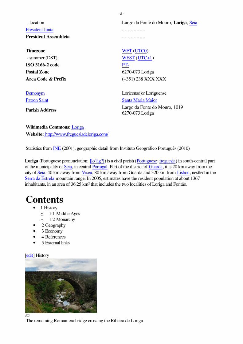
- location Largo da Fonte do Mouro, Loriga, Seia
President Junta - - - - - - - -
President Assembleia - - - - - - - -
Timezone WET (UTC0)
- summer (DST) WEST (UTC+1)
ISO 3166-2 code PT-
Postal Zone 6270-073 Loriga
Area Code & Prefix (+351) 238 XXX XXX
Demonym Loricense or Loriguense
Patron Saint Santa Maria Maior
Parish AddressLargo da Fonte do Mouro, 1019
6270-073 Loriga
Wikimedia Commons: Loriga
Website: http://www.freguesiadeloriga.com/
Statistics from INE (2001); geographic detail from Instituto Geográfico Português (2010)
Loriga (Portuguese pronunciation: [lo'?ig?]) is a civil parish (Portuguese: freguesia) in south-central part
of the municipality of Seia, in central Portugal. Part of the district of Guarda, it is 20 km away from the
city of Seia, 40 km away from Viseu, 80 km away from Guarda and 320 km from Lisbon, nestled in the
Serra da Estrela mountain range. In 2005, estimates have the resident population at about 1367
inhabitants, in an area of 36.25 km² that includes the two localities of Loriga and Fontão.
Contents• 1 History
o 1.1 Middle Ages
o 1.2 Monarchy
• 2 Geography
• 3 Economy
• 4 References
• 5 External links
[edit] History
The remaining Roman-era bridge crossing the Ribeira de Loriga
- 2 -

Loriga is ancient, beautiful and historic portuguese small town (vila), located in the Serra da Estrela
mountains. Known as Lobriga by the Lusitanians an Lorica by the Romans, it is more than 2600 years
old. Notable people from Loriga include Viriathus (known as Viriato in Portuguese), a famous Lusitanian
leader and portuguese national hero.
Loriga was founded originally along a column between ravines where today the historic centre exists. The
site was ostensibly selected more than 2600 years ago, owing to its defensibility, the abundance of
potable water and pasturelands, and lowlands that provided conditions to practice both hunting and
gathering/agriculture.[1]
When the Romans arrived in the region, the settlement was concentrated into two areas. The larger,
older and principal agglomeration was situated in the area of the main church and Rua de Viriato,
fortified with a wall and palisade.[1] The second group, in the Bairro de São Ginês, were some small
homes constructed on the rocky promintory, which were later appropriated by the Visigoths in order to
construct a chapel.[1] The 1st century Roman road and two bridges (the second was destroyed in the
17th century after flooding) connected the outpost of Lorica to the rest of their Lusitanian province.[1]
The barrio of São Ginês (São Gens), a local ex-libris, is the location of the chapel of Nossa Senhora do
Carmo, an ancient Visigothic chapel. São Gens, a Celtic saint, martyred in Arles na Gália, during the
reign of Emperor Diocletian, and over time the locals began to refer to this saint as São Ginês, due to its
easy of pronunciation.[1]
[edit] Middle Ages
Loriga was the municipal seat since the 12th century, receiving forals in 1136 (João Rhânia, master of
the Terras de Loriga for over two decades, during the reign of Afonso Henriques), 1249 (during the
reign of Afonso III), 1474 (under King Afonso V) and finally in 1514 (by King Manuel I).[1]
Loriga was an ecclesiastical parish of the vicarage of the Royal Padroado and its Matriz Church was
ordered constructed in 1233, by King Sancho II.[1] This church, was to the invokation of Santa Maria
Maior, and constructed over the ancient small Visigothic chapel (there is a lateral block with Visigoth
inscriptions visible).[1] Constructed in the Romanesque-style it consists of a three-nave building, with
hints of the Sé Velha of Coimbra. This structure was destroyed during the 1755 earthquake, and only
portions of the lateral walls were preserved.[1]
[edit] Monarchy
The 1755 earthquake resulted in significant damage to the village of Loriga, destroying homes and the
parcochial residence, in addition to opening-up cracks and faults in the village's larger buildings, such as
the historic municipal council hall (constructed in the 13th century).[1] An emissary of the Marquess of
Pombal actually visited Loriga to evaluate the damage (something that did not happen in other
mountainous parishes, even Covilhã) and provide support.[1]
The residents of Loriga supported the Asolutionist forces of the Infante Miguel of Portugal against the
Liberals, during the Portuguese Liberal Wars, which resulted in Loriga being abandoned politically after
Miguel's explusion by his brother King Peter.[1] In 1855, as a consequence of its support, it was
stripped of municipal status during the municipal reforms of the 19th century.[1] At the time of its
municipal demise (October 1855), the municipality of Loriga included the parishes of Alvoco da Serra,
Cabeça, Sazes da Beira, Teixeira, Valezim and Vide, as well as thirty other disincorporated villages.[1]
Loriga was an industrial centre for textile manufacturing during the 19th century. It was one of the few
industrialized centres in the Beira Interior region, even supplanting Seia until the middle of the 20th
- 3 -

century.[1] Only Covilhã out-preformed Loriga in terms of businesses operating from its lands;
companies such as Regato, Redondinha, Fonte dos Amores, Tapadas, Fândega, Leitão & Irmãos,
Augusto Luís Mendes, Lamas, Nunes Brito, Moura Cabral and Lorimalhas, among others.[1] The main
roadway in Loriga, Avenida Augusto Luís Mendes, is named for one of the villages most illustrious
industrialists. The wool industry started to decline during the last decades of the 20th century, a factor
that aggravated and accelerated the decline of the region.[1]
[edit] Geography
A bridge over a ravine in Loriga, with the pastures of the valley landscape
Known locally as the "Portuguese Switzerland" due to its landscape that includes a principal settlement
nestled in the mountains of the Serra da Estrela Natural Park.[2] It is located in the south-central part of
the municipality of Seia, along the southeast part of the Serra, between several ravines, but specifically
the Ribeira de São Bento and Ribeira de Loriga;[2] it is 20 kilometres from Seia, 80 kilometres from
Guarda and 300 kilometres from the national capital (Lisbon). A main village is accessible by the national
roadway E.N. 231, that connects directly to the region of the Serra da Estrela by way of E.N.338
(which was completed in 2006), or through the E.N.339, a 9.2 kilometre access that transits some of the
main elevations (960 metres near Portela do Arão or Portela de Loriga, and 1650 metres around the
Lagoa Comprida).
The region is carved by U-shaped glacial valleys, modelled by the movement of ancient glaciers. The
main valley, Vale de Loriga was carved by longitudanal abrasion that also created rounded pockets,
where the glacial resistance was minor. Starting at an altitude of 1991 metres along the Serra da Estrela
the valley descends abruptly until 290 metres above sea level (around Vide), passing villages such as
Cabeça, Casal do Rei and Muro. The central village, Loriga, is seven kilometres from Torre (the highest
point), but the parish is sculpted by cliffs, alluvial plains and glacial lakes deposited during millennia of
glacial erosion, and surrounded by rare ancient forest that surrounded the lateral flanks of these glaciers.
[edit] Economy
Vodafone Ski Resort, Serra da Estrela, in Loriga.
Textiles are the principal local export; Loriga was a hub the textile and wool industries during the
- 4 -

mid-19th century, in addition to being subsistence agriculture responsible for the cultivation of corn. The
Loriguense economy is based on metallurgical industries, bread-making, commercial shops, restaurants
and agricultural support services.
While that textile industry has since dissipated, the town began to attract a tourist trade due to its
proximity to the Serra da Estrela and Vodafone Ski Resort (the only ski center in Portugal), which was
constructed within the parish limits.
[edit] References
Notes
1. ^ a b c d e f g h i j k l m n o p q História Concisa de Loriga, por António Conde (in
Portuguese). Loriga, Portugal and similar pages (in Portuguese and English). Junta Freguesia, ed
(2011). "Breve história das origens à actualidade" (in Portuguese). Loriga (Seia), Portugal: Junta
de Freguesia de Loriga.
http://www.freguesiadeloriga.com/index.php?progoption=turnews&do=shownew&topic=12&ne
wid=30. Retrieved 17 June 2011.
2. ^ a b Junta Freguesia, ed (2011). "Conhece em Loriga...Geografia em Loriga" (in Portuguese).
Loriga (Seia), Portugal: Junta de Freguesia de Loriga.
http://www.freguesiadeloriga.com/index.php?progoption=turnews&do=shownewsbytopic&topic
=12&subtipo=Geografia%20de%20Loriga. Retrieved 17 June 2011.
[edit] External links
• (Portuguese and English) Loriga's Homepage
• (Portuguese and English) Loriga - Portugal
Retrieved from "http://en.wikipedia.org/wiki/Loriga"
Categories: Parishes of Seia | Towns in Portugal
Hidden categories: Articles containing Portuguese language text
Personal tools
• Log in / create account
Namespaces
• Article
• Discussion
Variants
Views
• Read
• Edit
• View history
Actions
Search
Navigation
• Main page
• Contents
• Featured content
• Current events
• Random article
- 5 -

• Donate to Wikipedia
Interaction
• Help
• About Wikipedia
• Community portal
• Recent changes
• Contact Wikipedia
Toolbox
• What links here
• Related changes
• Upload file
• Special pages
• Permanent link
• Cite this page
Print/export
• Create a book
• Download as PDF
• Printable version
Languages
• Deutsch
• Español
• Français
• Italiano
• Latina
• Nederlands
• Português
• ???????
• Türkçe
• This page was last modified on 26 July 2011 at 21:02.
• Text is available under the Creative Commons Attribution-ShareAlike License; additional terms
may apply. See Terms of use for details.
• Wikipedia® is a registered trademark of the Wikimedia Foundation, Inc., a non-profit
organization.
• Contact us
• Privacy policy
• About Wikipedia
• Disclaimers
•
•
- 6 -

LorigaCivil parish
Coordinates: 40.324°N 7.691°W
Country PortugalRegion CentroIntermunic.comm.
Beiras e Serra da Estrela
District GuardaMunicipality Seia
Area
LorigaLoriga (Portuguese pronunciation: [loˈɾiɡɐ]) is a civil parish
(Portuguese: freguesia) and town in south-central part
of the municipality of Seia, in central Portugal. Part of
the district of Guarda, it is 20 km away from the city of
Seia, 40 km away from Viseu, 80 km away from Guarda
and 320 km from Lisbon, nestled in the Serra da Estrela
mountain range. The population in 2011 was 1,053,[1] in
an area of 36.25 km²,[2] including the two localities, the
town of Loriga and the village of Fontão.
HistoryMiddle AgesMonarchy
GeographyEconomyReferencesExternal links
Loriga was founded along a column between ravines
where today the historic centre exists. The site was
ostensibly selected more than 2600 years ago, owing to
its defensibility, the abundance of potable water and
pasturelands, and lowlands that provided conditions to
practice both hunting and gathering/agriculture.[3]
Loriga
Coordinates: 40.324°N 7.691°W
Contents
History
The remaining Roman-era bridgecrossing the Ribeira de Loriga

• Total 36.25 km2 (14.00 sq mi)
Elevation 750 m (2,460 ft)
Population (2011) • Total 1,053 • Density 29/km2 (75/sq mi)
Postal code 6270Area code 238
Patron Santa Maria Maior
Website http://lorigaportugal.wordpress.com
When the Romans arrived in the region, the settlement
was concentrated into two areas. The larger, older and
principal agglomeration was situated in the area of the
main church and Rua de Viriato, fortified with a wall
and palisade.[3] The second group, in the Bairro de SãoGinês, were some small homes constructed on the rocky
promintory, which were later appropriated by the
Visigoths in order to construct a chapel.[3] The 1st
century Roman road and two bridges (the second was
destroyed in the 16th century after flooding in the
Ribeira de São Bento) connected the outpost of Lorica to
the rest of their Lusitanian province.[3] The barrio of São Ginês (São Gens), a local ex-libris, is the location of the
chapel of Nossa Senhora do Carmo, an ancient Visigothic chapel. São Gens, a Celtic saint, martyred in Arles na Gália,
during the reign of Emperor Diocletian, and over time the locals began to refer to this saint as São Ginês, due to its
easy of pronunciation.[3]
Loriga was the municipal seat since the 12th century, receiving forals in 1136 (João Rhânia, master of the Terras deLoriga for over two decades, during the reign of Afonso Henriques), 1249 (during the reign of Afonso III), 1474 (under
King Afonso V) and finally in 1514 (by King Manuel I).[3]
Loriga was an ecclesiastical parish of the vicarage of the Royal Padroado and its Matriz Church was ordered
constructed in 1233, by King Sancho II.[3] This church, was to the invokation of Santa Maria Maior, and constructed
over the ancient small Visigothic chapel (there is a lateral block with Visigoth inscriptions visible).[3] Constructed in
the Romanesque-style it consists of a three-nave building, with hints of the Sé Velha of Coimbra. This structure was
destroyed during the 1755 earthquake, and only portions of the lateral walls were preserved.[3]
The 1755 earthquake resulted in significant damage to the town of Loriga, destroying homes and the parcochial
residence, in addition to opening-up cracks and faults in the town's larger buildings, such as the historic municipal
council hall (constructed in the 13th century).[3] An emissary of the Marquess of Pombal actually visited Loriga to
evaluate the damage (something that did not happen in other mountainous parishes, even Covilhã) and provide
support.[3]
The residents of Loriga supported the Asolutionist forces of the Infante Miguel of Portugal against the Liberals, during
the Portuguese Liberal Wars, which resulted in Loriga being abandoned politically after Miguel's expulsion by his
brother King Peter.[3] In 1855, as a consequence of its support, it was stripped of municipal status during the
municipal reforms of the 19th century.[3] At the time of its municipal demise (October 1855), the municipality of Loriga
included the parishes of Alvoco da Serra, Cabeça, Sazes da Beira, Teixeira, Valezim and Vide, as well as thirty other
disincorporated villages.[3]
Loriga was an industrial centre for textile manufacturing during the 19th century. It was one of the few industrialized
centres in the Beira Interior region, even supplanting Seia until the middle of the 20th century.[3] Only Covilhã out-
performed Loriga in terms of businesses operating from its lands; companies such as Regato, Redondinha, Fonte dos
Amores, Tapadas, Fândega, Leitão & Irmãos, Augusto Luís Mendes, Lamas, Nunes Brito, Moura Cabral and
Lorimalhas, among others.[3] The main roadway in Loriga, Avenida Augusto Luís Mendes, is named for one of the
villages most illustrious industrialists. The wool industry started to decline during the last decades of the 20th century,
a factor that aggravated and accelerated the decline of the region.[3]
Middle Ages
Monarchy

Known locally as the "Portuguese Switzerland" due to its landscape that
includes a principal settlement nestled in the mountains of the Serra da
Estrela Natural Park.[4] It is located in the south-central part of the
municipality of Seia, along the southeast part of the Serra, between
several ravines, but specifically the Ribeira de São Bento and Ribeira da
Nave;[4] it is 20 kilometres from Seia, 80 kilometres from Guarda and
300 kilometres from the national capital (Lisbon). A main town is
accessible by the national roadway E.N. 231, that connects directly to the
region of the Serra da Estrela by way of E.N.338 (which was completed
in 2006), or through the E.N.339, a 9.2 kilometre access that transits
some of the main elevations (960 metres near Portela do Arão or Portela
de Loriga, and 1650 metres around the Lagoa Comprida).
The region is carved by U-shaped glacial valleys, modelled by the movement of ancient glaciers. The main valley, Valede Loriga was carved by longitudanal abrasion that also created rounded pockets, where the glacial resistance was
minor. Starting at an altitude of 1991 metres along the Serra da Estrela the valley descends abruptly until 290 metres
above sea level (around Vide), passing villages such as Cabeça, Casal do Rei and Muro. The central town, Loriga, is
seven kilometres from Torre (the highest point), but the parish is sculpted by cliffs, alluvial plains and glacial lakes
deposited during millennia of glacial erosion, and surrounded by rare ancient forest that surrounded the lateral flanks
of these glaciers.
Textiles are the principal local export; Loriga was a hub the textile and
wool industries during the mid-19th century, in addition to being
subsistence agriculture responsible for the cultivation of corn. The
Loriguense economy is based on metallurgical industries, bread-making,
commercial shops, restaurants and agricultural support services.
While that textile industry has since dissipated, the town began to
attract a tourist trade due to its proximity to the Serra da Estrela and
Vodafone Ski Resort (the only ski center in Portugal), which was
constructed totally the parish limits.
1. Instituto Nacional de Estatística (http://www.ine.pt/xportal/xmain?xlang=en&xpid=INE&xpgid=ine_indicadores&indOcorrCod=0005889&contexto=pi&selTab=tab0)
2. Áreas das freguesias, concelhos, distritos e país (http://www.dgterritorio.pt/cartografia_e_geodesia/cartografia/carta_administrativa_oficial_de_portugal_caop_/caop__download_/carta_administrativa_oficial_de_portugal___versao_2017__em_vigor_/)
3. Junta Freguesia, ed. (2011). "Breve história das origens à actualidade por António Conde" (https://web.archive.org/web/20120313002558/http://www.freguesiadeloriga.com/index.php?progoption=turnews&do=shownew&topic=12&newid=30) (in Portuguese). Loriga (Seia), Portugal: Junta de Freguesia de Loriga. Archived from the original (http://www.freguesiadeloriga.com/index.php?progoption=turnews&do=shownew&topic=12&newid=30) on 13 March2012. Retrieved 17 June 2011.
4. Junta Freguesia, ed. (2011). "Conhece em Loriga...Geografia em Loriga" (https://web.archive.org/web/20120313002726/http://www.freguesiadeloriga.com/index.php?progoption=turnews&do=shownewsbytopic&topic=12&subtipo=Geografia%20de%20Loriga) (in Portuguese). Loriga (Seia), Portugal: Junta de Freguesia de Loriga. Archived
Geography
A bridge over a ravine in Loriga, withthe pastures of the valley landscape
Economy
Vodafone Ski Resort, Serra da Estrela,in the town of Loriga.
References

from the original (http://www.freguesiadeloriga.com/index.php?progoption=turnews&do=shownewsbytopic&topic=12&subtipo=Geografia%20de%20Loriga) on 13 March 2012. Retrieved 17 June 2011.
(in Portuguese) Loriga's Homepage in portuguese and english (http://lorigaportugal.wordpress.com)
Retrieved from "https://en.wikipedia.org/w/index.php?title=Loriga&oldid=871988084"
This page was last edited on 4 December 2018, at 16:21 (UTC).
Text is available under the Creative Commons Attribution-ShareAlike License; additional terms may apply. By usingthis site, you agree to the Terms of Use and Privacy Policy. Wikipedia® is a registered trademark of the WikimediaFoundation, Inc., a non-profit organization.
External links

LorigaCivil parish
Coordinates: 40.324°N 7.691°W
Country PortugalRegion CentroSubregion Serra da EstrelaIntermunic.comm.
Beiras e Serra daEstrela
District GuardaMunicipality Seia
Area • Total 36.25 km2 (14.00 sq mi)
Elevation 750 m (2,460 ft)
Population (2011) • Total 1,053 • Density 29/km2 (75/sq mi)
Postal code 6270Area code 238
Patron Santa Maria Maior
Website http://www.loriga.info
LorigaLoriga (Portuguese pronunciation: [luˈɾiɡɐ]) is a civil parish (Portuguese: freguesia) and town in south-
central part of the municipality of Seia, in central Portugal. Part of the district of Guarda, it is 20 km away
from the city of Seia, 40 km away from Viseu, 80 km away from Guarda and 320 km from Lisbon, nestled
in the Serra da Estrela mountain range. The population in 2011 was 1,053,[1] in an area of 36.25 km²,[2]
including the two localities/villages of Loriga and Fontão.
HistoryMiddle AgesMonarchy
GeographyEconomyReferencesExternal links
Loriga was founded along a column between ravines where
today the historic centre exists. The site was ostensibly
selected more than 2600 years ago, owing to its
defensibility, the abundance of potable water and
pasturelands, and lowlands that provided conditions to
practice both hunting and gathering/agriculture.[3]
When the Romans arrived in the region, the settlement was
concentrated into two areas. The larger, older and principal
agglomeration was situated in the area of the main church
and Rua de Viriato, fortified with a wall and palisade.[3] The
second group, in the Bairro de São Ginês, were some small
homes constructed on the rocky promintory, which were
later appropriated by the Visigoths in order to construct a chapel.[3] The 1st century Roman road and two
bridges (the second was destroyed in the 16th century after flooding in the Ribeira de São Bento)
connected the outpost of Lorica to the rest of their Lusitanian province.[3] The barrio of São Ginês (SãoGens), a local ex-libris, is the location of the chapel of Nossa Senhora do Carmo, an ancient Visigothic
chapel. São Gens, a Celtic saint, martyred in Arles na Gália, during the reign of Emperor Diocletian, and
over time the locals began to refer to this saint as São Ginês, due to its easy of pronunciation.[3]
Loriga was the municipal seat since the 12th century, receiving forals in 1136 (João Rhânia, master of the
Terras de Loriga for over two decades, during the reign of Afonso Henriques), 1249 (during the reign of
Afonso III), 1474 (under King Afonso V) and finally in 1514 (by King Manuel I).[3]
Loriga was an ecclesiastical parish of the vicarage of the Royal Padroado and its Matriz Church was
ordered constructed in 1233, by King Sancho II.[3] This church, was to the invokation of Santa MariaMaior, and constructed over the ancient small Visigothic chapel (there is a lateral block with Visigoth
inscriptions visible).[3] Constructed in the Romanesque-style it consists of a three-nave building, with
hints of the Sé Velha of Coimbra. This structure was destroyed during the 1755 earthquake, and only
portions of the lateral walls were preserved.[3]
The 1755 earthquake resulted in significant damage to the town of Loriga, destroying homes and the
parcochial residence, in addition to opening-up cracks and faults in the town's larger buildings, such as
the historic municipal council hall (constructed in the 13th century).[3] An emissary of the Marquess of
Pombal actually visited Loriga to evaluate the damage (something that did not happen in other mountainous parishes, even Covilhã) and provide support.[3]
The residents of Loriga supported the Asolutionist forces of the Infante Miguel of Portugal against the Liberals, during the Portuguese Liberal Wars, which resulted
in Loriga being abandoned politically after Miguel's expulsion by his brother King Peter.[3] In 1855, as a consequence of its support, it was stripped of municipal
status during the municipal reforms of the 19th century.[3] At the time of its municipal demise (October 1855), the municipality of Loriga included the parishes of
Alvoco da Serra, Cabeça, Sazes da Beira, Teixeira, Valezim and Vide, as well as thirty other disincorporated villages.[3]
Loriga was an industrial centre for textile manufacturing during the 19th century. It was one of the few industrialized centres in the Beira Interior region, even
supplanting Seia until the middle of the 20th century.[3] Only Covilhã out-performed Loriga in terms of businesses operating from its lands; companies such as
Regato, Redondinha, Fonte dos Amores, Tapadas, Fândega, Leitão & Irmãos, Augusto Luís Mendes, Lamas, Nunes Brito, Moura Cabral and Lorimalhas, among
others.[3] The main roadway in Loriga, Avenida Augusto Luís Mendes, is named for one of the villages most illustrious industrialists. The wool industry started to
decline during the last decades of the 20th century, a factor that aggravated and accelerated the decline of the region.[3]
Loriga
Coordinates: 40.324°N 7.691°W
Contents
History
The remaining Roman-era bridgecrossing the Ribeira de Loriga
Middle Ages
Monarchy

Known locally as the "Portuguese Switzerland" due to its landscape that includes a principal settlement nestled in
the mountains of the Serra da Estrela Natural Park.[4] It is located in the south-central part of the municipality of
Seia, along the southeast part of the Serra, between several ravines, but specifically the Ribeira de São Bento and
Ribeira da Nave;[4] it is 20 kilometres from Seia, 80 kilometres from Guarda and 300 kilometres from the national
capital (Lisbon). A main town is accessible by the national roadway E.N. 231, that connects directly to the region of
the Serra da Estrela by way of E.N.338 (which was completed in 2006), or through the E.N.339, a 9.2 kilometre
access that transits some of the main elevations (960 metres near Portela do Arão or Portela de Loriga, and 1650
metres around the Lagoa Comprida).
The region is carved by U-shaped glacial valleys, modelled by the movement of ancient glaciers. The main valley, Valede Loriga was carved by longitudanal abrasion that also created rounded pockets, where the glacial resistance was
minor. Starting at an altitude of 1991 metres along the Serra da Estrela the valley descends abruptly until 290 metres
above sea level (around Vide), passing villages such as Cabeça, Casal do Rei and Muro. The central town, Loriga, is
seven kilometres from Torre (the highest point), but the parish is sculpted by cliffs, alluvial plains and glacial lakes deposited during millennia of glacial erosion,
and surrounded by rare ancient forest that surrounded the lateral flanks of these glaciers.
Textiles are the principal local export; Loriga was a hub the textile and wool industries during the mid-19th century,
in addition to being subsistence agriculture responsible for the cultivation of corn. The Loriguense economy is based
on metallurgical industries, bread-making, commercial shops, restaurants and agricultural support services.
While that textile industry has since dissipated, the town began to attract a tourist trade due to its proximity to the
Serra da Estrela and Vodafone Ski Resort (the only ski center in Portugal), which was constructed totally the parish
limits.
1. Instituto Nacional de Estatística (http://www.ine.pt/xportal/xmain?xlang=en&xpid=INE&xpgid=ine_indicadores&indOcorrCod=0005889&contexto=pi&selTab=tab0)
2. Direção-Geral do Território (http://www.dgterritorio.pt/ficheiros/cadastro/caop/caop_download/caop_2014_0/areasfregmundistcaop2014_2)
3. Junta Freguesia, ed. (2011). "Breve história das origens à actualidade por António Conde" (https://web.archive.org/web/20120313002558/http://www.freguesiadeloriga.com/index.php?progoption=turnews&do=shownew&topic=12&newid=30) (in Portuguese). Loriga (Seia), Portugal: Junta de Freguesia de Loriga.Archived from the original (http://www.freguesiadeloriga.com/index.php?progoption=turnews&do=shownew&topic=12&newid=30) on 13 March 2012.Retrieved 17 June 2011.
4. Junta Freguesia, ed. (2011). "Conhece em Loriga...Geografia em Loriga" (https://web.archive.org/web/20120313002726/http://www.freguesiadeloriga.com/index.php?progoption=turnews&do=shownewsbytopic&topic=12&subtipo=Geografia%20de%20Loriga) (in Portuguese). Loriga (Seia), Portugal: Junta deFreguesia de Loriga. Archived from the original (http://www.freguesiadeloriga.com/index.php?progoption=turnews&do=shownewsbytopic&topic=12&subtipo=Geografia%20de%20Loriga) on 13 March 2012. Retrieved 17 June 2011.
(in Portuguese) Loriga's Homepage in portuguese and english (http://lorigaportugal.wordpress.com)
Retrieved from "https://en.wikipedia.org/w/index.php?title=Loriga&oldid=857152105"
This page was last edited on 29 August 2018, at 22:05 (UTC).
Text is available under the Creative Commons Attribution-ShareAlike License; additional terms may apply. By using this site, you agree to the Terms of Use andPrivacy Policy. Wikipedia® is a registered trademark of the Wikimedia Foundation, Inc., a non-profit organization.
Geography
A bridge over a ravine in Loriga, withthe pastures of the valley landscape
Economy
Vodafone Ski Resort, Serra da Estrela,in the town of Loriga.
References
External links
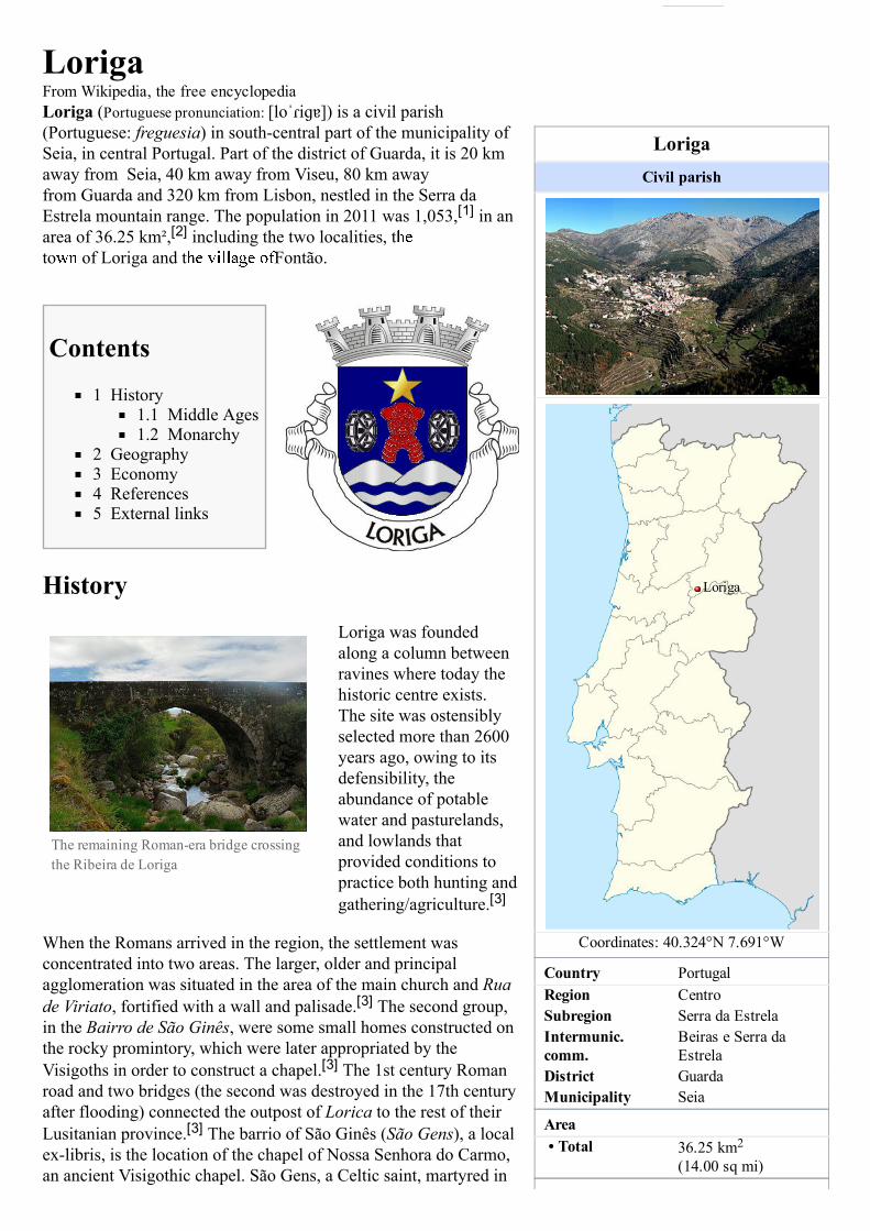
LorigaCivil parish
Coordinates: 40.324°N 7.691°W
Country PortugalRegion CentroSubregion Serra da EstrelaIntermunic.comm.
Beiras e Serra daEstrela
District GuardaMunicipality Seia
Area• Total 36.25 km2
(14.00 sq mi)
LorigaFrom Wikipedia, the free encyclopediaLoriga (Portuguese pronunciation: [lo ˈɾiɡɐ]) is a civil parish(Portuguese: freguesia) in southcentral part of the municipality ofSeia, in central Portugal. Part of the district of Guarda, it is 20 kmaway from Seia, 40 km away from Viseu, 80 km awayfrom Guarda and 320 km from Lisbon, nestled in the Serra daEstrela mountain range. The population in 2011 was 1,053,[1] in anarea of 36.25 km²,[2] including the two localities, tto of Loriga and t Fontão.
Contents
1 History1.1 Middle Ages1.2 Monarchy
2 Geography3 Economy4 References5 External links
History
Loriga was foundedalong a column betweenravines where today thehistoric centre exists.The site was ostensiblyselected more than 2600years ago, owing to itsdefensibility, theabundance of potablewater and pasturelands,and lowlands thatprovided conditions topractice both hunting andgathering/agriculture.[3]
When the Romans arrived in the region, the settlement wasconcentrated into two areas. The larger, older and principalagglomeration was situated in the area of the main church and Ruade Viriato, fortified with a wall and palisade.[3] The second group,in the Bairro de São Ginês, were some small homes constructed onthe rocky promintory, which were later appropriated by theVisigoths in order to construct a chapel.[3] The 1st century Romanroad and two bridges (the second was destroyed in the 17th centuryafter flooding) connected the outpost of Lorica to the rest of theirLusitanian province.[3] The barrio of São Ginês (São Gens), a localexlibris, is the location of the chapel of Nossa Senhora do Carmo,an ancient Visigothic chapel. São Gens, a Celtic saint, martyred in
Loriga
The remaining Romanera bridge crossingthe Ribeira de Loriga
Edited with the trial version of
Foxit Advanced PDF Editor
To remove this notice, visit:
www.foxitsoftware.com/shopping
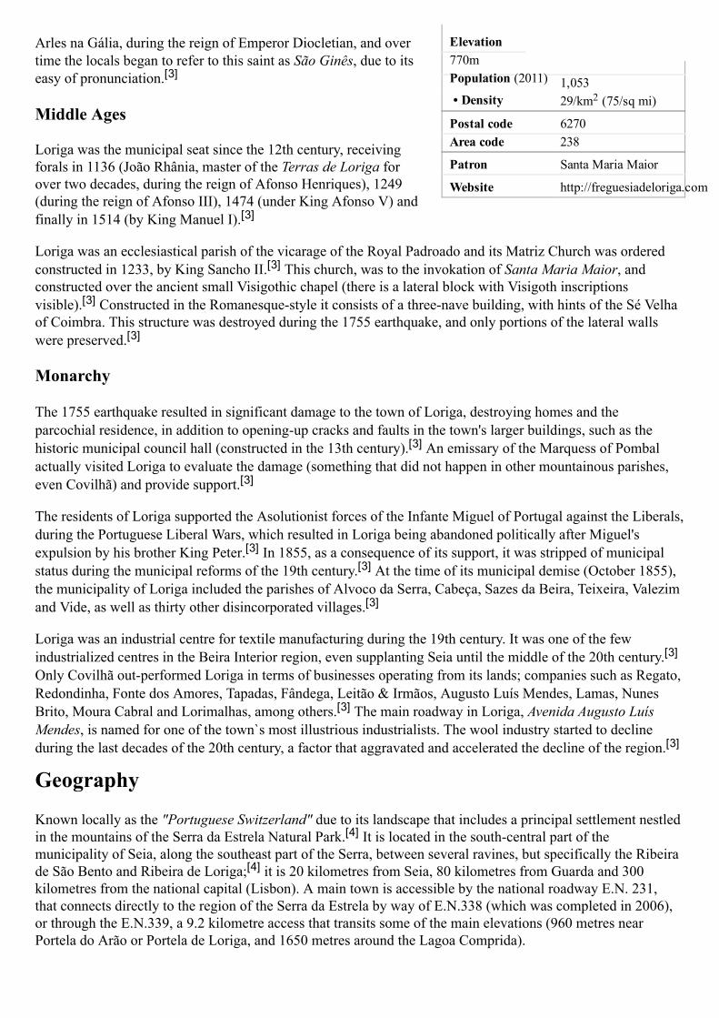
Elevation770m Population (2011)• Total
1,053• Density 29/km2 (75/sq mi)
Postal code 6270Area code 238
Patron Santa Maria Maior
Website http://freguesiadeloriga.com
Arles na Gália, during the reign of Emperor Diocletian, and overtime the locals began to refer to this saint as São Ginês, due to itseasy of pronunciation.[3]
Middle Ages
Loriga was the municipal seat since the 12th century, receivingforals in 1136 (João Rhânia, master of the Terras de Loriga forover two decades, during the reign of Afonso Henriques), 1249(during the reign of Afonso III), 1474 (under King Afonso V) andfinally in 1514 (by King Manuel I).[3]
Loriga was an ecclesiastical parish of the vicarage of the Royal Padroado and its Matriz Church was orderedconstructed in 1233, by King Sancho II.[3] This church, was to the invokation of Santa Maria Maior, andconstructed over the ancient small Visigothic chapel (there is a lateral block with Visigoth inscriptionsvisible).[3] Constructed in the Romanesquestyle it consists of a threenave building, with hints of the Sé Velhaof Coimbra. This structure was destroyed during the 1755 earthquake, and only portions of the lateral wallswere preserved.[3]
Monarchy
The 1755 earthquake resulted in significant damage to the town of Loriga, destroying homes and theparcochial residence, in addition to openingup cracks and faults in the town's larger buildings, such as thehistoric municipal council hall (constructed in the 13th century).[3] An emissary of the Marquess of Pombalactually visited Loriga to evaluate the damage (something that did not happen in other mountainous parishes,even Covilhã) and provide support.[3]
The residents of Loriga supported the Asolutionist forces of the Infante Miguel of Portugal against the Liberals,during the Portuguese Liberal Wars, which resulted in Loriga being abandoned politically after Miguel'sexpulsion by his brother King Peter.[3] In 1855, as a consequence of its support, it was stripped of municipalstatus during the municipal reforms of the 19th century.[3] At the time of its municipal demise (October 1855),the municipality of Loriga included the parishes of Alvoco da Serra, Cabeça, Sazes da Beira, Teixeira, Valezimand Vide, as well as thirty other disincorporated villages.[3]
Loriga was an industrial centre for textile manufacturing during the 19th century. It was one of the fewindustrialized centres in the Beira Interior region, even supplanting Seia until the middle of the 20th century.[3]Only Covilhã outperformed Loriga in terms of businesses operating from its lands; companies such as Regato,Redondinha, Fonte dos Amores, Tapadas, Fândega, Leitão & Irmãos, Augusto Luís Mendes, Lamas, NunesBrito, Moura Cabral and Lorimalhas, among others.[3] The main roadway in Loriga, Avenida Augusto LuísMendes, is named for one of the town`s most illustrious industrialists. The wool industry started to declineduring the last decades of the 20th century, a factor that aggravated and accelerated the decline of the region.[3]
Geography
Known locally as the "Portuguese Switzerland" due to its landscape that includes a principal settlement nestledin the mountains of the Serra da Estrela Natural Park.[4] It is located in the southcentral part of themunicipality of Seia, along the southeast part of the Serra, between several ravines, but specifically the Ribeirade São Bento and Ribeira de Loriga;[4] it is 20 kilometres from Seia, 80 kilometres from Guarda and 300kilometres from the national capital (Lisbon). A main town is accessible by the national roadway E.N. 231,that connects directly to the region of the Serra da Estrela by way of E.N.338 (which was completed in 2006),or through the E.N.339, a 9.2 kilometre access that transits some of the main elevations (960 metres nearPortela do Arão or Portela de Loriga, and 1650 metres around the Lagoa Comprida).
Edited with the trial version of
Foxit Advanced PDF Editor
To remove this notice, visit:
www.foxitsoftware.com/shopping

The region is carved by Ushaped glacial valleys, modelled by themovement of ancient glaciers. The main valley, Vale de Loriga wascarved by longitudanal abrasion that also created rounded pockets,where the glacial resistance was minor. Starting at an altitude of 1991metres along the Serra da Estrela the valley descends abruptly until290 metres above sea level (around Vide), passing villages such asCabeça, Casal do Rei and Muro. The central village, Loriga, is sevenkilometres from Torre (the highest point), but the parish is sculptedby cliffs, alluvial plains and glacial lakes deposited during millenniaof glacial erosion, and surrounded by rare ancient forest thatsurrounded the lateral flanks of these glaciers.
Economy
Textiles are the principal local export; Loriga was a hub the textileand wool industries during the mid19th century, in addition to beingsubsistence agriculture responsible for the cultivation of corn. TheLoriguense economy is based on metallurgical industries, breadmaking, commercial shops, restaurants and agricultural supportservices.While that textile industry has since dissipated, the town began toattract a tourist trade due to its proximity to the Serra da Estrela andVodafone Ski Resort (the only ski center in Portugal), which wasconstructed within the parish limits.
References
1. Instituto Nacional de Estatística (http://www.ine.pt/xportal/xmain?xlang=en&xpid=INE&xpgid=ine_indicadores&indOcorrCod=0005889&contexto=pi&selTab=tab0)
2. DireçãoGeral do Território (http://www.dgterritorio.pt/ficheiros/cadastro/caop/caop_download/caop_2014_0/areasfregmundistcaop2014_2)
3. Junta Freguesia, ed. (2011). "Breve história das origens à actualidade (by António Conde)" (http://www.freguesiadeloriga.co m/index.php?progoption=turnews&do=shownew&topic=12&newid=30) (in Portuguese). Loriga (Seia),Portugal: Junta de Freguesia de Loriga. Retrieved 17 June 2011.
4. Junta Freguesia, ed. (2011). "Conhece em Loriga...Geografia em Loriga" (http://www.freguesiadeloriga.com/index.php?progoption=turnews&do=shownewsbytopic&topic=12&subtipo=Geografia%20de%20Loriga) (in Portuguese). Loriga (Seia), Portugal: Junta de Freguesia de Loriga. Retrieved 17 June 2011.
External links(in Portuguese and english) Loriga's Homepage, Extracts from the work of António Conde, “Concise history of the village of Loriga - From origins to extinction of the municipality”, (http://lorigaportugal.wordpress.com/ficheiros-pdf-files)
Retrieved from "https://en.wikipedia.org/w/index.php?title=Loriga&oldid=783751553"
This page was last edited on 4 June 2017, at 12:22.Text is available under the Creative Commons AttributionShareAlike License; additional terms mayapply. By using this site, you agree to the Terms of Use and Privacy Policy. Wikipedia® is a registeredtrademark of the Wikimedia Foundation, Inc., a nonprofit organization.
A bridge over a ravine in Loriga, with thepastures of the valley landscape
Vodafone Ski Resort, Serra da Estrela, inthe town of Loriga.
Edited with the trial version of
Foxit Advanced PDF Editor
To remove this notice, visit:
www.foxitsoftware.com/shopping
town

LorigaCivil parish
Coordinates: 40.324°N 7.691°W
Country PortugalRegion CentroSubregion Serra da EstrelaIntermunic.comm.
Beiras e Serra daEstrela
District GuardaMunicipality Seia
Area• Total 36.25 km2
(14.00 sq mi)
LorigaFrom Wikipedia, the free encyclopediaLoriga (Portuguese pronunciation: [lッˈɾiɡɐ]) is a civil parish(Portuguese: freguesia) in southcentral part of the municipality ofSeia, in central Portugal. Part of the district of Guarda, it is 20 kmaway from Seia, 40 km away from Viseu, 80 km awayfrom Guarda and 320 km from Lisbon, nestled in the Serra daEstrela mountain range. The population in 2011 was 1,053,[1] in anarea of 36.25 km²,[2] including the two localitiesL@エエッ of Loriga and エ Fontão.
Contents
1 History1.1 Middle Ages1.2 Monarchy
2 Geography3 Economy4 References5 External links
History
Loriga was foundedalong a column betweenravines where today thehistoric centre exists.The site was ostensiblyselected more than 2600years ago, owing to itsdefensibility, theabundance of potablewater and pasturelands,and lowlands thatprovided conditions topractice both hunting andgathering/agriculture.[3]
When the Romans arrived in the region, the settlement wasconcentrated into two areas. The larger, older and principalagglomeration was situated in the area of the main church and Ruade Viriato, fortified with a wall and palisade.[3] The second group,in the Bairro de São Ginês, were some small homes constructed onthe rocky promintory, which were later appropriated by theVisigoths in order to construct a chapel.[3] The 1st century Romanroad and two bridges (the second was destroyed in the 17th centuryafter flooding) connected the outpost of Lorica to the rest of theirLusitanian province.[3] The barrio of São Ginês (São Gens), a localexlibris, is the location of the chapel of Nossa Senhora do Carmo,an ancient Visigothic chapel. São Gens, a Celtic saint, martyred in
Loriga
The remaining Romanera bridge crossingthe Ribeira de lッイゥァ。
Edited with the trial version of
Foxit Advanced PDF Editor
To remove this notice, visit:
www.foxitsoftware.com/shopping

ElevationWWPュ@Population (2011)• Total
1,053• Density 29/km2 (75/sq mi)
Postal code 6270Area code 238
Patron Santa Maria Maior
Website http://ヲイ・ァオ・ウゥ。、・loriga.」oュ
Arles na Gália, during the reign of Emperor Diocletian, and overtime the locals began to refer to this saint as São Ginês, due to itseasy of pronunciation.[3]
Middle Ages
Loriga was the municipal seat since the 12th century, receivingforals in 1136 (João Rhânia, master of the Terras de Loriga forover two decades, during the reign of Afonso Henriques), 1249(during the reign of Afonso III), (underNing Afonso V) andfinally in 1514 (by King Manuel I)[3]
Ooriga was an ecclesiastical parish of the vicarage of the Royal Padroado and its Matriz Church was orderedconstructed in 1233, by King Sancho II[3] This church, was to the invokation of Santa Maria Maior, andconstructed over the ancient small Visigothic chapel (there is a lateral block with Visigoth inscriptionsvisible).[3] Constructed in the Romanesquestyle it consists of a threenave building, with hints of the Sé Velhaof Coimbra. This structure was destroyed during the 1755 earthquake, and only portions of the lateral wallswere preserved.[3]
Monarchy
The 1755 earthquake resulted in significant damage to the エッキョ of Loriga, destroying homes and theparcochial residence, in addition to openingup cracks and faults in the エッキョ's larger buildings, such as thehistoric municipal council hall (constructed in the 13th century).[3] An emissary of the Marquess of Pombalactually visited Loriga to evaluate the damage (something that did not happen in other mountainous parishes,even Covilhã) and provide support.[3]
The residents of Loriga supported the Asolutionist forces of the InfanteMiguel of Portugal against the Liberals,during the Portuguese Liberal Wars, which resulted in Loriga being abandoned politically after Miguel'sexpulsion by his brother King Peter.[3] In as aconsequence ofits support, it was stripped of municipalstatus during the municipal reforms of the 19th century.[3] At the time of its municipal demise (October 1855),the municipality of Loriga included the parishes of Alvoco da Serra, Cabeça, Sazes da Beira, Teixeira, Valezimand Vide, as well as thirty other disincorporated villages.[3]
Loriga was an industrial centre for textile manufacturing during the 19th century. It was one of the fewindustrialized centres in the Beira Interior region, even supplanting Seia until the middle of the 20th century.[3]Only Covilhã outperformed Loriga in terms of businesses operating from its lands; companies such as Regato,Redondinha, Fonte dos Amores, Tapadas, Fândega, Leitão & Irmãos, Augusto Luís Mendes, Lamas, NunesBrito, Moura Cabral and Lorimalhas, among others.[3] The main roadway in Loriga, Avenida Augusto LuísMendes, is named for one of the エッキョ⦆s most illustrious industrialists. The wool industry started to declineduring the last decades of the 20th century, a factor that aggravated and accelerated the decline of the region.[3]
Geography
Known locally as the "Portuguese Switzerland" due to its landscape that includes a principal settlement nestledin the mountains of the Serra da Estrela Natural Park.[4] It is located in the southcentral part of themunicipality of Seia, along the southeast part of the Serra, between several ravines, but specifically the Ribeirade São Bento and Ribeira d・@lッイゥァ。;[4] it is 20 kilometres from Seia, 80 kilometres from Guarda and 300kilometres from the national capital (Lisbon). A main tッキョ is accessible by the national roadway E.N. 231,that connects directly to the region of the Serra da Estrela by way of E.N.338 (which was completed in 2006),or through the E.N.339, a 9.2 kilometre access that transits some of the main elevations (960 metres nearPortela do Arão or Portela de Loriga, and 1650 metres around the Lagoa Comprida).
Edited with the trial version of
Foxit Advanced PDF Editor
To remove this notice, visit:
www.foxitsoftware.com/shopping

The region is carved by Ushaped glacial valleys, modelled by themovement of ancient glaciers. The main valley, Vale de Loriga wascarved by longitudanal abrasion that also created rounded pockets,where the glacial resistance was minor. Starting at an altitude of 1991metres along the Serra da Estrela the valley descends abruptly until290 metres above sea level (around Vide), passing villages such asCabeça, Casal do Rei and Muro. The central village, Loriga, is sevenkilometres from Torre (the highest point), but the parish is sculptedby cliffs, alluvial plains and glacial lakes deposited during millenniaof glacial erosion, and surrounded by rare ancient forest thatsurrounded the lateral flanks of these glaciers.
Economy
Textiles are the principal local export; Loriga was a hub the textileand wool industries during the mid19th century, in addition to beingsubsistence agriculture responsible for the cultivation of corn. TheLoriguense economy is based on metallurgical industries, breadmaking, commercial shops, restaurants and agricultural supportservices.While that textile industry has since dissipated, the town began toattract a tourist trade due to its proximity to the Serra da Estrela andVodafone Ski Resort (the only ski center in Portugal), which wasconstructed within the parish limits.
References
1. Instituto Nacional de Estatística (http://www.ine.pt/xportal/xmain?xlang=en&xpid=INE&xpgid=ine_indicadores&indOcorrCod=0005889&contexto=pi&selTab=tab0)
2. DireçãoGeral do Território (http://www.dgterritorio.pt/ficheiros/cadastro/caop/caop_download/caop_2014_0/areasfregmundistcaop2014_2)
3. Junta Freguesia, ed. (2011). "Breve história das origens à actualidade@ H「ケ@ aョエ " (http://www.freguesiadeloriga.co m/index.php?progoption=turnews&do=shownew&topic=12&newid=30) (in Portuguese). Loriga (Seia),Portugal: Junta de Freguesia de Loriga. Retrieved 17 June 2011.
4. Junta Freguesia, ed. (2011). "Conhece em Loriga...Geografia em Loriga" (http://www.freguesiadeloriga.com/index.php?progoption=turnews&do=shownewsbytopic&topic=12&subtipo=Geografia%20de%20Loriga) (in Portuguese). Loriga (Seia), Portugal: Junta de Freguesia de Loriga. Retrieved 17 June 2011.
External links(in Portuguese@。ョ、@・ョァャゥウィ) Loriga's HomepageL@
ュオョゥ」ゥー。ャゥエケ (http://lッイゥァ。ーッイエオァ。ャNキッイ、ーイ・ウウN」ッュOヲゥ」ィ・ゥイッウMー、ヲMヲゥャ・ウ)
Retrieved from "https://en.wikipedia.org/w/index.php?title=Loriga&oldid=783751553"
This page was last edited on 4 June 2017, at 12:22.Text is available under the Creative Commons AttributionShareAlike License; additional terms mayapply. By using this site, you agree to the Terms of Use and Privacy Policy. Wikipedia® is a registeredtrademark of the Wikimedia Foundation, Inc., a nonprofit organization.
A bridge over a ravine in Loriga, with thepastures of the valley landscape
Vodafone Ski Resort, Serra da Estrela, inthe エッキョ of lッイゥァ。.
Edited with the trial version of
Foxit Advanced PDF Editor
To remove this notice, visit:
www.foxitsoftware.com/shopping
town

LorigaCivil Parish (Freguesia)
The valley parish of Loriga in the shadow of the Serra
da Estrela
Official name: Freguesia de Loriga
Country Portugal
Region Centro, Portugal
Subregion Serra da Estrela
District Guarda
Municipality Seia
Localities Fontão, Loriga
Landmark Torre (Serra da Estrela)
Rivers Ribeira de São Bento,
Ribeira de Loriga
Center Loriga
- elevation 1,293 m (4,242 ft)
- coordinates 40°19′13.69″N 7°39′58.15″W
Length 4.21 km (3 mi), Northwest-
Southeast
Width 13.78 km (9 mi), Southwest-
Northeast
Area 36.25 km² (14 sq mi)
Population 1,367 (2005)
Density 37.71 / km² (98 / sq mi)
LAU Freguesia/Junta Freguesia
- location Largo da Fonte do Mouro,
Loriga, Seia
President Junta António Mauricio Moura
Mendes
President Assembleia António Brito Aparício
Timezone WET (UTC0)
- summer (DST) WEST (UTC+1)
ISO 3166-2 code PT-
The remaining Roman-era bridge
crossing the Ribeira de São Bento
LorigaFrom Wikipedia, the free encyclopedia
Loriga (Portuguese pronunciation: [loˈɾiɡɐ]) is a
civil parish (Portuguese: freguesia) in south-central part of the municipality of Seia, in central Portugal. Part of the district of Guarda, it is 20 km away from the city of Seia, 40 km away from Viseu, 80 km away from Guarda and 320 km from Lisbon, nestled in the Serra da Estrela mountain range. In 2005, estimates have the resident population at about 1367 inhabitants, in an area of 36.25 km² that includes the two localities/villages of Loriga and Fontão.
Contents
1 History
1.1 Middle Ages
1.2 Monarchy
2 Geography
3 Economy
4 References
5 External links
History
Loriga was founded originally along a column between ravines where today the historic centre exists. The site was ostensibly selected more than 2600 years ago, owing to its defensibility, the abundance of potable water
Coordinates: 40°19′13.69″N 7°39′58.15″W
Página Web 1 de 4
26-07-2011http://en.wikipedia.org/wiki/Loriga
Vila
Vila
Loriga
Vila

Postal Zone 6270-073 Loriga
Area Code & Prefix (+351) 238 XXX XXX
Demonym Loriguense
Patron Saint Santa Maria Maior
Parish Address Largo da Fonte do Mouro,
1019
6270-073 Loriga
Wikimedia Commons: Loriga
Website: http://www.freguesiadeloriga.com/
Statistics from INE (2001); geographic detail from
Instituto Geográfico Português (2010)
and pasturelands, and lowlands that provided conditions to practice both hunting and
gathering/agriculture.[1]
When the Romans arrived in the region, the settlement was concentrated into two areas. The larger, older and principal agglomeration was situated in the area of the main church and Rua de Viriato, fortified with a wall and
palisade.[1]
The second group, in the Bairro de São Ginês, were some small homes constructed on the rocky promintory, which were later appropriated by the Visigoths in
order to construct a chapel.[1]
The 1st century Roman road and two bridges (the second was destroyed in the 17th century after flooding) connected the outpost of Lorica to the rest of their
Lusitanian province.[1] The barrio of São Ginês (São Gens), a local ex-libris, is the location of the chapel of Nossa Senhora do Carmo, an ancient Visigothic chapel. São Gens, a Celtic saint, martyred in Arles na Gália, during the reign of Emperor Diocletian, and over time the locals began to refer to
this saint as São Ginês, due to its easy of pronunciation.[1]
Middle Ages
Loriga was the municipal seat since the 12th century, receiving forals in 1136 (João Rhânia, master of the Terras de Loriga for over two decades, during the reign of Afonso Henriques), 1249 (during
the reign of Afonso III), 1474 (under King Afonso V) and finally in 1514 (by King Manuel I).[1]
Loriga was an ecclesiastical parish of the vicarage of the Royal Padroado and its Matriz Church was
ordered constructed in 1233, by King Sancho II.[1]
This church, was to the invokation of Santa Maria Maior, and constructed over the ancient small Visigothic chapel (there is a lateral block with
Visigoth inscriptions visible).[1] Constructed in the Romanesque-style it consists of a three-nave building, with hints of the Sé Velha of Coimbra. This structure was destroyed during the 1755
earthquake, and only portions of the lateral walls were preserved.[1]
Monarchy
The 1755 earthquake resulted in significant damage to the village of Loriga, destroying homes and the parcochial residence, in addition to opening-up cracks and faults in the village's larger buildings,
such as the historic municipal council hall (constructed in the 13th century).[1]
An emissary of the Marquess of Pombal actually visited Loriga to evaluate the damage (something that did not happen
in other mountainous parishes, even Covilhã) and provide support.[1]
The residents of Loriga supported the Asolutionist forces of the Infante Miguel of Portugal against the Liberals, during the Portuguese Liberal Wars, which resulted in Loriga being abandoned
politically after Miguel's explusion by his brother King Peter.[1]
In 1855, as a consequence of its
support, it was stripped of municipal status during the municipal reforms of the 19th century.[1] At the time of its municipal demise (October 1855), the municipality of Loriga included the parishes of Alvoco da Serra, Cabeça, Sazes da Beira, Teixeira, Valezim and Vide, as well as thirty other
disincorporated villages.[1]
Página Web 2 de 4
26-07-2011http://en.wikipedia.org/wiki/Loriga
or Loricense

A bridge over a ravine in Loriga, with
the pastures of the valley landscape
Vodafone Ski Resort, Serra da Estrela,
in Loriga.
Loriga was an industrial centre for textile manufacturing during the 19th century. It was one of the few industrialized centres in the Beira Interior region, even supplanting Seia until the middle of the
20th century.[1] Only Covilhã out-preformed Loriga in terms of businesses operating from its lands; companies such as Regato, Redondinha, Fonte dos Amores, Tapadas, Fândega, Leitão & Irmãos,
Augusto Luís Mendes, Lamas, Nunes Brito, Moura Cabral and Lorimalhas, among others.[1] The main roadway in Loriga, Avenida Augusto Luís Mendes, is named for one of the villages most illustrious industrialists. The wool industry started to decline during the last decades of the 20th
century, a factor that aggravated and accelerated the decline of the region.[1]
Geography
Known locally as the "Portuguese Switzerland" due to its landscape that includes a principal settlement nestled in the
mountains of the Serra da Estrela Natural Park.[2] It is located in the south-central part of the municipality of Seia, along the southeast part of the Serra, between several ravines, but specifically the Ribeira de São Bento and
Ribeira de Loriga;[2] it is 20 kilometres from Seia, 80 kilometres from Guarda and 300 kilometres from the national capital (Lisbon). A main village is accessible by the national roadway E.N. 231, that connects directly to the region of the Serra da Estrela by way of E.N.338 (which was completed in 2006), or through the E.N.339, a 9.2 kilometre access that transits some of the main elevations (960 metres near Portela do Arão or Portela de Loriga, and
1650 metres around the Lagoa Comprida).
The region is carved by U-shaped glacial valleys, modelled by the movement of ancient glaciers. The main valley, Vale de Loriga was carved by longitudanal abrasion that also created rounded pockets, where the glacial resistance was minor. Starting at an altitude of 1991 metres along the Serra da Estrela the valley descends abruptly until 290 metres above sea level (around Vide), passing villages such as Cabeça, Casal do Rei and Muro. The central village, Loriga, is seven kilometres from Torre (the highest point), but the parish is sculpted by cliffs, alluvial plains and glacial lakes deposited during millennia of glacial erosion, and surrounded by rare ancient forest that surrounded the lateral flanks of these glaciers.
Economy
Textiles are the principal local export; Loriga was a hub the textile and wool industries during the mid-19th century, in addition to being subsistence agriculture responsible for the cultivation of corn. The Loriguense economy is based on metallurgical industries, bread-making, commercial shops, restaurants and agricultural support services.
While that textile industry has since dissipated, the town began to attract a tourist trade due to its proximity to the Serra da Estrela and Vodafone Ski Resort (the only ski center in Portugal), which was constructed within the parish limits.
Página Web 3 de 4
26-07-2011http://en.wikipedia.org/wiki/Loriga
References
Notes
^ a b c d e f g h i j k l m n o p q Junta Freguesia, ed (2011). "Breve história das origens à actualidade" (http://www.freguesiadeloriga.com/index.php?progoption=turnews&do=shownew&topic=12&newid=30) (in Portuguese). Loriga (Seia), Portugal: Junta de Freguesia de Loriga. http://www.freguesiadeloriga.com/index.php?progoption=turnews&do=shownew&topic=12&newid=30. Retrieved 17 June 2011.
1.
^ a b Junta Freguesia, ed (2011). "Conhece em Loriga...Geografia em Loriga" (http://www.freguesiadeloriga.com/index.php?progoption=turnews&do=shownewsbytopic&topic=12&subtipo=Geografia%20de%20Loriga) (in Portuguese). Loriga (Seia), Portugal: Junta de Freguesia de Loriga. http://www.freguesiadeloriga.com/index.php?progoption=turnews&do=shownewsbytopic&topic=12&subtipo=Geografia%20de%20Loriga. Retrieved 17 June 2011.
2.
External links
(Portuguese) Loriga's Homepage (http://lorigaportugal.multiply.com)
Retrieved from "http://en.wikipedia.org/wiki/Loriga"Categories: Parishes of Seia | Towns in Portugal
This page was last modified on 26 July 2011 at 21:02.
Text is available under the Creative Commons Attribution-ShareAlike License; additional terms may apply. See Terms of use for details. Wikipedia® is a registered trademark of the Wikimedia Foundation, Inc., a non-profit organization.
Página Web 4 de 4
26-07-2011http://en.wikipedia.org/wiki/Loriga
http://www.lorica.no.sapo.pt
http://www.lorica.no.sapo.pt
http://www.lorica.no.sapo.pt
http://www.lorica.no.sapo.pt
http://viriathus.multiply.com

LorigaCivil Parish (Vila)
The valley parish of Loriga in the shadow of the Serra
da Estrela
Official name: Freguesia de Loriga
Country Portugal
Region Centro, Portugal
Subregion Serra da Estrela
District Guarda
Municipality Seia
Localities Fontão, Loriga
Landmark Torre (Serra da Estrela)
Rivers Ribeira de São Bento,
Ribeira de Loriga
Center Loriga
- elevation 1,293 m (4,242 ft)
- coordinates 40°19′13.69″N 7°39′58.15″W
Length 4.21 km (3 mi), Northwest-
Southeast
Width 13.78 km (9 mi), Southwest-
Northeast
Area 36.25 km² (14 sq mi)
Population 1,367 (2005)
Density 37.71 / km² (98 / sq mi)
LAU Freguesia/Junta Freguesia
- location Largo da Fonte do Mouro,
Loriga, Seia
President Junta António Mauricio Moura
Mendes
President Assembleia António Brito Aparício
Timezone WET (UTC0)
- summer (DST) WEST (UTC+1)
The remaining Roman-era bridge
crossing the Ribeira de Loriga
LorigaFrom Wikipedia, the free encyclopedia
You have new messages (last change).
Loriga (Portuguese pronunciation: [loˈɾiɡɐ]) is a
civil parish (Portuguese: freguesia) in south-central part of the municipality of Seia, in central Portugal. Part of the district of Guarda, it is 20 km away from the city of Seia, 40 km away from Viseu, 80 km away from Guarda and 320 km from Lisbon, nestled in the Serra da Estrela mountain range. In 2005, estimates have the resident population at about 1367 inhabitants, in an area of 36.25 km² that includes the two localities/villages of Loriga and Fontão.
Contents
1 History
1.1 Middle Ages
1.2 Monarchy
2 Geography
3 Economy
4 References
5 External links
History
Loriga was founded originally along a column between ravines where today the historic centre exists. The site was ostensibly selected more than 2600 years ago, owing to its
Coordinates: 40°19′13.69″N 7°39′58.15″W
Página Web 1 de 4
02-10-2011http://en.wikipedia.org/wiki/Loriga
........................
........................

ISO 3166-2 code PT-
Postal Zone 6270-073 Loriga
Area Code & Prefix (+351) 238 XXX XXX
Demonym Loriguense or Loricense
Patron Saint Santa Maria Maior
Parish Address Largo da Fonte do Mouro,
1019
6270-073 Loriga
Wikimedia Commons: Loriga
Website: http://www.freguesiadeloriga.com/
Statistics from INE (2001); geographic detail from
Instituto Geográfico Português (2010)
defensibility, the abundance of potable water and pasturelands, and lowlands that provided conditions to practice both hunting and
gathering/agriculture.[1]
When the Romans arrived in the region, the settlement was concentrated into two areas. The larger, older and principal agglomeration was situated in the area of the main church and Rua de Viriato, fortified with a wall and
palisade.[1] The second group, in the Bairro de São Ginês, were some small homes constructed on the rocky promintory, which were later appropriated by the Visigoths in
order to construct a chapel.[1] The 1st century Roman road and two bridges (the second was destroyed in the 17th century after flooding) connected the outpost of Lorica to the rest of their
Lusitanian province.[1]
The barrio of São Ginês (São Gens), a local ex-libris, is the location of the chapel of Nossa Senhora do Carmo, an ancient Visigothic chapel. São Gens, a Celtic saint, martyred in Arles na Gália, during the reign of Emperor Diocletian, and over time the locals began to refer to
this saint as São Ginês, due to its easy of pronunciation.[1]
Middle Ages
Loriga was the municipal seat since the 12th century, receiving forals in 1136 (João Rhânia, master of the Terras de Loriga for over two decades, during the reign of Afonso Henriques), 1249 (during
the reign of Afonso III), 1474 (under King Afonso V) and finally in 1514 (by King Manuel I).[1]
Loriga was an ecclesiastical parish of the vicarage of the Royal Padroado and its Matriz Church was
ordered constructed in 1233, by King Sancho II.[1] This church, was to the invokation of Santa Maria Maior, and constructed over the ancient small Visigothic chapel (there is a lateral block with
Visigoth inscriptions visible).[1] Constructed in the Romanesque-style it consists of a three-nave building, with hints of the Sé Velha of Coimbra. This structure was destroyed during the 1755
earthquake, and only portions of the lateral walls were preserved.[1]
Monarchy
The 1755 earthquake resulted in significant damage to the village of Loriga, destroying homes and the parcochial residence, in addition to opening-up cracks and faults in the village's larger buildings,
such as the historic municipal council hall (constructed in the 13th century).[1] An emissary of the Marquess of Pombal actually visited Loriga to evaluate the damage (something that did not happen
in other mountainous parishes, even Covilhã) and provide support.[1]
The residents of Loriga supported the Asolutionist forces of the Infante Miguel of Portugal against the Liberals, during the Portuguese Liberal Wars, which resulted in Loriga being abandoned
politically after Miguel's explusion by his brother King Peter.[1] In 1855, as a consequence of its
support, it was stripped of municipal status during the municipal reforms of the 19th century.[1]
At the time of its municipal demise (October 1855), the municipality of Loriga included the parishes of Alvoco da Serra, Cabeça, Sazes da Beira, Teixeira, Valezim and Vide, as well as thirty other
disincorporated villages.[1]
Página Web 2 de 4
02-10-2011http://en.wikipedia.org/wiki/Loriga

A bridge over a ravine in Loriga, with
the pastures of the valley landscape
Vodafone Ski Resort, Serra da Estrela,
in Loriga.
Loriga was an industrial centre for textile manufacturing during the 19th century. It was one of the few industrialized centres in the Beira Interior region, even supplanting Seia until the middle of the
20th century.[1] Only Covilhã out-preformed Loriga in terms of businesses operating from its lands; companies such as Regato, Redondinha, Fonte dos Amores, Tapadas, Fândega, Leitão & Irmãos,
Augusto Luís Mendes, Lamas, Nunes Brito, Moura Cabral and Lorimalhas, among others.[1] The main roadway in Loriga, Avenida Augusto Luís Mendes, is named for one of the villages most illustrious industrialists. The wool industry started to decline during the last decades of the 20th
century, a factor that aggravated and accelerated the decline of the region.[1]
Geography
Known locally as the "Portuguese Switzerland" due to its landscape that includes a principal settlement nestled in the
mountains of the Serra da Estrela Natural Park.[2] It is located in the south-central part of the municipality of Seia, along the southeast part of the Serra, between several ravines, but specifically the Ribeira de São Bento and
Ribeira da Nave;[2] it is 20 kilometres from Seia, 80 kilometres from Guarda and 300 kilometres from the national capital (Lisbon). A main village is accessible by the national roadway E.N. 231, that connects directly to the region of the Serra da Estrela by way of E.N.338 (which was completed in 2006), or through the E.N.339, a 9.2 kilometre access that transits some of the main elevations (960 metres near Portela do Arão or Portela de Loriga, and
1650 metres around the Lagoa Comprida).
The region is carved by U-shaped glacial valleys, modelled by the movement of ancient glaciers. The main valley, Vale de Loriga was carved by longitudanal abrasion that also created rounded pockets, where the glacial resistance was minor. Starting at an altitude of 1991 metres along the Serra da Estrela the valley descends abruptly until 290 metres above sea level (around Vide), passing villages such as Cabeça, Casal do Rei and Muro. The central village, Loriga, is seven kilometres from Torre (the highest point), but the parish is sculpted by cliffs, alluvial plains and glacial lakes deposited during millennia of glacial erosion, and surrounded by rare ancient forest that surrounded the lateral flanks of these glaciers.
Economy
Textiles are the principal local export; Loriga was a hub the textile and wool industries during the mid-19th century, in addition to being subsistence agriculture responsible for the cultivation of corn. The Loriguense economy is based on metallurgical industries, bread-making, commercial shops, restaurants and agricultural support services.
While that textile industry has since dissipated, the town began to attract a tourist trade due to its proximity to the Serra da Estrela and Vodafone Ski Resort (the only ski center in Portugal), which was constructed within the parish limits.
Página Web 3 de 4
02-10-2011http://en.wikipedia.org/wiki/Loriga

References
Notes
^ a b c d e f g h i j k l m n o p q Junta Freguesia, ed (2011). "Breve história das origens à actualidade" (http://www.freguesiadeloriga.com/index.php?progoption=turnews&do=shownew&topic=12&newid=30) (in Portuguese). Loriga (Seia), Portugal: Junta de Freguesia de Loriga. http://www.freguesiadeloriga.com/index.php?progoption=turnews&do=shownew&topic=12&newid=30. Retrieved 17 June 2011.
1.
^ a b Junta Freguesia, ed (2011). "Conhece em Loriga...Geografia em Loriga" (http://www.freguesiadeloriga.com/index.php?progoption=turnews&do=shownewsbytopic&topic=12&subtipo=Geografia%20de%20Loriga) (in Portuguese). Loriga (Seia), Portugal: Junta de Freguesia de Loriga. http://www.freguesiadeloriga.com/index.php?progoption=turnews&do=shownewsbytopic&topic=12&subtipo=Geografia%20de%20Loriga. Retrieved 17 June 2011.
2.
External links
(Portuguese) Loriga's Homepage (http://viriathus.multiply.com)
Retrieved from "http://en.wikipedia.org/wiki/Loriga"Categories: Parishes of Seia | Towns in Portugal
This page was last modified on 2 October 2011 at 14:14.
Text is available under the Creative Commons Attribution-ShareAlike License; additional terms may apply. See Terms of use for details. Wikipedia® is a registered trademark of the Wikimedia Foundation, Inc., a non-profit organization.
Página Web 4 de 4
02-10-2011http://en.wikipedia.org/wiki/Loriga
História concisa de Loriga, por António Conde
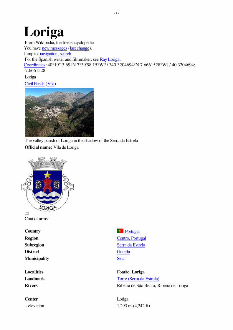
Loriga From Wikipedia, the free encyclopedia
You have new messages (last change).
Jump to: navigation, search
For the Spanish writer and filmmaker, see Ray Loriga.
Coordinates: 40°19'13.69?N 7°39'58.15?W? / ?40.3204694°N 7.6661528°W? / 40.3204694;
-7.6661528
Loriga
Civil Parish (Vila)
The valley parish of Loriga in the shadow of the Serra da Estrela
Official name: Vila de Loriga
Coat of arms
Country Portugal
Region Centro, Portugal
Subregion Serra da Estrela
District Guarda
Municipality Seia
Localities Fontão, Loriga
Landmark Torre (Serra da Estrela)
Rivers Ribeira de São Bento, Ribeira de Loriga
Center Loriga
- elevation 1,293 m (4,242 ft)
- 1 -

- coordinates40°19'13.69?N 7°39'58.15?W? / ?40.3204694°N
7.6661528°W? / 40.3204694; -7.6661528
Length 4.21 km (3 mi), Northwest-Southeast
Width 13.78 km (9 mi), Southwest-Northeast
Area 36.25 km² (14 sq mi)
Population 1,367 (2005)
Density 37.71 / km² (98 / sq mi)
LAU Freguesia/Junta Freguesia
- location Largo da Fonte do Mouro, Loriga, Seia
President Junta - - - - - - - - - - - - - -
President Assembleia - - - - - - - - - - - - - -
Timezone WET (UTC0)
- summer (DST) WEST (UTC+1)
ISO 3166-2 code PT-
Postal Zone 6270-073 Loriga
Area Code & Prefix (+351) 238 XXX XXX
Demonym Loriguense or Loricense
Patron Saint Santa Maria Maior
Parish AddressLargo da Fonte do Mouro, 1019
6270-073 Loriga
Wikimedia Commons: Loriga
Website: http://www.freguesiadeloriga.com/
Statistics from INE (2001); geographic detail from Instituto Geográfico Português (2010)
Loriga (Portuguese pronunciation: [lo'?ig?]) is a civil parish (Portuguese: freguesia) in south-central part
of the municipality of Seia, in central Portugal. Part of the district of Guarda, it is 20 km away from the
city of Seia, 40 km away from Viseu, 80 km away from Guarda and 320 km from Lisbon, nestled in the
Serra da Estrela mountain range. In 2005, estimates have the resident population at about 1367
inhabitants, in an area of 36.25 km² that includes the two localities, city of Loriga and village of Fontão.
Contents• 1 History
o 1.1 Middle Ages
o 1.2 Monarchy
• 2 Geography
• 3 Economy
• 4 References
• 5 External links
- 2 -

[edit] History
The remaining Roman-era bridge crossing the Ribeira de Loriga
Loriga was founded originally along a column between ravines where today the historic centre exists. The
site was ostensibly selected more than 2600 years ago, owing to its defensibility, the abundance of
potable water and pasturelands, and lowlands that provided conditions to practice both hunting and
gathering/agriculture.[1]
When the Romans arrived in the region, the settlement was concentrated into two areas. The larger,
older and principal agglomeration was situated in the area of the main church and Rua de Viriato,
fortified with a wall and palisade.[1] The second group, in the Bairro de São Ginês, were some small
homes constructed on the rocky promintory, which were later appropriated by the Visigoths in order to
construct a chapel.[1] The 1st century Roman road and two bridges (the second was destroyed in the
17th century after flooding) connected the outpost of Lorica to the rest of their Lusitanian province.[1]
The barrio of São Ginês (São Gens), a local ex-libris, is the location of the chapel of Nossa Senhora do
Carmo, an ancient Visigothic chapel. São Gens, a Celtic saint, martyred in Arles na Gália, during the
reign of Emperor Diocletian, and over time the locals began to refer to this saint as São Ginês, due to its
easy of pronunciation.[1]
[edit] Middle Ages
Loriga was the municipal seat since the 12th century, receiving forals in 1136 (João Rhânia, master of
the Terras de Loriga for over two decades, during the reign of Afonso Henriques), 1249 (during the
reign of Afonso III), 1474 (under King Afonso V) and finally in 1514 (by King Manuel I).[1]
Loriga was an ecclesiastical parish of the vicarage of the Royal Padroado and its Matriz Church was
ordered constructed in 1233, by King Sancho II.[1] This church, was to the invokation of Santa Maria
Maior, and constructed over the ancient small Visigothic chapel (there is a lateral block with Visigoth
inscriptions visible).[1] Constructed in the Romanesque-style it consists of a three-nave building, with
hints of the Sé Velha of Coimbra. This structure was destroyed during the 1755 earthquake, and only
portions of the lateral walls were preserved.[1]
[edit] Monarchy
The 1755 earthquake resulted in significant damage to the village of Loriga, destroying homes and the
parcochial residence, in addition to opening-up cracks and faults in the village's larger buildings, such as
the historic municipal council hall (constructed in the 13th century).[1] An emissary of the Marquess of
Pombal actually visited Loriga to evaluate the damage (something that did not happen in other
mountainous parishes, even Covilhã) and provide support.[1]
The residents of Loriga supported the Asolutionist forces of the Infante Miguel of Portugal against the
- 3 -

Liberals, during the Portuguese Liberal Wars, which resulted in Loriga being abandoned politically after
Miguel's explusion by his brother King Peter.[1] In 1855, as a consequence of its support, it was
stripped of municipal status during the municipal reforms of the 19th century.[1] At the time of its
municipal demise (October 1855), the municipality of Loriga included the parishes of Alvoco da Serra,
Cabeça, Sazes da Beira, Teixeira, Valezim and Vide, as well as thirty other disincorporated villages.[1]
Loriga was an industrial centre for textile manufacturing during the 19th century. It was one of the few
industrialized centres in the Beira Interior region, even supplanting Seia until the middle of the 20th
century.[1] Only Covilhã out-preformed Loriga in terms of businesses operating from its lands;
companies such as Regato, Redondinha, Fonte dos Amores, Tapadas, Fândega, Leitão & Irmãos,
Augusto Luís Mendes, Lamas, Nunes Brito, Moura Cabral and Lorimalhas, among others.[1] The main
roadway in Loriga, Avenida Augusto Luís Mendes, is named for one of the villages most illustrious
industrialists. The wool industry started to decline during the last decades of the 20th century, a factor
that aggravated and accelerated the decline of the region.[1]
[edit] Geography
A bridge over a ravine in Loriga, with the pastures of the valley landscape
Known locally as the "Portuguese Switzerland" due to its landscape that includes a principal settlement
nestled in the mountains of the Serra da Estrela Natural Park.[2] It is located in the south-central part of
the municipality of Seia, along the southeast part of the Serra, between several ravines, but specifically
the Ribeira de São Bento and Ribeira de Loriga;[2] it is 20 kilometres from Seia, 80 kilometres from
Guarda and 300 kilometres from the national capital (Lisbon). A main city is accessible by the national
roadway E.N. 231, that connects directly to the region of the Serra da Estrela by way of E.N.338
(which was completed in 2006), or through the E.N.339, a 9.2 kilometre access that transits some of the
main elevations (960 metres near Portela do Arão or Portela de Loriga, and 1650 metres around the
Lagoa Comprida).
The region is carved by U-shaped glacial valleys, modelled by the movement of ancient glaciers. The
main valley, Vale de Loriga was carved by longitudanal abrasion that also created rounded pockets,
where the glacial resistance was minor. Starting at an altitude of 1991 metres along the Serra da Estrela
the valley descends abruptly until 290 metres above sea level (around Vide), passing villages such as
Cabeça, Casal do Rei and Muro. The central village, Loriga, is seven kilometres from Torre (the highest
point), but the parish is sculpted by cliffs, alluvial plains and glacial lakes deposited during millennia of
glacial erosion, and surrounded by rare ancient forest that surrounded the lateral flanks of these glaciers.
[edit] Economy
- 4 -

Vodafone Ski Resort, Serra da Estrela, in Loriga.
Textiles are the principal local export; Loriga was a hub the textile and wool industries during the
mid-19th century, in addition to being subsistence agriculture responsible for the cultivation of corn. The
Loriguense economy is based on metallurgical industries, bread-making, commercial shops, restaurants
and agricultural support services.
While that textile industry has since dissipated, the town began to attract a tourist trade due to its
proximity to the Serra da Estrela and Vodafone Ski Resort (the only ski center in Portugal), which was
constructed within totally the parish limits.
[edit] References
Notes
1. ^ a b c d e f g h i j k l m n o p q "História concisa de Loriga" por António Conde. Junta
Freguesia, ed (2011). "Breve história das origens à actualidade" (in Portuguese). Loriga (Seia),
Portugal: Junta de Freguesia de Loriga.
http://www.freguesiadeloriga.com/index.php?progoption=turnews&do=shownew&topic=12&ne
wid=30. Retrieved 17 June 2011.
2. ^ a b Junta Freguesia, ed (2011). "Conhece em Loriga...Geografia em Loriga" (in Portuguese).
Loriga (Seia), Portugal: Junta de Freguesia de Loriga.
http://www.freguesiadeloriga.com/index.php?progoption=turnews&do=shownewsbytopic&topic
=12&subtipo=Geografia%20de%20Loriga. Retrieved 17 June 2011.
[edit] External links
• (Portuguese) Loriga's Homepage
Retrieved from "http://en.wikipedia.org/wiki/Loriga"
Categories: Parishes of Seia | Towns in Portugal
Hidden categories: Articles containing Portuguese language text | Articles with Portuguese language
external links
Personal tools
• Log in / create account
Namespaces
• Article
• Discussion
Variants
Views
• Read
• Edit
- 5 -

• View history
Actions
Search
Navigation
• Main page
• Contents
• Featured content
• Current events
• Random article
• Donate to Wikipedia
Interaction
• Help
• About Wikipedia
• Community portal
• Recent changes
• Contact Wikipedia
Toolbox
• What links here
• Related changes
• Upload file
• Special pages
• Permanent link
• Cite this page
Print/export
• Create a book
• Download as PDF
• Printable version
Languages
• Deutsch
• Español
• Français
• Italiano
• Latina
• Nederlands
• Português
• ???????
• Türkçe
• This page was last modified on 2 October 2011 at 14:14.
• Text is available under the Creative Commons Attribution-ShareAlike License; additional terms
may apply. See Terms of use for details.
• Wikipedia® is a registered trademark of the Wikimedia Foundation, Inc., a non-profit
organization.
• Contact us
• Privacy policy
• About Wikipedia
- 6 -

• Disclaimers
• Mobile view
•
•
- 7 -
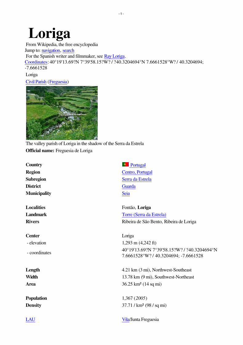
Loriga From Wikipedia, the free encyclopedia
Jump to: navigation, search
For the Spanish writer and filmmaker, see Ray Loriga.
Coordinates: 40°19'13.69?N 7°39'58.15?W? / ?40.3204694°N 7.6661528°W? / 40.3204694;
-7.6661528
Loriga
Civil Parish (Freguesia)
The valley parish of Loriga in the shadow of the Serra da Estrela
Official name: Freguesia de Loriga
Country Portugal
Region Centro, Portugal
Subregion Serra da Estrela
District Guarda
Municipality Seia
Localities Fontão, Loriga
Landmark Torre (Serra da Estrela)
Rivers Ribeira de São Bento, Ribeira de Loriga
Center Loriga
- elevation 1,293 m (4,242 ft)
- coordinates40°19'13.69?N 7°39'58.15?W? / ?40.3204694°N
7.6661528°W? / 40.3204694; -7.6661528
Length 4.21 km (3 mi), Northwest-Southeast
Width 13.78 km (9 mi), Southwest-Northeast
Area 36.25 km² (14 sq mi)
Population 1,367 (2005)
Density 37.71 / km² (98 / sq mi)
LAU Vila/Junta Freguesia
- 1 -

- location Largo da Fonte do Mouro, Loriga, Seia
President Junta - - - - - - - -
President Assembleia - - - - - - - -
Timezone WET (UTC0)
- summer (DST) WEST (UTC+1)
ISO 3166-2 code PT-
Postal Zone 6270-073 Loriga
Area Code & Prefix (+351) 238 XXX XXX
Demonym Loricense or Loriguense
Patron Saint Santa Maria Maior
Parish AddressLargo da Fonte do Mouro, 1019
6270-073 Loriga
Wikimedia Commons: Loriga
Website: http://www.freguesiadeloriga.com/
Statistics from INE (2001); geographic detail from Instituto Geográfico Português (2010)
Coat of arms
Loriga (Portuguese pronunciation: [lo'?ig?]) is a civil parish (Portuguese: freguesia) in south-central part
of the municipality of Seia, in central Portugal. Part of the district of Guarda, it is 20 km away from the
city of Seia, 40 km away from Viseu, 80 km away from Guarda and 320 km from Lisbon, nestled in the
Serra da Estrela mountain range. In 2005, estimates have the resident population at about 1367
inhabitants, in an area of 36.25 km² that includes the two localities of Loriga and Fontão.
Contents• 1 History
o 1.1 Middle Ages
o 1.2 Monarchy
• 2 Geography
• 3 Economy
• 4 References
• 5 External links
- 2 -

[edit] History
The remaining Roman-era bridge crossing the Ribeira de Loriga
Loriga is ancient, beautiful and historic portuguese small town (vila), located in the Serra da Estrela
mountains. Known as Lobriga by the Lusitanians an Lorica by the Romans, it is more than 2600 years
old. Notable people from Loriga include Viriathus (known as Viriato in Portuguese), a famous Lusitanian
leader and portuguese national hero.
Loriga was founded originally along a column between ravines where today the historic centre exists. The
site was ostensibly selected more than 2600 years ago, owing to its defensibility, the abundance of
potable water and pasturelands, and lowlands that provided conditions to practice both hunting and
gathering/agriculture.[1]
When the Romans arrived in the region, the settlement was concentrated into two areas. The larger,
older and principal agglomeration was situated in the area of the main church and Rua de Viriato,
fortified with a wall and palisade.[1] The second group, in the Bairro de São Ginês, were some small
homes constructed on the rocky promintory, which were later appropriated by the Visigoths in order to
construct a chapel.[1] The 1st century Roman road and two bridges (the second was destroyed in the
17th century after flooding) connected the outpost of Lorica to the rest of their Lusitanian province.[1]
The barrio of São Ginês (São Gens), a local ex-libris, is the location of the chapel of Nossa Senhora do
Carmo, an ancient Visigothic chapel. São Gens, a Celtic saint, martyred in Arles na Gália, during the
reign of Emperor Diocletian, and over time the locals began to refer to this saint as São Ginês, due to its
easy of pronunciation.[1]
[edit] Middle Ages
Loriga was the municipal seat since the 12th century, receiving forals in 1136 (João Rhânia, master of
the Terras de Loriga for over two decades, during the reign of Afonso Henriques), 1249 (during the
reign of Afonso III), 1474 (under King Afonso V) and finally in 1514 (by King Manuel I).[1]
Loriga was an ecclesiastical parish of the vicarage of the Royal Padroado and its Matriz Church was
ordered constructed in 1233, by King Sancho II.[1] This church, was to the invokation of Santa Maria
Maior, and constructed over the ancient small Visigothic chapel (there is a lateral block with Visigoth
inscriptions visible).[1] Constructed in the Romanesque-style it consists of a three-nave building, with
hints of the Sé Velha of Coimbra. This structure was destroyed during the 1755 earthquake, and only
portions of the lateral walls were preserved.[1]
[edit] Monarchy
The 1755 earthquake resulted in significant damage to the village of Loriga, destroying homes and the
parcochial residence, in addition to opening-up cracks and faults in the village's larger buildings, such as
the historic municipal council hall (constructed in the 13th century).[1] An emissary of the Marquess of
- 3 -

Pombal actually visited Loriga to evaluate the damage (something that did not happen in other
mountainous parishes, even Covilhã) and provide support.[1]
The residents of Loriga supported the Asolutionist forces of the Infante Miguel of Portugal against the
Liberals, during the Portuguese Liberal Wars, which resulted in Loriga being abandoned politically after
Miguel's explusion by his brother King Peter.[1] In 1855, as a consequence of its support, it was
stripped of municipal status during the municipal reforms of the 19th century.[1] At the time of its
municipal demise (October 1855), the municipality of Loriga included the parishes of Alvoco da Serra,
Cabeça, Sazes da Beira, Teixeira, Valezim and Vide, as well as thirty other disincorporated villages.[1]
Loriga was an industrial centre for textile manufacturing during the 19th century. It was one of the few
industrialized centres in the Beira Interior region, even supplanting Seia until the middle of the 20th
century.[1] Only Covilhã out-preformed Loriga in terms of businesses operating from its lands;
companies such as Regato, Redondinha, Fonte dos Amores, Tapadas, Fândega, Leitão & Irmãos,
Augusto Luís Mendes, Lamas, Nunes Brito, Moura Cabral and Lorimalhas, among others.[1] The main
roadway in Loriga, Avenida Augusto Luís Mendes, is named for one of the villages most illustrious
industrialists. The wool industry started to decline during the last decades of the 20th century, a factor
that aggravated and accelerated the decline of the region.[1]
[edit] Geography
A bridge over a ravine in Loriga, with the pastures of the valley landscape
Known locally as the "Portuguese Switzerland" due to its landscape that includes a principal settlement
nestled in the mountains of the Serra da Estrela Natural Park.[2] It is located in the south-central part of
the municipality of Seia, along the southeast part of the Serra, between several ravines, but specifically
the Ribeira de São Bento and Ribeira de Loriga;[2] it is 20 kilometres from Seia, 80 kilometres from
Guarda and 300 kilometres from the national capital (Lisbon). A main village is accessible by the national
roadway E.N. 231, that connects directly to the region of the Serra da Estrela by way of E.N.338
(which was completed in 2006), or through the E.N.339, a 9.2 kilometre access that transits some of the
main elevations (960 metres near Portela do Arão or Portela de Loriga, and 1650 metres around the
Lagoa Comprida).
The region is carved by U-shaped glacial valleys, modelled by the movement of ancient glaciers. The
main valley, Vale de Loriga was carved by longitudanal abrasion that also created rounded pockets,
where the glacial resistance was minor. Starting at an altitude of 1991 metres along the Serra da Estrela
the valley descends abruptly until 290 metres above sea level (around Vide), passing villages such as
Cabeça, Casal do Rei and Muro. The central village, Loriga, is seven kilometres from Torre (the highest
point), but the parish is sculpted by cliffs, alluvial plains and glacial lakes deposited during millennia of
glacial erosion, and surrounded by rare ancient forest that surrounded the lateral flanks of these glaciers.
[edit] Economy
- 4 -

Vodafone Ski Resort, Serra da Estrela, in Loriga.
Textiles are the principal local export; Loriga was a hub the textile and wool industries during the
mid-19th century, in addition to being subsistence agriculture responsible for the cultivation of corn. The
Loriguense economy is based on metallurgical industries, bread-making, commercial shops, restaurants
and agricultural support services.
While that textile industry has since dissipated, the town began to attract a tourist trade due to its
proximity to the Serra da Estrela and Vodafone Ski Resort (the only ski center in Portugal), which was
constructed within the parish limits.
[edit] References
Notes
1. ^ a b c d e f g h i j k l m n o p q História Concisa de Loriga, por António Conde (in
Portuguese). Loriga, Portugal and similar pages (in Portuguese and English). Junta Freguesia, ed
(2011). "Breve história das origens à actualidade" (in Portuguese). Loriga (Seia), Portugal: Junta
de Freguesia de Loriga.
http://www.freguesiadeloriga.com/index.php?progoption=turnews&do=shownew&topic=12&ne
wid=30. Retrieved 17 June 2011.
2. ^ a b Junta Freguesia, ed (2011). "Conhece em Loriga...Geografia em Loriga" (in Portuguese).
Loriga (Seia), Portugal: Junta de Freguesia de Loriga.
http://www.freguesiadeloriga.com/index.php?progoption=turnews&do=shownewsbytopic&topic
=12&subtipo=Geografia%20de%20Loriga. Retrieved 17 June 2011.
[edit] External links
• (Portuguese and English) Loriga's Homepage
• (Portuguese and English) Loriga - Portugal
Retrieved from "http://en.wikipedia.org/wiki/Loriga"
Categories: Parishes of Seia | Towns in Portugal
Hidden categories: Articles containing Portuguese language text
Personal tools
• Log in / create account
Namespaces
• Article
• Discussion
Variants
Views
• Read
- 5 -

• Edit
• View history
Actions
Search
Navigation
• Main page
• Contents
• Featured content
• Current events
• Random article
• Donate to Wikipedia
Interaction
• Help
• About Wikipedia
• Community portal
• Recent changes
• Contact Wikipedia
Toolbox
• What links here
• Related changes
• Upload file
• Special pages
• Permanent link
• Cite this page
Print/export
• Create a book
• Download as PDF
• Printable version
Languages
• Deutsch
• Español
• Français
• Italiano
• Latina
• Nederlands
• Português
• ???????
• Türkçe
• This page was last modified on 26 July 2011 at 21:02.
• Text is available under the Creative Commons Attribution-ShareAlike License; additional terms
may apply. See Terms of use for details.
• Wikipedia® is a registered trademark of the Wikimedia Foundation, Inc., a non-profit
organization.
• Contact us
• Privacy policy
- 6 -

• About Wikipedia
• Disclaimers
•
•
- 7 -

Loriga From Wikipedia, the free encyclopedia
Jump to: navigation, search
For the Spanish writer and filmmaker, see Ray Loriga.
Coordinates: 40°19'13.69?N 7°39'58.15?W? / ?40.3204694°N 7.6661528°W? / 40.3204694;
-7.6661528
Loriga
Civil Parish (Freguesia)
The valley parish of Loriga in the shadow of the Serra da Estrela
Official name: Freguesia de Loriga
Country Portugal
Region Centro, Portugal
Subregion Serra da Estrela
District Guarda
Municipality Seia
Localities Fontão, Loriga
Landmark Torre (Serra da Estrela)
Rivers Ribeira de São Bento, Ribeira de Loriga
Center Loriga
- elevation 1,293 m (4,242 ft)
- coordinates40°19'13.69?N 7°39'58.15?W? / ?40.3204694°N
7.6661528°W? / 40.3204694; -7.6661528
Length 4.21 km (3 mi), Northwest-Southeast
Width 13.78 km (9 mi), Southwest-Northeast
Area 36.25 km² (14 sq mi)
Population 1,367 (2005)
Density 37.71 / km² (98 / sq mi)
LAU Vila/Junta Freguesia
- 1 -

- location Largo da Fonte do Mouro, Loriga, Seia
President Junta - - - - - - - -
President Assembleia - - - - - - - -
Timezone WET (UTC0)
- summer (DST) WEST (UTC+1)
ISO 3166-2 code PT-
Postal Zone 6270-073 Loriga
Area Code & Prefix (+351) 238 XXX XXX
Demonym Loricense or Loriguense
Patron Saint Santa Maria Maior
Parish AddressLargo da Fonte do Mouro, 1019
6270-073 Loriga
Wikimedia Commons: Loriga
Website: http://www.freguesiadeloriga.com/
Statistics from INE (2001); geographic detail from Instituto Geográfico Português (2010)
Loriga (Portuguese pronunciation: [lo'?ig?]) is a civil parish (Portuguese: freguesia) in south-central part
of the municipality of Seia, in central Portugal. Part of the district of Guarda, it is 20 km away from the
city of Seia, 40 km away from Viseu, 80 km away from Guarda and 320 km from Lisbon, nestled in the
Serra da Estrela mountain range. In 2005, estimates have the resident population at about 1367
inhabitants, in an area of 36.25 km² that includes the two localities of Loriga and Fontão.
Contents• 1 History
o 1.1 Middle Ages
o 1.2 Monarchy
• 2 Geography
• 3 Economy
• 4 References
• 5 External links
[edit] History
The remaining Roman-era bridge crossing the Ribeira de Loriga
- 2 -

Loriga is ancient, beautiful and historic portuguese small town (vila), located in the Serra da Estrela
mountains. Known as Lobriga by the Lusitanians an Lorica by the Romans, it is more than 2600 years
old. Notable people from Loriga include Viriathus (known as Viriato in Portuguese), a famous Lusitanian
leader and portuguese national hero.
Loriga was founded originally along a column between ravines where today the historic centre exists. The
site was ostensibly selected more than 2600 years ago, owing to its defensibility, the abundance of
potable water and pasturelands, and lowlands that provided conditions to practice both hunting and
gathering/agriculture.[1]
When the Romans arrived in the region, the settlement was concentrated into two areas. The larger,
older and principal agglomeration was situated in the area of the main church and Rua de Viriato,
fortified with a wall and palisade.[1] The second group, in the Bairro de São Ginês, were some small
homes constructed on the rocky promintory, which were later appropriated by the Visigoths in order to
construct a chapel.[1] The 1st century Roman road and two bridges (the second was destroyed in the
17th century after flooding) connected the outpost of Lorica to the rest of their Lusitanian province.[1]
The barrio of São Ginês (São Gens), a local ex-libris, is the location of the chapel of Nossa Senhora do
Carmo, an ancient Visigothic chapel. São Gens, a Celtic saint, martyred in Arles na Gália, during the
reign of Emperor Diocletian, and over time the locals began to refer to this saint as São Ginês, due to its
easy of pronunciation.[1]
[edit] Middle Ages
Loriga was the municipal seat since the 12th century, receiving forals in 1136 (João Rhânia, master of
the Terras de Loriga for over two decades, during the reign of Afonso Henriques), 1249 (during the
reign of Afonso III), 1474 (under King Afonso V) and finally in 1514 (by King Manuel I).[1]
Loriga was an ecclesiastical parish of the vicarage of the Royal Padroado and its Matriz Church was
ordered constructed in 1233, by King Sancho II.[1] This church, was to the invokation of Santa Maria
Maior, and constructed over the ancient small Visigothic chapel (there is a lateral block with Visigoth
inscriptions visible).[1] Constructed in the Romanesque-style it consists of a three-nave building, with
hints of the Sé Velha of Coimbra. This structure was destroyed during the 1755 earthquake, and only
portions of the lateral walls were preserved.[1]
[edit] Monarchy
The 1755 earthquake resulted in significant damage to the village of Loriga, destroying homes and the
parcochial residence, in addition to opening-up cracks and faults in the village's larger buildings, such as
the historic municipal council hall (constructed in the 13th century).[1] An emissary of the Marquess of
Pombal actually visited Loriga to evaluate the damage (something that did not happen in other
mountainous parishes, even Covilhã) and provide support.[1]
The residents of Loriga supported the Asolutionist forces of the Infante Miguel of Portugal against the
Liberals, during the Portuguese Liberal Wars, which resulted in Loriga being abandoned politically after
Miguel's explusion by his brother King Peter.[1] In 1855, as a consequence of its support, it was
stripped of municipal status during the municipal reforms of the 19th century.[1] At the time of its
municipal demise (October 1855), the municipality of Loriga included the parishes of Alvoco da Serra,
Cabeça, Sazes da Beira, Teixeira, Valezim and Vide, as well as thirty other disincorporated villages.[1]
Loriga was an industrial centre for textile manufacturing during the 19th century. It was one of the few
industrialized centres in the Beira Interior region, even supplanting Seia until the middle of the 20th
- 3 -

century.[1] Only Covilhã out-preformed Loriga in terms of businesses operating from its lands;
companies such as Regato, Redondinha, Fonte dos Amores, Tapadas, Fândega, Leitão & Irmãos,
Augusto Luís Mendes, Lamas, Nunes Brito, Moura Cabral and Lorimalhas, among others.[1] The main
roadway in Loriga, Avenida Augusto Luís Mendes, is named for one of the villages most illustrious
industrialists. The wool industry started to decline during the last decades of the 20th century, a factor
that aggravated and accelerated the decline of the region.[1]
[edit] Geography
A bridge over a ravine in Loriga, with the pastures of the valley landscape
Known locally as the "Portuguese Switzerland" due to its landscape that includes a principal settlement
nestled in the mountains of the Serra da Estrela Natural Park.[2] It is located in the south-central part of
the municipality of Seia, along the southeast part of the Serra, between several ravines, but specifically
the Ribeira de São Bento and Ribeira de Loriga;[2] it is 20 kilometres from Seia, 80 kilometres from
Guarda and 300 kilometres from the national capital (Lisbon). A main village is accessible by the national
roadway E.N. 231, that connects directly to the region of the Serra da Estrela by way of E.N.338
(which was completed in 2006), or through the E.N.339, a 9.2 kilometre access that transits some of the
main elevations (960 metres near Portela do Arão or Portela de Loriga, and 1650 metres around the
Lagoa Comprida).
The region is carved by U-shaped glacial valleys, modelled by the movement of ancient glaciers. The
main valley, Vale de Loriga was carved by longitudanal abrasion that also created rounded pockets,
where the glacial resistance was minor. Starting at an altitude of 1991 metres along the Serra da Estrela
the valley descends abruptly until 290 metres above sea level (around Vide), passing villages such as
Cabeça, Casal do Rei and Muro. The central village, Loriga, is seven kilometres from Torre (the highest
point), but the parish is sculpted by cliffs, alluvial plains and glacial lakes deposited during millennia of
glacial erosion, and surrounded by rare ancient forest that surrounded the lateral flanks of these glaciers.
[edit] Economy
Vodafone Ski Resort, Serra da Estrela, in Loriga.
Textiles are the principal local export; Loriga was a hub the textile and wool industries during the
- 4 -

mid-19th century, in addition to being subsistence agriculture responsible for the cultivation of corn. The
Loriguense economy is based on metallurgical industries, bread-making, commercial shops, restaurants
and agricultural support services.
While that textile industry has since dissipated, the town began to attract a tourist trade due to its
proximity to the Serra da Estrela and Vodafone Ski Resort (the only ski center in Portugal), which was
constructed within the parish limits.
[edit] References
Notes
1. ^ a b c d e f g h i j k l m n o p q História Concisa de Loriga, por António Conde (in
Portuguese). Loriga, Portugal and similar pages (in Portuguese and English). Junta Freguesia, ed
(2011). "Breve história das origens à actualidade" (in Portuguese). Loriga (Seia), Portugal: Junta
de Freguesia de Loriga.
http://www.freguesiadeloriga.com/index.php?progoption=turnews&do=shownew&topic=12&ne
wid=30. Retrieved 17 June 2011.
2. ^ a b Junta Freguesia, ed (2011). "Conhece em Loriga...Geografia em Loriga" (in Portuguese).
Loriga (Seia), Portugal: Junta de Freguesia de Loriga.
http://www.freguesiadeloriga.com/index.php?progoption=turnews&do=shownewsbytopic&topic
=12&subtipo=Geografia%20de%20Loriga. Retrieved 17 June 2011.
[edit] External links
• (Portuguese and English) Loriga's Homepage
• (Portuguese and English) Loriga - Portugal
Retrieved from "http://en.wikipedia.org/wiki/Loriga"
Categories: Parishes of Seia | Towns in Portugal
Hidden categories: Articles containing Portuguese language text
Personal tools
• Log in / create account
Namespaces
• Article
• Discussion
Variants
Views
• Read
• Edit
• View history
Actions
Search
Navigation
• Main page
• Contents
• Featured content
• Current events
• Random article
- 5 -

• Donate to Wikipedia
Interaction
• Help
• About Wikipedia
• Community portal
• Recent changes
• Contact Wikipedia
Toolbox
• What links here
• Related changes
• Upload file
• Special pages
• Permanent link
• Cite this page
Print/export
• Create a book
• Download as PDF
• Printable version
Languages
• Deutsch
• Español
• Français
• Italiano
• Latina
• Nederlands
• Português
• ???????
• Türkçe
• This page was last modified on 26 July 2011 at 21:02.
• Text is available under the Creative Commons Attribution-ShareAlike License; additional terms
may apply. See Terms of use for details.
• Wikipedia® is a registered trademark of the Wikimedia Foundation, Inc., a non-profit
organization.
• Contact us
• Privacy policy
• About Wikipedia
• Disclaimers
•
•
- 6 -

LorigaCivil Parish (Freguesia)
The valley parish of Loriga in the shadow of the Serra
da Estrela
Official name: Freguesia de Loriga
Country Portugal
Region Centro, Portugal
Subregion Serra da Estrela
District Guarda
Municipality Seia
Localities Fontão, Loriga
Landmark Torre (Serra da Estrela)
Rivers Ribeira de São Bento,
Ribeira de Loriga
Center Loriga
- elevation 1,293 m (4,242 ft)
- coordinates 40°19′13.69″N 7°39′58.15″W
Length 4.21 km (3 mi), Northwest-
Southeast
Width 13.78 km (9 mi), Southwest-
Northeast
Area 36.25 km² (14 sq mi)
Population 1,367 (2005)
Density 37.71 / km² (98 / sq mi)
LAU Freguesia/Junta Freguesia
- location Largo da Fonte do Mouro,
Loriga, Seia
President Junta António Mauricio Moura
Mendes
President Assembleia António Brito Aparício
Timezone WET (UTC0)
- summer (DST) WEST (UTC+1)
ISO 3166-2 code PT-
The remaining Roman-era bridge
crossing the Ribeira de São Bento
LorigaFrom Wikipedia, the free encyclopedia
Loriga (Portuguese pronunciation: [loˈɾiɡɐ]) is a
civil parish (Portuguese: freguesia) in south-central part of the municipality of Seia, in central Portugal. Part of the district of Guarda, it is 20 km away from the city of Seia, 40 km away from Viseu, 80 km away from Guarda and 320 km from Lisbon, nestled in the Serra da Estrela mountain range. In 2005, estimates have the resident population at about 1367 inhabitants, in an area of 36.25 km² that includes the two localities/villages of Loriga and Fontão.
Contents
1 History
1.1 Middle Ages
1.2 Monarchy
2 Geography
3 Economy
4 References
5 External links
History
Loriga was founded originally along a column between ravines where today the historic centre exists. The site was ostensibly selected more than 2600 years ago, owing to its defensibility, the abundance of potable water
Coordinates: 40°19′13.69″N 7°39′58.15″W
Página Web 1 de 4
26-07-2011http://en.wikipedia.org/wiki/Loriga
Vila
Vila
Loriga
Vila

Postal Zone 6270-073 Loriga
Area Code & Prefix (+351) 238 XXX XXX
Demonym Loriguense
Patron Saint Santa Maria Maior
Parish Address Largo da Fonte do Mouro,
1019
6270-073 Loriga
Wikimedia Commons: Loriga
Website: http://www.freguesiadeloriga.com/
Statistics from INE (2001); geographic detail from
Instituto Geográfico Português (2010)
and pasturelands, and lowlands that provided conditions to practice both hunting and
gathering/agriculture.[1]
When the Romans arrived in the region, the settlement was concentrated into two areas. The larger, older and principal agglomeration was situated in the area of the main church and Rua de Viriato, fortified with a wall and
palisade.[1]
The second group, in the Bairro de São Ginês, were some small homes constructed on the rocky promintory, which were later appropriated by the Visigoths in
order to construct a chapel.[1]
The 1st century Roman road and two bridges (the second was destroyed in the 17th century after flooding) connected the outpost of Lorica to the rest of their
Lusitanian province.[1] The barrio of São Ginês (São Gens), a local ex-libris, is the location of the chapel of Nossa Senhora do Carmo, an ancient Visigothic chapel. São Gens, a Celtic saint, martyred in Arles na Gália, during the reign of Emperor Diocletian, and over time the locals began to refer to
this saint as São Ginês, due to its easy of pronunciation.[1]
Middle Ages
Loriga was the municipal seat since the 12th century, receiving forals in 1136 (João Rhânia, master of the Terras de Loriga for over two decades, during the reign of Afonso Henriques), 1249 (during
the reign of Afonso III), 1474 (under King Afonso V) and finally in 1514 (by King Manuel I).[1]
Loriga was an ecclesiastical parish of the vicarage of the Royal Padroado and its Matriz Church was
ordered constructed in 1233, by King Sancho II.[1]
This church, was to the invokation of Santa Maria Maior, and constructed over the ancient small Visigothic chapel (there is a lateral block with
Visigoth inscriptions visible).[1] Constructed in the Romanesque-style it consists of a three-nave building, with hints of the Sé Velha of Coimbra. This structure was destroyed during the 1755
earthquake, and only portions of the lateral walls were preserved.[1]
Monarchy
The 1755 earthquake resulted in significant damage to the village of Loriga, destroying homes and the parcochial residence, in addition to opening-up cracks and faults in the village's larger buildings,
such as the historic municipal council hall (constructed in the 13th century).[1]
An emissary of the Marquess of Pombal actually visited Loriga to evaluate the damage (something that did not happen
in other mountainous parishes, even Covilhã) and provide support.[1]
The residents of Loriga supported the Asolutionist forces of the Infante Miguel of Portugal against the Liberals, during the Portuguese Liberal Wars, which resulted in Loriga being abandoned
politically after Miguel's explusion by his brother King Peter.[1]
In 1855, as a consequence of its
support, it was stripped of municipal status during the municipal reforms of the 19th century.[1] At the time of its municipal demise (October 1855), the municipality of Loriga included the parishes of Alvoco da Serra, Cabeça, Sazes da Beira, Teixeira, Valezim and Vide, as well as thirty other
disincorporated villages.[1]
Página Web 2 de 4
26-07-2011http://en.wikipedia.org/wiki/Loriga
or Loricense

A bridge over a ravine in Loriga, with
the pastures of the valley landscape
Vodafone Ski Resort, Serra da Estrela,
in Loriga.
Loriga was an industrial centre for textile manufacturing during the 19th century. It was one of the few industrialized centres in the Beira Interior region, even supplanting Seia until the middle of the
20th century.[1] Only Covilhã out-preformed Loriga in terms of businesses operating from its lands; companies such as Regato, Redondinha, Fonte dos Amores, Tapadas, Fândega, Leitão & Irmãos,
Augusto Luís Mendes, Lamas, Nunes Brito, Moura Cabral and Lorimalhas, among others.[1] The main roadway in Loriga, Avenida Augusto Luís Mendes, is named for one of the villages most illustrious industrialists. The wool industry started to decline during the last decades of the 20th
century, a factor that aggravated and accelerated the decline of the region.[1]
Geography
Known locally as the "Portuguese Switzerland" due to its landscape that includes a principal settlement nestled in the
mountains of the Serra da Estrela Natural Park.[2] It is located in the south-central part of the municipality of Seia, along the southeast part of the Serra, between several ravines, but specifically the Ribeira de São Bento and
Ribeira de Loriga;[2] it is 20 kilometres from Seia, 80 kilometres from Guarda and 300 kilometres from the national capital (Lisbon). A main village is accessible by the national roadway E.N. 231, that connects directly to the region of the Serra da Estrela by way of E.N.338 (which was completed in 2006), or through the E.N.339, a 9.2 kilometre access that transits some of the main elevations (960 metres near Portela do Arão or Portela de Loriga, and
1650 metres around the Lagoa Comprida).
The region is carved by U-shaped glacial valleys, modelled by the movement of ancient glaciers. The main valley, Vale de Loriga was carved by longitudanal abrasion that also created rounded pockets, where the glacial resistance was minor. Starting at an altitude of 1991 metres along the Serra da Estrela the valley descends abruptly until 290 metres above sea level (around Vide), passing villages such as Cabeça, Casal do Rei and Muro. The central village, Loriga, is seven kilometres from Torre (the highest point), but the parish is sculpted by cliffs, alluvial plains and glacial lakes deposited during millennia of glacial erosion, and surrounded by rare ancient forest that surrounded the lateral flanks of these glaciers.
Economy
Textiles are the principal local export; Loriga was a hub the textile and wool industries during the mid-19th century, in addition to being subsistence agriculture responsible for the cultivation of corn. The Loriguense economy is based on metallurgical industries, bread-making, commercial shops, restaurants and agricultural support services.
While that textile industry has since dissipated, the town began to attract a tourist trade due to its proximity to the Serra da Estrela and Vodafone Ski Resort (the only ski center in Portugal), which was constructed within the parish limits.
Página Web 3 de 4
26-07-2011http://en.wikipedia.org/wiki/Loriga

References
Notes
^ a b c d e f g h i j k l m n o p q Junta Freguesia, ed (2011). "Breve história das origens à actualidade" (http://www.freguesiadeloriga.com/index.php?progoption=turnews&do=shownew&topic=12&newid=30) (in Portuguese). Loriga (Seia), Portugal: Junta de Freguesia de Loriga. http://www.freguesiadeloriga.com/index.php?progoption=turnews&do=shownew&topic=12&newid=30. Retrieved 17 June 2011.
1.
^ a b Junta Freguesia, ed (2011). "Conhece em Loriga...Geografia em Loriga" (http://www.freguesiadeloriga.com/index.php?progoption=turnews&do=shownewsbytopic&topic=12&subtipo=Geografia%20de%20Loriga) (in Portuguese). Loriga (Seia), Portugal: Junta de Freguesia de Loriga. http://www.freguesiadeloriga.com/index.php?progoption=turnews&do=shownewsbytopic&topic=12&subtipo=Geografia%20de%20Loriga. Retrieved 17 June 2011.
2.
External links
(Portuguese) Loriga's Homepage (http://lorigaportugal.multiply.com)
Retrieved from "http://en.wikipedia.org/wiki/Loriga"Categories: Parishes of Seia | Towns in Portugal
This page was last modified on 26 July 2011 at 21:02.
Text is available under the Creative Commons Attribution-ShareAlike License; additional terms may apply. See Terms of use for details. Wikipedia® is a registered trademark of the Wikimedia Foundation, Inc., a non-profit organization.
Página Web 4 de 4
26-07-2011http://en.wikipedia.org/wiki/Loriga
http://www.lorica.no.sapo.pt
http://www.lorica.no.sapo.pt
http://www.lorica.no.sapo.pt
http://www.lorica.no.sapo.pt
http://viriathus.multiply.com

LorigaCivil Parish (Vila)
The valley parish of Loriga in the shadow of the Serra
da Estrela
Official name: Freguesia de Loriga
Country Portugal
Region Centro, Portugal
Subregion Serra da Estrela
District Guarda
Municipality Seia
Localities Fontão, Loriga
Landmark Torre (Serra da Estrela)
Rivers Ribeira de São Bento,
Ribeira de Loriga
Center Loriga
- elevation 1,293 m (4,242 ft)
- coordinates 40°19′13.69″N 7°39′58.15″W
Length 4.21 km (3 mi), Northwest-
Southeast
Width 13.78 km (9 mi), Southwest-
Northeast
Area 36.25 km² (14 sq mi)
Population 1,367 (2005)
Density 37.71 / km² (98 / sq mi)
LAU Freguesia/Junta Freguesia
- location Largo da Fonte do Mouro,
Loriga, Seia
President Junta António Mauricio Moura
Mendes
President Assembleia António Brito Aparício
Timezone WET (UTC0)
- summer (DST) WEST (UTC+1)
The remaining Roman-era bridge
crossing the Ribeira de Loriga
LorigaFrom Wikipedia, the free encyclopedia
You have new messages (last change).
Loriga (Portuguese pronunciation: [loˈɾiɡɐ]) is a
civil parish (Portuguese: freguesia) in south-central part of the municipality of Seia, in central Portugal. Part of the district of Guarda, it is 20 km away from the city of Seia, 40 km away from Viseu, 80 km away from Guarda and 320 km from Lisbon, nestled in the Serra da Estrela mountain range. In 2005, estimates have the resident population at about 1367 inhabitants, in an area of 36.25 km² that includes the two localities/villages of Loriga and Fontão.
Contents
1 History
1.1 Middle Ages
1.2 Monarchy
2 Geography
3 Economy
4 References
5 External links
History
Loriga was founded originally along a column between ravines where today the historic centre exists. The site was ostensibly selected more than 2600 years ago, owing to its
Coordinates: 40°19′13.69″N 7°39′58.15″W
Página Web 1 de 4
02-10-2011http://en.wikipedia.org/wiki/Loriga
........................
........................

ISO 3166-2 code PT-
Postal Zone 6270-073 Loriga
Area Code & Prefix (+351) 238 XXX XXX
Demonym Loriguense or Loricense
Patron Saint Santa Maria Maior
Parish Address Largo da Fonte do Mouro,
1019
6270-073 Loriga
Wikimedia Commons: Loriga
Website: http://www.freguesiadeloriga.com/
Statistics from INE (2001); geographic detail from
Instituto Geográfico Português (2010)
defensibility, the abundance of potable water and pasturelands, and lowlands that provided conditions to practice both hunting and
gathering/agriculture.[1]
When the Romans arrived in the region, the settlement was concentrated into two areas. The larger, older and principal agglomeration was situated in the area of the main church and Rua de Viriato, fortified with a wall and
palisade.[1] The second group, in the Bairro de São Ginês, were some small homes constructed on the rocky promintory, which were later appropriated by the Visigoths in
order to construct a chapel.[1] The 1st century Roman road and two bridges (the second was destroyed in the 17th century after flooding) connected the outpost of Lorica to the rest of their
Lusitanian province.[1]
The barrio of São Ginês (São Gens), a local ex-libris, is the location of the chapel of Nossa Senhora do Carmo, an ancient Visigothic chapel. São Gens, a Celtic saint, martyred in Arles na Gália, during the reign of Emperor Diocletian, and over time the locals began to refer to
this saint as São Ginês, due to its easy of pronunciation.[1]
Middle Ages
Loriga was the municipal seat since the 12th century, receiving forals in 1136 (João Rhânia, master of the Terras de Loriga for over two decades, during the reign of Afonso Henriques), 1249 (during
the reign of Afonso III), 1474 (under King Afonso V) and finally in 1514 (by King Manuel I).[1]
Loriga was an ecclesiastical parish of the vicarage of the Royal Padroado and its Matriz Church was
ordered constructed in 1233, by King Sancho II.[1] This church, was to the invokation of Santa Maria Maior, and constructed over the ancient small Visigothic chapel (there is a lateral block with
Visigoth inscriptions visible).[1] Constructed in the Romanesque-style it consists of a three-nave building, with hints of the Sé Velha of Coimbra. This structure was destroyed during the 1755
earthquake, and only portions of the lateral walls were preserved.[1]
Monarchy
The 1755 earthquake resulted in significant damage to the village of Loriga, destroying homes and the parcochial residence, in addition to opening-up cracks and faults in the village's larger buildings,
such as the historic municipal council hall (constructed in the 13th century).[1] An emissary of the Marquess of Pombal actually visited Loriga to evaluate the damage (something that did not happen
in other mountainous parishes, even Covilhã) and provide support.[1]
The residents of Loriga supported the Asolutionist forces of the Infante Miguel of Portugal against the Liberals, during the Portuguese Liberal Wars, which resulted in Loriga being abandoned
politically after Miguel's explusion by his brother King Peter.[1] In 1855, as a consequence of its
support, it was stripped of municipal status during the municipal reforms of the 19th century.[1]
At the time of its municipal demise (October 1855), the municipality of Loriga included the parishes of Alvoco da Serra, Cabeça, Sazes da Beira, Teixeira, Valezim and Vide, as well as thirty other
disincorporated villages.[1]
Página Web 2 de 4
02-10-2011http://en.wikipedia.org/wiki/Loriga

A bridge over a ravine in Loriga, with
the pastures of the valley landscape
Vodafone Ski Resort, Serra da Estrela,
in Loriga.
Loriga was an industrial centre for textile manufacturing during the 19th century. It was one of the few industrialized centres in the Beira Interior region, even supplanting Seia until the middle of the
20th century.[1] Only Covilhã out-preformed Loriga in terms of businesses operating from its lands; companies such as Regato, Redondinha, Fonte dos Amores, Tapadas, Fândega, Leitão & Irmãos,
Augusto Luís Mendes, Lamas, Nunes Brito, Moura Cabral and Lorimalhas, among others.[1] The main roadway in Loriga, Avenida Augusto Luís Mendes, is named for one of the villages most illustrious industrialists. The wool industry started to decline during the last decades of the 20th
century, a factor that aggravated and accelerated the decline of the region.[1]
Geography
Known locally as the "Portuguese Switzerland" due to its landscape that includes a principal settlement nestled in the
mountains of the Serra da Estrela Natural Park.[2] It is located in the south-central part of the municipality of Seia, along the southeast part of the Serra, between several ravines, but specifically the Ribeira de São Bento and
Ribeira da Nave;[2] it is 20 kilometres from Seia, 80 kilometres from Guarda and 300 kilometres from the national capital (Lisbon). A main village is accessible by the national roadway E.N. 231, that connects directly to the region of the Serra da Estrela by way of E.N.338 (which was completed in 2006), or through the E.N.339, a 9.2 kilometre access that transits some of the main elevations (960 metres near Portela do Arão or Portela de Loriga, and
1650 metres around the Lagoa Comprida).
The region is carved by U-shaped glacial valleys, modelled by the movement of ancient glaciers. The main valley, Vale de Loriga was carved by longitudanal abrasion that also created rounded pockets, where the glacial resistance was minor. Starting at an altitude of 1991 metres along the Serra da Estrela the valley descends abruptly until 290 metres above sea level (around Vide), passing villages such as Cabeça, Casal do Rei and Muro. The central village, Loriga, is seven kilometres from Torre (the highest point), but the parish is sculpted by cliffs, alluvial plains and glacial lakes deposited during millennia of glacial erosion, and surrounded by rare ancient forest that surrounded the lateral flanks of these glaciers.
Economy
Textiles are the principal local export; Loriga was a hub the textile and wool industries during the mid-19th century, in addition to being subsistence agriculture responsible for the cultivation of corn. The Loriguense economy is based on metallurgical industries, bread-making, commercial shops, restaurants and agricultural support services.
While that textile industry has since dissipated, the town began to attract a tourist trade due to its proximity to the Serra da Estrela and Vodafone Ski Resort (the only ski center in Portugal), which was constructed within the parish limits.
Página Web 3 de 4
02-10-2011http://en.wikipedia.org/wiki/Loriga

References
Notes
^ a b c d e f g h i j k l m n o p q Junta Freguesia, ed (2011). "Breve história das origens à actualidade" (http://www.freguesiadeloriga.com/index.php?progoption=turnews&do=shownew&topic=12&newid=30) (in Portuguese). Loriga (Seia), Portugal: Junta de Freguesia de Loriga. http://www.freguesiadeloriga.com/index.php?progoption=turnews&do=shownew&topic=12&newid=30. Retrieved 17 June 2011.
1.
^ a b Junta Freguesia, ed (2011). "Conhece em Loriga...Geografia em Loriga" (http://www.freguesiadeloriga.com/index.php?progoption=turnews&do=shownewsbytopic&topic=12&subtipo=Geografia%20de%20Loriga) (in Portuguese). Loriga (Seia), Portugal: Junta de Freguesia de Loriga. http://www.freguesiadeloriga.com/index.php?progoption=turnews&do=shownewsbytopic&topic=12&subtipo=Geografia%20de%20Loriga. Retrieved 17 June 2011.
2.
External links
(Portuguese) Loriga's Homepage (http://viriathus.multiply.com)
Retrieved from "http://en.wikipedia.org/wiki/Loriga"Categories: Parishes of Seia | Towns in Portugal
This page was last modified on 2 October 2011 at 14:14.
Text is available under the Creative Commons Attribution-ShareAlike License; additional terms may apply. See Terms of use for details. Wikipedia® is a registered trademark of the Wikimedia Foundation, Inc., a non-profit organization.
Página Web 4 de 4
02-10-2011http://en.wikipedia.org/wiki/Loriga
História concisa de Loriga, por António Conde

Loriga From Wikipedia, the free encyclopedia
You have new messages (last change).
Jump to: navigation, search
For the Spanish writer and filmmaker, see Ray Loriga.
Coordinates: 40°19'13.69?N 7°39'58.15?W? / ?40.3204694°N 7.6661528°W? / 40.3204694;
-7.6661528
Loriga
Civil Parish (Vila)
The valley parish of Loriga in the shadow of the Serra da Estrela
Official name: Vila de Loriga
Coat of arms
Country Portugal
Region Centro, Portugal
Subregion Serra da Estrela
District Guarda
Municipality Seia
Localities Fontão, Loriga
Landmark Torre (Serra da Estrela)
Rivers Ribeira de São Bento, Ribeira de Loriga
Center Loriga
- elevation 1,293 m (4,242 ft)
- 1 -

- coordinates40°19'13.69?N 7°39'58.15?W? / ?40.3204694°N
7.6661528°W? / 40.3204694; -7.6661528
Length 4.21 km (3 mi), Northwest-Southeast
Width 13.78 km (9 mi), Southwest-Northeast
Area 36.25 km² (14 sq mi)
Population 1,367 (2005)
Density 37.71 / km² (98 / sq mi)
LAU Freguesia/Junta Freguesia
- location Largo da Fonte do Mouro, Loriga, Seia
President Junta - - - - - - - - - - - - - -
President Assembleia - - - - - - - - - - - - - -
Timezone WET (UTC0)
- summer (DST) WEST (UTC+1)
ISO 3166-2 code PT-
Postal Zone 6270-073 Loriga
Area Code & Prefix (+351) 238 XXX XXX
Demonym Loriguense or Loricense
Patron Saint Santa Maria Maior
Parish AddressLargo da Fonte do Mouro, 1019
6270-073 Loriga
Wikimedia Commons: Loriga
Website: http://www.freguesiadeloriga.com/
Statistics from INE (2001); geographic detail from Instituto Geográfico Português (2010)
Loriga (Portuguese pronunciation: [lo'?ig?]) is a civil parish (Portuguese: freguesia) in south-central part
of the municipality of Seia, in central Portugal. Part of the district of Guarda, it is 20 km away from the
city of Seia, 40 km away from Viseu, 80 km away from Guarda and 320 km from Lisbon, nestled in the
Serra da Estrela mountain range. In 2005, estimates have the resident population at about 1367
inhabitants, in an area of 36.25 km² that includes the two localities, city of Loriga and village of Fontão.
Contents• 1 History
o 1.1 Middle Ages
o 1.2 Monarchy
• 2 Geography
• 3 Economy
• 4 References
• 5 External links
- 2 -

[edit] History
The remaining Roman-era bridge crossing the Ribeira de Loriga
Loriga was founded originally along a column between ravines where today the historic centre exists. The
site was ostensibly selected more than 2600 years ago, owing to its defensibility, the abundance of
potable water and pasturelands, and lowlands that provided conditions to practice both hunting and
gathering/agriculture.[1]
When the Romans arrived in the region, the settlement was concentrated into two areas. The larger,
older and principal agglomeration was situated in the area of the main church and Rua de Viriato,
fortified with a wall and palisade.[1] The second group, in the Bairro de São Ginês, were some small
homes constructed on the rocky promintory, which were later appropriated by the Visigoths in order to
construct a chapel.[1] The 1st century Roman road and two bridges (the second was destroyed in the
17th century after flooding) connected the outpost of Lorica to the rest of their Lusitanian province.[1]
The barrio of São Ginês (São Gens), a local ex-libris, is the location of the chapel of Nossa Senhora do
Carmo, an ancient Visigothic chapel. São Gens, a Celtic saint, martyred in Arles na Gália, during the
reign of Emperor Diocletian, and over time the locals began to refer to this saint as São Ginês, due to its
easy of pronunciation.[1]
[edit] Middle Ages
Loriga was the municipal seat since the 12th century, receiving forals in 1136 (João Rhânia, master of
the Terras de Loriga for over two decades, during the reign of Afonso Henriques), 1249 (during the
reign of Afonso III), 1474 (under King Afonso V) and finally in 1514 (by King Manuel I).[1]
Loriga was an ecclesiastical parish of the vicarage of the Royal Padroado and its Matriz Church was
ordered constructed in 1233, by King Sancho II.[1] This church, was to the invokation of Santa Maria
Maior, and constructed over the ancient small Visigothic chapel (there is a lateral block with Visigoth
inscriptions visible).[1] Constructed in the Romanesque-style it consists of a three-nave building, with
hints of the Sé Velha of Coimbra. This structure was destroyed during the 1755 earthquake, and only
portions of the lateral walls were preserved.[1]
[edit] Monarchy
The 1755 earthquake resulted in significant damage to the village of Loriga, destroying homes and the
parcochial residence, in addition to opening-up cracks and faults in the village's larger buildings, such as
the historic municipal council hall (constructed in the 13th century).[1] An emissary of the Marquess of
Pombal actually visited Loriga to evaluate the damage (something that did not happen in other
mountainous parishes, even Covilhã) and provide support.[1]
The residents of Loriga supported the Asolutionist forces of the Infante Miguel of Portugal against the
- 3 -

Liberals, during the Portuguese Liberal Wars, which resulted in Loriga being abandoned politically after
Miguel's explusion by his brother King Peter.[1] In 1855, as a consequence of its support, it was
stripped of municipal status during the municipal reforms of the 19th century.[1] At the time of its
municipal demise (October 1855), the municipality of Loriga included the parishes of Alvoco da Serra,
Cabeça, Sazes da Beira, Teixeira, Valezim and Vide, as well as thirty other disincorporated villages.[1]
Loriga was an industrial centre for textile manufacturing during the 19th century. It was one of the few
industrialized centres in the Beira Interior region, even supplanting Seia until the middle of the 20th
century.[1] Only Covilhã out-preformed Loriga in terms of businesses operating from its lands;
companies such as Regato, Redondinha, Fonte dos Amores, Tapadas, Fândega, Leitão & Irmãos,
Augusto Luís Mendes, Lamas, Nunes Brito, Moura Cabral and Lorimalhas, among others.[1] The main
roadway in Loriga, Avenida Augusto Luís Mendes, is named for one of the villages most illustrious
industrialists. The wool industry started to decline during the last decades of the 20th century, a factor
that aggravated and accelerated the decline of the region.[1]
[edit] Geography
A bridge over a ravine in Loriga, with the pastures of the valley landscape
Known locally as the "Portuguese Switzerland" due to its landscape that includes a principal settlement
nestled in the mountains of the Serra da Estrela Natural Park.[2] It is located in the south-central part of
the municipality of Seia, along the southeast part of the Serra, between several ravines, but specifically
the Ribeira de São Bento and Ribeira de Loriga;[2] it is 20 kilometres from Seia, 80 kilometres from
Guarda and 300 kilometres from the national capital (Lisbon). A main city is accessible by the national
roadway E.N. 231, that connects directly to the region of the Serra da Estrela by way of E.N.338
(which was completed in 2006), or through the E.N.339, a 9.2 kilometre access that transits some of the
main elevations (960 metres near Portela do Arão or Portela de Loriga, and 1650 metres around the
Lagoa Comprida).
The region is carved by U-shaped glacial valleys, modelled by the movement of ancient glaciers. The
main valley, Vale de Loriga was carved by longitudanal abrasion that also created rounded pockets,
where the glacial resistance was minor. Starting at an altitude of 1991 metres along the Serra da Estrela
the valley descends abruptly until 290 metres above sea level (around Vide), passing villages such as
Cabeça, Casal do Rei and Muro. The central village, Loriga, is seven kilometres from Torre (the highest
point), but the parish is sculpted by cliffs, alluvial plains and glacial lakes deposited during millennia of
glacial erosion, and surrounded by rare ancient forest that surrounded the lateral flanks of these glaciers.
[edit] Economy
- 4 -

Vodafone Ski Resort, Serra da Estrela, in Loriga.
Textiles are the principal local export; Loriga was a hub the textile and wool industries during the
mid-19th century, in addition to being subsistence agriculture responsible for the cultivation of corn. The
Loriguense economy is based on metallurgical industries, bread-making, commercial shops, restaurants
and agricultural support services.
While that textile industry has since dissipated, the town began to attract a tourist trade due to its
proximity to the Serra da Estrela and Vodafone Ski Resort (the only ski center in Portugal), which was
constructed within totally the parish limits.
[edit] References
Notes
1. ^ a b c d e f g h i j k l m n o p q "História concisa de Loriga" por António Conde. Junta
Freguesia, ed (2011). "Breve história das origens à actualidade" (in Portuguese). Loriga (Seia),
Portugal: Junta de Freguesia de Loriga.
http://www.freguesiadeloriga.com/index.php?progoption=turnews&do=shownew&topic=12&ne
wid=30. Retrieved 17 June 2011.
2. ^ a b Junta Freguesia, ed (2011). "Conhece em Loriga...Geografia em Loriga" (in Portuguese).
Loriga (Seia), Portugal: Junta de Freguesia de Loriga.
http://www.freguesiadeloriga.com/index.php?progoption=turnews&do=shownewsbytopic&topic
=12&subtipo=Geografia%20de%20Loriga. Retrieved 17 June 2011.
[edit] External links
• (Portuguese) Loriga's Homepage
Retrieved from "http://en.wikipedia.org/wiki/Loriga"
Categories: Parishes of Seia | Towns in Portugal
Hidden categories: Articles containing Portuguese language text | Articles with Portuguese language
external links
Personal tools
• Log in / create account
Namespaces
• Article
• Discussion
Variants
Views
• Read
• Edit
- 5 -

• View history
Actions
Search
Navigation
• Main page
• Contents
• Featured content
• Current events
• Random article
• Donate to Wikipedia
Interaction
• Help
• About Wikipedia
• Community portal
• Recent changes
• Contact Wikipedia
Toolbox
• What links here
• Related changes
• Upload file
• Special pages
• Permanent link
• Cite this page
Print/export
• Create a book
• Download as PDF
• Printable version
Languages
• Deutsch
• Español
• Français
• Italiano
• Latina
• Nederlands
• Português
• ???????
• Türkçe
• This page was last modified on 2 October 2011 at 14:14.
• Text is available under the Creative Commons Attribution-ShareAlike License; additional terms
may apply. See Terms of use for details.
• Wikipedia® is a registered trademark of the Wikimedia Foundation, Inc., a non-profit
organization.
• Contact us
• Privacy policy
• About Wikipedia
- 6 -

• Disclaimers
• Mobile view
•
•
- 7 -

Loriga From Wikipedia, the free encyclopedia
Jump to: navigation, search
For the Spanish writer and filmmaker, see Ray Loriga.
Coordinates: 40°19'13.69?N 7°39'58.15?W? / ?40.3204694°N 7.6661528°W? / 40.3204694;
-7.6661528
Loriga
Civil Parish (Freguesia)
The valley parish of Loriga in the shadow of the Serra da Estrela
Official name: Freguesia de Loriga
Country Portugal
Region Centro, Portugal
Subregion Serra da Estrela
District Guarda
Municipality Seia
Localities Fontão, Loriga
Landmark Torre (Serra da Estrela)
Rivers Ribeira de São Bento, Ribeira de Loriga
Center Loriga
- elevation 1,293 m (4,242 ft)
- coordinates40°19'13.69?N 7°39'58.15?W? / ?40.3204694°N
7.6661528°W? / 40.3204694; -7.6661528
Length 4.21 km (3 mi), Northwest-Southeast
Width 13.78 km (9 mi), Southwest-Northeast
Area 36.25 km² (14 sq mi)
Population 1,367 (2005)
Density 37.71 / km² (98 / sq mi)
LAU Vila/Junta Freguesia
- 1 -

- location Largo da Fonte do Mouro, Loriga, Seia
President Junta - - - - - - - -
President Assembleia - - - - - - - -
Timezone WET (UTC0)
- summer (DST) WEST (UTC+1)
ISO 3166-2 code PT-
Postal Zone 6270-073 Loriga
Area Code & Prefix (+351) 238 XXX XXX
Demonym Loricense or Loriguense
Patron Saint Santa Maria Maior
Parish AddressLargo da Fonte do Mouro, 1019
6270-073 Loriga
Wikimedia Commons: Loriga
Website: http://www.freguesiadeloriga.com/
Statistics from INE (2001); geographic detail from Instituto Geográfico Português (2010)
Coat of arms
Loriga (Portuguese pronunciation: [lo'?ig?]) is a civil parish (Portuguese: freguesia) in south-central part
of the municipality of Seia, in central Portugal. Part of the district of Guarda, it is 20 km away from the
city of Seia, 40 km away from Viseu, 80 km away from Guarda and 320 km from Lisbon, nestled in the
Serra da Estrela mountain range. In 2005, estimates have the resident population at about 1367
inhabitants, in an area of 36.25 km² that includes the two localities of Loriga and Fontão.
Contents• 1 History
o 1.1 Middle Ages
o 1.2 Monarchy
• 2 Geography
• 3 Economy
• 4 References
• 5 External links
- 2 -

[edit] History
The remaining Roman-era bridge crossing the Ribeira de Loriga
Loriga is ancient, beautiful and historic portuguese small town (vila), located in the Serra da Estrela
mountains. Known as Lobriga by the Lusitanians an Lorica by the Romans, it is more than 2600 years
old. Notable people from Loriga include Viriathus (known as Viriato in Portuguese), a famous Lusitanian
leader and portuguese national hero.
Loriga was founded originally along a column between ravines where today the historic centre exists. The
site was ostensibly selected more than 2600 years ago, owing to its defensibility, the abundance of
potable water and pasturelands, and lowlands that provided conditions to practice both hunting and
gathering/agriculture.[1]
When the Romans arrived in the region, the settlement was concentrated into two areas. The larger,
older and principal agglomeration was situated in the area of the main church and Rua de Viriato,
fortified with a wall and palisade.[1] The second group, in the Bairro de São Ginês, were some small
homes constructed on the rocky promintory, which were later appropriated by the Visigoths in order to
construct a chapel.[1] The 1st century Roman road and two bridges (the second was destroyed in the
17th century after flooding) connected the outpost of Lorica to the rest of their Lusitanian province.[1]
The barrio of São Ginês (São Gens), a local ex-libris, is the location of the chapel of Nossa Senhora do
Carmo, an ancient Visigothic chapel. São Gens, a Celtic saint, martyred in Arles na Gália, during the
reign of Emperor Diocletian, and over time the locals began to refer to this saint as São Ginês, due to its
easy of pronunciation.[1]
[edit] Middle Ages
Loriga was the municipal seat since the 12th century, receiving forals in 1136 (João Rhânia, master of
the Terras de Loriga for over two decades, during the reign of Afonso Henriques), 1249 (during the
reign of Afonso III), 1474 (under King Afonso V) and finally in 1514 (by King Manuel I).[1]
Loriga was an ecclesiastical parish of the vicarage of the Royal Padroado and its Matriz Church was
ordered constructed in 1233, by King Sancho II.[1] This church, was to the invokation of Santa Maria
Maior, and constructed over the ancient small Visigothic chapel (there is a lateral block with Visigoth
inscriptions visible).[1] Constructed in the Romanesque-style it consists of a three-nave building, with
hints of the Sé Velha of Coimbra. This structure was destroyed during the 1755 earthquake, and only
portions of the lateral walls were preserved.[1]
[edit] Monarchy
The 1755 earthquake resulted in significant damage to the village of Loriga, destroying homes and the
parcochial residence, in addition to opening-up cracks and faults in the village's larger buildings, such as
the historic municipal council hall (constructed in the 13th century).[1] An emissary of the Marquess of
- 3 -

Pombal actually visited Loriga to evaluate the damage (something that did not happen in other
mountainous parishes, even Covilhã) and provide support.[1]
The residents of Loriga supported the Asolutionist forces of the Infante Miguel of Portugal against the
Liberals, during the Portuguese Liberal Wars, which resulted in Loriga being abandoned politically after
Miguel's explusion by his brother King Peter.[1] In 1855, as a consequence of its support, it was
stripped of municipal status during the municipal reforms of the 19th century.[1] At the time of its
municipal demise (October 1855), the municipality of Loriga included the parishes of Alvoco da Serra,
Cabeça, Sazes da Beira, Teixeira, Valezim and Vide, as well as thirty other disincorporated villages.[1]
Loriga was an industrial centre for textile manufacturing during the 19th century. It was one of the few
industrialized centres in the Beira Interior region, even supplanting Seia until the middle of the 20th
century.[1] Only Covilhã out-preformed Loriga in terms of businesses operating from its lands;
companies such as Regato, Redondinha, Fonte dos Amores, Tapadas, Fândega, Leitão & Irmãos,
Augusto Luís Mendes, Lamas, Nunes Brito, Moura Cabral and Lorimalhas, among others.[1] The main
roadway in Loriga, Avenida Augusto Luís Mendes, is named for one of the villages most illustrious
industrialists. The wool industry started to decline during the last decades of the 20th century, a factor
that aggravated and accelerated the decline of the region.[1]
[edit] Geography
A bridge over a ravine in Loriga, with the pastures of the valley landscape
Known locally as the "Portuguese Switzerland" due to its landscape that includes a principal settlement
nestled in the mountains of the Serra da Estrela Natural Park.[2] It is located in the south-central part of
the municipality of Seia, along the southeast part of the Serra, between several ravines, but specifically
the Ribeira de São Bento and Ribeira de Loriga;[2] it is 20 kilometres from Seia, 80 kilometres from
Guarda and 300 kilometres from the national capital (Lisbon). A main village is accessible by the national
roadway E.N. 231, that connects directly to the region of the Serra da Estrela by way of E.N.338
(which was completed in 2006), or through the E.N.339, a 9.2 kilometre access that transits some of the
main elevations (960 metres near Portela do Arão or Portela de Loriga, and 1650 metres around the
Lagoa Comprida).
The region is carved by U-shaped glacial valleys, modelled by the movement of ancient glaciers. The
main valley, Vale de Loriga was carved by longitudanal abrasion that also created rounded pockets,
where the glacial resistance was minor. Starting at an altitude of 1991 metres along the Serra da Estrela
the valley descends abruptly until 290 metres above sea level (around Vide), passing villages such as
Cabeça, Casal do Rei and Muro. The central village, Loriga, is seven kilometres from Torre (the highest
point), but the parish is sculpted by cliffs, alluvial plains and glacial lakes deposited during millennia of
glacial erosion, and surrounded by rare ancient forest that surrounded the lateral flanks of these glaciers.
[edit] Economy
- 4 -

Vodafone Ski Resort, Serra da Estrela, in Loriga.
Textiles are the principal local export; Loriga was a hub the textile and wool industries during the
mid-19th century, in addition to being subsistence agriculture responsible for the cultivation of corn. The
Loriguense economy is based on metallurgical industries, bread-making, commercial shops, restaurants
and agricultural support services.
While that textile industry has since dissipated, the town began to attract a tourist trade due to its
proximity to the Serra da Estrela and Vodafone Ski Resort (the only ski center in Portugal), which was
constructed within the parish limits.
[edit] References
Notes
1. ^ a b c d e f g h i j k l m n o p q História Concisa de Loriga, por António Conde (in
Portuguese). Loriga, Portugal and similar pages (in Portuguese and English). Junta Freguesia, ed
(2011). "Breve história das origens à actualidade" (in Portuguese). Loriga (Seia), Portugal: Junta
de Freguesia de Loriga.
http://www.freguesiadeloriga.com/index.php?progoption=turnews&do=shownew&topic=12&ne
wid=30. Retrieved 17 June 2011.
2. ^ a b Junta Freguesia, ed (2011). "Conhece em Loriga...Geografia em Loriga" (in Portuguese).
Loriga (Seia), Portugal: Junta de Freguesia de Loriga.
http://www.freguesiadeloriga.com/index.php?progoption=turnews&do=shownewsbytopic&topic
=12&subtipo=Geografia%20de%20Loriga. Retrieved 17 June 2011.
[edit] External links
• (Portuguese and English) Loriga's Homepage
• (Portuguese and English) Loriga - Portugal
Retrieved from "http://en.wikipedia.org/wiki/Loriga"
Categories: Parishes of Seia | Towns in Portugal
Hidden categories: Articles containing Portuguese language text
Personal tools
• Log in / create account
Namespaces
• Article
• Discussion
Variants
Views
• Read
- 5 -

• Edit
• View history
Actions
Search
Navigation
• Main page
• Contents
• Featured content
• Current events
• Random article
• Donate to Wikipedia
Interaction
• Help
• About Wikipedia
• Community portal
• Recent changes
• Contact Wikipedia
Toolbox
• What links here
• Related changes
• Upload file
• Special pages
• Permanent link
• Cite this page
Print/export
• Create a book
• Download as PDF
• Printable version
Languages
• Deutsch
• Español
• Français
• Italiano
• Latina
• Nederlands
• Português
• ???????
• Türkçe
• This page was last modified on 26 July 2011 at 21:02.
• Text is available under the Creative Commons Attribution-ShareAlike License; additional terms
may apply. See Terms of use for details.
• Wikipedia® is a registered trademark of the Wikimedia Foundation, Inc., a non-profit
organization.
• Contact us
• Privacy policy
- 6 -

• About Wikipedia
• Disclaimers
•
•
- 7 -

Loriga From Wikipedia, the free encyclopedia
Jump to: navigation, search
For the Spanish writer and filmmaker, see Ray Loriga.
Coordinates: 40°19'13.69?N 7°39'58.15?W? / ?40.3204694°N 7.6661528°W? / 40.3204694;
-7.6661528
Loriga
Civil Parish (Freguesia)
The valley parish of Loriga in the shadow of the Serra da Estrela
Official name: Freguesia de Loriga
Country Portugal
Region Centro, Portugal
Subregion Serra da Estrela
District Guarda
Municipality Seia
Localities Fontão, Loriga
Landmark Torre (Serra da Estrela)
Rivers Ribeira de São Bento, Ribeira de Loriga
Center Loriga
- elevation 1,293 m (4,242 ft)
- coordinates40°19'13.69?N 7°39'58.15?W? / ?40.3204694°N
7.6661528°W? / 40.3204694; -7.6661528
Length 4.21 km (3 mi), Northwest-Southeast
Width 13.78 km (9 mi), Southwest-Northeast
Area 36.25 km² (14 sq mi)
Population 1,367 (2005)
Density 37.71 / km² (98 / sq mi)
LAU Vila/Junta Freguesia
- 1 -

- location Largo da Fonte do Mouro, Loriga, Seia
President Junta - - - - - - - -
President Assembleia - - - - - - - -
Timezone WET (UTC0)
- summer (DST) WEST (UTC+1)
ISO 3166-2 code PT-
Postal Zone 6270-073 Loriga
Area Code & Prefix (+351) 238 XXX XXX
Demonym Loricense or Loriguense
Patron Saint Santa Maria Maior
Parish AddressLargo da Fonte do Mouro, 1019
6270-073 Loriga
Wikimedia Commons: Loriga
Website: http://www.freguesiadeloriga.com/
Statistics from INE (2001); geographic detail from Instituto Geográfico Português (2010)
Loriga (Portuguese pronunciation: [lo'?ig?]) is a civil parish (Portuguese: freguesia) in south-central part
of the municipality of Seia, in central Portugal. Part of the district of Guarda, it is 20 km away from the
city of Seia, 40 km away from Viseu, 80 km away from Guarda and 320 km from Lisbon, nestled in the
Serra da Estrela mountain range. In 2005, estimates have the resident population at about 1367
inhabitants, in an area of 36.25 km² that includes the two localities of Loriga and Fontão.
Contents• 1 History
o 1.1 Middle Ages
o 1.2 Monarchy
• 2 Geography
• 3 Economy
• 4 References
• 5 External links
[edit] History
The remaining Roman-era bridge crossing the Ribeira de Loriga
- 2 -

Loriga is ancient, beautiful and historic portuguese small town (vila), located in the Serra da Estrela
mountains. Known as Lobriga by the Lusitanians an Lorica by the Romans, it is more than 2600 years
old. Notable people from Loriga include Viriathus (known as Viriato in Portuguese), a famous Lusitanian
leader and portuguese national hero.
Loriga was founded originally along a column between ravines where today the historic centre exists. The
site was ostensibly selected more than 2600 years ago, owing to its defensibility, the abundance of
potable water and pasturelands, and lowlands that provided conditions to practice both hunting and
gathering/agriculture.[1]
When the Romans arrived in the region, the settlement was concentrated into two areas. The larger,
older and principal agglomeration was situated in the area of the main church and Rua de Viriato,
fortified with a wall and palisade.[1] The second group, in the Bairro de São Ginês, were some small
homes constructed on the rocky promintory, which were later appropriated by the Visigoths in order to
construct a chapel.[1] The 1st century Roman road and two bridges (the second was destroyed in the
17th century after flooding) connected the outpost of Lorica to the rest of their Lusitanian province.[1]
The barrio of São Ginês (São Gens), a local ex-libris, is the location of the chapel of Nossa Senhora do
Carmo, an ancient Visigothic chapel. São Gens, a Celtic saint, martyred in Arles na Gália, during the
reign of Emperor Diocletian, and over time the locals began to refer to this saint as São Ginês, due to its
easy of pronunciation.[1]
[edit] Middle Ages
Loriga was the municipal seat since the 12th century, receiving forals in 1136 (João Rhânia, master of
the Terras de Loriga for over two decades, during the reign of Afonso Henriques), 1249 (during the
reign of Afonso III), 1474 (under King Afonso V) and finally in 1514 (by King Manuel I).[1]
Loriga was an ecclesiastical parish of the vicarage of the Royal Padroado and its Matriz Church was
ordered constructed in 1233, by King Sancho II.[1] This church, was to the invokation of Santa Maria
Maior, and constructed over the ancient small Visigothic chapel (there is a lateral block with Visigoth
inscriptions visible).[1] Constructed in the Romanesque-style it consists of a three-nave building, with
hints of the Sé Velha of Coimbra. This structure was destroyed during the 1755 earthquake, and only
portions of the lateral walls were preserved.[1]
[edit] Monarchy
The 1755 earthquake resulted in significant damage to the village of Loriga, destroying homes and the
parcochial residence, in addition to opening-up cracks and faults in the village's larger buildings, such as
the historic municipal council hall (constructed in the 13th century).[1] An emissary of the Marquess of
Pombal actually visited Loriga to evaluate the damage (something that did not happen in other
mountainous parishes, even Covilhã) and provide support.[1]
The residents of Loriga supported the Asolutionist forces of the Infante Miguel of Portugal against the
Liberals, during the Portuguese Liberal Wars, which resulted in Loriga being abandoned politically after
Miguel's explusion by his brother King Peter.[1] In 1855, as a consequence of its support, it was
stripped of municipal status during the municipal reforms of the 19th century.[1] At the time of its
municipal demise (October 1855), the municipality of Loriga included the parishes of Alvoco da Serra,
Cabeça, Sazes da Beira, Teixeira, Valezim and Vide, as well as thirty other disincorporated villages.[1]
Loriga was an industrial centre for textile manufacturing during the 19th century. It was one of the few
industrialized centres in the Beira Interior region, even supplanting Seia until the middle of the 20th
- 3 -

century.[1] Only Covilhã out-preformed Loriga in terms of businesses operating from its lands;
companies such as Regato, Redondinha, Fonte dos Amores, Tapadas, Fândega, Leitão & Irmãos,
Augusto Luís Mendes, Lamas, Nunes Brito, Moura Cabral and Lorimalhas, among others.[1] The main
roadway in Loriga, Avenida Augusto Luís Mendes, is named for one of the villages most illustrious
industrialists. The wool industry started to decline during the last decades of the 20th century, a factor
that aggravated and accelerated the decline of the region.[1]
[edit] Geography
A bridge over a ravine in Loriga, with the pastures of the valley landscape
Known locally as the "Portuguese Switzerland" due to its landscape that includes a principal settlement
nestled in the mountains of the Serra da Estrela Natural Park.[2] It is located in the south-central part of
the municipality of Seia, along the southeast part of the Serra, between several ravines, but specifically
the Ribeira de São Bento and Ribeira de Loriga;[2] it is 20 kilometres from Seia, 80 kilometres from
Guarda and 300 kilometres from the national capital (Lisbon). A main village is accessible by the national
roadway E.N. 231, that connects directly to the region of the Serra da Estrela by way of E.N.338
(which was completed in 2006), or through the E.N.339, a 9.2 kilometre access that transits some of the
main elevations (960 metres near Portela do Arão or Portela de Loriga, and 1650 metres around the
Lagoa Comprida).
The region is carved by U-shaped glacial valleys, modelled by the movement of ancient glaciers. The
main valley, Vale de Loriga was carved by longitudanal abrasion that also created rounded pockets,
where the glacial resistance was minor. Starting at an altitude of 1991 metres along the Serra da Estrela
the valley descends abruptly until 290 metres above sea level (around Vide), passing villages such as
Cabeça, Casal do Rei and Muro. The central village, Loriga, is seven kilometres from Torre (the highest
point), but the parish is sculpted by cliffs, alluvial plains and glacial lakes deposited during millennia of
glacial erosion, and surrounded by rare ancient forest that surrounded the lateral flanks of these glaciers.
[edit] Economy
Vodafone Ski Resort, Serra da Estrela, in Loriga.
Textiles are the principal local export; Loriga was a hub the textile and wool industries during the
- 4 -

mid-19th century, in addition to being subsistence agriculture responsible for the cultivation of corn. The
Loriguense economy is based on metallurgical industries, bread-making, commercial shops, restaurants
and agricultural support services.
While that textile industry has since dissipated, the town began to attract a tourist trade due to its
proximity to the Serra da Estrela and Vodafone Ski Resort (the only ski center in Portugal), which was
constructed within the parish limits.
[edit] References
Notes
1. ^ a b c d e f g h i j k l m n o p q História Concisa de Loriga, por António Conde (in
Portuguese). Loriga, Portugal and similar pages (in Portuguese and English). Junta Freguesia, ed
(2011). "Breve história das origens à actualidade" (in Portuguese). Loriga (Seia), Portugal: Junta
de Freguesia de Loriga.
http://www.freguesiadeloriga.com/index.php?progoption=turnews&do=shownew&topic=12&ne
wid=30. Retrieved 17 June 2011.
2. ^ a b Junta Freguesia, ed (2011). "Conhece em Loriga...Geografia em Loriga" (in Portuguese).
Loriga (Seia), Portugal: Junta de Freguesia de Loriga.
http://www.freguesiadeloriga.com/index.php?progoption=turnews&do=shownewsbytopic&topic
=12&subtipo=Geografia%20de%20Loriga. Retrieved 17 June 2011.
[edit] External links
• (Portuguese and English) Loriga's Homepage
• (Portuguese and English) Loriga - Portugal
Retrieved from "http://en.wikipedia.org/wiki/Loriga"
Categories: Parishes of Seia | Towns in Portugal
Hidden categories: Articles containing Portuguese language text
Personal tools
• Log in / create account
Namespaces
• Article
• Discussion
Variants
Views
• Read
• Edit
• View history
Actions
Search
Navigation
• Main page
• Contents
• Featured content
• Current events
• Random article
- 5 -

• Donate to Wikipedia
Interaction
• Help
• About Wikipedia
• Community portal
• Recent changes
• Contact Wikipedia
Toolbox
• What links here
• Related changes
• Upload file
• Special pages
• Permanent link
• Cite this page
Print/export
• Create a book
• Download as PDF
• Printable version
Languages
• Deutsch
• Español
• Français
• Italiano
• Latina
• Nederlands
• Português
• ???????
• Türkçe
• This page was last modified on 26 July 2011 at 21:02.
• Text is available under the Creative Commons Attribution-ShareAlike License; additional terms
may apply. See Terms of use for details.
• Wikipedia® is a registered trademark of the Wikimedia Foundation, Inc., a non-profit
organization.
• Contact us
• Privacy policy
• About Wikipedia
• Disclaimers
•
•
- 6 -

LorigaCivil Parish (Freguesia)
The valley parish of Loriga in the shadow of the Serra da Estrela
Official name: Freguesia de Loriga
Country Portugal
Region Centro, Portugal
Subregion Serra da Estrela
District Guarda
Municipality Seia
Localities Fontão, Loriga
Landmark Torre (Serra da Estrela)
Rivers Ribeira de São Bento, Ribeira de Loriga
Center Loriga
- elevation 1,293 m (4,242 ft)
- coordinates 40°19′13.69″N 7°39′58.15″W
Length 4.21 km (3 mi), Northwest-Southeast
Width 13.78 km (9 mi), Southwest-Northeast
Area 36.25 km² (14 sq mi)
Population 1,367 (2005)
Density 37.71 / km² (98 / sq mi)
LAU Freguesia/Junta Freguesia
- location Largo da Fonte do Mouro, Loriga, Seia
President Junta António Mauricio Moura Mendes
President Assembleia António Brito Aparício
Timezone WET (UTC0)
- summer (DST) WEST (UTC+1)
ISO 3166-2 code PT-
The remaining Roman-era bridge
crossing the Ribeira de São Bento
LorigaFrom Wikipedia, the free encyclopedia
Loriga (Portuguese pronunciation: [loˈɾiɡɐ]) is a civil parish (Portuguese: freguesia) in south-central part of the municipality of Seia, in central Portugal. Part of the district of Guarda, it is 20 km away from the city of Seia, 40 km away from Viseu, 80 km away from Guarda and 320 km from Lisbon, nestled in the Serra da Estrela mountain range. In 2005, estimates have the resident population at about 1367 inhabitants, in an area of 36.25 km² that includes the two localities/villages of Loriga and Fontão.
Contents
1 History
1.1 Middle Ages
1.2 Monarchy
2 Geography
3 Economy
4 References
5 External links
History
Loriga was founded originally along a column between ravines where today the historic centre exists. The site was ostensibly selected more than 2600 years ago, owing to its defensibility, the abundance of potable water
Coordinates: 40°19′13.69″N 7°39′58.15″W
Página Web 1 de 4
26-07-2011http://en.wikipedia.org/wiki/Loriga
Vila
Vila
Loriga
Vila

Postal Zone 6270-073 Loriga
Area Code & Prefix (+351) 238 XXX XXX
Demonym Loriguense
Patron Saint Santa Maria Maior
Parish Address Largo da Fonte do Mouro, 1019 6270-073 Loriga
Wikimedia Commons: Loriga
Website: http://www.freguesiadeloriga.com/
Statistics from INE (2001); geographic detail from Instituto Geográfico Português (2010)
and pasturelands, and lowlands that provided conditions to practice both hunting and
gathering/agriculture.[1]
When the Romans arrived in the region, the settlement was concentrated into two areas. The larger, older and principal agglomeration was situated in the area of the main church and Rua de Viriato, fortified with a wall and
palisade.[1] The second group, in the Bairro de São Ginês, were some small homes constructed on the rocky promintory, which were later appropriated by the Visigoths in
order to construct a chapel.[1] The 1st century Roman road and two bridges (the second was destroyed in the 17th century after flooding) connected the outpost of Lorica to the rest of their
Lusitanian province.[1] The barrio of São Ginês (São Gens), a local ex-libris, is the location of the chapel of Nossa Senhora do Carmo, an ancient Visigothic chapel. São Gens, a Celtic saint, martyred in Arles na Gália, during the reign of Emperor Diocletian, and over time the locals began to refer to
this saint as São Ginês, due to its easy of pronunciation.[1]
Middle Ages
Loriga was the municipal seat since the 12th century, receiving forals in 1136 (João Rhânia, master of the Terras de Loriga for over two decades, during the reign of Afonso Henriques), 1249 (during
the reign of Afonso III), 1474 (under King Afonso V) and finally in 1514 (by King Manuel I).[1]
Loriga was an ecclesiastical parish of the vicarage of the Royal Padroado and its Matriz Church was
ordered constructed in 1233, by King Sancho II.[1] This church, was to the invokation of Santa Maria Maior, and constructed over the ancient small Visigothic chapel (there is a lateral block with
Visigoth inscriptions visible).[1] Constructed in the Romanesque-style it consists of a three-nave building, with hints of the Sé Velha of Coimbra. This structure was destroyed during the 1755
earthquake, and only portions of the lateral walls were preserved.[1]
Monarchy
The 1755 earthquake resulted in significant damage to the village of Loriga, destroying homes and the parcochial residence, in addition to opening-up cracks and faults in the village's larger buildings,
such as the historic municipal council hall (constructed in the 13th century).[1] An emissary of the Marquess of Pombal actually visited Loriga to evaluate the damage (something that did not happen
in other mountainous parishes, even Covilhã) and provide support.[1]
The residents of Loriga supported the Asolutionist forces of the Infante Miguel of Portugal against the Liberals, during the Portuguese Liberal Wars, which resulted in Loriga being abandoned
politically after Miguel's explusion by his brother King Peter.[1] In 1855, as a consequence of its
support, it was stripped of municipal status during the municipal reforms of the 19th century.[1] At the time of its municipal demise (October 1855), the municipality of Loriga included the parishes of Alvoco da Serra, Cabeça, Sazes da Beira, Teixeira, Valezim and Vide, as well as thirty other
disincorporated villages.[1]
Página Web 2 de 4
26-07-2011http://en.wikipedia.org/wiki/Loriga
or Loricense

A bridge over a ravine in Loriga, with
the pastures of the valley landscape
Vodafone Ski Resort, Serra da Estrela,
in Loriga.
Loriga was an industrial centre for textile manufacturing during the 19th century. It was one of the few industrialized centres in the Beira Interior region, even supplanting Seia until the middle of the
20th century.[1] Only Covilhã out-preformed Loriga in terms of businesses operating from its lands; companies such as Regato, Redondinha, Fonte dos Amores, Tapadas, Fândega, Leitão & Irmãos,
Augusto Luís Mendes, Lamas, Nunes Brito, Moura Cabral and Lorimalhas, among others.[1] The main roadway in Loriga, Avenida Augusto Luís Mendes, is named for one of the villages most illustrious industrialists. The wool industry started to decline during the last decades of the 20th
century, a factor that aggravated and accelerated the decline of the region.[1]
Geography
Known locally as the "Portuguese Switzerland" due to its landscape that includes a principal settlement nestled in the
mountains of the Serra da Estrela Natural Park.[2] It is located in the south-central part of the municipality of Seia, along the southeast part of the Serra, between several ravines, but specifically the Ribeira de São Bento and
Ribeira de Loriga;[2] it is 20 kilometres from Seia, 80 kilometres from Guarda and 300 kilometres from the national capital (Lisbon). A main village is accessible by the national roadway E.N. 231, that connects directly to the region of the Serra da Estrela by way of E.N.338 (which was completed in 2006), or through the E.N.339, a 9.2 kilometre access that transits some of the main elevations (960 metres near Portela do Arão or Portela de Loriga, and
1650 metres around the Lagoa Comprida).
The region is carved by U-shaped glacial valleys, modelled by the movement of ancient glaciers. The main valley, Vale de Loriga was carved by longitudanal abrasion that also created rounded pockets, where the glacial resistance was minor. Starting at an altitude of 1991 metres along the Serra da Estrela the valley descends abruptly until 290 metres above sea level (around Vide), passing villages such as Cabeça, Casal do Rei and Muro. The central village, Loriga, is seven kilometres from Torre (the highest point), but the parish is sculpted by cliffs, alluvial plains and glacial lakes deposited during millennia of glacial erosion, and surrounded by rare ancient forest that surrounded the lateral flanks of these glaciers.
Economy
Textiles are the principal local export; Loriga was a hub the textile and wool industries during the mid-19th century, in addition to being subsistence agriculture responsible for the cultivation of corn. The Loriguense economy is based on metallurgical industries, bread-making, commercial shops, restaurants and agricultural support services.
While that textile industry has since dissipated, the town began to attract a tourist trade due to its proximity to the Serra da Estrela and Vodafone Ski Resort (the only ski center in Portugal), which was constructed within the parish limits.
Página Web 3 de 4
26-07-2011http://en.wikipedia.org/wiki/Loriga

References
Notes
^ a b c d e f g h i j k l m n o p q Junta Freguesia, ed (2011). "Breve história das origens à actualidade" (http://www.freguesiadeloriga.com/index.php?progoption=turnews&do=shownew&topic=12&newid=30) (in Portuguese). Loriga (Seia), Portugal: Junta de Freguesia de Loriga. http://www.freguesiadeloriga.com/index.php?progoption=turnews&do=shownew&topic=12&newid=30. Retrieved 17 June 2011.
1.
^ a b Junta Freguesia, ed (2011). "Conhece em Loriga...Geografia em Loriga" (http://www.freguesiadeloriga.com/index.php?progoption=turnews&do=shownewsbytopic&topic=12&subtipo=Geografia%20de%20Loriga) (in Portuguese). Loriga (Seia), Portugal: Junta de Freguesia de Loriga. http://www.freguesiadeloriga.com/index.php?progoption=turnews&do=shownewsbytopic&topic=12&subtipo=Geografia%20de%20Loriga. Retrieved 17 June 2011.
2.
External links
(Portuguese) Loriga's Homepage (http://lorigaportugal.multiply.com)
Retrieved from "http://en.wikipedia.org/wiki/Loriga"Categories: Parishes of Seia | Towns in Portugal
This page was last modified on 26 July 2011 at 21:02.
Text is available under the Creative Commons Attribution-ShareAlike License; additional terms may apply. See Terms of use for details. Wikipedia® is a registered trademark of the Wikimedia Foundation, Inc., a non-profit organization.
Página Web 4 de 4
26-07-2011http://en.wikipedia.org/wiki/Loriga
http://www.lorica.no.sapo.pt
http://www.lorica.no.sapo.pt
http://www.lorica.no.sapo.pt
http://www.lorica.no.sapo.pt
http://viriathus.multiply.com

Loriga From Wikipedia, the free encyclopediaJump to: navigation, search For the Spanish writer and filmmaker, see Ray Loriga.Coordinates: 40°19'13.69?N 7°39'58.15?W? / ?40.3204694°N 7.6661528°W? / 40.3204694;-7.6661528
Loriga
Civil Parish (Freguesia)
The valley parish of Loriga in the shadow of the Serra da Estrela
Official name: Freguesia de Loriga
Country Portugal
Region Centro, Portugal
Subregion Serra da Estrela
District Guarda
Municipality Seia
Localities Fontão, Loriga
Landmark Torre (Serra da Estrela)
Rivers Ribeira de São Bento, Ribeira de Loriga
Center Loriga
- elevation 1,293 m (4,242 ft)
- coordinates40°19'13.69?N 7°39'58.15?W? / ?40.3204694°N7.6661528°W? / 40.3204694; -7.6661528
Length 4.21 km (3 mi), Northwest-Southeast
Width 13.78 km (9 mi), Southwest-Northeast
Area 36.25 km² (14 sq mi)
Population 1,367 (2005)
Density 37.71 / km² (98 / sq mi)
LAU Vila/Junta Freguesia
- 1 -

- location Largo da Fonte do Mouro, Loriga, Seia
President Junta - - - - - - - -
President Assembleia - - - - - - - -
Timezone WET (UTC0)
- summer (DST) WEST (UTC+1)
ISO 3166-2 code PT-
Postal Zone 6270-073 Loriga
Area Code & Prefix (+351) 238 XXX XXX
Demonym Loricense or Loriguense
Patron Saint Santa Maria Maior
Parish AddressLargo da Fonte do Mouro, 10196270-073 Loriga
Wikimedia Commons: Loriga
Website: http://www.freguesiadeloriga.com/
Statistics from INE (2001); geographic detail from Instituto Geográfico Português (2010)
Coat of arms
Loriga (Portuguese pronunciation: [lo'?ig?]) is a civil parish (Portuguese: freguesia) in south-central partof the municipality of Seia, in central Portugal. Part of the district of Guarda, it is 20 km away from thecity of Seia, 40 km away from Viseu, 80 km away from Guarda and 320 km from Lisbon, nestled in theSerra da Estrela mountain range. In 2005, estimates have the resident population at about 1367inhabitants, in an area of 36.25 km² that includes the two localities of Loriga and Fontão.
Contents• 1 History
o 1.1 Middle Ages
o 1.2 Monarchy• 2 Geography• 3 Economy• 4 References• 5 External links
- 2 -

[edit] History
The remaining Roman-era bridge crossing the Ribeira de Loriga
Loriga is ancient, beautiful and historic portuguese small town (vila), located in the Serra da Estrelamountains. Known as Lobriga by the Lusitanians an Lorica by the Romans, it is more than 2600 yearsold. Notable people from Loriga include Viriathus (known as Viriato in Portuguese), a famous Lusitanianleader and portuguese national hero.
Loriga was founded originally along a column between ravines where today the historic centre exists. Thesite was ostensibly selected more than 2600 years ago, owing to its defensibility, the abundance ofpotable water and pasturelands, and lowlands that provided conditions to practice both hunting andgathering/agriculture.[1]
When the Romans arrived in the region, the settlement was concentrated into two areas. The larger,older and principal agglomeration was situated in the area of the main church and Rua de Viriato,fortified with a wall and palisade.[1] The second group, in the Bairro de São Ginês, were some smallhomes constructed on the rocky promintory, which were later appropriated by the Visigoths in order toconstruct a chapel.[1] The 1st century Roman road and two bridges (the second was destroyed in the17th century after flooding) connected the outpost of Lorica to the rest of their Lusitanian province.[1]The barrio of São Ginês (São Gens), a local ex-libris, is the location of the chapel of Nossa Senhora doCarmo, an ancient Visigothic chapel. São Gens, a Celtic saint, martyred in Arles na Gália, during thereign of Emperor Diocletian, and over time the locals began to refer to this saint as São Ginês, due to itseasy of pronunciation.[1]
[edit] Middle Ages
Loriga was the municipal seat since the 12th century, receiving forals in 1136 (João Rhânia, master ofthe Terras de Loriga for over two decades, during the reign of Afonso Henriques), 1249 (during thereign of Afonso III), 1474 (under King Afonso V) and finally in 1514 (by King Manuel I).[1]
Loriga was an ecclesiastical parish of the vicarage of the Royal Padroado and its Matriz Church wasordered constructed in 1233, by King Sancho II.[1] This church, was to the invokation of Santa Maria
Maior, and constructed over the ancient small Visigothic chapel (there is a lateral block with Visigothinscriptions visible).[1] Constructed in the Romanesque-style it consists of a three-nave building, withhints of the Sé Velha of Coimbra. This structure was destroyed during the 1755 earthquake, and onlyportions of the lateral walls were preserved.[1]
[edit] Monarchy
The 1755 earthquake resulted in significant damage to the village of Loriga, destroying homes and theparcochial residence, in addition to opening-up cracks and faults in the village's larger buildings, such asthe historic municipal council hall (constructed in the 13th century).[1] An emissary of the Marquess of
- 3 -

Pombal actually visited Loriga to evaluate the damage (something that did not happen in othermountainous parishes, even Covilhã) and provide support.[1]
The residents of Loriga supported the Asolutionist forces of the Infante Miguel of Portugal against theLiberals, during the Portuguese Liberal Wars, which resulted in Loriga being abandoned politically afterMiguel's explusion by his brother King Peter.[1] In 1855, as a consequence of its support, it wasstripped of municipal status during the municipal reforms of the 19th century.[1] At the time of itsmunicipal demise (October 1855), the municipality of Loriga included the parishes of Alvoco da Serra,Cabeça, Sazes da Beira, Teixeira, Valezim and Vide, as well as thirty other disincorporated villages.[1]
Loriga was an industrial centre for textile manufacturing during the 19th century. It was one of the fewindustrialized centres in the Beira Interior region, even supplanting Seia until the middle of the 20thcentury.[1] Only Covilhã out-preformed Loriga in terms of businesses operating from its lands;companies such as Regato, Redondinha, Fonte dos Amores, Tapadas, Fândega, Leitão & Irmãos,Augusto Luís Mendes, Lamas, Nunes Brito, Moura Cabral and Lorimalhas, among others.[1] The mainroadway in Loriga, Avenida Augusto Luís Mendes, is named for one of the villages most illustriousindustrialists. The wool industry started to decline during the last decades of the 20th century, a factorthat aggravated and accelerated the decline of the region.[1]
[edit] Geography
A bridge over a ravine in Loriga, with the pastures of the valley landscape
Known locally as the "Portuguese Switzerland" due to its landscape that includes a principal settlementnestled in the mountains of the Serra da Estrela Natural Park.[2] It is located in the south-central part ofthe municipality of Seia, along the southeast part of the Serra, between several ravines, but specificallythe Ribeira de São Bento and Ribeira de Loriga;[2] it is 20 kilometres from Seia, 80 kilometres fromGuarda and 300 kilometres from the national capital (Lisbon). A main village is accessible by the nationalroadway E.N. 231, that connects directly to the region of the Serra da Estrela by way of E.N.338(which was completed in 2006), or through the E.N.339, a 9.2 kilometre access that transits some of themain elevations (960 metres near Portela do Arão or Portela de Loriga, and 1650 metres around theLagoa Comprida).
The region is carved by U-shaped glacial valleys, modelled by the movement of ancient glaciers. Themain valley, Vale de Loriga was carved by longitudanal abrasion that also created rounded pockets,where the glacial resistance was minor. Starting at an altitude of 1991 metres along the Serra da Estrelathe valley descends abruptly until 290 metres above sea level (around Vide), passing villages such asCabeça, Casal do Rei and Muro. The central village, Loriga, is seven kilometres from Torre (the highestpoint), but the parish is sculpted by cliffs, alluvial plains and glacial lakes deposited during millennia ofglacial erosion, and surrounded by rare ancient forest that surrounded the lateral flanks of these glaciers.
[edit] Economy
- 4 -

Vodafone Ski Resort, Serra da Estrela, in Loriga.
Textiles are the principal local export; Loriga was a hub the textile and wool industries during themid-19th century, in addition to being subsistence agriculture responsible for the cultivation of corn. TheLoriguense economy is based on metallurgical industries, bread-making, commercial shops, restaurantsand agricultural support services.
While that textile industry has since dissipated, the town began to attract a tourist trade due to itsproximity to the Serra da Estrela and Vodafone Ski Resort (the only ski center in Portugal), which wasconstructed within the parish limits.
[edit] References Notes
1. ^ a b c d e f g h i j k l m n o p q História Concisa de Loriga, por António Conde (inPortuguese). Loriga, Portugal and similar pages (in Portuguese and English). Junta Freguesia, ed(2011). "Breve história das origens à actualidade" (in Portuguese). Loriga (Seia), Portugal: Juntade Freguesia de Loriga.http://www.freguesiadeloriga.com/index.php?progoption=turnews&do=shownew&topic=12&newid=30. Retrieved 17 June 2011.
2. ^ a b Junta Freguesia, ed (2011). "Conhece em Loriga...Geografia em Loriga" (in Portuguese).Loriga (Seia), Portugal: Junta de Freguesia de Loriga.http://www.freguesiadeloriga.com/index.php?progoption=turnews&do=shownewsbytopic&topic=12&subtipo=Geografia%20de%20Loriga. Retrieved 17 June 2011.
[edit] External links• (Portuguese and English) Loriga's Homepage• (Portuguese and English) Loriga - Portugal
Retrieved from "http://en.wikipedia.org/wiki/Loriga"Categories: Parishes of Seia | Towns in PortugalHidden categories: Articles containing Portuguese language text
Personal tools
• Log in / create account
Namespaces
• Article• Discussion
Variants
Views
• Read
- 5 -

• Edit• View history
Actions
Search
Navigation
• Main page• Contents• Featured content• Current events• Random article• Donate to Wikipedia
Interaction
• Help• About Wikipedia• Community portal• Recent changes• Contact Wikipedia
Toolbox
• What links here• Related changes• Upload file• Special pages• Permanent link• Cite this page
Print/export
• Create a book• Download as PDF• Printable version
Languages
• Deutsch• Español• Français• Italiano• Latina• Nederlands• Português• ???????• Türkçe• This page was last modified on 26 July 2011 at 21:02.• Text is available under the Creative Commons Attribution-ShareAlike License; additional terms
may apply. See Terms of use for details.• Wikipedia® is a registered trademark of the Wikimedia Foundation, Inc., a non-profit
organization.• Contact us• Privacy policy
- 6 -

• About Wikipedia• Disclaimers
•
•
- 7 -

LorigaCivil Parish (Vila)
The valley parish of Loriga in the shadow of the Serra da Estrela
Official name: Freguesia de Loriga
Country Portugal
Region Centro, Portugal
Subregion Serra da Estrela
District Guarda
Municipality Seia
Localities Fontão, Loriga
Landmark Torre (Serra da Estrela)
Rivers Ribeira de São Bento, Ribeira de Loriga
Center Loriga
- elevation 1,293 m (4,242 ft)
- coordinates 40°19′13.69″N 7°39′58.15″W
Length 4.21 km (3 mi), Northwest-Southeast
Width 13.78 km (9 mi), Southwest-Northeast
Area 36.25 km² (14 sq mi)
Population 1,367 (2005)
Density 37.71 / km² (98 / sq mi)
LAU Freguesia/Junta Freguesia
- location Largo da Fonte do Mouro, Loriga, Seia
President Junta António Mauricio Moura Mendes
President Assembleia António Brito Aparício
Timezone WET (UTC0)
- summer (DST) WEST (UTC+1)
The remaining Roman-era bridge
crossing the Ribeira de Loriga
LorigaFrom Wikipedia, the free encyclopediaYou have new messages (last change).
Loriga (Portuguese pronunciation: [loˈɾiɡɐ]) is a civil parish (Portuguese: freguesia) in south-central part of the municipality of Seia, in central Portugal. Part of the district of Guarda, it is 20 km away from the city of Seia, 40 km away from Viseu, 80 km away from Guarda and 320 km from Lisbon, nestled in the Serra da Estrela mountain range. In 2005, estimates have the resident population at about 1367 inhabitants, in an area of 36.25 km² that includes the two localities/villages of Loriga and Fontão.
Contents
1 History
1.1 Middle Ages
1.2 Monarchy
2 Geography
3 Economy
4 References
5 External links
History
Loriga was founded originally along a column between ravines where today the historic centre exists. The site was ostensibly selected more than 2600 years ago, owing to its
Coordinates: 40°19′13.69″N 7°39′58.15″W
Página Web 1 de 4
02-10-2011http://en.wikipedia.org/wiki/Loriga
........................
........................
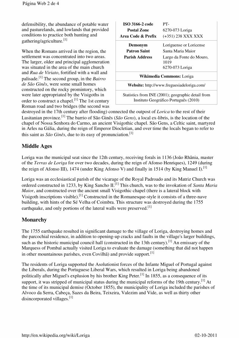
ISO 3166-2 code PT-
Postal Zone 6270-073 Loriga
Area Code & Prefix (+351) 238 XXX XXX
Demonym Loriguense or Loricense
Patron Saint Santa Maria Maior
Parish Address Largo da Fonte do Mouro, 1019 6270-073 Loriga
Wikimedia Commons: Loriga
Website: http://www.freguesiadeloriga.com/
Statistics from INE (2001); geographic detail from Instituto Geográfico Português (2010)
defensibility, the abundance of potable water and pasturelands, and lowlands that provided conditions to practice both hunting and
gathering/agriculture.[1]
When the Romans arrived in the region, the settlement was concentrated into two areas. The larger, older and principal agglomeration was situated in the area of the main church and Rua de Viriato, fortified with a wall and
palisade.[1] The second group, in the Bairro de São Ginês, were some small homes constructed on the rocky promintory, which were later appropriated by the Visigoths in
order to construct a chapel.[1] The 1st century Roman road and two bridges (the second was destroyed in the 17th century after flooding) connected the outpost of Lorica to the rest of their
Lusitanian province.[1] The barrio of São Ginês (São Gens), a local ex-libris, is the location of the chapel of Nossa Senhora do Carmo, an ancient Visigothic chapel. São Gens, a Celtic saint, martyred in Arles na Gália, during the reign of Emperor Diocletian, and over time the locals began to refer to
this saint as São Ginês, due to its easy of pronunciation.[1]
Middle Ages
Loriga was the municipal seat since the 12th century, receiving forals in 1136 (João Rhânia, master of the Terras de Loriga for over two decades, during the reign of Afonso Henriques), 1249 (during
the reign of Afonso III), 1474 (under King Afonso V) and finally in 1514 (by King Manuel I).[1]
Loriga was an ecclesiastical parish of the vicarage of the Royal Padroado and its Matriz Church was
ordered constructed in 1233, by King Sancho II.[1] This church, was to the invokation of Santa Maria Maior, and constructed over the ancient small Visigothic chapel (there is a lateral block with
Visigoth inscriptions visible).[1] Constructed in the Romanesque-style it consists of a three-nave building, with hints of the Sé Velha of Coimbra. This structure was destroyed during the 1755
earthquake, and only portions of the lateral walls were preserved.[1]
Monarchy
The 1755 earthquake resulted in significant damage to the village of Loriga, destroying homes and the parcochial residence, in addition to opening-up cracks and faults in the village's larger buildings,
such as the historic municipal council hall (constructed in the 13th century).[1] An emissary of the Marquess of Pombal actually visited Loriga to evaluate the damage (something that did not happen
in other mountainous parishes, even Covilhã) and provide support.[1]
The residents of Loriga supported the Asolutionist forces of the Infante Miguel of Portugal against the Liberals, during the Portuguese Liberal Wars, which resulted in Loriga being abandoned
politically after Miguel's explusion by his brother King Peter.[1] In 1855, as a consequence of its
support, it was stripped of municipal status during the municipal reforms of the 19th century.[1] At the time of its municipal demise (October 1855), the municipality of Loriga included the parishes of Alvoco da Serra, Cabeça, Sazes da Beira, Teixeira, Valezim and Vide, as well as thirty other
disincorporated villages.[1]
Página Web 2 de 4
02-10-2011http://en.wikipedia.org/wiki/Loriga

A bridge over a ravine in Loriga, with
the pastures of the valley landscape
Vodafone Ski Resort, Serra da Estrela,
in Loriga.
Loriga was an industrial centre for textile manufacturing during the 19th century. It was one of the few industrialized centres in the Beira Interior region, even supplanting Seia until the middle of the
20th century.[1] Only Covilhã out-preformed Loriga in terms of businesses operating from its lands; companies such as Regato, Redondinha, Fonte dos Amores, Tapadas, Fândega, Leitão & Irmãos,
Augusto Luís Mendes, Lamas, Nunes Brito, Moura Cabral and Lorimalhas, among others.[1] The main roadway in Loriga, Avenida Augusto Luís Mendes, is named for one of the villages most illustrious industrialists. The wool industry started to decline during the last decades of the 20th
century, a factor that aggravated and accelerated the decline of the region.[1]
Geography
Known locally as the "Portuguese Switzerland" due to its landscape that includes a principal settlement nestled in the
mountains of the Serra da Estrela Natural Park.[2] It is located in the south-central part of the municipality of Seia, along the southeast part of the Serra, between several ravines, but specifically the Ribeira de São Bento and
Ribeira da Nave;[2] it is 20 kilometres from Seia, 80 kilometres from Guarda and 300 kilometres from the national capital (Lisbon). A main village is accessible by the national roadway E.N. 231, that connects directly to the region of the Serra da Estrela by way of E.N.338 (which was completed in 2006), or through the E.N.339, a 9.2 kilometre access that transits some of the main elevations (960 metres near Portela do Arão or Portela de Loriga, and
1650 metres around the Lagoa Comprida).
The region is carved by U-shaped glacial valleys, modelled by the movement of ancient glaciers. The main valley, Vale de Loriga was carved by longitudanal abrasion that also created rounded pockets, where the glacial resistance was minor. Starting at an altitude of 1991 metres along the Serra da Estrela the valley descends abruptly until 290 metres above sea level (around Vide), passing villages such as Cabeça, Casal do Rei and Muro. The central village, Loriga, is seven kilometres from Torre (the highest point), but the parish is sculpted by cliffs, alluvial plains and glacial lakes deposited during millennia of glacial erosion, and surrounded by rare ancient forest that surrounded the lateral flanks of these glaciers.
Economy
Textiles are the principal local export; Loriga was a hub the textile and wool industries during the mid-19th century, in addition to being subsistence agriculture responsible for the cultivation of corn. The Loriguense economy is based on metallurgical industries, bread-making, commercial shops, restaurants and agricultural support services.
While that textile industry has since dissipated, the town began to attract a tourist trade due to its proximity to the Serra da Estrela and Vodafone Ski Resort (the only ski center in Portugal), which was constructed within the parish limits.
Página Web 3 de 4
02-10-2011http://en.wikipedia.org/wiki/Loriga

References
Notes
^ a b c d e f g h i j k l m n o p q Junta Freguesia, ed (2011). "Breve história das origens à actualidade" (http://www.freguesiadeloriga.com/index.php?progoption=turnews&do=shownew&topic=12&newid=30) (in Portuguese). Loriga (Seia), Portugal: Junta de Freguesia de Loriga. http://www.freguesiadeloriga.com/index.php?progoption=turnews&do=shownew&topic=12&newid=30. Retrieved 17 June 2011.
1.
^ a b Junta Freguesia, ed (2011). "Conhece em Loriga...Geografia em Loriga" (http://www.freguesiadeloriga.com/index.php?progoption=turnews&do=shownewsbytopic&topic=12&subtipo=Geografia%20de%20Loriga) (in Portuguese). Loriga (Seia), Portugal: Junta de Freguesia de Loriga. http://www.freguesiadeloriga.com/index.php?progoption=turnews&do=shownewsbytopic&topic=12&subtipo=Geografia%20de%20Loriga. Retrieved 17 June 2011.
2.
External links
(Portuguese) Loriga's Homepage (http://viriathus.multiply.com)
Retrieved from "http://en.wikipedia.org/wiki/Loriga"Categories: Parishes of Seia | Towns in Portugal
This page was last modified on 2 October 2011 at 14:14.
Text is available under the Creative Commons Attribution-ShareAlike License; additional terms may apply. See Terms of use for details. Wikipedia® is a registered trademark of the Wikimedia Foundation, Inc., a non-profit organization.
Página Web 4 de 4
02-10-2011http://en.wikipedia.org/wiki/Loriga
História concisa de Loriga, por António Conde

Loriga From Wikipedia, the free encyclopediaYou have new messages (last change).Jump to: navigation, search For the Spanish writer and filmmaker, see Ray Loriga.Coordinates: 40°19'13.69?N 7°39'58.15?W? / ?40.3204694°N 7.6661528°W? / 40.3204694;-7.6661528
Loriga
Civil Parish (Vila)
The valley parish of Loriga in the shadow of the Serra da Estrela
Official name: Vila de Loriga
Coat of arms
Country Portugal
Region Centro, Portugal
Subregion Serra da Estrela
District Guarda
Municipality Seia
Localities Fontão, Loriga
Landmark Torre (Serra da Estrela)
Rivers Ribeira de São Bento, Ribeira de Loriga
Center Loriga
- elevation 1,293 m (4,242 ft)
- 1 -

- coordinates40°19'13.69?N 7°39'58.15?W? / ?40.3204694°N7.6661528°W? / 40.3204694; -7.6661528
Length 4.21 km (3 mi), Northwest-Southeast
Width 13.78 km (9 mi), Southwest-Northeast
Area 36.25 km² (14 sq mi)
Population 1,367 (2005)
Density 37.71 / km² (98 / sq mi)
LAU Freguesia/Junta Freguesia
- location Largo da Fonte do Mouro, Loriga, Seia
President Junta - - - - - - - - - - - - - -
President Assembleia - - - - - - - - - - - - - -
Timezone WET (UTC0)
- summer (DST) WEST (UTC+1)
ISO 3166-2 code PT-
Postal Zone 6270-073 Loriga
Area Code & Prefix (+351) 238 XXX XXX
Demonym Loriguense or Loricense
Patron Saint Santa Maria Maior
Parish AddressLargo da Fonte do Mouro, 10196270-073 Loriga
Wikimedia Commons: Loriga
Website: http://www.freguesiadeloriga.com/
Statistics from INE (2001); geographic detail from Instituto Geográfico Português (2010)
Loriga (Portuguese pronunciation: [lo'?ig?]) is a civil parish (Portuguese: freguesia) in south-central partof the municipality of Seia, in central Portugal. Part of the district of Guarda, it is 20 km away from thecity of Seia, 40 km away from Viseu, 80 km away from Guarda and 320 km from Lisbon, nestled in theSerra da Estrela mountain range. In 2005, estimates have the resident population at about 1367inhabitants, in an area of 36.25 km² that includes the two localities, city of Loriga and village of Fontão.
Contents• 1 History
o 1.1 Middle Ages
o 1.2 Monarchy• 2 Geography• 3 Economy• 4 References• 5 External links
- 2 -

[edit] History
The remaining Roman-era bridge crossing the Ribeira de Loriga
Loriga was founded originally along a column between ravines where today the historic centre exists. Thesite was ostensibly selected more than 2600 years ago, owing to its defensibility, the abundance ofpotable water and pasturelands, and lowlands that provided conditions to practice both hunting andgathering/agriculture.[1]
When the Romans arrived in the region, the settlement was concentrated into two areas. The larger,older and principal agglomeration was situated in the area of the main church and Rua de Viriato,fortified with a wall and palisade.[1] The second group, in the Bairro de São Ginês, were some smallhomes constructed on the rocky promintory, which were later appropriated by the Visigoths in order toconstruct a chapel.[1] The 1st century Roman road and two bridges (the second was destroyed in the17th century after flooding) connected the outpost of Lorica to the rest of their Lusitanian province.[1]The barrio of São Ginês (São Gens), a local ex-libris, is the location of the chapel of Nossa Senhora doCarmo, an ancient Visigothic chapel. São Gens, a Celtic saint, martyred in Arles na Gália, during thereign of Emperor Diocletian, and over time the locals began to refer to this saint as São Ginês, due to itseasy of pronunciation.[1]
[edit] Middle Ages
Loriga was the municipal seat since the 12th century, receiving forals in 1136 (João Rhânia, master ofthe Terras de Loriga for over two decades, during the reign of Afonso Henriques), 1249 (during thereign of Afonso III), 1474 (under King Afonso V) and finally in 1514 (by King Manuel I).[1]
Loriga was an ecclesiastical parish of the vicarage of the Royal Padroado and its Matriz Church wasordered constructed in 1233, by King Sancho II.[1] This church, was to the invokation of Santa Maria
Maior, and constructed over the ancient small Visigothic chapel (there is a lateral block with Visigothinscriptions visible).[1] Constructed in the Romanesque-style it consists of a three-nave building, withhints of the Sé Velha of Coimbra. This structure was destroyed during the 1755 earthquake, and onlyportions of the lateral walls were preserved.[1]
[edit] Monarchy
The 1755 earthquake resulted in significant damage to the village of Loriga, destroying homes and theparcochial residence, in addition to opening-up cracks and faults in the village's larger buildings, such asthe historic municipal council hall (constructed in the 13th century).[1] An emissary of the Marquess ofPombal actually visited Loriga to evaluate the damage (something that did not happen in othermountainous parishes, even Covilhã) and provide support.[1]
The residents of Loriga supported the Asolutionist forces of the Infante Miguel of Portugal against the
- 3 -

Liberals, during the Portuguese Liberal Wars, which resulted in Loriga being abandoned politically afterMiguel's explusion by his brother King Peter.[1] In 1855, as a consequence of its support, it wasstripped of municipal status during the municipal reforms of the 19th century.[1] At the time of itsmunicipal demise (October 1855), the municipality of Loriga included the parishes of Alvoco da Serra,Cabeça, Sazes da Beira, Teixeira, Valezim and Vide, as well as thirty other disincorporated villages.[1]
Loriga was an industrial centre for textile manufacturing during the 19th century. It was one of the fewindustrialized centres in the Beira Interior region, even supplanting Seia until the middle of the 20thcentury.[1] Only Covilhã out-preformed Loriga in terms of businesses operating from its lands;companies such as Regato, Redondinha, Fonte dos Amores, Tapadas, Fândega, Leitão & Irmãos,Augusto Luís Mendes, Lamas, Nunes Brito, Moura Cabral and Lorimalhas, among others.[1] The mainroadway in Loriga, Avenida Augusto Luís Mendes, is named for one of the villages most illustriousindustrialists. The wool industry started to decline during the last decades of the 20th century, a factorthat aggravated and accelerated the decline of the region.[1]
[edit] Geography
A bridge over a ravine in Loriga, with the pastures of the valley landscape
Known locally as the "Portuguese Switzerland" due to its landscape that includes a principal settlementnestled in the mountains of the Serra da Estrela Natural Park.[2] It is located in the south-central part ofthe municipality of Seia, along the southeast part of the Serra, between several ravines, but specificallythe Ribeira de São Bento and Ribeira de Loriga;[2] it is 20 kilometres from Seia, 80 kilometres fromGuarda and 300 kilometres from the national capital (Lisbon). A main city is accessible by the nationalroadway E.N. 231, that connects directly to the region of the Serra da Estrela by way of E.N.338(which was completed in 2006), or through the E.N.339, a 9.2 kilometre access that transits some of themain elevations (960 metres near Portela do Arão or Portela de Loriga, and 1650 metres around theLagoa Comprida).
The region is carved by U-shaped glacial valleys, modelled by the movement of ancient glaciers. Themain valley, Vale de Loriga was carved by longitudanal abrasion that also created rounded pockets,where the glacial resistance was minor. Starting at an altitude of 1991 metres along the Serra da Estrelathe valley descends abruptly until 290 metres above sea level (around Vide), passing villages such asCabeça, Casal do Rei and Muro. The central village, Loriga, is seven kilometres from Torre (the highestpoint), but the parish is sculpted by cliffs, alluvial plains and glacial lakes deposited during millennia ofglacial erosion, and surrounded by rare ancient forest that surrounded the lateral flanks of these glaciers.
[edit] Economy
- 4 -

Vodafone Ski Resort, Serra da Estrela, in Loriga.
Textiles are the principal local export; Loriga was a hub the textile and wool industries during themid-19th century, in addition to being subsistence agriculture responsible for the cultivation of corn. TheLoriguense economy is based on metallurgical industries, bread-making, commercial shops, restaurantsand agricultural support services.
While that textile industry has since dissipated, the town began to attract a tourist trade due to itsproximity to the Serra da Estrela and Vodafone Ski Resort (the only ski center in Portugal), which wasconstructed within totally the parish limits.
[edit] References Notes
1. ^ a b c d e f g h i j k l m n o p q "História concisa de Loriga" por António Conde. JuntaFreguesia, ed (2011). "Breve história das origens à actualidade" (in Portuguese). Loriga (Seia),Portugal: Junta de Freguesia de Loriga.http://www.freguesiadeloriga.com/index.php?progoption=turnews&do=shownew&topic=12&newid=30. Retrieved 17 June 2011.
2. ^ a b Junta Freguesia, ed (2011). "Conhece em Loriga...Geografia em Loriga" (in Portuguese).Loriga (Seia), Portugal: Junta de Freguesia de Loriga.http://www.freguesiadeloriga.com/index.php?progoption=turnews&do=shownewsbytopic&topic=12&subtipo=Geografia%20de%20Loriga. Retrieved 17 June 2011.
[edit] External links• (Portuguese) Loriga's Homepage
Retrieved from "http://en.wikipedia.org/wiki/Loriga"Categories: Parishes of Seia | Towns in PortugalHidden categories: Articles containing Portuguese language text | Articles with Portuguese languageexternal links
Personal tools
• Log in / create account
Namespaces
• Article• Discussion
Variants
Views
• Read• Edit
- 5 -
• View history
Actions
Search
Navigation
• Main page• Contents• Featured content• Current events• Random article• Donate to Wikipedia
Interaction
• Help• About Wikipedia• Community portal• Recent changes• Contact Wikipedia
Toolbox
• What links here• Related changes• Upload file• Special pages• Permanent link• Cite this page
Print/export
• Create a book• Download as PDF• Printable version
Languages
• Deutsch• Español• Français• Italiano• Latina• Nederlands• Português• ???????• Türkçe• This page was last modified on 2 October 2011 at 14:14.• Text is available under the Creative Commons Attribution-ShareAlike License; additional terms
may apply. See Terms of use for details.• Wikipedia® is a registered trademark of the Wikimedia Foundation, Inc., a non-profit
organization.• Contact us• Privacy policy• About Wikipedia
- 6 -

• Disclaimers• Mobile view
•
•
- 7 -

Loriga From Wikipedia, the free encyclopediaJump to: navigation, search For the Spanish writer and filmmaker, see Ray Loriga.Coordinates: 40°19'13.69?N 7°39'58.15?W? / ?40.3204694°N 7.6661528°W? / 40.3204694;-7.6661528
Loriga
Civil Parish (Freguesia)
The valley parish of Loriga in the shadow of the Serra da Estrela
Official name: Freguesia de Loriga
Country Portugal
Region Centro, Portugal
Subregion Serra da Estrela
District Guarda
Municipality Seia
Localities Fontão, Loriga
Landmark Torre (Serra da Estrela)
Rivers Ribeira de São Bento, Ribeira de Loriga
Center Loriga
- elevation 1,293 m (4,242 ft)
- coordinates40°19'13.69?N 7°39'58.15?W? / ?40.3204694°N7.6661528°W? / 40.3204694; -7.6661528
Length 4.21 km (3 mi), Northwest-Southeast
Width 13.78 km (9 mi), Southwest-Northeast
Area 36.25 km² (14 sq mi)
Population 1,367 (2005)
Density 37.71 / km² (98 / sq mi)
LAU Vila/Junta Freguesia
- 1 -

- location Largo da Fonte do Mouro, Loriga, Seia
President Junta - - - - - - - -
President Assembleia - - - - - - - -
Timezone WET (UTC0)
- summer (DST) WEST (UTC+1)
ISO 3166-2 code PT-
Postal Zone 6270-073 Loriga
Area Code & Prefix (+351) 238 XXX XXX
Demonym Loricense or Loriguense
Patron Saint Santa Maria Maior
Parish AddressLargo da Fonte do Mouro, 10196270-073 Loriga
Wikimedia Commons: Loriga
Website: http://www.freguesiadeloriga.com/
Statistics from INE (2001); geographic detail from Instituto Geográfico Português (2010)
Loriga (Portuguese pronunciation: [lo'?ig?]) is a civil parish (Portuguese: freguesia) in south-central partof the municipality of Seia, in central Portugal. Part of the district of Guarda, it is 20 km away from thecity of Seia, 40 km away from Viseu, 80 km away from Guarda and 320 km from Lisbon, nestled in theSerra da Estrela mountain range. In 2005, estimates have the resident population at about 1367inhabitants, in an area of 36.25 km² that includes the two localities of Loriga and Fontão.
Contents• 1 History
o 1.1 Middle Ages
o 1.2 Monarchy• 2 Geography• 3 Economy• 4 References• 5 External links
[edit] History
The remaining Roman-era bridge crossing the Ribeira de Loriga
- 2 -

Loriga is ancient, beautiful and historic portuguese small town (vila), located in the Serra da Estrelamountains. Known as Lobriga by the Lusitanians an Lorica by the Romans, it is more than 2600 yearsold. Notable people from Loriga include Viriathus (known as Viriato in Portuguese), a famous Lusitanianleader and portuguese national hero.
Loriga was founded originally along a column between ravines where today the historic centre exists. Thesite was ostensibly selected more than 2600 years ago, owing to its defensibility, the abundance ofpotable water and pasturelands, and lowlands that provided conditions to practice both hunting andgathering/agriculture.[1]
When the Romans arrived in the region, the settlement was concentrated into two areas. The larger,older and principal agglomeration was situated in the area of the main church and Rua de Viriato,fortified with a wall and palisade.[1] The second group, in the Bairro de São Ginês, were some smallhomes constructed on the rocky promintory, which were later appropriated by the Visigoths in order toconstruct a chapel.[1] The 1st century Roman road and two bridges (the second was destroyed in the17th century after flooding) connected the outpost of Lorica to the rest of their Lusitanian province.[1]The barrio of São Ginês (São Gens), a local ex-libris, is the location of the chapel of Nossa Senhora doCarmo, an ancient Visigothic chapel. São Gens, a Celtic saint, martyred in Arles na Gália, during thereign of Emperor Diocletian, and over time the locals began to refer to this saint as São Ginês, due to itseasy of pronunciation.[1]
[edit] Middle Ages
Loriga was the municipal seat since the 12th century, receiving forals in 1136 (João Rhânia, master ofthe Terras de Loriga for over two decades, during the reign of Afonso Henriques), 1249 (during thereign of Afonso III), 1474 (under King Afonso V) and finally in 1514 (by King Manuel I).[1]
Loriga was an ecclesiastical parish of the vicarage of the Royal Padroado and its Matriz Church wasordered constructed in 1233, by King Sancho II.[1] This church, was to the invokation of Santa Maria
Maior, and constructed over the ancient small Visigothic chapel (there is a lateral block with Visigothinscriptions visible).[1] Constructed in the Romanesque-style it consists of a three-nave building, withhints of the Sé Velha of Coimbra. This structure was destroyed during the 1755 earthquake, and onlyportions of the lateral walls were preserved.[1]
[edit] Monarchy
The 1755 earthquake resulted in significant damage to the village of Loriga, destroying homes and theparcochial residence, in addition to opening-up cracks and faults in the village's larger buildings, such asthe historic municipal council hall (constructed in the 13th century).[1] An emissary of the Marquess ofPombal actually visited Loriga to evaluate the damage (something that did not happen in othermountainous parishes, even Covilhã) and provide support.[1]
The residents of Loriga supported the Asolutionist forces of the Infante Miguel of Portugal against theLiberals, during the Portuguese Liberal Wars, which resulted in Loriga being abandoned politically afterMiguel's explusion by his brother King Peter.[1] In 1855, as a consequence of its support, it wasstripped of municipal status during the municipal reforms of the 19th century.[1] At the time of itsmunicipal demise (October 1855), the municipality of Loriga included the parishes of Alvoco da Serra,Cabeça, Sazes da Beira, Teixeira, Valezim and Vide, as well as thirty other disincorporated villages.[1]
Loriga was an industrial centre for textile manufacturing during the 19th century. It was one of the fewindustrialized centres in the Beira Interior region, even supplanting Seia until the middle of the 20th
- 3 -

century.[1] Only Covilhã out-preformed Loriga in terms of businesses operating from its lands;companies such as Regato, Redondinha, Fonte dos Amores, Tapadas, Fândega, Leitão & Irmãos,Augusto Luís Mendes, Lamas, Nunes Brito, Moura Cabral and Lorimalhas, among others.[1] The mainroadway in Loriga, Avenida Augusto Luís Mendes, is named for one of the villages most illustriousindustrialists. The wool industry started to decline during the last decades of the 20th century, a factorthat aggravated and accelerated the decline of the region.[1]
[edit] Geography
A bridge over a ravine in Loriga, with the pastures of the valley landscape
Known locally as the "Portuguese Switzerland" due to its landscape that includes a principal settlementnestled in the mountains of the Serra da Estrela Natural Park.[2] It is located in the south-central part ofthe municipality of Seia, along the southeast part of the Serra, between several ravines, but specificallythe Ribeira de São Bento and Ribeira de Loriga;[2] it is 20 kilometres from Seia, 80 kilometres fromGuarda and 300 kilometres from the national capital (Lisbon). A main village is accessible by the nationalroadway E.N. 231, that connects directly to the region of the Serra da Estrela by way of E.N.338(which was completed in 2006), or through the E.N.339, a 9.2 kilometre access that transits some of themain elevations (960 metres near Portela do Arão or Portela de Loriga, and 1650 metres around theLagoa Comprida).
The region is carved by U-shaped glacial valleys, modelled by the movement of ancient glaciers. Themain valley, Vale de Loriga was carved by longitudanal abrasion that also created rounded pockets,where the glacial resistance was minor. Starting at an altitude of 1991 metres along the Serra da Estrelathe valley descends abruptly until 290 metres above sea level (around Vide), passing villages such asCabeça, Casal do Rei and Muro. The central village, Loriga, is seven kilometres from Torre (the highestpoint), but the parish is sculpted by cliffs, alluvial plains and glacial lakes deposited during millennia ofglacial erosion, and surrounded by rare ancient forest that surrounded the lateral flanks of these glaciers.
[edit] Economy
Vodafone Ski Resort, Serra da Estrela, in Loriga.
Textiles are the principal local export; Loriga was a hub the textile and wool industries during the
- 4 -

mid-19th century, in addition to being subsistence agriculture responsible for the cultivation of corn. TheLoriguense economy is based on metallurgical industries, bread-making, commercial shops, restaurantsand agricultural support services.
While that textile industry has since dissipated, the town began to attract a tourist trade due to itsproximity to the Serra da Estrela and Vodafone Ski Resort (the only ski center in Portugal), which wasconstructed within the parish limits.
[edit] References Notes
1. ^ a b c d e f g h i j k l m n o p q História Concisa de Loriga, por António Conde (inPortuguese). Loriga, Portugal and similar pages (in Portuguese and English). Junta Freguesia, ed(2011). "Breve história das origens à actualidade" (in Portuguese). Loriga (Seia), Portugal: Juntade Freguesia de Loriga.http://www.freguesiadeloriga.com/index.php?progoption=turnews&do=shownew&topic=12&newid=30. Retrieved 17 June 2011.
2. ^ a b Junta Freguesia, ed (2011). "Conhece em Loriga...Geografia em Loriga" (in Portuguese).Loriga (Seia), Portugal: Junta de Freguesia de Loriga.http://www.freguesiadeloriga.com/index.php?progoption=turnews&do=shownewsbytopic&topic=12&subtipo=Geografia%20de%20Loriga. Retrieved 17 June 2011.
[edit] External links• (Portuguese and English) Loriga's Homepage• (Portuguese and English) Loriga - Portugal
Retrieved from "http://en.wikipedia.org/wiki/Loriga"Categories: Parishes of Seia | Towns in PortugalHidden categories: Articles containing Portuguese language text
Personal tools
• Log in / create account
Namespaces
• Article• Discussion
Variants
Views
• Read• Edit• View history
Actions
Search
Navigation
• Main page• Contents• Featured content• Current events• Random article
- 5 -

• Donate to Wikipedia
Interaction
• Help• About Wikipedia• Community portal• Recent changes• Contact Wikipedia
Toolbox
• What links here• Related changes• Upload file• Special pages• Permanent link• Cite this page
Print/export
• Create a book• Download as PDF• Printable version
Languages
• Deutsch• Español• Français• Italiano• Latina• Nederlands• Português• ???????• Türkçe• This page was last modified on 26 July 2011 at 21:02.• Text is available under the Creative Commons Attribution-ShareAlike License; additional terms
may apply. See Terms of use for details.• Wikipedia® is a registered trademark of the Wikimedia Foundation, Inc., a non-profit
organization.• Contact us• Privacy policy• About Wikipedia• Disclaimers
•
•
- 6 -

________________________________________________________________________________________________________________
- 12 -

Brasão de Loriga - Coat of arms
- 13 -

Loriga - Casa das Fragas –
http://www.casadasfragas.com/
Loriga – Estância de Esqui -
http://www.facebook.com/estancia.de.esqui.de.loriga
Loriga – Banda Filarmónica –
http://www.facebook.com/AssociacaodeFreguesiasdaSerradaEstrela
- 38 -

LorigaCivil parish
Coordinates: 40.324°N 7.691°W
Country PortugalRegion CentroSubregion Serra da EstrelaIntermunic.comm.
Beiras e Serra daEstrela
District GuardaMunicipality Seia
Area• Total 36.25 km2
(14.00 sq mi)
LorigaFrom Wikipedia, the free encyclopediaLoriga (Portuguese pronunciation: [lッˈɾiɡɐ]) is a civil parish(Portuguese: freguesia) in southcentral part of the municipality ofSeia, in central Portugal. Part of the district of Guarda, it is 20 kmaway from Seia, 40 km away from Viseu, 80 km awayfrom Guarda and 320 km from Lisbon, nestled in the Serra daEstrela mountain range. The population in 2011 was 1,053,[1] in anarea of 36.25 km²,[2] including the two localitiesL@エエッ of Loriga and エ Fontão.
Contents
1 History1.1 Middle Ages1.2 Monarchy
2 Geography3 Economy4 References5 External links
History
Loriga was foundedalong a column betweenravines where today thehistoric centre exists.The site was ostensiblyselected more than 2600years ago, owing to itsdefensibility, theabundance of potablewater and pasturelands,and lowlands thatprovided conditions topractice both hunting andgathering/agriculture.[3]
When the Romans arrived in the region, the settlement wasconcentrated into two areas. The larger, older and principalagglomeration was situated in the area of the main church and Ruade Viriato, fortified with a wall and palisade.[3] The second group,in the Bairro de São Ginês, were some small homes constructed onthe rocky promintory, which were later appropriated by theVisigoths in order to construct a chapel.[3] The 1st century Romanroad and two bridges (the second was destroyed in the 17th centuryafter flooding) connected the outpost of Lorica to the rest of theirLusitanian province.[3] The barrio of São Ginês (São Gens), a localexlibris, is the location of the chapel of Nossa Senhora do Carmo,an ancient Visigothic chapel. São Gens, a Celtic saint, martyred in
Loriga
The remaining Romanera bridge crossingthe Ribeira de lッイゥァ。
Edited with the trial version of
Foxit Advanced PDF Editor
To remove this notice, visit:
www.foxitsoftware.com/shopping

ElevationWWPュ@Population (2011)• Total
1,053• Density 29/km2 (75/sq mi)
Postal code 6270Area code 238
Patron Santa Maria Maior
Website http://ヲイ・ァオ・ウゥ。、・loriga.」oュ
Arles na Gália, during the reign of Emperor Diocletian, and overtime the locals began to refer to this saint as São Ginês, due to itseasy of pronunciation.[3]
Middle Ages
Loriga was the municipal seat since the 12th century, receivingforals in 1136 (João Rhânia, master of the Terras de Loriga forover two decades, during the reign of Afonso Henriques), 1249(during the reign of Afonso III), (underNing Afonso V) andfinally in 1514 (by King Manuel I)[3]
Ooriga was an ecclesiastical parish of the vicarage of the Royal Padroado and its Matriz Church was orderedconstructed in 1233, by King Sancho II[3] This church, was to the invokation of Santa Maria Maior, andconstructed over the ancient small Visigothic chapel (there is a lateral block with Visigoth inscriptionsvisible).[3] Constructed in the Romanesquestyle it consists of a threenave building, with hints of the Sé Velhaof Coimbra. This structure was destroyed during the 1755 earthquake, and only portions of the lateral wallswere preserved.[3]
Monarchy
The 1755 earthquake resulted in significant damage to the エッキョ of Loriga, destroying homes and theparcochial residence, in addition to openingup cracks and faults in the エッキョ's larger buildings, such as thehistoric municipal council hall (constructed in the 13th century).[3] An emissary of the Marquess of Pombalactually visited Loriga to evaluate the damage (something that did not happen in other mountainous parishes,even Covilhã) and provide support.[3]
The residents of Loriga supported the Asolutionist forces of the InfanteMiguel of Portugal against the Liberals,during the Portuguese Liberal Wars, which resulted in Loriga being abandoned politically after Miguel'sexpulsion by his brother King Peter.[3] In as aconsequence ofits support, it was stripped of municipalstatus during the municipal reforms of the 19th century.[3] At the time of its municipal demise (October 1855),the municipality of Loriga included the parishes of Alvoco da Serra, Cabeça, Sazes da Beira, Teixeira, Valezimand Vide, as well as thirty other disincorporated villages.[3]
Loriga was an industrial centre for textile manufacturing during the 19th century. It was one of the fewindustrialized centres in the Beira Interior region, even supplanting Seia until the middle of the 20th century.[3]Only Covilhã outperformed Loriga in terms of businesses operating from its lands; companies such as Regato,Redondinha, Fonte dos Amores, Tapadas, Fândega, Leitão & Irmãos, Augusto Luís Mendes, Lamas, NunesBrito, Moura Cabral and Lorimalhas, among others.[3] The main roadway in Loriga, Avenida Augusto LuísMendes, is named for one of the エッキョ⦆s most illustrious industrialists. The wool industry started to declineduring the last decades of the 20th century, a factor that aggravated and accelerated the decline of the region.[3]
Geography
Known locally as the "Portuguese Switzerland" due to its landscape that includes a principal settlement nestledin the mountains of the Serra da Estrela Natural Park.[4] It is located in the southcentral part of themunicipality of Seia, along the southeast part of the Serra, between several ravines, but specifically the Ribeirade São Bento and Ribeira d・@lッイゥァ。;[4] it is 20 kilometres from Seia, 80 kilometres from Guarda and 300kilometres from the national capital (Lisbon). A main tッキョ is accessible by the national roadway E.N. 231,that connects directly to the region of the Serra da Estrela by way of E.N.338 (which was completed in 2006),or through the E.N.339, a 9.2 kilometre access that transits some of the main elevations (960 metres nearPortela do Arão or Portela de Loriga, and 1650 metres around the Lagoa Comprida).
Edited with the trial version of
Foxit Advanced PDF Editor
To remove this notice, visit:
www.foxitsoftware.com/shopping

The region is carved by Ushaped glacial valleys, modelled by themovement of ancient glaciers. The main valley, Vale de Loriga wascarved by longitudanal abrasion that also created rounded pockets,where the glacial resistance was minor. Starting at an altitude of 1991metres along the Serra da Estrela the valley descends abruptly until290 metres above sea level (around Vide), passing villages such asCabeça, Casal do Rei and Muro. The central village, Loriga, is sevenkilometres from Torre (the highest point), but the parish is sculptedby cliffs, alluvial plains and glacial lakes deposited during millenniaof glacial erosion, and surrounded by rare ancient forest thatsurrounded the lateral flanks of these glaciers.
Economy
Textiles are the principal local export; Loriga was a hub the textileand wool industries during the mid19th century, in addition to beingsubsistence agriculture responsible for the cultivation of corn. TheLoriguense economy is based on metallurgical industries, breadmaking, commercial shops, restaurants and agricultural supportservices.While that textile industry has since dissipated, the town began toattract a tourist trade due to its proximity to the Serra da Estrela andVodafone Ski Resort (the only ski center in Portugal), which wasconstructed within the parish limits.
References
1. Instituto Nacional de Estatística (http://www.ine.pt/xportal/xmain?xlang=en&xpid=INE&xpgid=ine_indicadores&indOcorrCod=0005889&contexto=pi&selTab=tab0)
2. DireçãoGeral do Território (http://www.dgterritorio.pt/ficheiros/cadastro/caop/caop_download/caop_2014_0/areasfregmundistcaop2014_2)
3. Junta Freguesia, ed. (2011). "Breve história das origens à actualidade@ H「ケ@ aョエ " (http://www.freguesiadeloriga.co m/index.php?progoption=turnews&do=shownew&topic=12&newid=30) (in Portuguese). Loriga (Seia),Portugal: Junta de Freguesia de Loriga. Retrieved 17 June 2011.
4. Junta Freguesia, ed. (2011). "Conhece em Loriga...Geografia em Loriga" (http://www.freguesiadeloriga.com/index.php?progoption=turnews&do=shownewsbytopic&topic=12&subtipo=Geografia%20de%20Loriga) (in Portuguese). Loriga (Seia), Portugal: Junta de Freguesia de Loriga. Retrieved 17 June 2011.
External links(in Portuguese@。ョ、@・ョァャゥウィ) Loriga's HomepageL@
ュオョゥ」ゥー。ャゥエケ (http://lッイゥァ。ーッイエオァ。ャNキッイ、ーイ・ウウN」ッュOヲゥ」ィ・ゥイッウMー、ヲMヲゥャ・ウ)
Retrieved from "https://en.wikipedia.org/w/index.php?title=Loriga&oldid=783751553"
This page was last edited on 4 June 2017, at 12:22.Text is available under the Creative Commons AttributionShareAlike License; additional terms mayapply. By using this site, you agree to the Terms of Use and Privacy Policy. Wikipedia® is a registeredtrademark of the Wikimedia Foundation, Inc., a nonprofit organization.
A bridge over a ravine in Loriga, with thepastures of the valley landscape
Vodafone Ski Resort, Serra da Estrela, inthe エッキョ of lッイゥァ。.
Edited with the trial version of
Foxit Advanced PDF Editor
To remove this notice, visit:
www.foxitsoftware.com/shopping
town

LorigaCivil Parish (Freguesia)
The valley parish of Loriga in the shadow of the Serra
da Estrela
Official name: Freguesia de Loriga
Country Portugal
Region Centro, Portugal
Subregion Serra da Estrela
District Guarda
Municipality Seia
Localities Fontão, Loriga
Landmark Torre (Serra da Estrela)
Rivers Ribeira de São Bento,
Ribeira de Loriga
Center Loriga
- elevation 1,293 m (4,242 ft)
- coordinates 40°19′13.69″N 7°39′58.15″W
Length 4.21 km (3 mi), Northwest-
Southeast
Width 13.78 km (9 mi), Southwest-
Northeast
Area 36.25 km² (14 sq mi)
Population 1,367 (2005)
Density 37.71 / km² (98 / sq mi)
LAU Freguesia/Junta Freguesia
- location Largo da Fonte do Mouro,
Loriga, Seia
President Junta António Mauricio Moura
Mendes
President Assembleia António Brito Aparício
Timezone WET (UTC0)
- summer (DST) WEST (UTC+1)
ISO 3166-2 code PT-
The remaining Roman-era bridge
crossing the Ribeira de São Bento
LorigaFrom Wikipedia, the free encyclopedia
Loriga (Portuguese pronunciation: [loˈɾiɡɐ]) is a
civil parish (Portuguese: freguesia) in south-central part of the municipality of Seia, in central Portugal. Part of the district of Guarda, it is 20 km away from the city of Seia, 40 km away from Viseu, 80 km away from Guarda and 320 km from Lisbon, nestled in the Serra da Estrela mountain range. In 2005, estimates have the resident population at about 1367 inhabitants, in an area of 36.25 km² that includes the two localities/villages of Loriga and Fontão.
Contents
1 History
1.1 Middle Ages
1.2 Monarchy
2 Geography
3 Economy
4 References
5 External links
History
Loriga was founded originally along a column between ravines where today the historic centre exists. The site was ostensibly selected more than 2600 years ago, owing to its defensibility, the abundance of potable water
Coordinates: 40°19′13.69″N 7°39′58.15″W
Página Web 1 de 4
26-07-2011http://en.wikipedia.org/wiki/Loriga
Vila
Vila
Loriga
Vila

Postal Zone 6270-073 Loriga
Area Code & Prefix (+351) 238 XXX XXX
Demonym Loriguense
Patron Saint Santa Maria Maior
Parish Address Largo da Fonte do Mouro,
1019
6270-073 Loriga
Wikimedia Commons: Loriga
Website: http://www.freguesiadeloriga.com/
Statistics from INE (2001); geographic detail from
Instituto Geográfico Português (2010)
and pasturelands, and lowlands that provided conditions to practice both hunting and
gathering/agriculture.[1]
When the Romans arrived in the region, the settlement was concentrated into two areas. The larger, older and principal agglomeration was situated in the area of the main church and Rua de Viriato, fortified with a wall and
palisade.[1]
The second group, in the Bairro de São Ginês, were some small homes constructed on the rocky promintory, which were later appropriated by the Visigoths in
order to construct a chapel.[1]
The 1st century Roman road and two bridges (the second was destroyed in the 17th century after flooding) connected the outpost of Lorica to the rest of their
Lusitanian province.[1] The barrio of São Ginês (São Gens), a local ex-libris, is the location of the chapel of Nossa Senhora do Carmo, an ancient Visigothic chapel. São Gens, a Celtic saint, martyred in Arles na Gália, during the reign of Emperor Diocletian, and over time the locals began to refer to
this saint as São Ginês, due to its easy of pronunciation.[1]
Middle Ages
Loriga was the municipal seat since the 12th century, receiving forals in 1136 (João Rhânia, master of the Terras de Loriga for over two decades, during the reign of Afonso Henriques), 1249 (during
the reign of Afonso III), 1474 (under King Afonso V) and finally in 1514 (by King Manuel I).[1]
Loriga was an ecclesiastical parish of the vicarage of the Royal Padroado and its Matriz Church was
ordered constructed in 1233, by King Sancho II.[1]
This church, was to the invokation of Santa Maria Maior, and constructed over the ancient small Visigothic chapel (there is a lateral block with
Visigoth inscriptions visible).[1] Constructed in the Romanesque-style it consists of a three-nave building, with hints of the Sé Velha of Coimbra. This structure was destroyed during the 1755
earthquake, and only portions of the lateral walls were preserved.[1]
Monarchy
The 1755 earthquake resulted in significant damage to the village of Loriga, destroying homes and the parcochial residence, in addition to opening-up cracks and faults in the village's larger buildings,
such as the historic municipal council hall (constructed in the 13th century).[1]
An emissary of the Marquess of Pombal actually visited Loriga to evaluate the damage (something that did not happen
in other mountainous parishes, even Covilhã) and provide support.[1]
The residents of Loriga supported the Asolutionist forces of the Infante Miguel of Portugal against the Liberals, during the Portuguese Liberal Wars, which resulted in Loriga being abandoned
politically after Miguel's explusion by his brother King Peter.[1]
In 1855, as a consequence of its
support, it was stripped of municipal status during the municipal reforms of the 19th century.[1] At the time of its municipal demise (October 1855), the municipality of Loriga included the parishes of Alvoco da Serra, Cabeça, Sazes da Beira, Teixeira, Valezim and Vide, as well as thirty other
disincorporated villages.[1]
Página Web 2 de 4
26-07-2011http://en.wikipedia.org/wiki/Loriga
or Loricense

A bridge over a ravine in Loriga, with
the pastures of the valley landscape
Vodafone Ski Resort, Serra da Estrela,
in Loriga.
Loriga was an industrial centre for textile manufacturing during the 19th century. It was one of the few industrialized centres in the Beira Interior region, even supplanting Seia until the middle of the
20th century.[1] Only Covilhã out-preformed Loriga in terms of businesses operating from its lands; companies such as Regato, Redondinha, Fonte dos Amores, Tapadas, Fândega, Leitão & Irmãos,
Augusto Luís Mendes, Lamas, Nunes Brito, Moura Cabral and Lorimalhas, among others.[1] The main roadway in Loriga, Avenida Augusto Luís Mendes, is named for one of the villages most illustrious industrialists. The wool industry started to decline during the last decades of the 20th
century, a factor that aggravated and accelerated the decline of the region.[1]
Geography
Known locally as the "Portuguese Switzerland" due to its landscape that includes a principal settlement nestled in the
mountains of the Serra da Estrela Natural Park.[2] It is located in the south-central part of the municipality of Seia, along the southeast part of the Serra, between several ravines, but specifically the Ribeira de São Bento and
Ribeira de Loriga;[2] it is 20 kilometres from Seia, 80 kilometres from Guarda and 300 kilometres from the national capital (Lisbon). A main village is accessible by the national roadway E.N. 231, that connects directly to the region of the Serra da Estrela by way of E.N.338 (which was completed in 2006), or through the E.N.339, a 9.2 kilometre access that transits some of the main elevations (960 metres near Portela do Arão or Portela de Loriga, and
1650 metres around the Lagoa Comprida).
The region is carved by U-shaped glacial valleys, modelled by the movement of ancient glaciers. The main valley, Vale de Loriga was carved by longitudanal abrasion that also created rounded pockets, where the glacial resistance was minor. Starting at an altitude of 1991 metres along the Serra da Estrela the valley descends abruptly until 290 metres above sea level (around Vide), passing villages such as Cabeça, Casal do Rei and Muro. The central village, Loriga, is seven kilometres from Torre (the highest point), but the parish is sculpted by cliffs, alluvial plains and glacial lakes deposited during millennia of glacial erosion, and surrounded by rare ancient forest that surrounded the lateral flanks of these glaciers.
Economy
Textiles are the principal local export; Loriga was a hub the textile and wool industries during the mid-19th century, in addition to being subsistence agriculture responsible for the cultivation of corn. The Loriguense economy is based on metallurgical industries, bread-making, commercial shops, restaurants and agricultural support services.
While that textile industry has since dissipated, the town began to attract a tourist trade due to its proximity to the Serra da Estrela and Vodafone Ski Resort (the only ski center in Portugal), which was constructed within the parish limits.
Página Web 3 de 4
26-07-2011http://en.wikipedia.org/wiki/Loriga

References
Notes
^ a b c d e f g h i j k l m n o p q Junta Freguesia, ed (2011). "Breve história das origens à actualidade" (http://www.freguesiadeloriga.com/index.php?progoption=turnews&do=shownew&topic=12&newid=30) (in Portuguese). Loriga (Seia), Portugal: Junta de Freguesia de Loriga. http://www.freguesiadeloriga.com/index.php?progoption=turnews&do=shownew&topic=12&newid=30. Retrieved 17 June 2011.
1.
^ a b Junta Freguesia, ed (2011). "Conhece em Loriga...Geografia em Loriga" (http://www.freguesiadeloriga.com/index.php?progoption=turnews&do=shownewsbytopic&topic=12&subtipo=Geografia%20de%20Loriga) (in Portuguese). Loriga (Seia), Portugal: Junta de Freguesia de Loriga. http://www.freguesiadeloriga.com/index.php?progoption=turnews&do=shownewsbytopic&topic=12&subtipo=Geografia%20de%20Loriga. Retrieved 17 June 2011.
2.
External links
(Portuguese) Loriga's Homepage (http://lorigaportugal.multiply.com)
Retrieved from "http://en.wikipedia.org/wiki/Loriga"Categories: Parishes of Seia | Towns in Portugal
This page was last modified on 26 July 2011 at 21:02.
Text is available under the Creative Commons Attribution-ShareAlike License; additional terms may apply. See Terms of use for details. Wikipedia® is a registered trademark of the Wikimedia Foundation, Inc., a non-profit organization.
Página Web 4 de 4
26-07-2011http://en.wikipedia.org/wiki/Loriga
http://www.lorica.no.sapo.pt
http://www.lorica.no.sapo.pt
http://www.lorica.no.sapo.pt
http://www.lorica.no.sapo.pt
http://viriathus.multiply.com

LorigaCivil Parish (Vila)
The valley parish of Loriga in the shadow of the Serra
da Estrela
Official name: Freguesia de Loriga
Country Portugal
Region Centro, Portugal
Subregion Serra da Estrela
District Guarda
Municipality Seia
Localities Fontão, Loriga
Landmark Torre (Serra da Estrela)
Rivers Ribeira de São Bento,
Ribeira de Loriga
Center Loriga
- elevation 1,293 m (4,242 ft)
- coordinates 40°19′13.69″N 7°39′58.15″W
Length 4.21 km (3 mi), Northwest-
Southeast
Width 13.78 km (9 mi), Southwest-
Northeast
Area 36.25 km² (14 sq mi)
Population 1,367 (2005)
Density 37.71 / km² (98 / sq mi)
LAU Freguesia/Junta Freguesia
- location Largo da Fonte do Mouro,
Loriga, Seia
President Junta António Mauricio Moura
Mendes
President Assembleia António Brito Aparício
Timezone WET (UTC0)
- summer (DST) WEST (UTC+1)
The remaining Roman-era bridge
crossing the Ribeira de Loriga
LorigaFrom Wikipedia, the free encyclopedia
You have new messages (last change).
Loriga (Portuguese pronunciation: [loˈɾiɡɐ]) is a
civil parish (Portuguese: freguesia) in south-central part of the municipality of Seia, in central Portugal. Part of the district of Guarda, it is 20 km away from the city of Seia, 40 km away from Viseu, 80 km away from Guarda and 320 km from Lisbon, nestled in the Serra da Estrela mountain range. In 2005, estimates have the resident population at about 1367 inhabitants, in an area of 36.25 km² that includes the two localities/villages of Loriga and Fontão.
Contents
1 History
1.1 Middle Ages
1.2 Monarchy
2 Geography
3 Economy
4 References
5 External links
History
Loriga was founded originally along a column between ravines where today the historic centre exists. The site was ostensibly selected more than 2600 years ago, owing to its
Coordinates: 40°19′13.69″N 7°39′58.15″W
Página Web 1 de 4
02-10-2011http://en.wikipedia.org/wiki/Loriga
........................
........................

ISO 3166-2 code PT-
Postal Zone 6270-073 Loriga
Area Code & Prefix (+351) 238 XXX XXX
Demonym Loriguense or Loricense
Patron Saint Santa Maria Maior
Parish Address Largo da Fonte do Mouro,
1019
6270-073 Loriga
Wikimedia Commons: Loriga
Website: http://www.freguesiadeloriga.com/
Statistics from INE (2001); geographic detail from
Instituto Geográfico Português (2010)
defensibility, the abundance of potable water and pasturelands, and lowlands that provided conditions to practice both hunting and
gathering/agriculture.[1]
When the Romans arrived in the region, the settlement was concentrated into two areas. The larger, older and principal agglomeration was situated in the area of the main church and Rua de Viriato, fortified with a wall and
palisade.[1] The second group, in the Bairro de São Ginês, were some small homes constructed on the rocky promintory, which were later appropriated by the Visigoths in
order to construct a chapel.[1] The 1st century Roman road and two bridges (the second was destroyed in the 17th century after flooding) connected the outpost of Lorica to the rest of their
Lusitanian province.[1]
The barrio of São Ginês (São Gens), a local ex-libris, is the location of the chapel of Nossa Senhora do Carmo, an ancient Visigothic chapel. São Gens, a Celtic saint, martyred in Arles na Gália, during the reign of Emperor Diocletian, and over time the locals began to refer to
this saint as São Ginês, due to its easy of pronunciation.[1]
Middle Ages
Loriga was the municipal seat since the 12th century, receiving forals in 1136 (João Rhânia, master of the Terras de Loriga for over two decades, during the reign of Afonso Henriques), 1249 (during
the reign of Afonso III), 1474 (under King Afonso V) and finally in 1514 (by King Manuel I).[1]
Loriga was an ecclesiastical parish of the vicarage of the Royal Padroado and its Matriz Church was
ordered constructed in 1233, by King Sancho II.[1] This church, was to the invokation of Santa Maria Maior, and constructed over the ancient small Visigothic chapel (there is a lateral block with
Visigoth inscriptions visible).[1] Constructed in the Romanesque-style it consists of a three-nave building, with hints of the Sé Velha of Coimbra. This structure was destroyed during the 1755
earthquake, and only portions of the lateral walls were preserved.[1]
Monarchy
The 1755 earthquake resulted in significant damage to the village of Loriga, destroying homes and the parcochial residence, in addition to opening-up cracks and faults in the village's larger buildings,
such as the historic municipal council hall (constructed in the 13th century).[1] An emissary of the Marquess of Pombal actually visited Loriga to evaluate the damage (something that did not happen
in other mountainous parishes, even Covilhã) and provide support.[1]
The residents of Loriga supported the Asolutionist forces of the Infante Miguel of Portugal against the Liberals, during the Portuguese Liberal Wars, which resulted in Loriga being abandoned
politically after Miguel's explusion by his brother King Peter.[1] In 1855, as a consequence of its
support, it was stripped of municipal status during the municipal reforms of the 19th century.[1]
At the time of its municipal demise (October 1855), the municipality of Loriga included the parishes of Alvoco da Serra, Cabeça, Sazes da Beira, Teixeira, Valezim and Vide, as well as thirty other
disincorporated villages.[1]
Página Web 2 de 4
02-10-2011http://en.wikipedia.org/wiki/Loriga

A bridge over a ravine in Loriga, with
the pastures of the valley landscape
Vodafone Ski Resort, Serra da Estrela,
in Loriga.
Loriga was an industrial centre for textile manufacturing during the 19th century. It was one of the few industrialized centres in the Beira Interior region, even supplanting Seia until the middle of the
20th century.[1] Only Covilhã out-preformed Loriga in terms of businesses operating from its lands; companies such as Regato, Redondinha, Fonte dos Amores, Tapadas, Fândega, Leitão & Irmãos,
Augusto Luís Mendes, Lamas, Nunes Brito, Moura Cabral and Lorimalhas, among others.[1] The main roadway in Loriga, Avenida Augusto Luís Mendes, is named for one of the villages most illustrious industrialists. The wool industry started to decline during the last decades of the 20th
century, a factor that aggravated and accelerated the decline of the region.[1]
Geography
Known locally as the "Portuguese Switzerland" due to its landscape that includes a principal settlement nestled in the
mountains of the Serra da Estrela Natural Park.[2] It is located in the south-central part of the municipality of Seia, along the southeast part of the Serra, between several ravines, but specifically the Ribeira de São Bento and
Ribeira da Nave;[2] it is 20 kilometres from Seia, 80 kilometres from Guarda and 300 kilometres from the national capital (Lisbon). A main village is accessible by the national roadway E.N. 231, that connects directly to the region of the Serra da Estrela by way of E.N.338 (which was completed in 2006), or through the E.N.339, a 9.2 kilometre access that transits some of the main elevations (960 metres near Portela do Arão or Portela de Loriga, and
1650 metres around the Lagoa Comprida).
The region is carved by U-shaped glacial valleys, modelled by the movement of ancient glaciers. The main valley, Vale de Loriga was carved by longitudanal abrasion that also created rounded pockets, where the glacial resistance was minor. Starting at an altitude of 1991 metres along the Serra da Estrela the valley descends abruptly until 290 metres above sea level (around Vide), passing villages such as Cabeça, Casal do Rei and Muro. The central village, Loriga, is seven kilometres from Torre (the highest point), but the parish is sculpted by cliffs, alluvial plains and glacial lakes deposited during millennia of glacial erosion, and surrounded by rare ancient forest that surrounded the lateral flanks of these glaciers.
Economy
Textiles are the principal local export; Loriga was a hub the textile and wool industries during the mid-19th century, in addition to being subsistence agriculture responsible for the cultivation of corn. The Loriguense economy is based on metallurgical industries, bread-making, commercial shops, restaurants and agricultural support services.
While that textile industry has since dissipated, the town began to attract a tourist trade due to its proximity to the Serra da Estrela and Vodafone Ski Resort (the only ski center in Portugal), which was constructed within the parish limits.
Página Web 3 de 4
02-10-2011http://en.wikipedia.org/wiki/Loriga
References
Notes
^ a b c d e f g h i j k l m n o p q Junta Freguesia, ed (2011). "Breve história das origens à actualidade" (http://www.freguesiadeloriga.com/index.php?progoption=turnews&do=shownew&topic=12&newid=30) (in Portuguese). Loriga (Seia), Portugal: Junta de Freguesia de Loriga. http://www.freguesiadeloriga.com/index.php?progoption=turnews&do=shownew&topic=12&newid=30. Retrieved 17 June 2011.
1.
^ a b Junta Freguesia, ed (2011). "Conhece em Loriga...Geografia em Loriga" (http://www.freguesiadeloriga.com/index.php?progoption=turnews&do=shownewsbytopic&topic=12&subtipo=Geografia%20de%20Loriga) (in Portuguese). Loriga (Seia), Portugal: Junta de Freguesia de Loriga. http://www.freguesiadeloriga.com/index.php?progoption=turnews&do=shownewsbytopic&topic=12&subtipo=Geografia%20de%20Loriga. Retrieved 17 June 2011.
2.
External links
(Portuguese) Loriga's Homepage (http://viriathus.multiply.com)
Retrieved from "http://en.wikipedia.org/wiki/Loriga"Categories: Parishes of Seia | Towns in Portugal
This page was last modified on 2 October 2011 at 14:14.
Text is available under the Creative Commons Attribution-ShareAlike License; additional terms may apply. See Terms of use for details. Wikipedia® is a registered trademark of the Wikimedia Foundation, Inc., a non-profit organization.
Página Web 4 de 4
02-10-2011http://en.wikipedia.org/wiki/Loriga
História concisa de Loriga, por António Conde

Loriga From Wikipedia, the free encyclopedia
You have new messages (last change).
Jump to: navigation, search
For the Spanish writer and filmmaker, see Ray Loriga.
Coordinates: 40°19'13.69?N 7°39'58.15?W? / ?40.3204694°N 7.6661528°W? / 40.3204694;
-7.6661528
Loriga
Civil Parish (Vila)
The valley parish of Loriga in the shadow of the Serra da Estrela
Official name: Vila de Loriga
Coat of arms
Country Portugal
Region Centro, Portugal
Subregion Serra da Estrela
District Guarda
Municipality Seia
Localities Fontão, Loriga
Landmark Torre (Serra da Estrela)
Rivers Ribeira de São Bento, Ribeira de Loriga
Center Loriga
- elevation 1,293 m (4,242 ft)
- 1 -

- coordinates40°19'13.69?N 7°39'58.15?W? / ?40.3204694°N
7.6661528°W? / 40.3204694; -7.6661528
Length 4.21 km (3 mi), Northwest-Southeast
Width 13.78 km (9 mi), Southwest-Northeast
Area 36.25 km² (14 sq mi)
Population 1,367 (2005)
Density 37.71 / km² (98 / sq mi)
LAU Freguesia/Junta Freguesia
- location Largo da Fonte do Mouro, Loriga, Seia
President Junta - - - - - - - - - - - - - -
President Assembleia - - - - - - - - - - - - - -
Timezone WET (UTC0)
- summer (DST) WEST (UTC+1)
ISO 3166-2 code PT-
Postal Zone 6270-073 Loriga
Area Code & Prefix (+351) 238 XXX XXX
Demonym Loriguense or Loricense
Patron Saint Santa Maria Maior
Parish AddressLargo da Fonte do Mouro, 1019
6270-073 Loriga
Wikimedia Commons: Loriga
Website: http://www.freguesiadeloriga.com/
Statistics from INE (2001); geographic detail from Instituto Geográfico Português (2010)
Loriga (Portuguese pronunciation: [lo'?ig?]) is a civil parish (Portuguese: freguesia) in south-central part
of the municipality of Seia, in central Portugal. Part of the district of Guarda, it is 20 km away from the
city of Seia, 40 km away from Viseu, 80 km away from Guarda and 320 km from Lisbon, nestled in the
Serra da Estrela mountain range. In 2005, estimates have the resident population at about 1367
inhabitants, in an area of 36.25 km² that includes the two localities, city of Loriga and village of Fontão.
Contents• 1 History
o 1.1 Middle Ages
o 1.2 Monarchy
• 2 Geography
• 3 Economy
• 4 References
• 5 External links
- 2 -

[edit] History
The remaining Roman-era bridge crossing the Ribeira de Loriga
Loriga was founded originally along a column between ravines where today the historic centre exists. The
site was ostensibly selected more than 2600 years ago, owing to its defensibility, the abundance of
potable water and pasturelands, and lowlands that provided conditions to practice both hunting and
gathering/agriculture.[1]
When the Romans arrived in the region, the settlement was concentrated into two areas. The larger,
older and principal agglomeration was situated in the area of the main church and Rua de Viriato,
fortified with a wall and palisade.[1] The second group, in the Bairro de São Ginês, were some small
homes constructed on the rocky promintory, which were later appropriated by the Visigoths in order to
construct a chapel.[1] The 1st century Roman road and two bridges (the second was destroyed in the
17th century after flooding) connected the outpost of Lorica to the rest of their Lusitanian province.[1]
The barrio of São Ginês (São Gens), a local ex-libris, is the location of the chapel of Nossa Senhora do
Carmo, an ancient Visigothic chapel. São Gens, a Celtic saint, martyred in Arles na Gália, during the
reign of Emperor Diocletian, and over time the locals began to refer to this saint as São Ginês, due to its
easy of pronunciation.[1]
[edit] Middle Ages
Loriga was the municipal seat since the 12th century, receiving forals in 1136 (João Rhânia, master of
the Terras de Loriga for over two decades, during the reign of Afonso Henriques), 1249 (during the
reign of Afonso III), 1474 (under King Afonso V) and finally in 1514 (by King Manuel I).[1]
Loriga was an ecclesiastical parish of the vicarage of the Royal Padroado and its Matriz Church was
ordered constructed in 1233, by King Sancho II.[1] This church, was to the invokation of Santa Maria
Maior, and constructed over the ancient small Visigothic chapel (there is a lateral block with Visigoth
inscriptions visible).[1] Constructed in the Romanesque-style it consists of a three-nave building, with
hints of the Sé Velha of Coimbra. This structure was destroyed during the 1755 earthquake, and only
portions of the lateral walls were preserved.[1]
[edit] Monarchy
The 1755 earthquake resulted in significant damage to the village of Loriga, destroying homes and the
parcochial residence, in addition to opening-up cracks and faults in the village's larger buildings, such as
the historic municipal council hall (constructed in the 13th century).[1] An emissary of the Marquess of
Pombal actually visited Loriga to evaluate the damage (something that did not happen in other
mountainous parishes, even Covilhã) and provide support.[1]
The residents of Loriga supported the Asolutionist forces of the Infante Miguel of Portugal against the
- 3 -
Liberals, during the Portuguese Liberal Wars, which resulted in Loriga being abandoned politically after
Miguel's explusion by his brother King Peter.[1] In 1855, as a consequence of its support, it was
stripped of municipal status during the municipal reforms of the 19th century.[1] At the time of its
municipal demise (October 1855), the municipality of Loriga included the parishes of Alvoco da Serra,
Cabeça, Sazes da Beira, Teixeira, Valezim and Vide, as well as thirty other disincorporated villages.[1]
Loriga was an industrial centre for textile manufacturing during the 19th century. It was one of the few
industrialized centres in the Beira Interior region, even supplanting Seia until the middle of the 20th
century.[1] Only Covilhã out-preformed Loriga in terms of businesses operating from its lands;
companies such as Regato, Redondinha, Fonte dos Amores, Tapadas, Fândega, Leitão & Irmãos,
Augusto Luís Mendes, Lamas, Nunes Brito, Moura Cabral and Lorimalhas, among others.[1] The main
roadway in Loriga, Avenida Augusto Luís Mendes, is named for one of the villages most illustrious
industrialists. The wool industry started to decline during the last decades of the 20th century, a factor
that aggravated and accelerated the decline of the region.[1]
[edit] Geography
A bridge over a ravine in Loriga, with the pastures of the valley landscape
Known locally as the "Portuguese Switzerland" due to its landscape that includes a principal settlement
nestled in the mountains of the Serra da Estrela Natural Park.[2] It is located in the south-central part of
the municipality of Seia, along the southeast part of the Serra, between several ravines, but specifically
the Ribeira de São Bento and Ribeira de Loriga;[2] it is 20 kilometres from Seia, 80 kilometres from
Guarda and 300 kilometres from the national capital (Lisbon). A main city is accessible by the national
roadway E.N. 231, that connects directly to the region of the Serra da Estrela by way of E.N.338
(which was completed in 2006), or through the E.N.339, a 9.2 kilometre access that transits some of the
main elevations (960 metres near Portela do Arão or Portela de Loriga, and 1650 metres around the
Lagoa Comprida).
The region is carved by U-shaped glacial valleys, modelled by the movement of ancient glaciers. The
main valley, Vale de Loriga was carved by longitudanal abrasion that also created rounded pockets,
where the glacial resistance was minor. Starting at an altitude of 1991 metres along the Serra da Estrela
the valley descends abruptly until 290 metres above sea level (around Vide), passing villages such as
Cabeça, Casal do Rei and Muro. The central village, Loriga, is seven kilometres from Torre (the highest
point), but the parish is sculpted by cliffs, alluvial plains and glacial lakes deposited during millennia of
glacial erosion, and surrounded by rare ancient forest that surrounded the lateral flanks of these glaciers.
[edit] Economy
- 4 -

Vodafone Ski Resort, Serra da Estrela, in Loriga.
Textiles are the principal local export; Loriga was a hub the textile and wool industries during the
mid-19th century, in addition to being subsistence agriculture responsible for the cultivation of corn. The
Loriguense economy is based on metallurgical industries, bread-making, commercial shops, restaurants
and agricultural support services.
While that textile industry has since dissipated, the town began to attract a tourist trade due to its
proximity to the Serra da Estrela and Vodafone Ski Resort (the only ski center in Portugal), which was
constructed within totally the parish limits.
[edit] References
Notes
1. ^ a b c d e f g h i j k l m n o p q "História concisa de Loriga" por António Conde. Junta
Freguesia, ed (2011). "Breve história das origens à actualidade" (in Portuguese). Loriga (Seia),
Portugal: Junta de Freguesia de Loriga.
http://www.freguesiadeloriga.com/index.php?progoption=turnews&do=shownew&topic=12&ne
wid=30. Retrieved 17 June 2011.
2. ^ a b Junta Freguesia, ed (2011). "Conhece em Loriga...Geografia em Loriga" (in Portuguese).
Loriga (Seia), Portugal: Junta de Freguesia de Loriga.
http://www.freguesiadeloriga.com/index.php?progoption=turnews&do=shownewsbytopic&topic
=12&subtipo=Geografia%20de%20Loriga. Retrieved 17 June 2011.
[edit] External links
• (Portuguese) Loriga's Homepage
Retrieved from "http://en.wikipedia.org/wiki/Loriga"
Categories: Parishes of Seia | Towns in Portugal
Hidden categories: Articles containing Portuguese language text | Articles with Portuguese language
external links
Personal tools
• Log in / create account
Namespaces
• Article
• Discussion
Variants
Views
• Read
• Edit
- 5 -

• View history
Actions
Search
Navigation
• Main page
• Contents
• Featured content
• Current events
• Random article
• Donate to Wikipedia
Interaction
• Help
• About Wikipedia
• Community portal
• Recent changes
• Contact Wikipedia
Toolbox
• What links here
• Related changes
• Upload file
• Special pages
• Permanent link
• Cite this page
Print/export
• Create a book
• Download as PDF
• Printable version
Languages
• Deutsch
• Español
• Français
• Italiano
• Latina
• Nederlands
• Português
• ???????
• Türkçe
• This page was last modified on 2 October 2011 at 14:14.
• Text is available under the Creative Commons Attribution-ShareAlike License; additional terms
may apply. See Terms of use for details.
• Wikipedia® is a registered trademark of the Wikimedia Foundation, Inc., a non-profit
organization.
• Contact us
• Privacy policy
• About Wikipedia
- 6 -

• Disclaimers
• Mobile view
•
•
- 7 -

Loriga From Wikipedia, the free encyclopedia
Jump to: navigation, search
For the Spanish writer and filmmaker, see Ray Loriga.
Coordinates: 40°19'13.69?N 7°39'58.15?W? / ?40.3204694°N 7.6661528°W? / 40.3204694;
-7.6661528
Loriga
Civil Parish (Freguesia)
The valley parish of Loriga in the shadow of the Serra da Estrela
Official name: Freguesia de Loriga
Country Portugal
Region Centro, Portugal
Subregion Serra da Estrela
District Guarda
Municipality Seia
Localities Fontão, Loriga
Landmark Torre (Serra da Estrela)
Rivers Ribeira de São Bento, Ribeira de Loriga
Center Loriga
- elevation 1,293 m (4,242 ft)
- coordinates40°19'13.69?N 7°39'58.15?W? / ?40.3204694°N
7.6661528°W? / 40.3204694; -7.6661528
Length 4.21 km (3 mi), Northwest-Southeast
Width 13.78 km (9 mi), Southwest-Northeast
Area 36.25 km² (14 sq mi)
Population 1,367 (2005)
Density 37.71 / km² (98 / sq mi)
LAU Vila/Junta Freguesia
- 1 -
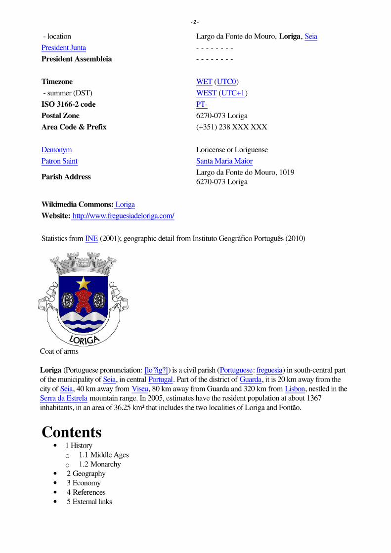
- location Largo da Fonte do Mouro, Loriga, Seia
President Junta - - - - - - - -
President Assembleia - - - - - - - -
Timezone WET (UTC0)
- summer (DST) WEST (UTC+1)
ISO 3166-2 code PT-
Postal Zone 6270-073 Loriga
Area Code & Prefix (+351) 238 XXX XXX
Demonym Loricense or Loriguense
Patron Saint Santa Maria Maior
Parish AddressLargo da Fonte do Mouro, 1019
6270-073 Loriga
Wikimedia Commons: Loriga
Website: http://www.freguesiadeloriga.com/
Statistics from INE (2001); geographic detail from Instituto Geográfico Português (2010)
Coat of arms
Loriga (Portuguese pronunciation: [lo'?ig?]) is a civil parish (Portuguese: freguesia) in south-central part
of the municipality of Seia, in central Portugal. Part of the district of Guarda, it is 20 km away from the
city of Seia, 40 km away from Viseu, 80 km away from Guarda and 320 km from Lisbon, nestled in the
Serra da Estrela mountain range. In 2005, estimates have the resident population at about 1367
inhabitants, in an area of 36.25 km² that includes the two localities of Loriga and Fontão.
Contents• 1 History
o 1.1 Middle Ages
o 1.2 Monarchy
• 2 Geography
• 3 Economy
• 4 References
• 5 External links
- 2 -

[edit] History
The remaining Roman-era bridge crossing the Ribeira de Loriga
Loriga is ancient, beautiful and historic portuguese small town (vila), located in the Serra da Estrela
mountains. Known as Lobriga by the Lusitanians an Lorica by the Romans, it is more than 2600 years
old. Notable people from Loriga include Viriathus (known as Viriato in Portuguese), a famous Lusitanian
leader and portuguese national hero.
Loriga was founded originally along a column between ravines where today the historic centre exists. The
site was ostensibly selected more than 2600 years ago, owing to its defensibility, the abundance of
potable water and pasturelands, and lowlands that provided conditions to practice both hunting and
gathering/agriculture.[1]
When the Romans arrived in the region, the settlement was concentrated into two areas. The larger,
older and principal agglomeration was situated in the area of the main church and Rua de Viriato,
fortified with a wall and palisade.[1] The second group, in the Bairro de São Ginês, were some small
homes constructed on the rocky promintory, which were later appropriated by the Visigoths in order to
construct a chapel.[1] The 1st century Roman road and two bridges (the second was destroyed in the
17th century after flooding) connected the outpost of Lorica to the rest of their Lusitanian province.[1]
The barrio of São Ginês (São Gens), a local ex-libris, is the location of the chapel of Nossa Senhora do
Carmo, an ancient Visigothic chapel. São Gens, a Celtic saint, martyred in Arles na Gália, during the
reign of Emperor Diocletian, and over time the locals began to refer to this saint as São Ginês, due to its
easy of pronunciation.[1]
[edit] Middle Ages
Loriga was the municipal seat since the 12th century, receiving forals in 1136 (João Rhânia, master of
the Terras de Loriga for over two decades, during the reign of Afonso Henriques), 1249 (during the
reign of Afonso III), 1474 (under King Afonso V) and finally in 1514 (by King Manuel I).[1]
Loriga was an ecclesiastical parish of the vicarage of the Royal Padroado and its Matriz Church was
ordered constructed in 1233, by King Sancho II.[1] This church, was to the invokation of Santa Maria
Maior, and constructed over the ancient small Visigothic chapel (there is a lateral block with Visigoth
inscriptions visible).[1] Constructed in the Romanesque-style it consists of a three-nave building, with
hints of the Sé Velha of Coimbra. This structure was destroyed during the 1755 earthquake, and only
portions of the lateral walls were preserved.[1]
[edit] Monarchy
The 1755 earthquake resulted in significant damage to the village of Loriga, destroying homes and the
parcochial residence, in addition to opening-up cracks and faults in the village's larger buildings, such as
the historic municipal council hall (constructed in the 13th century).[1] An emissary of the Marquess of
- 3 -

Pombal actually visited Loriga to evaluate the damage (something that did not happen in other
mountainous parishes, even Covilhã) and provide support.[1]
The residents of Loriga supported the Asolutionist forces of the Infante Miguel of Portugal against the
Liberals, during the Portuguese Liberal Wars, which resulted in Loriga being abandoned politically after
Miguel's explusion by his brother King Peter.[1] In 1855, as a consequence of its support, it was
stripped of municipal status during the municipal reforms of the 19th century.[1] At the time of its
municipal demise (October 1855), the municipality of Loriga included the parishes of Alvoco da Serra,
Cabeça, Sazes da Beira, Teixeira, Valezim and Vide, as well as thirty other disincorporated villages.[1]
Loriga was an industrial centre for textile manufacturing during the 19th century. It was one of the few
industrialized centres in the Beira Interior region, even supplanting Seia until the middle of the 20th
century.[1] Only Covilhã out-preformed Loriga in terms of businesses operating from its lands;
companies such as Regato, Redondinha, Fonte dos Amores, Tapadas, Fândega, Leitão & Irmãos,
Augusto Luís Mendes, Lamas, Nunes Brito, Moura Cabral and Lorimalhas, among others.[1] The main
roadway in Loriga, Avenida Augusto Luís Mendes, is named for one of the villages most illustrious
industrialists. The wool industry started to decline during the last decades of the 20th century, a factor
that aggravated and accelerated the decline of the region.[1]
[edit] Geography
A bridge over a ravine in Loriga, with the pastures of the valley landscape
Known locally as the "Portuguese Switzerland" due to its landscape that includes a principal settlement
nestled in the mountains of the Serra da Estrela Natural Park.[2] It is located in the south-central part of
the municipality of Seia, along the southeast part of the Serra, between several ravines, but specifically
the Ribeira de São Bento and Ribeira de Loriga;[2] it is 20 kilometres from Seia, 80 kilometres from
Guarda and 300 kilometres from the national capital (Lisbon). A main village is accessible by the national
roadway E.N. 231, that connects directly to the region of the Serra da Estrela by way of E.N.338
(which was completed in 2006), or through the E.N.339, a 9.2 kilometre access that transits some of the
main elevations (960 metres near Portela do Arão or Portela de Loriga, and 1650 metres around the
Lagoa Comprida).
The region is carved by U-shaped glacial valleys, modelled by the movement of ancient glaciers. The
main valley, Vale de Loriga was carved by longitudanal abrasion that also created rounded pockets,
where the glacial resistance was minor. Starting at an altitude of 1991 metres along the Serra da Estrela
the valley descends abruptly until 290 metres above sea level (around Vide), passing villages such as
Cabeça, Casal do Rei and Muro. The central village, Loriga, is seven kilometres from Torre (the highest
point), but the parish is sculpted by cliffs, alluvial plains and glacial lakes deposited during millennia of
glacial erosion, and surrounded by rare ancient forest that surrounded the lateral flanks of these glaciers.
[edit] Economy
- 4 -

Vodafone Ski Resort, Serra da Estrela, in Loriga.
Textiles are the principal local export; Loriga was a hub the textile and wool industries during the
mid-19th century, in addition to being subsistence agriculture responsible for the cultivation of corn. The
Loriguense economy is based on metallurgical industries, bread-making, commercial shops, restaurants
and agricultural support services.
While that textile industry has since dissipated, the town began to attract a tourist trade due to its
proximity to the Serra da Estrela and Vodafone Ski Resort (the only ski center in Portugal), which was
constructed within the parish limits.
[edit] References
Notes
1. ^ a b c d e f g h i j k l m n o p q História Concisa de Loriga, por António Conde (in
Portuguese). Loriga, Portugal and similar pages (in Portuguese and English). Junta Freguesia, ed
(2011). "Breve história das origens à actualidade" (in Portuguese). Loriga (Seia), Portugal: Junta
de Freguesia de Loriga.
http://www.freguesiadeloriga.com/index.php?progoption=turnews&do=shownew&topic=12&ne
wid=30. Retrieved 17 June 2011.
2. ^ a b Junta Freguesia, ed (2011). "Conhece em Loriga...Geografia em Loriga" (in Portuguese).
Loriga (Seia), Portugal: Junta de Freguesia de Loriga.
http://www.freguesiadeloriga.com/index.php?progoption=turnews&do=shownewsbytopic&topic
=12&subtipo=Geografia%20de%20Loriga. Retrieved 17 June 2011.
[edit] External links
• (Portuguese and English) Loriga's Homepage
• (Portuguese and English) Loriga - Portugal
Retrieved from "http://en.wikipedia.org/wiki/Loriga"
Categories: Parishes of Seia | Towns in Portugal
Hidden categories: Articles containing Portuguese language text
Personal tools
• Log in / create account
Namespaces
• Article
• Discussion
Variants
Views
• Read
- 5 -

• Edit
• View history
Actions
Search
Navigation
• Main page
• Contents
• Featured content
• Current events
• Random article
• Donate to Wikipedia
Interaction
• Help
• About Wikipedia
• Community portal
• Recent changes
• Contact Wikipedia
Toolbox
• What links here
• Related changes
• Upload file
• Special pages
• Permanent link
• Cite this page
Print/export
• Create a book
• Download as PDF
• Printable version
Languages
• Deutsch
• Español
• Français
• Italiano
• Latina
• Nederlands
• Português
• ???????
• Türkçe
• This page was last modified on 26 July 2011 at 21:02.
• Text is available under the Creative Commons Attribution-ShareAlike License; additional terms
may apply. See Terms of use for details.
• Wikipedia® is a registered trademark of the Wikimedia Foundation, Inc., a non-profit
organization.
• Contact us
• Privacy policy
- 6 -

• About Wikipedia
• Disclaimers
•
•
- 7 -

Loriga From Wikipedia, the free encyclopedia
Jump to: navigation, search
For the Spanish writer and filmmaker, see Ray Loriga.
Coordinates: 40°19'13.69?N 7°39'58.15?W? / ?40.3204694°N 7.6661528°W? / 40.3204694;
-7.6661528
Loriga
Civil Parish (Freguesia)
The valley parish of Loriga in the shadow of the Serra da Estrela
Official name: Freguesia de Loriga
Country Portugal
Region Centro, Portugal
Subregion Serra da Estrela
District Guarda
Municipality Seia
Localities Fontão, Loriga
Landmark Torre (Serra da Estrela)
Rivers Ribeira de São Bento, Ribeira de Loriga
Center Loriga
- elevation 1,293 m (4,242 ft)
- coordinates40°19'13.69?N 7°39'58.15?W? / ?40.3204694°N
7.6661528°W? / 40.3204694; -7.6661528
Length 4.21 km (3 mi), Northwest-Southeast
Width 13.78 km (9 mi), Southwest-Northeast
Area 36.25 km² (14 sq mi)
Population 1,367 (2005)
Density 37.71 / km² (98 / sq mi)
LAU Vila/Junta Freguesia
- 1 -

- location Largo da Fonte do Mouro, Loriga, Seia
President Junta - - - - - - - -
President Assembleia - - - - - - - -
Timezone WET (UTC0)
- summer (DST) WEST (UTC+1)
ISO 3166-2 code PT-
Postal Zone 6270-073 Loriga
Area Code & Prefix (+351) 238 XXX XXX
Demonym Loricense or Loriguense
Patron Saint Santa Maria Maior
Parish AddressLargo da Fonte do Mouro, 1019
6270-073 Loriga
Wikimedia Commons: Loriga
Website: http://www.freguesiadeloriga.com/
Statistics from INE (2001); geographic detail from Instituto Geográfico Português (2010)
Loriga (Portuguese pronunciation: [lo'?ig?]) is a civil parish (Portuguese: freguesia) in south-central part
of the municipality of Seia, in central Portugal. Part of the district of Guarda, it is 20 km away from the
city of Seia, 40 km away from Viseu, 80 km away from Guarda and 320 km from Lisbon, nestled in the
Serra da Estrela mountain range. In 2005, estimates have the resident population at about 1367
inhabitants, in an area of 36.25 km² that includes the two localities of Loriga and Fontão.
Contents• 1 History
o 1.1 Middle Ages
o 1.2 Monarchy
• 2 Geography
• 3 Economy
• 4 References
• 5 External links
[edit] History
The remaining Roman-era bridge crossing the Ribeira de Loriga
- 2 -

Loriga is ancient, beautiful and historic portuguese small town (vila), located in the Serra da Estrela
mountains. Known as Lobriga by the Lusitanians an Lorica by the Romans, it is more than 2600 years
old. Notable people from Loriga include Viriathus (known as Viriato in Portuguese), a famous Lusitanian
leader and portuguese national hero.
Loriga was founded originally along a column between ravines where today the historic centre exists. The
site was ostensibly selected more than 2600 years ago, owing to its defensibility, the abundance of
potable water and pasturelands, and lowlands that provided conditions to practice both hunting and
gathering/agriculture.[1]
When the Romans arrived in the region, the settlement was concentrated into two areas. The larger,
older and principal agglomeration was situated in the area of the main church and Rua de Viriato,
fortified with a wall and palisade.[1] The second group, in the Bairro de São Ginês, were some small
homes constructed on the rocky promintory, which were later appropriated by the Visigoths in order to
construct a chapel.[1] The 1st century Roman road and two bridges (the second was destroyed in the
17th century after flooding) connected the outpost of Lorica to the rest of their Lusitanian province.[1]
The barrio of São Ginês (São Gens), a local ex-libris, is the location of the chapel of Nossa Senhora do
Carmo, an ancient Visigothic chapel. São Gens, a Celtic saint, martyred in Arles na Gália, during the
reign of Emperor Diocletian, and over time the locals began to refer to this saint as São Ginês, due to its
easy of pronunciation.[1]
[edit] Middle Ages
Loriga was the municipal seat since the 12th century, receiving forals in 1136 (João Rhânia, master of
the Terras de Loriga for over two decades, during the reign of Afonso Henriques), 1249 (during the
reign of Afonso III), 1474 (under King Afonso V) and finally in 1514 (by King Manuel I).[1]
Loriga was an ecclesiastical parish of the vicarage of the Royal Padroado and its Matriz Church was
ordered constructed in 1233, by King Sancho II.[1] This church, was to the invokation of Santa Maria
Maior, and constructed over the ancient small Visigothic chapel (there is a lateral block with Visigoth
inscriptions visible).[1] Constructed in the Romanesque-style it consists of a three-nave building, with
hints of the Sé Velha of Coimbra. This structure was destroyed during the 1755 earthquake, and only
portions of the lateral walls were preserved.[1]
[edit] Monarchy
The 1755 earthquake resulted in significant damage to the village of Loriga, destroying homes and the
parcochial residence, in addition to opening-up cracks and faults in the village's larger buildings, such as
the historic municipal council hall (constructed in the 13th century).[1] An emissary of the Marquess of
Pombal actually visited Loriga to evaluate the damage (something that did not happen in other
mountainous parishes, even Covilhã) and provide support.[1]
The residents of Loriga supported the Asolutionist forces of the Infante Miguel of Portugal against the
Liberals, during the Portuguese Liberal Wars, which resulted in Loriga being abandoned politically after
Miguel's explusion by his brother King Peter.[1] In 1855, as a consequence of its support, it was
stripped of municipal status during the municipal reforms of the 19th century.[1] At the time of its
municipal demise (October 1855), the municipality of Loriga included the parishes of Alvoco da Serra,
Cabeça, Sazes da Beira, Teixeira, Valezim and Vide, as well as thirty other disincorporated villages.[1]
Loriga was an industrial centre for textile manufacturing during the 19th century. It was one of the few
industrialized centres in the Beira Interior region, even supplanting Seia until the middle of the 20th
- 3 -

century.[1] Only Covilhã out-preformed Loriga in terms of businesses operating from its lands;
companies such as Regato, Redondinha, Fonte dos Amores, Tapadas, Fândega, Leitão & Irmãos,
Augusto Luís Mendes, Lamas, Nunes Brito, Moura Cabral and Lorimalhas, among others.[1] The main
roadway in Loriga, Avenida Augusto Luís Mendes, is named for one of the villages most illustrious
industrialists. The wool industry started to decline during the last decades of the 20th century, a factor
that aggravated and accelerated the decline of the region.[1]
[edit] Geography
A bridge over a ravine in Loriga, with the pastures of the valley landscape
Known locally as the "Portuguese Switzerland" due to its landscape that includes a principal settlement
nestled in the mountains of the Serra da Estrela Natural Park.[2] It is located in the south-central part of
the municipality of Seia, along the southeast part of the Serra, between several ravines, but specifically
the Ribeira de São Bento and Ribeira de Loriga;[2] it is 20 kilometres from Seia, 80 kilometres from
Guarda and 300 kilometres from the national capital (Lisbon). A main village is accessible by the national
roadway E.N. 231, that connects directly to the region of the Serra da Estrela by way of E.N.338
(which was completed in 2006), or through the E.N.339, a 9.2 kilometre access that transits some of the
main elevations (960 metres near Portela do Arão or Portela de Loriga, and 1650 metres around the
Lagoa Comprida).
The region is carved by U-shaped glacial valleys, modelled by the movement of ancient glaciers. The
main valley, Vale de Loriga was carved by longitudanal abrasion that also created rounded pockets,
where the glacial resistance was minor. Starting at an altitude of 1991 metres along the Serra da Estrela
the valley descends abruptly until 290 metres above sea level (around Vide), passing villages such as
Cabeça, Casal do Rei and Muro. The central village, Loriga, is seven kilometres from Torre (the highest
point), but the parish is sculpted by cliffs, alluvial plains and glacial lakes deposited during millennia of
glacial erosion, and surrounded by rare ancient forest that surrounded the lateral flanks of these glaciers.
[edit] Economy
Vodafone Ski Resort, Serra da Estrela, in Loriga.
Textiles are the principal local export; Loriga was a hub the textile and wool industries during the
- 4 -

mid-19th century, in addition to being subsistence agriculture responsible for the cultivation of corn. The
Loriguense economy is based on metallurgical industries, bread-making, commercial shops, restaurants
and agricultural support services.
While that textile industry has since dissipated, the town began to attract a tourist trade due to its
proximity to the Serra da Estrela and Vodafone Ski Resort (the only ski center in Portugal), which was
constructed within the parish limits.
[edit] References
Notes
1. ^ a b c d e f g h i j k l m n o p q História Concisa de Loriga, por António Conde (in
Portuguese). Loriga, Portugal and similar pages (in Portuguese and English). Junta Freguesia, ed
(2011). "Breve história das origens à actualidade" (in Portuguese). Loriga (Seia), Portugal: Junta
de Freguesia de Loriga.
http://www.freguesiadeloriga.com/index.php?progoption=turnews&do=shownew&topic=12&ne
wid=30. Retrieved 17 June 2011.
2. ^ a b Junta Freguesia, ed (2011). "Conhece em Loriga...Geografia em Loriga" (in Portuguese).
Loriga (Seia), Portugal: Junta de Freguesia de Loriga.
http://www.freguesiadeloriga.com/index.php?progoption=turnews&do=shownewsbytopic&topic
=12&subtipo=Geografia%20de%20Loriga. Retrieved 17 June 2011.
[edit] External links
• (Portuguese and English) Loriga's Homepage
• (Portuguese and English) Loriga - Portugal
Retrieved from "http://en.wikipedia.org/wiki/Loriga"
Categories: Parishes of Seia | Towns in Portugal
Hidden categories: Articles containing Portuguese language text
Personal tools
• Log in / create account
Namespaces
• Article
• Discussion
Variants
Views
• Read
• Edit
• View history
Actions
Search
Navigation
• Main page
• Contents
• Featured content
• Current events
• Random article
- 5 -

• Donate to Wikipedia
Interaction
• Help
• About Wikipedia
• Community portal
• Recent changes
• Contact Wikipedia
Toolbox
• What links here
• Related changes
• Upload file
• Special pages
• Permanent link
• Cite this page
Print/export
• Create a book
• Download as PDF
• Printable version
Languages
• Deutsch
• Español
• Français
• Italiano
• Latina
• Nederlands
• Português
• ???????
• Türkçe
• This page was last modified on 26 July 2011 at 21:02.
• Text is available under the Creative Commons Attribution-ShareAlike License; additional terms
may apply. See Terms of use for details.
• Wikipedia® is a registered trademark of the Wikimedia Foundation, Inc., a non-profit
organization.
• Contact us
• Privacy policy
• About Wikipedia
• Disclaimers
•
•
- 6 -

LorigaCivil parish
Coordinates: 40.324°N 7.691°W
Country PortugalRegion CentroSubregion Serra da EstrelaIntermunic.comm.
Beiras e Serra daEstrela
District GuardaMunicipality Seia
Area • Total 36.25 km2 (14.00 sq mi)
Elevation 750 m (2,460 ft)
Population (2011) • Total 1,053 • Density 29/km2 (75/sq mi)
Postal code 6270Area code 238
Patron Santa Maria Maior
Website http://www.loriga.info
LorigaLoriga (Portuguese pronunciation: [luˈɾiɡɐ]) is a civil parish (Portuguese: freguesia) and town in south-
central part of the municipality of Seia, in central Portugal. Part of the district of Guarda, it is 20 km away
from the city of Seia, 40 km away from Viseu, 80 km away from Guarda and 320 km from Lisbon, nestled
in the Serra da Estrela mountain range. The population in 2011 was 1,053,[1] in an area of 36.25 km²,[2]
including the two localities/villages of Loriga and Fontão.
HistoryMiddle AgesMonarchy
GeographyEconomyReferencesExternal links
Loriga was founded along a column between ravines where
today the historic centre exists. The site was ostensibly
selected more than 2600 years ago, owing to its
defensibility, the abundance of potable water and
pasturelands, and lowlands that provided conditions to
practice both hunting and gathering/agriculture.[3]
When the Romans arrived in the region, the settlement was
concentrated into two areas. The larger, older and principal
agglomeration was situated in the area of the main church
and Rua de Viriato, fortified with a wall and palisade.[3] The
second group, in the Bairro de São Ginês, were some small
homes constructed on the rocky promintory, which were
later appropriated by the Visigoths in order to construct a chapel.[3] The 1st century Roman road and two
bridges (the second was destroyed in the 16th century after flooding in the Ribeira de São Bento)
connected the outpost of Lorica to the rest of their Lusitanian province.[3] The barrio of São Ginês (SãoGens), a local ex-libris, is the location of the chapel of Nossa Senhora do Carmo, an ancient Visigothic
chapel. São Gens, a Celtic saint, martyred in Arles na Gália, during the reign of Emperor Diocletian, and
over time the locals began to refer to this saint as São Ginês, due to its easy of pronunciation.[3]
Loriga was the municipal seat since the 12th century, receiving forals in 1136 (João Rhânia, master of the
Terras de Loriga for over two decades, during the reign of Afonso Henriques), 1249 (during the reign of
Afonso III), 1474 (under King Afonso V) and finally in 1514 (by King Manuel I).[3]
Loriga was an ecclesiastical parish of the vicarage of the Royal Padroado and its Matriz Church was
ordered constructed in 1233, by King Sancho II.[3] This church, was to the invokation of Santa MariaMaior, and constructed over the ancient small Visigothic chapel (there is a lateral block with Visigoth
inscriptions visible).[3] Constructed in the Romanesque-style it consists of a three-nave building, with
hints of the Sé Velha of Coimbra. This structure was destroyed during the 1755 earthquake, and only
portions of the lateral walls were preserved.[3]
The 1755 earthquake resulted in significant damage to the town of Loriga, destroying homes and the
parcochial residence, in addition to opening-up cracks and faults in the town's larger buildings, such as
the historic municipal council hall (constructed in the 13th century).[3] An emissary of the Marquess of
Pombal actually visited Loriga to evaluate the damage (something that did not happen in other mountainous parishes, even Covilhã) and provide support.[3]
The residents of Loriga supported the Asolutionist forces of the Infante Miguel of Portugal against the Liberals, during the Portuguese Liberal Wars, which resulted
in Loriga being abandoned politically after Miguel's expulsion by his brother King Peter.[3] In 1855, as a consequence of its support, it was stripped of municipal
status during the municipal reforms of the 19th century.[3] At the time of its municipal demise (October 1855), the municipality of Loriga included the parishes of
Alvoco da Serra, Cabeça, Sazes da Beira, Teixeira, Valezim and Vide, as well as thirty other disincorporated villages.[3]
Loriga was an industrial centre for textile manufacturing during the 19th century. It was one of the few industrialized centres in the Beira Interior region, even
supplanting Seia until the middle of the 20th century.[3] Only Covilhã out-performed Loriga in terms of businesses operating from its lands; companies such as
Regato, Redondinha, Fonte dos Amores, Tapadas, Fândega, Leitão & Irmãos, Augusto Luís Mendes, Lamas, Nunes Brito, Moura Cabral and Lorimalhas, among
others.[3] The main roadway in Loriga, Avenida Augusto Luís Mendes, is named for one of the villages most illustrious industrialists. The wool industry started to
decline during the last decades of the 20th century, a factor that aggravated and accelerated the decline of the region.[3]
Loriga
Coordinates: 40.324°N 7.691°W
Contents
History
The remaining Roman-era bridgecrossing the Ribeira de Loriga
Middle Ages
Monarchy

Known locally as the "Portuguese Switzerland" due to its landscape that includes a principal settlement nestled in
the mountains of the Serra da Estrela Natural Park.[4] It is located in the south-central part of the municipality of
Seia, along the southeast part of the Serra, between several ravines, but specifically the Ribeira de São Bento and
Ribeira da Nave;[4] it is 20 kilometres from Seia, 80 kilometres from Guarda and 300 kilometres from the national
capital (Lisbon). A main town is accessible by the national roadway E.N. 231, that connects directly to the region of
the Serra da Estrela by way of E.N.338 (which was completed in 2006), or through the E.N.339, a 9.2 kilometre
access that transits some of the main elevations (960 metres near Portela do Arão or Portela de Loriga, and 1650
metres around the Lagoa Comprida).
The region is carved by U-shaped glacial valleys, modelled by the movement of ancient glaciers. The main valley, Valede Loriga was carved by longitudanal abrasion that also created rounded pockets, where the glacial resistance was
minor. Starting at an altitude of 1991 metres along the Serra da Estrela the valley descends abruptly until 290 metres
above sea level (around Vide), passing villages such as Cabeça, Casal do Rei and Muro. The central town, Loriga, is
seven kilometres from Torre (the highest point), but the parish is sculpted by cliffs, alluvial plains and glacial lakes deposited during millennia of glacial erosion,
and surrounded by rare ancient forest that surrounded the lateral flanks of these glaciers.
Textiles are the principal local export; Loriga was a hub the textile and wool industries during the mid-19th century,
in addition to being subsistence agriculture responsible for the cultivation of corn. The Loriguense economy is based
on metallurgical industries, bread-making, commercial shops, restaurants and agricultural support services.
While that textile industry has since dissipated, the town began to attract a tourist trade due to its proximity to the
Serra da Estrela and Vodafone Ski Resort (the only ski center in Portugal), which was constructed totally the parish
limits.
1. Instituto Nacional de Estatística (http://www.ine.pt/xportal/xmain?xlang=en&xpid=INE&xpgid=ine_indicadores&indOcorrCod=0005889&contexto=pi&selTab=tab0)
2. Direção-Geral do Território (http://www.dgterritorio.pt/ficheiros/cadastro/caop/caop_download/caop_2014_0/areasfregmundistcaop2014_2)
3. Junta Freguesia, ed. (2011). "Breve história das origens à actualidade por António Conde" (https://web.archive.org/web/20120313002558/http://www.freguesiadeloriga.com/index.php?progoption=turnews&do=shownew&topic=12&newid=30) (in Portuguese). Loriga (Seia), Portugal: Junta de Freguesia de Loriga.Archived from the original (http://www.freguesiadeloriga.com/index.php?progoption=turnews&do=shownew&topic=12&newid=30) on 13 March 2012.Retrieved 17 June 2011.
4. Junta Freguesia, ed. (2011). "Conhece em Loriga...Geografia em Loriga" (https://web.archive.org/web/20120313002726/http://www.freguesiadeloriga.com/index.php?progoption=turnews&do=shownewsbytopic&topic=12&subtipo=Geografia%20de%20Loriga) (in Portuguese). Loriga (Seia), Portugal: Junta deFreguesia de Loriga. Archived from the original (http://www.freguesiadeloriga.com/index.php?progoption=turnews&do=shownewsbytopic&topic=12&subtipo=Geografia%20de%20Loriga) on 13 March 2012. Retrieved 17 June 2011.
(in Portuguese) Loriga's Homepage in portuguese and english (http://lorigaportugal.wordpress.com)
Retrieved from "https://en.wikipedia.org/w/index.php?title=Loriga&oldid=857152105"
This page was last edited on 29 August 2018, at 22:05 (UTC).
Text is available under the Creative Commons Attribution-ShareAlike License; additional terms may apply. By using this site, you agree to the Terms of Use andPrivacy Policy. Wikipedia® is a registered trademark of the Wikimedia Foundation, Inc., a non-profit organization.
Geography
A bridge over a ravine in Loriga, withthe pastures of the valley landscape
Economy
Vodafone Ski Resort, Serra da Estrela,in the town of Loriga.
References
External links
For the Spanish writer and filmmaker, see Ray Loriga.
Loriga (Portuguese pronunciation: [loˈɾiɡɐ]) is a civil parish (Portuguese: freguesia) and town insouth-central part of the municipality of Seia, in central Portugal. Part of the district of Guarda, itis 20 km away from the city of Seia, 40 km away from Viseu, 80 km away from Guarda and320 km from Lisbon, nestled in the Serra da Estrela mountain range. The population in 2011 was1,053,[1] in an area of 36.25 km²,[2] including the two localities, the town of Loriga and the villageof Fontão.

Loriga
Civil parish
Coordinates: 40.324°N 7.691°W
Country Portugal
Region Centro
Intermunic. comm. Beiras e Serra da Estrela
District Guarda
Municipality Seia
Loriga

The remaining Roman-era bridgecrossing the Ribeira de Loriga
Loriga was founded along a column between ravines where today the historic centre exists. Thesite was ostensibly selected more than 2600 years ago, owing to its defensibility, the abundanceof potable water and pasturelands, and lowlands that provided conditions to practice bothhunting and gathering/agriculture.[3]
When the Romans arrived in the region, the settlement was concentrated into two areas. Thelarger, older and principal agglomeration was situated in the area of the main church and Rua deViriato, fortified with a wall and palisade.[3] The second group, in the Bairro de São Ginês, weresome small homes constructed on the rocky promintory, which were later appropriated by theVisigoths in order to construct a chapel.[3] The 1st century Roman road and two bridges (thesecond was destroyed in the 16th century after flooding in the Ribeira de São Bento) connectedthe outpost of Lorica to the rest of their Lusitanian province.[3] The barrio of São Ginês (SãoGens), a local ex-libris, is the location of the chapel of Nossa Senhora do Carmo, an ancient
Area
• Total 36.25 km2 (14.00 sq mi)
Elevation 750 m (2,460 ft)
Population (2011)
• Total 1,053
• Density 29/km2 (75/sq mi)
Postal code 6270
Area code 238
Patron Santa Maria Maior
Website http://lorigaportugal.wordpress.com
History
Visigothic chapel. São Gens, a Celtic saint, martyred in Arles na Gália, during the reign ofEmperor Diocletian, and over time the locals began to refer to this saint as São Ginês, due to itseasy of pronunciation.[3]
Middle Ages
Loriga was the municipal seat since the 12th century, receiving forals in 1136 (João Rhânia,master of the Terras de Loriga for over two decades, during the reign of Afonso Henriques),1249 (during the reign of Afonso III), 1474 (under King Afonso V) and finally in 1514 (by KingManuel I).[3]
Loriga was an ecclesiastical parish of the vicarage of the Royal Padroado and its Matriz Churchwas ordered constructed in 1233, by King Sancho II.[3] This church, was to the invokation ofSanta Maria Maior, and constructed over the ancient small Visigothic chapel (there is a lateralblock with Visigoth inscriptions visible).[3] Constructed in the Romanesque-style it consists of athree-nave building, with hints of the Sé Velha of Coimbra. This structure was destroyed duringthe 1755 earthquake, and only portions of the lateral walls were preserved.[3]
Monarchy
The 1755 earthquake resulted in significant damage to the town of Loriga, destroying homes andthe parcochial residence, in addition to opening-up cracks and faults in the town's largerbuildings, such as the historic municipal council hall (constructed in the 13th century).[3] Anemissary of the Marquess of Pombal actually visited Loriga to evaluate the damage (somethingthat did not happen in other mountainous parishes, even Covilhã) and provide support.[3]
The residents of Loriga supported the Asolutionist forces of the Infante Miguel of Portugalagainst the Liberals, during the Portuguese Liberal Wars, which resulted in Loriga beingabandoned politically after Miguel's expulsion by his brother King Peter.[3] In 1855, as aconsequence of its support, it was stripped of municipal status during the municipal reforms ofthe 19th century.[3] At the time of its municipal demise (October 1855), the municipality of Lorigaincluded the parishes of Alvoco da Serra, Cabeça, Sazes da Beira, Teixeira, Valezim and Vide,as well as thirty other disincorporated villages.[3]
Loriga was an industrial centre for textile manufacturing during the 19th century. It was one ofthe few industrialized centres in the Beira Interior region, even supplanting Seia until the middleof the 20th century.[3] Only Covilhã out-performed Loriga in terms of businesses operating fromits lands; companies such as Regato, Redondinha, Fonte dos Amores, Tapadas, Fândega,Leitão & Irmãos, Augusto Luís Mendes, Lamas, Nunes Brito, Moura Cabral and Lorimalhas,among others.[3] The main roadway in Loriga, Avenida Augusto Luís Mendes, is named for oneof the villages most illustrious industrialists. The wool industry started to decline during the last

decades of the 20th century, a factor that aggravated and accelerated the decline of theregion.[3]
A bridge over a ravine in Loriga, with thepastures of the valley landscape
Known locally as the "Portuguese Switzerland" due to its landscape that includes a principalsettlement nestled in the mountains of the Serra da Estrela Natural Park.[4] It is located in thesouth-central part of the municipality of Seia, along the southeast part of the Serra, betweenseveral ravines, but specifically the Ribeira de São Bento and Ribeira da Nave;[4] it is 20kilometres from Seia, 80 kilometres from Guarda and 300 kilometres from the national capital(Lisbon). A main town is accessible by the national roadway E.N. 231, that connects directly tothe region of the Serra da Estrela by way of E.N.338 (which was completed in 2006), or throughthe E.N.339, a 9.2 kilometre access that transits some of the main elevations (960 metres nearPortela do Arão or Portela de Loriga, and 1650 metres around the Lagoa Comprida).
The region is carved by U-shaped glacial valleys, modelled by the movement of ancient glaciers.The main valley, Vale de Loriga was carved by longitudanal abrasion that also created roundedpockets, where the glacial resistance was minor. Starting at an altitude of 1991 metres along theSerra da Estrela the valley descends abruptly until 290 metres above sea level (around Vide),passing villages such as Cabeça, Casal do Rei and Muro. The central town, Loriga, is sevenkilometres from Torre (the highest point), but the parish is sculpted by cliffs, alluvial plains andglacial lakes deposited during millennia of glacial erosion, and surrounded by rare ancient forestthat surrounded the lateral flanks of these glaciers.
Geography
Economy

Vodafone Ski Resort, Serra da Estrela, inthe town of Loriga.
Textiles are the principal local export; Loriga was a hub the textile and wool industries during themid-19th century, in addition to being subsistence agriculture responsible for the cultivation ofcorn. The Loriguense economy is based on metallurgical industries, bread-making, commercialshops, restaurants and agricultural support services.
While that textile industry has since dissipated, the town began to attract a tourist trade due to itsproximity to the Serra da Estrela and Vodafone Ski Resort (the only ski center in Portugal), whichwas constructed totally the parish limits.
1. Instituto Nacional de Estatística
2. Áreas das freguesias, concelhos, distritos e país
3. Junta Freguesia, ed. (2011). "Breve história das origens à actualidade por António Conde"(in Portuguese). Loriga (Seia), Portugal: Junta de Freguesia de Loriga. Archived from theoriginal on 13 March 2012. Retrieved 17 June 2011.
4. Junta Freguesia, ed. (2011). "Conhece em Loriga...Geografia em Loriga" (in Portuguese).Loriga (Seia), Portugal: Junta de Freguesia de Loriga. Archived from the original on 13 March2012. Retrieved 17 June 2011.
(in Portuguese) Loriga's Homepage in portuguese and english
References
External links
Last edited 6 days ago by an anonymous user
Textbox