LOOP 202 Fact Sheet LOOP 202 - City of Phoenix Home€¦ · · 2015-05-29Background The Loop 202...
2
Background The Loop 202 South Mountain Freeway has been a critical part of the Maricopa Association of Governments (MAG) Regional Freeway and Highway Program since it was first included in funding approved by Maricopa County voters in 1985. The freeway was also part of the Regional Transportation Plan funding passed by Maricopa County voters in 2004 through Proposition 400. The freeway is a key component of the region’s adopted multimodal transportation plan and the Regional Freeway and Highway System and is the last piece to complete the Loop 202 system. Current status The Federal Highway Administration (FHWA) released the final decision-making document for the project, the Record of Decision (“ROD”), in March 2015. The FHWA, in coordination with ADOT, identified the preferred alternative in the Draft and Final Environmental Impact Statements as the Selected Alternative in the ROD (see map below). ADOT Loop 202 South Mountain Freeway 1655 W. Jackson Street, MD 126F | Phoenix, AZ 85007 Email: [email protected] | Phone: 602.712.7006 Website: azdot.gov/SouthMountainFreeway CONTACT Freeway Study LOOP 202 Freeway ADOT TRACS No.: 202L MA 054 H5764 01L Federal-aid Project No.: NH-202-D(ADY) Gila River Indian Community Phoenix South Mountain Park/Preserve DOWNTOWN PHOENIX TEMPE CHANDLER TOLLESON AVONDALE GOODYEAR Indian School Road Camelback Road Thomas Road McDowell Road Van Buren Street Buckeye Road Lower Buckeye Road Broadway Road Southern Avenue Baseline Road Dobbins Road Elliot Road Laveen Village Ahwatukee Foothills Village Baseline Road Dobbins Road Elliot Road Chandler Boulevard 83rd Avenue 91st Avenue 99th Avenue 107th Avenue Avondale Boulevard 75th Avenue 67th Avenue 59th Avenue 51st Avenue 43rd Avenue 35th Avenue 17th Avenue 7th Avenue Desert Foothills Parkway 16th Street 7th Street 24th Street 32nd Street 40th Street 48th Street Pecos Road Black Canyon Freeway 17 Papago Freeway 10 Superstition Freeway 60 51 Agua Fria Freeway 101 LOOP Santan Freeway 202 LOOP Maricopa Freeway 10 Selected Alternave Approximate scale 3 miles 1 Existing freeway Gila River Indian Community boundary Maricopa County line Selected Alternative Selected Alternative The selected route for this freeway corridor runs east and west along Pecos Road and then north and south between 55th and 63rd avenues, connecting with Interstate 10 on each end. Fact Sheet Record of Decision
Transcript of LOOP 202 Fact Sheet LOOP 202 - City of Phoenix Home€¦ · · 2015-05-29Background The Loop 202...

BackgroundThe Loop 202 South Mountain Freeway has been a critical part of the Maricopa Association of Governments (MAG) Regional Freeway and Highway Program since it was first included in funding approved by Maricopa County voters in 1985. The freeway was also part of the Regional Transportation Plan funding passed by Maricopa County voters in 2004 through Proposition 400. The freeway is a key component of the region’s adopted multimodal transportation plan and the Regional Freeway and Highway System and is the last piece to complete the Loop 202 system.
Current statusThe Federal Highway Administration (FHWA) released the final decision-making document for the project, the Record of Decision (“ROD”), in March 2015. The FHWA, in coordination with ADOT, identified the preferred alternative in the Draft and Final Environmental Impact Statements as the Selected Alternative in the ROD (see map below).
F r e e w a y S t u d y
L O O P 2 0 2
ADOT Loop 202 South Mountain Freeway1655 W. Jackson Street, MD 126F | Phoenix, AZ 85007
Email: [email protected] | Phone: 602.712.7006Website: azdot.gov/SouthMountainFreewayCONTACT
F r e e w a y S t u d y
L O O P 2 0 2
F r e e w a y S t u d y
L O O P 2 0 2
ADOT TRACS No.: 202L MA 054 H5764 01LFederal-aid Project No.: NH-202-D(ADY)
Gila River Indian Community
Phoenix SouthMountain Park/Preserve
DOWNTOWNPHOENIX
to Los Angeles
TEMPE
CHANDLER
TOLLESONAVONDALEGOODYEAR
Indian School Road
Camelback Road
Bethany Home Road
Thomas Road
McDowell Road
Van Buren Street
Buckeye Road
Lower Buckeye Road
Broadway Road
Southern Avenue
Baseline Road
Dobbins Road
Elliot Road
LaveenVillage
AhwatukeeFoothillsVillage
Baseline Road
Dobbins Road
Elliot Road
Chandler Boulevard
83rd
Ave
nue
91st
Ave
nue
99th
Ave
nue
107t
h Av
enue
Avon
dale
Bou
leva
rd
75th
Ave
nue
67th
Ave
nue
59th
Ave
nue
51st
Ave
nue
43rd
Ave
nue
35th
Ave
nue
17th
Ave
nue
7th
Aven
ue
Dese
rt Fo
othi
llsPa
rkw
ay16
th S
tree
t
7th
Stre
et
24th
Str
eet
32nd
Str
eet
40th
Str
eet
48th
Str
eet
Pecos Road
Black CanyonFreeway17
PapagoFreeway10
SuperstitionFreeway60
51
Agua FriaFreeway101
LOOP
SantanFreeway202
LOOP
MaricopaFreeway10
SelectedAlternative
Approximate scale
3 miles1
Existing freewayGila River Indian Community boundaryMaricopa County lineSelected Alternative
Selected Alternative
The selected route for this freeway corridor runs east and west along Pecos Road and then north and south between 55th and 63rd avenues, connecting with Interstate 10 on each end.
Fact SheetRecord of Decision
SOUTH MOUNTAIN FREEWAY FACT SHEET
Property AcquisitionTo prepare for construction, ADOT has been contacting property owners whose properties will be impacted by freeway construction and is beginning the process to acquire properties within the freeway corridor. ADOT’s property acquisition program includes working as early as possible with property owners and providing benefits to the extent allowed by law to cover actual, reasonable moving costs and related expenses. ADOT will pay market value for businesses and residential properties.
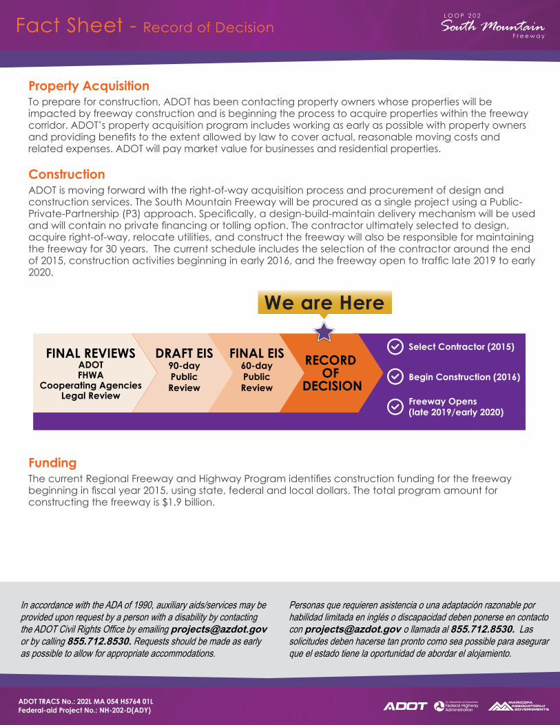
ConstructionADOT is moving forward with the right-of-way acquisition process and procurement of design and construction services. The South Mountain Freeway will be procured as a single project using a Public-Private-Partnership (P3) approach. Specifically, a design-build-maintain delivery mechanism will be used and will contain no private financing or tolling option. The contractor ultimately selected to design, acquire right-of-way, relocate utilities, and construct the freeway will also be responsible for maintaining the freeway for 30 years. The current schedule includes the selection of the contractor around the end of 2015, construction activities beginning in early 2016, and the freeway open to traffic late 2019 to early 2020.
FundingThe current Regional Freeway and Highway Program identifies construction funding for the freeway beginning in fiscal year 2015, using state, federal and local dollars. The total program amount for constructing the freeway is $1.9 billion.
In accordance with the ADA of 1990, auxiliary aids/services may be provided upon request by a person with a disability by contacting the ADOT Civil Rights Office by emailing [email protected] or by calling 855.712.8530. Requests should be made as early as possible to allow for appropriate accommodations.
Personas que requieren asistencia o una adaptación razonable por habilidad limitada en inglés o discapacidad deben ponerse en contacto con [email protected] o llamada al 855.712.8530. Las solicitudes deben hacerse tan pronto como sea possible para asegurar que el estado tiene la oportunidad de abordar el alojamiento.
FINAL REVIEWSADOTFHWA
Cooperating AgenciesLegal Review
DRAFT EIS90-dayPublicReview
FINAL EIS60-dayPublicReview
RECORD OF
DECISION
We are Here
Select Contractor (2015)
Begin Construction (2016)
Freeway Opens(late 2019/early 2020)
F r e e w a y S t u d y
L O O P 2 0 2
F r e e w a y S t u d y
L O O P 2 0 2
ADOT TRACS No.: 202L MA 054 H5764 01LFederal-aid Project No.: NH-202-D(ADY)
Fact Sheet - Record of Decision