Long-Term Management Plan for the Riverton, Wyoming
38
Long-Term Management Plan for the Riverton, Wyoming, Processing Site September 2009 LMS/RVT/S001187-0.0 Formerly DOE-LM/1430-2007
Transcript of Long-Term Management Plan for the Riverton, Wyoming

Long-Term Management Plan for the Riverton, Wyoming, Processing Site September 2009
LMS/RVT/S001187-0.0 Formerly DOE−LM/1430−2007

This page intentionally left blank
LMS/RVT/S01187-0.0
Formerly DOE−LM/1430−2007
Long-Term Management Plan for the Riverton, Wyoming, Processing Site
September 2009

This page intentionally left blank
U.S. Department of Energy Long-Term Management Plan for the Riverton, Wyoming, Processing Site September 2009 Doc. No. S01187-0.0 Page i
Contents Abbreviations................................................................................................................................. iii 1.0 Introduction ............................................................................................................................1
1.1 Purpose .........................................................................................................................1 1.2 Regulatory Requirements .............................................................................................1 1.3 DOE Role......................................................................................................................1
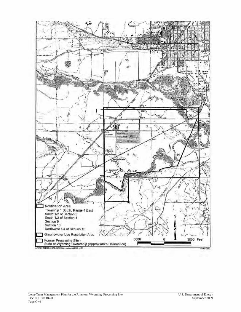
2.0 Site Summary .........................................................................................................................3 2.1 Site Description ............................................................................................................3 2.2 Site Ownership and Access ..........................................................................................3 2.3 Groundwater Conditions...............................................................................................3 2.4 Groundwater Compliance Strategy...............................................................................4 2.5 Institutional Controls ....................................................................................................4
3.0 Long-Term Management Program.........................................................................................5 3.1 Monitoring ....................................................................................................................5
3.1.1 Groundwater Monitoring ...................................................................................5 3.1.1.1 Water Quality .....................................................................................5 3.1.1.2 Water Levels ......................................................................................9
3.1.2 Surface Water Monitoring .................................................................................9 3.1.3 IC Monitoring ..................................................................................................10
3.1.3.1 Sampling...........................................................................................10 3.1.3.2 Land and Water Use Verification.....................................................10
3.2 Maintenance, Access, and Reports .............................................................................11 3.3 Quality Assurance and Health and Safety ..................................................................11 3.4 Review and Revision ..................................................................................................11
4.0 References ............................................................................................................................12
Figures Figure 1. Location Map................................................................................................................... 2 Figure 2. Long-Term Monitoring Locations................................................................................... 7
Tables Table 1. Summary of the Long-Term Groundwater Monitoring Network..................................... 6 Table 2. Summary of the Long-Term Surface Water Monitoring Network ................................... 9
Attachments Attachment A⎯Draft Ground Water Compliance Action Plan Attachment B⎯NRC Letter of Concurrence Attachment C⎯State of Wyoming Institutional Control Letters

Long-Term Management Plan for the Riverton, Wyoming, Processing Site U.S. Department of Energy Doc. No. S01187-0.0 September 2009 Page ii
This page intentionally left blank
U.S. Department of Energy Long-Term Management Plan for the Riverton, Wyoming, Processing Site September 2009 Doc. No. S01187-0.0 Page iii
Abbreviations
CFR Code of Federal Regulations
DOE U.S. Department of Energy
EPA U.S. Environmental Protection Agency
ft feet
GCAP Draft Ground Water Compliance Action Plan
IC institutional control
LTMP long-term management plan
MCL maximum concentration limit
NAUO Northern Arapaho Utility Organization
NRC U.S. Nuclear Regulatory Commission
RRM residual radioactive material
SAP Sampling and Analysis Plan
UMTRCA Uranium Mill Tailings Radiation Control Act
WREQC Wind River Environmental Quality Commission

Long-Term Management Plan for the Riverton, Wyoming, Processing Site U.S. Department of Energy Doc. No. S01187-0.0 September 2009 Page iv
This page intentionally left blank
U.S. Department of Energy Long-Term Management Plan for the Riverton, Wyoming, Processing Site September 2009 Doc. No. S01187-0.0 Page 1
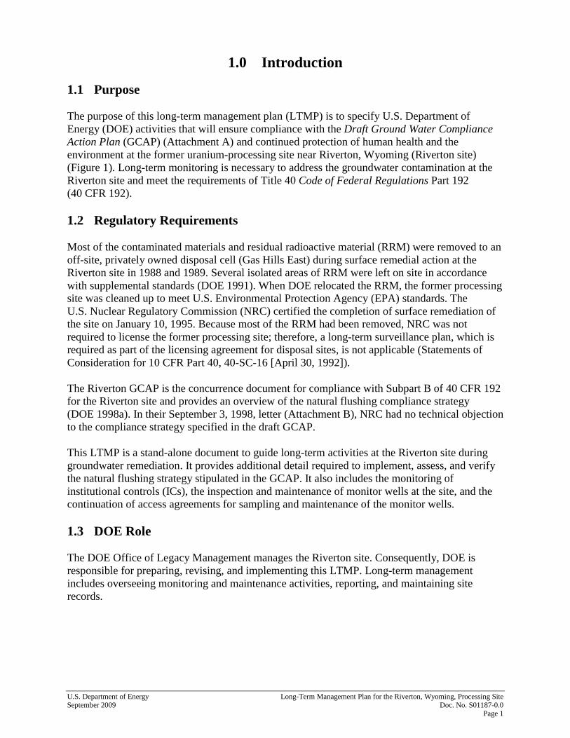
1.0 Introduction
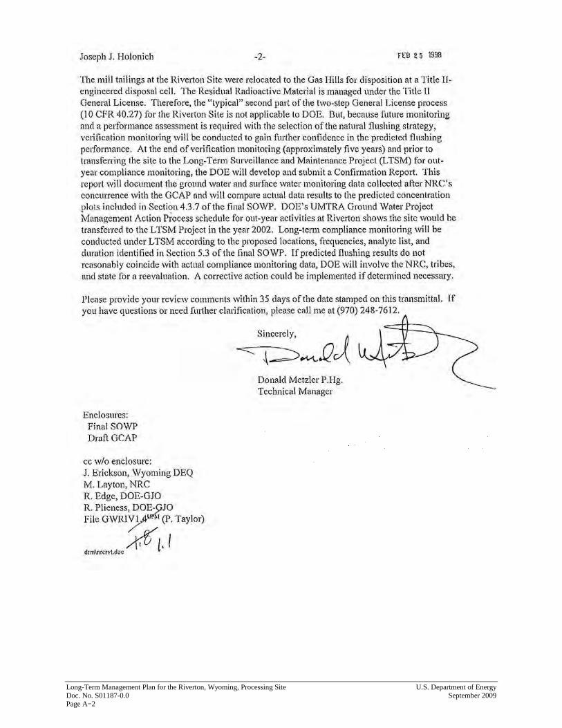
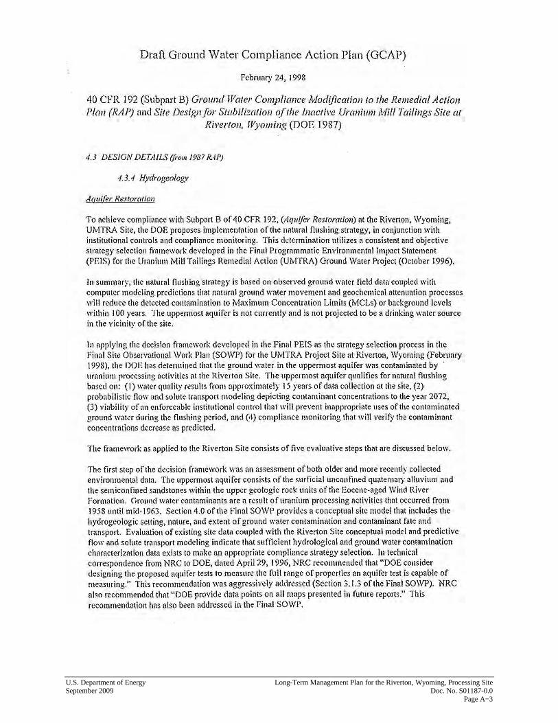
1.1 Purpose The purpose of this long-term management plan (LTMP) is to specify U.S. Department of Energy (DOE) activities that will ensure compliance with the Draft Ground Water Compliance Action Plan (GCAP) (Attachment A) and continued protection of human health and the environment at the former uranium-processing site near Riverton, Wyoming (Riverton site) (Figure 1). Long-term monitoring is necessary to address the groundwater contamination at the Riverton site and meet the requirements of Title 40 Code of Federal Regulations Part 192 (40 CFR 192). 1.2 Regulatory Requirements Most of the contaminated materials and residual radioactive material (RRM) were removed to an off-site, privately owned disposal cell (Gas Hills East) during surface remedial action at the Riverton site in 1988 and 1989. Several isolated areas of RRM were left on site in accordance with supplemental standards (DOE 1991). When DOE relocated the RRM, the former processing site was cleaned up to meet U.S. Environmental Protection Agency (EPA) standards. The U.S. Nuclear Regulatory Commission (NRC) certified the completion of surface remediation of the site on January 10, 1995. Because most of the RRM had been removed, NRC was not required to license the former processing site; therefore, a long-term surveillance plan, which is required as part of the licensing agreement for disposal sites, is not applicable (Statements of Consideration for 10 CFR Part 40, 40-SC-16 [April 30, 1992]). The Riverton GCAP is the concurrence document for compliance with Subpart B of 40 CFR 192 for the Riverton site and provides an overview of the natural flushing compliance strategy (DOE 1998a). In their September 3, 1998, letter (Attachment B), NRC had no technical objection to the compliance strategy specified in the draft GCAP. This LTMP is a stand-alone document to guide long-term activities at the Riverton site during groundwater remediation. It provides additional detail required to implement, assess, and verify the natural flushing strategy stipulated in the GCAP. It also includes the monitoring of institutional controls (ICs), the inspection and maintenance of monitor wells at the site, and the continuation of access agreements for sampling and maintenance of the monitor wells. 1.3 DOE Role The DOE Office of Legacy Management manages the Riverton site. Consequently, DOE is responsible for preparing, revising, and implementing this LTMP. Long-term management includes overseeing monitoring and maintenance activities, reporting, and maintaining site records.
Long-T
erm M
anagement Plan for the R
iverton, Wyom
ing, Processing Site U
.S. Departm
ent of Energy
Doc. N
o. S01187-0.0 Septem
ber 2009 Page 2
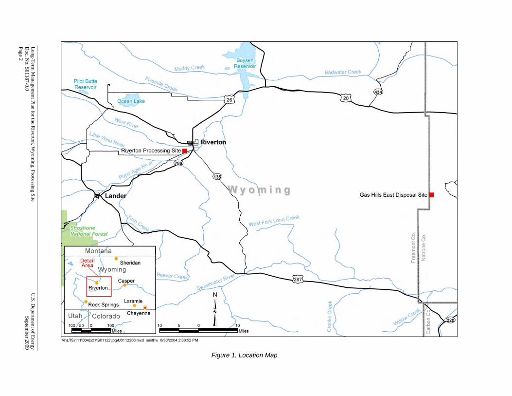
Figure 1. Location Map
U.S. Department of Energy Long-Term Management Plan for the Riverton, Wyoming, Processing Site September 2009 Doc. No. S01187-0.0 Page 3
2.0 Site Summary
2.1 Site Description The Riverton site is in Fremont County, 2 miles southwest of the city of Riverton (Figure 1), and is within the boundaries of the Wind River Indian Reservation (Northern Arapaho and Eastern Shoshone tribes). The site is on alluvial deposits between the Wind River, 1 mile north, and the Little Wind River, about 4,000 feet (ft) southeast. Three aquifers, which include (in descending stratigraphic order) an unconfined surficial alluvial aquifer (surficial aquifer), a semiconfined sandstone aquifer (semiconfined aquifer), and a confined sandstone aquifer (confined aquifer), underlie the site. Only the uppermost aquifer is within the purview of 40 CFR 192. The surficial aquifer and semiconfined aquifer constitute the uppermost aquifer, which is the aquifer where compliance with groundwater standards is assessed and enforced by NRC. A privately owned sulfuric acid plant currently operates in the northwest corner of the former processing site. Effluent from the plant is discharged through an unlined ditch and eventually flows into the Little Wind River. 2.2 Site Ownership and Access The former millsite is privately owned. Access to the site is granted through a perpetual easement and covenant filed with the owner. DOE has numerous monitor wells around the former processing site on private, State, and Tribal lands. Access to these monitor wells will be maintained through access agreements with the individual owner or with the appropriate Tribal or State entity. Wells are accessible most of the year. 2.3 Groundwater Conditions The surficial aquifer consists of 15 to 20 ft of alluvial sand and gravel with depth to groundwater typically ranging from 3 to 6 ft below ground surface. Horizontal flow in the aquifer is generally to the southeast. Molybdenum and uranium are constituents traceable to the former uranium-processing activities at the Riverton site and have contaminated the surficial aquifer. Concentrations of these constituents measured in samples from the surficial aquifer have been above their respective EPA maximum concentration limits (MCLs) (40 CFR 192), but concentrations have been declining (DOE 2009). The semiconfined aquifer comprises sandstone that ranges in thickness from 15 to 30 ft and is continuous throughout the Riverton site. A 5- to 10-ft thick shale unit separates the surficial and semiconfined aquifers; however, the shale unit does not appear to completely separate the two units because it is discontinuous near the site (DOE 1998b). Concentrations of molybdenum and uranium in the semiconfined aquifer remain below their respective MCLs, indicating an insignificant impact from former milling activities (DOE 2009). The confined aquifer comprises sandstone greater than 200 ft thick near the Riverton site. A shale aquitard 10 to 25 ft thick separates the semiconfined and confined aquifers. Sample results from domestic wells completed in the confined aquifer continue to indicate no impact related to former milling activities. Recent concentrations of molybdenum and uranium in samples
Long-Term Management Plan for the Riverton, Wyoming, Processing Site U.S. Department of Energy Doc. No. S01187-0.0 September 2009 Page 4
collected from domestic wells completed in the confined aquifer were two to three orders of magnitude below their respective MCLs (DOE 2009). 2.4 Groundwater Compliance Strategy The groundwater compliance strategy in the GCAP is natural flushing in conjunction with ICs and compliance monitoring. Groundwater modeling predicts that natural flushing of the surficial aquifer will be completed within the 100-year timeframe specified in 40 CFR 192, Subpart B, as enforced by NRC. 2.5 Institutional Controls Viable ICs are required to protect human health and the environment during the natural flushing period. ICs at the Riverton site are multilayered to provide additional protectiveness and limit exposure. These ICs consist of ordinances, easements, warnings, notices, and physical measures implemented and administered by a combination of Tribal and governmental agencies. Specifically:
• An alternate water supply system, funded by DOE and operated by Northern Arapaho Utility Organization (NAUO), supplies potable water to residents within the IC boundary to minimize groundwater use.
• Warning signs installed around the oxbow lake explain that the contaminated water is not safe for human consumption, and instruct passersby not to drink from, fish in, or swim in the lake.
• A Tribal ordinance controls well installation, prohibits surface impoundments, authorizes access to inspect and sample new wells, and notifies drilling contractors (who have Tribal permits) of the groundwater contamination within the IC boundary. Restrictions on well installation include a minimum depth of 150 ft below ground surface (approximately 50 ft below the top of the confined aquifer) and installation of surface casing through the contaminated upper aquifer.
• DOE notified area drilling contractors of existing groundwater contamination.
• Persons on privately owned land who apply for a gravel pit permit within the IC boundary will receive a State of Wyoming Department of Environmental Quality notification of existing groundwater contamination (Attachment C).
• Persons on Tribal land who apply for a surface impoundment within and adjacent to the IC boundary will receive a Bureau of Indian Affairs-provided notification of existing groundwater contamination.
• The State of Wyoming State Engineer’s Office will inform DOE when permit applications are received for wells or surface impoundments within or adjacent to the IC boundary, provide DOE with a copy of the application for comment, and incorporate comments on the permit, if approved (Attachment C).

U.S. Department of Energy Long-Term Management Plan for the Riverton, Wyoming, Processing Site September 2009 Doc. No. S01187-0.0 Page 5
• Fee land property owners within the IC boundary will receive a fact sheet detailing existing groundwater contamination and ICs every 5 years until natural flushing is complete. The fact sheet will notify new property owners of current conditions and restrictions.
• A perpetual covenant title restriction on the former millsite property in accordance with Uranium Mill Tailings Radiation Control Act (UMTRCA) requirements.
Following is an IC that is in progress but not finalized.
• All residents on Tribal land within and adjacent to the IC boundary will receive a Bureau of Indian Affairs-provided notification of existing groundwater contamination.
3.0 Long-Term Management Program
3.1 Monitoring 3.1.1 Groundwater Monitoring
3.1.1.1 Water Quality
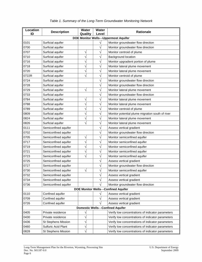
Groundwater quality will be monitored to evaluate contaminant plume movement, compare the progress of the natural flushing compliance strategy to model predictions, and verify the performance and completion of natural flushing. All samples from monitor wells in the long-term monitoring network will be analyzed for molybdenum and uranium, the indicator parameters that the GCAP identifies for the Riverton site (Attachment A). Uranium and molybdenum were selected as indicator constituents for compliance monitoring because they are the most widely distributed contaminants, form significant aqueous plumes in the uppermost aquifer near the site, exceed established groundwater standards, and are a result of former milling activities. In addition, samples will be analyzed for manganese and sulfate, which are indicators of former milling activities when detected in elevated concentrations. Field measurements of pH, specific conductance, temperature, and turbidity will be conducted at each well. The long-term groundwater monitoring network is summarized in Table 1 and shown in Figure 2. Groundwater will be sampled semiannually in June (high-flow) and November (low-flow) to assess variations in contaminant concentrations due to seasonal fluctuations. The June event will be considered the high-flow event because water levels and river flows are typically highest. The November event will be considered the low-flow event because water levels and river flows are typically low and summer-time evaporative losses from surface water have occurred. All monitor wells will be purged and sampled using low-flow methods specified in the Sampling and Analysis Plan for U.S. Department of Energy Office of Legacy Management Sites (SAP) (LMS/PLN/S04351). The SAP specifies quality assurance measures and required documentation associated with groundwater sampling. It also outlines procedures for filtering, preserving, identifying, and handling samples; conducting field measurements and calibrations; and decontaminating equipment.
Long-Term Management Plan for the Riverton, Wyoming, Processing Site U.S. Department of Energy Doc. No. S01187-0.0 September 2009 Page 6
Table 1. Summary of the Long-Term Groundwater Monitoring Network Location
ID Description Water Quality
Water Level Rationale
DOE Monitor Wells⎯Uppermost Aquifer
0101 Surficial aquifer √ Monitor groundwater flow direction
0700 Surficial aquifer √ Monitor groundwater flow direction
0707 Surficial aquifer √ √ Monitor centroid of plume
0710 Surficial aquifer √ √ Background location
0716 Surficial aquifer √ √ Monitor upgradient portion of plume
0718 Surficial aquifer √ √ Monitor lateral plume movement
0720 Surficial aquifer √ √ Monitor lateral plume movement
0722R Surficial aquifer √ √ Monitor centroid of plume
0724 Surficial aquifer √ Monitor groundwater flow direction
0728 Surficial aquifer √ Monitor groundwater flow direction 0729 Surficial aquifer √ √ Monitor lateral plume movement
0733 Surficial aquifer √ Monitor groundwater flow direction
0784 Surficial aquifer √ √ Monitor lateral plume movement
0788 Surficial aquifer √ √ Monitor lateral plume movement
0789 Surficial aquifer √ √ Monitor centroid of plume
0809 Surficial aquifer √ √ Monitor potential plume migration south of river
0824 Surficial aquifer √ √ Monitor lateral plume movement
0826 Surficial aquifer √ √ Monitor lateral plume movement
0111 Semiconfined aquifer √ Assess vertical gradient
0702 Semiconfined aquifer √ Monitor groundwater flow direction
0705 Semiconfined aquifer √ √ Monitor semiconfined aquifer
0717 Semiconfined aquifer √ √ Monitor semiconfined aquifer
0719 Semiconfined aquifer √ √ Monitor semiconfined aquifer
0721 Semiconfined aquifer √ √ Monitor semiconfined aquifer
0723 Semiconfined aquifer √ √ Monitor semiconfined aquifer
0725 Semiconfined aquifer √ Assess vertical gradient
0727 Semiconfined aquifer √ Monitor groundwater flow direction 0730 Semiconfined aquifer √ √ Monitor semiconfined aquifer
0732 Semiconfined aquifer √ Assess vertical gradient
0734 Semiconfined aquifer √ Assess vertical gradient
0736 Semiconfined aquifer √ Monitor groundwater flow direction
DOE Monitor Wells⎯Confined Aquifer
0110 Confined aquifer √ Assess vertical gradient
0709 Confined aquifer √ Assess vertical gradient
0726 Confined aquifer √ Assess vertical gradient
Domestic Wells⎯Confined Aquifer
0405 Private residence √ Verify low concentrations of indicator parameters
0430 Private residence √ Verify low concentrations of indicator parameters
0436 St Stephens Mission √ Verify low concentrations of indicator parameters
0460 Sulfuric Acid Plant √ Verify low concentrations of indicator parameters
0828 St Stephens Mission √ Verify low concentrations of indicator parameters

U.S. Department of Energy Long-Term Management Plan for the Riverton, Wyoming, Processing Site September 2009 Doc. No. S01187-0.0 Page 7
Figure 2. Long-Term Monitoring Locations

Long-Term Management Plan for the Riverton, Wyoming, Processing Site U.S. Department of Energy Doc. No. S01187-0.0 September 2009 Page 8
This page intentionally left blank
U.S. Department of Energy Long-Term Management Plan for the Riverton, Wyoming, Processing Site September 2009 Doc. No. S01187-0.0 Page 9
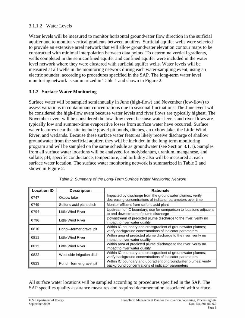
3.1.1.2 Water Levels
Water levels will be measured to monitor horizontal groundwater flow direction in the surficial aquifer and to monitor vertical gradients between aquifers. Surficial aquifer wells were selected to provide an extensive areal network that will allow groundwater elevation contour maps to be constructed with minimal interpolation between data points. To determine vertical gradients, wells completed in the semiconfined aquifer and confined aquifer were included in the water level network where they were clustered with surficial aquifer wells. Water levels will be measured at all wells in the monitoring network during each water-sampling event, using an electric sounder, according to procedures specified in the SAP. The long-term water level monitoring network is summarized in Table 1 and shown in Figure 2. 3.1.2 Surface Water Monitoring
Surface water will be sampled semiannually in June (high-flow) and November (low-flow) to assess variations in contaminant concentrations due to seasonal fluctuations. The June event will be considered the high-flow event because water levels and river flows are typically highest. The November event will be considered the low-flow event because water levels and river flows are typically low and summer-time evaporative losses from surface water have occurred. Surface water features near the site include gravel pit ponds, ditches, an oxbow lake, the Little Wind River, and wetlands. Because these surface water features likely receive discharge of shallow groundwater from the surficial aquifer, they will be included in the long-term monitoring program and will be sampled on the same schedule as groundwater (see Section 3.1.1). Samples from all surface water locations will be analyzed for molybdenum, uranium, manganese, and sulfate; pH, specific conductance, temperature, and turbidity also will be measured at each surface water location. The surface water monitoring network is summarized in Table 2 and shown in Figure 2.
Table 2. Summary of the Long-Term Surface Water Monitoring Network
Location ID Description Rationale
0747 Oxbow lake Impacted by discharge from the groundwater plumes; verify decreasing concentrations of indicator parameters over time
0749 Sulfuric acid plant ditch Monitor effluent from sulfuric acid plant
0794 Little Wind River Upstream of IC boundary; use for comparison to locations adjacent to and downstream of plume discharge
0796 Little Wind River Downstream of predicted plume discharge to the river; verify no impact to river water quality
0810 Pond⎯former gravel pit Within IC boundary and crossgradient of groundwater plumes; verify background concentrations of indicator parameters
0811 Little Wind River Within area of predicted plume discharge to the river; verify no impact to river water quality
0812 Little Wind River Within area of predicted plume discharge to the river; verify no impact to river water quality
0822 West side irrigation ditch Within IC boundary and crossgradient of groundwater plumes; verify background concentrations of indicator parameters
0823 Pond⎯former gravel pit Within IC boundary and upgradient of groundwater plumes; verify background concentrations of indicator parameters
All surface water locations will be sampled according to procedures specified in the SAP. The SAP specifies quality assurance measures and required documentation associated with surface
Long-Term Management Plan for the Riverton, Wyoming, Processing Site U.S. Department of Energy Doc. No. S01187-0.0 September 2009 Page 10
water sampling. It also outlines procedures for filtering, preserving, identifying, and handling samples; conducting field measurements and calibrations; and decontaminating equipment. Natural flushing will be considered complete, and the surface water monitoring program will be discontinued, when concentrations of molybdenum and uranium are below their respective groundwater MCLs in the oxbow lake. 3.1.3 IC Monitoring
The natural flushing compliance strategy depends on ICs to manage exposure during the flushing period. To verify that ICs are in place and working, an IC monitoring program will be conducted. A cooperative agreement with Tribal entities will be maintained as required by Title I of UMTRCA. The cooperative agreement will assure Tribal involvement in site management activities and IC monitoring. The IC monitoring will have two components: sampling, and land and water use verification. 3.1.3.1 Sampling
Domestic Wells Domestic wells within the IC boundary that are completed in the confined aquifer and are used as a potable water source will be included in DOE’s routine sampling events to verify they have not been impacted by former milling activities. All domestic well samples will be collected without filtering. Domestic wells identified for long-term sampling are 0405, 0430, 0436, 0460, and 0828 (Table 1 and Figure 2). Alternate Water Supply System NAUO is responsible for ensuring the quality, safety, and quantity of the water supply is adequate and is required to maintain compliance with EPA standards that regulate community water systems. Response to major concerns or compromises of the water supply system integrity will be discussed with NAUO or the Joint Business Council-appointed Tribal representative to further ensure exposure to former mill-related contaminants are managed. 3.1.3.2 Land and Water Use Verification
Land and water use within the IC boundary will be periodically inspected to verify and document that no additional land or water uses expose or involve shallow groundwater. Inspections will occur in conjunction with semiannual water sampling, and results will be documented in the trip report and published in the Verification Monitoring Report. Unauthorized land uses may include new wells, gravel pits, and recreational ponds. If unauthorized land use is observed, it will be documented in the trip report, and a letter will be sent to the appropriate regulatory agency (State of Wyoming or Wind River Environmental Quality Commission [WREQC]) to initiate corrective action. Additional support for land and water use verification will be provided by WREQC. Gravel ponds, the oxbow lake, and wetlands will be sampled as outlined in DOE’s long-term monitoring program (see Section 3.1.2). To date, site-related contamination has affected only the oxbow lake; therefore, the oxbow lake will be inspected routinely to verify that water from the
U.S. Department of Energy Long-Term Management Plan for the Riverton, Wyoming, Processing Site September 2009 Doc. No. S01187-0.0 Page 11
lake is not being used as a potable water source and that warning signs placed around the lake are intact. If future monitoring indicates site-related impacts to water quality in the gravel pit ponds, irrigation ditches, or wetlands, then these areas will be included in the inspection process. 3.2 Maintenance, Access, and Reports All monitor wells remaining at the Riverton site are part of the long-term monitoring program, so they must be inspected and maintained. Monitor wells will be inspected during each sampling event. The condition and integrity of the monitor wells will be documented, and maintenance will be performed as necessary. Access agreements will be maintained for monitor wells outside the boundary of the former millsite, and a perpetual easement will be in place to access monitor wells within the boundary of the former millsite. All monitor wells sampled in the long-term network will be redeveloped annually. A verification monitoring report will be produced each year. This report will include the status of the monitor wells and ICs, water quality data, water-level data, a summary of site conditions, and the progress of the natural flushing compliance strategy. This report will be distributed to the Joint Business Council of the Arapaho and Shoshone tribes, WREQC, NRC, the State of Wyoming Division of Environmental Quality, the local information repository, and the site file. A letter report to each homeowner where a domestic well was sampled will be sent after each sampling. The letter will provide the sampling results and compare them to applicable standards. 3.3 Quality Assurance and Health and Safety Quality assurance measures for implementing the long-term monitoring program include using trained and qualified personnel and following established procedures. Water-quality data will be collected in accordance with procedures specified in the SAP. The SAP specifies procedures for data validation and requirements for sample collection, quality control samples, analytical methods and reporting limits, and field instrument calibration. Health and safety considerations and controls for sampling and maintenance are addressed in the job safety analysis appended to the SAP. 3.4 Review and Revision As new data are evaluated and as conditions change, modifications to the long-term monitoring program may be required. The long-term monitoring program will be reviewed periodically, and modifications to the long-term monitoring program will be proposed to NRC and Tribal stakeholders as site conditions change or new information becomes available.
Long-Term Management Plan for the Riverton, Wyoming, Processing Site U.S. Department of Energy Doc. No. S01187-0.0 September 2009 Page 12
4.0 References
40 CFR 192. U.S. Environmental Protection Agency, “Health and Environmental Protection Standards for Uranium and Thorium Mill Tailings,” Code of Federal Regulations, July 1, 2008. Statements of Consideration for 10 CFR Part 40, 40-SC-16 (April 30, 1992). DOE (U.S. Department of Energy), 1991. Riverton Wyoming Final Completion Report, Albuquerque Operations Office, Albuquerque, New Mexico, December. DOE (U.S. Department of Energy), 1998a. Draft Ground Water Compliance Action Plan (GCAP), U.S. Department of Energy, Grand Junction Office, Grand Junction, Colorado, February. DOE (U.S. Department of Energy), 1998b. Final Site Observational Work Plan for the UMTRA Project Site at Riverton Wyoming, U0013801, Grand Junction Office, Grand Junction, Colorado, February. DOE (U.S. Department of Energy), 1998c. Environmental Assessment of Groundwater Compliance at the Riverton, Wyoming, Uranium Mill Tailings Site, DOE/EA-1261, Grand Junction Office, Grand Junction, Colorado, September. DOE (U.S. Department of Energy), 2009. Verification Monitoring Report for the Riverton, Wyoming, Processing Site, Update for 2008, LMS/RVT/S05094, U.S. Department of Energy, Office of Legacy Management, Grand Junction, Colorado, May. Sampling and Analysis Plan for U.S. Department of Energy Office of Legacy Management Sites, LMS/PLN/S04351, continually updated, prepared by S.M. Stoller Corporation for the U.S. Department of Energy Office of Legacy Management, Grand Junction, Colorado.
Attachment A
Draft Ground Water Compliance Action Plan

This page intentionally left blank
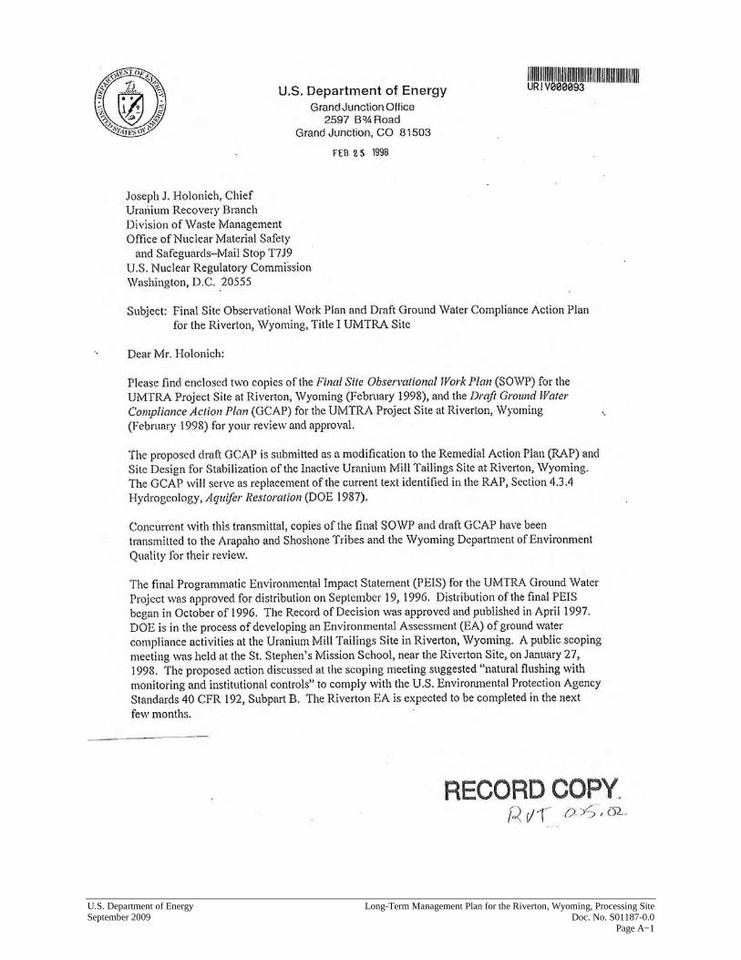
U.S. Department of Energy Long-Term Management Plan for the Riverton, Wyoming, Processing Site September 2009 Doc. No. S01187-0.0 Page A−1
Long-Term Management Plan for the Riverton, Wyoming, Processing Site U.S. Department of Energy Doc. No. S01187-0.0 September 2009 Page A−2
U.S. Department of Energy Long-Term Management Plan for the Riverton, Wyoming, Processing Site September 2009 Doc. No. S01187-0.0 Page A−3
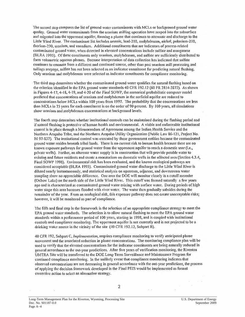
Long-Term Management Plan for the Riverton, Wyoming, Processing Site U.S. Department of Energy Doc. No. S01187-0.0 September 2009 Page A−4
U.S. Department of Energy Long-Term Management Plan for the Riverton, Wyoming, Processing Site September 2009 Doc. No. S01187-0.0 Page A−5

Long-Term Management Plan for the Riverton, Wyoming, Processing Site U.S. Department of Energy Doc. No. S01187-0.0 September 2009 Page A−6
This page intentionally left blank
Attachment B
NRC Letter of Concurrence

This page intentionally left blank
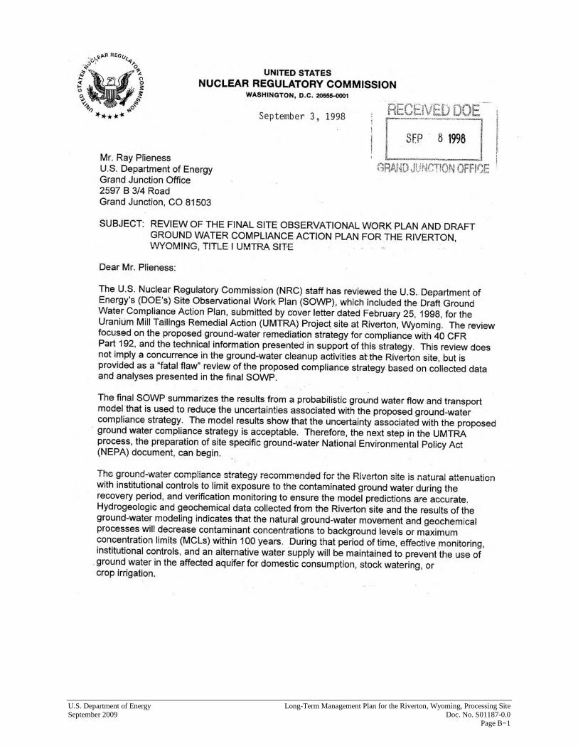
U.S. Department of Energy Long-Term Management Plan for the Riverton, Wyoming, Processing Site September 2009 Doc. No. S01187-0.0 Page B−1
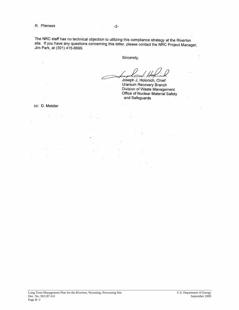
Long-Term Management Plan for the Riverton, Wyoming, Processing Site U.S. Department of Energy Doc. No. S01187-0.0 September 2009 Page B−2
Attachment C
State of Wyoming Institutional Control Letters

This page intentionally left blank
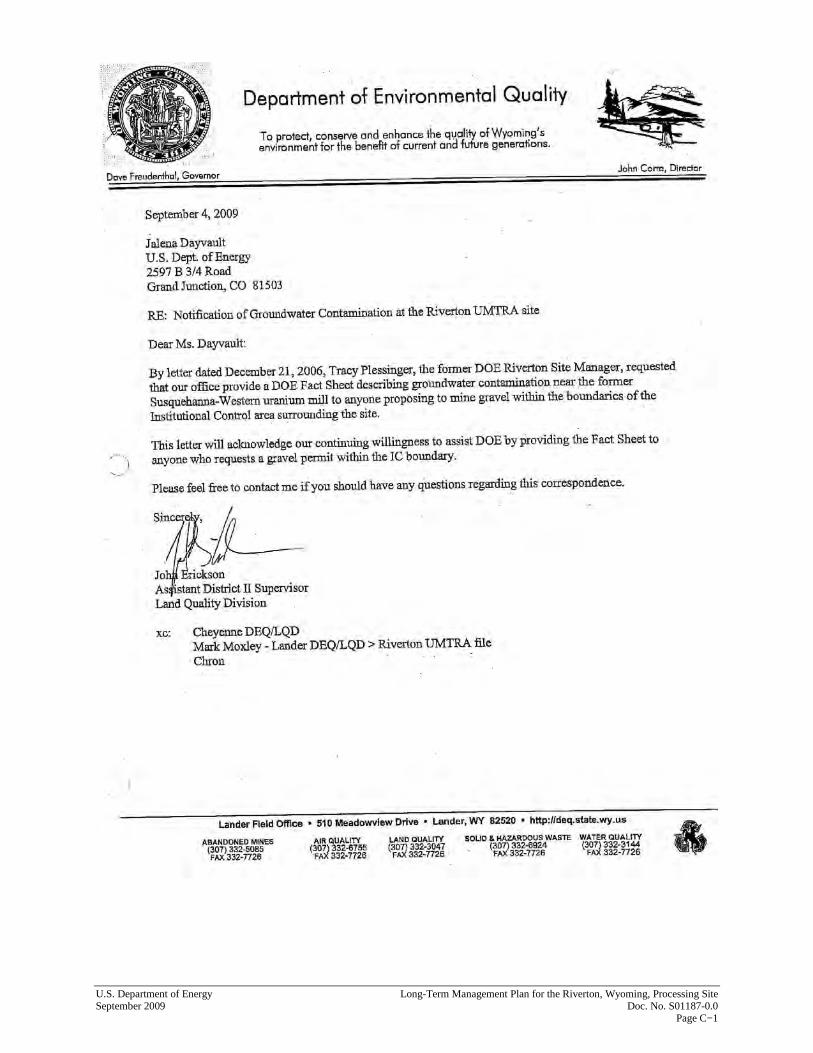
U.S. Department of Energy Long-Term Management Plan for the Riverton, Wyoming, Processing Site September 2009 Doc. No. S01187-0.0 Page C−1
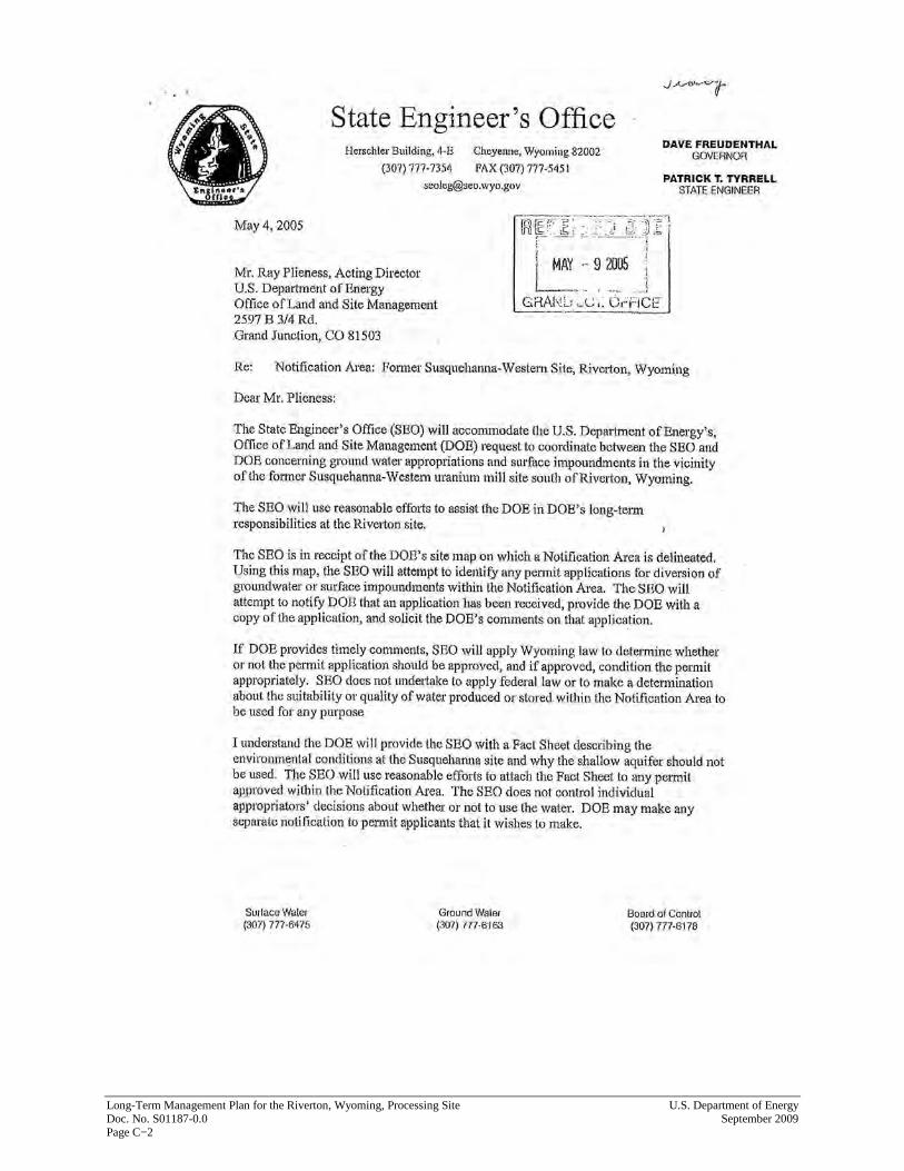
Long-Term Management Plan for the Riverton, Wyoming, Processing Site U.S. Department of Energy Doc. No. S01187-0.0 September 2009 Page C−2

U.S. Department of Energy Long-Term Management Plan for the Riverton, Wyoming, Processing Site September 2009 Doc. No. S01187-0.0 Page C−3
Long-Term Management Plan for the Riverton, Wyoming, Processing Site U.S. Department of Energy Doc. No. S01187-0.0 September 2009 Page C−4