Botanical survey in thirteen montane forests of Bawean Island ...

Vol. 16 No. 3 The Quarterly Newsletter Summer 2006
Long Island Botanical Society
Ecological Communities of Long Island, New York: Part 1 Gregory J. Edinger
INTRODUCTION In recognition of the Long Island Botanical Soci-ety’s 20th Anniversary it was thought that an article pre-senting a brief history and the current status of ecologi-cal community classification on Long Island would nicely complement recent articles in the LIBS Newslet-ter that focused on botany and rare plant discoveries (for example, Zaremba 2006). Compared to traditional species taxonomy, ecol-ogy and the classification of natural communities are relatively new to the realm of natural sciences. Natural communities have been described from Long Island for nearly as long as plant species. The earliest reports of natural communities on Long Island can be traced back to the European settlement and exploration of New York (Denton 1670). The eventual distribution of inter-acting plants and animals on Long Island can be traced even further back in its geologic history driven by the glacial advance and retreat. Long Island’s geologic his-tory, its proximity to the ocean, and its position within the temperate climate have combined to support the vegetation we observe today. Throw in a few hurri-canes, wild fires, floods, and human activity, and these dynamic forces result in the plant associations observed through time. Natural community classifications have proven to be important conservation tools throughout the world because (1) communities provide important eco-system functions that are worth conserving (e.g., groundwater recharge, flood water retention, provide wildlife habitat, etc.); (2) they serve as coarse filters to protect common and rare species (i.e., many species may be protected by protecting the natural communities in which they live); and (3) they can be used as surro-gates in areas where little is known about ecological processes and species distribution (Grossman et al. 1998). The conservation of high quality examples of the natural communities on Long Island assures the protection of most of the species that make up the bio-logical diversity of this part of the state.
HISTORICAL BACKGROUND Early accounts of the vegetation of Long Island can be found intermixed with the other more frequent topics of botany and natural history of the region. One of the earliest descriptions of natural communities on Long Island was written by Winslow C. Watson (1860) whose opening sentence reads: “The subject of the waste lands of Long Island has, for several years, en-gaged my earnest attention.” The balance of his article offers evidence that attempts to convince readers that “The Hempstead Plain” and “The Bush Plain” contain soils and climate suitable for successful agriculture. He was trying to dispel the widely held belief that the soils of Long Island were unproductive. Watson provides a good word picture of what present day ecologists would call Hempstead Plains grassland and pitch pine-scrub oak barrens (Reschke 1990, Edinger et al. 2002). He also provides the earliest assessment of the size of these natural areas: The Hempstead Plain—64 square miles (Denton 1670) reduced to 12,000 acres in 1860; The
(Continued on page 23)
Photo by Steve Young Coastal plain pond at Linus Pond.
Long Island Botanical Society
Founded: 1986 Incorporated: 1989
The Long Island Botanical Society is dedicated to the promotion of field botany and a greater understanding of the plants that grow wild on Long Is-land, New York.
Visit the Society’s Web site www.libotanical.org
Executive Board President Eric Lamont Vice President Skip Blanchard Treasurer Carol Johnston Recording Secretary Barbara Conolly Corresponding Secretary John Potente
Committee Chairpersons Local Flora Steven Clemants Field Trips Skip Blanchard Programs Rich Kelly Membership Lois Lindberg Conservation Andrew Greller Education Mary Laura Lamont Hospitality Jane Blanchard Zu Proly Dorothy Titus Newsletter Editor Margaret Conover Newsletter Layout & Design William Krol Webmaster Donald House [email protected]
Society News
Page 22 Long Island Botanical Society Vol. 16 No. 3
To celebrate LIBS’s 20th Anniversary, 18 LIBS members are enjoying a botani-cal field trip to Newfoundland (July 5-15). We look forward to a report of their adventure in the next issue of the LIBS Newsletter.
Andy Greller will represent LIBS in the Nassau Citizens for Clean Water and Open Space, a group that also includes The Nature Conservancy, the North Shore Land Alliance, and the Pine Barrens Society.
Rich Kelly wrote the lead article for the recent edition of the SOFO Naturalist: “Tipularia discolor and Other Things I Can’t Find on the South Fork.”
Karen Blumer is working on a handbook for site restorations and would like to know of other people who are restoring places with native plants.
Elsa l’Hommedieu wrote from California that she is just now going out in her camper to explore the American River Valley, the Feather River, and Yuba River where she expects to see “some good stuff.” She sent greetings to the membership. Elsa is 85 and travels alone in her camper to anywhere the flowers are!
Graduate student Kelly O’Donnell is looking for a local botanist to help her identify Amaranthus and Chenopodium in the field for a few days as she begins her summer project.
Marilyn Jordan asks that new finds of invasive species be reported to her at [email protected].
John Potente will present a talk on carnivorous plants of Long Island on September 13 at 7 p.m. at the Islip Public Library as part of the Seatuck Environmental Association’s Celebrating Nature lecture series. Call Seatuck at 631-581-6908 for more information.
A message from Tom Rawinski, USFS: European gray willow (Salix cinerea) is everywhere! Well, maybe not every-where, but it’s probably in every county in New England and New York. I know it is extant in 19 New England counties and three New York counties. This horse is already out of the barn! European gray willow has been a remarkably successful stealth invader (because few of us botanists wanted to, or could, key it out). Most notably, it is the prevalent willow sharing coastal plain pond shore habitats with state and globally rare plant species. Anyone managing wetlands should learn to identify the plant. In a nutshell, here’s how: The branchlets and leaf undersides are persistently whitish puberulent (covered with fine hairs). Peel back the bark on a quarter-inch or larger diameter branch and the decorticated wood will show a number of elevated narrow ridges. For many good images of the plant go to Google Im-ages. Incidentally, most of the occurrences occupy disturbed sites, such as moist road edges, reservoir shores, excavation bottoms, wet pastures, etc. It grows on upland as well as wetland sites. Please check your special habitats for this spe-cies and control it where necessary. And let us all know what you find. Thanks. Tom can be reached at [email protected] or 603-868-7642.
Long Island Botanical Society Vol. 16 No. 3 Page 23
(Continued from page 21) Bush Plain or “Long Island barrens”—about 258 to 344 square miles, but the vegetation descriptions are want-ing and use ambiguous common names (e.g., “low shrubby bushes” and “secretary grass”). Almost 40 years later Smith Ely Jelliffe published The Flora of Long Island (Jelliffe 1899) and the introduc-tion includes a section on Pine Barren Flora with a list of “the most important of these pine barren plants” us-ing scientific names. This is similar to the format cur-rently used by NY Natural Heritage in writing commu-nity classification descriptions (Reschke 1990, Edinger et al. 2002). He also provides a short description of the vegetation of the northern part of Long Island. During the early 1900s a prolific writer and botanist by the name of Roland M. Harper published several articles that documented the structure and com-position of several Long Island natural communities, such as Atlantic white cedar swamp (Harper 1907), pine barrens (Harper 1908a, 1908b), Hempstead Plains grass-land (Harper 1911, 1912, 1915, 1918), and the natural vegetation of western Long Island south of the terminal moraine (Harper 1917). A footnote in the last article provides an interesting explanation of the difference between “flora” and “vegetation.” An abridged excerpt follows:
The relation between flora and vegetation is much like that between…dictionaries and literature. Dictionaries are useful and well-nigh indispensable, but one does not need to know every word in the dictionary
before producing any literature, and if all writers made revising the dictionary their chief aim we would not have much litera-ture. Likewise one does not have to know all the plants of a region before describing its vegetation, and if all botanists were tax-onomists primarily it would be difficult to get any information about the aspect of the vegetation in a region one had not visited. (Harper 1917).
This philosophy led to the first ecological study that attempted to apply methods of “Plant Sociology” to the description of the vegetation of Long Island ti-tled, “The plant associations of central Long Island” by Henry S. Conard (1935). Conard presents detailed infor-mation on the geography, geology, climate, soils, and human activity that influence the observed vegetation patterns throughout central Long Island. Conard adopted the “plant association” as the fundamental unit of vegetation. The association is defined by its charac-teristic combination of species (i.e., a list of species and their role, function, and position in the community). Most interestingly, when it came to naming associations, Conard followed the custom of attaching the termina-tion-etum to the root word of an important genus of the association. This noun is followed by the specific name in the proper case, or by an adjective or another impor-tant genus in the association. For example, black oak dominated forests become the Quercetum velutinae asso-
(Continued on page 24)
Associations: 1. a group of plants of one or more species living together under uniform environ-mental conditions and having a uni-form and distinctive aspect. 2. the finest level of the hierarchy used in the National Vegetation Classifica-tion System (Grossman et al. 1998) and the basic unit for vegetation clas-sification in North America. It is de-fined as a plant community type of definite floristic composition, uni-form habitat conditions, and uniform physiognomy. Community: an assemblage of plants and animals interacting with one another, occupying a habitat, and often modifying the habitat; a vari-able assemblage of plant and animal populations sharing a common envi-
ronment and occurring repeatedly in the landscape (Reschke 1990, Ed-inger et al. 2002). Ecological Systems: recur-ring groups of biological communi-ties that are found in similar physical environments and are influenced by similar dynamic ecological processes, such as fire or flooding. They are in-tended to provide a classification unit that is readily mappable, often from remote imagery, and readily identifi-able by conservation and resource managers in the field, such as North-ern Atlantic Coastal Plain Pitch Pine Barrens (NatureServe). http://www.n a t u r e s e r v e . o r g / g e t D a t a /USecologyData.jsp Ecology: the study of the in-terrelationships between living or-
ganisms and their environment. Ecosystem: an ecological community of various plants, ani-mals, and other organisms, interact-ing with each other and with the nonliving resources in their environ-ment, all functioning as a unit. This term is sometimes used interchangea-bly with community, but generally the concept of ecosystem is larger in scale than that of community (e.g., pine barrens ecosystem versus dwarf pine barrens community). Habitat: a place or type of place where an organism, population, or community lives. For example, plant field guides often provide the common habitat for each species, such as “dry sandy woods” or “moist meadows.”
Some Terms and Concepts Used in This Study

Page 24 Long Island Botanical Society Vol. 16 No. 3
(Continued from page 23) ciation, Hempstead Plains grasslands become the Andro-pogonetum Hempsteadi association, and red maple swamps become either the Aceretum rubri association or the Acere-tum Osmundaceum association depending on the setting. For better or worse, this system of naming associations using binomial nomenclature was not widely accepted. Although it is interesting to note that Conard’s system was followed by at least one loyal practitioner (Cain 1937, Cain and Penfound 1938). A concise account of the history of describing and documenting vegetation types on Long Island can be found in Irwin M. Brodo’s book The Lichens of Long Island, New York: A Vegetational and Floristic Analysis (Brodo 1968). In addition to Conard’s 1935 work, Brodo notes others who have contributed to our un-derstanding of Long Island’s vegetation, such as the north shore oak forests (Harper 1917, Cain 1936), pine barrens (Watson 1860, Britton 1880, Harper 1908a, 1908b, Clute 1897), maritime heathlands or “downs” (Taylor 1923), sand dunes (Brodo 1961), cedar swamps (Bicknell 1908, Harper 1907, Taylor 1916), red maple swamps (Cain and Penfound 1938), and the Hempstead Plains (Hicks 1892, Bryson 1897, Kirby 1905, Harper 1911, 1912, 1915, 1918, Ferguson 1925, Cain et al. 1937). In addition to the types noted by Brodo (1968) there are numerous site-specific floras that were mined for vegetation descriptions, such as “The June flora of a Long Island swamp” by Anna Murray Vail (1895), and various salt marsh studies (Conard 1924, Taylor 1938, 1939, Johnson and York 1912, 1915). The publishing of site-specific floras and vegetation studies continues up until today. Over the years, NY Natural Heritage has greatly benefited from these studies and the steady flow of new information on Long Island’s natural communities from dedicated re-searchers. Limited space prevents the inclusion of an exhaustive list here, but some notable contributors to the Long Island portion the state community classifica-tion include Henry Art, Eric E. Lamont, Robert E. Za-remba, Ralph Good, Norma Good, Andrew M. Greller, Marilyn J. Jordan, Linda S. Olsvig, and Richard Stalter (Good and Good 1970, Art 1976, Greller 1977, 2001, Greller et al. 1978, Olsvig et al. 1979, Greller et al. 1982, Stalter et al. 1986, Stalter and Lamont 1987, 2002, La-mont and Stalter 1991, Zaremba and Lamont 1993, Jor-dan et al. 2003). Andrew M. Greller published a classification that described twelve mature forest types based on an exten-sive literature review and field surveys (Greller 1977, 2001). Andy provided detailed descriptions with charac-teristic species and a dichotomous key to the types, which included forested uplands and wetlands. Later this article was frequently cited by NY Natural Heritage
ecologist David M. Hunt in the process of describing the various “coastal oak-” (e.g., coastal oak-heath forest, coastal oak-hickory forest, etc.) and “maritime” forests, as well as the forested swamps (Edinger et al. 2002). In 1979, a milestone in wetland classification was published by the U.S. Fish and Wildlife Service: The Classification of Wetlands and Deepwater Habitats of the United States (Cowardin et al. 1979). This book presents the Sys-tem and Subsystem hierarchy adopted by the NY Natu-ral Heritage Program (Reschke 1990) and still in use to-day (Edinger et al. 2002). Cowardin et al. (1979) defined the following Systems: Marine, Estuarine, Riverine, Lacustrine, Palustrine. A list of these Systems along with the Terrestrial System and the Subsystems (modified by NY Natural Heritage) is published begin-ning on page 27. This brings us to the founding of the NY Natural Heritage Program in 1985 and its first ecologist, Carol Reschke. The mission of NY Natural Heritage is to en-able and enhance conservation of rare animals, rare plants, and significant natural communities. The bota-nist and zoologist had a bit of a head start in fulfilling this mission, with published taxonomic keys and species descriptions in hand; however, the ecologist lacked an equivalent statewide community classification to help decide what to inventory. The first edition of Ecological Communities of New York State (Reshke 1990) was pub-lished in 1990 and quickly became the primary source for community classification in the state. Its success and acceptance by a wide range of users was driven by its lofty goal to be an all-inclusive classification intending to fulfill a long-standing need. Ecological Communities of New York State remains the only classification in the northeast that includes a comprehensive treatment of cultural communities along with the natural types. This allows users of this classification to describe and map nearly any ecological community encountered in the state. It is impressive to see how much of the first edi-tion has remained unchanged in the later versions (Edinger et al. 2002). This attests to the fact that Ecologi-cal Communities of New York State was thoroughly re-searched and ahead of its time. The NY Natural Heri-tage Program was very fortunate to have had a pub-lished classification to build upon. Gregory J. Edinger is the program ecologist for the New York Natural Heritage Program. EDITORS NOTE: Part 2 of this article, to be published in October 2006, will cover the mapping of Long Island Natural Communities, and the current state of Commu-nity Classification on Long Island.
(Continued on page 25)
Long Island Botanical Society Vol. 16 No. 3 Page 25
(Continued from page 24)
REFERENCES Art, Henry (1976) Ecological studies of the Sunken For-est, Fire Island National Seashore, NY. US Natl Park Serv. Sci Monogr Ser, No. 7.
Bicknell, Eugene P. 1908. The white cedar swamp in western Long Island. Torreya 8:27-28.
Britton, N.L. 1880. On the northward extension of the New Jersey pine barrens flora on Long and Staten Is-lands. Bulletin of the Torrey Botanical Club 7:81-83.
Brodo, Irwin M. 1961. A study of lichen ecology in cen-tral Long Island, New York. Amer. Midland Natur. 65:290-310.
Brodo, Irwin M. 1968. The lichens of Long Island, New York: a vegetational and floristic analysis. Bulletin Num-ber 410. New York State Museum and Science Service. Albany, NY.
Bryson, John. 1897. The Hempstead Plains. American Geol. 20:61-65.
Cain, Stanley A. 1936. The composition and structure of an oak woods, Cold Spring Harbor, Long Island, with special attention to sampling methods. Amer. Midland Natur. 17:725-740.
Cain, Stanley A., M. Nelson and W. McLean 1937. An-dopogonetum hempsteadi: a Long Island grassland vegeta-tion type. Amer. Midland Nat. 18:334-350.
Cain, Stanley A. and William T. Penfound. 1938. Acere-tum rubri: the red maple swamp forest of central Long Island. Amer. Midland Nat. 19:390-416.
Clute, Willard N. 1897. Some sand-barren plants (of the Shinnecock hills). Plant World 1:11-12.
Conard, Henry S. 1924. Second survey of the vegetation of a Long Island salt marsh. Ecology 5:379-388.
Conard, Henry S. 1935. The plant associations of cen-tral Long Island. Amer. Midland Nat. 16:433-516.
Cowardin, L. M., V. Carter, F. C. Golet, and E. T. La-Roe. 1979. Classification of wetlands and deepwater habitats of the United States. Office of Biological Ser-vices, Fish and Wildlife Service, U.S. Dept. of Interior, Washington, D.C.
Denton, Daniel. 1670. A brief description of New-York: formerly called New-Netherlands. Printed for John Hancock, at the first Shop in Popes-Head-Alley in Cornhil at the three Bibles, and William Bradley at the three Bibles in the Minories, London, England.
Edinger, Gregory J., D.J. Evans, S. Gebauer, T.G. How-ard, D.M. Hunt, and A.M. Olivero (editors). 2002. Eco-logical Communities of New York State. Second Edi-tion. A revised and expanded edition of Carol Reschke’s Ecological Communities of New York State. (Draft for re-view). New York Natural Heritage Program, New York State Department of Environmental Conservation, Al-bany, NY.
Ferguson, William C. 1925. Ferns and flowering plants of the Hempstead Plains, Long Island, New York. Tor-reya 25:109-113.
Good, Ralph E., and Norma F. Good. 1970. Vegetation of the sea cliffs and adjacent uplands on the north shore of Long Island, New York. Bulletin of the Torrey Bo-tanical Club 97:204-208.
Greller, Andrew M. 1977. A classification of mature for-ests on Long Island, New York. Bulletin of the Torrey Botanical Club 104(4):376-382.
Greller, Andrew M. 2001. Outline of a revised classifica-tion for mature forests and related woody vegetation on Long Island, NY. Long Island Botanical Society News-letter 11:16-17, 33-34; 12:10.
Greller, Andrew M., James M. Mansky, and Robert E. Calhoon. 1982. An oak, hickory-dogwood forest on central Long Island, New York. Bulletin of the Torrey Botanical Club 109(2):219-225.
Greller, Andrew M., Robert E. Calhoon, and James M. Mansky. 1978. Grace Forest, a mixed mesophytic stand on Long Island, New York. Bot. Gaz. 139(4):482-489.
Grossman D.H., D. Faber-Langendoen, A.S. Weakley, M. Anderson, P. Bourgeron, R. Crawford, K. Goodin, S. Landaal, K. Metzler, K.D. Patterson, M. Pyne, M. Reid, and L. Sneddon. 1998. International classification
(Continued on page 26)
Internet Sources for Natural Community and Vegetation Classification Information
New York Natural Heritage Program http://nynhp.org
Ecological Communities of New York State (Edinger et al. 2002, Reschke 1990)
http://www.dec.state.ny.us/website/dfwmr/heritage/ecology.htm
NatureServe http://www.natureserve.org/
International Vegetation Classification System http://www.natureserve.org/explorer/
Page 26 Long Island Botanical Society Vol. 16 No. 3
(Continued from page 25) of ecological communities: terrestrial vegetation of the United States. Volume I, The National Vegetation Clas-sification System: development, status, and applications. The Nature Conservancy: Arlington, VA.
Harper, Roland M. 1907. A Long Island cedar swamp. Torreya 7:198-201.
Harper, Roland M. 1908a. Notes on the pine-barrens of Long Island (Abstract of a paper read before the Torrey Botanical Club December 10, 1907). Torreya 8:33-34.
Harper, Roland M. 1908b. The pine barrens of Babylon and Islip. Torreya 8:1-8.
Harper, Roland M. 1911. The Hempstead Plains. A natural prairie on Long Island. Bul. Amer. Geogr. Soc. 43:351-360.
Harper, Roland M. 1912. The Hempstead plains of Long Island. Torreya 12:277.
Harper, Roland M. 1915. Hempstead Plains. New Inter. Encyc. 2nd ed. 11:133.
Harper, Roland M. 1917. The natural vegetation of western Long Island, south of the terminal moraine. Torreya 17:1-13.
Harper, Roland M. 1918. The vegetation of the Hemp-stead Plains. Mem. Torrey Bot. Club 17:262-286.
Hicks, Henry. 1892. The vegetation of Hempstead Plains. Unpublished manuscript at Cornell University and at the Brooklyn Botanic Garden.
Jelliffe, Smith Ely. 1899. The flora of Long Island. The New Era Printing Company, Lancaster, PA.
Johnson, Duncan S. and H. H. York. 1912. The relation of plants to tide levels. A study of the distribution of marine plants at Cold Spring Harbor. John Hopkins Univ. Circ. 1912:116 (February).
Johnson, Duncan S. and H. H. York. 1915. The relation of plants to tide levels. Carnegie Inst. Pub. 206:113-121.
Jordan, Marilyn J., W.A. Patterson III, and A.W. Win-disch. 2003. Conceptual ecological models for the Long Island pitch pine barrens: implications for managing rare plant communities. Forest Ecology and Manage-ment 185:151-168.
Kirby, James. 1905. Some plants of the Hempstead plains. Amer. Bot. 7:110.
Lamont, Eric E. and Richard Stalter. 1991. The vascular flora of Orient Beach State Park, Long Island, New York. Bulletin of the Torrey Botanical Club 118(4):459-468.
Olsvig, L. S., J. F. Cryan, and R. H. Whittaker. 1979. Vegetational gradients of the pine plains and barrens of Long Island, New York. pp. 265-282, in: Forman, R. T. Pine Barrens: Ecosystem and Landscape. Academic Press, New York. 601 pp.
Reschke, Carol. 1990. Ecological Communities of New York State. New York State Department of Environ-mental Conservation, New York Natural Heritage Pro-gram. Latham, NY.
Stalter, Richard and Eric E. Lamont. 1987. Vegetation of Hempstead Plains, Mitchell Field, Long Island, New York. Bulletin of the Torrey Botanical Club 114(3):330-335.
Stalter, Richard., Eric E. Lamont, and James Northup. 1986. Vegetation of Fire Island, New York. Bulletin of the Torrey Botanical Club 113(3):298-306.
Stalter, Richard and Eric E. Lamont. 2002. Vascular flora of Jamaica Bay Wildlife Refuge, Long Island, New York. Journal of the Torrey Botanical Society 129(4):346-358.
Taylor, Norman. 1916. A white cedar swamp at Merrick, Long Island, and its significance. Mem. N.Y. Bot. Gard. 6:79-88.
Taylor, Norman. 1923. The vegetation of Long Island. Brooklyn Bot. Gard. Mem. 2:1-107.
Taylor, Norman. 1938. A preliminary report on the salt marsh vegetation of Long Island. N.Y. State Mus. Bul. 316:21-84.
Taylor, Norman. 1939. Salt tolerance of Long Island salt marsh plants. New York State Museum Circ. 23:1-42 Figs. 1-19 (November).
Thompson, John E. 1997. Ecological communities of the Montauk Peninsula, Suffolk, County, New York. The Nature Conservancy, Long Island Chapter, Cold Spring Harbor, NY.
Vail, Anna Murray. 1895. The June flora of a Long Is-land swamp. Gard. For. 8:282-283.
Watson, Winslow C. 1860. The plains of Long Island. C. Van Benthuysen, Albany, NY.
Zaremba, Robert E. 2006. Continuing botanical tradi-tions on Long Island: 1984-1985. Long Island Botanical Society Newsletter 16(2):16-19.
Zaremba, Robert E. and Eric E. Lamont. 1993. The status of the Coastal Plain pondshore community in New York. Bulletin of the Torrey Botanical Club 120(2):180-187.

Long Island Botanical Society Vol. 16 No. 3 Page 27
The following list is a subset of the com-munities described by NY Natural Heri-tage (Edinger et al. 2002) that are known or suspected to occur on Long Island. Cultural communities are included, but are not tracked by NY Natural Heritage. About 87 (50%) of the 174 natural com-munities described by NY Natural Heri-tage occur on Long Island. Out of the 1,709 natural community element occur-rences currently documented by NY Natural Heritage, 247 (14%) are on Long Island. # = number of Long Island occurrences
in NY Natural Heritage Biotics data-base as of June 1, 2006.
0 = definitely occurs on Long Island, but there are no occurrences in the NY Natural Heritage Biotics database as of June 1, 2006.
? = uncertain if this community occurs on Long Island.
I. MARINE SYSTEM A. MARINE SUBTIDAL 1. Marine deepwater community – 0 2. Marine eelgrass meadow – 1 B. MARINE INTERTIDAL 1. Marine intertidal mudflats – 0 2. Marine intertidal gravel/sand beach – 0 3. Marine rocky intertidal – 4 C. MARINE CULTURAL 1. Marine submerged artificial structure/
reef 2. Marine dredge spoil shore 3. Marine riprap/artificial shore II. ESTUARINE SYSTEM A. ESTUARINE SUBTIDAL 1. Tidal river – 0 2. Saltwater tidal creek – 4 3. Freshwater tidal creek – 0 4. Brackish subtidal aquatic bed – 0 5. Freshwater subtidal aquatic bed – 0 B. ESTUARINE INTERTIDAL 1. Brackish meadow – 2 2. Salt shrub – 2 3. High salt marsh – 9 4. Salt panne – 4 5. Low salt marsh – 7 6. Coastal salt pond – 7 7. Brackish interdunal swales – 3 8. Brackish tidal marsh – 2 9. Brackish intertidal mudflats – 0 10. Brackish intertidal shore – 1 11. Freshwater tidal swamp – ? 12. Freshwater tidal marsh – 1 13. Freshwater intertidal mudflats – 0
C. ESTUARINE CULTURAL 1. Estuarine submerged structure 2. Estuarine water chestnut bed 3. Estuarine channel/artificial impound-
ment 4. Estuarine ditch 5. Estuarine impoundment marsh 6. Estuarine reedgrass marsh 7. Estuarine dredge spoil shore 8. Estuarine riprap/artificial shore
III. RIVERINE SYSTEM A. NATURAL STREAMS 1. Marsh headwater stream – 0 2. Confined river – ? 3. Intermittent stream – 0 4. Coastal plain stream – 0 5. Spring – 0 B. RIVERINE CULTURAL 1. Riverine submerged structure 2. Riverine water chestnut bed 2. Acidified stream 3. Canal 4. Ditch/artificial intermittent stream 5. Industrial effluent stream
IV. LACUSTRINE SYSTEM A. NATURAL LAKES AND PONDS 1. Oligotrophic dimictic lake – 0 2. Coastal plain pond – 4 3. Oligotrophic pond – ? 4. Eutrophic pond – 0 B. LACUSTRINE CULTURAL 1. Lacustrine submerged structure 2. Lacustrine water chestnut bed 3. Acidified lake 4. Cultural eutrophic lake 5. Farm pond/artificial pond 6. Reservoir/artificial impoundment 7. Quarry pond 8. Artificial pool 9. Industrial cooling pond 10. Sewage treatment pond
V. PALUSTRINE SYSTEM A. OPEN MINERAL SOIL WETLANDS 1. Deep emergent marsh – 0 2. Shallow emergent marsh – 0 3. Shrub swamp – 0 4. Inland noncalcareous lake shore – ? 5. Coastal plain pond shore – 60 6. Maritime freshwater interdunal swales – 5 7. Pine barrens vernal pond – 0 8. Pine barrens shrub swamp – 4 B. OPEN PEATLANDS 1. Sedge meadow – 0 2. Coastal plain poor fen – 6 3. Sea level fen – 6 4. Highbush blueberry bog thicket – 4
C. FORESTED MINERAL SOIL WETLANDS 1. Floodplain forest – ? 2. Red maple-hardwood swamp – 1 3. Red maple-black gum swamp – 8 4. Red maple-sweetgum swamp – 1 5. Vernal pool – 0 6. Hemlock-hardwood swamp – ? D. FORESTED PEATLANDS 1. Coastal plain Atlantic white cedar
swamp – 4 E. PALUSTRINE CULTURAL 1. Reverted drained muckland 2. Impounded marsh 3. Impounded swamp 4. Reedgrass marsh 5. Purple loosestrife marsh 6. Dredge spoil wetland 7. Mine spoil wetland 8. Water recharge basin
VI. TERRESTRIAL SYSTEM A. OPEN UPLANDS 1. Sand beach – 0 2. Maritime beach – 7 3. Maritime dunes – 8 4. Maritime shrubland – 5 5. Maritime heathland – 3 6. Maritime grassland – 8 7. Hempstead Plains grassland – 1 8. Riverside sand/gravel bar – ? 9. Maritime bluff – 1 10. Successional fern meadow – ? 11. Successional blueberry heath – ? 12. Successional northern sandplain grass-
land – 0 13. Successional old field – 0 14. Successional shrubland – 0 B. BARRENS AND WOODLANDS 1. Dwarf pine plains – 1 2. Maritime pitch pine dune woodland – 4 3. Pitch pine-scrub oak barrens – 3 4. Pitch pine-oak-heath woodland – 9 5. Successional red cedar woodland – 0 C. FORESTED UPLANDS 1. Maritime post oak forest – 4 2. Maritime beech forest – 3 3. Maritime holly forest – 1 4. Maritime red cedar forest – 2 5. Coastal oak-heath forest – 6 6. Coastal oak-hickory forest – 7 7. Coastal oak-beech forest – 5 8. Coastal oak-laurel forest – 2 9. Coastal oak-holly forest – 1 10. Pitch pine-oak forest – 12 11. Appalachian oak-hickory forest – 0 12. Oak-tulip tree forest – 2 13. Appalachian oak-pine forest – 0
(Continued on page 28)
An Annotated List of the Ecological Communities of Long Island, New York
Page 28 Long Island Botanical Society Vol. 16 No. 3
(Continued from page 27) 14. Hemlock-northern hardwood forest – 0 15. Successional northern hardwoods – 0 16. Successional southern hardwoods – 0 17. Successional maritime forest – 2 D. TERRESTRIAL CULTURAL 1. Cropland/row crops 2. Cropland/field crops 3. Pastureland 4. Flower/herb garden 5. Orchard 6. Vineyard 7. Hardwood plantation 8. Pine plantation 9. Spruce/fir plantation 10. Conifer plantation
11. Mowed lawn with trees 12. Mowed lawn 13. Mowed roadside/pathway 14. Herbicide-sprayed roadside/pathway 15. Unpaved road/path 16. Railroad 17. Paved road/path 18. Roadcut cliff/slope 19. Riprap/erosion control roadside 20. Rock quarry 21. Gravel mine 22. Sand mine 23. Brushy cleared land 24. Artificial beach 25. Riprap/artificial lake shore 26. Dredge spoil lake shore 27. Construction/road maintenance spoils
28. Dredge spoils 29. Mine spoils 30. Landfill/dump 31. Junkyard 32. Urban vacant lot 33. Urban structure exterior 34. Rural structure exterior 35. Interior of barn/agricultural building 36. Interior of nonagricultural building
VII. SUBTERRANEAN SYSTEM A. NATURAL CAVES B. SUBTERRANEAN CULTURAL 1. Mine/artificial cave community 2. Sewer 3. Tunnel 4. Basement/building foundation
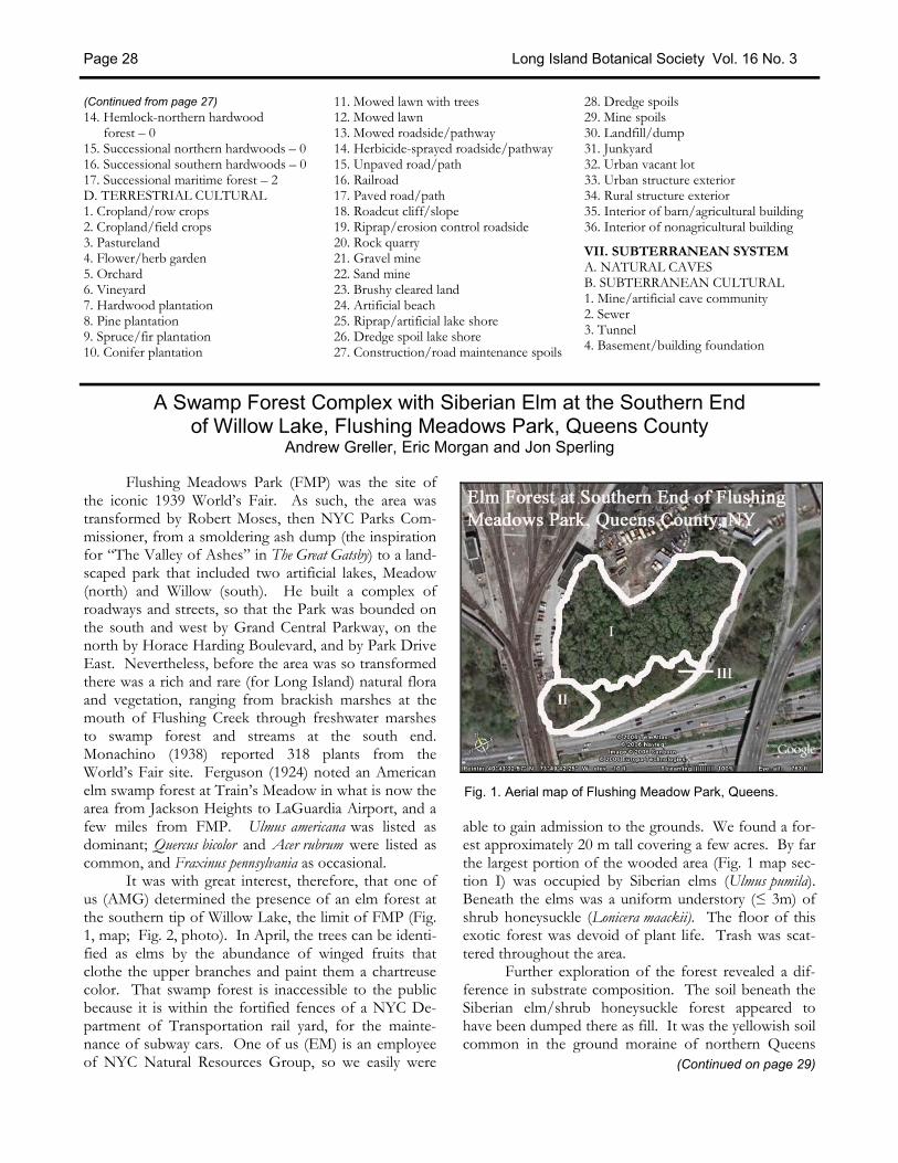
Flushing Meadows Park (FMP) was the site of the iconic 1939 World’s Fair. As such, the area was transformed by Robert Moses, then NYC Parks Com-missioner, from a smoldering ash dump (the inspiration for “The Valley of Ashes” in The Great Gatsby) to a land-scaped park that included two artificial lakes, Meadow (north) and Willow (south). He built a complex of roadways and streets, so that the Park was bounded on the south and west by Grand Central Parkway, on the north by Horace Harding Boulevard, and by Park Drive East. Nevertheless, before the area was so transformed there was a rich and rare (for Long Island) natural flora and vegetation, ranging from brackish marshes at the mouth of Flushing Creek through freshwater marshes to swamp forest and streams at the south end. Monachino (1938) reported 318 plants from the World’s Fair site. Ferguson (1924) noted an American elm swamp forest at Train’s Meadow in what is now the area from Jackson Heights to LaGuardia Airport, and a few miles from FMP. Ulmus americana was listed as dominant; Quercus bicolor and Acer rubrum were listed as common, and Fraxinus pennsylvania as occasional. It was with great interest, therefore, that one of us (AMG) determined the presence of an elm forest at the southern tip of Willow Lake, the limit of FMP (Fig. 1, map; Fig. 2, photo). In April, the trees can be identi-fied as elms by the abundance of winged fruits that clothe the upper branches and paint them a chartreuse color. That swamp forest is inaccessible to the public because it is within the fortified fences of a NYC De-partment of Transportation rail yard, for the mainte-nance of subway cars. One of us (EM) is an employee of NYC Natural Resources Group, so we easily were
able to gain admission to the grounds. We found a for-est approximately 20 m tall covering a few acres. By far the largest portion of the wooded area (Fig. 1 map sec-tion I) was occupied by Siberian elms (Ulmus pumila). Beneath the elms was a uniform understory (≤ 3m) of shrub honeysuckle (Lonicera maackii). The floor of this exotic forest was devoid of plant life. Trash was scat-tered throughout the area. Further exploration of the forest revealed a dif-ference in substrate composition. The soil beneath the Siberian elm/shrub honeysuckle forest appeared to have been dumped there as fill. It was the yellowish soil common in the ground moraine of northern Queens
(Continued on page 29)
A Swamp Forest Complex with Siberian Elm at the Southern End of Willow Lake, Flushing Meadows Park, Queens County
Andrew Greller, Eric Morgan and Jon Sperling
Fig. 1. Aerial map of Flushing Meadow Park, Queens.

Long Island Botanical Society Vol. 16 No. 3 Page 29
Several years ago Eric Lamont, no doubt under the delusion that my dabbling in digital photography and use of PowerPoint meant I was a “techie,” ap-proached me about maintaining the Long Island Botani-cal Society’s Web site. Actually, LIBS already had a Web site, which was on a server at SUNY Stony Brook. However, our contact had moved from the area and it had become neglected. We didn’t even have access to it anymore, hence the need to make a new start. Although I was coming under the increasing conviction that I should make a contribution to LIBS, I was uncertain as to whether or not I could do this. I knew almost noth-ing about HTML. I would peek at the source code of Web pages once in a while and believed that I could fig-
ure it out, but this is far from actually doing it. I told him my concerns. He said that we would get someone else to build it and that I need only maintain it. I said that I would think about it and let him know at the next meeting. Before the end of the night, I told him I would do it. As luck would have it, shortly after accepting Eric’s invitation, my employer decided they needed a webmaster and chose to train me, apparently under the same delusion that I was a “techie.” I met with Eric and Skip Blanchard several months later. Eric and Skip chose Jenn Blanchard, Skip Blanchard’s niece, who was trained in Web site con-struction, to build the site. She would do the initial
(Continued on page 30)
LIBS Online Donald House
(Continued from page 28) (Haven Loam, formerly known as “Miami Stony Loam”). Small boulders of diverse provenance were evidence of its origin as till. Walking west southwest, we came to a drop-off of a foot or so, where the soil was uniformly fine-textured, suggesting an alluvial ori-gin. This low, apparently unfilled area, had most of the largest trees. Here, in this relatively small section (Fig. 1, map section III) we found large specimens of five species of oak: Quercus bicolor, Q. palustris, Q. phellos, Q. rubra, and Q. velutina; also American elm, Ulmus ameri-cana. All of these species are characteristic of northeast-ern swamp forests, with the exception of black oak. Smaller trees in section III were: Liquidambar styraciflua, Prunus serotina, Cornus mas, and Rhamnus cf. frangula. We found a number of red oak saplings in this section. Wil-low oak (Q. phellos) is not known from mature stands on Long Island today, although it is present in all size classes in southern Staten Island (AMG, personal obser-vation). While it is possible that the willow oak speci-men was planted by Robert Moses when he constructed the parkway system for the 1939 World’s Fair, that spe-cies has been reported historically for Queens County (Jelliffe 1899). We then walked the length of section III, moving west, and reached another filled area. Here the ground was higher, approximately two or three feet above sec-tion III. We designated this smallest unit, II (Fig. 1, map section II). The substrate contained chunks of as-phalt. The soil matrix was unrecognizable but probably derived in part from till and perhaps from alluvium re-moved from an adjacent water-filled depression (sump or pond). Section II was dominated by some medium-sized red oaks that appear to have been planted in a row along the fence of the access road to the NYC DOT
parking lot. Ailanthus and Morus alba were the only other abundant trees here. The bryoflora of the area was depauperate, yet one of us (JS) uncovered from un-der the leaf litter an interesting moss, Phascum cuspidatum Hedw. (Pottiaceae). This bryophyte features a stemless sporophyte. REFERENCES Ferguson, W.C. 1924. Contributions to the flora of Long Island, N.Y., second paper.
Bulletin of the Torrey Botanical Club 51:177-201.
Jelliffe, S.E. 1899. The Flora of Long Island. Lancaster (privately printed). xvi+163 pp.
Monachino, J. 1938. Trip of July 9 (1938) to the World’s Fair region. Torreya 38:156-157.
Photo by Andrew M. Greller Fig. 2. Ulmis pumila swamp forest from south.

Barbara Connolly noted, on April 11, that skunk cabbage (Symplocarpus foetidus) in Shu Swamp is thriving. Marsh marigold (Caltha palustris) is in full bloom while trout lily (Erythronium americanum) and spring beauty (Claytonia vir-ginica) are just beginning. Andy Greller reported that he has found pipsissewa (Chimaphila umbellata) scattered under an acre of pine trees at the Iselin Preserve in Matinecock, Nassau County. He also discovered four patches of May-apple, Podophyllum peltatum, growing vigorously. Three are circu-lar patches in a field being maintained by once-a-year mowing. The other patch is in a woodland ravine near a fence. Podophyllum is not considered native to Long I. Rich Kelly found Lycopodium clavatum (running clubmoss) at the Muttontown Preserve, north of the glacial kame. Carol Johnston reported European dogtooth violet, Erythronium dens-canis, in Coffin Woods recently. Since there is a persistent group of about 30 plants, it will be added to the Atlas. On May 9, John Potente announced that Elsa L'Homme-dieu’s Platanthera lacera (ragged fringed orchid) is just emerging from the ground in his yard in Smithtown. Ray Welch notes that the Calycanthus floridus (sweet-shrub) that he found at Blydenburgh Park doesn’t look planted. It will be added to the Atlas. Skip Blanchard has found a vetch new to New York with paired purple flowers, Vicia lathyroides (spring vetch), on Smithtown Bypass, at the edge of Mt. Pleasant Road, and
also at the edge of the shagbark hickory site near Ridge. Andy Greller reported that he had found it at Caumsett and that it is in the Flora of Caumsett. Barbara Conolly announced that the Siberian geranium (Geranium sibericum) is alive and well in the Coffin Woods Preserve along with the goatsbeard (Aruncus dioicus) and the Galax urceolata (beetleweed). The latter was support-ing 14 blooms. Garlic mustard (Alliaria petiolata) has been in the news lately. Eric Lamont reported that this plant is now ap-pearing in a woodland in Riverhead for the first time. Marilyn Jordan urges all to pull up garlic mustard wher-ever they see it. Andy Greller reports that at Fox Hollow Preserve in Syosset, he found an entire hillside of dead and dying mountain laurels (Kalmia latifolia)!
In May and June, experts from the Peconic Estuary Pro-gram, The Nature Conservancy, and the New York State Department of Environmental Conservation joined local residents, fishermen, and canoeists to hand-pull water primrose (Ludwigia peploides), a newly discovered invasive plant that is threatening the Peconic River ecosystem. Native to South America, water primrose was first seen in Peconic Lake on the Peconic River in 2003. Since that point, it has spread three miles downstream to Grangebel Park in downtown Riverhead. Mysteriously, it has been found in only one other location on Long Island—Prospect Park in Brooklyn.
Long Island Botanical Society Vol. 16 No. 3 Page 30
Plant Sightings
(Continued from page 29) maintenance and, as I became proficient in HTML, I would take over. An archaeological investigation of my e-mail folder leads me to believe that I took over main-tenance of the LIBS site some time in October 2004. For those who have not visited the site, the Web address is www.libotanical.org. The main page has our statement of purpose, news, and, of course, a menu linking to the rest of the site. The site contains a sample from the Flora Atlas of Long Island (which may one day be available online), membership and contact informa-tion. The two pages I use most frequently are the “Field Trips” and “Programs” pages. Ever the slob, I am al-ways mislaying my hardcopy of the LIBS Newsletter. All the information about our field trips and programs are here, often before the Newsletter comes out. I try to post field trips and programs (for which we have in-
complete information from the monthly meeting min-utes) well in advance of the Newsletter. Last fall we planned a trip after the Newsletter came out. I was able to post it on the site two weeks beforehand. Meeting changes and cancellations have also been posted. The links page has a collection of links to botanical sites and sites of authorities that administrate local natural areas. Plans are underway to put an archive of past newsletters online. I invite members to visit the site and explore its features. Suggestions from members are always wel-come. The links page in particular can be expanded. Send all suggestions to [email protected]. Donald House, an amateur botanist, has been a member of LIBS since 1993. He has an M.A. in Music from Long Island University.
SATURDAY, JULY 29, 2006, 9:30 A.M. Avalon Preserve, Stony Brook, Suffolk County, New York Trip Leader: Ray Welch The preserve is a mixture of meadows and woods, the meadows very full of both planted and native species, and the darn yellow composites are very vigorous at this time of year in the meadows. We will be helping to add to the list of plants at the site. Directions: Meet at the Stony Brook Grist Mill. Call Ray for information. SATURDAY, AUGUST 12, 2006, 10 A.M. Clayton Pinetum, William Cullen Bryant Preserve of Nassau County, Roslyn Harbor, New York Trip leaders: Andy Greller and Jean Henning We will visit the historical Childe Frick collection of northern hemisphere conifers (Clayton Pinetum, origi-nally planted with about 25 genera and 190 species; plus a later planting of approximately 30 species of ferns), with an eye toward confirming/updating records of sev-eral champion trees. Directions: L.I.E. Exit 39 (Glen Cove Road), go north about a mile and a half to Route 25A. Turn left on 25A, go about 400 yards, and look for the large sign to Nassau County Museum of Art. This is on the right and immediately east of the viaduct over Roslyn Harbor/Hempstead Bay. Turn right under LIRR trestle and, following traffic arrows, bear to the left for about 200 yards to the entrance of the large, main parking field. Meet in the northeast corner of the main parking lot, an area that is immediately west of the entrance pathway to the Childe Frick Mansion. SUNDAY, AUGUST 20, 2006, 10 A.M. Pelham Bay Park, Bronx County, New York Trip Leader: Dave Künstler We will visit The Meadow with northern gama grass (Tripsacum dactyloides) and narrow-leaved mountain-mint (Pycnanthemum tenuifolium). We may also visit a rare, tow-ering old-growth oak-tulip tree forest and woodland and giant sunflowers (Helianthus divaricatus, H. giganteus) if we have time. A Park plant & fungi list is available for par-ticipants. This is a joint trip with Torrey Botanical Soci-ety. Directions: Bruckner Expwy./New England Thruway/I-95 to Orchard Beach/City Island Exit 8B and follow signs to Orchard Beach OR Hutchinson River Pkwy. to Orchard Beach/City Island or Pelham
Pkwy. East exits and follow signs to Orchard Beach. Park in the northeast corner (far left from booths) Or-chard Beach parking lot. Parking fee probably $8. A map with directions is available from Dave: NYC Dept. of Parks & Recreation, Van Cortlandt & Pelham Bay Parks Administrators’ Office, 1 Bronx River Pkwy., Bronx, NY 10462; 718-430-4684; [email protected]. SATURDAY, AUGUST 26, 2006, 10 A.M. Appalachian Trail, Dutchess County, New York Trip leaders: Skip Blanchard and Rich Kelly We will walk a short distance towards Maine, then back-track towards Georgia, with the hope of seeing a diverse flora in pastures, overgrown fields, edges, marshlands, streams, and upland forest. Target species will include Carduus acanthoides, Rudbeckia triloba, Lobelia siphilitica, and Geranium sibericum. Bring lunch and plenty of water, and be advised that there are no facilities on site. Some of the walk will be uphill, but the conditions underfoot are easy. You will be required to scale two wooden stiles to climb over fences. You must call either leader in ad-vance to advise if you will be coming. Directions: Take Route 684 north through Westchester County. As 684 ends, continue straight and you will run right into Route 22. Stay on 22 north all the way through Putnam County. Enter Dutchess County, pass by the town of Pawling, then watch for River Road on the left as a landmark. About 2/3 mile past River Road watch for the sign with the hiker symbol where the Appalachian Trail crosses Route 22. This is just past the Appalachian Trail Railroad station of Metro North on the left. Immediately past the AT, there are large, obvious parking areas on both sides of the road. If you get to the town of Wingdale, you missed it. Driving time from western Nassau County is about 90 minutes. SATURDAY, SEPTEMBER 16, 2006, 9:30 A.M. Hempstead Plains, Uniondale, Nassau County, New York Trip Leader: Betsy Gulotta We will tour the 19-acre parcel of Hempstead Plains on the campus of Nassau Community College, observing (hopefully) the sandplain gerardia (Agalinis acuta) and other fall-blooming forbs and grasses. The visit will in-clude a brief history of the Hempstead Plains and the management efforts of the Friends of the Hempstead Plains to date. We also plan to visit the other County-owned parcel across from the Marriott Hotel. Wear long pants and sturdy shoes or boots, and bring binocu-lars. (Directions on next page.)
Field Trips
Long Island Botanical Society Vol. 16 No. 3 Page 31
More Field Trips
September 12, 2006* Tuesday, 7:30 p.m. MANUEL LERDAU: “WAS REAGAN RIGHT - DO TREES CAUSE AIR POLLUTION?” This presentation will be about the influence of plants on atmospheric chemistry and air quality. Manuel is a professor of Ecology and Evolution, as well as pro-fessor at the Institute for Terrestrial and Planetary At-mospheres of the Marine Science Research Center, both at SUNY Stony Brook. Location: Museum of Long Island Natural Sciences, Earth and Space Science Building, Gil Hanson Room (Room 123) SUNY at Stony Brook, Stony Brook October 10, 2006* Tuesday, 7:30 p.m. STEVEN CLEMANTS: “WILDFLOWER STORIES” A discussion of the ecology and biology of wildflow-ers. Steve is VP of Science at the Brooklyn Botanic Garden and first author of the recently published (2006) Wildflowers in the Field and Forest. Location: Bill Paterson Nature Center, Muttontown Preserve, East Norwich * Refreshments and informal talk begin at 7:30 p.m. Formal meeting starts at 8:00 p.m.
Upcoming Programs Directions to Hempstead Plains: From Meadow-
brook Parkway, either North or South, take Exit M4 and follow signs for the Coliseum and Charles Lind-bergh Blvd. Take the first right turn from Charles Lind-bergh Blvd. into the NCC East Parking Area, go to stop sign, and you will see the sign for the Hempstead Plains in front of you. Park along fence, near entrance gate. SATURDAY, SEPTEMBER 30, 2006, 10 A.M. – 4 P.M. Muttontown Preserve, Oyster Bay, Nassau County, and Caumsett State Park, Huntington, Suffolk County, New York Trip leaders: Andy Greller and Al Lindberg This is a workshop focused on the identification of oak and hickory species. Join in hiking the oak woods of central Long Island to collect and identify specimens of oaks and hickories that are expected to be in fruit at this time. We will meet at the Muttontown Preserve. From there we will proceed to Caumsett State Park, Hunting-ton by bus or van, where we will collect leaf, stem, and fruit specimens from the many species of oaks and hickories. We will have lunch at Caumsett, and then re-turn to Muttontown Preserve to study the Caumsett collections and to search for local specimens. We ex-pect to find ten oaks and four hickories. We will have available herbarium specimens, Riker mounts, and drawings of the species. You are encouraged to bring your own field guides, hand lenses, and binoculars. Dress appropriately for the weather. Long sleeves and long pants are recommended, as are sturdy shoes or hiking boots; tick repellant is advised. Bring lunch and a liquid. This is a joint trip with the Torrey Botanical So-ciety. Please notify Andy if you plan to attend. Directions: Meet at the Bill Paterson Nature Center at Muttontown Preserve.
More Field Trips ...
Long Island Botanical Society Vol. 16 No. 3 Page 32
Letters to the Editor, Articles, and News items may be submitted to:
Margaret Conover Long Island Botanical Society
PO Box 507 Aquebogue, NY 11931
Join LIBS today! Annual Membership is $20 payable to:
Long Island Botanical Society
Mail your dues to: Lois Lindberg
Membership Chairperson Long Island Botanical Society
PO Box 507 Aquebogue, NY 11931