Logan Square Open Space Plan - Chicago · 2020-03-19 · a historic, urban environment that’s...
12
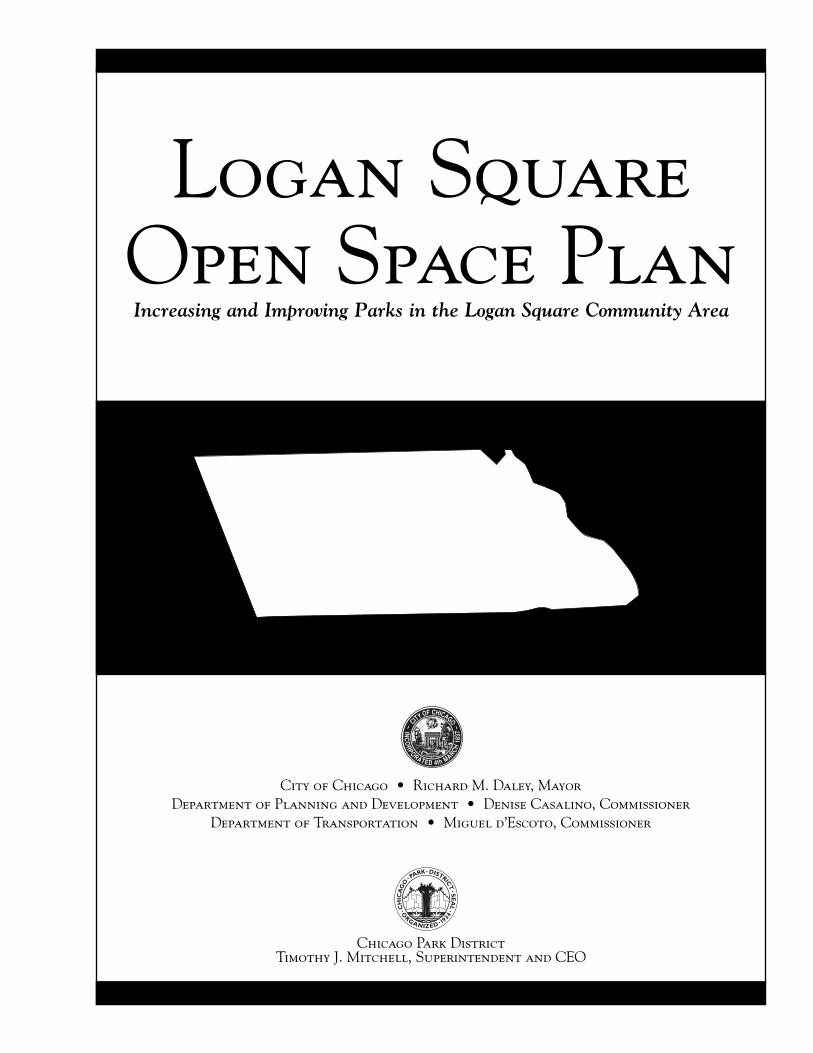
Chicago Park District Timothy J. Mitchell, Superintendent and CEO City of Chicago • Richard M. Daley, Mayor Department of Planning and Development • Denise Casalino, Commissioner Department of Transportation • Miguel d’Escoto, Commissioner C H I C A G O • P A R K • D IS T R I C T • S E A L • O R G A N I Z E D • 1 9 3 4 • Logan Square Open Space Plan Increasing and Improving Parks in the Logan Square Community Area
Transcript of Logan Square Open Space Plan - Chicago · 2020-03-19 · a historic, urban environment that’s...
Chicago Park DistrictTimothy J. Mitchell, Superintendent and CEO
City of Chicago • Richard M. Daley, MayorDepartment of Planning and Development • Denise Casalino, Commissioner
Department of Transportation • Miguel d’Escoto, Commissioner
CH
ICA
GO
• PARK• DISTRICT
•SEA
L
•O
RGANIZED• 1934•
Logan Square Open Space PlanIncreasing and Improving Parks in the Logan Square Community Area
Ta b l e o f C o n t e n t s
Mayor’s Letter . . . . . . . . . . . . . . . . . . . . . . . . . . . . . . . . . . 1
History of the Logan SquareCommunity Area . . . . . . . . . . . . . . . . . . . . . . . . . . . . . . . . . . 3
Previous Open Space Planning for Logan Square . . . . . . . . . . . . . . . . . . . . . . . . . . . . . . . . . . 5
Existing Open Space . . . . . . . . . . . . . . . . . . . . . . . . . . . . . . . . . . 7
Guiding Goals andPlanning Process . . . . . . . . . . . . . . . . . . . . . . . . . . . . . . . . . . 9
Key Recommendations . . . . . . . . . . . . . . . . . . . . . . . . . . . . . . . . . 13
Appendix I . . . . . . . . . . . . . . . . . . . . . . . . . . . . . . . . . 40
Appendix II . . . . . . . . . . . . . . . . . . . . . . . . . . . . . . . . . 41
Appendix III . . . . . . . . . . . . . . . . . . . . . . . . . . . . . . . . . 43
Acknowledgments . . . . . . . . . . . . . . . . . . . . . . . . . . . . . . . . . 47
Dear Chicagoans:
The Logan Square Open Space Plan provides a blueprint for increasing the amount andimproving the quality of open space in the Logan Square community on Chicago’sNorthwest Side. Encompassing more than 3.5 square miles, the community is one of 77community areas in the city and includes the neighborhoods of Logan Square, PalmerSquare and Bucktown.
As one of Chicago’s most densely developed areas, Logan Square has the least amountof open space per capita of any Chicago community area except South Lawndale. Themajority of its open space is along wide, tree-lined boulevards bordered by grand homes
and apartment buildings, many dating to the early decades of the 20th century. Tightly spaced working-classhomes of similar vintage fill other residential blocks, while the area’s commercial corridors are lined with shops,banks and small businesses. Acreage for traditional open spaces, such as parks and ball fields, is well below mini-mum standards.
To improve the quantity and quality of open space in the community, the Logan Square Open Space Plan identi-fies several opportunities, including the development of a recreational trail along an abandoned rail line, creativeuse of open space near the Kennedy Expressway, and improvements that restore the historic integrity and usabil-ity of both Logan and Palmer squares.
The plan was created through the close collaboration of community residents and businesses with the City ofChicago’s Department of Planning and Development (DPD), the Chicago Park District (CPD) and the ChicagoDepartment of Transportation (CDOT). When implemented, over fifteen acres of new open space prescribed bythe plan, in addition to facility enhancements at existing locations, will provide residents with increased recre-ational opportunities and also improve the aesthetics of the Logan Square community.
Sincerely,
Richard M. DaleyMayor
L o g a n S q u a r e O p e n S p a c e P l a n
1

Early SettlementLogan Square’s first settlers took advantage of vast open spaces that characterized the Chicago region in the early 19thcentury. The first, Martin Nelson Kimbell, arrived in 1836 and established a 160-acre farm in the area bounded todayby Fullerton, Diversey, Hamlin and Kimball avenues. In 1843, Justin Butterfield established an 80-acre farm in the areabounded today by Kedzie, Diversey and Milwaukee avenues. A wagon trail through the Kimbell property served as theinitial catalyst for development. In 1848, the Northwest Plank Road Company surfaced the trail with three-inch thickboards, providing a direct link to both downtown Chicago and the city of Milwaukee, for which the road was eventu-ally named. Small businesses sprang up along the route and led to Logan Square’s first major growth spurt.
Portions of Logan Square were annexed into Jefferson Township in 1850 and the city of Chicago in 1863. The remain-der of the community was annexed by the city between 1887 and 1889. Water and sewer systems appeared soon after,along with more paved streets.
Rail and Streetcar DevelopmentThe creation of the plank road on Milwaukee was the first in what would become a trend for Logan Square: Each newpiece of transportation infrastructure precipitated change. By 1870, a Chicago, Milwaukee & St. Paul Railroad stationnear Diversey and Rockwell provided direct rail connections to downtown Chicago and Milwaukee. In 1872, theChicago & Pacific Railroad started work on a grade-level freight and commuter line along what is today BloomingdaleAvenue. The line served numerous businesses, including coal and lumberyards, blacksmiths and tanneries, and provid-ed passenger boarding stations at Kimball and California avenues. By 1915, the line was raised above grade for safetyand access purposes. Mostly inactive since the year 2000, the line forms the southern border of the Logan Square com-munity.
The establishment of electric cable cars on Milwaukee and the construction of an elevated rail line in 1895 further con-tributed to several decades of booming real estate growth associated with transportation improvements. A local period-ical reported the considerable interest in the community by thousands of potential residents because of Logan Square’s“most central position in the system.” Additional rail expansion continued through much of the century, including sta-tions for regional commuters at Armitage and Ashland avenues, and at Fullerton Avenue and Pulaski Road, before cul-minating in the late 1960s with the construction of a below-grade rapid transit station at Logan and Kedzie boulevards.It was designed by the late Myron Goldsmith of Skidmore, Owings and Merrill.
BoulevardsLogan Square possesses 2.5 miles of the city’s 26-mile boulevard system. Entered in the National Register of HistoricPlaces in 1985, the system includes the community’s Humboldt, Kedzie, and Logan boulevards, as well as the formalPalmer Square and Logan Square, which serve as system focal points.
Lined with mostly high-end residential development, the boulevards represent 19th century planning initiatives to sep-arate work from play and businesses from residences. They were designed as pleasure drives linking regional parks, whichcreated an impressive, leisurely landscape that complimented adjacent, majestic residences. Unlike other portions ofthe citywide boulevard system, Logan Square’s boulevards included multi-unit buildings designed in similar architectur-al styles as neighboring mansions. While the boulevards were residential in character, several churches and ornate com-mercial structures in Logan Square added to their civic and religious monumentality.
In the 1890s, the boulevards were improved with a classic, European form proposed by Fredrick Law Olmstead: a cen-tral carriage drive separated from side drives for delivery carts. In sharp contrast to the rest of the city where unimproved
History of the Logan Square Community Area
L o g a n S q u a r e O p e n S p a c e P l a n
3

dirt roads were common, the boulevards provided carriage owners with a smooth and comfortable ride on compactedstone amid landscaped medians and formal lines of trees. The boulevards were also designed to accommodate public art,such as the Illinois Centennial Column commemorating the state’s 100th anniversary, at Logan and Kedzie boulevards.
In 1927, the boulevards were improved again with expanded grounds, landscaping, parking and, around Logan Square,electric lighting. Other improvements included asphalt paving, widened intersections, viaduct improvements atBloomingdale, and the extension of Kedzie Boulevard.
Social and Cultural ChangesFollowing advances in transportation and infrastructure, the first two decades of the 20th century saw an explosion ofgrowth in Logan Square. Norwegians, Swedes, Danes, Germans, Irish, English and Russians began to settle. When thecommunity population peaked at more than 100,000 people in the 1930s, Poles were the dominant ethnicity andremained so until the 1960s, when a significant Puerto Rican population moved in, along with immigrants from Cuba,Mexico and other Spanish-speaking countries.
Expressway, Decline and RejuvenationThe community’s population began to wane in the 1950s as many city residents, reflecting national, post-war trends,moved to the suburbs. Other Logan Square residents were displaced by the construction of the Kennedy Expressway (I-90/94). Unlike the other elements of transportation infrastructure that precipitated growth spurts, the expressway,though beneficial for many local industries, disturbed the residential fabric of the community and contributed to pop-ulation losses. “For rent” signs multiplied in shop windows along Fullerton and Milwaukee, and many buildings beganto deteriorate due to lack of investment and use.
In 1963, the Logan Square Neighborhood Association was formed with the goal of improving existing housing anddeveloping a cohesive community spirit. By the mid-1970s, signs of rejuvenation began to occur as high gasoline pricesand the increasing cost of nearby, suburban housing helped stem the exodus. By the late 1980s, real estate investors wererehabilitating the community’s vintage housing stock, especially for new residents attracted to the area’s historic char-acter and transportation amenities. The trend continued into the 1990s. More recently, new homeowners took advan-tage of low interest rates and the area’s proximity to downtown to invest in the community. As of 2000, Logan Square’spopulation was growing again, albeit slightly, with a population of 82,715.
Today, the community is a vibrant mix of young and old residents and new and established businesses, all coexisting ina historic, urban environment that’s poised for the future. The Logan Square Open Space Plan aims to continue thattrend by providing residents, workers and visitors with more open space.
Population Data Source: Census 2000
L o g a n S q u a r e O p e n S p a c e P l a n
4

Other than the boulevard system, few plans were everimplemented to provide for Logan Square’s open spaceneeds.
In 1919, landscape architect Jens Jensen published AGreater West Park System, a plan (Fig. 2) that prescribedparkland along the Chicago River on the community’s east-ern edge. The demand for industrial space, however,eclipsed the concept and the area evolved instead as anindustrial corridor.
The 1989 City of Chicago plan Life Along the Boulevards(Fig. 3) helped increase awareness of the boulevards as a system and highlighted Logan and Palmer squares as impor-tant elements of that system. The plan detailed historiclandscape treatments used along Humboldt, Kedzie andLogan boulevards and proposed sympathetic updates to thelandscape plantings. Authors of the plan noted that theboulevards are used for a variety of recreational uses, butthat the “mix of these activities is often far from ideal.”Recognizing the boulevards as a valuable recreationalresource for the city, the authors recommended that theCity of Chicago and the Chicago Park District “jointlyexplore the feasibility of transferring the boulevards back tothe Park District.”
Previous Open Space Planning for Logan Square
Fig. 2 From A Greater West Park System
Logan SquareLocation
Fig. 3 From Life Along the Boulevards
L o g a n S q u a r e O p e n S p a c e P l a n
5
In 1990, the Chicago Park District Land Policies Plan pinpointed 110 city blocks within Logan Square that were under-served by open space and highlighted the limited opportunities for park expansions. The recommendations made forexpanding Unity Park were pursued. In addition, recommendations were made for improving existing parks and part-nering with schools to better use asphalt school grounds as a way to help compensate for the lack of space.
In 1993, the Chicago Park District acknowledged again the lack of new opportunities for park development but iden-tified a few small parcels that were available, as well as recommending an operating agreement with Logan Square’sBrentano Elementary School. The parcels were too small for park sites and the one undeveloped small parcel ownedby the Park District has become Neighbor’s Garden Park, a park maintained by nearby residents.
In 1998, the intergovernmental CitySpace plan assessed the public open space inventories of every Chicago community and established a minimum acceptable standard of two acres of open space per 1,000 residents. Using 1990 census data, the plan’s analysis of Logan Square indicated .6 acres for every 1,000 residents. An updated analysis using2000 census and parkland figures indicated slight improvement, but Logan Square still needs 99 acres of public openspace to meet the city’s minimum standards. The poor ratio escalated the City of Chicago’s and the Chicago ParkDistrict’s effort to find creative ways to address the shortage.
L o g a n S q u a r e O p e n S p a c e P l a n
6

Most of Logan Square’s public open spaces are passive areas designed to provide beauty and respite, such as theDepartment of Transportation–owned boulevard system, which accounts for more than 36 of the community’s 62 totalopen space acres. The remainder is almost entirely located in the Chicago Park District–owned parks of Kosciuszko,Unity, Haas, Senior Citizen’s Memorial, Holstein, Erhler, Churchill, People’s, Mozart, Neighbor’s Garden, Monticelloand Maple (See Appendix I).
In addition to a general need for more open space, the community is in particular need for outdoor recreation placeslike ball fields, playgrounds, and hiking and biking trails. As for indoor recreational facilities, which fall outside thescope of the Logan Square Open Space Plan, Logan Square falls within the top 30% of community areas in number ofindoor recreational facilities provided.
As of 1996, a successful technique for adding green space to densely developed communities has been through theCampus Park Program, which was recommended by the CitySpace plan and is funded by the City of Chicago, ChicagoPark District, and Chicago Public Schools. The program replaces concrete and asphalt on public school property withgrass and gardens. Since the program started, 100 campus parks have been completed, including areas at Darwin,Funston, Goethe, Monroe, Pulaski, and Yates schools in Logan Square. The work added six acres of greenspace to thecommunity’s open space inventory (Fig. 5&6).
Another recommendation of the CitySpace plan was to increase the number of community managed open spaces inChicago’s neighborhoods. The City owns thousands of small, vacant lots on residential blocks that could be convert-ed into community gardens and parks. This spring, From the Ground UP, a program of Faith in Place, in partnershipwith Whipple Concerned Alliance of Neighbors, applied to the Chicago Botanic Garden for assistance in developinga community garden on the vacant city-owned lot at 2056 North Whipple.
Other Logan Square open space improvements in recent years involve the expansion of the Park District’s Unity Parkby .21 acres.These improvements have not solved the open space need in the community. But now public open spacehas been provided within walking distance for some residents who previously had no parks nearby (Fig. 5&6).
Existing Open Space
L o g a n S q u a r e O p e n S p a c e P l a n
7
Fig. 4

L o g a n S q u a r e O p e n S p a c e P l a n
8
Fig .5
Fig. 6
Due to the resistance of public agencies and residents to acquiring and demolishing residential buildings to create moreopen space, the Logan Square Open Space Plan only considers existing vacant land for conversion to public open space.The primary goals of the plan are to:
1) Increase the amount of public open space with parks, plazas, gateways, greenways and other outdoor areas.2) Improve the quality of existing open space and add more opportunities for active recreation.3) Investigate recreational and open space opportunities along the unused Bloomingdale rail line.4) Work with the community when buildings or tracts of land go on the market in areas not served by open space to
assess the feasibility of these sites for open space.
The planning process started in October 2002 and proceeded through the following phases:
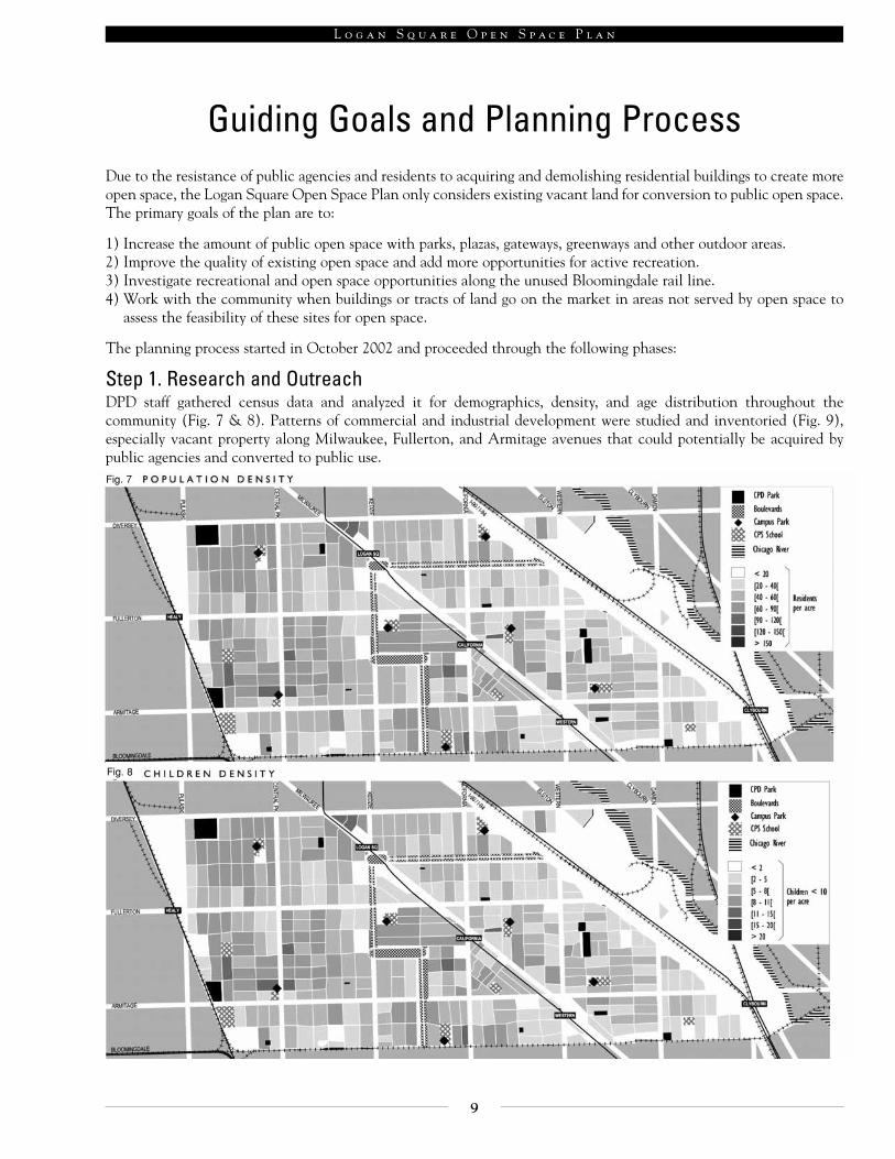
Step 1. Research and OutreachDPD staff gathered census data and analyzed it for demographics, density, and age distribution throughout the community (Fig. 7 & 8). Patterns of commercial and industrial development were studied and inventoried (Fig. 9),especially vacant property along Milwaukee, Fullerton, and Armitage avenues that could potentially be acquired bypublic agencies and converted to public use.
Guiding Goals and Planning Process
L o g a n S q u a r e O p e n S p a c e P l a n
9
Fig. 7
Fig. 8

Concurrently, planning staff worked with community organizations, aldermen, and others to spread the word that anew initiative would address the area’s open space shortage. Flyers and posters announcing meeting times and locationswere printed in English and Spanish and distributed at libraries, parks, churches, schools, residences, offices, and otherlocations. Press releases were sent to neighborhood papers and direct mail and email was sent to community organiza-tions, individual participants, and other affected parties. The DPD web page also posted all meeting dates, topics, andrelated maps.
Meanwhile, field studies were used to identify public land use behavior, such as the public’s use of random neighbor-hood spaces for dog walking and other uses.
Step 2. Initial community feedbackAt the kick-off meeting held in November 2002, community residents joined DPD and CPD staff to examine researchdata and strategize improvements. Participants divided into five small groups to discuss needs and opportunities in dif-ferent sections of the community. Among the issues raised were: a need for more children’s play spaces, creation of bikeroutes and safe walking routes through the neighborhoods, increased access to the Chicago River, needed upgrades toLogan and Palmer squares, improved use of boulevards, more spaces for dogs in parks, and the need to upgrade existingparks.
Step 3. Chicago Department of Transportation (CDOT) joins the planning process.DPD and Park District requested the assistance of CDOT after the November 2002 community meeting since many ofthe area’s open space issues involve the boulevards, bike routes and trails using rail lines. CDOT agreed to join theplanning process in order to make a cohesive plan.
Step 4. Focus Groups (See Appendix II)Throughout January and February of 2003, community members and planning staff held 10 public meetings to focusintensively on specific geographic areas and specific open space opportunities. The meetings provided intimate settingsfor community members to explore in detail ideas and issues that would have been lost in a larger forum.
L o g a n S q u a r e O p e n S p a c e P l a n
10
Fig. 9

Step 5. Survey WorkTwo surveys were conducted in early 2003 to assess the public’s perception of two community sites suggested by the focusgroups that could potentially be converted to open space use.
In March, research staff surveyed business owners, shoppers, and pedestrians near a shopping center on the 2500 blockof North Milwaukee Avenue. The survey asked more than 30 people about the value and utility of the shopping cen-ter, known as the “Mega Mall,” to the community. In general, both patrons and vendors were positive about the pres-ence of the center except for a perception of inadequate parking and management concerns.
In April, another survey was conducted over athree-day period at the Logan Square CTA sta-tion to determine suggested uses for a piece ofvacant, public land at the southwest corner ofMilwaukee Avenue and Logan Boulevard wherethe elevated line goes underground south of thestation. The most common of more than 200suggestions was its conversion to a park,although a concern over potential crime andvagrancy was expressed. Suggested uses to hin-der such activity were to activate it with people-intensive uses, such as programming for teens,amenities for families, and space for an outdoormarket.
Step 6. Survey of Park District facilitiesA survey of Chicago Park District facilities was also undertaken during the spring of 2003. The Department of Planningand Development distributed 500 bi-lingual surveys at Chicago Park District field houses throughout Logan Square.Staff at the field houses were to distribute the surveys to patrons that came into the field houses. Completed surveyswere to be returned to any Park District facility. It was hoped that the survey would provide some insight into everydaypark users that were not attending community meetings.
Ten percent of the surveys were completed. Although not representative of the entire community or all park patrons,the surveys show an existing interest in CPD programs and the facilities that the programs are held in. Most of thepatrons heard about CPD programs via word of mouth or from their neighbors. The surveys indicated that patrons wouldlike to see their indoor facilities improved. An overwhelming majority, 92% of the respondents, felt that parks areimportant to their community and 89% felt that there is a need to increase the parks/open space in their neighborhood.The majority of the surveys were from Haas Park patrons.
Step 7. Draft plan is released.In Spring 2003, all planning partners met to review recommendations and to finalize a draft of the plan for publicreview. The draft was released in June 2003, with eleven specific recommendations.
Fig. 10
L o g a n S q u a r e O p e n S p a c e P l a n
11