Local Knowledge of Reef Fish Spawning Aggregations in
37
Local Knowledge of Reef Fish Spawning Aggregations in Kimbe Bay, West New Britain Province, Papua New Guinea Unrestricted Access Version April 2005 TNC Pacific Island Countries Report No. 2/05 (Unrestricted) Prepared by: Richard J. Hamilton 1 , Philip Lahui 2 , Joseph Warku 2 , Joe Aitsi 2 , Annisah Sapul 2 and Shannon Seeto 2 Pacific Island Countries Coastal Marine Program The Nature Conservancy
Transcript of Local Knowledge of Reef Fish Spawning Aggregations in

Local Knowledge of Reef Fish Spawning Aggregations in Kimbe Bay, West New Britain Province, Papua New Guinea
Unrestricted Access Version
April 2005 TNC Pacific Island Countries
Report No. 2/05 (Unrestricted)
Prepared by: Richard J. Hamilton1, Philip Lahui2, Joseph Warku2,
Joe Aitsi2, Annisah Sapul2 and Shannon Seeto2
Pacific Island Countries Coastal Marine Program The Nature Conservancy

i
Author Contact Details: 1 51 Edmondstone Street, South Brisbane, Qld, 4101, Australia. Email: [email protected] 2 P.O. Box 267, Kimbe, West New Britain Province, Papua New Guinea Citation: Hamilton, R., P. Lahui, J. Warku, J. Aitsi, A. Sapul and S. Seeto. 2005. Local Knowledge of Reef Fish Spawning Aggregations in Kimbe Bay, West New Britain Province, Papua New Guinea. (UNRESTRICTED ACCESS VERSION). Report prepared for the Pacific Island Countries Coastal Marine Program, The Nature Conservancy. TNC Pacific Island Countries Report No. 2/05. © 2005 The Nature Conservancy
All Rights Reserved. Reproduction of this publication for educational or other non-commercial purposes is authorized without prior permission from the copyright holder(s). Reproduction for resale or other commercial purposes is prohibited without prior written permission of the copyright holder(s). Acknowledgements We are grateful to all of the individuals in the communities visited throughout Kimbe Bay for sharing with us their local knowledge on reef fish aggregations. The information presented in this report is based upon their knowledge and could not have been documented without their interest and support. We also thank Stuart Sheppard for preparing Figure 2. Project managed by Dr. Andrew Smith, Director, Pacific Island Countries Coastal Marine Programs, The Nature Conservancy. Donors Financial assistance was provided by the Office of Strategic Planning, Operations and Technical Support, Bureau for Asia and the Near East, U. S. Agency for International Development, under the terms of Award No. LAG-A-00-99-00045-00. The opinions expressed herein are those of the author(s) and do not necessarily reflect the view of the U. S. Agency for International Development. Report Available From: Indo-Pacific Resource Centre The Nature Conservancy 51 Edmondstone Street South Brisbane, QLD 4101 Australia Or via the worldwide web at: www.conserveonline.org Cover photo: Interviewing fishers at Vilavila village, Eastern Kimbe Bay (R. Hamilton).
ii
TABLE OF CONTENTS
Table of Contents .................................................................................................................................... ii List of Figures .................................................................................................................................... ii List of Tables...................................................................................................................................... ii
Introduction ............................................................................................................................................. 1 Spawning aggregations ...................................................................................................................... 2 Utilizing local knowledge for spawning aggregation research .......................................................... 2 Customary Marine Tenure (CMT) ..................................................................................................... 3
Kimbe Bay............................................................................................................................................... 5 Previous research on transient spawning aggregations in Kimbe Bay............................................... 5 Local knowledge surveys ................................................................................................................... 6 Community liaison and interviewing procedure ................................................................................ 6
Local knowledge of spawning aggregation sites..................................................................................... 7 Fishing pressure placed on spawning aggregations................................................................................. 8 UVC surveys at aggregation sites identified in the local knowledge survey .......................................... 9
Follow up UVC surveys in western Kimbe Bay .............................................................................. 11 Protection and monitoring of sites 5 and 6............................................................................................ 11 Conclusions ........................................................................................................................................... 11 Recommendations ................................................................................................................................. 12 References ............................................................................................................................................. 15 Appendices ............................................................................................................................................ 18
Appendix 1. Data tables for aggregations around Kimbe Bay........................................................ 18 Appendix 2. Dive log for each UVC Survey. ................................................................................. 26 Appendix 3. Insecticide replaces traditional derris root fish poison ................................................ 32
LIST OF FIGURES
Figure 1: Mt Uluwan smoking away in the distance. This photo was taken from the TNC field station at Ulamona. ....................................................................................................................................... 5
Figure 2: Nighttime spear-fishers from eastern Kimbe Bay displaying part of their catch..................... 9 Figure 3: Mosses and Joseph Warku clearing a tree that had fallen across the road to Tarobi. ............ 10 Figure 4: Some of the humphead wrasse that were aggregated around the promontory at Site 1 on the
March 9, 2005. ................................................................................................................................ 28 Figure 5: Fishers collecting poisoned fish. The poison was dumped by fishers seen in the canoes in
the background................................................................................................................................ 32 Figure 6: An individual’s catch. ............................................................................................................ 33 Figure 7: Poisoned fish on the sea floor. ............................................................................................... 33 Figure 8: A bird’s eye view of just some of the thousands of dead fish that covered the seabed, most of
which were well outside of free divers range. ................................................................................ 34
LIST OF TABLES
Table 1: A summary of the aggregation data documented from around Kimbe Bay, showing species known to aggregate at each site, the moon phase(s) when these aggregations are said to occur and the months of peak formation. .......................................................................................................... 7
Table 2: Summary of the UVC surveys. The new moon occurred on March 9, 2005. The estimates of the numbers of each species sighted were made by Richard Hamilton. ......................................... 10

1
INTRODUCTION
The Nature Conservancy (TNC) has worked in Kimbe Bay, West New Britain, Papua New Guinea since 1992. This region is the major focus point for TNC’s Papua New Guinea Marine Conservation Program, and TNC is currently working with various partners and stakeholders to establish a resilient, fully functional, network of Marine Protected Areas (MPA) in Kimbe Bay by 2008 (Green and Lokani, 2004). In early 2004 at a scientific workshop in Townsville it was recognized that one of the key information gaps that needed to be addressed prior to designing the network of MPAs in Kimbe Bay was the location of reef fish spawning aggregations sites. Particular importance was placed on identifying the locations of spawning aggregation sites that are used by large commercially important groupers and the humphead wrasse (Green and Lokani, 2004). An Underwater Visual Census (UVC) survey that was conducted in Western Kimbe Bay in 2003 did identify four small Plectropomus areolatus aggregation sites (Aitsi and Seeto, 2003), but there remained a dearth of information on the locations of grouper aggregation sites in other areas of Kimbe Bay. It was decided that a survey of fishers’ local ecological knowledge was a feasible way for TNC to identify other grouper aggregation sites in Kimbe Bay and this study was subsequently conducted. Ethnographic surveys that have utilized local fishers’ knowledge on spawning aggregations have proven to be cost effective and successful way of identifying grouper spawning aggregation sites in many coastal regions of Melanesia (e.g. Johannes, 1999; Johannes and Kile, 2001; Hamilton et al., 2005). TNC has recently commissioned several such surveys in Melanesia. These surveys have been conducted in areas where TNC is working, but where scientific databases on aggregations are scarce or non-existent (e.g. Hamilton and Kama, 2004; Hamilton et al., 2004). The aim of the TNC local knowledge surveys has been to quickly acquire as much information as possible on spawning aggregations in each region of interest. Documented local knowledge on aggregation parameters such as specific locations, species composition and status of aggregations can provide a template of information that can then be used to tailor future research, conservation and management efforts. In this report we outline the findings of a local knowledge field survey that was carried out March 1 – 5, 2005, in Kimbe Bay, West New Britain Province, Papua New Guinea. We then present the findings of Underwater Visual Census (UVC) surveys that were carried out between March 7 – 10, 2005, (the new moon period) at some of the sites identified in the local knowledge survey. These UVC surveys were carried out in order to provide fisheries independent assessments of grouper aggregation sites that had been identified in the earlier local knowledge surveys. The specific objectives of this field survey were: 1. Document local knowledge on the locations, seasonality, exploitation history and current status of
spawning aggregations in Kimbe Bay. 2. Determine through UVC surveys which sites identified in the local knowledge survey are
spawning aggregation sites. 3. Identify communities in Kimbe Bay that are interested in working with TNC to manage and
conserve spawning aggregations that occur within their traditional reef estates. 4. Familiarize Kimbe Bay TNC staff with methods on:
• Collecting local knowledge of spawning aggregations • Verifying sites identified in local knowledge surveys are spawning aggregations sites.
The local knowledge documented in this report was obtained by conducting interviews with local fishing experts in rural community settings in Kimbe Bay. An overview of the community liaison

2
procedures and the interview techniques that were used are explained in a later section of this report. We begin below by providing a brief overview on spawning aggregations, local knowledge and Customary Marine Tenure (CMT). Local knowledge and CMT need to be understood in order to appreciate how they may be utilized and incorporated into spawning aggregation conservation and management programs in Kimbe Bay.
SPAWNING AGGREGATIONS
Many large commercially valuable species of reef fish aggregate in the hundreds or thousands at fixed sites during specific lunar and seasonal periods for the purpose of reproduction (Domeier and Colin, 1997). Not surprisingly, fishers have often taken advantage of this predicable behavior, as exceptionally high catches can be made from spawning aggregations (Johannes, 1978). Although fishers have been aware of spawning aggregations for centuries, biological interest in them is far more recent (Colin et al., 2003). There is now a growing awareness among marine biologists and coastal managers of the need to understand the biological parameters of spawning aggregations and the effects of fishing these aggregations (Vincent and Sadovy, 1998; Levin and Grimes, 2002). This awareness has stemmed from the realization that; firstly, spawning aggregations of many commercially important species have often been rapidly over- fished, and secondly, the spawning aggregation phenomena represents a bottleneck in the life histories of many reef fish species, and their conservation and management is critical for ensuring the persistence of the populations that form them (Sadovy and Vincent, 2002). Although many species of reef fish aggregate to spawn, recent research on coral reef fish spawning aggregations has predominantly concentrated on groupers (e.g. Samoilys, 1997; Zellar, 1998; Johannes et al., 1999; Rhodes and Sadovy, 2002). This family’s large size, susceptibility to over fishing, and importance in destructive commercial ventures such as the Live Reef Food Fish Trade (LRFFT), has brought global attention to the spawning aggregation phenomena (Levin and Grimes, 2002; Pauly et al., 2002). The Live Reef Food Fish Trade actively targets spawning aggregations of reef fish, and is considered one of the major threats to spawning aggregations throughout the tropics (Sadovy and Vincent, 2002; Sadovy et al., 2003).
UTILIZING LOCAL KNOWLEDGE FOR SPAWNING AGGREGATION RESEARCH
The logistical difficulties of locating spawning aggregations that form at localized areas for brief periods of time has meant that marine biologists wanting to research or protect spawning aggregations have often drawn on the local knowledge of fishers in the initial stages of their field work (e.g. Johannes 1981; Beets and Friedlander 1998; Johannes et al. 1999; Sala et al. 2001; Colin et al., 2003). It is noteworthy however that the precision and depth of documented local knowledge on spawning aggregations has varied widely between both regions and researchers (Graham, 2002), no doubt reflecting: • The amount of local knowledge present in each region • The willingness of local fishers to divulge this information • The skills of the researcher and appropriateness of the methods used to obtain local knowledge • The amount of time spent documenting this cultural information Detailed anthropologically based studies that have focused on documenting the local knowledge of Pacific island fishers, have revealed that as well as knowing the locations of spawning sites, local fishers can also provide highly precise information on the annual and lunar periodicity of spawning aggregations, species composition at mixed species spawning sites, the spawning behavior of
3
aggregating fish and changes in the status of an aggregation over time (Johannes, 1981 and 1989; Johannes and Kile, 2001; Hamilton, 2003; Hamilton et al., 2005). It is important to highlight the fact that while indigenous marine knowledge can sometimes be of great practical value to scientists and conservationists, there are several common problems associated with documenting local knowledge that need to be taken into account: 1. Local ecological knowledge is an important component of the intellectual and cultural property of
many indigenous societies, and it needs to be documented and utilized in ways that are endorsed by the custodians of this information.
2. Anthropological methods such as interviewing and participant observation are required to
accurately document this material. 3. Local knowledge is often stratified by gender, age and geographical location, and specific
knowledge pertaining to specific families of fish is often restricted to expert fishers who specialize in targeting those species (Johannes et al., 2000).
4. Most local knowledge of marine ecology is ultimately directed towards identifying patterns that
maximize capture success. Thus some details of fish biology that are important to a marine biologist studying reef fish ecology may well be irrelevant to a local knowledge base, since these biological parameters have no influence on subsistence practice (Hamilton and Walter, 1999).
5. While local knowledge on recent changes in the abundance or size structure of local fish stocks
will often be very accurate, local explanations for the mechanisms underlying these changes may not be compatible with scientific paradigms (Ruddle et al., 1992:262). “In some places declining yields may be attributed to sorcery or a failure to propitiate the gods”.
6. Fishers’ knowledge, like scientists’, is fallible, and this cultural information needs to be gathered
systematically and treated with the same critical scrutiny that is applied by scientists to any other data set (Johannes et al., 2000).
CUSTOMARY MARINE TENURE (CMT)
Customary marine tenure is a situation in which identifiable groups of people have informal or formal rights to coastal areas, and in which their rights to use and access resources are, in principle, excludable, transferable, and enforceable, either on a conditional or permanent basis (Ruddle 1996). Virtually all Melanesian coral reef fisheries operate within well developed CMT systems, where ownership of, and hence access to, coastal areas depends on a range of culturally defined variables including descent line (e.g. Carrier and Carrier, 1983; Hviding, 1996; Aswani, 1999). In many coastal communities in PNG traditional management measures are put in place within existing CMT system in order to allow valuable marine resources to replenish. The most common management measure is the tambu, a temporary closure of a reef or inshore area. A tambu is typically put in place in order to allow valuable resources to accumulate, so that they may be harvested later in order to meet cultural obligations such as bride price payments. Various authors working in the coastal Pacific have promoted the idea that in countries where governments do not have the legislative or financial capacity to enforce management rules, CMT systems could be used as an effective basis for managing inshore fisheries (e.g. Ruddle et al., 1992; Foster and Poggie, 1993; Johannes, 1998; Thomas 2001). In some regions of the Pacific CMT estates and local ecological knowledge has been successfully incorporated into contemporary inshore management programs (e.g. Johannes, 1998; Fa'asili, and Kelekolo, l999; Aswani and Hamilton, 2004a). However, it has become apparent that CMT systems alone will not conserve marine resources in many countries, especially when the economic incentives to harvest these resources are high and tenure disputes among differing parties are unresolved (Foale 1998). It has been argued that CMT

4
systems throughout the Pacific and Asia were developed primarily for “gain not restrain” (Carrier and Carrier, 1983; Polunin, 1984; Ruttan, 1998) and this issue has been the point of some controversy among academics (Hviding, 1996; Aswani, 1999). Regardless of the mechanisms behind the development of CMT systems, their obvious and undisputed management benefits are: 1. They can provide an existing culturally recognized ownership structure around which management
incentives can be based (Johannes et al., 1993) 2. Robust CMT systems can effectively restrict outsiders access to traditional fishing grounds
(Johannes, 1981; Hviding, 1996) thereby eliminating some of the problems associated with common property that are prevalent in many of the world’s inshore fisheries (Hardin, 1968).
It is important to recognize that CMT systems vary markedly between different regions, and the intricacies of these systems and their robustness and appropriateness to management or conservation objectives need to be carefully evaluated for each region in question. A successful sea tenure regime requires that boundaries be well defined, that they are recognized within the local region, that there is little or no poaching by neighboring groups, that there is the local capacity to enforce rules, and that most of the stakeholders are willing to endorse a management initiative. In other words, it is meaningless to implement community based marine management measures, no matter how rich the biodiversity, if harvest restriction rules and exclusion of non-members cannot be enforced (Aswani and Hamilton, 2004b).

5
KIMBE BAY
Kimbe Bay is a large bay (140 km x 70 km) that is located on the north coast of the island of West New Britain. The landscape is dominated by numerous volcanoes that reach heights of over 2000 m (Figure 1). Kimbe Bay is one of the world’s most diverse and significant tropical marine environments, with the bay comprising a wide variety of shallow and deepwater marine habitats that are in very close proximity to each other. Rapid Ecological Assessments have described healthy coral reefs with high biodiversity, especially in the eastern and mid- to outer-portions of the bay. These reefs are considered part of the global centre of marine biodiversity known as the “Coral Triangle” (Green and Lokani, 2004).
Figure 1: Mt Uluwan smoking away in the distance. This photo was taken from the TNC field station at Ulamona.
PREVIOUS RESEARCH ON TRANSIENT SPAWNING AGGREGATIONS IN KIMBE BAY
Between the May 26-30, 2003, Kimbe Bay TNC field staff and partners carried out UVC surveys to identify grouper transient spawning aggregation sites in Western Kimbe Bay. UVC Surveys were conducted at 25 sites in Stettin Bay in the five days leading up to the new moon. Fourteen of the sites were selected based on satellite imagery maps, while the remaining sites were investigated based on intuition and the local knowledge of fishers (Aitsi and Seeto, 2003). No aggregations were sighted at the 14 locations picked from satellite imagery maps, however, four relatively small aggregations of P. areolatus were located at the other sites visited. At these sites the total numbers of P. areolatus ranged between 30 to 77 individuals. The highest abundances of P. areolatus were sighted at reefs near Schumman Island and Restorf Island. Indirect spawning signs such as grouping, color change and chasing were observed in P. areolatus at these four sites (Aitsi and Seeto, 2003). Epinephelus fuscoguttatus and Epinephelus polyphekadion were not aggregating at any of these sites, although individuals of E. fuscoguttatus were seen at several sites.

6
John Claydon, who was the Researcher in Residence at Mahonia Na Dari in 2003 and 2004, joined the May 2003 spawning aggregations survey. He subsequently made follow up observations in the second half of 2003 and in early 2004 at several of the P. areolatus aggregation sites identified in the May 2003 survey. Small aggregations of P. areolatus (20 - 60 fish) formed in January, February, March and May, with no aggregations of P. areolatus being sighted in August, September, October, November or December. Data was unavailable for April, June or July (Claydon and McCormick, not dated). Claydon’s observations indicate that P. areolatus shows a strong seasonal pattern in western Kimbe Bay, with aggregations forming in the first half of the year.
LOCAL KNOWLEDGE SURVEYS
The local knowledge survey was conducted around the eastern end of Kimbe Bay between March 1 and 5, 2005. Richard Hamilton, Philip Lahui and Joseph Warku conducted the local knowledge survey. Initially we drove from Walindi to the TNC field station at Ulamona and based ourselves here. Philip Lahui, who has extensive experience working in this region, selected the communities to visit. His selection criteria involved choosing communities that were renowned as fishing villages. Typically, these were communities located near the sea or on islands in Kimbe Bay. Between March 1-5 we interviewed fishers from the Ulamona, Potou (Lolobau Island), Biai, Vilavila, Noau, Soi, Mataliliu, Baikakae and Tarobi communities.
COMMUNITY LIAISON AND INTERVIEWING PROCEDURE
Upon arriving in a community we would ask to speak to the Community Councilor. Once we had located the Councilor, we would explain who we were working for and what our agenda was. Typically, the Councilor would then call a group of available expert fishers together under a tree or by the beach. We would then introduce ourselves and TNC and give an introductory talk on the life cycle of serranids, outlining among other things, aggregating behavior, pelagic spawning, the larvae stages of fish, sex reversal and why many aggregations are vulnerable to over exploitation. We would then point out that while biologists knew a lot about serranid biology, we knew nothing about where or when spawning aggregations occurred on reefs in this region, which is why we wanted to ask local fishers for their help. We ended by clearly stating that the information we were collecting was part of a preliminary assessment of spawning aggregations that TNC was making in their region, and specific details on locations of sites and other sensitive local knowledge would remain confidential. These introductory talks generated a great deal of interest and served as a very effective way of initiating conversations on spawning sites. Many fishers had witnessed spawning behaviors such as grouping, chasing, color change and courtship at aggregation sites, but they often had not realized that these behaviors related to spawning. Fishers often enthusiastically shared their own observations and asked numerous questions on spawning behavior. Importantly, these introductory talks also served as a quick way of assessing the level of local knowledge on spawning aggregations in the area visited. Individuals or groups of knowledgeable fishers who knew of aggregation sites on their reefs and were willing to be interviewed in detail were asked a wide range of questions. The questions in the Society for the Conservation of Reef Fish Aggregations (SCRFA) questionnaire (see http://www.scrfa.org/server/studying/introduction.htm) formed the template of the questions covered. Interviews were semi-structured, with the interviewee(s) being able to lead the interviewer as appropriate. All interviews were conducted in Papua New Guinea Tok Pidgin.

7
LOCAL KNOWLEDGE OF SPAWNING AGGREGATION SITES.
The local knowledge surveys in Kimbe Bay enabled us to document information on 10 single and multi-species aggregation sites. Species that had spatially overlapping territories were deemed to occur at the same aggregation site. For the majority of these aggregations their precise location was marked using GPS and oral histories of the fisheries (status, exploitation, methods employed) were documented. Detailed information for each aggregation site, including the direct and indirect evidence of spawning for each species is presented in tables in Appendix 1. The aggregation parameters in these tables are adapted from the SCRFA questionnaire guidelines. Table 1: A summary of the aggregation data documented from around Kimbe Bay, showing species known to aggregate at each site, the moon phase(s) when these aggregations are said to occur and the months of peak formation.
Aggregation Site No.
Aggregating species Moon Phase Months of formation
1 Plectropomus areolatus Cheilinus undulatus
New moon All months of the year
2 Plectropomus areolatus Epinephelus fuscoguttatus Epinephelus polyphekadion
Unknown Unknown
3 Epinephelus fuscoguttatus Epinephelus polyphekadion
Unknown Unknown
4 Epinephelus fuscoguttatus Epinephelus polyphekadion
Unknown Unknown
5 Plectropomus areolatus Epinephelus fuscoguttatus Epinephelus polyphekadion
Unknown Unknown
6 Plectropomus areolatus Unknown Unknown 7 Plectropomus areolatus Unknown Unknown
8-10 Plectropomus leopardus Unknown All months of the year In the majority of the communities visited fishers were aware of the spawning aggregation phenomena, and fishers often knew the specific locations where aggregations of groupers formed. Fishers in the eastern end of Kimbe Bay use the term vinivi in their Meramera language. This word translates into “Hap bilong pis i bung” in PNG Tok Pidgin, which in English means “The place where fish aggregate”. In all of the communities visited fishers were keen to talk to us about their knowledge of aggregations and they were also willing to take us to aggregation sites so that we could collect Global Positioning System (GPS) coordinates for later follow-up UVC surveys. Overall there was very little awareness that reef fish aggregate for the purpose of reproduction, and little knowledge of the fact that spawning aggregations form at predicable lunar and seasonal periods. Only the fishers that exploit Site 1 were aware that aggregations of P. areolatus formed around the new moon. For all other aggregations identified in this local knowledge survey fishers said they were unaware of the lunar periodicity with which the aggregations form. Several fishers stated that while they thought that perhaps these aggregations did form at certain lunar stages, they were unaware of which stages these were. Fishers that exploit sites 5 and 6 made the comment that at times when they went to aggregation sites 5 and 6 there would be no P. areolatus there, and that they believed they must have broken some traditional custom which is why the fish had left. There was also little information on annual seasonality in the local knowledge base, although several fishers from different locations made the comment that grouper aggregations formed in variable sizes throughout most months of the year.

8
FISHING PRESSURE PLACED ON SPAWNING AGGREGATIONS
Fishing pressure on spawning aggregations in the eastern areas of Kimbe Bay is low. All fishers who responded to questions on the status of aggregations reported that catch rates and total catches from aggregation sites had not declined in their lifetimes (See Appendix 1). The fact that very few fishers were aware of either the lunar or annual seasonality of grouper aggregations appears to provide aggregations in this area with a considerable amount of protection. In general, valuable marine resources in Kimbe Bay appeared plentiful, with one of the authors (Richard Hamilton) being surprised at the abundance of commercially valuable fishes, beche-de-mer and trochus sighted in the eastern Kimbe Bay. The healthy status of invertebrate and vertebrate resources in eastern Kimbe Bay appears to be due to two main factors: firstly, many of the people who live in Kimbe Bay have moved there from the highland provinces of PNG and they do not have a strong cultural relationship with the sea. Secondly, most people from Kimbe Bay are not heavily dependent on marine resources, relying more on land-based resources and activities for both subsistence and cash generating purposes (Cinner et al. 2002; Green and Lokani, 2004). The majority of fish captured in the eastern Kimbe Bay is used for subsistence purposes, with small-scale market driven artisanal fishing occurring prior to paydays (e.g. Oil Palm workers get paid fortnightly on Fridays, so every second Thursday, fishing intensifies). Fish captured for sale are either smoked or sold fresh at local markets. The main fishing methods used at aggregation sites are hook and line fishing from a canoe or small boat, followed by spearfishing. Although both day and nighttime spearfishing occurs, daytime spearfishing appears to be the preferred method. Spear-fishers in the eastern Kimbe Bay use basic technologies, i.e., typically they do not use fins, snorkels or powerful spearguns. Fishers who know of the lunar periodicity of aggregations at Site 1 stated that they did not target this aggregation at night, preferring to spearfish at night in shallower water in locations where the current was not as strong and sharks were less numerous (Figure 2). The fact that nighttime spearfishing pressure is currently light at many aggregation sites in Kimbe Bay is encouraging, as this practice has rapidly decimated grouper aggregations in many regions in Melanesia (Hamilton et al., 2005). Nighttime spearfishing at aggregation sites does however appears to be a more common practice in western Kimbe Bay (Shannon Seeto, personal observations).

9
Figure 2: Nighttime spear-fishers from eastern Kimbe Bay displaying part of their catch.
UVC SURVEYS AT AGGREGATION SITES IDENTIFIED IN THE LOCAL KNOWLEDGE SURVEY
Between March 7 and 10, 2005, Richard Hamilton, Philip Lahui, Joe Aitsi and Annisah Sapul conducted UVC surveys at five locations in the eastern Kimbe Bay that fishers had identified as potential grouper spawning aggregation sites in the local knowledge survey. UVC surveys were carried out using SCUBA. Surveys were conducted towards the end of the third quarter and during the early new moon period, being the lunar period when the numbers of groupers at spawning aggregation sites in Melanesia are known to peak (Johannes, 1989; Hamilton et al., 2005). Initially we had planed to work from a liveaboard boat that had a compressor onboard. However, due to bad weather and because the boat’s communication system was down the captain decided to abandon the trip in the afternoon of the first day. By that time we had only completed one UVC at Site 5. The TNC team subsequently decided to travel back to Walindi by land that night, and on March 8 we drove two trucks loaded up with dive tanks and dive gear to the Ulamona field station. From Ulamona we hired small boats from local operators, and were able to visit some potential aggregation sites near Ulamona on March 9 and 10. This approach worked relatively well, but we were limited in the number of dives we could do as we could only carry a certain number of full dive tanks from Walindi in the trucks. Heavy rain washed out much of the roads and the occasional fallen tree also made land-based travel very slow (Figure 3).

10
Figure 3: Mosses and Joseph Warku clearing a tree that had fallen across the road to Tarobi.
The main objectives of the UVC surveys were to: 1. Confirm that the sites identified by local fishers did support aggregations of groupers. 2. Observe any spawning signs that aggregating groupers displayed and estimate the approximate
abundance of groupers at each site. 3. Make an assessment based on local knowledge and UVC data as to whether or not the sites are
spawning aggregation sites. A summary of the UVC survey findings in shown in Table 2. Specific details of each dive can be found in Appendix 2. Table 2: Summary of the UVC surveys. The new moon occurred on March 9, 2005. The estimates of the numbers of each species sighted were made by Richard Hamilton.
Site No.
Date Aggregated species Estimated Number seen
Spawning signs seen.
5 7-Mar-05 Plectropomus areolatus 20 Grouping, chasing. 1 9-Mar-05 Plectropomus areolatus 150 - 200 Grouping, chasing, color change,
shimmering and multiple gravid females. 1 9-Mar-05 Cheilinus undulatus 15-20 Grouping of several large males and many
small (presumably female) fish. 2 10-Mar-05 Plectropomus areolatus 40-50 Grouping, color change and chasing. A
speared male was running ripe. 2 10-Mar-05 Epinephelus fuscoguttatus 15-20 Grouping, color change, chasing 3 10-Mar-05 - - - 4 10-Mar-05 Variola louti 12-15 Gravid females sighted
11
FOLLOW UP UVC SURVEYS IN WESTERN KIMBE BAY
On March 8, 2005, Shannon Seeto revisited two largest aggregations sites in the western Kimbe Bay that were identified in the earlier Aitsi and Seeto (2003) survey. Seeto saw much lower abundances of P. areolatus at both sites than he had seen in May 2003, recording approximately 25 P. areolatus at w_Site 2 and eight P. areolatus at w_Site 3. Both these sites are known to local spear-fishers, who often target these aggregations at night. PROTECTION AND MONITORING OF SITES 5 AND 6
Many of the communities we visited expressed an interest in conserving their spawning aggregation sites, and in August 2005 the community that holds customary ownership over sites 5 and 6 placed a traditional ban (tambu) on all forms of fishing at both sites at all times of the year. These bans are being actively enforced, with individuals who fish at the aggregation sites being taken to village court and fined 50 Kina per offence. In October 2005 approximately 500 Kina in fines had been collected, with this money being used to help run the village court system (Vincent Vareo, personal communication, October 2005). Further UVC monitoring is planned for Sites 5 and 6. CONCLUSIONS
Despite some logistical problems, the approach adopted in this field survey proved to be successful. Local knowledge surveys allowed us to quickly document baseline information on ten potential spawning aggregation sites in five days in eastern Kimbe Bay. A good result, especially when one considers that the majority of this time was spent navigating poor roads and rough seas to reach coastal communities. Although local knowledge on aggregations was not as detailed as in some regions of the Melanesia, it was more than sufficient to provide detailed information on various aggregation parameters such as: site locations, species composition, depth ranges, spawning signs and overall status of aggregations. Moreover, fishers were happy to share with us their knowledge of spawning sites and took us to the precise location of the known aggregations that formed on their reefs. The data collected in the later UVC survey provides a powerful testimony to the value of incorporating local knowledge into the initial stages of spawning aggregation research in this region. Of five sites surveyed, there was sufficient data to verify that three of the five sites surveyed (Sites 1, 2 and 5) are serranid spawning aggregations sites. Site 1 also appears to be a humphead wrasse spawning aggregation site. These three verified sites should be immediately incorporated into the Kimbe Bay MPA network design. The fact that no aggregations of P. areolatus or E. fuscoguttatus were sighted at Sites 3 and 4 on March 10, 2005, must be interpreted with caution. Local fishers who took us directly to Site 2 where both P. areolatus and E. fuscoguttatus were aggregated and displaying indirect spawning signs also knew that E. fuscoguttatus and E. polyphekadion aggregated at Sites 3 and 4. Two possible explanations as to why no aggregations were sighted at these sites in March 2005 are: 1. The aggregations of E. fuscoguttatus were fairly small at these sites (as was the case at Site 2) and
we simply missed them. 2. Aggregations of groupers did form here in March 2005, but these aggregations spawned earlier
than at nearby Site 2, and thus had subsequently dispersed by March 10, 2005, which was one day after the new moon. This is a feasible scenario when one considers that firstly, the lunar days on which aggregations form and disperse at a given site can vary by several lunar days between successive months, and secondly, there may be consistent variation in the lunar days on which the

12
same species of serranids disperse at aggregation sites that are separated by only short distances (Johannes, 1989; Johannes et al., 1999; Hamilton et al., 2004; Unpublished TNC monitoring data from Roviana Lagoon, Solomon Islands and Kavieng and Manus Province, PNG, 2004 and 2005).
Clearly further UVC surveys need to be conducted at Sites 3 and 4 before these sites can be verified as grouper spawning aggregation sites. The fact that the seasonality of E. fuscoguttatus is typically short in Melanesia and is not defined in the local knowledge base in Kimbe Bay makes identifying the ideal time to carry out further studies problematic. An excellent and cost effective suggestion put forward by a fisher from the eastern Kimbe Bay is that fishers simply pass a message to TNC field staff once the aggregations at sites 3 and 4 have formed, and that the dive team subsequently goes out and dives at these sites. Aggregations of P. areolatus sighted in March 2005 at Site 1 were considerably larger than P. areolatus aggregations at known western bay sites. There were several hundred P. areolatus sighted at Site 1 in March 2005. Whereas there were never more than 60 P. areolatus sighted at known western bay aggregations sites in 2003 and 2004 (Claydon and McCormick, not dated). UVC surveys conducted by Seeto on March 8, 2005, at the two largest aggregations identified in the western bay also recorded very low abundances of P. areolatus. The numbers of E. fuscoguttatus sighted at western sites also are lower than the eastern Site 2, with Claydon and McCormick (not dated) recording a maximum of seven E. fuscoguttatus at one of the western sites surveyed. The observed differences in sizes of aggregations in the western and eastern sides of Kimbe Bay is likely to be due to a combination of factors, such as, different draw areas for aggregating fish, different areas of suitable aggregating habitat and varying levels of historical fishing pressure. P. areolatus form ‘minor’ and ‘major’ aggregations at multiple habitats in Melanesia (Hamilton et al., 2004), and it appears that all the known aggregations in the western bay are all minor sites. An alternative is that all the western sites are major sites but that they are seriously overfished, but without baseline monitoring or a knowledge of historical fishing pressure at these sites we cannot substantiate this. Similarly, because peak seasonality is not known for P. areolatus in Kimbe Bay we cannot speculate whether or not the lower numbers of P. areolatus sighted in March 2005 than in May 2003 at western bay sites reflect seasonal differences or increased fishing pressure at these sites since 2003. Examples from Manus (PNG) and Roviana Lagoon (Solomon Islands) emphasize this point. At both of these locations monitoring at spawning aggregation sites has been ongoing over 2004 and 2005. At both locations P. areolatus aggregates in many months of the year, but aggregations show a definite peak over a 3-4 month period. The number of P. areolatus at the same site can vary ten-fold from one month to the next depending on whether or not surveys are conducted before, during or after a peak aggregation period (Hamilton et al., 2004; Unpublished TNC monitoring data from Roviana Lagoon, Solomon Islands and Manus Province, PNG, 2004 and 2005). Clearly, knowledge of peak seasonality is vital before interpretations of the status of an aggregation can be made from UVC surveys. RECOMMENDATIONS
1. Influential individuals in many of the communities visited were very interested in the work we did in this field trip and they have expressed their desire to manage and conserve their spawning aggregations. While the community interest is still high, TNC should move quickly and help these communities develop and implement community-based management and conservation guidelines for their grouper aggregation sites. As the example of sites 5 and 6 shows, some awareness and advice was all that it took to get the community that owns these aggregations actively conserving them.
2. Further local knowledge surveys should be conducted in Kimbe Bay. In this field trip we were
only able to cover a small number of coastal communities. Given that the local knowledge survey

13
approach proved successful, it is highly recommended that a longer period of time (several weeks) is set aside to do further local knowledge surveys. Philip Lahui and Joseph Warku who partook in the local knowledge surveys would be the ideal TNC staff to continue the local knowledge surveys in Kimbe Bay. Every effort should be made to collect GPS fixes at all aggregation sites when they are first documented, so that UVC surveys can be conducted at these sites at later dates.
3. UVC surveys should be carried out at all potential grouper aggregation sites that were not verified
in this field trip. All aggregation sites identified in this local knowledge survey need to be independently verified before they are incorporated into the Kimbe Bay MPA network design process. As well as conducting surveys at the sites not visited in the March 2005 UVC survey, further UVC surveys should also be conducted at Sites 3 and 4. Site 5 should also be resurveyed as this site was surveyed in very poor conditions in March 2005. It is recommended that these surveys be done prior to June 2005, as it appears that P. areolatus predominantly aggregates in the first-half of the year in Kimbe Bay (Claydon and McCormick, not dated).
4. Information on the lunar periodicity with which grouper aggregations form in Kimbe Bay should
not be made public. All available local and scientific knowledge shows that aggregations of P. areolatus, E. fuscoguttatus and E. polyphekadion form large aggregations around new moon lunar phases in Melanesia (Johannes, 1989; Hamilton et al., 2005). While some Melanesian fishers have detailed knowledge of this predicable lunar periodicity and concentrate fishing pressure on peak aggregation periods accordingly, the vast majority of eastern Kimbe Bay fishers were unaware of this precise lunar timing of aggregation formation. If knowledge of the lunar periodicity with which these aggregations form in Kimbe Bay becomes public, it will almost certainly lead to the more efficient exploitation of aggregations in this area.
5. The only way to determine the seasonality with which spawning aggregations of groupers form in
Kimbe Bay is to conduct routine monthly monitoring around the new moon at several known multi-species aggregation sites for at least 12 consecutive months. Obtaining this information is vital for developing future community-based and regional management measures such as closed seasons. Identifying peak seasonality is also important for identifying the time frames in which future UVC research on spawning aggregations in this region should be conducted. Claydon and McCormick (not dated) have shown that P. areolatus aggregates in the western bay in the first part of the year, but little is known for E. fuscoguttatus or E. polyphekadion. Neither of these species appear to aggregate in high densities at the known western bay sites. To date the only verified multi-species aggregation site is Site 2 in the eastern bay, however, Site 5 is also reported to be a multi-species site. If further UVC surveys confirm that E. fuscoguttatus does aggregate at Site 5, then both Sites 2 and 5 would be suitable for monitoring. Further local knowledge surveys may well identify larger multi-species sites that are in close proximity to Walindi that would be suitable for surveying.
6. For conservation of known spawning aggregations to be effective there is a need to understand the
social and political setting in which spawning aggregations of interest are located. For this reason, it would be valuable to document the following information through detailed interviews with individuals in the communities who own and exploit aggregations of conservation interest:
• Determine which communities, clans, and individuals claim primary customary ownership of
the aggregation sites of interest.
• Document the names of all individuals, clans and communities that exploit each aggregation of interest. This includes recording information on individuals with legitimate customary claims to these sites and individuals who are poaching.
• Document how ownership of the reefs on which these aggregations occur is passed on from
generation to generation, and if ownership rights change over time.

14
• Determine how much a closure on spawning aggregations would affect fishers who target these aggregations.
• Document individuals’ thoughts on community-based management of resources, and if they
think this is a necessary and workable approach for spawning aggregations.
• Determine the level of interest that communities have in community-based management.

15
REFERENCES
Aitsi, J. and S. Seeto (2003). A preliminary survey on fish spawning aggregations in Stettin Bay, West New Britain Province, 26-30th May 2003. (Draft Report). The Nature Conservancy. 10 pp.
Aswani, S. (1999) Common property models of sea tenure: a case study from Roviana and Vonavona
Lagoons, New Georgia, Solomon Islands. Human Ecology 27:417-453. Aswani, S. and R.J. Hamilton (2004a). Integrating indigenous ecological knowledge and customary
sea tenure with marine and social science for conservation of bumphead parrotfish (Bolbometopon muricatum) in the Roviana Lagoon, Solomon Islands. Environmental Conservation 31(1):69-83.
Aswani, S. and R. Hamilton (2004b). The value of many small vs. few large marine protected areas in
the Western Solomon Islands. SPC Traditional Marine Resource Management and Knowledge Bulletin 16:3-14.
Claydon, J.A.B. and M.I. McCormick (not dated). Spawning aggregations of coral reef fish: species,
location and timing. Unpublished. Cinner, J., M. Marnane, T. Clark, W. Kiene, I. Liviko, J. Ben and R. Yamuna, (2002). A
socioeconomic and coral reef ecosystem assessment of Kilu and Patanga villages, West New Britain Province, PNG. The Wildlife Conservation Society Asia-Pacific Coral Reef Program, Working papers Vol 1.
Carrier, J. and H. Carrier (1983). Profitless property: marine ownership and access to wealth on
Ponam Island, Manus Province. Ethnology 22(2):133-51. Colin, P.L. Y.J. Sadovy, and M.L. Domeier (2003). Manual for the study and conservation of reef fish
spawning aggregations. Society for the Conservation of Reef Fish Aggregations special publications No. 1 (Version 1.0), pp. 1-98 + iii
Domeier, M.L. and P.L. Colin (1997). Tropical reef fish spawning aggregations: defined and
reviewed. Bulletin of Marine Science 60:698-726. Fa’asili, U. and L. Kelekolo, (1999). The use of village by-laws in marine conservation and fisheries
management. SPC Traditional Marine Resource Management and Knowledge Bulletin 11:7-10.
Foale, S. (1998). The role of customary marine tenure and local knowledge in fishery management at
West Nggela, Solomon Islands. Ph.D. dissertation, University of Melbourne. Foster, K. and J. Poggie. (1993). Customary marine tenure and mariculture management in outlying
communities of Pohnpei State, Federated States of Micronesia. Ocean and Coastal Management 20:1-21.
Graham, T. (2002). Pacific division implementation plan for the Asia Pacific regional conservation
strategy for reef fish spawning aggregations. The Nature Conservancy Marine Program, 100 pp.
Green, A. and P. Lokani (2004). Designing a resilient network of marine protected areas in Kimbe
Bay, West New Britain, Papua New Guinea. Recommendations from the first scientific

16
workshop held in the International Marine Projects Activity Centre, Townsville, Australia (February 9-11, 2004). The Nature Conservancy. 24 pp.
Hamilton, R. (2003). A report on the current status of exploited reef fish aggregations in the Solomon
Islands and Papua New Guinea – Choiseul, Ysabel, Bougainville and Manus Provinces. Western Pacific Fisher Survey Series: Society for the Conservation of Reef Fish Aggregations. Volume 1 (confidential appendix). 52 pp. Available online at: www.scrfa.org/scrfa/doc/Hamilton_final_report.pdf
Hamilton, R.J., Matawai, M., Potuku, T., Kama, W., Lahui, P., Warku, J. & Smith, A. (2005).
Applying local knowledge and science to the management of grouper aggregation sites in Melanesia. SPC Live Reef Fish Information Bulletin 14: 7-19.
Hamilton, R.J. and W. Kama (2004). Spawning aggregations of coral reef fish in Roviana Lagoon,
Western Province, Solomon Islands: Local Knowledge Field Survey Report. Report prepared for The Nature Conservancy, Pacific Island Countries Coastal Marine Program. TNC Pacific Island Countries Report No. 5/04
Hamilton, R.J., M. Matawai and T. Potuku (2004). Spawning aggregations of coral reef fish in New
Ireland and Manus Province, Papua New Guinea: Local knowledge field survey report. Report prepared for the Pacific Island Countries Coastal Marine Program, The Nature Conservancy. TNC Pacific Island Countries Report No. 4/04
Hamilton, R. and R. Walter (1999). Indigenous ecological knowledge and its role in fisheries research
design. A case study from Roviana Lagoon, Western Province, Solomon Islands. SPC Traditional Marine Resource Management and Knowledge Bulletin 11:13-25.
Hardin, G. (1968). The tragedy of the commons. Science 162:1243-1248. Hviding, E. (1996). Guardians of Marovo Lagoon, Practice, Place, and Politics in Maritime
Melanesia. Pacific Islands Monograph Series 14, University of Hawaii Press, Honolulu. Johannes, R.E. (1998). The case of data-less marine resource management: examples from tropical
near shore fin fisheries. Trends in Ecology and Evolution 13(6):243-246. Johannes, R.E. (1989). Spawning aggregations of the grouper Plectropomus areolatus (Ruppell) in the
Solomon Islands. In: Proceedings of the 6th International Coral Reef Symposium, Townsville. 2:751-755.
Johannes, R.E. (1981). Words of the lagoon: fishing and marine lore in the Palau District of
Micronesia. University of California Press, Berkeley, California. Johannes, R.E. (1978). Reproductive strategies of coastal marine fishes in the tropics. Environmental
Biology of Fishes, 3:65-84. Johannes, R.E. and N. Kile (2001). Protecting grouper spawning aggregations, a potential target of the
live reef food fish trade in Ysabel and Wagina Islands, Solomon Islands. SPC Live Reef Fish Information Bulletin # 8.
Johannes, R. E., M. R. Freeman and R. Hamilton (2000). Ignore fishers’ knowledge and miss the boat.
Fish and Fisheries 1:257-271. Johannes R.E., L. Squire, T. Graham, Y. Sadovy and H. Renguul (1999). Spawning aggregations of
groupers (Serranidae) in Palau. Marine Conservation Research Series Publication No.1, The Nature Conservancy, Honolulu, Hawaii.

17
Johannes, R. E., K. Ruddle and E. Hviding (1993). The value today of traditional management and
knowledge of coastal marine resources in Oceania. Workshop: People, Society, and Pacific Islands Fisheries Development and Management (Noumea, New Caledonia) 1-7.
Levin, P.S. and C.B. Grimes (2002). Reef fish ecology and grouper conservation and management. In
Sale P.F. (ed) Coral reef fishes. Dynamics and diversity in a complex ecosystem. Academic Press, San Diego, p 377-389.
Pauly, D., V. Christensen, S. Guenette, T.J. Pitcher, U.R. Sumaila, C.J. Walters, R. Watson, and D.
Zeller (2002). Towards sustainability in world fisheries. Nature 418:689-695. Polunin, N. (1984). Do traditional reserves conserve? A view of Indonesia and New Guinea evidence.
In Maritime Institutions in the Western Pacific. Ruddle, K and Akimichi, T. (eds.). Senri Ethnological Studies 17. Osaka: National Museum of Ethnology.
Rhodes, K.L. and Y.J. (Sadovy 2002). Temporal and spatial trends in spawning aggregations of
camouflage grouper, Epinephelus polyphekadion, in Pohnpei, Micronesia. Environmental Biology of Fish 63:27-39.
Ruddle, K. (1996) Traditional management of reef fishing. In: Reef Fisheries, eds. N.V.C. Polunin and
C. M. Roberts, pp. 315–35. London: Chapman and Hall. Ruddle, K., E. Hviding and R.E. Johannes (1992). Marine resources management in the context of
customary tenure. Marine Resource Economics 7:249-273. Ruttan, L.M. (1998). Closing the commons: cooperation for gain or restraint? Human Ecology
26(1):43-65. Sadovy, Y.J., T.J. Donaldson, T.R. Graham, F. McGilvray, G.J. Muldoon, M.J. Phillips, M.A.
Rimmer, A. Smith and B.Yeeting (2003). While stocks last: The Live Reef Food Fish Trade. Asian Development Bank Pacific Studies Series.
Sadovy Y.J. and A.C.J. Vincent (2002). The trades in live reef fishes for food and aquaria: issues and
impacts. In: Sale PF, editor. Coral reef fishes. Dynamics and diversity in a complex ecosystem. Academic Press, San Diego, p 391-420.
Samoilys, M.A. (1997). Periodicity of spawning aggregations of coral trout Plectropomus leopardus
(Pisces: Serranidae) on the northern Great Barrier Reef. Marine Ecology Progress Series, 160 149-159.
Thomas, F.R. (2001). Remodeling marine tenure on the atolls: A case study from Western Kiribati,
Micronesia. Human Ecology 29(4):399-423. Vincent, A. and Y. Sadovy, (1998). Reproductive ecology in the conservation and management of
fishes. In: T. Caro (ed.). Behavioural ecology and conservation biology. Oxford University. Press, New York. pp 209-245.
Zeller, D.C. (1998). Spawning aggregations: patterns of movement of the coral trout Plectropomus
leopardus (Serranidae) as determined by ultrasonic telemetry. Marine Ecology Progress Series 162:253-263.
Sala E, E. Ballesteros and R.M. Starr (2001). Rapid decline of Nassau grouper spawning aggregations
in Belize: Fishery management and conservation needs. Fisheries 26:23-30.

18
APPENDICES
APPENDIX 1. Data tables for aggregations around Kimbe Bay
Note: At some sites several species aggregate at the same location during the same period. When no information was available for an aggregation parameter that row is left blank1. Aggregation Site # 1 Site name. Species names Plectropomus areolatus Cheilinus undulatus Local name vuli bado vehu Location Coordinates Depth (m) 5 – 35 m Habitat Reef promontory. Reef slopes down into sand at around 30 – 35 m depth. Duration Unknown
Month(s) of formation Aggregations of P. areolatus said to form here in most months of the year. There was no specific information about months of peak seasonality.
Sign of spawning P. areolatus: Grouping, color change, chasing, shimmering and multiple gravid females sighted here around new moon periods.
Type of aggregation P. areolatus: Transient, C. undulatus: Resident Time of spawning Unknown Type of spawning Unknown Moon phase New moon
Fish numbers
During a UVC survey of this site on the March 9, 2005 (new moon) several hundred P. areolatus were sighted around the promontory, as well as an aggregation of approximately 15-20 C. undulatus.
Area of aggregation (m. sq) Year discovered Known for generations How discovered Fisher Year first exploited Exploited for generations Gear used Hook and line and some daytime spearfishing CPUE trend Stable Current status Stable
Status parameters
Fishers report catch rates form this aggregation site have remained unchanged in living memory. Fishers report 10-20 P. areolatus can be captured in 2-3 hours using hook and line if good bait is used. (Skip jack tuna and fresh fish were said to be good bait)
Management/Protection None
Additional notes All fish species sighted at this location when free diving on the March 2, 2005 were easy to approach, indicating that spear-fishing pressure is light.
Source
1 Sensitive information that was documented under the aggregation parameters ‘Site name, Location, Coordinates and Source (informants interviewed)’ has purposely been omitted from all of the aggregation tables in this appendix.
19
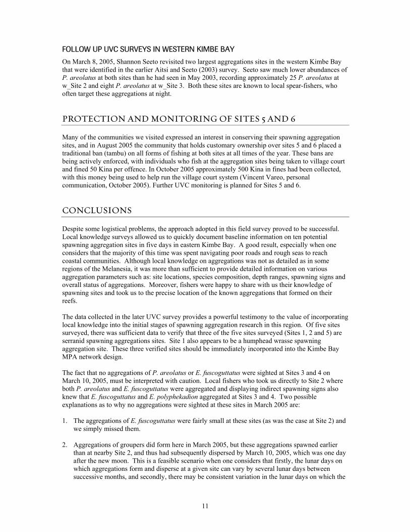
Aggregation Site # 2 Site name. Species names P. areolatus E. fuscoguttatus E. polyphekadion Local name vuli bado tia tili tia tili Location Coordinates Depth (m) Approx. 3 – 40m Habitat Reef promontory Duration
Month(s) of formation
Unknown. Fishers state sometimes aggregations are there, other times they are not. Have not attempted to mark lunar or annual seasonality with which aggregations form.
Sign of spawning Grouping, chasing, color change and gravid females. Type of aggregation Transient Time of spawning Type of spawning Moon phase Unknown Fish numbers Aggregation area (m. sq) Year discovered Location known for generations How discovered By fishers Year first exploited Exploited for generations Gear used Hook and line and spearguns CPUE trend Stable Current status Stable
Status parameters Fishes reported that no declines in total catch rates or Catch Per Unit Effort (CPUE) had occurred in their memory.
Management/Protection None
Additional notes
Dived here on the March 10, 2005, one day after new moon. Aggregations of P. areolatus and E. fuscoguttatus present. Both species displaying color change and chasing, and gravid females noted for both species. Aggregations were spatially separated, with P. areolatus aggregated in shallower water than E. fuscoguttatus. Fishers that exploit this site use the term vinivi in their local Meramera language. This word translates into “Hap bilong pis i bung” in Tok Pidgin, which in English means “The place where fish aggregate”.
Source

20
Aggregation Site # 3 Site name. Species names Epinephelus fuscoguttatus and Epinephelus polyphekadion
Local name
tai tili (This name is used for both E. fuscoguttatus and E. polyphekadion, with fishers identifying these two species as two different size classes of tai tili).
Location Coordinates Depth (m) Approx. 3 – 40 m Habitat Outer reef slope Duration
Month(s) of formation
Unknown. Fishers state sometimes aggregations are there, other times they are not. Have not attempted to mark lunar or annual seasonality with which aggregations form.
Sign of spawning Grouping, chasing, color change and gravid females observed. Type of aggregation Transient Time of spawning Type of spawning Moon phase Fish numbers Area of aggregation (m. sq) Year discovered Location known for generations How discovered By fishers Year first exploited Exploited for generations Gear used Hook and line and spearguns CPUE trend Stable Current status Stable
Status parameters Fishes reported that no declines in total catch rates or CPUE had occurred in their memory.
Management/Protection None
Additional notes Dived here on the March 10, 2005, one day after new moon. No E. fuscoguttatus or E. polyphekadion sighted.
Source

21
Aggregation Site # 4 Site name. Species names Epinephelus fuscoguttatus and Epinephelus polyphekadion
Local name
tai tili (This name is used for both E. fuscoguttatus and E. polyphekadion, with fishers identifying these two species as two different size classes of tai tili.
Location Coordinates Depth (m) Approx. 5-40 m. Habitat Promontory on outer reef. Duration
Month(s) of formation
Unknown. Fishers state sometimes aggregations are there, other times they are not. Have not attempted to mark lunar or annual seasonality with which aggregations form.
Sign of spawning Grouping of groupers around the promontory. Chasing and gravid females observed.
Type of aggregation Transient Time of spawning Type of spawning Moon phase Unknown
Fish numbers
Several spear-fishers said that in a large aggregation, 30-40 E. fuscoguttatus could be sighted in shallow water around the promontory. (NB: Spear-fishers do not use fins, and therefore are limited to fairly shallow water). Fishers also noted that this fish was more abundant in deeper water near the base of the slope (approx. 30- 40 m), which is the depth range they targeted when hook and line fishing.
Area of aggregation (m. sq) Year discovered Known for generations How discovered Fisher Year first exploited Exploited for generations. Gear used Hook and line and daytime spear fishing. Predominantly hook and line. CPUE trend Stable Current status Stable
Status parameters Fishes reported that no declines in total catch rates or CPUE had occurred in their memory.
Management/Protection None
Additional notes
Fishers that exploit this site use the term vinivi in their local Meramera language. This word translates into “Hap bilong pis i bung” in Tok Pidgin, which in English means “The place where fish aggregate”. Dived here on the March 10, 2005. No E. fuscoguttatus or E. polyphekadion seen, although habitat looked suitable to support large aggregations of both species.
Source

22
Aggregation Site # 5 Site name. Species names P. areolatus E. fuscoguttatus C. undulatus Local name sakuri are mami Location Coordinates Depth (m) 2 -20m. Habitat Reef promontory Duration Month(s) of formation Unknown Sign of spawning Grouping, chasing and multiple gravid females observed for P. areolatus. Type of aggregation Time of spawning Type of spawning
Moon phase
Unknown. Fishers have not attempted to mark lunar or annual seasonality with which aggregations form. There is a local belief that if one visits this site and aggregations of P. areolatus are not present, then the fisher must have broken some traditional customs that have caused the fish to depart (this area of reef was traditionally a tambu site).
Fish numbers
Fishers report ‘many more than 100 P. areolatus’ during a large aggregation. P. areolatus is reported to predominantly be found in very shallow water on the reef top, and it said to be the most numerically abundant grouper at this site.
Area of aggregation (m. sq) Year discovered 1960’s.
How discovered
A Fisher discovered this site by chance in the early 1960s when he was spearfishing. He was pursuing a large P. areolatus for some time along the reef, and it eventually led him to the aggregation site. He reports that himself and another spear-fisher who accompanied him could have shot at each other without worrying about hitting one another, as the P. areolatus were present in such high densities that they were ‘blocking out the water’.
Year first exploited 1960’s (year first discovered).
Gear used
Hook and line and spearfishing. Daytime spear-fishers (who do not use fins) report being able to take up to 20 P. areolatus from this site in several hours
CPUE trend Current status Unknown Status parameters Management/Protection Protected. (See this report) Additional notes Source

23
Aggregation Site # 6 Site name. Species names Plectropomus areolatus Local name sakuri Location Coordinates Depth (m) Habitat Reef promontory Duration Month(s) of formation Unknown Sign of spawning Grouping and chasing observed. Type of aggregation Transient Time of spawning Type of spawning
Moon phase Unknown. Fishers commented that aggregations always formed at this site at the same time that they formed at Site 5.
Fish numbers No estimates given. Fishers did state that this aggregation of P. areolatus is smaller than the aggregation that forms at the nearby Site 5.
Area of aggregation (m. sq) Year discovered How discovered Year first exploited Gear used Hook and line and spearfishing. CPUE trend Current status Status parameters Management/Protection Protected. (See this report)
Additional notes
Fishers who exploit Site 5 informed us of this aggregation site in passing when we returned on the 7-Mar-2005 to dive at Site 5. Fishers stated that the only serranid that aggregates at this site is P. areolatus.
Source

24
Aggregation Site # 7 Site name. Muguru Reef Species names Plectropomus areolatus Local name sakuri Location Coordinates Depth (m) Habitat Reef promontory Duration Month(s) of formation Unknown Sign of spawning Grouping, chasing and gravid females observed. Type of aggregation Transient Time of spawning Type of spawning
Moon phase Unknown. Fishers have not attempted to mark lunar or annual seasonality with which aggregations form.
Fish numbers No actual estimates given, but large numbers of P. areolatus said to be “just hanging around’ at this site during aggregation periods.
Area of aggregation (m. sq) Year discovered How discovered Year first exploited Gear used Hook and line and spearfishing. CPUE trend Current status Status parameters Management/Protection None
Additional notes
Kimbe TNC staff are going to mark the location of this site at a later date, and they also plan to carry out a verification dive at this site in the future on the new moon.
Source
25
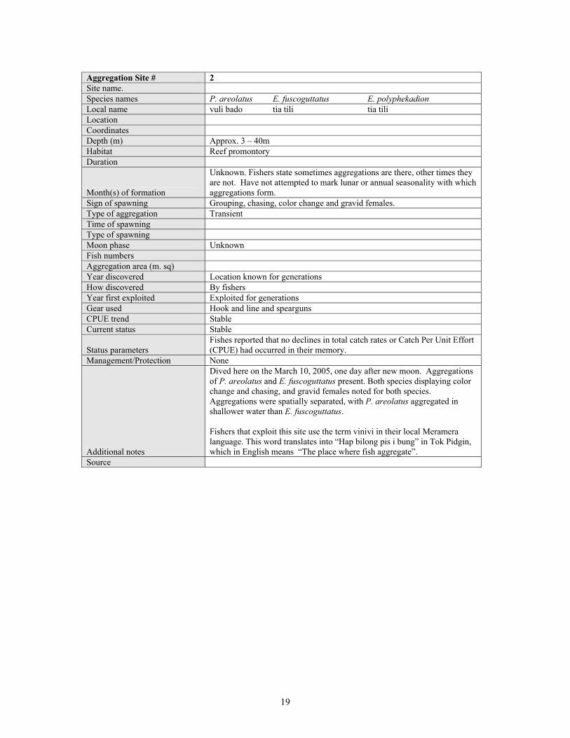
Aggregation Site # 8, 9, 10. Site name. Species names Plectropomus leopardus Local name eutu vuvu Location Coordinates Depth (m) Between approximately 10 -30 m for all sites Habitat Outer reef slopes that terminate in sand at 20 -30 m of depth Duration Several days Month(s) of formation Aggregations said to occur throughout the year Sign of spawning Grouping, gravid females Type of aggregation Time of spawning Type of spawning
Moon phase
Unknown. Fisher reports that often P. leopardus will not be present at the sites, but sometimes they are very plentiful. Made the observation that when an aggregation of P. leopardus forms at one site, aggregations will always have formed at all of the other known sites.
Fish numbers Less than 100.
Area of aggregation (m. sq)
Small aggregations. Fisher reported that all P. leopardus aggregations occurred over no more than approximately 50 linear meters of reef slope. This species is known to form small aggregations on the Great Barrier Reef, Australia (Samoilys, 1997).
Year discovered All sites reported to have been discovered by a single fisher in the 1980s and 1990s.
How discovered While fishing Year first exploited Since discovered
Gear used Hook and line. Fishing is said to be best between 6-8 am and between 4-6 pm.
CPUE trend Stable. 15-17 P. leopardus can be captured from an aggregation in several hours
Current status Stable
Status parameters
The fisher interviewed reports that catch rates from these aggregations have remained unchanged since 1981 when he first discovered and started targeting these sites.
Management/Protection None
Additional notes
Fishing pressure on these aggregations is light. Fisher who discovered these aggregations is reported to be the only individual who consistently targets them, with fishing predominantly for subsistence purposes. Occasionally captured fish are sold and marketed. Low numbers of P. areolatus, E. polyphekadion and C. undulatus are also reported to be taken from some of these sites during aggregation periods. Fisher who showed us these aggregation sites said that in total he knows of 10 P. leopardus aggregation sites within his traditional fishing grounds. Due to time constraints and very rough whether, we only marked the locations of three of these sites.
Source

26
APPENDIX 2. Dive log for each UVC Survey.
Date: 7-Mar-05 Time: 4 pm Divers: Richard Hamilton, Joe Aitsi and Annisah Sapul Site No. 5 Site name: Maximum depth: 15 m Visibility: 5 m Conditions: Rough seas, moderate current and raining The following number of fish were sighted by Richard Hamilton
Species Approximate number sighted Spawning signs Plectropomus areolatus 20 Grouping and chasing. Epinephelus fuscoguttatus 1 None Remarks: This dive was conducted in rough conditions and very bad visibility. It was also the first SCUBA dive that several members of the survey team had done in some time. For these reasons the dive was kept shallow. Richard Hamilton led the dive and he sighted the majority of the P. areolatus at the start of the dive in shallow water of 2-5 m on the reef lip. This is where local fishers say the P. areolatus are most concentrated. P. areolatus tended to flee out of sight shortly after being sighted. A sole E. fuscoguttatus was sighted in approximately 10 m of water. The walls of this promontory appear to drop steeply, although we did not go deep enough to see at what point this wall gave way to a gentler slope. It may be that aggregations of E. fuscoguttatus and E. polyphekadion that are reported to occur here had aggregated in deeper water at this site. Given the very poor visibility the counts of P. areolatus should only be taken to confirm that an aggregation was present. Actual numbers at the site may have been much higher than those seen.

27
Date: 9-Mar-05 Time: 2 pm Divers: Richard Hamilton, Joe Aitsi, Annisah Sapul and Philip Lahui Site No: 1 Site name: Maximum depth: 25 m Visibility: 30 m Current: Slow The following fish number of fish were sighted by Richard Hamilton
Species Approximate number Spawning signs Plectropomus areolatus 150 -200 Grouping, chasing, color change,
shimmering, multiple gravid females.
Cheilinus undulatus
15-20 Grouping of several very large males and many small (400 mm – 600 mm SL) individuals that were presumably females.
Epinephelus polyphekadion 1 None Remarks Richard Hamilton snorkeled at this site a week before the new moon in the afternoon on March 2, 2005. He sighted a high abundance and diversity of fish and six P. areolatus were sited around the promontory, indicating that an aggregation had began to form. Several large Plectropomus lavis and a large feeding school of Bolbometopon muricatum (50 fish) were also seen. On the March 9, 2005 P. areolatus were densely aggregated around both sides of the promontory between 5-30 m of water. Small females in the yellow/green color phase appeared to outnumber larger P. areolatus. Courtship behavior was observed in P. areolatus, with males repeatedly shimmering in front of stationary females. This was a very enjoyable dive. The corals at this site are spectacular and there was a very high abundance and diversity of fish, sharks, rays and turtles around the promontory. This site is located a considerable distance offshore, and visibility here was far better than at the near shore sites visited (Figure 4).

28
Figure 4: Some of the humphead wrasse that were aggregated around the promontory at Site 1 on the March 9, 2005.

29
Date 10-Mar-05 Time : 10 am Divers Richard Hamilton, Joe Aitsi, Annisah Sapul and Philip Lahui Site No: 4 Site name Maximum depth: 25 m Visibility 25 m Current: None The following fish number of fish were sighted by Richard Hamilton
Species Approximate number Spawning signs Variola louti 15 Gravid females observed Plectropomus oligocanthus 6 None Cheilinus undulatus 2 None Remarks This site is reported to be an aggregation site for E. fuscoguttatus and E. polyphekadion with aggregations occurring around the promontory in shallow and deep water. We commenced the dive up current from the promontory and proceeded to dive around the promontory. The reef habitat around the promontory looked like a likely spawning aggregation area. In particular, the gently sloping outer reef slope between 15 – 30 m depth looked like the typical reef habitat that E. fuscoguttatus and E. polyphekadion aggregate on to spawn. Despite this neither of these species were sighted on this dive. There was unusually large numbers of Variola louti sighted on this dive, and several very gravid females of this species were sighted. V. louti were not notably concentrated at any one place on the reef.
30
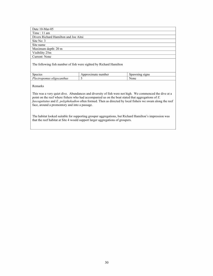
Date 10-Mar-05 Time : 11 am Divers Richard Hamilton and Joe Aitsi Site No: 3 Site name Maximum depth: 20 m Visibility 25m Current: None The following fish number of fish were sighted by Richard Hamilton
Species Approximate number Spawning signs Plectropomus oligocanthus 5 None Remarks This was a very quiet dive. Abundances and diversity of fish were not high. We commenced the dive at a point on the reef where fishers who had accompanied us on the boat stated that aggregations of E. fuscoguttatus and E. polyphekadion often formed. Then as directed by local fishers we swam along the reef face, around a promontory and into a passage. The habitat looked suitable for supporting grouper aggregations, but Richard Hamilton’s impression was that the reef habitat at Site 4 would support larger aggregations of groupers.

31
Date 10-Mar-05 Time : 2 pm Divers Richard Hamilton, Joe Aitsi, Annisah Sapul and Philip Lahui Site no. 2 Site name Maximum depth: 25 m Visibility 20 m Current: None The following fish number of fish were sighted by Richard Hamilton
Species Approximate number Spawning signs Plectropomus areolatus 40-50 Grouping, color change and
chasing. A speared male was running ripe.
Epinephelus fuscoguttatus 15-20 Grouping, color change, chasing Remarks Local fishers took us directly to this site and told us to dive around a promontory on the reef wall. Very shortly after entering the water we saw aggregations of both P. areolatus and E. fuscoguttatus. The aggregation was fairly small and occurred over a narrow area of the reef. Consequently we were able to transverse the aggregation several times. The aggregations of these two species were spatially separated with P. areolatus aggregated in shallower water than E. fuscoguttatus. Most of the E. fuscoguttatus seen were very large individuals. On one occasion we saw an unusual behavior where a large (presumably male) E. fuscoguttatus swam up above another slightly smaller E. fuscoguttatus that was stationary on the reef. The large E. fuscoguttatus then changed from its normal color to completely white in a split second, before changing back to its normal color pattern. A P. areolatus was speared so that we could examine the state of its gonads. The speared individual was a running ripe male with milt extractable by simply applying light pressure to its abdomen.

32
APPENDIX 3. Insecticide replaces traditional derris root fish poison
During this field trip we heard several accounts of how commercial insecticide, that is cheap and readily available in trade stores in Kimbe Bay, is being increasingly used as a more efficient and modern alternative to derris root fish poison. Informants told us accounts of how commercial grade insecticide is mixed in with buckets of water and used to poison both marine and freshwater fish. In rivers, fishers run a net across the river then dump the insecticide upstream. While in the sea fishers either dump insecticide on shallow reefs during low tides (a similar practice to traditional derris root) or they target pelagic schools of fish (such as small scrombids or carangids) that are close to the surface. The affect on both fresh and marine fish is said to be devastating, with fishers reporting that “everything dies”. Fishers also stated that fish died far quicker and over a far greater area than when derris poison was used. This extremely destructive and unselective fishing practice appears to be as potentially damaging to humans as it is on the ecosystems it is used in. Fishers reported that if fish that are captured using insecticide are not washed properly then individuals who consume these fish can experience palpitations and what they described as “a hot heart”. On March 9, 2005, we by chance observed fishers from Ulamona poisoning a large school of sardines. We were unable to identify or quantify the type of poison used, but insecticide was suspected given the very large area over which fish died, and the fact that fishers were generally not willing to talk to us about what poison had been used to kill the fish. Fish were poisoned in a black sandy bay and we arrived after the poison had been dumped in the water and when fishers were collecting dying and dead fish (Figure 5 and 6). Fishers that had goggles or masks were free diving, but the majority were simply using their hands to collect stunned and dying fish that were near the surface. Fish lay scattered over the seabed from 1-40 meters depths over hundreds of linear meters (Figure 7 and 8). It was obvious that the vast majority of fish that had died were in water too deep for free divers to access.
Figure 5: Fishers collecting poisoned fish. The poison was dumped by fishers seen in the canoes in the background.
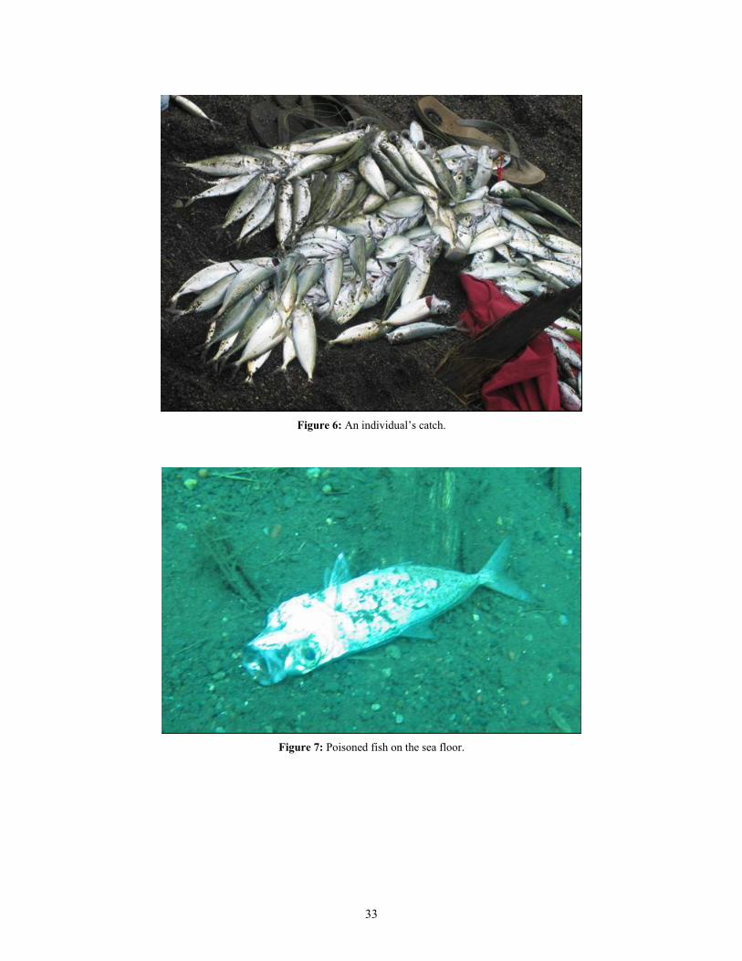
33
Figure 6: An individual’s catch.
Figure 7: Poisoned fish on the sea floor.

34
Figure 8: A bird’s eye view of just some of the thousands of dead fish that covered the seabed, most of which were well outside of free divers range.