Explanation Based Learning of Indirect Speech Act Interpretation Rules

MOSSEL BAY SPATIAL DEVELOPMENT FRAMEWORK (15.2574)
CNdV africa (Pty) Ltd DRAFT STATUS QUO REPORT
28 October 2016
page v
LIST AND EXPLANATION OF ACRONYMS AADT Average Annual Daily Traffic Volumes
ART Anti-Retroviral Treatment
BNG Breaking New Ground (new term for RDP (low income) housing)
CBA Critical Biodiversity Areas
DEADP Department of Environmental Affairs and Development Planning
DFA Development Facilitation Act (Act 67 of 1995)
DORA Division of Revenue Act, 2013 (Act 2 of 2013)
DTI Department of Trade and Industries
DWAF Department of Water Affairs and Forestry
EIAs Environmental Impact Assessments
EMF Environmental Management Framework
EMP Environmental Management Plan
ESA Ecological Support Areas
GIS Geographic Information System
GVA Gross Value Added
HIV/AIDS Human Immuno-deficiency Virus / Acquired Immune Deficiency
Syndrome
HSP Housing Sector Plan
HSP Human Settlement Plan
ICMP Integrated Coastal Management, Act No. 24 of 2008
IDP Integrated Development Plan
IPCC Intergovernmental Panel on Climate Change
IRPTN Integrated Rapid Public Transport Network
IRTN Integrated Rural Transport Network
ITP Integrated Transport Plan
IWMP Integrated Waste Management Strategy
LED Local Economic Development
LNG Liquid Natural Gas
LUMS Land Use Management System
LUPO Land Use Planning Ordinance, 1985 (Ordinance 15 of 1985)
MLRA Marine Living Resources Act (Act 18 of 1998)
MPCC’s Multi-Purpose Community Centres
MSA Municipal Systems Act, 2000 (Act 32 of 2000)
NBSAP National Biodiversity Strategy and Action Plan
NC PSDF Northern Cape Provincial Spatial Development Framework
NDP National Development Plan
NDPG Neighbourbood Development Partnership Grant
NEM:PAA National Environmental Management: Protected Areas Act, 2003
(Act 57 of 2003)
NFEPA National Freshwater Ecosystem Priority Areas
NGO Non-Governmental Organisation
NHA National Health Act 2003 (Act 61 of 2003)
NMT Non-Motorised Transport
NPC National Planning Commission
NSDP National Spatial Development Perspective
PGDS Provincial Growth and Development Strategy
PLAS Land for Proactive Acquisition
PLTF Provincial Land Transport Framework
PTP Public Transport Plan
RDP Reconstruction and Development Programme
RIDS Regional Industrial Development Strategy
SDF Spatial Development Framework
SEA Strategic Environmental Assessment
SIP Strategic Infrastructure Plan
SOEs State Owned Enterprises
SPC Spatial Planning Category
VIPL Ventilated Improved Pit Latrines
WC-PSDF Western Cape Provincial Spatial Development Framework
WSDP Water Services Development Plan
WWTWs Waste Water Treatment Works
MOSSEL BAY SPATIAL DEVELOPMENT FRAMEWORK (15.2574)
CNdV africa (Pty) Ltd DRAFT STATUS QUO REPORT
28 October 2016
page 1
1. INTRODUCTION
1.1 PURPOSE OF THIS REPORT
The purpose of this report is to provide an understanding of the state of the
Mossel Bay Municipality (see Figures 1.1.1 and 1.1.2) and the various issues
facing it in order to prepare a Spatial Development Framework to help
address those issues from a Spatial Perspective.
The report is structured in the following manner:
Section 1 describes the purpose and need for an SDF.
Section 2 describes a number of national provincial, district and local
guidelines, policy documents and concepts, all of which have a bearing
on the SDF.
Section 3 describes the current state of the Municipality under the following
subsections:
Natural Systems;
Socio-economic systems; and,
Built Systems.
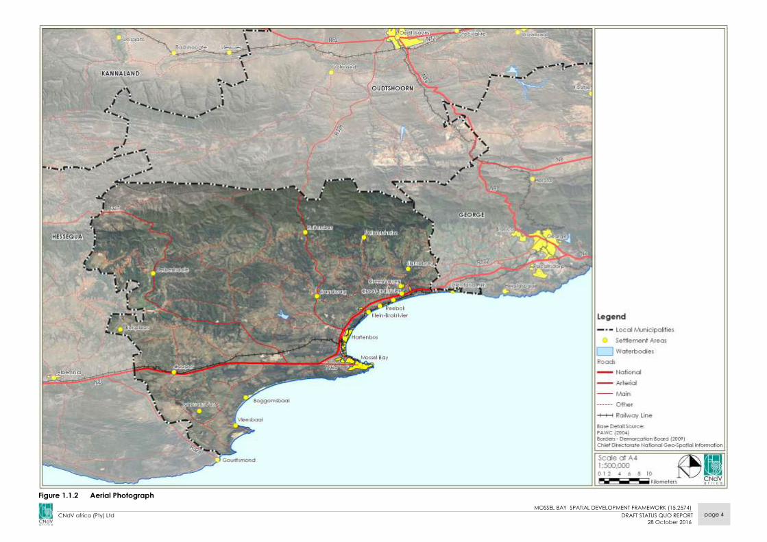
1.2 BRIEF OVERVIEW OF MOSSEL BAY MUNICIPALITY
The Mossel Bay Municipality is located in the eastern region of the
Western Cape Province, see Figure 1.1.1.
The main settlements in the Municipality are: Mossel Bay town,
Hartenbos, Vleesbaai, Dana Bay, Groot Brakrivier and Klein Brakrivier.
The Municipality has a population of approximately 89 412 people
(Census, 2011).
1.3 WHAT IS AN SDF AND WHY IS IT NEEDED?
The spatial management of growth in urban and rural environments due
to rapid urbanisation rates and the subsequent impact on resources was
previously done through the Guide Plans and Structure plans. These took
the form of rather inflexible master plans which were underpinned by the
principles of discrimination and separate development.
The new democratic government, post 1994, adopted a new system of
spatial planning described in the Development Facilitation Act, now
replaced by the Spatial Planning and Land Use Management (SPLUMA),
and Municipal Systems Act. This new system had two components to it.
The first is an indicative plan or Spatial Development Framework (SDF) that
was intended to show desired patterns of land use, directions for future
growth, indicate the alignment of Urban Edges, and depict other special
development areas.
The impact of SDFs is limited to providing policy to guide and informing
land development and management. They do not change or confer real
rights on land. This is done by the second component, the second
component is the Land Use Management System (LUMS). This is similar to a
town planning or zoning scheme. In many instances where they have not
been replaced or repealed these still take the place of LUMS. In contrast to
SDF’s LUMS have a binding effect on the development rights attributed to
land and confer real rights on properties.
Because development in Municipalities is dynamic and responds to
changing socio-economic and environmental circumstances, it is
impossible to predict the exact requirements of development rights in
every instance; therefore, LUMS may be amended from time to time to
take into account these changing circumstances. This is normally achieved
through the processing of rezonings, subdivisions and removal of title deed
restrictions applications.
It is in these instances where SDF’s play an important role in guiding
appropriate future change and helping to guide motivations as to the
need and desirability, or not, of proposed land use changes.
Because of their guiding and informing nature SDF’s also have a number of
other important functions in addition to guiding LUMS.

MOSSEL BAY SPATIAL DEVELOPMENT FRAMEWORK (15.2574)
CNdV africa (Pty) Ltd DRAFT STATUS QUO REPORT
28 October 2016
page 2
Figure 1.1.1 Study Area
MOSSEL BAY SPATIAL DEVELOPMENT FRAMEWORK (15.2574)
CNdV africa (Pty) Ltd DRAFT STATUS QUO REPORT
28 October 2016
page 3
These include:
Giving effect to the five spatial principles contained in SPLUMA, see
Section 2.1.1;
Setting out objectives that reflect the desired spatial form;
Defining strategies and policies to achieve these objectives which must
indicate, amongst others:
- the desired pattern of land use;
- how spatial reconstruction will be addressed; and
- providing strategic guidance in respect of the location and nature
of development. (In this regard it should be noted that the SDF’s
should inform the investment decisions of the public and the
private sectors.)
Set out a capital investment framework for development programs;
(this will mainly inform public sector investment priorities);
Include a Strategic Environmental Assessment (SEA) in the compilation
of the SDF;
Identify programs and projects for development of land;
Be aligned with neighbouring Municipal SDF’s; and,
Provide a visual representation of the designed spatial form with the
Municipality in the form of a map which must indicate the following:
- public and private land development and infrastructure
investment;
- desired and undesired use of land;
- may delineate the Urban Edge;
- identify areas for strategic investment;
- where policy intervention is needed; and,
- indicate where authority spending is required.
Informing the spatial location of budget spending in the IDP, see
Section 2.4.1.
1.4 LEGAL STATUS OF THE SDF
Within the limitations of a SDF as laid down by the Local Government
Municipal Systems Act, 2000 (Act 32 of 2000) i.e. that it should be a guiding
and informing document and does not confer real rights on land, it is
intended that the SDF should be a binding document endorsed by the
Municipal Council. The SDF must be approved by Council in terms of the
MSA, and as a sector plan of the IDP. This endorsement will assist with the
processing of development applications, demonstrating compliance with
different sectoral policies and motivating project funding and budgets.
SPLUMA stipulates, inter alia, that any authority mandated to make a land
development decision in terms of the Act or any other law relating to land
development, may not make a decision which is inconsistent with a MSDF
unless site-specific circumstances justify deviation from the provisions of
such MSDF.
1.5 RELATIONSHIP WITH OTHER PLANS
The SDF links the development objectives taken from the Integrated
Development Plan (IDP) and the Budget of a particular Municipality.
Therefore, the SDF becomes the spatial presentation of the IDP objectives
that guide projects funded through the budget of the local Municipality.
This link between the SDF, IDP and Budget is shown in Figure 1.5.1.
Figure 1.5.1 Link between SDF/IDP/Budget
The Mossel Bay Municipal SDF is further linked to other spatial policies at
different levels of detail depending on their level of jurisdiction. The
National Development Plan (NDP, 2030) and National Spatial
Development Perspective (NSDP) provides the broad national
development goals, objectives and strategies. This informs the Western
Cape Provincial SDF (WC-PSDF). The WC-PSDF in turn informs the Eden
District Council SDF. The Eden SDF then informs the preparation of the
Mossel Bay Municipal SDF.
SDF Budget
IDP
MOSSEL BAY SPATIAL DEVELOPMENT FRAMEWORK (15.2574)
CNdV africa (Pty) Ltd DRAFT STATUS QUO REPORT
28 October 2016
page 4
Figure 1.1.2 Aerial Photograph

MOSSEL BAY SPATIAL DEVELOPMENT FRAMEWORK (15.2574)
CNdV africa (Pty) Ltd DRAFT STATUS QUO REPORT
28 October 2016
page 5
It should be noted that the hierarchy is not only top down but also bottom
up, i.e. the lower level plans also inform the higher level plans through the
updating process as a result of more local level detailed information.
The lower the level of the plan the more detailed the plan becomes and
vice versa. This is illustrated in Figure 1.5.2.
Figure 1.5.2 Layers of SDF and Level of Detail
The SDF should consider the impact of the natural environment (rivers,
sensitive areas) as well as built environment aspects such as housing,
infrastructure and socio-economic issues relating to economy, human
development indicators, etc.
The SDF must guide all of the Municipality’s departments as well as national
sector departments, State Owned Enterprises (SOEs) and the private
sector.
Therefore, the SDF is informed by and in turn informs the plans and activities
of the various municipal line departments, see Figure 1.5.3.
Figure 1.5.3 SDF relationship to sector plans
1.6 CONSULTANT’S BRIEF
The consultants brief is to prepare an SDF for the Mossel Bay Local
Municipality.
The following methodology, in line with both the national and provincial
guidelines for the preparation of Spatial Development Frameworks, see
Figure 1.6.1, is used in this project:
Figure 1.6.1 Phases in the process of completing an SDF (source: CNdV, 2010)
The following serves as specific foci:
1.6.1 CRITICAL MILESTONES AND DELIVERABLES
Milestones mark the end of each phase of the project to ensure a credible
and comprehensive SDF as required by the above policy and regulation.
The four products mentioned above form the milestones for this project.
Inc
rea
sin
g le
ve
l o
f d
eta
il
1
2
3
OVERBERG DISTRICT SDF
EDEN DISTRICT SDF
WEST COAST DISTRICT SDF
OVERSTRAND
MUNICIPAL SDF
MOSSEL BAY
MUNICIPAL SDF
MATZIKAMA
SDF
WESTERN CAPE PSDF
Dis
ast
er
Ma
na
ge
me
nt
LED
SM
MEs
Tra
nsp
ort
atio
n
Hu
ma
n S
ett
lem
en
ts
En
vir
on
me
nt
Wa
ter
Ma
na
ge
me
nt
SDF
Are
a B
ase
d P
lan
(Dis
tric
t Le
ve
l)

MOSSEL BAY SPATIAL DEVELOPMENT FRAMEWORK (15.2574)
CNdV africa (Pty) Ltd DRAFT STATUS QUO REPORT
28 October 2016
page 6
Figure 1.1.3 Mossel Bay Municipality in the Eden District Municipality

MOSSEL BAY SPATIAL DEVELOPMENT FRAMEWORK (15.2574)
CNdV africa (Pty) Ltd DRAFT STATUS QUO REPORT
28 October 2016
page 7
It is expected that each milestone should cover several deliverables. Below
is a list of deliverables for each of the four milestones.
The following products of the SDF will be produced in the different phases
of the SDF as shown in Figure 1.6.1:
Product One: Inception Report
Product Two: Spatial Analysis of the Current Reality (Status Quo) Report
Product Three: Conceptual Spatial Development Framework (draft SDF)
Product Four: Final SDF Implementation Strategies and Programmes
PRODUCT 1 INCEPTION REPORT
The inception report should describe details pertaining to the project
process (contained in a work plan). As part of this phase a project
inception meeting will be conducted with the client to agree on a process
forward and deliverables/products of the SDF. The starting date of the
project and agreed payment schedule will also be noted in this report.
PRODUCT 2 SPATIAL ANALYSIS OF THE CURRENT REALITY (STATUS QUO)
This section should include a spatial analysis with maps, and indicate the
following:
Municipal-wide spatial issues (in relation to the needs identified) and
existing project proposals (including their locality);
The municipal investment and spending patterns. For example, are the
Municipality spending patterns:
o aligned with the DFA; and,
o biased towards urban areas or rural settlements?
The status of a Comprehensive Rural Development Programme (CRDP)
in the Municipality; and how does the proposals relate spatially and
economically to the adjacent settlements and towns? and,
A review, where necessary, of the existing municipal policies, plans,
resolutions and by-laws, pertaining to spatial planning, supportive of
what the Municipality wants to achieve in particular with regard to rural
development; or do they need to be revised?
Spatial implications of applicable provincial and national plans,
legislation, policies, strategies and directives including:
o the District SDF
o Provincial SDF
o the Growth and Development Strategy
Settlement spatial patterns and dysfunctionalities including:
o Evidence of urban sprawl, integration and spatial impacts,
effects of apartheid
o Status of the environment and its functioning as a system of
eco-system services
o Feasibility and progress with IDP proposals
Identification and analysis of existing nodal points indicating their:
o Viability and sustainability for promoting economic growth
Identification and analysis of strategic located vacant land and land
with development potential:
o Note, only important vacant land should be described.
Analysing every piece of land in the rural Municipality should be
avoided
Major structuring elements, urbanisation trends and their spatial
implication in the Municipality;
Strategic roads and transportation networks (district, provincial and
municipal roads):
o Level of functionality and contribution to the system as a whole
o A need for new roads
o Roads which need to be upgraded and for what reason.
o Roads whose upgrading will boost the economic growth of the
Municipality, etc.
Location and trends of basic services and infrastructure:
o Demand for services and infrastructure
o Alignment with other development programs including
highlighting dysfunctionalities
Housing (human settlements):
o Location of BNG housing
o Viability of locations from an economic and access point of
view?
o Existence of supporting infrastructure
o Restructuring Zones
o GAP/Social Housing
Environmental degradation, conservation and sensitive areas and the
impact which specific development may have on the environment:

MOSSEL BAY SPATIAL DEVELOPMENT FRAMEWORK (15.2574)
CNdV africa (Pty) Ltd DRAFT STATUS QUO REPORT
28 October 2016
page 8
o No development areas
o Where some development could be allowed with strict
management
Agriculture:
o Agricultural potential
o Land currently affected by land claims
o Land requirements for other purposes
Land reform:
o Areas suitable for land reform purposes
o Clarify what type of land is more suited to land reform than
others
Sports:
o Location of major sporting nodes or areas and status of relevant
infrastructure
Spatial relationships between urban and rural areas:
o Nature of urban / rural interfaces
o Nature of relationship between the two
o Patterns of infrastructure, deficits of poverty, welfare grants,
markets thresholds, economic or cultural activities
The relationship between the spatial issues and the vision of the
Municipality:
o Alignments or contradictions including relationships with
surrounding municipalities.
SPATIAL PERSPECTIVE OF THE IDP OF THE MUNICIPALITY
Because the SDF should also include a spatial representation of the IDP,
understanding and interpreting the IDP spatially is seen as an important
phase of the process. Therefore, this section should also include the
following:
Highlight the vision and mission of the IDP and its spatial implications;
Confirm the interrelationship of the Municipality’s vision and that of the
district from a spatial planning point of view;
Identify key principles and strategies as contained in the IDP and how
they translate spatially;
Delineate the municipal boundary, settlements, farms and wards; and,
Map the area where the main pressing needs and the proposed multi-
sector project(s) are located.
PRODUCT 3 CONCEPTUAL SPATIAL DEVELOPMENT FRAMEWORK
This information should be summarised to determine the way forward in
terms of how the Municipality should be shaped from a spatial point of
view.
In this phase the conceptual proposals are developed. They should
indicate how the spatial form of the Municipality should be shaped and
links with the outcomes of the two phases mentioned above.
This section should include and map the following:
Relevant objectives and principles that will guide activities into the
desired spatial form;
The macro-conceptual framework showing the desired spatial form
including how the Municipality should be portrayed as to how it will
function sustainably as a system;
A micro spatial plan of key focus/growth/nodal points in the
Municipality;
Horizontal and vertical alignments of the conceptual SDF with other
relevant plans such as PGDS, NSDP, District SDF and District IDP, etc;
Priority settlements for the implementation of the CRDP;
Rural towns needing revitalisation;
Strategic located land for agri-villages and agro-industries;
Land to be acquired or reserved for land reform activities including
land for proactive acquisition (PLAS) by the Department of Rural
Development and Land Reform;
Strategic sites for Thusong Service Centres (formerly also known as Multi
Purpose Community Centres (MPCC’s));
Strategic development areas and priority areas for investment;
Viable land for housing and other economic development and
supporting infrastructure;
Viable and functional nodal points, and identify potential nodes and
how they should be developed;
Nodes without development potential. Name or identify the nodes;
Functional development corridors and how they should be developed
to support the nodes;
Urban edges and direction for growth for any of the different areas at
micro framework level and for the Municipality as a whole at macro
level;

MOSSEL BAY SPATIAL DEVELOPMENT FRAMEWORK (15.2574)
CNdV africa (Pty) Ltd DRAFT STATUS QUO REPORT
28 October 2016
page 9
Functional and integrating municipal/district roads and public
passenger transportation network;
Proposals for upgrading of or new roads;
Proposed major bulk infrastructure for the whole Municipality;
Where appropriate, include new bulk infrastructure and the relevant
services;
Environmental conservation and sensitive areas;
Major sporting nodes as well as areas with tourism potential;
High agricultural potential and areas affected by claims which
Municipality needs the most for developmental purposes; and,
Areas needing urgent policy intervention.
PRODUCT 4 FINAL SDF WITH IMPLEMENTATION STRATEGIES AND
PROGRAMMES
This is the most important phase of the SDF in which the ideas as
conceptualised in the previous phases should be realised. For
implementation to succeed it is necessary to ensure the following from the
start of the process:
There should be a strategic vision for the spatial structure of the
Municipality as a whole shared by councillors, all the municipal
department’s officials, the district in which the Municipality is located,
national the sector departments and the private sector;
The development of the SDF should be consultative from the beginning
until to the end of the process; and,
There should be strategies and processes in place to involve the
relevant decision-makers and stakeholders.
From this work the following deliverables should be included in the SDF:
Relevant strategies and policies to implement the framework and
determine the points of intervention by the Municipality; and,
Amendments to the relevant sector plans to facilitate the
implementation of the SDF.
Note: Except for Land Use Management System (LUMS), most of the
implementation of the SDF will occur via the sector implementation
plans, e.g. HSP, SIP, PTP, disaster management, LED, EMF. The SDF
provides the spatial guidance to all of these plans.
Sector plans must always be aligned to advance the interests of the
SDF and hence the IDP, see Figure 1.6.2.
Land ownership with updated cadastral information that can be used
by the Municipality as part of a land audit;
Guidelines for transportation, infrastructure and other sector plans,
policies and plans;
LUMS guidelines or recommendations for the formulation of a land use
management scheme (not included in this brief);
Figure 1.6.2 Proposed Relationship between IDPs, Implementation Plans, including HSPs and
SDFs (source: CNdV 2010)
Tools (densification, infill, redevelopment, greenfields) to facilitate
development in strategic areas;
Recommend strategies to facilitate linkages between rural and urban
areas;

MOSSEL BAY SPATIAL DEVELOPMENT FRAMEWORK (15.2574)
CNdV africa (Pty) Ltd DRAFT STATUS QUO REPORT
28 October 2016
page 10
Proposals on how to ensure the sustainability of land with high
agricultural production potential; and,
An Implementation Plan that summarises the following from the sector
implementation plans:
o Capital Expenditure Framework for the Municipality’s
development programmes and budget process;
o Prioritised list of developmental interventions and spatial
location;
o Cost and budget estimates;
o Timing and phasing of development;
o Sources of finance;
o Implementation agent and their roles and responsibilities;
o Recommendations for the revision of existing policies or
strategies, where necessary;
o Proposals on how the SDF can be used for the implementation
of projects by Sector Departments;
o Institutional capacity recommendations; and,
o Review of trends and alignment with adjacent municipalities
with those of the Municipality under consideration.
The following general deliverables are to be included:
i. Resumes of meetings;
ii. Powerpoint slide shows and hand-outs of presentations;
iii. Reports to be produced incrementally as project progresses;
o Inception Report;
o Status Quo Report;
o Conceptual Framework Report; and,
o Final Spatial Development Framework (complete report).
All of these products should be compatible with national, provincial and
district GIS databases.
PRODUCT 5 PARTIAL ENVIRONMENTAL MANAGEMENT FRAMEWORK (EMF)
A need to develop an EMF which will allow for the delisting of certain
activities will form part of this SDF process. The following environmental
factors will be addressed as well.
Sufficient detail to allow for all land within the urban edge to be
approved as an urban area in terms of NEMA;
Sufficient strategic environmental information in order for the
competent authority to consider approving a Strategic Environmental
Assessment (SEA) in terms of SPLUMA and/or NEMA which includes a
strategic assessment of the environmental pressures and opportunities
within the municipal area, including the spatial location of
environmental sensitivities, high potential agricultural land and coastal
access strips, where applicable, through which geographical areas are
identified to facilitate subsidized, informal housing or strategic municipal
infrastructure projects to be excluded from obtaining Environmental
Impact Assessments (EIAs) in future; and
A scenario plan which should consider the economic and spatial
impacts related to PetroSA activities within the Municipal area.

MOSSEL BAY SPATIAL DEVELOPMENT FRAMEWORK (15.2574)
CNdV africa (Pty) Ltd DRAFT STATUS QUO REPORT
28 October 2016
page 11
1.7 THE ECOLOGICAL SOCIO-ECONOMIC RELATIONSHIP (ESER)
FRAMEWORK
Various references have been made to the importance of environmental
sustainability. This has to be achieved at the same time as urgently meeting
a number of socio-economic demands and requirements facing
Stellenbosch Municipality’s rural areas.
Therefore, there is a need to find a way to mediate all of these competing
requirements. This has given rise to the Ecological Socio-economic
Relationship Framework. This is used to inform the methodology in the
Status Quo section of this report, see Section 3.
1.7.1 Ecological Socio-economic Relationship
This framework is based on the principle that the relationship between
economic efficiency, social justice and human wellbeing, and ecological
integrity is not one of equal and overlapping spheres where losses in the
one can be set off by enhancements in another.
Rather, it recognises; firstly, that economic efficiency is wholly dependent
on the quality of human resources and their ability to deliver productive
into the economic system; and,
Secondly, economic activities and social development are in turn wholly
labour dependent on the availability of eco-system services (land, water,
arable land, and building materials). They cannot demand more from eco-
system services than their capacity to deliver on a long term sustainable
basis.
This is because there is only one planet and it operates within a closed
ecological cycle. Therefore, it is not possible to exceed the capacity of this
system in the long term. Any over-demand in the short term will lead to
long term negative consequences.
Figure 1.7 illustrates this relationship by depicting economic efficiency as a
circle nesting within social justice and human capital which, in turn, both
nest within the circle of ecological integrity. This illustrates graphically the
dependence of economic development and human reproduction on
available supply of eco-system services.
Figure 1.7 The Ecological Socio-economic Relationship
1.7.2 The Closed Ecological Cycle
The mediating relationship between the three components of the ESER
Framework is found within the Closed Ecological Cycle and its four
components of Extraction, Social Reproduction, Production and
decomposition, see Figure 1.8.
The only external input is solar energy. Everything else is found within the
confines of the planet’s finite resources. The closed ecological cycle
acknowledges that levels of production cannot exceed what is available
in terms of human resources (human reproduction) and what can be
extracted from the natural environment. In turn, for the cycle to remain in
balance, waste outputs from economic production and human
reproduction processes cannot exceed the capacity of environmental
sinks (decomposition) to absorb them, see Figure 1.8.
The interaction between the Ecological Socio-economic Relationship and
the Closed Ecological Cycle creates a framework on which the inputs and

MOSSEL BAY SPATIAL DEVELOPMENT FRAMEWORK (15.2574)
CNdV africa (Pty) Ltd DRAFT STATUS QUO REPORT
28 October 2016
page 12
outputs of a number of economic activities and eco system services can
be measured and managed, see Figure 1.8.
Figure 1.8 The Closed Ecological Cycle
1.7.3 Extraction
Primary extractive economic activities such as mining, fishing, agriculture
and forestry are directly dependent on the capacity of land resources
such as geology, soil, and biodiversity as well as water resources from rivers,
groundwater and estuaries and coastlines for their production. The extent
and way in which these resources are extracted has a great bearing on
their sustainability.
Figure 1.9 Extraction
MOSSEL BAY SPATIAL DEVELOPMENT FRAMEWORK (15.2574)
CNdV africa (Pty) Ltd DRAFT STATUS QUO REPORT
28 October 2016
page 13
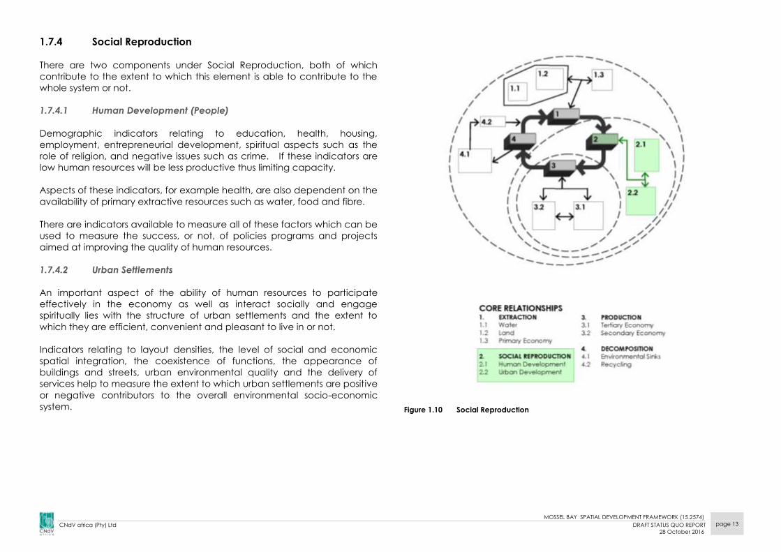
1.7.4 Social Reproduction
There are two components under Social Reproduction, both of which
contribute to the extent to which this element is able to contribute to the
whole system or not.
1.7.4.1 Human Development (People)
Demographic indicators relating to education, health, housing,
employment, entrepreneurial development, spiritual aspects such as the
role of religion, and negative issues such as crime. If these indicators are
low human resources will be less productive thus limiting capacity.
Aspects of these indicators, for example health, are also dependent on the
availability of primary extractive resources such as water, food and fibre.
There are indicators available to measure all of these factors which can be
used to measure the success, or not, of policies programs and projects
aimed at improving the quality of human resources.
1.7.4.2 Urban Settlements
An important aspect of the ability of human resources to participate
effectively in the economy as well as interact socially and engage
spiritually lies with the structure of urban settlements and the extent to
which they are efficient, convenient and pleasant to live in or not.
Indicators relating to layout densities, the level of social and economic
spatial integration, the coexistence of functions, the appearance of
buildings and streets, urban environmental quality and the delivery of
services help to measure the extent to which urban settlements are positive
or negative contributors to the overall environmental socio-economic
system.
Figure 1.10 Social Reproduction

MOSSEL BAY SPATIAL DEVELOPMENT FRAMEWORK (15.2574)
CNdV africa (Pty) Ltd DRAFT STATUS QUO REPORT
28 October 2016
page 14
1.7.5 Production
The main sets of indicators of economic production are found in the
tertiary and secondary economic sectors. The secondary economy sector
is largely rooted in the industrial age and has a considerable reliance on
extractive resources. Water, land, minerals and building materials as well as
skilled human resources. The tertiary sector relies more on highly skilled and
trained human resources.
Figure 1.11 Production
There has been much work done by economists and financial analysts
over the years measuring various aspects of the performance of economic
sectors and companies, but this is seldom done within a holistic context. As
a result narrow economic GDP growth and productivity imperatives have
tended to overshadow the need to ensure the ongoing ability of
ecosystem services and human resources to effectively continue to
contribute to the overall system.
1.7.6 Decomposition and Environmental Sinks
The final set of relationships in the closed ecological cycle relates to
decomposition and they focus on the performance of environmental sinks
such as waste water treatment works, landfill sites, stormwater and river
systems and the absorption of atmospheric and aquatic pollution. If
environmental sinks are unable to cope with the loads deposited in them,
this will lead to an increasing inability of the eco-system to continue to
provide the services that are required in terms of the various extractive
components. The exponential increase in global carbon production is an
example of this problem.
Figure 1.12 Decomposition

MOSSEL BAY SPATIAL DEVELOPMENT FRAMEWORK (15.2574)
CNdV africa (Pty) Ltd DRAFT STATUS QUO REPORT
28 October 2016
page 15
1.7.7 External Drivers
There are four key external drivers to the framework, see Figure 1.13.
Figure 1.13 The Relationship with Key Performance Indicators
They include:
1.7.7.1 The Property Market
The dynamics of the property market in terms of tourism, residential,
industrial, commercial, agricultural and rural property has an enormous
bearing on the extent to which the system is able to keep in balance and
redistributive policies to be implemented. The issue of land reform and
spiralling land prices is an example of the impact of this driver. These
factors drive the need for ever increasing returns on investment that
creates pressure for the conversion of land from rural to urban uses.
Understanding property market dynamics should play a major role in the
compilation of spatial development frameworks.
1.7.7.2 Governance and Legislation
Governance and the efficiency with which it is able to take action,
administer development control, and have the capacity to implement
major projects has a major bearing on the operation of the framework, see
Figure 1.13.
An important aspect of this capacity is the extent to which the
administration of legal frameworks at national, provincial and local level is
enabling or is becoming so unwieldy that it creates blockages that destroy
rather than create value and opportunity.
1.7.7.3 Equity and Inequality
The third external driver of the relationship framework relates to the link
between the first and second economies and the extent to which all of the
various activities are structured in such a way that lessens or deepens the
barriers between the “haves” and the “have nots”. The increase in these
barriers arising from poor education and marginalisation of the informal
sector through a variety of development processes – for example, taxi
recapitalisation or development of regional shopping centres - are
beginning to create an economic underclass which is increasingly unable
to participate in the mainstream economy. Most activities in the
relationship framework can function in either more capital intense or more
labour intense modes of production. It is critical that the implications of
choosing a particular mode of production are understood. Examples
MOSSEL BAY SPATIAL DEVELOPMENT FRAMEWORK (15.2574)
CNdV africa (Pty) Ltd DRAFT STATUS QUO REPORT
28 October 2016
page 16
include using pump jockeys or self-service at filling stations through to
promoting informal retail markets at regional shopping centres. There is a
great danger of deepening the divide between the first and second
economy and growing an underclass which could threaten the stability of
the entire socio-economic system.
1.7.7.4 Funding and Income
The fourth important external relationship driver relates to funding and the
need to achieve the following incomes:
Wages (labour);
Capital (interest);
Rent (land and property);
Profit (business enterprises); and,
Tax (municipal-rates, provincial-tariffs, fees and levies, national–
income, VAT, corporate, CGT).
Funding is important as it provides the money that lubricates the
Municipality’s economic system. Access to funding plays a major role in
decision making and the extent to which the ecological socio-economic
relationship framework is able to keep in balance. A particularly obvious
example of the impact of this driver is the perception of municipalities that
the main opportunity to balance their budgets lies with increasing their
rates income. To do this they believe they must encourage high income
property development. However, there is little clarity as to whether the
additional real costs of such development, often hidden or not fully
described, are in fact, covered by the additional rates income. This
approach also tends to side line the need to address the massive arrears
backlogs faced by most municipalities.

MOSSEL BAY SPATIAL DEVELOPMENT FRAMEWORK (15.2574)
CNdV africa (Pty) Ltd DRAFT STATUS QUO REPORT
28 October 2016
page 17
2. GOVERNANCE AND LEGISLATION - IMPLICATIONS
There are a number of Acts, policies and guidelines to be considered in the
preparation of the SDF. The following section spells out the more important
documents in this regard.
2.1 NATIONAL LEGISLATION AND POLICY
NATIONAL LEGISLATION
2.1.1 SPLUMA PRINCIPLES
The Spatial Planning and Land Use Management Act (SPLUMA) (Act 16 of
2013) provides an important set of overarching guidelines in the
development principles contained in Chapter 2 of the Act, see Figure
2.1.1.1.
Figure 2.1.1.1 SPLUMA: Development Principles
Key themes contained in these principles include:
Spatial justice;
Spatial sustainability;
Efficiency; and,
Spatial resilience.
Development principles
Spatial justice:
(a) past spatial and other development imbalances must be redressed through improved access to and
use of land;
(b) spatial development frameworks must address the inclusion of persons and areas that were previously
excluded;
(c) spatial planning mechanisms, including land use schemes, must incorporate provisions that enable
redress in access to land by disadvantaged communities and persons;
(d) land use management systems must include all areas of a municipality and include provisions that are
flexible and appropriate for the management of disadvantaged areas, informal settlements;
(e) land development procedures must include provisions that accommodate access to secure tenure
and the incremental upgrading of informal areas;
Spatial sustainability:
(f) promote land development that is within the fiscal, institutional and administrative means of the
Republic;
(g) ensure that special consideration is given to the protection of prime and unique agricultural land;
(h) uphold consistency of land use measures in accordance with environmental management instruments;
(i) promote and stimulate the effective and equitable functioning of land markets;
(j) consider current and future costs for the provision of infrastructure and social services;
(k) promote land development in locations that are sustainable and limit urban sprawl; and
(l) result in communities that are viable;
Efficiency:
(m) land development optimises the use of existing resources and infrastructure;
(n) decision-making procedures are designed to minimise negative financial, social, economic or
environmental impacts; and
(o) development application procedures are efficient and streamlined and timeframes are adhered to by
all parties;
(p) Spatial resilience, whereby flexibility in spatial plans, policies and land use management systems are
accommodated to ensure sustainable livelihoods in communities most likely to suffer the impacts of
economic and environmental shocks.
Implications for Mossel bay Municipality (letters in brackets refer to relevant
SPLUMA principle)
● Compact and integrated urban areas that are vibrant and support a mix of
opportunities whilst optimizing the use of existing resources and
infrastructure should be encouraged. This has particular implications for
Kwanonqaba in Mossel Bay town and Wolvedans above Groot Brak’s
future growth patterns. (e)
● Environmentally sensitive conservation areas should be identified for
preservation and urban development effectively managed in rural areas.
Mossel Bay Municipality’s urban areas are closely integrated with sensitive
aquatic (river valleys) and marine (estuarine and coastal) systems. (h)(n)
● Promote high levels of access that could minimize the need for private
motor vehicles and provide safe NMT routes. This will require spatial
integration and a new urbanism approach to spatial planning, especially
along Louis Fourie Corridor. (f)(j)(k)
● The outward growth of settlements should be restricted to prevent the
consumption of valuable agricultural and natural environments. The
efficient use of centrally located vacant land within existing urban areas
becomes critical in this regard. Some difficult choices will have to be made
regarding conservation of CBAs and land for future urban expansion.
(g)(n)(p) ● Emphasise the creation of integrated settlements especially with regards to
poorer communities and their proximity to services and employment.
(a)(b)(c)(d)
● Create compact urban environments to reduce expenditure on
infrastructure and support public transport.(a)(f)(i)(j)(m)(p)
● Urban villages as a planning and design concept based on walking
distance, especially along the Louis Fourie Corridor, are likely to be an
important structuring element. (a)(b)(c)(f)(h)(j)(k)(m)(p)

MOSSEL BAY SPATIAL DEVELOPMENT FRAMEWORK (15.2574)
CNdV africa (Pty) Ltd DRAFT STATUS QUO REPORT
28 October 2016
page 18
NATIONAL POLICY
2.1.2 NATIONAL DEVELOPMENT PLAN 2030, NOVEMBER 2011
The purpose of the National Development Plan 2030 is to guide the long
term development of South Africa in order to ensure a better future for all.
The plan was prepared by the National Planning Commission in November
2011 (National Planning Commission, 2011).
The approach of the plan is based on the following:
The active efforts and participation of all South Africans in their own
development;
Redressing the injustices of the past effectively;
Faster economic growth and higher investment and employment;
Rising standards of education, a healthy population and effective
social protection;
Strengthening the links between economic and social strategies;
An effective and capable government;
Collaboration between the private and public sectors; and,
Leadership from all sectors in society.
Ultimately the plan aims to create a prosperous country where poverty, the
effects of apartheid and colonial discrimination would be a thing of the
past.
A total of nine central challenges were identified:
1. Too few people work;
2. The standard of education for most black learners is of a poor
quality;
3. Infrastructure is poorly located, under-maintained and insufficient
to foster higher growth;
4. Spatial patterns exclude the poor from the fruits of development;
5. The economy is overly and unsustainable resource intensive;
6. A widespread disease burden is compounded by a failing public
health system;
7. Public services are uneven and often of poor quality;
8. Corruption is widespread; and,
9. South Africa remains a divided society.
The commission identified that increasing employment and improving the
quality of education available as the highest priorities. The plan identified
key demographic issues which need to be taken into account in national
planning:
The number of South Africans living in rural areas has decreased by 10%
resulting in about 60% of the population living in urban areas. More
than half of the poor live in cities. By 2030, it is expected that about
70% of the population will live in urban areas. Gauteng, eThekwini and
Cape Town are the fastest growing city-regions in the country;
Immigration will add between 0.1 percent and 0.2 percent to South
Africa’s population growth per year; and,
The HIV/AIDS infection rate has stabilized at about 10% and new
infections among young people have fallen. Improved treatment has
reduced the death rate and life expectancy is rising again.
External drivers of change affect South Africa’s fortunes in a number of
ways. These are briefly discussed below:
2.1.2.1 World Tourism Boom
Expected increase of between 15-20% in tourism; and,
Graph 2.1.2.1 shows the projected growth in global and regional
international tourist arrivals between 1950 and 2020.
Graph 2.1.2.1 Projected growth in global and regional international tourist arrivals between
1950 and 2020 (Impact Economix, 2012)
MOSSEL BAY SPATIAL DEVELOPMENT FRAMEWORK (15.2574)
CNdV africa (Pty) Ltd DRAFT STATUS QUO REPORT
28 October 2016
page 19
2.1.2.2 Population Growth and migration
Of concern is the impact of HIV/AIDS and the size of the work force
(growing or declining).
2.1.2.3 International political and economic developments
South African policy makers did not adequately provide for the effects of
the world economy on the local economy. Urbanisation and
industrialization in China and India are likely to keep the demand for
natural resources high for a decade or more which will broaden the
opportunities for the South African economy.
2.1.2.4 South Africa’s political-economic dynamics
Electricity costs are likely to continue to rise;
Green House Gasses (GHG) emissions will increase by 25% to 2014;
From 2016, there will be oil shortages as global supply of fuel drops by
4% per annum;
Fuel shortage will be prevalent in the smaller cities in the interior of the
country and will present a strain on heavy industry and transport;
After 2025 there will be tougher energy laws and increased fuel and
food prices; and,
By 2050 the situation will improve due to more affordable renewable
energy, alternative transport, energy and waste recycling, and tourism
and local food production.
2.1.2.5 Globalisation
Globalisation has led to increased complexity for countries and the way in
which they contend with each other. South Africa should manage the
risks that could develop when emerging powers may seek to exploit our
vulnerabilities.
This refers to the fact that the developments in the Municipality are
affected by global trends, e.g. the price of agricultural produce that is in
turn affected by the international price of oil. Another factor is the fact that
the Municipality can potentially play a role in the global market.
2.1.2.6 Africa’s development
Strong economic growth on the African continent has opened up major
opportunities for South African firms and industries. Nevertheless, a number
of structural weaknesses must be overcome for South African firms to
increase the benefits they can derive from, and the contributions they can
make to, growth and development in Africa. Poor transport links and
infrastructure networks, as well as tariff and non-tariff barriers, raise the cost
of doing business and stifle both investment and internal trade. Weak legal
institutions and, in some cases, poor governance heighten the risks of
investing.
2.1.2.7 Climate Change
Climate change has led to parts of South Africa becoming noticeable
dryer over the last 30 years. This has mainly been due to rising
temperatures and changing rainfall patterns. These directly impact on
food production and water supply. In an attempt to reduce the impacts
of climate change, households and industries have to reduce their
negative impact on the environment. Other innovative means of
combating climate change should be sought with due consideration of
regional and national contexts.
Of most concern is the next 10-15 years which is called the energy
interregnum, a period of generally high energy prices and major
fluctuations as the world adjusts to an alternative energy scenario.
To cope Municipalities will NEED to plan for:
Public transport and rail freight;
Extensive use of solar water heating;
Stringent energy conservation in business and industry; and
Recycling of energy from waste.
2.1.2.8 Technological change
Technology has brought many benefits to South Africa. The commission
has raised their concern regarding the cost of broadband internet
connectivity to all South Africans. The plan has a number of key priority
areas in addressing current development trends in South Africa:
An economy that will create more jobs;
Improving infrastructure;
MOSSEL BAY SPATIAL DEVELOPMENT FRAMEWORK (15.2574)
CNdV africa (Pty) Ltd DRAFT STATUS QUO REPORT
28 October 2016
page 20
Transition to a low-carbon economy;
An inclusive and integrated rural economy;
Reversing the spatial effects of apartheid;
Improving the quality of education, training and innovation;
Quality health care for all;
Social protection;
Building safer communities;
Reforming the public service;
Fighting corruption; and,
Transforming society and uniting the country.
The priority aim is to build, by 2030, a country that is fair, just, prosperous
and equitable.
2.1.2.9 Amazing new Technologies
Manufacturing will need fewer and more skilled workers;
Tele-processing will reduce the need for meeting travel;
50% of people will work from home by 2050;
Accelerated connectivity and economic growth of rural and urban
parts of Municipalities can be expected;
As technology continues to replace human labour and prosperity
allows more people in more countries to travel, tourism is set to
maintain its position as the world’s biggest and fastest growing industry;
and,
This means the design of towns needs to consider these potential
changes in human settlement patterns.
Implications for Mossel Bay Municipality
● Mossel Bay Municipality’s various environmental and heritage assets mean
that it is well placed to take advantage of the tourism boom.
● The Municipality should capitalise on the economic benefits offered by the
N2 national road and Louis Fourie Corridor its scenic mountainous
hinterland, historic CBD and eastern coastal strip to strengthen its economic
and tourism sectors.
● Architectural styles unique to the area together with the scenic beauty of
the natural landscape should be promoted to strengthen the tourism
sector.
● Off-grid and alternative energy sources should be considered in all new
development to reduce the rate and impact of climate change.
● The implications of climate change need to be considered not only from a
disaster management perspective but also from its impact on infrastructure
provision; such as buildings; agriculture; and the natural environment.
● Settlements are likely to experience an influx of people, e.g. Mossel Bay
town with a population of ± 62 000, is the main settlement in the
Municipality and will therefore require careful planning to ensure that it is
efficient and attractive and able to accommodate population growth.
● Local industries, particularly agriculture and petro-chemicals should be
strongly supported.
● The Municipality is well placed to offer tourism opportunities based on its
historic CBD, maritime history with the Diaz Museum, coastal settlements
(seaside holidays) and scenic, mountainous hinterland.
● Given the fact that tourism (local and international) is expected to
increase, the Municipality should prepare a comprehensive strategy to
assist in its marketing. Section 3.3.11 indicates that there are numerous
attractions that could help to draw tourists to the area.
● The design / spatial planning of the settlements need to consider that
people will tend to travel less and will need to plan taking the effects of
climate change into consideration. This can be addressed by reducing the
spread out nature of towns, and making it more environmentally
sustainable and economically efficient.
● The Louis Fourie Corridor settlement system extending into the R102 and
coast road to Groot Brakrivier together with the rail line offer important
opportunities here.
MOSSEL BAY SPATIAL DEVELOPMENT FRAMEWORK (15.2574)
CNdV africa (Pty) Ltd DRAFT STATUS QUO REPORT
28 October 2016
page 21
2.1.3 2030 AGENDA FOR SUSTAINABLE DEVELOPMENT
In September 2015 the UN member states adopted the 2030 Agenda for
Sustainable Development. This contains the following 17 development
goals:
1. End poverty in all its forms everywhere
2. End hunger, achieve food security and improved nutrition and
promote sustainable agriculture
3. Ensure healthy lives and promote well-being for all at all ages
4. Ensure inclusive and equitable quality education and promote
lifelong learning opportunities for all
5. Achieve gender equality and empower all women and girls
6. Ensure availability and sustainable management of water and
sanitation for all
7. Ensure access to affordable, reliable, sustainable and modern
energy for all
8. Promote sustained, inclusive and sustainable economic growth, full
and productive employment and decent work for all
9. Build resilient infrastructure, promote inclusive and sustainable
industrialization and foster innovation
10. Reduce inequality within and among countries
11. Make cities and human settlements inclusive, safe, resilient and
sustainable
12. Ensure sustainable consumption and production patterns
13. Take urgent action to combat climate change and its impacts
14. Conserve and sustainably use the oceans, seas and marine
resources for sustainable development
15. Protect, restore and promote sustainable use of terrestrial
ecosystems, sustainably manage forests, combat deseltification,
and halt and reverse land degradation and halt biodiversity loss
16. Promote peaceful and inclusive societies for sustainable
development, provide access to justice for all and build effective,
accountable and inclusive institutions at all levels
17. Strengthen the means of implementation and revitalize the global
partnership for sustainable development
These goals are intended to address the root causes of poverty and the
universal need for development that works for all people.
Many of these goals have been spatial implications and must be
addressed in other policy arenas. Those that have spatial implications in
particular:
1. Good Health and Well Being
2. Clean water and sanitation:
Ensure access to water and sewerage infrastructure
Restore quality in surface and ground water
3. Affordable and Clean Energy:
Optimise building orientation and comply with SANS XA in
the National Building Regulations
Promote alternative and renewable energy sources
4. Decent work and economic growth
Promote a hierarchy of spatial access to economic
opportunities from formal office parks, industrial estates,
mixed use areas along major routes to informal street
trading and home businesses
5. Sustainable cities and communities
See above
MOSSEL BAY SPATIAL DEVELOPMENT FRAMEWORK (15.2574)
CNdV africa (Pty) Ltd DRAFT STATUS QUO REPORT
28 October 2016
page 22
2.1.4 NEIGHBOURHOOD DEVELOPMENT PARTNERSHIP GRANT (NDPG)
REQUIREMENTS
The Neighbourbood Development Partnership Grant (NDPG) aims to
“stimulate and accelerate investment in poor and underserved
neighbourhoods.” (Republic of South Africa: National Treasury, 2007)
This stimulation is driven through technical assistance and capital grant
financing for municipal projects that are linked to distinctive private sector
elements or intended to create such a link.
The NDPG seeks to address the lack of development (primarily economic)
in townships, informal areas and low income settlements.
The following focus areas of challenges are identified:
2.1.4.1 Socio-Economic Challenges
The typical challenges on the socio-economic front, relating to townships,
are:
Large concentrations of poor households in both urban and rural
locations;
High levels of unemployment;
Poorly performing residential property markets;
Slower household income growth;
Limited income retention;
Undiversified and marginal local economies;
Limited private sector investment; and
Considerable fiscal burden
2.1.4.2 Planning and Investment Challenges
The challenges to coordinated public sector planning and investment and
its ability to creatively attract private and community investment include:
Exclusion by design which limits investment leverage;
Absence of township, and township nodal development plans and
limited municipal capacity to develop integrated projects;
Limited funding for capital works for public facilities and places;
Low levels of private sector investment;
Limited municipal capacity to assemble and align multiple funding
sources;
Risk of mismatch between capital investment made and
maintenance and operational budgets of municipalities; and
Focus on inner city metropolitan areas and established business
centres.
2.1.4.3 Interventions that the NDPG Supports
NDPG supports the following types of interventions:
Township area - to turn dormitory townships into fully functional
neighourhoods;
Strategic economic development projects;
Land use restructuring;
Stimulating property markets;
Purchasing power retention;
Public sector investment as catalyst;
Leveraging non-governmental investment;
Ensuring municipal support; and
Kick-starting township regeneration.
Given the above the target areas are:
• Township areas;
• New, post 1994 (generally), RDP housing and low-income housing
estates developed using the same principles prevalent prior to
1994;
• Areas and town centres that are populated mainly by Black
people and low-income; and
• Informal settlements.
2.1.4.4 Types of projects and eligibility
The focus is generally public infrastructure projects that will attract private
and community investment to help achieve township regeneration. These
projects include:
• Nodal and/or precinct projects;
• Linkage projects (internal and/or external); and
• Environmental Improvement projects.
Examples of these projects are:
MOSSEL BAY SPATIAL DEVELOPMENT FRAMEWORK (15.2574)
CNdV africa (Pty) Ltd DRAFT STATUS QUO REPORT
28 October 2016
page 23
• Public transport interchanges and linkages;
• Libraries as hubs of information, education and e-government;
• Tourism precincts;
• Heritage, cultural, social, and traditional amenities and/or
precincts;
• Sports precincts (providing it can be demonstrated to fulfil a critical
community and
• economic role in the township);
• Educational precincts;
• Revitalisation of existing nodes/ centres/ precincts/ high streets/
economic activity centres;
• Multi-Purpose Community Centres (MPCCs), including town halls
and youth centres;
• Informal trading facilities; and,
• Any element that may be required in order to secure private sector
investment, providing it can form part of the project, and can be
demonstrated to be instrumental in securing that investment into
the project area.
A Township Renewal Strategy was prepared for the Mossel Bay Municipality
by the National Treasury Department in December 2011. The Strategy
proposed the following goals:
Introduce a land banking policy in support of targeted economic
development;
Increase the organisation and marketing of township opportunities;
Create unique attractions in and/or around township communities
that will create a sense of place and stimulate tourism;
Create a milieu and climate which is conducive for business to
operate and thrive;
Strengthen the commercial identity, organisation and co-ordination
of businesses located in the centre of townships;
Institute a long-term mechanism to provide funding for township
development initiatives and implementation projects;
Establish a local enterprise agency dedicated to the creation of
employment;
Increase the capacity of the Mossel Bay Municipality to support the
creation of new commercial developments;
Establish a Mossel Bay education and training partnership;
Develop or provide vocational training to community-based
individuals that indicate potential;
Enhance opportunities for job placement;
Actively promote and enhance the role of the Municipality in
community-based initiatives; and,
Enhance and promote environmental protection of open spaces.
2.1.5 NSDP SPATIAL GUIDELINES
The National Spatial Development Perspective (NSDP) is an effort by
National Government to find the best way of allocating scarce resources in
the various geographic regions in the country. The basic premise of the
NSDP is that if there are not enough resources to satisfy all needs wherever
they may occur then they should be allocated to where the benefits will
be greatest.
The NSDP takes the form of a spatial narrative, a set of maps and a
strategic response. Using these tools, the NSDP objectives are to:
Provide a framework within in which to discuss future development;
Act as a common reference point for national, provincial and local
government for the analysis of development potentials;
Identify areas of tensions/ priority in achieving positive spatial outcomes
with government infrastructure;
Provide governments response to the above mentioned for a given
time period.
“The NSDP is unique in the sense that it proposes a mechanism that will link
local, provincial and national planning in one integrated system of
planning for development.” (source: NSDP)
The NSDP contains five major principles:
Economic growth is most likely to continue where it has previously
occurred and therefore economic potential will be highest in these
localities (NSDP, pg 24);
Economically active people will tend to move to localities where jobs
or other livelihoods are available (NSDP, pg 24);
Efforts to address past social inequalities should focus on people and
not in places where it will be difficult to promote sustainable and
economic growth (NSDP, pg 24);

MOSSEL BAY SPATIAL DEVELOPMENT FRAMEWORK (15.2574)
CNdV africa (Pty) Ltd DRAFT STATUS QUO REPORT
28 October 2016
page 24
It is important that people are trained and skilled to participate
effectively in the economy. Due to the tendency of people to move to
areas of greatest opportunity, especially when they have skills,
programs in areas with low economic development potential should
focus on enhancing people skills rather than the construction of fixed
infrastructure. This will avoid the risk of such investment becoming
redundant if people move away or there is not sufficient demand to
justify high levels of expenditure;
Future government spending on infrastructure and development
should be in localities that will not become poverty traps (NSDP, pg 25);
Figure 2.1.5.1 illustrates the principles of the NSDP Spatial Guidelines.
Figure 2.1.5.1 Principles of the NSDP Spatial Guidelines
Centres which have existing or potential economic growth should be the
priority for economic investment, i.e. fixed infrastructure such as housing,
underground services and roads. Centres with low economic potential
should not be priorities for fixed infrastructure. However, social capital
programs such as health, adult basic education and training,
entrepreneurship development, and business and technical training should
be directed to wherever people may require them. In this way, should the
recipients decide to move to other centres, they will, in effect, be able to
take this investment with them.
Facilities for the delivery of these programs in centres or areas of low
economic potential should use and share existing facilities. In many of
these locations there are under-utilised school buildings, clinics, etc. which
could be refurbished and used as multi-purpose centres.
The NSDP also recognises that development potential tends to be greatest
along linear corridors or axes, see Figure 2.1.4.2. This is as a result of the
relationship between urban nodes of opportunity and the transport and
communication routes that connect them. In some instances a river whose
banks also has enhanced economic opportunities could also give rise to
linear development corridors as zones of investment priority.
Figure 2.1.5.2 Development Potential along Linear Corridors
It shows Mossel Bay town as a secondary node with a rural town’s growth
status of GROWTH.
Figure 2.1.5.3 shows Mossel Bay Municipality in the context of a draft SDF for
the whole country.
A tertiary node is shown between Mossel Bay and George, presumably
Hartenbos / Groot Brak. It is located in a SANBI priority area and the
mountains forming its northern boundary are a SANBI escarpment.

MOSSEL BAY SPATIAL DEVELOPMENT FRAMEWORK (15.2574)
CNdV africa (Pty) Ltd DRAFT STATUS QUO REPORT
28 October 2016
page 25
The traffic volumes on section of the N2 passing through the municipality
fall within the highest category (27800 – 105000 AADT). Volumes on the N2
east of George drop to the next category (14900 - 27800 AADT).
Difficult Choices and Decisions
The principle of allocating investment into areas of greater economic
potential is considered controversial in situations where there is a concern
that this might lead to socio-economic or spatial marginalisation of areas
of less economic potential. While this is a valid concern, it needs to be
clearly understood that in spatial terms resources are not equally
distributed.
Figure 2.1.5.4 illustrates the difference between ideal relationships where all
space is equal, people are distributed evenly across that space, and
resources and opportunities are also equally distributed and reality which is
that space is warped by topography, the unequal distribution of mineral
resources, and the greater concentration of ecosystem services such as
water, soil fertility, areas of biodiversity, in some areas than in others.
As a consequence of the warping of these patterns different parts of the
landscape have greater opportunities than others. This, in turn, is reflected
by the uneven development of infrastructure providing access to these
areas of opportunity. This leads to a similarly biased or uneven pattern of
economic potential and population distribution.
It is important that the uneven pattern of these very powerful underlying
forces is understood when resources are being allocated so as to minimise
wastage and inefficiencies.
Figure 2.1.5.4 Differences between Ideal and Actual Patterns of Resources and Opportunities

MOSSEL BAY SPATIAL DEVELOPMENT FRAMEWORK (15.2574)
CNdV africa (Pty) Ltd DRAFT STATUS QUO REPORT
28 October 2016
page 26
Figure 2.1.5.3 Proposed Draft National SDF (source: DRDLR, 2010)
Study
area

MOSSEL BAY SPATIAL DEVELOPMENT FRAMEWORK (15.2574)
CNdV africa (Pty) Ltd DRAFT STATUS QUO REPORT
28 October 2016
page 27
In summary, the NSDP aims to direct where government invests its money. It
targets areas that have high economic growth potential for the
infrastructural (major physical) and social investment. It proposes that other
areas that do not have high economic growth potential should receive
social capital investment i.e. investing in people, in educating,
empowering, and uplifting the people.
This policy direction attempts to avoid the possibility of people who are
located in areas of low or no economic growth potential moving to areas
of higher economic growth potential and, thereby, making investment
housing and infrastructure redundant.
Therefore, it promotes investing in people skills that empower people
should they migrate. By following this strategy government would have
invested wisely and ensured the best return for public investment.
Implications for Mossel Bay Municipality
Long term infrastructure investment feasibility studies in rural areas should
include a long term view of whether people are likely to migrate or not.
Mossel Bay Municipality’s areas of opportunity focus mainly on the Louis
Fourie corridor between and its surrounding seafronts, near the port.
The mountainous areas inland represent a challenge in terms of prioritising
capital expenditure for road upgrades.
Rural areas, where informal settlements are growing, should be the focus of
social development programs.
Mossel Bay’s rural area land use management will need to find a balance
between bio-diversity conservation and agricultural development in those
areas suited for grazing and cropping.
Mossel Bay Municipality contains a rich mix of dramatically scenic formally
or informally conserved mountainous areas and a dramatic coastline which
together create challenges for balancing urban expansion with reserve
conservation.
Mossel Bay town should be prioritised for fixed infrastructure investment.
MOSSEL BAY SPATIAL DEVELOPMENT FRAMEWORK (15.2574)
CNdV africa (Pty) Ltd DRAFT STATUS QUO REPORT
28 October 2016
page 28
2.1.6 DEPARTMENT OF ENVIRONMENTAL AFFAIRS AND TOURISM:
SOUTH AFRICA’S NATIONAL BIODIVERSITY STRATEGY AND
ACTION PLAN
The Department of Environmental Affairs and Tourism prepared the
National Biodiversity Strategy and Action Plan (NBSAP) “to develop a plan
of action for the conservation and sustainable use of the country‘s
biological diversity.”
During the NBSAP preparation, the National Biodiversity Implementation
Plan identified objectives, outcomes and activities required for the NBSAP
to achieve its goals.
These objectives and targets include:
Strategic Objective One: A policy and legislative framework that
allows the integration of biodiversity management objectives into the
economy.
Targets:
o South Africa is to meet its international obligations with regards to
biodiversity
o Biodiversity issues become integrated in the macro-economy,
informing policy, planning, budgeting and decision making at all
levels
Strategic Objective Two: Ensure good governance in the biodiversity
sector by enhancing institutional effectiveness and efficiency.
Targets:
o Biodiversity concerns occupy a significant place on the national
agenda
o Government, stakeholders and role-players work together
(effectively and efficiently) to achieve biodiversity management
objectives
Strategic Objective Three: Integrated terrestrial and aquatic
management to minimise the impacts of threatening processes on
biodiversity, enhances ecosystem services and improve socio-
economic security.
Targets:
o By focusing on programmes aimed at poverty alleviation, effective
control of priority invasive species is achieved
o Meet biodiversity objectives within all biodiversity priority areas
o Produce disaster prevention and management plans incorporating
wise ecosystem management principles and practices
o Genetically modified organisms which threaten biodiversity, are not
to be released into the environment
o Consider biodiversity in all aspects of resource use
Strategic Objective Four: Enhance human well-being and
development by enhancing the sustainable use of biological
resources and equitable sharing of benefits.
Targets:
o Economies based on the use of species and genetic resources are
optimized and sustainably managed
o Priority fish stocks recover to sustainable levels
o No species status declines
o National products sector contribution to GDP grows by 50%
o With more effective and equitable resources, poverty is alleviated
Strategic Objective Five: Maintain key ecological processes across the
landscape and seascape.
Targets:
o Comprehensive biodiversity monitoring systems inform planning
o Protected area network in marine environmental hence
contribution to representation targets in priority areas
o No further loss of endangered ecosystems
o Establish protected environments and manage effectively
Implications for Mossel Bay Municipality
Allow for biodiversity management to stimulate the local economy and
possibly job creation.
Ensure that sensitive areas are mapped and their ongoing protection
ensured.
Aquatic and terrestrial CBAs to be effectively managed, see Figure 3.2.6.4.
There are 5 biomes in the Municipality, see Figure 3.2.6.1. Special policies
should be formulated to protect these vegetation types.
Guidelines need to be formulated, particularly with respect to the Critically
Endangered species located in the Municipality, see Figure 3.2.6.4.
MOSSEL BAY SPATIAL DEVELOPMENT FRAMEWORK (15.2574)
CNdV africa (Pty) Ltd DRAFT STATUS QUO REPORT
28 October 2016
page 29
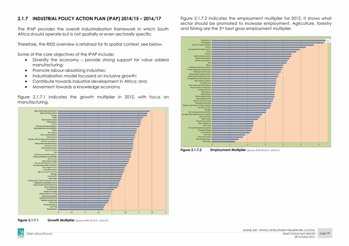
2.1.7 INDUSTRIAL POLICY ACTION PLAN (IPAP) 2014/15 – 2016/17
The IPAP provides the overall industrialisation framework in which South
Africa should operate but is not spatially or even sectorally specific.
Therefore, the RIDS overview is retained for its spatial context, see below.
Some of the core objectives of the IPAP include:
Diversify the economy – provide strong support for value added
manufacturing;
Promote labour-absorbing industries;
Industrialisation model focussed on inclusive growth; Contribute towards industrial development in Africa; and,
Movement towards a knowledge economy
Figure 2.1.7.1 indicates the growth multiplier in 2012, with focus on
manufacturing.
Figure 2.1.7.1 Growth Multiplier (Source: IPAP 2014/15 – 2016/17)
Figure 2.1.7.2 indicates the employment multiplier for 2012. It shows what
sector should be promoted to increase employment. Agriculture, forestry
and fishing are the 3rd best gross employment multiplier.
Figure 2.1.7.2 Employment Multiplier (Source: IPAP 2014/15 – 2016/17)

MOSSEL BAY SPATIAL DEVELOPMENT FRAMEWORK (15.2574)
CNdV africa (Pty) Ltd DRAFT STATUS QUO REPORT
28 October 2016
page 30
Figure 2.1.7.3 Industrial Policy Action Plan: How it all fits together Source: IPAP 2014/15 – 2016/17)

MOSSEL BAY SPATIAL DEVELOPMENT FRAMEWORK (15.2574)
CNdV africa (Pty) Ltd DRAFT STATUS QUO REPORT
28 October 2016
page 31
Figure 2.1.8.1 Determinants of Systemic Competitiveness (source: Draft Regional Industrial Development Strategy, DTI, 2006, pg20)
2.1.8 REGIONAL INDUSTRIAL DEVELOPMENT STRATEGY (RIDS)
The Department of Trade and Industries (DTI) Regional Industrial
Development Strategy (RIDS) seeks to move South Africa's industrial
development policy from the apartheid era's top-down localized
approach to a bottom-up approach that treats regions as functional
entities and builds on locally available skills and resources and relies on
external investment. (The DTI, Draft Regional Industrial Development
Strategy, June 2006, pg 16)
Therefore, it also seeks to strengthen world-class regions. These are high
performance regions that contain companies or networks of companies
which need to constantly upgrade so that they do not fall behind in global
competition. (The DTI, ibid)
One strategy here is to concentrate a critical mass of firms in a chosen
industry sector together with its upstream suppliers and service providers in
a specific geographic location. Necessary support infrastructure includes
transport, logistics, communications, education and training. Gauteng's
Blue IQ is an example of such a regional economic development strategy.
RIDS identifies four levels that determine systematic competitiveness, see
Figure 2.1.8.1.
National and regional industrial development policy is responsible for the
Meta and Macro levels. It is at the Meso and Micro levels where district and
local municipal policies can have the greatest effect.
Figure 2.1.8.2 indicates that the Mossel Bay Municipality is considered to
have significant economic growth.
Figure 2.1.8.3 indicates that the Mossel Bay Municipality has significant
levels of gross value along the N2 and coastal corridor.
Peaks of around R90m GVA / 50km² / pa are indicated around Mossel Bay
town.
Implications for Mossel Bay Municipality
Promote Mossel Bay town as the main driver of the municipal economy.
Mossel Bay town is the main business and administrative hub of the
Municipality.
These economic activities should be protected in the Municipality.
Forward and backward linkages need to be developed to support
economic activities.

MOSSEL BAY SPATIAL DEVELOPMENT FRAMEWORK (15.2574)
CNdV africa (Pty) Ltd DRAFT STATUS QUO REPORT
28 October 2016
page 32
Figure 2.1.8.2 Medium to High Base Areas (source: CSIR, 2006)
Study Area
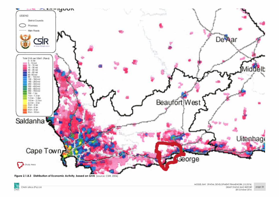
MOSSEL BAY SPATIAL DEVELOPMENT FRAMEWORK (15.2574)
CNdV africa (Pty) Ltd DRAFT STATUS QUO REPORT
28 October 2016
page 33
Figure 2.1.8.3 Distribution of Economic Activity, based on GVA (source: CSIR, 2006)
Study Area
MOSSEL BAY SPATIAL DEVELOPMENT FRAMEWORK (15.2574)
CNdV africa (Pty) Ltd DRAFT STATUS QUO REPORT
28 October 2016
page 34
2.1.9. NATIONAL ENVIRONMENTAL MANAGEMENT ACT 107 of 1998
As per SPLUMA requirements for the formulation of a Spatial Development
Framework, an Environmental Management Framework (EMF) should be
included in the SDF. The EMF for Mossel Bay will be completed in a
separate process and will be incorporated into the SDF as soon as it is
approved as an EMF, meeting all requirements within NEMA.
NEMA identifies the purpose and objectives of an EMF as follows:
Purpose of EMFs
The purpose of the EMF is to function as a support mechanism in the
environmental impact assessment process in the evaluation and review of
development applications, as well as decision making regarding land-use
planning applications.
EMFs that have been signed off by the Minister can therefore be used to
facilitate the compilation and consideration of application for
environmental authorisation in terms of the regulations. In this regard –
EMFs provide applicants with an early indication of the areas which it
would potentially appropriate to undertake an activity;
Co-operative government is facilitated through the identification of
different regulatory responsibilities and recommending mechanisms for
addressing the needs of the relevant authorities; and,
The competent authority has information which will guide and inform
decision-making.
In addition to above, EMFs must be considered in environmental
management:
EMFs can be used as a basis for the Minister or MEC to identify areas
where environmental authorisation will be required for certain
additional listed activities;
Where the undertaking for certain activities may be excluded from
requiring environmental authorisation; and,
For the co-ordinated management of strategic spatial environmental
information about a specific geographic area.
Objectives of EMFs
Support informed and integrated decision-making by making
significant and detailed information about an area available before
activity proposals are generated. Contribute to environmentally sustainable development by
anticipating potential impacts and by providing early warnings in
respect of thresholds, limits and cumulative impacts, and by identifying
already existing impacts to be addressed; Support the undertaking of environmental impact assessments in the
area by indicating the scope of potential impacts and information
needs that may be necessary for environmental impact assessments; Support the process of delineating geographical areas within which
additional specified activities are to be identified in terms of NEMA;
and, Support the process of delineating geographical areas within which
activities listed in terms of NEMA may be excluded by identifying areas
that are not sensitive to the potential impacts of such activities.

MOSSEL BAY SPATIAL DEVELOPMENT FRAMEWORK (15.2574)
CNdV africa (Pty) Ltd DRAFT STATUS QUO REPORT
28 October 2016
page 35
2.2 PROVINCIAL LEGISLATION AND POLICY
PROVINCIAL LEGISLATION
2.2.1 WESTERN CAPE LAND USE PLANNING ACT, ACT 3 OF 2014
The Act seeks to clarify the functions of municipalities and provincial
government in respect to land use planning and deals with the Municipal
Spatial Development Framework slightly differently.
LUPA sets the same principles as are found in SPLUMA. These principles bind
all organs of state when preparing an application or function in terms of
LUPA or other legislation in respect of land use planning.
LUPA provides shortened procedures to establish less informal settlements
and less formal townships and for the settlement of indigenous tribes. LUPA
provides for the exemption from other legislation, for the suspension or
cancellation of title deeds that may hamper development.
PROVINCIAL POLICY
2.2.2 WESTERN CAPE PROVINCIAL SPATIAL DEVELOPMENT
FRAMEWORK (2014)
The Western Cape Provincial Spatial Development Framework was
approved by the provincial cabinet in December 2014 and aims to give
direction and guidance for spatial development within the Western Cape.
The PSDF states that the province’s approach takes its strategic direction
from the NDP and OneCape2040 initiatives and tries to align their
development agendas (Provincial SDF 2014).
The National Development Plan 2030 promotes “An inclusive and
integrated rural economy”, with the fourth target (by 2030) seeking to
transform urban and rural spaces.
The Cape Vision 2040 seeks to achieve a “vibrant, equitable and
sustainable rural communities and food security.
The Western Cape PSDF sets out to put in place a coherent framework for
the Province’s urban and rural areas that:
gives spatial expression to the national and Provincial development
agendas;
serves as basis for coordinating, integrating and aligning ‘on the
ground’ delivery of national and Provincial departmental programmes;
supports municipalities to fulfil their municipal planning mandate in line
with the national and provincial agendas; and
communicate government’s spatial development intentions to the
private sector and civil society.
The WCPSDF adopts spatial principles closely linked to the SPLUMA
principles. These are the following:
Spatial Justice;
Sustainability and Resilience;
Spatial Efficiency;
Accessibility; and,
Quality and Liveability.
These principles further inform the spatial logic that underpins the PSDF’s
spatial strategy through the following focus areas (4 Cs):
1. CAPITALISE and build on the Western Cape comparative strengths
(e.g. gateway status, knowledge economy, lifestyle offering) and
leverage the sustainable use of its unique spatial assets.
2. CONSOLIDATE existing and emerging regional economic nodes as
they offer the best prospects to generate jobs and stimulate
innovation.
3. CONNECT urban and rural markets and consumers, fragmented
settlements and critical biodiversity areas (i.e. freight logistics, public
transport, broadband, priority climate change ecological corridors,
etc.)
4. CLUSTER economic infrastructure and facilities along public transport
routes (to maximise the coverage of these public investments) and
respond to unique regional identities within the Western Cape.
Table 2.1 indicates how the 4 ‘Cs’ are applied at different spatial scales.

MOSSEL BAY SPATIAL DEVELOPMENT FRAMEWORK (15.2574)
CNdV africa (Pty) Ltd DRAFT STATUS QUO REPORT
28 October 2016
page 36
Table 2.1 The spatial logic underpinning the spatial proposals of the PSDF according to
the four focus areas (4 C’s) (source: Western Cape PSDF 2014)
The spatial policy framework to which the spatial principles and logic are
applied is categorised into three (3) interrelated spatial planning themes
along with associated spatial objectives, namely:
1. Resources
1.1. Objective 1: the sustainable use of biodiversity and ecosystem
services.
1.2. Objective 2: The sustainable use of water.
1.3. Objective 3: the sustainable use of soil and mineral resources.
1.4. Objective 4: Sustainable resource consumption and disposal.
1.5. Objective 4: Sustainable use of landscape and the scenic assets.
2. Space Economy
2.1. Objective 5: Opening-up opportunities in regional economic
infrastructure;
2.2. Objective 6: Opening-up opportunities in the rural space-
economy; and,
2.3. Objective 7: Opening-up opportunities in urban space-economy
3. Settlement
3.1. Objective 8: Sense of place and settlement patterns;
3.2. Objective 9: Accessibility;
3.3. Objective 10: Land use and density;
3.4. Objective 11: Facilities and social services; and,
3.5. Objective 12: Informality, housing delivery, inclusion and urban
land markets.
Some of the issues the PSDF identifies for the Eden District include:
Land transformation (i.e. conversion from natural to man-made
landscapes), is the primary cause of biodiversity loss and deteriorating
ecosystems health. The main threat is in the lowlands, particularly in
areas intensively cultivated and subject to urban growth pressures.
Agriculture is being reduced to ‘islands’, visual cluttering of the
landscape by non-agricultural development is prevalent, and rural
authenticity, character and scenic value is being eroded (e.g. urban
sprawl into the Garden Route scenic corridors, particularly around
Mossel Bay town).
Some of the WC PSDF rural development policies included:
SDFs should be able to assist in the identification of strategically
located land for land reform purposes in terms of the Pro-active Land
Acquisition Strategy (PLAS).
Strengthen functional linkages between settlements and larger towns,
with specific attention given to introducing rural transport systems.
Promote the upgrading of existing rail infrastructure to offer higher
levels of service while developing combined road and rail transport
corridors to provide a real alternative to road transport for passengers
and freight.

MOSSEL BAY SPATIAL DEVELOPMENT FRAMEWORK (15.2574)
CNdV africa (Pty) Ltd DRAFT STATUS QUO REPORT
28 October 2016
page 37
Study
area
Figure 2.2.1 Western Cape Province- Informality, Housing Delivery, Inclusion and Urban Land Markets (Source: Western Cape Spaial Development Framework

MOSSEL BAY SPATIAL DEVELOPMENT FRAMEWORK (15.2574)
CNdV africa (Pty) Ltd DRAFT STATUS QUO REPORT
28 October 2016
page 38
Figure 2.5 Western Cape Province synthesis settlement focus areas- illustrating the relationship between areas of urban growth pressure and important natural and agricultural resources (Source: Western Cape Spaial
Development Framework, 2015 )
Figure 2.2.2 Western Cape Province synthesis settlement focus areas – illustrating the relationship between areas of urban growth pressure and important natural and agricultural land (WC-
PSDF, 2014)
Study
area

MOSSEL BAY SPATIAL DEVELOPMENT FRAMEWORK (15.2574)
CNdV africa (Pty) Ltd DRAFT STATUS QUO REPORT
28 October 2016
page 39
Develop Integrated Public Transport Networks (IPTN) in the rural regions
of the Province that are connected to regional centres.
Prioritise remote rural areas, small towns and low income urban areas
for the roll-out of broadband.
Prioritise rural development investment based on the economic role
and function of settlements in rural areas, acknowledging that
agriculture, fishing, mining and tourism remain important economic
underpinnings of rural settlements.
Support emergent Independent Power Producers (IPPs) and
sustainable energy producers (wind, solar, biomass and waste
conversion initiatives) in suitable rural locations (as per
recommendations of the Strategic Environmental Assessments for wind
energy (DEADP) and renewable energy (DEA)).
Figure 2.2.3 Patterns of Economic Activity (source: PSDF, 2014)
Implications for Mossel Bay Municipality
According to Figure 2.4 the node of competitiveness in the Western Cape
pertains to the Cape Metropolitan Region - City of Cape Town, and
recommends that government spending should be targeted here, to retain
economic value, improve economic performance and maximise job
creations.
Thus, directing funding to areas such as the Eden District and more
specifically Mossel Bay Local Municipality is seen less favourably (as these
are considered areas with less economic competitiveness), see Figure 2.2.2.
The implications of such budget allocations require areas such as Mossel
Bay municipality to be self-sustainable and resilient through other means.
Mossel Bay’s resilience should be improved through careful settlement
planning and design consideration that may improve standards of living
and through alternative attractive investment into the area.
The emphasis on diversifying sustainable agricultural production for job
security and food security should be focused in rural areas.
It should be noted that the PSDF strongly emphasises the importance of
capitalising, preserving and celebrating a wide range of the province’s
rural spatial assets including iconic landscapes, rural and coastal lifestyles,
agriculture, events, unique regional identities, e.g. the Garden Route,
cultural landscapes, character areas and typologies and unique local built
form and natural typologies, character and heritage. This has implications
for the pattern and form of Mossel Bay’s growth along the N2, see Figure
2.2.3a, good example, and 2.2.3b, poor example.
Settlement growth is proposed to be “urban” and “suburban”, i.e. more
rather than less compact and intense.
Figure 2.2.3a Stormswael Str (Google Earth)
Figure 2.2.3b Hartenbos, south of R102, west
of N2
MOSSEL BAY SPATIAL DEVELOPMENT FRAMEWORK (15.2574)
CNdV africa (Pty) Ltd DRAFT STATUS QUO REPORT
28 October 2016
page 40
2.2.3 WESTERN CAPE INFRASTRUCTURE FRAMEWORK (WCIF), 2013
The Western Cape infrastructure framework (WCIF) is intended to align the
planning, delivery and management of infrastructure, provided by all
stakeholders to the strategic agenda and vision for the province.
The objectives of the framework are to:
Align existing planning processes.
Outline strategic decisions and trade-offs that need to be made to
achieve the provincial 2040 vision in a complex and changing
environment.
Identify and guide the planning and execution of major
infrastructure interventions for the period 2012–2040.
Mobilise and direct new investments.
Facilitate partnerships and collaboration.
This framework has five focus areas:
Energy;
Water;
Transport;
Settlement; and
Information and Communication Technology (ICT).
The following have been identified as the key transitions in the respective
focus of areas:
Energy
Introduce natural gas processing and transport infrastructure to
make gas available as a transition fuel.
Promote the development of renewable energy plants in the
province and associated manufacturing capability.
Shift transport patterns to reduce reliance on liquid fuels.
Water
Have more stringent water conservation and demand-
management initiatives, particularly at municipal level.
Develop available groundwater resources.
Adopt more widely the reuse of wastewater effluent as standard
practice.
Adopt large-scale desalination once it becomes the “next best”
option to resolve inevitable water shortages in Saldanha, Cape
Town and the southern Cape.
Expand and diversify agriculture to increase availability of surface
water but reduce the water intensity of the sector, given the limited
availability of water for irrigation.
Transport
Invest in public transport and non-motorised transport (NMT)
infrastructure, particularly in larger urban centres.
Prioritise general freight rail over bulk rail freight.
Shift freight traffic from road to rail along major routes.
Settlement
Continue to provide basic services to achieve national targets.
Diversify the housing programme, with greater emphasis on
incremental options.
Integrate settlement development, prioritising public service
facilities in previously neglected areas.
About R49 billion is need till 2040 to address the housing need of
about 425 000 units
Improve energy efficiency in buildings through design standards.
Consolidate management of state land and property assets for
optimal use.
Distribute health and education facilities equitably.
Innovate in the waste sector to increase recycling and reuse,
including the adoption of waste-to- energy in the longer term
Information and Communication Technology (ICT)
Only 44% of households in the Western Cape have access to ICT. The
availability broadband infrastructure network is vital to efficient
communications and internet services and key to the economy.
The aim is to have all schools and government buildings connected by
2014. Also to have fibre optic connections to premises e.g. large
government buildings and targeted industries in the metropolitan area by
2014.
The WCIF summarized the spatial implications of the proposals as follows
MOSSEL BAY SPATIAL DEVELOPMENT FRAMEWORK (15.2574)
CNdV africa (Pty) Ltd DRAFT STATUS QUO REPORT
28 October 2016
page 41
(WCIF, 2013):
“Better transport links with other provinces, Gauteng specifically.
The ports, in particular Saldanha Bay and Mossel Bay, are likely to
become significant if Liquified Natural Gas (LNG) is adopted as
transition fuel.
Continued emphasis on environmental sustainability along the
coast, with the understanding of the importance of tourism and
sector diversity.
Continued support for farming in the hinterland but with increased
diversity and water efficiency, on the understanding that water is a
major constraint.”
Infrastructure investment must unlock economic potential at all
scales); and
Housing allocations and public and social services facility
allocations must not be planned in isolation but be aligned with
infrastructure investment plans, growth areas and future
development projects.
2.2.4 PROVINCIAL URBAN EDGE GUIDELINE MANUAL
The following is extracted from the Provincial Urban Edge Guideline
Manual dated December 2005. (ref: DEA&DP, 2005)
An Urban Edge is a demarcated line to contain, manage, direct and
control the outer limits of development around an urban area. The
intention of an Urban Edge is to establish limits beyond which urban
development should not occur and to promote urban and environmental
efficiency, effectiveness and economy in the interest of all, see Figure 2.10.
The function of an Urban Edge is three-fold, namely:
to assist with restructuring the urban areas and integrating the currently
segregated social groups and urban uses;
as one of a number of growth management tools to assist with limiting
sprawl and the outward growth of urban areas, support densification
and infill development, and to ensure the more efficient use of
resources and land within the urban area; and
as a conservation tool to exclude certain parts of the environment from
the urban area in order to protect or preserve or to discourage
development in the short and medium term while the long term
implications are being understood.
Urban development includes all development of land where the primary
use of the land is for the erection of structures. Residential estates on farms
and golf estates would, for this purpose if located outside the Urban Edge,
be defined as urban uses, albeit that the "primary use" is "agriculture" or
"private open space" and the "secondary use" is residential.
Agricultural uses, open space uses, conservation areas, transport zonings
(excluding public transport interchanges, ranks and stations that consist
mainly of buildings) and many similar use zonings refer to the use of the
land rather than buildings erected on the land in order for the use to
occur. These are non-urban uses.
Smallholdings used for bona fide agricultural purposes would or should
typically be excluded from the urban area by delineation of an Urban
Edge.
Implications for Mossel Bay Municipality
Mossel Bay (and Saldanha Bay) are considered important in the
infrastructure plan both as parts and as LNG centres, particularly Mossel Bay
with its refinery. Obviously, if both these resources, the harbour and the LNG production
capability have uncertain futures MBM’s potential in this regard will be
severely diminished.
MOSSEL BAY SPATIAL DEVELOPMENT FRAMEWORK (15.2574)
CNdV africa (Pty) Ltd DRAFT STATUS QUO REPORT
28 October 2016
page 42
Golf courses, polo fields and other sporting facilities with low ancillary
facilities are seen as rural in nature, whereas a golf estate, i.e. a golf course
with housing, is an urban use, unless it is a resort. Agricultural estates, i.e.
farms with a large residential component for owners or shareholders (as
opposed to bona fide labourer's residences) or for unrelated freehold or
sectional title ownership are seen as urban if the density exceeds one unit
per ten hectare.
The following issues, criteria and factors are regarded as informants when
considering Urban Edges for the urban areas:
Services infrastructure (barrier effect);
Services infrastructure (capacity and reach);
Vacant under-utilised land in urban area;
Availability of developable land in urban area;
Higher order roads, access routes and transport infrastructure;
Cadastral boundaries of adjoining land units;
Growth requirements over predetermined period;
Land use applications for new development;
Visual impact;
Cultural heritage resource areas;
Ownership of land and existing land use rights;
Informal settlements;
Urban agriculture and small scale farming;
Bio-regional spatial planning categories (core and buffer); and
Density policy for residential development in rural towns.
Given the criteria, issues and facilities for determining Urban Edges, Urban
Edges should be determined to:
Exclude prominent landforms and environmental character areas from
the urban area;
Exclude valuable soils for agricultural purposes;
Exclude valuable soils for mining purposes;
Exclude surface and ground water resources that could be used to
produce potable water;
Exclude surface and ground water features;
Exclude ecological resources and establish suitable; ecological
corridors to link resource areas;
Exclude all statutorily declared, proclaimed and protected natural
areas;
Exclude high intensity use and high potential agricultural resources and
activity areas;
Exclude scenic routes and routes of tourism significance;
Exclude cultural and heritage resource areas and sites;
Exclude areas that have visual sensitivity, skylines, mountainsides,
ridgelines and hilltops; and
Exclude the WC-PSDF defined core areas.
Implications for Mossel Bay Municipality
In the Mossel Bay Municipality the following elements play a critical role in
delineating the Urban Edge (DEA&DP, 2005):
Agricultural land: currently farmed land, high potential agricultural land,
agri-processing;
Rivers, wetlands and floodplains: 1:50 year flood plains, 1:100 year
floodplains and the 32m buffer zone around river corridors;
Heritage aspects such as landscapes, viewsheds, rural landscapes and
gateways;
Topography: Major topographical features (hills, ridgelines and focal
points), visual or aesthetic quality of scenery, slopes;
The policy plans for desired direction and pattern of growth; and,
Most of the settlements in the Municipality have challenges for future
growth and their lateral growth is limited because they are surrounded by
river corridors, critical biodiversity areas, productive farms and mountains.
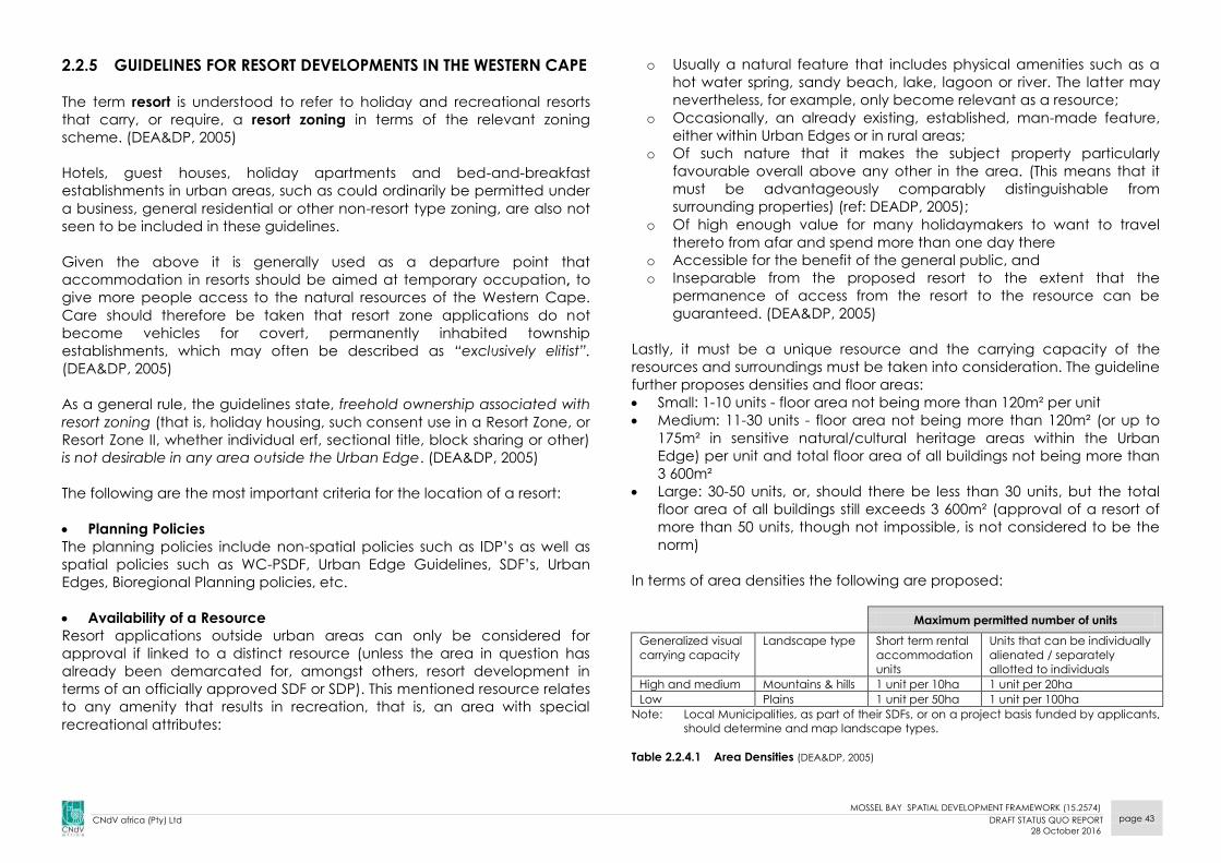
MOSSEL BAY SPATIAL DEVELOPMENT FRAMEWORK (15.2574)
CNdV africa (Pty) Ltd DRAFT STATUS QUO REPORT
28 October 2016
page 43
2.2.5 GUIDELINES FOR RESORT DEVELOPMENTS IN THE WESTERN CAPE
The term resort is understood to refer to holiday and recreational resorts
that carry, or require, a resort zoning in terms of the relevant zoning
scheme. (DEA&DP, 2005)
Hotels, guest houses, holiday apartments and bed-and-breakfast
establishments in urban areas, such as could ordinarily be permitted under
a business, general residential or other non-resort type zoning, are also not
seen to be included in these guidelines.
Given the above it is generally used as a departure point that
accommodation in resorts should be aimed at temporary occupation, to
give more people access to the natural resources of the Western Cape.
Care should therefore be taken that resort zone applications do not
become vehicles for covert, permanently inhabited township
establishments, which may often be described as “exclusively elitist”.
(DEA&DP, 2005)
As a general rule, the guidelines state, freehold ownership associated with
resort zoning (that is, holiday housing, such consent use in a Resort Zone, or
Resort Zone II, whether individual erf, sectional title, block sharing or other)
is not desirable in any area outside the Urban Edge. (DEA&DP, 2005)
The following are the most important criteria for the location of a resort:
Planning Policies
The planning policies include non-spatial policies such as IDP’s as well as
spatial policies such as WC-PSDF, Urban Edge Guidelines, SDF’s, Urban
Edges, Bioregional Planning policies, etc.
Availability of a Resource
Resort applications outside urban areas can only be considered for
approval if linked to a distinct resource (unless the area in question has
already been demarcated for, amongst others, resort development in
terms of an officially approved SDF or SDP). This mentioned resource relates
to any amenity that results in recreation, that is, an area with special
recreational attributes:
o Usually a natural feature that includes physical amenities such as a
hot water spring, sandy beach, lake, lagoon or river. The latter may
nevertheless, for example, only become relevant as a resource;
o Occasionally, an already existing, established, man-made feature,
either within Urban Edges or in rural areas;
o Of such nature that it makes the subject property particularly
favourable overall above any other in the area. (This means that it
must be advantageously comparably distinguishable from
surrounding properties) (ref: DEADP, 2005);
o Of high enough value for many holidaymakers to want to travel
thereto from afar and spend more than one day there
o Accessible for the benefit of the general public, and
o Inseparable from the proposed resort to the extent that the
permanence of access from the resort to the resource can be
guaranteed. (DEA&DP, 2005)
Lastly, it must be a unique resource and the carrying capacity of the
resources and surroundings must be taken into consideration. The guideline
further proposes densities and floor areas:
Small: 1-10 units - floor area not being more than 120m² per unit
Medium: 11-30 units - floor area not being more than 120m² (or up to
175m² in sensitive natural/cultural heritage areas within the Urban
Edge) per unit and total floor area of all buildings not being more than
3 600m²
Large: 30-50 units, or, should there be less than 30 units, but the total
floor area of all buildings still exceeds 3 600m² (approval of a resort of
more than 50 units, though not impossible, is not considered to be the
norm)
In terms of area densities the following are proposed:
Maximum permitted number of units
Generalized visual
carrying capacity
Landscape type Short term rental
accommodation
units
Units that can be individually
alienated / separately
allotted to individuals
High and medium Mountains & hills 1 unit per 10ha 1 unit per 20ha
Low Plains 1 unit per 50ha 1 unit per 100ha
Note: Local Municipalities, as part of their SDFs, or on a project basis funded by applicants,
should determine and map landscape types.
Table 2.2.4.1 Area Densities (DEA&DP, 2005)
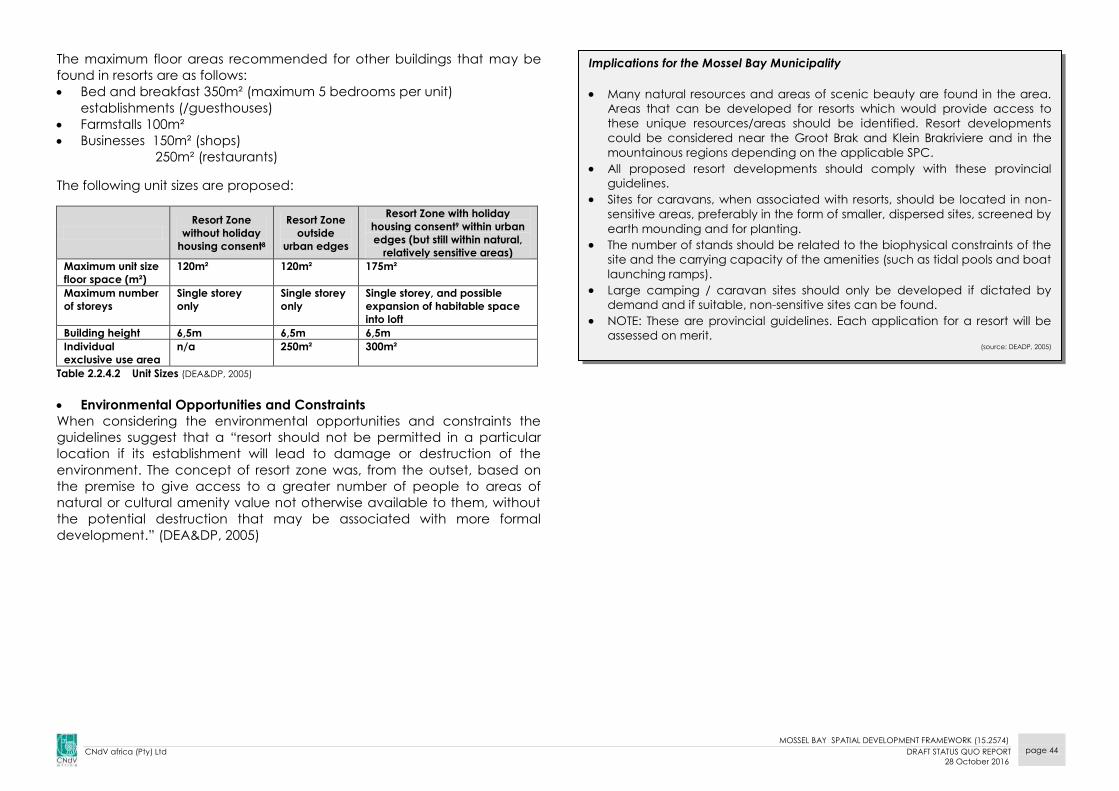
MOSSEL BAY SPATIAL DEVELOPMENT FRAMEWORK (15.2574)
CNdV africa (Pty) Ltd DRAFT STATUS QUO REPORT
28 October 2016
page 44
The maximum floor areas recommended for other buildings that may be
found in resorts are as follows:
Bed and breakfast 350m² (maximum 5 bedrooms per unit)
establishments (/guesthouses)
Farmstalls 100m²
Businesses 150m² (shops)
250m² (restaurants)
The following unit sizes are proposed:
Resort Zone
without holiday
housing consent8
Resort Zone
outside
urban edges
Resort Zone with holiday
housing consent9 within urban
edges (but still within natural,
relatively sensitive areas)
Maximum unit size
floor space (m²)
120m² 120m² 175m²
Maximum number
of storeys
Single storey
only
Single storey
only
Single storey, and possible
expansion of habitable space
into loft
Building height 6,5m 6,5m 6,5m
Individual
exclusive use area
n/a 250m² 300m²
Table 2.2.4.2 Unit Sizes (DEA&DP, 2005)
Environmental Opportunities and Constraints
When considering the environmental opportunities and constraints the
guidelines suggest that a “resort should not be permitted in a particular
location if its establishment will lead to damage or destruction of the
environment. The concept of resort zone was, from the outset, based on
the premise to give access to a greater number of people to areas of
natural or cultural amenity value not otherwise available to them, without
the potential destruction that may be associated with more formal
development.” (DEA&DP, 2005)
Implications for the Mossel Bay Municipality
Many natural resources and areas of scenic beauty are found in the area.
Areas that can be developed for resorts which would provide access to
these unique resources/areas should be identified. Resort developments
could be considered near the Groot Brak and Klein Brakriviere and in the
mountainous regions depending on the applicable SPC.
All proposed resort developments should comply with these provincial
guidelines.
Sites for caravans, when associated with resorts, should be located in non-
sensitive areas, preferably in the form of smaller, dispersed sites, screened by
earth mounding and for planting.
The number of stands should be related to the biophysical constraints of the
site and the carrying capacity of the amenities (such as tidal pools and boat
launching ramps).
Large camping / caravan sites should only be developed if dictated by
demand and if suitable, non-sensitive sites can be found.
NOTE: These are provincial guidelines. Each application for a resort will be
assessed on merit. (source: DEADP, 2005)
MOSSEL BAY SPATIAL DEVELOPMENT FRAMEWORK (15.2574)
CNdV africa (Pty) Ltd DRAFT STATUS QUO REPORT
28 October 2016
page 45
2.2.6 GUIDELINES FOR GOLF COURSES, GOLF ESTATES, POLO FIELDS
AND POLO ESTATES IN THE WESTERN CAPE
The guidelines have been produced to help decision-makers when dealing
with applications for golf courses, golf estates, polo fields, polo estates and
other developments of similar scale and/or complexity and as a reference
for formulating SDF’s and IDP’s. (DEA&DP, 2005)
The objectives of the guidelines are:
To promote responsible development, taking into consideration the
imperative for transformation;
To protect, enhance and maintain the natural resources and unique
biodiversity of the Western Cape;
To support the implementation of sustainable development principles;
To support and enhance the implementation of bioregional planning in
the Province;
To promote well-functioning, integrated urban settlements, and to
prevent urban sprawl;
To inform decision-making with respect to golf courses, golf estates,
polo fields and polo estates in all spheres of government, based on the
principle of cooperative governance;
To provide clarity into the application and assessment process, by
clarifying requirements without creating expectations; and
To improve the effectiveness of public participation. (DEA&DP, 2005)
The purpose of the location principles is to facilitate the appropriate siting
or placement of development on the landscape. It should be noted that
each application for a golf courses, etc. will be assessed on merit.
Urban Areas
The term “Urban Areas” refers to all land designated for urban
development purposes within a demarcated Urban Edge. Developments
that include golf and polo could be considered when:
“In or immediately adjacent to the urban area, where it assists in
defining an Urban Edge;
It forms part of the municipal open space system (to be read in
conjunction with the following bullet point); and,
Where residential components are added to existing amenities in
urban areas, as a form of general/overarching densification, on
condition that the recreational and open space/green lung function of
such amenities is not compromised and provided that:
o The site does not fall within an area that has been identified by
the relevant Municipality concerned for urban densification;
o If the site is located within the open space system/network,
access to public amenities and open spaces is not disrupted;
o The site has not been designated as being of sufficient cultural
significance by heritage authorities to warrant it a “no-go” area
for development;
o The site does not fall within an area that has been identified as
being of conservation significance, within the urban context;
o The site does not negatively affect the role, function, public
enjoyment and status of open space systems/networks,
designated sites of cultural significance and/or sites identified as
being of conservation significance;
o The development or part thereof will not be located within the
30m development restriction area measured from the bank of a
river, stream, wetland or any other natural surface water feature
or within the following 1:50 year or 1:100 year flood lines,
whichever is the most restrictive;
o The water demand for the development is in accordance with
the Municipality's water services plan and that there is no risk of
stress being placed on the municipal water supply;
o Where water resources are required to supply the development,
that these are not considered as being stressed by DWAF and
other relevant authorities;
o The area does not fall within the coastal zone as defined by
relevant legislation, policies or plans, or within 30m of the edge of
a cliff located on the coastline, or within 30m of the high water
mark, or on primary dunes or on dune systems that are mobile (the
most restrictive criteria will apply);
o The development will not result in the removal of traditional
access used by local communities;
o The development will not result in existing public and/or traditional
access to and along the coastline being disrupted (unless
acceptable alternative access has been provided);
o The development will not result in or contribute to visually obtrusive
or ribbon development along the coastline or along cliffs and
ridges.” (DEA&DP, 2005)
Core Areas
Core areas include officially proclaimed nature reserves, ecological
corridors, critically endangered habitats and river corridors. No golf

MOSSEL BAY SPATIAL DEVELOPMENT FRAMEWORK (15.2574)
CNdV africa (Pty) Ltd DRAFT STATUS QUO REPORT
28 October 2016
page 46
courses, golf estates, polo fields and polo estates should be located in
core areas, as identified through the WCPSDF's broad spatial planning
categories.
Buffer Areas
Buffer Areas include remaining natural habitat in endangered and
vulnerable ecosystems, including remnants, natural habitat in less
threatened ecosystems and extensive agricultural areas.
Development that includes a golf course or polo field component could
occur on the border between Buffer and Urban Areas provided it:
Results in long term Biodiversity offsets and / or heritage goals;
Result in securing the viability of a significant agricultural unit or
contribute significantly to land reform objectives;
Limits the number of units so that secondary developments (shops,
service stations, etc.) are not promoted;
Does not entail any form of township development outside the Urban
Edge;
Is not a significant heritage area;
Does not contribute to urban sprawl and or leapfrogging;
Is not in an area of medium or high value agricultural land;
Is not in an area designated for emerging farmers;
Does not use water resources (surface and ground) that are
considered stressed by DWAF and other authorities and
does not pollute the natural water resource by fertilizer or treated
effluent;
Does not negatively affect the open space network;
Is not in the coastal zone, within 30m of the edge of a cliff located on
the coastline or within 30m of the high water mark, or on the primary
dunes or dune systems that are mobile;
Does not impact on habitats / ecosystems that are defined as Critically
Endangered in terms of SANBI’s vegetation classification system;
Does not disrupt ecological corridors;
Does not fall within 30m of bank of river or 1:100 year flood line;
Does not negatively affect river, natural spring or the catchments of a
dam;
Does not derive water from rivers determined as being pristine / near
pristine or stressed by DWAF and authorities;
Does not remove traditional access, commonage etc.;
Does not result in the inappropriate alteration of the landform (e.g. cut
and fill); and
Does not result in / contribute to visually obtrusive / ribbon
development.
The following aspects must be considered in formulating development
applications:
Alternatives
Spatial planning – compliance
Land use – undertake a land use impact assessment
Cultural heritage and VIA
Biodiversity – how all biodiversity plans must be consulted
Water resources
Infrastructure and services
Social impacts
Employment and skills development
Economic impact
Management of planning, design, implementation and operational
activities
Social costs
Urban Edge principles
Intensive agricultural areas
These are areas with either agricultural potential or that are being
cultivated. They are considered an important resource for food security
and the agricultural economy.
No golf courses, golf estates, polo fields and polo estates should be
allowed in Intensive Agricultural areas.
The SDF needs to indicate Urban Edge proposals, and should make policies
to guide potential proposals for development outside the Urban Edge that
could be seen as leapfrogging or urban sprawl.
MOSSEL BAY SPATIAL DEVELOPMENT FRAMEWORK (15.2574)
CNdV africa (Pty) Ltd DRAFT STATUS QUO REPORT
28 October 2016
page 47
2.2.7 PROVINCIAL STRATEGIC PLAN, 2014-2019
The Western Cape Government has identified the following strategic goals (source: Western Cape Government Provincial Strategic Plan 2014-2019)
PSG 1 Creating opportunities for growth and jobs by supporting strategic
sectors, improving artisan and technical skills, improving the
regulatory environment, nurture innovation throughout the
economy, optimising land use, ensure sufficient water and energy,
improve Broadband roll out and improve the transport system.
PSG 2 Improving education outcomes and opportunities for youth
development. The objectives highlighted include improving levels
of language and mathematics, increasing the number of quality
passes for national senior certificate, increasing the quality of
education in poorer communities, providing access to more social
and economic opportunities and improving family support to
children and youth and development programmes.
PSG 3 Increasing wellness, safety and tackle social ills. This can be done
by building inclusive, safe and healthy communities, nurture
resilient and healthy families and ensuring safe and healthy
children and youth.
PSG 4 Enable a resilient, sustainable, quality and inclusive living
environment. The objectives listed to ensure that this goal is
reached include facilitating improvements in settlement
development and functionality, improving management and
maintenance of the ecological and agricultural resource base
and improving the response to climate change.
PSG 5 Embed good governance and integrated service delivery
through partnerships and spatial alignment. This can be
promoted by enhanced corporate governance maturity in the
Western Cape Government and municipalities, significantly
improved stakeholder satisfaction with Western Cape
Government services and integrated management of the PSP
and the game changers in the Western Cape.
2.2.8 RURAL LAND USE PLANNING AND MANAGEMENT
GUIDELINES, MAY 2009
These guidelines were prepared with the purpose of complementing the
Guidelines for Rural Resorts, Golf Estates, Polo Fields and Polo Estates
(DEA&DP, 2009).
The objectives of the guidelines are:
To promote sustainable development in appropriate rural locations
while ensuring that the poor share in the growth of the rural economy;
To safeguard the functionality of life supporting ecosystem services;
To maintain the integrity, authenticity and accessibility of farming,
ecological, cultural and scenic rural landscapes and natural resources;
To assist municipalities with the management of rural areas;
To provide clarity on the type of development that is appropriate
beyond the urban edge, as well as the scale and form of such
development (DEA&DP, 2009)
The purpose of this document is to serve as a logical planning and
management guideline for all types of rural land uses.
The Rural Settlement patterns in the Western Cape include:
The farm homestead and associated outbuildings, historically
enclosing a farmyard or werf;
Workers accommodation (on-farm) i.e. labourers cottages located
away from the werf;
Villages and off-farm hamlets located along main movement routes;
Rural residential sprawl usually located along the outskirts of urban
centres;
The change of working farms to weekend leisure destinations.
Guidelines on Managing Rural Land Use Change
Decisions in terms of Rural Land Use applications are to be based on
the following sustainable land use principles:
social inclusion;
effective protection and enhancement of the environment;
prudent use of natural resources;
the maintenance of high and stable levels of economic growth;
Good quality and carefully sited development should be encouraged
in existing settlements;

MOSSEL BAY SPATIAL DEVELOPMENT FRAMEWORK (15.2574)
CNdV africa (Pty) Ltd DRAFT STATUS QUO REPORT
28 October 2016
page 48
Accessibility should be a key consideration in development decisions;
New development in the countryside should be strictly controlled in
terms of scale, height, colour, roof profile etc.;
Prioritise the re-use of previously developed sites in preference to
Greenfield sites;
All development should be well developed and inclusive, in keeping
and in scale with its surroundings, sensitive to the character of the
landscape.
Rural Land Use Management Guidelines: Holiday Accommodation
Avoid fragmentation of the cadastral unit, instead use leasehold for 3rd
party ownership for holiday accommodation;
Land for holiday accommodation should be non-alienable (i.e. rental,
time-share, share block, fractional ownership);
Resort development outside Urban Edge to not include individually
alienable units;
Precinct plans are to be provided and address the impact on
agricultural activities and/or conservation and the impact of
agricultural activities on the proposal;
Development proposals to be considered on marginal farming land
and land of low environmental sensitivity and significance;
Municipalities should solicit comments of surrounding properties and
consider impact on rural landscape;
Municipalities to ensure approved precinct development plans are
adhered to and enforce the building regulations;
EIA regulations and flood line restrictions are to be enforced.
Rural Land Use Management Guidelines: “On-Farm” Settlement of Farm
Workers
Farms are to be subdivided in order to balance the interests of the
farm workers and its owners;
Subdivided portions are required to be affordable and sustainable to
their beneficiaries;
All dwellings (proposed, new and existing) are to comply with building
and engineering standards;
If right of way servitudes are required, they are to be entrenched in the
title deed of the parent farm.
Rural Land Use Management Guidelines: Tourist and Recreational Facilities
Development applications are to include:
- tenure arrangements, with leasehold used for 3rd party operators or
owners of facilities;
- buildings, landscaping and infrastructure provision;
- access and parking arrangements;
- nature and position of all proposed signage;
- Business Plan specifying BEE arrangements;
- Environmental, agricultural and visual impact assessments;
- Environmental Management Plan;
- Disaster Management Plan detailing search and rescues
procedures.
Consent use applications to be advertised for comment by interested
and affected parties and adjoining property owner’s;
Applicable EIA regulations to be enforced by the local authorities and
compliance with the approved EMP;
Local authority to apply building regulations and ensure conditions of
approval is adhered to.
Implications for the Mossel Bay Municipality
There should be policies to manage appropriate rural land use change with
regards to holiday accommodation, on-farm settlements, residential and
tourist and recreational facilities, where needed.
MOSSEL BAY SPATIAL DEVELOPMENT FRAMEWORK (15.2574)
CNdV africa (Pty) Ltd DRAFT STATUS QUO REPORT
28 October 2016
page 49
2.2.9 SETTLEMENT RESTRUCTURING: AN EXPLANATORY MANUAL
(MARCH, 2009)
The Settlement Restructuring Manual was approved as a Structure Plan in
terms of Section 4(6) of the Land Use Planning Ordinance (Ordinance 15 of
1985) on the 24th of June 2009. The purpose of this document is to guide
government, labour, business and civil society order to create human
settlements that are dignified and sustainable.
The document consists of the following:
Land use management tools for:
1) Auditing vacant and underutilised land;
2) Strategies for densification; and
3) Toolkits for applying tools and strategies;
Strategies for urban integration;
Toolkits for applying tools and strategies.
Vacant and underutilised land audit:
The purpose of a vacant and underutilised land audit it to provide
municipalities with a record of all the usable land parcels located
within the urban edge. By having access to this information, a
Municipality is able to understand its future land use and urban
restructuring opportunities;
Land is considered vacant and underutilised if:
- it has no identifiable land use;
- there are no building or improvements;
- its previous productive usage has ceased;
- it would benefit from improvement and development.
The following exclusion criteria is applicable to land audits:
- high potential agricultural land and productive agricultural land;
- land with a high biodiversity and conservation value;
- road reserves;
- protected nature areas;
- 30m river corridors and 1:50 year floodplains;
- land high in scenic value or that is visually sensitive;
- buffer areas from hazardous services.
Densification Strategy:
The purpose of the densification strategy is contain urban sprawl and
fragmentation in order to achieve efficient, integrated and
sustainable human settlements;
Densification should be encouraged in the following manner:
- within areas with high economic potential ( provincial, district and
local scale);
- along mobility routes in order to support public transport routes;
- along the periphery of open spaces in order to increase their
surveillance;
- within areas that have been identified as public-sector investment
areas;
- in selected areas of high private sector investment;
The following should be mapped per settlement for which an urban
edge is to be demarcated:
- agricultural land and agricultural processing around urban areas;
- smallholdings, rural land and small farms;
- urban and regional open spaces and natural areas;
- rivers and floodplains;
- coastal zones (i.e. sea level rise);
- landscapes that are considered to be high in value.

MOSSEL BAY SPATIAL DEVELOPMENT FRAMEWORK (15.2574)
CNdV africa (Pty) Ltd DRAFT STATUS QUO REPORT
28 October 2016
page 50
Strategies for Urban Integration:
Integration is the mix of various land uses and/or income groups in
specific areas which contributes to creating a whole functioning
urban area;
Physical integration includes well designed dense development which
are linked to pedestrian friendly streets and a horizontal and vertical
mix of uses (which includes residential, non-polluting industrial services,
commercial and institutional uses);
Integration is encouraged in 1) spaces where social integration can
occur, 2) along public transport routes in order to improve access to
opportunities, services and facilities and 3) where concentrations of
major urban functions occur.
Implications for the Mossel bay Municipality
Ensure that proposals are prepared in accordance with the guidelines and
support the aims of the restructuring guidelines.
Establish appropriate densification targets and broadly identify areas
suitable for densification.
Prepare proposals for strategically located suitable land.
Utilize land and its development to help achieve national policy directives,
e.g. integration and restructuring.
Mossel Bay’s urban settlements should be:
- analysed to see whether they are performing satisfactorily in terms of
efficiency, equity and quality of place;
- the relevant guidelines from these reports should be applied
depending on the results of this analysis.
MOSSEL BAY SPATIAL DEVELOPMENT FRAMEWORK (15.2574)
CNdV africa (Pty) Ltd DRAFT STATUS QUO REPORT
28 October 2016
page 51
2.2.10 THE PROVINCIAL LAND TRANSPORT FRAMEWORK,
PROVINCIAL GOVERNMENT: WESTERN CAPE DEPARTMENT OF
TRANSPORT AND PUBLIC WORKS, APRIL 2011
The Provincial Land Transport Framework (PLTF) sets out the longer-term
vision (20-30 years) for transport for the Western Cape Province in line with
the directives of the WC-PSDF. The long-term vision for transport is intended
to support:
A fully Integrated Rapid Public Transport Network (IRPTN) in higher order
urban regions through access to opportunity, equity, sustainability,
safety and multi-modal interchange;
A fully integrated rural Integrated Rural Transport Network (IRTN);
A safe public transport system;
A well maintained road network;
A sustainable, efficient high speed rail long distance public and freight
transport network;
An efficient international airport that links the rest of the world to the
choice gateway of the African Continent;
International – standard posts and logistics system;
A transport system that is resilient to peak oil; and
A transport system that is fully integrated with land us.
The PLTF goals and objectives are:
1. An efficient, accessible and integrated multi-modal public transport
system managed by capacitated and equipped municipal authorities
Develop a framework for the development of safe and accessible
IPTNs in district by 2014
Establish land-use incentives and NMT improvements around 10
underdeveloped public transport nodes of provincial significance
by 2014 (Provincial Key Projects).
Fully implement a universally accessible and multimodal IRT Phase
1a by 2014.
Increase user satisfaction of public transport facilities by 25% by
2014.
Organise courses and seminars dealing with infrastructure
management, transport planning and land-use planning for district
municipalities by 2014.
Bring minibus taxi recapitalization rate on national level by 2016.
Influencing parties in order to achieve a shift in contestable freight
haulage from road to rail freight by 10% by 2014.
2. NMT as a pivotal part of all forms of transport planning in urban and
rural areas
Dedicated NMT Expanded Public Works Program projects by 2014.
Every provincial road project in the province must include a NMT
component.
NMT Plans must be developed and implemented for each local
Municipality or the Province, as a part of the mobility strategy and
IPTN roll-out by 2014.
Dedicated cycle lanes in the Western Cape must be doubled by
2014.
3. A well maintained and preserved transport system
Reduce the road transport infrastructure backlog by 16% by 2014.
Bring commuter rail network from D+ to a C maintenance level on
A corridors by 2016
Introduce economic decisions support tools to facilitate decision
making with regard to road investment by 2014
4. A sustainable transport system
Shift in contestable freight haulage from road to rail by 10% by 2014.
5. A safe transport system
Reduction of the number of fatalities on the Western Cape roads
by 50% by 2014.
The provincial and the Cape metro incident management plan will
be expanded to include lower roads by 2014.
Implementation of an integrated transport safety management
system by 2014.
6. A transport system that supports the province as a leading tourist
destination
Introduce economic decision support tools to facilitate decision
making with regard to road investment by 2014.

MOSSEL BAY SPATIAL DEVELOPMENT FRAMEWORK (15.2574)
CNdV africa (Pty) Ltd DRAFT STATUS QUO REPORT
28 October 2016
page 52
Implications for the Mossel Bay Municipality
Ensure that there is sufficient capacity (human resources) within the
Municipality to manage transport requirements within the municipal area.
Promote Non-Motorised Transport (NMT) in and between settlements.
Ensure commuter safety on the various modes of transport within the
Municipality.
Invest in transport infrastructure as a means of promoting economic growth
and tourism.
Louis Fourie Road as a multi-nodal transport corridor and is a key driver of
the Mossel Bay economy in terms of accessibility and tourism.

MOSSEL BAY SPATIAL DEVELOPMENT FRAMEWORK (15.2574)
CNdV africa (Pty) Ltd DRAFT STATUS QUO REPORT
28 October 2016
page 53
2.3 DISTRICT POLICY
2.3.1 EDEN DISTRICT SDF
Spatial Vision
The Eden DSDF has been reviewed in 2009 and states the following aims
and objectives for the review:
Alignment with the latest National and Provincial spatial planning
initiatives, policies, projects and programmes;
Alignment with the Spatial Development Frameworks of the local
municipalities;
Alignment with the Eden Growth and Development Strategy (Eden
Local Economic Development Strategy, 2006),
Alignment with IDP focus areas,
Issues common to local municipalities, (such as delineation of urban
edge, densification and integration, and vacant land audit, rural
development) at a policy and guideline level in order to achieve a
common approach to these challenges in the district;
The need for and strategies to facilitate speedy land reform in line
with the Department of Land Affairs’ “New Strategic Framework for
Land Reform” and Area Based Land Sector Plan Approach
Disaster Management,
The need for water demand management,
Identification of strategic projects, and
A Capital Investment Framework
The DSDF mentions that there has been a proposal for a deep sea harbour
in Mossel Bay which would have a district wide impact in terms of
economic development. There is an application to Eden DM to consider
Mossel Bay a regional/district harbour which can accommodate a range
of uses and provide a major access point to markets in the district.
Promotion of non-motorised transport is mentioned, where the repair of the
railway line between Knysna and Mossel Bay should be considered.
The DSDF also mentions that Mossel Bay can be considered as a regional
or district centre. The DSDF defines a regional/district centre as the
following:
innovative business environments;
centres of jobs and lifestyle;
have the highest concentration of work opportunities;
attract new shopping, health, education, business and cultural
facilities;
provide highly specialised services and a full range of business,
governments and retail services;
preferred location for activities that have significant impact on trip
generators; and,
majority of the public and private sector housing should be
concentrated within these towns' urban edges.
The Eden District SDF is to be updated in the 2016/2017 financial year.
Implications for the Mossel Bay Municipality
The potential for Mossel Bay has been explored in the Eden District SDF.
However, the implementation of these proposals will need funding from
state resources to be realised.
The growth of Mossel Bay and particularly its harbour, will have a major
effect on the local economy of the municipality, the district and the
province.
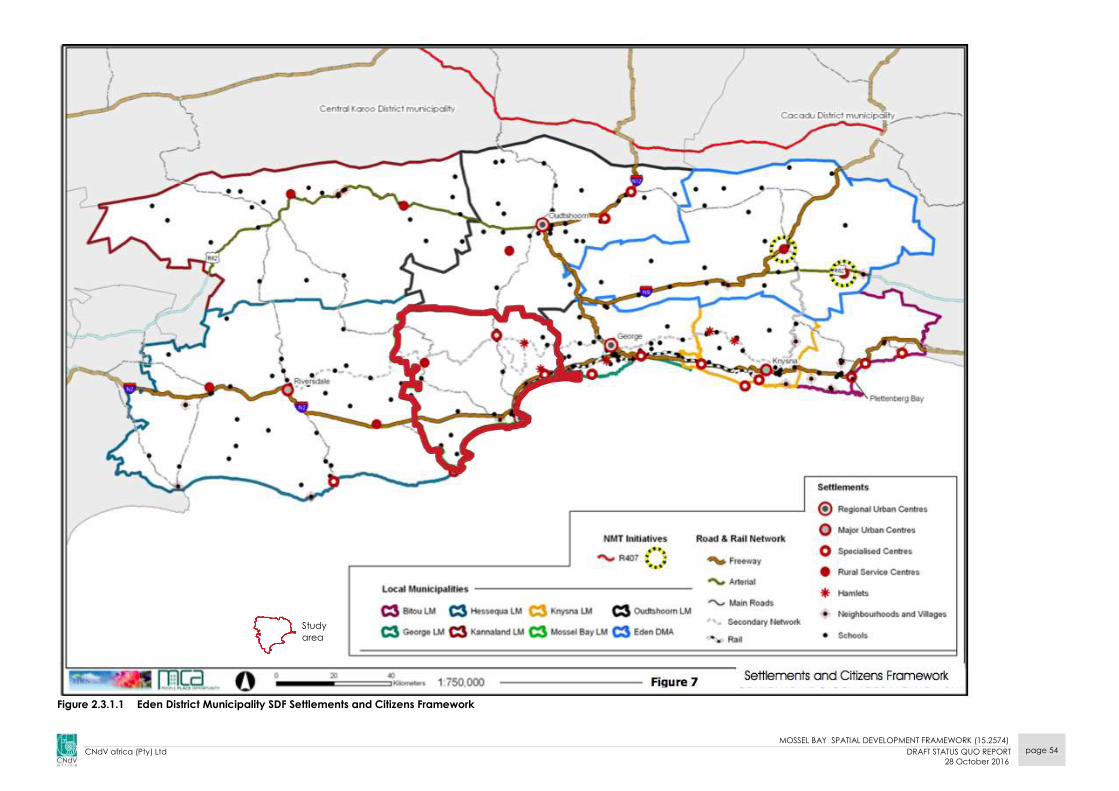
MOSSEL BAY SPATIAL DEVELOPMENT FRAMEWORK (15.2574)
CNdV africa (Pty) Ltd DRAFT STATUS QUO REPORT
28 October 2016
page 54
Figure 2.3.1.1 Eden District Municipality SDF Settlements and Citizens Framework
Study
area

MOSSEL BAY SPATIAL DEVELOPMENT FRAMEWORK (15.2574)
CNdV africa (Pty) Ltd DRAFT STATUS QUO REPORT
28 October 2016
page 55
Figure 2.3.1.2 Eden District Municipality Framework SDF Natural Resources
Study
area

MOSSEL BAY SPATIAL DEVELOPMENT FRAMEWORK (15.2574)
CNdV africa (Pty) Ltd DRAFT STATUS QUO REPORT
28 October 2016
page 56
2.4 MUNICIPAL POLICY
2.4.1 MOSSEL BAY MUNICIPALITY 4th GENERATION IDP & BUDGET
PLAN 2017 - 2023
The Integrated Development Plan (IDP) is a municipality’s principal
strategic plan that deals with the most critical development needs of the
municipal area (external focus) as well as the most critical governance
needs of the organisation (internal focus).
The IDP Process Plan incorporates all municipal planning, budgeting,
performance management, performance reporting and public and
stakeholder engagement processes. The preparation of a Process Plan,
which is in essence the IDP Process set out in writing, requires the adoption
by Council.
According to the IDP and Budget Time Schedule in this document, the final
capital budgets have not yet been released at the time of printing this
report. Therefore, this section will be updated as soon as the budget is
released by the municipality.
According to the 2016/2017 IDP, the following projects are envisaged up
until 2019.
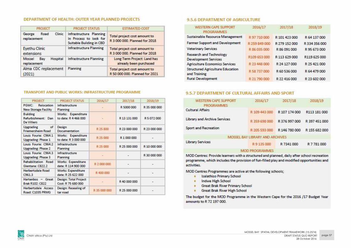
MOSSEL BAY SPATIAL DEVELOPMENT FRAMEWORK (15.2574)
CNdV africa (Pty) Ltd DRAFT STATUS QUO REPORT
28 October 2016
page 57
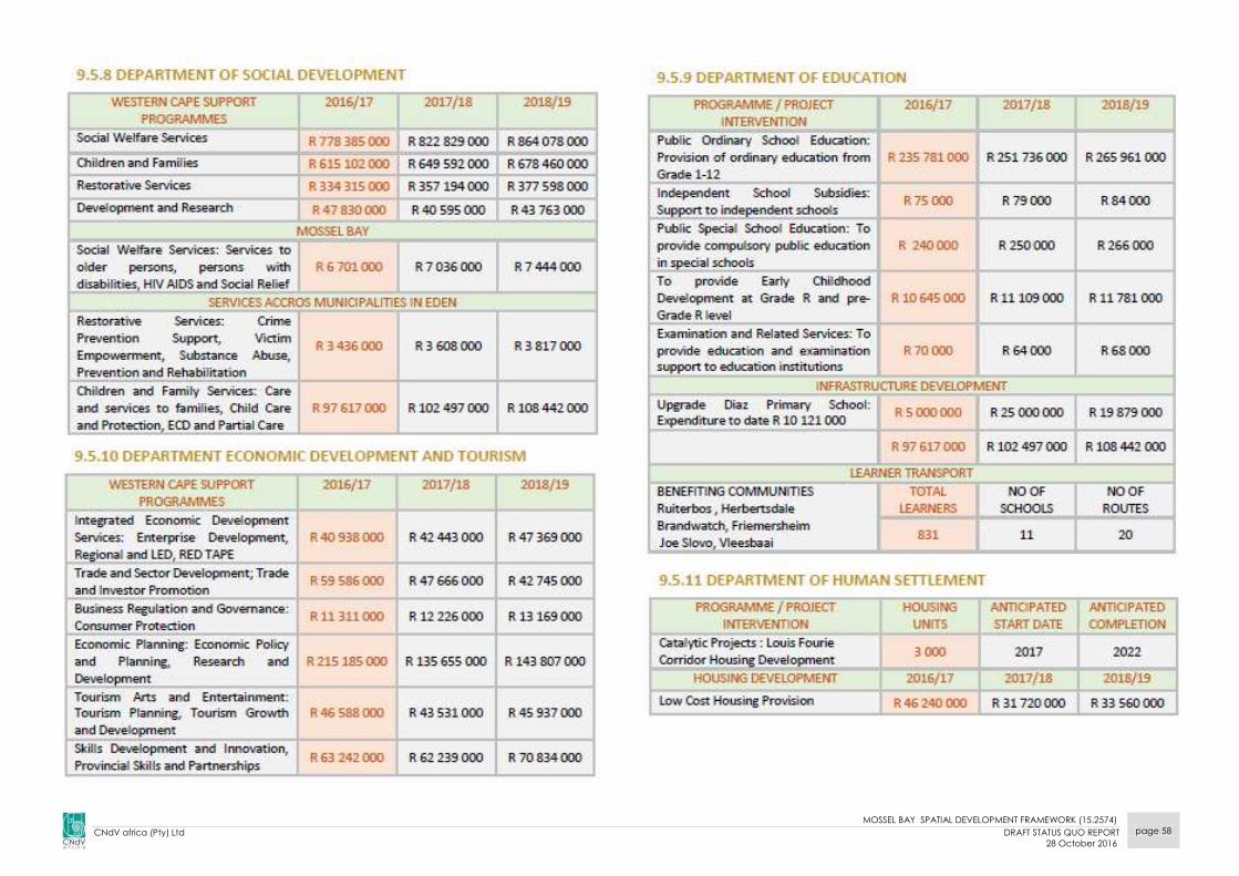
MOSSEL BAY SPATIAL DEVELOPMENT FRAMEWORK (15.2574)
CNdV africa (Pty) Ltd DRAFT STATUS QUO REPORT
28 October 2016
page 58
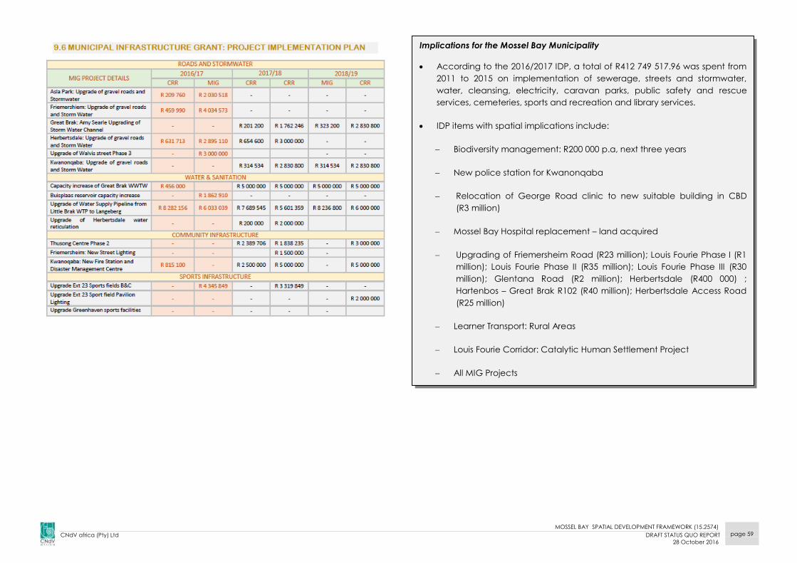
MOSSEL BAY SPATIAL DEVELOPMENT FRAMEWORK (15.2574)
CNdV africa (Pty) Ltd DRAFT STATUS QUO REPORT
28 October 2016
page 59
Implications for the Mossel Bay Municipality
According to the 2016/2017 IDP, a total of R412 749 517.96 was spent from
2011 to 2015 on implementation of sewerage, streets and stormwater,
water, cleansing, electricity, caravan parks, public safety and rescue
services, cemeteries, sports and recreation and library services.
IDP items with spatial implications include:
Biodiversity management: R200 000 p.a, next three years
New police station for Kwanonqaba
Relocation of George Road clinic to new suitable building in CBD
(R3 million)
Mossel Bay Hospital replacement – land acquired
Upgrading of Friemersheim Road (R23 million); Louis Fourie Phase I (R1
million); Louis Fourie Phase II (R35 million); Louis Fourie Phase III (R30
million); Glentana Road (R2 million); Herbertsdale (R400 000) ;
Hartenbos – Great Brak R102 (R40 million); Herbertsdale Access Road
(R25 million)
Learner Transport: Rural Areas
Louis Fourie Corridor: Catalytic Human Settlement Project
All MIG Projects

MOSSEL BAY SPATIAL DEVELOPMENT FRAMEWORK (15.2574)
CNdV africa (Pty) Ltd DRAFT STATUS QUO REPORT
28 October 2016
page 60
2.4.2 MOSSEL BAY MUNICIPALITY SPATIAL DEVELOPMENT
FRAMEWORK, 2013 (MBM IDP, 2016/17)
The 2013 SDF review takes cognisance of the existing (2008) SDF and the six
existing precinct plans that have been prepared for the sub-areas of the
municipality. The Conceptual SDF employs planning principles as
promulgated in the Provincial Spatial Development Framework (2009).
These principles include:
The implementation of an Urban Edge that takes into account new
environmental informants such as Critical Biodiversity Areas and flood
lines.
The principle of ‘smart growth’ that promotes compact settlements,
meaning that Mossel Bay should undergo large scale densification.
Smart growth allows the efficient provision of services, puts amenities
within walking distance of residences, and promotes mixed use
development, integration and fosters a sense of place.
Sustainability in terms of built form and the local environment
The SDF highlights nodes and intensification corridors for each of the main
settlements within the Mossel Bay municipal area, and advocates
pedestrianisation and upgrades to public streets, and highlights important
heritage areas. The Louis Fourie Corridor area is recognised as a strategic
area for upgrade with additional housing planned in this area and the
potential for a Neighbourhood Development Partnership Grant (NDPG).
The importance of the of Da Nova for connectivity between the Mossel
Bay CBD and Louis Fourie area and the growing medical node is
highlighted, therefore this area is targeted for residential densification and
expansion of business uses. The historical importance of Mossel Bay town
area and the revitalisation the CBD is highlighted. The link between Diaz
Industria and the beachfront and the introduction of tourist uses in the area
is recognised as important.
A New Hartenbos/Monte Christo nodal settlement is planned, while two
main nodes are proposed at either end of Kaap de Goede Hoop road are
proposed. A Heritage protection area is proposed in the centre of Groot
Brak with nodes and an activity corridor along the Long Street and in line
with the urban fabric towards the Friemersheim Road. 21ha of possible new
development land is identified in Groot Brak.
2.4.2.1 Urban Edge: Mossel Bay Town and Hartenbos
The 2013 SDF presents a new updated Urban Edge that is generally more
restrictive than either the 2008 Urban Edge (formulated by the 2008 SDF) or
the amendments to the Urban Edge presented in the 2010 Mossel Bay SDF
Review. The Comparison of Urban Edges Plan Series shows the proposed
2013 Urban Edge.
2.4.2.2 Classified Heritage Areas
Mossel Bay is one of the oldest towns in South Africa and therefore enjoys a
rich heritage with multiple heritage resources in need of careful
management and protection. The Heritage Plan identifies several areas
within the Mossel Bay Municipality that should be the focus of heritage
management that have been incorporated in the Mossel Bay Spatial
Development framework and other precinct plans including the Mossel
Bay Central Precinct Plan.
The Mossel Bay SDF (2013) recommends a heritage overlay area that
encompasses the built-up area of the CBD and portions of central Great
Brak.

MOSSEL BAY SPATIAL DEVELOPMENT FRAMEWORK (15.2574)
CNdV africa (Pty) Ltd DRAFT STATUS QUO REPORT
28 October 2016
page 61
2.4.3 MOSSEL BAY MUNICIPAL PLANNING BY-LAW, 2015
The Mossel Bay Municipal Planning By-Law was adopted on 1 December
2015.
This By-Law addresses the following planning aspects in the municipality:
Interpretation and Application
Spatial Planning
Development Management
Application Procedures
Criteria for Decision-Making
Extension of Validity Period of Approvals
Municipal Planning Decision-Making Structures
Provision of Engineering Services
Enforcement
Miscellaneous Subjects
This By-Law will advise all planning applications made to the Municipality.
The Municipality is working on its Integrated Zoning Scheme.
MOSSEL BAY SPATIAL DEVELOPMENT FRAMEWORK (15.2574)
CNdV africa (Pty) Ltd DRAFT STATUS QUO REPORT
28 October 2016
page 62
2.5 ABUTTING SPATIAL DEVELOPMENT FRAMEWORKS
Three local Municipalities abut the Mossel Bay Municipality, namely the
George Local Municipality, Oudtshoorn Local Municipality and Hessequa
Local Municipality.
MOSSEL BAY SPATIAL DEVELOPMENT FRAMEWORK (15.2574)
CNdV africa (Pty) Ltd DRAFT STATUS QUO REPORT
28 October 2016
page 63
2.5.1 GEORGE LOCAL MUNICIPAL SPATIAL DEVELOPMENT
FRAMEWORK (DRAFT MAY 2013)
The George Municipal Spatial Development Framework (SDF) was
prepared in May 2013.
SDF Spatial Vision
“Develop George as a Destination of Opportunity”
SDF Spatial Mission
Facilitate a sustainable and quality living environment which will:
(1) Support Economic growth & vitality
(2) Contribute to Social upliftment and wellbeing
(3) Protect the environmental integrity
The SDF is based on five (5) spatial development objectives, namely:
Restructuring and integrating the dysfunctional urban fabric, together
with a public transport system and urban renewal interventions;
Strengthening the economic vitality by enhancing the regional and
local space economy, strategic developments to diversify and
strengthen the economy, consolidating and reinforcing nodes of
economic activity, and infrastructure services provision;
Creating quality living environments trough sustainable urban growth
management, managing a hierarchy of city activity nodes, the use of
strategic vacant land to take up new development demand, the
densification of urban areas, and the provision of housing and public
facilities;
Safeguarding the environmental integrity and assets by establishing a
city-wide open space system and environmental corridors,
maintaining the functionality of Critical Biodiversity Areas (CBAs) and
applying the principles of the Spatial Planning Categories (SPCs);
Mitigating against impacts of climate change, managing visual
landscapes and corridors as well as heritage resources; and,
Enhance the rural character and livelihood by protecting the
productive landscape, managing the subdivision of land and by
enhancing the rural livelihood and promoting integrated rural
development.
Figure 2.5.1 indicates the SDF prepared for the George Municipality.
Implications for Mossel Bay Municipality:
Some of George Municipality’s best agricultural land abuts MBM and care
must be taken to protect this use with appropriate land uses.
George Airport is located on the N2.
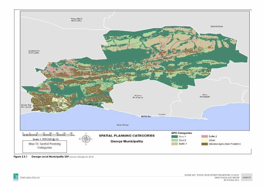
MOSSEL BAY SPATIAL DEVELOPMENT FRAMEWORK (15.2574)
CNdV africa (Pty) Ltd DRAFT STATUS QUO REPORT
28 October 2016
page 64
Figure 2.5.1 George Local Municipality SDF (source: George LM, 2013)
MOSSEL BAY SPATIAL DEVELOPMENT FRAMEWORK (15.2574)
CNdV africa (Pty) Ltd DRAFT STATUS QUO REPORT
28 October 2016
page 65
2.5.2 OUDTSHOORN LOCAL MUNICIPALITY, 2013
Oudtshoorn’s priorities are summarized into the 2030 vision statement as;
“Greater Oudtshoorn: a town to work, learn, play and prosper in.”
The vision is expanded into 5 Principles
1. Live: fostering social development, regeneration of wards,
infrastructure;
2. Work: fostering job creation, good governance, agriculture, industrial
development;
3. Learn: fostering earning and teaching and the knowledge economy;
4. Play: supporting and developing tourism, arts and culture;
5. Prosper: bringing together the principles of live, work, learn and play.
Implications for Mossel Bay Municipality:
The Outeniqua Mossel Bay boundary mainly comprises the Outeniqua
Nature Reserve, a core SPC and this should be continued southwards into
Mossel Bay.
The Kayaking River and R328 regional route cut through the Outeniqua
mountains at the Robinson Pass.

MOSSEL BAY SPATIAL DEVELOPMENT FRAMEWORK (15.2574)
CNdV africa (Pty) Ltd DRAFT STATUS QUO REPORT
28 October 2016
page 66
Figure 2.5.2 Oudtshoorn Local Municipal SDF, 2013
Study
area
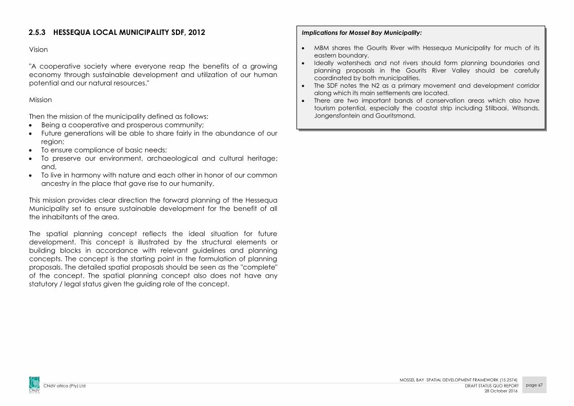
MOSSEL BAY SPATIAL DEVELOPMENT FRAMEWORK (15.2574)
CNdV africa (Pty) Ltd DRAFT STATUS QUO REPORT
28 October 2016
page 67
2.5.3 HESSEQUA LOCAL MUNICIPALITY SDF, 2012
Vision
"A cooperative society where everyone reap the benefits of a growing
economy through sustainable development and utilization of our human
potential and our natural resources."
Mission
Then the mission of the municipality defined as follows:
Being a cooperative and prosperous community;
Future generations will be able to share fairly in the abundance of our
region;
To ensure compliance of basic needs;
To preserve our environment, archaeological and cultural heritage;
and,
To live in harmony with nature and each other in honor of our common
ancestry in the place that gave rise to our humanity.
This mission provides clear direction the forward planning of the Hessequa
Municipality set to ensure sustainable development for the benefit of all
the inhabitants of the area.
The spatial planning concept reflects the ideal situation for future
development. This concept is illustrated by the structural elements or
building blocks in accordance with relevant guidelines and planning
concepts. The concept is the starting point in the formulation of planning
proposals. The detailed spatial proposals should be seen as the "complete"
of the concept. The spatial planning concept also does not have any
statutory / legal status given the guiding role of the concept.
Implications for Mossel Bay Municipality:
MBM shares the Gourits River with Hessequa Municipality for much of its
eastern boundary.
Ideally watersheds and not rivers should form planning boundaries and
planning proposals in the Gourits River Valley should be carefully
coordinated by both municipalities.
The SDF notes the N2 as a primary movement and development corridor
along which its main settlements are located.
There are two important bands of conservation areas which also have
tourism potential, especially the coastal strip including Stilbaai, Witsands,
Jongensfontein and Gouritsmond.

MOSSEL BAY SPATIAL DEVELOPMENT FRAMEWORK (15.2574)
CNdV africa (Pty) Ltd DRAFT STATUS QUO REPORT
28 October 2016
page 68
Figure 2.5.3 Hessequa Local Municipal SDF, 2012
Study
area

MOSSEL BAY SPATIAL DEVELOPMENT FRAMEWORK (15.2574)
CNdV africa (Pty) Ltd DRAFT STATUS QUO REPORT
28 October 2016
page 69
2.6 ALIGNMENTS
The vertical and horizontal alignment between the Mossel Bay Local
Municipality SDF and the other planning policies affecting and affected
by this SDF are illustrated below.
2.6.1 Vertical Alignment
The vertical alignment shows the relationship and alignment between
the proposals and policies of the Western Cape PSDF, Western Cape
Growth and Development Strategy and the Cape Winelands District SDF.
Of importance are the following:
Develop the tourism potential of the Mossel Bay region;
The Louie Fourie road should be promoted as a continuous
combined road/rail transport corridor through the municipality and
enhance the road in order to be a part of the ‘garden route’;
The promotion of higher order services and urban densities should be
encouraged here;
Mossel Bay (and Saldanha Bay) are seen as important sports and
LJNG resources. However, Mossel Bay is currently on the back burner
in this regard given the uncertainties around PetroSA’s plans for the
refinery and Portnet’s lack of attention to Mossel Bay harbour.
2.6.2 Horizontal Alignment
The horizontal alignments of the relationship between the Mossel Bay
Municipality and the abutting municipal SDF’s are shown on Figure
2.6.2.1.
The main abutting proposals that could influence the formulation of a
spatial development plan for the Mossel Bay Municipality are:
Promote the Louis Fourie corridor as a continuous transport, business
and tourism corridor; (Note: township tourism, eg. Mzoli’s restaurant is
becoming increasingly popular as an alternative tourism offering)
Promote the extension of the conservation status of existing reserves
along the Outeniqua mountains and the coast into a series of
continuous biodiversity corridors;
Protect intensive agriculture areas to ensure food security.
Acknowledging the need for joint planning co-ordination with
Hessequa Municipality in the Gourits River Valley.

MOSSEL BAY SPATIAL DEVELOPMENT FRAMEWORK (15.2574)
CNdV africa (Pty) Ltd DRAFT STATUS QUO REPORT
28 October 2016
page 70
Figure 2.6.2.1 Alignment with surrounding SDFs

MOSSEL BAY SPATIAL DEVELOPMENT FRAMEWORK (15.2574)
CNdV africa (Pty) Ltd DRAFT STATUS QUO REPORT
28 October 2016
page 71