Linking Adelaide with Nature
24
www.parks.sa.gov.au LINKING ADELAIDE NATURE WITH A strategy for the sustainable development of trails in the parks of the Mount Lofty Ranges
Transcript of Linking Adelaide with Nature

www.parks.sa.gov.au
LINKING ADELAIDE NATUREW
ITH
A strategy for the sustainable development of trails in the parks of the Mount Lofty Ranges

1. Introduction ...................................................................................................... 1
2. The trails network ......................................................................................... 3
3. Challenges ........................................................................................................ 5
4. Vision and goals ............................................................................................. 7
5. Guiding principles .......................................................................................... 9
6. Strategies ........................................................................................................ 11
7. Actions .............................................................................................................. 15
Appendices .......................................................................................................... 17
A. Map of the study area ....................................................................................................................17
B. Parks of the Mount Lofty Ranges ..............................................................................................18
C. Park Management Plans .............................................................................................................18
D. Adelaide Hills Trails Advisory Group .........................................................................................18
E. Links between strategies and actions .....................................................................................19
CONTENTS

1 Linking Adelaide with nature - A strategy for the sustainable development of trails in the parks of the Mount Lofty Ranges
1. INTRODUCTIONThe city of Adelaide is surrounded by a beautiful natural environment. To the west are beaches, coastal reserves and Gulf St Vincent. To the north is a network of 29 parks and reserves, which stretch across the Mount Lofty Ranges.
The traditional custodians of this land have a spiritual relationship with their country. These parks and reserves are special places for many South Australians and tourists, attracting more than 1.5 million visits a year.
The parks support a diverse range of life sustaining processes, ecosystems and species. More than 450 native fauna species and about 1500 native plant species have been recorded in the region. Many of these are threatened or under represented within the protected area system. The Australian Government has identified the Mount Lofty Ranges as one of the nation’s 15 national biodiversity hotspots – areas that support largely intact natural ecosystems and with a high diversity of locally endemic species. The Mount Lofty Ranges is a precious island of habitat, separated from other areas of eucalypt forest and woodland in South Eastern Australia.
Trails in the Mount Lofty Ranges link people to parks and other destinations. They are a natural setting for all sorts of recreation activity. Trail-based recreation helps to prevent disease, reduce stress and improve mental health, building more resilient communities that are less reliant on public health programs. Adelaide’s commercial tour operators and outdoor equipment retailers benefit from trail use and they make a significant contribution to the local economy.
People and Parks: A Visitor Strategy for South Australia’s National Parks, Marine Parks and Reserves is based on the principles of sustainable use and is an important guiding document for this strategy. It includes a vision, strategies and actions to ensure that more people appreciate, understand and help with the conservation of reserves.
Linking Adelaide with Nature is the first step towards two important actions outlined in People and Parks:
• Action 1.3 – Establish Mount Lofty Ranges as a nationally recognised cycling destination.
• Action 1.4 – Expand the suite of distinctive, broadly appealing trails in the Adelaide Hills that are suitable for people with limited mobility.
Linking Adelaide with Nature focuses on 29 parks and reserves managed by the Department of Environment, Water and Natural Resources (DEWNR) in Adelaide and the Adelaide Hills, between Para Wirra Recreation Park in the north, Aldinga Scrub Conservation Park in the south and Porter Scrub Conservation Park in the east (see Appendix A).
It outlines how trail creation, management and use will support the State Government’s goals for South Australia. In particular it demonstrates how trails will contribute to the conservation of parks and reserves, and the biodiversity of the Adelaide Hills.

Linking Adelaide with nature - a strategy for the sustainable development of trails in the parks of the Mount Lofty Ranges 2
Linking Adelaide with Nature also contributes to four key targets in South Australia’s Strategic Plan 2011:
• Target 1 – Urban spaces: Increase the use of public spaces by the community.
• Target 2 – Cycling: Double the number of people cycling in South Australia by 2020.
• Target 4 – Tourism Industry: Increase visitor expenditure in South Australia’s total tourism industry to $8 billion and on Kangaroo Island to $180 million by 2020 (Milestone of $6.3 billion (total industry) by 2014).
• Target 83 – Sport and Recreation: Increase the proportion of South Australians participating in sport or physical recreation at least once per week to 50% by 2020.
Additionally, this strategy contributes to the goals and objectives in:
• the Department of Environment, Water and Natural Resources Corporate Plan 2012–14, Goal 2: The environment is valued and enjoyed
• People and Parks: A Visitor Strategy for South Australia’s National Parks, Marine Parks and Reserves (DEWNR 2012)
• Linking with Nature: A Trails Strategy for South Australia’s Protected Areas 2008–2012 (Department for Environment and Heritage 2008)
• The Department of Health’s ‘Health in All Policies’ approach
• Informing Biodiversity Conservation for the Adelaide and Mount Lofty Ranges Region, South Australia (Department for Environment and Heritage 2010)
• Regional Recovery Plan for Threatened Species and Ecological Communities of Adelaide and the Mount Lofty Ranges, South Australia 2009–2014 (Department for Environment and Heritage 2009)
• Phytophthora Threat Management Standard Operating Procedure (Department for Environment and Heritage 2002)
• Creating A Sustainable Future An Integrated Natural Resources Management Plan for the Adelaide and Mount Lofty Ranges Region Volume B – 10 year plan for the region (Adelaide and Mount Lofty Ranges NRM Board 2008)
• The 30-Year Plan for Greater Adelaide (Department of Planning and Local Government 2010).
Linking Adelaide with Nature is also consistent with the DEWNR Cycling Policy and seeks to complement existing park management and trails plans (see Appendix C) and infrastructure redevelopment plans.
The Adelaide Hills Trails Advisory Group was formed to provide advice to DEWNR on the development of Linking Adelaide with Nature. This group consists of representatives from key community and stakeholder groups concerned about trail development and use in the Mount Lofty Ranges (see Appendix D).

3 Linking Adelaide with nature - A strategy for the sustainable development of trails in the parks of the Mount Lofty Ranges
The network of trails in the Mount Lofty Ranges is an integral component of this iconic tourism drawcard and is central to the lives of many South Australians. The ranges are recognised for scenic and challenging walks including the Yurebilla Trail, Heysen Trail and the Waterfall Gully to Mount Lofty Summit Trail. Without this trails network the community would not be able to enjoy the solitude and tranquillity of these natural areas sustainably.
The trails have a broad range of purposes. Some were planned and constructed with specific uses in mind; others have developed over time through use. The network consists of:
• trails – access routes used by people. They are primarily used for walking; however, designated trails may also be used for other recreational activities
• management vehicle tracks – used by motor vehicles authorised for park management and walkers. Designated trails may also be used for cycling or horse riding. They are not for public vehicle use
• unplanned tracks and trails – often inappropriate and unauthorised, they’ve evolved through use. Their number is significant, but has yet to be quantified.
There are about 560 kilometres of trails and management vehicle tracks in the network. Walking is currently allowed on all tracks and trails. To help walkers assess whether the trails are suitable for their level of fitness, they are classified from class 1 (easy) to class 5 (challenging). Only 110km of trails have been classified. The trails network includes:
• less than 15 km of trails that are suitable for walking by all people, including those with limited mobility (class 1 or 2)
• about 90 km of tracks and trails with few if any facilities that are suitable for walkers with a moderate level of fitness (class 3 or 4)
• about 7 km of walking trails that are challenging and require a higher level of fitness (class 5)
• about 27 km of cycling trails on management vehicle tracks
• about 4 km of designated cycle trail
• about 32 km of designated horse-riding trails.
2. THE TRAILS NETWORK
Linking Adelaide with nature - a strategy for the sustainable development of trails in the parks of the Mount Lofty Ranges 4
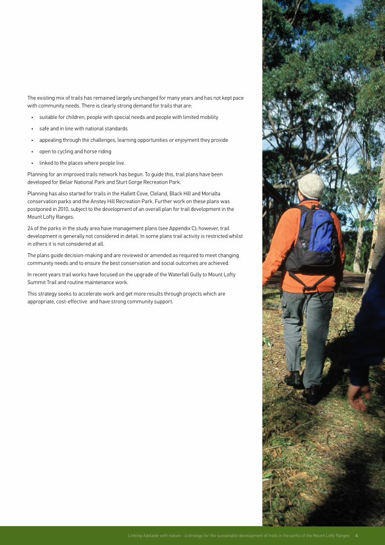
The existing mix of trails has remained largely unchanged for many years and has not kept pace with community needs. There is clearly strong demand for trails that are:
• suitable for children, people with special needs and people with limited mobility
• safe and in line with national standards
• appealing through the challenges, learning opportunities or enjoyment they provide
• open to cycling and horse riding
• linked to the places where people live.
Planning for an improved trails network has begun. To guide this, trail plans have been developed for Belair National Park and Sturt Gorge Recreation Park.
Planning has also started for trails in the Hallett Cove, Cleland, Black Hill and Morialta conservation parks and the Anstey Hill Recreation Park. Further work on these plans was postponed in 2010, subject to the development of an overall plan for trail development in the Mount Lofty Ranges.
24 of the parks in the study area have management plans (see Appendix C); however, trail development is generally not considered in detail. In some plans trail activity is restricted whilst in others it is not considered at all.
The plans guide decision-making and are reviewed or amended as required to meet changing community needs and to ensure the best conservation and social outcomes are achieved.
In recent years trail works have focused on the upgrade of the Waterfall Gully to Mount Lofty Summit Trail and routine maintenance work.
This strategy seeks to accelerate work and get more results through projects which are appropriate, cost-effective and have strong community support.
5 Linking Adelaide with nature - A strategy for the sustainable development of trails in the parks of the Mount Lofty Ranges
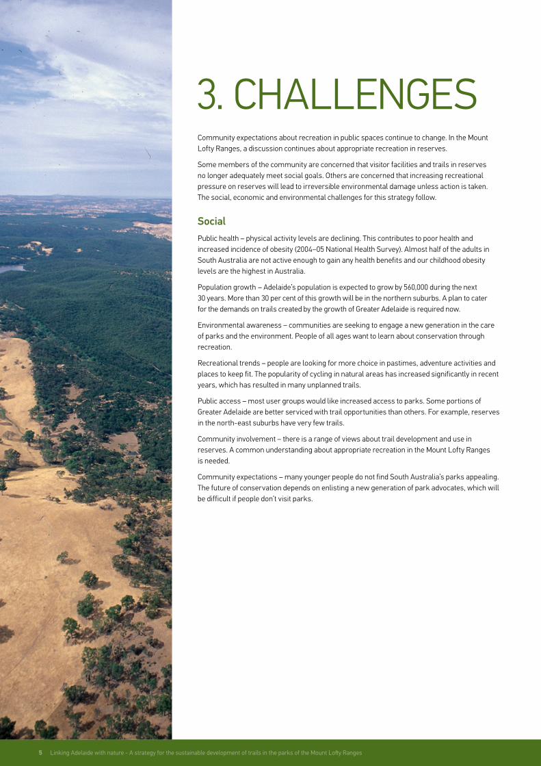
3. CHALLENGESCommunity expectations about recreation in public spaces continue to change. In the Mount Lofty Ranges, a discussion continues about appropriate recreation in reserves.
Some members of the community are concerned that visitor facilities and trails in reserves no longer adequately meet social goals. Others are concerned that increasing recreational pressure on reserves will lead to irreversible environmental damage unless action is taken. The social, economic and environmental challenges for this strategy follow.
SocialPublic health – physical activity levels are declining. This contributes to poor health and increased incidence of obesity (2004–05 National Health Survey). Almost half of the adults in South Australia are not active enough to gain any health benefits and our childhood obesity levels are the highest in Australia.
Population growth – Adelaide’s population is expected to grow by 560,000 during the next 30 years. More than 30 per cent of this growth will be in the northern suburbs. A plan to cater for the demands on trails created by the growth of Greater Adelaide is required now.
Environmental awareness – communities are seeking to engage a new generation in the care of parks and the environment. People of all ages want to learn about conservation through recreation.
Recreational trends – people are looking for more choice in pastimes, adventure activities and places to keep fit. The popularity of cycling in natural areas has increased significantly in recent years, which has resulted in many unplanned trails.
Public access – most user groups would like increased access to parks. Some portions of Greater Adelaide are better serviced with trail opportunities than others. For example, reserves in the north-east suburbs have very few trails.
Community involvement – there is a range of views about trail development and use in reserves. A common understanding about appropriate recreation in the Mount Lofty Ranges is needed.
Community expectations – many younger people do not find South Australia’s parks appealing. The future of conservation depends on enlisting a new generation of park advocates, which will be difficult if people don’t visit parks.

Linking Adelaide with nature - a strategy for the sustainable development of trails in the parks of the Mount Lofty Ranges 6
EconomicCost – building and maintaining trails and other visitor facilities for a broad range of user groups in all parks is costly. The trails network needs to be managed within the constraints of finite resources.
EnvironmentalWeeds – weeds displace native vegetation and affect natural ecological processes. The introduction of weeds must be avoided in any trail construction or use.
Erosion – poorly placed trails have caused erosion in some areas, particularly on steep slopes and where soils are prone to erosion.
Threatened species – the study area contains many state or nationally listed threatened species. 35 species (27 flora and eight fauna) are listed as nationally threatened under the Commonwealth’s Environment Protection and Biodiversity Conservation Act 1999 (EPBC Act). Of these, three flora and two fauna species are listed as critically endangered. All threatened species require special protection from threatening processes, such as weed invasion, or impacts, such as trail construction.
Climate change – a changing climate places additional pressure on fragile ecosystems. It also requires a management approach that is flexible and adaptive to changing circumstances.
Phytophthora cinnamomi – this soil-borne pathogen causes the loss of native vegetation. It is present in several reserves and can be spread by trail use, maintenance or insensitive design. Further spread must be minimised.
Habitat fragmentation – reserves help to protect areas of remnant vegetation; however, many of these areas are significantly fragmented by land clearing, tracks and trails. Further fragmentation must be avoided.

7 Linking Adelaide with nature - A strategy for the sustainable development of trails in the parks of the Mount Lofty Ranges
There are a range of community views about addressing social and environmental challenges for trails in the Mount Lofty Ranges. Views about changing trails use and increasing visitor numbers in parks have been robustly debated by the Adelaide Hills Trails Advisory Group.
To discuss these challenges, DEWNR held a workshop with the Adelaide Hills Trails Advisory Group to explore the participants’ beliefs about values and risks. It also evaluated their level of acceptance to various management alternatives.
This methodology is based on the view that a traditional scientific risk assessment involving a group of stakeholders with divergent views often results in a stalemate, a poor decision or a decision that alienates some members of the community.
This workshop did not aim to achieve a consensus view on any particular management strategy. It did help to identify the goals and guiding principles. It also helped to identify the conditions that make strategies and actions acceptable to stakeholders. Through this process, a vision, goals, guiding principles, strategies and actions have been developed.
This strategy seeks to realise the vision:
A sustainable trails network to engage people in the parks of the Mount Lofty Ranges
To achieve the vision, three goals have been set.
1. A sustainable trails network
A ‘sustainable’ trails network is a network that meets the needs of South Australians today, while conserving our ecosystems for the benefit of future generations. It requires an understanding of park management objectives, ecological values, economic constraints and social demand.
Good design and the use of appropriate materials can minimise detrimental impacts of trails. Most importantly, users of the trails can contribute to the care, repair and renewal of trails and parks. Achieving this goal depends on Goal 2 Increased community appreciation, understanding and stewardship for parks.
2. Increased community appreciation, understanding and stewardship for parks
The use of trails is one way people can develop an appreciation and understanding of parks. Encouraging visitors to contribute to conservation and trail maintenance activities can lead to long term stewardship for parks. This goal is supported by Goal 3 A more appealing trails network.
3. A more appealing trails network
A more appealing trails network will meet the expectations of more people. Trails need to match what people want.
4. VISION & GOALS

Linking Adelaide with nature - a strategy for the sustainable development of trails in the parks of the Mount Lofty Ranges 8

9 Linking Adelaide with nature - A strategy for the sustainable development of trails in the parks of the Mount Lofty Ranges
5. GUIDING PRINCIPLES
Six guiding principles describe how the strategies and actions in the strategy will be achieved.
1. Trail development and use should be sustainable and confined to a smaller carefully planned and properly resourced trails network
Conservation of natural and cultural values is the primary objective for parks. This objective is set out in the National Parks and Wildlife Act 1972.
Trails that are eroding, causing incremental vegetation loss, spreading weeds or soil-borne pathogens, fragmenting areas of high conservation value, or disturbing important wildlife habitats cannot be part of a sustainable trails network.
2. The trails network should minimise conflict between recreation activities
It is not always possible to provide separate trails for each recreation activity. Visitors should expect some trails that are purpose-built for an activity and others that accommodate a range of uses.
3. The trails network should provide for a broad range of sustainable uses based on the level of current and future demand
The National Parks and Wildlife Act includes an objective for ‘the encouragement of public use and enjoyment of reserves and education in, and a proper understanding and recognition of, their purpose and significance …’
Meeting this objective may not always be compatible with conservation objectives or be financially realistic. This means that priority will be given to sustainable projects with broad appeal and significant demand.
4. The risk to park values from trail development and use should be minimised through good planning, adaptive management and community stewardship
Good planning seeks to understand and prevent any unacceptable impact on park values. An ‘adaptive management’ approach ensures that decision-making is constantly revised and improved in light of new information.
This means that any change to the trails network will be done gradually. Pilot projects will be monitored to see if they have minimal impact and enhance community stewardship. If successful, additional projects will be considered.
Park management plans and trail plans are important documents; however, they may need some changes to achieve the vision of this strategy. The objectives of both the National Parks and Wildlife Act and management plans will guide any future changes.
Linking Adelaide with nature - a strategy for the sustainable development of trails in the parks of the Mount Lofty Ranges 10
5. GUIDING PRINCIPLES
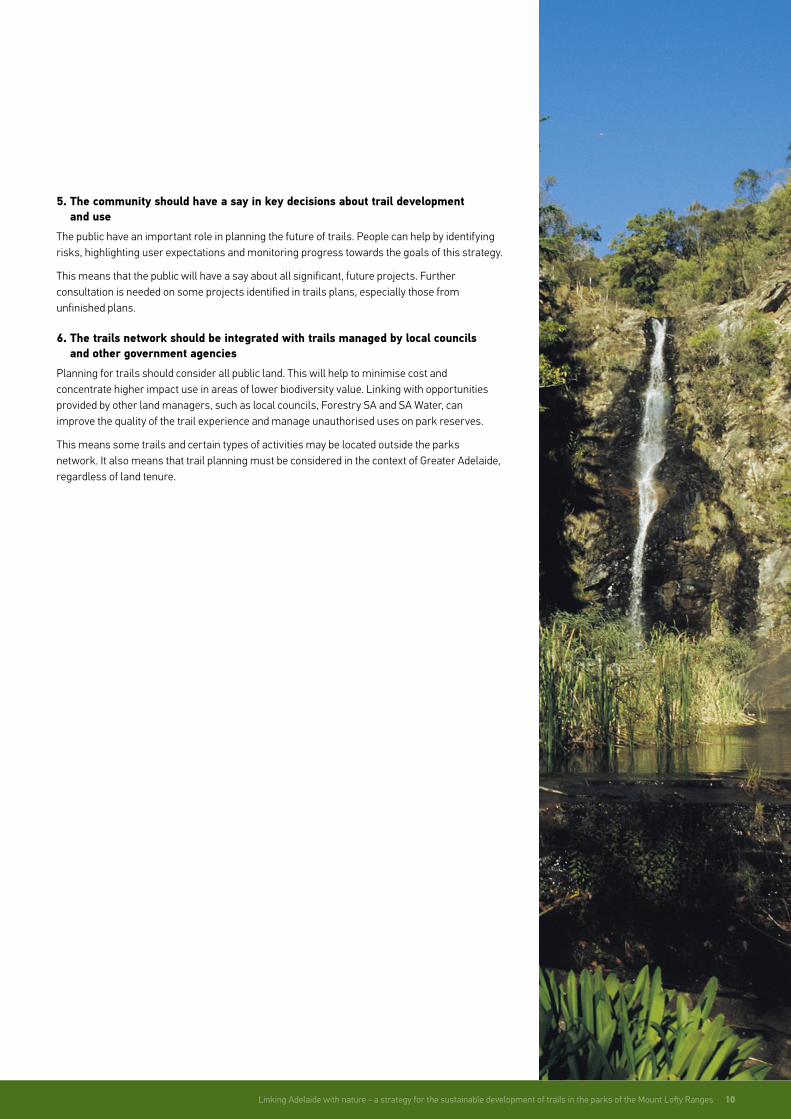
5. The community should have a say in key decisions about trail development and use
The public have an important role in planning the future of trails. People can help by identifying risks, highlighting user expectations and monitoring progress towards the goals of this strategy.
This means that the public will have a say about all significant, future projects. Further consultation is needed on some projects identified in trails plans, especially those from unfinished plans.
6. The trails network should be integrated with trails managed by local councils and other government agencies
Planning for trails should consider all public land. This will help to minimise cost and concentrate higher impact use in areas of lower biodiversity value. Linking with opportunities provided by other land managers, such as local councils, Forestry SA and SA Water, can improve the quality of the trail experience and manage unauthorised uses on park reserves.
This means some trails and certain types of activities may be located outside the parks network. It also means that trail planning must be considered in the context of Greater Adelaide, regardless of land tenure.

11 Linking Adelaide with nature - A strategy for the sustainable development of trails in the parks of the Mount Lofty Ranges
6. STRATEGIESEach strategy contributes to achieving the three goals by either:
• restricting or stopping public access (strategy 1)
• increasing the range of permitted uses (strategies 2, 3, 5, 6 and 7)
• undertaking capital works (strategies 4 and 8).
Selecting the best combination of strategies requires an understanding of risk. In other words, the implications of every strategy in every proposed scenario need to be appreciated. Environmental, economic and social challenges should be addressed for each project. This will result in a synergy between recreation and conservation and a net benefit to the park and the community.
The completion of a detailed science-based risk assessment across the Mount Lofty Ranges is not realistic, nor is it likely to provide a solution to conflicting expectations and perceptions about risk. This strategy broadly identifies four important planning considerations, which will determine the selection of strategies and drive more detailed, scientific risk assessment on a case-by-case basis. The planning considerations are:
• Park values – areas of higher park value include places where there are threatened plant species, important vegetation communities, cultural sites or important habitats
• Risks – areas of risk to park values include places where soils are sensitive, phytophthora or weeds could be spread, wildlife could be disturbed, or high levels of unauthorised activities occur
• Social values – areas of public benefit include places that offer a unique experience, where there are high levels of use or demonstrated high levels of demand
• Legal overlays – areas where specific and clear legal provisions apply.
Legal overlays may arise as a result of:
• management plans with specific and relevant zoning provisions
• the National Parks and Wildlife (National Parks) Regulations 2001 (SA)
• the Environment Protection and Biodiversity Conservation Act 1999 (Cwlth)
• the Aboriginal Heritage Act 1988 (SA).

Linking Adelaide with nature - a strategy for the sustainable development of trails in the parks of the Mount Lofty Ranges 12
The strategies are:
1. Close and rehabilitate unnecessary and unsustainable trails
The closure and rehabilitation of trails is necessary when the presence or the use of a trail is having an unacceptable impact on park values. This can also help to reduce habitat fragmentation and focus finite resources on higher priority trails.
This strategy targets trails in areas with higher park values, and that pose unacceptable risks to park values and have lower public benefit.
2. Test options for the management of new activities
Any changes to the trails network or expansion of recreational opportunities should be based on sound evidence. Expanded opportunities for cycling or horse-riding should demonstrate enhanced stewardship and more sustainable patterns of use before any further expansion is considered. This strategy targets a series of pilots to monitor, measure, and evaluate social and environmental goals.
Sound baseline data is needed and will require surveys to identify user needs and gaps in the current trails network.
3. Promote opportunities for the community to contribute to the development, sustainable use and care of the trails network
Trails that are appealing will attract more visitors. This could lead to additional pressures on parks. On the other hand, it could get more people involved in the care of trails and parks.
To ensure that increased use is matched by a growth in stewardship requires a suite of activities. This will involve communication, education and interpretation through the internet, signs, DEWNR staff and volunteers. Community groups, tour operators and adjoining land managers have a role in this.
4. Upgrade selected trails
Some visitors cannot physically access existing walking trails, are not satisfied with their experience or don’t find them appealing. Upgrading trails includes repairing surfaces, steps and bridges, finding a better alignment, or improving signage and information.
This strategy targets trails in areas where there is public benefit and not a significant risk to park values. This approach may also be necessary to address environmental issues. A long term approach to the upgrade of trails is needed to realise the vision of the trails network.
5. Open selected management vehicle tracks to cycling
A bicycle is considered a vehicle under the National Parks and Wildlife Act. The National Parks Regulations refer specifically to the use of vehicles in parks. The regulations specify that a person cannot cycle in a reserve except on a track or in an area set aside for cycling.
This means that cycling is not allowed on management vehicle tracks. To allow this, the track must be ‘set aside’ for cycling. Normally this is done through the development or amendment of the park management plan. This strategy can improve access for cycling at a relatively low cost and without an expansion of the trail footprint. The suitability of management vehicle tracks for cycling depends on park values, levels of use, cyclist behaviour and any conditions imposed on cyclists.
This strategy targets tracks in areas where there is public benefit and not a significant risk to park values.
13 Linking Adelaide with nature - A strategy for the sustainable development of trails in the parks of the Mount Lofty Ranges
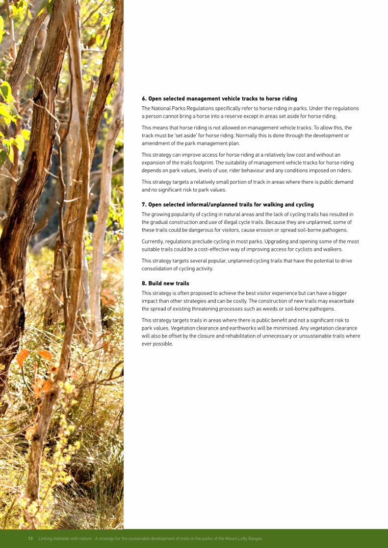
6. Open selected management vehicle tracks to horse riding
The National Parks Regulations specifically refer to horse riding in parks. Under the regulations a person cannot bring a horse into a reserve except in areas set aside for horse riding.
This means that horse riding is not allowed on management vehicle tracks. To allow this, the track must be ‘set aside’ for horse riding. Normally this is done through the development or amendment of the park management plan.
This strategy can improve access for horse riding at a relatively low cost and without an expansion of the trails footprint. The suitability of management vehicle tracks for horse riding depends on park values, levels of use, rider behaviour and any conditions imposed on riders.
This strategy targets a relatively small portion of track in areas where there is public demand and no significant risk to park values.
7. Open selected informal/unplanned trails for walking and cycling
The growing popularity of cycling in natural areas and the lack of cycling trails has resulted in the gradual construction and use of illegal cycle trails. Because they are unplanned, some of these trails could be dangerous for visitors, cause erosion or spread soil-borne pathogens.
Currently, regulations preclude cycling in most parks. Upgrading and opening some of the most suitable trails could be a cost-effective way of improving access for cyclists and walkers.
This strategy targets several popular, unplanned cycling trails that have the potential to drive consolidation of cycling activity.
8. Build new trails
This strategy is often proposed to achieve the best visitor experience but can have a bigger impact than other strategies and can be costly. The construction of new trails may exacerbate the spread of existing threatening processes such as weeds or soil-borne pathogens.
This strategy targets trails in areas where there is public benefit and not a significant risk to park values. Vegetation clearance and earthworks will be minimised. Any vegetation clearance will also be offset by the closure and rehabilitation of unnecessary or unsustainable trails where ever possible.

Linking Adelaide with nature - a strategy for the sustainable development of trails in the parks of the Mount Lofty Ranges 14
15 Linking Adelaide with nature - A strategy for the sustainable development of trails in the parks of the Mount Lofty Ranges
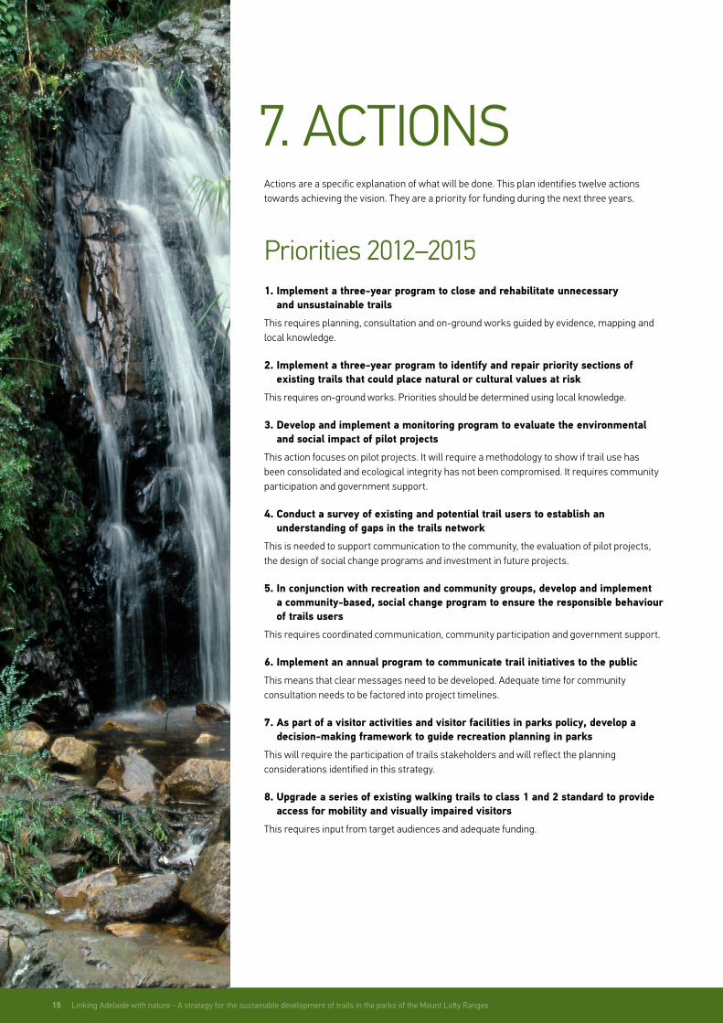
7. ACTIONS Actions are a specific explanation of what will be done. This plan identifies twelve actions towards achieving the vision. They are a priority for funding during the next three years.
Priorities 2012–20151. Implement a three-year program to close and rehabilitate unnecessary
and unsustainable trails
This requires planning, consultation and on-ground works guided by evidence, mapping and local knowledge.
2. Implement a three-year program to identify and repair priority sections of existing trails that could place natural or cultural values at risk
This requires on-ground works. Priorities should be determined using local knowledge.
3. Develop and implement a monitoring program to evaluate the environmental and social impact of pilot projects
This action focuses on pilot projects. It will require a methodology to show if trail use has been consolidated and ecological integrity has not been compromised. It requires community participation and government support.
4. Conduct a survey of existing and potential trail users to establish an understanding of gaps in the trails network
This is needed to support communication to the community, the evaluation of pilot projects, the design of social change programs and investment in future projects.
5. In conjunction with recreation and community groups, develop and implement a community-based, social change program to ensure the responsible behaviour of trails users
This requires coordinated communication, community participation and government support.
6. Implement an annual program to communicate trail initiatives to the public
This means that clear messages need to be developed. Adequate time for community consultation needs to be factored into project timelines.
7. As part of a visitor activities and visitor facilities in parks policy, develop a decision-making framework to guide recreation planning in parks
This will require the participation of trails stakeholders and will reflect the planning considerations identified in this strategy.
8. Upgrade a series of existing walking trails to class 1 and 2 standard to provide access for mobility and visually impaired visitors
This requires input from target audiences and adequate funding.

Linking Adelaide with nature - a strategy for the sustainable development of trails in the parks of the Mount Lofty Ranges 16
9. Establish three cycle trail pilot projects, each based on up to 10 km of management trails
These three pilots will be used to determine the long term feasibility of using management trails for cycling. These projects require risk assessment, consultation, community participation and clear communication to users. This will involve signage and partnerships with user groups. Any further developments will depend on the outcomes of monitoring.
10. Establish an improved loop trail experience for horse riders by incorporating additional sections of management track
This action focuses on linking existing trail experiences into an improved loop using sections of management track. This requires risk assessment, consultation and clear communication to users.
11. Establish a cycle trail pilot project based on up to 5 km of existing unplanned walking and cycle trails
This pilot project will be used to determine the long term feasibility of integrating selected unplanned trails into the trails network. This project requires risk assessment, consultation and community participation. It means that any further developments will depend on the outcomes of monitoring.
12. Establish a shared-use trail for walking, horse riding and cycling
This project helps address growing demand and provides a purpose built experience to monitor social and ecological risks using best practice methodologies. This requires risk assessment, consultation and clear communication to users.
Priorities 2015 onwardsIn the longer term, there is much more to be done to realise the vision. The guiding principles, strategies and planning considerations outlined in this plan will help to shape future actions.
The next step is to develop an action plan for trail management from 2015 onwards. This will require a review of pilot projects.
The results of the pilot projects will help identify the best management alternatives to protect conservation values, improve community stewardship and meet changing community needs.
Planning will be based on strategic priorities rather than a park by park approach. To ensure the right projects get funding they will need to:
• align with the goals of this strategy
• meet current and future demand
• have adequate resourcing
• address risks (social, ecological, heritage and economic)
• be supported by the community.

17 Linking Adelaide with nature - A strategy for the sustainable development of trails in the parks of the Mount Lofty Ranges
APPENDIX AMap of the study area
ADELAIDE
Totness RP
Cleland CP
Para Wirra RP
Belair NP
OnkaparingaRiver NP
Black Hill CP
Morialta CP
Scott Creek CP
Anstey Hill RP
Aldinga Scrub CP
Sturt Gorge RP
Giles CP
O'Halloran Hill RP
Mark Oliphant CP
Porter Scrub CP
Cobbler Creek RP
OnkaparingaRiver RP
Mount George CP
Shepherds Hill RP
Hallett Cove CP
Marino CP
Brownhill Creek RP
Greenhill RP
Moana Sands CP
Blackwood Forest RP
Eurilla CP
Ferguson CP
Angove CP
Horsnell Gully CP
Adelaide
Parks of interest
Built Up Area
Major road
0 7.5
Kms

Parks of the Mount Lofty RangesAldinga Scrub Conservation Park
Angove Conservation Park
Anstey Hill Recreation Park
Belair National Park
Black Hill Conservation Park
Blackwood Forest Recreation Park
Brownhill Creek Recreation Park
Cleland Conservation Park
Cobbler Creek Recreation Park
APPENDIX B
APPENDIX D
APPENDIX C
Eurilla Conservation Park
Ferguson Conservation Park
Giles Conservation Park
Greenhill Recreation Park
Hallett Cove Conservation Park
Horsnell Gully Conservation Park
Marino Conservation Park
Mark Oliphant Conservation Park
Moana Sands Conservation Park
Morialta Conservation Park
Mount George Conservation Park
O’Halloran Hill Recreation Park
Onkaparinga River National Park
Onkaparinga Recreation Park
Para Wirra Recreation Park
Porter Scrub Conservation Park
Scott Creek Conservation Park
Shepherds Hill Recreation Park
Sturt Gorge Recreation Park
Totness Recreation Park
Park Management PlansAldinga Scrub Conservation Park Management Plan 1992
Angove Conservation Park Management Plan 2005
Anstey Hill Recreation Park Management Plan 2006
Belair National Park Management Plan 2003
Black Hill Conservation Park Management Plan 2001
Blackwood Forest Recreation Park Management Plan 2005
Brownhill Creek Recreation Park Management Plan 2003
Cleland Conservation Park Management Plan 1983
Adelaide Hills Trails Advisory GroupAnnie Bond, Nature Conservation Society of South Australia
Nicolas Bowman, International Mountain Biking Association Australia
Julie Fiedler, Horse SA
Bill Gehling, Walking SA, The Walking Federation of South Australia Inc.
Christian Haag, Bicycle SA
Cobbler Creek Recreation Park Management Plan 2003
Ferguson Conservation Park Management Plan 1984
Hallett Cove Conservation Park Management Plan 2010
Marino Conservation Park Management Plan 2010
Mark Oliphant Conservation Park Management Plan 1996
Morialta Conservation Park Management Plan 2001
Mount George Conservation Park Management Plan 2006
O’Halloran Hill Recreation Park Management Plan 2008
Onkaparinga River National Park Management Plan 2004
Onkaparinga River Recreation Park Management Plan 2004
Para Wirra Recreation Park Management Plan 1993
Porter Scrub Conservation Park Management Plan 1983
Scott Creek Conservation Park Management Plan 2000
Shepherds Hill Recreation Park Management Plan 2008
Sturt Gorge Recreation Park Management Plan 2008
Totness Recreation Park Management Plan 2007
Trails PlansBelair Trails Plan 2010
Sturt Gorge Trails Plan 2010
Jill Marks, Department for Families and Communities – Disability South Australia
Peter Mayer, Orienteering Association of South Australia
David Mitchell, Friends of Parks Inc.
Cathy Potts, Conservation Council of South Australia
Malcolm Robertson, Adelaide Mountain Bike Club
Ward Tilbrook, South Australian Tourism Industry Council
Matt Turner, Wilderness Society South Australia
Andrew West, Adelaide and Mount Lofty Ranges Natural Resources Management Board
Linking Adelaide with nature - a strategy for the sustainable development of trails in the parks of the Mount Lofty Ranges 18
19 Linking Adelaide with nature - A strategy for the sustainable development of trails in the parks of the Mount Lofty Ranges
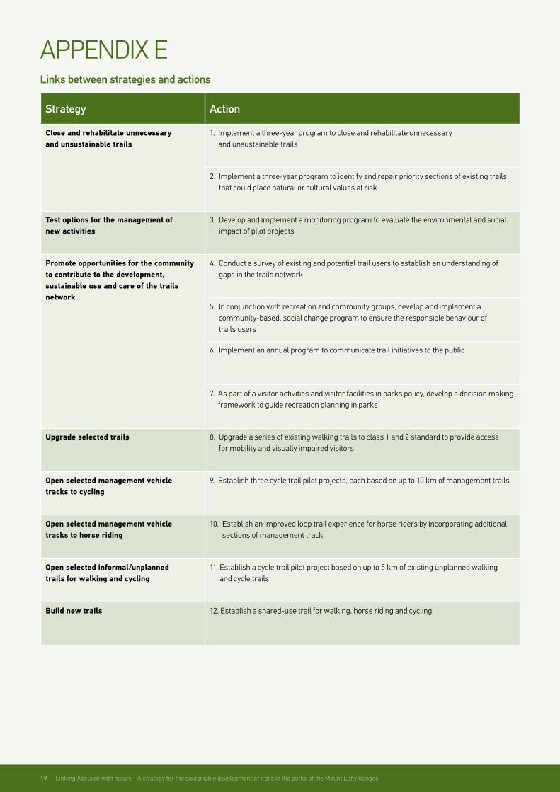
Links between strategies and actions
Strategy Action
Close and rehabilitate unnecessary and unsustainable trails
1. Implement a three-year program to close and rehabilitate unnecessary and unsustainable trails
2. Implement a three-year program to identify and repair priority sections of existing trails that could place natural or cultural values at risk
Test options for the management of new activities
3. Develop and implement a monitoring program to evaluate the environmental and social impact of pilot projects
Promote opportunities for the community to contribute to the development, sustainable use and care of the trails network
4. Conduct a survey of existing and potential trail users to establish an understanding of gaps in the trails network
5. In conjunction with recreation and community groups, develop and implement a community-based, social change program to ensure the responsible behaviour of trails users
6. Implement an annual program to communicate trail initiatives to the public
7. As part of a visitor activities and visitor facilities in parks policy, develop a decision making framework to guide recreation planning in parks
Upgrade selected trails 8. Upgrade a series of existing walking trails to class 1 and 2 standard to provide access for mobility and visually impaired visitors
Open selected management vehicle tracks to cycling
9. Establish three cycle trail pilot projects, each based on up to 10 km of management trails
Open selected management vehicle tracks to horse riding
10. Establish an improved loop trail experience for horse riders by incorporating additional sections of management track
Open selected informal/unplanned trails for walking and cycling
11. Establish a cycle trail pilot project based on up to 5 km of existing unplanned walking and cycle trails
Build new trails 12. Establish a shared-use trail for walking, horse riding and cycling
APPENDIX E

Linking Adelaide with nature - a strategy for the sustainable development of trails in the parks of the Mount Lofty Ranges 20

For further information please contact:Department of Environment, Water and Natural Resources GPO Box 1047 Adelaide SA 5001 Telephone: (08) 8204 1910
Copies of this document can be downloaded from: www.parks.sa.gov.au
Photography credits: Adam Bruzzone, Bill Doyle, James Knowler, Matt Nettheim, Andrew Neighbour, Craig Ingram and South Australian Tourism Commission www.southaustralia.com
Permissive Licence© State of South Australia through the Department of Environment, Water and Natural Resources. Apart from fair dealings and other uses permitted by the Copyright Act 1968 (Cth), no part of this publication may be reproduced, published, communicated, transmitted, modified or commercialised without the prior written approval of the Department of Environment, Water and Natural Resources.
Written requests for permission should be addressed to: Department of Environment, Water and Natural Resources, GPO Box 1047, Adelaide SA 5001.
DisclaimerWhile reasonable efforts have been made to ensure the contents of this publication are factually correct, the Department of Environment, Water and Natural Resources makes no representations and accepts no responsibility for the accuracy, completeness or fitness for any particular purpose of the contents, and shall not be liable for any loss or damage that may be occasioned directly or indirectly through the use of or reliance on the contents of this publication.
Reference to any company, product or service in this publication should not be taken as a Departmental endorsement of the company, product or service.
© Department of Environment, Water and Natural Resources. All rights reserved. Published September 2012 | ISBN: 978-1-921800-48-1 | FIS: 91080