
LIMITED PURPOSE AQUACULTURE LICENSE (LPA ... · Web viewFloating upweller system for spat growout....
34
Revised March 26, LIMITED PURPOSE AQUACULTURE LICENSE (LPA) APPLICATION This is a joint application form for (1) a limited purpose aquaculture (“LPA”) license from the Maine Department of Marine Resources (DMR) and (2) a permit for aquaculture gear from the U.S. Army Corps of Engineers (ACOE). You must have both an LPA license and Army Corps permit before you can place aquaculture gear in Maine coastal waters. Incomplete Applications: Incomplete applications will be returned to the applicant resulting in significant delays in processing time. Do not leave any questions blank. Review each checklist carefully to make sure all required information is included. Contact Flora Drury at (207) 633-9531 with any questions. Fee: The Maine Department of Marine Resources requires a non-refundable fee of $50 for each LPA license application from Maine residents and $300 from non-residents of Maine. Make check payable to “Treasurer, State of Maine.” There is no charge for the Army Corps permit. Black Ink Only: Please use black ink when completing your application. DMR sends a copy of your application to the ACOE to expedite processing time. Colored ink and pencil often become illegible when scanned and copied and can result in delays for the applicant. To apply for an LPA license: Complete this application form, including the required attachments. Send one copy of the application with the attachments and the license fee to the address below. MDMR will forward a copy of your application to the Army Corps of Engineers. DEPARTMENT OF MARINE RESOURCES ATTN: Flora Drury DMR, PO Box 8 West Boothbay Harbor, ME 04575
Transcript of LIMITED PURPOSE AQUACULTURE LICENSE (LPA ... · Web viewFloating upweller system for spat growout....

Revised March 26, 2018
LIMITED PURPOSE AQUACULTURE LICENSE (LPA) APPLICATION
This is a joint application form for (1) a limited purpose aquaculture (“LPA”) license from the Maine Department of Marine Resources (DMR) and (2) a permit for aquaculture gear from the U.S. Army
Corps of Engineers (ACOE). You must have both an LPA license and Army Corps permit before you can place aquaculture gear in Maine coastal waters.
Incomplete Applications: Incomplete applications will be returned to the applicant resulting in significant delays in processing time. Do not leave any questions blank. Review each checklist carefully to make sure all required information is included. Contact Flora Drury at (207) 633-9531 with any questions.
Fee: The Maine Department of Marine Resources requires a non-refundable fee of $50 for each LPA license application from Maine residents and $300 from non-residents of Maine. Make check payable to “Treasurer, State of Maine.” There is no charge for the Army Corps permit.
Black Ink Only: Please use black ink when completing your application. DMR sends a copy of your application to the ACOE to expedite processing time. Colored ink and pencil often become illegible when scanned and copied and can result in delays for the applicant.
To apply for an LPA license: Complete this application form, including the required attachments. Send one copy of the application with the attachments and the license fee to the address below. MDMR will forward a copy of your application to the Army Corps of Engineers.
DEPARTMENT OF MARINE RESOURCESATTN: Flora Drury
DMR, PO Box 8West Boothbay Harbor, ME 04575

Revised March 26, 2018
APPLICATION CHECKLIST
Before submitting your application make sure you have answered all questions and included all of the following documents. Failure to do
so may result in significant delays in processing time.
Required documents for all LPA applications.
☐Check for application fee ($50 or $300) Payable to “Treasurer, State of Maine.”
☐ Vicinity map with required items shown (Page 8 & Figure 1 on Page 9)
☐ Overhead view depicting layout of the gear from overhead (Page 12)
☐ Cross-section view depicting gear & moorings from the side (Page 13)
Documents that are only required for sites that are within 300’ from shorefront property (measured from mean low water mark). Applications for LPA sites in marina slips, lobster pounds, and similar sites are exempt from this requirement.
☐ Tax map, certified (Step 1, Page 15)
☐ Riparian list, certified (Page 17)
☐ Copies of receipts for sending certified mail to riparian landowners (Step 3, Page 15)
- 1 -

Revised March 26, 2018
[THIS SECTION INTENTIONALLY BLANK]

- 3 Revised March 26, 2018
REQUIREMENTS AND RESTRICTIONS FOR LPA LICENSESSee DMR Regulation 2.90 for the full regulation
1. License Limit: No more than four licenses may be held by any individual at the same time.
2. Density Limit: There can be no more than four LPA license sites within a 1,000-ft. radius. Riparian landowners are allowed to have one LPA site within 150 feet of their shorefront property that does not count toward this limitation. LPA sites located in marina slips, lobster pounds, or similar enclosed or partially-enclosed sites that are owned or controlled by an entity which has the legal authority to restrict access to or use of the site and which has consented in writing to the placement of the gear on the site are exempt from this density standard.
3. Assistants: Up to three unlicensed assistants per license may be declared as helpers. An individual holding four licenses can be an assistant on up to eight additional licenses. If the license holder represents an educational institution, students are authorized to work under the direct supervision of the license holder or assistants.
4. Intertidal Sites: For LPA sites above the extreme low water mark (XLW) in towns with a municipal shellfish management ordinance approved by DMR, the chairperson of the municipal shellfish committee is required to sign the LPA application form to verify that the LPA will not unreasonably interfere with the activities of the shellfish program. For LPA sites above the mean low water mark (MLW), the signature of the riparian landowner of the adjacent upland is required on the application to verify that the landowner consents to the LPA activity being conducted on the owner’s intertidal land.
5. Water Quality: Find the water quality classification of your LPA site on the web at http://www.maine.gov/dmr/rm/public_health/closures/closedarea.htm. LPA license sites for shellfish may not be within 300 feet of any areas classified as “prohibited” and can only be located in areas that are classified as approved or conditionally approved, except for the sole culture of seed. Sites raising only shellfish seed may be located in restricted, conditionally restricted, or prohibited areas subject to relay requirements, but are prohibited in the 300:1 dilution area around a wastewater treatment plant outfall (DMR Rule Chapter 2.90(3)(D)(3)). Water quality classification restrictions do not apply for the culture of green sea urchins or marine algae, with the exception of marine algae for human consumption, which cannot be grown in the 300:1 dilution area around a wastewater treatment plant outfall.
6. Essential Habitats: LPA licenses may not be located within areas designated as Essential Habitat by the Maine Department of Inland Fisheries and Wildlife (MDIFW). DMR will determine whether your proposed LPA site is located within an Essential Habitat.
7. Eagles Nests: Eagles Nests: Bald and Golden Eagles are not protected under the Endangered Species Act but are protected under the Bald and Golden Eagle Protection Act (16 U.S.C. 668 et seq.) by the U.S. Fish & Wildlife Service (USFWS). As such, the USFWS recommends that all structures and activity should be limited to no closer than 660 feet of an active nest to avoid disturbing eagles under the Eagle Act. Contact Erynn Call at MDIF&W at [email protected] or (207) 941-4481 for questions regarding the location and status of eagle's nests.
8. Riparian Landowners: You are required to notify all shorefront or intertidal land owners within 300 feet of the license site by sending, via certified mail, a copy of the LPA application, including information about how riparians can submit comments to DMR regarding issuance or renewal of the license. Notification requirements apply to privately and publicly (state or federal) owned lands.
9. Army Corps Permit: A permit from the U.S. Army Corps of Engineers is required prior to the placement or use of any gear in the license area. For more information about the Army Corps permit, contact the U.S. Army Corps of Engineers at the Maine Project Office, 442 Civic Center Drive, Ste. 350, Augusta, Maine 04330, or at (207) 623-8367.
10. Renewing your LPA License: LPA licenses expire on December 31 each year. DMR will send you a renewal form in November and an invoice for the renewal payment in early December. If these steps are not

- 4 Revised March 26, 2018
completed before December 31, your LPA will expire, your Army Corps permit will become invalid, and you will be required to remove all gear from the LPA site by December 31.
- 5 Revised March 26, 2018
STANDARD CONDITIONS for LPA licenses Source: DMR Rule Chapter 2.90 (5) and (6)
1. No Discharge. See Chapter 2.90 (5)(A). The licensed activity must not generate a discharge. This means that you cannot add any foreign substances to the water, such as feed or medicine.
2. Carry a copy of the LPA License. See Chapter 2.90 (5)(B). You and your named assistants are the only people legally allowed to handle aquaculture gear belonging to you. You must each carry a copy of the LPA license whenever you are engaged in any activity at the LPA site. If a National Weather Service-issued hurricane warning is in effect, then others may also assist you and handle the gear.
3. Restrictions on Harvest. See Chapter 2.90 (5)(C)(1). Harvest of shellfish is prohibited in areas closed due to marine biotoxins or bacterial pollution. For details about closed areas, see the Department’s web site at: http://www.maine.gov/dmr/rm/public_health/shellfishgrowingarea.htm or call DMR Marine Patrol Division I at 207-633-9595 (for areas west of Port Clyde), or Division II at 207-667-3373 (for areas east of Port Clyde), or call the Shellfish Sanitation Hotline at 1-800-232-4733.
4. Record-Keeping and Annual Report. You must maintain complete, legible, and accurate records of transport, transfer, harvest, and monitoring and keep these available for inspection for at least two (2) years; and submit to the Commissioner an annual report of these activities. The records must include the following:
(1) LPA acronym, site location, date(2) Source of shellfish, including seed if the seed is from growing areas which are not in the approved
classification status pursuant to Chapter 2.90 and/or Chapter 15;(3) Dates of transplanting and harvest;(4) Detailed records of sales;(5) Records of the origin and health status of all seed or shellfish stocks reared on the site must also be
maintained.
5. Site Marking. See Chapter 2.90 (6)(B). Mark your LPA site at each corner or at the center with buoys supporting letters at least 2” high spelling “Sea Farm”. Each buoy must also clearly display your Site ID. Corner buoys, if any, must be distinguishable from interior markers and gear.
6. Maintenance Standards. See Chapter 2.90 (6)(A). All aquaculture gear must be maintained and kept in a fully operational condition. You must collect and/or remove any loose or errant gear or equipment. Storage of gear when not in use must be located in an upland location and not on the substrate or on marsh vegetation.
7. Contact the Coast Guard. See Chapter 2.90 (6)(C). You must contact the U.S Coast Guard Private Aids to Navigation Office for approval of navigation marking devices according to the United States Coast Guard Private Aids to Navigation (PATON) standards. To begin the application process, go to http://www.usharbormaster.com and register. Send DMR a copy of any Coast Guard marking requirements.

- 5 Revised March 26, 2018
GENERAL INFORMATION
Name of Applicant (must be a person): _______________________________
Address:______________________________
City: _______________________________ County: _______________________________
State: _______________________________ Zip: _______________________________
Telephone: ____________________________ Email address: _______________________________
Are you listed as an assistant on any existing LPA licenses? If yes, please list them (LPA Acronym):
___________________________________________________________________________________
Do you have any other current LPA licenses? If yes, please list them (LPA Acronym):
___________________________________________________________________________________
Assistants: (1) _______________________________ (2) _______________________________
(3) _______________________________
Location of license site: Town: ___________________________ County: _______________________
Water body: _______________________________
Additional description (e.g., south of Hog Island): _______________________________
Is this site above Mean Low Water (is the site intertidal)? ☐YES ☐ NO
If no above, is this site above Extreme Low Water (does the site ever drain)? ☐YES ☐ NO
NOTE: If the site is above XLW the Chair of the Municipal Shellfish Management Committee in your site town must sign page 14 of this application.
LPA Health Zone #: _______________________________
NOTE: More information on LPA Health Zones can be found on MDMR’s website.
Purpose (Check one):
☐Commercial (product is ultimately sold)
☐Recreational (product kept for personal use, not sold)
☐Municipal Shellfish Management
☐Scientific
☐Educational

- 6 Revised March 26, 2018
Species and Source of Stock: Check each species to be cultivated and list the source of stock for each. Note: Any seed that does not come directly from an approved hatchery is considered “wild” seed and must come from within the LPA License Health Area in which your license is located, OR you will need a transfer permit from DMR aquaculture biologists. Clams, other than razor clams, may only be obtained from a hatchery unless a town has issued a permit to collect wild stock.
Check Here
Species Source of Stock (Name, address, & phone number)
☐ Blue mussel (Mytilus edulis)
☐ Hard clam/quahog (Mercenaria mercenaria)
☐ Hen clam (Spisula solidissima)
☐ Soft-shelled clam (Mya arenaria)
☐ Razor clam (Ensis directus)
☐ American or eastern oyster (Crassostrea virginica)
☐ European oyster (Ostrea edulis)
☐ Sea scallop (Placopecten magellanicus)
☐ Green sea urchin (Strongylocentrotusdroebachiensis)
☐ Bay scallop (Aequipecten irradians)
☐ Marine algae (all seaweeds, including kelp)
List each individual marine algae species and sources of stock here:
Coordinates: Enter geodetic coordinates for the center point of the license site below. Please enter your coordinates in one of the following three formats:
1) Degrees, Minutes, Seconds (43º 12’ 34.56” N, 69 12’ 34.56” W)2) Degrees, Minutes (43º 12.34’ N, 69º 12.34’ W)3) Decimal Degrees (43.123456 N, -69.123456 W)
Latitude: _______________________________ N
Longitude: _______________________________ W

- 7 Revised March 26, 2018
Water Quality: Pollution Area (e.g. “19-A”): _____ Pollution Area Section # (e.g. “B.2”. or “none”): _____
Water Quality Classification: _______________________________ (Go to http://www.maine.gov/dmr/shellfish-sanitation-management/closures/pollution.html for information)
Eagle’s nest: Is there an eagle’s nest within 660 feet (200 m) of the LPA? ☐ Yes ☐ NoIf yes, contact [email protected]. What restrictions does MDIF&W suggest for your proposed activities at this location?
_________________________________________________________________________________
Description of License Site (in sentence form, describe the site below):Surrounding uplands (i.e. forested, residential, farmland, commercial):
__________________________________________________________________________________
_________________________________________________________________________________
Bottom characteristics (description of substrate including flora and fauna):
________________________________________________________________________________
_____________________________________________________________________________
Depth at mean low water in feet: ________________________
Depth at mean high water in feet: _______________________
Eelgrass: Are there eelgrass beds on or near the site? If none, write "None." If so, where? How far are they from the site?
__________________________________________________________________________________
________________________________________________________________________________
When were these eelgrass observations made? Month and Year: ___________________________
Existing Uses: Describe, in detail, all current uses of the waters on and around the proposed license site. Including the type, frequency, season, duration, and amount of activity.
Commercial Fishing: _______________________________________________________
________________________________________________________________________
Recreational Fishing: _______________________________________________________
________________________________________________________________________ Boating: _________________________________________________________________
_________________________________________________________________________
Other Uses: ______________________________________________________________
Harbormasters Initials indicating the “existing uses” information is correct:________
- 8 Revised March 26, 2018
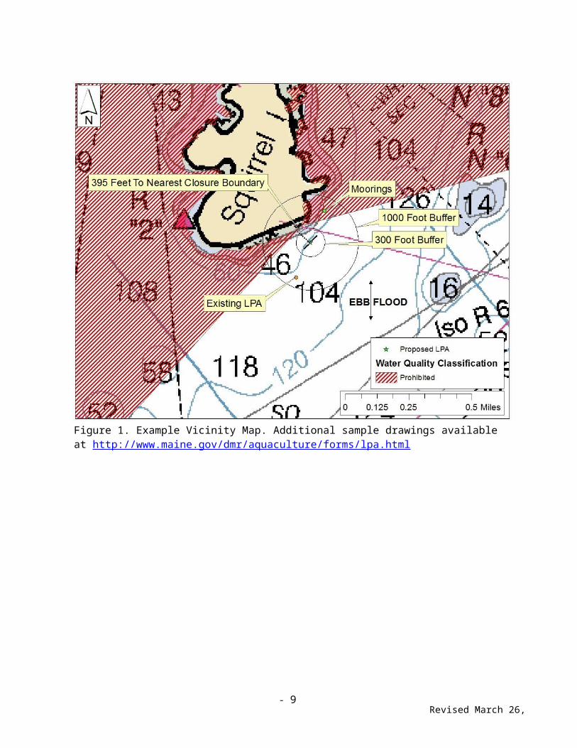
VICINITY MAP
Attach a vicinity map showing the LPA site and surrounding area. An enlargement of a NOAA chart or USGS Topographic map is suggested to provide this information. On the map, show the following:
Location of proposed site 300’ radius circle around site 1,000’ radius circle around site North Arrow (indicate true or magnetic north) Show depth contours and indicate mean low water (MLW) and mean high water (MHW) on all
land adjacent or nearest the site. Ebb and Flood directions Scale used on plan Distance to DMR water quality closure lines Gear orientation
Label the location on your vicinity map, and check each of the following below, that are within 1,000 feet of the site.
☐Federal navigation projects or anchorages
☐ Navigational channels
☐ Structures
☐ Aquaculture leases or licenses (LPAs)
☐ Anchorages or moorings
☐ State or federal beaches
☐ Docking Facilities
☐ None of the above

- 9 -Revised March 26, 2018
Figure 1. Example Vicinity Map. Additional sample drawings available at http://www.maine.gov/dmr/aquaculture/forms/lpa.html

- 10 Revised March 26, 2018
GEAR DESCRIPTIONNo Gear (bottom culture only): Organisms will be cultured on the bottom with no gear or predator netting.
Upweller: Floating upweller system for spat growout.
Shellfish rafts, associated predator nets and spat collectors: Floating raft with suspended dropper lines and anti-predator netting typical of mussel culture. E.g. mussel raft.
Shellfish tray racks and over wintering cages: Box shaped cages made of rigid mesh (wire coated or plastic), often with interior shelves designed to hold soft mesh bags. Tray racks are often outfitted with floats that double as feet to hold the cages off the bottom. E.g. OysterGro and OysterRanch cages.
Soft bags, semi rigid bags, and/or floating trays: Single-layer soft mesh bags that are typically made of rigid plastic or wire mesh. Bags are most frequently floated on the surface in lines, placed inside tray racks/overwintering cages, or sunk to the bottom.
Lantern nets and/or pearl nets: A lantern net is a five or ten tier set of circular nets suspended from a central line. A pearl net is a single, pyramidal mesh enclosure.
Fencing and brushing: Typically used by municipal shellfish programs in the intertidal zone for collection of soft shell clam spat.
Scallop spat collector bags: Mesh bags containing additional material (e.g. smaller mesh, Brillo pads) to increase surface area. Multiple bags are typically attached to a single vertical line.
Scallop ear hangers: Horizontal or vertical lines that attach to individual scallops by ear hangers.
Marine algae gear: Gear typically used May include rope, rafts with ropes attached, bags, longlines, and or rope grids.
Bottom anti-predator netting: Netting that is spread over the bottom to exclude predators from species being cultured.
Check each gear category that you are seeking authorization for.☐ No Gear (bottom culture only)☐ Upweller☐ Shellfish rafts, associated predator nets and spat collectors☐ Shellfish tray racks and over wintering cages☐ Soft bags, semi rigid bags, and/or floating trays☐ Lantern nets and/or pearl nets☐ Fencing and brushing☐ Scallop spat collector bags☐ Scallop ear hangers☐ Marine algae☐ Bottom anti-predator netting
- 11 Revised March 26, 2018
LIST EACH INDIVIDUAL GEAR TYPE THAY YOU WILL USE IN THE TABLE BELOW
Specific Gear Type and Maximum
Number to be used (e.g. (20) soft mesh
bags)
Dimensions(e.g.
16”x20”x2”)
Dates that gear will be in the water
Outer dimensions of maximum gear layout: Width (1’ or more): ______________ Length (1’ or more): __________________Note: Gear, excluding mooring equipment, may not exceed 400 square feet and must be provided in whole feet.
Moorings: Describe the tackle to be used inclusive of mooring type, poly line, bottom tackle, etc.
________________________________________________________________________________
________________________________________________________________________________
Overwintering: Will gear remain on the site during the winter?
☐ Yes ☐ No
If yes, describe the changes between growing season and overwintering.
________________________________________________________________________________
________________________________________________________________________________

- 12 Revised March 26, 2018
OVERHEAD VIEW AND CROSS-SECTIONAL VIEW OF GEAR LAYOUT
ATTACH both an overhead view and cross-sectional view drawing on 8 ½” x 11” paper, drawn clearly and dark enough to photocopy. Do not use color shading; it will not show on copies. Additional sample drawings are posted on the DMR web site at: http://www.maine.gov/dmr/aquaculture/forms/lpa.html
Overhead View: From an overhead view, show the maximum layout of gear to be deployed on the site. Label gear to show number of units, dimensions, and materials. Include drawings of individual types of gear. Show on the plan that the area occupied by the gear, excluding mooring equipment but including space between items of gear, will not exceed 400 square feet.
NOTE: A SEPARATE OVERHEAD VIEW DRAWING IS REQUIRED FOR EACH POSSIBLE GEAR CONFIGURATION, INCLUDING CHANGES FOR OVERWINTERING
Figure 2. Example overhead view of gear.

- 13 Revised March 26, 2018
Cross-Section View: Show the sea bottom substrate, mean high and low water marks, and profiles of gear in cross-section as it will be deployed. Label all gear with dimensions and materials. Show mooring gear with mooring type, scope, hardware, and line type and size. Drawing must depict water depth at mean high- and mean low-water.
NOTE: A SEPARATE OVERHEAD VIEW DRAWING IS REQUIRED FOR EACH POSSIBLE GEAR CONFIGURATION, INCLUDING CHANGES FOR OVERWINTERING.
Figure 3. Example Cross Sectional View of Gear

- 14 Revised March 26, 2018
REQUIRED SIGNATURES
Harbormaster or Town Official Signature
I have reviewed this license application and find that this activity, as proposed, will not unreasonably interfere with navigation, the ingress and egress of riparians within 300’ of the license site, or fishing or other uses of the area.
Print Name, Town, Title: Date
Signature of Harbormaster or Town Official
Note: Harbormasters may attach an additional page outlining any conditions associated with their approval of this license. *DMR Rule Chapter 2.90 (2) (D) (2) – In municipalities not served by a harbormaster, a municipal officer (selectman, councilor, alderman, or mayor, see 30-A MRS §2001 (10)) or other elected municipal official may sign the application. For the unorganized territory where a harbormaster does not have jurisdiction, a marine patrol officer may sign.
OTHER SIGNATURES REQUIRED AS NOTED BELOW
Marina or Pound Owner(For sites in marina slips, lobster pounds, and similar areas - see DMR Rule Chapter 2.90 2 (E)(1)
I, (print name), am the owner or the authorized representative of the owner or entity that has the legal authority to restrict access to or use of the marina slip, lobster pound, or similar area where this LPA license site is located, as described in DMR Rule Chapter 2.90 (1) (B). I consent to the placement of aquaculture gear on this site as proposed in this application.
Signed: Date:
Riparian Landowner of Intertidal Zone:(For sites above mean low water, MLW – see DMR Rule Chapter 2.90 (2)(D)(3)(b)
I, (print name) , am the riparian owner of the upland and adjacent intertidal land where this LPA license site is located. I consent to the placement of aquaculture gear on this site as proposed in this application.
Signed: Date:
Shellfish Committee Chair(For sites above extreme low water, XLW see DMR Rule chapter 2.90(2)(D)(3)(a). Only required in municipalities with an established Municipal Shellfish Committee)
I, (print name) , am the chairperson of the Municipal Shellfish Management Committee for the Town of This LPA license site is located above the extreme low water mark. My signature below verifies that this LPA will not unreasonably interfere with the activities of the municipal shellfish management program, according to DMR Rule Chapter 2.90 (3) (a).
Signed: Date:
- 15 Revised March 26, 2018
Riparian NotificationIs there shorefront land (including land above MLW and state and federal owned land) within 300 feet of the proposed license site?
☐ Yes ☐ No
If yes, you are required to send a copy of your application to all riparian property owners whose property is within 300 feet of the proposed license site following the directions below. If there is no shorefront land within 300 feet, you may skip this section. Applications for LPA sites in marina slips, lobster pounds, and similar sites are exempt from this requirement.
INSTRUCTIONS FOR NOTIFICATION TO RIPARIAN LANDOWNERS
Step 1, Tax Map: Obtain a certified copy of the municipal tax map showing the land in the vicinity of the lease site. On the map, mark the center point of the LPA site. If there is an accurate scale on the map, draw a 300-foot radius around the site. ATTACH THE MAP TO YOUR APPLICATION
NOTE FOR LPAs PROPOSED IN UNORGANIZED TERRITORY: To obtain a list of shorefront properties for LPAs in Unorganized Territory, contact Lisa Whynot, Property Appraiser II, Unorganized Territory, 24 State House Station, Augusta, Maine, 04333.
Step 2, Riparian Owners List: On the “Certified Riparian List” (Page 17 below), list the names and current mailing addresses of all riparian landowners of shorefront land within 300 feet of the lease site as shown in the municipal tax records. Have the list certified by the municipal clerk or tax collector. ATTACH THIS LIST TO YOUR APPLICATION
Step 3, Notify Riparians: Send a copy of the completed application, including the page of this application titled “Notice to Riparian Landowners” (Page 16 below), via certified mail to all the riparian landowners on the list. Note: Name and address must be filled out on receipt(s). ATTACH THE ORIGINAL (OR COPIES) OF THE RECIEPTS TO YOUR APPLICATION
[THIS SECTION INTENTIONALLY BLANK]

- 16 Revised March 26, 2018
NOTICE TO RIPARIAN LANDOWNERS
You have received a copy of an application to the Maine Department of Marine Resources for a limited- purpose aquaculture (LPA) license to grow shellfish or marine algae (seaweed) in an area of Maine coastal waters covering no more than 400 square feet. DMR rules require the applicant to send a copy of the application to owners of shorefront land that is located within 300 ft. of the proposed license site.
This is a very small-scale aquaculture project. The town harbormaster or other official is required to sign the application form to certify that the project will not unreasonably interfere with navigation, fishing or other uses, or the ingress and egress of riparian landowners.
Please contact DMR at the address below within the next two weeks if you have comments or concerns about the impact of the proposed license on your ability to move to and from your shore by water.
Should the license be granted, please contact us if you have concerns about the operation of the license site at any time. You should feel free to contact the licensee with any concerns, as well; the contact information is listed on the first page of the application form.
LPA licenses are issued for the calendar year; they expire on December 31, and they can be renewed at that time for the following year. If the licensee applies to renew this license in future, DMR will notify the municipality and request it to post the notice of the renewal application at the town office. Riparian landowners may submit comments to DMR about the proposed renewal within 14 days of the date of the notice.
DMR will consider all comments received in the course of the renewal process, as well as any comments received during the course of the previous year of operations under the license, in determining whether the license should be renewed for an additional year.
To submit comments to the Department about this LPA license site at any time, please contact:
Flora Drury Department of Marine Resources
P.O. Box 8West Boothbay Harbor, ME 04575
(207) [email protected]

- 17 Revised March 26, 2018
RIPARIAN OWNERS LISTFor LPA applications
THIS LIST MUST BE
***CERTIFIED***On this list, please show the current owners’ names and mailing addresses for all shorefront parcels within 300 feet of the proposed license site along with the map and lot number for each parcel. It is the applicant’s responsibility to assemble the information for the Town Clerk to certify. The Town Clerk only certifies that the information is correct according to the Town’s records. Once you have completed the form, ask the Town Clerk to complete the certification form below. If the parcels are within more than one municipality, provide a separate, certified, riparian list for each municipality.
TOWN OF: Click or tap here to enter text.
MAP ## LOT # Landowner name(s) and address(es)
CERTIFICATION
I, ,Town Clerk for the Town of , certify that the names and addresses of the property owners listed above, as well as the map and lot numbers, are those listed in the records of this municipality and are current as of this date.
SIGNED: DATE:
SEAL:

- 18 Revised March 26, 2018
MAP ## LOT # Landowner name(s) and address(es)
Please use additional sheets if necessary and attach hereto.
CERTIFICATION
I, , Town Clerk for the Town of , certify that the names and addresses of the property owners listed above, as well as the map and lot numbers, are those listed in the records of this municipality and are current as of this date.
SIGNED: DATE:
SEAL:

- 19 Revised March 26, 2018
APPLICANT’S SIGNATURE
I declare that the information I have provided on this form is true and correct and that I will comply with all applicable DMR laws and rules. I understand that, under Title 12 MRS §6306, my signature on this application authorizes Marine Patrol officers to inspect my license site. I understand that my license can be revoked if I provided false information in my application.
Signature of Applicant Date
Note: When the applicant is a municipal shellfish management committee, the committee chair shall sign the application (C.2.90 (2) (D) (1)).
Before submitting your application make sure you have answered all questions and included all of the following documents. Failure
to do so may result in significant delays in processing time.
Required documents for all LPA applications.
☐Check for application fee ($50 or $300) Payable to “Treasurer, State of Maine.”
☐ Vicinity map with required items shown (Page 8 & Figure 1 on Page 9)
☐ Overhead view depicting layout of the gear from overhead (Page 12)
☐ Cross-section view depicting gear & moorings from the side (Page 13)
Documents that are only required for sites that are within 300’ from shorefront property (measured from mean low water mark). Applications for LPA sites in marina slips, lobster pounds, and similar sites are exempt from this requirement.
☐ Tax map, certified (Step 1, Page 15)
☐ Riparian list, certified (Page 17)
☐ Copies of receipts for sending certified mail to riparian landowners (Step 3, Page 15)