LiDAR: Driving the Future of Autonomous Navigation · 1 © 2016 Frost & Sullivan LiDAR: Driving the...
30
1 © 2016 Frost & Sullivan LiDAR: Driving the Future of Autonomous Navigation A Frost & Sullivan Exclusive Whitepaper For Analysis of LiDAR technology for advanced safety
Transcript of LiDAR: Driving the Future of Autonomous Navigation · 1 © 2016 Frost & Sullivan LiDAR: Driving the...

1
© 2016 Frost & Sullivan
LiDAR: Driving the Future of
Autonomous Navigation
A Frost & Sullivan Exclusive Whitepaper For
Analysis of LiDAR technology for advanced safety

LiDAR: Driving the Future of Autonomous Navigation Analysis of LiDAR technology for advanced safety
2
© 2016 Frost & Sullivan
LIDAR: DRIVING THE FUTURE OF ADAS WITH AUTONOMOUS INTELLIGENCE
Analysis of LiDAR technology for Advanced Safety
Preface
Safety and its improvement is a concern paramount to all passenger vehicle manufacturers.
The value proposition for driver, passenger and pedestrian safety has become equally
important as engine performance and fuel economy. This paper addresses how light detection
and range (LiDAR) technology will impact Advanced Driver Assistance Systems and explore
the term, “autonomous driving intelligence.”
The paper will consider Lidar technology today and how it stands to capture a large market
share of automotive sensor technology in the future. Lidar is poised to penetrate the market
in 2016 as the lead technology in automotive safety and autonomous systems.
Three primary approaches to Lidar development are considered, including Hybrid Solid-State
Lidar, MEMS Lidar, and Mechanical Mechanism Lidar. Mechanical mechanism Lidar is the oldest
and most traditional technology. MEMS Lidar technology is in the beginning stage of
development as a low cost Lidar solution for low level automotive safety. Solid-state Hybrid
Lidar (SH Lidar) was introduced in 2005 as a result of the Darpa Robotic Car Races. The
technology has been tested for autonomous safety over the years and the cost for SH Lidar
dropped dramatically in 2015. With planned mass production to meet the growing demand
for autonomous navigation and advanced safety, further dramatic cost reduction is expected
in 2016 – 2017.
The development of Solid-State Hybrid Lidar (SH Lidar) was a break away from the traditional
mechanical mechanism of single Lidar technology, and it is described in detail in this paper.
The technology simplified what was previously a complex mechanical system of parts into
one robust solid-state part. The solid-state developmental enabled faster data capture in 3D,
capturing pictures instantaneously while moving in real-time at speeds of 30-40MPH. SH Lidar
technology has matured from an extremely costly technology and large system to being
affordable, smaller in size, and headed toward mass production. SH Lidar technology is poised
to be commercialized in 2015-16 and radically change the way we move about in the world.
This paper looks at other sensor technology in use today in the automotive industry for safety.
There are several type of sensors currently in use for ADAS (Advanced Driver Assistance
Systems) levels 1 and 2 level, such as camera solutions, radar, and infrared sensors. We will
look at how sensor technology systems will potentially affect the future of safety by improving
what is currently offered and addressing safety levels of ADAS 3 and 4.
LiDAR: Driving the Future of Autonomous Navigation Analysis of LiDAR technology for advanced safety
3
© 2016 Frost & Sullivan
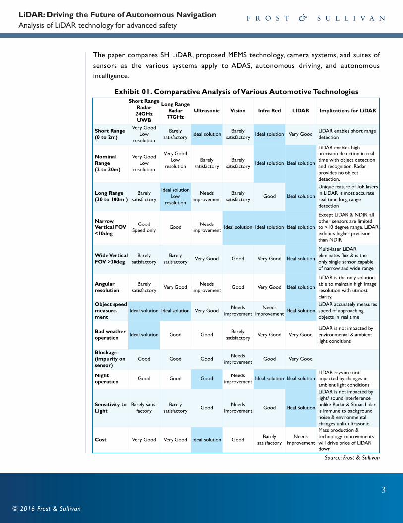
The paper compares SH LiDAR, proposed MEMS technology, camera systems, and suites of
sensors as the various systems apply to ADAS, autonomous driving, and autonomous
intelligence.
Exhibit 01. Comparative Analysis of Various Automotive TechnologiesShort Range
Radar24GHzUWB
Long RangeRadar77GHz
Ultrasonic Vision Infra Red LIDAR Implications for LiDAR
Short Range (0 to 2m)
Very GoodLow
resolution
Barely satisfactory
Ideal solutionBarely
satisfactory Ideal solution Very Good
LiDAR enables short rangedetection
Nominal Range (2 to 30m)
Very GoodLow
resolution
Very GoodLow
resolutionBarely
satisfactory Barely
satisfactory Ideal solution Ideal solution
LiDAR enables high precision detection in realtime with object detectionand recognition. Radar provides no object detection.
Long Range (30 to 100m )
Barely satisfactory
Ideal solutionLow
resolution
Needs improvement
Barely satisfactory
Good Ideal solution
Unique feature of ToF lasersin LiDAR is most accuratereal time long range detection
Narrow Vertical FOV<10deg
GoodSpeed only
GoodNeeds
improvement Ideal solution Ideal solution Ideal solution
Except LiDAR & NDIR, allother sensors are limited to <10 degree range. LiDARexhibits higher precisionthan NDIR
Wide VerticalFOV >30deg
Barely satisfactory
Barely satisfactory
Very Good Good Very Good Ideal solution
Multi-laser LiDAR eliminates flux & is the only single sensor capableof narrow and wide range
Angular resolution
Barely satisfactory
Very Good Needs
improvement Good Very Good Ideal solution
LiDAR is the only solutionable to maintain high imageresolution with utmost clarity.
Object speedmeasure-ment
Ideal solution Ideal solution Very Good Needs
improvement Needs
improvement Ideal Solution
LiDAR accurately measuresspeed of approaching objects in real time
Bad weatheroperation
Ideal solution Good GoodBarely
satisfactory Very Good Very Good
LiDAR is not impacted byenvironmental & ambientlight conditions
Blockage (impurity onsensor)
Good Good GoodNeeds
improvement Good Very Good
Night operation
Good Good GoodNeeds
improvement Ideal solution Ideal solution
LIDAR rays are not impacted by changes in ambient light conditions
Sensitivity toLight
Barely satis-factory
Barely satisfactory
GoodNeeds
Improvement Good Ideal Solution
LiDAR is not impacted bylight/ sound interferenceunlike Radar & Sonar. Lidaris immune to backgroundnoise & environmentalchanges unlik ultrasonic.
Cost Very Good Very Good Ideal solution GoodBarely
satisfactory Needs
improvement
Mass production & technology improvementswill drive price of LiDARdown
Source: Frost & Sullivan
LiDAR: Driving the Future of Autonomous Navigation Analysis of LiDAR technology for advanced safety
4
© 2016 Frost & Sullivan
This paper will examine the roadmap and future vision of Lidar sensor technology developers
as the technology is poised to substantially increase vehicle safety across the industry.
“Lidar is the single best way of getting integral information about the world around you," said
Douglas Thornton, an engineer at Battelle Memorial Institute, who works on automotive Lidar
applications.
- Nick Shchetko, Wall Street Journal, 2014
“The difference between a 64-beam LiDAR, and a $150 single-beam unit, underscores an
important point: not all LiDAR is created equal. There are three primary levels of automotive
applications—one for mapping; another for limited driver-assistance functions; and the more
forward-looking fully self-driving vehicles.”
- 11-Feb-2015 Automotive Engineering Magazine Source :http://articles.sae.org/13899/
LiDAR: Driving the Future of Autonomous Navigation Analysis of LiDAR technology for advanced safety
5
© 2016 Frost & Sullivan
CONTENTS
1. Preface
• Analysis of LiDAR Technology for ADAS and Autonomous Intelligence
2. LiDAR Overview
• How LiDAR Works
• Solid-state Hybrid LiDAR and How it Works
• Optics in 3D Visualization
• Solid-State Hybrid LiDAR Summary
• A History of Real-Time LiDAR
3. NHTSA and Automotive Safety
• Sensor Technologies for ADAS
• Next Generation ADAS
• NHTSA New Goals for Braking
• Automatic Emergency Braking (AEB)
4. Alternative Solutions to SH LiDAR for Autonomy
• Single Laser LiDAR
• Camera and Radar
• MEMS, Flash LiDAR, and Phased Array (OPA) Technology for 3D Visualization
• Testing Durability and Reliability of SH LiDAR
5. Testing Durability and Reliability of SH LiDAR
6. LiDAR Form Factor and Placement on Vehicles
7. Roadmap to Autonomy
8. Mass Production of LiDAR and Cost Reduction
• Current SH LiDAR Production
9. Conclusion

LiDAR: Driving the Future of Autonomous Navigation Analysis of LiDAR technology for advanced safety
6
© 2016 Frost & Sullivan
LIDAR OVERVIEW
How LiDAR Works
LiDAR is a tool to measure the shape and contour of the ground and environment. It bounces
a laser pulse off a target and then measures the time (and distance) each pulse traveled. The
science is based on the physics of light and optics, measuring wavelengths in nanoseconds. In
a LiDAR system, light is emitted from a rapidly firing laser. LiDAR gathers its information by
sending out laser light and gathering the light each laser beam generates. Laser light travels
and reflects off points of things in the environment like buildings and tree branches. The
reflected light energy then returns to the LiDAR sensor where it is recorded.
Time of Flight or TOF is the way Lidar measures the environment and it is the most viable
and proven technique used for detecting target objects. Simultaneously, as the lasers fire,
firmware within a Lidar system is analyzing and measuring the data. The optical receiving lens
within the LiDAR system acts like a telescope gathering fragments of light photons returning
from the environment. Lasers generate and fire out billions of photons, but for each 1M
photons sent out, 1 photon returns. Lasers send out 1B photons to generate 1000 photons
of returning information. The more laser beams used in a system, the more the information
about the environment is gathered. Single laser Lidar systems and systems with 8 or fewer
lasers are at a disadvantage because fewer photons are retrieved, thus less information
compared to a multi-laser Lidar system equipped with 16 or more laser beams.
There are three basic methods developers have employed to make Lidar technology, all based
on firing a single or multiple laser light into the environment and through different methods,
determining the distance from the points it illuminates in the environment and reflects back.
The distinct approaches to LiDAR technology are 1) solid-state hybrid technology invented
in 2007, 2) MEMS technology (in development stage) and 3) mechanical mechanism technology.
Solid-State Hybrid Lidar (SH LiDAR) defines Lidar used by Google over the past ten years
and sold by Velodyne. Ibeo technology is also a hybrid using fewer laser beams. Quanergy is a
start-up company exploring the use of semiconductor/MEMS for LiDAR, discussed later in
this paper. Mechanical Mechanism LiDAR has been around for decades and it describes the
technology of Leica, Riegl, and Sick Lidar, which are companies that play in the high-end
industrial LiDAR market.
LiDAR: Driving the Future of Autonomous Navigation Analysis of LiDAR technology for advanced safety
7
© 2016 Frost & Sullivan
Solid-State Hybrid LiDAR and how it Works
Single laser LiDAR technology was invented more than fifty years ago and it took the invention
of the Hybrid LiDAR to change the future of Lidar for real-time scanning and navigation. Single
LiDAR technology is slow comparatively, not fast enough for a moving car to see in high
resolution.
Solid State Hybrid LiDAR is a combination of a solid-state detector system within a spinning
system taking advantage of a 360 degree view in order to gather data at a very fast speed.
Using multiple laser beams, 16 to 64 lasers scan the environment at 1.2M points per second.
The Hybrid design was break-through technology in 2007 because it vastly simplified what
was previously a complex mechanical part into one solid-state part. Without the hybrid
technical advance, multiple laser systems of 16 to 64 lasers at one time would be complicated
and unmanageable.
As a solid-state central component, the detector system is consolidated into a robust part
which can be spun, an excellent solution for incredibly fast data collection. It is hardened to
resist laser and detector misalignment from vibration. It proves to be a reliable, strong, and
practical as a method of 3D visualization for automotive navigation, while fast enough for
computation in a real-time moving vehicle. The solid-state hybrid was patented as a radically
efficient technology for fast data collection in real-time.
Specifically, SH LiDAR is a point-by-point measurement of distance and reflectivity in a
horizontal field of view of 360° and a vertical field of view of up to 40°, updated up to 20
times per second. It’s a Time of Flight (TOF) measurement, where a pulse of light is emitted
and the return trip to an object is measured and by using the speed of light, the exact distance
can be determined. In the case of SH Lidar, multiple pulses of light from multiple lasers are
simultaneously pulsing and measuring distances in nano-seconds. The calculation for measuring
how far a returning light photon has travelled to and from an object is:
Distance = (Speed of Light x Time of Flight)
The speed at which images can be developed is affected by the speed at which it can be
scanned into the system and create a high resolution picture. The calculations of the distance
are processed instantaneously, measuring distances in nanoseconds. The speed of data
calculation and measurement is critical because the faster the speed of the scanning process
the more data points are collected. Abundant and accurate data produces the highest
resolution, best 3D picture.
LiDAR: Driving the Future of Autonomous Navigation Analysis of LiDAR technology for advanced safety
8
© 2016 Frost & Sullivan
Multiple Points of Viewing (MPV) was invented with the development of SH Lidar. The intrinsic
technology of the SH Lidar provides MPV, a radical 3D visualization feature which allows the
computer-brain of the system to have greater “visibility” of the environment, seeing from
multiple points of view simultaneously due to its 360 degree coverage. The Lidar brain and
control center is able to take advantage of a million points of view, scanning the environment
in nanoseconds. The 360 degree rotating view of the environment is able to assess the
environment, “seeing” faster and more completely than the human brain, excelling beyond
what the eyes, ears, and human brain can perceive from the driver’s seat of a moving vehicle.
It can “see” emergencies in some cases before a human driver can because the system has
the advantage of a million different points of view, directly centered on the moving vehicle,
using the view from the driver’s seat, but not confined to this as a single point of view.
Viewing SH LiDAR data in real-time is akin to moving through computer-generated 3D
scenery. The “view” can be shifted, choosing from a million views of the environment if you
are looking at a computer screen. The computer sees the millions of views simultaneously.
The views include multiple views from overhead, from different vantage points, or directly
ahead like a conventional driver in a driver’s seat.
Every measured LiDAR point reflects full X, Y, Z reflectivity data over time, which means that
the observer’s point of view can be selected at any location within the scene. With
instantaneous visual information from multiple vantage points, the computer analyzes millions
of points at speeds measured in nanoseconds, to assess conditions of the environment
including the lay of the road, road conditions, foot traffic, approaching pedestrians, and vehicle
traffic. XYZ points that move together are recognized as objects and, due to the high density
of data, can be classified discretely as bicycles, pedestrians, cars, etc.
Multi-laser SH Lidar can produce data that include these qualities: 1) Abundant data for
up-close, mid-range, and far range viewing. 2) Accurate data without false positives or false
negative information. It is not blinded by sunlight and can “see,” well at night. 3) Lidar is durable
and reliable in all kinds of weather, including snow, fog and rain. 4) It can “see” in 360 degrees.
5) It “sees” in measurements, so it is highly accurate and not confused by optical illusions, like
cameras. Multi-laser SH Lidar can currently be purchased as small as a hockey puck.

LiDAR: Driving the Future of Autonomous Navigation Analysis of LiDAR technology for advanced safety
9
© 2016 Frost & Sullivan
Optics in 3D Visualization
In a complex SH LiDAR system, 3D visualization is made through mathematics calculating the
speed of light waves. The nano-sized light waves are also analyzed for their characteristics
using patented software, measuring the travel-time of light waves in nanoseconds, so the quality
and size of the optical lens is critical.
The optical lens in a 3D viewing system for a vehicle system is comparable to the central
nerve system of a human. It gathers information and serves as a vehicle’s eyes and ears,
providing the entire perception system for a vehicle. The lens gathers accurate environmental
information, measuring and analyzing at speeds of nano-seconds, feeding a computer and
software system which will make critical decisions to navigate the vehicle. In a SH LiDAR
system, 3D visualization is made through mathematics calculating the speed of light waves. The
nano-sized light waves are also analyzed for their characteristics with software.
The SH Lidar technology involves measuring the travel-time of light waves in nanoseconds, so
the quality and size of the optical lens is critical. The lens acts like a telescope gathering
fragments of light returning. Lasers generate billions of photons, but for each 1M photons
sent out, 1 photon returns. Lasers send out 1B photons to generate 1000 photons of
information. The equipment required to measure this needs to operate extremely fast.
This highlights why a high quality lens is required to generate accurate, abundant environmental
data. The importance of the size and quality of an optical lens within the Lidar system can be
understood if you consider the lens of NASA Hubble’s telescope and other professional
telescopes. The far reaching telescopes have large lenses, from 17-33’ in diameter to view far
away planets and comets in space. There is a reason that NASA has not yet invented a
telescope and method of viewing the universe that is as small as a matchbox. The limits of
the physics of optics make it impossible. For a similar reason, SH LiDAR requires a quality
lens for accuracy and abundance of data collection, essential for automotive safety. If the lens
is reduced to less than 1” in a system, it could produce degraded data best suited for lower
levels of ADAS for automotive safety.
The effective range of the Lidar device is in proportional to the diameter of the size of its
optical lens. Like professional telescopes, the SH Lidar becomes degraded if it is miniaturized
smaller than 1” in diameter. At this point, the viewing distance, resolution, and details becomes
compromised. Miniaturization is possible to a certain degree, after which the results produce
degraded and compromised data.

LiDAR: Driving the Future of Autonomous Navigation Analysis of LiDAR technology for advanced safety
10
© 2016 Frost & Sullivan
“The speed at which images can be developed (pictures of the environment created in order
for a car to function and make decisions to drive autonomously,) is affected by the speed at
which the data from the environment can be scanned into the system. A variety of scanning
methods are available for different purposes such as azimuth and elevation, dual oscillating
plane mirrors, dual axis scanner and polygonal mirrors. The type of optic system determines
the resolution and range that can be detected by a system.”
- Source: http://www.lidar-uk.com/
Solid-State Hybrid LiDAR Summary
When combined with automated processing of data in real time, reflectivity measurements
successfully identify street signs, lane-markings and license plates. SH Lidar excels at “seeing”
lane markings.
The data capability of the SH LiDAR sets it apart from other sensor technologies, making it
the solution for ADAS with the higher level requirements of safety, including levels 3, 4, and 5.
Combining multiple laser beams and firing the laser pulses at extremely high repletion rates
(20000Hz)--while rotating the laser sources and detectors up to 20 times per second -- allows
for very effective 360° perception around a vehicle, in real time with up to 1.3M data points
per second.
Multi-laser Solid-State Hybrid LiDAR produces optimal data with following details:
1) Abundant data for up-close, mid-range, and far range viewing.
2) Accurate data results without false positives or false negatives. The LiDAR is not blinded
by sunlight and can “see,” perfectly at night.
3) SH Lidar is durable and reliable in all kinds of weather, including snow, fog and rain.
4) It can “see” in 360 degrees.
5) It “sees” in measurements, so it is highly accurate and not confused by optical illusions,
like cameras. Multi-laser SH Lidar can currently be purchased as small as a hockey puck.
The History of Real-Time Lidar
LIDAR is an optical technology of environmental measurement, first used in the 1960s for
remote sensing instruments including lunar laser ranging, satellite laser ranging, oceanographic
and atmospheric research. Lidar developed slowly for 30 years, used by NASA for atmospheric
and oceanographic study, space exploration, weaponry, and for topographic mapping
applications. By the mid-1990s, laser scanner manufacturers were delivering Lidar sensors
capable of 2,000 to 25,000 pulses per second to commercial customers for topographic
mapping applications. In the 1990s, Lidar was used to create accurate maps of three
dimensional terrains. Photography based systems and radar systems were less than ideal.
LiDAR: Driving the Future of Autonomous Navigation Analysis of LiDAR technology for advanced safety
11
© 2016 Frost & Sullivan
Lidar presented a fast, accurate, and direct (not inferential) method of generating 3-
dimensional data.
Real-time Lidar technology has been developing over the past decade, as a direct result of the
DARPA sponsored Grand Challenge Races of Robotic Vehicles. Ten years ago David Hall
conceived of real-time Lidar in preparation for the second race. It was the first time multiple
lasers were bundled into one unit, with an array of detectors to gather abundant data for
navigation purposes, working in real-time from a moving vehicle. For the first race Hall had
used stereovision but it did not have the accurate data needed for the computer to make
critical navigational decisions. Even multiple cameras bundled together produced many false
positives and flawed data. For the sophisticated decisions, Lidar was the answer for the second
race. The third race held in 2007, Hall was asked to not race but further develop and produce
Lidar for other teams. Subsequently, the real-time Lidar was used on six of the winning teams.
“The Urban Challenge introduced the concept of high-density LIDARs through a sensor
developed by Velodyne. The new sensor had a spinning head that swept a set of 64 LIDAR
emitters through space, generating over 1 million range measurements per second with
relatively high angular resolution. This style of sensor enabled a new level of precision modeling
that had until then been difficult, if not impossible, to achieve in real time.”
- National Academy of Engineering, Spring 2015. Source: https://www.nae.edu/
Since then, enthusiasm for the technology continued after the Darpa races as dozens of top
universities and hundreds of engineers continued their research and development of
software/Lidar solutions for autonomous cars. The interest and technology was quickly picked
up by Google, Umber, and many other companies who are now developing and offering
commercial products. The technology continues to develop and improve at lightning speed.

LiDAR: Driving the Future of Autonomous Navigation Analysis of LiDAR technology for advanced safety
12
© 2016 Frost & Sullivan
3. NHTSA AND AUTOMOTIVE SAFETY
Statistics provided by National Highway Traffic Safety Administration or NHTSA report 90
percent of accidents are due to human error. Common driving states which cause fatalities
include Intoxication, driver distraction, and health emergencies. Current ADAS address
situations with passive technology to prevent injuries, but not a large number of fatalities.
ADAS safety levels 3 and 4 will address more dangerous situations with the potential to
significantly decrease car and pedestrian fatalities.
In 2013 the NHTSA issued a Preliminary Statement of Policy Concerning Automated Vehicles.
It stated, “America is at a historic turning point for automotive travel. Motor vehicles and
drivers’ relationships with them are likely to change significantly in the next ten to twenty
years, perhaps more than they have changed in the last one hundred years. Recent and
continuing advances in automotive technology and current research on and testing of exciting
vehicle innovations have created completely new possibilities for improving highway safety…
in fact, many are inspired by the vision that the vehicles will do the driving for us…Recent
and continuing advances in automotive technology and current research on and testing of
exciting vehicle innovations have created completely new possibilities for improving highway
safety preventing significant numbers of crashes.”
Exhibit 02. Classification and Definition of Automated Driving
Level of Autonomy
Type of Automated Driving
Description
Assisted (Level 1)
The driver is responsible for motion control while the vehicle providesadvisory information and supportive actions when appropriate. Assistance systems include Blind Spot Detection (BSD), Lane KeepingAssist (LKA), Adaptive Cruise Control (ACC), and Autonomous Emergency Braking System (AEBS ).
Automated
Semi-automated(Level 2)
ADAS functions take partial control of the vehicle under specific circumstances and at the driver’s discretion. The function combinesboth longitudinal control (for speeding up or down) and lateral controlfor additional steering torque overlay or counter-steering based ondriving conditions.
Conditional Automation
(Level 3)
All aspects of dynamic driving tasks are automated. The human driveris prompted when to intervene actively as indicated by the system.
Fully AutomatedHighly Automated
(Level 4 )
All aspects of dynamic driving tasks are automated. The system has theability to override manual controls if the driver fails to respond timelyto a system-generated warning based on information derived from thedriving environment.
Fully Autonomous(Level 5)
The vehicle is capable of driving itself in all traffic conditions withoutthe physical presence of a human driver. These vehicles need to have redundancy in critical systems, such as steering, braking, and powertrain, so that they can be fail operational.
Source: Frost & Sullivan; NHTSA; MIRA Ltd

LiDAR: Driving the Future of Autonomous Navigation Analysis of LiDAR technology for advanced safety
13
© 2016 Frost & Sullivan
Within the Statement, NHTSA published a chart of safety levels for ADAS automated vehicles.
It included the complete range of vehicle automation, ranging from vehicles that do not have
any of their control systems automated (level 0) through fully automated vehicles (level 4).
The agency segmented vehicle automation into these five levels to clarify the level(s) of
automation.
The distinct levels provide car makers and developers of sensors and systems for ADAS a
language and way to categorize the new safety systems and the degree and features of driver
assistance it provides.
Exhibit 03. Roadmap to Automation- Driver Driven to Driverless Vehicles
Source: Frost & Sullivan; VDA Automotive SYS Konferenz 2014
Sensor Technologies for ADAS
ADAS (Advanced Driver Assisted Systems) covers a wide variety of capabilities that make for
easier and safer driving. Car makers are currently using an array of less expensive sensors to
provide safety, when minimal data, 2D information, and low resolution data is helpful and
acceptable.
LiDAR Covers All Levels of ADAS Automated Safety
LiDAR is Essential Part for ADAS
Driver Only
Driver UndertakesLane Holdingand LaneChanging Activities
No InterveningVehicle System
Active
System Handles the
Other Function
System HandlesLane Holding
and LaneChanges in a
Special Application
Case
System HandlesLane Holding
and Changing ina Specific
ApplicationCase. Detects
Limits of System and
Asks the Driverto Take
OverWith Sufficient Warning
System HandlesLane System
Can Handle AllSituations
Automatically inthe Specific Application
Case SufficientWarning
System CanHandle All Solutions
AutomaticallyThroughout theTrip. No Driver
Needed
AssistedDriving
Driver Carries OutAll LaneHolding orLane Changes
Partly Automated
System Handles LaneHolding andLane Changesin a SpecialApplicationCase
Highly Automated
Driver NeedsNo LongerContinuouslyMonitor theSystem. MustPotentially BeAvailable toTake Over
Fully Automated
No Driver isNecessary inSpecial Application
Driverless
LEVEL 0
LEVEL 1
LEVEL 2
LEVEL 3
LEVEL 4
LEVEL 5
Dri
ver
Aut
omat
ion

LiDAR: Driving the Future of Autonomous Navigation Analysis of LiDAR technology for advanced safety
14
© 2016 Frost & Sullivan
In anticipation of the growing automotive automation market, the NHTSA released a ratings
chart describing levels of safety, from 1 to 5 for Advanced Driver Assistance Systems (ADAS.)
The paper will document current ADAS technology and the companies producing sensors
addressing levels 1 and 2. Examples of level 1 and 2 are parking assist, backup safety, and
warning lights for blind spot detection.
Currently addressing levels ADAS safety levels 1 and 2: • Long and Short Range Radar,
• Short Range Lidar,
• Infrared Sensors,
• Single Laser Lidar,
• Flash Lidar,
• 4-8 Laser Lidar,
• Camera and Stereovision
• Sensor Suites, a combination of above sensors
The more advanced the automated driving features are, the greater the requirement for both
data quantity and data quality. For Level 3 and Level 4 ADAS features -- where the computer
assumes control from the human being, especially in emergency situations – rich, redundant
data is essential. False positives are unacceptable, since bad data could well prompt the
computer to brake for an object that doesn’t exist.
The NHTSA applauds the current features in ADAS; at the same time it calls for more
measures by car makers to reduce highway and pedestrian fatalities. This would require
addressing higher levels of safety, 3, and 4 of ADAS, with sophisticated technology to actively
mitigate accidents. Developers of alternative technologies advocate for a suite of sensor
technology stitched together and coordinated with complex software solutions.
The system should cover 360 degrees of the environment and not isolated, sliced sections of
the environment in the front and rear of a vehicle. For levels 3 and 4 to be adequately
addressed, a sensor system should be able to anticipate danger coming from the sides as well
as front. Side views become important to mitigate accidents caused by lane changing, or
vehicles entering from an on-ramp onto highway.
For a robotic technology to intervene and make an important decision such as to brake, it
has to be accurately informed by the 3D visualization system in real-time. False positives,
which are abundant in photographic-based sensor system, are unacceptable. The technology
for level 3 and 4 requires brake functioning, steering, speed, and all other controls in place
that are needed for autonomy.

LiDAR: Driving the Future of Autonomous Navigation Analysis of LiDAR technology for advanced safety
15
© 2016 Frost & Sullivan
To make tough decisions on critical maneuvers, the system should be equipped with sensors
with high resolution for object detection, a 360 degree view and range up to at least 200
meters, and the system should produce accurate data without false positives.
ADAS systems which address levels 3 and 4 will reduce highway fatalities more dramatically
because most fatalities are caused by complex road and driver conditions, at speeds over 15
MPH when changing lanes and while typically driving in the city and on the highway. Collision
avoidance and crash prevention requires a more robust and sophisticated technology.
“Ford is road-testing a fleet of self-driving Ford Fusion Hybrids in Dearborn, Michigan, and
hopes to expand beyond its hometown. What’s more, the company wants to offer a no-kidding,
it’s-fully-autonomous car in five years. No middle ground, not half measures, just a headlong
leap into robo-vehicles...to avoid one big problem with semi-autonomous technology.”
- Alex Davies in Wired Magazine comments about Ford’s plan for autonomy:. Source: http://www.wired.com/2015/11/ford-self-driving-car-plan-google/
Ford is one automaker that is fast moving on its technology roadmap to have fully autonomous
vehicle on road. Recently at CES they showcased their Level-4 autonomous vehicle which
takes human totally out of the loop. Ford plans to introduce directly Level-4 safety compliant
autonomous vehicles, closely working with Velodyne to achieve this using LiDAR. Ford plans
to skip Level-3 and go directly to Level-4, assuming a high degree of autonomy is needed for
level 3 because the engineers at Ford do not believe that a driver can be expected to recover
control in matters of seconds. Ford wants to skip Level 3 because it presents the one of the
biggest challenges with this technology: How to safely transfer control from the computer to
the driver, particularly in an emergency.
A lot can happen in that time—a car traveling 60 mph covers 88 feet per second—and
automakers have different ideas for solving this problem. Audi has an elegant, logical human
machine interface. Volvo is creating its own HMI, and says it will accept full liability for its cars
while in autonomous mode.”
Audi says its tests show it takes an average of 3 to 7 seconds, and as long as 10, for a driver
to snap to attention and take control, even with flashing lights and verbal warnings.
- Source: http://www.wired.com/2015/11/ford-self-driving-car-plan-google/

LiDAR: Driving the Future of Autonomous Navigation Analysis of LiDAR technology for advanced safety
16
© 2016 Frost & Sullivan
Next Generation ADAS
Car makers have been testing and analyzing SH Lidar technology to address NHTSA safetylevels 1, 2, 3 and 4 simultaneously. The technology has been developing over the past tenyears and has reached a state of technical and product maturity.
The same technology developed for robotic autonomous driving is appropriate for the development of Forward Crash Avoidance and Mitigation (FCAM) systems with AutomaticEmergency Braking (AEB) systems and Crash Imminent Braking (CIB.)
To explain the concept of providing the utmost in safety, Japanese Professor Masao Nagaicalled it Autonomous Intelligence, a term used by Nagai in a 2014, ADAS with autonomousintelligence for the future innovation of safety.
The professor points to the aging population in Japan and sees the need for a back-up safetysystem “to recover the situation from degraded performances of recognition, decision-makingand operation for elderly drivers.” On the same hand, a robust Lidar safety system could recover an emergency situation for the disabled, distracted, tired, and intoxicated saving manylives.
The conversation within the consumer automotive market will likely shift from exclusivelyabout autonomy to the safety it can provide. As the cost of the SH shrinks, car companieswill likely offer cars with autonomous technology primarily used as safety back-up systems.The technology for advanced ADAS needs to be accurate and robust. The technology forlevel 3 and 4 requires brake functioning, steering, speed, and all other controls in place thatare needed for autonomy. However, a Lidar system will likely be welcomed first because ofits contribution to safety.
Exhibit 04. LiDAR Application and Technology Roadmap in Automotive
Phase Passive SafetySemi and Highly
Automated DrivingFully Automated
Driving
Most Suited LiDAR Flash and Simple LidarSolid-State Hybrid 360
Rotating LidarSolid-State Hybrid 360
Rotating Lidar
Resolution Low to Moderate High Resolution High Resolution
Speed Range Up to 50Km/hr Up to 70Km/hr Up to 150Km/hr
Operational RangeShort range close
to 30m Short to long range
200mShort to long range
300m
Use case
Driving under limiteduncertainties withdriver alert all of
the time
Driving needs 100 %backup from system
Driving needs 100 %backup from system
}
}
}
}
}
}Source: Frost & Sullivan
LiDAR: Driving the Future of Autonomous Navigation Analysis of LiDAR technology for advanced safety
17
© 2016 Frost & Sullivan
NHTSA New Goals for Braking
ADAS Braking systems in play today employ low cost, single laser Lidar as well as radar,
cameras, and infrared sensors. The enthusiasm for an automated (back up) safety braking
system is high but the delivery on good braking systems in 2015 is low.
An analysis of the tests conducted in 2015 shows that though most car models drastically
reduced their speed, but could not avoid the impact and nor brake as expected.
This is evident in AUTOEVOLUTION, 11TH MAY 2015, 14:54 UTC HTTP://WWW.AU-TOEVOLUTION.COM/NEWS/SHOCKING-MOST-PEDESTRIAN-EMERGENCY-BRAKING-SYSTEMS-FAIL-INDEPENDENT-TEST-VIDEO-95337.HTML
Automatic-braking systems may get scored during a future round of government safety tests.
The NHTSA has submitted a proposal to test and rate this crash-avoidance technology to
better differentiate the effectiveness of the systems currently on sale. In the future, the SH
Lidar will be cost reduced and provide vehicles with a more complete and robust system of
visualization for crash avoidance.
The National Highway Traffic Safety Administration plans to add two cutting-edge automatic
emergency braking systems to the recommended advanced safety features included under its
New Car Assessment Program (NCAP) – the latest step in a half-century of safety
innovations.
The agency plans to continue to encourage development and commercialization of additional
promising safety-related technologies of vehicle automation through its recommendation of
two automatic emergency braking systems – crash imminent braking (CIB) and dynamic brake
support (DBS).
Automatic Emergency Braking (AEB)
AEB system technologies are a subset of what NHTSA refers to as Forward Crash Avoidance
and Mitigation (FCAM) systems. Whereas the FCAM designation includes systems that provide
Forward Collision Warning (FCW) only, AEB systems such as Crash Imminent Braking (CIB)
and Dynamic Brake Support (DBS) are specifically designed to help drivers avoid, or mitigate
the severity of, rear-end crashes. CIB systems provide automatic braking when forward-looking
sensors indicate that a crash is imminent and the driver has not braked, whereas DBS systems
provide supplemental braking when sensors determine that driver-applied braking is
insufficient to avoid an imminent crash.

LiDAR: Driving the Future of Autonomous Navigation Analysis of LiDAR technology for advanced safety
18
© 2016 Frost & Sullivan
According to NHTSA data, one-third of all police-reported crashes in 2013 involved a
rear-end collision with another vehicle at the start of the crash. The agency also found that a
large number of drivers involved in rear-end crashes either did not apply the brakes at all or
did not apply the brakes fully prior to the crash. Crash imminent braking and dynamic brake
support systems can intervene by automatically applying the vehicle's brakes or supplementing
the driver's braking effort to mitigate the severity of the crash or to avoid it altogether. This
would include the development of Forward Crash Avoidance and Mitigation (FCAM) systems
with Automatic Emergency Braking (AEB) systems and Crash Imminent Braking (CIB.)

LiDAR: Driving the Future of Autonomous Navigation Analysis of LiDAR technology for advanced safety
19
© 2016 Frost & Sullivan
4. ALTERNATIVE SOLUTIONS TO SH LIDAR FOR AUTONOMY
We will consider whether it is realistic that Phased Array technology, MEMS technology, radar,stereovision, non-SH LiDAR, or other unseen technology in combination can replace SHLiDAR technology in advanced safety and autonomy in the future. We will look at alternativeconcepts for guiding autonomous vehicles and advanced safety.
Single-laser LiDAR
The historical approach of using a single laser beam rotating in a circle, or some fraction of acircle, results in measurement of a single plane (the difference between 2D and 3D data). Objects directly in front of the vehicle can be detected only if they are exactly within thatplane. Objects that are slightly above or below the plane won’t be detected and so collisionavoidance is almost impossible with a single laser.
Exhibit 05. Comparing Single-laser LiDAR and Multi-laser LiDARImplications for ADAS
Multi-Laser
• Multi-laser Channels: Velodyne employs up to 64 laser channels and avertical field of view of 30-40°, depending on the model of LiDAR sensor, with spacing as tight as 0.3°
• Enables Detection in harsh environment: Design enables the scannerto direct multiple laser lines on an object, even at 100 meters range enabling detection even under harshweather conditions.
• High Resolution:The tight spacing produces high special resolution goodfor object recognition and collision prevention. Combining high resolutionand an extensive vertical field of viewyields other significant benefits.
• Real Time 360 Detection :Velodyne’sreal-time 3D LiDAR sensors can also beused for localization within the environment. The high spatial resolutionsupports feature recognition in a scene(a sidewalk, streetlamps, parked cars,etc.)
• High Precision: Comparing the real-time scenery to a pre-recorded mapin order to determine an exact locationbeyond anything GPS can provide • Mapping for Autonomous Car Applications: In addition to generatingpre-recorded maps for car navigation,these data-rich high performance LiDARscanners can also be used for applications like Google’s Street Viewand Microsoft’s Bing Maps
Single-Laser
• Sick AG offers a single plane, 2D scanner,
• For DARPA Grand Challenge multiple scanners used to achieve directional 3D perception.
• Alternatively, Challenge participants created “nodding” mechanisms whereby a motor would move the 2D sensor up and down, to extend the view beyond a singular plane.
• Acquiring 3D data through nodding does not lead to problem solving the problem;
• At highway speeds of 65 mph (100 km/h), nodding frequency would be much too slow to fully detect an object at 100 meters and still react in time to avoid a collision.
Single-Laser
• IBEO markets a four-line Lux sensor for simple ADAS features that do not require 360°
• Offers one or two lines on target, with a restricted horizontal field of view (145°).
• IBEO’s approach of using 4x laser lines, spaced over a few degrees though significant solution but has limitations for higher-level autonomous features
• In this configuration, typically just one or two laser beams hit an object, making classification of that object difficult .
• Radar system detects but it unable to analyze it physical form.
• A narrow vertical field of view (3.2°). Any deviation results in object not being detected but can detect road instead
LiDAR: Driving the Future of Autonomous Navigation Analysis of LiDAR technology for advanced safety
20
© 2016 Frost & Sullivan
Camera and Radar
“Unlike camera imagery, which has an abundance of information, but requires pattern-
recognizing software to bring meaning to all those pixels, LiDAR systems deliver a potent
stream of point-clouds that is easily digestible by a car’s computer network. These rapid-fire
accurate 3D snapshots of every object surrounding the vehicle can occur day or night, rain or
shine. Lidar would turn cars into machines keenly aware of their surroundings—with the ability
to discern details to the centimeter from 100 meters away.”
- 11-Feb-2015 Automotive Engineering magazine
LiDAR is a direct measurement of distance and reflectivity. LiDAR is not like stereovision;
distances are measured by determining the time it takes for a pulse of light to travel from the
sensor to an object and back again based on time of flight principle. The return signal level is
used to determine reflectivity after normalizing for distance and laser power.
Cameras are high-res only in 2D, but are quite poor in the third dimension, and traditional
radar has a very limited spatial resolution. LiDAR, by contrast, can not only be used to identify
objects around the car but also classify them, distinguishing pedestrians, bicycles, other
vehicles, etc. High resolution LiDAR creates pictures, versus the abstract spots radar
produces. Based on the classification, prediction models of path interference can help to
control the vehicle in a manner that avoids collisions (Autonomous Intelligence).
Cameras have problems at both extremes; blinding sunlight over saturates the data with false
positives and it has trouble “seeing” at night. Because SH LiDAR uses its own light source
(e.g., lasers), it works equally well in bright sunlight as well as in the darkness of night.
LiDAR data is especially computer-friendly, providing full 5D information (X,Y,Z, Reflectivity
and time), which is easy for ADAS software to process. While camera data might provide
higher pixel density, the information in those pixels is much more limited, since the third
dimension is missing. In order for camera data to be interpreted correctly, higher computing
power – by orders of magnitude -- is necessary; native LiDAR data is much more
content-rich, which makes for better, more reliable Autonomous Intelligent decisions.
Photographic solutions, like Mobileye use a method called “structure from motion,” to analyze
the 2D image and gain some 3D information. However, if a vehicle comes to a stop at a
stoplight and is not moving, the information can’t be computed. Mobileye method’s method
has limitations in bright sunlight and in darkness due to the 2D camera technology. It has
software with an extensive dictionary of roadway symbols, car descriptions, and road signs,
so that the Mobileye makes the most of photographic 2D data for level 1 and 2 safety. The
camera system works well for low level safety, but not it is not suited to autonomy or
advanced safety.

Comparative Analysis of Camera and LiDAR
Exhibit 06. LiDAR Systems in Comparison to Camera and Radar
Radar has the historical advantage of measuring speeds of objects over relatively large
distances (300 meters), and Radar sensors can be hidden behind the bumper, since radar is
not a line-of-sight measurement, as LiDAR is. On the other hand, Velodyne Lidar has already
increased its detection range to 200 meters with a range of 300-400 meters to be attained at
the latest by 2017.
LiDAR: Driving the Future of Autonomous Navigation Analysis of LiDAR technology for advanced safety
21
© 2016 Frost & Sullivan
3D LiDAR has the highest spatial resolution in the X, Y, and Z coordinates. Can not only be used toidentify objects around the car butalso classify distinguishing them aspedestrians, bicycles, other vehicles,etc. Avoid collisions.
LiDAR uses its own light source (e.g.,lasers), it doesn’t depend on environmental lighting. LiDAR worksequally well during the day and atnight, and unlike a camera, is notblinded when pointed in the directionof the sun.
ü
Computer-friendly, providing full 5Dinformation (X,Y,Z, Reflectivity andtime), which is easy for ADAS software to process. necessary;LiDARdata is much more content-rich,which makes for better, more reliableAutonomous Intelligent decisions.
ü
Quite poor in the third dimension,and very limited spatial resolution.
û
Depend on environmental lighting
û
While camera data might providehigher pixel density, the informationin those pixels is much more limited,since the third dimension is missing.In order for camera data to be interpreted correctly, higher computing power – by orders of magnitude -- is necessary
ûCam
eras
ü
3D L
iDA
R

Safety by ADAS Using LiDAR Range Capability Level-1 to Level-4
Exhibit 07. Enabling LiDAR Safety Solution
Source: Frost & Sullivan
LiDAR has no problem calculating the speed of an oncoming car and now the technology is
replacing radar as the first choice for determining car speed by police. Radar doesn’t come
close to approximating LiDAR’s spatial high resolution and object detection. Radar has
problems with false positives that need to be filtered out by advanced software.
MEMS, Flash Lidar, and Phased Array (OPA) Technology for 3D Visualization
Companies developing MEMs (micro-electrical-mechanical systems) and Phased Array LiDAR
technology have proposed as methods to challenge SH LiDAR. The technologies face serious
obstacles:
1) Small beams fundamentally lead to more divergence which leads to less range. The three
LiDAR technologies of Flash LiDAR, MEMS based LiDAR and OPA LiDAR currently operate
in limited range and limited FOV. They also face increases in laser power which would
need to be made in order to scale for usefulness.
2) Limited actuation means limited horizontal and vertical range. Yes, limited horizontal range
could conceptually be covered through multiple sensors around the vehicle, but these
would also need to be stacked several times vertically to achieve the vertical range, which
is not practical. Finally, the software effort to stick such sensor together is both highly
impractical and costly.
LiDAR: Driving the Future of Autonomous Navigation Analysis of LiDAR technology for advanced safety
22
© 2016 Frost & Sullivan
ADAS Safety Level 3 andLevel 4
ADAS Safety Level 3 andLevel 4
300
Meters
300Meters
Range ofLiDAR Sensor
Range ofLiDAR Sensor
Range ofLiDAR Sensor
Range ofLiDAR Sensor
300Meters
300Meters
ADAS Safety Level 1 and Level 2
Short Range
Short Range

LiDAR: Driving the Future of Autonomous Navigation Analysis of LiDAR technology for advanced safety
23
© 2016 Frost & Sullivan
3) Continuous detection of the LiDARS field of view will jeopardizes safety, reliability and performance as the sensor is greatly susceptible to sun noise, other sensors and foul-play. A false positive from one of these factories could lead to continuous vehicle stoppage (or worse).
4) Thermal and manufacturing issues with both laser actuation and detection have not been solved for a practical working system.
MEMS, OPA, and Flash Lidar system solutions address one part of the whole working Lidarsystem, without addressing the detector system solution and power source. Storage of thepower supply, the powerful laser, and a detector system are not solved for its form factor atthis time. The detector system is the most expensive and complex part of the sensor system.It is not clear if the MEMS or Phased Array systems will require a larger, more powerful laserwhich will run up the power requirement for the system and run hot. The powerful laser mayneed to be stored in the car trunk because it is so large.
Until the detector is developed and its solution solved for MEMS and Phased Array systems,it is premature and a leap of imagination to assume either technology will work as a full system. There is reason to assume it will be effective at data collection, compact in a small ID,or prove to be an inexpensive alternative for autonomy.
MEMS and Phased Array technology have limited FOV (field of view.) which need to be stitchedtogether with the computational complexity to do this. The limited field of view in mirror solutions causes highly degraded and less abundant data. The range for Mems has been testedat best currently to 50M.
Current MEMS and Phased Array systems produce less data and degraded data in comparisonto multi-Laser LiDAR systems. This is due to trouble functioning in bright sunlight, darkness,and the limited FOV. The systems are limited in range, resolution, object detection, objectidentification, and data reliability. There is speculation by LiDAR developers asserting softwarecan enhance the degraded data, but so it is unproven. Both systems have trouble working inbright sunlight from over-saturation with unreliable data.
There isn’t evidence showing a well-developed progression of the technology toward autonomy that would ultimately replace the multi-laser Lidar system in the next ten years.The experimental alternatives so far tested may be applied to ADAS applications that addresslevel 1 and 2. Prototypes of the experimental technology described above have yet to crossmultiple road blocks and become viable alternatives for autonomous driving or autonomousintelligence that address levels 3 and 4. The rotational Lidar is patented and currently onlyused by Google and sold by Velodyne. Thus, the developers have been scrambling to find othermethods for a robust and affordable solution to 3D visualization. Developers have philosophical ideas for approaching the difficulty of autonomy but they face serious roadblocks.
Driverless cars and those with autonomous intelligence systems depend on abundant, accuratedata. Algorithms must be sophisticated to understand the driving environment’s direct and indirect messages in terms of traffic and maneuvering.
LiDAR: Driving the Future of Autonomous Navigation Analysis of LiDAR technology for advanced safety
24
© 2016 Frost & Sullivan
5. TESTING DURABILITY AND RELIABILITY OF SH LIDAR
Sensors used in safety systems demand hours testing including actual road testing before use
on public roadways. Current LiDAR selling on the market passes all safety tests currently
imposed on LiDAR manufacturing including eye safety. Velodyne Lidar stands out as a system
road-tested over a period of seven years. Starting in 2009, Velodyne’s LiDAR technology has
been tested on the Google fleet of “driverless cars,” well publicized as it drove on more than
a million miles of road.
In the Google Self-Driving Car Project “In 2009, Google started the self-driving car project,
since then…Google cars have self-driven over 1 million miles and are currently out on the
streets of Mountain View, California and Austin, Texas…we tested with the Toyota Prius, each
designed from the ground up to be fully self-driving. There are safety drivers aboard all
vehicles...”
- Google 2015 website Source: bhttps://www.google.com/selfdrivingcar/
In June, 2015 Google published the safety results of the tests and no errors were attributed
to the technology of the autonomous cars. Seven small incidents were caused by human error
of other cars on the roadway.
Caterpillar purchased hundreds of Lidar units from 2009 to the present, mounting them on
large mining trucks and other construction vehicles for 3D real-time visibility. Caterpillar was
satisfied with the SH Lidar performance and safety record and entered into a multi-million
dollar deal exclusivity contract with Velodyne to supply LiDAR for mining and construction
vehicles. However, before signing Caterpillar demanded stringent tests and “hardening” of the
LiDAR. Caterpillar vehicles often work in extreme weather conditions, including the freezing
cold and hot desert.
The Lidar was hardened and manufactured to pass tests for extreme heat, extreme cold,
visibility and functionality in rain, snow, and sleet, waterproofing, intense vibration, humidity
tolerance, sensor cross-talk, multi-echo capability (necessary for functioning well in snow,
sleet, rain, dust, and fog.) The sensor had to test negative on “blinding,” caused by light sources
such as the sun, headlights, light towers or highly reflective targets. The Lidar was tested for
accuracy of intensity, scan rate, beam divergence, range accuracy, field of horizontal view and
field of vertical view. It was drop tested and shock tested, tested with chemical spray and salt
water spray. The Lidar passed all of the environmental and mechanical tests and the agreement
was signed in 2012.
LiDAR: Driving the Future of Autonomous Navigation Analysis of LiDAR technology for advanced safety
25
© 2016 Frost & Sullivan
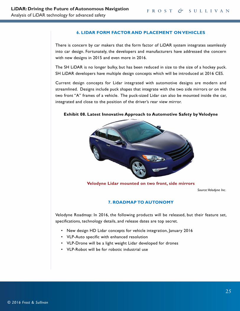
6. LIDAR FORM FACTOR AND PLACEMENT ON VEHICLES
There is concern by car makers that the form factor of LiDAR system integrates seamlessly
into car design. Fortunately, the developers and manufacturers have addressed the concern
with new designs in 2015 and even more in 2016.
The SH LiDAR is no longer bulky, but has been reduced in size to the size of a hockey puck.
SH LiDAR developers have multiple design concepts which will be introduced at 2016 CES.
Current design concepts for Lidar integrated with automotive designs are modern and
streamlined. Designs include puck shapes that integrate with the two side mirrors or on the
two front “A” frames of a vehicle. The puck-sized Lidar can also be mounted inside the car,
integrated and close to the position of the driver’s rear view mirror.
Exhibit 08. Latest Innovative Approach to Automotive Safety by Velodyne
Velodyne Lidar mounted on two front, side mirrorsSource: Velodyne Inc.
7. ROADMAP TO AUTONOMY
Velodyne Roadmap: In 2016, the following products will be released, but their feature set,
specifications, technology details, and release dates are top secret.
• New design HD Lidar concepts for vehicle integration, January 2016
• VLP-Auto specific with enhanced resolution
• VLP-Drone will be a light weight Lidar developed for drones
• VLP-Robot will be for robotic industrial use
LiDAR: Driving the Future of Autonomous Navigation Analysis of LiDAR technology for advanced safety
26
© 2016 Frost & Sullivan
Quanergy Roadmap: Quanergy announced recently: “Quanergy Systems, Inc. will introduce in
2016 the first solid-state LiDAR sensor for advanced driver assistance systems (ADAS)” The
sensor will likely address safety level 1 and 2.
Mobileye Roadmap: Mobileye plays in the level 1 and 2 safety level. On their website,
November 2015, Mobileye states, “Mobileye is already working on the next evolution -
autonomous driving – and is planning to launch, in the 2016 timeframe…The technology is
enabled by a number of forward-facing cameras and low-cost radars for redundancy…”
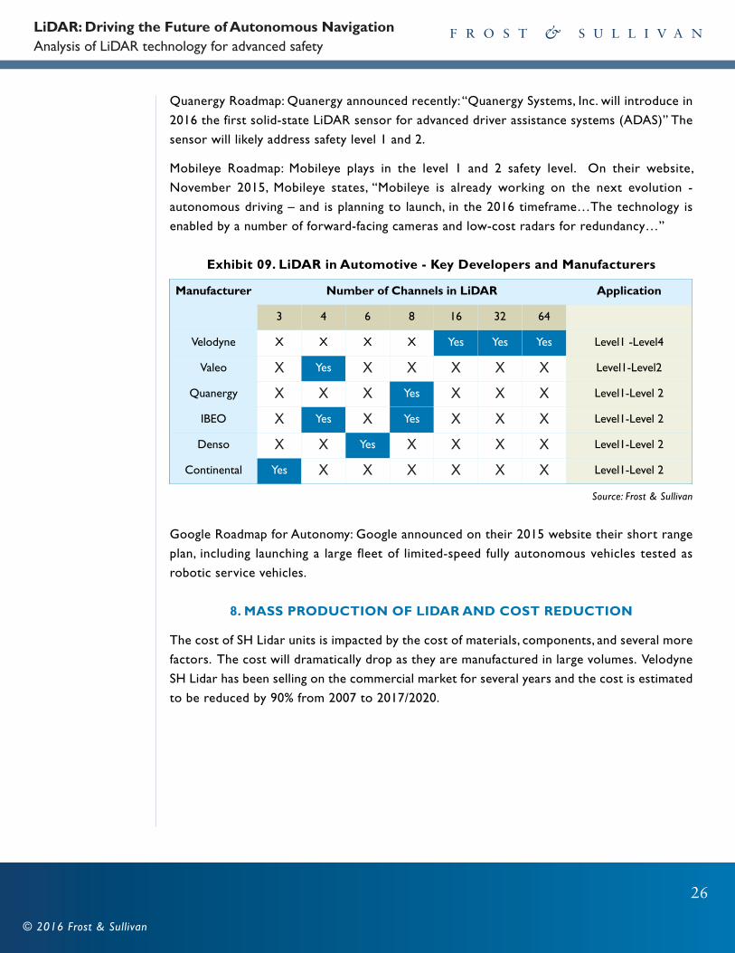
Exhibit 09. LiDAR in Automotive - Key Developers and Manufacturers
Source: Frost & Sullivan
Google Roadmap for Autonomy: Google announced on their 2015 website their short range
plan, including launching a large fleet of limited-speed fully autonomous vehicles tested as
robotic service vehicles.
8. MASS PRODUCTION OF LIDAR AND COST REDUCTION
The cost of SH Lidar units is impacted by the cost of materials, components, and several more
factors. The cost will dramatically drop as they are manufactured in large volumes. Velodyne
SH Lidar has been selling on the commercial market for several years and the cost is estimated
to be reduced by 90% from 2007 to 2017/2020.
Manufacturer Number of Channels in LiDAR Application
3 4 6 8 16 32 64
Velodyne X X X X Yes Yes Yes Level1 -Level4
Valeo X Yes X X X X X Level1-Level2
Quanergy X X X Yes X X X Level1-Level 2
IBEO X Yes X Yes X X X Level1-Level 2
Denso X X Yes X X X X Level1-Level 2
Continental Yes X X X X X X Level1-Level 2

LiDAR: Driving the Future of Autonomous Navigation Analysis of LiDAR technology for advanced safety
27
© 2016 Frost & Sullivan
Exhibit 10. Price DeclineCost Optimization Through Mass Production by Velodyne Leads to Price Decline
Source: Frost & Sullivan; Velodyne Inc
Cost reduction is accelerating as more LiDAR is selling in larger quantities and is in the process
of being designed mass production. The cost to be reduced to $500 at an annual production
volume of 1M units that is likely happen after year 2018.
Current SH Lidar Production
Velodyne LiDAR is currently used by most autonomous car research teams which the company
manufactures in Morgan Hill, California, in a 60,000 sq. ft. facility. Here they have been
engineered, tested, and for five years and also sold in moderate industrial quantities. With
recent growth in demand for the Lidar products, plans are underway for facility expansion
and additional hiring to accommodate larger production.
In 2015, the Velodyne has expanded its team by adding to its engineering talent, program
managers, a new VP of Operations, VP of Engineering, CFO, 30 new engineers, President and
acting COO. Staff has been added with skills to specifically engineer cost reduction while
maintaining the high quality of the LiDAR. Also in 2015, the Velodyne Puck (VLP-16) was
introduced; the smallest, newest, and most advanced product of the Velodyne LiDAR series, it
sells at 90% of the cost of the original Lidar 64. Significantly more cost-effective than similarly
priced sensors and developed with mass production in mind, it retains the key features of
Velodyne's breakthroughs in LiDAR: Real-time, 360°, 3D distance, calibrated reflectivity
measurements and unmatched accuracy.
Price in $
$75,000
$35,000
$8,000$250-$400
LiDAR: Driving the Future of Autonomous Navigation Analysis of LiDAR technology for advanced safety
28
© 2016 Frost & Sullivan
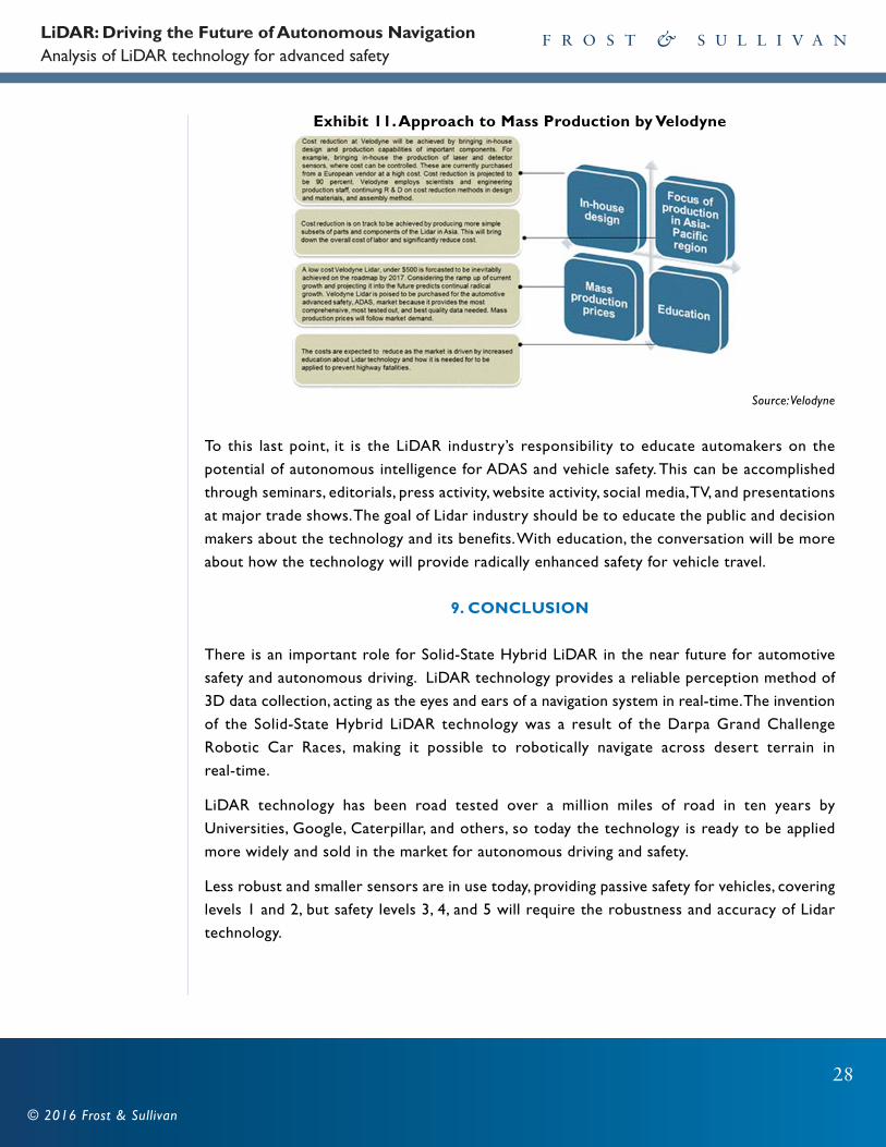
Exhibit 11. Approach to Mass Production by Velodyne
Source: Velodyne
To this last point, it is the LiDAR industry’s responsibility to educate automakers on the
potential of autonomous intelligence for ADAS and vehicle safety. This can be accomplished
through seminars, editorials, press activity, website activity, social media, TV, and presentations
at major trade shows. The goal of Lidar industry should be to educate the public and decision
makers about the technology and its benefits. With education, the conversation will be more
about how the technology will provide radically enhanced safety for vehicle travel.
9. CONCLUSION
There is an important role for Solid-State Hybrid LiDAR in the near future for automotive
safety and autonomous driving. LiDAR technology provides a reliable perception method of
3D data collection, acting as the eyes and ears of a navigation system in real-time. The invention
of the Solid-State Hybrid LiDAR technology was a result of the Darpa Grand Challenge
Robotic Car Races, making it possible to robotically navigate across desert terrain in
real-time.
LiDAR technology has been road tested over a million miles of road in ten years by
Universities, Google, Caterpillar, and others, so today the technology is ready to be applied
more widely and sold in the market for autonomous driving and safety.
Less robust and smaller sensors are in use today, providing passive safety for vehicles, covering
levels 1 and 2, but safety levels 3, 4, and 5 will require the robustness and accuracy of Lidar
technology.

LiDAR: Driving the Future of Autonomous Navigation Analysis of LiDAR technology for advanced safety
29
© 2016 Frost & Sullivan
The Solid State Hybrid Lidar technology is leading the way toward advanced automotive safety
and the convenience of vehicle autonomy. When combined with advanced software and
computer technology, LiDAR equipped safety systems can provide features and meet the
requirements of SAE Safety Levels 1 to 5. Other 3D viewing sensor technologies on the
horizon have been compared to LiDAR, yet none are promising for the enormous task of
autonomous navigation or autonomous intelligence for advanced safety.
Semiconductor hybrid LiDAR is now miniaturized to the size of a hockey puck and its price
has dropped by substantially (approximately by 90 percent) since first on the market. The
technology has evolved to be small in form factor and affordable, providing key safety for
vehicle travel. As the trend goes the cost of LiDAR is estimated to drop substantially again in
2016, becoming more affordable for car makers who will eventually provide impactful safety
features and autonomy the massive automotive world market. Due to recent innovations of
LiDAR, automotive users will experience safer, robotic, and futuristic methods of travel, sooner
than ever imagined.
Safety systems with advanced back-up features can become the norm in our lifetime,
preventing the alcoholic from killing himself along with others, allowing seniors to be
independent by driving longer, and helping the disabled drive. It can be a back-up for young
teen drivers who are documented to take more chances, speed, and text more often while
driving. The future will also see driverless service vehicles in the cities for the general public.
Navya is partnering with Postbus, a public bus company in Switzerland to provide the first bus
service for the public, open on a limited route in March, 2016. It has been tested for more
than a year with an SH LiDAR for navigation.
Source: http://chb44.com/2015/10/navya-arma-french-autonomous-vehicle-that-wants-to-compete-with-google-car/

30
© 2016 Frost & Sullivan
AucklandBahrainBangkokBeijingBengaluruBogotáBuenos AiresCape TownChennaiColomboDelhi/NCRDetroit
MumbaiMoscowOxfordParisPuneRockville CentreSan AntonioSão PauloSeoulShanghaiShenzhenSilicon Valley
SingaporeSophia AntipolisSydneyTaipeiTel AvivTokyoTorontoWarsawWashington, DC
DubaiFrankfurtIskander Malaysia/Johor BahruIstanbulJakartaKolkataKuala LumpurLondonManhattanMexico CityMiamiMilan
Frost & Sullivan, the Growth Partnership Company, partners with clients to accelerate their growth. The
company's TEAM Research, Growth Consulting, and Growth Team Membership™ empower clients to create
a growth-focused culture that generates, evaluates, and implements effective growth strategies. Frost &
Sullivan employs over 50 years of experience in partnering with Global 1000 companies, emerging businesses,
and the investment community from more than 40 offices on six continents. For more information about
Frost & Sullivan’s Growth Partnership Services, visit www.frost.com
For information regarding Frost & Sullivan's whitepaper, please write to:
FROST & SULLIVAN331 E. Evelyn Ave. Suite 100 Mountain View, CA 94041