Licensed to IT. Printed on 21 Sep 2009. Notice: After 25 ...fly-sea.com/charts/KCLT.pdf · RNAV 1....
27
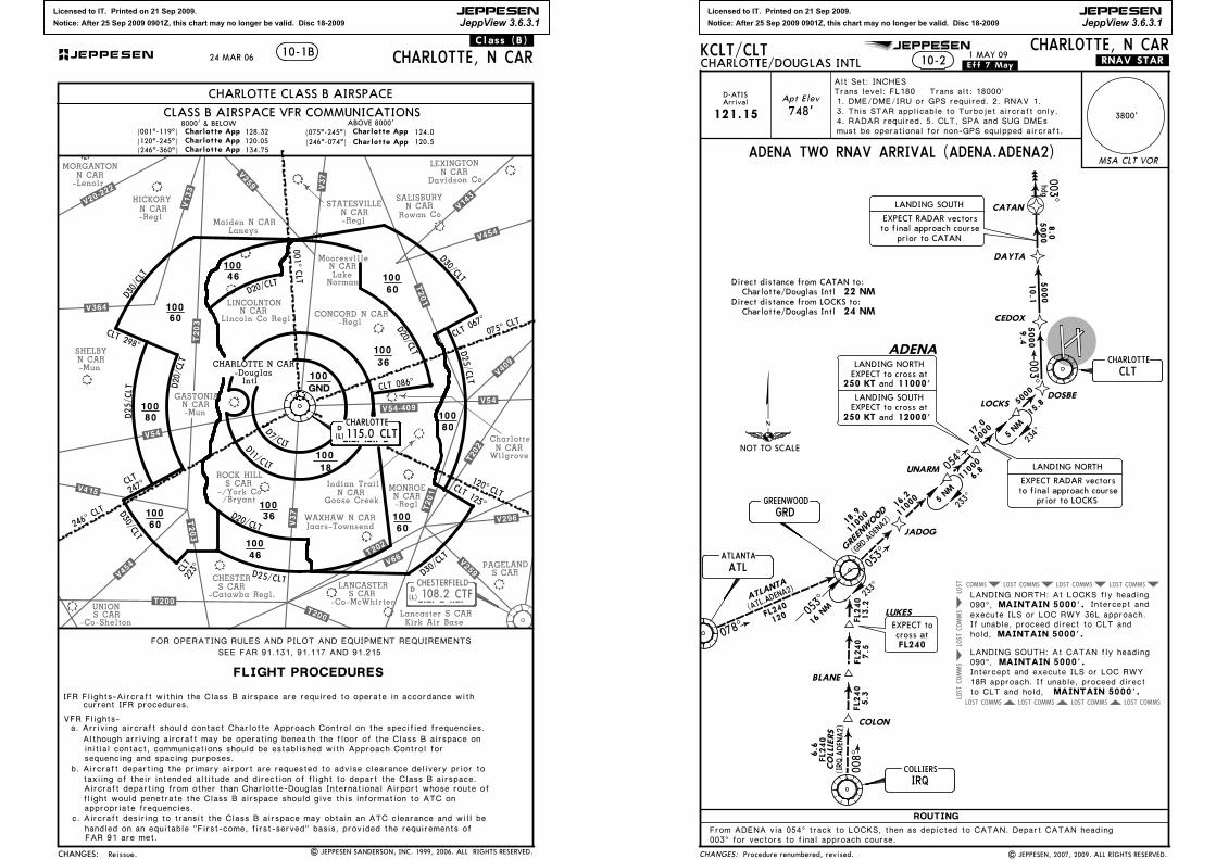
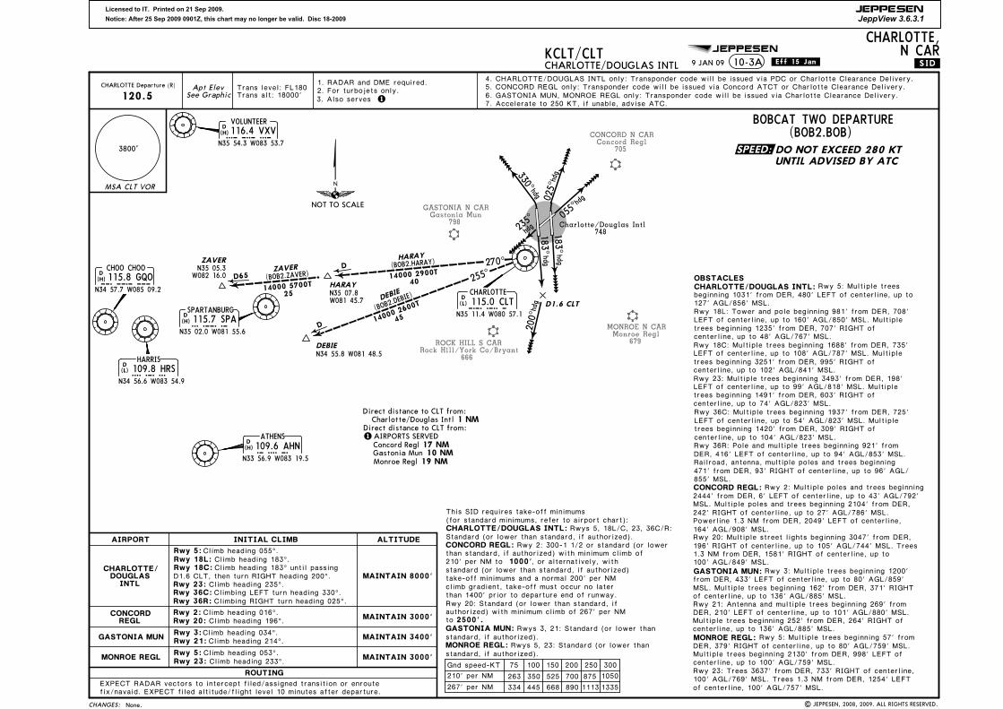
Licensed to IT. Printed on 21 Sep 2009. Notice: After 25 Sep 2009 0901Z, this chart may no longer be valid. Disc 18-2009 JEPPESEN JeppView 3.6.3.1 Wilgrove Jaars-Townsend Laneys -Regl GASTONIA SHELBY STATESVILLE L E X I N G T O N LANCASTER CHESTER S CAR N CAR N C A R N CAR N CAR WAXHAW N CAR S CAR S CAR MONROE N CAR Lake Norman LINCOLNTON N CAR -Co-McWhirter ROCK HILL S CAR -Lenoir MORGANTON N CAR HICKORY N CAR P A G E L A N D S C A R -/York Co /Bryant -Regl CONCORD N CAR D 108.2 CTF CTF CHESTERFIELD .V133. .V143 . . V259. .V25 9. . V 2 9 6 . . V 3 6 4 . .V37 . .V37. . V409. . V 415. .V454. . V 4 54. . V 5 4 . . V 66 . . V 54 . .V20- 222. . V 5 4- 40 9. (L) -Regl Lancaster S CAR Kirk Air Base Mooresville N CAR Lincoln Co Regl Maiden N CAR -Mun -Mun N CAR Indian Trail Goose Creek UNION -Co-Shelton D a v i d s o n C o Charlotte N CAR R o w a n C o . T 2 0 0 . .T 20 0. .T2 01. .T201. N C A R S A L I S B U R Y .T202. .T203. -Regl -Catawba Regl. .T20 2. .T203. Intl CHARLOTTE N CAR CHANGES: 10-1B FLIGHT PROCEDURES FOR OPERATING RULES AND PILOT AND EQUIPMENT REQUIREMENTS CHARLOTTE, N CAR VFR Flights- a. Arriving aircraft should contact Charlotte Approach Control on the specified frequencies. b. Aircraft departing the primary airport are requested to advise clearance delivery prior to (120^-245^) Charlotte App Charlotte App Charlotte App (075^-245^) Charlotte App 124.0 ABOVE 8000' (001^-119^) 120.05 128.32 (246^-074^) 8000' & BELOW 120.5 CLASS B AIRSPACE VFR COMMUNICATIONS CHARLOTTE CLASS B AIRSPACE IFR Flights-Aircraft within the Class B airspace are required to operate in accordance with current IFR procedures. Although arriving aircraft may be operating beneath the floor of the Class B airspace on initial contact, communications should be established with Approach Control for sequencing and spacing purposes. taxiing of their intended altitude and direction of flight to depart the Class B airspace. Aircraft departing from other than Charlotte-Douglas International Airport whose route of flight would penetrate the Class B airspace should give this information to ATC on appropriate frequencies. c. Aircraft desiring to transit the Class B airspace may obtain an ATC clearance and will be handled on an equitable "First-come, first-served" basis, provided the requirements of FAR 91 are met. .Class.(B). SEE FAR 91.131, 91.117 AND 91.215 D (L) -Douglas Charlotte App (246^-360^) 134.75 | JEPPESEN SANDERSON, INC. 1999, 2006. ALL RIGHTS RESERVED. 24 MAR 06 Reissue. 1 CLT 125^ CL T 2 9 8 ^ 100 60 100 60 100 36 100 60 100 46 100 60 100 80 100 36 C L T 2 4 7^ CLT 001^ 100 GND D30 /CLT D30/ C LT D3 0/CL T D30/CLT 100 18 D 1 /C L T CLT 0 6 7^ D2 5/ C L T D2 5/ C L T D 2 5 / C L T C L T 0 8 6^ 80 100 100 46 CLT 223^ D20 /C LT D 20 / C L T D 20/ C L T D 2 0 /CLT D 7 / C L T JEPPESEN 115.0 CLT CLT CHARLOTTE 246^ CLT 120^ CL T C LT 07 5 ^ Licensed to IT. Printed on 21 Sep 2009. Notice: After 25 Sep 2009 0901Z, this chart may no longer be valid. Disc 18-2009 JEPPESEN JeppView 3.6.3.1 JEPPESEN COMMS LOST COMMS LOST LOST COMMS COMMS LOST COMMS LOST COMMS LOST COMMS LOST COMMS LOST COMMS LOST COMMS LOST CHANGES: MSA CLT VOR ROUTING 10-2 KCLT/CLT CHARLOTTE/DOUGLAS INTL .Eff.7.May. CHARLOTTE, N CAR 3800' Apt Elev 748' ADENA TWO RNAV ARRIVAL (ADENA.ADENA2) 121.15 D-ATIS Arrival UNARM ADENA LUKES BLANE COLON LOCKS A T L AN T A COLLIERS (A TL .A D E N A 2 ) (IRQ.ADENA2) 0 78 ^ 053^ 05 4^ 008^ 120 16.2 6. 8 6.6 5.3 7.5 13.2 F L240 FL240 FL240 FL240 FL240 11000 11000 5000 5000 5000 500 0 5000 003^ 17.0 15.8 9.4 1 0.1 8.0 003^ hdg 0 5 3^ 233^ 234^ 233^ CEDOX DAYTA CATAN DOSBE FL240 EXPECT to cross at MAINTAIN 5000'. MAINTAIN 5000'. MAINTAIN 5000'. ATLANTA ATL GRD COLLIERS IRQ CLT GREENWOOD CHARLOTTE Direct distance from CATAN to: Charlotte/Douglas Intl 22 NM Direct distance from LOCKS to: Charlotte/Douglas Intl 24 NM Alt Set: INCHES Trans level: FL180 Trans alt: 18000' From ADENA via 054^ track to LOCKS, then as depicted to CATAN. Depart CATAN heading 003^ for vectors to final approach course. EXPECT RADAR vectors to final approach course prior to CATAN LANDING SOUTH EXPECT RADAR vectors to final approach course prior to LOCKS LANDING NORTH .RNAV.STAR. 1 MAY 09 LANDING NORTH EXPECT to cross at EXPECT to cross at LANDING SOUTH and 12000' 250 KT 250 KT 11000' and 5 NM 5 NM 16 NM 3. This STAR applicable to Turbojet aircraft only. 18 .9 11000 GREENWOOD (GRD.ADENA 2) JADOG 1. DME/DME/IRU or GPS required. 2. RNAV 1. 090^, LANDING NORTH: At LOCKS fly heading execute ILS or LOC RWY 36L approach. If unable, proceed direct to CLT and Intercept and hold, 090^, LANDING SOUTH: At CATAN fly heading MAINTAIN 5000'. 18R approach. If unable, proceed direct Intercept and execute ILS or LOC RWY to CLT and hold, | JEPPESEN, 2007, 2009. ALL RIGHTS RESERVED. Procedure renumbered, revised. 4. RADAR required. 5. CLT, SPA and SUG DMEs must be operational for non-GPS equipped aircraft. NOT TO SCALE
Transcript of Licensed to IT. Printed on 21 Sep 2009. Notice: After 25 ...fly-sea.com/charts/KCLT.pdf · RNAV 1....
Licensed to IT. Printed on 21 Sep 2009.
Notice: After 25 Sep 2009 0901Z, this chart may no longer be valid. Disc 18-2009
JEPPESEN
JeppView 3.6.3.1
Wilgrove
Jaars-Townsend
Laneys
-Regl
GASTONIA
SHELBY
STATESVILLE
LEXINGTON
LANCASTERCHESTER
S CAR
N CAR
N CAR
N CAR
N CAR
WAXHAW N CAR
S CARS CAR
MONROEN CAR
LakeNorman
LINCOLNTONN CAR
-Co-McWhirter
ROCK HILLS CAR
-Lenoir
MORGANTON N CAR
HICKORY N CAR
PAGELANDS CAR
-/York Co/Bryant
-ReglCONCORD N CAR
D 108.2 CTFCTFCHESTERFIELD
.V133.
.V143.
.V259.
.V259.
.V296.
.V364..V37.
.V37.
.V409.
.V415.
.V454.
.V454.
.V54.
.V66.
.V54.
.V20-222.
.V54-409.
(L)
-Regl
Lancaster S CARKirk Air Base
MooresvilleN CAR
Lincoln Co Regl
Maiden N CAR
-Mun
-Mun
N CARIndian Trail
Goose Creek
UNION
-Co-Shelton
Davidson Co
CharlotteN CAR
Rowan Co
.T200..T200.
.T201.
.T201.
N CARSALISBURY
.T202.
.T203.
-Regl
-Catawba Regl.
.T202.
.T203 .
Intl
CHARLOTTE N CAR
CHANGES:
10-1B
FLIGHT PROCEDURES
FOR OPERATING RULES AND PILOT AND EQUIPMENT REQUIREMENTS
CHARLOTTE, N CAR
VFR Flights-a. Arriving aircraft should contact Charlotte Approach Control on the specified frequencies.
b. Aircraft departing the primary airport are requested to advise clearance delivery prior to
(120^-245^) Charlotte AppCharlotte AppCharlotte App (075^-245^)Charlotte App
124.0ABOVE 8000'
(001^-119^)120.05128.32
(246^-074^)
8000' & BELOW
120.5
CLASS B AIRSPACE VFR COMMUNICATIONS
CHARLOTTE CLASS B AIRSPACE
IFR Flights-Aircraft within the Class B airspace are required to operate in accordance with current IFR procedures.
Although arriving aircraft may be operating beneath the floor of the Class B airspace on initial contact, communications should be established with Approach Control for sequencing and spacing purposes.
taxiing of their intended altitude and direction of flight to depart the Class B airspace. Aircraft departing from other than Charlotte-Douglas International Airport whose route of flight would penetrate the Class B airspace should give this information to ATC on appropriate frequencies.
c. Aircraft desiring to transit the Class B airspace may obtain an ATC clearance and will be handled on an equitable "First-come, first-served" basis, provided the requirements of FAR 91 are met.
.Class.(B).
SEE FAR 91.131, 91.117 AND 91.215
D(L)
-Douglas
Charlotte App(246^-360^) 134.75
| JEPPESEN SANDERSON, INC. 1999, 2006. ALL RIGHTS RESERVED.
24 MAR 06
Reissue.
1
CLT 125^
CLT 298^
10060
100
60
100
36
10060
100
46
10060
10080
10036
CLT
247^
CLT
001^
100
GND
D30/CLT
D30/CLT
D30/CLT
D30/CLT
100
18
D
1/C LT
CLT 06
7^
D25/ C
L T
D25/CLT
D25/CLT
CLT 086^
80100
10046
CLT
223^
D20/CLT
D20/CLT
D20/CLT
D20/CLT
D7/CLT
JEPPESEN
115.0 CLTCLTCHARLOTTE
246^ CLT
120^ CLT
CLT075^
Licensed to IT. Printed on 21 Sep 2009.
Notice: After 25 Sep 2009 0901Z, this chart may no longer be valid. Disc 18-2009
JEPPESEN
JeppView 3.6.3.1
JEPPESEN
COMMS
LOST
COMMS
LOST
LOST COMMS COMMSLOST COMMSLOST COMMSLOST
COMMSLOST COMMSLOST COMMSLOST COMMSLOST
CHANGES:
MSA CLT VOR
ROUTING
10-2KCLT/CLTCHARLOTTE/DOUGLAS INTL .Eff.7.May.
CHARLOTTE, N CAR
3800'
Apt Elev
748'
ADENA TWO RNAV ARRIVAL (ADENA.ADENA2)
121.15
D-ATISArrival
UNARM
ADENA
LUKES
BLANE
COLON
LOCKS
ATLANTA
CO
LLIE
RS
(ATL.AD
ENA2)
( IRQ.ADENA2 )
078^
053^
054^
008 ^
120
16.2
6.8
6.6
5.3
7.5
13.2
FL240
FL2
40
FL 2
40
FL 2
40
FL2
40
11000
11000
5000
5000
5000
5000
5000
003 ^
17.0
15.8
9. 4
10.1
8.0
003^hdg
053^
233^
234^
233^
CEDOX
DAYTA
CATAN
DOSBE
FL240
EXPECT tocross at
MAINTAIN 5000'.
MAINTAIN 5000'.
MAINTAIN 5000'.
ATLANTA
ATL
GRD
COLLIERS
IRQ
CLT
GREENWOOD
CHARLOTTE
Direct distance from CATAN to:Charlotte/Douglas Intl 22 NM
Direct distance from LOCKS to:Charlotte/Douglas Intl 24 NM
Alt Set: INCHES Trans level: FL180 Trans alt: 18000'
From ADENA via 054^ track to LOCKS, then as depicted to CATAN. Depart CATAN heading 003^ for vectors to final approach course.
EXPECT RADAR vectorsto final approach course
prior to CATAN
LANDING SOUTH
EXPECT RADAR vectorsto final approach course
prior to LOCKS
LANDING NORTH
.RNAV.STAR.1 MAY 09
LANDING NORTHEXPECT to cross at
EXPECT to cross atLANDING SOUTH
and 12000'250 KT
250 KT 11000' and
5 NM
5 NM
16 NM
3. This STAR applicable to Turbojet aircraft only.
18.9
11000
GRE
ENWOOD
(GRD.ADENA2)
JADOG
1. DME/DME/IRU or GPS required. 2. RNAV 1.
090^,LANDING NORTH: At LOCKS fly heading
execute ILS or LOC RWY 36L approach.If unable, proceed direct to CLT and
Intercept and
hold,
090^,LANDING SOUTH: At CATAN fly heading
MAINTAIN 5000'.
18R approach. If unable, proceed directIntercept and execute ILS or LOC RWY
to CLT and hold,
| JEPPESEN, 2007, 2009. ALL RIGHTS RESERVED.Procedure renumbered, revised.
4. RADAR required. 5. CLT, SPA and SUG DMEsmust be operational for non-GPS equipped aircraft.
NOT TO SCALE

Licensed to IT. Printed on 21 Sep 2009.
Notice: After 25 Sep 2009 0901Z, this chart may no longer be valid. Disc 18-2009
JEPPESEN
JeppView 3.6.3.1
JEPPESEN
WADESBORO N CAR
Anson Co
300
ROCK HILL S CAR
666
Rock Hill/York Co/Bryant
SHELBY N CAR
847
877
LINCOLNTON N CAR
GASTONIA N CAR
Gastonia Mun
798
CHESTER S CAR
656
LANCASTER S CAR
Lancaster Co-McWhirter
486
WAXHAW N CAR
Jaars-Townsend
602
679
MONROE N CAR
-Lincoln Co Regl
Chester Catawba Regl
Monroe Regl
-Cleveland Co Regl
BO
OZE
N34 42.2 W080 20.4
HUSTN
R139
^5
D5 C
LT D10 C
LT
16D2
6
319^16
D42
Douglas Intl
Charlotte/
748
STRET
317^
D
50004
132^
22FLO
RENCE
(FLO.CTF3)
312^
215^
FAYETTEVIL
LE
72
11000
(FAY.CTF3)
258^
035^
011^
391100
0
334^
R154^
107
FL18026
(CHS.CTF3)
N33 36.5 W079 57.1
PRO
MM
N34 04.4
W079 53.6
(SAV.C
TF3)
NA
VEE
N33 42.0 W080 09.2
D
FL180
11000
D
28
D
5
SAVANNAH
CHARLESTON
(TURBOJETACFT ONLY)
(TURBOJET
ACFT
ONLY)
D133
215^
CHANGES:
MSA CLT VOR
KCLT/CLTCHARLOTTE/DOUGLAS INTL .Eff.7.May.
CHARLOTTE, N CAR
3800
'
CHESTERFIELD THREE ARRIVAL (CTF.CTF3)
.STAR.10-2A
Apt ElevSee Graphic
1. DME required.Alt Set: INCHES Trans level: FL180 Trans alt: 18000'
2. CHARLESTON and SAVANNAH transitions for Turbojet aircraft only.
N34 53.3
W080 34.3
139^
035^
EXPE
CT
clea
ranc
e to
cros
s at FL2
40
4311000
5000
500017
WA
RNR
N34 28.2 W080 00.4
CHARLOTTE
115.0 CLT
CLT
N35 11.4 W080 57.1
D (L)
CHESTERFIELD
108.2 CTF
CTF
N34 39.0 W080 16.5
D (L)
FAYETTEVILLE
108.8 FAY
FAY
N34 59.1 W078 52.5
D (L)
FLORENCE
115.2 FLO
FLO
N34 14.0 W079 39.4
D (H)
SAVANNAH
115.95 SAV
SAV
N32 08.8 W081 11.9
D (H)
CHARLESTON
113.5 CHS
CHS
N32 53.7 W080 02.3
D (H)
EXPE
CT
clea
ranc
e to
cro
ss
TURB
OJE
TS
250 KT
at a
nd 11000'
D20
D
132^
D
EXPE
CT
clea
ranc
e to
cros
s at FL2
40
1 MAY 09
ROUTING
Fro
m o
ver CTF v
ia C
TF R
-317 to B
OOZE.
LANDING CHARLOTTE/DOUGLAS INTL
Then v
ia C
LT R
-139 to H
USTN. EXPECT R
ADAR
vecto
rs to final appro
ach c
ours
e.
EXPECT R
ADAR v
ecto
rs to d
estination a
irport
or final
appro
ach c
ours
e p
rior to
D10 C
LT.
to final appro
ach c
ours
e p
rior to
D5 C
LT.
Then v
ia C
LT R
-139 to C
LT. EXPECT R
ADAR v
ecto
rs
3. Also serves 1
2
3
NORTH
2
SOUTH
3
4
4LANDING ALL OTHER AIRPORTS
Direc
t di
stan
ce fro
m C
LT to:
AIR
PORT
S SE
RVED
1
-Lin
coln
Co
Regl
Ans
on C
o
Gas
toni
a M
unJa
ars-
Towns
end
Mon
roe
Regl 44 NM
10 NM
22 NM
20 NM
19 NM 3
2 NM
R132^
| JEPPESEN, 2007, 2009. ALL RIGHTS RESERVED.
-Cle
vela
nd C
o Re
gl
Airports served elevations, name.
DOUGLAS
D-ATISINTL
121.15Arrival
CHARLOTTE/
NOT
TO S
CALE

Licensed to IT. Printed on 21 Sep 2009.
Notice: After 25 Sep 2009 0901Z, this chart may no longer be valid. Disc 18-2009
JEPPESEN
JeppView 3.6.3.1
JEPPESEN
COMMS COMMSLOST COMMSLOST COMMSLOST COMMSLOST
COMMS
LOST
LOST
COMMSLOST COMMSLOST COMMSLOST COMMSLOST
121.15
D-ATISArrival
LANDING NORTH: At PACOK fly heading 090^,
MAINTAIN 5000'.
LANDING SOUTH: At FOSSE fly heading 090^,
MAINTAIN 5000'.
Direct distance from FOSSE to:Charlotte/Douglas Intl 24 NM
Direct distance from PACOK to:Charlotte/Douglas Intl 25 NM
183^ for vectors to final approach course.From JOHNS via 136^ track to FOSSE, then as depicted to PACOK. Depart PACOK heading
MAINTAIN 5000'. Intercept and execute ILS or LOC RWY 36L approach. If unable, proceed direct to CLT and hold,
MAINTAIN 5000'. Intercept and execute ILS or LOC RWY 18R approach. If unable, proceed direct to CLT and hold,
4. This STAR applicable to Turbojet aircraft only.
CHANGES:
MSA CLT VOR
3800'
.Eff.7.May.KCLT/CLT
748'Apt Elev
ROUTING
CHARLOTTE/DOUGLAS INTL 10-2B1 MAY 09
JOHNS TWO RNAV ARRIVAL(JOHNS.JOHNS2)
.RNAV.STAR.
| JEPPESEN, 2009. ALL RIGHTS RESERVED.
BURLS
SWENK
GIBSS
SPWAY
PENSK
WUDDS
RCHRD
FLABB
FOSSE
CEDOX
DOSBE
IKICO
PACOK
FALMOUTH CHARLESTON
148^
196^
149^
FALM
OUTH
(FLM.JOHNS2)
FL180
FL180
54.0
11.0
116
THOOR
ATLSS
FLM HVQ
104
11000
(HVQ.JOHNS2)
CHA
RLESTO
N
11000
18 3^5000
9.4
5000
10.4
5000
8.0
183^hdg
137^500017.6
5000
10.0
JOHNS
EXPECT RADAR vectorsto final approach course
prior to FOSSE
LANDING SOUTH
110005.0
136^
LANDING NORTHEXPECT to cross at
EXPECT to cross atLANDING SOUTH
and 11000'250 KT
250 KT and 12000'
7 NM316^
SHINE136^
110006.0
316^
7 NM
11000
6.0
135^
7 NM
315^
135^098^VOLUNTEER(VXV.JOHNS2)
1100020.0
11000
6.0
58.011000
099^1100015.8 110006.0
159^
11000
30.0
12.0
11000
14.2
11000
HOLSTON
MOUNTAIN
(HMV.JOHNS2)
HMV
HOLSTONMOUNTAIN
CLTCHARLOTTE
Alt Set: INCHES Trans level: FL180 Trans alt: 18000'1. DME/DME/IRU or GPS required. 2. RADAR required. 3. RNAV 1.
CHARLOTTE,N CAR
339^
7 NM
279^
099^
7 NM
Procedure reindexed, renumbered, revised.
VXVVOLUNTEER
EXPECT RADAR vectorsto final approach course
prior to PACOK
LANDING NORTH
5. HOLSTON MOUNTAIN and FALMOUTH transitions: BZM, CLT and HMV DMEs must be operational for
operational for non-GPS equipped aircraft. 7. CTF DME must be operational.non-GPS equipped aircraft. 6. CHARLESTON and VOLUNTEER transitions: BZM and CLT DMEs must be
NOT TO SCALE

Licensed to IT. Printed on 21 Sep 2009.
Notice: After 25 Sep 2009 0901Z, this chart may no longer be valid. Disc 18-2009
JEPPESEN
JeppView 3.6.3.1
JEPPESEN
COMMSLOST COMMSLOST COMMSLOST COMMSLOST COMMSLOST
COMMS
LOST
LOST
COMMS COMMSLOST COMMSLOST COMMSLOST COMMSLOST
CHANGES:
MSA CLT VOR
ROUTING
KCLT/CLTCHARLOTTE/DOUGLAS INTL .Eff.7.May.
CHARLOTTE, N CAR
3800'
Apt Elev
748'
HUSTN ONE RNAV ARRIVAL (HUSTN.HUSTN1)
121.15
D-ATISArrival
LANDING NORTH: At CUVPA fly heading 320^,
MAINTAIN 4000'.LANDING SOUTH: At ENNAB fly heading 320^,
MAINTAIN 4000'.
CLTCHARLOTTE
Direct distance from CUVPA to:Charlotte/Douglas Intl 10 NM
Direct distance from ENNAB to:Charlotte/Douglas Intl 22 NM
Alt Set: INCHES Trans level: FL180 Trans alt: 18000'
056^ for vectors to final approach course.
10-2C
CHARLESTON
CHESTERFIELD
FAYETTEVILLE
FLORENCE
SAVANNAH
STRET
PROMM
BOOZEHUSTN
338^
261^
316^
036^
037^
003^
056^
321^
013^
CHA
RLESTO
N
FAYETTEVILLE
FLOREN
CE
SAVANNAH
(CHS.HUSTN1)
(FAY.HUST
N1)
(FLO.HUSTN1)
(SAV.HUSTN1)
43.0
28.0
39.4
4.5
16.0
16.3
7.0
5.0
7.0
6.1
FL1
80
FL180
11000
11000
FL1
80
11000
11000
5000
4000
4000
4000
4000
4000
FL180
25.9
107
39.6
72.0
056^hdg
From HUSTN via 321^ track to CUVPA, then as depicted to ENNAB. Depart ENNAB heading
NAVEE
CUVPA
EAFIV
MENIE
KITGE
ENNAB
EXPECT to crossat FL240
EXPECT to crossat FL240
EXPECT RADAR vectorsto final approach course
prior to CUVPA
LANDING NORTHEAST
039^
219^
217^
136^
141^
MAINTAIN 4000'. Intercept and execute ILS
direct to CLT and hold,
MAINTAIN 4000'. Intercept and execute ILS RWY 23 approach. If unable, proceed direct to CLT and hold,
FAY
CTFFLO
SAVCHS
.RNAV.STAR.1 MAY 09
EXPECT RADAR vectorsto final approach course
prior to ENNAB
LANDING SOUTHWEST
or LOC RWY 5 approach. If unable, proceed
EXPECT to cross at250 KT and 11000'
3. This STAR applicable to Turbojet aircraft only.
be operational for non-GPS equipped aircraft.
5 NM
8 NM
7 NM
12
NM
4. RADAR required. 5. BZM, CLT and CAE must
| JEPPESEN, 2007, 2009. ALL RIGHTS RESERVED.Procedure reindexed.
1. DME/DME/IRU or GPS required. 2. RNAV 1.
NOT TO SCALE
Licensed to IT. Printed on 21 Sep 2009.
Notice: After 25 Sep 2009 0901Z, this chart may no longer be valid. Disc 18-2009
JEPPESEN
JeppView 3.6.3.1
JEPPESEN
LANCASTER S CAR
798Gastonia Mun
N CARGASTONIA
ROCK HILL S CAR
666
CHESTER S CAR
656
130^
WADESBORO N CARAnson Co
300
WAXHAW N CARJaars-Townsend
602
679
MONROE N CAR
Lancaster Co-McWhirter
LINCOLNTON N CAR
877
SHELBY N CAR
847
486
252^
360^D17
Rock Hill/York Co/Bryant
-Lincoln Co Regl
Chester Catawba Regl
Monroe Regl
-Cleveland Co Regl
61
D83
273^40
MAYOS
38
219^
219^
D45
5
R039^
RO
ANO
KE
219^
181^
LYNCHBURG
19
D26
14
D40
SUDSY
GIZMON35 33.0 W080 39.3
039^
(ROA.MAJIC
1)
(LYH.MAJIC1)
(LIB.MAJIC1)
16
5
5
N35 48.7 W080 26.2MAJIC
Charlotte/ Douglas Intl
748
D10 CLT
D5 CLT
2
CHANGES:
MSA CLT VOR
KCLT/CLTCHARLOTTE/DOUGLAS INTL
CHARLOTTE, N CAR
3800'
10-2D
Apt ElevSee Graphic
N36 19.6 W079 59.8
ROANOKE
109.4 ROAROAN37 20.6 W080 04.2
D(L)
LYNCHBURG
109.2 LYHLYHN37 15.3 W079 14.2
D(L)
SOUTH BOSTON
110.4 SBVSBVN36 40.5 W079 00.9
D(L)
GREENSBORO
116.2 GSOGSON36 02.7 W079 58.6
D(H)
117.2 RDURDUN35 52.4 W078 47.0
D(H)
LIBERTY113.0 LIBLIB
N35 48.7 W079 36.8
D(L)
110.8 BZMBZMN35 52.1 W081 14.4
D(L)
CHARLOTTE
115.0 CLTCLTN35 11.4 W080 57.1
D(L)
RALEIGH-DURHAM
BARRETTSMOUNTAIN
.STAR.
LANDING CHARLOTTE/DOUGLAS INTL
approach course prior to D10 CLT.
From over MAJIC via CLT R-039 to CLT. EXPECT RADAR vectors to final approach course prior to D5 CLT.
approach course.From over MAJIC via CLT R-039 to GIZMO. EXPECT RADAR vectors to final
From over MAJIC via CLT R-039 to CLT. EXPECT RADAR vectors to destination airport or final
2RADAR requiredfor LIB R-273
NORTH3
SOUTH4
LANDING ALL OTHER AIRPORTS5
5
3
4
Direct distance from CLT to:AIRPORTS SERVED1
-Lincoln Co Regl
Anson Co
Gastonia MunJaars-Townsend
Monroe Regl
44 NM
10 NM 22 NM 20 NM
19 NM
32 NM
cross at FL220
TURBOJETS
15 MAY 09
MAJIC ONE ARRIVAL (MAJIC.MAJIC1)
KELLS
4814000
14000
14000
11000
11000
N36 35.2W079 47.2
039^
4000
4000
4000
4000
4000
| JEPPESEN, 2007, 2009. ALL RIGHTS RESERVED.
LIBERTY
N35 44.6W080 29.6
-Cleveland Co Regl
121.15
D-ATISArrival
CHARLOTTTE/DOUGLAS
INTL
TURBOJETS
250 KTat and 13000'EXPECT to cross
EXPECT to
15NM
10NM
Direct distance from CLT to: 1 NM
Lincoln Co Regl, Rock Hill/York Co /Bryant airport elevations.
Charlotte/Douglas Intl
Alt Set: INCHES
1. DME required.2. Also serves 1
Trans level: FL180 Trans alt: 18000'
NOT TO SCALE

Licensed to IT. Printed on 21 Sep 2009.
Notice: After 25 Sep 2009 0901Z, this chart may no longer be valid. Disc 18-2009
JEPPESEN
JeppView 3.6.3.1
JEPPESEN
ALBEMARLE N CAR
Stanly Co609
SHELBY N CAR
847
WADESBORO N CAR
Anson Co
656
CHESTER S CAR
ROCK HILL S CAR
666
MONROE N CAR
679
602Jaars-TownsendWAXHAW N CAR
McWhirter Lancaster Co-
LANCASTER S CAR
247^
486
GASTONIA N CARGastonia Mun
798300
SALISBURY N CAR
Rowan Co773
877 N CAR
705
CONCORD
Concord Regl
Rock Hill/York Co/Bryant
-Lincoln Co Regl
Monroe Regl
Chester Catawba Regl
LINCOLNTON N CAR
-Cleveland Co Regl
D
1100020
094^
156^
134^
D64134^ 611000
11000
18
5
145^
FL180169
R012^
192^
CHARLE
STON
11000
116
R327^
FALM
OUTH
R314^
D35
D40
D25
10
15JOHNS
FOSSE
N35 27.1 W081 20.9
1100074
BURLSN35 51.5
W081 58.3
FLABBN35 53.9
W083 29.1
8000
56
314^
314^
314^
Charlotte/ Douglas Intl
748
VOLUNTEER
N35 33.4 W081 30.4
(HVQ.SHINE5)(FLM.SHINE5)
(HMV.SHINE5)
(VXV.SHINE5)
5
5
D10 CLT
D5 CLT
SWENK
SHINEN35 36.5 W081 35.2
HOLSTON
MOUNTAIN
N35 40.3 W081 41.0
CHANGES:
MSA CLT VOR
KCLT/CLTCHARLOTTE/DOUGLAS INTL
CHARLOTTE, N CAR
3800'121.15
D-ATISArrival
10-2E
Apt ElevSee Graphic
SHINE FIVE ARRIVAL (SHINE.SHINE5)
110.8 BZMBZMN35 52.1 W081 14.4
D(L)
CHARLOTTE
115.0 CLTCLTN35 11.4 W080 57.1
D(L)
BARRETTSMOUNTAIN
134^
LANDING NORTHTURBOJETS
EXPECT clearance to cross 250 KTat and 12000'
TURBOJETSLANDING SOUTH
EXPECT clearance to cross 250 KTat and 11000'
FALMOUTH
117.0 FLMFLMN38 39.0 W084 18.6
D(H) CHARLESTON
117.4 HVQHVQN38 21.0 W081 46.2
D(H)
114.6 HMVHMVN36 26.2 W082 07.8
D(L)
VOLUNTEER
116.4 VXVVXVN35 54.3 W083 53.7
D(H)
HOLSTONMOUNTAIN
.STAR.
Alt Set: INCHES Trans level: FL180 Trans alt: 18000'Also serves 1
LANDING CHARLOTTE/DOUGLAS INTL
approach course prior to D10 CLT.From over SHINE via CLT R-314 to CLT. EXPECT RADAR vectors to destination airport or final
NORTH2
SOUTH3
LANDING ALL OTHER AIRPORTS4
From over SHINE via CLT R-314 to CLT. EXPECT RADAR vectors to final approach course prior to D5 CLT.
From over SHINE via CLT R-314 to FOSSE. EXPECT RADAR vectors to final approach course.
23
4
Direct distance from CLT to:AIRPORTS SERVED1
-Lincoln Co Regl
Anson Co
Gastonia MunJaars-Townsend
Monroe Regl
44 NM
10 NM 22 NM 20 NM
19 NM
15 MAY 09
| JEPPESEN, 2007, 2009. ALL RIGHTS RESERVED.
CHARLOTTE/DOUGLAS INTL
Direct distance from CLT to:
32 NM-Cleveland Co Regl
1 NM
Lincoln Co Regl, Rock Hill/York Co/Bryant airport elevations.
Charlotte/Douglas Intl
NOT TO SCALE
Licensed to IT. Printed on 21 Sep 2009.
Notice: After 25 Sep 2009 0901Z, this chart may no longer be valid. Disc 18-2009
JEPPESEN
JeppView 3.6.3.1
COMMSLOSTCOMMSLOSTCOMMSLOSTCOMMSLOSTLOSTCOMMS
COMMS
LOST
LOST
COMMS COMMSLOST COMMSLOST COMMSLOST COMMSLOST
CHANGES:
MSA CLT VOR
ROUTING
KCLT/CLTCHARLOTTE/DOUGLAS INTL .Eff.25.Sep.
CHARLOTTE, N CAR
3800'Apt Elev
748'
Procedure renumbered, revised.
121.15
D-ATISArrival
Direct distance from GIZMO to:Charlotte/Douglas Intl 25 NM
Direct distance from JATAB to:Charlotte/Douglas Intl 24 NM
Alt Set: INCHES Trans level: FL180 Trans alt: 18000'
183^ for vectors to final approach course.
10-2F
From SUDSY via 221^ track to GIZMO, then as depicted to JATAB. Depart JATAB heading
LYNCHBURG
LIBERTY
ROANOKE
MAYOS
MAJIC
SUDSY
GIZMO
221^
222^
221^
183^
LYNCHBURG
RO
ANO
KE
(LYH.SUDSY3)
(ROA.S U
DS Y3)
14000
14000
11000
11000
4000
4000
4000
4000
48.0
37.5
5.0 40.2
61.0
14.0
16.3
8. 5
20. 8
183^hdg
AMOBE
INNOR
JATAB
042^
LANDING NORTH: At JATAB fly heading 270^,
MAINTAIN 4000'.
LANDING SOUTH: At GIZMO fly heading 270^,
MAINTAIN 4000'.
MAINTAIN 4000'. Intercept and execute ILS or LOC RWY 36R approach. If unable, proceed direct to CLT and hold,
MAINTAIN 4000'
direct to CLT and hold,
CLTCHARLOTTE
ROA
LYH
RDU
LIB
RALEIGH-DURHAM
.RNAV.STAR.
184^
277^
3. This STAR applicable to turbojet aircraft only.
19 SEP 08
1. DME/DME/IRU or GPS required. 2. RNAV 1.
EXPECT to cross at250 KT and 13000'
10 NM
KELLS
041^
15 NM
14000
18.6
LIBERTY(LIB.SUDSY3)
EXPECT RADAR vectorsto final approach course
prior to JATAB
LANDING NORTH
| JEPPESEN, 2007, 2008. ALL RIGHTS RESERVED.
EXPECT RADAR vectorsto final approach course
prior to GIZMO
LANDING SOUTH
EXPECT to cross FL220at
non-GPS equipped aircraft BZM, CLT, CTF, GSOand LIB DMEs must be operational.
non-GPS equipped aircraft BZM, CLT and CTFDMEs must be operational.
6. LYNCHBURG and ROANOKE Transitions: For
4. RADAR required. 5. LIBERTY Transition: For
. Intercept and execute ILSor LOC RWY 18L approach. If unable, proceed
SUDSY THREE RNAV ARRIVAL (SUDSY.SUDSY3)
4000
NOT TO SCALE
JEPPESEN

Licensed to IT. Printed on 21 Sep 2009.
Notice: After 25 Sep 2009 0901Z, this chart may no longer be valid. Disc 18-2009
JEPPESEN
JeppView 3.6.3.1
283^
N CAR
Stanly Co
609
SALISBURY N CAR
Rowan Co
773
GASTONIA N CAR
Gastonia Mun
798
SHELBY N CAR
847
103^
135^
150^
875
LINCOLNTON N CAR
667
WADESBORO
N CAR
Anson Co
MONROE N CAR
679
ROCK HILL S CAR
WAXHAW N CAR
Jaars-Townsend
602
CHESTER S CAR
656
LANCASTER S CAR
Lancaster Co-
McWhirter
486
300
705
CONCORD N CAR
Concord Regl
Bryant
Rock Hill/York Co/
D27
D32
-Lincoln Co Regl
Monroe Regl
Chester
Catawba Regl
-Cleveland Co Regl
ALBEMARLE
D59
047^
35
D
R182^ 005^D
D40
17
7
227^
047^
1311000
R232^
5000
UNA
RM
N34 39.3 W081 38.6
232^
232^
748
Douglas Intl
Charlotte/
071^
ATLANTA
11000
120
R254^ COLLIERS
1100020
(ATL.UNARM1)
(IRQ.UNARM1)
55
13D23D5 C
LT
D10 C
LT
052^
(CLT VOR
)
N34 55.7 W081 17.5
LO
CKS
N34 44.0 W081 32.6
ADENA
N34 01.9 W082 09.4
LUKES
CHANGES:
MSA CLT VOR
KCLT/CLTCHARLOTTE/DOUGLAS INTL .Eff.25.Sep.
CHARLOTTE, N CAR
3800
'
.STAR.10-2G
CHARLOTTE
115.0 CLT
CLT
N35 11.4 W080 57.1
D (L)
LANDIN
G N
ORT
HTU
RBOJE
TS
EXPE
CT
clea
ranc
e to
cro
ss
250 KT
at a
nd 11000'
TURB
OJE
TSLA
NDIN
G S
OUTH
EXPE
CT
clea
ranc
e to
cro
ss
250 KT
at a
nd 12000'
EXPE
CT
clea
ranc
e to
cros
s at FL2
40
TURB
OJE
TS
SPARTANBURG
115.7 SPA
SPA
N35 02.0 W081 55.6
D (H)
GREENWOOD
115.5 GRD
GRD
N34 15.1 W082 09.2
D (L)
ATLANTA
116.9 ATL
ATL
N33 37.7 W084 26.1
D (H)
COLLIERS
113.9 IRQ
IRQ
N33 42.4 W082 09.7
D (H)
COLUMBIA
114.7 CAE
CAE
N33 51.4 W081 03.2
D (H)
UNARM ONE ARRIVAL(UNARM.UNARM1)
LANDING CHARLOTTE/DOUGLAS INTL
NORTH
2
SOUTH
3
Fro
m o
ver UNARM v
ia C
LT R
-232 to L
OCKS. EXPECT
RADAR v
ecto
rs to final appro
ach c
ours
e.
Fro
m o
ver UNARM v
ia C
LT R
-232 to C
LT. EXPECT R
ADAR
vecto
rs to final appro
ach c
ours
e p
rior to
D5 C
LT.
Fro
m o
ver UNARM v
ia C
LT R
-232 to C
LT. EXPECT R
ADAR v
ecto
rs
to d
estination a
irport o
r final appro
ach c
ours
e p
rior to
D10 C
LT.
234
LANDING ALL OTHER AIRPORTS
4
Direc
t di
stan
ce fro
m C
LT to:
AIR
PORT
S SE
RVED
1
-Lin
coln
Co
Regl
Ans
on C
o
Gas
toni
a M
unJa
ars-
Towns
end
Mon
roe
Regl 44 NM
10 NM
22 NM
20 NM
19 NM 3
2 NM
19 SEP 08
| JEPPESEN, 2007, 2008. ALL RIGHTS RESERVED.
Direc
t di
stan
ce fro
m C
LT to: 1 NM
Cha
rlot
te/D
ougl
as Int
l
-Cle
vela
nd C
o Re
gl
121.15
D-ATISArrival
CHARLOTTE/DOUGLAS INTL
Apt ElevSee Graphic Also serves 1
Alt Set: INCHES Trans level: FL180 Trans alt: 18000'
Airports served elevations.
NOT
TO S
CALE
JEPPESEN

Licensed to IT. Printed on 21 Sep 2009.
Notice: After 25 Sep 2009 0901Z, this chart may no longer be valid. Disc 18-2009
JEPPESEN
JeppView 3.6.3.1
JEPPESEN
ROUTING
CLTCHARLOTTE
EXPECT clearance to filed altitude within 10 minutes after departure.
INITIAL CLIMB
Climb heading 183^ to 1260', then direct HISOR, then via depicted route to ACSIL.
Climb heading 183^ to 1260', then direct GIRGY, then via depicted route to ACSIL.
18L
18C
36C
36R
ALTITUDE
HISORGIRGY
KAYFOEBAWI
183^hdg
CHANGES:
3800'
MSA CLT VOR
RWY
003^
003^hdg
hdg
028^326^
6. Transponder code will be issued via PDC or Charlotte clearance delivery.
MAINTAIN8000'
6 NM 3 NM
6 NM
Direct distance from Charlotte/Douglas Intl
(Rwy 36C) to: EBAWI(Rwy 18C) to: GIRGY
(Rwy 36R) to: KAYFO
(Rwy 18L) to: HISOR 4 NM
Trans level: FL180Trans alt: 18000'
TREAL
TAYLOR
ANDYS
BEAVY
ACSIL
BAYAL
TIBLE
ZARKS
KATSE
TARBT
234^
198^
197^
182^
101^
180^
240^
269^
177^
162^
198^
208^
7.6
17.3
12.0
13.1
11.6
10.8
17.1
11.0
7.7
19.4
79.3
164
FL180 1900T
11200 2100T
(ANDYS5.TAY)
TAYLOR
TAY
CHARLOTTEDeparture (R)
124.0
1260'.
then LEFT turn via 177^ track to TARBT, then via depicted route to ACSIL.Climb heading 003^ to intercept the 326^ course to EBAWI, then via 269^ track to KATSE,
Climb heading 003^ to intercept the 028^ course to KAYFO, then via depicted route to ACSIL.
| JEPPESEN, 2007, 2009. ALL RIGHTS RESERVED.
UNTIL ADVISED BY ATC
DO NOT EXCEED 280 KT
725' LEFT of centerline, up to 54' AGL/823' MSL.
Rwy 36R: Pole and multiple trees beginning 921' from
OBSTACLES
Rwy 18L: Tower and pole beginning 981' from DER, 708' LEFT of centerline, up to 160' AGL/850' MSL. Multiple trees beginning 1235' from DER, 707' RIGHT of centerline, up to 48' AGL/767' MSL.Rwy 18C: Multiple trees beginning 1688' from DER, 735' LEFT of centerline, up to 108' AGL/787' MSL. Multiple trees beginning 3251' from DER, 995' RIGHT of centerline, up to 102' AGL/841' MSL.
Rwy 36C: Multiple trees beginning 1937' from DER,
Multiple trees beginning 1420' from DER, 309' RIGHT of centerline, up to 104' AGL/823' MSL.
DER, 416' LEFT of centerline, up to 94' AGL/853' MSL. Railroad, antenna, multiple poles and trees beginning 471' from DER, 93' RIGHT of centerline, up to 96' AGL/855' MSL.
AptElev
748'
KCLT/CLTCHARLOTTE/DOUGLAS INTL
CHARLOTTE,N CAR
.RNAV.SID.10-3 .Eff.15.Jan.
7. For non-GPS equipped aircraft: CLT and SPA DMEs must be operational for take-off Rwys 18L/C; BZM, CLT and SPA DMEs must be operational for take-off Rwy 36C; CLT and CTF DMEs must be
NM to
75 100 150 200 250 300
275' per NM
Gnd speed-KT
344 458 688 917 1146 1375
ANDYS FIVE RNAV DEPARTURE(ANDYS5.ANDYS)
NIKIE
177^
192^
5.8
7.1
5
23
operational for take-off Rwy 36R; CAE, CLT, FLO and SPA DMEs must be operational for take-off
This SID requires take-off minimums(for standard minimums, refer to airport chart):Rwy 5: Standard (or lower than standard, if
2000'. ATC climb of 500' per NM to 1260'.authorized) with minimum climb of 275' per NM toRwys 18L/C, 23, 36C/R: ATC climb of 500' per
500' per NM 625 833 1250 1667 2083 2500
Rwy 5: Multiple trees beginning 1031' from DER, 480' LEFT of centerline, up to 127' AGL/856' MSL.
Rwy 23: Multiple trees beginning 3493' from DER, 198' LEFT of centerline, up to 99' AGL/818' MSL. Multiple trees beginning 1491' from DER, 603' RIGHT of centerline, up to 74' AGL/823' MSL.
hdg
hdg
22 NM(Rwys 5, 23) to: ACSIL
At or above1260'
At or above1260'
1. RNAV 1. 2. DME/DME/IRU or GPS required.
5. If unable to accept climb rates, advise ATC on initial contact.
3. RADAR required.4. For turbojets only.
8. Accelerate to 250 KT, if unable, advise ATC.Rwys 5, 23.
9 JAN 09
Climb heading 055^ or as assigned by ATC, EXPECT vectors to ACSIL, then via depictedroute.
Climb heading 235^ or as assigned by ATC, EXPECT vectors to ACSIL, then via depictedroute.
5300 2300T
8800 2000T
Procedure revised, renumbered.
SPEED:
183^hdg
235^
055^
NOT TO SCALE
Licensed to IT. Printed on 21 Sep 2009.
Notice: After 25 Sep 2009 0901Z, this chart may no longer be valid. Disc 18-2009
JEPPESEN
JeppView 3.6.3.1
JEPPESEN
CONCORD N CARConcord Regl
705
GASTONIA N CARGastonia Mun
798
MONROE N CARMonroe Regl
679ROCK HILL S CARRock Hill/York Co/Bryant
666
VOLUNTEER116.4 VXVVXV
N35 54.3 W083 53.7
D(H)
CHOO CHOO115.8 GQOGQO
N34 57.7 W085 09.2
D(H)
HARRIS109.8 HRSHRS
N34 56.6 W083 54.9
D(L)
ATHENS
109.6 AHNAHNN33 56.9 W083 19.5
D(H)
SPARTANBURG115.7 SPASPA
N35 02.0 W081 55.6
D(H)
CHARLOTTE
115.0 CLTCLTN35 11.4 W080 57.1
D(L)
HARAY
ZAVER
DEBIE
N34 55.8 W081 48.5
CHANGES:
MSA CLT VOR
Apt ElevSee Graphic
3800'
(BOB2.BOB)
INITIAL CLIMBAIRPORT
Rwy 5:
CHARLOTTE/DOUGLASINTL
MAINTAIN 8000'
ROUTING
ALTITUDE
Rwy 23:
Rwy 3:Rwy 21:
MAINTAIN 3400'
Rwy 5:Rwy 23:
MAINTAIN 3000'
Climb heading 055^.Rwy 18L:Rwy 18C:
Climb heading 183^.
Climb heading 235^.Rwy 36C: Climbing LEFT turn heading 330^.Rwy 36R: Climbing RIGHT turn heading 025^.
Climb heading 034^. Climb heading 214^.
Climb heading 053^. Climb heading 233^.
EXPECT RADAR vectors to intercept filed/assigned transition or enroute fix/navaid. EXPECT filed altitude/flight level 10 minutes after departure.
Climb heading 183^ until passing
MONROE REGL
GASTONIA MUN
Trans level: FL180Trans alt: 18000'
BOBCAT TWO DEPARTURE
055^
235^
183^
183^
200^
330^
025^hdg
hdg
hdg
hdg
hdg
hdg
hdg D1.6 CLT
Charlotte/Douglas Intl748
270^
255^
HARAY
ZAVER
DEBIE
(BOB2.HARAY)
(BOB2.ZAVER)
(BOB2.DE
BIE)
14000 2900T
14000 5700T
14000
2600T
40
45
25
4. CHARLOTTE/DOUGLAS INTL only: Transponder code will be issued via PDC or Charlotte Clearance Delivery.
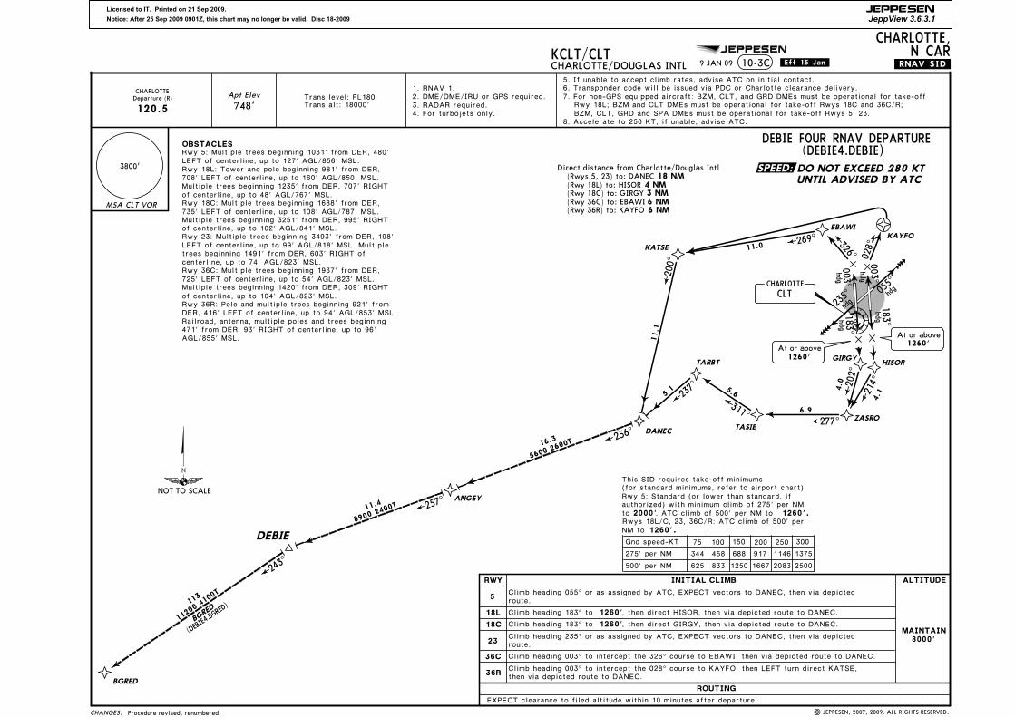
KCLT/CLTCHARLOTTE/DOUGLAS INTL
CHARLOTTE,N CAR
10-3A .Eff.15.Jan. .SID.
7. Accelerate to 250 KT, if unable, advise ATC.
D65D
D
N35 05.3W082 16.0
N35 07.8W081 45.7
UNTIL ADVISED BY ATC
DO NOT EXCEED 280 KT
120.5
D1.6 CLT, then turn RIGHT heading 200^.
Rwy 36R: Pole and multiple trees beginning 921' from
OBSTACLESCHARLOTTE/DOUGLAS INTL:
GASTONIA MUN:
Rwy 5: Multiple trees
Rwy 3: Multiple trees beginning 1200' from DER, 433' LEFT of centerline, up to 80' AGL/859' MSL. Multiple trees beginning 162' from DER, 371' RIGHT of centerline, up to 136' AGL/885' MSL.
127' AGL/856' MSL.beginning 1031' from DER, 480' LEFT of centerline, up to
Rwy 18L: Tower and pole beginning 981' from DER, 708' LEFT of centerline, up to 160' AGL/850' MSL. Multiple trees beginning 1235' from DER, 707' RIGHT of centerline, up to 48' AGL/767' MSL.Rwy 18C: Multiple trees beginning 1688' from DER, 735' LEFT of centerline, up to 108' AGL/787' MSL. Multiple
centerline, up to 102' AGL/841' MSL.trees beginning 3251' from DER, 995' RIGHT of
Rwy 23: Multiple trees beginning 3493' from DER, 198' LEFT of centerline, up to 99' AGL/818' MSL. Multiple
centerline, up to 74' AGL/823' MSL.trees beginning 1491' from DER, 603' RIGHT of
Rwy 36C: Multiple trees beginning 1937' from DER, 725' LEFT of centerline, up to 54' AGL/823' MSL. Multiple
centerline, up to 104' AGL/823' MSL.trees beginning 1420' from DER, 309' RIGHT of
DER, 416' LEFT of centerline, up to 94' AGL/853' MSL. Railroad, antenna, multiple poles and trees beginning 471' from DER, 93' RIGHT of centerline, up to 96' AGL/855' MSL.
Rwy 21: Antenna and multiple trees beginning 269' from DER, 210' LEFT of centerline, up to 101' AGL/880' MSL.
centerline, up to 136' AGL/885' MSL.Multiple trees beginning 252' from DER, 264' RIGHT of
CONCORD REGL:2444' from DER, 6' LEFT of centerline, up to 43' AGL/792' MSL. Multiple poles and trees beginning 2104' from DER, 242' RIGHT of centerline, up to 27' AGL/786' MSL. Powerline 1.3 NM from DER, 2049' LEFT of centerline, 164' AGL/908' MSL.Rwy 20: Multiple street lights beginning 3047' from DER, 196' RIGHT of centerline, up to 105' AGL/744' MSL. Trees 1.3 NM from DER, 1581' RIGHT of centerline, up to 100' AGL/849' MSL.
Rwy 2: Multiple poles and trees beginning
MONROE REGL: Rwy 5: Multiple trees beginning 57' from DER, 379' RIGHT of centerline, up to 80' AGL/759' MSL. Multiple trees beginning 2130' from DER, 998' LEFT of centerline, up to 100' AGL/759' MSL.Rwy 23: Trees 3637' from DER, 733' RIGHT of centerline, 100' AGL/769' MSL. Trees 1.3 NM from DER, 1254' LEFT of centerline, 100' AGL/757' MSL.
MONROE REGL:
(for standard minimums, refer to airport chart):
GASTONIA MUN:
This SID requires take-off minimums
Rwys 5, 23: Standard (or lower than standard, if authorized).
CHARLOTTE/DOUGLAS INTL: Rwys 5, 18L/C, 23, 36C/R: Standard (or lower than standard, if authorized).
standard, if authorized). Rwys 3, 21: Standard (or lower than
75 100 150 200 250 300
210' per NM 263 350 525 700 875 1050
Gnd speed-KT
267' per NM 334 445 668 890 1113 1335
1000'
2500'.
210' per NM to , or alternatively, with
Rwy 20: Standard (or lower than standard, if
toauthorized) with minimum climb of 267' per NM
take-off minimums and a normal 200' per NM climb gradient, take-off must occur no later than 1400' prior to departure end of runway.
standard (or lower than standard, if authorized)
19 NM 10 NM
AIRPORTS SERVED1
Gastonia MunMonroe Regl
1 NMDirect distance to CLT from:
Charlotte/Douglas IntlDirect distance to CLT from:
17 NMConcord Regl
CONCORDREGL
MAINTAIN 3000' Climb heading 016^.Rwy 2:
Rwy 20: Climb heading 196^.
6. GASTONIA MUN, MONROE REGL only: Transponder code will be issued via Charlotte Clearance Delivery.5. CONCORD REGL only: Transponder code will be issued via Concord ATCT or Charlotte Clearance Delivery.
13. Also serves2. For turbojets only.1. RADAR and DME required.
CONCORD REGL: Rwy 2: 300-1 1/2 or standard (or lower than standard, if authorized) with minimum climb of
9 JAN 09
None. | JEPPESEN, 2008, 2009. ALL RIGHTS RESERVED.
SPEED:
NOT TO SCALE
CHARLOTTE Departure (R)

Licensed to IT. Printed on 21 Sep 2009.
Notice: After 25 Sep 2009 0901Z, this chart may no longer be valid. Disc 18-2009
JEPPESEN
JeppView 3.6.3.1
JEPPESEN
CHANGES:
3800'
MSA CLT VOR
KAYFOEBAWI
Apt Elev
748'Trans level: FL180Trans alt: 18000'
5. If unable to accept climb rates, advise ATC on initial contact.6. Transponder code will be issued via PDC or Charlotte clearance delivery.
CLTCHARLOTTE
HISORGIRGY
183^hdg
003^hdg
028^326^
TIBLE
ZARKS
KATSE
TARBT
182^
101^
180^
240^
269^
177^
13.1
11.6
10.8
17.1
11.0
7.7
BAYAL
BUCKL
CODGI
COLUMBIA
139^
183^
199^
18.5
19.9
40.9
9000 2500T
(BUCKL5.CAE)
COLUM
BIA
CAE
CHARLOTTEDeparture (R)
124.0
ROUTING
EXPECT clearance to filed altitude within 10 minutes after departure.
INITIAL CLIMB
Climb heading 183^ to 1260', then direct HISOR, then via depicted route to BAYAL.
Climb heading 183^ to 1260', then direct GIRGY, then via depicted route to BAYAL.
18L
18C
36C
36R
ALTITUDERWY
MAINTAIN8000'
Climb heading 003^ to intercept the 326^ course to EBAWI, then via 269^ track to KATSE, then LEFT turn via 177^ track to TARBT, then via depicted route to BAYAL.
6 NM 3 NM
6 NM
Direct distance from Charlotte/Douglas Intl
(Rwy 36C) to: EBAWI(Rwy 18C) to: GIRGY
(Rwy 36R) to: KAYFO
(Rwy 18L) to: HISOR 4 NM
Climb heading 003^ to intercept the 028^ course to KAYFO, then via depicted route to BAYAL.
| JEPPESEN, 2007, 2009. ALL RIGHTS RESERVED.
KCLT/CLTCHARLOTTE/DOUGLAS INTL
CHARLOTTE,N CAR
.RNAV.SID..Eff.15.Jan.10-3B
UNTIL ADVISED BY ATC
DO NOT EXCEED 280 KT
BUCKL FIVE RNAV DEPARTURE(BUCKL5.BUCKL)
7. For non-GPS equipped aircraft: CLT and CTF DMEs must be operational for take-off Rwys 18L/C, 36R;
177^5.8
NIKIE
192^
7.1
1260'.
725' LEFT of centerline, up to 54' AGL/823' MSL.
Rwy 36R: Pole and multiple trees beginning 921' from
of centerline, up to 102' AGL/841' MSL.
Rwy 36C: Multiple trees beginning 1937' from DER,
Multiple trees beginning 1420' from DER, 309' RIGHT of centerline, up to 104' AGL/823' MSL.
DER, 416' LEFT of centerline, up to 94' AGL/853' MSL. Railroad, antenna, multiple poles and trees beginning 471' from DER, 93' RIGHT of centerline, up to 96' AGL/855' MSL.
NM to
75 100 150 200 250 300
275' per NM
Gnd speed-KT
344 458 688 917 1146 1375
This SID requires take-off minimums(for standard minimums, refer to airport chart):Rwy 5: Standard (or lower than standard, if
2000'. ATC climb of 500' per NM to 1260'.authorized) with minimum climb of 275' per NM toRwys 18L/C, 23, 36C/R: ATC climb of 500' per
500' per NM 625 833 1250 1667 2083 2500
Rwy 23: Multiple trees beginning 3493' from DER, 198' LEFT of centerline, up to 99' AGL/818' MSL. Multiple trees beginning 1491' from DER, 603' RIGHT of centerline, up to 74' AGL/823' MSL.
OBSTACLES
Rwy 18L: Tower and pole beginning 981' from DER, 708' LEFT of centerline, up to 160' AGL/850' MSL. Multiple trees beginning 1235' from DER, 707' RIGHT of centerline, up to 48' AGL/767' MSL.Rwy 18C: Multiple trees beginning 1688' from DER, 735' LEFT of centerline, up to 108' AGL/787' MSL. Multiple trees beginning 3251' from DER, 995' RIGHT
Rwy 5: Multiple trees beginning 1031' from DER, 480' LEFT of centerline, up to 127' AGL/856' MSL.
hdg
003^hdg
hdg
16 NM(Rwys 5, 23) to: BAYAL
5
23
Climb heading 055^ or as assigned by ATC, EXPECT vectors to BAYAL, then via depicted
Climb heading 235^ or as assigned by ATC, EXPECT vectors to BAYAL, then via depicted
At or above1260'
At or above1260'
4. For turbojets only.
1. RNAV 1. 2. DME/DME/IRU or GPS required.3. RADAR required.
8. Accelerate to 250 KT, if unable, advise ATC.
BZM, CLT and CTF DMEs must be operational for take-off Rwy 36C; CTF DME must be operational for take-off Rwys 5, 23.
9 JAN 09
route.
route.
4000 2200T
181^
5.1
8000 1900T
Procedure revised, renumbered.
SPEED:
235^
055^
183^hdg
NOT TO SCALE
Licensed to IT. Printed on 21 Sep 2009.
Notice: After 25 Sep 2009 0901Z, this chart may no longer be valid. Disc 18-2009
JEPPESEN
JeppView 3.6.3.1
JEPPESEN
ROUTING
EXPECT clearance to filed altitude within 10 minutes after departure.
INITIAL CLIMB
Climb heading 183^ to 1260', then direct HISOR, then via depicted route to DANEC.
Climb heading 183^ to 1260', then direct GIRGY, then via depicted route to DANEC.
18L
18C
36C
36R
ALTITUDE
CHANGES:
3800'
MSA CLT VOR
RWY
Apt Elev
748'
5. If unable to accept climb rates, advise ATC on initial contact.6. Transponder code will be issued via PDC or Charlotte clearance delivery.
Trans level: FL180Trans alt: 18000'
6 NM 3 NM
6 NM(Rwy 36C) to: EBAWI(Rwy 18C) to: GIRGY
(Rwy 36R) to: KAYFO
(Rwy 18L) to: HISOR 4 NM
Climb heading 003^ to intercept the 326^ course to EBAWI, then via depicted route to DANEC.
Climb heading 003^ to intercept the 028^ course to KAYFO, then LEFT turn direct KATSE, then via depicted route to DANEC.
8. Accelerate to 250 KT, if unable, advise ATC.
KCLT/CLTCHARLOTTE/DOUGLAS INTL
CHARLOTTE,N CAR
10-3C .Eff.15.Jan. .RNAV.SID.
| JEPPESEN, 2007, 2009. ALL RIGHTS RESERVED.
7. For non-GPS equipped aircraft: BZM, CLT, and GRD DMEs must be operational for take-off
UNTIL ADVISED BY ATC
DO NOT EXCEED 280 KTDirect distance from Charlotte/Douglas Intl 18 NM(Rwys 5, 23) to: DANEC
OBSTACLES
725' LEFT of centerline, up to 54' AGL/823' MSL.
Rwy 36R: Pole and multiple trees beginning 921' from
of centerline, up to 102' AGL/841' MSL.
Rwy 36C: Multiple trees beginning 1937' from DER,
Multiple trees beginning 1420' from DER, 309' RIGHT of centerline, up to 104' AGL/823' MSL.
DER, 416' LEFT of centerline, up to 94' AGL/853' MSL. Railroad, antenna, multiple poles and trees beginning 471' from DER, 93' RIGHT of centerline, up to 96' AGL/855' MSL.
Rwy 23: Multiple trees beginning 3493' from DER, 198' LEFT of centerline, up to 99' AGL/818' MSL. Multiple trees beginning 1491' from DER, 603' RIGHT of centerline, up to 74' AGL/823' MSL.
Multiple trees beginning 1235' from DER, 707' RIGHT of centerline, up to 48' AGL/767' MSL.Rwy 18C: Multiple trees beginning 1688' from DER, 735' LEFT of centerline, up to 108' AGL/787' MSL. Multiple trees beginning 3251' from DER, 995' RIGHT
Rwy 18L: Tower and pole beginning 981' from DER, 708' LEFT of centerline, up to 160' AGL/850' MSL.
Rwy 5: Multiple trees beginning 1031' from DER, 480' LEFT of centerline, up to 127' AGL/856' MSL.
1260'.NM to
75 100 150 200 250 300
275' per NM
Gnd speed-KT
344 458 688 917 1146 1375
This SID requires take-off minimums(for standard minimums, refer to airport chart):Rwy 5: Standard (or lower than standard, if
2000'. ATC climb of 500' per NM to 1260'.authorized) with minimum climb of 275' per NM toRwys 18L/C, 23, 36C/R: ATC climb of 500' per
500' per NM 625 833 1250 1667 2083 2500
MAINTAIN8000'
5
23
Climb heading 055^ or as assigned by ATC, EXPECT vectors to DANEC, then via depicted
Climb heading 235^ or as assigned by ATC, EXPECT vectors to DANEC, then via depicted
DEBIE FOUR RNAV DEPARTURE(DEBIE4.DEBIE)
DEBIE
BGRED
243^
113
11.4
BGRE
D
(DEBIE4.BGRED)
11200 4100T
DANEC
ANGEY
256^
16.3
CLTCHARLOTTE
HISOR
ZASRO
TASIE
TARBT
KATSE
GIRGY
KAYFO
EBAWI
183^hdg
214^
277^
311^
202^
4.0
6.9
5.6
4.1
003^hdg
028^326^
237^
200^
11.1
11.0
5.1
269^
hdg
hdg
003^
hdg
CHARLOTTE
120.5Departure (R)
1. RNAV 1. 2. DME/DME/IRU or GPS required.3. RADAR required.4. For turbojets only.
Rwy 18L; BZM and CLT DMEs must be operational for take-off Rwys 18C and 36C/R; BZM, CLT, GRD and SPA DMEs must be operational for take-off Rwys 5, 23.
At or above1260'
At or above1260'
257^
9 JAN 09
route.
route.
Procedure revised, renumbered.
5600 2
600T
8900 2
400T
SPEED:hdg183^
235^
055^
NOT TO SCALE

Licensed to IT. Printed on 21 Sep 2009.
Notice: After 25 Sep 2009 0901Z, this chart may no longer be valid. Disc 18-2009
JEPPESEN
JeppView 3.6.3.1
JEPPESEN
CLTCHARLOTTE
HISOR
ZASRO
TASIE
TARBT
KATSE
GIRGY
KAYFO
EBAWI
183^hdg
3800'
MSA CLT VOR
214^
277^
311^
202^
4.0
6.9
5.6
4.1
003^hdg
028^326^
Apt Elev
748'Trans level: FL180Trans alt: 18000'
11.0269^
VOLUNTEER
NASHVILLE
CHANGES:
HEDMA
HARAY
SAYBO
ZAVER
248^
272^ 278^272^
294^
309^
15.2
8.0
25.0
225
93.6
14.7
NASHVILLE(HARAY4.BNA)
(HARAY4.VXV)
VOLUNTEER
9800 5100T
15300 8800T
15300 8400T
BNA
VXV
6. Transponder code will be issued via PDC or Charlotte clearance delivery.5. If unable to accept climb rates, advise ATC on initial contact.
6 NM 3 NM
6 NM(Rwy 36C) to: EBAWI(Rwy 18C) to: GIRGY
(Rwy 36R) to: KAYFO
(Rwy 18L) to: HISOR 4 NM
ALTITUDE
Climb heading 183^ to 1260'18L
RWY
ROUTING
EXPECT clearance to filed altitude within 10 minutes after departure.
INITIAL CLIMB
, then direct HISOR, then via depicted route to HEDMA.
Climb heading 183^ to 1260', then direct GIRGY, then via depicted route to HEDMA.18C
36C
36R
Climb heading 003^ to intercept the 326^ course to EBAWI, then via depicted route to HEDMA.
Climb heading 003^ to intercept the 028^ course to KAYFO, then LEFT turn direct KATSE, then via depicted route to HEDMA.
8. Accelerate to 250 KT, if unable, advise ATC.
| JEPPESEN, 2007, 2009. ALL RIGHTS RESERVED.
KCLT/CLTCHARLOTTE/DOUGLAS INTL
CHARLOTTE,N CAR
.RNAV.SID..Eff.15.Jan.10-3D
UNTIL ADVISED BY ATCDO NOT EXCEED 280 KT
hdg
hdg
003^
hdg
Direct distance from Charlotte/Douglas Intl 28 NM(Rwys 5, 23) to: HEDMA
OBSTACLES
725' LEFT of centerline, up to 54' AGL/823' MSL.
Rwy 36R: Pole and multiple trees beginning 921' from
of centerline, up to 102' AGL/841' MSL.
Rwy 36C: Multiple trees beginning 1937' from DER,
Multiple trees beginning 1420' from DER, 309' RIGHT of centerline, up to 104' AGL/823' MSL.
DER, 416' LEFT of centerline, up to 94' AGL/853' MSL. Railroad, antenna, multiple poles and trees beginning 471' from DER, 93' RIGHT of centerline, up to 96' AGL/855' MSL.
Rwy 23: Multiple trees beginning 3493' from DER, 198' LEFT of centerline, up to 99' AGL/818' MSL. Multiple trees beginning 1491' from DER, 603' RIGHT of centerline, up to 74' AGL/823' MSL.
Multiple trees beginning 1235' from DER, 707' RIGHT of centerline, up to 48' AGL/767' MSL.Rwy 18C: Multiple trees beginning 1688' from DER, 735' LEFT of centerline, up to 108' AGL/787' MSL. Multiple trees beginning 3251' from DER, 995' RIGHT
Rwy 18L: Tower and pole beginning 981' from DER, 708' LEFT of centerline, up to 160' AGL/850' MSL.
Rwy 5: Multiple trees beginning 1031' from DER, 480' LEFT of centerline, up to 127' AGL/856' MSL.
1260'.NM to
75 100 150 200 250 300
275' per NM
Gnd speed-KT
344 458 688 917 1146 1375
This SID requires take-off minimums(for standard minimums, refer to airport chart):Rwy 5: Standard (or lower than standard, if
2000'. ATC climb of 500' per NM to 1260'.authorized) with minimum climb of 275' per NM toRwys 18L/C, 23, 36C/R: ATC climb of 500' per
500' per NM 625 833 1250 1667 2083 2500
MAINTAIN8000'
5
23
Climb heading 055^ or as assigned by ATC, EXPECT vectors to HEDMA, then via depicted
Climb heading 235^ or as assigned by ATC, EXPECT vectors to HEDMA, then via depicted
HARAY FOUR RNAV DEPARTURE(HARAY4.HARAY)
7. For non-GPS equipped aircraft: BZM and CLT DMEs must be operational for take-off Rwys 18L/C, 36C/R; BZM, SPA and SUG DMEs must be operational for take-off Rwys 5, 23.120.5
Departure (R)CHARLOTTE 1. RNAV 1.
2. DME/DME/IRU or GPS required.3. RADAR required.4. For turbojets only.
At or above1260'
At or above1260'
9 JAN 09
route.
route.
Procedure revised, renumbered.
7200 2400T
8800 2300T
271^
4.9
SPEED:
hdg183^
235^
055^
NOT TO SCALE
Licensed to IT. Printed on 21 Sep 2009.
Notice: After 25 Sep 2009 0901Z, this chart may no longer be valid. Disc 18-2009
JEPPESEN
JeppView 3.6.3.1
JEPPESEN
147^
248^
021D25
679
MONROE N CARMonroe Regl
705
CONCORD N CARConcord Regl
Gastonia Mun798
GASTONIA N CAR
ROCK HILL S CAR
666Rock Hill/York Co/Bryant
071^
D21
CHANGES:
MSA CLT VOR
Apt ElevSee Graphic
3800'(HOR4.HOR)
INITIAL CLIMBAIRPORT
Rwy 5:
CHARLOTTE/DOUGLASINTL
Rwy 18L:
MAINTAIN 8000'Rwy 18C:Rwy 23:Rwy 36C:Rwy 36R:
Rwy 3:Rwy 21:
GASTONIAMUN
ROUTING
MAINTAIN 3400'
ALTITUDE
after departure.EXPECT RADAR vectors to intercept filed/assigned transition or enroute fix/navaid. EXPECT filed altitude/flight level 10 minutes
Rwy 5:Rwy 23:
MAINTAIN 3000'MONROEREGL
KCLT/CLTCHARLOTTE/DOUGLAS INTL
CHARLOTTE,N CAR
10-3E .Eff.15.Jan. .SID.
HORNET FOUR DEPARTURE
| JEPPESEN, 2004, 2009. ALL RIGHTS RESERVED.
Climb heading 055^. Climb heading 183^. Climb heading 183^ until passing D1.6 CLT, then turn RIGHT heading 200^.
Climb heading 235^.
Climb heading 034^. Climb heading 214^.
Climb heading 053^. Climb heading 233^.
120.5
CHARLOTTE Departure (R)JOTTA & NALEY
Transitions
124.0
MERILTransition
Trans level: FL180Trans alt: 18000'
13. Also serves
UNTIL ADVISED BY ATCDO NOT EXCEED 280 KT
Climbing LEFT turn heading 330^. Climbing RIGHT turn heading 025^.
2. For turbojets only.1. RADAR and DME required.
200^
hdg
FALMOUTH117.0 FLMFLM
N38 39.0 W084 18.6
D(H)
D(H)
114.6 HMVHMVN36 26.2 W082 07.8
D(L)
HOLSTONMOUNTAIN
NALEYCHARLESTON
117.4 HVQHVQN38 21.0 W081 46.2
PULASKI116.8 PSKPSK
N37 05.3 W080 42.8
D(H)
D(L)
LYNCHBURG
109.2 LYHLYHN37 15.3 W079 14.2
MERIL
117.2 RDURDUN35 52.4 W078 47.0
D(H)LIBERTY
113.0 LIBLIBN35 48.7 W079 36.8
D(L)
N35 36.8W079 26.0
RALEIGH-DURHAM
D
SANDHILLS111.8 SDZSDZ
N35 12.9 W079 35.3
D(L)
hdg183^
183^hdg
hdg
235^
Charlotte/Douglas Intl
748
D1.6 CLT
0 11^
8000 3600T
MERIL
(HOR4.M
ERIL)
8000 3
100T
79
hdg
055^
076^
hdg
025^CHARLOTTE
115.0 CLTCLTN35 11.4 W080 57.1
D(L)
hdg
JOTTA
D
( HOR4.JOTTA)
JO
TTA
50
330^
110.8 BZMBZMN35 52.1 W081 14.4
D(L)
BARRETTSMOUNTAIN
(HOR4. NALEY)
NALEY
20
D70
8000 4000T
.V.37.
Rwy 36R: Pole and multiple trees beginning 921' from
OBSTACLESCHARLOTTE/DOUGLAS INTL:
GASTONIA MUN:
Rwy 5: Multiple trees
Rwy 3: Multiple trees beginning 1200' from DER, 433' LEFT of centerline, up to 80' AGL/859' MSL. Multiple trees beginning 162' from DER, 371' RIGHT of centerline, up to 136' AGL/885' MSL.
127' AGL/856' MSL.beginning 1031' from DER, 480' LEFT of centerline, up to
Rwy 18L: Tower and pole beginning 981' from DER, 708' LEFT of centerline, up to 160' AGL/850' MSL. Multiple trees beginning 1235' from DER, 707' RIGHT of centerline, up to 48' AGL/767' MSL.Rwy 18C: Multiple trees beginning 1688' from DER, 735' LEFT of centerline, up to 108' AGL/787' MSL. Multiple
centerline, up to 102' AGL/841' MSL.trees beginning 3251' from DER, 995' RIGHT of
Rwy 23: Multiple trees beginning 3493' from DER, 198' LEFT of centerline, up to 99' AGL/818' MSL. Multiple
centerline, up to 74' AGL/823' MSL.trees beginning 1491' from DER, 603' RIGHT of
Rwy 36C: Multiple trees beginning 1937' from DER, 725' LEFT of centerline, up to 54' AGL/823' MSL. Multiple
centerline, up to 104' AGL/823' MSL.trees beginning 1420' from DER, 309' RIGHT of
DER, 416' LEFT of centerline, up to 94' AGL/853' MSL. Railroad, antenna, multiple poles and trees beginning 471' from DER, 93' RIGHT of centerline, up to 96' AGL/855' MSL.
Rwy 21: Antenna and multiple trees beginning 269' from DER, 210' LEFT of centerline, up to 101' AGL/880' MSL.
centerline, up to 136' AGL/885' MSL.Multiple trees beginning 252' from DER, 264' RIGHT of
CONCORD REGL:2444' from DER, 6' LEFT of centerline, up to 43' AGL/792' MSL. Multiple poles and trees beginning 2104' from DER, 242' RIGHT of centerline, up to 27' AGL/786' MSL. Powerline 1.3 NM from DER, 2049' LEFT of centerline, 164' AGL/908' MSL.Rwy 20: Multiple street lights beginning 3047' from DER, 196' RIGHT of centerline, up to 105' AGL/744' MSL. Trees 1.3 NM from DER, 1581' RIGHT of centerline, up to 100' AGL/849' MSL.
Rwy 2: Multiple poles and trees beginning
MONROE REGL: Rwy 5: Multiple trees beginning 57' from DER, 379' RIGHT of centerline, up to 80' AGL/759' MSL. Multiple trees beginning 2130' from DER, 998' LEFT of centerline, up to 100' AGL/759' MSL.Rwy 23: Trees 3637' from DER, 733' RIGHT of centerline, 100' AGL/769' MSL. Trees 1.3 NM from DER, 1254' LEFT of centerline, 100' AGL/757' MSL.
MONROE REGL:
(for standard minimums, refer to airport chart):
GASTONIA MUN:
This SID requires take-off minimums
Rwys 5, 23: Standard (or lower than standard, if authorized).
CHARLOTTE/DOUGLAS INTL: Rwys 5, 18L/C, 23, 36C/R: Standard (or lower than standard, if authorized).
standard, if authorized). Rwys 3, 21: Standard (or lower than
75 100 150 200 250 300
210' per NM 263 350 525 700 875 1050
Gnd speed-KT
267' per NM 334 445 668 890 1113 1335
1000'
2500'.
210' per NM to , or alternatively, with
Rwy 20: Standard (or lower than standard, if
toauthorized) with minimum climb of 267' per NM
take-off minimums and a normal 200' per NM climb gradient, take-off must occur no later than 1400' prior to departure end of runway.
standard (or lower than standard, if authorized)
19 NM 10 NM
AIRPORTS SERVED1
Gastonia MunMonroe Regl
1 NMDirect distance to CLT from:
Charlotte/Douglas IntlDirect distance to CLT from:
17 NMConcord Regl
CONCORDREGL
MAINTAIN 3000'Rwy 2:Rwy 20: Climb heading 196^.
Climb heading 016^.
7. Accelerate to 250 KT, if unable, advise ATC.6. GASTONIA MUN, MONROE REGL only: Transponder code will be issued via Charlotte Clearance Delivery.5. CONCORD REGL only: Transponder code will be issued via Concord ATCT or Charlotte Clearance Delivery.4. CHARLOTTE/DOUGLAS INTL only: Transponder code will be issued via PDC or Charlotte Clearance Delivery.
CONCORD REGL: Rwy 2: 300-1 1/2 or standard (or lower than standard, if authorized) with minimum climb of
9 JAN 09
None.
SPEED:
NOT TO SCALE
N36 21.2W080 48.4
N36 00.9W080 51.0

Licensed to IT. Printed on 21 Sep 2009.
Notice: After 25 Sep 2009 0901Z, this chart may no longer be valid. Disc 18-2009
JEPPESEN
JeppView 3.6.3.1
JEPPESEN
272^D20
MONROE N CAR
679
666Rock Hill/York Co/Bryant
ROCK HILL S CAR
705
CONCORD N CARConcord Regl
Monroe Regl
026^
798Gastonia Mun
GASTONIA N CAR
347^ROBAY
SADIE
(HUG8.SA
DIE)
(HUG8.RO
BAY)
40
55
D95
D
165^
CHOPN
60
D
196^
ANDYS
(HUG8.ANDYS)
50
D
(HUG8.C
HOPN)
CHARLESTON
117.4 HVQHVQN38 21.0 W081 46.2
D(H)
114.6 HMVHMVN36 26.2 W082 07.8
D(L)
112.2 SUGSUGN35 24.4 W082 16.1
D(L)
FOOTHILLS113.4 ODFODF
N34 41.8 W083 17.9
D(H)
ELECTRIC CITY
108.6 ELWELWN34 25.2 W082 47.1
D(L)
GREENWOOD
115.5 GRDGRDN34 15.1 W082 09.2
D(L)
COLUMBIA
114.7 CAECAEN33 51.4 W081 03.2
D(H)
SAVANNAH115.95 SAVSAV
N32 08.8 W081 11.9
D(H)
COLLIERS113.9 IRQIRQ
N33 42.4 W082 09.7
D(H)
PULASKI
116.8 PSKPSKD(H)
LYNCHBURG109.2 LYHLYH
N37 15.3 W079 14.2
D(L)
117.2 RDURDUN35 52.4 W078 47.0
D(H)
N37 05.3 W080 42.8
SANDHILLS
111.8 SDZSDZN35 12.9 W079 35.3
D(L)
RALEIGH-DURHAM
CHESTERFIELD108.2 CTFCTF
N34 39.0 W080 16.5
D(L)
h dg003^ hd
g
055^
183^hdg
CHARLOTTE
115.0 CLTCLTN35 11.4 W080 57.1
D(L)
CHANGES:
MSA CLT VOR
Apt ElevSee Graphic
3800'
(HUG8.HUG)
INITIAL CLIMBAIRPORT
Rwy 5:CHARLOTTE/DOUGLASINTL
MAINTAIN 4000'
ROUTING
ALTITUDE
Rwy 18L/C:Rwy 23:Rwy 36C/R:
EXPECT filed altitude/flight level 10 minutes after departure.EXPECT RADAR vectors to intercept filed/assigned transition or enroute fix/navaid.
Rwy 3:Rwy 21:
GASTONIAMUN
MAINTAIN 3400'
Rwy 5:Rwy 23:
MONROEREGL
MAINTAIN 3000'
HOLSTONMOUNTAIN
SUGARLOAFMOUNTAIN
Climb heading 055^. Climb heading 183^.
Climb heading 235^. Climb heading 003^.
Climb heading 034^. Climb heading 214^.
Climb heading 053^. Climb heading 233^.
KCLT/CLTCHARLOTTE/DOUGLAS INTL
CHARLOTTE,N CAR
.Eff.15.Jan.10-3F .SID.
| JEPPESEN, 2004, 2009. ALL RIGHTS RESERVED.
Trans level: FL180Trans alt: 18000'
11000 2300T1
1000 2300T
11000 2900T
11000 4800T
FL240 8000T
110003100T
11000
2600T
HUGO EIGHT DEPARTURE
.V.54-409.
1. RADAR and DME required.
3. Also serves2. For propeller aircraft only.
1
Rwy 36R: Pole and multiple trees beginning 921' from
OBSTACLESCHARLOTTE/DOUGLAS INTL:
GASTONIA MUN:
Rwy 5: Multiple trees
Rwy 3: Multiple trees beginning 1200' from DER, 433' LEFT of centerline, up to 80' AGL/859' MSL. Multiple trees beginning 162' from DER, 371' RIGHT of centerline, up to 136' AGL/885' MSL.
127' AGL/856' MSL.beginning 1031' from DER, 480' LEFT of centerline, up to
Rwy 18L: Tower and pole beginning 981' from DER, 708' LEFT of centerline, up to 160' AGL/850' MSL. Multiple trees beginning 1235' from DER, 707' RIGHT of centerline, up to 48' AGL/767' MSL.Rwy 18C: Multiple trees beginning 1688' from DER, 735' LEFT of centerline, up to 108' AGL/787' MSL. Multiple
centerline, up to 102' AGL/841' MSL.trees beginning 3251' from DER, 995' RIGHT of
Rwy 23: Multiple trees beginning 3493' from DER, 198' LEFT of centerline, up to 99' AGL/818' MSL. Multiple
centerline, up to 74' AGL/823' MSL.trees beginning 1491' from DER, 603' RIGHT of
Rwy 36C: Multiple trees beginning 1937' from DER, 725' LEFT of centerline, up to 54' AGL/823' MSL. Multiple
centerline, up to 104' AGL/823' MSL.trees beginning 1420' from DER, 309' RIGHT of
DER, 416' LEFT of centerline, up to 94' AGL/853' MSL. Railroad, antenna, multiple poles and trees beginning 471' from DER, 93' RIGHT of centerline, up to 96' AGL/855' MSL.
Rwy 21: Antenna and multiple trees beginning 269' from DER, 210' LEFT of centerline, up to 101' AGL/880' MSL.
centerline, up to 136' AGL/885' MSL.Multiple trees beginning 252' from DER, 264' RIGHT of
CONCORD REGL:
Rwy 20: Multiple street lights beginning 3047' from DER, 196' RIGHT of centerline, up to 105' AGL/744' MSL. Trees 1.3 NM from DER, 1581' RIGHT of centerline, up to 100' AGL/849' MSL.
MONROE REGL: Rwy 5: Multiple trees beginning 57' from DER, 379' RIGHT of centerline, up to 80' AGL/759' MSL. Multiple trees beginning 2130' from DER, 998' LEFT of centerline, up to 100' AGL/759' MSL.Rwy 23: Trees 3637' from DER, 733' RIGHT of centerline, 100' AGL/769' MSL. Trees 1.3 NM from DER, 1254' LEFT of centerline, 100' AGL/757' MSL.
19 NM 10 NM
AIRPORTS SERVED1
Gastonia MunMonroe Regl
1 NMDirect distance to CLT from:
Charlotte/Douglas IntlDirect distance to CLT from:
17 NMConcord Regl
CONCORDREGL
MAINTAIN 3000'Rwy 2: Climb heading 016^.
Climb heading 196^.Rwy 20:
MONROE REGL:
(for standard minimums, refer to airport chart):
GASTONIA MUN:
This SID requires take-off minimums
Rwys 5, 23: Standard (or lower than standard, if authorized).
CHARLOTTE/DOUGLAS INTL: Rwys 5, 18L/C, 23, 36C/R: Standard (or lower than standard, if authorized).
standard, if authorized). Rwys 3, 21: Standard (or lower than
75 100 150 200 250 300
210' per NM 263 350 525 700 875 1050
Gnd speed-KT
267' per NM 334 445 668 890 1113 1335
1000'
2500'.
210' per NM to , or alternatively, with
Rwy 20: Standard (or lower than standard, if
toauthorized) with minimum climb of 267' per NM
take-off minimums and a normal 200' per NM climb gradient, take-off must occur no later than 1400' prior to departure end of runway.
standard (or lower than standard, if authorized)
Rwy 2: 300-1 1/2 or standard (or lower CONCORD REGL:than standard, if authorized) with minimum climb of
7. Turboprops: Operate in a manner that will result in best forward speed and climb rate.6. GASTONIA MUN, MONROE REGL only: Transponder code will be issued via Charlotte Clearance Delivery.
4. CHARLOTTE/DOUGLAS INTL only: Transponder code will be issued via PDC or Charlotte Clearance Delivery.5. CONCORD REGL only: Transponder code will be issued via Concord ATCT or Charlotte Clearance Delivery.
Rwy 2: Multiple poles and trees beginning 2444' from DER, 6' LEFT of centerline, up to 43' AGL/792' MSL. Multiple poles and trees beginning 2104' from DER, 242' RIGHT of centerline, up to 27' AGL/786' MSL. Powerline 1.3 NM from DER, 2049' LEFT of centerline, 164' AGL/908' MSL.
9 JAN 09
D
GIPPR formation.
hdg23
5^
093^255
^286^
GIPPRDEB
IE
D
D
PITTY
45
45
PITTY
DEBIE
GIPPR
Charlotte/Douglas Intl
748
(HUG8.GIPPR)
(HUG8.PITTY)
(HUG8.DE
BIE)
48
ROBAY
SADIE
CHOPNN34 14.9W080 32.4
ANDYSN34 22.2
W081 08.6
NOT TO SCALE
N36 03.8 W081 18.1
N36 41.8 W081 33.6
N35 12.6W079 59.1
N35 19.8 W081 51.1
(SOUTHEAST SECTOR)
(NORTHWEST SECTOR)
FORDEPARTURE CONTROL FREQ.
SEE GRAPHIC
CHARLOTTEDeparture (R)134.75
CHARLOTTEDeparture (R)128.32
N34 55.8W081 48.5

Licensed to IT. Printed on 21 Sep 2009.
Notice: After 25 Sep 2009 0901Z, this chart may no longer be valid. Disc 18-2009
JEPPESEN
JeppView 3.6.3.1
JEPPESEN
ROUTING
CLTCHARLOTTE
EXPECT clearance to filed altitude within 10 minutes after departure.
INITIAL CLIMB
Climb heading 183^ to 1260', then direct HISOR, then via depicted route to JACAL.
Climb heading 183^ to 1260', then direct GIRGY, then via depicted route to JACAL.
18L
18C
36C
36R
ALTITUDE
JACAL
JOTTA
NALEY
GLADI
HISOR
ZASRO
TASIE
TARBT
KATSE
GIRGY
KAYFO
OTAME
EBAWI
183^hdg
CHANGES:
3800'
MSA CLT VOR
RWY
214^
277^
311^
357^
061^
021^
202^
4.0
6.9
5.6
7.7
15.1
18.3
4.1
5.3
19.2
7.4
003^
018^
359^
012^
hdg
028^326^
013^ 18.2
20.4
NALEY
(JACAL4.NALEY)
Apt Elev
748'5. If unable to accept climb rates, advise ATC on initial contact.
6. Transponder code will be issued via PDC or Charlotte clearance delivery.
6900 3600T
10700 4000T
6 NM 3 NM
6 NM(Rwy 36C) to: EBAWI(Rwy 36R) to: KAYFO
(Rwy 18L) to: HISOR 4 NM
1. RNAV 1. 2. DME/DME/IRU or GPS required.3. RADAR required.4. For turbojets only.
Climb heading 003^ to intercept the 326^ course to EBAWI, then via depicted route to JACAL.
Climb heading 003^ to intercept the 028^ course to KAYFO, then via depicted route to JACAL.
CHARLOTTEDeparture (R)
120.58. Accelerate to 250 KT, if unable, advise ATC.
| JEPPESEN, 2007, 2009. ALL RIGHTS RESERVED.
KCLT/CLTCHARLOTTE/DOUGLAS INTL
CHARLOTTE,N CAR
10-3G .Eff.15.Jan. .RNAV.SID.
UNTIL ADVISED BY ATC
DO NOT EXCEED 280 KT
hdg
hdg
003^
hdg
Direct distance from Charlotte/Douglas Intl 30 NM(Rwys 5, 23) to: JACAL
OBSTACLES
725' LEFT of centerline, up to 54' AGL/823' MSL.
Rwy 36R: Pole and multiple trees beginning 921' from
of centerline, up to 102' AGL/841' MSL.
Rwy 36C: Multiple trees beginning 1937' from DER,
Multiple trees beginning 1420' from DER, 309' RIGHT of centerline, up to 104' AGL/823' MSL.
DER, 416' LEFT of centerline, up to 94' AGL/853' MSL. Railroad, antenna, multiple poles and trees beginning 471' from DER, 93' RIGHT of centerline, up to 96' AGL/855' MSL.
Rwy 23: Multiple trees beginning 3493' from DER, 198' LEFT of centerline, up to 99' AGL/818' MSL. Multiple trees beginning 1491' from DER, 603' RIGHT of centerline, up to 74' AGL/823' MSL.
Multiple trees beginning 1235' from DER, 707' RIGHT of centerline, up to 48' AGL/767' MSL.Rwy 18C: Multiple trees beginning 1688' from DER, 735' LEFT of centerline, up to 108' AGL/787' MSL. Multiple trees beginning 3251' from DER, 995' RIGHT
Rwy 18L: Tower and pole beginning 981' from DER, 708' LEFT of centerline, up to 160' AGL/850' MSL.
Rwy 5: Multiple trees beginning 1031' from DER, 480' LEFT of centerline, up to 127' AGL/856' MSL.
1260'.NM to
75 100 150 200 250 300
275' per NM
Gnd speed-KT
344 458 688 917 1146 1375
This SID requires take-off minimums(for standard minimums, refer to airport chart):Rwy 5: Standard (or lower than standard, if
2000'. ATC climb of 500' per NM to 1260'.authorized) with minimum climb of 275' per NM toRwys 18L/C, 23, 36C/R: ATC climb of 500' per
500' per NM 625 833 1250 1667 2083 2500
MAINTAIN8000'
5
23
JACAL FOUR RNAV DEPARTURE(JACAL4.JACAL)
Trans level: FL180Trans alt: 18000'
7. For non-GPS equipped aircraft: BZM and CLT DMEs must be operational for take-off Rwys 18L/C and 36R; GSO DME must be operational for take-off Rwy 36C; BZM and CLT DMEs must be operational for take-off Rwys 5, 23.
Climb heading 055^ or as assigned by ATC, EXPECT vectors to JACAL.
Climb heading 235^ or as assigned by ATC, EXPECT vectors to JACAL.
At or above1260'
At or above1260'
(Rwy 18C to: GIRGY
9 JAN 09
Procedure renumbered.
SPEED:
hdg183^
235^
055^
NOT TO SCALE

Licensed to IT. Printed on 21 Sep 2009.
Notice: After 25 Sep 2009 0901Z, this chart may no longer be valid. Disc 18-2009
JEPPESEN
JeppView 3.6.3.1
JEPPESEN
ROUTING
INITIAL CLIMB
Climb heading 183^ to 1260', then direct HISOR, then via depicted route to LAMDE.
Climb heading 183^ to 1260', then direct GIRGY, then via depicted route to LAMDE.
18L
18C
36C
36R
ALTITUDE
3800'
MSA CLT VOR
RWY
Apt Elev
748'Trans level: FL180Trans alt: 18000'
CHANGES:
6. Transponder code will be issued via PDC or Charlotte clearance delivery.5. If unable to accept climb rates, advise ATC on initial contact.
then via depicted route to LAMDE.
CHARLOTTEDeparture (R)
124.0
Climb heading 003^ to intercept the 326^ course to EBAWI, then RIGHT turn direct SILSE,
Climb heading 003^ to intercept the 028^ course to KAYFO, then via depicted route to LAMDE.
8. Accelerate to 250 KT, if unable, advise ATC.
| JEPPESEN, 2007, 2009. ALL RIGHTS RESERVED.
KCLT/CLTCHARLOTTE/DOUGLAS INTL
CHARLOTTE,N CAR
.RNAV.SID..Eff.15.Jan.10-3H
7. For non-GPS equipped aircraft: GSO DME must be operational for take-off
UNTIL ADVISED BY ATC
DO NOT EXCEED 280 KT
OBSTACLES
725' LEFT of centerline, up to 54' AGL/823' MSL.
Rwy 36R: Pole and multiple trees beginning 921' from
of centerline, up to 102' AGL/841' MSL.
Rwy 36C: Multiple trees beginning 1937' from DER,
Multiple trees beginning 1420' from DER, 309' RIGHT of centerline, up to 104' AGL/823' MSL.
DER, 416' LEFT of centerline, up to 94' AGL/853' MSL. Railroad, antenna, multiple poles and trees beginning 471' from DER, 93' RIGHT of centerline, up to 96' AGL/855' MSL.
Rwy 23: Multiple trees beginning 3493' from DER, 198' LEFT of centerline, up to 99' AGL/818' MSL. Multiple trees beginning 1491' from DER, 603' RIGHT of centerline, up to 74' AGL/823' MSL.
Multiple trees beginning 1235' from DER, 707' RIGHT of centerline, up to 48' AGL/767' MSL.Rwy 18C: Multiple trees beginning 1688' from DER, 735' LEFT of centerline, up to 108' AGL/787' MSL. Multiple trees beginning 3251' from DER, 995' RIGHT
Rwy 18L: Tower and pole beginning 981' from DER, 708' LEFT of centerline, up to 160' AGL/850' MSL.
Rwy 5: Multiple trees beginning 1031' from DER, 480' LEFT of centerline, up to 127' AGL/856' MSL.
1260'.NM to
75 100 150 200 250 300
275' per NM
Gnd speed-KT
344 458 688 917 1146 1375
This SID requires take-off minimums(for standard minimums, refer to airport chart):Rwy 5: Standard (or lower than standard, if
2000'. ATC climb of 500' per NM to 1260'.authorized) with minimum climb of 275' per NM toRwys 18L/C, 23, 36C/R: ATC climb of 500' per
500' per NM 625 833 1250 1667 2083 2500
MAINTAIN8000'
5
23
LILLS FOUR RNAV DEPARTURE(LILLS4.LILLS)
4. For turbojets only.
1. RNAV 1. 2. DME/DME/IRU or GPS required.3. RADAR required. Rwys 18L/C; BZM and CLT DMEs must be operational for take-off Rwy 36C;
CTF DME must be operational for take-off Rwy 5, 23.
6 NM 3 NM
6 NM(Rwy 36C) to: EBAWI(Rwy 18C) to: GIRGY
(Rwy 36R) to: KAYFO
(Rwy 18L) to: HISOR 4 NM
Direct distance from Charlotte/Douglas Intl 28 NM(Rwys 5, 23) to: LAMDE
CLTCHARLOTTE
HISOR
GIRGY
KAYFO
EBAWI
183^hdg
003^hdg
028^326^
EATHR
TIBLE
093^
152^
144^
090^113^
139^ 5.1
10.511.8
5.9
13.1
19.3
hdg
hdg
003^
hdg
LAMDE
SILSE
114^
LILLS
25.1
At or above1260'
At or above1260'
9 JAN 09
Climb heading 055^ or as assigned by ATC, EXPECT vectors to LAMDE.
Climb heading 235^ or as assigned by ATC, EXPECT vectors to LAMDE.
Via depicted route to LILLS. EXPECT clearance to filed altitude within 10 minutes after departure.
Procedure text, renumbered.
SPEED:
hdg183^
235^
055^
NOT TO SCALE

Licensed to IT. Printed on 21 Sep 2009.
Notice: After 25 Sep 2009 0901Z, this chart may no longer be valid. Disc 18-2009
JEPPESEN
JeppView 3.6.3.1
JEPPESEN
CHANGES:
3800'
MSA CLT VOR
Apt Elev
748'
5. If unable to accept climb rates, advise ATC on initial contact.6. Transponder code will be issued via PDC or Charlotte clearance delivery.
Trans level: FL180Trans alt: 18000'
CLTCHARLOTTE
HISOR
GIRGY
KAYFO
EBAWI
183^hdg
003^hdg
028^326^
EATHR
TIBLE
SILSE
093^
144^
090^
139^ 5.1
10.5
5.9
13.1
ROUTING
INITIAL CLIMB
Climb heading 183^ to 1260', then direct HISOR, then via depicted route to MUNBE.
Climb heading 183^ to 1260', then direct GIRGY, then via depicted route to MUNBE.
18L
18C
36C
36R
ALTITUDERWY
then via depicted route to MUNBE.
MERIL
MUNBE
LILIC
038^
077^
080^
093^
15.2
17.3
37.1
7.6
6 NM 3 NM
6 NM(Rwy 36C) to: EBAWI(Rwy 18C) to: GIRGY
(Rwy 36R) to: KAYFO
(Rwy 18L) to: HISOR 4 NM
CHARLOTTEDeparture (R)
124.0
Climb heading 003^ to intercept the 326^ course to EBAWI, then RIGHT turn direct SILSE,
Climb heading 003^ to intercept the 028^ course to KAYFO, then via depicted route to MUNBE.
8. Accelerate to 250 KT, if unable, advise ATC.
| JEPPESEN, 2007, 2009. ALL RIGHTS RESERVED.
KCLT/CLTCHARLOTTE/DOUGLAS INTL
CHARLOTTE,N CAR
10-3J .Eff.15.Jan. .RNAV.SID.
7. For non-GPS equipped aircraft: CLT and CTF DMEs must be operational for take-off Rwys 18L/C; BZM and CLT DMEs must be operational for take-off Rwy 36C; BZM DME must be operational for take-off Rwy 36R;
UNTIL ADVISED BY ATC
DO NOT EXCEED 280 KT
hdg
hdg
003^
hdg
Direct distance from Charlotte/Douglas Intl 23 NM(Rwys 5, 23) to: MUNBE
OBSTACLES
725' LEFT of centerline, up to 54' AGL/823' MSL.
Rwy 36R: Pole and multiple trees beginning 921' from
of centerline, up to 102' AGL/841' MSL.
Rwy 36C: Multiple trees beginning 1937' from DER,
Multiple trees beginning 1420' from DER, 309' RIGHT of centerline, up to 104' AGL/823' MSL.
DER, 416' LEFT of centerline, up to 94' AGL/853' MSL. Railroad, antenna, multiple poles and trees beginning 471' from DER, 93' RIGHT of centerline, up to 96' AGL/855' MSL.
Rwy 23: Multiple trees beginning 3493' from DER, 198' LEFT of centerline, up to 99' AGL/818' MSL. Multiple trees beginning 1491' from DER, 603' RIGHT of centerline, up to 74' AGL/823' MSL.
Multiple trees beginning 1235' from DER, 707' RIGHT of centerline, up to 48' AGL/767' MSL.Rwy 18C: Multiple trees beginning 1688' from DER, 735' LEFT of centerline, up to 108' AGL/787' MSL. Multiple trees beginning 3251' from DER, 995' RIGHT
Rwy 18L: Tower and pole beginning 981' from DER, 708' LEFT of centerline, up to 160' AGL/850' MSL.
Rwy 5: Multiple trees beginning 1031' from DER, 480' LEFT of centerline, up to 127' AGL/856' MSL.
1260'.NM to
75 100 150 200 250 300
275' per NM
Gnd speed-KT
344 458 688 917 1146 1375
This SID requires take-off minimums(for standard minimums, refer to airport chart):Rwy 5: Standard (or lower than standard, if
2000'. ATC climb of 500' per NM to 1260'.authorized) with minimum climb of 275' per NM toRwys 18L/C, 23, 36C/R: ATC climb of 500' per
500' per NM 625 833 1250 1667 2083 2500
MAINTAIN8000'
5
23
MERIL FOUR RNAV DEPARTURE(MERIL4.MERIL)
CLT and GSO DMEs must be operational for take-off Rwys 5, 23.
1. RNAV 1. 2. DME/DME/IRU or GPS required.3. RADAR required.4. For turbojets only.
At or above1260'
At or above1260'
9 JAN 09
Climb heading 055^ or as assigned by ATC, EXPECT vectors to MUNBE.
Climb heading 235^ or as assigned by ATC, EXPECT vectors to MUNBE.
Via depicted route to MERIL. EXPECT clearance to filed altitude within 10 minutes after departure.
Procedure text, renumbered.
SPEED:
hdg183^
235^
055^
NOT TO SCALE

Licensed to IT. Printed on 21 Sep 2009.
Notice: After 25 Sep 2009 0901Z, this chart may no longer be valid. Disc 18-2009
JEPPESEN
JeppView 3.6.3.1
JEPPESEN
271^D52
798Gastonia Mun
GASTONIA N CAR
666
ROCK HILL S CARRock Hill/York Co/Bryant
MONROE N CAR
679
345^
705
CONCORD N CARConcord Regl
Monroe Regl
228^
D24
262^
205^
D51
350^D101
056^
CHANGES:
MSA CLT VOR
3800'
(PAN8.PAN)
INITIAL CLIMB
Rwy 5:
AIRPORT
CHARLOTTE/DOUGLASINTL
Rwy 18L:
MAINTAIN 8000'Rwy 18C:Rwy 23:Rwy 36C:Rwy 36R:
ROUTING
ALTITUDE
124.0CHARLOTTE Departure (R)
KCLT/CLTCHARLOTTE/DOUGLAS INTL
CHARLOTTE,N CAR
.Eff.20.Nov.10-3K .SID.
PANTHER EIGHT DEPARTURE
| JEPPESEN, 2003, 2008. ALL RIGHTS RESERVED.
Climb heading 055^. Climb heading 183^. Climb heading 183^ until passing D1.6 CLT, then turn RIGHT heading 200^.
Climb heading 235^.
Rwy 3:Rwy 21:
GASTONIAMUN
Rwy 5:Rwy 23:
MONROEREGL
MAINTAIN 3000'
MAINTAIN 3400' Climb heading 034^. Climb heading 214^.
Climb heading 053^. Climb heading 233^.
EXPECT RADAR vectors to intercept filed/assigned transition or enroute fix/navaid. EXPECT filed altitude/flight level 10 minutes after departure.
Climbing LEFT turn heading 330^. Climbing RIGHT turn heading 025^.
UNTIL ADVISED BY ATCDO NOT EXCEED 280 KT
6. GASTONIA MUN, MONROE REGL only: Transponder code will be issued via Charlotte Clearance Delivery.
4. CHARLOTTE/DOUGLAS INTL only: Transponder code will be issued via PDC or Charlotte Clearance Delivery.Trans level: FL180Trans alt: 18000'
Apt ElevSee Graphic
7. Accelerate to 250 KT, if unable, advise ATC.
14 NOV 08
Rwy 36R: Pole and multiple trees beginning 921' from
OBSTACLESCHARLOTTE/DOUGLAS INTL:
GASTONIA MUN:
Rwy 5: Multiple trees
Rwy 3: Multiple trees beginning 1200' from DER, 433' LEFT of centerline, up to 80' AGL/859' MSL. Multiple trees beginning 162' from DER, 371' RIGHT of centerline, up to 136' AGL/885' MSL.
127' AGL/856' MSL.beginning 1031' from DER, 480' LEFT of centerline, up to
Rwy 18L: Tower and pole beginning 981' from DER, 708' LEFT of centerline, up to 160' AGL/850' MSL. Multiple trees beginning 1235' from DER, 707' RIGHT of centerline, up to 48' AGL/767' MSL.Rwy 18C: Multiple trees beginning 1688' from DER, 735' LEFT of centerline, up to 108' AGL/787' MSL. Multiple
centerline, up to 102' AGL/841' MSL.trees beginning 3251' from DER, 995' RIGHT of
Rwy 23: Multiple trees beginning 3493' from DER, 198' LEFT of centerline, up to 99' AGL/818' MSL. Multiple
centerline, up to 74' AGL/823' MSL.trees beginning 1491' from DER, 603' RIGHT of
Rwy 36C: Multiple trees beginning 1937' from DER, 725' LEFT of centerline, up to 54' AGL/823' MSL. Multiple
centerline, up to 104' AGL/823' MSL.trees beginning 1420' from DER, 309' RIGHT of
DER, 416' LEFT of centerline, up to 94' AGL/853' MSL. Railroad, antenna, multiple poles and trees beginning 471' from DER, 93' RIGHT of centerline, up to 96' AGL/855' MSL.
Rwy 21: Antenna and multiple trees beginning 269' from DER, 210' LEFT of centerline, up to 101' AGL/880' MSL.
centerline, up to 136' AGL/885' MSL.Multiple trees beginning 252' from DER, 264' RIGHT of
CONCORD REGL:2444' from DER, 6' LEFT of centerline, up to 43' AGL/792' MSL. Multiple poles and trees beginning 2104' from DER, 242' RIGHT of centerline, up to 27' AGL/786' MSL. Powerline 1.3 NM from DER, 2049' LEFT of centerline, 164' AGL/908' MSL.Rwy 20: Multiple street lights beginning 3047' from DER, 196' RIGHT of centerline, up to 105' AGL/744' MSL. Trees 1.3 NM from DER, 1581' RIGHT of centerline, up to 100' AGL/849' MSL.
Rwy 2: Multiple poles and trees beginning
MONROE REGL: Rwy 5: Multiple trees beginning 57' from DER, 379' RIGHT of centerline, up to 80' AGL/759' MSL. Multiple trees beginning 2130' from DER, 998' LEFT of centerline, up to 100' AGL/759' MSL.Rwy 23: Trees 3637' from DER, 733' RIGHT of centerline, 100' AGL/769' MSL. Trees 1.3 NM from DER, 1254' LEFT of centerline, 100' AGL/757' MSL.
19 NM 10 NM
AIRPORTS SERVED1
Gastonia MunMonroe Regl
1 NMDirect distance to CLT from:
Charlotte/Douglas IntlDirect distance to CLT from:
17 NMConcord Regl
CONCORDREGL
MAINTAIN 3000'
Also serves, runways 18/36C, procedure renumbered.
Rwy 20:Rwy 2: Climb heading 016^.
Climb heading 196^.
BUCKLN34 31.5W080 52.9W081 08.6
N34 22.2ANDYS
(PAN8.ANDYS)
D
ANDYS
50
LILLS
53
112^
196^
LILLSN34 56.1
W079 55.8
(PAN8.LILLS)
D
40
180^
CHARLOTTE115.0 CLTCLT
N35 11.4 W080 57.1
D(L)
FAYETTEVILLE108.8 FAYFAY
N34 59.1 W078 52.5
D(L)
hd g183^
hdg
055^
hdg23
5^
194^
SANDHILLS111.8 SDZSDZ
N35 12.9 W079 35.3
D(L)
FLORENCE115.2 FLOFLO
N34 14.0 W079 39.4
D(H)
8000 2700T
8000 2300T
8000
2300T
330^ hdg
025^
hdg
D1.6 CLT
hdg
200^
TREAL
DUNKN
79
TAYLOR
41
71
(PAN8.TAY)
(PAN8.CAE)
R014^COLLIERS
113.9 IRQIRQN33 42.4 W082 09.7
D(H)
D(H)
SAVANNAH
SAVD(H)
N31 58.7W081 57.9
N33 04.2W081 26.5
R022^
D93
CRAIG
114.5 CRGCRGN30 20.3 W081 30.6
D(H)
TAYLOR112.9 TAY
15000 2100T
FL180 1800T
FL180
1900T
.J.75.
202^
.J.75.
D129
COLUM
BIA
COLUMBIA114.7 CAECAE
N33 51.4 W081 03.2
115.95 SAVN32 08.8 W081 11.9
8000 2500T
TAYN30 30.3 W082 33.2
D(H)
5. CONCORD REGL only: Transponder code will be issued via Concord ATCT or Charlotte Clearance Delivery.
3. Also serves 12. For turbojets only.1. RADAR and DME required.
MONROE REGL:
(for standard minimums, refer to airport chart):
GASTONIA MUN:
This SID requires take-off minimums
Rwys 5, 23: Standard (or lower than standard, if authorized).
CHARLOTTE/DOUGLAS INTL: Rwys 5, 18L/C, 23, 36C/R: Standard (or lower than standard, if authorized).
standard, if authorized). Rwys 3, 21: Standard (or lower than
75 100 150 200 250 300
210' per NM 263 350 525 700 875 1050
Gnd speed-KT
267' per NM 334 445 668 890 1113 1335
1000'
2500'.
210' per NM to , or alternatively, with
Rwy 20: Standard (or lower than standard, if
toauthorized) with minimum climb of 267' per NM
take-off minimums and a normal 200' per NM climb gradient, take-off must occur no later than 1400' prior to departure end of runway.
standard (or lower than standard, if authorized)
CONCORD REGL: Rwy 2: 300-1 1/2 or standard (or lower than standard, if authorized) with minimum climb of
SPEED:
NOT TO SCALE
Charlotte/Douglas Intl748
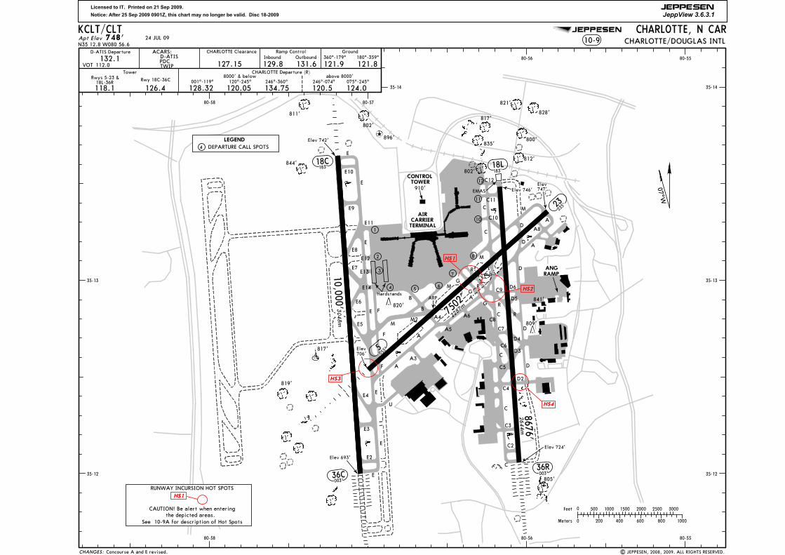
Licensed to IT. Printed on 21 Sep 2009.
Notice: After 25 Sep 2009 0901Z, this chart may no longer be valid. Disc 18-2009
JEPPESEN
JeppView 3.6.3.1
JEPPESEN
CHARLOTTE Clearance
132.1127.15 129.8
Inbound
131.6Outbound
121.9360^-179^
121.8180^-359^
Tower
118.1 126.4
Ramp Control Ground
Elev 724'
D-ATIS Departure
112.0VOT
120.05 134.75 124.0120.5128.32
07^W
500 2000 2500
800600200
Feet
Meters
0
0 1000
30001000 1500
400
Apt Elev
35-12 35-12
35-13 35-13
35-14 35-14
80-55
80-55
80-56
80-56
80-57
80-58
80-58
| JEPPESEN, 2008, 2009. ALL RIGHTS RESERVED.
24 JUL 09
EMAS
Concourse A and E revised.
RUNWAY INCURSION HOT SPOTS
CAUTION! Be alert when enteringthe depicted areas.
See 10-9A for description of Hot Spots
AIRCARRIERTERMINAL
ANGRAMP
E
E2
E3
E
E
E
E
E4
E5
E6
E
A
A
A
A
A4
M
M
M
C
C3
C
C
C
C
C4
R
R
D4
D3
D2
D
D
D
A
D6
7502'
18C183^
36C003^
Elev 742'
Elev 693'
10,000'
18L183^
36R003^
Elev 746'
8676'
844'
811'
802'
835'
817'
812'
819'
Elev706'
Elev747'
73
1
910'TOWER
CONTROL
ARP
654
BR
R
D5
2 8
LEGEND
DEPARTURE CALL SPOTS
E10
E9
E8
E11
E12
E13E7
F
U
A8
A5
A6
23235^
5055^
A3
D
D
C7
3048m
2287m
2644m
C2
C
C8
C11
C10
C5
C6
M2
821'
828'
800'
802'
817'
820'841'
809'
805'
F
M
E
F
748'CHARLOTTE, N CAR
10-9N35 12.8 W080 56.6 CHARLOTTE/DOUGLAS INTL
Rwy 18C-36CRwys 5-23 &18L-36R
TWIPPDCD-ATIS
ACARS:
120^-245^8000' & below
246^-360^ 075^-245^above 8000'
246^-074^
CHARLOTTE Departure (R)
G
G
G
12
001^-119^
E14
C12
C9
896'
KCLT/CLT
B
4
10
Hardstands
11
CHANGES:
HS1
HS3
HS1
HS2
HS4

Licensed to IT. Printed on 21 Sep 2009.
Notice: After 25 Sep 2009 0901Z, this chart may no longer be valid. Disc 18-2009
JEPPESEN
JeppView 3.6.3.1
JEPPESEN
NA
TAKE-OFF
(For information only, not to be construed as ATC instructions.)
KCLT/CLT
OBSTACLE DPRwy 5; Climb heading 055^ to 1700' before turning right.Rwy 36C; Climb heading 003^ to 1400' before turning left.
| JEPPESEN, 1997, 2009. ALL RIGHTS RESERVED.
Eng EngEng EngCL, or
24 JUL 09
None.
CHARLOTTE, N CAR
600-2
A
B
C
D
FOR FILING AS ALTERNATE
GENERAL:
800-2
Low-level wind shear alert system.
CHARLOTTE/DOUGLAS INTL10-9A
AMEND
4
RWY
ADDITIONAL RUNWAY INFORMATION
ThresholdLANDING BEYOND
USABLE LENGTHS
WIDTHGlide Slope
5 6302'
23
18C8840'
36C 9040'
7660'
36R 7634'
Upwind angle 3.25^, downwind angle 2.75^.1
RVRHIRL MALSR VASI-L grooved
RVRgroovedREILHIRL
HIRL CL MALSR PAPI-R (angle 3.0^) RVR
HIRL CL ALSF-II TDZ RVR
HIRL CL REIL 1VASI (3 bar)-R RVR
RVR
18L
1921m
2694m
2755m
2335m
2327m
150'46m
150'46m
150'46m
2
2
Angle 3.00^
1010
Vis RefAdequate
10
STD
RVR or116 4
TDZ RVR
Rollout RVR
Mid RVR
Terminal Doppler Weather Radar.
CHANGES:
CL
CL6387'1947m
ALSF-II TDZ PAPI-RHIRL CL
ILS Rwy 5
ILS Rwy 23
700-2
VASI-R
Intersections of Twy R & G and Rwy 23.
Intersection of Twy E and Rwy 5.
RUNWAY INCURSION HOT SPOTS
Intersection of Twy D2 and Rwy 36R.
Successive or simultaneous departures from Runways 18L and 18C are authorized, with course divergencebeginning no later than 3 miles from the departure end of parallel runways, due to noise abatementrestrictions.
ILS Rwy 18L/CILS Rwy 36C/R RNAV (GPS) All Rwys
LOC All RwysOther
Rwys 18L/C, 36C/R
Vis RefAdequate
STD
RVR or116 4
PAPI-L (angle 3.0^)
Rwy 5, 23
grooved
grooved
Birds in vicinity of airport.
ASDE-X Surveillance system in use. Pilots should operate transponders with Mode C on alltaxiways and runways.
CL, or RCLM & HIRL
Rollout RVR 1010TDZ RVR
TAKE-OFF & OBSTACLE DEPARTURE PROCEDURE
2 operating RVRs are required
RVR
or
241 2
RVR
or
241
2
RVR
or
501
RVR
or
501
3 & 4 1 & 23 & 4 1 & 2
55
5
TDZ RVR
Rollout RVR
Mid RVR
RCLM & HIRLCL & HIRL
All operating RVRsare controlling
Both RVRs required& controlling
Intersection of Twy C9 and Rwy 18L, convergence of Twys R, A, C, and C9 along with grass island.
HS1
HS2
HS3
HS4
Licensed to IT. Printed on 21 Sep 2009.
Notice: After 25 Sep 2009 0901Z, this chart may no longer be valid. Disc 18-2009
JEPPESEN
JeppView 3.6.3.1
JEPPESEN
10-9BCHARLOTTE, N CAR
CHARLOTTE/DOUGLAS INTLKCLT/CLT
CONCOURSE
E
TERMINAL
CARRIER
AIR
CONTROL
TOWER
CONCOURSE
D
CONCOURSE
C
CONCOURSE
B
CONCOURSE
A
C11
C13
C10
C15
C12
C17
C14
C19 C
18
C16
C3
C2
C5
C4
C7
C6
C9
C8
D11
D13
D12
D10
D1
D2
D3
D4
D5D7D9
D8
D6
E20
E22
E24
E26
E25
E23
E21 E10E12
E14E16
E18
E19
E17
E15
E13
E11
E1E2E3
E5E7E9
E4E6E8
E11
E12
E13
E14
E7
E8
E9
E
E6
FB
M
M
M
C10
C11
C
C
C
G
R G
R
A
C
W080-57.0
W080-56.9
W080-56.8
W080-56.7
W080-56.6
W080-56.5
W080-56.3
W080-56.2
W080-56.5
W080-56.6
W080-56.7
W080-56.8
W080-57.0
W080-56.2
W080-57.1
W080-56.3
RWY 5-23
RWY 18L-36R
RWY 18C-36C
E
M
10
8
7
65
4
3
2
1
4DEP
ART
URE
CALL
SPO
TS
11 North Ramp
Hold Line
HARDSTANDS
W080-56.9
24 JUL 09
| JEPPESEN, 1998, 2009. ALL RIGHTS RESERVED.
Ram
p Con
trol
Inbo
und
Out
boun
d12
9.8
131.
6
E28
E27
E29
E30
E31A
E31B
E32A
E32B
Concourse A and E revised.
N35-13.4
N35-13.1
N35-13.0
N35-13.2
N35-13.3
CHANGES:
A1
A3
A5
A7
A9
A8A6
A2
A11
A12A10
B1
B2
B3
B4
B5
B6
B7
B8
B9
B11
B13 B15B16B14
B12
B10
A9A
A4
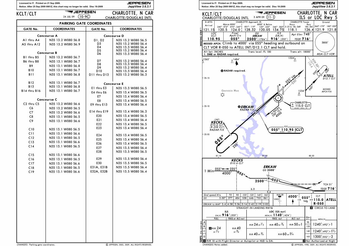
Licensed to IT. Printed on 21 Sep 2009.
Notice: After 25 Sep 2009 0901Z, this chart may no longer be valid. Disc 18-2009
JEPPESEN
JeppView 3.6.3.1
JEPPESEN
PARKING GATE COORDINATES
GATE No. COORDINATES
A1 thru A4
B1 thru B5
Concourse A
Concourse B
N35 13.2 W080 56.8N35 13.2 W080 56.9
N35 13.2 W080 56.7N35 13.1 W080 56.7
N35 13.1 W080 56.8
Concourse D
GATE No. COORDINATES
B13
N35 13.1 W080 56.5
N35 13.2 W080 56.6Concourse C
N35 13.1 W080 56.7
C2 thru C5
C7C6 N35 13.2 W080 56.5
N35 13.2 W080 56.6
N35 13.1 W080 56.6
C18
N35 13.1 W080 56.6N35 13.1 W080 56.5
N35 13.1 W080 56.6
N35 13.3 W080 56.4N35 13.2 W080 56.4
N35 13.3 W080 56.4
N35 13.2 W080 56.4
C10
C12C11
N35 13.1 W080 56.5
N35 13.1 W080 56.5C13C14
N35 13.1 W080 56.6N35 13.1 W080 56.5
C16C15
C17 N35 13.1 W080 56.6N35 13.1 W080 56.5
A5 thru A12
10-9CCHARLOTTE, N CAR
CHARLOTTE/DOUGLAS INTL
N35 13.2 W080 56.4
D7D8D9
N35 13.2 W080 56.3N35 13.3 W080 56.4D10
Concourse E
N35 13.4 W080 56.5N35 13.4 W080 56.4N35 13.4 W080 56.5N35 13.3 W080 56.5
N35 13.4 W080 56.4
E1 thru E3
E7E8
N35 13.4 W080 56.3
E9 thru E13
E14 thru E19
KCLT/CLT
N35 13.2 W080 56.5D1, D2
C8C9
C19 N35 13.1 W080 56.6
N35 13.2 W080 56.4
D3D4D5
N35 13.3 W080 56.4
D6
24 JUL 09
| JEPPESEN, 2002, 2009. ALL RIGHTS RESERVED.Parking gate coordinates.
B6 thru B8N35 13.1 W080 56.8
B10B11
N35 13.1 W080 56.7N35 13.1 W080 56.8
B9
B12 N35 13.1 W080 56.7
B14 thru B16
D11 thru D13
E20 N35 13.4 W080 56.5N35 13.4 W080 56.4N35 13.4 W080 56.5N35 13.4 W080 56.4
N35 13.4 W080 56.5N35 13.4 W080 56.4N35 13.4 W080 56.5N35 13.5 W080 56.4
N35 13.5 W080 56.4
N35 13.5 W080 56.5
N35 13.5 W080 56.5N35 13.5 W080 56.4N35 13.5 W080 56.4
E21E22E23
E24E25E26E27E28
E29E30
E31A, E31BE32A, E32B
E4 thru E6
CHANGES:
Licensed to IT. Printed on 21 Sep 2009.
Notice: After 25 Sep 2009 0901Z, this chart may no longer be valid. Disc 18-2009
JEPPESEN
JeppView 3.6.3.1
JEPPESEN
BZM110.8151 MZB
050^
Gastonia Mun
3800'
C
D
FULL
ILS
CIRCLE-TO-LAND2
2
165
140
KtsMax
MDA(H)RAIL out ALS out
1240'(492')-1
1240'(492')-1
1300'(552')-2
STRAIGHT-IN LANDING RWY5LOC (GS out)
CHARLOTTE, N CARCHARLOTTE/DOUGLAS INTL 11-1
LOC
110.95ICLT
FinalApch Crs
055^
GS
2500'
ILSDA(H)
916' (200')
Apt Elev
TDZE
748'716'
MISSED APCH:
5.4
3.00^ 377 484 538 646 753 861GS
716'TCH 51'
5.4 06.0
KECKS
055^2500'
4000'hdg
CLT
115.0R-050
andVASI
TDZE
121.15 124.0 128.32246^- 074^
120.05
8000' & Below001^- 119^ 120^- 245^075^- 245^
CHARLOTTE Tower
126.4118.1360^-179^ 180^-359^
121.9 121.8Arrival
18C-36C5-23 & 18L-36RRwyRwys
D-ATISAbove 8000'
120.5 134.75246^- 360^
KCLT/CLT
ERKAW
MSA CLT VOR
ILS
055^ 110.95 ICLT
KECKS(IAF)
I C L T
055^
hdg
RADAR FIX
CHARLOTTE115.0 CLTCLTD
(L)
235^05
5^
ATELL
050^ 230^
MISSEDAPCH FIX
D12.1 CLT
to KEC
KS
238^ 10
.6
4000
ERKAWRADAR FIX
1 Min 055^ 235^4000'
4:38 3:36 3:14 2:42 2:19 2:02ERKAW to MAP
Gnd speed-Kts 70 90 100 120 140 160055^
ATELL
35-10
80-5081-10
1484'
1234'
1324'
ILS or LOC Rwy 5
Climb to 4000' via 055^ heading and outbound onCLT VOR R-050 to ATELL INT/D12.1 CLT and hold.
D10.6 CLT
055^
(1784')
050^
D10.6 CLT(R-238 CLT)
CHARLOTTE Approach (R) Ground
AMEND
37B
MALSR
BRIEFING STRIP
TMvia
TERPS
Trans alt: 18000'Alt Set: INCHES Trans level: FL 180
35-15
RAILor ALS out
A
B
90
120
DA(H) 916'(200') MDA(H)1140'(424')
Not Authorized at Night
35-05
| JEPPESEN, 1998, 2009. ALL RIGHTS RESERVED.
1265'
3 APR 09
1
1 RVR 18 with Flight Director or Autopilot or HUD to DA.
1. DME or RADAR required.
RADAR required.1
1
Notes added.
81-00
2500'
CHANGES:
GSERKAW
12
RVR
or
241 2
RVR
or
4034
RVR 40 or 34
RVR 24 or1 2 RVR 40 or 34 orRVR 150
60 11 4RVR or

Licensed to IT. Printed on 21 Sep 2009.
Notice: After 25 Sep 2009 0901Z, this chart may no longer be valid. Disc 18-2009
JEPPESEN
JeppView 3.6.3.1
JEPPESEN
MunGastonia
ConcordRegl
1 77 ^CLT
HURRS
1 15 .0
177^
CLTD2.2
D12.7 CLT
35 7^
MISSEDAPCH FIX
183^
003^hdg
D2.2
MISSED APCH:
CHARLOTTE, N CARCHARLOTTE/DOUGLAS INTL 11-2
LOC
110.35IVKQ
FinalApch Crs
183^
GSQUWED
3100'
ILSDA(H)
(274')
Apt Elev
TDZE
748'748'
2600' CLT
115.0
TDZE
REIL
112
Gnd speed-Kts 70 90 100 120 140 160
R-177VASI-R
BRIEFING STRIP
TM
Ground
121.15 120.5 128.32075^- 245^
CHARLOTTE Approach (R)
120.05
8000' & Below001^- 119^ 120^- 245^246^- 074^
CHARLOTTE Tower
126.4118.1360^-179^ 180^-359^
121.9 121.8Arrival
18C-36C5-23 & 18L-36RRwyRwys
D-ATISAbove 8000'
124.0 134.75246^- 360^
KCLT/CLT
Trans alt: 18000'Alt Set: INCHES Trans level: FL 180
ILS or LOC Rwy 18L
1022'Climb to 2600' via 183^ heading then climb to 4000'
341
TERPS
35-20
80-50
81-0081-10
to S NAKK
00 4^ 1 5. 44000
1
directed by ATC.1 3100' when
1 Min183^ 003^
4000'3600'
directed by ATC.2 when3100'
2
2
377 484 538 646 753 861
6:05 4:44 4:16 3:33 3:03 2:40
via 183^hdg
2755'
2343'
1849'
1484'
1575'
1234'
1634'
1324'
via4000'
outbound via CLT VOR R-177 to LANSR INT/D12.7 CLT and hold.
(2352')
35-10
1. RADAR or DME required. 2. Simultaneous approaches authorized with Rwy 18C.
C
D
A
B
165
140
KtsMax
90
120
3. VGSI and ILS glidepath not coincident.
| JEPPESEN, 1998, 2009. ALL RIGHTS RESERVED.
958'
3 APR 09
None.
(L)DCHARLOTTE
QUWED
183^
115.0 CLTC L T
SNAKK
MM
D15.4 CLTRADAR FIX
RADAR FIXD9.1 CLT
LANSR
17 7^
GILGE
RADAR FIX
D11.0 CLT
3800'
183^
QUWEDSNAKK
4.4
QUWED to MAP 7.1
3100'
748'
183^
TCH 56'
CIRCLE-TO-LAND
MDA(H)
1280'(532')-1
1280' -1(532')
DAY NIGHT
NA
GS 3.00^
STRAIGHT-IN LANDING RWY 18L
ILS LOC (GS out)
0.66.5
MMCD15.4 CLT
1300'(552')-2
D9.1 CLTCLT
MAP at D2.2 CLT or
CHANGES:
12
orRVR 150
MSA CLT VOR
D11.0 CLTGILGE
1.9
(R-011 CLT)183^ 110.35 IVKQILS
I V K Q
GS 981'
GS 3100'
DA(H)1022'(274') MDA(H) 1280'(532')
orRVR 150
AMEND
6A
(IF/IAF)
Licensed to IT. Printed on 21 Sep 2009.
Notice: After 25 Sep 2009 0901Z, this chart may no longer be valid. Disc 18-2009
JEPPESEN
JeppView 3.6.3.1
JEPPESEN
M Z BBZM
18 5^1 10 .8
FML307^112.4
MFL
SOPHE
264^
264^
2
1240'
1240'1300'(552')
(492')
(492')-1-1-2
2
GS 3.00^
D
CBA
FULL
ILSSTRAIGHT-IN LANDING RWY CIRCLE-TO-LAND18C
MDA(H)RAIL out ALS out
165
140
120
90
KtsMax
1600'
R-264115.0
CLT
6.4 0.4 742'
TCH 55'
4.4
D2.2CLT
2 3000' whendirected by ATC.
25000'
OZEJI
3000'
D9.0 CLT
MM
934'
GS 3000'
DA(H) 942' (200') MDA(H)1200' (458')LOC (GS out)
RAIL or ALS out
D15.4 CLTTOMME
CHARLOTTE, N CARCHARLOTTE/DOUGLAS INTL 11-3
Gnd speed-Kts 70 90 100 120 140 160
MAP at D2.2 CLT or
FinalApch Crs
ILSDA(H) Apt Elev
TDZE
748'
MISSED APCH:
TDZE
MSA CLT VOR
OZEJI to MAP 6.8
Ground
121.15 120.5 128.32075^- 245^
CHARLOTTE Approach (R)
120.05
8000' & Below001^- 119^ 120^- 245^246^- 074^
CHARLOTTE Tower
126.4118.1360^-179^ 180^-359^
121.9 121.8Arrival
18C-36C5-23 & 18L-36RRwys
D-ATISAbove 8000'
124.0 134.75246^- 360^
KCLT/CLTILS or LOC Rwy 18C
Climb to 1600' then climbing RIGHT turn to 5000'
2.0
1 Min183^ 003^
D11.0 CLTHAGUL
3600'2
GS
183^
377 484 538 646 753 861
5:50 4:32 4:05 3:24 2:55 2:33
5000' 272^hdg
183^
003^
MM
CHARLOTTE
OZEJI ILS
I P E P183^ 111.3 IPEP
C L TD(L)115.0 CLT
D2.2CLT
D9.0 CLT
TOMMED15.4 CLT
HAGUL
RADAR FIXD11.0 CLT
264^
084^
BRYDED14.0 CLT
272^hdg
to TOM
ME
001^ 15.45000
directed by ATC.1 3000' when
1
35-10
35-20
80-50
81-10
D14.0 CLT and hold.
183^
MISSEDAPCH FIX
2755'
2343'
1849'
1484'
1575'
1343'2000'
1234'
1634'
1180'
1324'
via 272^ heading and outbound on CLT VOR R-264 to BRYDE INT/
(2258')
Rwy
c
BRIEFING STRIP
TM
Trans alt: 18000'Alt Set: INCHES Trans level: FL 180
RT
TERPS
andvia
RADAR FIX
RADAR FIX(R-001 CLT)
(R-002 CLT)
14 NOV 08
Night Not Authorized.11
2
.Eff.20.Nov.
1. RADAR or DME required. 2. Simultaneous approach authorized with Rwy 18L.
| JEPPESEN, 1997, 2008. ALL RIGHTS RESERVED.
3. VGSI and ILS glidepath not coincident.
1
1RVR 18 with Flight Director or Autopilot or HUD to DA
9
AMEND
A
Procedure.
894'
958'
900'
910'817'
(IF/IAF)
LOC GS
111.3IPEP
183^OZEJI
3000' 942'(200') 742'
PAPI
CHANGES:
3800'
MALSR
1260 11 4RVR or
RVR 40 or 34 orRVR 150
orRVR 150RVR 40 or 3
4
RVR 24 or1
2
RVR 24 or1
2 RVR 40 or 34
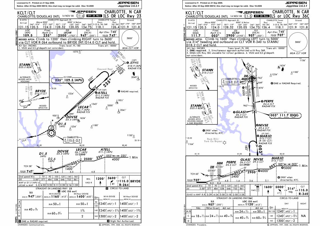
Licensed to IT. Printed on 21 Sep 2009.
Notice: After 25 Sep 2009 0901Z, this chart may no longer be valid. Disc 18-2009
JEPPESEN
JeppView 3.6.3.1
JEPPESEN
Concord Regl
264^
140^
BZM110.8
bzm
1234'
D1.5IAPU
CHARLOTTE, N CARCHARLOTTE/DOUGLAS INTL 11-4
LOC
109.5IAPU
FinalApch Crs235^
LECAR
2500'
ILSDA(H)
(200')
Apt Elev
TDZE
748'747'
MISSED APCH:
Gnd speed-Kts 70 90 100 120 140 1603600' CLT
115.0R-264
TDZE
D14.0 CLT
VASI-R
1200'BRYDE
REIL
947'
GS
GS 3.00^ 377 484 538 646 753 861
2
4:33 3:32 3:11 2:39 2:16 1:595.3LECAR to MAP
MAP at D1.5 IAPU orRT
via
134
BRIEFING STRIP
TM
11 2
2
2
Ground
121.15 120.5 128.32075^- 245^
CHARLOTTE Approach (R)
120.05
8000' & Below001^- 119^ 120^- 245^246^- 074^
CHARLOTTE Tower
126.4118.1360^-179^ 180^-359^
121.9 121.8Arrival
18C-36C5-23 & 18L-36RRwyRwys
D-ATISAbove 8000'
124.0 134.75246^- 360^
KCLT/CLT
Trans alt: 18000'Alt Set: INCHES Trans level: FL 180
TERPS
MISSEDAPCH FIX
(1753')
14 NOV 08
Climb to 1200' then climbing RIGHT turn to 3600'
Night Not Authorized.
.Eff.20.Nov. ILS OR LOC Rwy 23
1. VGSI and ILS glidepath not coincident.
DOVSE
NoPT40
00
| JEPPESEN, 1999, 2008. ALL RIGHTS RESERVED.
1 RADAR required.
1
35-10
35-20
80-4080-5081-00
STANN
171^
351^
HOLDING
ALTERNATEMISSED APCH
D25.0 BZM
GS 2500'
via CLT VOR R-264 outbound to BRYDE INT/D14.0 CLT and hold.
5NM
1
7.5
235^
1
1 DME or RADAR required.
D2.6IAPU
Communications.
BZM
110.8171^
CLT340^
115.0bzm
0.81.1
264^
BZM
185^110. 8 M Bz
(L)D115.0 CLTCHARLOTTE
235^05
5^
C L T
235^ 109.5 IAPU
1324'
1180'
1343'
ATELLD11.5 IAPU
1634'
LECAR2000'
RADAR FIX2041'
D1.5IAPU
264^
BRYDE
084^
LECAR ATELL
1 Min
235^
055^
4.8
D11.5 IAPU
2500'
747'
235^4000'
3800'
CIRCLE-TO-LAND23
165
140
120
90
KtsMaxDA(H)
MDA(H)
1240'(492')-1
(492')1240'
1300'(552')-2
(200')
CHANGES:
MSA CLT VOR
A
B
C
D
STRAIGHT-IN LANDING RWYLOC (GS out)ILS
947' MDA(H) (653')1400'
D6.7 IAPU
IAPU
D6.7 IAPU
RADAR FIX
ILS DME
235^
orRVR 150
RVR 40 or 34
1400'3.3
orRVR 150
MDA(H)1160'(413')
1400'(652')-1
-1(652')1400'
1400'(652')-2
34
MDA(H)
-
With DOVSEWith DOVSE
60 11 4RVR or
1951'
JEPHS(IAF)
D18.9 IAPURADAR FIX
(IF/IAF)
DOVSED3.4 IAPU
D3.4 IAPU
Without DOVSEWithout DOVSE
AMEND
2
899'
1575'
1150'
2049'
930'
TCH 58'
Licensed to IT. Printed on 21 Sep 2009.
Notice: After 25 Sep 2009 0901Z, this chart may no longer be valid. Disc 18-2009
JEPPESEN
JeppView 3.6.3.1
JEPPESEN
York Co/BryantRock Hill/
CLT115.0340 clt
340^
110.8171^BZMmzb
115.0340^CLTD
18.2
m110.8171^BZMzb
D25.0
(L)D115.0 CLTCHARLOTTE
IMMM
to MARJO
ILS
183^
003^
MARJOD12.7 CLT
5000181^
12.7
003^ 111.7 IDQG
C L T
I D Q G
hdg
314^
RADAR FIX
GLASID6.0 CLT
RADAR FIX
1
NIVSED9.6 CLT
RADAR FIX
STANN
MISSEDAPCH FIX
CHARLOTTE, N CARCHARLOTTE/DOUGLAS INTL
LOC
111.7IDQG
FinalApch Crs
003^
GSGLASI
2900'
ILSDA(H)
907'(200')Apt Elev
TDZE
748'707'
MISSED APCH: Climb to 1600' then climbing LEFT turn to 5000'
STRAIGHT-IN LANDING RWY CIRCLE-TO-LAND
C
D
1240'(492')-1
1240'(492')-1
1300' -2
36C
(552')
MDA(H)
ILS
FULL TDZ or outCL ALS out
DA(H) 907'(200')ALS out
MDA(H)1120'(413')
A/B
GS
hdg
CLT
115.0R-340
314^5000'1600'
MARJO
807'GS5IM
0.4707'
TCH 60'
01.4
2900' whendirected by ATC.
4
1 Min
D12.7 CLT
003^ 2900'
45000'
3.6
GLASID6.0 CLT
2900'GS 183^ 003^
4000'GS 881'CMM
4
TDZE
ALSF-II
LT
Gnd speed-Kts 70 90 100 120 140 160
and
RVR or1
218
340^160^
BRIEFING STRIP
TM
via
D18.2 CLT
Ground
121.15 120.5 128.32075^- 245^
CHARLOTTE Approach (R)
120.05
8000' & Below001^- 119^ 120^- 245^246^- 074^
CHARLOTTE Tower
126.4 118.1360^-179^ 180^-359^
121.9 121.8Arrival
18C-36C 5-23 & 18L-36RRwy Rwys
D-ATISAbove 8000'
124.0 134.75246^- 360^
GLASI to MAP
3.00^ 377 484 538 646 753 861
6.6
KCLT/CLT
Trans alt: 18000'Alt Set: INCHES Trans level: FL 180
ILS or LOC Rwy 36C
TERPS
2900' whendirected by ATC.
1
NIVSED9.6 CLT
3.1
5:39 4:24 3:58 3:18 2:50 2:28
5 NM
D18.2 CLT and hold.
0.2
003^
35-00
35-10
80-5081-0081-10
1234'
1634'
1180'
962'
(2193')
PERPED4.6 CLT
RADAR FIX
PERPED4.6 CLT
2400'4.8
PAPI
DAY NIGHT
NA
MSA CLT VOR
11-5
1156'
LOC (GS out)
14 NOV 08
via 314^ heading and outbound on CLT VOR R-340 to STANN/
DME or RADAR Required.2
2
2
2
2
.Eff.20.Nov.
2. Simultaneous approach authorized with Rwy 36R.3. IDQG LOC Rwy 36C unusable for rollout guidance. 4. VGSI and ILS glidepathnot coincident.
171^5 N
M351^
STANND25.0 BZM
ALTERNATEMISSED APCH
1164'
870'
849'834'
762'
AMEND15C
Procedure. | JEPPESEN, 1997, 2008. ALL RIGHTS RESERVED.
(IF/IAF)
HOLDING-RADAR& DME REQUIRED
1. DME required.
CHANGES:
165
140
KtsMax
90/120
12
RVR 40 or 34 60 1RVR or 1 4
RVR 24 or1
2 RVR 40 or 34
(R-181 CLT)
RVR 24 or1
2 orRVR 150
3800'
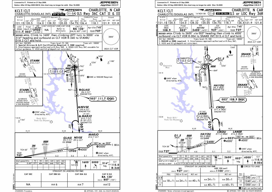
Licensed to IT. Printed on 21 Sep 2009.
Notice: After 25 Sep 2009 0901Z, this chart may no longer be valid. Disc 18-2009
JEPPESEN
JeppView 3.6.3.1
JEPPESEN
York Co/BryantRock Hill/
340^
CLT115.0340 clt
110.8171^BZMmzb
340^CLT115.0
110.8171^BZMmzb
D25.0
D18.2
707'
TCH 60'5IM
CMMGS 881'
STRAIGHT-IN LANDING RWY
CAT IIIA ILS CAT II ILSCAT IIIB ILS
36C
6.2
GLASI
2900'whendirected by ATC.4
MARJO
1 Min183^ 003^
D12.7 CLT
003^45000'
3.6
D6.0 CLTGS 2900'
4000'
CHARLOTTE, N CARCHARLOTTE/DOUGLAS INTL
LOC
111.7IDQG
FinalApch Crs
003^
GSGLASI
2900'Apt Elev748'TDZE 707'
hdg
1600' 5000' 314^CLT
115.0R-340
and
TDZE
ILS Rwy 36C CAT II & III
MSA CLT VOR
Gnd speed-Kts 70 90 100 120 140 160 ALSF-II
LT
CAT IIIC
NA
NA
CAT IIIC CAT IIIB CAT IIIA
DA(H) 807'(100')RA 130'CAT II
Climb to 1600' then climbing LEFT turn to 5000' viaMISSED APCH:
11-5A
D18.2 CLT and hold.
BRIEFING STRIP
TM
Ground
121.15 120.5 128.32075^- 245^
CHARLOTTE Approach (R)
120.05
8000' & Below001^- 119^ 120^- 245^246^- 074^
CHARLOTTE Tower
126.4 118.1360^-179^ 180^-359^
121.9 121.8Arrival
18C-36C 5-23 & 18L-36RRwy Rwys
D-ATISAbove 8000'
124.0 134.75246^- 360^
GS 3.00^ 377 484 538 646 753 861
KCLT/CLT
Trans alt: 18000'Alt Set: INCHES Trans level: FL 180
(L)D115.0 CLTCHARLOTTE
IMMM
to MARJO
ILS
183^
003^
5000181^
12. 7
003^ 111.7 IDQG
C L T
I D Q G
hdg
314^
GLASID6.0 CLT
RADAR FIX
1
NIVSED9.6 CLT
RADAR FIX2900' whendirected by ATC.
1
35-00
35-10
80-5081-0081-10
4
3.1
NIVSED9.6 CLT
(100')807'DA(H)
RA 130'
RVR12RVR 7RVR 6
TERPS
1234'
1634'
1180'
962'
2900'
003^
(2193')
0.4
D12.7 CLT
RADAR FIX
MARJO
PAPI
Refer toMinimums
via
314^ heading and outbound on CLT VOR R-340 to STANN/
2
DME or RADAR Required.
14 NOV 08
2
2
2
3. Simultaneous approach authorized with Rwy 36R. 4. IDQG LOC Rwy 36C unusable for
STANN
MISSEDAPCH FIX
340^160^
D18.2 CLT
5 NM
171^5 NM
STANND25.0 BZM
351^
ALTERNATEMISSED APCH
.Eff.20.Nov.
rollout guidance. 5. VGSI and ILS glidepath not coincident.
AMEND15C
Procedure. | JEPPESEN, 1997, 2008. ALL RIGHTS RESERVED.
1164'
870'
849'834'
762'
(IF/IAF)
HOLDING-RADAR& DME REQUIRED
GS 807'
1. Special Aircrew & Acft Certification Required. 2. DME required.
3800'
CHANGES:
(R-181 CLT)
Licensed to IT. Printed on 21 Sep 2009.
Notice: After 25 Sep 2009 0901Z, this chart may no longer be valid. Disc 18-2009
JEPPESEN
JeppView 3.6.3.1
JEPPESEN
MunGastonia
York Co/BryantRock Hill/
00 4^CLT
11 5.0
157^BZM110.8
bzm0 04 ^CL T
1 15 .0D1 5.4
D15.4 CLT
D1.5
Gnd speed-Kts 70 90 100 120 140 160 2600' CLT
115.0R-004
PAPI
TDZE 727'
MMCGS 902'
TCH 58'
4.6
003^
HAYOU
2400'GSD6.5 IBQC
IBQC
TDZ or CL out
RVR or1
218
ALS out
CHARLOTTE, N CARCHARLOTTE/DOUGLAS INTL 11-6
LOC
108.9IBQC
FinalApch Crs003^
GSHAYOU
2400'
ILSDA(H)
927' (200')Apt Elev
TDZE
748'727'
MISSED APCH:
5IMGS 828'
ALSF-II
via
BRIEFING STRIP
TM
Ground
121.15 120.5 128.32075^- 245^
CHARLOTTE Approach (R)
120.058000' & Below
001^- 119^ 120^- 245^246^- 074^
CHARLOTTE Tower
126.4118.1360^-179^ 180^-359^
121.9 121.8Arrival
18C-36C5-23 & 18L-36RRwyRwys
D-ATISAbove 8000'
124.0 134.75246^- 360^
MAP at D1.5 IBQC or
HAYOU to MAP
GS 3.00^ 377 484 538 646 753 861
5.0
KCLT/CLT
Trans alt: 18000'Alt Set: INCHES Trans level: FL 180
ILS or LOC Rwy 36R
D1.5
to LANSR
177^ 12.740001
Climb to 2600' via 003^ heading then climb to 4000'
5 NM
35-00
35-10
80-5081-00
2400'whendirected by ATC.
1
4:17 3:20 3:00 2:30 2:09 1:53
4000'via
003^hdg
outbound via CLT VOR R-004 to SNAKK INT/D15.4 CLT and hold.
1343'
1234'
1634'
834'
962'
(1673')
003 ^
hdg
14 NOV 08
TERPS
.Eff.20.Nov.
1. RADAR or DME required. 2. Simultaneous approach authorized with Rwy 36C.3. VGSI and ILS glidepath not coincident.
SNAKKD28.8 BZM
ALTERNATEMISSED APCH
337^157^
5 NM
849'870'
762'
Notes, alternate missed approach. | JEPPESEN, 1997, 2008. ALL RIGHTS RESERVED.
HOLDING-RADAR& DME REQUIRED
0.20.2
SNAKK
184^ 004^
MISSEDAPCH FIX
C
D
FULL
ILS
ALS out
CIRCLE-TO-LAND
1240'(492')-11240'(492')-11300'(552')-2
1
MDA(H)
165
140
KtsMax
1
MDA(H)
LOC (GS out)
DA(H) 927'(200') 1100'(373')
STRAIGHT-IN LANDING RWY36R
1 Min183^ 003^003^
LANSR
3.2
14000'
12400'directed by ATC.5.1
14000'2400'
when
CIKDUD14.8 IBQCD11.6 IBQC
CHANGES:
A/B 90/120
12
60 1RVR or 1 4RVR 40 or 34
RVR 24 or1 2 RVR 40 or 34
RVR 24 or1
2 orRVR 150
3800'
MSA CLT VOR
MM
003^
183^
ILS DME
003^ 108.9 IBQCI B Q C
HAYOU
LANSR
CIKDU
CHARLOTTE
C L T115.0 CLTD(L)
RADAR FIX
RADAR FIXD6.5 IBQC
D11.6 IBQC
IBQCIM
AMEND
10
D14.8 IBQC(R-177 CLT) RADAR FIX
A
(IF/IAF)
Night not authorized.

Licensed to IT. Printed on 21 Sep 2009.
Notice: After 25 Sep 2009 0901Z, this chart may no longer be valid. Disc 18-2009
JEPPESEN
JeppView 3.6.3.1
JEPPESEN
MunGastonia
York Co/BryantRock Hill/
157^BZM110.8
00 4^CL T
1 15 .0
bzm0 04 ^CLT
11 5.0D1 5.4
Gnd speed-Kts 70 90 100 120 140 160
TDZE 727'
MMCGS 902'
TCH 58'
1 Min
4.6
183^ 003^003^
LANSR
3.2
14000'
12400'directed by ATC.5.1
003^14000'2400'
HAYOU
2400'GS
when
CIKDUD14.8 IBQC
D6.5 IBQCD11.6 IBQC
5IM
CAT II ILSSTRAIGHT-IN LANDING RWY 36R
CAT IIIACAT IIIBCAT IIIC
NA
CHARLOTTE, N CARCHARLOTTE/DOUGLAS INTL
TDZE748'
727'MISSED APCH:
11-6A ILS Rwy 36R CAT II & III
CAT IIIB CAT IIIALOC
108.9IBQC
Final
Apch Crs
003^
GSHAYOU
2400'
CAT II ILS
RA 119'DA(H)827'(100')
Apt ElevCAT IIIC
NA
1. Special Aircrew & Acft Certification required. 2. DME or RADAR required.
Refer to Minimums
BRIEFING STRIP
TM
Ground
121.15 120.5 128.32075^- 245^
CHARLOTTE Approach (R)
120.058000' & Below
001^- 119^ 120^- 245^246^- 074^
CHARLOTTE Tower
126.4118.1360^-179^ 180^-359^
121.9 121.8Arrival
18C-36C5-23 & 18L-36RRwyRwys
D-ATISAbove 8000'
124.0 134.75246^- 360^
GS 3.00^ 377 484 538 646 753 861
KCLT/CLT
Trans alt: 18000'Alt Set: INCHES Trans level: FL 180
D15.4 CLT
to LANSR
177^ 12.740001
5 NM
2400' whendirected by ATC.
Climb to 2600' via 003^ heading then climb to 4000'
TERPS
2600' CLT
115.0R-004
PAPI
ALSF-II
via4000'
via003^hdg
RA 119'DA(H)827'(100')
RVR12RVR 7RVR 6
35-00
35-10
80-5081-00
outbound via VOR CLT R-004 to SNAKK INT/D15.4 CLT and hold.
1343'
1234'
1634'
962'
834'
(1673')
003^hdg
1
0.40.20
14 NOV 08
SNAKKD28.8 BZM
ALTERNATEMISSED APCH
337^157^
5 NM
.Eff.20.Nov.
4. VGSI and ILS glidepath not coincident.3. Simultaneous approach authorized with Rwy 36C.
849'870'
762'
Notes, alternated missed approach. | JEPPESEN, 1998, 2008. ALL RIGHTS RESERVED.
HOLDING-RADAR& DME REQUIRED
GS 828'
CHANGES:
3800'
MSA CLT VOR
SNAKK
184^ 004^
MISSEDAPCH FIX
MM
003^
183^
ILS DME
003^ 108.9 IBQCI B Q C
HAYOU
LANSR
CIKDU
CHARLOTTE
C L T115.0 CLTD(L)
RADAR FIX
RADAR FIX
RADAR FIX
D14.8 IBQC
D6.5 IBQC
D11.6 IBQC
IM
AMEND10
(R-177 CLT)
A
(IF/IAF)
Licensed to IT. Printed on 21 Sep 2009.
Notice: After 25 Sep 2009 0901Z, this chart may no longer be valid. Disc 18-2009
JEPPESEN
JeppView 3.6.3.1
Gastonia Mun
1484'
1337'2000'
1234'
1634'
1180'
962'
CHARLOTTE
ATELL
056^
236^
4 NM
MISSED APCH FIX
NOT TO SCALE
to KEC
KS
240^ 10.6
4000
1
055^
235^
KECKS
ERKAW
MISSED APCH:BRIEFING STRIP
TM
CIRCLE-TO-LAND
A
B
C
D
MaxKts MDA(H)
90
120
140
165
STRAIGHT-IN LANDING RWY 5LNAV
1240'
RAIL out ALS out
LNAV/VNAV
-21300'
Gnd speed-Kts 70 90 100 120 140 160
055^2500'
KECKS
DA(H)1180'(464')
(492')
(552')
ATELL4000'
MALSR
VASI372 478 531 637 743 849
MAP at RW~5
to RW~5
3
3800'
MSA RW~5
121.15 120.5 124.0 128.32 118.1 126.4 121.9 121.8
D-ATISArrival
CHARLOTTE Approach (R) Ground
180^-359^360^-179^
FinalApch Crs
055^
Minimum AltERKAW
2500'DA(H)
1060'(344')
Apt Elev 748'
TDZE 716'
CHARLOTTE Tower
18R-36LRwys Rwy
5-23 & 18L-36R
120.05 134.75
Above 8000' 8000' & Below246^-074^ 075^-245^ 001^-119^ 120^-245^ 246^-360^
CHARLOTTE, N CARCHARLOTTE/DOUGLAS INTL RNAV (GPS) Rwy 512-1
1. Baro-VNAV not authorized below -16^C (4^F). 2. GPS or RNP-0.3 required.3. DME/DME RNP-0.3 not authorized. 4. VGSI and descent angles not coincident.
DAY NIGHT
NA
KCLT/CLT
| JEPPESEN SANDERSON, INC., 2001, 2006. ALL RIGHTS RESERVED.
Trans alt: 18000'Alt Set: INCHES Trans level: FL 180
(1784')
LPV
Climb to 4000' direct ATELL and hold.
DTERPS
35-10
80-5081-0081-10
RW~5
1
4 NM2
055^ 235^
2 2500' when
2500' when
-1
(IF/IAF)
CLT
MDA(H)1140'(424')RAIL or ALS outRAIL or ALS out
DA(H)1060'(344')LPV
2
AMEND
WAAS
Ch 70300W-05A
WAAS
Ch 70300 W-05A
TCH 51'
Glide Path Angle 3.00^
authorized by ATC.
authorized by ATC.
11 2
14 JUL 06
1189'
3
LNAV only.
Profile.CHANGES:
JEPPESEN
4.1 TDZE 716'
4000'
6.0
ERKAWRW~5
1.3 NM
0.911.4 5.4 0
34
0.4
RVR
or
241 2
RVR
or
4034
RVR
or
501
RVRor34
40
60 11 4RVR or
60or
RVR
114
RVR
or
4034
RVR
or
501

Licensed to IT. Printed on 21 Sep 2009.
Notice: After 25 Sep 2009 0901Z, this chart may no longer be valid. Disc 18-2009
JEPPESEN
JeppView 3.6.3.1
Gastonia Mun
Concord Regl
CHARLOTTE
SNAKK
GILGE
QUWED
RW18L
LANSR
183^
003^
to SNAKK
006^ 15.44000
1
183^
003^
MISSED APCH FIX
MISSED APCH:
BRIEFING STRIP
TM
Gnd speed-Kts 70 90 100 120 140 160
3100'
SNAKK
372 478 531 637 743 849 4000'LANSR
REILVASI-R
MAP at RW18L
FinalApch Crs
183^
Minimum AltQUWED
3100'DA(H)
1080'(332')
Apt Elev 748'
TDZE 748'
CHARLOTTE, N CARCHARLOTTE/DOUGLAS INTL RNAV (GPS) Rwy 18L12-2
3800'
MSA RW18L1. Baro-VNAV not authorized below -16^C (4^F). 2. GPS or RNP-0.3 required.
121.15 120.5 124.0 128.32 118.1 126.4 121.9 121.8
D-ATISArrival
CHARLOTTE Approach (R) Ground
180^-359^360^-179^
CHARLOTTE Tower
18R-36LRwys Rwy
5-23 & 18L-36R
120.05 134.75
Above 8000' 8000' & Below246^-074^ 075^-245^ 001^-119^ 120^-245^ 246^-360^
3. DME/DME RNP-0.3 not authorized. 4. VGSI and descent angles not coincident.
KCLT/CLT
Trans alt: 18000'Alt Set: INCHES Trans level: FL 180
| JEPPESEN SANDERSON, INC., 2001, 2006. ALL RIGHTS RESERVED.
Climb to 4000' direct LANSR and hold.
D
4000'2
183^ 003^
3100' when2
GILGE
183^ 3600'2
3
TERPS
35-20
80-5081-00
(IF/IAF)
3
3100' when1
2749'
2343'
1849'
1484'
1575'
1337'
1234'
1634'
1324'
2000'
4 NM
4 NM1.7 NMto RW18L
(2352')
1.9 NMto QUWED
1.9 NMto QUWED
CLT
WAAS
Ch 77500W-18A
WAAS
Ch 77500 W-18A
TCH 55'
Glide Path Angle 3.00^
CIRCLE-TO-LAND
A
B
C
D
MaxKts MDA(H)
90
120
140
165
STRAIGHT-IN LANDING RWY
LNAV
1280'
LNAV/VNAV
-21300'
DA(H)1240'(492')
(532')
(552')
DAY NIGHT
NA-1
DA(H)1080'(332')LPV
18L
2
AMEND
MDA(H)1280'(532')
341 11
2
341
LPV
authorized by ATC.
authorized by ATC.
2041'
1951'
14 JUL 06
LNAV only.
Profile.CHANGES:
JEPPESEN
5.4 TDZE 748'4.5
QUWED
RW18L
13.5 7.1 01.9 0.5
34
60 11 4RVR or
orRVR 150
0.90.3
Licensed to IT. Printed on 21 Sep 2009.
Notice: After 25 Sep 2009 0901Z, this chart may no longer be valid. Disc 18-2009
JEPPESEN
JeppView 3.6.3.1
JEPPESEN
Gastonia Mun
Concord Regl
CHARLOTTE
TOMME
HAGUL
OZEJI
RW18C
183^
003^
to TOM
ME
003^ 15.45000
1
(IF/IAF)
MARJO
003^
183^
MISSED APCH FIX35-10
35-20
80-5081-00
2749'
2343'
1849'
1484'
1575'
1343' 2000'
2041'
1634'
1180'
1951'1324'
1234'
BRIEFING STRIP
TMGnd speed-Kts 70 90 100 120 140 160
372 478 531 637 743 849
MAP at RW18C
5000'MARJO
MALSR
PAPI
183^
3000'
TOMME
to RW18C
3
3
MISSED APCH:
FinalApch Crs
183^
Minimum AltOZEJI
3000'DA(H)
1039'(297')
Apt Elev 748'
TDZE 742'3800'
MSA RW18C
CHARLOTTE, N CARCHARLOTTE/DOUGLAS INTL RNAV (GPS) Rwy 18C12-3
121.15 120.5 124.0 128.32 118.1126.4 121.9 121.8
D-ATISArrival
CHARLOTTE Approach (R) Ground
180^-359^360^-179^
CHARLOTTE Tower
18C-36CRwysRwy
5-23 & 18L-36R
120.05 134.75
Above 8000' 8000' & Below246^-074^ 075^-245^ 001^-119^ 120^-245^ 246^-360^
KCLT/CLT
Trans alt: 18000'Alt Set: INCHES Trans level: FL 180Climb to 5000' direct MARJO and hold.
3000' when1
183^ 003^
5000' 3600'2 2
2 3000' when
HAGUL
DTERPS
4 NM
4 NM
(2258')
CLT
CIRCLE-TO-LAND
A
B
C
D
MaxKts MDA(H)
90
120
140
165
STRAIGHT-IN LANDING RWYLNAV
1240'
RAIL out ALS out
LNAV/VNAV
-21300'
DA(H)1200'(458')
(492')
(552')
DAY NIGHT
NA-111 2
RAIL or ALS out
DA(H)1039'(297')LPV
WAAS
Ch 81800 W-18B
WAAS
Ch 81800W-18B
11 2
MDA(H)1200'(458')
18C
Glide Path Angle 3.00^
TCH 55'
LPV
2
AMEND
authorized by ATC.
authorized by ATC.
LNAV only.
14 NOV 08 .Eff.20.Nov.
| JEPPESEN, 2001, 2008. ALL RIGHTS RESERVED.
-16^C (4^F) or above 47^C (116^F). 2. DME/DME RNP-0.3 not authorized.1. For uncompensated Baro-VNAV systems, LNAV/VNAV not authorized below
3. VGSI and RNAV glidepath not coincident.
A
Procedure.
1240'(492')-1
958'
894'
900'
910'
817'
RAIL or ALS out
CHANGES:
5.6 TDZE 742'1.9
OZEJIRW18C
1.2 NM
13.1 6.8 04.4
RVR
or
501
RVR
or
4034
60 1RVR or 1 4
RVR
or
241 2
RVR
or
501
RVR
or
241 2
RVRor501
RVRor34
40
0.4 0.8
1 2orRVR 150
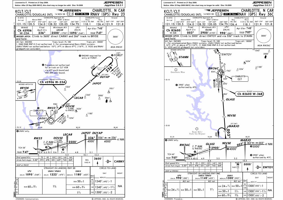
Licensed to IT. Printed on 21 Sep 2009.
Notice: After 25 Sep 2009 0901Z, this chart may no longer be valid. Disc 18-2009
JEPPESEN
JeppView 3.6.3.1
JEPPESEN
ConcordRegl
DOVSE
CARMY
RW23
MISSED APCH:BRIEFING STRIP
TM
236^
Gnd speed-Kts 70 90 100 120 140 160
236^
2500'
DUYAP
to RW23
MAP at RW23
3600'CARMY
REILVASI-R
0
AMEND
FinalApch Crs
236^
Minimum AltLECAR
2500'DA(H)
1095'(348')
Apt Elev 748'
TDZE 747'
MSA RW23
3800'
266^
CHARLOTTE, N CARCHARLOTTE/DOUGLAS INTL 12-4
1234'
1343'
1951'
2041'
1180'
1634'
1324'
121.15 120.5 124.0 128.32 118.1 126.4 121.9 121.8
D-ATISArrival
CHARLOTTE Approach (R) Ground
180^-359^360^-179^
CHARLOTTE Tower
18C-36CRwys Rwy
5-23 & 18L-36R
120.05 134.75
Above 8000' 8000' & Below246^-074^ 075^-245^ 001^-119^ 120^-245^ 246^-360^
2000'
KCLT/CLT
Trans alt: 18000'Alt Set: INCHES Trans level: FL 180
TERPS
(1753')
CHARLOTTE
056^
DUYAP
CLT
to DUY
AP
14.2 052
^
Climb to 3600' direct CARMY and 266^ track to BRYDEand hold.
D
236^056^4 NM
LPV
1.9 NMto RW23
LECAR
DOVSE
3
14 NOV 08 RNAV (GPS) Rwy 23.Eff.20.Nov.
WAAS
Ch 45906
1. DME/DME RNP-0.3 not authorized. 2. For uncompensated Baro-VNAV systems, LNAV/VNAV not authorized below -16^C (4^F) or above 47^C (116^F). 3. VGSI and RNAV glidepath not coincident.
CIRCLE-TO-LAND
A
B
C
D
MaxKts
(492')
MDA(H)
-1
STRAIGHT-IN LANDING RWY 23
LNAV
1240'
(433')MDA(H) 1180'LNAV/VNAV
(492')-11240'
(552') -21300'
LPV
1222' (475')DA(H) 1095' (348') DA(H)
341
112
372 478 531 637 743 849Glide Path Angle 3.00^
TCH 58'
JAPOT
3
3LNAV only.
4000
'
JAPOT
264^4 NM
084^BRYDE
MISSED APCH FIX
266^
FORUT(IAF)
to DUY
AP
5.4 23
6^
4000
'
35-10
35-20
80-4080-5081-00
Procedure not authorizedfor arrivals at CLT VORvia V37 south bound andV54-409 west bound.
1
930'
22 RADAR required for entry at FORUT.
WAAS
Ch 45906 W-23A
NoPT
1.9 NMto RW23
899'
1
DAY NIGHT
NA
| JEPPESEN, 2008. ALL RIGHTS RESERVED.
W-23A
Communications.CHANGES:
3.4TDZE 747'
4000'
4.8
LECAR
RW23
1.2 NM
5.3 12.200.9 0.6
(IF/IAF)
1400'
90
120
140
165
1260 11 4RVR or
orRVR 150
60 11 4RVR or
2.110.1
4000'
0.3 0.1
Licensed to IT. Printed on 21 Sep 2009.
Notice: After 25 Sep 2009 0901Z, this chart may no longer be valid. Disc 18-2009
JEPPESEN
JeppView 3.6.3.1
JEPPESEN
Gastonia Mun
Rock Hill/York Co/Bryant
MISSED APCH:BRIEFING STRIP
TM
-11300' 12
Gnd speed-Kts 70 90 100 120 140 160
003^
2900'
MARJO
372 478 531 637 743 849
MAP at RW36C
5000'EWTOY
ALSF-II
(552')
0.8
to RW36C
2
3800'
FinalApch Crs
003^
Minimum AltGLASI
2900'DA(H)
(283')
Apt Elev 748'TDZE 707'
CHARLOTTE, N CARCHARLOTTE/DOUGLAS INTL RNAV (GPS) Rwy 36C12-5
121.15 120.5 124.0 128.32 118.1126.4 121.9 121.8
D-ATISArrival
CHARLOTTE Approach (R) Ground
180^-359^360^-179^
CHARLOTTE Tower
18C-36CRwysRwy
5-23 & 18L-36R
120.05 134.75
Above 8000' 8000' & Below246^-074^ 075^-245^ 001^-119^ 120^-245^ 246^-360^
112
341
KCLT/CLT
Trans alt: 18000'Alt Set: INCHES Trans level: FL 180
D
CHARLOTTE
MARJO
NIVSE
GLASI
RW36C
EWTOY003^
183^
(IF/IAF)
to MARJO
183^ 12.75000
1
1 2900' when
003^183^ 4 NMNIVSE
5000'4000'3
3
3 2900' when
TERPS
MISSED APCH FIX
STANN
167^
347^
4 NM
35-00
35-10
80-5081-0081-10
1343'
2000'
1234'
1634'
1180'
(2193')
336^
336^
and hold.
CLT
2
AMEND
TCH 60'
3.00^Glide Path Angle
WAAS
Ch 82600W-36B
WAAS
Ch 82600 W-36B
CIRCLE-TO-LAND
A
B
C
D
MaxKts MDA(H)
STRAIGHT-IN LANDING RWYLNAV
ALS out
LNAV/VNAV
-21300'
DA(H)1140'(433')
(552')
DAY NIGHT
NA112
DA(H) (283')LPV
990'ALS out ALS out
MDA(H)1300'(593')
36C
90
120
140
165
authorized by ATC.
LPV
MSA RW36C
990'
authorized by ATC.
PAPI
2
LNAV only.
14 NOV 08 .Eff.20.Nov.
| JEPPESEN, 2001, 2008. ALL RIGHTS RESERVED.
1. For uncompensated Baro-VNAV systems, LNAV/VNAV not authorized below-16^C (4^F) or above 47^C(116^F). 2. DME/DME RNP-0.3 not authorized.3. VGSI and ILS glidepath not coincident.
A
Procedure.
-11300'(552')
870'
962'
849'
834' 762'
Climb to 5000' direct EWTOY and via 336^ track to STANN
CHANGES:
4.9TDZE 707'
GLASIRW36C
0.4
1.7 NM
13.36.603.5 3.2
orRVR 15060 11 4RVR or
RVR 24 or1 2 orRVR 150
0.5
RVR 24 or1 2 orRVR 150 orRVR 150

Licensed to IT. Printed on 21 Sep 2009.
Notice: After 25 Sep 2009 0901Z, this chart may no longer be valid. Disc 18-2009
JEPPESEN
JeppView 3.6.3.1
JEPPESEN
Rock Hill/York/Bryant
CHARLOTTE
LANSR
CIKDU
HAYOU
RW36R
003^
183^
MISSED APCH:BRIEFING STRIP
TM
CIRCLE-TO-LAND
A
B
C
D
MaxKts MDA(H)
90
120
140
165
STRAIGHT-IN LANDING RWYLNAV
ALS outMDA(H)1140'
LNAV/VNAV
-11240' 12
-21300'
Gnd speed-Kts 70 90 100 120 140 160
003^
2400'
LANSR
ALS outDA(H)1180'
36R
(453') (413')
112
(492')
(552')
372 478 531 637 743 849
MAP at RW36R
4000'SNAKK
ALSF-II
PAPI
to RW36R
2
2
FinalApch Crs
003^
Minimum AltHAYOU
2400'DA(H)
1010'(283')
Apt Elev 748'
TDZE 727'
CHARLOTTE, N CARCHARLOTTE/DOUGLAS INTL RNAV (GPS) Rwy 36R12-6
3800'
1. Baro-VNAV not authorized below -16^C (4^F). 2. GPS or RNP-0.3 required.
NIGHT
NA
DAY
121.15 120.5 124.0 128.32 118.1 126.4 121.9 121.8
D-ATISArrival
CHARLOTTE Approach (R) Ground
180^-359^360^-179^
CHARLOTTE Tower
18C-36CRwys Rwy
5-23 & 18L-36R
120.05 134.75
Above 8000' 8000' & Below246^-074^ 075^-245^ 001^-119^ 120^-245^ 246^-360^
KCLT/CLT
Trans alt: 18000'Alt Set: INCHES Trans level: FL 180
LPV
Climb to 4000' direct SNAKK and hold.
D
MISSEDAPCH FIX
SNAKK
003^
183^
4 NM
to LANSR
179^ 12. 74000
1
1 2400' when
35-00
35-10
80-5081-00
4 NM183^ 003^
CIKDU
4000'4000'3 3
3 2400' when
TERPS
1156'2041'
1234'
1634'
1180'
(IF/IAF)
(1673')
5.1 NMto HAYOU
5.1 NMto HAYOU
CLT
DA(H) (283')LPV
ALS out
1010'
2
AMEND
authorized by ATC.
MSA RW36R
TCH 57'
3.00^Glide Path Angle
WAAS
Ch 90100 W-36A
WAAS
Ch 90100W-36A
authorized by ATC.
3. DME/DME RNP-0.3 not authorized. 4. VGSI and descent angles not coincident.
LNAV only.
14 NOV 08.Eff.20.Nov.
Communications. | JEPPESEN, 2001, 2008. ALL RIGHTS RESERVED.
870'
962'
849'834'
762'
CHANGES:
3.7TDZE 727' 3.2
HAYOURW36R1.1 NM
13.35.000.4 5.1
10.1
RVR
or
4034
RVR
or
241
2
RVR
or
241
2
RVRor34
40
RVRor501
60or
RVR
11 4
RVRor501
RVR
or
501
0.7 0.2