LG EA coverpage 02282012 aaf -...
44
Environmental Assessment United States Department of Agriculture Forest Service Lima Green Project March 2012 Gunflint Ranger District, Superior National Forest Cook County, Minnesota Township 63 North, Ranges 1 West, 1 East & 2 East; and Township 64 North, Ranges 1 West, 1 East & 2 East.
Transcript of LG EA coverpage 02282012 aaf -...

Environmental Assessment United States
Department of Agriculture
Forest Service
Lima Green Project March 2012
Gunflint Ranger District, Superior National Forest Cook County, Minnesota Township 63 North, Ranges 1 West, 1 East & 2 East; and Township 64 North, Ranges 1 West, 1 East & 2 East.

The U.S. Department of Agriculture (USDA) prohibits discrimination in all its programs and activities on the basis of race, color, national origin, gender, religion, age, disability, political beliefs, sexual orientation, and marital or familial status. (Not all prohibited bases apply to all programs.) Persons with disabilities who require alternative means for communication of program information (Braille, large print, audiotape, etc.) should contact USDA's TARGET Center at 202-720-2600 (voice and TDD). To file a complaint of discrimination, write USDA, Director, Office of Civil Rights, Room 326-W, Whitten Building, 1400 Independence Ave. SW, Washington, DC 20250-9410 or call 202-720-5964 (voice or TDD). USDA is an equal opportunity provider and employer.

Lima Green Project Environmental Assessment
March 2012 i Contents and Lists
Table of Contents
Chapter 1: Purpose and Need Page
1.1 Introduction ………………………………………………………………….... 1-1 1.2 Organization of the Environmental Assessment …………………………….... 1-3 1.3 Forest Plan Direction for Lima Green Project Area…………………………… 1-3 1.4 Purpose of and Need for Action ………………………………………………. 1-6 1.5 Proposed Action ………………………………………………………………. 1-11 1.6 Decision to be Made …………………………………………………………... 1-14 1.7 Public Involvement and Issues with the Proposed Action ……………………. 1-14
Chapter 2: Comparison of Alternatives
2.1 Introduction …………………………………………………………………... 2-1 2.2 How a Range of Alternatives was Developed...……………………………….. 2-1 2.3 Alternatives Analyzed in Detail ………………………………………………. 2-2 2.4 Alternatives Analyzed Briefly………………. ………………………………... 2-6 2.5 Comparison of Alternatives Considered in Detail……………………………... 2-11
Chapter 3: Environmental Consequences
3.1 Introduction …………………………………………………………………… 3-1 3.2 Treaty Rights ………………………………………………………………….. 3-2 3.3 Vegetation ……………………………………………………………………... 3-5 3.4 Threatened and Endangered Species ………………………………………….. 3-15 3.5 Regional Forester’s Sensitive Species ………………………………………… 3-18 3.6 Soil Productivity and Wetlands………………………………………………... 3-21 3.7 Non-Native Invasive Plants…...……………………………………………….. 3-27 3.8 Water Quality……………….…………………………………………………. 3-34 3.9 Boundary Waters Canoes Area Wilderness…...……………………………...... 3-41 3.10 Scenic Quality…………………………………………………………………. 3-51 3.11 Other Determinations …………………………………………………………. 3-58
Chapter 4: Lists and References
4.1 Lists of Preparers and Contributors …………………………………………….. 4-1 4.2 Distribution Lists ……………………………………………………………….. 4-2 4.3 References and Literature Cited ………………………………………………… 4-6
Appendices
Appendix A: Lima Green Scoping Summary……………………………………….. A-1 Appendix B: List of Stands and Treatments..……………………………………….. B-1 Appendix C: Description of Treatment Types and Mitigation Measures ...………… C-1 Appendix D: Operational Standard and Guidelines………………………………. D-1 Appendix E: Economics…………………………………………………………… E-1 Appendix F: Cumulative Actions…………………………………………………. F-1 Appendix G: Management Indicator Habitat (1-9)……………………………….. G-1 Appendix H: Mature Upland Patches…………………………..…………………. H-1 Appendix I: Moose (Alces alces)………………………………………………….. I-1
Lima Green Project Environmental Assessment
March 2012 ii Contents and Lists
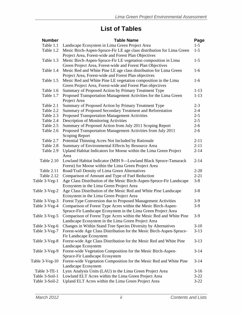
List of Tables
Number Table Name Page Table 1.1 Landscape Ecosystem in Lima Green Project Area 1-5 Table 1.2 Mesic Birch-Aspen-Spruce-Fir LE age class distribution for Lima Green
Project Area, Forest-wide and Forest Plan Objectives 1-5
Table 1.3 Mesic Birch-Aspen-Spruce-Fir LE vegetation composition in Lima Green Project Area, Forest-wide and Forest Plan Objectives
1-5
Table 1.4 Mesic Red and White Pine LE age class distribution for Lima Green Project Area, Forest-wide and Forest Plan objectives
1-6
Table 1.5 Mesic Red and White Pine LE vegetation composition in the Lima Green Project Area, Forest-wide and Forest Plan objectives
1-6
Table 1.6 Summary of Proposed Action by Primary Treatment Type 1-13 Table 1.7 Proposed Transportation Management Activities for the Lima Green
Project Area 1-13
Table 2.1 Summary of Proposed Action by Primary Treatment Type 2-3 Table 2.2 Summary of Proposed Secondary Treatment and Reforestation 2-4 Table 2.3 Proposed Transportation Management Activities 2-5 Table 2.4 Description of Monitoring Activities 2-5 Table 2.5 Summary of Proposed Action from July 2011 Scoping Report 2-6 Table 2.6 Proposed Transportation Management Activities from July 2011
Scoping Report 2-6
Table 2.7 Potential Thinning Acres Not Included by Rationale 2-11 Table 2.8 Summary of Environmental Effects by Resource Area 2-11 Table 2.9 Upland Habitat Indicators for Moose within the Lima Green Project
Area 2-14
Table 2.10 Lowland Habitat Indicator (MIH 9—Lowland Black Spruce-Tamarack Forest) for Moose within the Lima Green Project Area
2-14
Table 2.11 Road/Trail Density of Lima Green Alternatives 2-20 Table 2.12 Comparison of Amount and Type of Fuel Reduction 2-21
Table 3-Veg-1 Age Class Distribution of the Mesic Birch-Aspen-Spruce-Fir Landscape Ecosystem in the Lima Green Project Area
3-8
Table 3-Veg-2 Age Class Distribution of the Mesic Red and White Pine Landscape Ecosystem in the Lima Green Project Area
3-8
Table 3-Veg-3 Forest Type Conversion due to Proposed Management Activities 3-9 Table 3-Veg-4 Comparison of Forest Type Acres within the Mesic Birch-Aspen-
Spruce-Fir Landscape Ecosystem in the Lima Green Project Area 3-9
Table 3-Veg-5 Comparison of Forest Type Acres within the Mesic Red and White Pine Landscape Ecosystem in the Lima Green Project Area
3-9
Table 3-Veg-6 Changes in Within Stand Tree Species Diversity by Alternatives 3-10 Table 3-Veg-7 Forest-wide Age Class Distribution for the Mesic Birch-Aspen-Spruce-
Fir Landscape Ecosystem 3-13
Table 3-Veg-8 Forest-wide Age Class Distribution for the Mesic Red and White Pine Landscape Ecosystem
3-13
Table 3-Veg-9 Forest-wide Vegetation Composition for the Mesic Birch-Aspen-Spruce-Fir Landscape Ecosystem
3-14
Table 3-Veg-10 Forest-wide Vegetation Composition for the Mesic Red and White Pine Landscape Ecosystem
3-14
Table 3-TE-1 Lynx Analysis Units (LAU) in the Lima Green Project Area 3-16 Table 3-Soil-1 Lowland ELT Acres within the Lima Green Project Area 3-22 Table 3-Soil-2 Upland ELT Acres within the Lima Green Project Area 3-22

Lima Green Project Environmental Assessment
March 2012 iii Contents and Lists
Number Table Name Page Table 3-Soil-3 Acres of Soil Slope Class within the Lima Green Project 3-22 Table 3-Soil-4 Acres of Nutrient Low ELTs (6, 8, 9, 11, 12, 16, 17, and 18) in which
Slash Disposal or Site Preparation are Proposed within the Lima Green Project Area
3-24
Table 3-Soil-5 Acres of Lowland ELTs which could be Mechanically Treated within the Lima Green Project Area (by Alternative)
3-26
Table 3-NNIP-1 Non-native Invasive Plants known in the Lima Green Project Area 3-29 Table 3-WQ-1 Sixth Level Watersheds Intersecting the Lima Green Project Area 3-37 Table 3-WQ-2 Percentage of Upland Open or Upland Young Forests in Sixth Level
HUC Watersheds in year 2020 3-38
Table 3-BW-1 Definition of Duration for Sound Impacts 3-45 Table 3-BW-2 Definition of Scope for Sound Impacts 3-45
List of Figures
Number Figure Name Page Figure 1.1 Lima Green Project Area Vicinity Map 1-2 Figure 2.1 Alternative 2: Proposed Treatment Map 2-24
Figure 3-WQ-1 Lima Green Watersheds 3-35 Figure 3-WQ-2 Example of Improved Aquatic Organism Passage at Road Crossing 3-37 Figure 3-BW-1 Alternative 2 Treatments within one mile of BWCAW lakes 3-46

Lima Green Project Environmental Assessment
March 2012 iv Contents and Lists
Key for Acronyms
ATV all terrain vehicle BA biological assessment BE biological evaluation BMPs Best Management Practices BWCAW Boundary Waters Canoe Area Wilderness CEQ Council on Environmental Quality CFR Code of Federal Regulations CWPP Community Wildfire Protection Plan DBH diameter at breast height DNR Department of Natural Resources EA environmental assessment ELT ecological landtype FEIS Final Environmental Impact Statement FPIR Forest Plan Inventoried Roadless FR Forest Road FSH Forest Service Handbook GIS Geographic Information System HUC Hydrologic Unit Code IDT interdisciplinary team LAU Lynx Analysis Unit LE landscape ecosystems LTA landtype association MA management area MBA Mesic Birch-Aspen-Spruce-Fir MFRC Minnesota Forest Resource Council MIH Management Indicator Habitat MIS Management Indicator Species MMBF Million Board Feet MPCA Minnesota Pollution Control Agency NEPA National Environmental Policy Act NFS National Forest System NHPA National Historic Preservation Act NNIP Non-native Invasive Plants NNIS Non-native Invasive Species NRHP National Register of Historical Places PCE Primary Constituent Element RACR Roadless Area Conservation Rule RFSS Regional Forester Sensitive Species ROD Record of Decision ROS Recreational Opportunity Spectrum SHPO State Historic Preservation Office SNF Superior National Forest TES threatened, endangered, and sensitive TEUI Terrestrial Ecological Unit Inventory USDA United States Department of Agriculture USFWS United State Fish and Wildlife Service WUI Wildland Urban Interface

Lima Green Project Environmental Assessment
March 2012 1-1 Chapter 1
Chapter 1: Purpose and Need
1.1 Introduction The purpose of the Lima Green Project is to implement the 2004 Superior National Forest Land and Resource Management Plan (Forest Plan). The project’s proposed activities are designed to move the vegetation in the project area from its existing condition toward the desired conditions described in the Forest Plan. The key objectives of the Lima Green Project are to improve moose habitat; restore red and white pine forests; and to maintain and improve the long term scenic quality of Gunflint Trail. Other objectives are described further in this document. Activities proposed to accomplish these objectives include harvesting (intermediate and regeneration), reforestation activities, prescribed burning and understory fuel reduction. Additional proposed actions include constructing and obliterating temporary roads to access units and decommissioning roads no longer needed. The Lima Green Project Area encompasses about 48,700 acres of land, of which over 39,200 acres are National Forest System land. This area is in Cook County, about twelve miles north of Grand Marais, Minnesota (Township 63 North, Ranges 1 West, 1 East, and 2 East and Township 64 North, Ranges 1 West, 1 East, and 2 East). The project area location is shown on Figure 1.1, the Lima Green Project Area Vicinity Map. This environmental assessment was prepared to provide the decision-maker (Gunflint District Ranger) and the public with information about the potential effects of proposed vegetation management activities and connected road actions in the project area. An interdisciplinary team of resource specialists prepared this document.

Lima Green Project Environmental Assessment
March 2012 1-2 Chapter 1
Figure 1.1: Lima Green Project Area Vicinity Map.

Lima Green Project Environmental Assessment
March 2012 1-3 Chapter 1
1.2 Organization of the Environmental Assessment This environmental assessment (EA) is organized into four chapters with appendices and follows the format established by the Council on Environmental Quality (CEQ) regulations (40 CFR 1500-1508) for implementing the National Environmental Policy Act (NEPA). The major sections of the EA are as follows:
Chapter 1: Purpose and Need. This section provides introductory material that explains the purpose and need for the proposed action, provides background information about the project area, presents the pertinent laws and regulations, and describes the issues to be addressed.
Chapter 2: Alternatives. This section describes the No Action Alternative and the action alternative, both of which are analyzed in detail in Chapter 3. This chapter also includes mitigation measures and monitoring procedures that would be used in implementing the action alternative. A summary comparison of the environmental effects for each alternative is also provided.
Chapter 3: Affected Environment and Environmental Effects. This section describes the affected environment and the direct, indirect, and cumulative effects likely to occur with the implementation of each alternative.
Chapter 4: References. This chapter provides names of the preparers and contributors to this environmental assessment, a distribution list, and literature cited.
An important consideration in the preparation of this EA was the reduction of paperwork as specified in 40 CFR 1500.4. The objective is to furnish enough site-specific information to demonstrate a reasoned consideration of the environmental effects of the alternatives and how any adverse effects can be mitigated or avoided. Additional supporting information is in the Lima Green Project Record and is available at the Gunflint Ranger District Office in Grand Marais, Minnesota, or upon request. This environmental assessment is tiered to the Forest Plan Revision Final Environmental Impact Statement (FEIS). Relevant analysis from the Forest Plan Revision FEIS was incorporated by reference rather than repeating the information.
1.3 Forest Plan Direction for Lima Green Project Area The Forest Plan divides the Superior National Forest outside the BWCAW into ten management areas. Chapter 3 of the Forest Plan (FP) includes the desired conditions, objectives, standards, and guidelines for each management area. The Lima Green Project Area overlaps two Forest Plan Management Areas (MA): General Forest-Longer Rotation (FP, pp. 3-10 to 3-11) and Eligible Wild, Scenic and Recreational River (FP, pp. 3-17 to 3-20). The Lima Green Project Area Vicinity Map (Figure 1.1) displays these two management areas. The interdisciplinary team used management area direction to guide development of the purpose and need and the proposed action. The following is a brief summary of the desired vegetation for each management area.

Lima Green Project Environmental Assessment
March 2012 1-4 Chapter 1
In General Forest-Longer Rotation MA, the desired condition is that the forest is a variety of stand sizes, shapes, crown closures, and age structures. A full range of silvicultural practices is used when managing the vegetation. In the General Forest-Long Rotation MA, vegetation will be managed to represent young to old (0 to 250 year old) vegetative growth stages. Some larger patch sizes would occur within this area, although those associated with young, even-aged, vegetative conditions would be less frequent than in the General Forest MA. One quarter mile of either side of the Brule River is in the Eligible Wild, Scenic and Recreational River MA. The segment of the river through the Lima Green project area is classified as recreational. Vegetation management practices will promote the retention of long-lived trees species, leading toward the development of a big-tree character throughout the river corridor. A wide range of silvicultural practices are allowed provide that the methods used would have no substantial adverse effect to the river’s free flow, water quality and outstanding values.
Landscape Ecosystem Objectives
Landscape Ecosystems (LE) are ecological areas characterized by their dominant vegetation communities and patterns that are a product of local climate, glacial topography, dominant soils, and natural processes such as succession, fire, wind, insects, and disease (FP, p. 2-55). The Forest Plan uses landscape ecosystems to outline management objectives for forest vegetation composition, age class, tree species diversity, and management indicator habitats (MIH). Management in each landscape ecosystem would maintain or restore the forest to conditions more representative of native plant communities and landscape scale patterns. Management indicator habitats represent the habitats used by a wide variety of native plants and animals, including management indicator species and sensitive species. MIH provide a means of monitoring and evaluating the effects of actions on biotic resources including specific species, communities, habitats and interrelationships among organisms. Managing for MIH objectives is a key component of providing for the full diversity of desired wildlife habitats. The predominant landscape ecosystems in the Lima Green Project Area are the Mesic Birch-Aspen-Spruce-Fir (MBA) and Mesic Red and White Pine (MRW) as shown in Table 1.1. The Lima Green Project Area represents six percent of the total Forest-wide Mesic Birch-Aspen-Spruce-Fir Landscape Ecosystem and about nine percent of the Mesic Red and White Pine Landscape Ecosystem. The following tables show the age class and composition of the Lima Green Project Area as well as for the landscape ecosystem forest-wide. The Forest Plan objectives are applicable to an entire landscape ecosystem and, therefore, are not directly applicable to smaller project areas. However, management actions in project areas such as Lima Green, contribute to meeting Forest-wide objectives based on opportunities in the specific area. Opportunities to move the existing condition of the Lima Green Project Area closer to the desired condition were used to develop the Purpose and Need.

Lima Green Project Environmental Assessment
March 2012 1-5 Chapter 1
Tables 1.2 and 1.3 show the age class and composition of the Mesic Birch-Aspen-Spruce-Fir Landscape Ecosystem and Table 1.4 and 1.5 show the age class and composition of the Mesic Red and White Pine Landscape Ecosystem.
Table 1.2: Mesic Birch-Aspen-Spruce-Fir LE age class distribution for Lima Green Project Area, Forest-wide and Forest Plan Objectives.
Age Class
Lima Green Project Area
2011
Forest-wide Projected
2014
Forest Plan Objectives
2014Uplands Acres % % %
0-9 152 1 7 1010-49 11,036 58 39 4550-79 4,63 25 17 1580-99 1,710 9 26 21 100+ 1,368 7 11 9
TOTAL: 19,030 100 100 100 Data source: Lima Green Analysis Runs 2 and 7
Table 1.3: Mesic Birch-Aspen-Spruce-Fir LE vegetation composition in Lima Green Project Area, Forest-wide and Forest Plan Objectives.
Forest Type
Lima Green Project Area
2011
Forest-wide Projected
2014
Forest Plan Objectives
2014 Acres % % %
Jack Pine 1,308 7 3 4Red Pine 2,166 11 5 5
White Pine 1,816 10 3 3Spruce-Fir 3,325 17 27 26
N. Hardwoods 0 0 5 4Aspen 8,990 47 42 43
Paper Birch 1,406 7 14 14 TOTAL: 19,030 100 100 100
Forest Type 30 (Mixed Pines) was combined with White Pine. Data source: Lima Green Analysis Runs 2 and 7
Table 1.1: Landscape Ecosystems in Lima Green Project Area Landscape Ecosystem Acres1 % of Area
Mesic Birch/Aspen/Spruce-fir (MBA) 19,029 53 Mesic Red and White Pine (MRW) 11,811 33 Lowland Conifer B-MRW-MBASF (LCB) 3,983 11 Jack Pine-Black Spruce (JPB) 997 3 Lowland Conifer A-JPBS-DMRWP 237 <1
TOTAL: 36,057* 100 1Acres extracted from Run02, EA Analysis. Acres only include NFS lands * Total is lower than total acres in Project Area because it excludes non-forested lowlands.

Lima Green Project Environmental Assessment
March 2012 1-6 Chapter 1
Table 1.4: Mesic Red and White Pine LE age class distribution for Lima Green Project Area, Forest-wide and Forest Plan objectives.
Age Class
Lima Green Project Area
2011
Forest-wide Projected
2014
Forest Plan Objectives
2014Uplands Acres % % %
0-9 208 2 8 10 10-49 6,853 58 42 45 50-79 2,551 22 17 16 80-99 974 8 25 21
100-119 804 7 7 6 120+ 399 3 2 2
TOTAL: 11,811 100 100 100 Data source: Lima Green Analysis Runs 2 and 7
Table 1.5: Mesic Red and White Pine LE vegetation composition in the Lima Green Project Area, Forest-wide and Forest Plan objectives.
Forest Type
Lima Green Project Area
2011
Forest-wide Projected
2014
Forest Plan Objectives
2014 Acres % % %
Jack Pine 705 6 5 6Red Pine 1,359 12 7 7
White Pine 2,063 17 6 5Spruce-Fir 2,649 22 20 18
N. Hardwoods 0 0 3 2Aspen 4,545 39 46 47
Paper Birch 468 4 14 15TOTAL: 12,273 100 100 100
Forest Type 30 (Mixed Pines) was combined with White Pine. Data source: Lima Green Analysis Runs 2 and 7
1.4 Purpose of and Need for Action An interdisciplinary team of natural resource specialists compared the existing condition of the Lima Green Project Area with desired conditions and objectives in the Forest Plan. This analysis called the Lima Green Mid-level Assessment, considered all resources (vegetation, recreation, wildlife, watershed, etc.) and recommended possible opportunities to move the project area toward desired conditions. The District Ranger chose to address forest vegetation management as the primary purpose and need for this project. Within the scope of vegetation management, three areas were identified for emphasis: 1) moose habitat, 2) pine management and 3) the Gunflint Trail Scenic Byway. Why these areas are important in this project area is described in more detail later in this chapter.

Lima Green Project Environmental Assessment
March 2012 1-7 Chapter 1
Once the purpose and need was determined, the interdisciplinary team developed actions that would accomplish the objectives. As it turns out, the opportunities to accomplish the objectives are somewhat spatially oriented. In general, opportunities for moose management are greater on the east side of the Gunflint Trail, opportunities for pine management are greater on the west side of the Gunflint trail, and the Gunflint Trail Scenic Byway corridor splits the project area. However, these are just generalizations; many actions accomplish multiple objectives and may occur anywhere. For example, moose use all of the project area and some of the actions on the west side of the Gunflint Trail will provide habitat; similarly, not all proposed actions on the east side of the trail will benefit moose.
1.4.1 Improve Moose Habitat The Lima Green Project Area supports a relatively high population of moose (Alces alces). In 2010 the Minnesota Department of Natural Resources estimated the moose population to be 2.1 moose per square mile in this area. The eastern two thirds of Lima Green, an area of about 23,500 acres, appears to provide the best combination of forage and cover, although moose use all of the project area. Seventy percent of the upland forest in this unit has been harvested in the last 50 years, and the forage from the frequent harvests may have been significant in maintaining relatively high moose numbers. Conifer trees dominate adjacent to and within the many drainages and bogs, and provide both winter and summer thermal protection. The moose population in Northeastern Minnesota is apparently declining (Lenarz, 2009). Specific reasons have not been detected. Tribal, State and federal wildlife managers are very concerned about the fate of the Minnesota moose herd and continue to study the problem in hopes they can find a cause. For more information on moose research and how wildlife managers are responding, see the Report to the Minnesota Department of Natural Resources (DNR) by the Moose Advisory Committee from August 18, 2009. This report can be found at http://files.dnr.state.mn.us/fish_wildlife/wildlife/moose/mac/macreport.pdf. Warmer year-round temperatures may be affecting moose throughout their range in Minnesota. Much of the recent recorded mortality appears to be health-related, particularly disease and parasites, and may be linked to heat stress (Minnesota Department of Natural Resources [MNDNR], 2009, p. 16). Providing a constant supply of shrub and small tree forage near stands of conifer trees may encourage moose survival. Stands of spruce, fir, and pine provide cooler temperatures in summer and lower wind speeds in the winter. Habitat alone is not likely limiting moose numbers throughout Minnesota (MNDNR, 2009, p. 35). However, maintaining well distributed forage and
Photo of a young moose in spring

Lima Green Project Environmental Assessment
March 2012 1-8 Chapter 1
conifer should help to reduce any potential stress induced by poor nutrition and thermal extremes in temperatures. Since moose apparently find favorable food, cover, and space in Lima Green such that their populations have remained relatively high here, providing a boost to the food supply may help maintain the current number of moose. Concentrated harvest units adjacent to conifer, thermal cover and ponds should induce a pulse of forage to benefit moose for the next decade.
1.4.2 Restore red and white pine forests Red and white pine trees and forests are a valuable part of northern ecosystems. Because of red and white pine’s long life and large size, it provides important structural diversity in the forest and is used by many wildlife species. For example, mature white pine is used by eagles (a sensitive species) and osprey as nest trees. Red and white pine forests, particularly as they grow larger, add scenic beauty along area roads and trails. The trees also provide valuable wood products to the local economy. Increasing red and white pine as a component of other forest types is desirable in all Landscape Ecosystems (FP p. 2-62, 2-65, 2-68, 2-71); additionally, in the Mesic Red and White Pine Landscape Ecosystem, an increase in white pine and red pine forest types is desired. While both red pine and white pine are valuable, additional emphasis is placed on restoring white pine because of the large decrease in white pine across the landscape (O-WL-32, FP p. 2-35). The Lima Green Project Area has some of the highest percentages of red and white pine forest types on the Gunflint District, ranging from 10-13% in different Landscape Ecosystems. However, young pine rarely becomes established in the understory of these stands. In the long term, without treatment, some of these stands will lose the pine component through disease and windthrow, and balsam fir and spruce will eventually become established in the understory. To promote multi-age and old growth characteristics and perpetuate pine in the future, there is a need to establish pine regeneration in the understory.
White pine in Lima Green Project Area

Lima Green Project Environmental Assessment
March 2012 1-9 Chapter 1
There is also a need to reintroduce prescribed fire into red and white pine forest types and reduce fuel loads. Red and white pine systems are fire adapted and historically supported short rotation, low intensity surface fire. The lack of fire within these ecosystems has resulted in vegetation composition and surface fuel loadings that are different than what was historically found on the landscape. Forest Plan objective O-ID-4 directs us to reduce understory fuels in stands that had naturally occurring low intensity surface fires. In 1996 the Forest Service began implementing the Lullaby Decision which was aimed at promoting multi-age pine and pine regeneration in the same area as the Lima Green Project. In 1999, the July 4th blowdown storm occurred and most of our resources were diverted to addressing the clean-up, fuel reduction and restoration needs created through the blowdown. In addition, many reforestation resources that have been used to plant long-lived conifers in the area burned in the 2007 Ham Lake Fire. With resources diverted to other projects, only a portion of what was decided in Lullaby has been accomplished. This project evaluated what was accomplished from the Lullaby decision and what still needs to occur. More information on what was decided in the Lullaby Project and what was accomplished is in the project record (1996LullabyEA_summary, Lima Green Proj. Rec.).
1.4.3 Enhance the long-term scenic quality of the Gunflint Trail and enhance ecosystem function within the scenic byway corridor.
The Gunflint Trail, a National and State Scenic Byway, bisects the Lima Green Project Area for a distance of about seven miles. The Gunflint Trail is a valuable historic and natural resource offering a pleasurable drive with scenic vistas, forest landscapes and access to many recreational opportunities. Most of the forest ecosystem within the byway corridor is considered fire dependent. The byway corridor is one mile either side of the road. Many of the tree species within the byway corridor are short lived, roughly 100 years or so, and without harvest, need fire at some point in their lifespan to adequately regenerate. For example, jack pine and black spruce need crown fires to open their cones and release seed onto newly exposed mineral soil (Gunflint Trail Scenic Byway Committee [GTSBC], 2010). In addition, without regular intervals of fire, red and white pine may develop a large understory of balsam fir, which in the next big fire, can carry flames to the tops of the, normally fire resistant, old pine and kill the stand and its seed source. This situation not only leaves the stand in poor ecological health, it also creates an increased fire risk. Within the byway corridor itself, wildfire, for the most part, is not allowed to carry out its historic role in the forest due to human habitation (GTSBC, 2010).
Forest vistas from the Gunflint Trail

Lima Green Project Environmental Assessment
March 2012 1-10 Chapter 1
Since fire is not allowed to carry out its natural role, there is a need to create disturbance to carry out the functions that fire used to do, such as regenerating jack pine and removing the balsam fir in the understory to allow regeneration of pine and reduce the fuel hazard. As the primary travel corridor for ingress and egress to the area, reducing some of the fuel hazard along the Gunflint Trail Corridor would improve the safety of the travel way during a wildfire
1.4.4 Landscape Ecosystem age class and composition objectives The purpose of the Lima Green Project is to maintain and promote native vegetation communities that are diverse, productive, healthy, and resilient by moving the vegetation component toward Landscape Ecosystem objectives and Management Indicator Habitat objectives described in the Forest Plan (O-VG-1, FP p. 2-23). Young age class historically has been and continues to be an important component of every landscape ecosystem, although the amount desired in each landscape ecosystem varies. There is an opportunity within the project area to increase the component of young upland forest, Management Indicator Habitat (MIH) 2 (D-WL-3, FP p. 2-28). Young forests provide habitat needs for various species such as browse for moose and deer (young aspen/birch, MIH 4) or spruce grouse (young jack pine, MIH 8). Since all of the current acres in the 0-9 age class will move into an older class within ten years there is a need for activities to create young age class. Jack pine is a pioneer species which needs disturbance such as harvest or fire to regenerate and without disturbance, jack pine stands usually succeed to spruce-fir. Jack pine (MIH 8) is an important habitat for species such as spruce grouse and black-backed woodpecker. To maintain this forest type, it is necessary to harvest and regenerate old jack pine stands before seed production is reduced and before they succeed to spruce/fir. The Lima Green Project Area has sites suitable for jack pine forest and there are opportunities to restore jack pine on some of those sites.
1.4.5 Maintain or increase longer lived species in riparian areas Forest Plan direction encourages maintaining or increasing long-lived tree species such as white pine, red pine and white spruce in riparian areas to benefit both lake and stream riparian and aquatic habitat conditions (O-WS-3, 4, 5, FP p. 2-12). Natural regeneration of these long-lived species in riparian areas is often hindered by a thick understory of brush or balsam fir regeneration. Riparian habitat surveys indicate there are opportunities to increase long-lived species in riparian areas.
1.4.6 Reduce road density in Lynx Analysis Units with high road density Maintaining road and trail densities below two miles per square mile help maintain the natural competitive advantage of lynx in deep snow (G-WL-8, FP p. 2-30). Reducing the road density would improve habitat conditions for lynx, particularly where road densities are higher than two miles per square mile. In addition, Forest Plan direction is to maintain the minimum National Forest road system needed to provide adequate access to both National Forest System and non-National Forest System land (D-TS-1, FP p. 2-47).

Lima Green Project Environmental Assessment
March 2012 1-11 Chapter 1
There are opportunities to decommission roads in the Lima Green Project Area in which the roads are no longer needed.
1.4.7 Reduce hazardous fuels in areas of concern The Forest Plan desired condition is one in which “accumulations of natural and activity fuels are treated to enhance ecosystem resiliency and maintain desired fuel levels” (D-ID-4, FP p. 2-19). In the Lima Green Project Area one type of fuel hazard is associated with older stands of aspen and birch, where overstory trees are dying and collapsing and thick, regenerating, balsam fir is providing an increasing volume of fuel below the mature canopy. The combination of understory and overstory fuel loading creates a continuous fuel path for fire to spread from the ground into the canopy, creating high intensity crown fires. Throughout the Lima Green Project Area there are areas which have a high fuel hazard and fire risk and need treatment to reduce the fuel hazard. In addition to treating current fuel hazards within the project area, there is a need to treat fuel hazards created by the proposed actions.
1.4.8 Provide sustainable timber products The desired condition is “the amount of commercial timber sales available for purchase is at a level that is sustainable over time…Mills operating in northern Minnesota can depend on a consistent level of timber harvest on the National Forest” (D-TM-1, FP p. 2-20). Over 5,400 acres of forest within the Lima Green Project Area have been identified as needing some type of treatment in order to balance age class distribution or species composition, improve stand health and enhance growth, improve wildlife habitat, and reduce fuels in wildland urban interface areas. Treatments to meet the other project objectives could be accomplished through the sale of marketable wood products, including tops of trees for biomass. Timber harvesting on the suitable forestland within the project area would meet the needs of sustaining a healthy forest and providing an economic opportunity to local communities. Vegetation management has the opportunity to provide wood products (including biomass) for businesses and mills in northern Minnesota.
1.5 Proposed Action The proposed actions are those actions the interdisciplinary team felt would best accomplish the purpose and need. When developing the proposed action the interdisciplinary team worked with tribal biologists, state personnel and Gunflint Trail Scenic Byway Committee members and held a public open house. The purpose of these discussions was to share expertise and gather the latest research, information and ideas on how to effectively reach the objectives listed above.
Logs from a previous timber sale

Lima Green Project Environmental Assessment
March 2012 1-12 Chapter 1
The proposed actions are those actions the interdisciplinary team felt would best accomplish the purpose and need. When developing the proposed action the interdisciplinary team worked with tribal biologists, state personnel and Gunflint Trail Scenic Byway Committee members and held a public open house. The purpose of these discussions was to share expertise and gather the latest research, information and ideas on how to effectively reach objectives. A scoping report that described the Proposed Action was distributed to the public in July 2011 and the public was invited to submit comments. The interdisciplinary team modified the Proposed Action based on review of comments received from public scoping and further evaluation of the existing condition. The intent of the Proposed Action remained intact with the modifications. The primary modifications are:
1. Based on field reconnaissance, units 105-031,105-033, and 105-075 (42 acres) were deleted from the Proposed Action. These units were dropped due to a combination of factors - steep terrain, difficult road access and long temporary road costs for limited harvest acres.
2. Based on field reconnaissance, the treatment for Units 82-054, 82-070 and 83-020 was changed from Shelterwood 30 to Variable Thinning. The field review determined there was more red pine in the units and the interdisciplinary team felt the units should be managed to promote pine in the long term.
3. Unit 46-006 was added to the Proposed Action for treatment similar to unit 46-020. This unit was mistakenly not included in the Scoping Report. This unit was part of the original Locket Lake prescribed burn which also included unit 46-020 and 46-041. The entire Locket Lake burn area needs further treatment to establish white pine regeneration.
4. The treatment for unit 64-053 was changed to release and underplant instead of mechanical site preparation and underplant. There is adequate pine regeneration in the entire unit except adjacent to the Gunflint Trail. The proposed treatment would release or create small openings to enable planting additional white pine along the Gunflint Trail.
5. Upon further review of red pine stands in the project area, approximately 100 acres were additionally identified as needing thinning to provide adequate growing space. Units 64-032, 64-067, 64-080, 69-043, 82-061, 83-022, 102-030, 104-043 were added to the proposed action.
6. Upon further review by the silviculturist and other interdisciplinary team members, prescription details related to harvest method or reforestation of a unit or mitigation measures were changed to more accurately reflect site conditions, ensure forest type objectives would be met and respond to public comments.
A detailed listing of the changes in the Proposed Action is in the Lima Green Project Record (ChangesInPASinceScoping). A review of the original Proposed Action as presented in the Lima Green Scoping Report, see Section 2.4 of this report. The Lima Green Project EA analyzes the Modified Proposed Action (Alternative 2) as described below.

Lima Green Project Environmental Assessment
March 2012 1-13 Chapter 1
A summary of the acres proposed for each treatment type are shown in Tables 1.6. The acres shown are counted only once and can give a picture of the total acres proposed for treatment. The acres listed are the total acres of a stand. The actual treatment acres would be less because some areas of the stand may be inoperable or mitigation may preclude treatment. The 12 primary treatment types are grouped into four broad treatment categories based on what the treatment would achieve.
Table 1.6: Summary of Proposed Action by Primary Treatment Type. Primary Treatment Description Acres
Creating young forest through even-aged harvest treatments Clearcut with Reserves 3,685 Shelterwood Cut 30 with Reserves 218 Patch Clearcut 52
Creating or maintaining two or more age classes through uneven age harvest Shelterwood Cut with Reserves 15 Selection Cut 176
Improving stand conditions through intermediate harvest treatments Thinning 349 Variable Thinning 381
Restoring stands through a variety of non-harvest activities Underplant 60 Understory Fuels Reduction 245 Mechanical Site Preparation 264 Under Burn 22 Release 68
Total of all Treatment Types 5,535 Proposed road management actions are summarized in Table 1.7. No new permanent roads would be constructed. Temporary roads would need to be constructed to access some of the proposed treatment units.
Table 1.7: Proposed Transportation Management Activities for the Lima Green Project Area
Transportation Activity Miles
Construction of temporary roads 15.2 Unclassified road as temporary access 4.0 Decommission roads 2.3
All temporary roads would be obliterated and effectively closed to motorized traffic as soon as access use is complete. In areas at risk for erosion, water bars are constructed on roadbeds and slopes are seeded. Small trees and brush from nearby are transplanted into the roadbed. Rocks, stumps and slash are randomly placed to ensure that passage does not seem feasible and is not attempted. At the access point off the main road, the original ditch will be restored.
Lima Green Project Environmental Assessment
March 2012 1-14 Chapter 1
Four roads within the project area are proposed to be decommissioned. The roads proposed for decommissioning are: Forest Road (FR) 1382AA, FR 1382A, a portion of FR 1385A, and FR 1385B.
1.6 Decision to be Made Based on the purpose and need identified for the Lima Green Project, the scope of the project is limited to decisions concerning vegetation and related transportation system activities. The Gunflint District Ranger will decide whether or not to implement any of the proposed management activities. If the District Ranger decides to conduct management activities, he will then decide on the following:
The amount and type of vegetation treatment activities, including reforestation Relevant mitigation measures and monitoring actions
The District Ranger will also decide if the proposed management activities would have a significant impact that would trigger the need to prepare an environmental impact statement.
1.7 Public Involvement and Issues with the Proposed Action Public, community and agency involvement has occurred throughout the development of the proposed action, issues and alternatives. When developing the proposed action, the interdisciplinary team as a whole and as individual members collaborated with biologists from 1854 Treaty Authority, Fond du Lac Band and Grand Portage Band, and Minnesota Department of Natural Resources specialists. Biologists and specialists shared data on wildlife habitat, rare species in the area, and ecology of the area and forest management actions each agency was considering. Collaboration focused on incorporating current research on moose management into actions in the Lima Green Project. The interdisciplinary team also hosted a public open house (April 1, 2001) during development of the Proposed Action. The purpose of the open house was to gather data about different stands along the Gunflint Trail, ideas about what type of forest is desired in the future, and ideas about how to reach that desired condition. Prior to the open house, the interdisciplinary team identified some stands that may need treatment, why they would need treatment and a couple different treatment options. This information was posted on the Superior National Forest web page, a local news release was issued, and information was aired on local radio. About twelve people attended and provided comments. The interdisciplinary team utilized several methods to inform the public about the scoping comment period for the Lima Green Project. In July 2011, a scoping package requesting comments was mailed to almost 300 individuals, groups, and agencies who either own land within the project area or who have expressed an interest in these types of

Lima Green Project Environmental Assessment
March 2012 1-15 Chapter 1
projects. The scoping package was also available online at www.usda.fs.gov/goto/superior/projects. The Lima Green Project was listed in the Superior Quarterly (a Schedule of Proposed Actions for the Superior National Forest) starting in January 1, 2011. During the scoping period, the District Ranger and interdisciplinary team hosted a public field trip to look at potential treatments along the Gunflint Trail. Topics discussed included jack pine regeneration, fuel hazard and reduction along the Gunflint Trail and white pine management. Eight people (from the public) participated in the field trip. The purpose of public scoping is to identify significant environmental issues deserving of further study and to de-emphasize the insignificant issues in the environmental effects analysis (40 CFR 1500.4g). Issues are points of disagreement, debate, or dispute about potential effects of a proposed activity and are based on some anticipated outcome. Fourteen written and verbal responses were received from individuals, groups, and agencies. All comments received on the Lima Green Project were reviewed by the interdisciplinary team and District Ranger. The following explains how public comments were categorized and addressed. Categories of comments include:
1. Issues Analyzed in the Environmental Assessment: An issue is a point of debate with a proposed action based on some anticipated effect(s). Issues may drive alternatives based on extent of geographic distribution of effects, duration of effects, and intensity of interest or conflict generated.
2. Alternatives, including mitigation measures: Alternatives are other reasonable courses of action or mitigation measures not included in the proposed action (CEQ 1508.25 (b)). Alternatives may be based on key issues or may be suggested by the public during scoping. The EA describes which alternative will be analyzed in detail or analyzed briefly and eliminated from further study.
3. Non-issue comments and questions: Non-issues are comments that do not debate possible effects of the proposed activities. They may be questions, asking for more clarification of the proposed action.
4. Comments noted: Some comments are statements of opinion or preference about the proposed actions. These are considered by the interdisciplinary team and provide information on individual and group values and preferences relating to this project. However, the scoping process is not a vote and comments are not used in that manner.
Appendix A, Response to Scoping Comments lists all comments received and how they were categorized.

Lima Green Project Environmental Assessment
March 2012 2-1 Chapter 2
Chapter 2: Comparison of Alternatives
2.1 Introduction This chapter is the heart of the environmental assessment. It describes how an adequate range of alternatives was developed for the Lima Green Project. It describes each of the alternatives analyzed in detail and also briefly describes the alternatives eliminated from further study and the reasons why they were eliminated. This chapter presents the environmental effects of the proposed action and alternatives in a comparative form. The comparison of alternatives is by resource and how each alternative would accomplish the purpose and need, providing a clear basis for choice among alternatives. The environmental effects presented here are a summary of the analysis from Chapter 3.
2.2 How a Range of Alternatives was Developed The implementation guidelines (40 CFR 1500) developed by the Council on Environmental Quality (CEQ) require that an environmental analysis must “...rigorously explore and objectively evaluate all reasonable alternatives, and for alternatives which were eliminated from detailed study, briefly discuss the reasons for their having been eliminated (Sec. 1502.14 (a)).” This direction does not mean every conceivable alternative must be considered or analyzed in detail, but the selection and discussion of alternatives must permit a reasoned choice and foster informed public participation and decision-making. A range of alternatives includes all reasonable alternatives analyzed in detail as well as those analyzed briefly. In making a decision, the District Ranger must consider all alternatives, whether analyzed in detail or briefly (CEQ 1981, Forty Most Asked Questions, Question 1a). The purpose and need for action defines the range of alternatives since all alternatives must in some way meet the purpose and need. Alternatives to the proposed action are usually developed to address unresolved significant issues about effects identified during scoping. No issues were raised for the Lima Green Project from scoping that would necessitate the development of an alternative to analyze in detail. However, scoping comments did suggest other alternatives and these alternatives were analyzed briefly. Rationale for why there were not analyzed further is discussed in Section 2.4. The proposed action (Alternative 2), which was included in the July 12, 2011 Scoping Report, was developed by the interdisciplinary team to meet the purpose and need for the Lima Green Project Area. Based on additional field reviews and new information, the team made minor modifications to the proposed action. A summary of the modifications made to the proposed action is described in Chapter 1, section 1.5. In accordance with CEQ regulations, a No Action Alternative (Alternative 1) is included in this analysis. This alternative is intended to serve as a control showing the environmental and social effects of taking no action, as well as to provide the deciding official the option of taking no action at this time.

Lima Green Project Environmental Assessment
March 2012 2-2 Chapter 2
The Lima Green Environmental Assessment analyzes the effects of four alternatives briefly and then focuses detailed analyses on two alternatives. The amount of analysis of each alternative is appropriate because there is adequate disclosure of the trade-offs between resources, the effects of the alternatives, and how each meets the direction in the Forest Plan. These six alternatives are an adequate range of alternatives.
2.3 Alternatives Analyzed in Detail
Alternative 1 - No Action In this alternative, the proposed action would not take place, and there would be no new vegetation management actions in the project area. Existing management actions such as timber sales or road projects would continue. Natural succession processes would take place. Selection of this alternative would not preclude future management actions in the project area.
Alternative 2 – Modified Proposed Action Alternative 2-Modified Proposed Action was developed to meet the purpose and need for action in the Lima Green Project Area (see Section 1.4 for the Purpose and Need). Activities were designed to meet the key objectives of: 1) improve moose habitat; 2) restore red and white pine forests; and 3) maintain and improve the long-term the scenic quality of Gunflint Trail. Alternative 2 treatments aim to maintain and improve moose habitat by providing nutrient-rich, young browse with plentiful thermal cover within and adjacent to foraging habitat. About 3,600 acres of young upland forest would be created through harvest to promote browse. The resulting shrub and tree regeneration would provide another 10 to 20 years of forage within the area proposed for moose emphasis. Thermal and hiding cover would be maintained in proposed units through reserve areas and legacy patches, and in higher proportions than is normally prescribed. Natural regeneration would take place on about 3,000 acres. Regeneration would be predominantly aspen, but many acres of birch, jack pine, black spruce, and balsam fir are proposed. Natural regeneration with interplanting to improve tree species diversity would take place on another approximately 400 acres. The regeneration of these species in the moose emphasis area would assure continued diversity, maintenance of native species and forest types, and protective cover for moose. Alternative 2 proposes a range of activities to restore red and white pine by creating growing conditions—sunlight and nutrients—favorable for healthy pine trees. In some units, the overstory is too dense to allow vigorous regeneration. Treatments such as harvesting would remove some of the overstory before regeneration. In other stands, there are overstory gaps and a dense, overcrowded, understory with vegetation like balsam fir or hazel. Treatments such as mechanical site preparation would reduce the understory competition.

Lima Green Project Environmental Assessment
March 2012 2-3 Chapter 2
Alternative 2 units adjacent to the Gunflint Trail are designed to meet the scenic quality or fuel reduction objectives. Units not adjacent to or visible from the Gunflint Trail, but within the scenic byway corridor are designed to enhance ecosystem function and meet other objectives such as improving moose habitat or restoring pine.
Summary of Actions
The summary of treatment acres provided in Table 2.1 is listed by the primary treatment type. Unit acres listed are based on the acres in our vegetation database for each stand proposed for treatment. Treatment acres are an estimate of what would actually be implemented because of further refinement of unit boundaries and operable areas during implementation. More detailed information on Alternative 2 can be found in the appendices. Reviewing all of the information will provide a more complete picture of the alternative.
Figure 2.1, Alternative 2 Proposed Treatment Map displays the locations of the proposed treatments in the project area.
Appendix B lists the specific treatments and mitigation measures proposed for each unit.
Appendix C gives a definition for each of the treatment types and mitigation measures.
Appendix D lists the Operational Standards and Guidelines that apply to all units. Operational Standards and Guidelines, based on the Forest Plan and Minnesota Forest Resource Council Guidelines, are an integral part of the proposal and are designed to minimize adverse effects.
Table 2.1: Summary of Proposed Action by Primary Treatment Type
Primary Treatment Description Unit
Acres Treatment
Acres Creating young forest through even-aged harvest treatments
Clearcut with Reserves 3,685 2,764 Shelterwood Cut 30 with Reserves 218 164 Patch Clearcut 52 39
Creating or maintaining two or more age classes through uneven age harvest Shelterwood Cut with Reserves 15 11 Selection Cut 176 132
Improving stand conditions through intermediate harvest treatments Thinning 349 262 Variable Thinning 381 286
Restoring stands through a variety of non-harvest activities Underplant 60 45 Understory Fuels Reduction 245 184 Mechanical Site Preparation 264 198 Under Burn 22 17 Release 68 51
Total of all Treatment Types 5,535 4,151
Lima Green Project Environmental Assessment
March 2012 2-4 Chapter 2
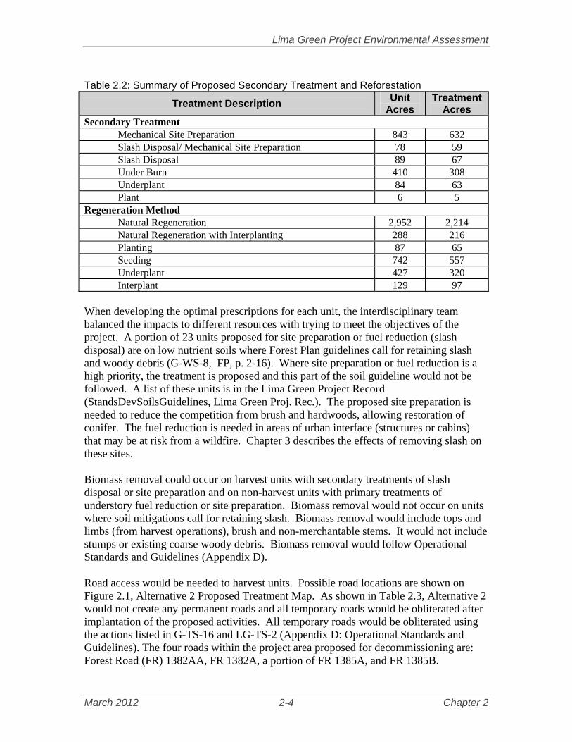
Table 2.2: Summary of Proposed Secondary Treatment and Reforestation
Treatment Description Unit
Acres Treatment
Acres Secondary Treatment
Mechanical Site Preparation 843 632 Slash Disposal/ Mechanical Site Preparation 78 59 Slash Disposal 89 67 Under Burn 410 308 Underplant 84 63 Plant 6 5
Regeneration Method Natural Regeneration 2,952 2,214 Natural Regeneration with Interplanting 288 216 Planting 87 65 Seeding 742 557 Underplant 427 320 Interplant 129 97
When developing the optimal prescriptions for each unit, the interdisciplinary team balanced the impacts to different resources with trying to meet the objectives of the project. A portion of 23 units proposed for site preparation or fuel reduction (slash disposal) are on low nutrient soils where Forest Plan guidelines call for retaining slash and woody debris (G-WS-8, FP, p. 2-16). Where site preparation or fuel reduction is a high priority, the treatment is proposed and this part of the soil guideline would not be followed. A list of these units is in the Lima Green Project Record (StandsDevSoilsGuidelines, Lima Green Proj. Rec.). The proposed site preparation is needed to reduce the competition from brush and hardwoods, allowing restoration of conifer. The fuel reduction is needed in areas of urban interface (structures or cabins) that may be at risk from a wildfire. Chapter 3 describes the effects of removing slash on these sites. Biomass removal could occur on harvest units with secondary treatments of slash disposal or site preparation and on non-harvest units with primary treatments of understory fuel reduction or site preparation. Biomass removal would not occur on units where soil mitigations call for retaining slash. Biomass removal would include tops and limbs (from harvest operations), brush and non-merchantable stems. It would not include stumps or existing coarse woody debris. Biomass removal would follow Operational Standards and Guidelines (Appendix D). Road access would be needed to harvest units. Possible road locations are shown on Figure 2.1, Alternative 2 Proposed Treatment Map. As shown in Table 2.3, Alternative 2 would not create any permanent roads and all temporary roads would be obliterated after implantation of the proposed activities. All temporary roads would be obliterated using the actions listed in G-TS-16 and LG-TS-2 (Appendix D: Operational Standards and Guidelines). The four roads within the project area proposed for decommissioning are: Forest Road (FR) 1382AA, FR 1382A, a portion of FR 1385A, and FR 1385B.

Lima Green Project Environmental Assessment
March 2012 2-5 Chapter 2
Table 2.3: Proposed Transportation Management Activities Transportation Activity Miles Construction of temporary roads 15.2 Unclassified road as temporary access 4.0 Decommission roads 2.3
A list and description of monitoring activities that would occur under Alternative 2 is displayed in Table 2.4. Table 2.4: Description of Monitoring Activities.
Harvest and Site Preparation Areas
Objective Ensure that the mitigation measures and provisions in contracts are implemented, with emphasis on soil compaction
Methods Visual inspection of treatment stands
Frequency Treatment areas would be visited on a regular basis during the length of the contract
Responsibility Timber Management Assistant, Silviculturist Non-Native Invasive Plants
Objective Avoid or minimize an increase in the extent of non-native plant infestation in the project area.
Methods Monitor a sample of harvest units and newly constructed roads after harvest, site preparation, or construction to determine if invasive plants have colonized areas where management activities have occurred
Frequency Between year one and year three, following the sale Responsibility Forest Plant Ecologist
Temporary Roads
Objective Ensure that temporary roads are constructed properly and obliterated after completion of treatment activities
Methods Inspect temporary road locations as they are being built, during treatments, between treatments, and after they are closed to determine if additional protection/rehabilitation efforts are needed
Frequency Inspect all temporary road locations that are more than ¼ mile in length. Responsibility Timber Management Assistant, Zone Engineer
Forest Composition/Regeneration
Objective Ensure that minimum stocking standards (S-TM-4, Forest Plan p 2-20) are met in each forest type for artificial and natural regeneration treatments including the interplanting of white pine
Methods Natural and artificial regeneration areas would be surveyed for the number of acceptable trees per acre using Regional Guidelines; Stands planted to red and white pine would be checked for pruning and release need
Frequency
Stocking surveys would be conducted after the 1st and 3rd growing season following reforestation treatment; Stands not expected to reach stocking standards after the 5th growing season would be evaluated for a replant; Release and pruning needs would be evaluated at the time of stocking surveys, every other year for 10 years, and after 10 years every 5 years until the branches are 9 ft. off the ground
Responsibility District Silviculturist

Lima Green Project Environmental Assessment
March 2012 2-6 Chapter 2
2.4 Alternatives Analyzed Briefly Four alternatives, including the Proposed Action from the Scoping Report, are analyzed briefly. Two of the alternatives would treat fewer units to reduce impacts and one alternative considered treating more units to provide more timber products. These alternatives highlight a range of concern expressed about how much treatment and what type of treatment should occur in the Lima Green Project Area. The analysis, although not detailed, provides valuable information for consideration in making a decision on actions to take in the Lima Green Project Area.
Alternative 3 – Proposed Action from Scoping Report In July 2011, a Scoping Report was distributed to the public informing them of the Lima Green Project. The Scoping Report included a “Proposed Action” which outlined the management activities the interdisciplinary team had determined would accomplish the Purpose and Need for Action as described in the report, Tables 2.5 and 2.6 display information about the proposed action from the Scoping Report.
Table 2.5: Summary of Proposed Action from July 2011 Scoping Report Treatment Description Acres
Creating young forest through even-aged harvest treatments Clearcut with Reserves 3,721 Shelterwood Cut 30 with Reserves 306 Patch Clearcut 52
Creating or maintaining two or more age classes through uneven age harvest Selection Cut 176 Shelterwood Cut with Reserves 15
Improving stand conditions through intermediate harvest treatments Thinning 357 Variable density thinning 177
Restoring stands through a variety of non-harvest activities Underplant 60 Understory Fuels Reduction 244 Mechanical Site Preparation 294 Underburn 22
Total of all Treatment Types 5,424
Table 2.6: Proposed Transportation Management Activities From July 2011 Scoping Report Transportation Activity Miles Construction of temporary roads 13.5 Unclassified road as temporary access 3.3 Decommission roads 1.6
This original Proposed Action was not carried forward for detailed analysis primarily because the interdisciplinary team conducted further field reconnaissance and analysis and made modifications that would better meet project objectives (the purpose and need).
Lima Green Project Environmental Assessment
March 2012 2-7 Chapter 2
The Interdisciplinary team incorporated updated data and information on specific stands. Stand boundaries were updated from field reconnaissance resulting in a more accurate accounting of stand acres and, in some cases, forest types. Units where treatments were deemed not feasible were eliminated from the proposed action. The Modified Proposed Action, which is also called Alternative 2, is analyzed in Chapter 3.
Alternative 4 – Reduce impacts to scenery Various comments were received about specific methods to reduce the visual impact of the proposed action. The interdisciplinary team considered these proposals and incorporated them into the proposed action. For example, the suggestion to use hand treatment to complete the Understory Fuel Reduction along the Gunflint Trail instead of mechanical treatment was incorporated into the proposed action. Alternative 4 was developed to respond to comments that suggested specific ways to reduce effects to the scenery that were not incorporated into the proposed action. This alternative is similar to Alternative 2 except:
Treatment would not occur in units 113.022, 113.033, 113.028, 113.053, 113.013, 113.010, 113.007, 113.06, and 112.029. These units are all within the Gunflint Trail Scenic Byway Corridor. Comments from the public suggested eliminating these units would reduce impacts to views from the Gunflint Trail, maintain and improve species diversity, and keep spruce as thermal cover for moose.
There would be no even aged harvest within 500 feet of the Greenwood Road and
Shoe Lake Road. Shelterwood harvest with reserves followed by planting of red and white pine would occur in these areas. Comments from the public suggested changing the treatment along the roads would minimize visual impact and to have a more natural appearing (mixed age) forest. This would change the treatment type for 34 units. The remainder of the unit away from the road would be harvested using the method listed in Alternative 2.
Analysis of Alternative The units in compartments 113 and 112 are within the Gunflint Trail corridor but they are not adjacent to the Gunflint Trail. The units were overlaid on a topography and hill shade map to see their juxtaposition on the hillside. In addition, photos of the area, including the past state harvest, were taken from the Gunflint Trail to estimate what could be seen. By retaining these units in Alternative 4, there would not be any changes to the background views along the Gunflint Trail. However, the difference in effects between treating and not treating these stands is slight. Portions of the units appear to be on the slope facing the Gunflint Trail and may be visible but effects to scenery would be small. The harvests would be in the background view for a short stretch of the Gunflint Trail and would likely only be visible in leaf-off conditions. The height of the trees in the foreground would also obscure some of the change in scenery.

Lima Green Project Environmental Assessment
March 2012 2-8 Chapter 2
While Alternative 4 would retain more thermal cover for moose by not treating the identified units, the difference between Alternative 4 and Alternative 2 is so slight, it is not measureable. Conifer stands older than nine years provide good thermal cover for moose (Forest Plan FEIS, section 3.3.4.2.b). Units 113.013, 113.007 and 113.024, the units closest to the Gunflint Trail, are red pine stands and Unit 113.006 is a black spruce/jack pine stand. Alternative 4 would maintain these stands as thermal cover; Alternative 2 would retain the red pine stands for thermal cover (the stands would be thinned) and within 10 year of harvest, the jack pine stand would be available for thermal cover. All the remaining units are aspen or aspen/conifer stands which provide limited or no thermal cover, depending on the amount of conifer in the stand. Alternative 4 would use shelterwood harvests, where feasible, for the portion of harvest units along the Greenwood and Shoe Lake Roads. The feasibility of using a shelterwood harvest would depend on the basal area (density of trees) of the unit. Some of the units would not have adequate basal area for a shelterwood harvest and no treatment would occur within 500 feet of the roads (in essence a buffer strip). In the short-term, shelterwood harvest and buffer strips would minimize impact on visuals quality along the two roads. The harvests would be noticeable to users of the roads but some of the overstory trees would be retained, making less of a contrast between the harvest areas and untreated forest. The buffer strips would screen the harvests from the road in the short-term. In the long-term, the trees in the buffer strip would die and blow over, allowing a viewshed into the harvest area. By that time, the harvest areas would be regenerating and would not be as noticeable within the surrounding landscape. White and red pine would be planted in some of the units along the road. As the trees grow and mature, they would add scenic quality and diversity to the views along the road. Although desirable, it is likely not all units would be planted to pine because of limited funding. The limited funding available from timber sales, appropriated money, or grants would likely be used in higher priority areas, such as the Gunflint Trail which has a High Visual Quality Objective. The Greenwood and Shoe Lake roads have a Moderate Visual Quality Objective (Forest Plan 2-48). While visual quality is still important along these roads, temporary openings may be more evident than in areas with High Scenic Integrity Objectives. Openings may be larger than those in the surrounding landscape, and after ground cover has become established openings may have the appearance of a management activity (G-SC-1, FP P. 2-46). Alternative 2 would have more of an impact to the scenery along the two roads, but the treatments would still meet the Moderate Visual Quality Objectives. Mitigation measures such as leaving legacy patches or areas of untreated forest along the roads to screen and minimize the view of the harvest unit would lessen the impact. In addition, more overstory trees would be left in some units such as 113.022 (shelterwood 30), reducing

Lima Green Project Environmental Assessment
March 2012 2-9 Chapter 2
the visual impact. Forest Plan FEIS acknowledged that there would be some impacts to scenery along some of the secondary roads in the forest (FP FEIS p.3.8-39). Alternative 4 will not be considered further because the difference in effects between Alternative 2 and 4 is small and the effects to scenery from Alternative 2 are within those anticipated with the Forest Plan FEIS.
Alternative 5– Minimize NNIS Alternative 4 was developed to address concerns about the introduction of non-native invasive plant species from mechanical treatment. This alternative is the same as Alternative 2 except for:
No treatment would occur in units 46.020, 46.041 and 46.006. Comments from the public suggested not treating these units to reduce the risk of increasing non-native invasive plants and currents (alternate host for white pine blister rust) and to protect the 100 year old pine trees from root damage (from mechanical treatment) or heat (from underburning).
The treatment in units 81.010 and 81.009 would be underplanting pine (with hand clearing of planting spot) instead of harvest. Comments from the public suggested changing the treatment would result in less chance of introduction of invasive species and less damage to desired leave trees.
Analysis of Alternative Units 46.006, 46.020, and 46.041: Under Alternative 5, no treatment would occur in these stands and many of the current conditions would continue into the future. Currently these units are bisected by a road that provides a vector for a slight chance of non-native invasive species spread along the road. Unit 46.041 has been harvested in the past and has less canopy cover than the other two units making it more suitable environment for non-native infestations. There are hawkweed along the old temporary road corridor through the units, as well as one inventoried patch of tansy within 46-020 and one inventoried patch of bull thistle at the edge of 46-041. Currently, the understory is predominately brush species with little or no white pine regeneration. Without any treatment or disturbance, it is likely there would continue to be little or no future white pine regeneration in this area. White pine usually cannot out compete brush, however, balsam fir can. In the long-term, balsam fir would begin to replace the brush in the understory and, eventually, the pine in the overstory. The existing bull thistle and tansy would likely be treated with herbicide under the 2006 Superior National Forest Non-native Invasive Plant Project at some point in the future, but would be a lower priority because no ground disturbance would occur in the area. The hawkweeds would not be treated. Under Alternative 2, there would be mechanical treatment of the understory brush, creating a fuel bed for a subsequent underburn. These treatments would increase the chance for non-native invasive plant spread but mitigation measures would reduce the risk. Mitigation would include equipment cleaning before the vegetation treatment as

Lima Green Project Environmental Assessment
March 2012 2-10 Chapter 2
well as herbicide treatment of the known NNIP prior to the vegetation treatment. These treatments would be a higher priority because of the proposed ground-disturbing activities. The substantial, remaining, overstory would create shade and also discourage increase in infestation. Mechanical treatment is not expected to damage the root system but there may be slight damage to tree bark from operations. This damage would be monitored and limited and is not expected to cause tree mortality. There may be mortality to pine trees from the prescribed burn. However, a mitigation action that would lower the fire intensity around a pine tree could include pulling fuel away from its base. The treatments would set back the brush in the understory and create favorable conditions for white pine regeneration. Based on experience with recent, similar, treatments near Isabella, it is expected white pine would naturally seed in. However, the regeneration would be monitored and if it was not adequate, white pine would be planted. Units 81.010 (aspen forest type) and 81.009 (white pine forest type): Alternative 5 would hand clear small areas along the Gunflint Trail in these units to plant white or red pine. Because of the intensive nature of the treatment, it would likely only occur within 100 to 500 feet of the road. There is considerable cedar regeneration in this area. As the pine grows and matures, it would add some variety and beauty to the Gunflint Trail. However, the pine would be scattered (particularly in unit 81.010) and not the main component in the stand. This type of treatment would not increase or connect the areas of white pine forest type in the Gunflint Trail Corridor. Under Alternative 2, the aspen (and some diseased white pine) would be harvested from these stands using a shelterwood with reserves system. The site would be mechanically prepared for planting or natural seeding of pine. There is an increased risk of spreading invasive plants with the mechanical treatment, but mitigation, such as described above, would reduce the risk. Area with concentrations of cedar would be avoided. This alternative would increase with white pine forest type along the Gunflint Trail and throughout the byway corridor. There is a small difference in the risk of NNIP spread between Alternative 5 and Alternative 2. While the risk of spread of non-native invasive species is less in Alternative 5, this alternative does not increase pine regeneration as much as Alternative 2, particularly in the long-term. Alternative 2 would better meet the purpose and need for restoring red and white pine forest with only a small increased risk of NNIP; therefore, Alternative 5 will not be analyzed further.
Alternative 6- Increase Red Pine Management Public comments suggested the Forest Service consider an alternative that included additional red pine management treatments within the project area. More than 2,500 acres of red pine within the 30 to 70 year age-class were suggested for commercial thinning opportunities.

Lima Green Project Environmental Assessment
March 2012 2-11 Chapter 2
The District Silviculturalist, Timber Management Assistant Ranger, and other interdisciplinary team members reviewed the suggested stands to determine if stand conditions indicated a need for thinning, i.e. dense growing conditions. The team also accessed the operability of the stands and the feasibility of thinning. Of the 2,471 acres suggested, only 94 acres were determined to need thinning treatment and were not already in the proposed action. Because this is a minor amount, the units were added to the proposed action (Alternative 2) instead of creating a separate alternative. The additional 923 acres will not be considered further because the thinning is not feasible. Table 2.7 shows the reasons for not including units and how many acres were eliminated for each reason. Table 2.7: Potential Thinning Acres Not Included by Rationale
Rationale Acres Already included in the Proposed Action 667 Recently thinned or included in a current timber sale 787 Not feasible because of terrain issues, size and isolation from other treatment units, low density of pine, or not ready for a thin
923
2.5 Comparison of Alternatives Considered in Detail
2.5.1 Comparison of Effects of Alternatives by Resource This section summarizes and compares the effects of the two alternatives analyzed in detail. The salient indicators and conclusions of each resource analyzed in Chapter 3 or appendices are summarized here. For the detailed analysis, including analysis methods, data, cumulative effects, etc, see Chapter 3 and relevant appendices. Table 2.8: Summary of Environmental Effects by Resource Area
Indicator Alternative 1 Alternative 2
Treaty Rights Alternative 1 would not create any young age class for foraging habitat for game species. Alternative 2 would provide more foraging habitat for game species such as moose and grouse and increase opportunities for hunting. Alternative 2 also offers the opportunity to further collaboration between the Forest Service, MN DNR and Tribal bands through aerial moose surveys, examining the effects of habitat management on moose populations.
Vegetation There would be zero acres in the young age class in either landscape ecosystem under Alterative 1 and there would be a total of 3,644 acres in young age class under Alternative 2. Alternative 2 would increase the amount of jack pine forest types, a valuable component of both ecosystems. Mesic Birch Aspen Landscape Ecosystem
Young age class acres 0 2,500 Jack pine forest type acres 1,185 1,338
Mesic Red and White Pine Landscape Ecosystem Young age class acres 0 1,144 Jack pine forest type acres 632 840

Lima Green Project Environmental Assessment
March 2012 2-12 Chapter 2
Table 2.8: Summary of Environmental Effects by Resource Area Indicator Alternative 1 Alternative 2
Threatened and Endangered Species Neither Alternative 1 nor Alternative 2 is likely to adversely affect Canada lynx, nor would either destroy or adversely modify proposed critical habitat. Under both alternatives, forest conditions would continue to provide for lynx denning, foraging, and movement across the analysis area.
RFSS/MIS Terrestrial Wildlife Alternative 1 would result in the least amount of disturbance to Regional Forester’s Sensitive Species (RFSS) and generally results in a finding of no impact. Alternative 1 will have no impact to gray wolf. Alternative 2 may impact individuals but is not likely to cause a trend to federal listing or loss of viability. Suitable forest habitat for the wolf and its prey would be maintained by either alternative. With the delisting of the gray wolf, critical habitat will no longer be considered. For Alternative 2, the proposed activities would have no impact on Freijia’s grizzled skipper or wood turtle. For Alternative 2, the proposed activities may impact individuals but are not likely to cause a trend to federal listing or loss of viability for little brown myotis, northern myotis, tri-colored bay, heather vole, bald eagle, northern goshawk, olive-sided flycatcher, bay-breasted warbler, Connecticut warbler, American three-toed woodpecker, great gray owl, boreal owl, Taiga alpine butterfly or Nabokov’s blue butterfly. Aquatic species The effects analysis determined none of the alternatives would impact the lake sturgeon, short-jaw cisco and nipigon cisco since they occupy deep lakes and there is no record of these species occupying the Lima Green Project Area. The northern brook lamprey, creek heelsplitter, black sandshell, Quebec emerald dragonfly, ebony boghaunter dragonfly and headwaters chilostigman caddisfly would not be impacted by Alternative 1. Alternative 2 may impact individuals or habitat but would not contribute toward a federal listing or cause a loss of viability to the populations or species. Plant Species Alternative 1 may impact six RFSS plant species. However, this impact is not likely to cause a trend toward federally listing these species or loss in their population viability; none of the remaining RFSS plants would be directly, indirectly, or cumulatively impacted by Alternative 1. Alternative 2 may impact 41 RFSS plant species. However, this impact is not likely to cause a trend toward federally listing these species or loss in their population viability; none of the remaining RFSS plants would be directly, indirectly, or cumulatively impacted by Alternative 2.
Soil Productivity and Wetlands Alternative 1 would have no direct effects to soil productivity because no soil disturbing activities would take place as a result of this alternative. Impacts to soil productivity would be minimal under Alternative 2 because appropriate mitigation measures and Operational Standards and Guidelines would be followed during implementation to reduce effects to soil resources. Acres of landings and skid trails 0 210 Acres of slash disposal, site preparation, and prescribed burning on low nutrient ELTs
0 712
Acres of wetland within mechanical treatment units 0 1,426

Lima Green Project Environmental Assessment
March 2012 2-13 Chapter 2
Table 2.8: Summary of Environmental Effects by Resource Area Indicator Alternative 1 Alternative 2
Non-Native Invasive Plants When direct, indirect, and cumulative effects are considered together, Alternative 1 emerges as the alternative with the lower risk of weed spread and subsequent negative impacts because there would be no ground disturbance with this alternative. Alternative 2 has a higher risk of weed spread and negative impacts than Alternative 1, but overall the risk for Alternative 2 would still be relatively low. Miles of new upland road construction 0 10.1 Acres of upland treatment units within 50 feet of NNIP occurrence
0 1,152
Water Quality Alternative 1 would have no direct effects to water quality because there would be no increase in road miles or increase in the percentage of watersheds in a young or open condition. Impacts to water quality would be minimal under Alternative 2 because Operational Standards and Guidelines from the Lima Green Project and site specific mitigation measures would be followed during implementation. Also 2.3 miles of National Forest System Roads would be decommissioned reducing potential sediment sources and improving the water quality. Miles of temporary roads 0 15.2 Miles of new temporary roads crossing Ecological Landtype 1-6 (lowlands)
0 0.53
Percentage of upland open and upland young forest within each sixth level watershed
0-3.6 0-19.7
BWCAW Alternative 1 would have no impacts to the Boundary Waters Canoe Area Wilderness. Alternative 2 would create short-term impacts to BWCAW visitors in the way of sound from mechanical operations that may be heard on the periphery of the Wilderness. Acres of mechanical treatment within one mile of Wilderness recreation sites
0 65
Scenery Alternative 1 would have no impacts to scenery. The forest would continue to age and change according to natural processes. Under Alternative 2, in the short-term users of the Gunflint Trail would notice a decrease in the mature forest and in the long-term would see more white, red and jack pine. Users of the Greenwood Road would notice a larger decrease in mature forest in the short-term. Over time the young forests would grow into mature forests.
2.5.2 Comparison of How Alternatives Meet Purpose and Need This section explains how each alternative would meet the objectives of the purpose and need (see Section 1.4 for the Purpose and Need).
Improve Moose Habitat
Alternative 1 – No Action would result in a 50 percent decrease in young (greater than 10 years old) upland forest by 2014 compared to the existing condition of only 1.2 percent in the Lima Green Project Area. It is widely accepted that moose browse preferentially on early successional vegetation, providing more nutrients and being more accessible. Since the 1990’s, tribal biologists have documented that there has been a reduced harvest of moose in the project area. Although this result may be influenced by a number of

Lima Green Project Environmental Assessment
March 2012 2-14 Chapter 2
variables, it is thought that the reduction in available browse may be a contributing factor (Tribal_Consultation_ Meeting_Notes, Lima Green Proj. Rec.). Moose presence may continue in the project area under Alternative 1, however, the continued loss of available young, highly nutritious, browse would likely have a negative effect on moose numbers throughout the project area. Alternative 2 would result in about 3,600 acres of young upland forest created by harvest to promote browse. Moose tend to favor early successional browse species such as quaking aspen, paper birch, mountain ash, willow, red-osier dogwood, and beaked hazel, which would regenerate following harvest. Additionally, red maple is browsed when available and balsam fir may be consumed during winter. The resulting shrub and tree regeneration would provide another 10 to 20 years of forage. Natural regeneration would take place on approximately 3,000 acres. Regeneration would be dominated primarily by aspen, but would also include acres of birch, jack pine, black spruce, and balsam fir. To improve tree species diversity natural regeneration and interplanting would take place on at least 400 acres. The shrub component should be extensive in harvested stands and would provide browse in areas scheduled for natural regeneration or artificial reforestation. The regeneration of these species in the moose emphasis area would assure the continued diversity, maintenance of native species and forest types, and hiding cover for moose. Tables 2.9 and 2.10 describe the differences between existing conditions and the alternatives for habitat types expected to influence moose, such as young forest, upland conifer, and lowland conifer.
Table 2.9: Upland Habitat Indicators for Moose within the Lima Green Project Area
Indicators Existing Condition
2011 Alternative 1
2020 Alternative 2
2020 Acres % Acres % Acres %
Young upland forest <10 years old 360 1.2 0 0 3644 11.8 Upland conifer > 9 years old 15,164 49 16,193 53 14,962 49 Data source: Existing condition from 2010 CDS data, and all alternatives are based on projected CDS data in the year 2014 and 2020. Note: percentages are based on the percent of total upland forest on federal lands in the project area (30,800 acres) for the upland landscape ecosystems.
Table 2.10: Lowland Habitat Indicator (MIH 9—Lowland Black Spruce-Tamarack Forest) for Moose within the Lima Green Project Area
Management Indicator Habitat
Existing Condition2011
Alternative 1 2020
Alternative 2 2020
Acres % Acres % Acres % Young 140 3.5 0 0 101 3 Pole 787 19.7 659 16.5 659 17 Mature 2,236 56 2,128 53.3 2,051 51.3 Old/Old Growth and Multi-Aged 832 20.8 1,209 30.2 1,185 29.7 Totals: 3,995 100 3,996 100 3,996 100 Data Source: Same as Table 2.9. Note: percentage represent percent of total lowlands for MIH 9 (Existing Condition) on NFS lands.
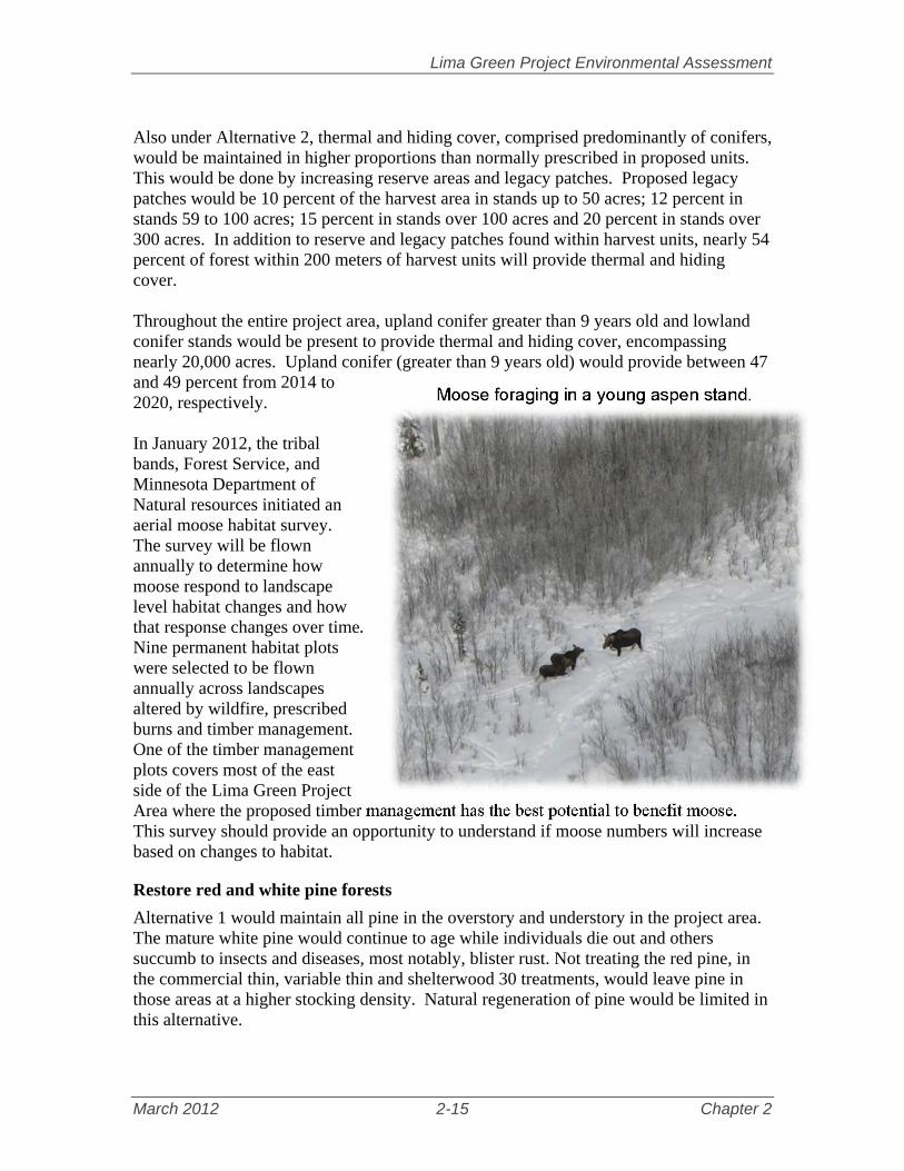
Lima Green Project Environmental Assessment
March 2012 2-15 Chapter 2
Also under Alternative 2, thermal and hiding cover, comprised predominantly of conifers, would be maintained in higher proportions than normally prescribed in proposed units. This would be done by increasing reserve areas and legacy patches. Proposed legacy patches would be 10 percent of the harvest area in stands up to 50 acres; 12 percent in stands 59 to 100 acres; 15 percent in stands over 100 acres and 20 percent in stands over 300 acres. In addition to reserve and legacy patches found within harvest units, nearly 54 percent of forest within 200 meters of harvest units will provide thermal and hiding cover. Throughout the entire project area, upland conifer greater than 9 years old and lowland conifer stands would be present to provide thermal and hiding cover, encompassing nearly 20,000 acres. Upland conifer (greater than 9 years old) would provide between 47 and 49 percent from 2014 to 2020, respectively. In January 2012, the tribal bands, Forest Service, and Minnesota Department of Natural resources initiated an aerial moose habitat survey. The survey will be flown annually to determine how moose respond to landscape level habitat changes and how that response changes over time. Nine permanent habitat plots were selected to be flown annually across landscapes altered by wildfire, prescribed burns and timber management. One of the timber management plots covers most of the east side of the Lima Green Project Area where the proposed timber management has the best potential to benefit moose. This survey should provide an opportunity to understand if moose numbers will increase based on changes to habitat.
Restore red and white pine forests
Alternative 1 would maintain all pine in the overstory and understory in the project area. The mature white pine would continue to age while individuals die out and others succumb to insects and diseases, most notably, blister rust. Not treating the red pine, in the commercial thin, variable thin and shelterwood 30 treatments, would leave pine in those areas at a higher stocking density. Natural regeneration of pine would be limited in this alternative.
Moose foraging in a young aspen stand.

Lima Green Project Environmental Assessment
March 2012 2-16 Chapter 2
Alternative 2 would treat 1,738 acres that would contribute to restoring red and white pine. The restoration actions are described below.
Manage a young component of pine along the Gunflint Trail, 169 acres: Five units within the Scenic Byway Corridor would be treated with a release, a shelterwood cut with reserves, a shelterwood cut 30 with reserves, and two patch clearcuts. The patch clearcuts would be regenerated to jack pine and the other units would be planted with either red pine, white pine, or both to convert the stand to pine or maintain pine as a component in the units.
Create a second age class in a white pine patch, 258 acres: These units were underburned in the 1990’s under the Lullaby Decision to reduce brush competition and prepare the seed bed for natural regeneration under overstory white pine. The intent was to conduct two to three underburns to substantially reduce the brush competition. After the first burn there wasn’t sufficient fuel to complete the subsequent burns. In order to complete the restoration efforts from the Lullaby Decision, brush accumulation would be mechanically sheared followed by an underburn in this proposal. The units would be interplanted to supplement a seedling component of white pine but the intention would be to encourage natural regeneration of pine. A third burn would not be expected but might be conducted depending on the regeneration success of the white pine.
Create and maintain a multi-aged pine patch, 193 acres: These units would be managed to mimic natural processes and create conditions for a young cohort of pine underneath the overstory. A selection harvest in all but 17 acres would create small gaps and thin out hardwood species between the gaps. The units would be underburned to remove some of the organic layer and reduce the shrub and herb competition. The desired outcome would be natural regeneration of a pine component underneath the canopy. However, white pine would be interplanted to supplement the natural regeneration since logistics to complete a successful underburn might not coincide with a heavy cone crop in the mature trees. One of the units, six acres, would be converted to a white pine forest type. The units would be managed as a long-term multi-aged patch and periodic selection harvests, to maintain the different age groups, would be conducted along with underburning.
Improve growing conditions of pine, 915 acres: Commercial thinning, variable thinning and shelterwood 30 treatments would focus on increasing growing space for the healthiest pine in these units. The treatments would capture the volume loss from the competing trees for timber production.
Reduce fuel hazard and establish pine regeneration, 137 acres: These units would be initially treated to reduce the amount of fuels in the understory. Either white pine, red pine, or both would be planted after treatment.
Increase pine in riparian areas, 60 acres: Three mature aspen stands would be underplanted with white pine next to riparian areas.
Mechanical site preparation and plant red and jack pine, six acres: Pine would be re-introduced to an area where the overstory blew down.
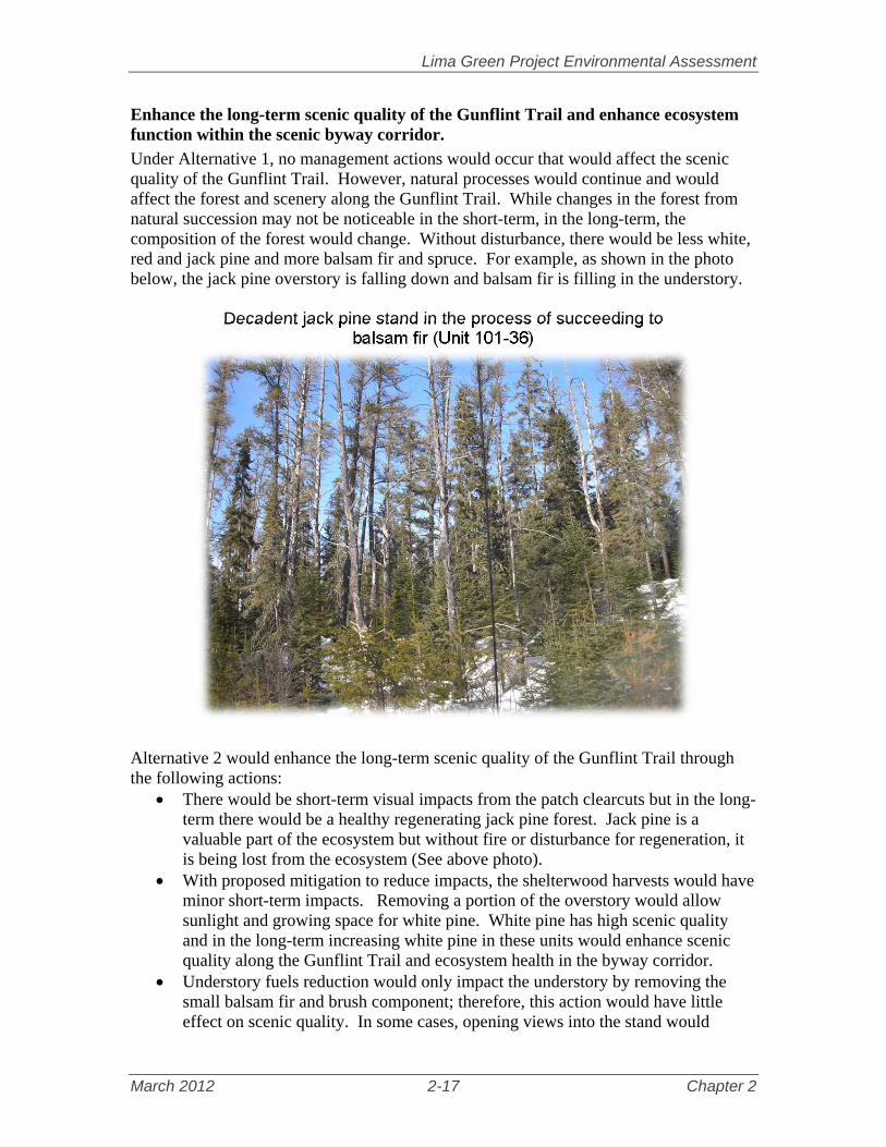
Lima Green Project Environmental Assessment
March 2012 2-17 Chapter 2
Enhance the long-term scenic quality of the Gunflint Trail and enhance ecosystem function within the scenic byway corridor.
Under Alternative 1, no management actions would occur that would affect the scenic quality of the Gunflint Trail. However, natural processes would continue and would affect the forest and scenery along the Gunflint Trail. While changes in the forest from natural succession may not be noticeable in the short-term, in the long-term, the composition of the forest would change. Without disturbance, there would be less white, red and jack pine and more balsam fir and spruce. For example, as shown in the photo below, the jack pine overstory is falling down and balsam fir is filling in the understory.
Decadent jack pine stand in the process of succeeding to balsam fir (Unit 101-36)
Alternative 2 would enhance the long-term scenic quality of the Gunflint Trail through the following actions:
There would be short-term visual impacts from the patch clearcuts but in the long-term there would be a healthy regenerating jack pine forest. Jack pine is a valuable part of the ecosystem but without fire or disturbance for regeneration, it is being lost from the ecosystem (See above photo).
With proposed mitigation to reduce impacts, the shelterwood harvests would have minor short-term impacts. Removing a portion of the overstory would allow sunlight and growing space for white pine. White pine has high scenic quality and in the long-term increasing white pine in these units would enhance scenic quality along the Gunflint Trail and ecosystem health in the byway corridor.
Understory fuels reduction would only impact the understory by removing the small balsam fir and brush component; therefore, this action would have little effect on scenic quality. In some cases, opening views into the stand would

Lima Green Project Environmental Assessment
March 2012 2-18 Chapter 2
improve scenic quality. Reducing the fuel loading along the corridor would improve ecosystem function by reducing possible impacts during a wildfire. The treatments would leave white pine, cedar and spruce in the understory which would likely make the trees more visible, enhancing the forest scenery.
The release treatment in unit 64.053 would create growing spaces for white pine adjacent to the Gunflint Trail. As the white pine grows over time, the scenic quality would be improved.
Additional actions under Alternative 2 that would improve ecosystem function in the corridor are:
The creation of a second age class in a white pine patch (described above under Restore red and white pine forests) would occur in the Gunflint Trail scenic byway corridor (these might not be visible from the road). Increasing white pine regeneration under a white pine overstory would perpetuate the white pine forest in the long-term.
Clearcuts with reserves within the byway corridor but away from the road would create young age class, creating browse for area moose. Moose tend to favor early successional browse species such as quaking aspen, paper birch, mountain ash, willows, red-osier dogwood, and beaked hazel, which would likely regenerate following this activity. The resulting shrub and tree regeneration would provide another 10 to 20 years of forage within the area proposed for moose emphasis.
Landscape ecosystem age class and composition objectives
Alternative 1 would not create young age class in either landscape ecosystem in the project area. Alternative 2 would create 2,500 acres of young age class in the Mesic Birch-Aspen-Spruce-fir Landscape Ecosystem and 1,144 acres of young age class in the Mesic Red and White Pine Landscape Ecosystem. In 2020, following Alternative 1, jack pine, aspen and paper birch forest types decrease in area within both the Mesic Birch-Aspen-Spruce-fir and Mesic Red and White Pine LE while the spruce-fir type would increase. Red and white pine forest types would remain the same. In 2020, following Alternative 2, jack pine, white pine and spruce-fir forest types would increase in area within the Mesic Birch-Aspen-Spruce-fir LE (increasing 30, 54 and 578 acres respectively) while aspen and paper birch would decrease (decreasing 513 and 149 acres respectively). In the Mesic Red and White Pine LE, jack pine, white pine and spruce-fir forest types would increase in area (increasing 135, 5, and 186 acres respectively) while aspen and paper birch would decrease (decreasing 255 and 71 acres respectively). White pine forest type would remain the same. Under Alternative 1, the within-stand diversity would be created primarily by succession as a result of the older pine, aspen and birch dying and being replaced by spruce, fir and brush. Other species, such as pine and hardwoods, would come in naturally but at a much slower rate. Structural diversity would be maintained.

Lima Green Project Environmental Assessment
March 2012 2-19 Chapter 2
The same process of succession would happen in Alternative 2 outside of the treated stands. Most of the even-aged and understory fuels treatments would reduce the amount of species diversity. Planting, seeding or releasing areas with known advanced white and red pine regeneration would increase the pine and spruce component in those stands. Structural diversity in some harvested stands, in Alternative 2, would decrease.
Maintain or increase longer lived species in riparian areas
Forest Plan management direction tells us to actively manage vegetation for the primary purpose of enhancing or restoring the functional linkage between aquatic and terrestrial ecosystems, and to favor long-lived site-suitable tree species such as white pine, red pine, black spruce, tamarack, etc. suitable for the site and at stand densities suitable for the site (FP, p. 2-8). Alternative 1 would not actively plant long-lived tree species within the riparian areas. Without any disturbance, balsam fir would begin to dominate these areas. Alternative 2 would manage for conifers in the riparian area; approximately 60 acres would be underplanted with northern white cedar, red pine, white pine or white spruce (only a portion of each unit would be planted so actual implementation acres would be less). The conifers would grow into an overstory of trees creating shade for aquatic and wetland ecosystems, thermal cover for wildlife and nest sites for riparian associated species, such as eagles and osprey (D-WS-10, FP, p. 2-11).
Reduce road density in Lynx Analysis Units with high road density
Forest Plan direction is to maintain the minimum National Forest road system needed to provide adequate access to both National Forest System and non-National Forest System land (D-TS-1, FP p. 2-47). In addition, maintaining road and trail densities below two miles per square mile help maintain the natural competitive advantage of lynx in deep snow (G-WL-8, FP, p. 2-30). There are two Lynx Analysis Units in the Lima Green Project Area, LAU 41 and LAU 43, where management actions are proposed. In LAU 41, a total of 2.36 miles of OML1 road would be decommissioned in Alternative 2. This decommissioning would reduce the road density in LAU 41 from 1.82 miles per square mile to 1.78 miles per square mile (Table 2.11). These proposed road closures would improve lynx security in the areas where the closures occur. There would be no reduction in road/trail densities following Alternative 1. The interdisciplinary team did not identify any opportunities for road closure in LAU 43. In effect, neither Alternative 1 nor 2 would reduce the road/trail density in LAU 43 even though it has a high density. Much of the density in this LAU is from trails. Table 2.11 indicates that with Alternative 1 (the existing condition) LAU 41 is below the 2 mi/mi2 level while LAU 43 exceeds the 2 mi/mi2 level. Both LAUs would continue to either remain below or exceed the 2 mi/mi2 level for both Alternatives 1 and 2 regardless of the planned closures in Alternative 2.

Lima Green Project Environmental Assessment
March 2012 2-20 Chapter 2
Table 2.11: Road/Trail Density of Lima Green Alternatives Lynx Analysis
Units Alternative 1
Density (mi/mi2) Alternative 2
Density (mi/mi2) LAU 41 1.82 1.78LAU 43 2.23 2.23
Reduce hazardous fuels in areas of concern
Alternative 1 would not change existing fuel hazards near wildland urban interface areas. Existing fuel volumes would increase throughout most forested land within the project area. This is due to dead, dying, and/or wind thrown trees and successional trends toward spruce-fir forest types. This increase fuel loading can result in intense wildfires. Subsequently, values at risk, such as private property, future forest products, and recreation resources, could potentially be negatively impacted in the event of wildfire within the project area. Alternative 2 would reduce fuel hazard on about 677 acres (Table 2-12). In developing the fuel reduction treatments for the Lima Green Project Area, surface fuels, ladder fuels and crown fuels were targeted for treatment. These are the primary attributes of a forest that influence fire behavior.
Surface fuels include needles, leaves, grass, forbs, dead and down branches, tree boles, stumps, shrubs, and short trees. This type of fuel allows fire to spread along the surface. In the Lima Green Project Area, there is dead and down balsam as a result of spruce budworm. Also of concern is older hardwood species that are dying off and falling over, adding to the surface fuel loading. When surface fuel loadings are high, fires can burn quickly through the smaller fuels. Ladder fuels include shrubs and young trees that provide continuous fine fuels which reach from the forest floor into the crowns of the overstory. Ladder fuels allow fire to move from the surface to the overstory. Balsam fir is the primary ladder fuel in the project area. Balsam fir is shade tolerant and can easily grow in the understory of stands. It also contains a chemical component in its needles which makes it extremely flammable. Crown fuels include the live and dead foliage, live and dead branches, and lichen of trees and tall shrubs that lie above the surface fuels which allows fire to spread through the canopy. Crown fuels include spruce, pine, and balsam fir species. When those species grow tightly together, fire can easily spread through the canopy.
The Table 2.12 describes how different types of fuel reduction treatments target the different fuel types to reduce overall fuel loadings in an area. The fuel reduction treatments within Alternative 2 would be primarily located along roadways. By treating near roadways, defensible space would be increased. Defensible space is the area between a fire and values at risk where firefighters are able to take

Lima Green Project Environmental Assessment
March 2012 2-21 Chapter 2
suppression actions. Additionally, removing hazardous fuels near high travel corridors, like the Gunflint Trail, would improve the safety of travel for forest visitors and local residents during a wildfire. All fuels reduction treatments within Alternative 2 would reduce hazardous fuels to a level in which fire behavior from a wildfire would be decreased. By decreasing fire behavior, firefighting tactics can be more effective. The combination of increasing defensible space and decreasing fire behavior would increase the likelihood that fire suppression activities can be conducted to minimize impacts to values at risk and provide for public safety. Table 2.12: Comparison of Amount and Type of Fuel Reduction.
Description of Treatment Acres
Alternative 1 Alternative 2Harvest followed by Site Preparation Burn: Removes the crown fuels and crushes some of the ladder fuels through harvest activity; a site preparation burn removes the dead and down fuel hazards and some ladder fuel hazards by allowing a low intensity fire to burn in the understory of the stand.
0 152
Understory Fuel Reduction: Reduces the ladder fuels by removing or crushing balsam fir
0 245
Underburning: Low intensity fire used in the understory of pine stands to remove surface and ladder fuels
0 280
Total 0 677 Many of the fuel treatments along roadways would be along the Gunflint Trail. Fuel reduction treatments along roadways would address the need to protect scenic integrity while decreasing fuel loadings to an acceptable level. This type of fuel reduction treatment would be primarily an understory fuel reduction treatment where the understory fuel hazards (primarily surface and ladder fuels) are removed. The following design features would minimize the effects on scenic integrity: 1) These treatments would be conducted by hand (chainsaws and either chipping or piling and burning); 2) Areas of no treatment would be left to reduce the appearance of a completely cleared out understory; 3) Areas of no treatment would be left near roadways to provide visual buffers.
Pre-treatment Understory Fuel Reduction
Post-treatment Understory Fuel Reduction

Lima Green Project Environmental Assessment
March 2012 2-22 Chapter 2
Pre-treatment Understory Fuel Reduction
Post-treatment Understory Fuel Reduction
Two areas have been identified for understory burns which would remove small diameter and ladder fuels. These are larger areas (150-300 acres in size). These treatments have been designed to create larger patches on the landscape. If there were to be a larger, landscape scale wildfire, these treatments would provide regions where fire behavior would decrease, allowing suppression resources to employ suppression tactics. These treatments are also designed with other pine restoration objectives in mind (see Chapter 1, pg 1-7, Purpose and Need related to restoring red and white pine forest). The lack of fire on the landscape has lead to poor forest health and little regeneration in those areas. Understory burns help improve forest health by thinning out thick stands that can easily spread insect and disease outbreaks. Additionally, underburns prepare the soil so regeneration can take place.
Underburning Underneath White Pine

Lima Green Project Environmental Assessment
March 2012 2-23 Chapter 2
Provide sustainable timber products
The Lima Green Project Area contains many acres of land classified to produce timber products. A Forest Plan desired condition is to provide sustainable timber sales and supply continuous timber to area mills. Similarly, one emphasis of the General Forest – Longer Rotation Management Area (MA) is timber production and most of the project area is included in this MA. There is demand for forest commodities, such as pulpwood and saw timber, and this project would contribute to providing sustainable forest products. Alternative 1 would not provide timber products from this area at this time. It would not preclude providing timber products in the future, however. Alternative 2 would provide approximately 24.74 million board feet. Harvesting the timber stands proposed in Alternative 2 offer immediate economic returns to federal and local governments and to the timber industry. Harvesting in Alternative 2 would be a continuation of the economic returns from harvest similar to the return in the past 10 years. Further discussion of economic impacts is presented in Appendix E.