Lewis River Dispersed Campsites Program Dispersed Site ...
85
Lewis River Dispersed Campsites Program Dispersed Site Monitoring Report Prepared by Mason, Bruce & Girard, Inc. Portland, Oregon January 2010
Transcript of Lewis River Dispersed Campsites Program Dispersed Site ...

Lewis River Dispersed Campsites Program
Dispersed Site Monitoring Report
Prepared by Mason, Bruce & Girard, Inc.
Portland, Oregon
January 2010
TABLE OF CONTENTS
1.0 Introduction ................................................................................................................................... 1
2.0 Dispersed Site Assessment Methodology ....................................................................................... 3 2.1 Pre‐Field Desktop GIS Effort ......................................................................................................... 3 2.2 Field Effort .................................................................................................................................... 5
2.2.1 Special Situations ............................................................................................................. 5 2.2.1.1 Dispersed Recreation Sites with No Evidence of Use ...................................... 6 2.2.1.2 Unsuitable Dispersed Recreation Sites ............................................................ 6 2.2.1.3 New Dispersed Recreation Sites ...................................................................... 6 2.2.1.4 Potential New Dispersed Recreation Sites ...................................................... 6
2.3 Post‐Field Analysis ........................................................................................................................ 7 2.3.1 Initial GIS Analysis ............................................................................................................ 7 2.3.2 Initial Site Data and Recreation Analysis .......................................................................... 7 2.3.3 Bank Access Analysis ........................................................................................................ 8 2.3.4 Sensitive Resource Analysis ............................................................................................. 8 2.3.5 Cultural Resource Analysis ............................................................................................... 9 2.3.6 Driftwood Analysis ........................................................................................................... 9 2.3.7 Vegetation Cover Type Analysis ..................................................................................... 10
3.0 Results .......................................................................................................................................... 11 3.1 Merwin Reservoir ....................................................................................................................... 15
3.1.1 Baseline Conditions and RRMP Criteria ......................................................................... 17 3.2 Yale Reservoir ............................................................................................................................. 18
3.2.1 Baseline Conditions and RRMP Criteria ......................................................................... 18 3.3 Swift Reservoir ............................................................................................................................ 21
3.3.1 Baseline Conditions and RRMP Criteria ......................................................................... 23
4.0 Closure Recommendations ........................................................................................................... 25
5.0 Refined Long‐Term Monitoring ..................................................................................................... 31 5.1 Trash Rating ................................................................................................................................ 31 5.2 Bank Slope .................................................................................................................................. 32
6.0 Conclusions ................................................................................................................................... 33
7.0 References .................................................................................................................................... 34
8.0 Final Dispersed Recreation Site Recommendations ........................................................ Appendix A
‐ i ‐

‐ ii ‐
FIGURES
Figure 1.0‐1. Dispersed Recreation Site Project Area ................................................................................ 2 Figure 2.0‐1. Typical Dispersed Recreation Site ........................................................................................ 2 Figure 3.0‐1. 2009 Dispersed Recreation Site Assessment Results ......................................................... 10 Figure 3.1‐1. Merwin Reservoir Dispersed Recreation Sites ................................................................... 14 Figure 3.2‐1. Yale Reservoir Dispersed Recreation Sites ........................................................................ 17 Figure 3.3‐1. Swift Reservoir Dispersed Recreation Sites ........................................................................ 20 Figure 8.4‐1 Yale Sites Recommended for Hardening .............................................................. Appendix A Figure 8.4‐2 Swift Sites Recommended for Hardening ............................................................. Appendix A
TABLES
Table 3.0‐1. Results of 2009 Dispersed Recreation Site Assessment ....................................................... 9 Table 3.0‐2. Recreation Resource Management Plan (RRMP) Criteria Summary Table ........................ 11 Table 3.0‐3. Dispersed Recreation Site Baseline Data Summary Table ................................................. 11 Table 3.0‐4. Vegetation Cover Types ...................................................................................................... 12 Table 3.1‐1. Dispersed Recreation Site Types Observed at Merwin Reservoir ...................................... 15 Table 3.2‐1. Dispersed Recreation Site Types Observed at Yale Reservoir ............................................ 16 Table 3.2‐2. Vegetation Cover Types at Dispersed Recreation Sites along Yale Reservoir ................... 18 Table 3.3‐1. Dispersed Recreation Site Types Observed at Swift Reservoir .......................................... 21 Table 4.0‐1. Recreation Resource Management Plan (RRMP) Criteria and Site Suitability Table ........ 25 Table 6.0‐1. Summary of Dispersed Recreation Sites ............................................................................. 31 Table 8.2‐1 Suitable Dispersed Recreation Sites within PacifiCorp and Clark County
Ownership.. .......................................................................................................... Appendix A Table 8.3‐1 Ownership for Suitable Dispersed Recreation Sites along Swift Reservoir .......... Appendix A Table 8.4‐1 Summary of Dispersed Recreation Sites Recommended for Hardening .............. Appendix A Table 8.4‐2 Dispersed Recreation Sites Recommended for Hardening .................................. Appendix A
APPENDICIES Appendix A. Final Dispersed Recreation Site Recommendations Appendix B. Merwin Reservoir Dispersed Recreation Site Data Appendix C. Yale Reservoir Dispersed Recreation Site Data Appendix D. Swift Reservoir Dispersed Recreation Site Data Appendix E. Dispersed Site Assessment Methodology

1.0 Introduction
PacifiCorp is developing a proactive plan for the long term monitoring of dispersed recreation sites at the Lewis River Hydroelectric Projects (Project) (Federal Energy Regulatory Commission [FERC] Project Nos. 935, 2071, and 2111) located in Cowlitz, Clark, and Skamania Counties, Washington. On November 30, 2004, PacifiCorp Energy, Cowlitz County Public Utility District (PUD), federal and state agencies, Tribes, and non‐governmental organizations (Parties) entered into a Settlement Agreement (SA) that resolved all issues between the Parties related to the relicensing and ongoing operations of the Lewis River Projects. The SA describes the terms under which the Parties will support the FERC’s issuance of new licenses for the Lewis River Projects, and was reached after nearly three years of negotiations covering a broad array of resource areas, including fish passage, in‐stream flow, hatcheries and supplementation, aquatic habitat, monitoring and evaluation, wildlife habitat, recreation, cultural resources, flood management, socioeconomics, reporting, and coordination among the Parties. PacifiCorp developed a Recreation Resource Management Plan (RRMP) as part of the SA (PacifiCorp 2004). The RRMP establishes guidelines for determining the suitability of known existing dispersed recreation sites, and calls for the implementation of a monitoring methodology for each dispersed recreation site. The RRMP defines “dispersed” as overnight camping or day use recreation occurring at sites lacking hardened facilities, such as picnic tables or toilets. PacifiCorp contracted with Mason, Bruce & Girard, Inc. (MB&G) to develop the Dispersed Site Monitoring Methodology. PacifiCorp presented this methodology to the Terrestrial Coordination Committee (TCC); an oversight committee made up of stakeholders and regulatory agencies, and obtained approval in accordance with the SA. The methodology, summarized in Section 2.0 and included in Appendix E, provides PacifiCorp with the means to implement the RRMP, and to effectively manage dispersed recreation throughout the Lewis River Project. This report includes a summary of the results of the field effort utilizing the Dispersed Site Monitoring Methodology (Section 3.0), a discussion of closure recommendations (Section 4.0), refined guidelines for future monitoring efforts (Section 5.0), conclusions (Section 6.0), and final site recommendations (Section 8.0). The Project area for the Dispersed Recreation Site Program is shown below (Figure 1.0‐1). For the purposes of the RRMP, PacifiCorp defines the Project area as the shorelines surrounding Yale Reservoir, Merwin Reservoir, and Swift Reservoir.
‐ 1 ‐
C o w l i t z C o u n t yC o w l i t z C o u n t y
S k a m a n i a C o u n t yS k a m a n i a C o u n t y
C l a r k C o u n t yC l a r k C o u n t y
NNaattiioo nnaall FF oo rr ee ss tt RR oo aa dd 9900
YaleYale
HallHall
DaytonDayton
CougarCougar
NorthwoodsNorthwoods
ChelatchieChelatchieCedarvilleCedarville
Woodland ParkWoodland Park
M e r w i n R e s e r v o i rM e r w i n R e s e r v o i r
S w i f t R e s e r v o i rS w i f t R e s e r v o i r
Yal e
Re s e
r vo i r
Yal e
Re s e
r vo i r
Populated Places
Highways
National Forest
National Park or Monument
Roads
Figure 1.0-1Dispersed Recreation Site Project Area
Lewis River Hydroelectric ProjectCowlitz, Clark and Skamania Counties, Washington Mason, Bruce & Girard, Inc.
Natural Resource Consultants since 1921
Data Source: Counties, Highways, LandOwnership and City Limits from WSDOT.
NAIP Aerial Imagery, 2005. All data reproduced by Mason, Bruce & Girard,
Inc. for the purposes of this document.
This product is for information purposes and may not be suitable for legal, engineering or surveying purposes. This information or data is provided with the understanding that conclusions drawn
from such information are the responsibility of the user.
Gifford Pinchot National ForestGifford Pinchot National Forest
Gifford Pinchot National ForestGifford Pinchot National Forest
Mount St.Mount St.Helens NationalHelens National
Volcanic MonumentVolcanic Monument
503
503
503 S
0 1 20.5Miles

2.0 Dispersed Site Assessment Methodology
There are approximately 100 known dispersed recreation sites identified in PacifiCorp’s RRMP. Monitoring of these sites is required to provide information on three key indicators: 1) site creep (the enlargement of dispersed recreation sites over time), 2) site pioneering (the creation of new dispersed recreation sites), and 3) perceived crowding (dispersed recreation site occupancy). Additionally, each dispersed recreation site was assessed for site suitability. According to PacifiCorp’s RRMP (2004), a site must meet the following criteria in order to be considered suitable for dispersed recreation:
• Criterion 1: Initial Site Data and Recreation. For campsites, be of suitable size for overnight use, with an adequate boat‐in shoreline, adequate level tent pad space, and adequate and safe campfire space.
• Criterion 2: Bank Access. Have low to moderate bank access and low erosion potential. • Criterion 3: Sensitive Habitats or Species. Not affect sensitive habitat or species. Not be
within or affect the function of a jurisdictional wetland. • Criterion 4: Cultural Resources. Not affect eligible cultural resource sites. • Criterion 5: Driftwood. Not be in a location that collects large amounts of driftwood
(interfere with boat beaching). The above criteria were used to establish baseline conditions and to determine whether a dispersed recreation site should be closed to the public. Figure 2.0‐1 provides a diagram of a typical dispersed recreation site.
2.1 Pre‐Field Desktop GIS Effort The dispersed recreation site assessment involved both an office and a field component. Prior to the field survey, biologists reviewed existing GIS layers maintained by PacifiCorp as they relate to known locations of dispersed recreation sites. These layers include:
• Associated species habitat • Wetlands • Streams • Cultural resources • Bank erosion potential
These data provided a baseline prior to conducting the field portion of the dispersed recreation site assessment. Field maps including these data were created to provide reference during the field effort.
‐ 3 ‐

Typical Dispersed Recreation SiteLewis River Hydroelectric Project
Cowlitz, Clark and Skamania Counties, Washington
Campsite Boundary
Campfire Vegetation Setback (10’)
Campfire
Picnic Table
Tent Pad (10’x10’)
Toilet
Campsite ID Sign
Campsite Access Point
Reservoir
Reservoir
8’
8’4’
10’x10’
10’x10’
Figure 2.0-1
Mason, Bruce & Girard, Inc.Natural Resource Consultants since 1921
This product is for informationpurposes and may not be suitable
for legal, engineering or surveyingpurposes. This information or data
is provided with the understanding thatconclusions drawn from such
information are the responsibility ofthe user.
10’
0 52.5Feet

The approximately 100 sites identified within the RRMP were given unique alpha‐numeric site identifications (ID) to streamline the field effort. Site IDs were composed of a letter identifying closest reservoir (M for Merwin, S for Swift, Y for Yale), and were then numbered in order, starting upstream and continuing clockwise until all sites were numbered. Finally, a general direction modifier was added to the end of the site ID, to specify which bank of the reservoir each site was found along, based on the general alignment of each reservoir with the cardinal directions. For Merwin and Swift Reservoirs, direction modifiers were confined to north (N) and south (S); sites along Yale Reservoir received a direction modifier of east (E) or west (W). Examples of final site IDs include Y17 N, S9 S, and M6 N.
2.2 Field Effort MB&G conducted the dispersed recreation site assessment of the project area on April 13‐16 and April 20‐23, 2009. All sites were assessed using the criteria outlined in the Dispersed Site Monitoring Methodology (MB&G 2009) (Appendix E). This assessment established the baseline conditions at each of the dispersed recreation sites identified in the RRMP. Data collected at each site fell into three categories:
• Initial site (including the location of the site and the level of impact at each site);
• Access potential (including the presence of driftwood, and the slope of the bank at each site); and
• Sensitive resources (including the presence and proximity of wetlands, rare plants, noxious weeds and associated species).
The above data were collected at each site, where applicable. In some instances, certain data parameters were not applicable to a particular site and were therefore left blank on field data forms. For example, sites that exhibited no signs of use were noted as such, instead of assigning a level of “low” to the degree of trash, toilets or damage.
The assessment was completed using a custom data collection application built for handheld GPS units. The application, called The Dispersed Campsite Assessment Application V.1 (DCA Application) was customized to collect spatial and tabular data specifically related to the Dispersed Site Assessment process. Technical details regarding the Dispersed Campsite Application, as well as an abbreviated User’s guide, are included in the Dispersed Site Monitoring Methodology, Section 3.0 in Appendix E.
2.2.1 Special Situations During the field effort, although some of the sites identified in the RRMP were located, not all were assessed according to the complete monitoring methodology. This was either due to a lack of use and/or site unsuitability (e.g., extremely steep slopes). Also, some new dispersed recreation sites that were not previously mapped were located and added to the inventory. Dispersed recreation sites with no evidence of use but that could provide a potential location for a new dispersed recreation site were also recorded. The following paragraphs outline the procedures employed in these special situations.
‐ 5 ‐

2.2.1.1 Dispersed Recreation Sites with No Evidence of Use Some of the mapped dispersed recreation sites were suitable for dispersed recreation (e.g., had easy access from reservoir, a flat tent space, etc.), but were not being utilized by those recreating on the shores of Yale, Swift and/or Merwin Reservoirs. However, these sites have the potential to be developed into dispersed recreation sites, often with minimal effort (e.g., minor brush clearing). When these areas were observed, biologists conducted a thorough search of the area adjacent to the mapped location of the recreation site to confirm that the site did not “migrate” from nearby. Photographs were then taken, a sketch was drawn, and notes were entered into the handheld application, as applicable. In cases where a potential dispersed recreation site area (i.e., clearing, flat area, etc.) could be reasonably discerned from the surrounding vegetation, the site was measured and dimensions were input into the handheld application. However, in situations where a potential dispersed recreation site area could not be delineated (even roughly), this information was omitted. Initial site data, access potential and sensitive resource data were recorded, as discussed above, where applicable.
2.2.1.2 Unsuitable Dispersed Recreation Sites Biologists were unable to locate some of the dispersed recreation sites where their mapped location was unsuitable for dispersed site development, primarily due to steep slopes and limited access from the reservoir. When these “sites” were observed, biologists made appropriate notes in the handheld application and took photographs of the mapped dispersed recreation site location. In general, initial site data and sensitive resource data were not applicable for these sites, thus sketches were not completed and these data were omitted. However, general site notes and access potential information were recorded in the handheld application.
2.2.1.3 New Dispersed Recreation Sites During the course of fieldwork, multiple dispersed recreation sites were observed and recorded that were not included in the original RRMP inventory. These new sites were recorded according to the monitoring methodology established for RRMP mapped sites (including initial site data, access potential information and sensitive resource data), and were given a unique site identification number in sequential order from the last known campsite for any given reservoir. For example, 10 sites were originally mapped within the RRMP along the shoreline of Merwin Reservoir; these sites were numbered M1 – M10. New sites located along Merwin Reservoir were numbered in the order they were located, beginning with M11. New sites were recorded if it was apparent that the area was being used as a dispersed recreation sites.
2.2.1.4 Potential New Dispersed Recreation Sites Biologists also located several areas in which no dispersed recreation site was currently mapped or present, but which had good potential for the establishment of a dispersed recreation site, based on ease of access, site topography and natural vegetative breaks. The location of these potential sites was recorded in the handheld device. Biologists also recorded all of the applicable site information, including initial site data, access information, sensitive resource data and any applicable disturbance information. Biologists took photographs of the area of
‐ 6 ‐
potential site establishment and recorded sketches outlining the area. When possible, the approximate size of the potential site was measured, based on topographic breaks and general clearings in vegetation.
2.3 Post‐Field Analysis Analysis of all data collected during the field effort was thoroughly reviewed and analyzed in order to establish baseline conditions and develop closure recommendations (discussed in Sections 3.0 and 4.0 below). In general, this analysis was completed through the use of PacifiCorp‐provided GIS layers depicting associated species habitat, wetlands, streams, cultural resources, and bank erosion potential, review of site photographs and notes, and through analysis of site locations. The following paragraphs outline the methods used to complete the post‐field analysis.
2.3.1 Initial GIS Analysis Immediately following the field effort, all data were downloaded, scanned and/or copied to provide a back‐up of all field data collected. Biologists then reviewed the data to ensure accuracy and completeness. At that time, it became apparent that there was a discrepancy in the data provided in the RRMP, specifically with regards to the number of mapped dispersed recreation sites on Yale Reservoir. The map included in the RRMP shows 45 dispersed recreation sites located along the shoreline of Yale Reservoir (RRMP Exhibit K, Sheet 2). However, the associated GIS layers for Yale Reservoir provided to MB&G by PacifiCorp show 86 mapped sites along the shoreline. During the field effort, biologists confirmed that the GIS layer with 86 mapped dispersed recreation sites on Yale Reservoir contained the most accurate information. Biologists confirmed the presence of 81 of the 86 mapped dispersed sites. The remaining five sites appeared to be “duplicates” or errors in the GIS data, where one site was mapped as two separate, but immediately adjacent, sites.
The dispersed recreation sites were subsequently renumbered to include new sites and exclude duplicate sites within the data. This process ensured that the site IDs ascended, in order, clockwise from the upstream end of each reservoir, as discussed in Section 2.1. Renumbering parameters were the same as those employed originally (Section 2.1), with the addition of “_09” at the end of each ID to differentiate the new IDs from sites assessed during the 2009 inventory from those originally mapped in the RRMP.
In order to complete the analyses described in the following sections, it was necessary to create site polygons, or “envelopes” for each site point collected in the field. GIS analysts created the polygons using the measurements from site centers collected by biologists in the field. In this way, a rough estimate of the size, location and shape of each dispersed campsite was created. These envelopes were used as the site location for the analyses described in Sections 2.3.2 – 2.3.8.
2.3.2 Initial Site Data and Recreation Analysis Each site was analyzed based on the criteria established in PacifiCorp’s RRMP, i.e., suitable size for overnight use, with an adequate boat‐in shoreline, adequate level tent pad space, and
‐ 7 ‐
adequate and safe campfire space. Bank slope, access notes, photo notes, and approximate size attributes were evaluated within the GIS data to establish whether the inventoried sites met these criteria. If a site did not fully satisfy all of the criteria described above, it was determined unsuitable for dispersed recreation site use.
2.3.3 Bank Access Analysis The RRMP states that in order for a site to be considered suitable for dispersed recreation, it must have good bank access (i.e., bank slope of less than 20 percent) and low erosion potential. Each of these factors was analyzed independently to ascertain whether or not the campsite met the bank access criteria. First, the GIS data were analyzed to determine which sites were recorded with a slope greater than 20 percent. Due to the prevalence of steep (but short) cut banks found along each of the reservoirs, notes made pertaining to access were analyzed in tandem with the slope percentages for each site, so as not to eliminate sites that may have good access. Erosion potential for each site was analyzed using the GIS substrate layer provided by PacifiCorp. The substrate layer includes data for the composition of the banks of each of the reservoirs. The substrate layer was overlaid with each campsite location in GIS to determine the substrate and erosion potential at each site. Those substrates composed of silt or sand were determined to have a high potential for erosion. If a dispersed recreation site was located within silt or sand substrate, had a slope of greater than 20 percent, and had an associated note regarding difficulties with site access; the site was determined unsuitable for use.
2.3.4 Sensitive Resource Analysis To be suitable for dispersed recreation, the RRMP states that a site should not be in a jurisdictional wetland or affect its function, nor should it affect sensitive habitat or species. These sensitive resources were analyzed for each site using GIS technology and field observations, as described in further detail below.
Potential effects to jurisdictional wetlands were analyzed in two ways. First, during the field effort, biologists noted the presence of wetlands within and adjacent to dispersed recreation sites with field sketches and the handheld application, and whether or not the dispersed site was affecting the functions of the wetland. This information was used to determine site suitability. If a site was located within a wetland, it was considered unsuitable. If a site was located adjacent to a wetland, notes and photographs were reviewed to determine if the site had the potential to affect the wetland functions (e.g., the only access to the site was through the wetland). Second, the GIS wetland layer maintained by PacifiCorp was overlaid with the mapped dispersed recreation site locations collected in the field. Where the two layers overlapped, biologists reviewed site data collected in the field to verify if the site was indeed located near a wetland, and if dispersed recreation had the potential to effect wetland functions.
Due to their federal protections, PacifiCorp identified the northern spotted owl (NSO) (Strix occidentalis) and the bald eagle (Haliaeetus leucocephalus) as the primary sensitive species of
‐ 8 ‐

concern for this analysis. Potential impacts to these species from dispersed recreation sites were independently analyzed to determine site suitability, as described below. PacifiCorp maintains GIS layers for both NSO Management Areas and bald eagle Roost Areas. Upon completion of the field effort, the dispersed recreation locations were overlaid with both of these layers using GIS. Although this analysis provided valuable baseline information, dispersed recreation site suitability was not based solely on whether these layers overlapped. Instead, sites were analyzed to determine their proximity to known nest locations, as described below. PacifiCorp maintains GIS layers documenting the known location of bald eagle and NSO nest sites in the areas surrounding Merwin, Swift and Yale Reservoirs. In coordination with PacifiCorp biologists, each dispersed recreation site was analyzed to determine if it fell within 330 feet of a known bald eagle nest or one‐quarter mile of an NSO nest. If a dispersed recreation site was within these buffer distances, the site was determined unsuitable, as it had the potential to affect bald eagles or NSOs, especially during the breeding season. As part of the monitoring methodology, the presence of rare plants was recorded for each site (see Appendix E). A dispersed recreation site was designated as potentially affecting sensitive resources if a rare plant species was documented within it. However, during the 2009 assessment, no rare plant species were observed; as such, post‐field analysis did not need to be completed.
2.3.5 Cultural Resource Analysis The RRMP requires PacifiCorp to perform an assessment of whether dispersed recreation sites will affect cultural resources. PacifiCorp maintains a GIS layer with known cultural resource sites. Due to the sensitive nature of the cultural resource layer, exact locations of known cultural resource sites cannot be specifically identified. Instead, cultural resource sites have been buffered, creating larger polygons depicting cultural resource sites. The dispersed recreation sites were overlaid with this buffer layer. If the site was located within the buffer it was designated as potentially affecting cultural resources (i.e., unsuitable).
2.3.6 Driftwood Analysis The RRMP requires an assessment of whether dispersed recreation sites are located in areas that have the potential to collect large amounts of driftwood and whether the driftwood has the potential to interfere with boat traffic and/or cause boat beaching. At each dispersed recreation site, biologists recorded whether or not driftwood was present in the beach access area. If driftwood was present, biologists recorded the number of pieces of driftwood with a diameter greater than 12 inches according to the following categories: low (less than 5 pieces), medium (5 to 10 pieces), and high (greater than 10 pieces). In addition, biologists indicated (yes or no) if driftwood was affecting access to the dispersed recreation location, as high amounts of driftwood were not necessarily indicative of reduced site accessibility. The site was considered
‐ 9 ‐

unsuitable if the site contained high amounts of driftwood and it was noted that driftwood presence was affecting access.
2.3.7 Vegetation Cover Type Analysis Vegetation cover type was analyzed at each dispersed recreation location to provide additional baseline information. This analysis was performed using vegetation GIS layers provided by PacifiCorp. These layers were overlapped with each site envelope to determine the vegetation cover type(s) observed at each site. When more than one vegetation cover type was identified for specific sites, biologists reviewed site locations, photographs, notes and aerial photographs to determine the dominant cover type.
‐ 10 ‐

3.0 Results
A total of 143 dispersed recreation sites were evaluated within the Lewis River Project area within five categories of dispersed recreation sites: mapped with use, mapped with no use, mapped potential, new potential, and new with use. “Mapped” sites refer to those dispersed recreation sites previously identified within the RRMP. “New” sites are sites that were not identified within the RRMP, but were located during the field effort. Sites with “no use” are areas where no evidence of dispersed camping was observed. Conversely, sites with “use” are those where evidence of dispersed campsite use (e.g., fire ring, trash, tent pad area, etc.) was observed. Sites with “potential” are areas where biologists observed no signs of use, but where the area provided the potential for dispersed recreation site development (e.g., level area of adequate size, adequate boat access etc.). Results of the 2009 dispersed recreation site assessment are shown below relative to each of the above categories (Table 3.0‐1). The location of all dispersed recreation sites is shown below (Figure 3.0‐1).
Table 3.0‐1. Results of 2009 Dispersed Recreation Site Assessment.
Reservoir
Dispersed Recreation Site Type
Mapped with Use
Mapped with No Use
Mapped Potential
New Potential
New with Use
Total
Merwin 5 4 1 0 1 11
Yale 49 24 13 2 20 108
Swift 16 2 0 0 6 24
Total Sites 70 30 14 2 27 143
Of the 143 total dispersed recreation sites evaluated, 97 sites (mapped or new) exhibited signs of use, 16 (mapped or new) had the potential for future campsite development, and 30 sites displayed no evidence of dispersed recreation use. The majority (108) of all sites are located along the shoreline of Yale Reservoir. A total of 11 sites were found along the shoreline of Merwin Reservoir and 24 adjacent to Swift Reservoir.
As discussed in Section 2.0, each of the sites was assessed against a number of criteria according to the Dispersed Site Assessment Methodology, unless a particular criterion was not applicable (Appendix E) (MB&G 2009). Results of the assessment are shown below (Tables 3.0‐2 and 3.0‐3). Table 3.0‐2 contains data pertaining to the five criteria for site suitability, as outlined in the RRMP and discussed in Section 2.3.7. Table 3.0‐3 includes a summary of the baseline data collected at each site.
‐ 11 ‐

C o w l i t z C o u n t yC o w l i t z C o u n t y
S k a m a n i a C o u n t yS k a m a n i a C o u n t y
C l a r k C o u n t yC l a r k C o u n t y
NNaattiioo nnaall FF oo rr ee ss tt RR oo aa dd 9900
YaleYale
HallHall
DaytonDayton
CougarCougar
NorthwoodsNorthwoods
ChelatchieChelatchieCedarvilleCedarville
Woodland ParkWoodland Park
M e r w i n R e s e r v o i rM e r w i n R e s e r v o i r
S w i f t R e s e r v o i rS w i f t R e s e r v o i r
Yal e
Re s e
r vo i r
Yal e
Re s e
r vo i r
Suitable Dispersed Recreation Sites
Mapped (RRMP)
New
Potential
Unsuitable Dispersed Recreation Sites
Populated Places
Roads
Highways
National Forest
National Park or Monument
Figure 3.0-12009 Dispersed Recreation Site Assessment Results
Lewis River Hydroelectric ProjectCowlitz, Clark and Skamania Counties, Washington Mason, Bruce & Girard, Inc.
Natural Resource Consultants since 1921
Data Source: Counties, Highways, LandOwnership and City Limits from WSDOT.
NAIP Aerial Imagery, 2005. All data reproduced by Mason, Bruce & Girard,
Inc. for the purposes of this document.
This product is for information purposes and may not be suitable for legal, engineering or surveying purposes. This information or data is provided with the understanding that conclusions drawn
from such information are the responsibility of the user.
Gifford Pinchot National ForestGifford Pinchot National Forest
Gifford Pinchot National ForestGifford Pinchot National Forest
Mount St.Mount St.Helens NationalHelens National
Volcanic MonumentVolcanic Monument
503
503
503 S
0 1 20.5Miles

Table 3.0‐2. Recreation Resource Management Plan (RRMP) Criteria Summary Table
Reservoir
Criterion 1: Site Data and Recreation Criterion 2: Bank Access Criterion 3: Sensitive Habitats or Species Criterion 4: Cultural Resources
Criterion 5: Driftwood
Adequate Boat‐in shoreline1
Adequate Level Tent Pad Space
Slope %2 Potential for Erosion3
Bald Eagle Nest Proximity4
NSO Nest Proximity5
Wetlands Onsite Wetland Adjacent Cultural Resources6 Driftwood7 Driftwood Affecting Access8
Merwin 11 sites 7 sites 4 high 4 medium 3 low
0 sites 0 sites 0 sites 1 site 2 sites 2 sites 0 high 1 medium 9 low
0 sites
Yale 75 sites 98 sites 38 high 19 medium 34 low
6 sites
1 site 0 sites 6 sites 13 sites 1 site 16 high 10 medium 48 low
15 sites
Swift 24 sites 22 sites 6 high 13 medium 3 low
3 sites
1 site 0 sites 0 sites 1 sites 1 site 6 high 1 medium 15 low
3 sites
Total 110 sites 127 sites 48 high 36 medium 40 low
9 sites
2 sites 0 sites 7 sites 16 sites 4 sites 22 high 12 medium 72 low
19 sites
1 – Sites determined to have adequate boat‐in shoreline if biologists were able to access the site by boat during the 2009 Assessment. 2 – Slope measured from the site center to ordinary high water mark. Low: <10%, Medium: 10‐20%, and High: >20%. 3 – PacifiCorp maintains a GIS layer of the substrate of each reservoir and its shoreline. Sites were determined to have potential for erosion if they were located on silt or sand substrates. 4 – PacifiCorp maintains a GIS layer for bald eagle Nest sites. Dispersed recreation sites within 330 feet of a bald eagle nests were noted. 5 – PacifiCorp maintains a GIS layer for Northern Spotted Owl nest sites. Dispersed recreation sites within 0.25 mile of NSO nests were noted. 6 – PacifiCorp maintains a layer with known cultural resource sites. PacifiCorp created a buffer layer for these sites and MB&G noted which sites fell within this buffer. 7 –High: > 10 pieces, Medium: 5‐10 pieces, and Low: < 5 pieces. 8 – Biologists recorded whether driftwood was affecting access at the dispersed recreation site location.
Table 3.0‐3. Dispersed Recreation Site Baseline Data Summary Table
Reservoir
Level of Impact Associated Species4 Streams Weeds5
Campfire Ring Trash1 Toilet Damage2 NSO/Bald Eagle Areas3 Elk Deer Beaver Bald Eagle Other Avian
Perennial / Intermittent
Noxious, invasive or exotic
Merwin 4 (1 ring) 0 (> 1 ring)
0 High 0 Medium 7 Low
1 with toilet 2 High 0 Medium 5 Low
0 in NSO Management Area 0 in Bald Eagle Roost Area
4 sites 0 sites 0 sites 0 sites 1 site 1 site 1 site
Yale 42 (1 ring) 6 (> 1 ring)
1 High 10 Medium 61 Low
12 with toilet 2 High 20 Medium 49 Low
45 in NSO Management Area 8 in Bald Eagle Roost Area
72 sites 50 sites 0 sites 3 sites 11 sites 11 sites 15 sites
Swift 17 (1 ring) 3 (> 1 ring)
0 High 0 Medium 22 Low
7 with toilet 1 High 4 Medium 17 Low
1 in NSO Management Area 7 in Bald Eagle Roost Area
18 sites 16 sites 1 site 0 sites 3 sites 3 sites 0 sites
Total 63 (1 ring) 9 (> 1 ring)
1 High 10 Medium 90 Low
20 with toilet 5 High 24 Medium 71 Low
46 in NSO Management Area 15 in Bald Eagle Roost Area
94 sites 66 sites 1 site 3 sites 15 sites 15 sites 16 sites
1 – High: greater than 5 bags of trash, Medium: 2 to 5 bags of trash, and Low: less than 2 bags of trash. A bag of trash is equivalent to a 30 gallon trash bag. 2 – High: more than 10 damaged tress / shrubs damaged, Medium: 5 to 10 trees / shrubs damaged, and Low: less than 5 trees / shrubs damaged. Types of damage could include, but are not limited to, vandalism to the trunk or bark of a tree, removal of limbs for firewood, presence of exposed roots, etc. 3 – PacifiCorp maintains GIS layers for the NSO Management Area and the bald eagle Roost Area. 4 – The calculations include observations of species and evidence of species. 5 – Observed weed species included Himalayan blackberry (Rubus armeniacus) and Scot’s broom (Cytisus scoparius).
‐ 13 ‐

The dispersed recreation sites observed in the 2009 assessment generally had low amounts of trash, low levels of damage to vegetation, and did not have toilets present. Only one of the sites assessed contained high levels of trash (greater than five 30‐gallon bags), and only five had high levels (greater than 10 damaged trees/shrubs) of damage to vegetation.
Very few patches of noxious weeds were observed within or near dispersed recreation sites. Only 16 sites contained or were adjacent to noxious weed populations, the majority of which (15 sites) were located along Yale Reservoir. Noxious weed species observed were limited to Himalayan blackberry (Rubus armeniacus) and Scot’s broom (Cytisus scoparius). No rare plants were observed throughout the field assessment.
Associated species (as identified in the Dispersed Site Monitoring Methodology – Appendix E) observed (directly or indirectly) at all of the sites were limited to beaver (Castor canadensis), deer (Odocoileus hemionus), elk (Cervus elaphus), bald eagle, pileated woodpecker (Dryocopus pileatus), or other avian species, most frequently osprey (Pandion haliaetus). Observations of these species occurred on all three reservoirs.
Perennial or intermittent streams were observed within or adjacent to 15 dispersed recreation sites. Swift Reservoir had the highest incidence of streams; 11 sites had streams within or adjacent to the site.
As discussed in Section 2.3.8, vegetation cover type was analyzed at each dispersed recreation site using vegetation GIS layers provided by PacifiCorp. At 16 sites vegetation cover types could not be identified due to limitations in the GIS layer. The remainder of the sites fell into a total of 11 cover types (Table 3.0‐4).
Table 3.0‐4. Vegetation Cover Types
Cover Type Number of Dispersed Recreation Sites
Merwin Yale Swift Total Sites
Lodgepole Pine 0 2 0 2
Mature Conifer 1 7 5 13
Mid‐Successional Conifer 2 7 1 10
Old Growth 0 3 7 10
Riparian Deciduous 0 1 1 2
Riparian Mixed 0 1 0 1
Riparian Shrub 0 1 0 1
Riverine Unconsolidated Shore 0 3 0 3
Seedling/Sapling 0 1 1 2
Upland Deciduous 2 63 0 65
Upland Mixed 2 12 4 18
Of the 143 sites assessed during April 2009, most (110 sites) have adequate boat‐in shorelines and level tent pad space (127 sites). The majority of the sites assessed in 2009 had steep bank
‐ 14 ‐

slopes (greater than 20 percent). This is primarily due to the prevalence of cut banks. Steep banks inhibited site access at 32 sites. Sites were deemed to have a high potential of erosion if they were located on a substrate of silt or sand, as determined by GIS analysis with PacifiCorp‐provided GIS layers (as discussed in Section 2.3.3). A total of nine sites were located on silt or sand substrates. Wetlands were observed adjacent to 16 sites and within seven sites. These wetlands were generally of low quality and were generally dominated by reed canarygrass (Phalaris arundinacea). Yale Reservoir had the highest incidence of wetlands both adjacent to and within dispersed recreation sites. As discussed in Section 2.3.4, all of the dispersed recreation sites were analyzed to determine whether they were located within NSO management areas or known bald eagle roost areas. A total of 46 sites were located within NSO management areas; 15 sites were within bald eagle roost areas. In addition, sites were analyzed to determine if they were located within 330 feet of a bald eagle or one‐quarter mile of a NSO nest. Only two dispersed recreation sites were observed within the bald eagle buffer; no dispersed recreation sites were located within one‐quarter mile of an NSO nest. The majority of the sites located in these sensitive habitat layers were located along Yale Reservoir. The majority of the dispersed recreation sites were located outside of known cultural resources, as determined by GIS analysis with PacifiCorp GIS layers (see Section 2.3.5). A total of four sites were located within the cultural resources layer; two located on Merwin Reservoir, and one on both Yale and Swift Reservoirs. Most of the boat access areas to the 143 dispersed recreation sites contained low amounts (less than five pieces) of driftwood. A total of 22 sites had high amounts (more than 10 pieces) of driftwood, 19 of which were sites where driftwood impeded boat access. Most of the sites affected by high amounts of driftwood were located along Yale Reservoir.
3.1 Merwin Reservoir Merwin Reservoir contained the fewest dispersed recreation sites of all three reservoirs. This is likely due to the fact that Merwin Reservoir has the most developed shoreline; private residences along Merwin limit the amount of shoreline available for dispersed recreation.
A total of 11 dispersed recreation sites were evaluated according to the established methodology along Merwin Reservoir, 10 of which were previously mapped within the RRMP. One site (M11 N) was added during the 2009 site assessment. All data collected for the dispersed recreation sites are presented in Appendix B and summarized below. Geographic location and the types of sites observed of dispersed sites along Merwin Reservoir are shown in Figure 3.1‐1 and Table 3.1‐1, respectively.
‐ 15 ‐

Clark CountyClark County
Cowlitz CountyCowlitz County
Pup Crk
Cedar Crk
John C
rk
Speelyai Crk
Jim Crk
Brush Crk
Brooks Crk
Rock Crk
Cresu
p Crk
Dry Crk
Cape Horn Crk
Buncombe Hollow Crk
Che
latc
hie
Crk
Can
yon
Crk
Marble Crk
Cedar Crk
YaleYale
HallHall
DaytonDayton
ChelatchieChelatchieCedarvilleCedarville
Woodland ParkWoodland Park
M6N_09
M4N_09
M2S_09M5N_09
M1S_09
M8N_09
M9N_09
M7N_09
M3N_09
M11N_09
M10N_09
M e r w i n R e s e r v o i rM e r w i n R e s e r v o i r
Unsuitable Dispersed Recreation Sites
Suitable Dispersed Recreation Sites
Mapped (RRMP)
New
Potential
Populated Places
Highways
Roads
Streams
National Forest
National Park or Monument
Figure 3.1-1Mewin Reservoir Dispersed Recreation Sites
Lewis River Hydroelectric ProjectCowlitz, Clark and Skamania Counties, Washington
Mason, Bruce & Girard, Inc.Natural Resource Consultants since 1921
Data Source: Counties, Highways, LandOwnership and City Limits from WSDOT.
NAIP Aerial Imagery, 2005. All data reproduced by Mason, Bruce & Girard,
Inc. for the purposes of this document.
This product is for information purposes and may not be suitable for legal, engineering or surveying purposes. This information or data is provided with the understanding that conclusions drawn
from such information are the responsibility of the user.
503
503
503 S
0 0.5 10.25Miles
Ownership
PacifiCorp
Federal
Federal (BLM)
Federal (USFS)
County
State
Northwest Electric Co.
Pope Resources
Private
Weyerhaeuser
Woodland School District
Unknown

Table 3.1‐1. Dispersed Recreation Site Types Observed at Merwin Reservoir. Dispersed Recreation Site Type
Mapped1 with Use
Mapped with No Use
Mapped Potential
New Potential New with Use Total
5 sites 4 sites 1 site 0 sites 1 site 11 sites 1Mapped: sites previously identified in the RRMP.
3.1.1 Baseline Conditions and RRMP Criteria • All of the dispersed recreation sites located along Merwin Reservoir contained low
amounts (less than two 30‐gallon bags) of trash, and damage to vegetation was low (less than five trees/shrubs damaged) at all but two sites.
• Only one dispersed recreation site contained an established toilet (user‐created).
• Four dispersed recreation sites (36 percent) had existing campfire rings.
• Only one dispersed recreation site (M4 N) contained a noxious weed (Himalayan blackberry) population.
• Elk were the only associated wildlife species observed along Merwin Reservoir. Evidence of their presence was observed at four dispersed recreation sites.
• An unnamed perennial stream was observed adjacent to dispersed recreation site M9 N. Streams were not present at any other dispersed recreation site along Merwin Reservoir.
• Vegetation cover types associated with the dispersed recreation sites along Merwin Reservoir included Mature Conifer, Mid‐Successional Conifer, Upland Deciduous and Upland Mixed. Vegetation cover type was not available at four of the dispersed recreation sites along Merwin Reservoir due to limitation of the GIS vegetation layer.
• Of the 11 dispersed recreation sites assessed on Merwin Reservoir, all had adequate boat‐in shorelines, and seven had adequate, level, tent pad space. The size of the dispersed recreation sites ranged from approximately 350 to 1,160 square feet. The dispersed recreation sites were large enough to support overnight camping.
• A total of four dispersed recreation sites had banks with slopes greater than 20 percent, however, bank access was only affected by the steep slopes at two of these dispersed recreation sites.
• None of the dispersed recreation sites located along Merwin Reservoir exhibited potential for erosion.
• None of the dispersed recreation sites located along Merwin Reservoir were located within NSO management areas or bald eagle roost areas.
‐ 17 ‐

• None of the dispersed recreation sites located along Merwin Reservoir were located within 330 feet of a known bald eagle nest or one‐quarter mile from a NSO nest.
• Three dispersed recreation sites (M1 S, M9 N and M10 N) were located within or adjacent to a wetland, and all three of these dispersed recreation sites were potentially affecting wetland functions. Wetlands were dominated by reed canarygrass.
• Two of the dispersed recreation sites (M8 N and M11 N) located along the shoreline of Merwin Reservoir were within the cultural resources buffer.
• The majority of the boat access points to the dispersed recreation sites along Merwin Reservoir contained low (less than five pieces) amounts of driftwood. One dispersed recreation site (M9 N) contained medium (5‐10 pieces) amounts of driftwood, but access was not affected by its presence. It should be noted that surveys took place during the period of driftwood removal from Merwin Reservoir (March 2 – May 22, 2009), potentially affecting the amount of driftwood observed at each site.
3.2 Yale Reservoir Yale Reservoir had the most dispersed recreation sites of the three reservoirs. Spectacular views of Mt. St. Helens and large, accessible beaches make Yale Reservoir desirable for dispersed recreation. However, portions of Yale Reservoir are prohibitive to dispersed recreation sites because of steep slopes.
A total of 108 dispersed recreation sites were evaluated according to the established Dispersed Site Monitoring Methodology along Yale Reservoir. Of these, 86 were originally mapped within the RRMP. A total of 22 new dispersed recreation sites were located during the 2009 dispersed recreation site assessment. All data collected for the dispersed recreation sites are presented in Appendix C and summarized below. The types of dispersed recreation sites observed along Yale Reservoir and the geographic location of all dispersed recreation are shown in Table 3.2‐1 and Figure 3.2‐1, respectively.
Table 3.2‐1. Dispersed Recreation Site Types Observed at Yale Reservoir. Dispersed Recreation Site Type
Mapped with Use
Mapped with No Use
Mapped Potential
New Potential New with Use Total
49 sites 24 sites 13 sites 2 sites 20 sites 108 sites
3.2.1 Baseline Conditions and RRMP Criteria • The majority of the dispersed recreation sites along Yale Reservoir contained low (less
than two 30‐gallon bags) amounts of trash. However, 10 dispersed recreation sites exhibited medium (two to five 30‐gallon bags) amounts of trash. The only dispersed recreation site with high (greater than five 30‐gallon bags) amounts of trash observed during the 2009 assessment was located along Yale Reservoir.
‐ 18 ‐

Dog C
rk
Spee
lyai
Crk
Ole C
rk
Siouxon Crk
Cougar Crk
North Siouxon Crk
Dry
Crk
Speelyai Crk
Speelyai Crk
IP R
oad
IP R
oad
CougarCougar
Y8E_09
Y7E_09
Y6E_09Y10E_09
Y11E_09Y12E_09
Y16E_09Y15E_09
Y69E_09
Y22E_09
Y24E_09Y25E_09
Y27E_09
Y29E_09
Y33E_09Y37E_09
Y43E_09
Y44E_09Y46E_09
Y47E_09 Y48E_09
Y49E_09 Y53E_09
Y80E_09Y78E_09
Y75E_09
Y88E_09
Y23E_09
Y40E_09
Y76E_09
Y94W_09
Y32E_09
Y38E_09
Y91W_09
Y93W_09
Y42E_09
Y54E_09
Y41E_09
Y50E_09
Y65E_09
Y71E_09
Y82E_09
Y86E_09
Y90E_09
Y89E_09Y87E_09
Y5E_09
Y9E_09
Y3E_09Y4E_09
Y30E_09
Y35E_09
Y64E_09
Y74E_09
Y52E_09
Y58E_09
Y66E_09
Y83E_09
Y97W_09 Y62E_09
Y56E_09
Y98W_09
Y92W_09
Y96W_09
Y95W_09
Y99W_09
Y17E_09
Y19E_09Y20E_09
Y21E_09
Y28E_09
Y26E_09
Y18E_09
Y61E_09
Y59E_09
Y55E_09
Y60E_09
Y63E_09
Y70E_09
Y68E_09
Y79E_09
Y85E_09Y84E_09
Y106W_09Y105W_09
Y100W_09
Y101W_09
Y102W_09
Y103W_09
Y104W_09
Y108W_09Y107W_09
Yal e
Re s e
r vo i r
Yal e
Re s e
r vo i r
Unsuitable Dispersed Recreation Sites
Suitable Dispersed Recreation Sites
Mapped (RRMP)
New
Potential
Populated Places
Highways
Roads
Streams
National Forest
National Park or Monument
Figure 3.2-1Yale Reservoir
Dispersed Recreation SitesLewis River Hydroelectric Project
Cowlitz, Clark and Skamania Counties, Washington
Mason, Bruce & Girard, Inc.Natural Resource Consultants since 1921
Data Source: Counties, Highways, LandOwnership and City Limits from WSDOT.
NAIP Aerial Imagery, 2005. All data reproduced by Mason, Bruce & Girard,
Inc. for the purposes of this document.
This product is for information purposes and may not be suitable for legal, engineering or surveying purposes. This information or data is provided with the understanding that conclusions drawn
from such information are the responsibility of the user.
503 S
0 0.5 10.25Miles
Mount St. Helens NationalMount St. Helens NationalVolcanic MonumentVolcanic Monument
IP R
oad
IP R
oad
Y33E_09
Y37E_09
Y43E_09Y44E_09
Y46E_09Y47E_09
Y48E_09
Y49E_09
Y53E_09
Y40E_09
Y45E_09
Y32E_09
Y38E_09
Y42E_09
Y54E_09
Y41E_09
Y50E_09
Y30E_09
Y35E_09
Y52E_09
Y58E_09
Y31E_09Y34E_09
Y56E_09
Y59E_09
Y55E_09
Y51E_09
Y39E_09
Y36E_09
Y57E_09
Y69E_09
Y80E_09
Y78E_09
Y75E_09
Y73E_09
Y71E_09
Y82E_09
Y74E_09Y72E_09
Y67E_09
Y83E_09Y70E_09
Y68E_09
Y79E_09
Y81E_09
Yale
Eas
t
Souixon Creek
Souixon Creek
Yale East
Cowlitz CountyCowlitz County
Ska
man
ia C
ount
yS
kam
ania
Cou
nty
Clark CountyClark County
Y13E_09Y14E_09
Ownership
PacifiCorp
Federal
Federal (BLM)
Federal (USFS)
County
State
Northwest Electric Co.
Pope Resources
Private
Weyerhaeuser
Woodland School District
Unknown

• Damage to vegetation was primarily low (less than five damaged trees/shrubs); however, a considerable number (20 total dispersed recreation sites) had medium (5‐10 damaged trees/shrubs) damage to vegetation.
• A total of 12 dispersed recreation sites along Yale Reservoir contained an established or primitive toilet; 48 dispersed recreation sites (44 percent) had at least one campfire ring. In general, these facilities were user‐created (some facilities appear to have been historically placed by various land owners, such as Cowlitz County).
• Noxious weeds were observed within or adjacent to 15 of the dispersed recreation sites located along Yale Reservoir. Noxious weed species observed included both Himalayan blackberry and Scot’s broom.
• Evidence of elk and deer were observed by biologists at 72 and 50 dispersed recreation sites along Yale Reservoir, respectively. Other associated species observed included bald eagle and other avian species (primarily pileated woodpecker and osprey).
• Of the dispersed recreation sites located on Yale Reservoir, 11 were located adjacent to perennial or intermittent streams. Dispersed recreation sites were located near Siouxon Creek, Dry Creek, and the Speelyai Canal, among others.
• The dispersed recreation sites observed along Yale Reservoir fell into 11 vegetation cover types. The majority of the dispersed recreation sites were located within the Upland Deciduous vegetation cover type. A high concentration of dispersed recreation sites were located within red alder (Alnus rubra) stands located on the southern shoreline of Yale Reservoir (Table 3.2‐2).
Table 3.2‐2. Vegetation Cover Types at Dispersed Recreation Sites along Yale Reservoir
Cover Type No. of Yale Reservoir
Dispersed Recreation Sites
Lodgepole Pine 2
Mature Conifer 7
Mid‐Successional Conifer 7
Old Growth 3
Riparian Deciduous 1
Riparian Mixed 1
Riparian Shrub 1
Riverine Unconsolidated Shore 3
Seedling/Sapling 1
Upland Deciduous 63
Upland Mixed 12
Not Available 7
‐ 20 ‐
• Of the 108 dispersed recreation sites assessed on Yale Reservoir, 75 had adequate boat‐in shorelines and 98 had adequate, level, tent pad space. The size of the dispersed recreation sites ranged from 118 to 7,770 square feet. All of the dispersed recreation sites were large enough to support overnight camping with the exception of one dispersed recreation site (Y84 E).
• A total of 38 dispersed recreation sites had banks with slopes greater than 20 percent; bank access was affected by the steep slopes at 28 of these sites. Six of the dispersed recreation sites located along Yale Reservoir were located on silt or sand substrates.
• A total of 45 dispersed recreation sites along Yale Reservoir were located within an NSO management area. Eight dispersed recreation sites were located within known bald eagle roost areas.
• One dispersed recreation site (Y3 E) was located within 330 feet of a known bald eagle nest.
• None of the dispersed recreation sites located along Yale Reservoir were located within one‐quarter mile from a NSO nest.
• Wetlands were located within six and adjacent to 13 dispersed recreation sites. Eight of these have the potential to affect wetland functions.
• One dispersed recreation site (Y67 E) along the shoreline of Yale Reservoir was located within the cultural resources buffer layer.
• The majority (48) of the boat access points to the dispersed recreation sites along Yale Reservoir contained low (less than five pieces) amounts of driftwood. 10 dispersed recreation sites contained medium (5‐10 pieces) amounts of driftwood and 16 contained high (greater than 10 pieces) amounts of driftwood. Driftwood affected boat access at 15 of the dispersed recreation sites.
3.3 Swift Reservoir A total of 24 dispersed recreation sites were observed along Swift Reservoir. Twenty‐five percent (six dispersed recreation sites) of these are new (i.e., not previously identified within the RRMP); the highest percentage of new dispersed recreation sites found on the three reservoirs. High rates of new dispersed recreation site development by dispersed recreation users may be influenced by the relative ease of boat access to the shoreline at Swift Reservoir.
The types of dispersed recreation sites observed along Swift Reservoir and the geographic location of all dispersed recreation are shown below (Table 3.3‐1 and Figure 3.3‐1, respectively).
‐ 21 ‐

Skamania CountySkamania County
Range Crk
Drift Crk
Mar
ble
Crk
Cam
p Crk
Pine CrkDiamond CrkNNaattiioonnaall FF oorreesstt RR oo aa dd 99 00
NorthwoodsNorthwoods
S9S_09S8S_09
S7S_09
S5S_09
S4S_09
S3S_09S2S_09
S1S_09
S24N_09
S23S_09S20S_09
S19S_09
S16N_09S15S_09
S14S_09
S12S_09S13S_09
S6S_09
S22N_09
S21N_09
S17N_09
S18N_09
S10S_09
S11S_09
S w i f t R e s e r v o i rS w i f t R e s e r v o i r
Unsuitable Dispersed Recreation Sites
Suitable Dispersed Recreation Sites
Mapped (RRMP)
New
Potential
Populated Places
Highways
Roads
Streams
National Forest
National Park or Monument
Figure 3.3-1Swift Reservoir Dispersed Recreation Sites
Lewis River Hydroelectric ProjectCowlitz, Clark and Skamania Counties, Washington
Mason, Bruce & Girard, Inc.Natural Resource Consultants since 1921
Data Source: Counties, Highways, LandOwnership and City Limits from WSDOT.
NAIP Aerial Imagery, 2005. All data reproduced by Mason, Bruce & Girard,
Inc. for the purposes of this document.
This product is for information purposes and may not be suitable for legal, engineering or surveying purposes. This information or data is provided with the understanding that conclusions drawn
from such information are the responsibility of the user.
Gifford Pinchot National ForestGifford Pinchot National Forest
Gifford Pinchot National ForestGifford Pinchot National Forest
0 0.5 10.25Miles
NN aattiioonnaall FFoorreesstt RRooaadd 9900
S9S_09S8S_09
S7S_09
S5S_09
S4S_09
S3S_09S2S_09
S1S_09
S19S_09
S12S_09
S13S_09
S6S_09
S10S_09
S11S_09
Drift Creek
Drift Creek
Ownership
PacifiCorp
Federal
Federal (BLM)
Federal (USFS)
County
State
Northwest Electric Co.
Pope Resources
Private
Weyerhaeuser
Woodland School District
Unknown

Table 3.3‐1. Dispersed Recreation Site Types Observed at Swift Reservoir Dispersed Recreation Site Type
Mapped with Use
Mapped with No Use
Mapped Potential
New Potential New with Use Total
16 sites 2 sites 0 sites 0 sites 6 sites 24 sites
3.3.1 Baseline Conditions and RRMP Criteria • Low amounts of trash (less than two 30‐gallon bags) were observed at all dispersed
recreation sites where the parameter was applicable.
• The majority of the dispersed recreation sites (17 total) had low (less than five trees shrubs damaged) damage to vegetation. However, four dispersed recreation sites contained medium (5‐10 trees/shrubs damaged) damage to vegetation and one dispersed recreation site had high (greater than 10 trees/shrubs damaged) amounts of vegetation damage.
• Seven (29 percent) of the dispersed recreation sites located along Swift Reservoir had established or primitive toilets; this is the highest percentage of toilets established at dispersed recreation sites of the three reservoirs. These facilities were all user‐created.
• 20 dispersed recreation sites (83 percent) along Swift Reservoir contained at least one campfire ring, by far the highest percentage of dispersed recreation sites with campfire rings of the three reservoirs. All campfire rings appeared to be user‐created.
• Noxious weeds were not observed along Swift Reservoir.
• Associated species observed at or near the dispersed recreation sites along Swift Reservoir include elk (18 dispersed recreation sites), deer (16 dispersed recreation sites), beaver (one dispersed recreation site), and other avian (osprey) (three dispersed recreation sites). Beaver damage at dispersed recreation site S13 S is the only observation biologists made of beaver activity at all the dispersed recreation sites along any of the reservoirs.
• A total of three dispersed recreation sites along Swift Reservoir were located adjacent to perennial or intermittent stream channels. Several dispersed recreation sites were situated at the mouth of Drift Creek.
• Vegetation cover types associated with the dispersed recreation sites along Swift Reservoir included Upland Mixed, Seedling/Sapling, Riparian Deciduous, Old Growth, Mature Conifer, and Mid‐Successional Conifer. Vegetation cover type was not available at five of the dispersed recreation sites along Swift Reservoir due to limitation in the GIS vegetation layer.
• Of the 24 dispersed recreation sites assessed on Swift Reservoir, all had adequate boat‐in shorelines and 22 had adequate, level, tent pad space.
‐ 23 ‐

• Recreation sites along Swift ranged from 215 to 2,490 square feet. All of the dispersed recreation sites were large enough to support overnight camping.
• A total of six dispersed recreation sites had banks with slopes greater than 20 percent, however, bank access was only affected by the steep slopes at two of these dispersed recreation sites. Three of the dispersed recreation sites located along Swift Reservoir were located on silt or sand substrates.
• One of the dispersed recreation sites (S14 S) located along Swift Reservoir was located within an NSO management area.
• One dispersed recreation site (S6 S) along Swift Reservoir was located within 330 feet of a known bald eagle nest.
• None of the dispersed recreation sites located along Swift Reservoir were located within one‐quarter mile from a NSO nest.
• Seven dispersed recreation sites were located within known bald eagle roost areas.
• An emergent wetland was located adjacent to dispersed recreation site S5 S. The dispersed recreation site did not appear to be affecting wetland functions.
• One dispersed recreation site (S11 S) located along the shoreline of Swift Reservoir was located within the cultural resources buffer layer.
• The majority of the boat access points to the dispersed recreation sites along Swift Reservoir contained low (less than five pieces) amounts of driftwood. Six dispersed recreation sites contained medium (5‐10 pieces) amounts of driftwood; access was affected by the driftwood at three of these dispersed recreation sites.
‐ 24 ‐

4.0 Closure Recommendations
Dispersed recreation site closure recommendations were made by assessing each site’s suitability, as determined by the five criteria outlined in the RRMP. After completing the analysis, the sites that were considered unsuitable for any of the five criteria were recommended for closure. Site suitability was established by thorough review of field data and post‐field GIS analysis. The following sections describe the process of site suitability analysis.
4.1 Criteria 1: Site Data and Recreation Criteria 1 (Site Data and Recreation) is composed of several sub‐criteria. These sub‐criteria include: boat access, level tent pad space, and adequate site size. Each site was assessed to determine if the boat access was adequate, the site had a level area large enough for a tent, and if there was sufficient room for overnight camping. These parameters were established through GIS analysis and review of field notes, as described in Section 2.3.2. If a site was determined to be inadequate for any of these reasons, it was considered unsuitable based on Criteria 1.
4.2 Criteria 2: Bank Access Site suitability for Criteria 2 (Bank Access) was based upon two sub‐criteria: bank slope and erosion potential. These sub‐criteria were analyzed through review of data and notes collected in the field, and through GIS analysis of PacifiCorp substrate data, as described in Section 2.3.3. If a dispersed recreation site was located within silt or sand substrate, had a slope of greater than 20 percent, and had an associated note regarding difficulties with site access, the site was determined unsuitable for use.
4.3 Criteria 3: Sensitive Habitats or Species Criteria 3 (Sensitive Habitats or Species) is composed of two sub‐criteria: affecting wetland functions and sensitive species. These sub‐criteria were analyzed by determining site proximity to sensitive resources and reviewing field notes, as described in Section 2.3.4. If, through analysis, it was determined that a site was affecting wetland functions or potentially affecting sensitive species (bald eagle, NSO), the site was considered unsuitable based on Criteria 3.
4.4 Criteria 4: Cultural Resources Site suitability for Criteria 4 (Cultural Resources) was based solely on whether or not a dispersed recreation site was within a known cultural resource area. Analysis of this criterion
‐ 25 ‐

took place after field data was completed using GIS analysis of PacifiCorp cultural resources data as described in Section 2.3.5. If a dispersed recreation site was determined to be within a cultural resource area, it was considered unsuitable.
4.5 Criteria 5: Driftwood Site suitability for Criteria 5 (Driftwood) was based solely on whether driftwood was affecting access to a dispersed recreation site. As described in Section 2.3.6, this was determined by analyzing the amounts of driftwood observed at each site, along with comments about whether or not a site was difficult to access due to the driftwood. If access to a dispersed recreation site was determined to be affected by driftwood, the site was considered unsuitable based on Criteria 5.
4.6 Dispersed Recreation Site Closure Recommendations Sites were recommended for closure (considered unsuitable) if they failed to meet any of the five criteria, as described above (Section 4.1). Based on the RRMP criteria, a total of 72 dispersed recreation sites are recommended for closure: seven dispersed recreation sites (64 percent) on Merwin Reservoir, 58 (54 percent) on Yale Reservoir, and seven (29 percent) on Swift Reservoir. The majority of the dispersed recreation sites that were recommended for closure were based upon Criterion 1 (Site Data and Recreation). A large number of dispersed recreation sites were unsuitable because they lacked adequate boat access or level, tent pad space. Additionally, a large number of dispersed recreation sites are considered unsuitable and are recommended for closure because driftwood could limit boat access (Criterion 5). A total of 11 dispersed recreation sites were considered unsuitable and recommended for closure as they were located within or adjacent to wetlands, and had the potential to affect wetland functions (Criterion 3). A summary of the RRMP criteria and individual dispersed recreation site suitability is shown below (Table 4.0‐1).
‐ 26 ‐

Table 4.0-1. Recreation Resource Management Plan (RRMP) Criteria and Site Suitablility Table u - Subcriteria Unsuitable g - Criteria Unsuitable
Site Suitability
Boat Access
Level Tent Pad Space
Adequate Size
Criterion 1 SlopeErosion
PotentialCriterion 2
Affecting Wetland
Functions
Within 330 feet of Bald Eagle Nest
Within 1/4 mile of NSO
NestCriterion 3
Within Cultural Resource Layer
Criterion 4Driftwood
Affecting AccessCriteron 5 All Criteria
M1S u g UnsuitableM2S SuitableM3N u g u UnsuitableM4N SuitableM5N SuitableM6N SuitableM7N u g u UnsuitableM8N u g UnsuitableM9N u g u g Unsuitable
M10N u g u g UnsuitableM11N u g Unsuitable
Y1E u g UnsuitableY2E u g UnsuitableY3E u g u g UnsuitableY4E u g UnsuitableY5E u g UnsuitableY6E SuitableY7E SuitableY8E SuitableY9E u g u Unsuitable
Y10E u SuitableY11E SuitableY12E SuitableY13E SuitableY14E SuitableY15E SuitableY16E SuitableY17E u g u UnsuitableY18E u g u UnsuitableY19E u g u UnsuitableY20E u g u UnsuitableY21E u g u UnsuitableY22E SuitableY23E SuitableY24E SuitableY25E SuitableY26E u g u Unsuitable
Merwin Reservoir
Yale Reservoir
Criteria 1: Site Data and Recreation Criteria 2: Bank Access Criteria 3: Sensitive Habitats or Species
Site ID
Criteria 5: DriftwoodCriteria 4: Cultural Resources

Table 4.0-1. Recreation Resource Management Plan (RRMP) Criteria and Site Suitablility Table u - Subcriteria Unsuitable g - Criteria Unsuitable
Site Suitability
Boat Access
Level Tent Pad Space
Adequate Size
Criterion 1 SlopeErosion
PotentialCriterion 2
Affecting Wetland
Functions
Within 330 feet of Bald Eagle Nest
Within 1/4 mile of NSO
NestCriterion 3
Within Cultural Resource Layer
Criterion 4Driftwood
Affecting AccessCriteron 5 All Criteria
Criteria 1: Site Data and Recreation Criteria 2: Bank Access Criteria 3: Sensitive Habitats or Species
Site ID
Criteria 5: DriftwoodCriteria 4: Cultural Resources
Y27E SuitableY28E u g u UnsuitableY29E SuitableY30E u g UnsuitableY31E u g u u g UnsuitableY32E SuitableY33E SuitableY34E u g UnsuitableY35E u g UnsuitableY36E u g UnsuitableY37E SuitableY38E SuitableY39E u g UnsuitableY40E SuitableY41E SuitableY42E SuitableY43E SuitableY44E SuitableY45E SuitableY46E u SuitableY47E u SuitableY48E SuitableY49E SuitableY50E u SuitableY51E u u g UnsuitableY52E u u g UnsuitableY53E SuitableY54E u SuitableY55E u u g UnsuitableY56E u g u UnsuitableY57E u g u UnsuitableY58E u g UnsuitableY59E u g UnsuitableY60E u g UnsuitableY61E u g u u g UnsuitableY62E u g UnsuitableY63E u g UnsuitableY64E u g UnsuitableY65E Suitable

Table 4.0-1. Recreation Resource Management Plan (RRMP) Criteria and Site Suitablility Table u - Subcriteria Unsuitable g - Criteria Unsuitable
Site Suitability
Boat Access
Level Tent Pad Space
Adequate Size
Criterion 1 SlopeErosion
PotentialCriterion 2
Affecting Wetland
Functions
Within 330 feet of Bald Eagle Nest
Within 1/4 mile of NSO
NestCriterion 3
Within Cultural Resource Layer
Criterion 4Driftwood
Affecting AccessCriteron 5 All Criteria
Criteria 1: Site Data and Recreation Criteria 2: Bank Access Criteria 3: Sensitive Habitats or Species
Site ID
Criteria 5: DriftwoodCriteria 4: Cultural Resources
Y66E u g UnsuitableY67E u g UnsuitableY68E u g u UnsuitableY69E SuitableY70E u g UnsuitableY71E SuitableY72E u g UnsuitableY73E SuitableY74E u g UnsuitableY75E SuitableY76E SuitableY77E u u g u UnsuitableY78E SuitableY79E u g UnsuitableY80E SuitableY81E g UnsuitableY82E SuitableY83E u g u UnsuitableY84E u g u u g UnsuitableY85E u g UnsuitableY86E u SuitableY87E u SuitableY88E SuitableY89E SuitableY90E SuitableY91W SuitableY92W u g u UnsuitableY93W SuitableY94W u SuitableY95W u g u u g UnsuitableY96W u u g u u g UnsuitableY97W u u g u u g UnsuitableY98W u g UnsuitableY99W u g u g Unsuitable
Y100W u u g UnsuitableY101W u g u UnsuitableY102W u g u UnsuitableY103W u g UnsuitableY104W u g Unsuitable

Table 4.0-1. Recreation Resource Management Plan (RRMP) Criteria and Site Suitablility Table u - Subcriteria Unsuitable g - Criteria Unsuitable
Site Suitability
Boat Access
Level Tent Pad Space
Adequate Size
Criterion 1 SlopeErosion
PotentialCriterion 2
Affecting Wetland
Functions
Within 330 feet of Bald Eagle Nest
Within 1/4 mile of NSO
NestCriterion 3
Within Cultural Resource Layer
Criterion 4Driftwood
Affecting AccessCriteron 5 All Criteria
Criteria 1: Site Data and Recreation Criteria 2: Bank Access Criteria 3: Sensitive Habitats or Species
Site ID
Criteria 5: DriftwoodCriteria 4: Cultural Resources
Y105W u g UnsuitableY106W u g UnsuitableY107W u g UnsuitableY108W u g Unsuitable
S1S SuitableS2S SuitableS3S SuitableS4S u SuitableS5S SuitableS6S u g UnsuitableS7S SuitableS8S u SuitableS9S Suitable
S10S u u g u UnsuitableS11S u g UnsuitableS12S SuitableS13S SuitableS14S SuitableS15S u SuitableS16N SuitableS17N u g UnsuitableS18N u g UnsuitableS19S SuitableS20S SuitableS21N u g UnsuitableS22N u u g UnsuitableS23S SuitableS24N Suitable
Swift Reservoir
5.0 Refined Long‐Term Monitoring
Results of the 2009 Dispersed Site Assessment point to refinements in the monitoring guidelines contained in the Dispersed Site Monitoring Methodology (MB&G 2009) (Appendix E) to include methodology for special situations (as described in Section 2.2.4). The following paragraphs discuss modifications that may be appropriate for inclusion in an updated monitoring methodology.
Protocols developed for the 2009 assessment did not anticipate large numbers of dispersed recreation sites where there was no evidence of use in the mapped location, or where the mapped location was clearly unsuitable for dispersed camping (e.g., no access from reservoir by boat, extremely steep terrain, mapped area actively eroding into the reservoir, etc.). During the 2009 assessment, biologists recorded notes regarding these dispersed recreation sites and captured photographs of the area. MB&G recommends formally including this process in future surveys to more effectively assess the range of sites and conditions encountered. In addition, MB&G suggests programming a prompt in the handheld application for the observer to record data, even in cases where vandalism, trash, etc. are not observed (in contrast to use of “low”), or when no evidence of a dispersed recreation site exists at the mapped location. Specific recommendations with respect to two parameters, Trash Rating and Bank Slope, are discussed below.
5.1 Trash Rating During the 2009 assessment, biologists observed that most dispersed recreation sites fell within the Low category for trash noted on dispersed recreation site. In addition, there were dispersed recreation sites where no trash was observed onsite. The categories described in the monitoring methodology, are shown below:
• Low: less than two bags of trash • Medium: two to five bags of trash • High: Greater than five bags of trash.
A bag of trash is equivalent to a 30 gallon trash bag. In order to capture the variability in the amount of trash that fell into the Low category, MB&G suggests adopting the following categories to assess the amount of trash onsite:
• None: zero bags of trash • Low: greater than zero but less than one bag of trash • Medium: one to less than two bags of trash • High: Greater than two bags of trash
‐ 31 ‐
5.2 Bank Slope Percent slope from the dispersed recreation site center to the Ordinary High Water Mark (OHWM) or water level was recorded at each dispersed recreation site according to the protocol outlined in the Dispersed Site Monitoring Methodology (MB&G 2009). However, during the data analysis, biologists observed that it was difficult to make a recommendation about whether a dispersed recreation site was suitable or unsuitable based solely on the bank slope. Slope data were separated into three categories: Low (less than 10 percent), Medium (10‐20 percent), and High (greater than 20 percent). In addition to these categories, biologists relied on notes taken during the field effort to assess access potential. This was due to the fact that there were many dispersed recreation sites that had a bank slope of greater than 20 percent, but it was apparent that users were still accessing the site regularly and without difficulty. As part of future monitoring efforts, MB&G suggests including: a measurement of cut bank height at the primary beach access point for the dispersed recreation site and programming the question: ‘Is the bank slope affecting access?’ into the handheld application. The combination of these two additional observations will better inform PacifiCorp about site suitability for dispersed camping.
‐ 32 ‐

‐ 33 ‐
6.0 Conclusions
Based on the results of the 2009 dispersed recreation site assessment, 71 sites are suitable for dispersed camping based on the criteria developed for this assessment; 4 dispersed recreation sites at Merwin Reservoir, 50 at Yale Reservoir, and 17 at Swift Reservoir. A summary of the dispersed recreation sites suitable for dispersed camping is shown below (Table 6.0‐1); see Appendix B, C and D for additional details.
Table 6.0‐1. Summary of Dispersed Recreation Sites
Reservoir Total Dispersed Recreation
Sites Suitable Dispersed Recreation Sites
Merwin 11 4 Yale 108 50 Swift 24 17 Total 143 71

7.0 References
PacifiCorp. April 2004. Recreation Resource Management Plan. Lewis River Hydroelectric Projects. FERC Project Nos. 935, 2017, and 2111. Portland, Oregon. PacifiCorp Lewis River Hydroelectric Projects. Federal Energy Regulatory Commission Project Nos. 935, 2071, 2011, and 2213. Portland, Oregon.
PacifiCorp. 2008. Lewis River Wildlife Habitat Management Plan. PacifiCorp Lewis River
Hydroelectric Projects. Federal Energy Regulatory Commission Project Nos. 935, 2071, and 2011. Portland, Oregon.
Mason, Bruce & Girard, Inc. (MB&G). 2009. Lewis River Dispersed Campsites Program,
Dispersed Site Monitoring Methodology. Portland, Oregon.
‐ 34 ‐

Appendix A
Final Dispersed Recreation Site Recommendations
Lewis River Dispersed Campsites Program
______________________________

8.0 Final Recommendations
Dispersed recreation site closure recommendations were made by assessing each site’s suitability, as determined by the five criteria outlined in the RRMP. After completing the analysis, the sites that were considered unsuitable for any of the five criteria were recommended for closure. Site suitability was established by thorough review of field data and post‐field GIS analysis. Based on the RRMP criteria, a total of 72 dispersed recreation sites are recommended for closure: seven dispersed recreation sites (64 percent) on Merwin Reservoir, 58 (54 percent) on Yale Reservoir, and seven (29 percent) on Swift Reservoir.
Subsequent to this analysis, PacifiCorp further refined the list of dispersed recreation sites proposed for hardening. In order for a site to be considered ‘hardened,’ PacifiCorp will ensure that each site has the following elements:
• One or two 10‐foot by 10‐foot tent pads
• Permanent fire ring
• Boat access point from the reservoir
• Picnic table
• Campsite identification sign
A typical dispersed recreation site that has been hardened is depicted in Figure 8.0‐1. Recommended sites will be hardened during 2010 and 2011. A number of sites were determined to be suitable for day‐use only. Day‐use only sites will not be hardened and will provide short term recreation opportunities (i.e., picnicking). The following sections provide a discussion of this analysis for sites at each reservoir.
8.1 Merwin Merwin Reservoir contained the fewest dispersed recreation sites of all three reservoirs. A total of 11 dispersed recreation sites were evaluated according to the established methodology along Merwin Reservoir, 10 of which were previously mapped within the RRMP. One site (M11 N) was added during the 2009 site assessment. Of the 11 dispersed recreation sites assessed, four were determined to be suitable for dispersed recreation based on the RRMP criteria.
Although four dispersed recreation sites were determined to be suitable on Merwin Reservoir, none are recommended for hardening. Instead, the suitable dispersed recreation sites located on Merwin Reservoir are recommended to be maintained as day‐use only sites. This is primarily due to the fact that Merwin Reservoir has the most developed shoreline and because existing private residences along Merwin limit the amount of shoreline available for dispersed recreation.
A‐1

Typical Dispersed Recreation SiteLewis River Hydroelectric Project
Cowlitz, Clark and Skamania Counties, Washington
Campsite Boundary
Campfire Vegetation Setback (10’)
Campfire
Picnic Table
Tent Pad (10’x10’)
Toilet
Campsite ID Sign
Campsite Access Point
Reservoir
Reservoir
8’
8’4’
10’x10’
10’x10’
Figure 8.0-1
Mason, Bruce & Girard, Inc.Natural Resource Consultants since 1921
This product is for informationpurposes and may not be suitable
for legal, engineering or surveyingpurposes. This information or data
is provided with the understanding thatconclusions drawn from such
information are the responsibility ofthe user.
10’
0 52.5Feet
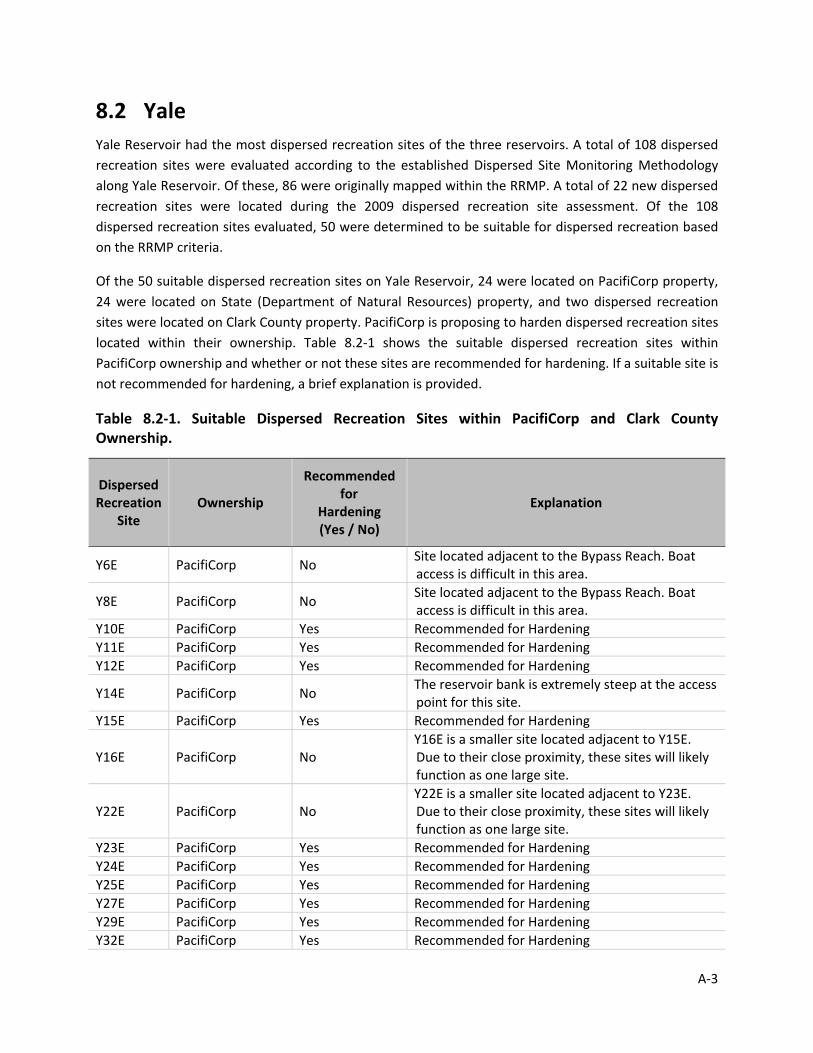
8.2 Yale Yale Reservoir had the most dispersed recreation sites of the three reservoirs. A total of 108 dispersed recreation sites were evaluated according to the established Dispersed Site Monitoring Methodology along Yale Reservoir. Of these, 86 were originally mapped within the RRMP. A total of 22 new dispersed recreation sites were located during the 2009 dispersed recreation site assessment. Of the 108 dispersed recreation sites evaluated, 50 were determined to be suitable for dispersed recreation based on the RRMP criteria.
Of the 50 suitable dispersed recreation sites on Yale Reservoir, 24 were located on PacifiCorp property, 24 were located on State (Department of Natural Resources) property, and two dispersed recreation sites were located on Clark County property. PacifiCorp is proposing to harden dispersed recreation sites located within their ownership. Table 8.2‐1 shows the suitable dispersed recreation sites within PacifiCorp ownership and whether or not these sites are recommended for hardening. If a suitable site is not recommended for hardening, a brief explanation is provided.
Table 8.2‐1. Suitable Dispersed Recreation Sites within PacifiCorp and Clark County Ownership.
Dispersed Recreation
Site Ownership
Recommended for
Hardening (Yes / No)
Explanation
Y6E PacifiCorp No Site located adjacent to the Bypass Reach. Boat access is difficult in this area.
Y8E PacifiCorp No Site located adjacent to the Bypass Reach. Boat access is difficult in this area.
Y10E PacifiCorp Yes Recommended for Hardening Y11E PacifiCorp Yes Recommended for Hardening Y12E PacifiCorp Yes Recommended for Hardening
Y14E PacifiCorp No The reservoir bank is extremely steep at the access point for this site.
Y15E PacifiCorp Yes Recommended for Hardening
Y16E PacifiCorp No Y16E is a smaller site located adjacent to Y15E. Due to their close proximity, these sites will likely function as one large site.
Y22E PacifiCorp No Y22E is a smaller site located adjacent to Y23E. Due to their close proximity, these sites will likely function as one large site.
Y23E PacifiCorp Yes Recommended for Hardening Y24E PacifiCorp Yes Recommended for Hardening Y25E PacifiCorp Yes Recommended for Hardening Y27E PacifiCorp Yes Recommended for Hardening Y29E PacifiCorp Yes Recommended for Hardening Y32E PacifiCorp Yes Recommended for Hardening
A‐3
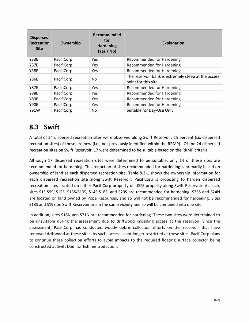
Recommended Dispersed
for Recreation Ownership Explanation
Hardening Site
(Yes / No)
Y33E PacifiCorp Yes Recommended for Hardening Y37E PacifiCorp Yes Recommended for Hardening Y38E PacifiCorp Yes Recommended for Hardening
Y86E PacifiCorp No The reservoir bank is extremely steep at the access point for this site.
Y87E PacifiCorp Yes Recommended for Hardening Y88E PacifiCorp Yes Recommended for Hardening Y89E PacifiCorp Yes Recommended for Hardening Y90E PacifiCorp Yes Recommended for Hardening Y91W PacifiCorp No Suitable for Day‐Use Only
8.3 Swift A total of 24 dispersed recreation sites were observed along Swift Reservoir. 25 percent (six dispersed recreation sites) of these are new (i.e., not previously identified within the RRMP). Of the 24 dispersed recreation sites on Swift Reservoir, 17 were determined to be suitable based on the RRMP criteria.
Although 17 dispersed recreation sites were determined to be suitable, only 14 of these sites are recommended for hardening. This reduction of sites recommended for hardening is primarily based on ownership of land at each dispersed recreation site. Table 8.3‐1 shows the ownership information for each dispersed recreation site along Swift Reservoir. PacifiCorp is proposing to harden dispersed recreation sites located on either PacifiCorp property or USFS property along Swift Reservoir. As such, sites S1S‐S9S, S12S, S13S/S19S, S14S‐S16S, and S20S are recommended for hardening. S23S and S24N are located on land owned by Pope Resources, and so will not be recommended for hardening. Sites S13S and S19S on Swift Reservoir are in the same vicinity and so will be combined into one site.
In addition, sites S18N and S21N are recommended for hardening. These two sites were determined to be unsuitable during the assessment due to driftwood impeding access at the reservoir. Since the assessment, PacifiCorp has conducted woody debris collection efforts on the reservoir that have removed driftwood at these sites. As such, access is not longer restricted at these sites. PacifiCorp plans to continue these collection efforts to avoid impacts to the required floating surface collector being constructed at Swift Dam for fish reintroduction.
A‐4

Table 8.3‐1. Ownership for Suitable Dispersed Recreation Sites along Swift Reservoir.
Dispersed Recreation Site
Ownership
S1S USFS S2S USFS S3S USFS S4S USFS S5S USFS S7S USFS S8S USFS S9S USFS S12S USFS
S13S / S19S1 PacifiCorp S14S PacifiCorp S15S PacifiCorp S16N PacifiCorp S18N PacifiCorp S20S PacifiCorp S21N PacifiCorp S23S Pope Resources S24N Pope Resources
1 Sites combined due to close proximity.
8.4 Conclusion Based on the results of the 2009 dispersed recreation site assessment and subsequent analysis, 31 sites are recommended for hardening as part of PacifiCorp’s Dispersed Recreation Program; no dispersed recreation sites at Merwin Reservoir, 15 at Yale Reservoir, and 16 at Swift Reservoir. A summary and complete list of the dispersed recreation sites recommended for hardening is shown below (Table 8.4‐1 and 8.4‐2); see Appendices B, C and D for additional details. The dispersed sites recommended for hardening are also shown on Figure 8.4‐1 (Yale) and Figure 8.4‐2 (Swift).
Table 8.4‐1. Summary of Dispersed Recreation Sites Recommended for Hardening
Reservoir Total Dispersed
Recreation Sites
Suitable Dispersed Recreation Sites
Sites Recommended for Hardening
Merwin 11 4 0 Yale 108 50 15 (17)1 Swift 24 17 16 (17)1 Total 143 71 31 (34)1
1 Sites Y11E/Y12E, Sites Y24E/Y25E, and Sites S13S/S19S are extremely close in proximity and so have been combined to constitute one site, respectively.
A‐5

Dog C
rk
Spee
lyai
Crk
Ole C
rk
Siouxon Crk
Cougar Crk
North Siouxon Crk
Dry
CrkPanamaker Crk
Speelyai Crk
Speelyai Crk
IP R
oad
IP R
oad
CougarCougar
Y10E_09Y11E_09
Y12E_09Y15E_09
Y24E_09Y25E_09
Y27E_09
Y29E_09Y33E_09
Y37E_09
Y88E_09
Y23E_09
Y32E_09
Y38E_09
Y90E_09
Y89E_09Y87E_09
Yal e
Re s e
r vo i r
Yal e
Re s e
r vo i r
Sites Recommended for Hardening
Mapped (RRMP)
New
Potential
Populated Places
Highways
Roads
Streams
National Forest
National Park or Monument
Figure 8.4-1Yale Reservoir Dispersed Recreation Sites
Recommended for HardeningLewis River Hydroelectric Project
Cowlitz, Clark and Skamania Counties, Washington
Mason, Bruce & Girard, Inc.Natural Resource Consultants since 1921
Data Source: Counties, Highways, LandOwnership and City Limits from WSDOT.
NAIP Aerial Imagery, 2005. All data reproduced by Mason, Bruce & Girard,
Inc. for the purposes of this document.
This product is for information purposes and may not be suitable for legal, engineering or surveying purposes. This information or data is provided with the understanding that conclusions drawn
from such information are the responsibility of the user.
503 S
0 0.5 10.25Miles
Mount St. Helens NationalMount St. Helens NationalVolcanic MonumentVolcanic Monument
IP R
oad
IP R
oad
Y24E_09Y25E_09
Y27E_09
Y29E_09
Y33E_09
Y37E_09
Y23E_09
Y32E_09
Y38E_09
Yale
Eas
t
Yale East
Cowlitz CountyCowlitz County
Ska
man
ia C
ount
yS
kam
ania
Cou
nty
Clark CountyClark County
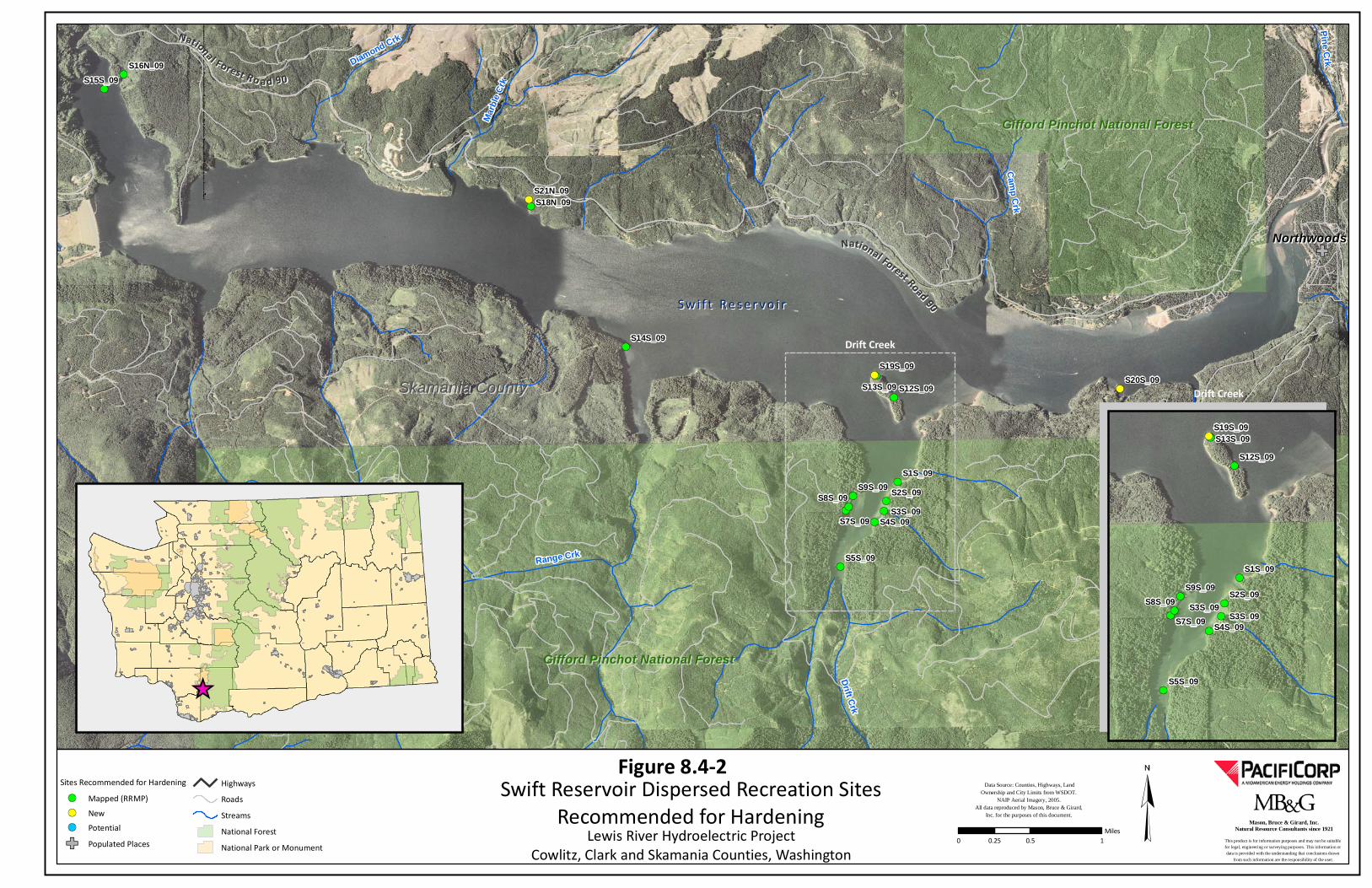
Skamania CountySkamania County
Range Crk
Drift Crk
Mar
ble
Crk
Cam
p Crk
Pine CrkDiamond CrkNNaattiioonnaall FF oorreesstt RR oo aa dd 99 00
NorthwoodsNorthwoods
S9S_09S8S_09
S7S_09
S5S_09
S4S_09
S2S_09
S1S_09
S21N_09S18N_09
S20S_09S19S_09
S16N_09
S15S_09
S14S_09
S12S_09S13S_09
S w i f t R e s e r v o i rS w i f t R e s e r v o i r
Sites Recommended for Hardening
Mapped (RRMP)
New
Potential
Populated Places
Highways
Roads
Streams
National Forest
National Park or Monument
Figure 8.4-2Swift Reservoir Dispersed Recreation Sites
Recommended for HardeningLewis River Hydroelectric Project
Cowlitz, Clark and Skamania Counties, Washington
Mason, Bruce & Girard, Inc.Natural Resource Consultants since 1921
Data Source: Counties, Highways, LandOwnership and City Limits from WSDOT.
NAIP Aerial Imagery, 2005. All data reproduced by Mason, Bruce & Girard,
Inc. for the purposes of this document.
This product is for information purposes and may not be suitable for legal, engineering or surveying purposes. This information or data is provided with the understanding that conclusions drawn
from such information are the responsibility of the user.
Gifford Pinchot National ForestGifford Pinchot National Forest
Gifford Pinchot National ForestGifford Pinchot National Forest
0 0.5 10.25Miles
NN aattiioonnaall FFoorreesstt RRooaadd 9900
S9S_09S8S_09
S7S_09
S5S_09
S4S_09
S3S_09S2S_09
S1S_09
S19S_09
S12S_09
S13S_09
Drift Creek
Drift Creek
S3S_09
S3S_09
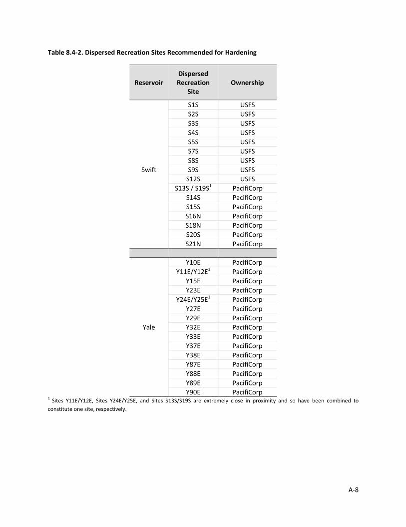
A‐8
Table 8.4‐2. Dispersed Recreation Sites Recommended for Hardening
Reservoir Dispersed Recreation
Site Ownership
Swift
S1S USFS S2S USFS S3S USFS S4S USFS S5S USFS S7S USFS S8S USFS S9S USFS S12S USFS
S13S / S19S1 PacifiCorp S14S PacifiCorp S15S PacifiCorp S16N PacifiCorp S18N PacifiCorp S20S PacifiCorp
S21N PacifiCorp
Yale
Y10E PacifiCorp Y11E/Y12E1 PacifiCorp
Y15E PacifiCorp Y23E PacifiCorp
Y24E/Y25E1 PacifiCorp Y27E PacifiCorp Y29E PacifiCorp Y32E PacifiCorp Y33E PacifiCorp Y37E PacifiCorp Y38E PacifiCorp Y87E PacifiCorp Y88E PacifiCorp Y89E PacifiCorp Y90E PacifiCorp
1 Sites Y11E/Y12E, Sites Y24E/Y25E, and Sites S13S/S19S are extremely close in proximity and so have been combined to constitute one site, respectively.

Appendix B
Merwin Reservoir Dispersed Recreation Site Data
Lewis River Dispersed Campsites Program
______________________________

Campground
Group Camping
Day Use / Picnic Area
RV Park
Food / Lodging
Dock / Moorage
Marina
Boat Ramp or Access
River Access
Fishing Access
Swimming
Interpretive Center
Informational Kiosk or Sign
Parking / Turnout
Trailhead
Fire Pit
Garbage Rack
Restroom (proposed)
Picnic Table
MERWIN
SWIFT
YALE
Lewis River Dispersed Campsites - Summary Sheets
Lewis River Dispersed Campsites - Summary Sheet LegendExisting Dispersed Campsites
Suitable
Unsuitable
Recreation
T&E Observations*
Vegetation*
SP
Species & Habitat Streams and Roads
Fish Presence
Yes
No
Unknown
Road Surface
Paved
Gravel
Dirt
Other
Abandoned
* Label = species / vegetation acronym(See tables on the following page)
Existing Dispersed Campsites
Suitable
Unsuitable
The following section is a summary of each dispersed campsite survey including field notes and the site’s feasibility as a dispersed campsite. Site feasibility is based on the following five criteria: - Site Data & Recreation Potential- Bank Access- Impact on Sensitive Habitat & Species- Impact on Cultural Resources- Driftwood Presence
(Each Dispersed Campsite polygon reflects it’s approximate shape and area.)
Sources: Dispersed campsites were collected by MB&G staff using Timble GeoXT 2005 handheld GPS units withan accuracy of < 3 meters. Aerial imagery is USDA NAIP 2005 one meter resolution. All other data provided by PacifiCorp.

DISPERSED CAMPSITES - LABEL KEY
Species Observation and Vegetation Label Keys
The labels below coincide with the map labels for T&E Observations and Vegetation
T&E Species Observation Label Key Vegetation Label Key
Label Common Name Label Type
BE Bald Eagle AG Agriculture
BH Bat Hibernaculum DI Disturbed
BTP Band-tailed Pigeon DV Developed
CF Cascade Frog ER Exposed Rock
CGS Cope's Giant Salamander ISL Island
CTS Cascade Torrent Salamander LP Lodgepole Pine
EWT Eastern Wild Turkey LUB Lacustrine Unconsolidated Bottom
GBH Great Blue Heron M Mature Conifer
GGO Great Gray Owl MD Meadow
GW Gray Wolf MS Mid-Successional Conifer
LMS Larch Mountain Salamander MS-T Mid-Successional Conifer (Thinned)
M Mink OG Old Growth
NAL Northern Alligator Lizard OR Orchard
O Osprey OW Oak Woodland
PL Pacific Lamprey P Pole Conifer
PWBB Pacific Western Big-eared Bat P-T Pole Conifer (Thinned)
PW Pileated Woodpecker PEM Palustrine Emergent Wetland
RLF Red-legged Frog PFO Palustrine Forested Wetland
RS Reticulated Sculpin PSS Palustrine Scrub-Shrub Wetland
SAL Southern Alligator Lizard PUB Palustrine Unconsolidated Bottom
TF Tailed Frog RD Riparian Deciduous
VDS Van Dyke's Salamander REC Recreation
WT Western Toad RES Residential
RESERVOIR Reservoir
RM Riparian Mixed
RO Rock Outcrop
ROW Right-of-way
RS Riparian Shrub
RT Rock Talus
RUB Riverine Unconsolidated Bottom
RUS Riverine Unconsolidated Shore
SH Shrub
SS Seedling /Sampling
SS1 Seedling / Sampling (New)
SV Sparsely Vegetated
UD Upland Deciduous
UM Upland Mixed
UM-T Upland Mixed (Thinned)
YRM Young Riparian Mixed
YUD Young Upland Deciduous
YUM Young Upland Mixed

Merwin Reservoir Dispersed Recreation Site Ownership
Site ID Township, Section, Range Site Suitability Owner
M1S T6N R4E Sec31 Unsuitable PacifiCorp
M2S T6N R2E Sec26 Suitable PacifiCorp
M3N T6N R2E Sec23 Unsuitable PacifiCorp
M4N T6N R2E Sec24 Suitable PacifiCorp
M5N T6N R3E Sec27 Suitable PacifiCorp
M6N T6N R3E Sec27 Suitable PacifiCorp
M7N T6N R3E Sec26 Unsuitable PacifiCorp
M8N T6N R3E Sec26 Unsuitable PacifiCorp
M9N T6N R4E Sec31 Unsuitable PacifiCorp
M10N T6N R4E Sec31 Unsuitable PacifiCorp
M11N T6N R3E Sec28 Unsuitable Federal

Site ID: Site IDReservoir: Swift, Yale, MerwinLatitude / Longitude: LAT / LONGSurvey Date: month/day/yearWater Level: FeetSurveyors: Field StaffAccesss: Auto, boat, footAssessment: Complete, Partial, NoneStatus: Suitable, Unsuitable
Campfire Ring: None, 1, >1 Trash:Low (0-2), Medium (2-5), High (>5) Erosion: Y / N
Toilet: Y / N Vandalism:Low (0-5), Medium (5-10), High (> 10) Erosion Type:
None, Cobble, Silt/Cobble, Silt, Deposition, Silt/Sand/Cobble, Cobble/Gravel/Sand
Notes: Notes Cultural Site Conflict: Y / N
Bank Slope:Low (<10%), Medium (10-20%), High (>20%) Bank Material:
Gravel, concrete, dirt, sand Driftwood Present: Y / N
# of Driftwood:Low (<5), Medium (5-10), High (>10 pieces)
Driftwood Affecting Access: Y / N
Notes: Notes
Wetlands Present: Adjacent, Onsite, NA Wetlands Type:Emergent, Forested, Scrub / Shrub Stream Present: Y / N
Stream Type: Perennial, IntermittentNotes: Notes
Mapped Cover Type:See Table 4. on page 12 for values
Invasive Species Present: Y / N
Invasive Species Type: Species
Notes: NotesEvidence Observed NSO Management Area:
Beaver: Y / N Y / N Y / NDeer: Y / N Y / N NSO Nest Proximity:Elk: Y / N Y / N Y / N
Eagle: Y / N Y / NBald Eagle Roost Range:
Woodpecker: Y / N Y / N Y / N
Other raptor: Y / N Y / NBald Eagle Nest Proximity:
Avian Notes: Notes Y / NMammal Notes: NotesOther notes: Notes
Plan
tsSe
nsit
ive
Spec
ies
Summary Sheet KeyD
ispe
rsed
Sit
eH
uman
Impa
cts
Bank
Acc
ess
Wat
er

RESERVOIR
UM
MS
MS UMMS
MSMD RDMS-T
M1S_09
2009 Site ID:
Reservoir:
Survey Date:
Surveyors:
Access:
Status:
Campfire Ring: 1
Vandalism: 0-5
Trash: 0-2 Bags
Toilet: None
Notes (below):
Site located on small island.
Bank Slope: < 10% Bank Material: Gravel
Driftwood Present:
# of Driftwood Pieces: NA Driftwood Affecting Access: No
Notes (below):Good access to site.
Mapped Cover Type: Not Available
Invasive Species Present: Invasive Species Type:
Notes:
No
Wetlands Present:
NA
Wetlands Type:
Notes:
Stream Present:
Stream Type:
No
Beaver
Evidence Observed
Deer
Elk
Eagle
Woodpecker
Other Raptor
N N
N N
N N
N N
N N
N N
M1S
Merwin
4/23/2009
A. Casey & C. Maynard (MB&G)
Boat
Complete
M1S
Lat / Long: 45.9619152125
Approx. Site Size (Sqft)*: 548
Meets Erosion Criteria :
Erosion Type:
Yes
Cobble
No
Adjacent Emergent
None
Avian: None
Mammals: None
Other: None
Criterion 1- Site Data & Recreation:U
nsui
tabl
e
Water Level (ft): 237
Assessment:
Unsuitable
Dis
pers
ed S
ite
Hum
an Im
pact
sBa
nk A
cces
sW
ater
Plan
ts
None
Site located on island that is almost all wetland.
Sens
itiv
e Sp
ecie
s
Resu
lts
Criterion 2 - Bank Access:
Criterion 3 - Sensitive Habitat & Species:
Criterion 4 - Cultural Resources:
Criterion 5 - Driftwood:
Status: Unsuitable
Suitable
Suitable
Unsuitable
Suitable
Suitable
Mason, Bruce & Girard, Inc.Natural Resource Consultants since 1921
NSO Management Area: No
Bald Eagle RoostRange: No
Cultural Site Conflict: No
-122.365863046/
* 0 values indicate that the site was not measured.
0 200 400100Feet
Bald Eagle Nest Proximity:
NSO Nest Proximity:
No
No

1
Lewis River Dispersed Camping Site PhotosReservoir: Merwin Campsite ID: M1 S Date Surveyed: 4/23/09
Photo Direction: North
Description/Notes: View towards Merwin Reservoir from M1 S. Campsite center is near edge of water, in sandy beach area.
Photo Direction: East Description/Notes: Eastern edge of campsite M1 S. Island is dominated by reed canarygrass (Phalarisarundinacea)
Photo Direction: South
Description/Notes: Southern edge of M1 S. Note adjacent wetland in photo background.
Photo Direction: West Description/Notes: Western edge of campsite M1 S. Suitable boat access from western end of island.
Boat

2
Lewis River Dispersed Camping Site PhotosReservoir: Merwin Campsite ID: M1 S Date Surveyed: 4/23/09
Photo Direction: East Description/Notes: View of campsite M1 S, as seen from the reservoir, looking east. West end of island provides suitable boat access point.
Photo Direction: South
Description/Notes: View of campsite M1 S, as seen from the reservoir. Campsite encompasses gravel beach area.

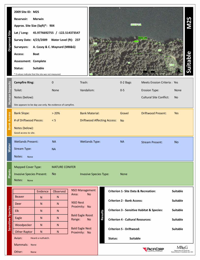
M
RESERVOIR
MSUD
YUM
UM
MS
M2S_09
2009 Site ID:
Reservoir:
Survey Date:
Surveyors:
Access:
Status:
Campfire Ring: 0
Vandalism: 0-5
Trash: 0-2 Bags
Toilet: None
Notes (below):
Site appears to be day use only. No evidence of campfire.
Bank Slope: > 20% Bank Material: Gravel
Driftwood Present:
# of Driftwood Pieces: < 5 Driftwood Affecting Access: No
Notes (below):Good access to site.
Mapped Cover Type: MATURE CONIFER
Invasive Species Present: Invasive Species Type:
Notes:
No
Wetlands Present:
NA
Wetlands Type:
Notes:
Stream Present:
Stream Type:
No
Beaver
Evidence Observed
Deer
Elk
Eagle
Woodpecker
Other Raptor
N N
N N
N N
N N
N N
N N
M2S
Merwin
4/23/2009
A. Casey & C. Maynard (MB&G)
Boat
Complete
M2S
Lat / Long: 45.9776692755
Approx. Site Size (Sqft)*: 904
Meets Erosion Criteria :
Erosion Type:
Yes
None
Yes
NA NA
None
Avian: Heard a nuthatch.
Mammals: None
Other: None
Criterion 1- Site Data & Recreation:Su
itab
le
Water Level (ft): 237
Assessment:
Suitable
Dis
pers
ed S
ite
Hum
an Im
pact
sBa
nk A
cces
sW
ater
Plan
ts
None
None
Sens
itiv
e Sp
ecie
s
Resu
lts
Criterion 2 - Bank Access:
Criterion 3 - Sensitive Habitat & Species:
Criterion 4 - Cultural Resources:
Criterion 5 - Driftwood:
Status: Suitable
Suitable
Suitable
Suitable
Suitable
Suitable
Mason, Bruce & Girard, Inc.Natural Resource Consultants since 1921
NSO Management Area: No
Bald Eagle RoostRange: No
Cultural Site Conflict: No
-122.514373547/
* 0 values indicate that the site was not measured.
0 200 400100Feet
Bald Eagle Nest Proximity:
NSO Nest Proximity:
No
No

1
Lewis River Dispersed Camping Site PhotosReservoir: Merwin Campsite ID: M2 S Date Surveyed: 4/23/09
Photo Direction: North
Description/Notes: View towards Merwin Reservoir from M2 S. Campsite center is near edge of slope.
Photo Direction: East Description/Notes: Eastern edge of campsite M2 S, which is located in dirt road.
Photo Direction: South
Description/Notes: Southern edge of M2 S. Note steep slope in photo background.
Photo Direction: West Description/Notes: Western edge of campsite M2 S. Dirt road slopes steeply towards reservoir.

2
Lewis River Dispersed Camping Site PhotosReservoir: Merwin Campsite ID: M2 S Date Surveyed: 4/23/09
Photo Direction: East Description/Notes: View of campsite M2 S, as seen from the reservoir, looking south. Suitable boat access point located at end of old dirt road.


MS
RESERVOIR
UM
P-T
SS1
UM
UD
UDUM
RM
O
M3N_09
2009 Site ID:
Reservoir:
Survey Date:
Surveyors:
Access:
Status:
Campfire Ring: 0
Vandalism: NA
Trash: NA
Toilet: NA
Notes (below):
No evidence of use at site; area not suitable for dispersed site location. Area is steep and difficult to access.
Bank Slope: > 20% Bank Material: Dirt
Driftwood Present:
# of Driftwood Pieces: < 5 Driftwood Affecting Access: Yes
Notes (below):Too steep for access.
Mapped Cover Type: MID-SUCCESSIONAL CONIFER
Invasive Species Present: Invasive Species Type:
Notes:
No
Wetlands Present:
NA
Wetlands Type:
Notes:
Stream Present:
Stream Type:
No
Beaver
Evidence Observed
Deer
Elk
Eagle
Woodpecker
Other Raptor
N N
N N
Y N
N N
N N
N N
M3N
Merwin
4/23/2009
A. Casey & C. Maynard (MB&G)
Boat
Partial
M3N
Lat / Long: 45.9859755135
Approx. Site Size (Sqft)*: 0
Meets Erosion Criteria :
Erosion Type:
Yes
None
Yes
NA NA
None
Avian: None
Mammals: None
Other: None
Criterion 1- Site Data & Recreation:U
nsui
tabl
e
Water Level (ft): 237
Assessment:
Unsuitable
Dis
pers
ed S
ite
Hum
an Im
pact
sBa
nk A
cces
sW
ater
Plan
ts
None
None
Sens
itiv
e Sp
ecie
s
Resu
lts
Criterion 2 - Bank Access:
Criterion 3 - Sensitive Habitat & Species:
Criterion 4 - Cultural Resources:
Criterion 5 - Driftwood:
Status: Unsuitable
Unsuitable
Suitable
Suitable
Suitable
Unsuitable
Mason, Bruce & Girard, Inc.Natural Resource Consultants since 1921
NSO Management Area: No
Bald Eagle RoostRange: No
Cultural Site Conflict: No
-122.520585155/
* 0 values indicate that the site was not measured.
0 200 400100Feet
Bald Eagle Nest Proximity:
NSO Nest Proximity:
No
No
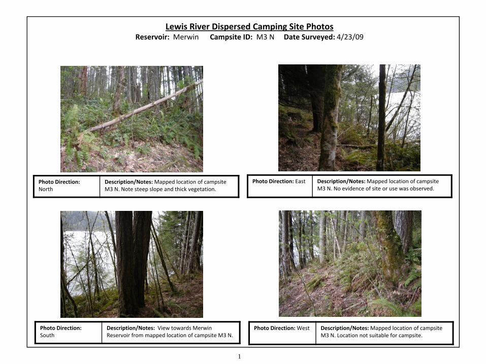
1
Lewis River Dispersed Camping Site PhotosReservoir: Merwin Campsite ID: M3 N Date Surveyed: 4/23/09
Photo Direction: North
Description/Notes: Mapped location of campsite M3 N. Note steep slope and thick vegetation.
Photo Direction: East Description/Notes: Mapped location of campsite M3 N. No evidence of site or use was observed.
Photo Direction: South
Description/Notes: View towards MerwinReservoir from mapped location of campsite M3 N.
Photo Direction: West Description/Notes: Mapped location of campsite M3 N. Location not suitable for campsite.
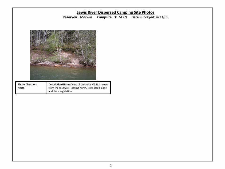
2
Lewis River Dispersed Camping Site PhotosReservoir: Merwin Campsite ID: M3 N Date Surveyed: 4/23/09
Photo Direction: North
Description/Notes: View of campsite M3 N, as seen from the reservoir, looking north. Note steep slope and thick vegetation.

UM
RESERVOIR
UM
SS1
RM
ROW
RMROW
UD
ROW
UM
YUD
AG AG
M4N_09
2009 Site ID:
Reservoir:
Survey Date:
Surveyors:
Access:
Status:
Campfire Ring: 1
Vandalism: 0-5
Trash: 0-2 Bags
Toilet: None
Notes (below):
Tent left at site.
Bank Slope: < 10% Bank Material: Gravel
Driftwood Present:
# of Driftwood Pieces: < 5 Driftwood Affecting Access: No
Notes (below):Good access to site.
Mapped Cover Type: UPLAND MIXED
Invasive Species Present: Invasive Species Type:
Notes:
Yes
Wetlands Present:
NA
Wetlands Type:
Notes:
Stream Present:
Stream Type:
No
Beaver
Evidence Observed
Deer
Elk
Eagle
Woodpecker
Other Raptor
N N
N N
Y N
N N
N N
N N
M4N
Merwin
4/23/2009
A. Casey & C. Maynard (MB&G)
Boat
Complete
M4N
Lat / Long: 45.9914600975
Approx. Site Size (Sqft)*: 688
Meets Erosion Criteria :
Erosion Type:
Yes
None
Yes
NA NA
Himalayan blackberry
Avian: None
Mammals: None
Other: None
Criterion 1- Site Data & Recreation:Su
itab
le
Water Level (ft): 237
Assessment:
Suitable
Dis
pers
ed S
ite
Hum
an Im
pact
sBa
nk A
cces
sW
ater
Plan
ts
None
Small stream 50 feet west of site.
Sens
itiv
e Sp
ecie
s
Resu
lts
Criterion 2 - Bank Access:
Criterion 3 - Sensitive Habitat & Species:
Criterion 4 - Cultural Resources:
Criterion 5 - Driftwood:
Status: Suitable
Suitable
Suitable
Suitable
Suitable
Suitable
Mason, Bruce & Girard, Inc.Natural Resource Consultants since 1921
NSO Management Area: No
Bald Eagle RoostRange: No
Cultural Site Conflict: No
-122.500896049/
* 0 values indicate that the site was not measured.
0 200 400100Feet
Bald Eagle Nest Proximity:
NSO Nest Proximity:
No
No

1
Lewis River Dispersed Camping Site PhotosReservoir: Merwin Campsite ID: M4 N Date Surveyed: 4/23/09
Photo Direction: North
Description/Notes: Northern edge of campsite M4 N. Stinging nettle (Urtica dioica) at campsite edge.
Photo Direction: East Description/Notes: View towards MerwinReservoir. Path leads from campsite to waters edge.
Photo Direction: South
Description/Notes: Southern edge of campsite M4 N. Note driftwood “bench” at photo left.
Photo Direction: West Description/Notes: Large, open tent area at western end of M4 N. Faint trail extends to west.

2
Lewis River Dispersed Camping Site PhotosReservoir: Merwin Campsite ID: M4 N Date Surveyed: 4/23/09
Photo Direction: North
Description/Notes: View of campsite M4 N, as seen from the reservoir, looking north. Note wide beach and easy boat access.


RESERVOIR
MS UM
SS
UD
MS
MS
UM
MS
MS O
M6N_09
M5N_09
2009 Site ID:
Reservoir:
Survey Date:
Surveyors:
Access:
Status:
Campfire Ring: 0
Vandalism: 0-5
Trash: 0-2 Bags
Toilet: None
Notes (below):
No evidence of use at site.
Bank Slope: 10-20% Bank Material: Gravel
Driftwood Present:
# of Driftwood Pieces: < 5 Driftwood Affecting Access: No
Notes (below):None
Mapped Cover Type: MID-SUCCESSIONAL CONIFER
Invasive Species Present: Invasive Species Type:
Notes:
No
Wetlands Present:
NA
Wetlands Type:
Notes:
Stream Present:
Stream Type:
No
Beaver
Evidence Observed
Deer
Elk
Eagle
Woodpecker
Other Raptor
N N
N N
N N
N N
N N
N N
M5N
Merwin
4/23/2009
A. Casey & C. Maynard (MB&G)
Boat
Partial
M5N
Lat / Long: 45.9788475688
Approx. Site Size (Sqft)*: 0
Meets Erosion Criteria :
Erosion Type:
Yes
None
Yes
NA NA
None
Avian: None
Mammals: None
Other: None
Criterion 1- Site Data & Recreation:Su
itab
le
Water Level (ft): 237
Assessment:
Suitable
Dis
pers
ed S
ite
Hum
an Im
pact
sBa
nk A
cces
sW
ater
Plan
ts
None
None
Sens
itiv
e Sp
ecie
s
Resu
lts
Criterion 2 - Bank Access:
Criterion 3 - Sensitive Habitat & Species:
Criterion 4 - Cultural Resources:
Criterion 5 - Driftwood:
Status: Suitable
Suitable
Suitable
Suitable
Suitable
Suitable
Mason, Bruce & Girard, Inc.Natural Resource Consultants since 1921
NSO Management Area: No
Bald Eagle RoostRange: No
Cultural Site Conflict: No
-122.417062461/
* 0 values indicate that the site was not measured.
0 200 400100Feet
Bald Eagle Nest Proximity:
NSO Nest Proximity:
No
No
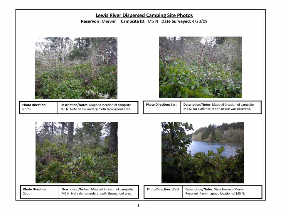
1
Lewis River Dispersed Camping Site PhotosReservoir: Merwin Campsite ID: M5 N Date Surveyed: 4/23/09
Photo Direction: North
Description/Notes: Mapped location of campsite M5 N. Note dense undergrowth throughout area.
Photo Direction: East Description/Notes: Mapped location of campsite M5 N. No evidence of site or use was observed.
Photo Direction: South
Description/Notes: Mapped location of campsite M5 N. Note dense undergrowth throughout area.
Photo Direction: West Description/Notes: View towards MerwinReservoir from mapped location of M5 N.

2
Lewis River Dispersed Camping Site PhotosReservoir: Merwin Campsite ID: M5 N Date Surveyed: 4/23/09
Photo Direction: North
Description/Notes: View of mapped location of campsite M5 N, as seen from the reservoir. Note dense undergrowth. No evidence of use was observed.

RESERVOIR
UD
UMMS
SSSS1
MS
MS
P-T
O
O
M6N_09
M5N_09
M7N_09
2009 Site ID:
Reservoir:
Survey Date:
Surveyors:
Access:
Status:
Campfire Ring: 1
Vandalism: 5-10
Trash: 0-2 Bags
Toilet: None
Notes (below):
None
Bank Slope: 10-20% Bank Material: Gravel
Driftwood Present:
# of Driftwood Pieces: < 5 Driftwood Affecting Access: No
Notes (below):Good access to site.
Mapped Cover Type: UPLAND DECIDUOUS
Invasive Species Present: Invasive Species Type:
Notes:
No
Wetlands Present:
NA
Wetlands Type:
Notes:
Stream Present:
Stream Type:
No
Beaver
Evidence Observed
Deer
Elk
Eagle
Woodpecker
Other Raptor
N N
N N
Y N
N N
N Y
N Y
M6N
Merwin
4/23/2009
A. Casey & C. Maynard (MB&G)
Boat
Complete
M6N
Lat / Long: 45.9781980653
Approx. Site Size (Sqft)*: 1162
Meets Erosion Criteria :
Erosion Type:
Yes
None
Yes
NA NA
None
Avian: Heard an osprey and a pileated woodpecker.
Mammals: None
Other: None
Criterion 1- Site Data & Recreation:Su
itab
le
Water Level (ft): 237
Assessment:
Suitable
Dis
pers
ed S
ite
Hum
an Im
pact
sBa
nk A
cces
sW
ater
Plan
ts
None
None
Sens
itiv
e Sp
ecie
s
Resu
lts
Criterion 2 - Bank Access:
Criterion 3 - Sensitive Habitat & Species:
Criterion 4 - Cultural Resources:
Criterion 5 - Driftwood:
Status: Suitable
Suitable
Suitable
Suitable
Suitable
Suitable
Mason, Bruce & Girard, Inc.Natural Resource Consultants since 1921
NSO Management Area: No
Bald Eagle RoostRange: No
Cultural Site Conflict: No
-122.414246958/
* 0 values indicate that the site was not measured.
0 200 400100Feet
Bald Eagle Nest Proximity:
NSO Nest Proximity:
No
No

1
Lewis River Dispersed Camping Site PhotosReservoir: Merwin Campsite ID: M6 N Date Surveyed: 4/23/09
Photo Direction: North
Description/Notes: Northern edge of campsite M6 N. Note exposed tree roots resulting from site use.
Photo Direction: East Description/Notes: Eastern edge of campsite M6 N. Note fire ring in photo foreground.
Photo Direction: South
Description/Notes: View to Merwin Reservoir. Sign has been removed from post in foreground.
Photo Direction: West Description/Notes: Western extent of campsite M6 N. Note exposed roots throughout site.
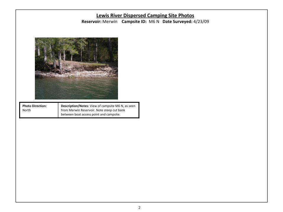
2
Lewis River Dispersed Camping Site PhotosReservoir: Merwin Campsite ID: M6 N Date Surveyed: 4/23/09
Photo Direction: North
Description/Notes: View of campsite M6 N, as seen from Merwin Reservoir. Note steep cut bank between boat access point and campsite.

UD
SS1
RESERVOIR
UM
P-TUM
MS
O
OM6N_09
M7N_09
2009 Site ID:
Reservoir:
Survey Date:
Surveyors:
Access:
Status:
Campfire Ring: 0
Vandalism: NA
Trash: NA
Toilet: NA
Notes (below):
None
Bank Slope: > 20% Bank Material: Gravel
Driftwood Present:
# of Driftwood Pieces: NA Driftwood Affecting Access: No
Notes (below):Steep access.
Mapped Cover Type: UPLAND DECIDUOUS
Invasive Species Present: Invasive Species Type:
Notes:
No
Wetlands Present:
NA
Wetlands Type:
Notes:
Stream Present:
Stream Type:
No
Beaver
Evidence Observed
Deer
Elk
Eagle
Woodpecker
Other Raptor
N N
N N
N N
N N
N N
N N
M7N
Merwin
4/23/2009
A. Casey & C. Maynard (MB&G)
Boat
Partial
M7N
Lat / Long: 45.9780029919
Approx. Site Size (Sqft)*: 0
Meets Erosion Criteria :
Erosion Type:
Yes
None
No
NA NA
None
Avian: None
Mammals: None
Other: None
Criterion 1- Site Data & Recreation:U
nsui
tabl
e
Water Level (ft): 237
Assessment:
Unsuitable
Dis
pers
ed S
ite
Hum
an Im
pact
sBa
nk A
cces
sW
ater
Plan
ts
None
None
Sens
itiv
e Sp
ecie
s
Resu
lts
Criterion 2 - Bank Access:
Criterion 3 - Sensitive Habitat & Species:
Criterion 4 - Cultural Resources:
Criterion 5 - Driftwood:
Status: Unsuitable
Unsuitable
Suitable
Suitable
Suitable
Suitable
Mason, Bruce & Girard, Inc.Natural Resource Consultants since 1921
NSO Management Area: No
Bald Eagle RoostRange: No
Cultural Site Conflict: No
-122.411202447/
* 0 values indicate that the site was not measured.
0 200 400100Feet
Bald Eagle Nest Proximity:
NSO Nest Proximity:
No
No

1
Lewis River Dispersed Camping Site PhotosReservoir: Merwin Campsite ID: M7 N Date Surveyed: 4/23/09
Photo Direction: North
Description/Notes: Mapped location of M7 N. No evidence of campsite was observed.
Photo Direction: North
Description/Notes: Mapped location of M7 N. Note small creek entering reservoir, photo center.
Photo Direction: Northwest
Description/Notes: Mapped location of M7 N. Due to steep slope, this area is unsuitable for campsite.
RESERVOIR
P-TUM
SS
UD
UM
M8N_09
2009 Site ID:
Reservoir:
Survey Date:
Surveyors:
Access:
Status:
Campfire Ring: 1
Vandalism: 5-10
Trash: 0-2 Bags
Toilet: Established
Notes (below):
Several user-created structures (stools, tables, etc.) at site.
Bank Slope: 10-20% Bank Material: Gravel
Driftwood Present:
# of Driftwood Pieces: < 5 Driftwood Affecting Access: No
Notes (below):None
Mapped Cover Type: UPLAND MIXED
Invasive Species Present: Invasive Species Type:
Notes:
No
Wetlands Present:
NA
Wetlands Type:
Notes:
Stream Present:
Stream Type:
No
Beaver
Evidence Observed
Deer
Elk
Eagle
Woodpecker
Other Raptor
N N
N N
Y N
N N
N N
N N
M8N
Merwin
4/23/2009
A. Casey & C. Maynard (MB&G)
Boat
Complete
M8N
Lat / Long: 45.9738419448
Approx. Site Size (Sqft)*: 414
Meets Erosion Criteria :
Erosion Type:
Yes
None
Yes
NA NA
None
Avian: None
Mammals: None
Other: None
Criterion 1- Site Data & Recreation:U
nsui
tabl
e
Water Level (ft): 237
Assessment:
Unsuitable
Dis
pers
ed S
ite
Hum
an Im
pact
sBa
nk A
cces
sW
ater
Plan
ts
None
None
Sens
itiv
e Sp
ecie
s
Resu
lts
Criterion 2 - Bank Access:
Criterion 3 - Sensitive Habitat & Species:
Criterion 4 - Cultural Resources:
Criterion 5 - Driftwood:
Status: Unsuitable
Suitable
Suitable
Suitable
Unsuitable
Suitable
Mason, Bruce & Girard, Inc.Natural Resource Consultants since 1921
NSO Management Area: No
Bald Eagle RoostRange: No
Cultural Site Conflict: Yes
-122.403571016/
* 0 values indicate that the site was not measured.
0 200 400100Feet
Bald Eagle Nest Proximity:
NSO Nest Proximity:
No
No

1
Lewis River Dispersed Camping Site PhotosReservoir: Merwin Campsite ID: M8 N Date Surveyed: 4/23/09
Photo Direction: North
Description/Notes: Northern edge of campsite M8 N. Note user‐created wooden structure.
Photo Direction: East Description/Notes: Eastern edge of campsite M8 N. Multiple pieces of driftwood observed in campsite.
Photo Direction: South
Description/Notes: Southern edge of campsite M8 N. Merwin Reservoir can be seen in background.
Photo Direction: West Description/Notes: Western extent of campsite M8 N. Path extends to additional clearing.

2
Lewis River Dispersed Camping Site PhotosReservoir: Merwin Campsite ID: M8 N Date Surveyed: 4/23/09
Photo Direction: North
Description/Notes: General view of campsite M8 N. Note wooden structure and numerous driftwood pieces. Surveyor in orange vest is standing at site center (fire ring).
Photo Direction: North
Description/Notes: View of campsite M8 N, as seen from Merwin Reservoir. Banks are undercut at this location, but campsite can still be easily accessed from the water.
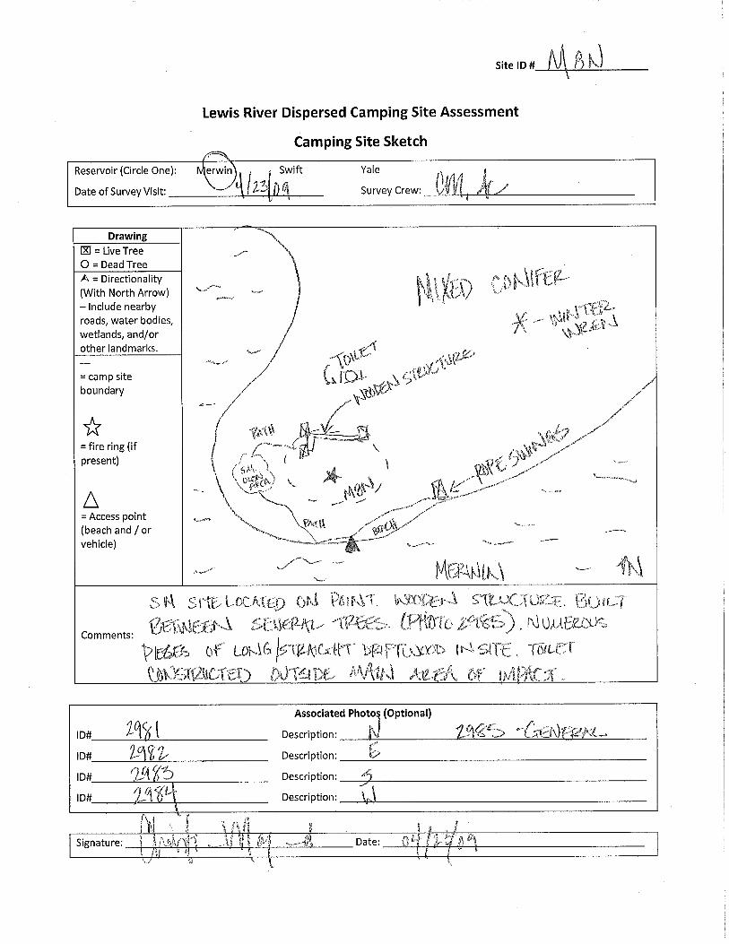

MS
M
RESERVOIR
P-T
PUD UDSHRES
UD
UM
MS UM RESUM
O
M9N_09
2009 Site ID:
Reservoir:
Survey Date:
Surveyors:
Access:
Status:
Campfire Ring: 0
Vandalism: NA
Trash: NA
Toilet: NA
Notes (below):
No evidence of use at site. Area unsuitable for dispersed recreation because it is located in a wetland.
Bank Slope: < 10% Bank Material: Gravel
Driftwood Present:
# of Driftwood Pieces: 5-10 Driftwood Affecting Access: No
Notes (below):None
Mapped Cover Type: Not Available
Invasive Species Present: Invasive Species Type:
Notes:
No
Wetlands Present:
Perennial
Wetlands Type:
Notes:
Stream Present:
Stream Type:
Yes
Beaver
Evidence Observed
Deer
Elk
Eagle
Woodpecker
Other Raptor
N N
N N
N N
N N
N N
N N
M9N
Merwin
4/23/2009
A. Casey & C. Maynard (MB&G)
Boat
Partial
M9N
Lat / Long: 45.9627652818
Approx. Site Size (Sqft)*: 0
Meets Erosion Criteria :
Erosion Type:
Yes
None
Yes
On Site Emergent
None
Avian: None
Mammals: None
Other: None
Criterion 1- Site Data & Recreation:U
nsui
tabl
e
Water Level (ft): 237
Assessment:
Unsuitable
Dis
pers
ed S
ite
Hum
an Im
pact
sBa
nk A
cces
sW
ater
Plan
ts
None
None
Sens
itiv
e Sp
ecie
s
Resu
lts
Criterion 2 - Bank Access:
Criterion 3 - Sensitive Habitat & Species:
Criterion 4 - Cultural Resources:
Criterion 5 - Driftwood:
Status: Unsuitable
Unsuitable
Suitable
Unsuitable
Suitable
Suitable
Mason, Bruce & Girard, Inc.Natural Resource Consultants since 1921
NSO Management Area: No
Bald Eagle RoostRange: No
Cultural Site Conflict: No
-122.361726219/
* 0 values indicate that the site was not measured.
0 200 400100Feet
Bald Eagle Nest Proximity:
NSO Nest Proximity:
No
No

1
Lewis River Dispersed Camping Site PhotosReservoir: Merwin Campsite ID: M9 N Date Surveyed: 4/23/09
Photo Direction: North
Description/Notes: Small stream and associated wetland encompass the mapped location of M9 N.
Photo Direction: East Description/Notes: Mapped location of campsite M9 N. No evidence of site or use was observed.
Photo Direction: South
Description/Notes: Mapped location of M9 N is unsuitable for campsite due to stream/wetland.
Photo Direction: West Description/Notes: Mapped location of M9 N, as seen from reservoir. Note stream/wetland, center.

MS
RESERVOIR
UM
M
UM
SS
RD
ROW
UM
ROW
RD
UM
UM
O
M10N_09
2009 Site ID:
Reservoir:
Survey Date:
Surveyors:
Access:
Status:
Campfire Ring: 0
Vandalism: NA
Trash: NA
Toilet: NA
Notes (below):
No evidence of use at site.
Bank Slope: > 20% Bank Material: Gravel
Driftwood Present:
# of Driftwood Pieces: NA Driftwood Affecting Access: No
Notes (below):Access okay.
Mapped Cover Type: Not Available
Invasive Species Present: Invasive Species Type:
Notes:
No
Wetlands Present:
NA
Wetlands Type:
Notes:
Stream Present:
Stream Type:
No
Beaver
Evidence Observed
Deer
Elk
Eagle
Woodpecker
Other Raptor
N N
N N
N N
N N
N N
N N
M10N
Merwin
4/23/2009
A. Casey & C. Maynard (MB&G)
Boat
Partial
M10
N
Lat / Long: 45.9583730028
Approx. Site Size (Sqft)*: 0
Meets Erosion Criteria :
Erosion Type:
Yes
None
No
Adjacent Emergent
None
Avian: None
Mammals: None
Other: None
Criterion 1- Site Data & Recreation:U
nsui
tabl
e
Water Level (ft): 237
Assessment:
Unsuitable
Dis
pers
ed S
ite
Hum
an Im
pact
sBa
nk A
cces
sW
ater
Plan
ts
None
Wetland adjacent to site, near beach area.
Sens
itiv
e Sp
ecie
s
Resu
lts
Criterion 2 - Bank Access:
Criterion 3 - Sensitive Habitat & Species:
Criterion 4 - Cultural Resources:
Criterion 5 - Driftwood:
Status: Unsuitable
Unsuitable
Suitable
Unsuitable
Suitable
Suitable
Mason, Bruce & Girard, Inc.Natural Resource Consultants since 1921
NSO Management Area: No
Bald Eagle RoostRange: No
Cultural Site Conflict: No
-122.360120057/
* 0 values indicate that the site was not measured.
0 200 400100Feet
Bald Eagle Nest Proximity:
NSO Nest Proximity:
No
No

1
Lewis River Dispersed Camping Site PhotosReservoir: Merwin Campsite ID: M10 N Date Surveyed: 4/23/09
Photo Direction: Southeast
Description/Notes: Mapped location of M10 N. This area is a steep, narrow peninsula.
Photo Direction: Southeast
Description/Notes: Mapped location of campsite M10 N. No evidence of site was observed.
Photo Direction: Northeast
Description/Notes: Steep, narrow, rocky peninsula is unsuitable for campsite. Footpath observed.
Photo Direction: North
Description/Notes: Mapped location of M10 N, as seen from reservoir. Difficult access from water.


RESERVOIR
UM
SS1
UMMSMS
SS
O
BE
BE
M11N_09
2009 Site ID:
Reservoir:
Survey Date:
Surveyors:
Access:
Status:
Campfire Ring: 0
Vandalism: 0-5
Trash: 0-2 Bags
Toilet: None
Notes (below):
None
Bank Slope: 10-20% Bank Material: Gravel
Driftwood Present:
# of Driftwood Pieces: NA Driftwood Affecting Access: No
Notes (below):None
Mapped Cover Type: Not Available
Invasive Species Present: Invasive Species Type:
Notes:
No
Wetlands Present:
NA
Wetlands Type:
Notes:
Stream Present:
Stream Type:
No
Beaver
Evidence Observed
Deer
Elk
Eagle
Woodpecker
Other Raptor
N N
N N
N N
N N
N N
N N
M11N
Merwin
4/23/2009
A. Casey & C. Maynard (MB&G)
Boat
Partial
M11
N
Lat / Long: 45.9779492333
Approx. Site Size (Sqft)*: 0
Meets Erosion Criteria :
Erosion Type:
Yes
Cobble
No
NA NA
None
Avian: None
Mammals: None
Other: None
Criterion 1- Site Data & Recreation:U
nsui
tabl
e
Water Level (ft): 237
Assessment:
Unsuitable
Dis
pers
ed S
ite
Hum
an Im
pact
sBa
nk A
cces
sW
ater
Plan
ts
None
None
Sens
itiv
e Sp
ecie
s
Resu
lts
Criterion 2 - Bank Access:
Criterion 3 - Sensitive Habitat & Species:
Criterion 4 - Cultural Resources:
Criterion 5 - Driftwood:
Status: Unsuitable
Suitable
Suitable
Suitable
Unsuitable
Suitable
Mason, Bruce & Girard, Inc.Natural Resource Consultants since 1921
NSO Management Area: No
Bald Eagle RoostRange: No
Cultural Site Conflict: Yes
-122.436192556/
* 0 values indicate that the site was not measured.
0 200 400100Feet
Bald Eagle Nest Proximity:
NSO Nest Proximity:
No
No