Leveraging Maximo for Data Driven Decisions In the Nation’s 5 th Largest School District

Leveraging SQL Spatial Analytics
for Making Business Decisions
Rolf TesmerSQL & BI Solution Architect -- Dimension [email protected]
SQL Saturday #296, Melbourne
5th April 2014

Dimension Data today
2013 global
revenues of
USD 5.8 billion
73% of Global Fortune 100 and
59% of Global Fortune 500
are Dimension Data clients
Client-centric,
services-focused
business
Extensive experience in
emerging markets
Over 15,000 employeeswith operations in
52 countries
across 5 regions
Over
6,000clients across all
industry sectors

Agenda
What are Location Based Services (LBS) solutions?
Technical overview and solution architecture
Leveraging SQL Spatial functions
data, Data, DATA!
Reporting and analytics
Questions

What are location based services (LBS)?
A value add suite of mobility services that leverages Wi-Fi infrastructure
Can track device location, movementsand browsing activity in real-time over maps
Can push interactive servicesand content / data back to devices

What can they do?
1. Capturing Traffic, Behaviours & Patterns; opportunities to optimise or monetise Ex: Positioning long/short term Store location matched to traffic, time and demographics
Ex: Attach accurate sale value to a location based on traffic direction and time of day
Ex: Provide rules and alerting for “out of bounds” activities
Ex: Asset tracking (medical equipment, high risk patients, high value casino chips, etc.)
2. Provide “Consumer” Experiences; personalised location based content & marketing Ex: Send personalised voucher based on location, demographic, dwell time, etc
Ex: Activate interactive media station on location, demographic, dwell time, etc
3. Provide “Consumer” Services; “Where is it”, “Where am I”, “Take me to”, eCommerce Ex: Locate store indicated in voucher, map path to store, track conversions (QR Code)
Ex: path finding based on capabilities and waypoints

Key metrics captured
1. Primary Key (PK) – The MAC Address The “unique key” of every device on the network
Can also be dissected to identify device manufacturer
2. Movement Measures Date, Time, Map Location (X Y Z), Dwell Time, Direction of Travel, Speed of Travel, Distance
3. Registration Attributes Anything you want – but recommended to build profile slowly
Basics; Name, DoB, Gender, Home Post Code, Email, Phone, Address, Marital Status
Nice-to-Have; Occupation, Education, Income, Associates (ie Partner Registration)
Advanced; Integration of purchase history, Integration of social media feeds
4. Aggregation Calculations and Forecasting Capability Device Crowding, cumulative dwell times, common travel paths, likely travel paths, frequency
Calculated “Customer Value” based on business formula

But this is just the Future… right?
Sydney Airport, YESTERDAY (2014-04-04)
Connected to free Wi-Fi (Qantas Free Wi-Fi) – as I usually do
Actually scanned the T&C this time around…
…may collect and/or track certain information that is derived from your usage of the service such as usage patterns, travel patterns and Web site page views and traffic patterns…
Qantas/Everywhere Internet also records the
MAC (Media Access Controller)…

Agenda
What are Location Based Services (LBS) solutions?
Technical overview and solution architecture
Leveraging SQL Spatial functions
data, Data, DATA!
Reporting and analytics
Questions

Vendor OOTB Deployments
• Wi-Fi Infrastructure / kit (Cisco)
• Mobility Service Appliances (Cisco MSE)
• Web Proxy Appliance (Blue Coat)
• Registration Appliance / Web Service
Custom Developed Components
• Data Acquisition (ETL) layer (.NET)
• Data Warehouse (DW) layer (SQL Server 2012/14)
• Analytics & Reporting layer (SQL Server 2012/14)
• Device layer (.NET / HTML5)
What are the solution components?
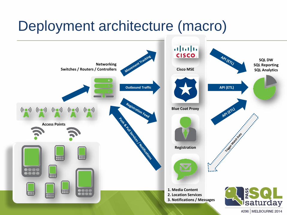
API (ETL)
NetworkingSwitches / Routers / Controllers
Blue Coat Proxy
Cisco MSE
SQL DWSQL ReportingSQL Analytics
Access Points
Outbound Traffic
Registration
1. Media Content2. Location Services3. Notifications / Messages
Deployment architecture (macro)

Key SQL Server tables (simplified)
A row created for each URL
browsed while on the network(anonymous cannot
browse internet)
A row for eachdevice’s
historicallocation that was on the
network(incl anonymous)
A “hot” row for each device’s
currentlocation that ison the network
RIGHT NOW(incl anonymous)
A row for eachregistered shopper
/ network user(incl anonymous)

MovementAnalyticsDWDB
Managing large database tables (simplified)
Solid State Device (SSD)
Real-Time (n) - TODAY
Fact Movement
20
14
03
22
20
14
03
23
20
14
03
24
20
14
03
25
20
14
03
26
20
14
03
27
20
14
03
28
20
14
03
29
20
14
03
30
20
14
03
31
20
14
04
01
20
14
04
02
20
14
04
03
20
14
04
04
Fact Movement History (partitioned by day)
Tiered Back-End SAN Array
Historical (n+1) – YESTERDAY to 15,000 (41 years)
EMP
TY
Sto
red
Pro
ced
ure
s
High Velocity Data
20
14
04
05
Set Read Only with Columnstore
If on SQL 2014…use updateable columnstore!
Set Read Write(empty)
Only backup new partition(s) daily
if on SQL 2014…use memory
optimised tables!
Agenda
What are Location Based Services (LBS) solutions?
Technical overview and solution architecture
Leveraging SQL Spatial functions
data, Data, DATA!
Reporting and analytics
Questions

Leveraging SQL Spatial Functions 1 of 4
Calculating and tracking device Movements Need 2 data points – current location (FactMovement) & last location (FactMovementHistory) Data points need to be related to the same device / movement pattern to make sense
Calculating Distance Can be done via geometry STDistance function or mathematically (Pythagoras Theorem) A2 + B2 = C2
Calculating Speed No geometry functions to do this, has to be done mathematically Speed (m/sec) = Distance (m) / Time (sec)
Calculating Direction No geometry functions to do this, has to be done mathematically Need to use Trigonometric functions
DEMO: Calculating Movement Measures
Not the Geography datatypeNot on a global scale!

Leveraging SQL Spatial Functions 2 of 4
Calculating device Proximity Need 1 data point – current or historical location (FactMovement) / (FactMovementHistory)
Need something to search against – such as a list of stores, other devices, etc
Drawing a Radius Can be done via geometry using STBuffer and STContains or STIntersects functions
Can probably be done mathematically – but why bother?!
Calculating Nearest and Furthest Elements Can be done via geometry using STDistance function
Can be done mathematically – but again why bother?!
DEMO: Calculating Proximity

Leveraging SQL Spatial Functions 3 of 4
Calculating device Aggregations Need LOTS of data points – current or historical (FactMovement) / (FactMovementHistory)
Need something to reference against – such as a list of stores, other devices, etc
Calculating a Dwell Time Aggregations Can be done via simple SQL aggregation functions (avg, max, min, stdev, etc)
Overlay with maps to visualise where these aggregations occur
Calculating a Crowding Index Aggregations Can be done via simple SQL aggregation functions (count & distinct count)
Overlay with maps to visualise where these aggregations occur
DEMO: Calculating Aggregations

Leveraging SQL Spatial Functions 4 of 4
Route Finding Algorithm – A* Widely used algorithm for graph traversal
The process of plotting an efficiently traversable path between points
Finds a least-cost path from an initial node to one goal node
Follows a path of the lowest expected total cost or distance
Takes distance already travelled into account
“Complete” algorithm – it will find a solution if one exists!
DEMO: A* Route Finding .Net Application
NOT NEW! First described in 1968

Agenda
What are Location Based Services (LBS) solutions?
Technical overview and solution architecture
Leveraging SQL Spatial functions
data, Data, DATA!
Reporting and analytics
Questions

• Very Large Unnamed Victorian Retail Shopping Centre
• Open 9 hours/day, 7 days/week
• 68,000 shoppers (@ peak hour & day)
• Assume… Peak of 3 hours/day (6 hours @ 33% of peak load)
• Assume… 40% have a "trackable" device (27,200)
• Assume… 10 URL's browsed an hour/device
• Assume… 5% YOY shopper growth rate
Let’s size up this EXAMPLE scenario...
(Q) So what happens next?
So just how BIG could these solutions get?

Year 1 Year 2 Year 3 Year 4 Year 5 Year 6 Year 7 …
39,058,737,600 rows
or
1.54 TB
289,311,991,785 rows
or
11.39 TB
E X P
A N
S I O N
2,603,807,926,068 rows
or
103 TB
Data volumes and growth over time
May need to considerspecialised SQL solutions

The industry marketing definition of BIG DATA is reasonably specific...
1. [V]elocity? YES! @ 245,000 data rows/second
2. [V]olume? YES? @ 100+ TB of data
3. [V]ariety? NO! Data is well defined & structured!
(Q) So how do we manage all this data?
So then, is this a BIG DATA problem?

@ DAY 'n'...
Microsoft SQL Parallel Data Warehouse (PDW)
MPP Compute Solution (up to 64 parallel nodes)
Can also integrate Big Data from Hadoop via PolyBase
Scale > 1 TB < 6 PB
@ DAY 1...
• Microsoft SQL 2012/14 Enterprise on CISCO UCS & EMC Storage
• SMP Compute Solution
• Calculated Compute and Storage Specifications
• Can also integrate Big Data from Hadoop via Hive ODBC
• Scale > 0 TB < 100 TB
Tim
e -
Res
po
nsi
ven
ess
-Si
ze -
Co
st
SQL Server can do it of course!

DEMO – Data Sizing Model

Agenda
What are Location Based Services (LBS) solutions?
Technical overview and solution architecture
Leveraging SQL Spatial functions
data, Data, DATA!
Reporting and analytics
Questions

DEMO – Analytics and Reporting

SSRS – Browser Contextualisation

SSRS – Device Movements
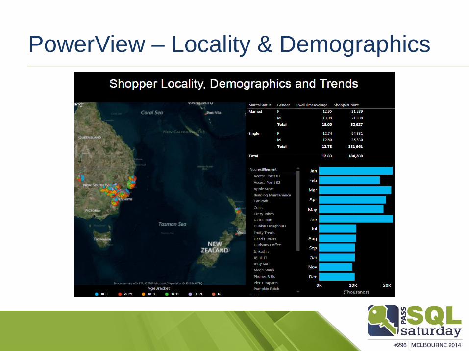
PowerView – Locality & Demographics

Agenda
What are Location Based Services (LBS) solutions?
Technical overview and solution architecture
Leveraging SQL Spatial functions
data, Data, DATA!
Reporting and analytics
Questions

Some SQL Spatial Geometry Fun…
SQL Spatial can do more than just boring business stuff… tsk!
We can create our own Patch Work Animals!
A BIG kudos to Alastair Aitchison (MVP & MCTS) http://alastaira.wordpress.com/2012/04/13/gridding-geometries-or-creating-patchwork-animals-in-sql-server/

Questions?
Please complete an Evaluation Form and
return it to the Room Monitor
Please make sure you visit our fantastic sponsors:

And a final parting note to leave you with…
…and in other news…
According to this sign one of the great benefits
of a pregnant woman on a bus is the…
Free Wi-Fi !

References
Location Based Services – A WIKI Definition http://en.wikipedia.org/wiki/Location-based_service
Cisco Mobility Services Engine (MSE) http://www.cisco.com/c/en/us/products/wireless/mobility-services-engine/index.html
http://www.cisco.com/c/en/us/products/collateral/wireless/mobility-services-engine/white_paper_c11-728970.html
Gridding Geometries - Alastair Aitchison Blog http://alastaira.wordpress.com/2012/04/13/gridding-geometries-or-creating-patchwork-animals-in-sql-server/
A* Search Algorithm http://en.wikipedia.org/wiki/A*_search_algorithm
27/27
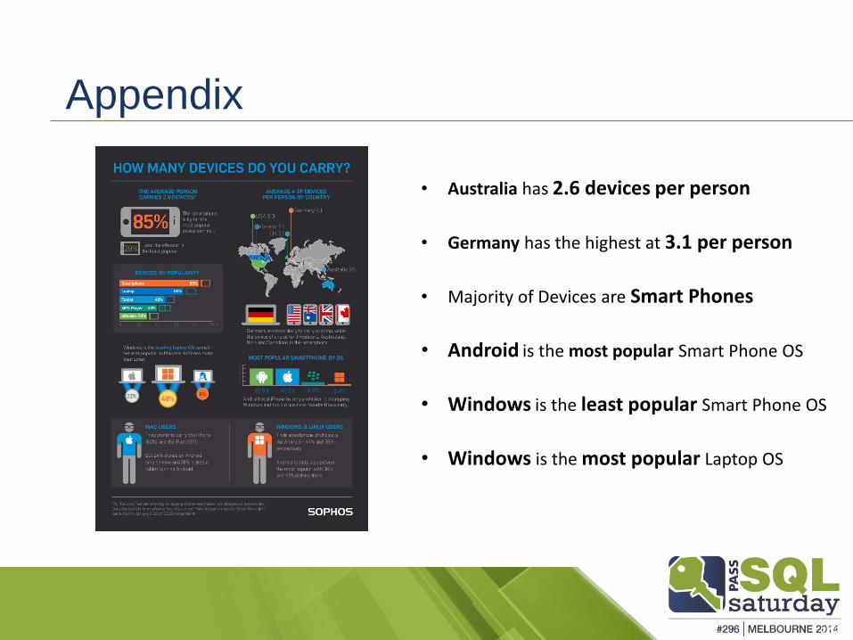
• Australia has 2.6 devices per person
• Germany has the highest at 3.1 per person
• Majority of Devices are Smart Phones
• Android is the most popular Smart Phone OS
• Windows is the least popular Smart Phone OS
• Windows is the most popular Laptop OS
Appendix