
LESSON 6 HEIGHT ON A MAP - kidsgrovesecondary.org.uk 7 Work/6. Height on … · LESSON 6 – HEIGHT...
5
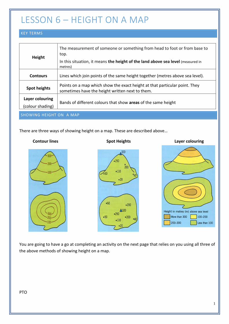
1 LESSON 6 – HEIGHT ON A MAP KEY TERMS Height The measurement of someone or something from head to foot or from base to top. In this situation, it means the height of the land above sea level (measured in metres) Contours Lines which join points of the same height together (metres above sea level). Spot heights Points on a map which show the exact height at that particular point. They sometimes have the height written next to them. Layer colouring (colour shading) Bands of different colours that show areas of the same height SHOWING HEIGHT ON A MAP There are three ways of showing height on a map. These are described above… Contour lines Spot Heights Layer colouring You are going to have a go at completing an activity on the next page that relies on you using all three of the above methods of showing height on a map. PTO
Transcript of LESSON 6 HEIGHT ON A MAP - kidsgrovesecondary.org.uk 7 Work/6. Height on … · LESSON 6 – HEIGHT...
1
LESSON 6 – HEIGHT ON A MAP KEY TERMS
Height
The measurement of someone or something from head to foot or from base to top.
In this situation, it means the height of the land above sea level (measured in
metres)
Contours Lines which join points of the same height together (metres above sea level).
Spot heights Points on a map which show the exact height at that particular point. They sometimes have the height written next to them.
Layer colouring
(colour shading) Bands of different colours that show areas of the same height
SHOWING HEIGHT ON A MAP
There are three ways of showing height on a map. These are described above…
Contour lines Spot Heights Layer colouring
You are going to have a go at completing an activity on the next page that relies on you using all three of
the above methods of showing height on a map.
PTO

2
TASK 1 – USING CONTOURS
a) In pencil join up all the places that are 100 metres above sea level.
b) Join up all the places that are 200 metres above sea level.
c) Join up all the places that are 300 metres above sea level.
d) Join up all the places that are 400 metres above sea level.
TASK 2 – USING LAYER COLOURING
a) Fill in the key by colouring the boxes under the map.
b) Shade the map using those colours. Colour lightly in pencil.
TASK 2 – USING SPOT HEIGHTS
a) What is the height of each letter on the map?
b) Choose your heights from:
50m 470m 220m 110m 390m 520m
Letter A B C D E F
Height

3
CONTOUR INTERVALS
The intervals between the contours on the diagram are 10
metres.
If you are standing on the 10 metre contour, you would need to
imagine that the ground between you and the next contour is
on a slope. As you walk towards the 20 metre line, your
elevation increases.
This means that point would at be about 15 metres.
When contours are close together, it means we are
climbing higher quickly, so the land must be steep.
When the contours are far apart, it means that we are
climbing higher slowly, so the slope must be gentler.
TASK 4
Fill in the blanks using words from the choices below
Choose from… relief contour slope close gentle
______________ lines are a good way of showing the height and __________ on a map. Contour lines
that are _________ together show a steep _________ and contour lines that are far apart show a
___________ slope
PTO
1

4
TASK 5
Look at the images below and answer the questions…
Is this a steep or gentle slope? ____________________
How do you know? ______________________________
______________________________________________
Is this a steep or gentle slope? ____________________
How do you know? ______________________________
______________________________________________
Contours are really useful as they can tell
us about the shape of the land without
even visiting
Contours in this formation indicate a hill.
Contours in this formation indicate a river
valley,
10 20
30 40
50
50
100
150
50
100
150

5
TASK 6
Match the 3D image with the correct contour line image. Write the numbers next to the letters.
A. B. C. D.
A
B
C
D
1. 2. 3. 4.
KNOWLEDGE CHECK
1. Name the three ways of showing height on a map
2. What measurement do we use to measure height on a map?
3. What does it mean when the contour lines are close together?


