Lesson 14: Plate Tectonics II National Science 14: Plate Tectonics II ... NOAA’s Science on a...
13
Lesson 14: Plate Tectonics II Overview Lesson 14 builds on the previous lesson on plate tectonics in which students learned about Earth’s layers and plates. This lesson presents specific types of plate movement and describes how this movement formed Earth’s geological features over time. During the activity, students use NOAA’s Science on a Sphere online educational tool to view and interpret Earth’s topography and bathymetry. Lesson Objectives Students will: 1. Identify geological features on the ocean floor 2. Explain three different ways that plates typically move with relation to one another 3. Identify examples of features formed as a result of each type of plate motion Lesson Contents 1. Teaching Lesson 14 a. Introduction b. Lecture Notes c. Additional Resources 2. Teacher’s Edition: Science on a Sphere 3. Student Activity: Science on a Sphere 4. Student Handout 5. Mock Bowl Quiz Standards Addressed National Science Education Standards, Grades 9-12 Unifying concepts and processes Physical science Earth and space science Ocean Literacy Principles The Earth has one big ocean with many features The ocean is largely unexplored DCPS, High School Earth Science ES.7. Plate tectonics operating over geologic time has altered the features of land, sea and mountains on the Earth’s surface
Transcript of Lesson 14: Plate Tectonics II National Science 14: Plate Tectonics II ... NOAA’s Science on a...

1 | P a g e
Lesson 14: Plate Tectonics II Overview Lesson 14 builds on the previous lesson on plate tectonics in which students learned about Earth’s layers and plates. This lesson presents specific types of plate movement and describes how this movement formed Earth’s geological features over time. During the activity, students use NOAA’s Science on a Sphere online educational tool to view and interpret Earth’s topography and bathymetry.
Lesson Objectives Students will:
1. Identify geological features on the ocean floor
2. Explain three different ways that plates typically move with relation to one another
3. Identify examples of features formed as a result of each type of plate motion
Lesson Contents
1. Teaching Lesson 14 a. Introduction b. Lecture Notes c. Additional Resources
2. Teacher’s Edition: Science on a Sphere
3. Student Activity: Science on a Sphere
4. Student Handout
5. Mock Bowl Quiz
Standards Addressed
National Science Education Standards, Grades 9-12 Unifying concepts and processes Physical science Earth and space science Ocean Literacy Principles The Earth has one big ocean with many features The ocean is largely unexplored DCPS, High School Earth Science ES.7. Plate tectonics operating over geologic time has altered the features of land, sea and mountains on the Earth’s surface

2 | P a g e
Teaching Lesson 14 Lesson 14 Teaching Lesson 14 Lesson 14
Lesson Outline1 I. Introduction Introduce the lesson with the following demonstration that uses a simple model to simulate plate tectonics. For this demonstration, you will need one large Milky Way bar and several mini “fun size” Milky Way bars if you want the students to use them. (Chilling the candy prior to class will help prevent them from melting too fast.)This demonstration was adapted from the Student Experiments at Sea (SEAS) Activity 3, “Modeling Plate Tectonics,” found at the following link: http://www.ridge2000.org/seas/downloads/curriculum/seas_unit1_activity3.pdf. Begin the demonstration by asking students to describe a scientific model. Students should explain that models are simple representations of reality that scientists can use to gain insight into natural phenomena. Stress to students that models can range from very simple physical representations (e.g., plastic molds of organisms in biology class) to very complex computer or mathematical models (e.g., video games that simulate real-life concepts). Open the large Milky Way bar and gently crush it. Ask students to think of ways that the Milky Way could serve as a simple model of Earth’s physical structure:
It is composed of layers Its outer layer is rigid (like the lithosphere) and rests on top of a relatively fluid
inner layer (like the asthenosphere) When the crushed bar is moved (pulled apart or pushed together), the rigid pieces
“glide” slowly on the fluid underlying layer Now ask students to list ways in which the Milky Way bar does not portray a realistic interpretation of Earth’s physical structure:
It is a different size and shape It is not subject to the same magnitude of physical forces as Earth (pressure,
temperature, gravity) It is composed of different materials
Remind students that Earth’s plates are in constant motion. Tell students that they will learn about three specific types of plate motion in today’s lesson: plates moving apart, plates coming together and plates sliding past one another. Simulate these three types of motion with the Milky Way bar and instruct students to do the same with their small bars if you have enough. Have students record their observations about what happens to the Milky Way bar when subject to these types of motion.
1 Unless otherwise indicated, all websites provided or referenced in this guide were last accessed in November 2010.

3 | P a g e
Teaching Lesson 14 Lesson 14
II. Lecture Notes Present the following information using the PowerPoint for Lesson 14 (File: Lesson 14 – Plate Tectonics II.ppt). Distribute the Student Handout before you begin for students to take notes on key information. There are three types of plate boundaries (slide 5)
1. Earth’s plates are constantly moving. Plates can move in three different ways with respect to one another: in opposite directions, into one another or sliding past one another.
Divergent boundary (slides 6 and 7)
1. When the crust breaks apart, features like mid-ocean ridges, continuous mountain
chains found in all the world’s ocean basins, and rift valleys and rift valleys, the lowlands running through ocean ridges, form on the sea floor.
2. Magma rises up through the breaks in the crust and forms new sea floor. In some cases, volcanic activity at divergent boundaries can cause high mountains to form. Some islands, like Iceland, were created by this process.
Convergent boundary (slide 9)
1. Oceanic-oceanic convergence results in one oceanic plate getting subducted (pushed beneath) beneath the other. When this happens, a trench forms where the plates meet. An island arc can form next to the trench as the subducted plate melts and the magma rises up. The Aleutian Islands were formed this way.
2. Continental-oceanic convergence results in the oceanic crust subducted under the
continental. Again, a trench forms in the sea where the plates collided. In this case, volcanic mountain chains usually form on land as the oceanic plate melts beneath the continental plate. Mount St. Helens was formed this way.
3. Continental-continental convergence results in plates pushing upward because the
plates are about the same density. This forms mountain ranges like the Himalayas. Conservative boundary (slide 11)
1. Transform faults are associated with earthquakes because plates sliding past one another can cause disturbances that result in plate “slippage” or rebound motion.
2. Faults like the San Andreas Fault in California are thus usually well-known for frequent seismic activity.
III. Additional Resources
1. Lesson plans and teaching tools http://free.ed.gov/keywords.cfm?keyword_id=675&res_feature_request=1

4 | P a g e
Teacher’s Edition Lesson 14 Teacher’s Edition Lesson 14
A Trip to Space with Science on a Sphere
Overview In this activity, students use NOAA’s Science on a Sphere (SOS) on the internet to view various features on Earth that formed as a result of plate tectonics. The activity instructs students how to view each video and asks students to describe features they see and explain how these features formed. Each group will need a computer with internet access. Computers must have QuickTime 7, available free for Mac and PC, to play the videos. If there aren’t enough computers available, you may want to play the videos for the class on one computer and have students complete the worksheets in their groups. NOTE: If internet access is not available in your classroom, use the alternative version of this exercise (File:StudentActivity_Alt.pdf) document found in the Lesson 14 folder. This is the same exercise that uses pictures taken from the SOS videos instead of requiring the students to watch the videos. No internet access is necessary. A color printer is necessary for this alternative activity. An additional alternative activity that does not require internet access or a color printer is available from the Society for Sedimentary Geology (SEPM) at the following link: http://www.beloit.edu/sepm/Earth_Works/Sea_floor_spreading.html. An answer key for this activity is located in the Lesson 14 folder (File:Answer Key.pdf). Background SOS is a giant animated globe that displays images of the ocean and atmosphere. You can view the datasets for these animations without visiting the large-scale SOS locations simply by opening them with a computer media program. From your computer, you can view animations of Earth to explore more about plate tectonics. First go to the Science on a Sphere website: http://sos.noaa.gov/index.html. Click on the Datasets tab. This is where students get the information they need to complete the worksheet. Procedure
1. Distribute the student activity and help students navigate to the Science on a Sphere website at the link given about. Instruct students to follow the procedures given and to answer the accompanying questions.
2. First, students click on “Land” under “Data catalogue.” Click Earth - The Blue Marble and watch the first video on the upper right hand side of the page titled The Blue Marble. This video gets students oriented with a view of Earth from space – this is the view of Earth you’d get as an astronaut!
5 | P a g e
Teacher’s Edition Lesson 14
3. Next, students look at some of the topographic and bathymetric features of Earth.
Bathymetry is the measurement of the ocean depths and underwater terrain; bathymetric maps show the topography of the sea floor. Students should go back to “Land” on the data catalogue and click on the ETOPO1 Dataset link. They will read the description and watch the ETOPO1 movie. To get another perspective on topography and bathymetry, they will click the Land dataset and click the Surface of the Earth and Nighttime Lights link. After reading the description and watching the movie, students answer questions 1-5 on their answer sheet.
4. Students may have figured out that plate tectonics are responsible for the geological
features in the ETOPO1 video. The architecture of Earth looks very different than it did millions of years ago, when the continents existed as one large land mass called Pangaea. Students look at the evolution of ocean basins and continental placement due to plate tectonics. Students should go back to the Land datasets and click on Plate Tectonics and Paleo Animation link. After reading the descriptions and watching both videos, students answer questions 6-8 on their answer sheet.
5. It is important to study plate tectonics not only to understand the geological
features of Earth, but also to help us understand and prepare for disasters like earthquakes and tsunamis. Students should go back to the Land datasets and click on Real-time Global Earthquakes. After reading the description and watching the video to see earthquakes and their magnitudes around the world, students answer questions 9-11.
Answer key
1. Describe the bathymetry of Earth that you see on the video. Is the terrain flat? List the features that you see. Students should describe ridges and trenches and their locations.
2. What is the longest mid-ocean ridge? Can you see it on the video? How did this ridge
form? The Mid-Atlantic Ridge in the Atlantic Ocean. It is visible on the video, and formed by a divergent boundary.
3. Did you see any trenches on the video? Is the deepest trench in the ocean taller or
shorter than the highest mountain on land? Where is this trench located? Trenches are visible on the video. The Marianas Trench east of Japan is the deepest trench on Earth. It is deeper than the highest mountain (Mount Everest) is tall.
4. How do trenches form? A trench forms when subduction occurs as an oceanic plate moves beneath a continental plate.

6 | P a g e
Teacher’s Edition Lesson 14
5. When you watch the Surface of the Earth and Nighttime Lights video, look closely
when North America comes into view. Can you see the Hawaiian Islands? What geological phenomenon is associated with formation of this island chain? Describe how the islands were formed. You may do additional web research if necessary. The Hawaiian Islands are associated with a hot spot – melting area within the mantle where magma breaks through the crust. When tectonic plates move over the hot spot, volcanic island chains form, like the Hawaiian Islands.
6. When did the “super continent” Pangaea start to break apart?
Around 300 million years ago. 7. What type of plate movement caused the Appalachian Mountains to form? Can you
name another large mountain range that formed because of this type of plate movement? Convergent plate movement. Other examples include the Himalayas, the Cascade Mountain range and Andes mountains.
8. Collision of which two land masses caused the Himalayas to form?
Indo-Australian plate and Eurasian plate.
9. Describe the distribution of earthquakes and their magnitude across the globe. Name a few locations where you see them occurring. Answers will vary.
10. Some earthquakes are related to plate tectonics. What type of plate movement
results in an earthquake? What well-known geological feature results is associated with earthquakes in California? A transform boundary or fault is the nexus where two plates slide past one another. When disruptions occur along these boundaries, earthquakes can occur. The San Andreas Fault is in CA.
11. The descriptions on some of the SOS videos indicate that data about plate movement
can help scientists predict and prepare for tsunamis. How do you think the data you’ve seen today could help to predict and prepare for these events? Tsunamis can be triggered by earthquakes in the sea. The data sets on the SOS site can be used to identify where these earthquakes are likely to occur for monitoring. When earthquakes do occur, scientists can then predict who is likely to be affected by an impending tsunami.

7 | P a g e
Student Activity Lesson 14
A Trip to Space with Science on a Sphere During today’s activity you will take a trip into space using NOAA’s Science on a Sphere (SOS) program. SOS is a giant animated globe that displays images of the ocean and atmosphere. You can view the datasets for these animations without visiting the large-scale SOS locations simply by opening them with a computer media program. From your computer, you can view animations of Earth to explore more about plate tectonics. First go to the Science on a Sphere website: http://sos.noaa.gov/index.html Click on the Datasets tab. This is where you will get the information to complete the worksheet. Follow the instructions below and answer the questions. Procedure
1. When you are ready to start your journey, click on “Land” under “Data catalogue.” Click Earth - The Blue Marble and watch the first video on the upper right hand side of the page titled The Blue Marble. This video will get you oriented with Earth from space – this is the view of Earth you’d get as an astronaut!
2. Now let’s take a look at some of the topographic and bathymetric features of Earth.
Bathymetry is the measurement of the ocean depths and underwater terrain; bathymetric maps show the topography of the sea floor. Go back to “Land” on the data catalogue and click on the ETOPO1 Dataset link. Read the description and watch the ETOPO1 movie. To get another perspective on topography and bathymetry, go back to the Land dataset and click the Surface of the Earth and Nighttime Lights link. Read the description and watch the movie. Answer questions 1-5 on your answer sheet.
3. You may have figured out that plate tectonics are responsible for the geological
features you saw in the ETOPO1 video. The architecture of Earth looks very different than it did millions of years ago, when the continents existed as one large land mass called Pangaea. Let’s look at the evolution of ocean basins and continental placement due to plate tectonics. Go back to the Land datasets and click on Plate Tectonics and Paleo Animation link. Read the descriptions and watch both videos. Then answer questions 6-8 on your answer sheet.
4. It is important to study plate tectonics not only to understand the geological
features of Earth, but also to help us understand and prepare for disasters like earthquakes and tsunamis. Go back to the Land datasets and click on Real-time Global Earthquakes. Read the description and watch the video to see earthquakes and their magnitudes around the world. Answer questions 9-11.

8 | P a g e
Student Activity Lesson 14
Questions 1. Describe the bathymetry of Earth that you see on the video. Is the terrain flat? List
the features that you see.
2. What is the longest mid-ocean ridge? Can you see it on the video? How did this ridge form?
3. Did you see any trenches on the video? Is the deepest trench in the ocean taller or shorter than the highest mountain on land? Where is this trench located?
4. How do these trenches form?
5. When you watch the Surface of the Earth and Nighttime Lights video, look closely when North America comes into view. Can you see the Hawaiian Islands?
6. When did the “super continent” Pangaea start to break apart?
7. When did the Appalachian Mountains form? What type of plate movement caused
the mountains to form? Can you name another large mountain range that formed because of this type of plate movement?

9 | P a g e
Student Activity Lesson 14
8. Collision of which two land masses caused the Himalayas to form?
9. Describe the distribution of earthquakes and their magnitude across the globe. Name a few locations where you see them occurring.
10. Some earthquakes are related to plate tectonics. What type of plate movement results in an earthquake? What well-known geological feature results in earthquakes in California?
11. The descriptions on some of the SOS videos indicate that data about plate movement can help scientists predict and prepare for tsunamis. How do you think the data you’ve seen today could help to predict and prepare for these events?

10 | P a g e
Student Handout Lesson 14
Tips for the Bowl – Plate Tectonics Know your definitions Write down definitions and notes for the following terms during your teacher’s presentation: Magma: Rift valley: Seafloor spreading: Subducted: Transform fault: Know your plate movement Plates are continually moving in relation to one another. Three major types of plate motion are listed in the table below. Write some examples of the geological features formed by each type in the blank spaces.
11 | P a g e
Mock Bowl Quiz Lesson 14
Plate Tectonics II
1. About when did the super continent Pangaea begin to break apart? w. About 30 million years ago x. About 100 million years ago y. About 300 million years ago z. About 600 million years ago
2. Mountain ranges like the Himalayas result from which type of plate movement? w. Transform x. Divergent y. Subduction z. Convergent
3. The lithosphere is composed of which of the following: w. Upper mantle and crust x. Crust only y. Upper mantle only z. All layers of Earth except for the inner core
4. Reminder question : A CTD measures which of the following:
w. Connectivity, Temperature, Depth x. Conductivity, Temperature, Depth y. Conductivity, Temperature, Density z. Currents, Temperature, Depth
5. Which of the following hazards occur along a fault line? w. Earthquakes x. Volcanic eruptions y. Hurricanes z. Storm surges
6. Reminder question - Short Answer: What piece of technology would you use to analyze the chemistry of a water sample from 200m deep? Answer: Niskin bottle
7. Which of the following features does not form as a result of divergent plate
movement? w. Islands x. Mid-ocean ridges y. Rift valleys z. Trenches
12 | P a g e
Mock Bowl Quiz Lesson 14
8. Short answer: The Aleutian Islands formed as a result of what type of tectonic plate movement? Answer: Convergent (Or oceanic-oceanic convergence)
9. Short answer: Which distance is bigger: the distance to the highest point on Earth or
the distance to the deepest point in the ocean floor? Answer: The deepest point on the ocean floor
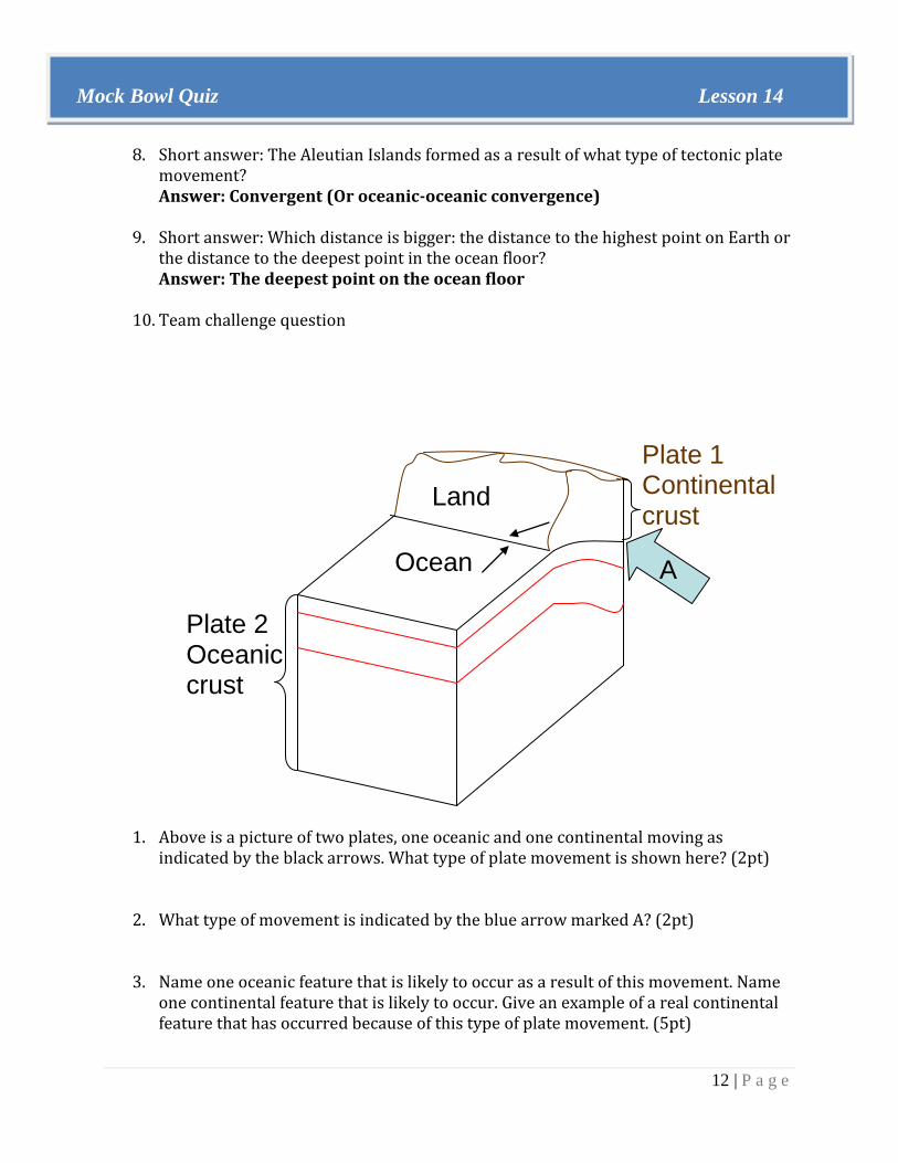
10. Team challenge question
1. Above is a picture of two plates, one oceanic and one continental moving as indicated by the black arrows. What type of plate movement is shown here? (2pt)
2. What type of movement is indicated by the blue arrow marked A? (2pt)
3. Name one oceanic feature that is likely to occur as a result of this movement. Name one continental feature that is likely to occur. Give an example of a real continental feature that has occurred because of this type of plate movement. (5pt)
Plate 2 Oceanic crust
A Ocean
Land
Plate 1 Continental crust

13 | P a g e
Mock Bowl Quiz Lesson 14
ANSWER
1. Above is a picture of two plates, one oceanic and one continental moving as indicated by the black arrows. What type of plate movement is shown here? (2pt) Convergent
2. What type of movement is indicated by the blue arrow marked A? (2pt) Subduction
3. Name one oceanic feature that is likely to occur as a result of this movement. Name
one continental feature that is likely to occur. Give an example of a real continental feature that has occurred because of this type of plate movement. (5pt) Trench (2pt); volcanic mountain range (2pt); answers vary (1pt).
A Ocean
Land
Plate 1 Continental crust
Plate 2 Oceanic crust