Leichhardt River Dam
74
Leichhardt River Dam EMERGENCY ACTION PLAN Version Number 17, September 2020 | 1 Leichhardt River Dam EMERGENCY ACTION PLAN Mount Isa Mines September 2021
Transcript of Leichhardt River Dam
Leichhardt River Dam EMERGENCY ACTION PLAN
Version Number 17, September 2020 | 1
Leichhardt River Dam EMERGENCY ACTION PLAN
Mount Isa Mines September 2021
WIDTJ
Text Box
Approved by the delegate of the Chief Executive, Department of Regional Development, Manufacturing and Water until 21 April 2022.

Leichhardt River Dam EMERGENCY ACTION PLAN
Version Number 18, September 2021 | 2
Table of contents
Table of contents .................................................................................... 2
Emergency Activation Quick Reference Guide…………………………………………………….4
Leichhardt River Dam EAP Review sheet……..…............................................5
Controlled Copies…………………………………………………………………………………………….6
Document Control Details .………………………………………………………………………….7
1 Procedural Flow Chart and Notification List ....................................... 10
1.1 Procedural Flow Chart .................................................................. 10
1.2 Notification List ........................................................................... 11
2 Basic Details of Dam ...................................................................... 15
3 Purpose, Scope and Responsibilities ................................................. 16
3.1 Purpose ................................................................................... 16
3.2 Scope ...................................................................................... 16
3.3 Responsibilities ......................................................................... 16
4 Emergency events and Actions…………………………………………………………………18
4.1 General …..……………………………………………………………………………………………18
4.2 Emergency Access and Communications ……………………………………………18
4.3 Significant flow over spillway ...................................................... 19
4.4 Potential structural damage to dam .............................................. 23
4.5 Potential contamination of dam water supply ................................. 29
4.6 Terrorism / Security Threat …………………………………………………………………32
5 Supporting Documents and Reference Material .................................. 35
5.1 List of Abbreviations …..………………………………………………………………………….35
5.2 Glossary ...……………………………………………………………………………………………..36
Leichhardt River Dam EMERGENCY ACTION PLAN
Version Number 18, September 2021 | 3
Appendices .......................................................................................... 38
Appendix A .......................................................................................... 40
Locality Map ...................................................................................... 40
Appendix B .......................................................................................... 40
Flood Mapping ................................................................................... 40
Appendix C .......................................................................................... 53
Flood Inundation Assessment .............................................................. 53
Appendix D .......................................................................................... 56
Weather Information (Flood Warning) ................................................... 56
Appendix E .......................................................................................... 60
Discharge and Storage Curves ............................................................. 60
Appendix F .......................................................................................... 61
Modified Mercalli Scale ....................................................................... 61
Appendix G .......................................................................................... 63
Emergency Resources ........................................................................ 63
Appendix H .......................................................................................... 64
Dam Safety Emergency Situation Report ............................................... 64
Appendix I ........................................................................................... 69
Standard phone, SMS and email messages to the immediately affected downstream residents and others ........................................................... 69
Appendix J ........................................................................................... 72
Public Access to Notification List Via Internet ......................................... 72

Leichhardt River Dam EMERGENCY ACTION PLAN
Version Number 18, September 2021 | 4
Structual Damage:
Earthquake
See Sec tion 4.4
Page 21
• Increased seepage through the
foundatons, abutments or dam
face
• Earthquake with an intens ity of
greater than or equal to 4 on the
Richter Scale within 500km of the
area
• Earthquake with an intens ity of
greater than or equal to 6 on the
Richter Scale within 250km of the
area
• 48 hours elapsed in further
increase in s tructural damage
• Structural engineering assessment
has determined that failure risk has
reduced
Pontential Contaminaton
of Dam
See Sec tion4.5
PAGE 26
• Identification of poss ible
contaminant in the water s torage
area.
• Confirmation of s ignificant
amount of contaminant in the
water s torage area.
• Enivronmental damage
cons iderable
• An excess ive amount of
contaminate found in the water
s torage area.
• Enivronmental damage severe
• Confirmation the contamination
has been managed.
• Piping condition has been
established
• Significant areas of lands lip or
eros ion on the downstream
embankment deeper than 2m
over an area of greater than
20m2.
• Seepage measurements of
more than 50 litres per second
or a vis ibly increas ing rate of
seepage concurrent with a
decrease in dam level.
• 48 hours elapsed in further
increase in s tructural damage
• Structural engineering assessment
has determined that failure risk has
reduced
• Increas ing seepage through an
embankment, the foundations, or
abutments with cloudy water
• Seepage measurements of
more than 5 litres per second
and more than 20% increase in
seepage over 24 hours without a
corresponding increase in dam
level.
• Identification of localised
eros ion on the downstream
embankment deeper than 1m
over an area of greater than
10m2.
Dam hazards and
sections numbers
Activation Levels
• Water level is =>3.5m above
spillway level.
• Water level is falling with no
further rain and flood levels are
found to be receding over 3
consecutive houly readings.
Structual Damage:
Piping, Embankment,
Foundation, or
Abutments
See Sec tion 4.4
PAGE 21
S tand Down
• Locally Managed • Locally Managed • Locally Managed with Advice• Locally Managed with Advice from
Owner
Emergency Activation Quick Reference - Dam Hazards The Emergency Action Plan (EAP) for Leichhardt River Dam covers five dam hazards evaluated within Glencore Mount Isa
Mines management plan. Use the following table to select the relevent section of the EAP that deals with the dam hazard.
Terroris t Threat/Security
Threat
See Sec tion 4.6
PAGE 27
• 48 hours elapsed in further
increase in s tructural damage
• Structural engineering assessment
has determined that failure risk has
reduced
• Large explos ion
heard/observed at dam (e.g.,
bomb explos ion, aircraft hit)
• Failure in progress or likely due
to impact or explos ion
• Poss ible terroris t activity
noticed at dam or threat
received
• Observation of s ignificant
areas of damage to the dam
face due to terrorism activity.
• Suspicious behaviour at the dam
or surrounding area.
• Identification of a poss ible
threat.
Flood Opertations
See Sec tion 4.3
PAGE 17
• Water level is <=2.6m above
spillway level.
• Water level is >2.6m above
spillway level.
Ale rt Lean Forward
• Increased seepage through an
embankment, the foundatons, or
abutments
S tand Up


Leichhardt River Dam EMERGENCY ACTION PLAN
Version Number 18, September 2021 | 6
Controlled Copy List
Table 2 : Controlled Copy List
Copy
Number
Position (Name) Location
Mount Isa Mines Limited
1 Isa Processing General Manager
Mount Isa
2 Copper Concentrator Manager
Mount Isa
3
Leichhardt River Dam Operator/Rifle Creek Dam
Caretaker
Mount Isa
4
Health, Environment, Safety, Communications (HSEC
Department)
Mount Isa
5 Mount Isa Mines Crisis Room
Board Meeting Room, Central Building
Mount Isa
MIM Representatives on LDMG
6 Mount Isa
7 Mount Isa
Director Dam Safety
8 Water Planning and Regulation (DRDMW) Brisbane
Mount Isa City Council
9
Executive Officer
LDMG Local Disaster Coordinator
Mount Isa
Local Disaster Management Group (LDMG)
10
LDMG Chair – Mount Isa District
Mount Isa District
Mount Isa
District Disaster Management Group (DDMG)
11
Executive Officer
Mount Isa District
Mount Isa

Leichhardt River Dam EMERGENCY ACTION PLAN
Version Number 18, September 2021 | 7
Document Control Details
Controlled Copy Number: 1
Revision Status: Original Copy
Table 3 : Controlled Copy List
Revision
Number
Revision Description Revision
Date
Authorisation Signature
1 MOMM - Change of email address
DNR&M - Change of contact name
12-Sept-02 – 16/12/02
2 DDC - New controlled copy
DNR&M - Change of contact name
MlCC - New controlled copy
03-Dec-02 – 16/12/02
3 DNRM&E - Change of contact name
- Change business name /
initials
ES - Change of contact name
Maunsell - Change of contact name
MlCC - Change of contact name
SES - Change of phone numbers
SSM - Change of contact name
SSM - Change of title
WS - Change of contact name
21-Sept-04 – 30/09/04
4 Notification List updated. 30-Jun-07 – 27/07/07
MIM Water Distribution
Superintendent
5 Notification List updated. 31-July-08 – 19/01/09
MIM Water Distribution
Superintendent
6 Department name change to Utilities
UM - Change of contact name
Incorporate recommendations from 2009
Comprehensive Inspection
DNRME - Change of Business Name
30-May-09 – 29/05/09
MIM Water Distribution
Superintendent
7 Maunsell - Contact removed from copy
list
ES - Contact removed from copy list
20-May-10 – 21/05/10

Leichhardt River Dam EMERGENCY ACTION PLAN
Version Number 18, September 2021 | 8
DNRM - Contact removed from copy
list
MIM Water Distribution
Superintendent
8 MIM Utilities Manager – Change of
contact name and details.
09-May-11 – 22/05/11
MIM Water Distribution
Superintendent
9 Mica Creek Power Station – Change of
owners and manager
14-May-12 – 22/05/12
MIM Water Distribution
Superintendent
10 Updated EAP & QLD flood commission of
inquiry recommendations from review by
Hari Khadka dated 26/07/2012.
Updated notification list
Updated emergency events and actions
Included BOM web site details
Included locality maps
Included discharge, storage curves
Included flood inundation maps
Changed LDMG Chief Executive Officer
mobile phone numbers
14-May-13 15/05/13
MIM Water Distribution
Superintendent
11 Name change on company from Xstrata
Mount Isa Mines to Mount Isa Mines and
XMIM to MIM
Department name change to Central
Engineering- CEM – Central Engineering
Manager
Email addresses changed for all MIM
personnel
20-July-14
21/05/14
MIM Water Distribution
Superintendent
12 General Update of Document 05-Aug-15
GMIM Water Distribution
Superintendent
13 General updates throughout document
29/10/2016
GMIM Water Distribution
Superintendent
14 General updates throughout document
14/8/2017
GMIM Water Distribution
Superintendent

Leichhardt River Dam EMERGENCY ACTION PLAN
Version Number 18, September 2021 | 9
15
16
General updates throughout document
Change of name from DEWS to DNRME
Submission date change. Address
schedule of matters
General updates throughout document.
Updated Procedural Flow Chart
Added Terrorism / Security threat to
Emergency events
Updated Notification List
24/7/2018
14/6/2019
GMIM Water Distribution
Superintendent
15/06/19
GMIM Water Distribution
Superintendent
17
General updates throughout document.
Updated MIM representatives
Added quick reference guide to document
Updated Notification List
31/6/2020
20/07/20
GMIM Water Distribution
Superintendent
18a General updates throughout document
- Department name change to S&R
Engineering
- S&R GM – Smelting & Refining General
Manager
- EM – Engineering Manager
- HSEC department added
- Updated MIM representatives
- Updated procedural flow chart layout
- Updated Notification List
- 2021 Failure Impact Assessment
incorporated
- Inclusion of inundation mapping
- Revised chain of command for
notification
of immediate downstream residents
Incorporated feedback from
LDMG/DDMG,
including update of contact details,
position names and direct notification of
emergency services for
terrorism/security threat.
17/06/2021
05/05/2021
Engineering Manager
Note this revision of the
EAP was withdrawn.
18b Department name change to CUCN HV &
Refrig. Water
New names & phone numbers for
Glencore personnel
CUCNM - New abbreviation for
department manager
HSEC - New abbreviation (Health Safety
Environment Community)
Regulator name changed from DNRME to
Department of Regional Development,
Manufacturing & Water (DRDMW)
13/09/2021
(Copper Concentrator
Manager)

Leichhardt River Dam EMERGENCY ACTION PLAN
Version Number 18, September 2021 | 10
Update of document from new FIA and
comprehensive reports

Leichhardt River Dam EMERGENCY ACTION PLAN
Version Number 18, September 2021 | 11
1 Procedural Flow Chart and Notification List
1.1 Procedural Flow Chart
Risk of
contamination?
STAND
DOWN
Water level 1.5m above spillway
and rising?
No
Water level
1.9m above spillway and
rising?
Yes
Advise IPGM Advise HSEC
EMERGENCY RESPONSE
EM to notify
Emergency Services
MOUNT ISA LDMG
GMIMSC
20kRes
HSEC to notify
DRDMW
MIWB to notify
Recreational Visitors
MOUNT ISA LDMG to notify other parties and
coordinate Emergency Response as appropriate
Is dam
spilling?
T
EM to notify
Mount Isa LDMG
IMCC
MIWB
20kRes
HSEC to notify
DRDMW
Notification App.H
EM to notify LDMG
IMCC Continue to monitor and
issue updates every 24hrs
Risk of
structural
failure?
LEAN FORWARD
Event
receding?
Terrorism/
Security
Threat
Contamination contained
LEAN FORWARD
ALERT
Dam failure imminent?
EM to notify
LJSS
Mount Isa LDMG
20kRes
MIWB
IMCC
HSEC to notify
DRDMW
Monitor + issue
updates every 8hrs
Dam failure
imminent?
EM to notify
Mount Isa LDMG
IMCC
MIWB
HSEC to notify
DRDMW
Notification App.H
STAND UP
IPGM to notify all previously
contacted parties, and engage follow up as
appropriate. HSEC to issue
EER to DRDMW
LEAN
FORWARD
STAND UP
STAND UP
STAND DOWN
EMERGENCY RESPONSE
EM to notify
Emergency Services
MOUNT ISA LDMG
GMIMSC
20kRes
HSEC to notify
DRDMW
MOUNT ISA LDMG to notify other parties and
coordinate Emergency Response as appropriate
STAND UP
STAND DOWN
STAND DOWN
Issue Managed.
Issue Managed.
Issue Managed.
Issue Managed
No
Yes
No
No
Yes
Yes
Yes
No
Yes
No
No
No Yes
Yes
No No
Yes
Yes
Yes Yes
Yes
Yes
No
No
No
No
No
Yes
Risk of structural
failure?
ALERT LEAN FORWARD
EM to notify
Emergency
Services
IMCC
MIWB
20kRes
MIWB to notify
Recreational
Visitors
HSEC to notify
DRDMW
EMERGENCY RESPONSE
EM to notify
Emergency Services
MOUNT ISA LDMG
GMIMSC
20kRes
HSEC to notify
DRDMW
MIWB to notify
Recreational Visitors
MOUNT ISA LDMG to notify other parties and
coordinate Emergency Response as appropriate
EMERGENCY RESPONSE
EM to notify
Emergency Services
MOUNT ISA LDMG
GMIMSC
20kRes
HSEC to notify
DRDMW
MIWB to notify
Recreational Visitors
MOUNT ISA LDMG to notify other parties
and coordinate Emergency Response as
appropriate
ALERT
Abnormal condition or significant
discharge
identified
Legend
4.X.X – Procedure as detailed in Section 4
20kRes – Residents and affected properties within 20km downstream
of the dam, as well as Isa Youth Camp and Lake Julius Storage
Supervisor
Caretaker – Leichhardt River Dam Operator/Rifle Creek Dam Caretaker
IPGM – Glencore Mount Isa Mines Isa Processing General Manager
DRDMW – Department of Regional Development, Manufacturing &
Water
EER – Emergency Event Report
LDMG – Chairman of the Local Disaster Management Group
LJSS – Lake Julius Storage Supervisor
IMCC – Glencore Mount Isa Mines Security Control
MIWB – Mount Isa Water Board

Leichhardt River Dam EMERGENCY ACTION PLAN
Version Number 18, September 2021 | 17
2 Basic Details of Dam
Location Leichhardt River Road, 18km NNE of Mt Isa
Latitude 20°34'53"S
Longitude 139°34'23"E
Construction Type Concrete faced rock fill dam
Construction Date 1958 (spillway raised 1971)
Owner Mount Isa Mines
Dam Length 259m
Spillway / gates Primary Spillway: Unlined rock-cut channel on left abutment, with concrete weir inlet
control, 77m long, weir crest level RL
3405.53m (MIM datum)
Auxiliary spillway 1: Unlined by-wash channel, 37m long, crest level RL 3405.77m
(MIM datum)
Auxiliary spillway 2: Unlined by-wash channel, 47m long, crest level RL 3405.80m
(MIM datum)
No gates or scour outlets.
Height above stream bed 27.5m above lowest downstream toe level
Storage Capacity 106,833 ML at Full Supply Level
Full Supply Level (FSL) 3,405.53m (MIM datum)
Dam Crest Level 3,410.26m (MIM datum)
Catchment Area Approximately 1,200km2
Surface area at FSL 21.9km2
Supply Water supply to Mount Isa Water Board,
distributed to: Mt Isa Township, Mt Isa Mine,
Mica Creek Power Station and Diamantina Power Station.
Raw water supply direct to Haslingden Station and West Leichhardt Station.
Spillway capacity Combined spillway capacity 4,900m3/s (Dam
Crest Level)
1:7,000 AEP flood event
Section 1.2 has been redacted

Leichhardt River Dam EMERGENCY ACTION PLAN
Version Number 18, September 2021 | 18
3 Purpose, Scope and Responsibilities
3.1 Purpose The purpose of an Emergency Action Plan is to pre-plan the coordination of necessary actions
by Mount Isa Mines Limited (GMIM) and to provide timely notification to the Department Natural Resource, Mining and Energy, police, Local Disaster Management Groups and affected
persons in the event that a condition at Leichhardt River Dam could develop into an emergency.
This action plan is aimed at addressing the requirements of the “Emergency Action Planning for Referable Dams” Water Supply (Safety and Reliability) Act 2008, as the owner(s) of the referable dam to have an approved EAP for the dam.
3.2 Scope This document applies to Leichhardt River Dam, Mount Isa, and identifies emergency
conditions which could endanger the integrity of the dam and which require immediate action prescribes procedures which are to be followed in the event of an emergency condition
developing
3.3 Responsibilities General
Mount Isa Mines is the owner and operator of the Leichhardt River Dam. The day to day
management of this facility is the responsibility of the Central Engineering Department.
As the dam has no controlled discharge outlets which would be of significance in an emergency event, the primary form of response to emergencies is to provide appropriate and timely
notification to people at risk. The Isa Processing General Manager shall be responsible for activation and coordination of the Emergency Action Plan, including assessing the risk in
accordance with this plan, providing notifications to affected parties appropriate to the level of
impact.
The Isa Processing General Manager shall keep a record of the distribution and location of the Emergency Action Plan. The Manager shall ensure that all copies are current and that duplicate
(uncontrolled) copies are not used in the event of an emergency. Records shall be kept of the locations and status of each copy.
The manual shall be reviewed annually by Mount Isa Mines. Revisions shall be approved by the
Isa Processing General Manager and shall include the Document Control Details and the
Controlled Copy List. A summary listing of all revisions shall be filed in the revision sheet at the front of the manuals.
The controlled copy shall have a watermark on each page clearly indicating that it is the original
copy. All copies of the control document shall not have this mark.
Leichhardt River Dam Operator, GMIM shall:
Advise Isa Processing General Manager, GGMIM, of an intended absence from the dam
Isa Processing General Manager (IPGM), GMIM shall:
Maintain a current notification list

Leichhardt River Dam EMERGENCY ACTION PLAN
Version Number 18, September 2021 | 19
Ensure Dam Caretaker and the Copper Concentrator Manager is conversant with the
EAP
Review EAP in consultation with the Copper Concentrator Manager at 12 monthly
intervals (maximum)
If during a potential emergency condition, the Isa Processing General Manager shall
₋ enact the EAP
Monitor and record emergency situation
Monitor emergency condition and evaluate situation on best available information
Organise a helicopter to visually inspect the dam from the air
Direct action of Mount Isa Mines personnel during an emergency event to protect
property and life to the maximum extent considered possible under the prevailing
conditions and with the resources available
Provide internal advice and status reports during an emergency event by phone in the timeframe as mentioned in Section 4 Emergency Events and Actions or Appendix H
page 56 to:
₋ Affected residents within 20km of the dam
₋ Lake Julius Dam Supervisor, Sunwater
₋ Mount Isa Water Board (MIWB)
₋ GMIM Water Distribution Superintendent (WD)
₋ Mount Isa Mines Security Control (GMIMSC)
₋ Local Disaster Management Group
₋ Director of Dam Safety (DRDMW)
Organise a helicopter to visually inspect the dam from the air
Copper Concentrator Manager, GMIM
If during a potential emergency condition the Water Distribution Superintendent has not
been contacted by the Isa Processing General Manager, the Water Distribution
Superintendent shall:
₋ attempt to contact the Isa Processing General Manager
₋ enact the EAP if the Isa Processing General Manager cannot be contacted
On delegation from Isa Processing General Manager at the time of an emergency event,
act for and on behalf of the Isa Processing General Manager during the event, including
all roles as listed above.
HSEC Department, GMIM
Notify the Director of Dam Safety (DRDMW) within 48 hours of activation of EAP.
Once activation level returns to Stand Down, prepare an Emergency Event Report and forward within 30 business days after the end of the emergency event. The
Emergency Event Report must contain:
₋ a description of the event
₋ instrumentation readings (where appropriate)
₋ description of any observed damage
₋ photographs
₋ details of communication which took place during the emergency
₋ comment on the adequacy of the EAP
₋ any recommendations or suggested changes to the EAP
Leichhardt River Dam EMERGENCY ACTION PLAN
Version Number 18, September 2021 | 20
Local Disaster Management Group (LDMG)
The Chairman of the Local Disaster Management Group shall be responsible for assessing the
impact of and managing the response to downstream hazards beyond 20km from the dam site. Emergency Events and Actions.
4 Emergency Events and Actions
4.1 General The following events are defined as conditions that could lead to emergency events:
Significant flow over spillway (≥2.6m depth of flow over spillway), is likely to contribute to downstream flooding
Extreme flow over spillway (≥3.5m depth of flow over spillway), on the basis that such
discharges are likely to contribute to downstream flooding, and further increase may lead to rapid deterioration of the dam integrity
Earthquake, explosion, landslide or observed structural damage to dam, which could result in dam failure and/or a sudden discharge contributing to downstream flooding
New area of seepage, significant increase in seepage, or significant unexplained loss of storage contents, which could indicate a potential loss of structural integrity
Significant movement of the dam wall, indicating potential loss of structural integrity Potential contamination of dam water supply, due to object crashing into the dam or
toxic waste being dumped into dam water supply
Terrorism / Security Threat
Glencore Mount Isa Mines, Water Distribution personnel undertake daily visual reviews of the
dam, daily measurements of the dam level, and weekly reviews of dam seepage when not overtopping. As such, Water Distribution personnel are likely to be the first to identify an issue.
Upon identification of any of the above, an activation level of “Alert” shall be recorded. The
person identifying the event shall immediately contact the Isa Processing General Manager for
direction and to manage the event. The sections below describe what actions should be directly implemented in the event of an emergency.
The IPGM shall notify the Director Dam Safety (DRDMW) within 48 hours of activation of the EAP.
4.2 Emergency Access and Communications Normal dry weather access is via Leichhardt River Road from Mt Isa, as shown in Appendix A.
During flood events, access to site is only possible by helicopter for the visual inspection of
the dam wall, spillways and surrounding area.
The Isa Processing General Manager shall be responsible for managing the EAP, including
notification of affected parties as detailed below and standard messages from Appendix H.
Media releases for an emergency event will be issued from the GMIM Site Response
Recovery Team (SRRT) through the North Queensland Copper Division (NQCD)
Communications Manager.

Leichhardt River Dam EMERGENCY ACTION PLAN
Version Number 18, September 2021 | 21
4.3 Significant flow over spillway
Spillway discharges have the potential to pose a flooding risk to assets and persons downstream of the dam. An assessment of the impacts of flooding from the dam is presented in the Failure Impact Assessment Report (Aurecon 2021). Key properties identified as being at risk are as follows:
Immediately Downstream
1. Warrina Park Picnic Area is located approximately 0.5km downstream of the dam wall, in close proximity to the watercourse. For the purpose of risk assessments, the PAR was estimated at 9. Overnight camping is not permitted in this area.
2. Haslingden Station is located approximately 1.8km downstream of the dam wall. The homestead is offset approximately 280m from the centreline of the watercourse. The main habitable dwelling is raised from the ground surface, resting on stilts approximately 1.7m high. Although the FIA Report assessed that the main habitable dwelling is on the verge of the flood modelling, and not contributing to the incremental PAR, it would be prudent for this properties inhabitants be prepared to move to higher ground should the event progress to a “Lean Forward” activation level.
3. Other Areas the reservoir is frequently used by recreational watercraft and public recreational access is available to the walkway on the dam crest.
There is also a youth camp (Isa / Lions Youth Camp) located north of the Dam, and whilst the campsite would be unaffected by dam failure, the access road passes downstream of the dam and spillways. It is understood that the Isa Youth Camp is not currently operational but should be considered in future issues of the EAP should it become be utilised in the future
In close proximity (within 20km downstream)
4. West Leichhardt Station is located approximately 14km downstream from the dam. The homestead is offset approximately 200m from the centreline of the watercourse. The FIA Report assessed that the property would be inundated by a Sunny Day Failure. It is expected that a Sunny Day Failure discharge would affect the homestead between 1 to 2 hours from the initiation of a Sunny Day Failure. Additionally the FIA Report assessed that West Leichhardt Station would be inundated by a Dam Crest Flood and Probable Maximum Flood.
Further Downstream
5. Lake Julius Dam is located approximately 75km downstream from the dam. A discharge from Leichhardt River Dam is expected to affect Lake Julius around 5 to 6 hours later. Discharge from Leichhardt River Dam under flooding and/or dam break events is not expected to affect the Lake Julius Dam integrity, however rising waters may affect the safety of operators on or near the water’s edge.

Leichhardt River Dam EMERGENCY ACTION PLAN
Version Number 18, September 2021 | 22
6. Populations downstream of Lake Julius including the community of Kajabbi and properties at Gereta Station, Coolullah Station and Gleeson Station are located from 100km to 190km downstream from the dam, with the potential to be affected by flooding in the Leichhardt River watercourse.
As dam overflow is one of several factors affecting flooding of Lake Julius and properties downstream thereof, assessing the flooding hazards downstream of Lake Julius is the responsibility of the Local Disaster Management Group.
This EAP is aimed at providing timely information to the Local Disaster Management Group, affected stakeholders and emergency services so as to assist them in assessing the overall hazards and responding accordingly.
Further details in relation to the extent and findings of the flood modelling from the FIA Report
are presented in Appendix B. Discharge and Storage Curves for various storm events are presented in Appendix D.
4.3.1 Low Flow over Spillway (less than 2.6m depth of flow)
Activation level:
A trigger point of 2.6m above spillway is set as a reference marker that water levels are significantly higher than recent records. Whilst discharges up to this level may lead to flooding downstream, the dam is considered to be well within its design limits.
Once the spillway begins overtopping:
The Leichhardt River Dam Operator shall:
Inspect the dam as soon as safe access is possible after the event
The Isa Processing General Manager shall:
Visually observe flood levels, record situation and record rainfall
Notify LDMG of spillway levels, with updates every 24 hours.
Notify IMCC of spillway levels, with updates every 24 hours.
Monitor the dam levels
Updates shall continue until water levels begin to recede
Sample notification messages are presented in Appendix H
4.3.2 Significant Flow over Spillway (2.6m to 3.5m depth of flow and rising)
Activation level:
Spillway flow levels of greater than 2.6m represent an event significantly higher than recent
records, and whilst the dam is still within its theoretical capacity, a greater level of vigilance is appropriate. Under such flood events, it is likely that the access road to the dam would be cut
by floodwaters. Telecommunications may or may not be affected, depending on the nature of the storm event.
If flow over the spillway is more than 2.6m and rising then:
The Leichhardt River Dam Operator shall:
Inspect the dam as soon as safe access is possible after the event
ALERT
LEAN FORWARD

Leichhardt River Dam EMERGENCY ACTION PLAN
Version Number 18, September 2021 | 23
The Isa Processing General Manager shall:
Visually observe flood levels, record situation and record rainfall
Notify LDMG of spillway levels, with updates every 8 hours.
Notify key contacts on properties within 20km downstream of the dam and Lake Julius
Storage Supervisor, with updates every 8 hours.
Notify IMCC, with updates every 8 hours.
Monitor the dam levels
Updates shall continue until water levels begin to recede, or dam levels exceed 3.5m
over the spillway
Sample notification messages are presented in Appendix H
The HSEC Department shall:
Notify DRDMW that activation level has moved to “Lean Forward”
4.3.3 Significant Flow over Spillway (greater than 3.5m depth of flow and rising)
Activation level:
A trigger point of 3.5m above the spillway is set as a reference marker that water levels are significantly above any historical levels. Discharge flow rates are approximately half of the
spillway capacity, and should the spillway capacity be exceeded then the integrity of the dam is likely to be compromised.
Under such flood events, it is likely that the access road to the dam would be cut by floodwaters. Telecommunications may or may not be affected, depending on the nature of the storm event.
If flow over the spillway is more than 3.5m and rising then:
The Isa Processing General Manager shall:
Notify Emergency Services of intent to move into “Stand Up”
Notify IMCC of intent to move into “Stand Up”
Notify LDMG of spillway levels, and the intent to move into “Stand Up” activation level.
Notify key contacts on properties within 20km downstream of the dam and Lake Julius
Storage Supervisor.
If safe, visually monitor dam levels at suitable intervals, including photographic records.
Monitor the dam levels
Maintain communications with IMCC, LDMG, and affected residents every 8 hours.
Sample notification messages are presented in Appendix H
The HSEC Department shall:
Notify DRDMW of spillway levels, and the intent to move into “Stand Up” activation
level.
The Chairman of the Local Disaster Management Group shall:
STAND UP

Leichhardt River Dam EMERGENCY ACTION PLAN
Version Number 18, September 2021 | 24
Identify the impact of floodwaters on residents further than 20km downstream of the
dam, and coordinate appropriate response measures.
Liaise with the IPGM
4.3.4 Flow over Spillway Receding
Activation level:
If rainfall at the dam has ceased and flood levels are found to be receding over 3 consecutive hourly readings, then the impacts of flooding may assume to have peaked and the benefit of further warnings to properties is of limited value. In this instance:
The Leichhardt River Dam Operator shall:
Inspect the dam as soon as safe access is possible after the event
The Isa Processing General Manager shall:
Continue to visually observe flood levels, record situation and record rainfall
Notify all previously contacted parties of the intent to move activation level to Stand
Down.
Monitor the dam levels
Sample notification messages are presented in Appendix H
The HSEC Department shall:
Prepare an Emergency Event Report and forward to Director Dam Safety (DRDMW)
within 30 business days after the end of the emergency event.
STAND DOWN

Leichhardt River Dam EMERGENCY ACTION PLAN
Version Number 18, September 2021 | 25
4.4 Potential structural damage to dam A number of events have the potential to cause significant structural damage to the dam including:
Earthquakes, placing excessive stress on the dam structure
Landslide along the abutment or dam wall, damaging or undercutting the dam structure
Landslide along the reservoir rim, displacing a volume of water that leads to a sudden
rise in the dam level and potential flooding downstream
Uncontrolled seepage leading to piping failure through the dam wall or abutments
Flood levels overtopping the dam wall.
Signs that the structural integrity of the dam may have been compromised include:
Observation of significant areas of damage on the upstream dam face or walkway, such
as new cracking in the concrete facing
Significant amounts of scour on the downstream face
Unexplained loss of storage contents
Unexplained eddies in proximity to the dam wall, indicating potential piping failure
Unexpected changes to the levels of seepage observed downstream of the dam
Significant movement of the dam wall
The effects of dam failure is dependent on the volume of water stored at the time of failure.
From the 2021 Failure Impact Assessment Report, the estimated incremental Population at
Risk from inundation relating to Sunny Day Failure at Full Supply Level is 34 people, including 9 persons at Warrina Park, 5 people at West Leichhardt Station, and 20 people at various settlements downstream of Lake Julius.
The estimated incremental Population at Risk from inundation relating to dam failure during a 1:7,000 flood event (Dam Crest Flood) is 36 people at various settlements downstream of Lake Julius.
4.4.1 Events considered unlikely to pose risk of structural failure
Reference is made to the Leichhardt River Dam Comprehensive Inspection Report (AECOM 2013). This report identified that the dam is in sound condition, but has a number of issues that require attention including:
Some of the vertical joints on the face slab have deteriorated and should be repaired. Ongoing monitoring of the face slab joints should continue as part of routine
inspections.
Rock protection is installed on the downstream face, and has irregular grading of material. There are several locations where large rock has not interlocked with smaller
material and is leading to rill erosion. These locations should be monitored in future inspections. Should erosion become excessive it is recommended that the area be
backfilled and with a suitable material and compacted.
The condition of the spillway has not deteriorated noticeably since the last
comprehensive inspection. Continued monitoring of some potentially unstable rock

Leichhardt River Dam EMERGENCY ACTION PLAN
Version Number 18, September 2021 | 26
above the right abutment of the control crest is considered necessary as a rock fall
could result in damage to the crest and some uncontrolled loss of storage.
Seepage through the dam wall
Reference is made to GHD’s design drawings for the dam 4509-5 and 4509-7, which indicate the dam being constructed from rock fill founding on bedrock, with batter slopes of 1:11/4.
Generally speaking, it is expected that a significant flow velocity would be required to erode sufficient material to lead to progressive piping failure of rock fill. However, as no specific
details are available in relation to the type, size or condition of the rock fill, specific limits as to an acceptable seepage rate cannot be accurately calculated. Accordingly it is proposed that a
suitable trigger for activating the EAP would be observing a significant increase in seepage flow without a corresponding rise in the dam water level.
Seepage through the dam is currently being monitored by measuring the flow rate in the watercourse, through a V-notch cut into the bedrock approximately 600m downstream of the
dam wall. This measurement is undertaken on the assumption that all flow in the watercourse can be attributed to seepage through the dam wall, and is only applicable when the spillway is
not overtopping. Flow rate is measured on a weekly basis by the operator. In general, seepage is only identified when the dam level is close to Full Supply Level.
Damage to the concrete facing
The concrete facing on the upstream face of the dam provides the primary water retention
barrier. GHD drawing 4509-7 identifies this facing as 4 inch thick Gunite, anchored to the rock fill with A.R.C 5/8 inch rods embedded 4 feet into the rock fill. The Gunite is divided into 24’ x
20’ panels, with rubber water stops central to the facing slab. 1” square cork joint sealants are applied above the rubber water stops, primarily to protect the water stop from degradation.
Figure 1 – extract from GHD drawing 4509-7
The condition of the cork sealant is important to protect the underlying water stop, but should in itself not be seen as a trigger for activation of the EAP.
Suitable triggers relating to the condition of the concrete facing would include:
development of new cracks (not at existing joint locations), detection of a significant increase in seepage without a corresponding increase in dam
level

Leichhardt River Dam EMERGENCY ACTION PLAN
Version Number 18, September 2021 | 27
detection of an unexplained eddy in proximity of the dam wall
Damage to the downstream embankment
The existing drawings for the dam do not indicate any capping to the downstream
embankment, however a range of grading including fine particles is visible along the finished surface. As noted in the 2013 Comprehensive Inspection Report, a degree of large rock has
not interlocked with smaller material and is leading to rill erosion. Furthermore, an
accumulation of large rocks at the toe of the embankment indicate that a degree of erosion may be present leading to dislodgement of these rocks.
Given there is no structural facing to the embankment, a significant loss of material would be required to lead to global instability. Proposed triggers for activating the EAP include:
Identification of localised erosion deeper than 1m over an area of greater than 10m2. Identification of new areas of rill erosion or slip failure.
Movement of the dam wall
A key indicator of degradation of the rock fill would be significant movement of the dam wall. Small movements may be attributed to thermal changes or settlement of fill material.
A series of survey monitoring points along the dam wall are being monitored. A trend of
horizontal movement is apparent in the order of 40mm since 1969. A trend of vertical movement is also apparent in the order of 30mm since 1966.
Proposed triggers for activating the EAP include:
Lateral displacement across a crack or movement joint of greater than 20mm. Movement of any part of the dam of more than 20mm in one year
4.4.2 Events which may pose risk of structural failure
Activation level:
The following items indicate that the integrity of the dam may have been compromised, and requires precautionary measures to be undertaken:
Any act of terrorism or sabotage that may have affected the structure
Earthquakes, with magnitude of over 4 on the Richter scale within 500km of the site. This may be approximated as an event which will be clearly felt by persons on site (or
in Mount Isa).
Seepage measurements of more than 5 litres per second and more than 20% increase
in seepage over 24 hours without a corresponding increase in dam level.
Development of distinct new cracks in the concrete facing (not at existing joint
locations),
Detection of an unexplained eddy in proximity of the dam wall
Identification of localised erosion on the downstream embankment deeper than 1m over
an area of greater than 10m2.
Identification of new areas of rill erosion or slip failure on the downstream
embankment.
Lateral displacement across a crack or movement joint of greater than 20mm.
LEAN FORWARD

Leichhardt River Dam EMERGENCY ACTION PLAN
Version Number 18, September 2021 | 28
Movement of any part of the dam of more than 20mm in one year
Following identification of one or more of the above items, a potential risk of structural failure
shall be noted and the following actions undertaken:
The Leichhardt River Dam Operator shall:
As feasible, inspect all accessible areas of the dam to identify the extent of any damage, including new cracking, new seepage, deformation, or spalling of concrete on
the dam face or abutments. Damage should be recorded in terms of notes estimating
extent of damage as well as photographs.
Continue to monitor and record the situation at suitable intervals until otherwise
notified by the IPGM
The Isa Processing General Manager shall:
Notify LDMG of the potential structural risk
Notify IMCC of the potential structural risk
Notify key contacts on properties within 20km downstream of the dam
Notify MIWB of potential structural risk
Monitor the dam
Sample notification messages are presented in Appendix H
Engage a detailed engineering assessment as soon as practical.
The HSEC Department shall:
Notify Director Dam Safety (DRDMW) within 48 hours of activating the EAP.
Prepare an Emergency Event Report at Stand Down level and forward within 30
business days after the end of the emergency event.
Activation level shall remain at Lean Forward until either a structural engineering review confirms the dam integrity has not been compromised, or 48 hours has passed without further
increase in damage.
4.4.3 Potential indicators of imminent structural failure
Activation level:
The following items indicate that the integrity of the dam is likely to have been compromised, and requires immediate emergency measures to be undertaken:
Earthquakes, with magnitude over 6 on the Richter scale within 250km of the site. This
may be approximated as an event which causes significant damage to most buildings,
and is felt as strong shaking by persons on site (or in Mount Isa).
Seepage measurements of more than 50 litres per second or a visibly increasing rate of
seepage concurrent with a decrease in dam level.
Observation of major areas of damage to the dam face, such as dislodgement of
sections of concrete facing or new cracks over 5mm in width
Significant areas of landslip or erosion on the downstream embankment deeper than
2m over an area of greater than 20m2.
STAND UP

Leichhardt River Dam EMERGENCY ACTION PLAN
Version Number 18, September 2021 | 29
Lateral displacement across a crack or movement joint of greater than 50mm.
Following identification of one or more of the above items, an imminent risk of structural
failure shall be noted and the following actions undertaken:
The Leichhardt River Dam Operator shall:
Monitor visible areas of the dam to identify the extent of any damage, including new
cracking, new seepage, deformation, or spalling of concrete on the dam face or abutments. Damage should be recorded in terms of notes estimating extent of damage
as well as photographs.
Continue to monitor and record the situation at suitable intervals until otherwise
notified by the IPGM
The Isa Processing General Manager shall:
Instruct any visitors to leave, including persons at the Warrina Park Picnic Area, Isa
Youth Camp.
Notify Emergency Services of the imminent risk of dam failure
Notify LDMG of the imminent risk of dam failure, with progressive updates on an hourly
basis.
Notify key contacts on properties within 20km downstream of the dam of the imminent
risk of dam failure.
Notify Lake Julius Storage Supervisor of the imminent risk of dam failure
Notify IMCC of the imminent risk of dam failure, with progressive updates on an hourly
basis.
Notify MIWB of the imminent risk of dam failure, with progressive updates on an hourly
basis.
Sample notification messages are presented in Appendix H
Monitor the dam
Engage a detailed engineering assessment as soon as practical.
The HSEC Department shall:
Notify Director Dam Safety (DRDMW) within 48 hours of activating the EAP.
Prepare an Emergency Event Report at Stand Down level and forward within 30
business days after the end of the emergency event.
Activation level shall remain at Stand Up until either a structural engineering review confirms the dam integrity has not been compromised, or 48 hours has passed without further increase
in damage.
4.4.4 Structural concerns managed
Activation level:
Once either 48 hours has elapsed without further increase in the observed structural damage, or an engineering assessment has been undertaken and any prescribed actions to make the dam safe have been undertaken then:
The Isa Processing General Manager shall:
STAND DOWN

Leichhardt River Dam EMERGENCY ACTION PLAN
Version Number 18, September 2021 | 30
Notify all previously contacted parties of the intent to move activation level to Stand
Down.
Sample notification messages are presented in Appendix H.
Ensure that an appropriate structural engineering assessment has been undertaken to address the observed defects as soon as possible if not already done so, and all
recommended follow up actions prescribed by the certifying engineer are closed out.
The HSEC Department shall:
Prepare an Emergency Event Report and forward to Director Dam Safety (DRDMW)
within 30 business days after the end of the emergency event.

Leichhardt River Dam EMERGENCY ACTION PLAN
Version Number 18, September 2021 | 31
4.5 Potential contamination of dam water
supply Contamination of the dam potentially affects the environment and users of the water including
recreational users,
Haslingden and West Leichhardt Stations, drawing raw water from the dam.
MIWB, supplying treated water to Mt Isa Township, Mount Isa Mines, Mica Creek Power
Station and Diamantina Power Station.
Early containment of the contamination and notification of the appropriate emergency services
is critical.
Any operations undertaken by GMIM or Contractors which have the potential to contaminate a
watercourse must include provision of a suitable spill collection kit and environmental management plan.
Likely causes of a contamination include a vehicle or boat accident, with the potential contaminants limited to the contents of fuel on board. Other less likely potential incidents
include plane crash, failure of maintenance plant or toxic waste dumped into the dam catchment or water supply storage area.
In the event that an incident occurs which contaminates or has the potential to contaminate the water supply:
4.5.1 Identification of contaminant into the dam or dam catchment
Activation level:
Identification of possible contaminant.
The Isa Processing General Manager shall:
Identify the hazardous substance if possible
Take reasonable steps to isolate the spill or contaminant from the storage and prevent
further contamination
Monitor the hazard
4.5.2 Significant amount of contaminant into the dam or dam catchment
Activation level:
Confirmation or significant amount of contaminant in the water storage area.
The Leichhardt River Dam Operator shall:
As feasible, inspect all accessible areas of the dam to identify the extent of any contamination. Contamination should be recorded in terms of notes estimating extent
of damage as well as photographs.
Continue to monitor and record the situation at suitable intervals until otherwise
notified by the IPGM
The Isa Processing General Manager shall:
Identify the hazardous substance if possible
LEAN FORWARD
ALERT

Leichhardt River Dam EMERGENCY ACTION PLAN
Version Number 18, September 2021 | 32
Take reasonable steps to isolate the spill or contaminant from the storage and prevent
further contamination
Contact emergency services as soon as possible
Notify IMCC
Notify Director Dam Safety (DRDMW)
Notify MIWB
Monitor the hazard
4.5.3 Excessive amount of contaminant into the dam or dam catchment
Activation level:
Very high probability of an excessive amount of contaminate found in the water storage area.
The Leichhardt River Dam Operator shall:
Monitor visible areas of the dam to identify the extent of any contamination.
Contamination should be recorded in terms of notes estimating extent of damage as
well as photographs.
Continue to monitor and record the situation at suitable intervals until otherwise
notified by the IPGM.
The Isa Processing General Manager shall:
Contact emergency services as soon as possible
Notify LDMG
Notify IMCC
Notify key contacts on properties within 20km downstream of the dam and MIWB of the
contamination and decision to cut of water supply.
Notify LJSS
Notify MIWB
Sample notification messages are presented in Appendix H
Monitor the hazard
The HSEC Department shall
Notify Director Dam Safety (DRDMW) within 48 hours of activating the EAP.
Prepare an Emergency Event Report and forward within 30 business days after the end
of the emergency event.
Activation level shall remain at Stand Up until the emergency response team has confirmed
that the contamination has been controlled.
4.5.4 Contamination concerns managed
Activation level:
Once the team responsible for managing the contamination have confirmed that the contamination has been managed:
The Isa Processing General Manager shall:
STAND UP
STAND DOWN

Leichhardt River Dam EMERGENCY ACTION PLAN
Version Number 18, September 2021 | 33
Notify all previously contacted parties of the intent to move activation level to Stand
Down.
Sample notification messages are presented in Appendix H
The HSEC Department shall
Prepare an Emergency Event Report and forward to Director Dam Safety (DRDMW)
within 30 business days after the end of the emergency event.
Activation level shall remain at Stand Up until the emergency response team has confirmed
that the contamination has been controlled.
For more information see the Queensland Government website:
http://www.qld.gov.au/environment/water/quality/algae/blue-green/
Sunwater Website:
http://www.sunwater.com.au/home/water-storage-levels/blue-green-algae-level

Leichhardt River Dam EMERGENCY ACTION PLAN
Version Number 18, September 2021 | 34
4.6 Terrorism / Security Threat The emergency action described in this section relates to a potential dam hazard due to a terrorist threat or activity.
The vulnerability of Leichhardt River Dam to a terrorist attack is low.
The area likely to be affected by this dam hazard is described as:
If dam failure does not occur then there will not be any area affected
If dam failure occurs, reference the flood inundation assessment in Appendix B
4.6.1 Terrorism or security threat which may pose risk of structural failure
Activation level:
The following items may indicate that the integrity of the dam has been compromised, and requires precautionary measures to be undertaken:
Observation of significant areas of damage to the dam face due to terrorism activity or
Suspicious behaviour noticed at the dam or surrounding area.
Following identification of one or more of the above items, a potential risk of structural failure
shall be noted and the following actions undertaken:
The Leichhardt River Dam Operator shall:
As feasible, inspect all accessible areas of the dam to identify the extent of any
damage, including new cracking, new seepage, deformation, or spalling of concrete on
the dam face or abutments. Damage should be recorded in terms of notes estimating
extent of damage as well as photographs.
Continue to monitor and record the situation at suitable intervals until otherwise
notified by the IPGM.
The Isa Processing General Manager shall:
Liaise with the Leichhardt River Dam Caretaker or otherwise monitor the dam
Notify Police or National Security hotline
Notify LDMG of the potential structural risk
Notify MIMSC of the potential structural risk
Sample notification messages are presented in Appendix H
Engage a detailed engineering assessment as soon as practical.
The HSEC Department shall:
Notify Director Dam Safety (DRDMW) within 48 hours of activating the EAP.
The need to notify key contacts on downstream properties and frequency of updates will depend on the outcomes of the structural investigation. There is little benefit in advising the
contacts of defects until there is reasonable cause to believe that there is a realistic threat of a
structural failure. Should the structural assessment identify that there is significant cause to
notify downstream contacts then that would be managed under subroutine 4.4.3.
LEAN FORWARD

Leichhardt River Dam EMERGENCY ACTION PLAN
Version Number 18, September 2021 | 35
Activation level shall remain at Lean Forward until either a structural engineering review
confirms the dam integrity has not been compromised, or 48 hours has passed without further
increase in damage.
4.6.2 Potential indicators of imminent structural failure from a terrorism or security
threat
Activation level:
The following item may indicate that the integrity of the dam has been compromised, and requires immediate emergency measures to be undertaken:
Observation of major areas of damage on dam face, such as new cracking actively
leaking water greater than 1 litre per minute, any relative movement of part of the dam wall greater than 10mm, or cavitation blowouts over 1m2 in area due to an explosion or
object crashing into wall.
Following identification of one or more of the above items, an imminent risk of structural
failure shall be noted and the following actions undertaken:
The Leichhardt River Dam Operator shall:
Monitor visible areas of the dam to identify the extent of any damage, including new
cracking, new seepage, deformation, or spalling of concrete on the dam face or abutments. Damage should be recorded in terms of notes estimating extent of damage
as well as photographs.
Continue to monitor and record the situation at suitable intervals until otherwise
notified by the IPGM.
The Isa Processing General Manager shall:
Liaise with the Leichhardt River Dam Caretaker or otherwise monitor the dam.
Notify Police or National Security hotline
Notify LDMG of the imminent risk of dam failure, with progressive updates on an hourly
basis.
Notify key contacts on properties within 20km downstream of the dam of the imminent
risk of dam failure.
Notify Mica Creek Power Station and Diamantina Power Station of the dam of the
imminent risk of dam failure.
Notify MIMSC of the imminent risk of dam failure, with progressive updates on an
hourly basis.
Sample notification messages are presented in Appendix H.
Notify Director Dam Safety (DRDMW) within 48 hours of activating the EAP.
Engage a detailed engineering assessment as soon as practical.
The HSEC Department shall
Notify Director Dam Safety (DRDMW) within 48 hours of activating the EAP.
Once elevated to Stand Up, the event will be managed by either the LDMG or DDMG as
appropriate, whom will determine the frequency of ongoing updates.
STAND UP

Leichhardt River Dam EMERGENCY ACTION PLAN
Version Number 18, September 2021 | 36
Activation level shall remain at Stand Up until either a structural engineering review confirms
the dam integrity has not been compromised, 48 hours has passed without further increase in
damage.
4.6.3 Structural concerns managed
Activation level:
Once either 48 hours has elapsed without further increase in the observed structural damage,
or an engineering assessment has been undertaken and any prescribed actions to make the dam safe have been undertaken then:
The Isa Processing General Manager shall:
Notify all previously contacted parties of the intent to move activation level to Stand
Down.
Sample notification messages are presented in Appendix H.
Ensure that an appropriate structural engineering assessment has been undertaken to address the observed defects as soon as possible if not already done so, and all
recommended follow up actions prescribed by the certifying engineer are closed out.
The HSEC Department shall:
Prepare an Emergency Event Report and forward to Director Dam Safety (DRDMW)
within 30 business days after the end of the emergency event.
STAND DOWN

Leichhardt River Dam EMERGENCY ACTION PLAN
Version Number 18, September 2021 | 37
5 Supporting Documents and Reference
Material
The following supporting documents form part of the Emergency Action Plan:
Queensland Dam Safety Management Guidelines (October 2020)
Australian Government Emergency Management Planning for Floods Affected by Dams
(2009)
ANCOLD Guidelines on Dam Safety Management (August 2003)
Mines Regulations Act 1964 – 1983
Metalliferous Mining Regulations 1995
Mining and Quarrying Safety and Health Act 1999
Mining and Quarrying Safety and Health Regulations 2001.
Emergency Action Plan for Referable Dam Guideline, June 2021.
Failure Impact Assessment Report (Aurecon, 2021).
Leichhardt River Dam Comprehensive Inspection Report (AECOM 2013)
GHD’s design drawings for the dam 4509-5 and 4059-7
5.1 List of abbreviations 20kRes Key contacts on properties within 20km downstream of the dam
IPGM Glencore Mount Isa Mines Isa Processing General Manager
DCF Dam Crest Flood
DCL Dam Crest Level
DRDMW Director of Dam Safety, DRDMW
EAP Emergency Action Plan
EER Emergency Event Report
FSL Full Supply Level
LDMG Chairman of the Local Disaster Management Group
MIWB Mount Isa Water Board
GMIM Glencore Mount Isa Mines
IMCC Glencore Mount Isa Mines Security Control
PAR Population at Risk
PMF Probable Maximum Flood
SDF Sunny Day Failure

Leichhardt River Dam EMERGENCY ACTION PLAN
Version Number 18, September 2021 | 38
5.2 Glossary the Act Water Supply (Safety and Reliability) Act 2008
Affected Persons Any persons which would be significantly and adversely affected as a result of an
event, such as expected to lose an essential resource or be subject to an increased
safety risk
Alert The first stage of emergency response whereby a heightened level of vigilance is
maintained due to the possibility of an emergency event occurring. Action is required
to ensure the situation is monitored by someone capable of assessing the potential of
the threat.
Controlled document Having an EAP issued as a ‘controlled document’ means that specified copies of a
document are kept up to date in a controlled manner using a system that distributes
updated versions/pages of the document as they are issued and retrieves superseded
versions/pages of the document as they become redundant. In this way, only the
current version of the document is used during any event.
A controlled document requires the following metadata to be recorded in the
document and securely archived:
Contents, versions and dates of versions;
Name and role of the person approving each version and details of any prior
consultation undertaken; and
Names and roles of persons issued with copies.
Dam Crest Flood (DCF) A flood event occurring when the dam is initially at Full Supply Level and results in
maximum discharge from the dam correlating to the crest of the dam wall.
Dam Crest Level (DCL) The level correlating to the top of the dam wall
Downstream release
hazard
The Act defines a downstream release hazard in relation to a dam to be a reasonably
foreseeable hazard to the safety of persons or property that could potentially be
caused or aggravated by—
(a) a release of water from the dam’s spillway; or
(b) a controlled release of the water from the dam.
Example— flooding of downstream properties and transport infrastructure caused by
a release of water
Emergency Event
Report (EER)
Report on the performance of the dam and the functioning of the EAP during
emergency event which is presented to the chief executive following the end of the
event
Failure Impact
Assessment (FIA)
It is a process used under the Act to determine the number of people whose safety
could be at risk should the dam fail. This assessment must be certified by a
registered professional engineer in accordance with the Act
Full Supply Level (FSL) A situation where the dam storage is at the level of the spillway.
Lean Forward The stage of emergency response prior to ‘stand up’ whereby a heightened level of
situational awareness of a disaster event (either current or impending) is maintained
and a state of operational readiness is developed. Personnel at dam are on standby;
ready to activate EAP.

Leichhardt River Dam EMERGENCY ACTION PLAN
Version Number 18, September 2021 | 39
Local Disaster
Management Group
(LDMG)
Local Disaster Management Groups are established to support local government
disaster management activities. The Local Group is supported by the relevant District
Group if and when disaster management activities exceed the capacity of a Local
Group. The functions of the Local Group include (but are not limited to):
develop, regularly review and assess effective disaster management;
assist local government for its area to prepare a local disaster management
plan;
ensuring the community is aware of ways of mitigating the adverse effects of
an event, and preparing for, responding to and recovery from a disaster;
identify, and coordinate the use of resources that may be used for disaster
operations;
manage disaster operations in the area under policies and procedures decided
by the State Group; and
ensuring disaster management and disaster operations in the area are
consistent with the State Group’s SPF for disaster management for the
State.
Population at Risk (PAR) The number of people calculated under the FIA guidelines, whose safety will be at
risk if the dam, or the proposed dam after its construction, fails.
Referable Dam A dam, or a proposed dam after its construction will be a referable dam if—
(a) a failure impact assessment of the dam, or the proposed dam, is required to be
carried out under the Act; and
(b) the assessment states the dam has, or the proposed dam after its construction
will have, a category 1 or category 2 failure impact rating; and
(c) The chief executive has, under section 349 of the Act, accepted the assessment.
Stand down The final stage of emergency response when there is no longer a requirement to
respond to the event and the threat is no longer present. At ‘stand down’ there is a
transition from responding to an event back to normal core business and/or recovery
operations.
Stand up The operational state following ‘lean forward’ whereby resources are mobilised,
personnel are activated and operational activities commenced. Moving into this
operational state triggers the requirement for an emergency event report.
Sunny Day failure /
Sunny Day dam break
The failure of a dam without any other general flooding or spillway discharges.
Generally taken from the dam being initially at Full Supply Level.

Leichhardt River Dam EMERGENCY ACTION PLAN
Version Number 18, September 2021 | 40
Appendices
Appendix A
Locality Map
Figure A1. – Google Earth Map of Mount Isa to Lake Julius Dam
From Mount Isa (Barkly Hwy Turnoff) to dam wall carpark by
road = 15km (20 minutes)
In flood events, the road would
be cut in three locations: Moondarra Crossing, Davis Road
and Stoney Creek.
During flood the dam wall is only accessible by air.
Refer to Figure A2 for details

Leichhardt River Dam EMERGENCY ACTION PLAN
Version Number 18, September 2021 | 41
Figure A2. – Google Earth Map of Lake Moondarra
Figure A3. – Google Earth Map of Leichhardt River Dam V-notch
V-Notch
Level Monitor and Weather Station

Leichhardt River Dam EMERGENCY ACTION PLAN
Version Number 18, September 2021 | 42
Appendix B

Leichhardt River Dam EMERGENCY ACTION PLAN
Version Number 18, September 2021 | 43

Leichhardt River Dam EMERGENCY ACTION PLAN
Version Number 18, September 2021 | 44
Leichhardt River Dam EMERGENCY ACTION PLAN
Version Number 18, September 2021 | 45

Leichhardt River Dam EMERGENCY ACTION PLAN
Version Number 18, September 2021 | 46

Leichhardt River Dam EMERGENCY ACTION PLAN
Version Number 18, September 2021 | 47

Leichhardt River Dam EMERGENCY ACTION PLAN
Version Number 18, September 2021 | 48

Leichhardt River Dam EMERGENCY ACTION PLAN
Version Number 18, September 2021 | 49

Leichhardt River Dam EMERGENCY ACTION PLAN
Version Number 18, September 2021 | 50

Leichhardt River Dam EMERGENCY ACTION PLAN
Version Number 18, September 2021 | 51

Leichhardt River Dam EMERGENCY ACTION PLAN
Version Number 18, September 2021 | 52

Leichhardt River Dam EMERGENCY ACTION PLAN
Version Number 18, September 2021 | 53

Leichhardt River Dam EMERGENCY ACTION PLAN
Version Number 18, September 2021 | 54

Leichhardt River Dam EMERGENCY ACTION PLAN
Version Number 18, September 2021 | 55
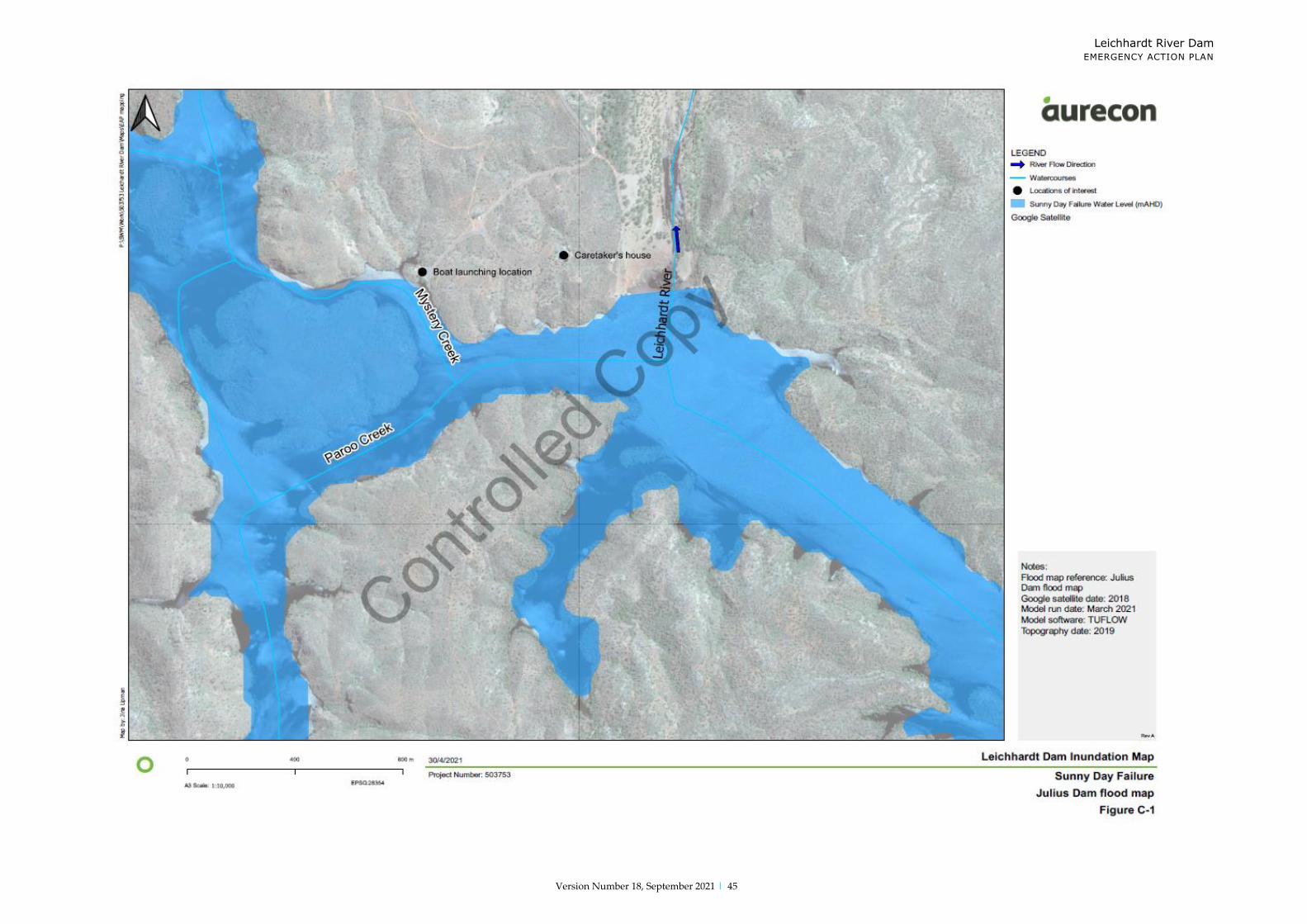
Appendix C
Flood Inundation Assessment Summary
Extracts from FIA Report (Aurecon 2021)
Summary
It was found that the Population at Risk for Sunny Day failure of the dam is 34 persons.
In the event of a Dam Crest Flood, triggering failure of the dam, the incremental population at Risk is 36 persons.
The Population at Risk is spread over a 190 km reach downstream of Leichhardt River
Dam and includes Warrina Park, Haslingden Station, West Leichhardt Station, Kajabbi
and three other settlements downstream of Lake Julius. In the event of failure, flood
waters would peak in the Haslingden station approximately 2.0 hours after breach
initiation. The failure of Leichhardt River Dam would be likely to result in significant damage to West Leichhardt Station. In the event of failure, flood water would peak in the West Leichhardt station approximately 4 to 5 hours after breach initiation.
The failure of the dam would not trigger failure of Lake Julius Dam.
The current Spillway capacity was found to be 4900 m3/s which equates to a 1 in 7,000
AEP flood event. The spillway capacity is currently 43% of the Fall-back Acceptable
Flood Capacity and will need to be upgraded to pass 12,300 m3/s or 100% of the AFC
prior to the year 2035. It is expected that further risk assessment of the Dam will be undertaken to establish if the current spillway capacity requires further upgrade to safely accommodate the Inflow Design Flood (IDF).
Dam Failure Analysis
For the dam failure analysis, the Empirical Model of Embankment Dam Breaching
(Froehlich, 2018) was utilised. To simulate the flood behaviour immediately downstream
of the dam, a series of two-dimensional (2D) hydraulic models were developed using
the TUFLOW software. Hydrologic RORB models were coupled with the Hydraulic Models at the upstream extents of each model.
The following Flow vs Time Plots and Inundation Maps are contained hereafter:
Sunny Day Failure
Dam Crest Flood – No Failure Dam Crest Flood – Failure
Probable Maximum Flood – No Failure
Probable Maximum Flood – Failure
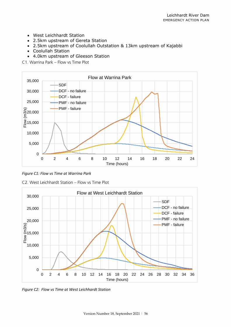
Flow vs Time Plots Warning times
The peak flow of floodwaters at various locations downstream Leichhardt River Dam
are shown in Figure C1 through Figure C6. The graphs indicate the modelled predicted
time to flood peak at the four following locations:
Warrina Park
Leichhardt River Dam EMERGENCY ACTION PLAN
Version Number 18, September 2021 | 56
West Leichhardt Station
2.5km upstream of Gereta Station
2.5km upstream of Coolullah Outstation & 13km upstream of Kajabbi
Coolullah Station
4.0km upstream of Gleeson Station
C1. Warrina Park – Flow vs Time Plot
Figure C1: Flow vs Time at Warrina Park
C2. West Leichhardt Station – Flow vs Time Plot
Figure C2: Flow vs Time at West Leichhardt Station
0
5,000
10,000
15,000
20,000
25,000
30,000
35,000
0 2 4 6 8 10 12 14 16 18 20 22 24
Flo
w (
m3
/s)
Time (hours)
Flow at Warrina Park
SDF
DCF - no failure
DCF - failure
PMF - no failure
PMF - failure
0
5,000
10,000
15,000
20,000
25,000
30,000
0 2 4 6 8 10 12 14 16 18 20 22 24 26 28 30 32 34 36
Flo
w (
m3
/s)
Time (hours)
Flow at West Leichhardt Station
SDF
DCF - no failure
DCF - failure
PMF - no failure
PMF - failure

Leichhardt River Dam EMERGENCY ACTION PLAN
Version Number 18, September 2021 | 57
C3. Gereta Station (2.5 km Upstream) – Flow vs Time Plot
Figure C3: Flow vs Time 2.5km upstream of Gereta Station
C4. Coolullah Outstation (2.5 km upstream) & 13 km Upstream Kajabbi – Flow vs Time Plot
Figure C4: Flow vs Time 2.5km upstream of Coolullah Outstation & 13km upstream of Kajabbi
0
5,000
10,000
15,000
20,000
25,000
0 5 10 15 20 25 30 35 40 45 50 55 60 65 70 75 80
Flo
w (
m3
/s)
Time (hours)
Flow 2.5 km upstream of Gereta Station flood map
SDF
DCF - no failure
DCF - failure
PMF - no failure
PMF - failure
0
5,000
10,000
15,000
20,000
25,000
0 5 10 15 20 25 30 35 40 45 50 55 60 65 70 75 80
Flo
w (
m3
/s)
Time (hours)
Flow 2.5 km upstream of Coolullah Outstation flood map & 13km upstream of Kajabbi flood map
SDF
DCF - no failure
DCF - failure
PMF - no failure
PMF - failure

Leichhardt River Dam EMERGENCY ACTION PLAN
Version Number 18, September 2021 | 58
C5. Coolullah Station – Flow vs Time Plot
Figure C5: Flow vs Time at Coolullah Station
C6. Gleeson Station (4 km Upstream) – Flow vs Time Plot
Figure C6: Flow vs Time 4km upstream of Gleeson Station
In a Sunny Day failure, following failure of the Leichhardt River dam, flood waters would
rise rapidly at Haslingden Station, peaking approximately 2 hours after breach initiation.
The water level would peak at West Leichhardt Station, 13 km downstream,
approximately 4-5 hours after breach initiation. The flood peak would take approximately 14.0 hours to reach Lake Julius Dam Spillway.
0
2,000
4,000
6,000
8,000
10,000
12,000
14,000
16,000
18,000
20,000
0 5 10 15 20 25 30 35 40 45 50 55 60 65 70 75 80
Flo
w (
m3
/s)
Time (hours)
Flow at Coolullah Station
SDF
DCF - no failure
DCF - failure
PMF - no failure
PMF - failure
0
2,000
4,000
6,000
8,000
10,000
12,000
14,000
16,000
18,000
0 5 10 15 20 25 30 35 40 45 50 55 60 65 70 75 80
Flo
w (
m3
/s)
Time (hours)
Flow 4 km upstream of Gleeson Station flood map
SDF
DCF - no failure
DCF - failure
PMF - no failure
PMF - failure

Leichhardt River Dam EMERGENCY ACTION PLAN
Version Number 18, September 2021 | 59
In a Dam Crest flood with failure of the dam, the dam failure was initiated approximately
13 hours after the onset of heavy rainfall. In this circumstance, the peak flood level at Lake Julius Dam was reached approximately 8 hours after failure.
Consequences – Dam Failure
The Incremental Population at Risk (PAR) was determined by site inspection of some of
the properties in the floodplain downstream of the Dam and by the modelled results of
both the SDF and DCF events. All properties in the floodplain downstream of the Dam and included in the PAR numbers are as identified in the aerial imagery
The Incremental Population at Risk (PAR) was determined by inspection of the aerial
photography of the floodplain downstream of the dam. Buildings located within the flood extent or properties where the depth of floodwater exceeds 0.3 m are considered to lie
within the affect zone. The Warrina Park, Haslingden Station and West Leichhardt
Station are the possible infrastructure and localities that are situated downstream of
the Leichhardt River Dam. In addition, four small settlements were identified
downstream of Lake Julius. The furthest downstream of these is approximately 190 km downstream of Lake Julius. These properties may potentially be occupied during a dam failure event and therefore, population at risk exists.
In the Sunny Day failure scenario, it is estimated that the PAR is 34 persons. In the DCF with failure, the incremental PAR would be 36 persons.
The failure of Leichhardt River Dam would not trigger failure of Lake Julius Dam.
Consequences – Flooding Over Spillway (No Dam Failure)
It should be notes that in the event a flood to overtop the spillway but does not
lead to a dam failure, there are populations that will be within the flood inundation
zone. The number of people within this zone are listed in the following table. Further details of the flood inundation zones for relevant flood events are in Appendix B – Flood Inundation Maps.
Table C1: Population At Risk for Flood Events (With & Without Dam Failure)
Flood Event Dam Failure PAR No Dam Failure PAR
Sunny Day 33.6 N/A
1 in 50 AEP 36.4 14.6
1 in 100 AEP 39.2 14.6
1 in 500 AEP 44.8 28.0
1 in 2000 AEP 56.0 36.4
1 in 7000 AEP 84.0 47.6
1 in 50,000 AEP 100.8 72.8
Probable Maximum Precipitation 100.8 98.0
Probable Maximum Flood 100.8 98.0

Leichhardt River Dam EMERGENCY ACTION PLAN
Version Number 18, September 2021 | 60
Appendix D
Appendix D Weather Information (Flood Warning)
Flood Warning
USING THE INTERNET – www.bom.gov.au
Click on this link
Click on QLD for Flood Warning

Leichhardt River Dam EMERGENCY ACTION PLAN
Version Number 18, September 2021 | 61
Radar Images
Place cursor over AUSTRALIA then
click Radar Images
Queensland Flood
Warning information

Leichhardt River Dam EMERGENCY ACTION PLAN
Version Number 18, September 2021 | 62
Rainfall and River Conditions
Click on Mount Isa to
view Mount Isa Radar Loop
Place cursor over QLD then click Rainfall & River
Conditions

Leichhardt River Dam EMERGENCY ACTION PLAN
Version Number 18, September 2021 | 63

Leichhardt River Dam EMERGENCY ACTION PLAN
Version Number 18, September 2021 | 64
Appendix E Discharge and Storage Curves
Figure E1: Stage / storage Relationship (Aurecon FIA, 2021)
Figure E2: Stage / Discharge Relationship (Aurecon FIA, 2021)
FSL = 106 GL
FSL = 326.21m AHD
Dam Crest = 330.94m AHD

Leichhardt River Dam EMERGENCY ACTION PLAN
Version Number 18, September 2021 | 65
Appendix F
Modified Mercalli Scale
No. Descriptive
Term
Description Acceleration
(cm/s2)
I Imperceptible Not felt. Marginal and long-period effects of large earthquakes.
<1
II Very Slight Felt by persons at rest, on upper floor, or favourably placed. 1-2
III Slight Felt indoors. Hanging objects swing. Vibration like passing of light trucks. Duration estimated. May not be recognised
as an earthquake.
2-5
IV Moderate Hanging objects swing. Vibration like passing of heavy trucks or sensation of a jolt like a heavy ball striking the walls. Standing motor cars rock. Windows, dishes, doors
rattle. Glasses clink, crockery clashes. In upper range of IV, wooden walls and frames creak.
5-10
V Rather Strong Felt outdoors; direction estimated. Sleepers waken. Liquids
disturbed, some spilled. Small unstable objects displaced or upset. Doors swing, close, open. Shutters, pictures move. Pendulum clocks stop, start, change rate.
10-20
VI Strong Felt by all. Many frightened and run outdoors. People walk unsteadily. Dishes, glassware broken. Knick-knacks, books, off shelves. Pictures off walls. Furniture overturned or moved. Weak plaster, masonry D cracked. Small bells ring.
Trees shaken.
20-50
VII Very Strong Difficult to stand. Noticed by motor car drivers. Hanging objects quiver. Furniture broken. Damage, to masonry D,
including cracks. Weak chimneys broken at roof line. Fall of plaster, loose bricks, stones, tiles, cornices. Some cracks in masonry C. Waves on ponds: water turbid with mud. Small
slides and caving in along sand or gravel banks. Large bells ring. Concrete irrigation ditches damaged.
50-100
VIII Destructive Steering of motor cars affected. Damage to masonry C: partial collapse. Some damage to masonry B, none to
masonry A. Fall of stucco, some masonry walls. Twisting,
fall of chimneys factory stacks, monuments, towers, elevated tanks. Frame houses move on foundations if not
bolted down; loose panel walls thrown out. Decayed piling broken off. Branches broken from trees. Changes in flow or temperature of springs and wells. Cracks in wet ground, on
steep slopes.
100-200
IX Devastating General panic. Masonry D destroyed; masonry C heavily damaged, sometimes with complete collapse; masonry B seriously damaged. Frame structures, if not bolted, shifted
off foundations. Frames cracked. Serious damage to reservoirs. Underground pipes broken. Conspicuous cracks in ground. In alleviated areas sand, mud ejected,
earthquake fountains, sand craters.
200-500
X Annihilating Most masonry and frame structures destroyed with their foundations. Some well-built wooden structures and
500-1000

Leichhardt River Dam EMERGENCY ACTION PLAN
Version Number 18, September 2021 | 66
bridges Destroyed. Serious damage to dams, dykes, and embankments. Large landslides. Water thrown on banks of
canals, rivers, lakes, etc. Sand and mud shifted horizontally
on beaches and flat land. Rails bent slightly.
XI Disaster Disaster Rails bent greatly. Underground pipelines completely out of service.
1000-2000
XII Major Disaster Major Disaster Damage nearly total. Large rock masses displaced. Line of sight and level distorted. Objects thrown into the air.
>2000
Categories of Masonry
Masonry A:
Good workmanship, mortar and design; reinforced, especially laterally, and bound
together using:
₋ Steel
₋ Concrete etc.
₋ Designed to resist lateral forces
Masonry B:
Good workmanship and mortar; reinforced, but not designed in detail to resist lateral forces.
Masonry C:
Ordinary workmanship and mortar; no extreme weaknesses like failing to tie in at corners, but neither reinforced nor designed against horizontal forces.
Masonry D:
Weak materials such as:
₋ Adobe
₋ Poor mortar
₋ Low standards or workmanship
₋ Weak horizontally

Leichhardt River Dam EMERGENCY ACTION PLAN
Version Number 18, September 2021 | 67
Appendix G
EMERGENCY RESOURCES
In an emergency situation, equipment, supplies and construction personnel will likely be needed on short notice. The table below lists general emergency resources, and also indicates how to
access them. Item Contact/Telephone Location_________________
General Remploy 4743 4190 101 Duchess Road Mt Isa
Front end Loader Remploy 4743 4190 101 Duchess Road Mt Isa
Excavators Remploy 4743 4190 101 Duchess Road Mt Isa
Sand & Gravel Remploy 4743 4190 101 Duchess Road Mt Isa
Sandbags IDC Store 4744 2350 Mount Isa Mines
Pumps Coates Hire 47491902 Barkly Highway Mt Isa
Labourers’ Remploy 4743 4190 101 Duchess Road Mt Isa
Tradesmen Schmider 0403 045 588 Commercial Road Mt Isa
Custom Steel Fabrication 2 Traders Way Mt Isa 0447 011 412 Pipe Tonkin Steel 4743 4089 45 Commercial Road Mt Isa
Helicopter NQ Rescue Helicopter 4743 0937 Mount Isa Airport

Leichhardt River Dam EMERGENCY ACTION PLAN
Version Number 18, September 2021 | 68
Appendix H
DAM SAFETY EMERGENCY SITUATION REPORT
The dam operator/caretaker is responsible for undertaking daily, weekly and monthly inspection of Leichhardt River Dam. Weekly and monthly inspections are recorded via the
completion of a Data Record Form which are available through Glencore’s Internal Document Management System. These can be accessed via the following links:
C-MIM-CENG-FRM-Lake Moondarra Dam Weekly Inspection (577002) C-MIM-CENG-FRM-Lake Moondarra Dam Monthly Inspection (577003)
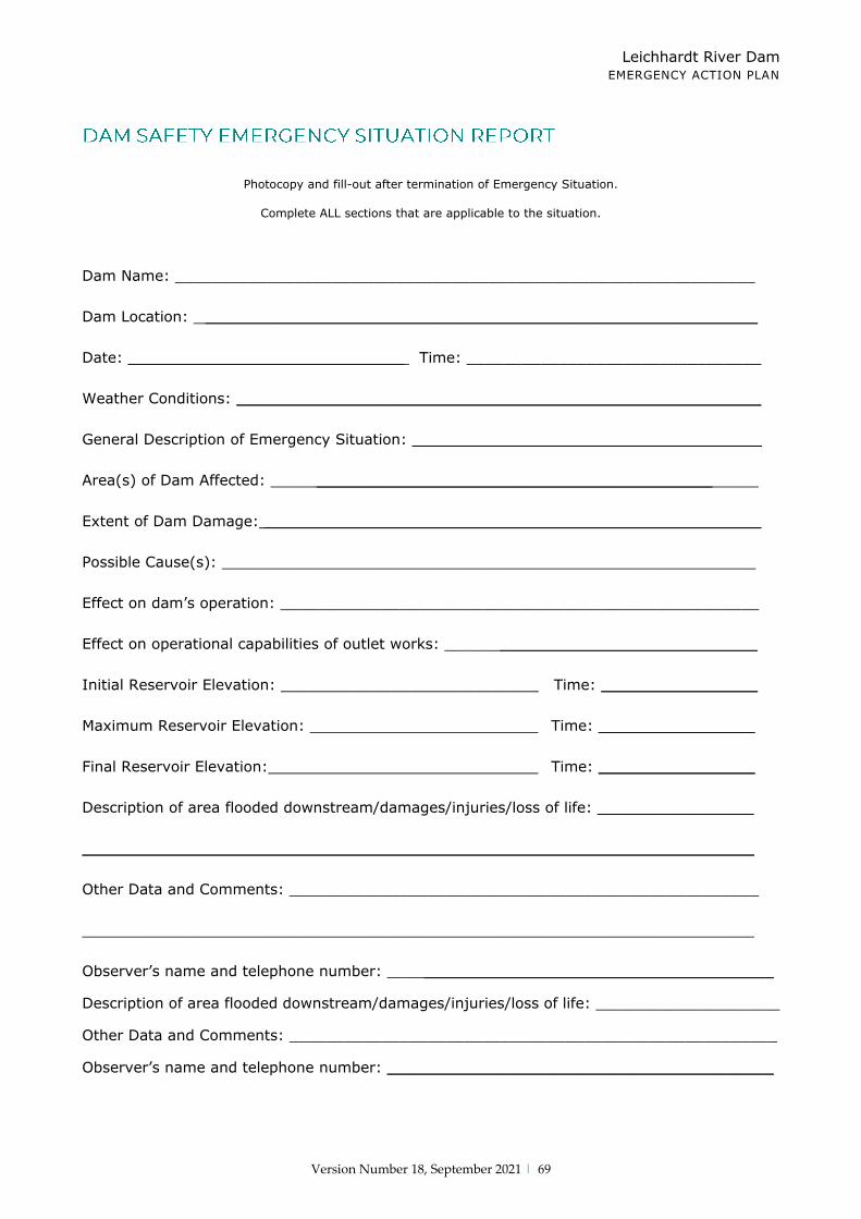
Leichhardt River Dam EMERGENCY ACTION PLAN
Version Number 18, September 2021 | 69
Photocopy and fill-out after termination of Emergency Situation.
Complete ALL sections that are applicable to the situation.
Dam Name: _______________________________________________________________
Dam Location: ____________________________________________________________
Date: ______________________________ Time: ________________________________
Weather Conditions: _________________________________________________________
General Description of Emergency Situation: ______________________________________
Area(s) of Dam Affected: _____________________________________________________
Extent of Dam Damage: ______________________________________________________
Possible Cause(s): __________________________________________________________
Effect on dam’s operation: ____________________________________________________
Effect on operational capabilities of outlet works: __________________________________
Initial Reservoir Elevation: ____________________________ Time: _________________
Maximum Reservoir Elevation: Time: _________________
Final Reservoir Elevation: Time: _________________
Description of area flooded downstream/damages/injuries/loss of life: _________________
_________________________________________________________________________
Other Data and Comments: ___________________________________________________
_________________________________________________________________________
Observer’s name and telephone number: __________________________________________
Description of area flooded downstream/damages/injuries/loss of life: ____________________
Other Data and Comments: _____________________________________________________
Observer’s name and telephone number: __________________________________________
Leichhardt River Dam EMERGENCY ACTION PLAN
Version Number 18, September 2021 | 70
Communication Record
Date: Time: AM
PM Author:
Communication With: Communication: Conversation
Telephone
Subject:
Telephone Number Called: Affiliation:
Other Pertinent Information:
Discussion Summary:
Action Item Action Resolution/Completion
1. 1.
2. 2.
3. 3.
4. 4.
5. 5.
Distribution List:
Author’s Signature:
(Print name, then sign.) (Date)
Utilities Water Distribution Department

Leichhardt River Dam EMERGENCY ACTION PLAN
Version Number 18, September 2021 | 71

Leichhardt River Dam EMERGENCY ACTION PLAN
Version Number 18, September 2021 | 72
DATE JAN FEB MARCH APRIL MAY JUNE JULY AUG SEPT OCT NOV DEC
1 2 3 4 5 6 7 8 9 10 11 12 13 14 15 16 17 18 19 20 21 22 23 24 25 26 27 28 29 30 31

Leichhardt River Dam EMERGENCY ACTION PLAN
Version Number 18, September 2021 | 73
Appendix I
Standard phone, SMS and email messages to the immediately
affected downstream residents and others
ALERT NOTIFICATION FOR– 4.3.1 (LDMG, GMIMSC, LJSS)
Dam: Leichhardt River Dam
Event: 4.3.1 Dam spillway overtopping, increased downstream flows expected. Flood at XXXX (XXX below Abutment Crest Level).
Act Level: Alert. Moderate flooding possible.
Notification Updates: 24 hourly.
Refer: www.bom.gov.au and contact Local Emergency Mgt. Group on for more details
ALERT NOTIFICATION FOR– 4.3.2 (LDMG, 20kRes, GMIMSC, DRDMW, MIWB, LJSS)
Dam: Leichhardt River
Event: 4.3.2 Flood at XXXX and (rising / steady / falling).
Act Level: Lean Forward. Moderate flooding expected.
Notification Updates: 8 hourly updates.
Refer::www.bom.gov.au and contact Local Emergency Mgt. Group on for more details
ALERT NOTIFICATION FOR – 4.3.3 (Emergency Services, LDMG, GMIMSC, 20kRes, LJSS, DRDMW, MIWB)
Dam: Leichhardt River
Event: 4.3.3 Flood at XXXX and (rising / steady / falling).
Act Level: Stand Up. High level of flooding expected.
Notification Updates: Every 8 hours
Refer::Immediately contact the Local Emergency Mgt. Group on for more details
ALERT NOTIFICATION FOR – 4.3.4 (LDMG, 20kRes, GMIMSC, DRDMW, MIWB, LJSS)
Dam: Leichhardt River
Event: 4.3.4 Flood levels receding.
Act Level: Stand Down. No further updates pending.
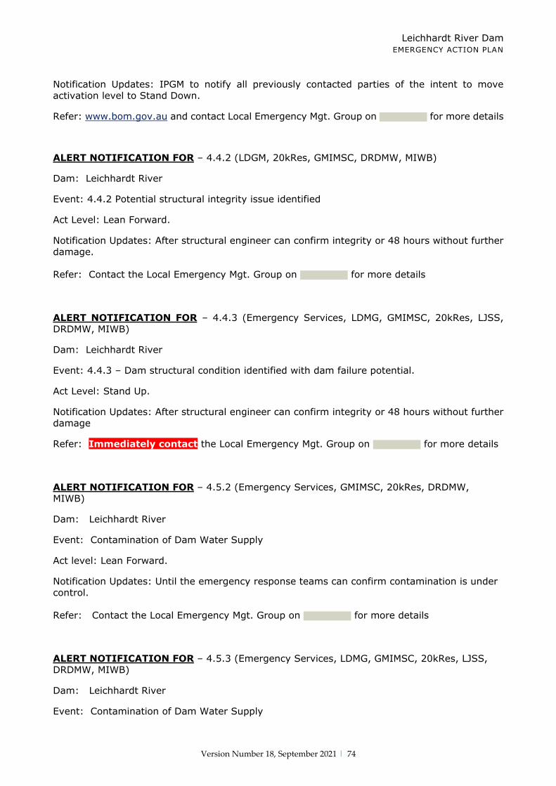
Leichhardt River Dam EMERGENCY ACTION PLAN
Version Number 18, September 2021 | 74
Notification Updates: IPGM to notify all previously contacted parties of the intent to move activation level to Stand Down.
Refer: www.bom.gov.au and contact Local Emergency Mgt. Group on for more details
ALERT NOTIFICATION FOR – 4.4.2 (LDGM, 20kRes, GMIMSC, DRDMW, MIWB)
Dam: Leichhardt River
Event: 4.4.2 Potential structural integrity issue identified
Act Level: Lean Forward.
Notification Updates: After structural engineer can confirm integrity or 48 hours without further damage.
Refer: Contact the Local Emergency Mgt. Group on for more details
ALERT NOTIFICATION FOR – 4.4.3 (Emergency Services, LDMG, GMIMSC, 20kRes, LJSS, DRDMW, MIWB)
Dam: Leichhardt River
Event: 4.4.3 – Dam structural condition identified with dam failure potential.
Act Level: Stand Up.
Notification Updates: After structural engineer can confirm integrity or 48 hours without further damage
Refer: Immediately contact the Local Emergency Mgt. Group on for more details
ALERT NOTIFICATION FOR – 4.5.2 (Emergency Services, GMIMSC, 20kRes, DRDMW, MIWB)
Dam: Leichhardt River
Event: Contamination of Dam Water Supply
Act level: Lean Forward.
Notification Updates: Until the emergency response teams can confirm contamination is under control.
Refer: Contact the Local Emergency Mgt. Group on for more details
ALERT NOTIFICATION FOR – 4.5.3 (Emergency Services, LDMG, GMIMSC, 20kRes, LJSS, DRDMW, MIWB)
Dam: Leichhardt River
Event: Contamination of Dam Water Supply
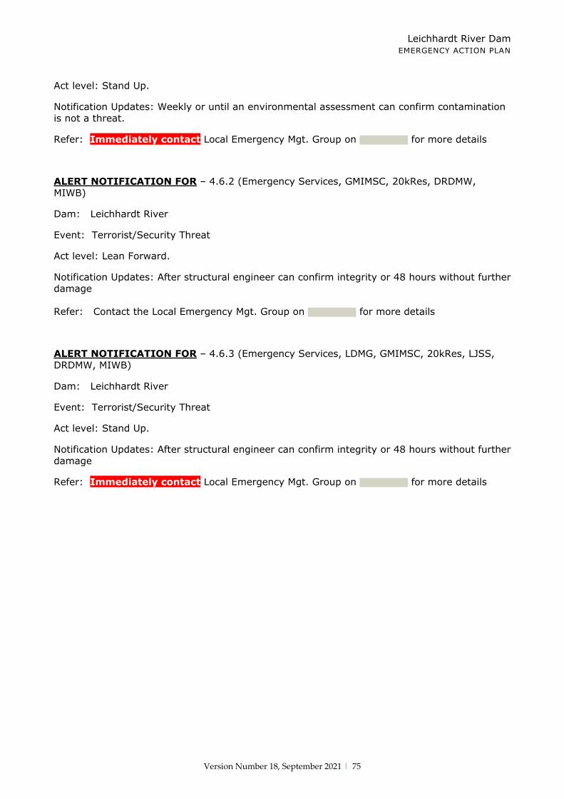
Leichhardt River Dam EMERGENCY ACTION PLAN
Version Number 18, September 2021 | 75
Act level: Stand Up.
Notification Updates: Weekly or until an environmental assessment can confirm contamination is not a threat.
Refer: Immediately contact Local Emergency Mgt. Group on for more details
ALERT NOTIFICATION FOR – 4.6.2 (Emergency Services, GMIMSC, 20kRes, DRDMW, MIWB)
Dam: Leichhardt River
Event: Terrorist/Security Threat
Act level: Lean Forward.
Notification Updates: After structural engineer can confirm integrity or 48 hours without further damage
Refer: Contact the Local Emergency Mgt. Group on for more details
ALERT NOTIFICATION FOR – 4.6.3 (Emergency Services, LDMG, GMIMSC, 20kRes, LJSS, DRDMW, MIWB)
Dam: Leichhardt River
Event: Terrorist/Security Threat
Act level: Stand Up.
Notification Updates: After structural engineer can confirm integrity or 48 hours without further damage
Refer: Immediately contact Local Emergency Mgt. Group on for more details

Leichhardt River Dam EMERGENCY ACTION PLAN
Version Number 18, September 2021 | 76
Appendix J
Public Access to Notification List via Internet
USING THE INTERNET –
http://www.glencore.com.au
Click on this link
Hover over Operations and
Projects
Click on
Queensland Metals
Click on
Sustainability

Leichhardt River Dam EMERGENCY ACTION PLAN
Version Number 18, September 2021 | 77
Click on
Environmental
Click on Water
resource management

Leichhardt River Dam EMERGENCY ACTION PLAN
Version Number 18, September 2021 | 78
Click on Water
Emergency Notification
1. Fill out
appropriate fields with *
2. Tick Lake
Moondarra Dam box
4. Press Submit
3. Tick I’m not a robot box
Scroll down until you find
emergency notification

Leichhardt River Dam EMERGENCY ACTION PLAN
Version Number 18, September 2021 | 79
Private Mail Bag 6 · Mount Isa · Queensland 4825 · Australia Tel +61 7 4744 2011 · Fax +61 7 4744 3737 · Web www.mountisamines.com.au
Mount Isa Mines Limited ABN 87 009 661 447