Leica ALS80 · LS80-LP ALS80-CM ALS80-HP Leica ALS80-CM is designed for city and corridor mapping...
6
Leica ALS80 Airborne Laser Scanners Performance for every Application
-
Upload
duongkhanh -
Category
Documents
-
view
217 -
download
0
Transcript of Leica ALS80 · LS80-LP ALS80-CM ALS80-HP Leica ALS80-CM is designed for city and corridor mapping...

Leica ALS80Airborne Laser ScannersPerformance for every Application

Three Models, One Result.Highest Productivity in all Applications.
Imagine an affordable city-mapping LIDAR system with an
industry-leading 1.0 MHz pulse rate, capable of meeting
your specialized needs now, and that is easily upgradable
to a full-capability configuration as your business grows.
Imagine producing high density point clouds for corridor,
urban, flood plain or general-purpose airborne mapping in
a fraction of the time it took previously.
Imagine being able to perform wide-area mapping from
high altitudes to obtain nearly 8 km swath.
The Leica ALS80 is a single family of systems that offers
this level of flexibility and productivity, without compro-
mising on quality and accuracy. Three models, Leica
ALS80-CM, Leica ALS80-HP and Leica ALS80-HA, share
a common platform (high-performance laser, scanner,
range counting electronics, position/attitude measure-
ment subsystem and user interface, flight planning and
execution software), to create a range of laser scanners
designed to meet the varied needs of the airborne
survey market.
Two Laser Scanner configurations and two System
Controller configurations are combined to create the
three models in the Leica ALS80 range:
1-6 PiA
1-6 PiA
1-5 PiA
5,000 m AGL *
3,500 m AGL *
1,600 m AGL *
ØØ
Ø
System Controller
SC80-CM SC80
ScannerLS80-HA N/A ALS80-HA
LS80-LP ALS80-CM ALS80-HP
Leica ALS80-CM is designed for city and
corridor mapping applications from lower
flying heights. Ultra-high-density can be
achieved by flying in small aircraft or
mounted in helicopter pods, taking
advantage of the low-profile scanner.
Leica ALS80-HP is designed for general-
purpose mapping at the flying heights
most widely used, and can accommodate
greater terrain relief due to its higher
maximum flying height.
Leica ALS80-HA is a high-altitude variant,
allowing the market’s highest flying
heights, for wide-area mapping on a
state or national level.
CM
HP
HA
Need room to grow? No problem.
The unique modular design of the Leica ALS80 offers
numerous benefits, including easy growth options.
Did your business start with lower-altitude corridor
mapping, but is expanding? Any Leica ALS80-CM can
become a Leica ALS80-HP at the user’s site. Need
truly high altitude performance? Leica ALS80-CM and
Leica ALS80-HP can be factory-reconfigured into Leica
ALS80-HA and vice versa. Expanding your business into
forestry and environmental areas? Add the optional Full
Waveform Digitizer at any time, at any location.
Leica ALS80 – a total package
Leica ALS80 systems come complete with peripheral
products and software that provide a seamless workflow
from mission planning through point cloud generation.
* Flying heights based on 10 % diffuse reflective target
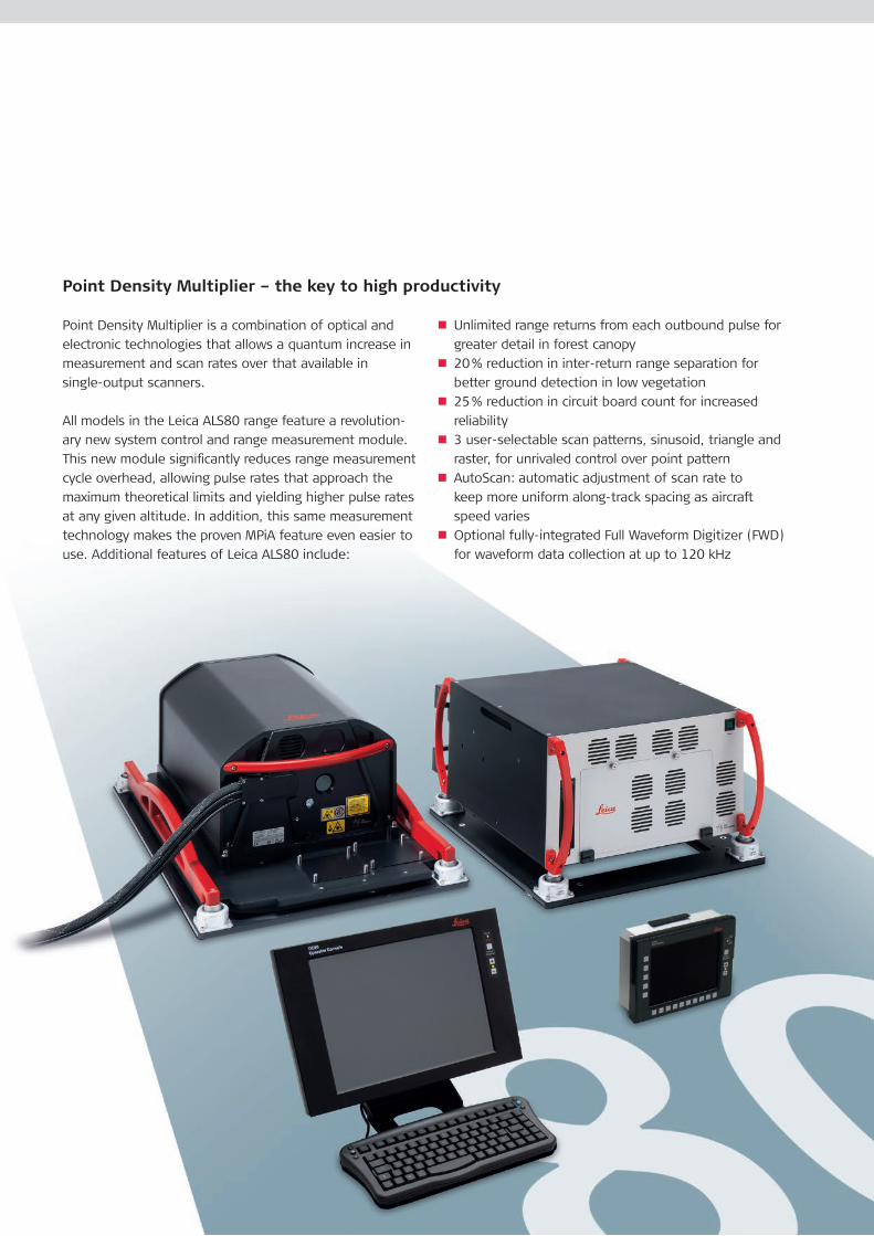
Point Density Multiplier is a combination of optical and
electronic technologies that allows a quantum increase in
measurement and scan rates over that available in
single-output scanners.
All models in the Leica ALS80 range feature a revolution-
ary new system control and range measurement module.
This new module significantly reduces range measurement
cycle overhead, allowing pulse rates that approach the
maximum theoretical limits and yielding higher pulse rates
at any given altitude. In addition, this same measurement
technology makes the proven MPiA feature even easier to
use. Additional features of Leica ALS80 include:
n Unlimited range returns from each outbound pulse for
greater detail in forest canopy
n 20 % reduction in inter-return range separation for
better ground detection in low vegetation
n 25 % reduction in circuit board count for increased
reliability
n 3 user-selectable scan patterns, sinusoid, triangle and
raster, for unrivaled control over point pattern
n AutoScan: automatic adjustment of scan rate to
keep more uniform along-track spacing as aircraft
speed varies
n Optional fully-integrated Full Waveform Digitizer (FWD)
for waveform data collection at up to 120 kHz
Point Density Multiplier – the key to high productivity
Leica ALS80-CM and Leica ALS80-HP models also
feature a unique multiple-output scanning system.
This new scanning approach allows the system to double
the pulse rate and scan rate of single-output systems,
without the use of multiple scanner assemblies or lasers.
The elegance of this implementation adds to the stability
and consistency of the high-point-density data product
delivered by the system, without increasing the complex-
ity of system control.
Mission planning and system control
Planning for all Leica ALS80 models is accommodated
using Leica MissionPro planning and evaluation software,
including optimizing both system settings as well as flight
line layout. The intuitive AeroPlan pull-down menu allows
manual or automated optimization of system settings in
three ways:
n Fixed settings on all lines with fixed flying altitude for
all lines
n Variable settings for each line with fixed flying altitude
for all lines
n Variable settings for each line with different flying
altitudes for each line
This third optimization mode can cut the number of flight
lines by 40 % in large-relief terrain.
Leica MissionPro software works hand-in-hand with
Leica FlightPro flight management software, by transfer-
ring the entire mission plan, both sensor settings and
flight navigation information, from planner to system in
a single digital file. Direct transfer of the mission plan
minimizes the chance for operator error, and ensures
that the mission is flown exactly as intended.
Leica FlightPro provides an information-rich user interface
for both operator and pilot, allowing both crew members
access to critical data on flight navigation, progress and
system performance. The optional “remote control”
software module allows the operator and pilot to view
different presentations simultaneously to maximize
productivity.
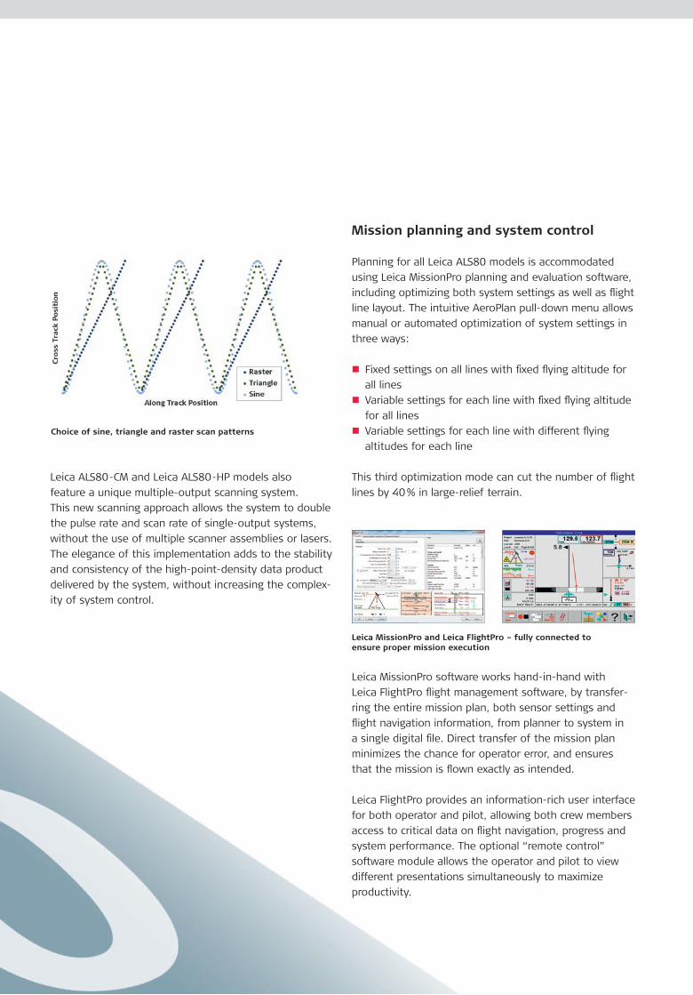
Choice of sine, triangle and raster scan patterns
Leica MissionPro and Leica FlightPro – fully connected to ensure proper mission execution

Quick, comprehensive post processing
Post-flight data processing uses NovAtel Inertial Explorer
for GNSS/IMU data reduction and Leica CloudPro for
generation of the point cloud. NovAtel Inertial Explorer
utilizes “tightly-coupled” GNSS/IMU data processing to
allow full trajectory accuracy, even when satellites are
temporarily obscured, reducing the need for inefficient
and lengthy low-bank-angle turns from one flight line to
the next.
Leica CloudPro provides multi-threaded processing for
reduced processing time and a command-line interface
compatible with GeoCue job management software or
your custom workflows. And the included Leica AHAB LSS
Viewer allow simple, fast viewing and measurements to
be made in the produced data set.
System performance
Leica ALS80-CM and Leica ALS80-HP systems achieve
industry-leading measurements rates of 1.0 MHz,
reducing on-line flying time by up to 50 % over the
previous generation of systems. Leica ALS80-HA offers
an extended flying height with scan rates appropriate for
wide-area data acquisition.
Leica ALS80 accommodates operation with up to 6PiA
operation (5PiA for Leica ALS80-CM), carrying high pulse
rates to even greater flying heights.
Leica ALS80-CM and Leica ALS80-HP provide high accuracy, even in MPiA mode
Leica ALS80-HA carries accuracy to an industry-leading 5,000 m AGL
Model
ALS80-CM ALS80-HP ALS80-HA
Maximum Flying Height (m AGL)* 1,600 3,500 5,000
Minimum Flying Height (m AGL) 100 100 100
Maximum Measurement Rate (kHz) 1,000 1,000 500
Field of view
(degrees, full-angle, user-adjustable)0 – 72 0 – 75
Roll stabilization
(automatic adaptive, degrees)72 – active FOV 75 –
active FOV
Scan patterns (user selectable) sine, triangle, raster
sine
Maximum Scan Rate (Hz) triangle
raster
200
158
120
100
79
60
Numbers of returns
Number of intensity measurements
unlimited
3 (first, second, third)
Accuracy see graph
Storage media removable 800 GB SSD
Storage capacity
(hours @ max pulse rate, 2 returns)6,9 9,2
Physical specifications (unmounted)
All Models
Size (cm), Weight (kg)
Scanner
Control Electronics
37 W x 68 L x 26 H cm
47 kg
45 W x 47 D x 25 H cm
33 kg
Operating Temp. (C ) Scanner
Control Electronics
0 –40°C cabin-side temperature
0 –40°C
Flight Management Leica FlightPro
Power Consumption
(nominal, including FWD option)922 W @ 22.0 – 30.3 VDC
Leica LS80-LP Scanner
* 10 % diffuse reflective target
Main performance specifications

Leica Geosystems AG Heerbrugg, Switzerland
www.leica-geosystems.comhttp://di.leica-geosystems.com
Illustrations, descriptions and technical data are not binding. All rights reserved. Printed in Switzerland – Copyright Leica Geosystems AG, Heerbrugg, Switzerland, 2014. 823028en – 08.14 – galledia
Class 4 Laser Product Invisible laser radiation: Avoid eye or skin exposure to direct or scattered radiation
Whether you want to capture airborne data of an agricultural area
or of a city, record the challenges in a disaster area or the expanse of
a high tension line, you need reliable measurements and solutions for
your entire workflow to build image-based maps. Leica Geosystems’
broad array of airborne sensors and integrated software solutions
capture data efficiently, reference imagery accurately, measure easily,
analyze and present spatial information in 3D.
Those who use Leica Geosystems products every day trust them
for their precision, their seamless integration and their superior
customer support. When data really counts, Leica Geosystems delivers
geospatial imaging solutions with precision, integration and service.
When it has to be right.
The Leica ADS100Airborne Digital SensorAirborne Evolution
Leica RCD30 Series 80 MP CameraMultispectral RGBN Imagery
Leica FlightProMake every flighta success
Leica MissionProMission Planning Software
n Full multispectral color swath width of 20000 pixels
in RGBN for highest data acquisition efficiency
n Selectable TDI stages for improved sensitivity and
expanded operational envelope
n Improved cycle time to acquire smaller GSDs
at faster speed
n Full color RGBN in forward, nadir and backward for
more flexible stereo interpretation
n Improved Leica PAV100 gyrostabilized mount with
adaptive control for improved image quality
n Embedded Novatel SPAN GNSS/IMU with tightly coupled
processing to reduce fuel consumption
n End-to-end workflow from mission planning with Leica
MissionPro to orthophoto and point cloud generation
with Leica XPro
The new Leica ADS100 Airborne Digital Sensor – Airborne evolution.
For over ten years, the Leica ADS Airborne Digital Sensor has defined airborne imaging. Just like your job requirements, it has evolved over time to continuously innovate in image quality, accuracy, acquisition performance and processing speed.
The Leica ADS100 Airborne Digital SensorAirborne Evolution
The new Leica ADS100 continues to lead the path of airborne evolution. With its number of unique features it
is designed to meet the needs of 21st century airborne imaging with higher acquisition efficiency, more applications
and reduced costs.
In addition, the Leica ADS100 supports a unified aircraft installation. All aircraft components such as Leica PAV100,
Camera Controller CC33 as well as operator and pilot displays can be shared with the Leica RCD30 medium format
and oblique cameras, thus significantly reducing cost of ownership and simplifying operation.
The new Leica ADS100 – Leading airborne evolution.
Leica RCD30 Series80 MP Camera Multispectral RGBN Imagery
A true MasterpieceThe Leica RCD30 Series is not only true imaging
innovation, it remains a masterpiece. The Leica RCD30
offers performance that is otherwise only known from
large-format airborne sensors at a lower cost and thus
makes digital multispectral photogrammetry available to
everyone.
The Leica RCD30 boasts quite a number of innovative and
unique “world‘s first“ features and is the only suitable
medium format camera for photogrammetric and remote
sensing applications:
n 60MP and 80MP single camera heads deliver
co-registered, multispectral RGBN imagery
nMechanical Forward Motion Compensation (FMC)
along two axis
n Ruggedized and thermal stabilized lens system with
innovative bayonet mount and user replaceable central
shutter with automatically controlled high precision
aperture
nModular concept for single standalone, multihead and
oblique configurations
n Full integration with Leica ALS LIDAR and other third
party sensors as well as the Leica MissionPro and
Leica FlightPro Software
The new Leica RCD30 camera is presently the only one in the market which is able to collect 80 MP RGBN multispectral imagery perfectly co-registered. When first released, the Leica RCD30 Series of medium format cameras started a revolution in airborne imaging. Since then, just like the RC30 has once set standards in film based airborne imaging, the Leica RCD30 is setting new standards in what you and your customers can expect from a medium format digital camera.
NEW
The new Leica RCD30 Series – unique imaging innovation from the leader
RGB FCIR
Leica FlightPro Make every flight a success
Leica MissionProMission Planning Software
Leica_MissionPro_6P_Bro_DIN_V5.indd 3 07.03.12 10:04
Cover image Lucerne, Switzerland, flown from 1,600 m AGL at 100 knots, with a 15-degree FOV, 50 Hz scan rate and 140 kHz (MPiA) pulse rate. Point density ~25 points / m2, average post spacing 20 cm. Fusion of intensity image and classified point cloud.