Leeder 1993. Tectonic Controls Alluvial Architecture
17
Geological Society, London, Special Publications doi: 10.1144/GSL.SP.1993.073.01.02 p7-22. 1993, v.73; Geological Society, London, Special Publications M. R. Leeder and characterization implications for hydrocarbon reservoir development river channel migration and alluvial architecture: Tectonic controls upon drainage basin development, service Email alerting new articles cite this article to receive free e-mail alerts when here click request Permission part of this article to seek permission to re-use all or here click Subscribe Collection London, Special Publications or the Lyell to subscribe to Geological Society, here click Notes © The Geological Society of London 2014 at MINCYT on March 11, 2014 http://sp.lyellcollection.org/ Downloaded from at MINCYT on March 11, 2014 http://sp.lyellcollection.org/ Downloaded from
-
Upload
nicolas-farroni -
Category
Documents
-
view
215 -
download
0
Transcript of Leeder 1993. Tectonic Controls Alluvial Architecture
Geological Society, London, Special Publications
doi: 10.1144/GSL.SP.1993.073.01.02p7-22.
1993, v.73;Geological Society, London, Special Publications M. R. Leeder and characterizationimplications for hydrocarbon reservoir developmentriver channel migration and alluvial architecture: Tectonic controls upon drainage basin development,
serviceEmail alerting
new articles cite this article to receive free e-mail alerts whenhereclick
requestPermission
part of this article to seek permission to re-use all orhereclick
Subscribe
Collection London, Special Publications or the Lyell
to subscribe to Geological Society,hereclick
Notes
© The Geological Society of London 2014
at MINCYT on March 11, 2014http://sp.lyellcollection.org/Downloaded from at MINCYT on March 11, 2014http://sp.lyellcollection.org/Downloaded from
Tectonic controls upon drainage basin development, river channel migration and alluvial architecture: implications for hydrocarbon
reservoir development and characterization
M. R. LEEDER Department of Earth Sciences, University of Leeds, Leeds LS2 9JT, UK
Abstract: Hydrocarbon reservoirs of ttuviatile origin are the product of a number of geological processes acting on a variety of scales. Reservoir characterization must be approached holistically in order to understand these processes fully. Tectonic style produces the macro-architectural framework and influences the behaviour of rivers at a meso- architectural scale. Tectonics controls the magnitude, position and development of drainage basins and thus, with climate and local geology, controls the flux of sediment fed into any fluviatile system. Migration of normal faulting may lead to the initiation of drainage basins in previously depositional areas, erosion and reworking thus enhancing reservoir quality. Sediment may be introduced as axial or transverse fluxes. Deducing these contributions in ancient basins establishes basin geometry and the basis for reservoir characterization. Individual river channels are highly susceptible to gradient changes caused by tectonic tilting. This causes slow channel belt migration, incision or sudden diversion (avulsion), depending, in a poorly known way, upon the magnitude of the gradients involved. The alluvial architecture of both tilt-block and growth fold basins is discussed, the latter illustrated by recent studies in the Southern North Sea Basin.
There is currently widespread interest in the interaction between sedimentation and tectonics, particularly in the ways in which tectonic pro- cesses control the development in space and time of different types of sedimentary environments. The distribution and tectonic control of sand lithofacies that make up reservoirs is obviously of great relevance in the hydrocarbon industry. In this contribution it is proposed that an interdisciplinary approach to the study of neo- tectonics, drainage basin development and sedi- ment deposition can shed light on the evolution of sedimentary environments adjacent to active faults and folds. Some of the lessons learnt from this approach may be useful in evaluating the geological controls upon hydrocarbon reservoirs that formed in previously active basins such as the Mesozoic extensional basins of the northern North Sea and the recently recognized Upper Carboniferous growth-fold plays in the southern North Sea.
Since stream channels transfer water and sedi- ment down the local and regional gravity slope, they are sensitive indicators of active tectonics which perturbs surface gradients by faulting and warping. Fluviatile reservoirs will also reflect the nature of the contemporary fluvial regime, such as channel magnitude, sinuosity and migration pathway. These variables are in turn controlled by the regional slopes, drainage basin areas and
discharge imposed by tectonics, geology and climate. A fluviatile deposystem can also mould its own local slope and may be said to possess its own inertial resistance to landscape change induced by tectonics. Thus fluviatile reservoir sequences must be studied in a holistic manner, with due regard for all the influences that might have affected the stratigraphic architecture.
Fluvial architecture: scale, controls and time
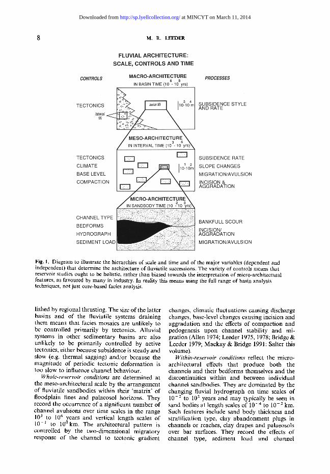
Figure 1 illustrates the continuum of scales in fluvial architecture that the petroleum sedimen- tologist must work with in order to develop a reservoir model fully.
Basin type is established by tectonics and pro- vides the macro-architectural framework for reservoir characterization. Time scales are in the range 106 to 108 years, with horizontal length scales of 101 to 103 krn and vertical length scales of 10 ~ to 101 km. Extensional basins and their facies mosaics are often strongly asymmetric and controlled by the rotation of normal fault- bounded tilt blocks. Pull-apart basins astride inflections in strike slip faults are narrow and frequently asymmetric. Thrust-related basins in compressional settings may form as narrow growth synclines in the footwall of blind thrusts, or they may define flexural basins of great wave- length adjacent to major crustal loads estab-
From North, C. P. & Prosser, D. J. (eds), 1993, Characterization of Fluvial and Aeolian Reservoirs, Geological Society Special Publication No 73, pp 7-22.
at MINCYT on March 11, 2014http://sp.lyellcollection.org/Downloaded from
8 M.R. LEEDER
Fig. 1. Diagram to illustrate the hierarchies of scale and time and of the major variables (dependent and independent) that determine the architecture of fluviatile successions. The variety of controls means that reservoir studies ought to be holistic, rather than biased towards the interpretation of micro-architectural features, as favoured by many in industry. In reality this means using the full range of basin analysis techniques, not just core-based facies analysis.
lished by regional thrusting. The size of the latter basins and of the fluviatile systems draining them means that facies mosaics are unlikely to be controlled primarily by tectonics. Alluvial systems in other sedimentary basins are also unlikely to be primarily controlled by active tectonics, either because subsidence is steady and slow (e.g. thermal sagging) and/or because the magnitude of periodic tectonic deformation is too slow to influence channel behaviour.
Whole-reservoir conditions are determined at the meso-architectural scale by the arrangement of fluviatile sandbodies within their 'matrix' of floodplain fines and palaeosol horizons. They record the occurrence of a significant number of channel avulsions over time scales in the range 10 3 to 10 6 years and vertical length scales of 10 -~ to 10 ~ The architectural pattern is controlled by the two-dimensional migratory response of the channel to tectonic gradient
changes, climatic fluctuations causing discharge changes, base-level changes causing incision and aggradation and the effects of compaction and pedogenesis upon channel stability and mi- gration (Allen 1974; Leeder 1975, 1978; Bridge & Leeder 1979; Mackay & Bridge 1991; Salter this volume).
Within-reservoir conditions reflect the micro- architectural effects that produce both the channels and their bedforms themselves and the discontinuities within and between individual channel sandbodies. They are dominated by the changing fluvial hydrograph on time scales of 10 -2 to 102 years and may typically be seen in sand bodies at length scales of 10 - 4 to l 0 - 2 km. Such features include sand body thickness and stratification type, clay abandonment plugs in channels or reaches, clay drapes and palaeosols over bar surfaces. They record the effects of channel type, sediment load and channel
at MINCYT on March 11, 2014http://sp.lyellcollection.org/Downloaded from

TECTONICS AND FLUVIATILE RESERVOIRS 9
changes due to bankfull discharge, reach and bend cutoff and migration, flood scour (see Salter this volume), slack water settling and the local effects of gradient changes due to tectonics and other base level changes. Examples illus- trating the complexities produced by some of these features are given by Alexander & Gawthorpe (this volume).
Following the above discussion, and endea- vouring to relate basin, reservoir and sandbody scales with those of erosional geomorphology (Schumm & Lichty 1965, pp. 113-115; Carson & Kirkby 1972, pp. 5-7) we may identify our macro-architectural scale with the concept of cyclic time (the length of an erosion cycle, c. 106 years); meso-architectural scale with graded time (a short span of cyclic time in which a graded or dynamic equilibrium exists, c. 102 years) and micro-architectural scale with steady or unsteady time (steady or unsteady discharge, 10-2-10 o years).
The drainage basin is the fundamental geomorphic unit
i
Erosion I DRAINAGE BASIN I ] I I SEDIMENTARY BASIN Deposition
I SEDIMENT FLUX
$
]1 Source{
The sedimentary basin is the fundamental geological unit
Fig. 2. To illustrate the complementary nature of drainage basins and sedimentary basins and the fluxes of material from one to the other.
The importance of the drainage basin
Chorley, in a memorable phrase (1967), has called the drainage basin 'the fundamental geo- morphic unit'. In the same way the present author argues that the sedimentary basin is the fundamental geological unit (Fig. 2). Geologists have greatly neglected the drainage basin, largely because it is an area where erosion predomi- nates. By way of contrast, geomorphologists have neglected the sedimentary basin because it is characterized (generally) by deposition. This unnatural division of interests has no logic, since the erosional and transport processes going on in the drainage basin will control the magnitude of sediment flux that issues into the depositional area of the sedimentary basin. Thus the petro- leum geologist interested in the source and mag- nitude of reservoir-bearing sands in the basin
would do well to study drainage basin develop- ment associated with the growth of new tectonic uplands.
A DRAINAGE BASIN HAS: AREA
&
SHAPE
Controlled by
EXTENT OF TECTONIC UPLAND incl.
fault offsets, barriers, fault migration
RUNOFF SLOPE
HANGINGWALL/FOOTWALLLITHOLOGIES
Fig. 3. Some controls upon drainage basin area and shape.
A. EXTENSIONAL TILT BLOCK
V. . ,~ . -~( ) I " ' , - - pre-rilt surface
B. COMPRESSIONAL GROWTH FOLD
Hangingwall growth anticline
F~176 ~ pre-iold surface
Fig. 4. Sketches to show the tectonic slopes produced by tilt blocks and growth folds.
Tectonics and new drainage areas
The starting point is the simple observation that active tectonics creates 'new' areas of continental surface characterized by discontinuities in sur- face slope. These new areas (Figs 3 and 4) may be arranged in discrete segments bounded by abrupt discontinuities like normal or reverse faults, or they may merge smoothly with the surrounding pre-existing topography as in a growing buckle fold (see the experiments of Dubey & Cobbold 1977). The magnitude of these new areas will be controlled by fault or
at MINCYT on March 11, 2014http://sp.lyellcollection.org/Downloaded from
10 M . R . L E E D E R
fold spacing and by the magnitude of the tilting produced by the active tectonic processes. Local or regional uplift creates a 'source' which has gravitational potential above adjacent areas. Uplift occurs at certain rates dependent upon the tectonic processes responsible (Leeder 1991). We must therefore consider the areal rate of delivery of new land available for drainage development. Consider the development of an extensional terrane wherein the crust is broken up into rigid blocks bounded by normal faults, the so called domino-mode of extensional tectonics (Fig. 4). The slope components of the footwall and hangingwall are a function of the fault dip and of the rotation of fault dip with time.
Footwall slope = 0 - ~P Hangingwall slope = q'
Both slopes will evolve with time, the hanging wall slope increasing and the footwall slope decreasing, both at a rate determined by the regional strain and erosional effects. The hang- ingwall area becomes constant immediately whilst the footwall area increases with time at a rate dependent on the strain rate. These concepts can also be applied to the development of a growth fold due to flexural slip folding. Here flank dips increase with time whilst the flank area available for runoff stays constant.
D i s c u s s i o n
The influence of tectonically-produced slopes and areas to the drainage basin may be summar- v ized as follows.
(1) We know from experimental work on the initiation of drainage (Schumm et al. 1988) that slope magnitude and the area of substrate avail- able for runoff controls various attributes of the developing drainage systems. Thus: (a) drainage density (total length of channels
divided by drainage area) increases with increasing slope;
(b) drainage basins become increasingly elon- gate with increasing slope and the drainage channels involved become increasingly par- allel;
(c) sediment yield increases with increasing slope;
(d) drainage basins decrease in area as slope is increased.
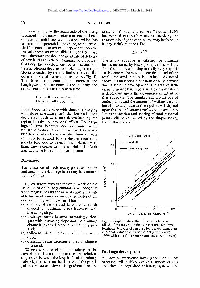
(2) Several studies of modern drainage basins have shown that an important scaling relation- ship exists between the length, L, of a drainage network, measured as the distance of the princi- pal stream course down the gradient, and the
area, A, of that network. As Turcotte (1989) has pointed out, such relations, involving the relationship of perimeter to area may be fractalic if they satisfy relations like
L ~ A 0/2.
The above equation is satisfied for drainage basins measured by Hack (1957) with D = 1.22. This fractalic relationship is really very import- ant because we have good tectonic control of the total area available to be drained. As noted above this may remain constant or may increase during tectonic development. The area of indi- vidual drainage basins permissible on a substrate is dependant upon the downgradient extent of that substrate. The number and magnitude of outlet points and the amount of sediment trans- ferred into any basin at these points will depend upon the area of tectonic surface made available. Thus the location and spacing of sand dispersal points will be controlled by the simple scaling law outlined above.
100 -
lO
u_
0.1
. . . . Calif. Coast Ranges I ' " f" ........ S. Spain
,.. Death Valley area . " ' "
i
to loo
DRAINAGE BASIN AREA (kin 2)
Fig. 5. Graph to show the relationship between alluvial fan area and drainage basin area for three locations. Increase of fan area for a given basin area is probably due to climatic factors (after Harvey 1989; with data from sources acknowledged therein).
Drainage development As soon as emergence takes place then runoff processes will quickly evolve a system of rills and then an organized tributary system. The
at MINCYT on March 11, 2014http://sp.lyellcollection.org/Downloaded from
TECTONICS AND FLUVIATILE RESERVOIRS 1 1
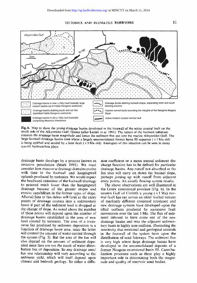
Fig. 6. Map to show the young drainage basins developed in the footwall of the active coastal fault on the south side of the Alkyonides Gulf, Greece (after Leeder et al. 1991). The nature of the footwall substrate controls the drainage basin magnitude and hence the sediment flux out into the marine Alkyonides Gulf. The large footwall drainage basins exist where a largely unconsolidated former basin fill sequence (> 1 Ma old) is being uplifted and eroded by a later fault (< 1 Ma old). Analogues of this situation can be seen in many syn-rift hydrocarbon plays.
drainage basin develops by a process known as invasion percolation (Stark 1991). We must consider how transverse drainage domains evolve with time in the footwall and hangingwall uplands produced by tectonics. We would expect the headward extension of the footwall drainage to proceed much faster than the hangingwall drainage because of the greater slopes and erosive capabilities in the former types of slope. Alluvial fans or fan deltas will form at the entry points of drainage courses into a sedimentary basin if part of the sediment load is dropped at the change of slope. As noted above the number of these points will depend upon the number of drainage basins established in the area of new land created by tectonics. The area of a trans- verse fan produced by sediment deposition is a function of drainage basin area, since the latter will control the amount of water carried through the system (Fig. 5). But the area of the fan will also depend on the amount of sediment depo- sited since fans are not the result of water distri- bution but of deposition. So any drainage area/ fan size relationship will vary according to the sediment yield, which will itself depend upon climate and bedrock geology. So either a diffu-
sion coefficient or a mean annual sediment dis- charge function has to be defined for particular drainage basins. Any runoff not absorbed at the fan sites will carry on down the basinal slope, perhaps joining up with runoff from adjacent entry points. An axial ly flowing system results.
The above observations are well illustrated in the Greek extensional province (Fig. 6). In the eastern Gulf of Corinth a young (< 1 Ma) nor- mal fault has cut across an older faulted terrane of markedly different erosional resistance and new drainage systems have developed upon the tilted surfaces produced by successive fault movements over the last 1 Ma. The flux of sedi- ment inferred to have come out of the new drainage basins and into the adjacent sedimen- tary basin is highly non-uniform, illustrating the sensitivity that erosional and geological controls in the footwall of the system have upon the distribution of sand fairways. The sediment flux is very high where large drainage basins have developed in the unconsolidated deposits of a former Neogene extensional basin fill. Canniba- lization processes such as these play a highly important role in determining both the magni- tude and quality of reservoir sand bodies.
at MINCYT on March 11, 2014http://sp.lyellcollection.org/Downloaded from
12 M.R. LEEDER
Modelling erosion and deposition in the fluviatile system
The total available stream power per unit bed area, co, for a river channel is given by:
m = r u = p g D S u (1)
where -r is the bed shear stress, p is fluid density, g is gravity, D is water depth, S is slope and u is mean flow velocity. The rate of bedload sedi- ment transport is a function of this available stream power. Note, however, that the rate of transport is not a linear function of slope, since slope itself controls the mean flow velocity to some higher power than unity, usually a square function. Note also that the transport of fine 'washload' (the majority of the mass flux in most rivers) does not seem amenable to this approach, since it is known that natural rivers are usually undersaturated and capable of transporting a huge and unquantifiable amount of such mat- erials (the flow capacity is erosion limited). This latter point is perhaps best illustrated by the Yellow River, China.
Now, deposition or erosion ( + h ) in water flows occurs in response to both horizontal spa- tial (x) and time (t) changes in the rate of bedload sediment transport, i. This is expressed by the one-dimensional sediment continuity equation for bedload transport (neglecting den- sity terms and the time differential for simpli- city):
Oh/d t = --t~i/t~x (2)
Contrary to the remarks made above, some authors (e.g. Flemmings & Jordan 1989) have
assumed that the sediment transport rate is linearly related to the gravity slope of the surface over which sediment is transferred. Thus they write S as cgh/c3x and:
i = - x O h / O x (3)
where x is a sediment transport coefficient (di- mensions L 2 / T ) analogous to the conduction of heat coefficient in diffusional heat flow theory. Combining the continuity equation with the transport equation yields the so-called diffusive relationship between deposition and gradient change for streamflows:
~3h/Ot = lr 2 (4)
Solutions of this equation have enabled deposi- tional models to be set up along tectonic gradi- ents produced during basin/hinterland evolution (Flemmings & Jordan 1989). Such approaches, whilst stimulating discussion of the long term evolution of sedimentary architecture, seem flawed in their assumptions of slope linearity, treatment of suspended and washload materials and neglect of hydraulic geometry and channel platform changes. These conspire to make the linear dependence of transport upon slope a highly simplistic view.
Sediment transfer systems from active structures
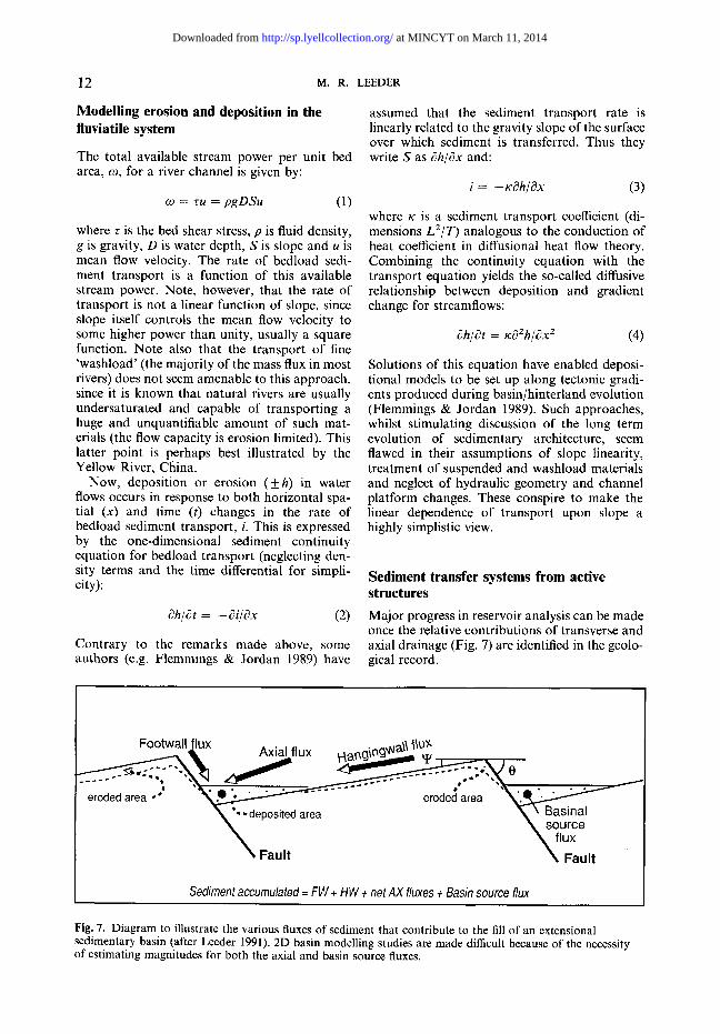
Major progress in reservoir analysis can be made once the relative contributions of transverse and axial drainage (Fig. 7) are identified in the geolo- gical record.
Footwall flux . . . . . . . . . a~ ~ / ~xla/TlUX y ~ a ~ g ' ~ ~
eroded area -* . . - - ~ eroded area " ~ , ~ . : ~ ~, %-deposited area ~, \ Basinal
\ source ~ , flux
Fault \ Fault
Sediment accumulated = FW + HW + net AX fluxes + Basin source flux
Fig. 7. Diagram to illustrate the various fluxes of sediment that contribute to the fill of an extensional sedimentary basin (after Leeder 1991). 2D basin modelling studies are made difficult because of the necessity of estimating magnitudes for both the axial and basin source fluxes.
at MINCYT on March 11, 2014http://sp.lyellcollection.org/Downloaded from
TECTONICS AND FLUVIATILE RESERVOIRS 13
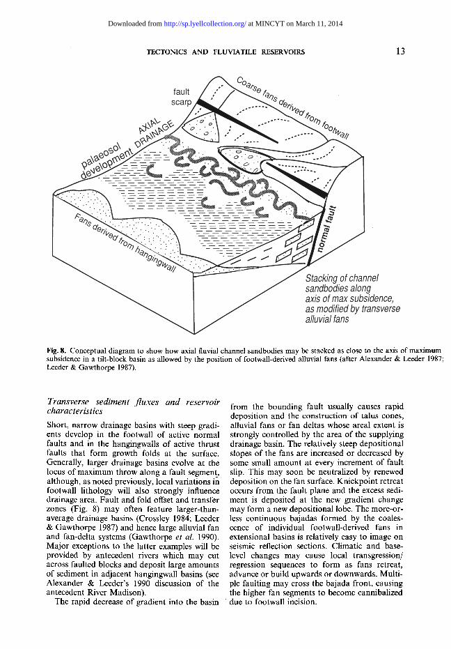
Fig. 8. Conceptual diagram to show how axial fluvial channel sandbodies may be stacked as close to the axis of maximum subsidence in a tilt-block basin as allowed by the position of footwall-derived alluvial fans (after Alexander & Leeder 1987; Leeder & Gawthorpe 1987).
Transverse sediment fluxes and reservoir characteristics
Short, narrow drainage basins with steep gradi- ents develop in the footwall of active normal faults and in the hangingwalls of active thrust faults that form growth folds at the surface. Generally, larger drainage basins evolve at the locus of maximum throw along a fault segment, although, as noted previously, local variations in footwall lithology will also strongly influence drainage area. Fault and fold offset and transfer zones (Fig. 8) may often feature larger-than- average drainage basins (Crossley 1984; Leeder & Gawthorpe 1987) and hence large alluvial fan and fan-delta systems (Gawthorpe et al. 1990). Major exceptions to the latter examples will be provided by antecedent rivers which may cut across faulted blocks and deposit large amounts of sediment in adjacent hangingwall basins (see Alexander & Leeder's 1990 discussion of the antecedent River Madison).
The rapid decrease of gradient into the basin
from the bounding fault usually causes rapid deposition and the construction of talus cones, alluvial fans or fan deltas whose areal extent is strongly controlled by the area of the supplying drainage basin. The relatively steep depositional slopes of the fans are increased or decreased by some small amount at every increment of fault slip. This may soon be neutralized by renewed deposition on the fan surface. Knickpoint retreat occurs from the fault plane and the excess sedi- ment is deposited at the new gradient change may form a new depositional lobe. The more-or- less continuous bajadas formed by the coales- cence of individual footwall-derived fans in extensional basins is relatively easy to image on seismic reflection sections. Climatic and base- level changes may cause local transgression/ regression sequences to form as fans retreat, advance or build upwards or downwards. Multi- ple faulting may cross the bajada front, causing the higher fan segments to become cannibalized due to footwall incision.
at MINCYT on March 11, 2014http://sp.lyellcollection.org/Downloaded from
14 M . R . LEEDER
By way of contrast to footwall uplands in extensional basins, hangingwall sourcelands are initially much longer normal to the tectonic gradient and they must progressively shorten as basin infilling proceeds. Longer and wider drainage basins occur, feeding larger alluvial fans whose gradients are normally gentler than footwall-sourced fans (Hooke 1972; Leeder & Gawthorpe 1987). Channel and fan surface gradients will be increased during each episode of fault slip, local fan surface incision resulting. Fan incision may also result from purely climatic or runoff changes. Coalescence of hangingwall fans creates linear low-angle bajadas which will also adjust to any climatic or base-level changes.
Transversely-derived sediment deposited on subaerial alluvial fans is not normally likely to make good reservoir material. Short transport distances, rapid subaerial deposition, and abun-
dance of debris flows conspire to produce imma- ture, poorly sorted (often matrix-rich) deposits of poor reservoir potential. This is particularly true if acid to intermediate plutonic igneous rocks make up the hinterlands, since early diage- netic alteration of feldspar also creates abundant secondary pore-filling clay minerals (aided by high heat flow and hot formation waters circu- lating near the fault zone). Some improvement results if a bajada is uplifted, eroded and reworked to provide second-cycle deposits d u e to fault or fold migration. Much-improved potential exists if the fans prograde into lakes or marine gulfs as fan deltas (Gawthorpe et al. 1990; Gawthorpe & Colella 1990), with better sorting due to delta-front wave reworking, Gil- bert Delta foreset construction or subaqueous redeposition down submarine fan channels onto submarine fans.
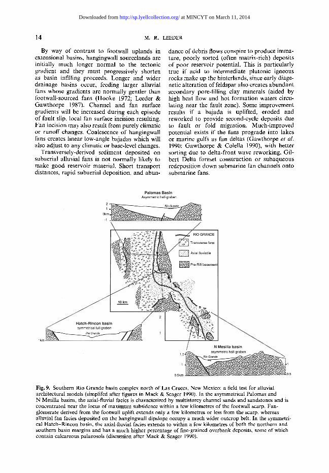
Fig. 9. Southern Rio Grande basin complex north of Las Cruces, New Mexico: a field test for alluvial architectural models (simplifed after figures in Mack & Seager 1990). In the asymmetrical Palomas and N Mesilla basins, the axial-fluvial facies is characterized by multistorey channel sands and sandstones and is concentrated near the locus of maximum subsidence within a few kilometres of the footwall scarp. Fan- glomerate derived from the footwall uplift extends only a few kilometres or less from the scarp, whereas alluvial fan facies deposited on the hangingwall dipslope occupy a much wider outcrop belt. In the symmetri- cal Hatch-Rincon basin, the axial-fluvial facies extends to within a few kilometres of both the northern and southern basin margins and has a much higher percentage of fine-grained overbank deposits, some of which contain calcareous palaeosols (discussion after Mack & Seager 1990).
at MINCYT on March 11, 2014http://sp.lyellcollection.org/Downloaded from
TECTONICS AND FLUVIATILE RESERVOIRS 15
Axial sediment fluxes and reservoir characteristics
Closed basins with a longitudinal tilt may developshort axial drainage channels feeding lakes. More commonly, basins may become linked along strike to adjacent basins once cross- over zones are breached. The course of an axial river channel will be controlled by the magnitude of alluvial fans issuing from transverse drainage basins (Figs 8 and 9) and by the occurrence of any intrabasinal faults. The axial channel will, by fan toe-trimming and alluviation, create its own alluvial plain upon which a facies architec- ture will evolve according to the nature of the channel involved (high/low sinuosity etc.). In- evitably the longitudinal, strike parallel, slope of the axial floodplain will be perturbed during each period of slip along the basin-bounding faults. As discussed in more detail below, axial channels have to adjust to this new slope compo- nent, either by slow migration or by channel belt avulsion (Alexander & Leeder 1987, 1990; Leeder & Alexander 1987; Mack & Seager 1990). Strongly asymmetric channel belts arise from both processes, the former producing orientated
oxbow cutoffs whose closed loops point uniformly up the tectonic slope.
The net result of continued tilting is to pro- duce a concentration of channel sand bodies as close to the axis of maximum subsidence as the transverse fans allow (Figs 8 and 9). As pre- dicted by earlier models (Leeder 1975), lower deposition rates up the hangingwall encourage palaeosol development (Leeder & Gawthorpe 1987). Kraus & Bown (this volume) show how palaeosol development sequences may be of use in determining channel avulsion behaviour.
The reservoir potential of axial channels is high, since perennial streamflow processes can sort and order the sediment provided from transverse input. The reservoir characters of an axial channel belt are controlled by meso-archi- tectural processes (Fig. 1), the actual position and extent of the channel belt reflecting the influence of transverse alluvial fans and the pres- ence of any intrabasinal antithetic or synthetic faults.
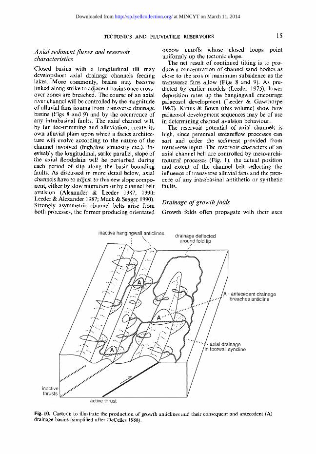
Drainage of growth folds Growth folds often propagate with their axes
Fig. 10. Cartoon to illustrate the production of growth anticlines and their consequent and antecedent (A) drainage basins (simplified after DeCelles 1988).
at MINCYT on March 11, 2014http://sp.lyellcollection.org/Downloaded from
16 M . R . LEEDER
normal to the regional palaeoslope formed by flexure or by topographic stacking due to crustal thickening. Locally-sourced transverse and axial fluvial systems of some complexity may result (DeCelles 1988) as the short-headed drainage basins unroof the growing folds and the rivers seek out gradients around fold tips (Fig. 10). The presence of an antecedent regional drainage sys- tem issuing from the interior of the thrust belt is an important additional element to consider, since any consequent drainage systems will tend ultimately to feed into this system (Fig. 10). Antecedent rivers will be diverted along the synclinal axes of any folds oblique to the drain- age trend or cut across orthogonal fold axes in narrow gorges, with periodic thrust movements causing temporary incision and terrace forma- tion in the hangingwall. Fine examples of antece- dent drainage cutting through successive growth folds to feed substantial alluvial fans are recorded in the Transverse Ranges of Southern California (Rockwell et al. 1988). When antece- dent rivers flow against the sense of fold ver- gence the tectonic damming causes large tempor- ary lakes to form in the footwall syncline. Hangingwall damming was first discovered after the 1981 E1 Asnam earthquake in N Algeria and subsequent palaeoseismic studies have shown that previous thrusting events were accompanied by similar effects (Meghraoui et al. 1988).
Channel planform changes and tectonics
It was noted in an earlier section that increased gradients due to base-level changes may cause fluvial incision. Whilst this is certainly true of low-sinuosity channels, sinuous river channels have an extra degree of freedom with which to respond to gradient changes; they can change their sinuosity to counteract the imposed gradi- ent change. This is because a high sinuosity channel has a lower mean channel gradient than a low sinuosity channel flowing down the same valley floor. The response of both types of chan- nel to positive and negative gradient changes was the subject of~a series of important exper- iments by Schumm and co-workers (Schumm et al. 1988, pp. 251-277). This work established that planform changes and incision/aggradation cycles do indeed characterize channels of con- trasting sinuosity when they are subjected to gradient changes. Thus the sandbodies produced by such effects are expected to show more verti- cal and lateral variability in facies and size than normal.
In natural examples, the tectonic warping that affects river floodplains may also cause the chan- nel to migrate preferentially away from the up-
lift, particularly if the warping occurs over only part of the flood plain. Such an example charac- terizes the Mississippi River as it flows through the Reelfoot Uplift of the New Madrid seismic zone (Alexander & Leeder 1987).
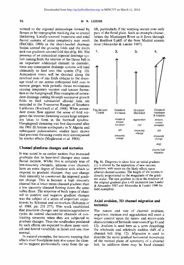
1. 2. 3. 4.
Equilibrium/ Grade
Gradient Gradient Gradient increase decrease increase
& rotation
incision & aggradation incision, terrace terrace
formation OR formation
OR sinuousity OR change
sinuousity sinuousity change change
AND
channel belt migration
Fig. 11. Diagrams to show how an initial gradient (I) is altered by the imposition of new tectonic gradients, with notes on the likely effects upon alluvial channel systems. The length of the arrows is directly proportional to the magnitude of the gradi- ent scalar. The new gradient in (4) is the resultant of the original gradient plus a tilt increment (see Leeder & Alexander 1987 and Alexander & Leeder 1990 for field examples).
Axial avulsion, 3D channel migration and tectonics
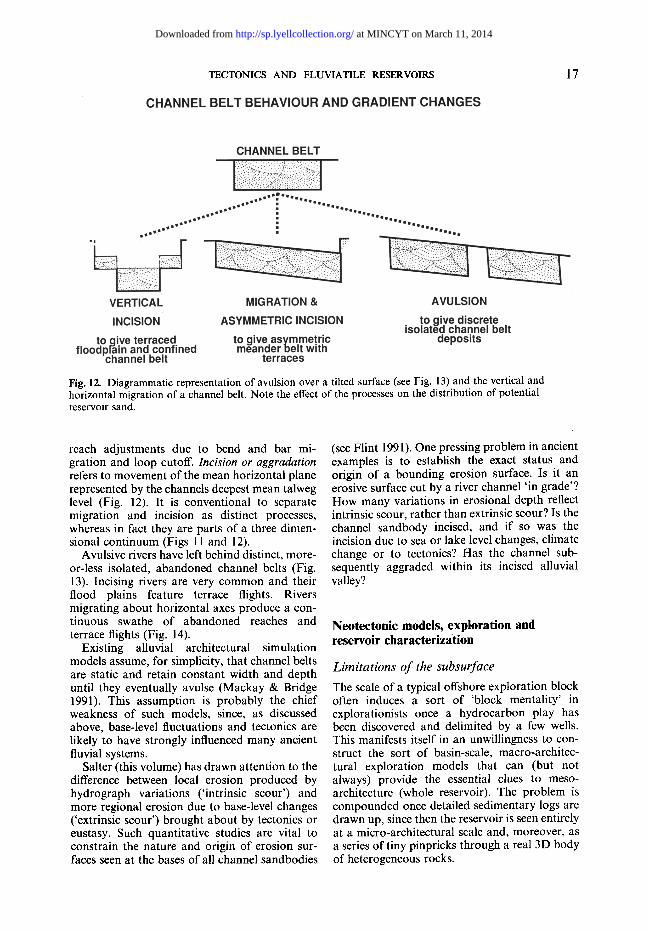
The nature and rate of channel avulsion, migration, incision and aggradation will exert a major control upon the meso- and micro-scale characteristics offluviatile reservoirs (Figs 11 and 12). Avulsion is used here as a term describing the wholesale and relatively sudden shift of a channel belt (Fig. 12). Migration is used to describe the more gradual horizontal movement of the vertical plane of symmetry of a channel belt. In addition there may be local channel
at MINCYT on March 11, 2014http://sp.lyellcollection.org/Downloaded from
TECTONICS AND FLUVIATILE RESERVOIRS 17
Fig. 12. Diagrammatic representation of avulsion over a tilted surface (see Fig. 13) and the vertical and horizontal migration of a channel belt. Note the effect of the processes on the distribution of potential reservoir sand.
reach adjustments due to bend and bar mi- gration and loop cutoff. Inc&ion or aggradation refers to movement of the mean horizontal plane represented by the channels deepest mean talweg level (Fig. 12). It is conventional to separate migration and incision as distinct processes, whereas in fact they are parts of a three dimen- sional continuum (Figs 11 and 12).
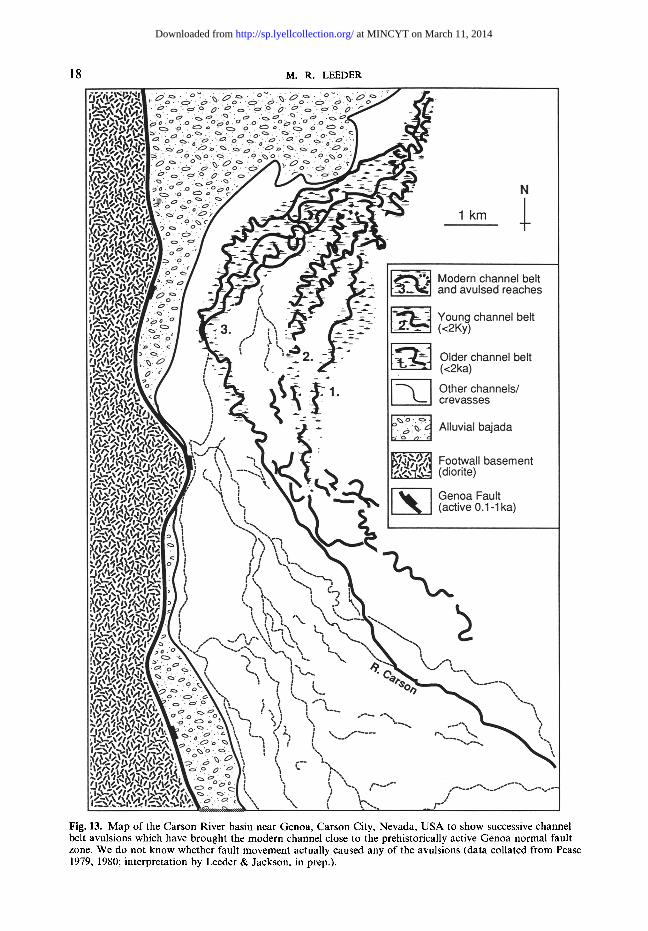
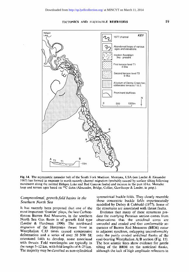
Avulsive rivers have left behind distinct, more- or-less isolated, abandoned channel belts (Fig. 13). Incising rivers are very common and their flood plains feature terrace flights. Rivers migrating about horizontal axes produce a con- tinuous swathe of abandoned reaches and terrace flights (Fig. 14).
Existing alluvial architectural simulation models assume, for simplicity, that channel belts are static and retain constant width and depth until they eventually avulse (Mackay & Bridge 1991). This assumption is probably the chief weakness of such models, since, as discussed above, base-level fluctuations and tectonics are likely to have strongly influenced many ancient fluvial systems.
Salter (this volume) has drawn attention to the difference between local erosion produced by hydrograph variations ('intrinsic scour') and more regional erosion due to base-level changes ('extrinsic scour') brought about by tectonics or eustasy. Such quantitative studies are vital to constrain the nature and origin of erosion sur- faces seen at the bases of all channel sandbodies
(see Flint 1991). One pressing problem in ancient examples is to establish the exact status and origin of a bounding erosion surface. Is it an erosive surface cut by a river channel ' in grade'? How many variations in erosional depth reflect intrinsic scour, rather than extrinsic scour? Is the channel sandbody incised, and if so was the incision due to sea or lake level changes, climate change or to tectonics? Has the channel sub- sequently aggraded within its incised alluvial valley?
Neotectonic models, exploration and reservoir characterization
Limitations of the subsurface
The scale of a typical offshore exploration block often induces a sort of 'block mentality' in explorationists once a hydrocarbon play has been discovered and delimited by a few wells. This manifests itself in an unwillingness to con- struct the sort of basin-scale, macro-architec- tural explora t ion models that can (but not always) provide the essential clues to meso- architecture (whole reservoir). The problem is compounded once detailed sedimentary logs are drawn up, since then the reservoir is seen entirely at a micro-architectural scale and, moreover, as a series of tiny pinpricks through a real 3D body of heterogeneous rocks.
at MINCYT on March 11, 2014http://sp.lyellcollection.org/Downloaded from
18 M . R . LEEDER
Fig. 13. Map of the Carson River basin near Genoa, Carson City, Nevada, USA to show successive channel belt avulsions which have brought the modern channel close to the prehistorically active Genoa normal fault zone. We do not know whether fault movement actually caused any of the avulsions (data collated from Pease 1979, 1980; interpretation by Leeder & Jackson, in prep.).
at MINCYT on March 11, 2014http://sp.lyellcollection.org/Downloaded from
TECTONICS AND FLUVIATILE RESERVOIRS 19
Fig. 14. The asymmetric meander belt of the South Fork Madison, Montana, USA (see Leeder & Alexander 1987) has formed in response to north easterly channel migration (probably caused by surface tilting following movement along the normal Hebgen Lake and Red Canyon faults) and incision in the past 10 ka. Meander loop and terrace ages based on 14C dates (Alexander, Bridge, Collier, Gawthorpe & Leeder, in prep.).
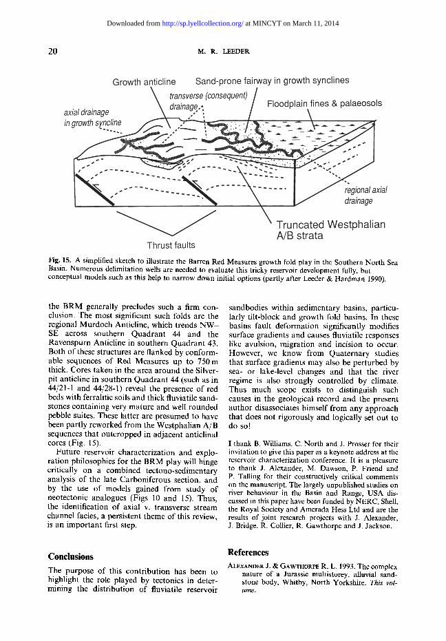
Compressional, growth-fold basins in the Southern North Sea
It has recently been proposed that one of the most important 'frontier' plays, the late Carbon- iferous Barren Red Measures, in the southern North Sea Gas Basin is of growth fold type (Leeder & Hardman 1990). The northward migration of the Hercynian thrust front in Westphalian C/D times caused compressive deformation and a series of over 50 NW-SE orientated folds to develop, some associated with thrusts. Fold wavelengths are typically in the range 5-12 km, with fold lengths of 6-25 kin. The majority may be classified as non-cylindrical
symmetrical buckle folds. They closely resemble those concentric buckle folds experimentally modelled by Dubey & Cobbold (1977). Some of the structures are associated with thrust faults.
Evidence that many of these structures pre- date the overlying Permian section comes from observations that the anticlinal cores are unroofed and eroded and that conformable se- quences of Barren Red Measures (BRM) occur in adjacent synclines, onlapping unconformably onto the partly eroded anticlinal flanks of the coal-bearing Westphalian A/B section (Fig. 15). The best seismic lines show evidence for gentle tilting of the BRM on the anticlinal flanks, although the lack of high amplitude reflectors in
at MINCYT on March 11, 2014http://sp.lyellcollection.org/Downloaded from
20 M.R. LEEDER
Fig. 15. A simplified sketch to illustrate the Barren Red Measures growth fold play in the Southern North Sea Basin. Numerous delimitation wells are needed to evaluate this tricky reservoir development fully, but conceptual models such as this help to narrow down initial options (partly after Leeder & Hardman 1990).
the BRM generally precludes such a firm con- clusion. The most significant such folds are the regional Murdoch Anticline, which trends N W - SE across southern Quadrant 44 and the Ravenspurn Anticline in southern Quadrant 43. Both of these structures are flanked by conform- able sequences of Red Measures up to 750m thick. Cores taken in the area around the Silver- pit anticline in southern Quadrant 44 (such as in 44/21-1 and 44/28-1) reveal the presence of red beds with ferralitic soils and thick fluviatile sand- stones containing very mature and well rounded pebble suites. These latter are presumed to have been partly reworked from the Westphalian A/B sequences that outcropped in adjacent anticlinal cores (Fig. 15).
Future reservoir characterization and explo- ration philosophies for the BRM play will hinge critically on a combined tectono-sedimentary analysis of the late Carboniferous section, and by the use of models gained from study of neotectonic analogues (Figs 10 and 15). Thus, the identification of axial v. transverse stream channel facies, a persistent theme of this review, is an important first step.
sandbodies within sedimentary basins, particu- larly tilt-block and growth fold basins. In these basins fault deformation significantly modifies surface gradients and causes fluviatile responses like avulsion, migration and incision to occur. However, we know from Quaternary studies that surface gradients may also be perturbed by sea- or lake-level changes and that the river regime is also strongly controlled by climate. Thus much scope exists to distinguish such causes in the geological record and the present author disassociates himself from any approach that does not rigorously and logically set out to do so!
I thank B. Williams, C. North and J. Prosser for their invitation to give this paper as a keynote address at the reservoir characterization conference. It is a pleasure to thank J. Alexander, M. Dawson, P. Friend and P. Talling for their constructively critical comments on the manuscript. The largely unpublished studies on river behaviour in the Basin and Range, USA dis- cussed in this paper have been funded by NERC, Shell, the Royal Society and Amerada Hess Ltd and are the results of joint research projects with J. Alexander, J. Bridge, R. Collier, R. Gawthorpe and J. Jackson.
Conclusions
The purpose of this contribution has been to highlight the role played by tectonics in deter- mining the distribution of fluviatile reservoir
References
ALEXANDER J. & GAWTHORPE R. L. 1993. The complex nature of a Jurassic multistorey, alluvial sand- stone body, Whitby, North Yorkshire. This vol- ume.
at MINCYT on March 11, 2014http://sp.lyellcollection.org/Downloaded from

TECTONICS AND FLUVIATILE RESERVOIRS 21
8s LEEDER, M. R. 1987. Active tectonic control of alluvial architecture In: ETHRIDGE, F. G. & FLORES, R. M. (eds) Fluvial Sedimentology. Special Publication, Society of Economic Paleon- tologists and Mineralogists 39, 243-252.
- - & - 1990. Geomorphology and surface tilting in an active extensional basin, SW Montana, USA. Journal of Geological Society, London, 147, 461-467.
ALLEN, J. R. L. 1974. Studies in fluviatile sedimen- tation: implications of pedogenic carbonate units, Lower Old Red Sandstone, Anglo-Welsh outcrop. Geological Journal, 9, 181-208.
BRIDGE, J. S. 8s LEEDER, M. R. 1979. A simulation model of alluvial stratigraphy. Sedimentology, 26, 617~M4.
CARSON, M. 8s KIRKBY, M. J. 1972. Hillslope Form and Process. Cambridge University Press.
CHORLEY, R. J. 1967. Models in Geomorphology. In: CHORLEY, R. J. 8s HAGGETT, P. (eds) Models in Geography. Methuen, 59-96.
CROSSLEY, R. 1984. Controls of sedimentation in the Malawi Rift Valley, Central Africa. Sedimentary Geology, 40, 33-50.
DECELLES, P. G. 1988. Lithologic provenance modell- ing applied to the Late Cretaceous synorogenic Echo Canyon Conglomerate, Utah: a case of multiple source areas. Geology, 16, 1039-1043.
DUBEY, A. K. 8s COBBOLD, P. R. 1977. Noncylindrical flexural slip folds in nature and experiment. Tec- tonophysics, 38, 223-239.
FLEMMINGS, P. B. 8s JORDAN, T. E. 1989. A synthetic stratigraphic model of foreland basin develop- ment. Journal of Geophysics Research, 94B, 3851- 3866.
FLINT, S. 1991. Prediction of fluvial sand body archi- tecture and connectivity for reservoir modelling:
KRAUS, M. J. & BROWN, T. M. 1993. Paleosols as an exploration tool. This volume.
LEEDER, M. R. 1975. Pedogenic carbonates and flood sediment accretion rates: a quantitative model for alluvial arid-zone lithofacies. Geological Maga- zine, 112, 257-270.
1978. A quantitative stratigraphic model for alluvium, with special reference to channel deposit density and interconnectedness. In: MIALL, A. D. (ed.) Fluvial sedimentology. Canadian Society of Petroleum Geologists Memoir, 5, Calgary, 587- 596.
- - 1991. Rates of denudation, vertical crustal move- ments and sedimentary basin infill. Geologische Rundschau, 80, 441-458.
- - & ALEXANDER, J. 1987. The origin and tectonic significance of asymmetrical meander-belts. Sedi- mentology, 34, 217-226.
- - & GAWTHORPE, R. L. 1987. Sedimentary models for extensional tilt-block/half-graben basins. In: COWARD, M. P., DEWEY, J. F. & HANCOCK, P. L. (eds) Continental Extensional Tectonics. Geologi- cal Society, London, Special Publications, 28, 139-152.
- - & HARDMAN, M. 1990. Carboniferous geology of the Southern North Sea Basin and controls on hydrocarbon prospectivity. In" HARDMAN, R. F. P. & BROOKS, J. (eds) Tectonic Events Responsible for Britain's Oil and Gas Reserves, Geological Society, London, Special Publications, 55, 87- 105.
- - , SEGER, M. J. 8s STARK, C. P. 1991. Sedimento- logy and tectonic geomorphology adjacent to active and inactive normal faults in the Megara Basin and Alkyonides Gulf, Central Greece. Jour- nal of the Geological Society, London, 148, 331- 343.
a new application of sequence stratigraphy. In: MACK, G. H. & SEAGER, W. R. 1990. Tectonic control NORTH, C. P. & PROSSER, D. J. (eds). Abstracts for on facies distribution of the Camp Rice and the British Sedimentological Research Group con- ference on Characterisation of Fluvial and Aeolian Reservoirs, University of Aberdeen, Scotland, 24- 27 March 1991.
GAWTHORPE, R. L. & COLELLA, A. 1990. Tectonic controls on coarse-grained delta depositional sys- tems in rift basins. In: COLELLA, A. & PRIOR, D. B. (eds) Coarse-Grained Deltas. Special Publication, International Association of Sedimentologists, 10, 113-128. , HURST, J. M. & SLADEN, C. P. 1990. Evolution of Miocene footwall-derived coarse-grained deltas, Gulf of Suez, Egypt: implications for exploration. American Assocation of Petroleum Geologists Bulletin, 74, 1077-1086.
HACK, J. T. 1957. Studies of longitudinal stream profiles in Virginia and Maryland. United States Geologi- cal Survey Professional Paper 29413.
HARVEY, A. M. 1989. The occurrence and role of arid zone alluvial fans. In: THOMAS, D. G. (ed.) Arid Zone Geomorphology. Belhaven Halstead Press, 136-158.
HOOKE, R. LeB. 1972. Geomorphic evidence for late- Wisconsian and Holocene tectonic deformation, Death Valley California. Geological Society of America Bulletin, 83, 2073-2098.
Palomas Formations (Pliocene-Pleistocene) in the southern Rio Grande rift. Geological Society of America Bulletin, 102, 45-53.
MACKEY, S. D. & BRIDGE, J. S. 1991. Process-based alluvial stratigraphy models: a progress report. In: NORTH, C. P. & PROSSER, D. J. (eds). Abstracts for the British Sedimentological Research Group con- ference on Characterisation of Fluvial and Aeolian Reservoirs, University of Aberdeen, Scotland, 24- 27 March 1991.
MEGHRAOUI, M., PHILIP, H., ALBAREDE, F. & CISTER- NAS, A. 1988. Trench investigations through the trace of the 1980 E1 Asnam thrust fault: evidence for palaeoseismicity. Bulletin of the Seismological Society of America, 78, 979-999.
PEASE, R. C. 1979. Genoa Quadrangle earthquake hazards map. Nevada Bureau of Mines and Geo- logy, Map 1Ci.
- - 1980. Genoa Quadrangle geologic map. Nevada Bureau of Mines and Geology, Map 1CA.
ROCKWELL, T. K., KELLER, E. A. & DEMBROFF, G. R. 1988. Quaternary rate of folding of the Ventura Avenue anticline, western Transverse Ranges, southern California. Geological Society of Amer- ica Bulletin, 100, 850-858.
at MINCYT on March 11, 2014http://sp.lyellcollection.org/Downloaded from

22 M . R . LEEDER
SALTER, T. 1993. Fluvial scour and incision; models for their influence on the development of realistic reservoir geometries. This volume.
SCHtJMM, S. A. & LICHTY, R. W. 1965. Time, space and causality in geomorphology. American Journal of Science, 263, ll0-119. , HARVEY, M. D. & WATSON, C. C. 1988. Incised
channels: morphology, dynamics and control. Water Resources Publications, Littleton, Co.
STARK, C. P. 1991. An invasion percolation model of drainage network evolution. Nature, 352, 423- 425.
TURCOTTE, D. L. 1989. Fractals in geology and geo- physics. PAGEOPH, 131, 171-196.
at MINCYT on March 11, 2014http://sp.lyellcollection.org/Downloaded from