Lee Walker Heights Master Plan 2016
144
LEE WALKER HEIGHTS MASTER PLAN HOUSING AUTHORITY OF THE CITY OF ASHEVILLE JANUARY 8, 2016
Transcript of Lee Walker Heights Master Plan 2016

LEE WALKER HEIGHTS MASTER PLANHOUSING AUTHORITY OF THE CITY OF ASHEVILLE JANUARY 8, 2016

CREDITS
Owner/Developer
Asheville Housing AuthoritySPONSOR AGENCY
Development & Design Team
Mountain Housing OpportunitiesCO-DEVELOPER
David Baker ArchitectsMASTER PLAN ARCHITECT
McMillan Pazdan SmithARCHITECT OF RECORD
Sitework StudiosLANDSCAPE ARCHITECT
Civil Design ConceptsCIVIL ENGINEER
Asheville Design CenterPLAY AREA CONSULTANT
Lee Walker Heights Resident Advisory Committee
Natasha Boseman
Dolly Burwell
Crystal Reid
Joseph Tarrant III
Theresa Timbers
Butch Worthy
Constance ProctorMANAGER, LEE WALKER HEIGHTS

CONTENTS
Introduction .......................................................... 04
Goals ....................................................................... 10
City & Neighborhood Context ........................ 12
Planning & Policy ................................................. 19
Existing Site Conditions .................................... 41
Community Participation .................................. 57
Master Plan Vision .............................................66
Neighborhood Character ...............................108
Implementation ................................................... 116
Appendices .........................................................124
1
2
3
4
5
6
7
8
9
10

1
INTRODUCTION
4Introduction

EXECUTIVE SUMMARYDavid Baker Architects, along with McMillan Pazdan Smith, has consulted with the Housing Authority of the City of Asheville (HACA) and its co-developer, Mountain Housing Opportunities (MHO), to create a Master Plan for the redevelopment of Lee Walker Heights, a small community of 96 public housing units, located on 11.5 acres at 17 Wilbar Avenue, in Asheville, North Carolina. The Master Plan study area also includes a neighboring parcel of 5.5 acres at 319 Biltmore Avenue, which the development team has been informed may become available for direct or coordinated development in the future.
The vision for the project, developed in consultation with current residents, is to replace Asheville’s oldest public housing property with a transformational new mixed-income community, including one-for-one replacement of the 96 subsidized units to be scattered through a total of at least 200 mixed-income units. The development team is optimistic that the neighboring Biltmore Avenue property can be added to the project, allowing mixed-use development and expansion to as many as 400 units, with the deeply subsidized units ultimately dispersed throughout both parcels.
___
LEE WALKER HEIGHTSResident community
5Introduction • Executive Summary

The project site is surrounded by areas undergoing major transformation, including a planned expansion and redevelopment effort at Mission Hospital and new businesses and market-rate homes in the South Slope neighborhood. Lee Walker Heights is currently isolated from these improvements due to steep slopes and only one street connection.
Building on the strong community of residents and the site’s prominent location along a major transit corridor at the southern gateway to downtown Asheville, this Master Plan offers a complete transformation to a sustainable, walkable neighborhood of mixed-income housing, with mixed-use neighborhood shopping and other amenities.
This plan has been developed in close consultation with current Lee Walker Heights residents. The outreach and engagement process has included multiple community meetings and design workshops, resident surveys, and site visits to recently built affordable housing properties. Comments from the six-month community planning process have been collected and analyzed to guide the design process. Draft plans have also been reviewed with City agencies and officials to incorporate feedback.
The Master Plan includes the following significant components:
• Replacement of the 96 functionally obsolete row houses with at least 200, and as many as 400, sustainable homes in a combination of apartment, walk-up, and stacked-flat buildings.
• Replacement of an undersized community building with spacious new common spaces and a variety of amenities.
___
LEE WALKER HEIGHTSResident Community
6Introduction • Executive Summary

• Replacement of the existing single loop road with three new streets that will prioritize pedestrian and bicyclist safety and allow access for school buses and emergency vehicles.
• A new open-space configuration with a variety of gathering and play areas.
• Potential mixed-use development on the 319 Biltmore Avenue parcel, with ground-floor retail and commercial uses and/or other community and training facilities.
• Affordable rent levels ranging from under $200 per month for a subsidized replacement unit, up to a range of $800 to $1150, per month for workforce families earning up to 80% of the Area Median Income (AMI).
• Carefully planned temporary relocation of residents with a guaranteed right to return, if they choose, to the new neighborhood.
• Respect for the history of the property, and recognition of the two important historical figures for whom it was named in the plaza and street names of the new development.
• Implementation using a combination of private equity through Low Income Housing Tax Credits, funds generated from conversion under HUD’s Rental Assistance Demonstration, long-term loans with FHA guarantees, and local contributions and incentives.
7Introduction • Executive Summary

Project Background
Lee Walker Heights faces many challenges. The community has strong social bonds, but is physically isolated from surrounding neighborhoods and the city by steep hillsides and only one street connection. The buildings have undergone some modernization, but the current buildings are obsolete based on current construction standards. The homes at Lee Walker Heights are inaccessible and unsustainable with high operation and maintenance costs. Community spaces—including play areas and a common building—are undersized and inadequate for the needs of the residents. Public transportation and such amenities as grocery stores and other retail are difficult to access.
Despite these challenges, the social and physical assets of the neighborhood offer the opportunity for a positive transformation that both supports the existing community and welcomes surrounding neighbors. By creating strong connections that restitch Lee Walker Heights to the rest of the City—and by making a healthy, diverse, and sustainable neighborhood—a renewed Lee Walker Heights can become a special place that current and future residents will be proud to call home.
___
LEE WALKER HEIGHTSExisting Housing
8Introduction • Project Background

___
AERIAL IMAGE OF EXISTING SITESteep hillsides and a single access point isolate the community and limit access to amenities.
___
SITE CONDITIONSSteep, discontinuous sidewalks
STEEP HILLSIDES
COMMUNITY BUILDING
SOUTHSIDE A
VE
BIL
TMO
RE
AV
EMC
DO
WELL ST
SINGLE ACCESS POINT AT WILBAR AVENUE
N
ONE-WAY LOOP ROAD319
BILTMORE AVENUE
BIL
TMO
RE
AV
E
MISSION HOSPITAL ST. JOSEPH CAMPUS
LEE WALKER HEIGHTS
9Introduction • Project Background

GOALS
2
10Goals

OVERVIEW�e Master Plan addresses three primary project goals: Community, Connectivity, and Health/Sustainability.
Community
• Provide replacement housing.
• Provide facilities and open spaces for social interaction.
• Honor the history of the Lee Walker Heights community.
Connectivity
• Create or repair connections to surrounding neighborhoods, amenities, and landscape.
• Provide safe and convienent connections within the rebuilt neighborhood, focusing on creating safe spaces for positive social activities and active play and recreation for kids.
Health/Sustainability
• Promote community health and activity through the built environment.
• Provide sustainable site and building strategies for resident health and resource-use reduction.
11Goals

CITY & NEIGHBOROOD CONTEXT
3
12City & Neighborhood Context

OVERVIEWCity
Asheville is a city that is undergoing rapid change. It is the largest city in western North Carolina and serves as the region’s economic and cultural hub. Asheville’s distinct character and high quality of life are attracting increasing numbers of new residents at all income levels and fueling development in the city and surrounding areas. Downtown is extremely active, and areas like the River Arts District, South Slope, and West Asheville are experiencing increased investment.
Along with the economic benefits of growth and development come challenges of affordability, housing, and transportation. Because of its close proximity to Downtown, Lee Walker Heights is uniquely positioned to become a strengthened, economically diverse community that creates opportunity for families of all income levels to participate in these broader urban changes.
___
ASHEVILLE SKYLINE
___
DOWNTOWN ASHEVILLE
13City & Neighborhood Context • City

___
DOWNTOWN ASHEVILLEThe lively City Center has a variety of restaurants, galleries, locally-owned stores, free festivals, and a vibrant street life.
HISTORIC SOUTHSIDE NEIGHBORHOOD
LEE WALKER HEIGHTS
___
MISSION HOSPITAL + AB TECHMission Hospital is the Mission Health System’s flagship hospital. AB Tech is the region’s largest community college.
___
SOUTH SLOPE BUSINESS DISTRICTCalled by some the “South Slope Brewing District,” this area south of downtown has half a dozen breweries and is seeing greater multifamily development.
___
RIVER ARTS DISTRICTArtist-oriented live-work spaces, breweries, restaurants, and small businesses have revitalized a formerly industrial stretch of Asheville’s riverfront.
14City & Neighborhood Context • City
Mission Hospital & Asheville Buncombe Technical Community College
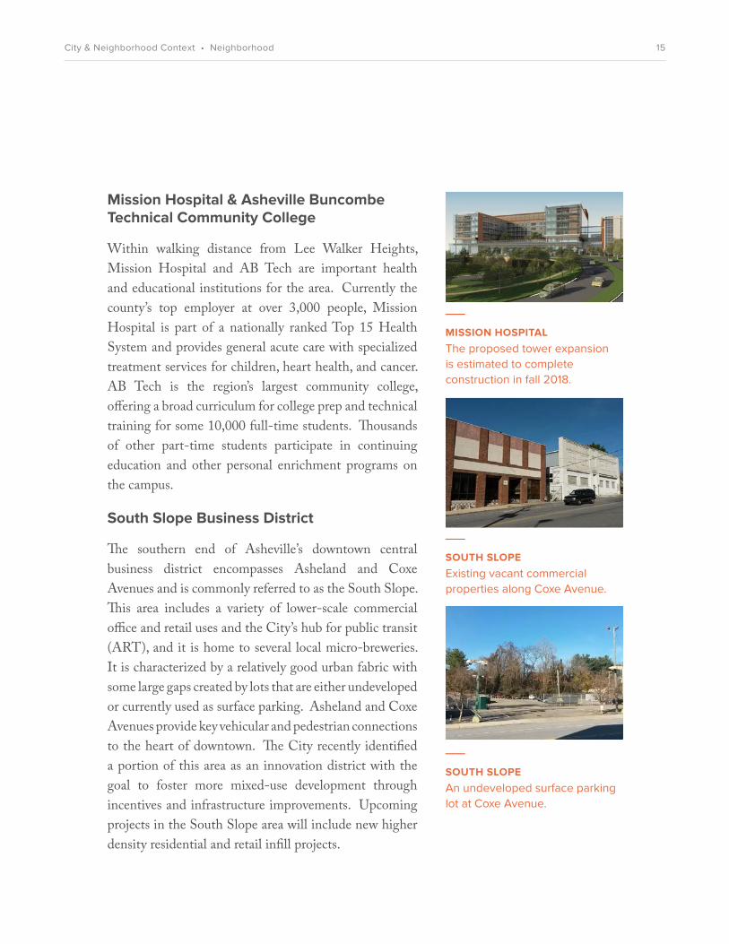
Within walking distance from Lee Walker Heights, Mission Hospital and AB Tech are important health and educational institutions for the area. Currently the county’s top employer at over 3,000 people, Mission Hospital is part of a nationally ranked Top 15 Health System and provides general acute care with specialized treatment services for children, heart health, and cancer. AB Tech is the region’s largest community college, offering a broad curriculum for college prep and technical training for some 10,000 full-time students. Thousands of other part-time students participate in continuing education and other personal enrichment programs on the campus.
South Slope Business District
The southern end of Asheville’s downtown central business district encompasses Asheland and Coxe Avenues and is commonly referred to as the South Slope. This area includes a variety of lower-scale commercial office and retail uses and the City’s hub for public transit (ART), and it is home to several local micro-breweries. It is characterized by a relatively good urban fabric with some large gaps created by lots that are either undeveloped or currently used as surface parking. Asheland and Coxe Avenues provide key vehicular and pedestrian connections to the heart of downtown. The City recently identified a portion of this area as an innovation district with the goal to foster more mixed-use development through incentives and infrastructure improvements. Upcoming projects in the South Slope area will include new higher density residential and retail infill projects.
___
MISSION HOSPITALThe proposed tower expansion is estimated to complete construction in fall 2018.
___
SOUTH SLOPEAn undeveloped surface parking lot at Coxe Avenue.
___
SOUTH SLOPE Existing vacant commercial properties along Coxe Avenue.
15City & Neighborhood Context • Neighborhood

MC
DO
WELL ST
SOUTHSIDE A
VE
MARTIN
LUTHER
KING JR DR
S C
HA
RLO
TTE
ST
CHOCTAW ST
LIVINGSTON ST
BEAUCATCHER OVERLOOK PARK
EDINGTON EDUCATION &
CAREER CENTER
MEMORIAL STADIUM
MOUNTAINSIDE PARK
MEMORIAL
MCCORMICK FIELD
YWCA
ASHEVILLE MIDDLE SCHOOL
DR. WESLEY GRANT SR
SOUTHSIDE CENTER
ASTON PARK
ASHEVILLE WOMEN’S MEDICAL CENTER
HILLARD AVE
PHIFER ST
AS
HELA
ND
AV
E
S F
REN
CH
BR
OA
D A
VE
CO
XE A
VE
BIL
TMO
RE
AV
E
MINNIE JONES
HEALTH CENTER
BUS STOP
N
TO DOWNTOWN ASHEVILLEA
SH
ELAN
D A
VE
SOUTH SLOPE BUSINESS DISTRICT
MISSION MEDICAL DISTRICT
MISSION HOSPITAL
319 BILTMORE AVENUE
LEE WALKER HEIGHTS(17 WILBAR
AVE)
Neighborhood
�e Lee Walker Heights site and surrounding area have tremendous opportunities for transformation, with many eorts currently underway. Several existing mixed-income neighborhoods can also contribute to area stability. Current redevelopment activity at the South Slope Business District, the St. Joseph/Mission Hospital Medical Campus, and along Biltmore Avenue will complement the changes at the project site, making for a cohesive, stronger district.
16City & Neighborhood Context • Neighborhood
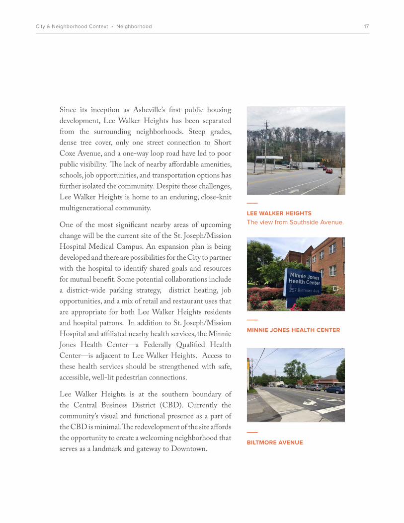
Since its inception as Asheville’s first public housing development, Lee Walker Heights has been separated from the surrounding neighborhoods. Steep grades, dense tree cover, only one street connection to Short Coxe Avenue, and a one-way loop road have led to poor public visibility. The lack of nearby affordable amenities, schools, job opportunities, and transportation options has further isolated the community. Despite these challenges, Lee Walker Heights is home to an enduring, close-knit multigenerational community.
One of the most significant nearby areas of upcoming change will be the current site of the St. Joseph/Mission Hospital Medical Campus. An expansion plan is being developed and there are possibilities for the City to partner with the hospital to identify shared goals and resources for mutual benefit. Some potential collaborations include a district-wide parking strategy, district heating, job opportunities, and a mix of retail and restaurant uses that are appropriate for both Lee Walker Heights residents and hospital patrons. In addition to St. Joseph/Mission Hospital and affiliated nearby health services, the Minnie Jones Health Center—a Federally Qualified Health Center—is adjacent to Lee Walker Heights. Access to these health services should be strengthened with safe, accessible, well-lit pedestrian connections.
Lee Walker Heights is at the southern boundary of the Central Business District (CBD). Currently the community’s visual and functional presence as a part of the CBD is minimal. The redevelopment of the site affords the opportunity to create a welcoming neighborhood that serves as a landmark and gateway to Downtown.
___
LEE WALKER HEIGHTSThe view from Southside Avenue.
___
BILTMORE AVENUE
___
MINNIE JONES HEALTH CENTER
17City & Neighborhood Context • Neighborhood

In addition to the hospital-related changes, infill market-rate housing, commercial and retail development are expected to grow on Biltmore Avenue, Short Coxe Avenue and McDowell Street. As of late 2015, nearby development projects in the works include:
• 62 affordable workforce apartments with commercial at 62 Eagle Street
• 32 apartments at 58 S. Lexington Avenue• 38 apartments at 45 Asheland Avenue• 116 apartments at 246 Patton Avenue• 168 apartments at 55 S. Market Street• 97 apartments at 128 Florence Street• 49 apartments at 11 Collier Avenue• 146 apartments at 185 Coxe Avenue• 48 apartments at 150 Coxe Avenue• 20 townhomes at 88 Southside Avenue• 92-room Foundry Inn Hotel at 51 S. Market Street• expansion of Green Man Brewing on S. Lexington
Avenue• new 7-story Buncombe County DSS building at
40 Coxe Avenue• new 12-story hospital tower at 509 Biltmore
Avenue
• comprehensive mixed-use redevelopment of 60-100 Biltmore Avenue, with French Broad Food Coop as anchor ground-floor tenant
These transformations will add density near downtown and will bring a larger residential population to the neighborhoods south of downtown. They will also serve to create stronger links between Lee Walker Heights and other parts of Asheville.
___
BILTMORE AVENUE | DOWNTOWNVibrant mixed-use downtown corridor.s
18City & Neighborhood Context • Neighborhood

PLANNING & POLICY
4
19Planning & Policy

OVERVIEW�e City of Asheville’s eorts to embrace future development and promote smart growth are re�ected in local and regional policy and long-term planning initiatives. �e studies and planning documents excerpted below focus on housing, transportation, and downtown redevelopment. Speci�c sections have been highlighted to emphasize the policy framework that supports the proposed vision for Lee Walker Heights redevelopment. �e proposed vision is compatible with virtually every adopted City of Asheville plan.
2015 Housing Needs Assessment
�e Housing Needs Assessment identi�es current and future housing needs for Asheville and the surrounding four-county region (emphasis added).
• 1% overall vacancy rate in rental housing (including a 0% vacancy in aordable/subsidized rental housing) shows that there is “signi�cant pent-up demand and need for a�ordable rentals within the region.”
• Need exists across all income levels, but is greatest below 50% AMI (Area Median Income). Even with 1,330 rental units in the region’s development pipeline, need still exists for 23,816 units. �e report quanti�es a total “housing gap” of 3,532 family rental apartments, with 1,800 of these below 50% AMI.
• “Due to the projected growth of senior households and one- and two-person households, the development of smaller bedroom types (one- and two-bedroom units) should be an area of emphasis.”
• “�e development of housing alternatives closer to downtown Asheville and other employment centers will help to diminish transportation-associated costs for area residents. �is will be particularly bene�cial to low-income households.”
___
2015 HOUSING NEEDS ASSESSMENT (Four-county region)
20Planning & Policy • Housing Needs Assessment

South Slope Municipal Service District Plan
�e Lee Walker Heights Master Plan area is located within the South Slope Innovation District and this plan conforms with or addresses the following objectives of the plan (emphasis added):
• “In June 2013, Asheville City Council developed an economic and community development strategy that would allow for signi�cant infrastructure improvements in the city. �e South Slope is an area of the city that has been identi�ed as having signi�cant redevelopment opportunities. In order to make sure those opportunities are realized, the City would like to invest in urban area revitalization projects, street and sidewalk improvements, drainage projects, and o-street parking facilities within this boundary.”
• “A municipal service district is a special taxing district in which a city may levy property taxes in addition to those levied throughout the city in order to �nance, provide, or maintain services, facilities, or functions speci�cally authorized in N.C. Gen. Stat. sec. 160A-536 for that district. Allowed projects include urban area revitalization projects, street and sidewalk improvements, drainage projects, and o�-street parking facilities. �ere is no intent of the current City Council to increase the tax rate in these proposed districts; as noted above, the intent is to use special obligation bonds to fund any improvements.”
___
SOUTH SLOPE MUNICIPAL SERVICE DISTRICT PLAN2014
21Planning & Policy • South Slope Municipal Service District Plan

• “The South Slope is recognized as an up-and-coming economic engine for the City of Asheville, Buncombe County, and Western North Carolina. The area’s urban vitality is critical to all residents. This area is geographically connected to the Central Business District. Buildings in this area have deteriorated, causing crime and vagrancy issues. City Council adopted the Downtown Master Plan in May 2009 that recognized the South Slope as a distinct place, and recommended cultivating that distinct place as a major southern gateway to downtown. In the referenced study, the need for parking and mixed-use developments to revitalize the area was specifically identified as a goal.”
• “The purpose of the South Slope Municipal Service District is to finance urban area revitalization projects and infrastructure improvements such as sidewalks, bike facilities, greenways and improved roadway access.”
• “City Council desires to revitalize the South Slope by improving the infrastructure to include sidewalks, bike facilities, greenways and improved roadway access. The revitalization will include partnering in mixed-use redevelopment to reduce high crime areas, particularly on the southern most portion of the district. Improvements will include parking to encourage revitalization of the area. Improvements in domestic and storm water lines will be made to replace or install old or nonexistent services. Undergrounding utility lines will be completed to improve pedestrian access in the area. Other improvements such as trash cans, streetscape, way-finding and place-making will be included in the improvements.”
22Planning & Policy • South Slope Municipal Service District Plan

___
ALTERNATIVES TO GENTRIFCATION IN THE EAST OF THE RIVERWAY PLAN2014
East of the Riverway Plans
�rough federal Department of Transportation TIGER funding, Asheville’s East of the Riverway neighborhoods completed a two-year community-planning process from 2011 to 2013. �e planning process identi�ed several priorities to help connect low- and moderate-income neighborhoods with jobs, neighborhood services, and community assets. A $14.6-million TIGER 2014 grant will implement an interconnected six-mile network of pedestrian, bicycle, roadway, and streetscape improvements, including construction of three new greenways, a multimodal riverfront corridor, and conversion of a major street to a complete street. Other elements include four key bicycle and pedestrian facilities that complete an on- and o-road system connecting neighborhoods to the commercial centers of the area.
Alternatives to Gentrification in the East of the Riverway Plan, 2014
Additional priorities and goals outlined in the various East of the Riverway (EOTR) Sustainable Community reports are compatible with the Lee Walker Heights redevelopment Master Plan, including (emphasis added):
• “It is our opinion that the East of the Riverway neighborhoods have transitioned into the “middle” stage of gentri�cation, as housing prices and property values are trending upward in these neighborhoods. At the same time, fortunately, both rental and owner-occupied housing and some commercial spaces are less expensive than elsewhere in the city and the county and a signi�cant amount of vacant land (both publicly and privately owned) remains available for future, aordable commercial and
23Planning & Policy • East of the Riverway Plans

residential development.... What is required to keep these neighborhoods from becoming more homogenous and exclusive is a swift intervention of targeted, long-term public sector/private sector partnerships and collaborations.”
• “It is our recommendation that a comprehensive, successful strategy to ensure that these neighborhoods remain inclusive and heterogeneous, with the kind of diversity of incomes, race, and culture that is the hallmark of healthy, vibrant communities, should include ... primary focuses:
Affordable Housing—Stabilize and preserve existing housing in the neighborhoods and develop additional, affordably priced housing to replace what has been (and will be) lost and to create opportunities for limited-income households to move into – and return to—these neighborhoods. Ensure this affordable housing remains affordable over time....”
The report also recommends to “Scan the inventory of City-owned land in these neighborhoods and assess the potential for donating at least some of these parcels for development of affordably priced rental and ownership housing and artist space in exchange for a contractual commitment to ensure these properties are kept permanently affordable for the long-term benefit of the community.”
Anchored by the large employment center of the Mission Medical Campus, the report makes an interesting note that “of the 13,647 persons employed in EOTR in 2011, 13,390, or 98.1 percent, do not live in EOTR but in-commute from outside. Residents who both work and live in EOTR total 257. Most EOTR resident workers out-commute for employment; totaling 1,307 in 2011.”
24Planning & Policy • East of the Riverway Plans

East of the Riverway Connections Plan Recommendations, 2014
Among other planning recommendations, the Connections Plan underscores a need for more residential and mixed-use infill in the East of the Riverway area; walkability through site design, building orientation, ground-floor access, and active uses in ground-floor spaces; community retail and services; and right-sized parking. The Connections Plan recommends that greenways, pedestrian connections, and Complete Street redesigns be included in the City’s Capital Improvement Program, including a pedestrian connection linking Lee Walker Heights with Southside Avenue.
Reducing Energy Use in the East of the Riverway: Growing a Sustainable Community and Local Economy Plan, 2012
• “Density and infill incentives that support public policy priorities like affordable housing and green building standards reward the developer through higher profitability for supporting the values in the public policy.”
• “Leverage public infrastructure and property to catalyze sustainable economic development.”
• “Oftentimes governments decide when and where to invest in public infrastructure based on operational and maintenance needs. Local government can expand their selection criteria beyond operational considerations to include prioritizing projects that fall in strategic locations or that support green business development opportunities.”
25Planning & Policy • East of the Riverway Plans

East of the Riverway Transportation and Energy Community Survey, 2012
The goal of the Sustainable Communities Initiative is to make the East of the Riverway area more sustainable by following six Livability Principles established by the federal government’s Sustainable Communities Partnership:
1. Provide more transportation choices 2. Promote equitable and affordable housing 3. Enhance economic competitiveness 4. Support existing communities 5. Coordinate policies and leverage investment 6. Value communities and neighborhoods
Additional focus areas that are part of the East of the Riverway project include:
• Community Involvement• Community Inventories and Asset Sharing• Transportation Planning• Greenways Planning• The Wilma Dykeman Riverway Plan• Transformational Development Projects
As part of the planning grant, the City of Asheville recruited a project team that included East of the Riverway community members, Just Folks, Green Opportunities (GO), and Appalachian State University graduate planning students to develop and conduct a survey in the target area. The survey showed that a higher percentage of those who rent from the Housing Authority of the City of Asheville compared to those who don’t cited public transportation as a primary (41%) and secondary (24%) mode of transit. A greater percentage of those who rent from the Housing Authority indicated “catching rides” as their third mode of transit (33%).
26Planning & Policy • East of the Riverway Plans

Downtown Master Plan
�e 2009 Downtown Master Plan proposes a shared vision for the growth of Downtown Asheville, while preserving the area’s eclectic character. �e plan focuses on sustainable residential neighborhoods with a vibrant Downtown core. �rough a highly inclusive planning process, the community identi�ed several priorities and strategies for growth (emphasis added).
Enhance Downtown’s role as the larger community’s “front porch.”
• Increase diversity of races, ethnicities, ages, and income levels.
Strengthen Downtown’s identity as a series of residential neighborhoods.
• Create neighborhood centers within a network of parks, services, and transportation options.
• Build housing that suits a variety of household incomes, sizes, ages, and lifestyles.
• Use housing and amenities to attract the growing variety of workers needed for current and emerging Downtown jobs.
• Invest in underutilized land to build greater density and increase the tax base.
Make Downtown a national model of sustainable planning, development, and operations.
• Provide incentives to spur green development and energy-e¨cient retro�tting.
• Promote resource e¨ciency in all City operations.
• Set standards for and support regional smart growth.
___
DOWNTOWN MASTER PLAN2009
27Planning & Policy • Downtown Master Plan

___
DOWNTOWN PLACES
“Aordable housing is an almost universally agreed upon priority in Downtown (although it should not dominate Downtown housing options). While the supply of Section 8 units is decreasing, more aordable housing Downtown would help satisfy workforce needs of Downtown employers such as government, �nance, education, and Mission Health Systems. It would also leverage Downtown’s good access to retail services and transportation.”
—2009 Downtown Master Plan
28Planning & Policy • Downtown Master Plan
___
AFFORDABLE HOUSING PLAN FOR THE CITY OF ASHEVILLE2008
A�ordable Housing Plan—City of Asheville
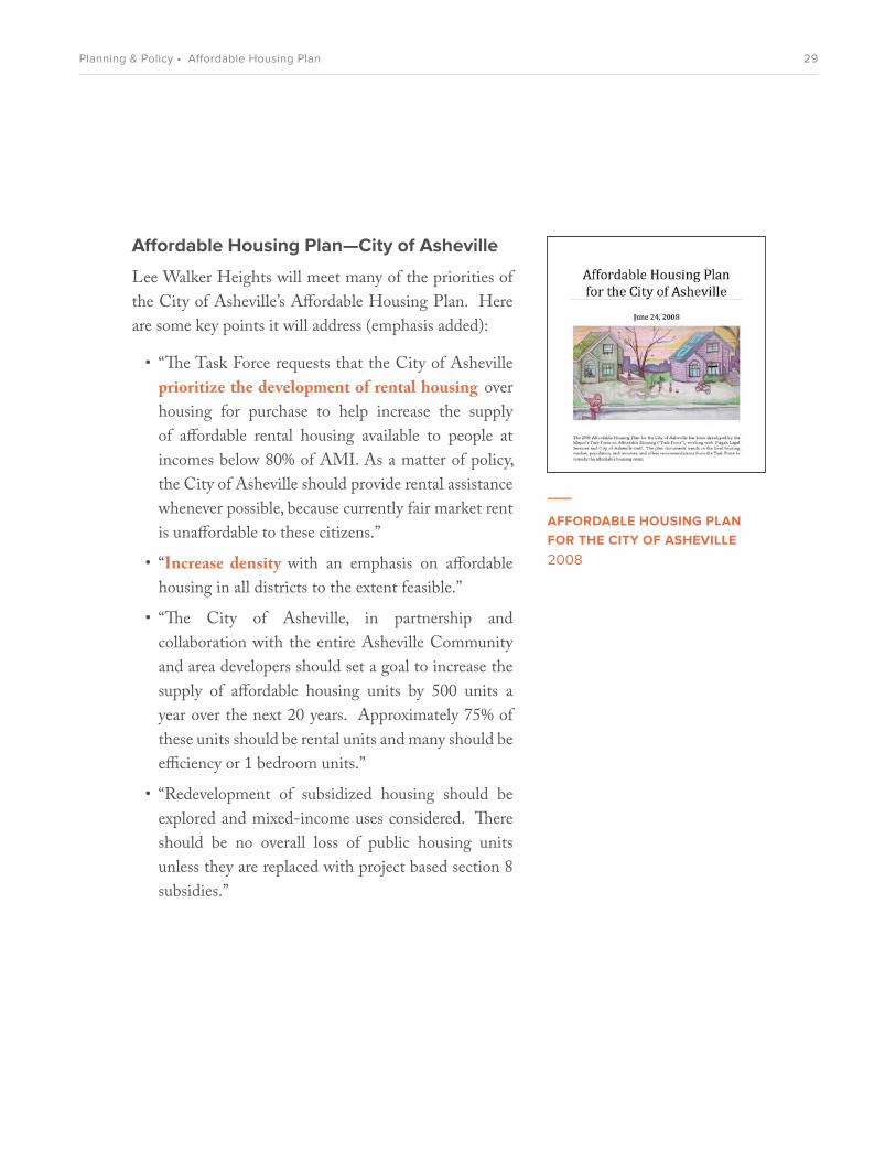
Lee Walker Heights will meet many of the priorities of the City of Asheville’s Aordable Housing Plan. Here are some key points it will address (emphasis added):
• “�e Task Force requests that the City of Asheville prioritize the development of rental housing over housing for purchase to help increase the supply of aordable rental housing available to people at incomes below 80% of AMI. As a matter of policy, the City of Asheville should provide rental assistance whenever possible, because currently fair market rent is unaordable to these citizens.”
• “Increase density with an emphasis on aordable housing in all districts to the extent feasible.”
• “�e City of Asheville, in partnership and collaboration with the entire Asheville Community and area developers should set a goal to increase the supply of aordable housing units by 500 units a year over the next 20 years. Approximately 75% of these units should be rental units and many should be e¨ciency or 1 bedroom units.”
• “Redevelopment of subsidized housing should be explored and mixed-income uses considered. �ere should be no overall loss of public housing units unless they are replaced with project based section 8 subsidies.”
29Planning & Policy • Affordable Housing Plan

Lee Walker Heights will be a transformational redevelopment, serve a mix of incomes, and include many additional affordable units. The public housing units will be replaced with project-based Section 8 subsidies, with no overall loss of these deeply affordable units.
Most of the new units will be affordable to families at 80% of AMI or below, and all of the units will be affordable to families under 120% of AMI.
The current plan is to double the density of units on the existing Lee Walker Heights site; provide as many affordable units as possible; and provide additional mixed-use buildings with residential units over ground- floor commercial space on an adjacent site that was once exclusively commercial.
30Planning & Policy • Affordable Housing Plan

___
ASHEVILLE CITY DEVELOPMENT PLAN 2025 2003
Asheville City Development Plan 2025
�e Asheville City Development Plan 2025 was adopted in 2003 to guide decisons on land use, transportation networks, City services, and infrastructure. As of late 2015, the City of Asheville is working to update the City Development Plan.
Center City Plan
�e Center City Plan, a component of the Asheville City Development Plan 2025, speci�cally addresses Downtown issues relevant to Lee Walker Heights redevelopment (emphasis added):
“One of the most signi�cant components of creating a vibrant downtown is a diverse mix of housing. Although the low, and to some degree, upper-income housing components are in place, there is a need to encourage and create greater opportunities for the development of moderately priced housing.”
Goal I. Substantially increase the number of people living Downtown and in nearby neighborhoods.
3. Encourage new construction of housing in Downtown and adjacent areas.
a) New construction in the Downtown core and gateway areas should incorporate retail or other active uses at ground level.
b) New high-density single-use residential construction is appropriate in the area south of Hilliard Avenue and at the western end of Downtown.
c) Provide residential uses as a component of public/private catalytic development projects.
d) Assist in the assembly of land for residential projects.
31Planning & Policy • Asheville City Development Plan 2025

e) Encourage a wider mix of housing types and products in the Downtown area.
f ) Investigate economic incentives for targeted types of housing.
5. Develop incentives to increase residential densities in surrounding areas, particularly along gateway corridors.
Goal II. Provide a range of housing options to attract an economically and socially diverse population.
2. Encourage the development of “aordable” or middle-range housing in the Downtown area.
a) Identify the market that is currently under-served in the Downtown area.
b) Acquire properties and/or use existing City-owned properties suitable for housing and make them available at favorable rates for the development of housing for targeted market.
c) Provide “aordable” or mid-range residential units as a component of public/private catalytic development projects.
d) Educate developers about programs, grants, and credits available for building aordable housing.
e) Make information about vacant or under-utilized land readily available to housing developers.
g) Explore the creation of incentives and/or creative �nancing mechanisms for the development of aordable and midrange housing.
h) Utilize Housing Trust Fund monies for the development of a�ordable housing in the Downtown area.
___
ASHEVILLE CENTER CITY PLAN2003
32Planning & Policy • Asheville City Development Plan 2025

3. Use local, State, and Federal subsidies to preserve and improve housing units Downtown that are affordable to very-low-income people, including those with special needs.
Goal III. Improve the Overall Livability of Downtown Asheville.
1. Encourage the development of a complete range of goods and services to meet the needs of Downtown residents. A grocery store and a hardware store have been identified as primary needs.
4. Improve and strengthen pedestrian connections and transit opportunities both within Downtown and between Downtown and surrounding neighborhoods.
Vision: Affordable Housing
Affordable Housing is an important component of the Asheville City Devlopment 2025 Plan (emphasis added):
“Affordable housing is one of the most pressing problems facing the City of Asheville. There is a growing gap between the incomes of City residents and the price of available housing in the City. The City’s Sustainable Economic Development Strategic Plan listed lack of affordable housing as the number one economic development problem for the community, recognizing the connection between affordable housing and economic development.”
Affordable Housing Goals and Strategies:
Goal IV. Insure that affordable housing programs and projects are consistent with Smart Growth and Sustainable Economic Development objectives and policies.
33Planning & Policy • Asheville City Development Plan 2025

1. Review every City-assisted affordable housing program and project for consistency with City of Asheville Smart Growth policies.
2. Target City assistance to encourage housing developments that have good access to transportation infrastructure (transit, bike lanes, sidewalks) and services; including the preservation of affordable downtown housing.
Goal V. Address the affordable housing problem in a coordinated and comprehensive fashion by allocating available resources to address both the supply and demand sides of the affordable housing issue, as well as promoting public education about the extent of the problem.
1. Advocate for and support efforts to increase earnings in the region to a level where Fair Market Rents are affordable to all working people.
2. Identify and support regional efforts to increase the supply of affordable housing, including employer-provided programs.
3. Provide financial and organizational support for non-profit housing developers and financial support for affordable housing produced by for-profit developers.
4. Develop and implement a public education program targeted at improving public awareness of the extent of the affordable housing problem and addressing neighborhood compatibility concerns.
5. Evaluate the effectiveness of an affordable housing bond issue in order to direct more immediate influx of resources to this critical community need.
34Planning & Policy • Asheville City Development Plan 2025
6. Evaluate and promote the effectiveness of tax-credit programs that encourage the provision of more affordable housing, including providing an appropriate level of technical assistance to people considering this financial tool.
Land Use and Transportation Goals
Land Use Goals:
Goal III. The City should permit and encourage transit supportive density (8-16 units per acre minimum) along and adjacent to major corridors and at logical transit nodes.
Goal IV. The City should revise its development standards for corridors to ensure that the corridors are developed in an urban manner.
Goal V. The City should encourage the construction of affordable housing throughout the community.
Goal X. The City should assure that as land is developed or redeveloped, provision is made for access by various means of transportation.
Goal XI. The City should work with property owners, institutions, and public and private agencies to enhance the streetscape along streets and roads in the City.
Transportation Goals:
Goal II. Develop a system of sidewalks, greenways and bicycle facilities that will make Asheville a more walkable and more livable city.
Goal IV. Increase the level of investment in the transportation system to support economic development and promote quality of life.
35Planning & Policy • Asheville City Development Plan 2025

Police Goals
Goal VIII. Utilize CPTED practices and development review and in retrofitting existing infrastructure and neighborhoods in order to reduce the incidence of crime.
“In the coming years the department will also continue to use its crime prevention program named Crime Prevention Through Environmental Design (CPTED). CPTED is based on the belief that the way the built environment is constructed and managed can impact both the fear of crime and the actual frequency of criminal events in a given location.
The five principles of CPTED are:
1. Defensible space
2. Natural and technological surveillance
3. Lighting designed to reduce criminal activity
4. Landscape planting sensitive to issues of crime prevention
5. Physical security measures used to delay or deny access to protected space.”
36Planning & Policy • Asheville City Development Plan 2025

Smart Growth Land Use Policies Adopted by the Asheville City Council
Smart Growth urban planning and transportation policies and design promote compact, urban neighborhoods to counteract suburban sprawl. The following principles were adopted by Asheville City Council in 2000:
“Asheville’s topography and existing development pattern complicates the establishment of an effective and efficient transportation network. The road pattern tends to follow valleys and ridgelines and circumvent neighborhoods rather than follow a more grid-like pattern. Additionally, there are a limited number of development nodes of sufficient density to provide efficient public transportation. Under these circumstances, it is difficult to disperse traffic through an interconnected roadway network or successfully use public transportation as a primary transportation mode. On a more positive note, there are a number of neighborhoods within reasonable walking and biking distance of Downtown Asheville, a circumstance that provides alternative modes of transportation for many residents.”
— 2000 City Smart Growth Policy
1. Mixed use developments and buildings should be encouraged.
2. Compatible, higher density commercial and residential infill development should be encouraged.
3. New development should promote a sustainable land development pattern.
5. Discretionary block grant and local funding for affordable housing and economic development should be used to support a Smart Growth development pattern.
37Planning & Policy • Smart Growth Land Use Policies

Smart Growth Transportation Policies Adopted by the Asheville City Council
1. Where feasible, new development projects should be designed to connect to the existing street network at multiple points; cul-de-sac development and gated communities should be avoided except where unreasonable due to topographical conditions or inadequacy of some surrounding roadways to handle the volume and/or type of traffic generated by the development project.
2. Strongly encourage improvements that make Asheville a premier walking and biking community, including the use of evaluative and regulatory tools and capital improvements.
3. Implementation of various projects from the City’s Bicycle and Pedestrian Plan should be implemented on a priority basis as funding allows.
4. Where possible, multimodal transportation interconnectivity between neighborhoods and to destination areas such as parks and neighborhood shopping locations should be encouraged.
5. New development projects should incorporate mass transit features where appropriate.
38Planning & Policy • Smart Growth Transportation Policies

Comprehensive Bicycle Plan
�e Comprehensive Bicycle Plan, adopted in 2008, builds on the existing assets to propose improvements to the bicycle infrastructure in Asheville.
�e proposed Lee Walker Heights redevelopment plans to connect to and add immediate access points to the network of on- and o-street bicycle facilities outlined in the Comprehensive Bicycle plan (bike lanes on Coxe Avenue and the Town Branch greenway that runs along Southside Avenue). �e Lee Walker Heights redevelopment also plans to add bike racks to serve the resident population.
One of the Lee Walker Heights Resident Advisory Committee members is an avid cyclist who has emphasized the importance of bicycle safety and has personally repaired bikes for the existing neighborhood children.
___
COMPREHENSIVE BICYCLE PLAN2008
39Planning & Policy • Bicycle & Pedestrian Plans

Asheville Pedestrian Thoroughfare Plan
�e Asheville Pedestrian and Bicycle �oroughfare Plan, adopted in 1999 and updated in 2005, provides City and state transportation organizations with goals and objectives for improving the quality and safety of pedestrian and bicyle transportation in Asheville.
Goals:
• Promote pedestrian activity as a viable alternative to automobile use.
• Enhance the pedestrian environment and increase opportunities to choose walking as a mode of transportation to help improve the health of the citizens of Asheville.
• Develop standards that enhance livability, economic opportunity, safety, and quality of life.
“Creating a walkable community creates opportunity for everyone to have access to jobs, libraries, schools, community centers, and other destinations no matter what their income.”
___
ASHEVILLE PEDESTRIAN THOROUGHFARE PLAN2005
40Planning & Policy • Bicycle & Pedestrian Plans

5
EXISTING SITE CONDITIONS
41Existing Site Conditions

OVERVIEWDeveloped by the Asheville Housing Authority, Lee Walker Heights �rst opened in 1951.
History
Established in 1940, the Housing Authority was charged with constructing low-rent public housing. Because World War II intervened, it was not until 10 years later that funds became available to construct their �rst low-income housing project—“96 modern apartments” at a cost of $894,470.
�e new neighborhood was named for two prominent African-American community leaders—Walter Smith Lee and John Wake�eld Walker. Lee was an important civic and educational leader, serving as a school teacher and principal of Stephens-Lee High School for nearly 25 years. Walker was a physician who became a specialist in the treatment of tuberculosis. In the early 1900’s, he served as head of the tuberculosis sanitarium for African Americans at the North Carolina State Sanitarium in Raleigh before returning to private practice in Asheville.
Opening day at Lee Walker Heights was a big success. �e interest in the community was so great that seven secretaries were kept busy taking applications and had to implement a numbering system to handle the 350 applicants. �e impact of Lee Walker Heights paved the way for the construction of two additional housing developments built by the Housing Authority during the 1950s: Pisgah View Apartments and Hillcrest Apartments.
___
LEE WALKER HEIGHTS CIRCA 1950
___
WALTER SMITH LEEA professor and one namesake of Lee Walker Heights
___
DR. JOHN WAKEFIELD WALKER (right) A doctor and one namesake of Lee Walker Heights
42Existing Site Conditions • History

___
ORIGINAL SITE PLAN
The construction of Lee Walker Heights came at an interesting transitional time in Asheville’s history. The City was struggling to rise out of post-depression era debt and had no means of investment for community development. Urban renewal largely left the downtown intact, but had a less positive impact on historically African-American neighborhoods. While not vibrant, the Downtown core, located just north of Lee Walker Heights, remained a prominent place for business and shopping. This provided the residents of this new neighborhood with important community connections and job opportunities.
Appealing to African-American WWII veterans and their families in the segregation years, Lee Walker Heights supported the baby boom in its own unique way. Due to the prevalence of laundry and cloth diapers being hung out to dry, the community became known as “Diaper Hill.” To this day, Lee Walker Heights is home to a large population of families with children, with almost half of the current residents being under the age of 18.
43Existing Site Conditions • History

___
ORIGINAL TOWNHOME ELEVATIONS
___
ORIGINAL TOWNHOME FLOOR PLANS
44Existing Site Conditions • History

___
AERIAL PHOTOGRAPH, CIRCA 1950s
___
ORIGINAL CONSTRUCTION SIGNAGE
45Existing Site Conditions • History

N
Current Housing Conditions
�e Lee Walker Heights neighborhood currently has 96 total units of housing consisting of primarily two-story two-, three-, and four-bedroom townhouses and a few one-story one-bedroom �ats. �e buildings are organized around a loop road with parking. Outdoor spaces between buildings typically consist of unprogrammed grassy areas. A dense perimeter of trees surrounds the housing, with some mature trees among the rowhouses. On the exteriors, the buildings are aesthetically uniform, with red brick bases and pillars, painted wood trim, and cement plaster panels. Roofs have gray asphalt shingles.
COMMUNITY BUILDINGRECREATION AREASTEEP HILLSIDES
MINNIE JONES HEALTH CENTER
SHORT COXE AVENUE
WILB
AR
AV
E
SOU
THSI
DE
AVEN
UE
BILTM
OR
E AV
ENU
E
MC
CD
OW
ELL STREET MISSION HOSPITAL LAUNDRY BUILDING
FORMER CAR DEALERSHIP
46Existing Site Conditions • Current Housing Conditions

Though the buildings have had modest upgrades over the years, they are currently outdated compared with contemporary building standards and have relatively high maintenance costs. The buildings are not universally accessible for people in wheelchairs or with other mobility limitations because of the discontinuous, steep, and broken pathways; insufficient lighting; porches and apartments with stairs; narrow doorways; bathrooms located on upper floors; and small kitchens and bathrooms with insufficient clearances and fixtures.
___
EXISTING TOWNHOUSES
___
UNIT INTERIOR: BATHROOM
___
UNIT INTERIOR: KITCHEN
___
CLOTHESLINES
47Existing Site Conditions • Current Housing Conditions
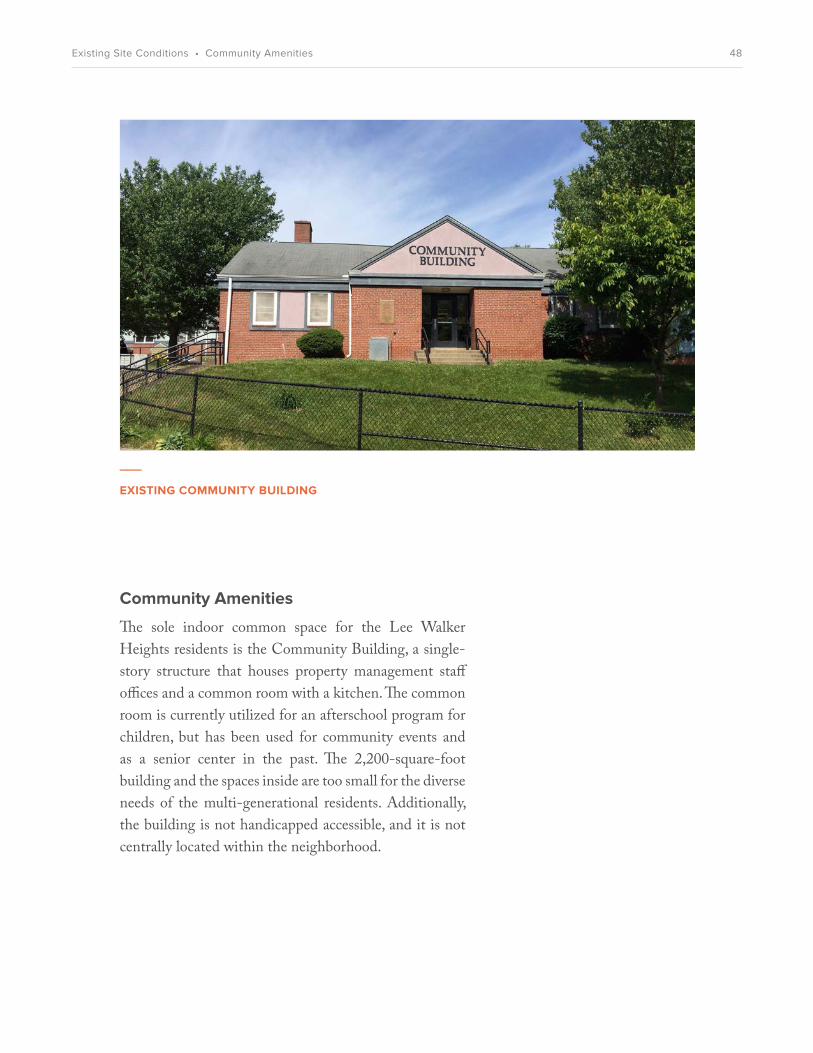
Community Amenities
The sole indoor common space for the Lee Walker Heights residents is the Community Building, a single-story structure that houses property management staff offices and a common room with a kitchen. The common room is currently utilized for an afterschool program for children, but has been used for community events and as a senior center in the past. The 2,200-square-foot building and the spaces inside are too small for the diverse needs of the multi-generational residents. Additionally, the building is not handicapped accessible, and it is not centrally located within the neighborhood.
___
EXISTING COMMUNITY BUILDING
48Existing Site Conditions • Community Amenities

___
WILBAR AVENUEThis narrow, steep road is the only entrance to the neighborhood.
Connections
The existing connections to and through Lee Walker Heights are inadequate for the residents’ needs. Sidewalks within the neighborhood are narrow, discontinuous, and largely inaccessible to disabled users. Paths with stairs and sidewalks on only one side of the street make it difficult to cross the site. Since the narrow one-way loop road is the only continuous circuit through the site, it dangerously serves as a pedestrian walking and bike path in addition to being a drive aisle for automobiles.
The narrow loop road makes it difficult for fire department vehicles to circulate and impossible for larger vehicles like buses to access the site. On-street parking and small parking lots are dispersed along the street, but some buildings are not conveniently served by an adjacent parking area. With a lack of other alternatives, the loop road has become a very important social component of Lee Walker Heights. Residents congregate along the road on the townhouse porches and socialize with their neighbors.
There is a series of informal pathways in the dense forested areas at the periphery of the site. These paths are in poor condition now, but have the potential to be improved. With the addition of adequate lighting, maintenance, and security measures, this network of paths can become an important part of the open-space and recreation system and helps create connections to surrounding neighborhoods.
49Existing Site Conditions • Connections

___
NATURE PATHS AT EDGE OF SITE
___
ENTRANCE AT SHORT COXE AVENUE
___
NO CONNECTION AT 319 BILTMORE AVENUE
___
NARROW LOOP ROAD
50Existing Site Conditions • Connections

Transportation
Many residents use the City bus system as their primary mode of transportation. The nearest bus stop is located at the intersection of Biltmore Avenue and Short Coxe Avenue. The walk to Lee Walker Heights is steep, and a small shelter—previously a bus stop—exists at the base of Wilbar Avenue. The shelter is no longer on an active bus route and so currently only serves as a school bus stop. Other bus stops are located on the periphery of the site and due to the single entrance at Wilbar Avenue, most residents have to walk an indirect path to get to the bus.
As Biltmore Avenue is a “frequent service corridor,” the City bus travels its length at least twice per hour. The ART (Asheville Redefines Transit) Station, located approximately one mile north of the Lee Walker Heights neighborhood, serves as a multimodal transit hub for the city. With improved site access to public transportation, the community is well-positioned to connect residents with services, amenities, and jobs.
The car-ownership rate among residents is relatively low. Residents rely on informal ridesharing when public transportation is not a viable option. Existing surface parking lots are in disrepair and need accessibility and lighting improvements.
Bicycles are used for recreation by some residents, especially kids. Bicycle use for commuting or other trips outside of Lee Walker Heights is minimal. There are currently no permanent parking or maintenance facilities for bicycles.
___
CITY OF ASHEVILLE ART STATIONLocated downtown at 49 Coxe Avenue, the transit station and its programs demonstrate the City’s commitment to multimodal, affordable, sustainable transportation.
51Existing Site Conditions • Transportation

___
BUS STOP: BILTMORE AVENUE AT MCCORMICK PLACE (NORTHBOUND)
___
COVERED SHELTER AT WILBAR AVENUE
___
SURFACE PARKING AT COMMUNITY CENTER
___
INADEQUATE ACCESSIBLE PARKING
52Existing Site Conditions • Transportation

Open Space
Other than the undefined green spaces between buildings, a large grassy field at the west side of the neighborhood is the main play space. A basketball court, baseball field, and playground are also part of this recreation area. The few items of play equipment are older and could use upgrades. There are no private outdoor areas other than small stoops and porches at apartments.
The site is surrounded by a mature forest of diverse tree species. This is a beautiful existing amenity that should be improved and preserved to the extent possible. There are partial distant views through the forest to the Blue Ridge Mountains and to downtown. Views in to Lee Walker Heights from surrounding streets are obscured by the thick tree cover.
___
LARGE OPEN LAWN WITH PLAYGROUND
___
BASKETBALL COURT
53Existing Site Conditions • Open Space

___
SMALL STOOPS & PORCHES
___
PLAYGROUND
___
MATURE FOREST
___
RECREATION AREA
54Existing Site Conditions • Open Space

Site Topography & Drainage
Lee Walker Heights sits on top of a hill and is only accessible from the north. Other sides of the site have very steep, rocky slopes with limited opportunities for new pedestrian and vehicle connections without significant regrading.
The current stormwater-control system consists of curbs that divert water to storm drains and the City’s stormwater system. Stormwater can seep into the ground and existing planted areas, but there is currently no capture, reuse, or filtration of existing stormwater onsite.
___
VIEW OF LEE WALKER HEIGHTS FROM 319 BILTMORE AVENUE SITE
55Existing Site Conditions • Site Topography

2125
___
EXISTING STORM DRAINS
___
STEEP PATHS
___
RETAINING WALL AT 319 BILTMORE AVENUE
___
STEEP SLOPE AT MCDOWELL STREET
56Existing Site Conditions • Site Topography

COMMUNITYPARTICIPATION
6
57Community Participation

OVERVIEWBeginning in early 2015, Mountain Housing Opportunities (MHO) and the Housing Authority of the City of Asheville (HACA) began a community- outreach process to solicit ideas and desires from current residents and other local stakeholders. Through regular meetings with a Resident Advisory Committee, community workshops, building tours, and surveys, the development team identified goals, values, and priorities for the new Lee Walker Heights.
All community meetings were held on-site at the Lee Walker Heights community center in the evenings, when most residents would be able to attend. Community workshops generally consisted of an introduction and brief presentation, continued with an interactive exercise or break-out group discussion, and concluded with an opportunity for participants to share feedback.
___
COMMUNITY WORKSHOP
58Community Participation • Overview

Resident Advisory Committee
The volunteer Resident Advisory Committee, composed of Lee Walker Heights residents, held regular meetings to steer the outreach process and provide vital feedback from community leaders, discussions, and goal-setting sessions. The committee of volunteers consisted of six Lee Walker Heights residents, as well as Housing Authority staff.
The committee’s work started in the fall of 2014, when they participated in the interview and selection process of the co-development team. Beginning in March 2015, the committee members met bimonthly with the team on the first and third Thursdays of the month at 1:30 p.m. After the conclusion of the community-planning sessions in August 2015, the committee has continued to meet on the first Thursday of the month for updates as the planning moves toward implementation. As of late 2015, the Committee has held more than 15 meetings and has been instrumental in the successful inclusion of resident voices in all aspects of the planning process.
RESIDENT ADVISORY COMMITTEE___
LEE WALKER HEIGHTS RESIDENTS
Natasha Boseman
Dolly Burwell
Crystal Reid
Joseph Tarrant III
Theresa Timbers
Butch Worthy
HOUSING AUTHORITY STAFF
David Nash CHIEF OPERATING OFFICER
Constance ProctorLEE WALKER HEIGHTS MANAGER
Rebecca BrothersFAMILY/SELF-SUFFICIENCY PROGRAM MANAGER
Terry Bellamy COMMUNICATIONS DIRECTOR
___
RESIDENT ADVISORY COMMITTEE
59Community Participation • Resident Advisory Committee

Kickoff Meeting April 7, 2015, 6 p.m.
The initial resident meeting was held at the community center and was attended by current residents, HACA leadership, MHO staff, and members of the local design team. After a brief introduction to the process, the local design team presented massing sketches and three “vision” principles, a conceptual site plan, and a few character vignettes. The second part of the workshop focused on gathering information from the residents about their experiences living in Lee Walker Heights and their vision for the future. Questions were posed to the residents, such as:
• Where do you walk in the neighborhood?
• How can the history of the site be represented?
• What kinds of play areas should be provided?
• What’s the most important thing about a home?
___
INITIAL RESIDENT MEETINGHACA CEO Gene Bell discusses the development process at the first resident community meeting.
___
INITIAL RESIDENT MEETINGElinor Earle, director of the Youthful Hands after-school program at Lee Walker Heights, reviews preliminary design sketches.
60Community Participation • Kick-off Meeting

Design Workshop #1: Site PlanMay 14, 2015, 2-7 p.m. & May 16, 2015, 2-4 p.m.
The first community design workshop focused on site planning and an overall vision for the new community. The design team presented a revised site plan and vision, as well as example project images to illustrate ideas for programmatic uses, open spaces, building typologies, connections, and homes.
The design team also facilitated discussion about site layout and amenities using model kits. Residents split into three groups to arrange model pieces on a large Lee Walker Heights site plan. Kits included: a site plan, blocks for residential buildings (apartments and townhomes), retail blocks, roads, and different types of green and open space. This interactive exercise served as a way to discuss density, access, and community vision. After the smaller group sessions, the group reassembled, presented their schemes, and shared feedback. The design team worked on a revised site plan based on community input, which was presented at a follow-up “open house” event.
___
SMALL GROUP DISCUSSIONSmall groups discussed their proposed site arrangements and responded to images from example projects.
___
SITE PLANNING MODEL KITSModel kits allowed residents to explore site-plan iterations.
___
KIDS’ VISIONING ACTIVITYLed by Asheville Design Center, neighborhood children drew their “dream playground.”
61Community Participation • Design Workshop #1: Site Plan

Design Workshop #2: BuildingsJune 12, 2015, 5-8 p.m.
The second community design workshop focused on gathering input and engaging the residents in a conversation about the character of the buildings and desired community amenities. The design team led a brief presentation that summarized feedback from previous meetings and introduced design developments: a revised site plan, and hand-sketched vignettes of civic space, townhouses, and a landmark building.
The small group activity involved programming for an enlarged community center, the heart of the neighborhood. Model kits included a ground-level floor plan of the community center and paper cutouts with reference images and approximate square footages representing programmatic elements. Residents discussed a variety of potential program elements and voiced preferences about the organization of uses within the building. Possible community amenities discussed by the groups included: community room, community kitchen, daycare, after-school program, senior center, job training, shared laundry, and fitness center.
___
WORKSHOP PARTICIPANTS
___
COMMUNITY CENTER PROGRAMMING ACTIVITY
___
SITE PLAN FEEDBACK
___
WORKSHOP PARTICIPANTS
62Community Participation • Design Workshop # 2: Buildings
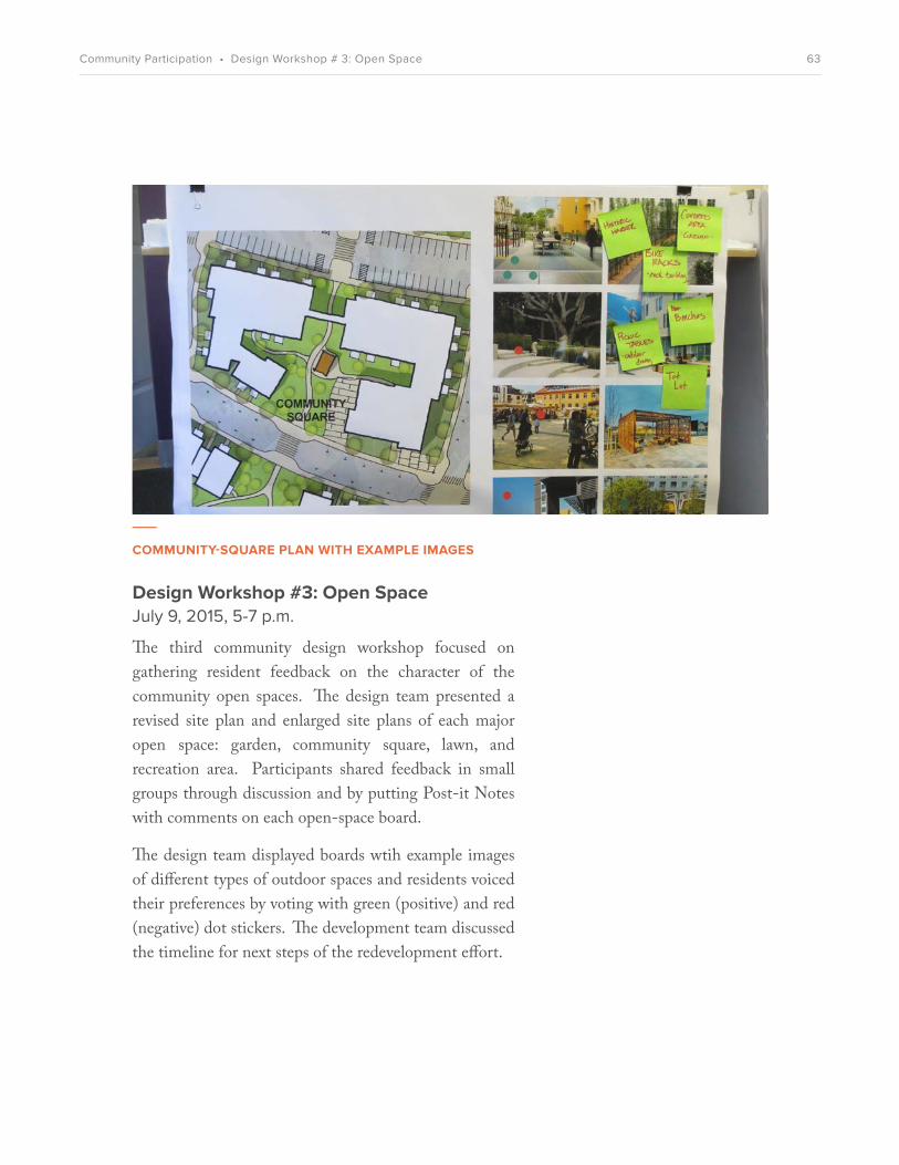
Design Workshop #3: Open SpaceJuly 9, 2015, 5-7 p.m.
The third community design workshop focused on gathering resident feedback on the character of the community open spaces. The design team presented a revised site plan and enlarged site plans of each major open space: garden, community square, lawn, and recreation area. Participants shared feedback in small groups through discussion and by putting Post-it Notes with comments on each open-space board.
The design team displayed boards wtih example images of different types of outdoor spaces and residents voiced their preferences by voting with green (positive) and red (negative) dot stickers. The development team discussed the timeline for next steps of the redevelopment effort.
___
COMMUNITY-SQUARE PLAN WITH EXAMPLE IMAGES
63Community Participation • Design Workshop # 3: Open Space

Building Tours
In May 2015, MHO invited current Lee Walker Heights residents to attend tours of recently completed MHO projects. Approximately 20 residents attended the tour of three communities: Mars Hill Commons, Glen Rock Apartments, and Larchmont Apartments. The residents who attended provided written comments on feedback sheets regarding unit size, quality, and character of the community spaces.
Resident Surveys
The Housing Authority has administered written surveys to current residents as an additional method to gather feedback and information regarding existing and future community needs. Survey questions focused on likes and dislikes of the existing community and aspirations for the redevelopment. The majority of people who responded appreciate the close-knit community and are “excited” to “somewhat excited” about redevelopment. The main priorities voiced for the future focused on site access, open space, and safety.
___
BUILDING TOUR OF MHO’S GLEN ROCK COMMUNITYLee Walker Heights residents toured recently built units and community spaces at a local affordable property and provided feedback.
___
GLEN ROCK BUILDING TOUR
64Community Participation • Building Tours & Resident Surveys

RESIDENT PARTICIPATION SUMMARYOutreach Event Resident Priorities and Input
• Parking is a big issue• Residents would like
parking closer to units• Street is too narrow
• Would like an access road to connect to Southside
• Safe bike routes for kids• Multi-use paths for walking
and biking• Direct access to
apartments• Covered bus stop
• Minimize noise between units
• Outdoor community space• Private porches/balconies• Community amenities• Mix of building types/sizes
• Landmark location is good• Like private/individual
porches and balconies (deep enough for chairs)
• Want multiple ways in/out of units for safety
• Maximize bedroom space vs. closet space
• Pantry space in kitchen• Color/texture of buildings
should feel like home • Community program:
prioritize Pre-K daycare & after-school, senior center, wellness, shared kitchen/community room
• Places to walk• Places to sit—benches,
covered areas, picnic tables, seating at play areas
• Community grill area
• Community gardens• Play areas in one place,
for di¤erent age groups
• Like the close-knit community
• Dislike limited site access• Dislike non-resident
guests• Dislike poor sidewalks
• Want better park/recreation spaces
• Want improved parking• Shade trees• Desire for daycare/
educational programs
• Like lots of community space (Glen Rock)
• Like protected space for younger kids, adjacent to amenities (Glen Rock)
• Like W/D in apartments • Hallways too narrow
• Like spacious bedrooms, large bathrooms, closets
• Like ceiling fans, shared porches
• Dislike small living area• Like exterior materials
(Mars Hill)
Kicko¤ MeetingApril 7, 2015
Design Meeting #1:Site PlanningMarch 14, 2015
Design Meeting #2:Community AmenitiesJune 12, 2015
Design Meeting #3: Open SpaceJuly 9, 2015
Surveys
Building Tours
65Community Participation • Resident Feedback

MASTER PLANVISION
7
66Master Plan Vision

OVERVIEW�ree major goals guide the vision for the Master Plan: Community, Connectivity, and Health/Sustainability. �ese goals were determined by understanding the needs and desires of residents through an extensive outreach process, HACA’s project requirements, and identifying opportunities to improve the existing urban conditions of the site.
Community
• Support the existing resident community, and integrate it with the surrounding neighborhood.
�e extensive outreach process allowed the residents to share what they needed to improve the quality of their lives. New homes, great green spaces, spacious and �exible community areas, and access to supportive services were all part of the collective hopes for a new Lee Walker Heights neighborhood. �e proposed Master Plan for the site—with its diverse building and unit types, mix of uses, and emphasis on human-scaled spaces—completes this vision and creates a supportive environment.
67Master Plan Vision • Vision Goals

Connectivity
• Provide strong physical connections both within the neighborhood and to the broader context.
�e vision for the new Lee Walker Heights neighborhood relies on better and more connections. �e long-standing physical isolation from the surrounding neighborhood— a result of steep slopes, tree cover, and a solitary access road—is being reversed with several new streets that can safely accommodate cars, bicycles, and pedestrians, including those with mobility challenges. �ese new connections will help establish Lee Walker Heights as an anchor to the surrounding neighborhood and will give residents better access to jobs and amenities throughout the district and city.
Health/Sustainability
• Create a sustainable neighborhood with buildings that promote resident health and reduce resource use and operational costs.
• Enterprise Green Communities will be used as a sustainability evaluation tool.
A sustainable neighborhood is a healthy neighborhood. With resident health as a primary objective, the Master Plan envisions a place where physical activity is encouraged, access to fresh food is easy and aordable, interior spaces have ample fresh air and daylight, and outdoor spaces are inviting and convenient. �ese health strategies, combined with low-energy and and low-water-usage systems, can help minimize ongoing long-term costs for both residents and the Housing Authority.
68Master Plan Vision • Vision Goals

Site Plan
�e site plan creates an integrated network of streets, buildings, and open spaces. Small block sizes, connections to surrounding streets, and a variety of building types with porches and active ground �oors make a comfortable and inviting place for pedestrians.
SHORT COXE AVENUESO
UTH
SID
E AV
ENU
E
LEE
GA
RD
EN R
OA
D
BILTM
OR
E AV
ENU
E
MC
CD
OW
ELL STREET
WALKER AVENUE
BUILDING I
BUILDING II
WALKER AVENUESTACKED FLATS
& WALK-UPS
FUTURE DEVELOPMENT
MIXED-USE
MIXED-USE
69Master Plan Vision • Site Plan

___
SITE SECTION
___
SITE PLAN
Height
Lee Walker Heights currently sits on top of a signi�cant hill. �e new building heights are organized to accentuate the general form of the hill, with the tallest building at the top of the hill and lower buildings on the north and south blocks. A taller neighborhood landmark at the southeast corner of the Block II building marks the “front door” to Lee Walker Heights from the Biltmore Avenue approach.
Views
�e new site plan is organized to place the project within the larger context of Asheville. �e buildings “open up” at recreational areas to frame views north to Downtown and south to the Blue Ridge Mountains in the distance. Views within the site unfold along a series of courtyards and planted areas connected by a pedestrian path.
70Master Plan Vision • Views & Height

___
STREETS & BLOCKS DIAGRAMNew streets are added within the neighborhood and as connectors to Southside, Coxe, and Biltmore Avenues.
___
PEDESTRIAN-FRIENDLY STREET“Active uses” at the ground floor—retail, commercial, and community spaces—create a more diverse and welcoming street experience for people.
Slow Streets
Neighborhoods need slow streets for a safe and pleasant environment. Slow streets are designed to accommodate cars and bikes, but highest priority is given to pedestrians. In addition to corner bulb-outs (wider sidewalks at corners), streets are made as narrow as possible to make crossing them safe and easy. Narrow streets also control tra¨c speeds, while still providing emergency vehicle access. Additional measures that may be explored to create slow streets include speed humps, changes in paving materials, and speed tables at intersections.
All parking will be accommodated as surface parking. It will be convenient for residents and visitors, but not predominant in the site plan. Parking will be con�gured in one of two ways: as parallel parking on one or both sides of the street, or as perpendicular parking on both street sides. �ere will not be any parking on the street connection to Southside Avenue.
Blocks
Blocks are sized to be human-scaled, with relatively small internal and perimeter dimensions. �e curving, organic block shapes are driven by Asheville’s typical topographical constraints. Buildings and trees are located to make the neighborhood feel varied, natural, and informal.
71Master Plan Vision • Slow Streets & Blocks

8' parallel parking
8' parallel parking
11' vehicle lane
11' vehicle lane
6'-6" sidewalk
6'-6" sidewalk
15' setback
15' setback
18' perpendicular parking
18' perpendicular parking
12' vehicle lane
12' vehicle lane
6'-6" sidewalk
6'-6" sidewalk
15' setback
15' setback
___
KEY PLAN
12 3
___
SECTION 1: STREET BETWEEN BUILDINGS I & II (73' WIDE)
___
SECTION 2: WALKER AVENUE (51' WIDE) UPHILL SECTION
72Master Plan Vision • Slow Streets & Blocks

8' parallel parking
8' parallel parking
10' sidewalk
10' sidewalk
11' vehicle lane11' vehicle lane
___
KEY PLAN
12 3
___
SECTION 3: WALKER AVENUE (58' WIDE) DOWNHILL SECTION AT BILTMORE CONNECTION
73Master Plan Vision • Streets & Blocks

___
PEDESTRIAN-FRIENDLY INTERSECTIONSCorner bulb-outs and a change in paving material at intersections give priority to pedestrians at Tassafaronga Village in Oakland, California.
___
STREET PARKINGParallel parking distributes resident and visitor parking spaces throughout the site.
___
WIDE SIDEWALKS, STREET TREESPlanting buffers and generous sidewalks promote walking throughout the neighborhood.
___
ACTIVE GROUND-FLOOR USESTall retail spaces in mixed-use buildings promote vibrant street life.
74Master Plan Vision • Streets & Blocks

___
PEDESTRIAN & BICYCLE PATHS
___
BICYCLE-FRIENDLY STREET WITH “SHARROWS”
Pedestrian Connections
Pedestrian sidewalks adjacent to streets are typically six feet wide, with plantings at building setback areas. Larger sidewalk areas and distinctive paving materials will be planned adjacent to common areas and building entries to de�ne community zones. �e sidewalks will be paved with the city-standard concrete, with grading and ramping for accessibility. In addition to sidewalks at streets, mid-block pedestrian paths will connect open spaces and de�ned nature trails will oer short hiking paths through the wooded areas. Additional pedestrian connections to Biltmore Avenue and other surrounding streets will help knit the development in with the rest of the neighborhood. New lighting and “eyes on the street” will improve the safety and security of pedestrian connections.
Bicycle Connections
Shared streets are proposed to make bicycling a feasible and convenient alternative to driving. �ese streets will have “sharrows”—shared-lane markings—and signage to indicate that both cars and bicycles can use the lanes of tra¨c. Secure bicycle parking will be provided for resident use, and public bike racks will be distributed throughout the site.
75Master Plan Vision • Pedestrian & Bicycle Paths

___
BICYCLE PARKINGSafe and convenient bike parking will be distributed throughout the neighborhood.
___
STOOPSSidewalks with stoops encourage interaction between neighbors.
___
WIDE WALKING PATHSGenerous paths through planted areas promote walking, biking, and a connection to the outdoors.
76Master Plan Vision • Pedestrian & Bicycle Paths

___
OPEN-SPACE DIAGRAMA variety of open spaces are distributed throughout the site. A central “spine” of green space creates a visual north-south connection, and Walker Avenue provides an east-west connection to Biltmore Avenue.
___
OPEN-SPACE PLAY AREACentrally located play areas near community facilities make it easier for adults to supervise children at play.
Open Space
�e open-space system is an integral part of the site plan and forms a network for positive social interaction.
�e main public “spine” for this open-space system is Walker Avenue, which is envisioned as a “green” street with ample street trees and varied low-scale plantings. It is the principal east-west street on the site and connects the top of the hill with Biltmore Avenue, through the 319 Biltmore Avenue site. At the foot of Walker Avenue lies John W. Walker Plaza, a welcoming area with café seating, benches, bike parking, and public events.
Each of the three main areas of the Lee Walker Heights site—Building I, Building II, and Stacked Flats & Walk-ups—has a unique open-space use.
Building I features a community garden with raised planters and a tool shed to allow residents to grow their own fresh food and to help build positive community bonds. A recreation area at the north side of the site will have views to Downtown and will be programmed as a more intimate, contemplative garden for seniors.
77Master Plan Vision • Open Space

Building II has a neighborhood square that is directly connected to the community spaces on the ground floor. Play areas and a pavilion are also proposed for this space.
Stacked Flats & Walk-ups have a generous lawn for play and larger community events. This space will be framed with lower-scaled buildings, a pavilion, and views to the south.
An additional recreation area at the west side of the site will be designated for more active play. Roof decks may also be considered as the architectural designs are refined. Private open space will be provided via generous covered porches at ground-floor homes, and balconies at upper floors. Podium-level elevated courtyards for residents are proposed for the buildings on the 319 Biltmore Avenue site.
___
PLENTIFUL SEATING
___
COMMUNITY GARDENING
78Master Plan Vision • Open Space

THE LAWN
PLAZA
JOHN W. WALKERPLAZA
PLAY SPACE
WALTER S. LEE COMMUNITY
GARDENS
Landscape Plan
�e landscape plan for Lee Walker Heights has a variety of open spaces linked with pedestrian-friendly connections. Walker Plaza creates a gateway into the neighborhood, and each building group has a central common open space focused on play, gardening, or socializing.
79Master Plan Vision • Landscape Concept

___
PAVILION
___
CONTEMPLATION GARDEN
___
COMMUNITY GARDEN
___
STREET TREES
80Master Plan Vision • Landscape Concept
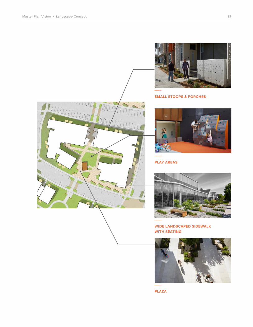
___
SMALL STOOPS & PORCHES
___
PLAY AREAS
___
WIDE LANDSCAPED SIDEWALK WITH SEATING
___
PLAZA
81Master Plan Vision • Landscape Concept

___
THE LAWN
___
PAVILION & VIEWING AREA
___
MATURE FOREST
82Master Plan Vision • Landscape Concept

___
PEOPLE-FRIENDLY STREET
___
PLAZA
___
RESIDENTIAL COURTYARD
83Master Plan Vision • Landscape Concept

___
EXISTING LEE WALKER HEIGHTS PLAYGROUND, 2015
___
PLAY-AREA WORKSHOPChildren living at Lee Walker Heights were asked to draw their “dream playground.”
Asheville Design Center Play Space
Asheville Design Center’s volunteer designers worked with Lee Walker Heights children and other residents, the Housing Authority of the City of Asheville, the City of Asheville, Mountain Housing Opportunities, Siteworks Studios, and David Baker Architects to develop a new concept for a playground in the redesigned Lee Walker Heights development.
Methodology
The Asheville Design Center (ADC) design team held two stakeholder workshops with children in Lee Walker Heights in May and September 2015. More than 20 children and adults attended each meeting. The design team asked the children to draw their “dream playground” ideas and what playground elements they desire to have in the new Lee Walker Heights. The ADC design team also showed the children examples of other playgrounds and collected input based on their reactions.
In general, the children were drawn to a range of fantasy and more natural playground materials. There were several playground elements the children said that they strongly disliked: spring bouncers, twisting slides, and tunnel slides.
The children also revealed that two existing playground elements are used frequently and that there is strong interest in keeping those elements: the basketball court and the covered shade structure. The basketball court is used frequently by residents of all ages. The covered shade structure allows children to host impromptu performances, provides an open area for pretend play, and offers adults and kids alike a shaded area to rest. The ADC design team recommends that both elements are incorporated into the new playground design.
84Master Plan Vision • ADC Play Space

Kids’ Playground-Design Preferences
• Treehouse component• Wide, straight slide• Swings: regular and baby swings• Basketball court• Monkey bars• Covered stage and shade structure• Merry-go-round• Pretend cars• Fantasy elements• Natural playground materials
EXISTING VEGETATION
EXISTING VEGETATION
“NATURAL” PLAYGROUND• Canyon Collection from Landscape Structures• Catwalk to main play structure (boulder)• Clatter bridge between treehouse towers• Straight slides, rope climbers, and boulder climbers• Monkey bars, 3 bays of swings• Play-safe mulch• Benches
SPORT COURT• Multi-use courts• Central 3-way basketball goal• Half basketball court• Court games, hopscotch, etc.• Benches
EXISTING VEGETATION ACCESSIBLE WALK
OUTDOOR PERFORMANCE• Timber stage• Shade sail• Sloped lawn & amphitheater• Ornamental tree planting
SHADE PLAZA• Benches• Ornamental tree planting
SWINGS• 3 bays with 6 swings
85Master Plan Vision • ADC Play Space
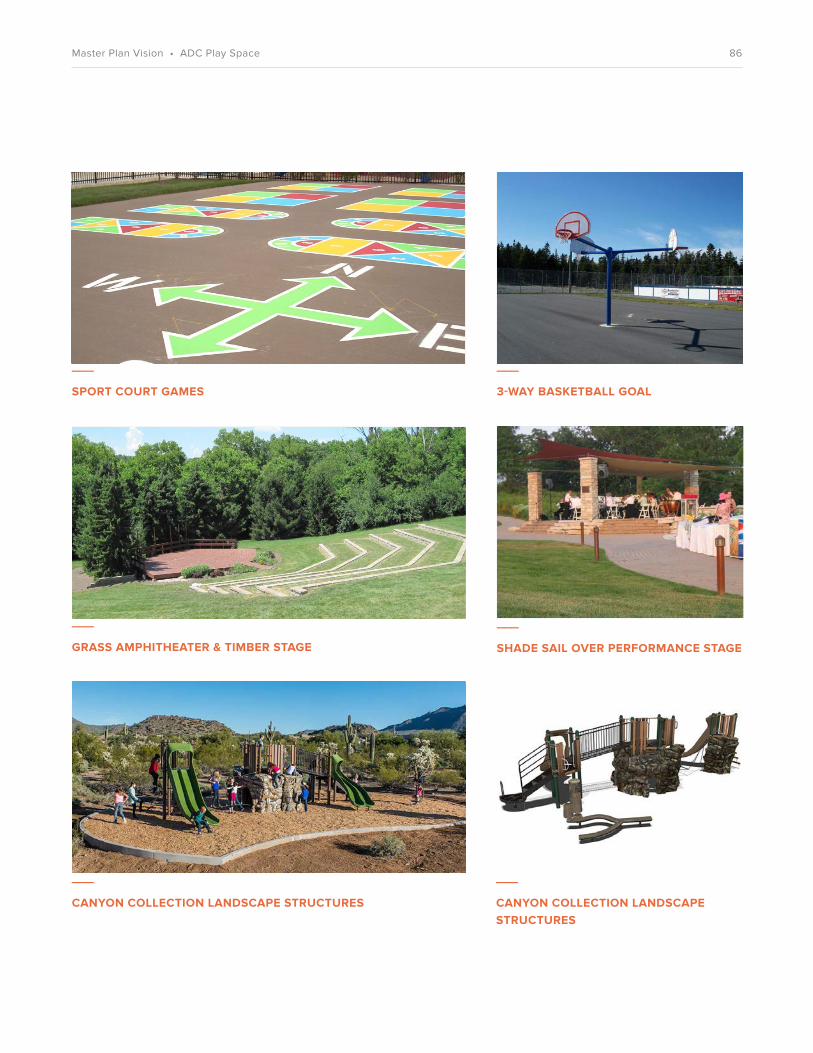
___
SPORT COURT GAMES
___
GRASS AMPHITHEATER & TIMBER STAGE
___
3-WAY BASKETBALL GOAL
___
SHADE SAIL OVER PERFORMANCE STAGE
___
CANYON COLLECTION LANDSCAPE STRUCTURES
___
CANYON COLLECTION LANDSCAPE STRUCTURES
86Master Plan Vision • ADC Play Space

___
GRASS AMPHITHEATER / TIMBER STAGE
___
TREEHOUSE ADD-ON
___
SHADE SAIL OVER PERFORMANCE STAGE
___
CATWALK TO MAIN PLAY STRUCTURE
___
SHADE PLAZA WITH BENCHES
___
ROPE CLIMBER
___
“NATURAL” ROCK CLIMBER
___
SWINGS: REGULAR AND BABY SIZES
87Master Plan Vision • ADC Play Space

___
LANDMARKS DIAGRAM
___
STRONG CORNER LANDMARK
Landmarks
For most of its history, Lee Walker Heights has been hidden away owing to the property’s lack of connections, steep slopes, and dense wooded areas. New architectural landmarks will create a clear and visible identity for the neighborhood and help as way�nding and placemaking elements. Two sites—the southeast corner of Building II at the community center, and the corner of Building III at the entrance to the 319 Biltmore Avenue site—will be taller than surrounding forms and distinct from other architectural elements via special materials and coloration. �ese landmarks will have distinctive lighting or windows to act as beacons for the neighborhood.
88Master Plan Vision • Landmarks

___
USES DIAGRAM
___
RESIDENTIAL COMMON SPACEAiry interior space opening to the outside.
Uses
�e majority of the site will be reserved for multifamily residential uses in apartment buildings, walk-ups, and stacked �ats. �ere will also be signi�cant common areas for building residents and some for public use. Common spaces will be at the ground �oors of Building I and Building II in prominent locations and will open out onto adjacent open spaces. �ere are also possibilities for a limited amount of retail and co-working space. Ground-�oor common spaces will be generous and �exible to accommodate future changes in use.
For ongoing operations, a property management o¨ce will be located in Building II and a maintenance workshop will be located near the parking area adjacent to Building I.
RESIDENTIAL
COMMONPARKING GARAGE
RESIDENTIAL OVER GROUND- FLOOR RETAIL
89Master Plan Vision • Uses
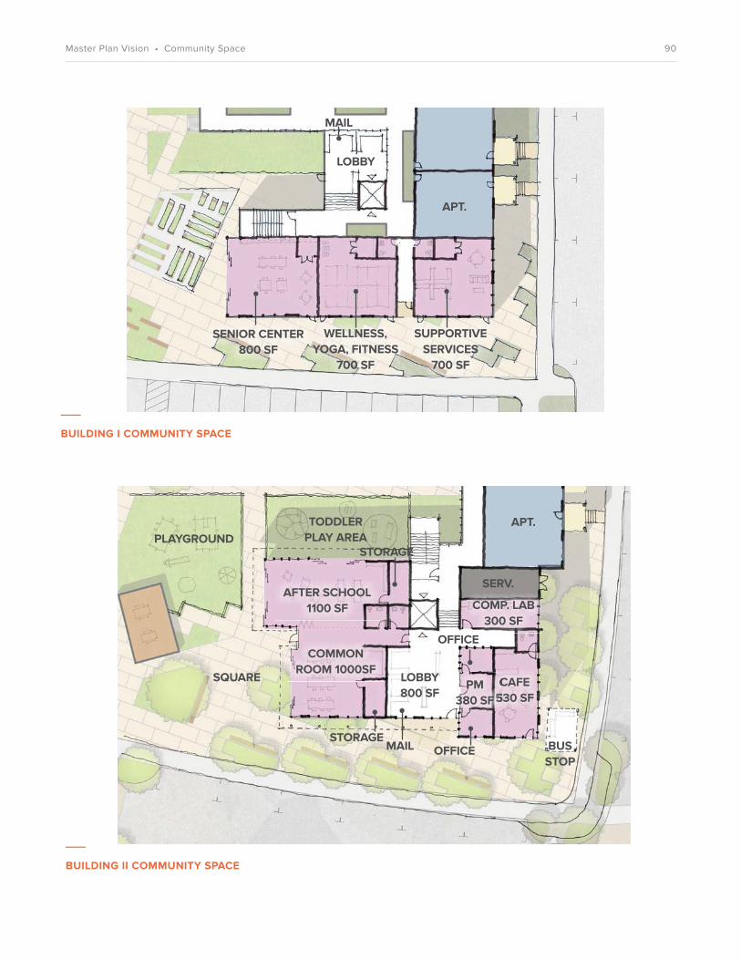
___
BUILDING I COMMUNITY SPACE
___
BUILDING II COMMUNITY SPACE
SENIOR CENTER 800 SF
LOBBY
SUPPORTIVE SERVICES
700 SF
WELLNESS, YOGA, FITNESS
700 SF
PLAYGROUND
SQUARE
COMMON ROOM 1000SF
TODDLER PLAY AREA
SERV.
STORAGE
STORAGE
AFTER SCHOOL1100 SF COMP. LAB
300 SF
CAFE530 SF
OFFICE
OFFICEMAIL BUS STOP
LOBBY800 SF
APT.
CAFE530 SF
PM380 SF
APT.
90Master Plan Vision • Community Space

___
COMMUNITY ROOM
___
EXTERIOR GATHERING SPACE
___
LOUNGE AREA
___
CHILDREN’S PLAY AREA
91Master Plan Vision • Uses

SHORT COXE AVENUE
BILTM
ORE AV
ENU
E
TO F
REDER
ICK
STRE
ET
MCD
OW
ELL STREET
SOUTH
SIDE
AVEN
UE
17 WILBAR AVENUE
319 BILTMORE AVENUE
Building Types & Unit Plans
Asheville has an eclectic and diverse architectural history, and this variety gives Asheville’s neighborhoods their character. A similar strategy is envisioned for Lee Walker Heights. Buildings are organized on the site to maximize open space. A range of building types (including apartments, walk-ups, stacked �ats, and mixed- use buildings) provides spatial and visual interest for residents and visitors. Ground-�oor activity, architectural variation, a simple contemporary aesthetic, and human-scaled buildings create a rich and vibrant urban environment that fosters positive social interaction and connections.
STACKED FLATS
WALK-UPS
APARTMENTS PARKING GARAGE
FUTURE DEVELOPMENT
RESIDENTIAL OVER GROUND-FLOOR RETAIL
92Master Plan Vision • Building Types & Unit Plans

0
10
20
40
80
17 Wilbar Avenue: Ground Level
2
2
2
1
1
SERV.1 1
1
1 1 1
1
1COMMON
2
2
2
2 2
2
2
2
22
22
2
22 2
2
3
3
3
3
3
3
3
1
1
2
2
1
1
1
1
2 1
1
1
1
1
SERV.
COMMON
COMMON
WALTER S. LEE COMMUNITY
GARDEN
PLAZA
THE LAWN
PLAY AREA
LEE
GA
RDEN
RO
AD
WALKER AVENUE
93Master Plan Vision • Building Types & Unit Plans

17 Wilbar Avenue: Typical Upper Level
BUILDING III
BUILBUILDING III
22
2
2
2 3
22
3
3
3
3
1 2
1
2
1 2
1
1
1
1
11
1
11
COMMON @ L3 & L4
COMMON @ L3, 3BD @ L4
2
2
2
3
3
1
1
11 1
1
1 1 1
1
1
1
WALKER AVENUE
2
2 2
2
2
2
22
22
2
22 2
3
3
31
1
1
0
10
20
40
80
LEE
GA
RDEN
RO
AD
BUILDING I
BUILDING II
STACKED FLATS & WALK-UPS
94Master Plan Vision • Building Types & Unit Plans

COMMERCIAL
COMMERCIAL
PARKING
PARKING
PARKING
CO
MM
ERC
IAL
NEIGHBORHOOD SHOPPING
BIL
TMO
RE A
VEN
UE
WALKER AVENUE
DRIVE THRU
0
10
20
40
80
LEE
GA
RDEN
RO
AD
319 Biltmore Avenue: Ground Level
JOHN W. WALKER PLAZA
95Master Plan Vision • Building Types & Unit Plans
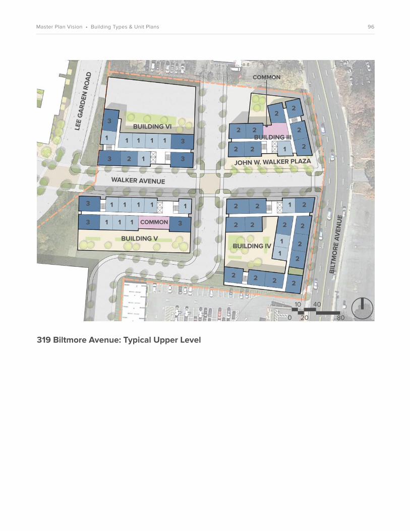
319 Biltmore Avenue: Typical Upper Level
1
2
2 2
22
22
2
2
2 2
2 2
2
2 2
2
2
2222
33
3
3
3 3
3
11
1
1
1
1 1 1 1 1
111
1 1 11
COMMON
COMMON
WALKER AVENUE
0
10
20
40
80
BIL
TMO
RE A
VEN
UE
LEE
GA
RDEN
RO
AD
BUILDING III
BUILDING IVBUILDING V
BUILDING VI
JOHN W. WALKER PLAZA
96Master Plan Vision • Building Types & Unit Plans

17 Wilbar Avenue: Unit Mix, Use Areas & Parking
Unit Type Building II Stacked Flats & Walk-ups
Building I
1 Bedroom 46 44 6
2 Bedroom
3 Bedroom
12
6
36 36
20 6
Total 64 100 48
Use
Common Space 2,325 SF 7,358 SF —
Commercial — 530 SF —
Total 2,325 SF 7,888 SF —
Total
212
96
84
32
9.683SF
530 SF
10,213 SF
Parking
On-Street Parallel
On-Street Perpendicular
Total
110
95
205 Spaces
97Master Plan Vision • Building Types & Unit Plans

319 Biltmore Avenue: Unit Mix, Use Areas & Parking
Unit Type Building IVBuilding III
1 Bedroom 4 12 32 24
2 Bedroom 32 52 0 4
3 Bedroom 0 0 12 16
Total 36 64 44 44
Building V Building VI
Use
Neighborhood Shopping
1,244 SF 1,385 SF— —Common Space
Other Commercial
9,720 SF —
— 5,380 SF
—
8,870 SF
—
4,240 SF
Total 10,964 SF 6,765 SF8,870 SF 4,240 SF
Total
72
88
28
188
2,629 SF
9,720 SF
18,490 SF
30,839 SF
Parking
On-Street Parallel
Garage
Total
136
45
181 Spaces
— 20 36 80
98Master Plan Vision • Building Types & Unit Plans

___
APARTMENT 3D VIEW
Apartments
• 4 stories total
• Common spaces on the ground floor
• Sustainable design strategies including solar readiness, non-toxic finishes, well-insulated building envelope and efficient fixtures
• Elevators
• Accessible units on all floors
• Open-air corridors and stairs
• Porches at ground floor
• Balconies on upper floors
99Master Plan Vision • Building Types & Unit Plans

___
APARTMENT FLOOR PLAN3 Bedroom
___
APARTMENT FLOOR PLAN2 Bedroom
___
APARTMENT FLOOR PLAN1 Bedroom
BALCONY
BALCONYBALCONY
PORCH
WALKWAY
LIVING / DINING
LIVING / DINING
LIVING / DINING
BED
BED BED BED
BED
KITCHEN
KITCHENKITCHEN
BATH
BATHBATH
BATH
BED
100Master Plan Vision • Building Types & Unit Plans

___
APARTMENTSMassing and material variation
___
APARTMENTSBalconies and bridges
___
APARTMENTSGround-floor community and retail uses
___
APARTMENTSCourtyards
101Master Plan Vision • Building Types & Unit Plans

___
WALK-UP 3D VIEW
___
WALK-UP FLOOR PLANEach floor consists of four 2-bedroom homes.
Walk-ups
• 3 stories
• Arranged around lawn open space
• Sustainable design strategies including solar readiness, non-toxic finishes, well-insulated building envelope, and efficient fixtures
• Accessible units on ground floor
• Open air corridors and stairs
• Porches at ground floor
• Balconies on upper floors
BALC. BALC.
BALC.BALC.
BED
BED
BED
BED BED
BED
BED
BED
KITCH.
LIVING / DINING
LIVING / DINING
LIVING / DINING
LIVING / DINING
KITCH.
KITCH.
KITCH.
BATH
BATH BATH
BATH
102Master Plan Vision • Building Types & Unit Plans
___
WALK-UPS Human-scaled buildings
___
WALK-UPS Bays and balconies
103Master Plan Vision • Building Types & Unit Plans

___
STACKED FLATS 3D VIEW
___
STACKED FLATS FLOOR PLAN1, 2, and 3 Bedrooms
Stacked Flats
• 2 stories
• Arranged around lawn open space
• Sustainable design strategies including solar readiness, non-toxic finishes, well-insulated building envelope, and efficient fixtures
• Accessible units on ground floor
• Internal stairs
• Porches at ground floor
• Balconies on upper floors
PORCH
PORCHPORCH
PORC
H
BED
BED
BED BED
BED
BED
BED BED
KITCH.
KITCH.
LIVING
LIVING
KITCH.
KITCH.
BATH
BATH
BATH
2 BED 2 BED
3 BED1 BED
104Master Plan Vision • Building Types & Unit Plans
___
STACKED FLATSShared courtyards
___
STACKED FLATSColor and material variation
___
STACKED FLATSPorches and active sidewalks
105Master Plan Vision • Building Types & Unit Plans
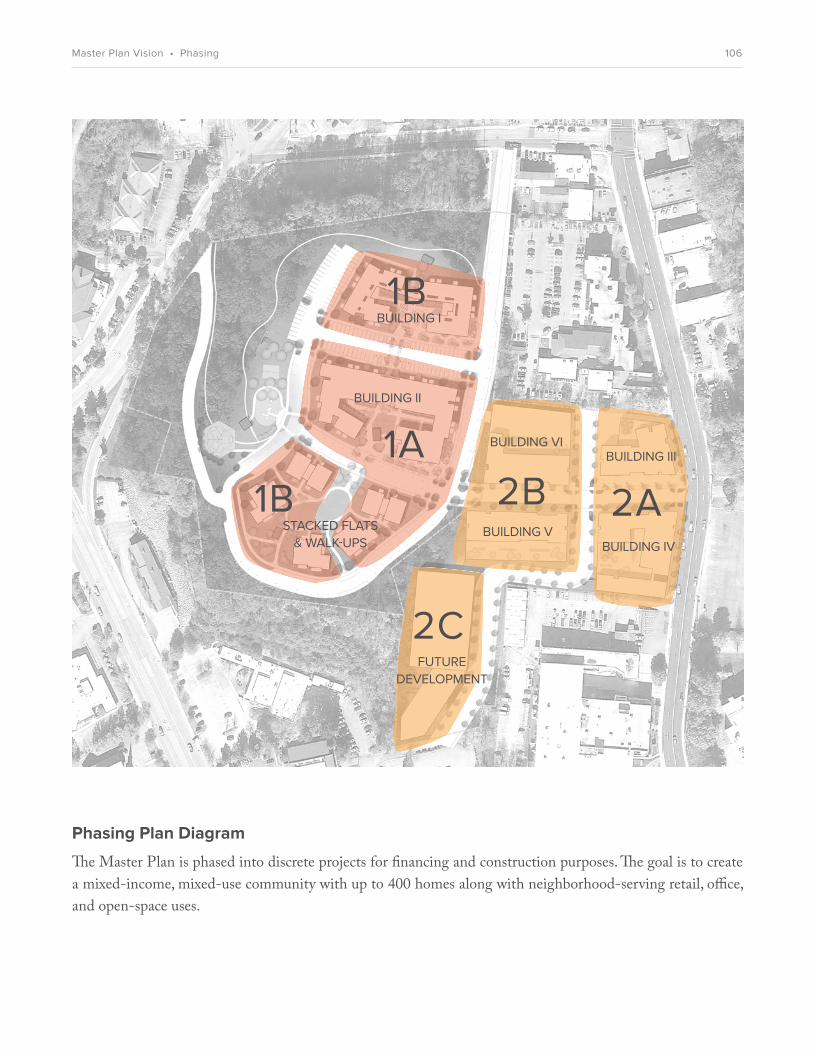
BUILDING III
BUILDING IV
FUTURE DEVELOPMENT
BUILDING V
BUILDING VI
BUILDING I
BUILDING II
STACKED FLATS & WALK-UPS
Phasing Plan Diagram
�e Master Plan is phased into discrete projects for �nancing and construction purposes. �e goal is to create a mixed-income, mixed-use community with up to 400 homes along with neighborhood-serving retail, o�ce, and open-space uses.
1A2A
1B
1B 2B
2C
106Master Plan Vision • Phasing

Phase Unit SummaryBlock
Building I
Building II
Building III
Building IV
Building V
Building VI
Stacked Flats & Walk-ups
Stacked Flats & Walk-ups
Phase 1B[92 units]
Phase 2A[100 units]
64 units (4-story single-loaded building) • 46 1-bedroom • 12 2-bedroom• 6 3-bedroom
100 units (4-story double-loaded building) • 44 1-bedroom • 36 2-bedroom• 20 3-bedroom
36 units (5-story mixed-use building) • 4 1-bedroom• 32 2-bedroom
64 units (5-story mixed-use building) • 12 1-bedroom• 52 2-bedroom
44 units (5-story mixed-use building) • 32 1-bedroom• 12 3-bedroom
44 units (5-story mixed-use building) • 24 1-bedroom• 16 3-bedroom
12 units (one 3-story walk-up building)• 12 2-bedrooms
12 units (one 3-story walk-up building)• 12 2-bedrooms
8 units (one 2-story stacked-flat building)• 2 1-bedroom • 4 2-bedroom• 2 3-bedroom
16 units (two 2-story stacked-flat buildings)• 4 1-bedroom • 8 2-bedroom• 4 3-bedroom
Phase 2B[88 units]
Phase 2C To Be DeterminedFuture Development
Phase 1A[120 units]
Master Plan Vision • Phasing 107

NEIGHBORHOOD CHARACTER
8
108Neighborhood Character

OVERVIEWThe redevelopment of Lee Walker Heights provides the opportunity for a fresh start built upon the strength of the existing residents and neighborhood. A new walkable community with a mix of uses and excellent open spaces will enhance quality of life and help people build strong social connections and a sense of belonging. Based on the core principles of Community, Connectivity and Health/Sustainability, the new Lee Walker Heights will be a model of sustainable placemaking that is a point of pride not only for the residents, but for the whole city.
___
A NEW WALKABLE COMMUNITY
109Neighborhood Character • Overview

The Master Plan in the Cityscape
The Master Plan street and building design respects the scale of the existing surrounding neighborhoods and takes advantage of the hilltop location for views to the city and landscape beyond.
110Neighborhood Character • Aerial View

Welcome to Lee Walker Heights!
The main entry into the Phase 1 development from Biltmore Avenue will be distinguished with a special landmark corner. The unique architectural moment will help with wayfinding and will be a welcoming “handshake” into the neighborhood.
___
KEY PLAN
111Neighborhood Character • Perspective Views

The Heart of the Community
The neighborhood square at Building II will be the main gathering point for the community. Surrounded by ground-floor common spaces with places to sit, socialize, and play, the square will support diverse uses for continual activity and people-watching.
___
KEY PLAN
112Neighborhood Character • Perspective Views

The Great Lawn
At the southern block, a spacious lawn will be edged with trees and small-scale stacked flats and walk-up buildings. Views to the mountains beyond can be seen from the lawn pavilion, one of several in the neighborhood.
___
KEY PLAN
113Neighborhood Character • Perspective Views

Sociable Porches
Porches are an important part of a walkable, friendly neighborhood. Buildings will meet the street with generous porches to encourage sidewalk activity, community safety, and socializing.
___
KEY PLAN
114Neighborhood Character • Perspective Views

John W. Walker Plaza
The entry from Biltmore Avenue will be marked by Walker Plaza. A compact urban space, the plaza will be fronted with active ground-floor uses and can be programmed for cultural, marketplace, and arts activities. A bus stop, seating areas, and generous landscaping will make this an inviting place for the neighborhood.
___
KEY PLAN
115Neighborhood Character • Perspective Views

IMPLEMENTATION
9
116Implementation
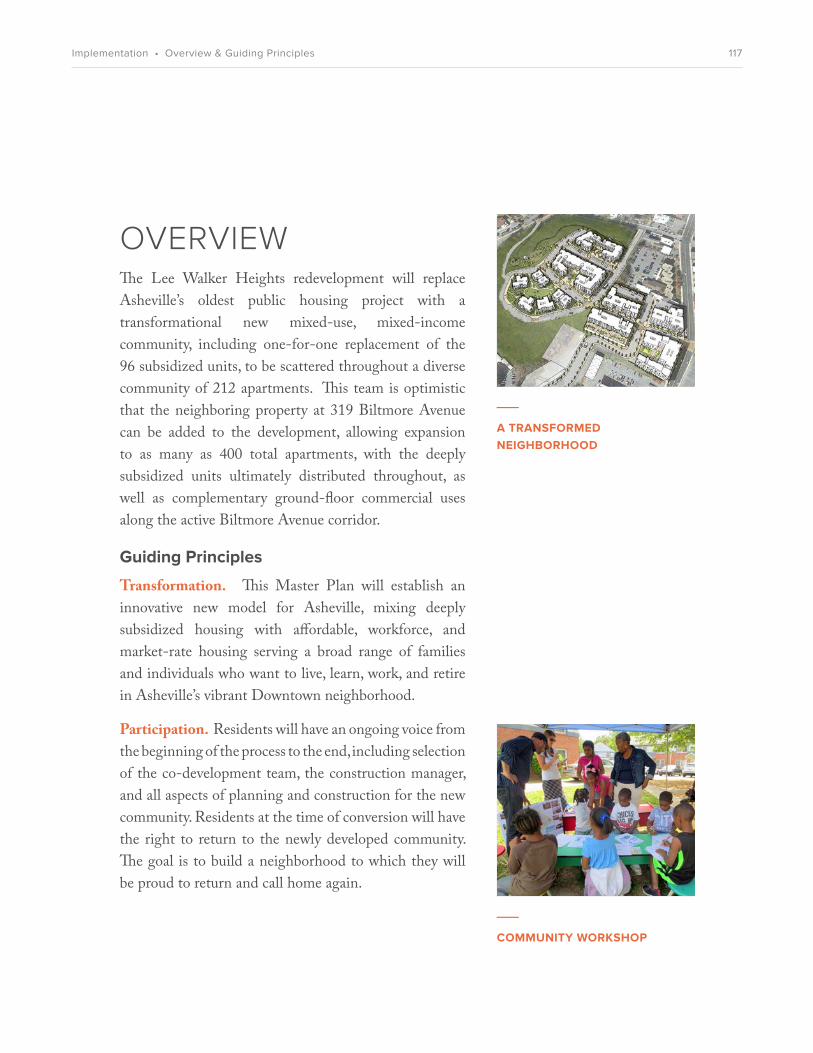
___
COMMUNITY WORKSHOP
OVERVIEWThe Lee Walker Heights redevelopment will replace Asheville’s oldest public housing project with a transformational new mixed-use, mixed-income community, including one-for-one replacement of the 96 subsidized units, to be scattered throughout a diverse community of 212 apartments. This team is optimistic that the neighboring property at 319 Biltmore Avenue can be added to the development, allowing expansion to as many as 400 total apartments, with the deeply subsidized units ultimately distributed throughout, as well as complementary ground-floor commercial uses along the active Biltmore Avenue corridor.
Guiding Principles
Transformation. This Master Plan will establish an innovative new model for Asheville, mixing deeply subsidized housing with affordable, workforce, and market-rate housing serving a broad range of families and individuals who want to live, learn, work, and retire in Asheville’s vibrant Downtown neighborhood.
Participation. Residents will have an ongoing voice from the beginning of the process to the end, including selection of the co-development team, the construction manager, and all aspects of planning and construction for the new community. Residents at the time of conversion will have the right to return to the newly developed community. The goal is to build a neighborhood to which they will be proud to return and call home again.
___
A TRANSFORMED NEIGHBORHOOD
117Implementation • Overview & Guiding Principles

Connections. The timeworn, isolated public housing project will be replaced with one that is connected to surrounding streets and neighborhoods by as many road, pedestrian, and bicycle access points as possible. This plan will also maximize connectivity through transit, technology, education, employment opportunity, and social realms. The team will strive to include sustainable opportunities for co-working, education, affordable dining, and shopping in and near the renewed community. Children and family interests will be prioritized with a safe, convenient location for children to catch the bus and an ample, on-site supportive after-school program.
Collaboration. HACA is partnering with Mountain Housing Opportunities, western North Carolina’s premier nonprofit housing developer, and a strong team of local architects, engineers, and builders, along with a nationally recognized affordable housing design consultant. To the greatest extent possible, this team will use the collaborative Integrated Project Delivery model in the design and construction phases. HACA and MHO are reaching out to private employers interested in developing housing opportunities for their workers, as well as to the full range of public and private entities that will be needed to make this transformation a success.
Relocation
Currently, Lee Walker Heights provides apartments for 96 families. Redevelopment plans will necessitate temporary relocation of current residents. HACA has committed to assist with any relocation activities in a sensitive and responsible manner in order to minimize the disruption to families’ lives. Apartments at Lee Walker Heights that are currently deeply affordable will be
___
NEW CONNECTIONS
___
COLLABORATIVE DESIGN
118Implementation • Guiding Principles & Relocation

replaced on a one-for-one basis. Residents living at Lee Walker Heights on the date that the U.S. Department of Housing and Urban Development (HUD) approves the final Financing Plan—expected in late 2016 or early 2017—will be eligible to receive moving assistance and to return. These established residents will not be subject to any new screening criteria in order to return to a new dwelling unit at the redeveloped Lee Walker Heights.
Planned Programs
The redevelopment plan for Lee Walker Heights will include 96 replacement units and approximately 116 additional units for a total of 212 apartments in Phases 1A and 1B. The goal for Phase 2 is an additional 150 to 200 apartments over ground-level commercial space.
With frontage on the major Biltmore Avenue corridor, the Phase 2 site will include a variety of commercial, community, and public-service uses that are compatible with the residential apartments. The specific uses are still under discussion and will be subject to market conditions at the time of predevelopment and construction. It is hoped that a small grocery or a combination grocery-pharmacy can be attracted to Phase 2.
The redevelopment plan will also include a range of neighborhood improvements such as both new and reconstructed streets that have been widened to accommodate buses and emergency vehicles. Other improvements will include new outdoor green spaces, sidewalks and bicycle-pedestrian pathways, street lighting, and several areas for residents to gather and for children to play.
119Implementation • Planned Programs

Project Budget
Housing development in Phase 1 (212 apartments) assumes an average per-unit construction cost of approximately $140,000. This estimate is based on current construction costs in the Asheville market and is subject to change.
For Phase 1, the estimated total cost of construction of 212 residential housing units will be approximately $28 million. This estimate will include newly constructed housing units and associated community spaces as well as demolition, grading, and new infrastructure.
Phase 2 expenses are to be determined as the Phase 2 site becomes available and more details are known regarding acquisition costs, demolition costs, and type and size of new construction.
A detailed project budget for the Lee Walker Heights redevelopment will be determined as the Phase 1 and Phase 2 applications for financing and funding are processed. Applications for Phase 1 funding will be prepared in 2016.
The funding and financing model assumes that HACA will remain as the owner and master developer of the newly constructed real estate. Additional development partners will be added as needed.
Potential Sources of Funding
One of the main funding sources sought for the redevelopment of Lee Walker Heights is tax credit equity from the LIHTC programs. Both the 4% and 9% tax credit options will be explored. In conjunction with the 4% tax credits, bond financing will be researched to help fill financing gaps. These tax credit sources are key to
120Implementation • Project Budget & Potential Sources of Funding

making any units affordable and for replacing the Rental Assistance Demonstration Program (RAD) units.
Public Housing Capital funds or other public housing funds may be available. Final approval by HUD of the RAD conversion will allow HACA to use these funds in conjunction with the new RAD units.
There will be conventional debt used to finance many pieces of the development, probably including FHA, Fannie Mae, or other long-term financing. The Federal Home Loan Bank Affordable Housing Program will be explored to complement the conventional bank financing and fill budget gaps for the affordable housing units.
The City of Asheville receives both Community Development Block Grant Program (CDBG) and HOME Investment Partnerships Program (HOME) block grant funding. These federal sources can help to lessen the risk for other private lenders and investors. However, these funds are limited by the small size of Asheville’s allocations compared to other metropolitan areas. To supplement CDBG and HOME, the City and County also offer affordable-housing trust funds, which are additional potential funding sources. The likely use of long term FHA-insured financing makes coordination with these funding sources more difficult.
HACA will ask the City and County to use Capital Improvement Program (CIP) funds to provide infrastructure to this site. This area has been designated as a part of one of Asheville’s Innovation Districts, with the intent of spurring investment through City incentives. Other City incentives could include fee rebates or waivers, land-use incentive grants, tax-increment financing, or other tools.
121Implementation • Potential Sources of Funding

Depending on the size of the commercial and retail spaces at the 319 Biltmore Avenue site, New Market Tax Credits may be an option for financing Phase 2. Most New Market Tax Credit providers need large economies of scale to make the high program-transaction costs work with the budget.
Phasing
Because of the limited amount of subsidy and soft financing and the competitiveness of several sources of funding, the project will have to be completed in phases. Phase 1 plans to include 212 new residential units in two sub-phases (Phase 1A to include 120 units, and Phase 1B to include 92 units), and Phase 2 plans to include an additional 150 to 200 units plus retail, office, public service, or other commercial space.
Overall, the development team hopes to achieve 400 new mixed-income units including a range of deeply subsidized units. Furthermore, the 319 Biltmore Avenue site to be developed in Phase 2 provides the opportunity to develop commercial, community, and residential spaces that complement the needs of the residents (grocery, pharmacy), and the needs of the largest employers in the area (workforce housing, offices for complementary services).
Implementation is expected to take place starting in 2017 and continue through approximately 2022, with the goal of completing Phase 1 by 2019. The speed of implementation will depend on the success of competitive applications, financing availability, and market conditions.
122Implementation • Phasing

Long-Term Affordability
All of the affordable housing units on the site are expected to have a minimum affordability term of 30 years and will be secured by restrictive covenants or land-use restrictions. Operating budgets will include replacement and operating reserves aimed at keeping the property affordable and healthy for a minimum of 30 years. The RAD units will be subject to a perpetually renewable contract requiring affordability over the long term.
Rezoning
In order to implement the Master Plan, the project site will be rezoned to Urban Place or Central Business District zoning. Both designations provide flexibility for denser mixed-use developments.
123Implementation • Long-Term Affordability & Rezoning

APPENDICES
10
124Appendices

APPENDICES1. Surveys
2. Additional Workshop Images
3. Enterprise Communities Completed Checklist
4. Figures & Charts Index
125Appendices • Overview

126Appendices • Sample Survey

127Appendices • Sample Survey

___
DESIGN WORKSHOP #1 Architectural design notes from the community.
___
DESIGN WORKSHOP #
___
DESIGN WORKSHOP #1
___
DESIGN WORKSHOP #1Neighborhood design notes.
128Appendix • Additional Workshop Images

___
DESIGN WORKSHOP #1Design team sketching revised site plan based on Design Workshop #1 feedback.
___
DESIGN WORKSHOP #1Design team presenting revised site plan to community members at an open house following Design Workshop #1.
___
DESIGN WORKSHOP #1 Revised site plan based on Design Workshop #1 feedback.
129Appendix • Additional Workshop Images

___
DESIGN WORKSHOP #2 Community center programming activity.
___
DESIGN WORKSHOP #2 Community center programming activity.
130Appendix • Additional Workshop Images
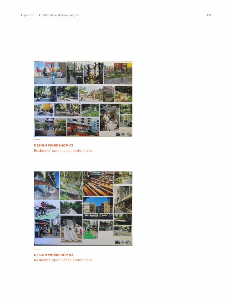
___
DESIGN WORKSHOP #3 Residents’ open-space preferences.
___
DESIGN WORKSHOP #3 Residents’ open-space preferences.
131Appendix • Additional Workshop Images

upda
te
132Appendix • Enterprise Green Communities

upda
te0-9
7
133Appendix • Enterprise Green Communities

upda
te10
3
4
2
24- 45
134Appendix • Enterprise Green Communities

upda
te0-9
4
4
135Appendix • Enterprise Green Communities

upda
te
n/a
0-7
3
136Appendix • Enterprise Green Communities

upda
ten/a
137Appendix • Enterprise Green Communities

upda
te4-26
138Appendix • Enterprise Green Communities

upda
te
139Appendix • Enterprise Green Communities

upda
te9-22
140Appendix • Enterprise Green Communities

upda
te
141Appendix • Enterprise Green Communities

upda
ten/a
40-49
142Appendix • Enterprise Green Communities

upda
te
0
77-244
143Appendix • Enterprise Green Communities

Plans, Diagrams & Renderings
Charts
Images
Aerial Image of Existing Site 9City of Asheville Context Plan 14Neighborhood Context Plan 16Current Housing Conditions Site Plan 46Existing Site Conditions: Connections 50Existing Site Conditions: Transportation 52Existing Site Conditions: Open Space 54Existing Site Conditions: Site Topography 56Site Plan 69Diagram & Section: Views & Height 70Diagram: Streets & Blocks 71Street Section 1 & 2 72Street Section 3 73Diagram: Pedestrian & Bicycle Paths 75Diagram: Open Space 77Landscape Plan 79ADC Playground Site Plan 85Diagram: Landmarks 88Diagram: Uses 89Floor Plan: Building I & II Community Space 90Diagram: Building Types 9217 Wilbar Avenue Plan: Ground Level 9317 Wilbar Avenue Plan: Upper Level 94319 Biltmore Avenue Plan: Ground Level 95319 Biltmore Avenue Plan: Upper Level 963D View: Apartments 99Unit Type Floor Plans: Apartments 1003D View & Unit Plans: Walk-ups 1023D View & Unit Plans: Stacked Flats 104Diagram: Phasing Plan 1063D View: Master Plan 110Perspective View: Main Entry 111Perspective View: Neighborhood Square 112Perspective View: Great Lawn 113Perspective View: Porches 114Perspective View: John W. Walker Plaza 115
All photos used with permission. Contact [email protected] for credit and usage information.
Resident Participation Summary 6517 Wilbar Avenue: Unit Mix, Use Areas & Parking 97319 Biltmore Avenue: Unit Mix, Use Areas & Parking 98Phasing Plan 107
144Appendix • Figures & Charts