Lecture D2L2, Yves-Louis DESNOS Head Research ...earth.esa.int/landtraining07/D2L2-Desnos.pdf ·...
83
Lecture D2L2, Yves-Louis DESNOS Head Research & Development section & Senior Advisor EO Science and Applications Department ESA-ESRIN Frascati Italy
-
Upload
vuongkhanh -
Category
Documents
-
view
217 -
download
0
Transcript of Lecture D2L2, Yves-Louis DESNOS Head Research ...earth.esa.int/landtraining07/D2L2-Desnos.pdf ·...
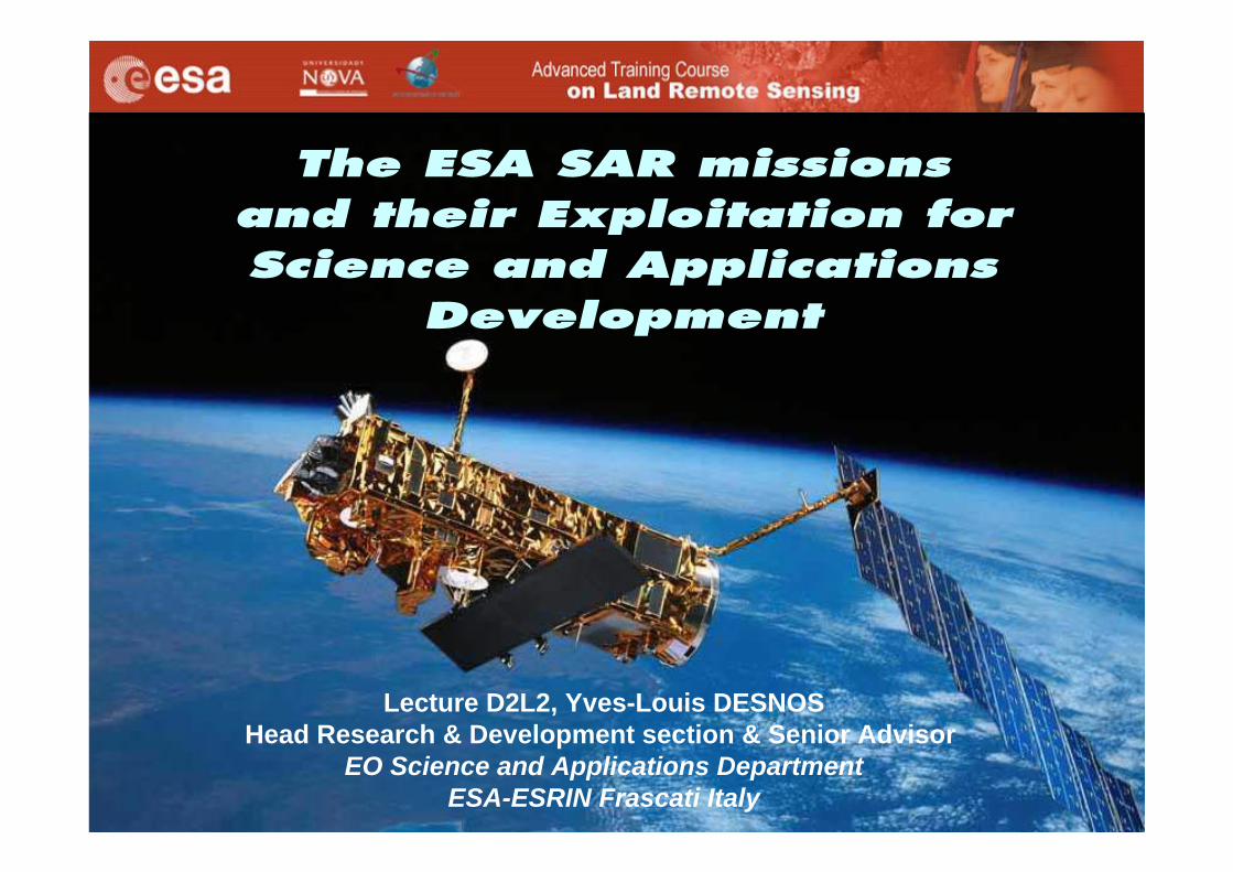
Lecture D2L2, Yves-Louis DESNOSHead Research & Development section & Senior Advisor
EO Science and Applications DepartmentESA-ESRIN Frascati Italy
4 September 2007 D2L2 (A)SAR instrument series Yves-Louis Desnos 2
4 September 2007 D2L2 (A)SAR instrument series Yves-Louis Desnos 3
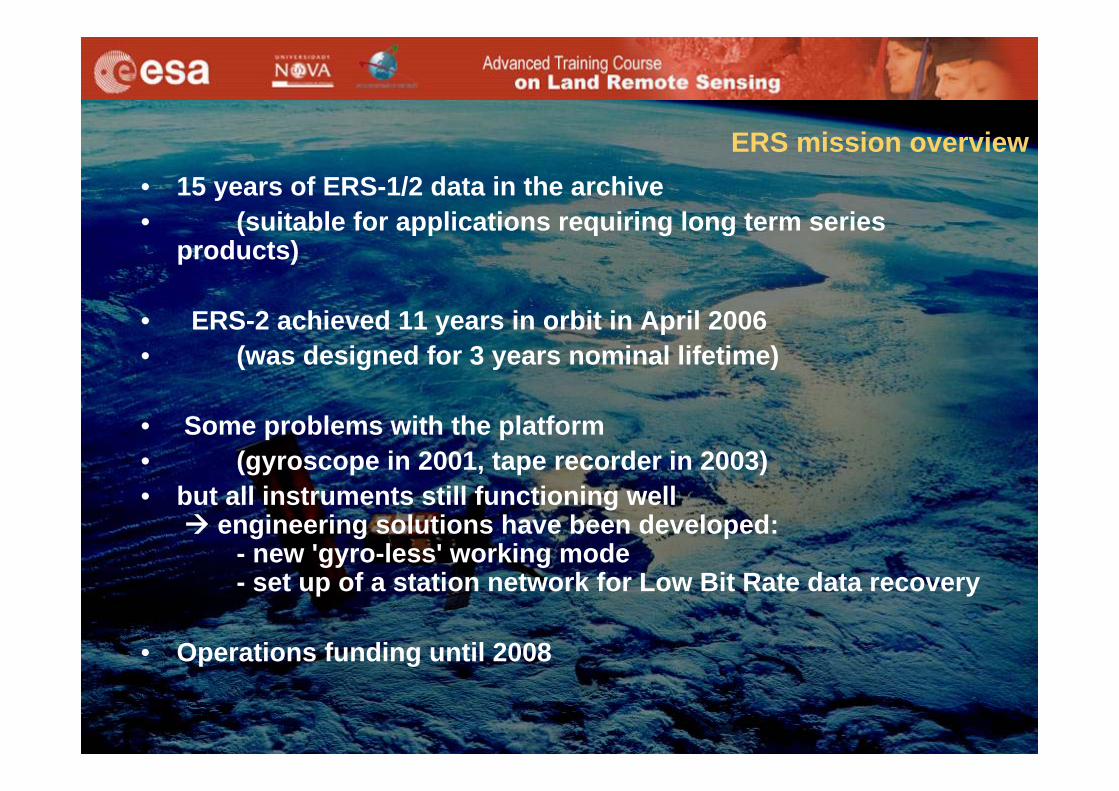
• 15 years of ERS-1/2 data in the archive• (suitable for applications requiring long term series
products)
• ERS-2 achieved 11 years in orbit in April 2006• (was designed for 3 years nominal lifetime)
• Some problems with the platform • (gyroscope in 2001, tape recorder in 2003)• but all instruments still functioning well
engineering solutions have been developed:- new 'gyro-less' working mode- set up of a station network for Low Bit Rate data recovery
• Operations funding until 2008
ERS mission overview
4 September 2007 D2L2 (A)SAR instrument series Yves-Louis Desnos 4
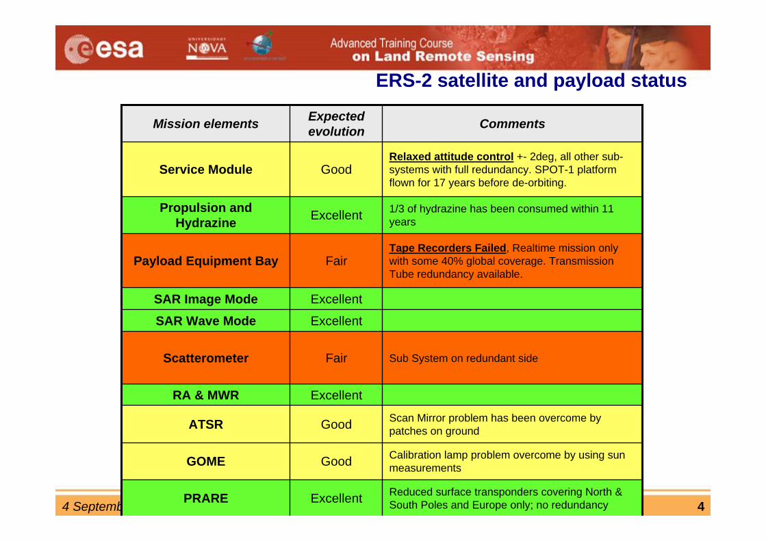
Calibration lamp problem overcome by using sun measurements GoodGOME
Reduced surface transponders covering North & South Poles and Europe only; no redundancyExcellentPRARE
Scan Mirror problem has been overcome by patches on groundGoodATSR
ExcellentRA & MWR
Sub System on redundant side FairScatterometer
ExcellentSAR Wave ModeExcellentSAR Image Mode
Tape Recorders Failed, Realtime mission only with some 40% global coverage. Transmission Tube redundancy available.
FairPayload Equipment Bay
1/3 of hydrazine has been consumed within 11 yearsExcellentPropulsion and
Hydrazine
Relaxed attitude control +- 2deg, all other sub-systems with full redundancy. SPOT-1 platform flown for 17 years before de-orbiting.
GoodService Module
CommentsExpected evolutionMission elements
ERS-2 satellite and payload status
4 September 2007 D2L2 (A)SAR instrument series Yves-Louis Desnos 5
4 September 2007 D2L2 (A)SAR instrument series Yves-Louis Desnos 6
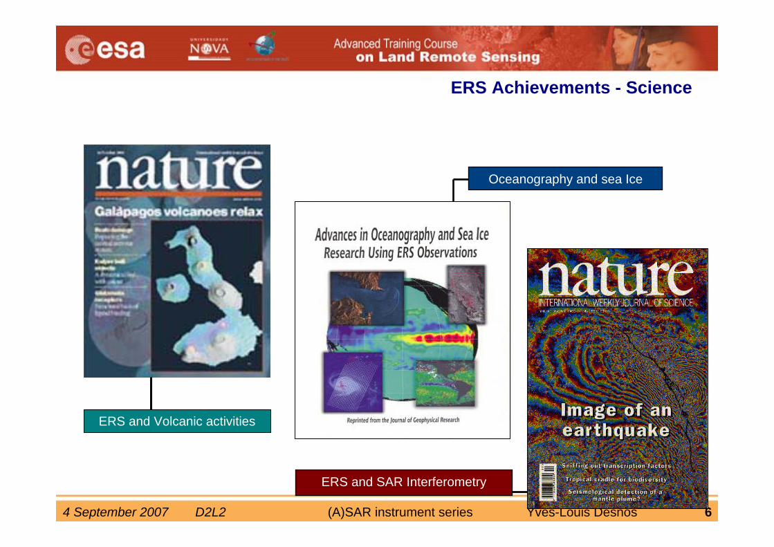
ERS Achievements - Science
ERS and SAR Interferometry
Oceanography and sea Ice
ERS and Volcanic activities
4 September 2007 D2L2 (A)SAR instrument series Yves-Louis Desnos 7
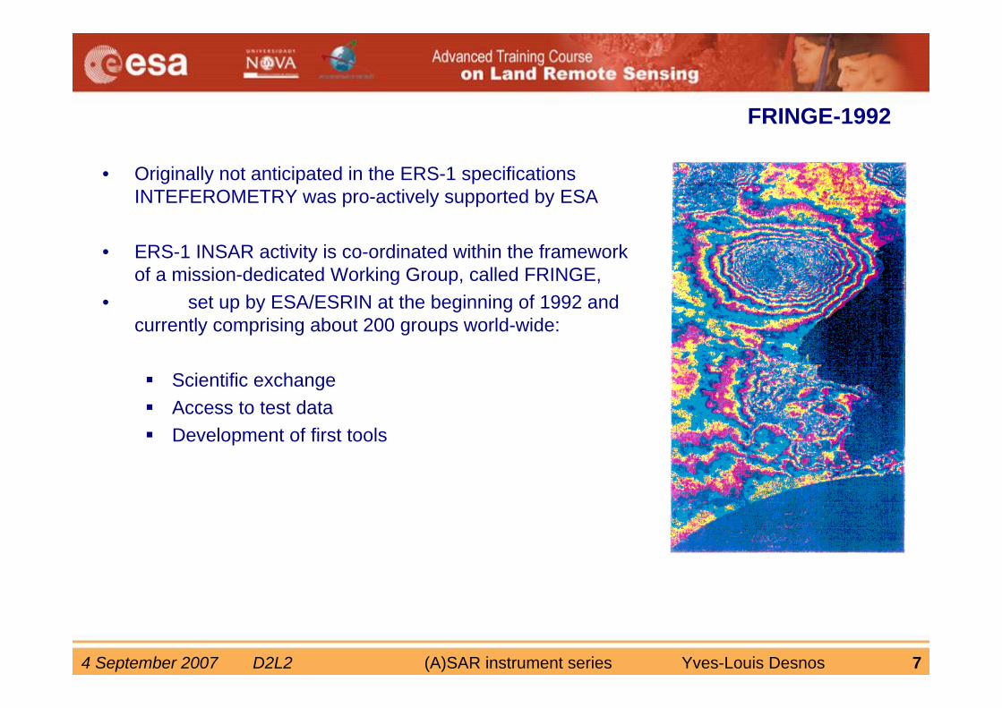
FRINGE-1992
• Originally not anticipated in the ERS-1 specifications INTEFEROMETRY was pro-actively supported by ESA
• ERS-1 INSAR activity is co-ordinated within the framework of a mission-dedicated Working Group, called FRINGE,
• set up by ESA/ESRIN at the beginning of 1992 and currently comprising about 200 groups world-wide:
Scientific exchangeAccess to test dataDevelopment of first tools
4 September 2007 D2L2 (A)SAR instrument series Yves-Louis Desnos 8
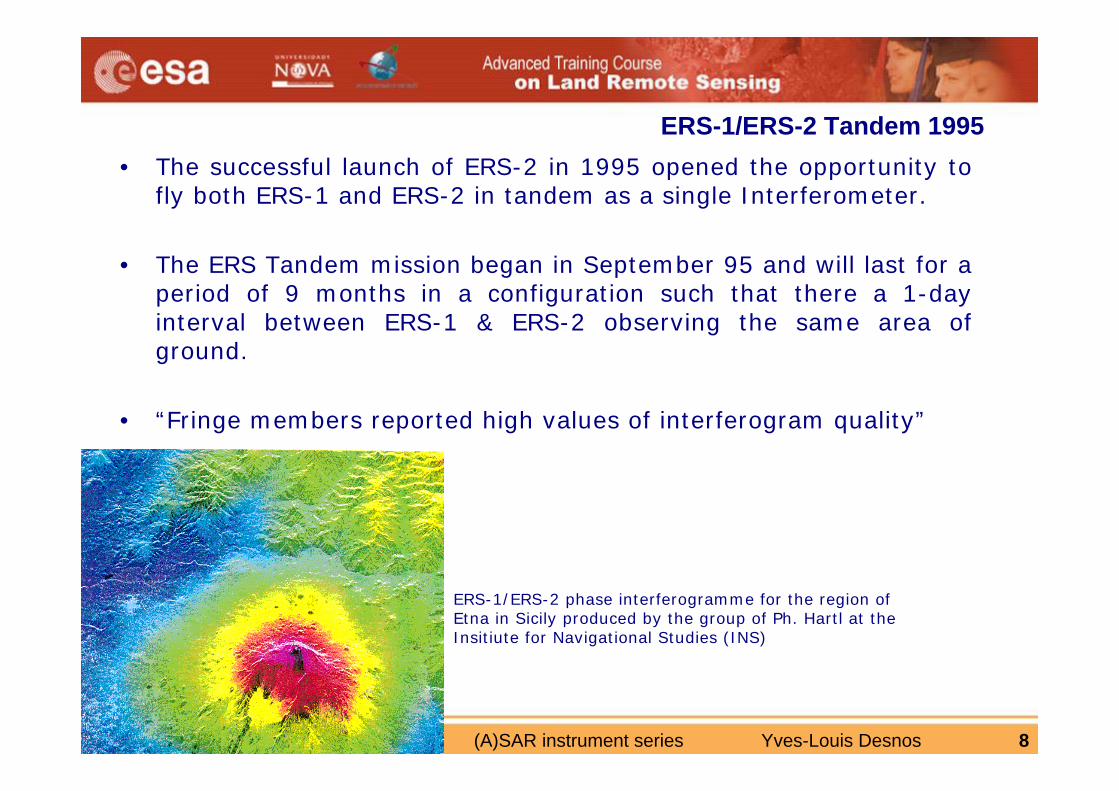
ERS-1/ERS-2 Tandem 1995• The successful launch of ERS-2 in 1995 opened the opportunity to
fly both ERS-1 and ERS-2 in tandem as a single Interferometer.
• The ERS Tandem mission began in September 95 and will last for aperiod of 9 months in a configuration such that there a 1-day interval between ERS-1 & ERS-2 observing the same area of ground.
• “Fringe members reported high values of interferogram quality”
ERS-1/ERS-2 phase interferogramme for the region of Etna in Sicily produced by the group of Ph. Hartl at the Insitiute for Navigational Studies (INS)
4 September 2007 D2L2 (A)SAR instrument series Yves-Louis Desnos 9
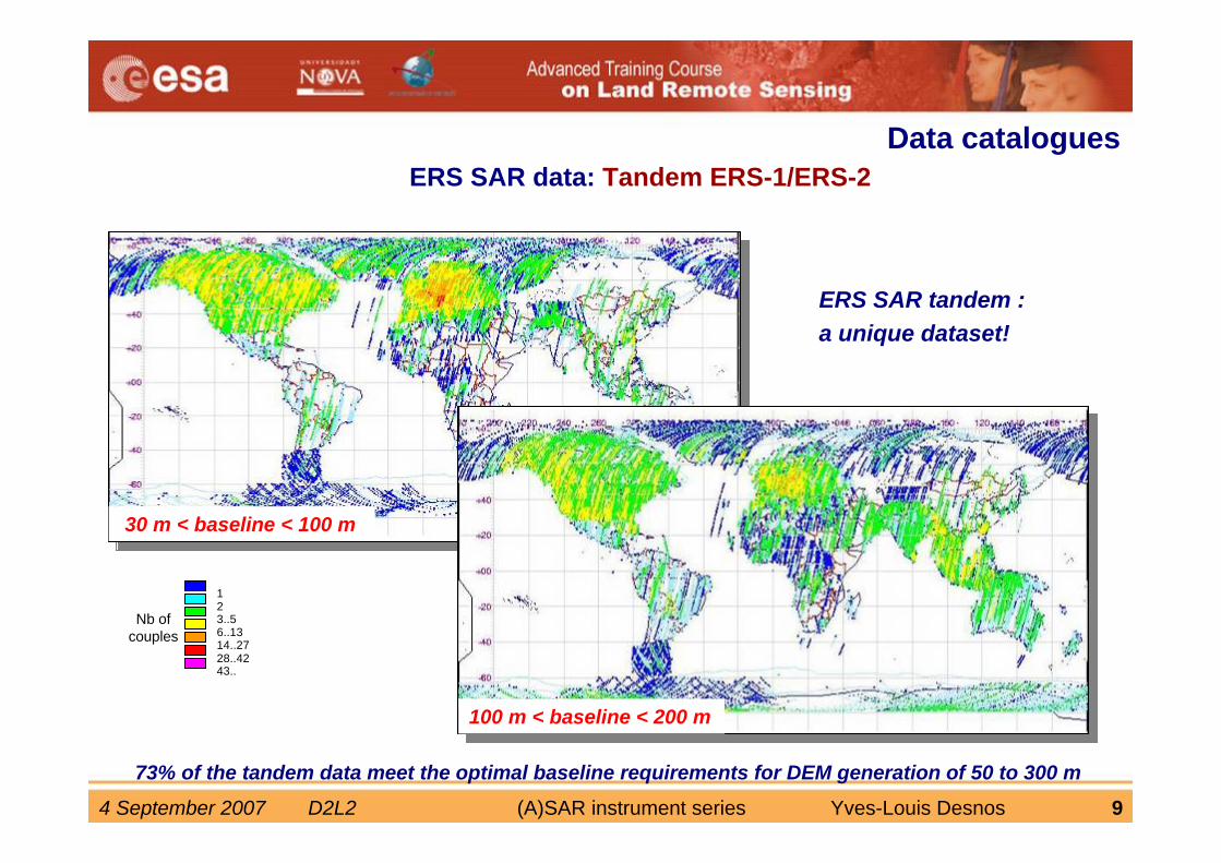
ERS SAR data: Tandem ERS-1/ERS-2
123..56..1314..2728..4243..
73% of the tandem data meet the optimal baseline requirements for DEM generation of 50 to 300 m
Data catalogues
30 m < baseline < 100 m
100 m < baseline < 200 m
ERS SAR tandem :a unique dataset!
Nb of couples
4 September 2007 D2L2 (A)SAR instrument series Yves-Louis Desnos 10
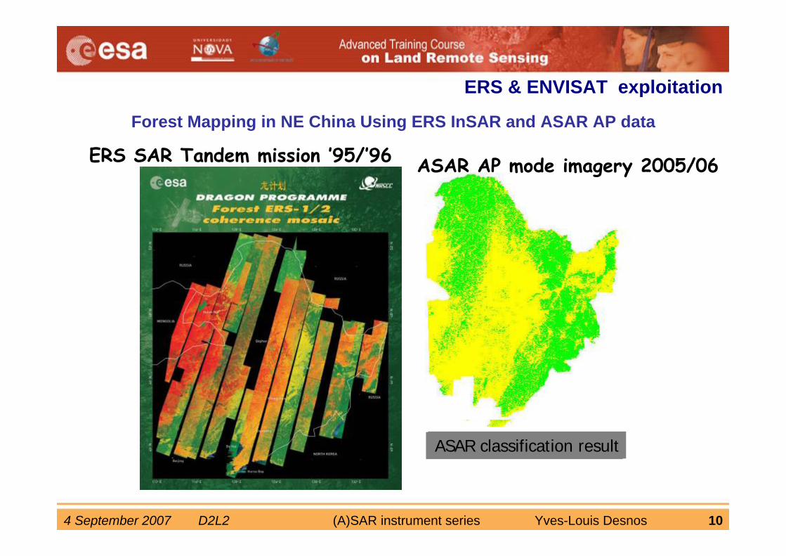
Land use map(1996)ASAR classification result
Forest Mapping in NE China Using ERS InSAR and ASAR AP data
ASAR AP mode imagery 2005/06ERS SAR Tandem mission ’95/’96
ERS & ENVISAT exploitation
4 September 2007 D2L2 (A)SAR instrument series Yves-Louis Desnos 11
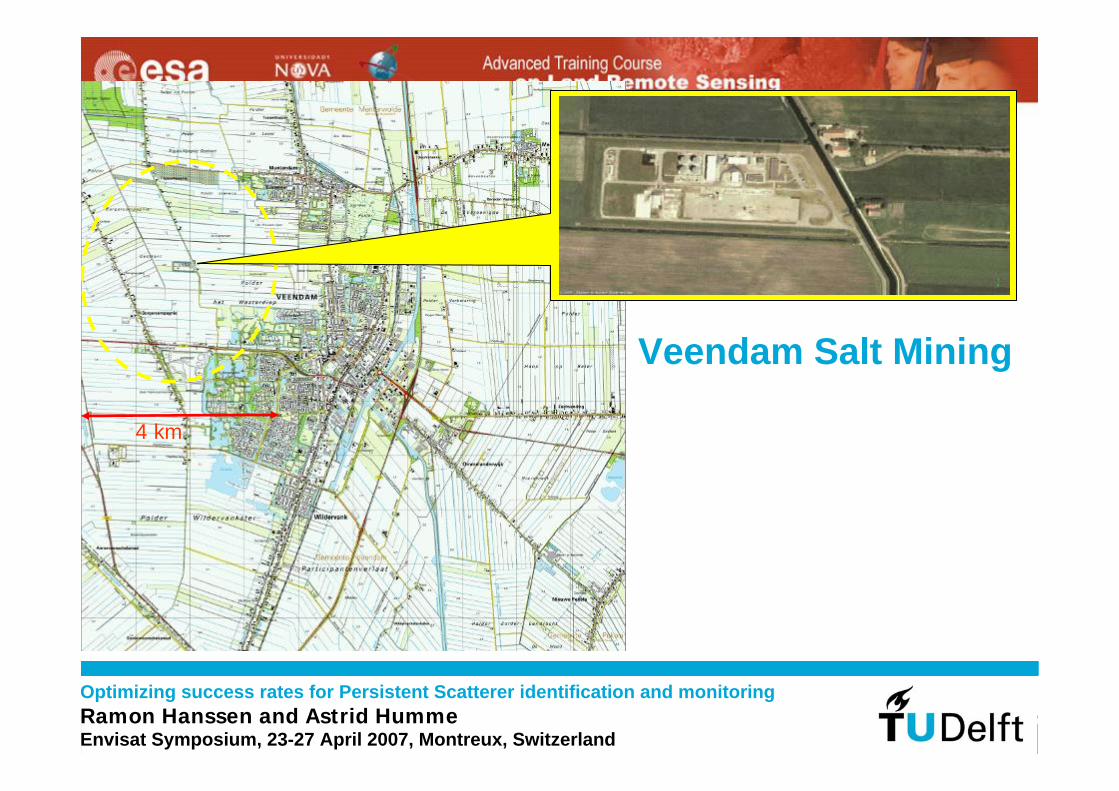
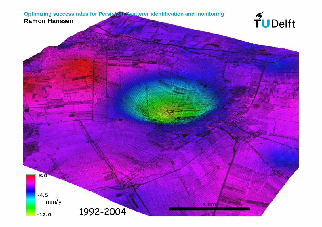
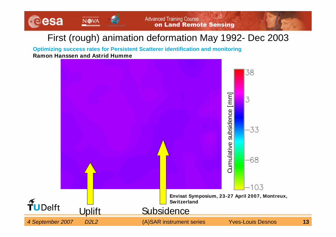
Optimizing success rates for Persistent Scatterer identification and monitoringRamon Hanssen and Astrid HummeEnvisat Symposium, 23-27 April 2007, Montreux, Switzerland
Veendam Salt Mining
4 km
4 September 2007 D2L2 (A)SAR instrument series Yves-Louis Desnos 12
mm/y
1992-2004
Optimizing success rates for Persistent Scatterer identification and monitoringRamon Hanssen
4 September 2007 D2L2 (A)SAR instrument series Yves-Louis Desnos 13
First (rough) animation deformation May 1992- Dec 2003
Cum
ulat
ive
subs
iden
ce [
mm
]
Uplift Subsidence
Envisat Symposium, 23-27 April 2007, Montreux, Switzerland
Optimizing success rates for Persistent Scatterer identification and monitoringRamon Hanssen and Astrid Humme

4 September 2007 D2L2 (A)SAR instrument series Yves-Louis Desnos 14
4 September 2007 D2L2 (A)SAR instrument series Yves-Louis Desnos 15
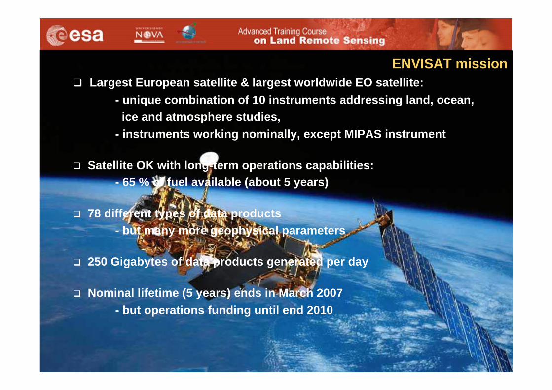
Largest European satellite & largest worldwide EO satellite: - unique combination of 10 instruments addressing land, ocean, ice and atmosphere studies,
- instruments working nominally, except MIPAS instrument
Satellite OK with long-term operations capabilities:- 65 % of fuel available (about 5 years)
78 different types of data products - but many more geophysical parameters
250 Gigabytes of data products generated per day
Nominal lifetime (5 years) ends in March 2007- but operations funding until end 2010
ENVISAT mission
4 September 2007 D2L2 (A)SAR instrument series Yves-Louis Desnos 16
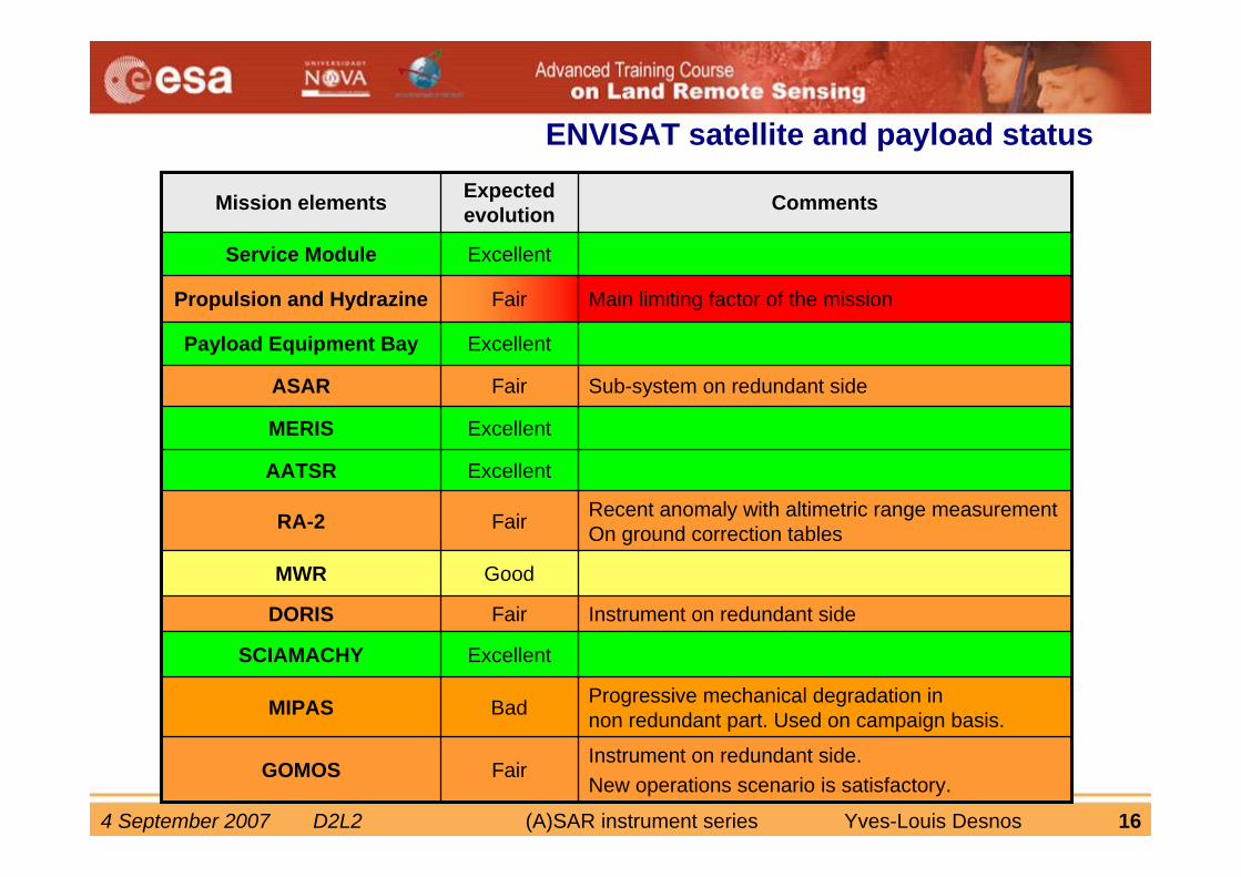
Instrument on redundant side.New operations scenario is satisfactory.
FairGOMOS
Progressive mechanical degradation in non redundant part. Used on campaign basis.BadMIPAS
ExcellentSCIAMACHY
Instrument on redundant sideFairDORIS
GoodMWR
Recent anomaly with altimetric range measurement On ground correction tablesFairRA-2
ExcellentAATSR
ExcellentMERIS
Sub-system on redundant sideFairASAR
ExcellentPayload Equipment Bay
Main limiting factor of the missionFairPropulsion and Hydrazine
ExcellentService Module
CommentsExpected evolutionMission elements
ENVISAT satellite and payload status
4 September 2007 D2L2 (A)SAR instrument series Yves-Louis Desnos 17
4 September 2007 D2L2 (A)SAR instrument series Yves-Louis Desnos 18
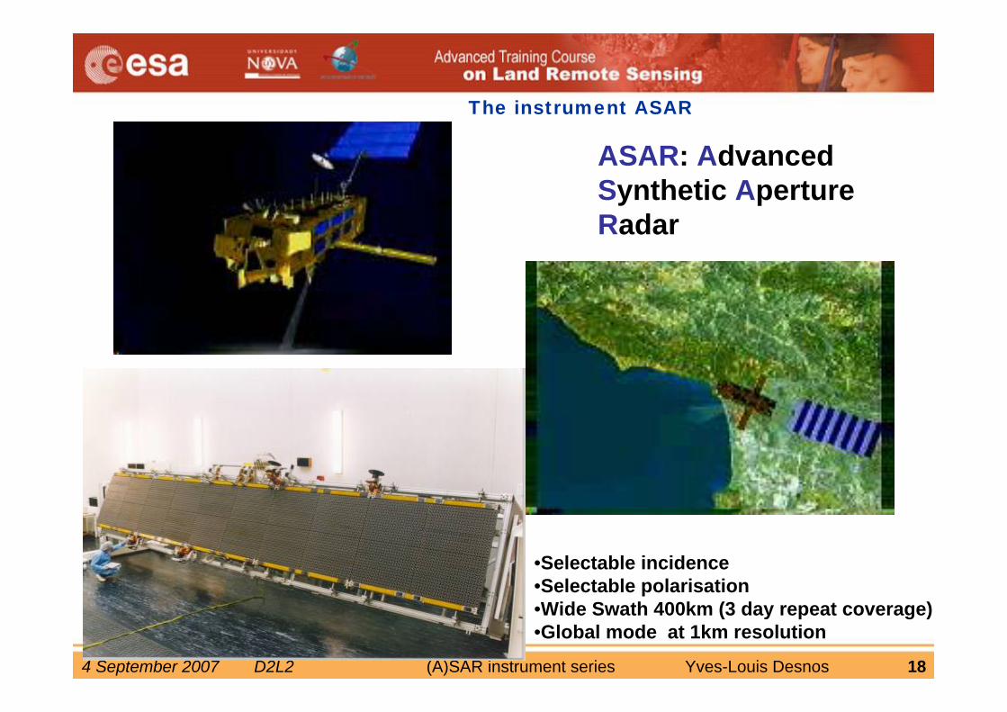
The instrument ASAR
ASAR: AdvancedSynthetic ApertureRadar
•Selectable incidence •Selectable polarisation•Wide Swath 400km (3 day repeat coverage)•Global mode at 1km resolution
4 September 2007 D2L2 (A)SAR instrument series Yves-Louis Desnos 19
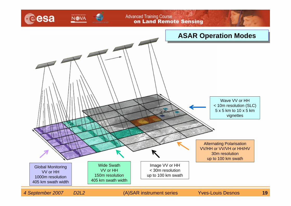
ASAR Operation ModesASAR Operation Modes
Wave VV or HH< 10m resolution (SLC)5 x 5 km to 10 x 5 km
vignettes
Image VV or HH< 30m resolution
up to 100 km swath
Alternating PolarisationVV/HH or VV/VH or HH/HV
30m resolutionup to 100 km swath
Wide SwathVV or HH
150m resolution405 km swath width
Global MonitoringVV or HH
1000m resolution405 km swath width
4 September 2007 D2L2 (A)SAR instrument series Yves-Louis Desnos 20
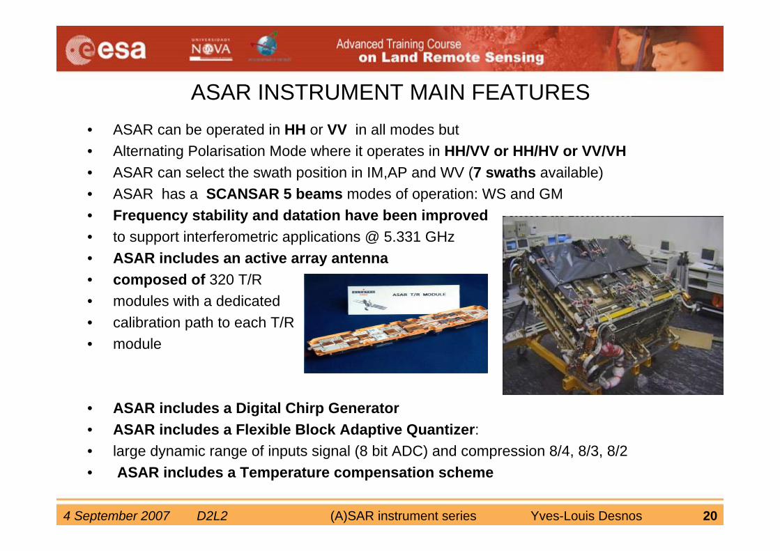
ASAR INSTRUMENT MAIN FEATURES• ASAR can be operated in HH or VV in all modes but• Alternating Polarisation Mode where it operates in HH/VV or HH/HV or VV/VH• ASAR can select the swath position in IM,AP and WV (7 swaths available)• ASAR has a SCANSAR 5 beams modes of operation: WS and GM• Frequency stability and datation have been improved• to support interferometric applications @ 5.331 GHz• ASAR includes an active array antenna • composed of 320 T/R • modules with a dedicated• calibration path to each T/R• module
• ASAR includes a Digital Chirp Generator• ASAR includes a Flexible Block Adaptive Quantizer: • large dynamic range of inputs signal (8 bit ADC) and compression 8/4, 8/3, 8/2 • ASAR includes a Temperature compensation scheme
4 September 2007 D2L2 (A)SAR instrument series Yves-Louis Desnos 21
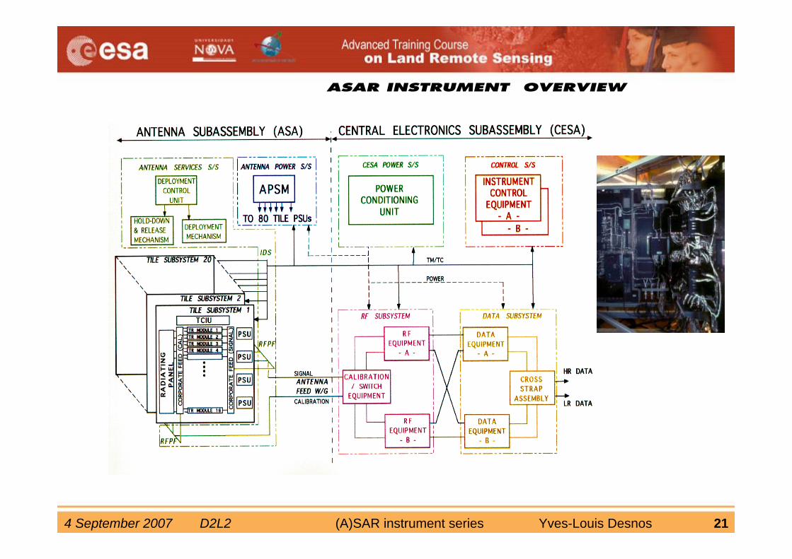
ASAR INSTRUMENT OVERVIEW
4 September 2007 D2L2 (A)SAR instrument series Yves-Louis Desnos 22
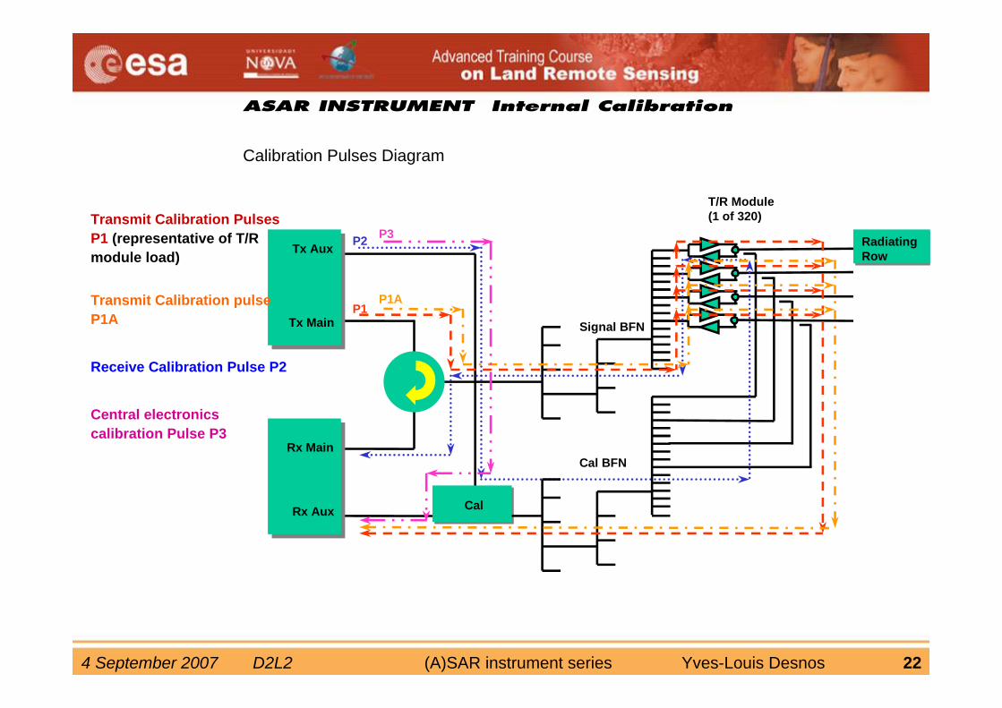
ASAR INSTRUMENT Internal Calibration
Calibration Pulses Diagram
Tx Aux
Tx Main
Rx Main
Rx Aux
RadiatingRow
T/R Module(1 of 320)
Signal BFN
Cal BFN
Cal
P3P2
P1AP1
Transmit Calibration Pulses P1 (representative of T/R module load)
Transmit Calibration pulse P1A
Receive Calibration Pulse P2
Central electronics calibration Pulse P3
4 September 2007 D2L2 (A)SAR instrument series Yves-Louis Desnos 23
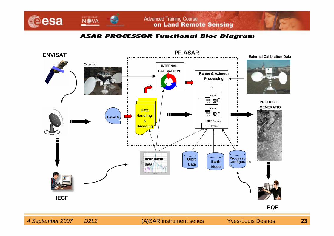
ASAR PROCESSOR Functional Bloc Diagram
DataHandling
&Decoding
HPS Switch
SP Frame
NodelocaldisksLAN
slots
NodelocaldisksLAN
slots
Level 0
Instrumentdata
INTERNALCALIBRATION
EarthModel
OrbitData
External Calibration Data
Range & AzimuthProcessing
PRODUCT GENERATION
External
Characterization
ENVISAT PF-ASAR
IECFPQF
Processor Configuration
4 September 2007 D2L2 (A)SAR instrument series Yves-Louis Desnos 24
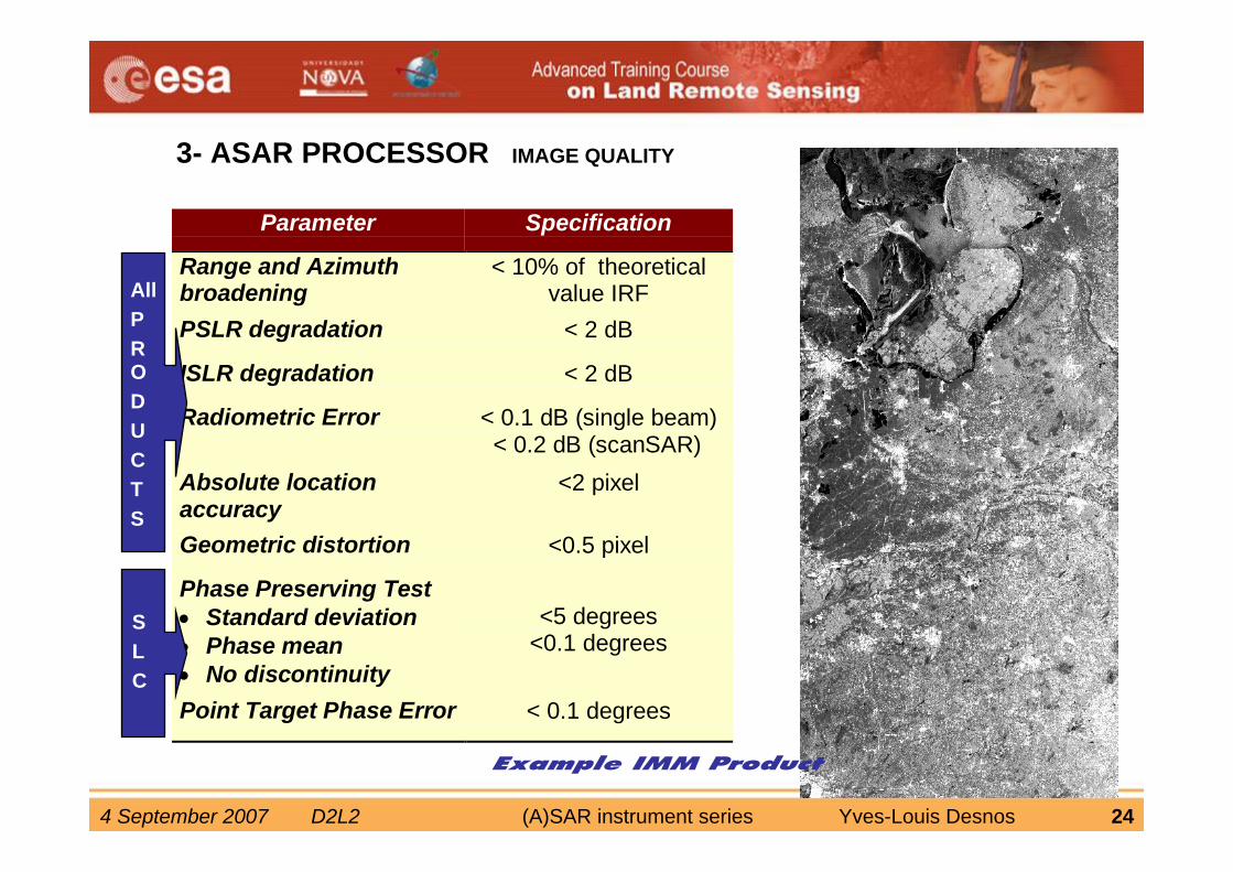
Parameter Specification
Range and Azimuthbroadening
< 10% of theoreticalvalue IRF
PSLR degradation < 2 dB
ISLR degradation < 2 dB
Radiometric Error < 0.1 dB (single beam)< 0.2 dB (scanSAR)
Absolute locationaccuracy
<2 pixel
Geometric distortion <0.5 pixel
Phase Preserving Test• Standard deviation• Phase mean• No discontinuity
<5 degrees<0.1 degrees
Point Target Phase Error < 0.1 degrees
3- ASAR PROCESSOR IMAGE QUALITY
AllPRODUCTS
SLC
Example IMM Product
4 September 2007 D2L2 (A)SAR instrument series Yves-Louis Desnos 25
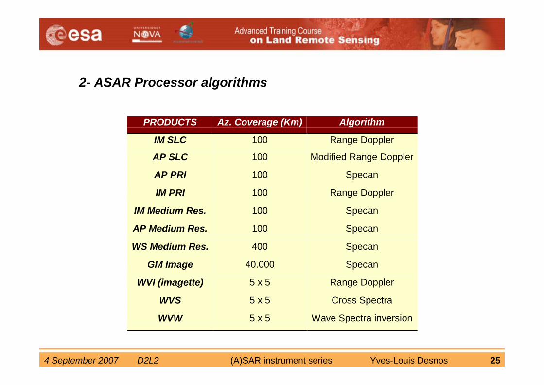
2- ASAR Processor algorithms
PRODUCTS Az. Coverage (Km) Algorithm
IM SLC 100 Range Doppler
AP SLC 100 Modified Range Doppler
AP PRI 100 Specan
IM PRI 100 Range Doppler
IM Medium Res. 100 Specan
AP Medium Res. 100 Specan
WS Medium Res. 400 Specan
GM Image 40.000 Specan
WVI (imagette) 5 x 5 Range Doppler
WVS 5 x 5 Cross Spectra
WVW 5 x 5 Wave Spectra inversion
4 September 2007 D2L2 (A)SAR instrument series Yves-Louis Desnos 26
Product quality & calibration performance
By B. Rosich, ESA-ESRIN et al
“Review of ASAR Instrument Performance and Product Quality”, Envisat symposium Montreux April 2007
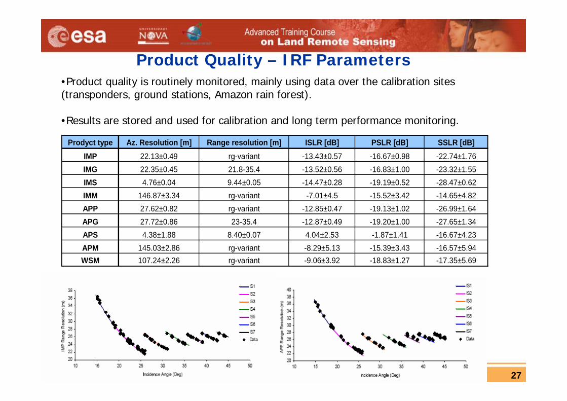
4 September 2007 D2L2 (A)SAR instrument series Yves-Louis Desnos 27
Prodyct type Az. Resolution [m] Range resolution [m] ISLR [dB] PSLR [dB] SSLR [dB]IMP 22.13±0.49 rg-variant -13.43±0.57 -16.67±0.98 -22.74±1.76IMG 22.35±0.45 21.8-35.4 -13.52±0.56 -16.83±1.00 -23.32±1.55IMS 4.76±0.04 9.44±0.05 -14.47±0.28 -19.19±0.52 -28.47±0.62IMM 146.87±3.34 rg-variant -7.01±4.5 -15.52±3.42 -14.65±4.82APP 27.62±0.82 rg-variant -12.85±0.47 -19.13±1.02 -26.99±1.64APG 27.72±0.86 23-35.4 -12.87±0.49 -19.20±1.00 -27.65±1.34APS 4.38±1.88 8.40±0.07 4.04±2.53 -1.87±1.41 -16.67±4.23APM 145.03±2.86 rg-variant -8.29±5.13 -15.39±3.43 -16.57±5.94WSM 107.24±2.26 rg-variant -9.06±3.92 -18.83±1.27 -17.35±5.69
Product Quality – IRF Parameters•Product quality is routinely monitored, mainly using data over the calibration sites (transponders, ground stations, Amazon rain forest).
•Results are stored and used for calibration and long term performance monitoring.
4 September 2007 D2L2 (A)SAR instrument series Yves-Louis Desnos 28
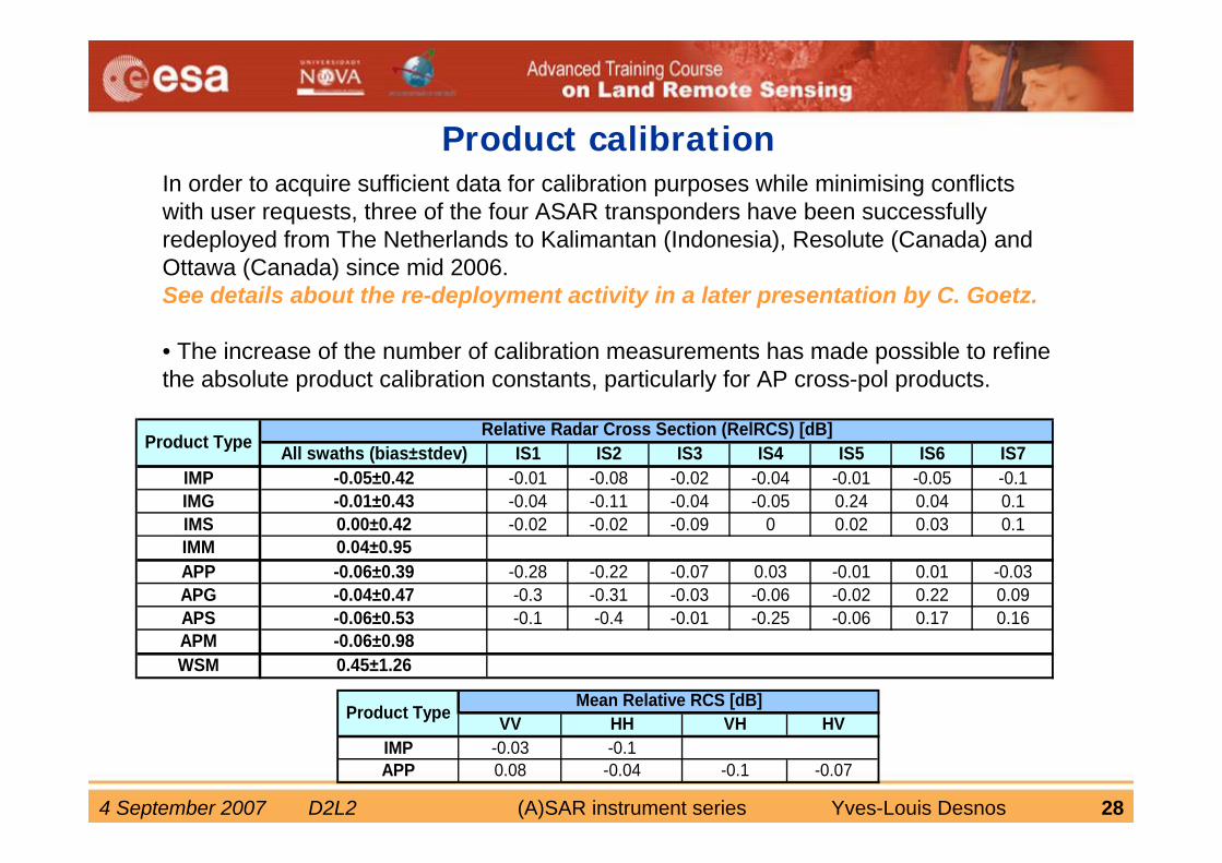
Product calibrationIn order to acquire sufficient data for calibration purposes while minimising conflicts with user requests, three of the four ASAR transponders have been successfully redeployed from The Netherlands to Kalimantan (Indonesia), Resolute (Canada) and Ottawa (Canada) since mid 2006.See details about the re-deployment activity in a later presentation by C. Goetz.
• The increase of the number of calibration measurements has made possible to refine the absolute product calibration constants, particularly for AP cross-pol products.
All swaths (bias±stdev) IS1 IS2 IS3 IS4 IS5 IS6 IS7IMP -0.05±0.42 -0.01 -0.08 -0.02 -0.04 -0.01 -0.05 -0.1IMG -0.01±0.43 -0.04 -0.11 -0.04 -0.05 0.24 0.04 0.1IMS 0.00±0.42 -0.02 -0.02 -0.09 0 0.02 0.03 0.1IMM 0.04±0.95APP -0.06±0.39 -0.28 -0.22 -0.07 0.03 -0.01 0.01 -0.03APG -0.04±0.47 -0.3 -0.31 -0.03 -0.06 -0.02 0.22 0.09APS -0.06±0.53 -0.1 -0.4 -0.01 -0.25 -0.06 0.17 0.16APM -0.06±0.98WSM 0.45±1.26
Product TypeRelative Radar Cross Section (RelRCS) [dB]
VV HH VH HVIMP -0.03 -0.1APP 0.08 -0.04 -0.1 -0.07
Product TypeMean Relative RCS [dB]
4 September 2007 D2L2 (A)SAR instrument series Yves-Louis Desnos 29
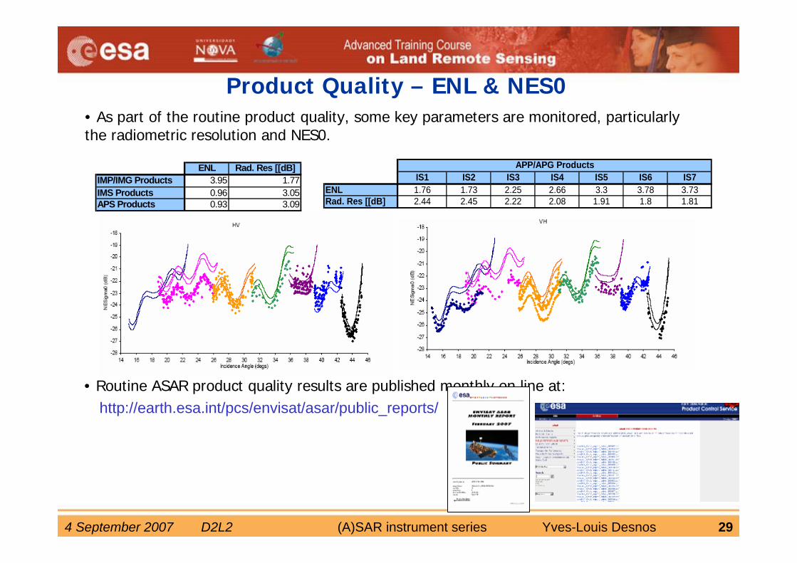
ENL Rad. Res [[dB]IMP/IMG Products 3.95 1.77IMS Products 0.96 3.05APS Products 0.93 3.09
IS1 IS2 IS3 IS4 IS5 IS6 IS7ENL 1.76 1.73 2.25 2.66 3.3 3.78 3.73Rad. Res [[dB] 2.44 2.45 2.22 2.08 1.91 1.8 1.81
APP/APG Products
http://earth.esa.int/pcs/envisat/asar/public_reports/
Product Quality – ENL & NES0• As part of the routine product quality, some key parameters are monitored, particularly the radiometric resolution and NES0.
• Routine ASAR product quality results are published monthly on line at:
4 September 2007 D2L2 (A)SAR instrument series Yves-Louis Desnos 30
4 September 2007 D2L2 (A)SAR instrument series Yves-Louis Desnos 31
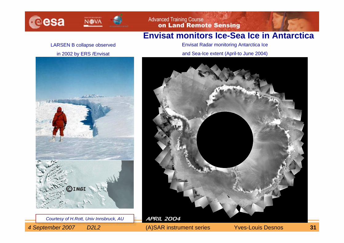
Envisat monitors Ice-Sea Ice in AntarcticaLARSEN B collapse observed
in 2002 by ERS /Envisat
Envisat Radar monitoring Antarctica Ice
and Sea-Ice extent (April-to June 2004)
Courtesy of H.Rott, Univ Innsbruck, AUCourtesy of H.Rott, Univ Innsbruck, AU
4 September 2007 D2L2 (A)SAR instrument series Yves-Louis Desnos 32
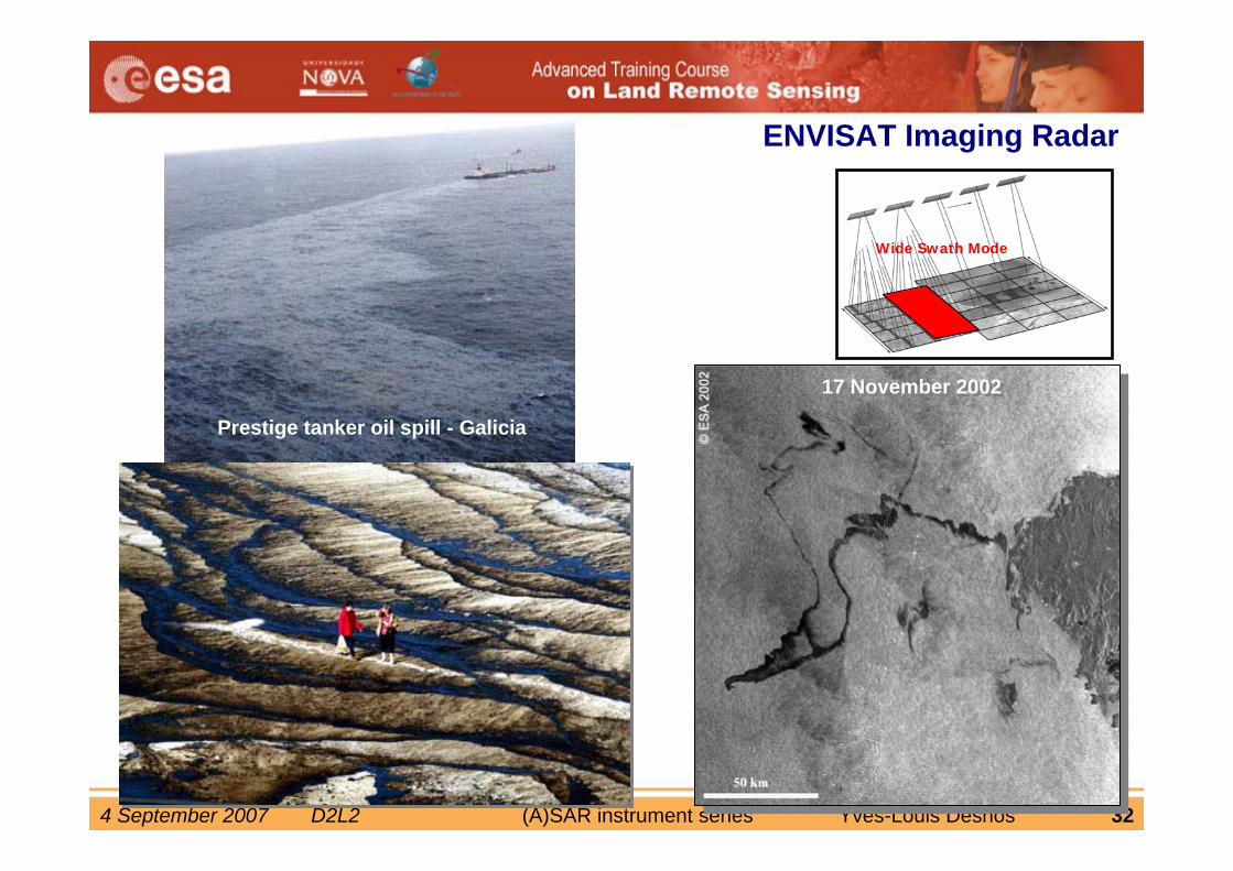
17 November 200217 November 2002
Prestige tanker oil spill - Galicia
Wide Swath Mode
ENVISAT Imaging Radar
4 September 2007 D2L2 (A)SAR instrument series Yves-Louis Desnos 33
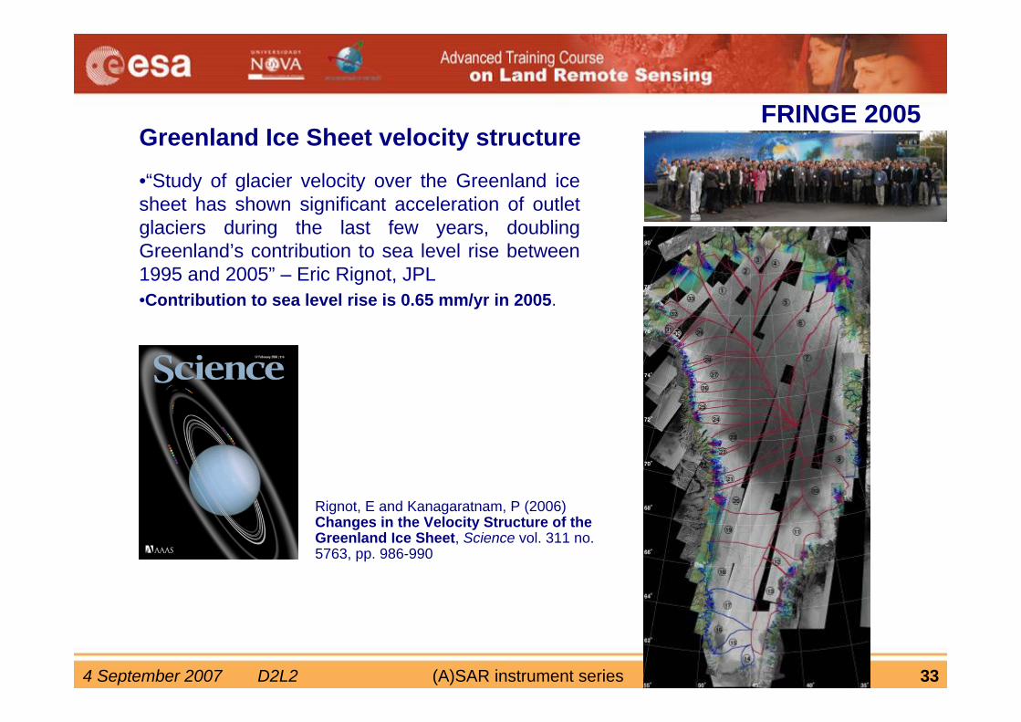
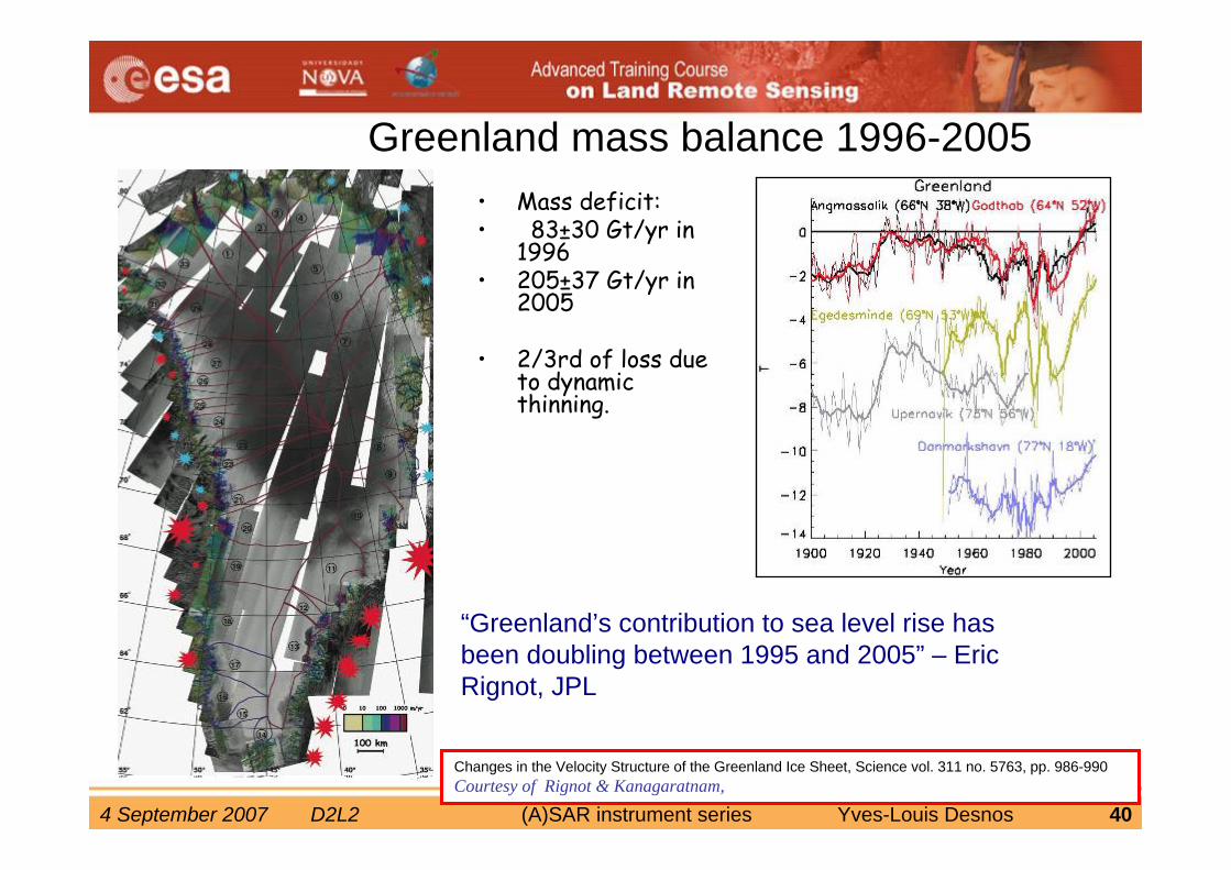
•“Study of glacier velocity over the Greenland ice sheet has shown significant acceleration of outlet glaciers during the last few years, doubling Greenland’s contribution to sea level rise between 1995 and 2005” – Eric Rignot, JPL•Contribution to sea level rise is 0.65 mm/yr in 2005.
Greenland Ice Sheet velocity structure
Rignot, E and Kanagaratnam, P (2006) Changes in the Velocity Structure of the Greenland Ice Sheet, Science vol. 311 no. 5763, pp. 986-990
FRINGE 2005
4 September 2007 D2L2 (A)SAR instrument series Yves-Louis Desnos 34
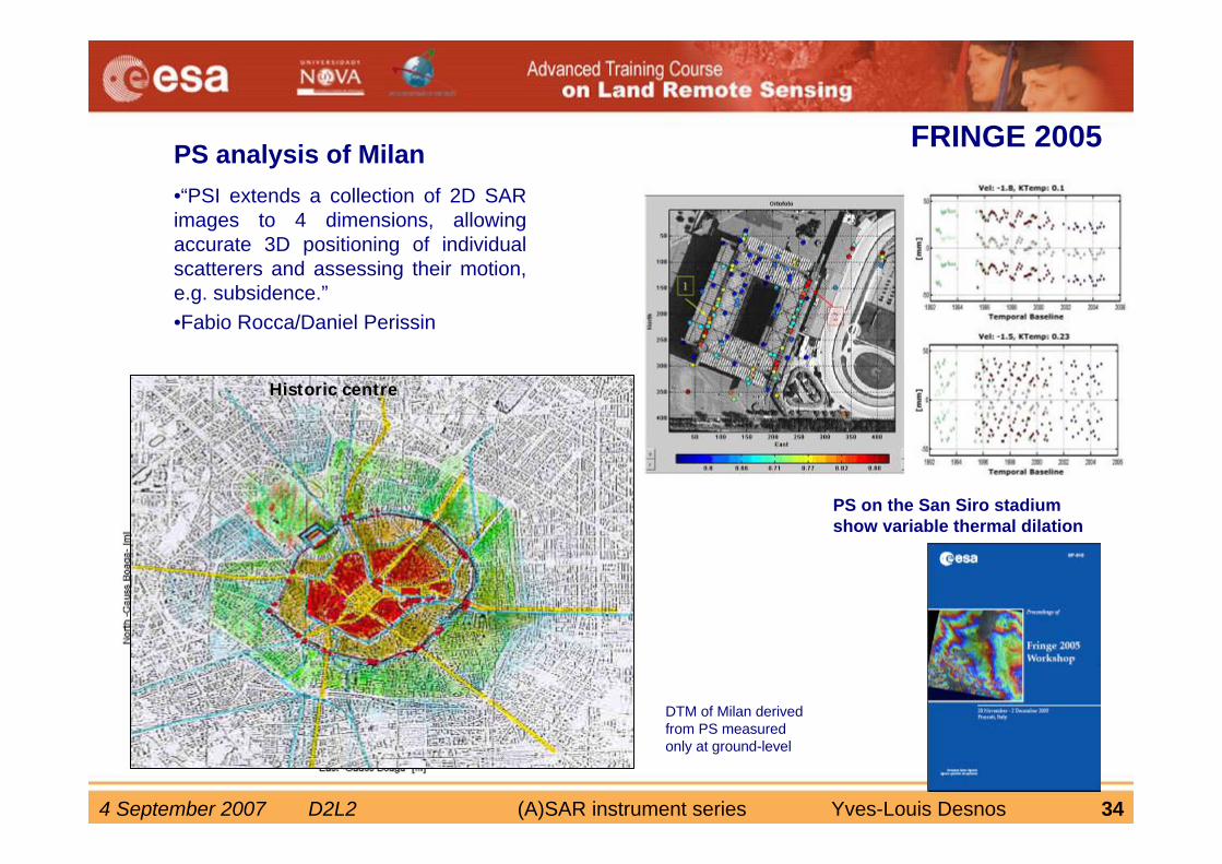
•“PSI extends a collection of 2D SAR images to 4 dimensions, allowing accurate 3D positioning of individual scatterers and assessing their motion, e.g. subsidence.”•Fabio Rocca/Daniel Perissin
PS analysis of Milan
Seveso Lambro
Olona
DTM of Milan derived from PS measured only at ground-level
PS on the San Siro stadium show variable thermal dilation
HistoricHistoric centrecentre
FRINGE 2005
4 September 2007 D2L2 (A)SAR instrument series Yves-Louis Desnos 35
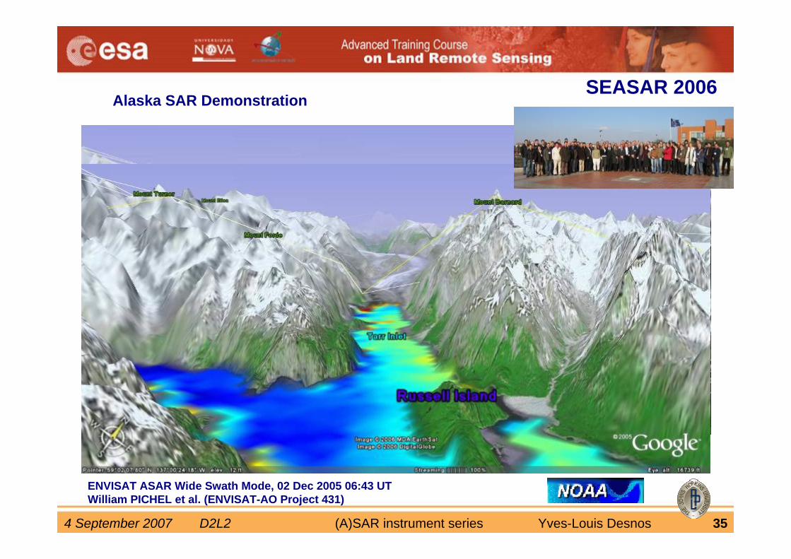
Alaska SAR Demonstration
ENVISAT ASAR Wide Swath Mode, 02 Dec 2005 06:43 UTWilliam PICHEL et al. (ENVISAT-AO Project 431)
SEASAR 2006
4 September 2007 D2L2 (A)SAR instrument series Yves-Louis Desnos 36
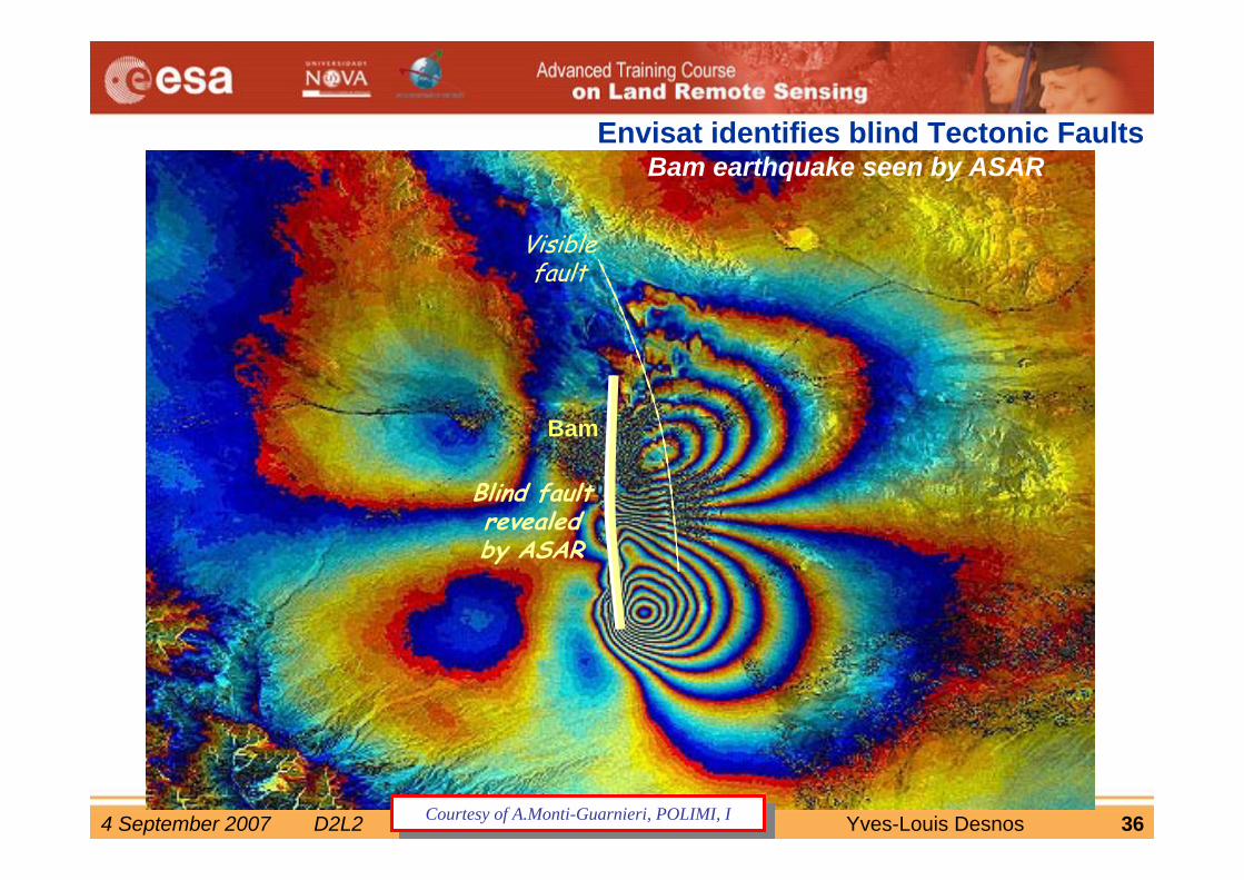
Bam earthquake seen by ASAR
Bam
Envisat identifies blind Tectonic Faults
Blind faultrevealed by ASAR
Visible fault
Courtesy of A.Monti-Guarnieri, POLIMI, ICourtesy of A.Monti-Guarnieri, POLIMI, I
4 September 2007 D2L2 (A)SAR instrument series Yves-Louis Desnos 37
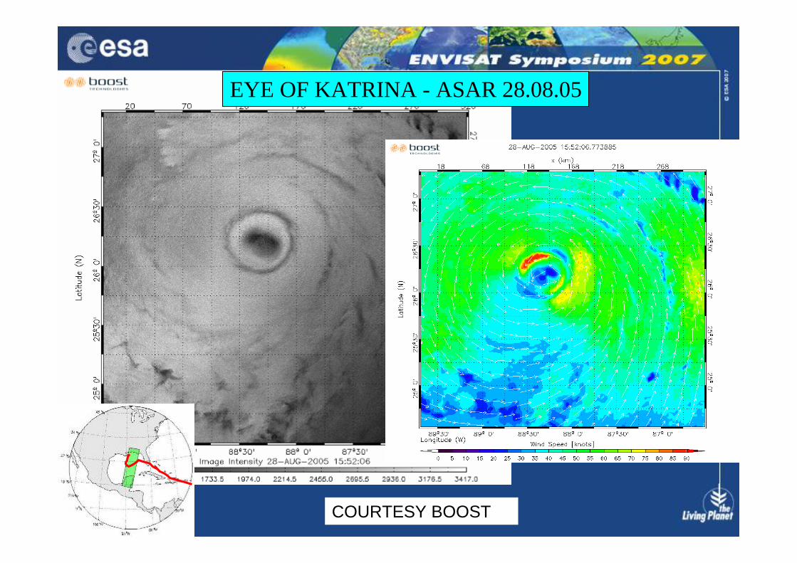
EYE OF KATRINA - ASAR 28.08.05
COURTESY BOOST
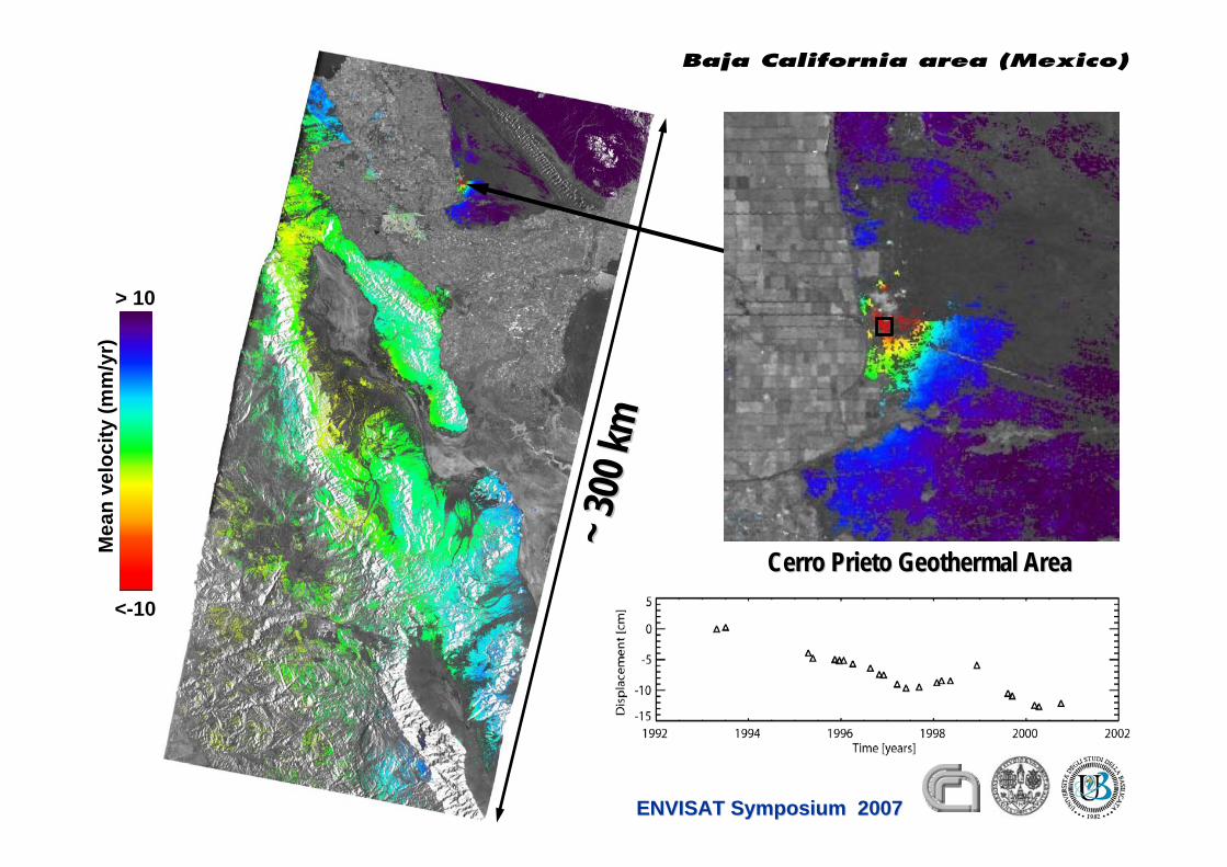
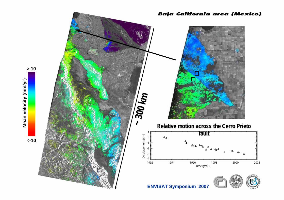
Baja California area (Mexico)
Mea
nve
loci
ty(m
m/y
r)
<-10
> 10
~ 300
km~ 3
00 km
Cerro Cerro PrietoPrieto Geothermal AreaGeothermal Area
ENVISAT Symposium 2007ENVISAT Symposium 2007
Mea
nve
loci
ty(m
m/y
r)
<-10
> 10
~ 300
km~ 3
00 km
Relative motion across the Cerro Relative motion across the Cerro PrietoPrietofaultfault
ENVISAT Symposium 2007ENVISAT Symposium 2007
Baja California area (Mexico)
4 September 2007 D2L2 (A)SAR instrument series Yves-Louis Desnos 40
Greenland mass balance 1996-2005• Mass deficit:• 83±30 Gt/yr in
1996 • 205±37 Gt/yr in
2005
• 2/3rd of loss due to dynamic thinning.
Changes in the Velocity Structure of the Greenland Ice Sheet, Science vol. 311 no. 5763, pp. 986-990Courtesy of Rignot & Kanagaratnam,
“Greenland’s contribution to sea level rise has been doubling between 1995 and 2005” – Eric Rignot, JPL
4 September 2007 D2L2 (A)SAR instrument series Yves-Louis Desnos 41
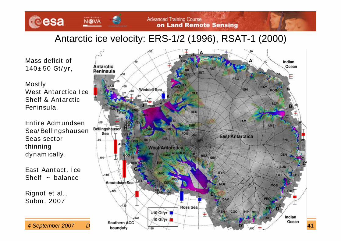
Antarctic ice velocity: ERS-1/2 (1996), RSAT-1 (2000)
Mass deficit of 140±50 Gt/yr,
Mostly West Antarctica Ice Shelf & Antarctic Peninsula.
Entire AdmundsenSea/Bellingshausen Seas sector thinning dynamically.
East Aantact. Ice Shelf ~ balance
Rignot et al.,Subm. 2007
4 September 2007 D2L2 (A)SAR instrument series Yves-Louis Desnos 42
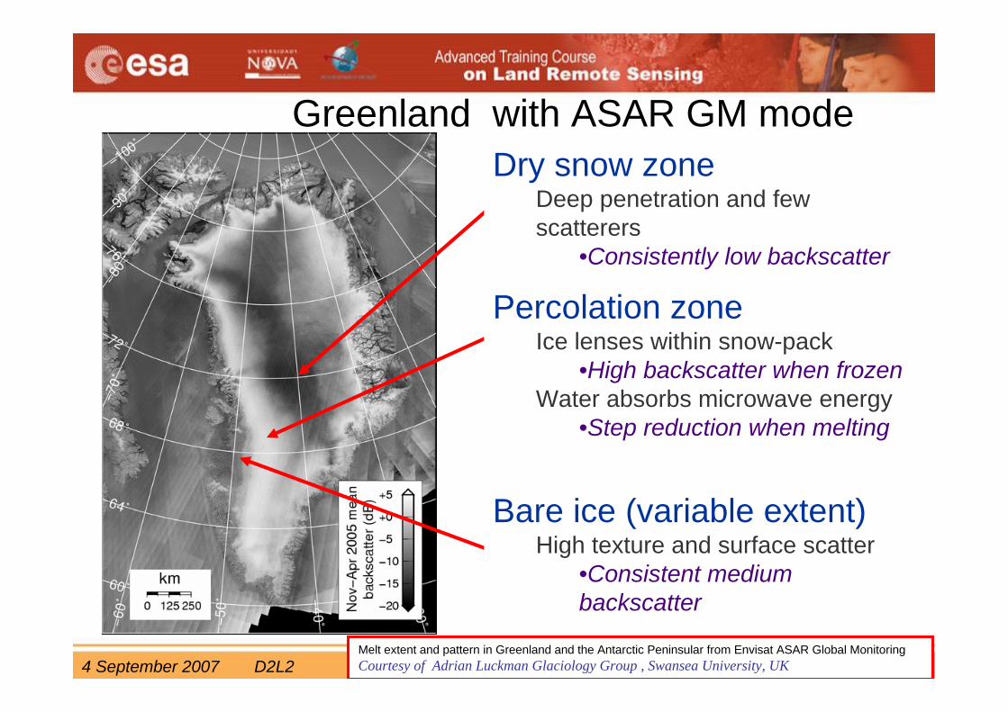
Greenland with ASAR GM modeDry snow zone
Deep penetration and few scatterers
•Consistently low backscatter
Percolation zoneIce lenses within snow-pack
•High backscatter when frozenWater absorbs microwave energy
•Step reduction when melting
Bare ice (variable extent)High texture and surface scatter
•Consistent medium backscatter
Melt extent and pattern in Greenland and the Antarctic Peninsular from Envisat ASAR Global Monitoring Courtesy of Adrian Luckman Glaciology Group , Swansea University, UK

4 September 2007 D2L2 (A)SAR instrument series Yves-Louis Desnos 43
• Freeze/Melt transition is dramatic• validation with Greenland climate
network• Envisat ASAR GMM unique tool to
monitor ice-sheet/ice-shelf melt extent– 1 km spatial resolution– Adequate temporal resolution
(subject to BRM)• Improved observations:
– Melt pattern (ice shelves)– Small ice caps– Individual Greenland catchmentsno melt
meltbare iceno ice
Melt extent in Greenland
Melt extent and pattern in Greenland and the Antarctic Peninsular from Envisat ASAR Global Monitoring Courtesy of Adrian Luckman Glaciology Group , Swansea University, UK
4 September 2007 D2L2 (A)SAR instrument series Yves-Louis Desnos 44
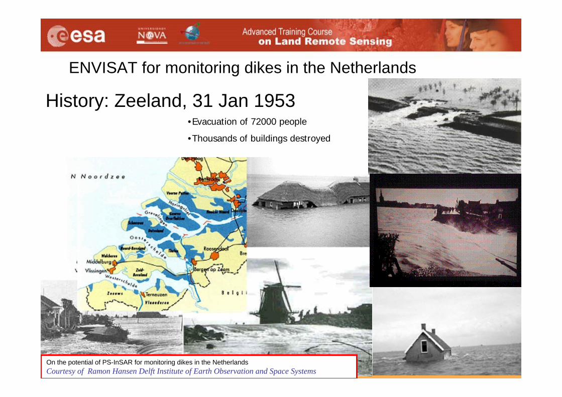
History: Zeeland, 31 Jan 1953•1835 casualties
•2500 km2 flooded
•Evacuation of 72000 people
•Thousands of buildings destroyed
ENVISAT for monitoring dikes in the Netherlands
On the potential of PS-InSAR for monitoring dikes in the NetherlandsCourtesy of Ramon Hansen Delft Institute of Earth Observation and Space Systems
4 September 2007 D2L2 (A)SAR instrument series Yves-Louis Desnos 45
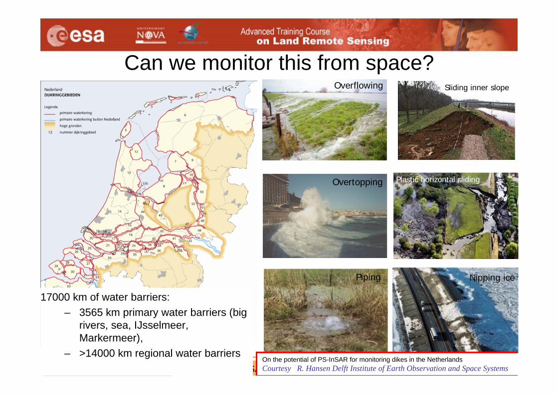
Overflowing
Overtopping
Piping
Sliding inner slope
Plastic horizontal sliding
Nipping ice
Can we monitor this from space?
BLUE Below Sea level
17000 km of water barriers:– 3565 km primary water barriers (big
rivers, sea, IJsselmeer, Markermeer),
– >14000 km regional water barriersOn the potential of PS-InSAR for monitoring dikes in the NetherlandsCourtesy R. Hansen Delft Institute of Earth Observation and Space Systems
4 September 2007 D2L2 (A)SAR instrument series Yves-Louis Desnos 46
029
258 487 215180380151
151
423
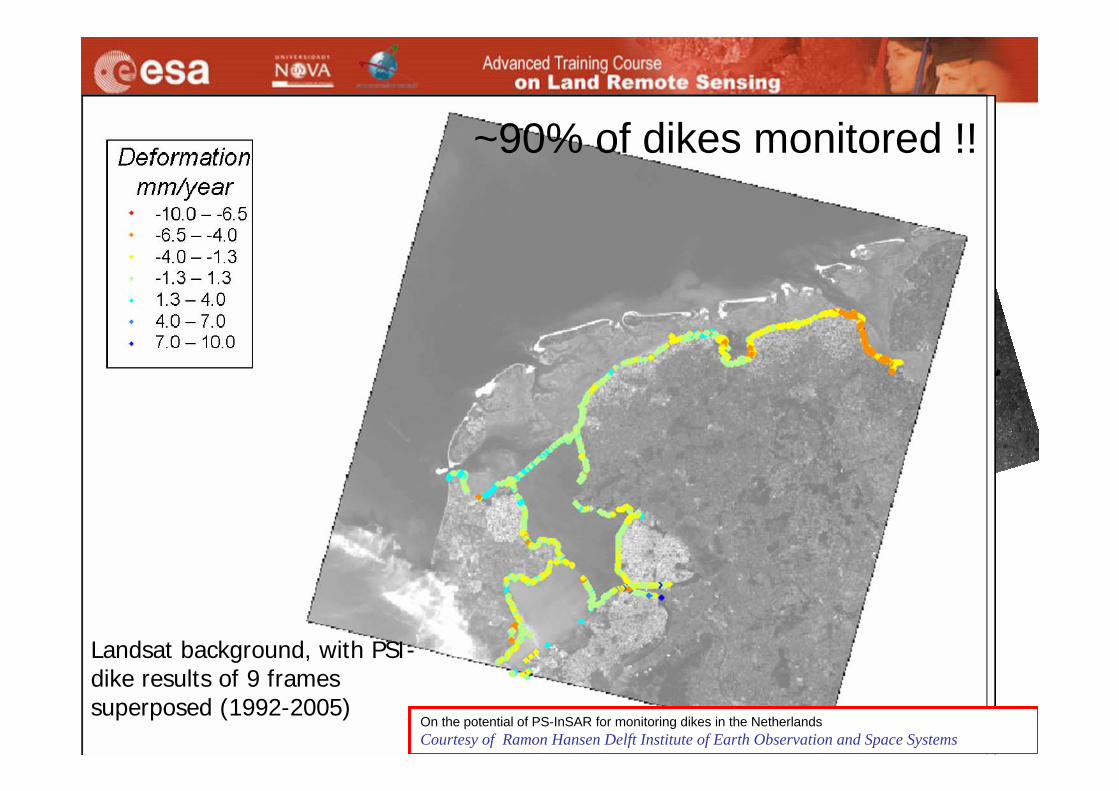
Landsat background, with PSI-dike results of 9 frames superposed (1992-2005)
On the potential of PS-InSAR for monitoring dikes in the NetherlandsCourtesy of Ramon Hansen Delft Institute of Earth Observation and Space Systems
~90% of dikes monitored !!
4 September 2007 D2L2 (A)SAR instrument series Yves-Louis Desnos 47
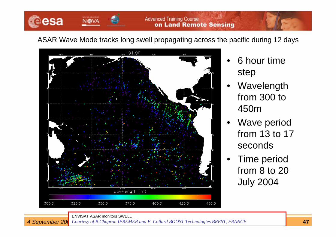
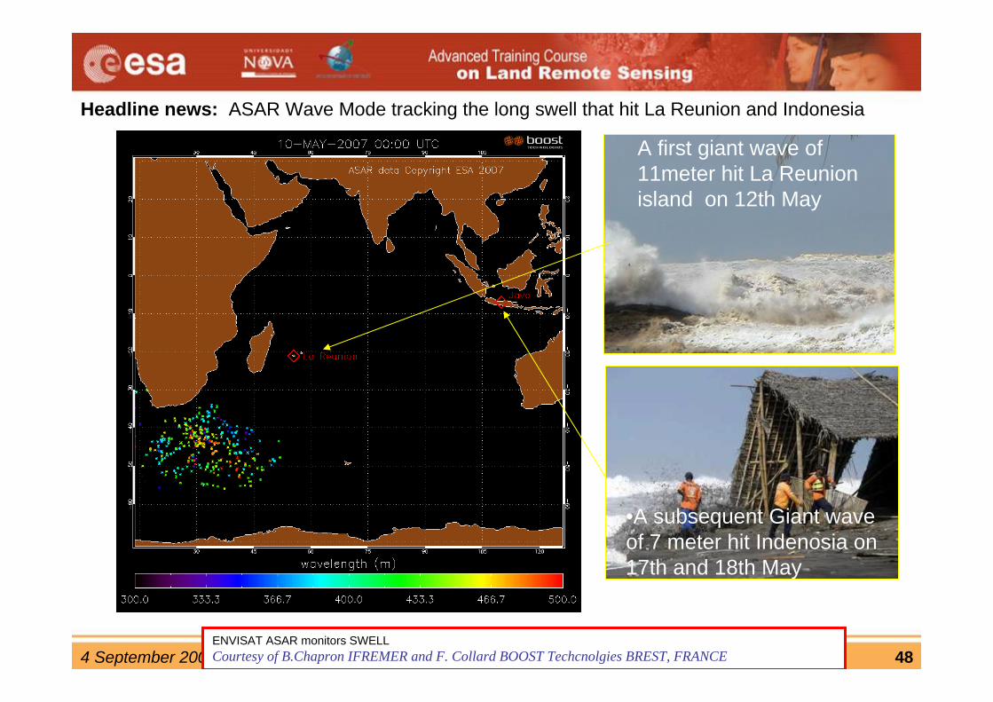
ASAR Wave Mode tracks long swell propagating across the pacific during 12 days
• 6 hour time step
• Wavelengthfrom 300 to 450m
• Wave periodfrom 13 to 17 seconds
• Time periodfrom 8 to 20 July 2004
ENVISAT ASAR monitors SWELL Courtesy of B.Chapron IFREMER and F. Collard BOOST Technologies BREST, FRANCE
4 September 2007 D2L2 (A)SAR instrument series Yves-Louis Desnos 48
• Animation of observed swell generated by a strong storm in the southern ocean, and propagating across the Indian Ocean.
• The moving storm source was tracked by scatterometers from south of Cape Town, South Africa, on 9 May 2007 to north of the Kerguelen Islands on May 14, 2007.
A first giant wave of 11meter hit La Reunion island on 12th May
Headline news: ASAR Wave Mode tracking the long swell that hit La Reunion and Indonesia
ENVISAT ASAR monitors SWELL Courtesy of B.Chapron IFREMER and F. Collard BOOST Techcnolgies BREST, FRANCE
•A subsequent Giant wave of 7 meter hit Indenosia on 17th and 18th May
4 September 2007 D2L2 (A)SAR instrument series Yves-Louis Desnos 49
4 September 2007 D2L2 (A)SAR instrument series Yves-Louis Desnos 50
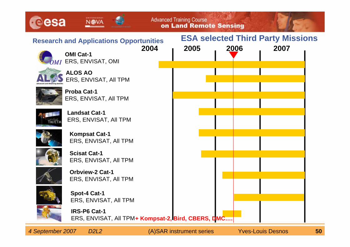
ESA selected Third Party MissionsResearch and Applications Opportunities2004 2005 2006 2007
OMI Cat-1ERS, ENVISAT, OMI
ALOS AOERS, ENVISAT, All TPM
Proba Cat-1ERS, ENVISAT, All TPM
Landsat Cat-1ERS, ENVISAT, All TPM
Kompsat Cat-1ERS, ENVISAT, All TPM
Scisat Cat-1ERS, ENVISAT, All TPM
Orbview-2 Cat-1ERS, ENVISAT, All TPM
Spot-4 Cat-1ERS, ENVISAT, All TPM
+ Kompsat-2, Bird, CBERS, DMC….IRS-P6 Cat-1ERS, ENVISAT, All TPM
4 September 2007 D2L2 (A)SAR instrument series Yves-Louis Desnos 51
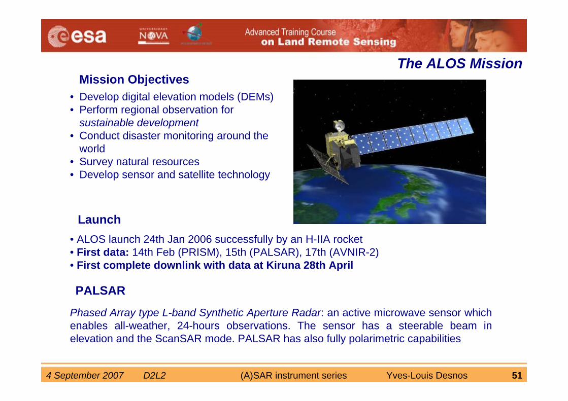
Mission ObjectivesThe ALOS Mission
• Develop digital elevation models (DEMs) • Perform regional observation for
sustainable development• Conduct disaster monitoring around the
world• Survey natural resources• Develop sensor and satellite technology
Launch• ALOS launch 24th Jan 2006 successfully by an H-IIA rocket• First data: 14th Feb (PRISM), 15th (PALSAR), 17th (AVNIR-2) • First complete downlink with data at Kiruna 28th April
PALSAR
Phased Array type L-band Synthetic Aperture Radar: an active microwave sensor which enables all-weather, 24-hours observations. The sensor has a steerable beam in elevation and the ScanSAR mode. PALSAR has also fully polarimetric capabilities
4 September 2007 D2L2 (A)SAR instrument series Yves-Louis Desnos 52
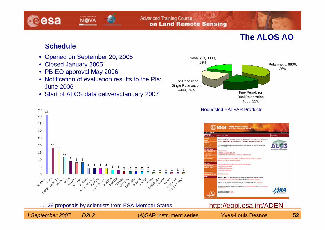
ScheduleThe ALOS AO
• Opened on September 20, 2005• Closed January 2005• PB-EO approval May 2006• Notification of evaluation results to the PIs:
June 2006• Start of ALOS data delivery:January 2007
http://eopi.esa.int/ADEN
Polarimetry, 6600, 36%
Fine Resolution Dual Polarization,
4000, 22%
Fine Resolution Single Polarization,
4400, 24%
ScanSAR, 3300, 18%
41
1816
129 8 8
4 4 4 4 3 3 2 2 2 2 2 1 1 1 1 1 10
5
10
15
20
25
30
35
40
45
GERMANYITALY
UNITED KIN
GDOMFRANCE
SPAINBELGIU
MNORWAY
FINLA
ND
NETHERLANDSSWEDEN
SWITZERLA
NDAUSTRIAGREECEALG
ERIADENMARKMOROCCO
POLAND
TURKEYCHIN
ACAMEROON
ICELA
NDISRAEL
PORTUGAL
SOUTH AFRICA
…139 proposals by scientists from ESA Member States
Requested PALSAR Products
4 September 2007 D2L2 (A)SAR instrument series Yves-Louis Desnos 53
4 September 2007 D2L2 (A)SAR instrument series Yves-Louis Desnos 54
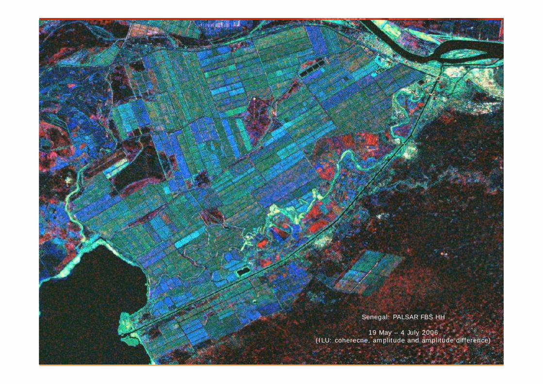
Senegal: PALSAR FBS HH
19 May – 4 July 2006(ILU: coherecne, amplitude and amplitude difference)
4 September 2007 D2L2 (A)SAR instrument series Yves-Louis Desnos 55
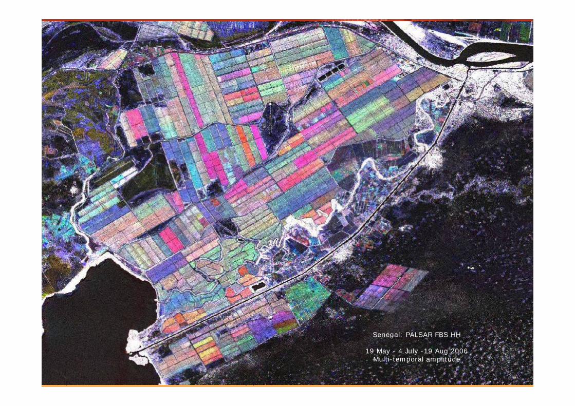
Senegal: PALSAR FBS HH
19 May - 4 July -19 Aug 2006Multi-temporal amplitude
4 September 2007 D2L2 (A)SAR instrument series Yves-Louis Desnos 56
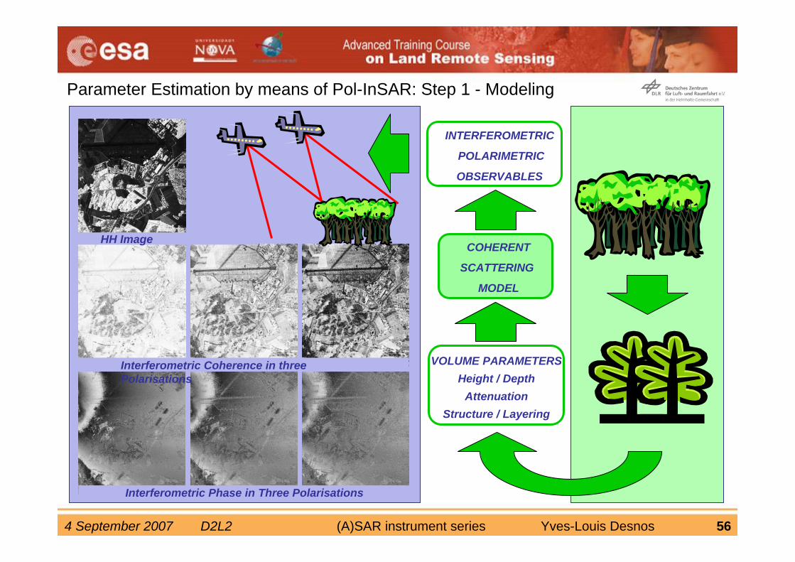
Parameter Estimation by means of Pol-InSAR: Step 1 - Modeling
HH
INTERFEROMETRIC
POLARIMETRIC
OBSERVABLES
VOLUME PARAMETERSHeight / Depth
AttenuationStructure / Layering
COHERENT
SCATTERING
MODEL
Interferometric Coherence in three Polarisations
Interferometric Phase in Three Polarisations
HH Image
4 September 2007 D2L2 (A)SAR instrument series Yves-Louis Desnos 57
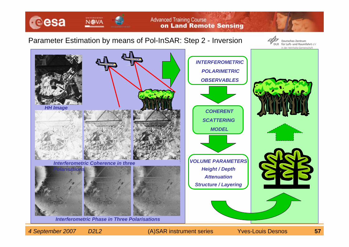
Parameter Estimation by means of Pol-InSAR: Step 2 - Inversion
HH
INTERFEROMETRIC
POLARIMETRIC
OBSERVABLES
VOLUME PARAMETERSHeight / Depth
AttenuationStructure / Layering
COHERENT
SCATTERING
MODEL
Interferometric Coherence in three Polarisations
Interferometric Phase in Three Polarisations
HH Image
4 September 2007 D2L2 (A)SAR instrument series Yves-Louis Desnos 58
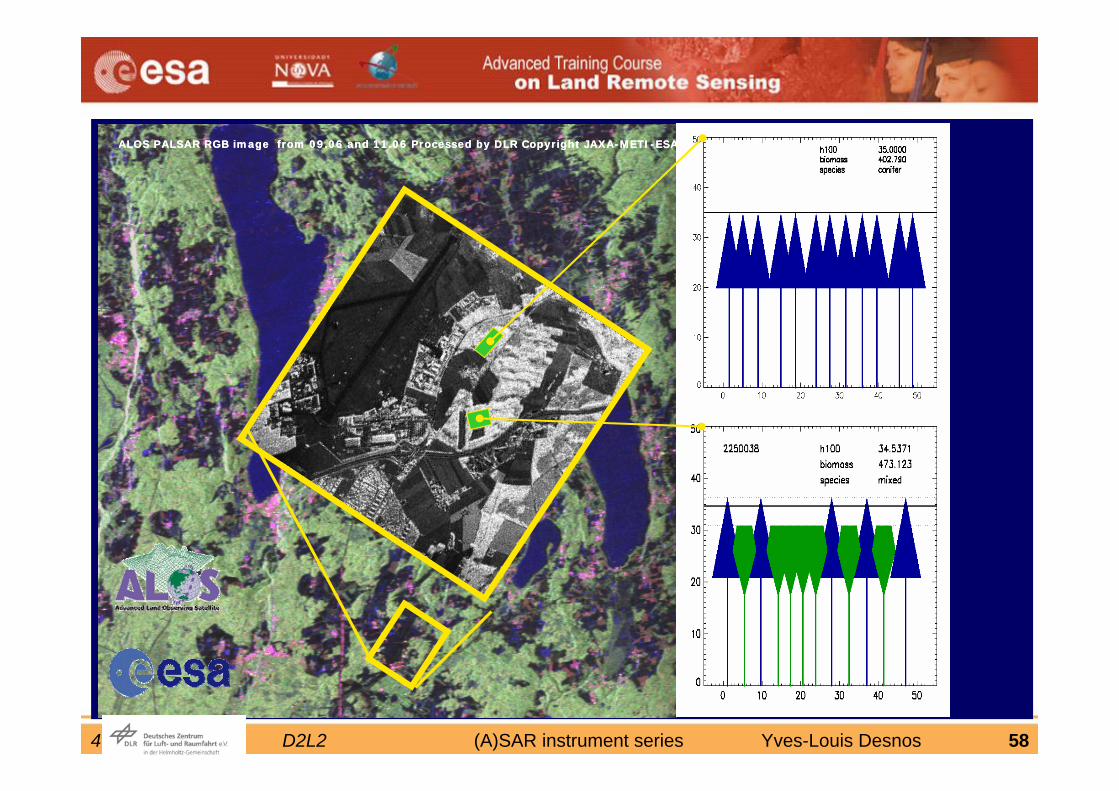
ALOS PALSAR RGB image from 09.06 and 11.06 Processed by DLR Copyright JAXA-METI-ESAALOS PALSAR RGB image from 09.06 and 11.06 Processed by DLR Copyright JAXA-METI-ESA
4 September 2007 D2L2 (A)SAR instrument series Yves-Louis Desnos 59
4 September 2007 D2L2 (A)SAR instrument series Yves-Louis Desnos 60
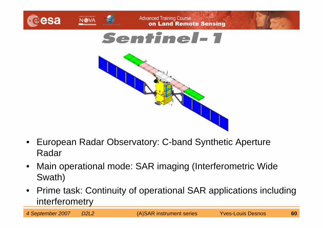
• European Radar Observatory: C-band Synthetic Aperture Radar
• Main operational mode: SAR imaging (Interferometric Wide Swath)
• Prime task: Continuity of operational SAR applications including interferometry
4 September 2007 D2L2 (A)SAR instrument series Yves-Louis Desnos 61
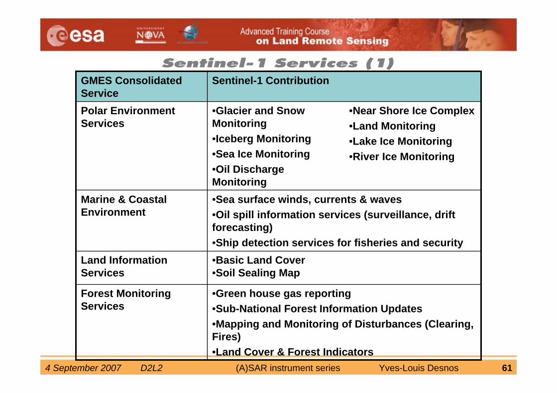
Sentinel-1 Services (1)
•Green house gas reporting•Sub-National Forest Information Updates•Mapping and Monitoring of Disturbances (Clearing, Fires) •Land Cover & Forest Indicators
Forest MonitoringServices
•Near Shore Ice Complex •Land Monitoring •Lake Ice Monitoring •River Ice Monitoring
•Glacier and Snow Monitoring •Iceberg Monitoring •Sea Ice Monitoring•Oil Discharge Monitoring
Polar Environment Services
•Basic Land Cover •Soil Sealing Map
Land InformationServices
•Sea surface winds, currents & waves•Oil spill information services (surveillance, drift forecasting)•Ship detection services for fisheries and security
Marine & CoastalEnvironment
Sentinel-1 ContributionGMES Consolidated Service
4 September 2007 D2L2 (A)SAR instrument series Yves-Louis Desnos 62
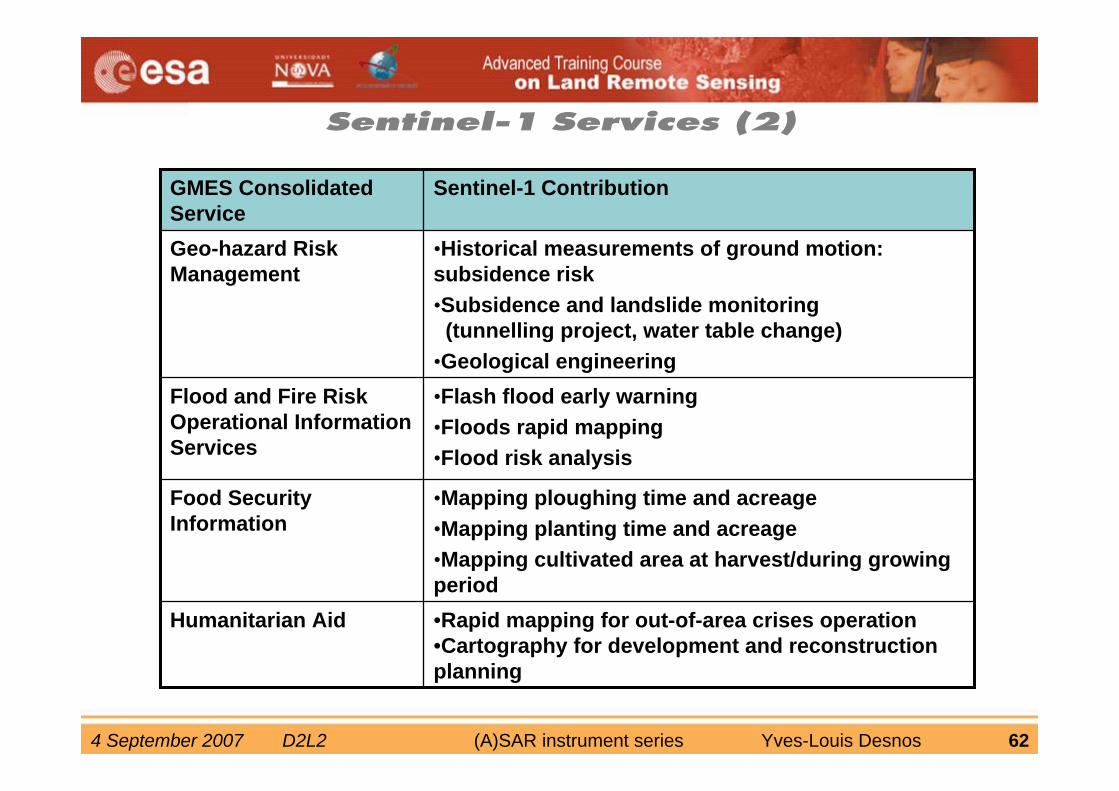
•Mapping ploughing time and acreage•Mapping planting time and acreage•Mapping cultivated area at harvest/during growingperiod
Food SecurityInformation
•Rapid mapping for out-of-area crises operation•Cartography for development and reconstruction planning
Humanitarian Aid
•Flash flood early warning•Floods rapid mapping•Flood risk analysis
Flood and Fire Risk Operational InformationServices
•Historical measurements of ground motion: subsidence risk•Subsidence and landslide monitoring
(tunnelling project, water table change)•Geological engineering
Geo-hazard Risk Management
Sentinel-1 ContributionGMES Consolidated Service
Sentinel-1 Services (2)
4 September 2007 D2L2 (A)SAR instrument series Yves-Louis Desnos 63
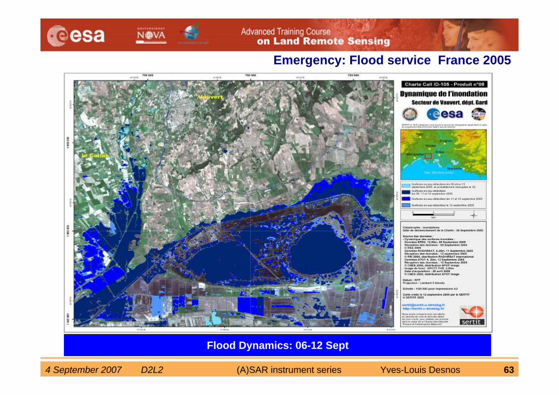
Crisis Map: 06 SeptFlood Dynamics: 06-12 Sept
Emergency: Flood service France 2005
4 September 2007 D2L2 (A)SAR instrument series Yves-Louis Desnos 64
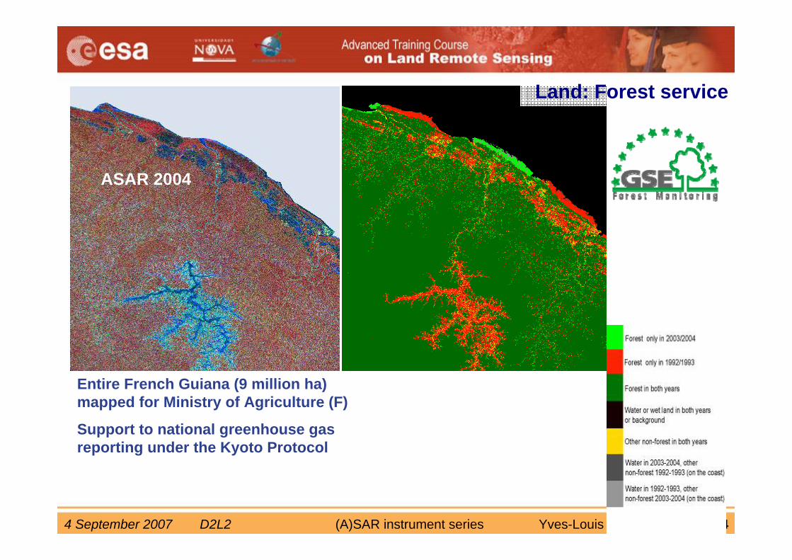
ERS-1 1992ASAR 2004
Entire French Guiana (9 million ha) mapped for Ministry of Agriculture (F)
Support to national greenhouse gas reporting under the Kyoto Protocol
Forest changes
Land: Forest service
4 September 2007 D2L2 (A)SAR instrument series Yves-Louis Desnos 65
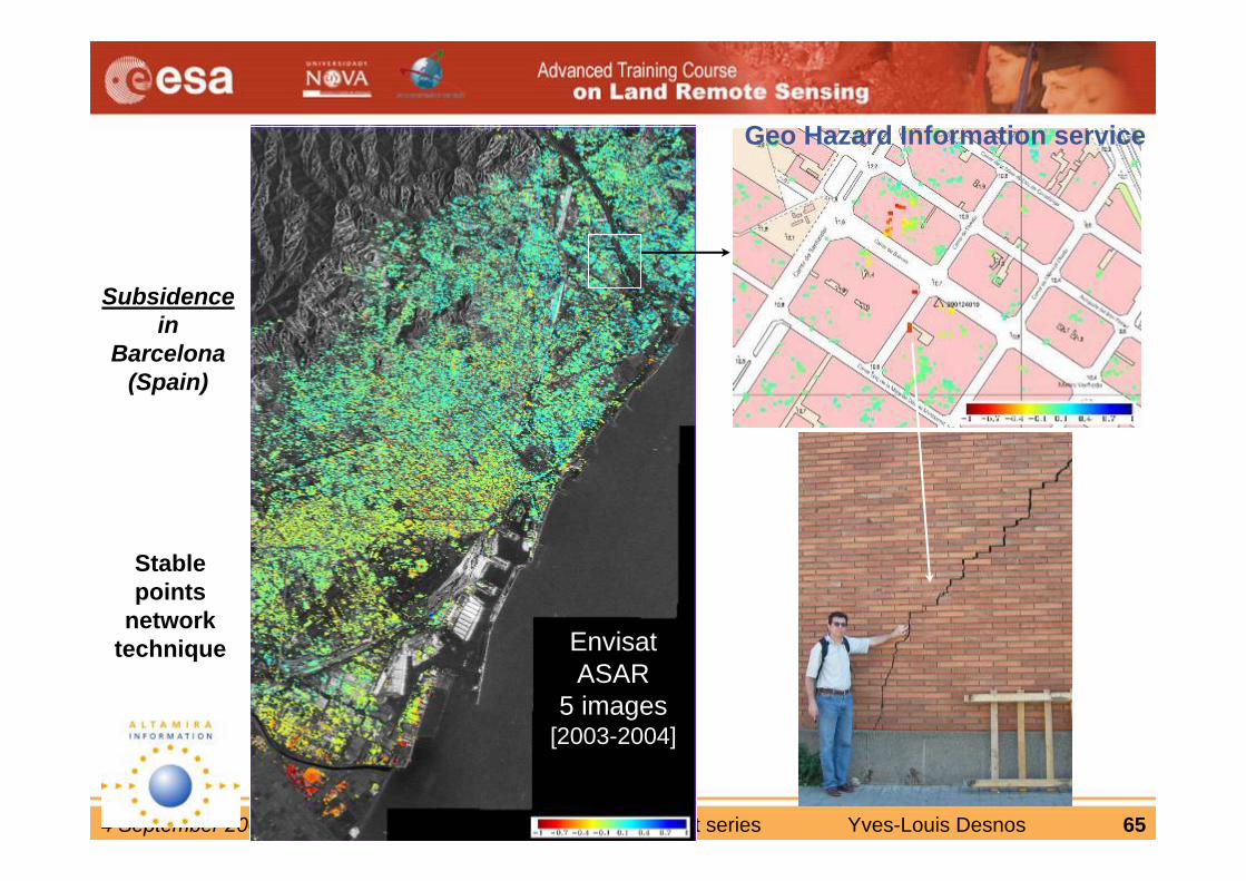
ERS-1/2 SAR
47 images [1995-2001]
EnvisatASAR
5 images[2003-2004]
Subsidencein
Barcelona (Spain)
Stable points
network technique
Geo Hazard Information service
4 September 2007 D2L2 (A)SAR instrument series Yves-Louis Desnos 66
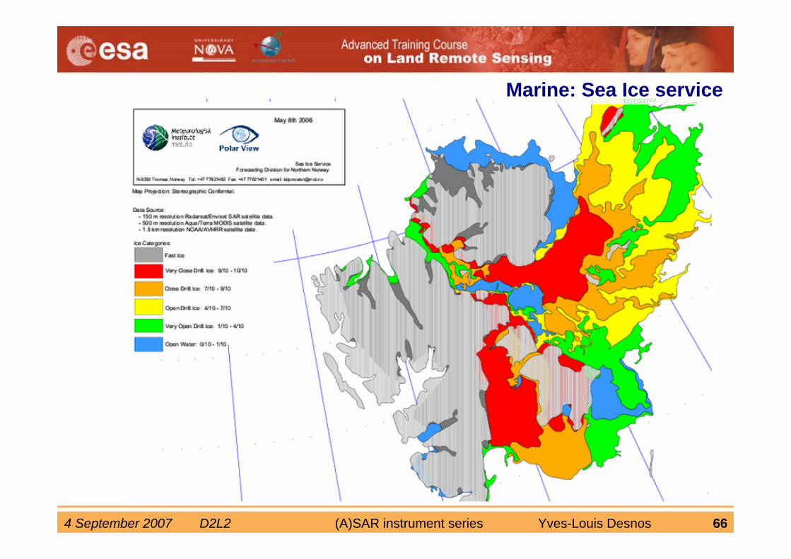
Marine: Sea Ice service
4 September 2007 D2L2 (A)SAR instrument series Yves-Louis Desnos 67
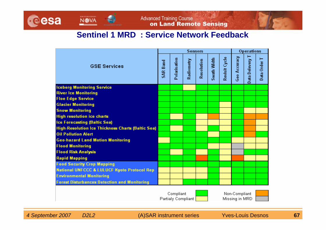
Sentinel 1 MRD : Service Network Feedback
4 September 2007 D2L2 (A)SAR instrument series Yves-Louis Desnos 68
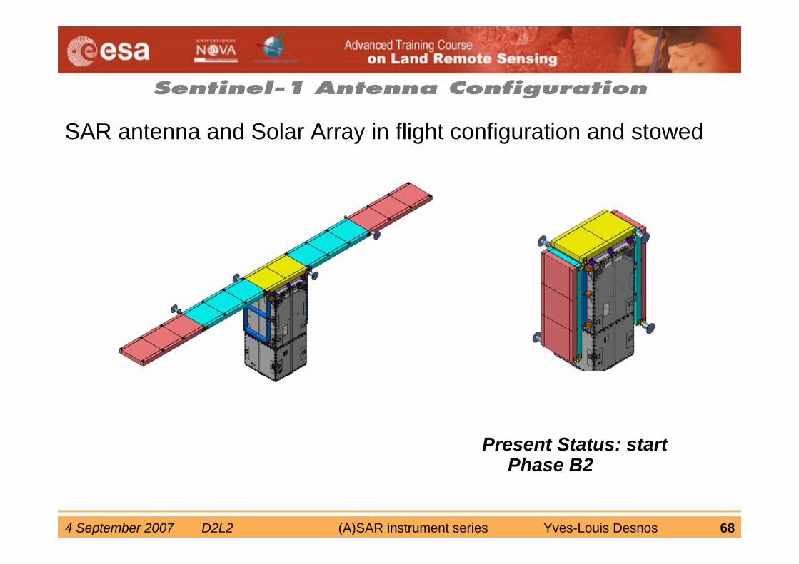
Sentinel-1 Antenna Configuration
SAR antenna and Solar Array in flight configuration and stowed
Present Status: start Phase B2
4 September 2007 D2L2 (A)SAR instrument series Yves-Louis Desnos 69
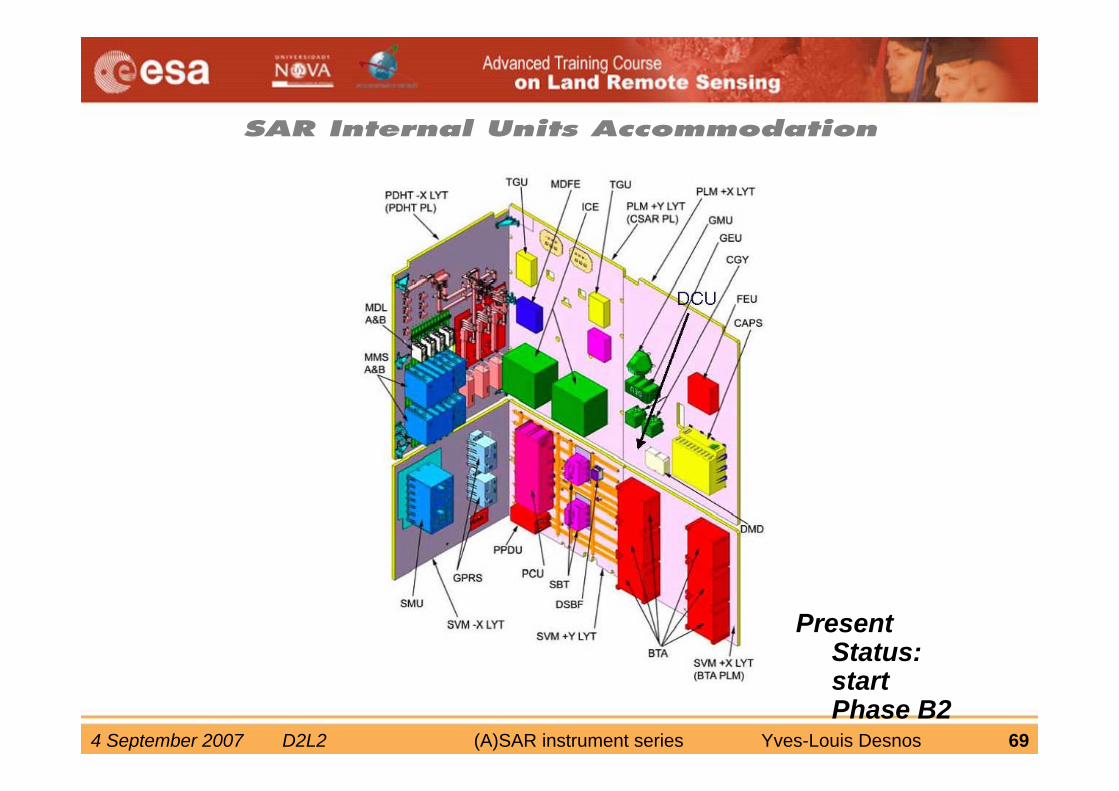
SAR Internal Units Accommodation
Present Status: start Phase B2
4 September 2007 D2L2 (A)SAR instrument series Yves-Louis Desnos 70
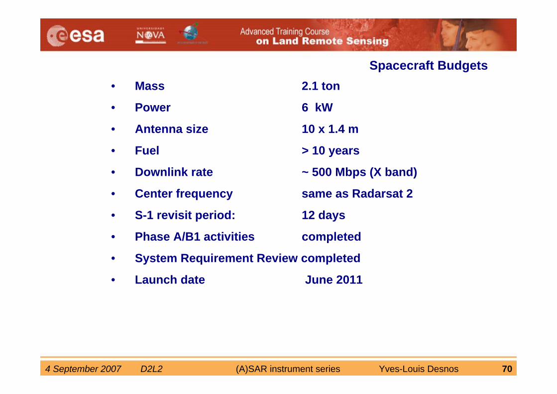
• Mass 2.1 ton
• Power 6 kW
• Antenna size 10 x 1.4 m
• Fuel > 10 years
• Downlink rate ~ 500 Mbps (X band)
• Center frequency same as Radarsat 2
• S-1 revisit period: 12 days
• Phase A/B1 activities completed
• System Requirement Review completed
• Launch date June 2011
Spacecraft Budgets
4 September 2007 D2L2 (A)SAR instrument series Yves-Louis Desnos 71
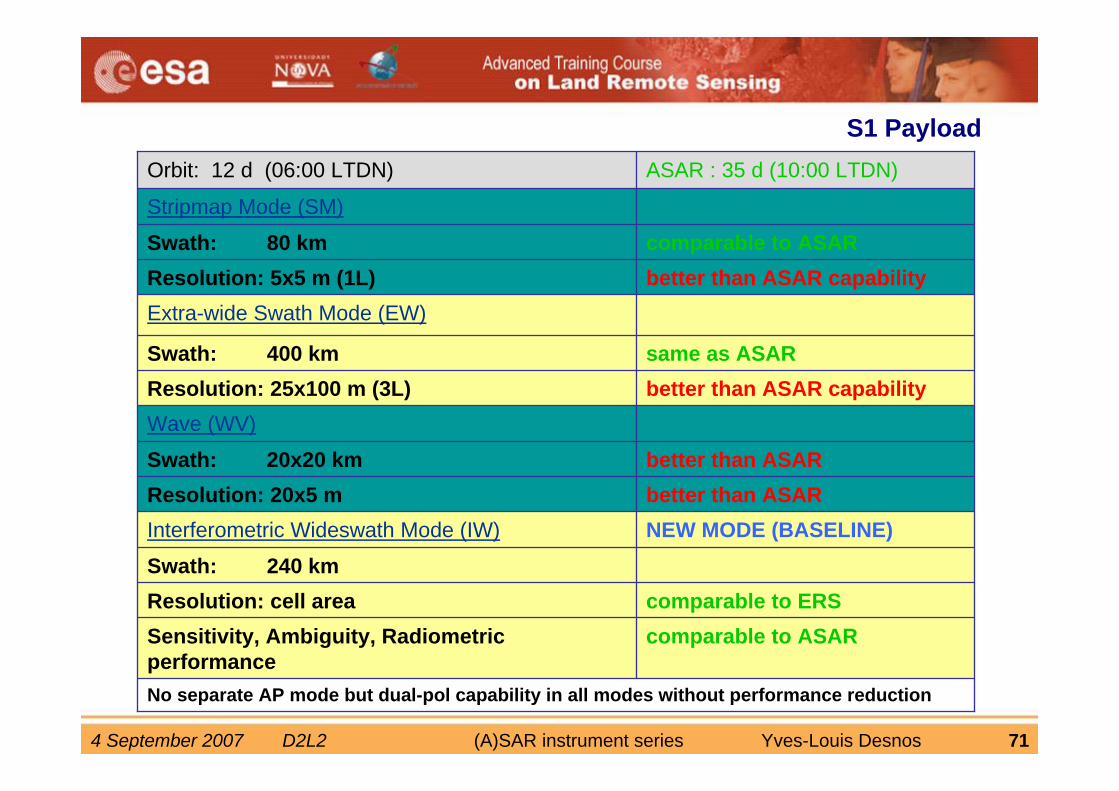
S1 Payload
No separate AP mode but dual-pol capability in all modes without performance reduction
comparable to ASARSensitivity, Ambiguity, Radiometric performance
comparable to ERSResolution: cell areaSwath: 240 km
NEW MODE (BASELINE)Interferometric Wideswath Mode (IW)better than ASARResolution: 20x5 m better than ASARSwath: 20x20 km
Wave (WV)better than ASAR capabilityResolution: 25x100 m (3L)same as ASARSwath: 400 km
Extra-wide Swath Mode (EW)better than ASAR capabilityResolution: 5x5 m (1L)comparable to ASARSwath: 80 km
Stripmap Mode (SM)
ASAR : 35 d (10:00 LTDN)Orbit: 12 d (06:00 LTDN)
4 September 2007 D2L2 (A)SAR instrument series Yves-Louis Desnos 72
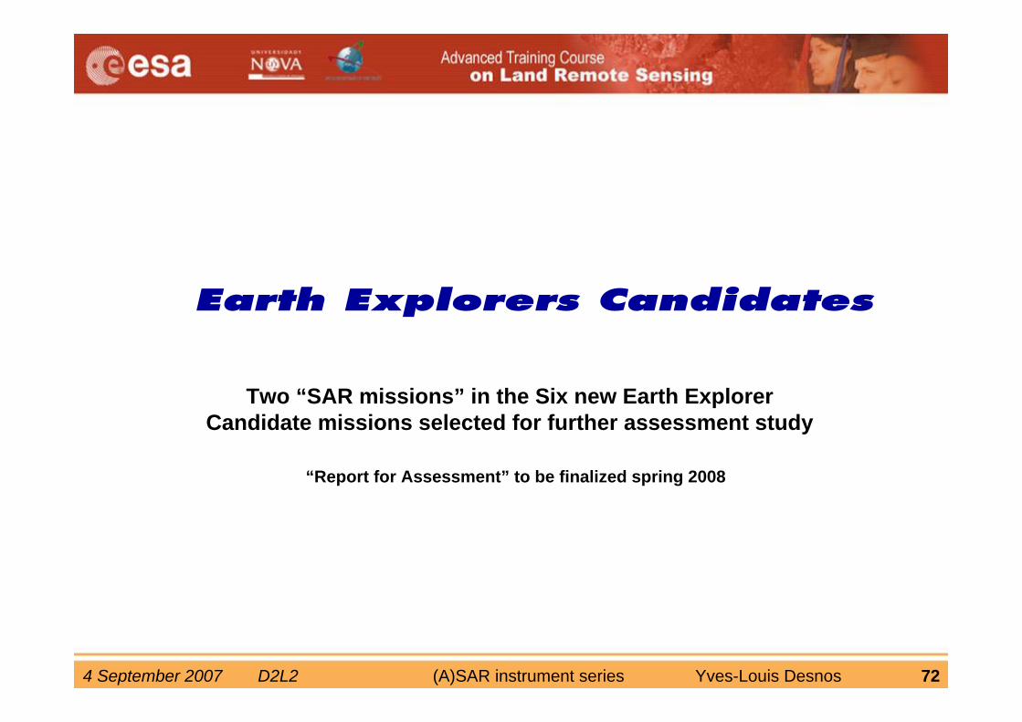
Two “SAR missions” in the Six new Earth Explorer Candidate missions selected for further assessment study
“Report for Assessment” to be finalized spring 2008
4 September 2007 D2L2 (A)SAR instrument series Yves-Louis Desnos 73
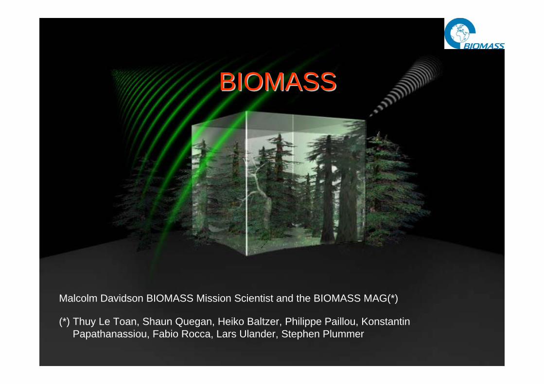
Malcolm Davidson BIOMASS Mission Scientist and the BIOMASS MAG(*)
BIOMASSBIOMASS
(*) Thuy Le Toan, Shaun Quegan, Heiko Baltzer, Philippe Paillou, Konstantin Papathanassiou, Fabio Rocca, Lars Ulander, Stephen Plummer

4 September 2007 D2L2 (A)SAR instrument series Yves-Louis Desnos 74
Mission objectives
• Better understanding and quantification of land contribution to global carbon cycle through– Gridded high-resolution global estimates of above ground biomass
– Monitoring and quantification of forest disturbance and recovery
– Monitoring and quantification of wetland areas and forest inundation
• Additional objectives related to opportunity for spaceborne P-Band SAR images– Mapping subsurface structures, polar regions,
– Mapping subsurface geomorphology in arid zones
4 September 2007 D2L2 (A)SAR instrument series Yves-Louis Desnos 75
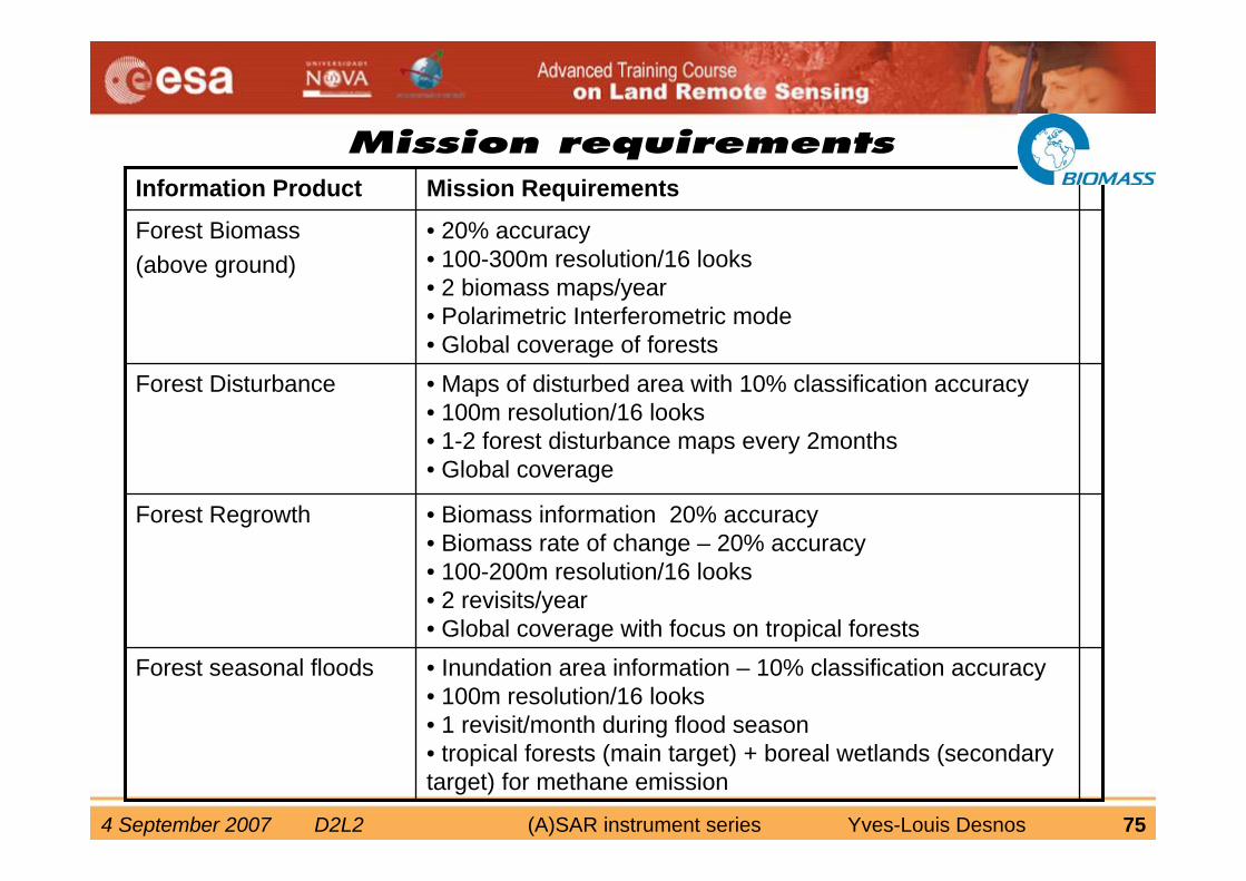
• Inundation area information – 10% classification accuracy• 100m resolution/16 looks• 1 revisit/month during flood season• tropical forests (main target) + boreal wetlands (secondary target) for methane emission
Forest seasonal floods
• Biomass information 20% accuracy • Biomass rate of change – 20% accuracy • 100-200m resolution/16 looks• 2 revisits/year• Global coverage with focus on tropical forests
Forest Regrowth
• Maps of disturbed area with 10% classification accuracy• 100m resolution/16 looks• 1-2 forest disturbance maps every 2months• Global coverage
Forest Disturbance
• 20% accuracy• 100-300m resolution/16 looks• 2 biomass maps/year• Polarimetric Interferometric mode• Global coverage of forests
Forest Biomass(above ground)
Mission RequirementsInformation Product
4 September 2007 D2L2 (A)SAR instrument series Yves-Louis Desnos 76
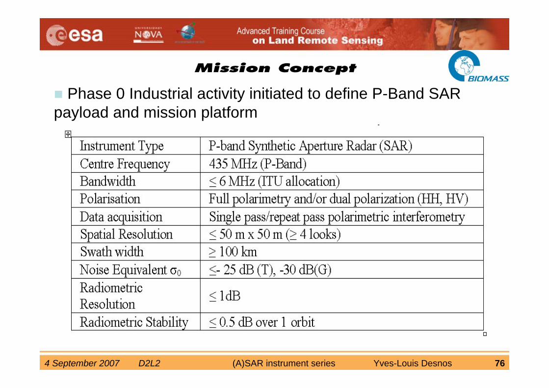
Mission Concept
Phase 0 Industrial activity initiated to define P-Band SAR payload and mission platform

4 September 2007 D2L2 (A)SAR instrument series Yves-Louis Desnos 77
• Biomass retrieval based on advanced techniques (e.g. PolInSAR forest height, classification) expected to improve intensity-only retrievals
Advanced techniques
4 September 2007 D2L2 (A)SAR instrument series Yves-Louis Desnos 78
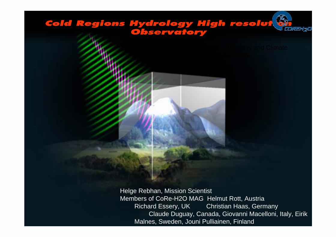
Cold Regions Hydrology High resolution Observatory
A dual-frequency SAR Mission for Hydrology and Climate Research in Cold Environment
Helge Rebhan, Mission ScientistMembers of CoRe-H2O MAG Helmut Rott, Austria
Richard Essery, UK Christian Haas, GermanyClaude Duguay, Canada, Giovanni Macelloni, Italy, Eirik
Malnes, Sweden, Jouni Pulliainen, Finland
4 September 2007 D2L2 (A)SAR instrument series Yves-Louis Desnos 79
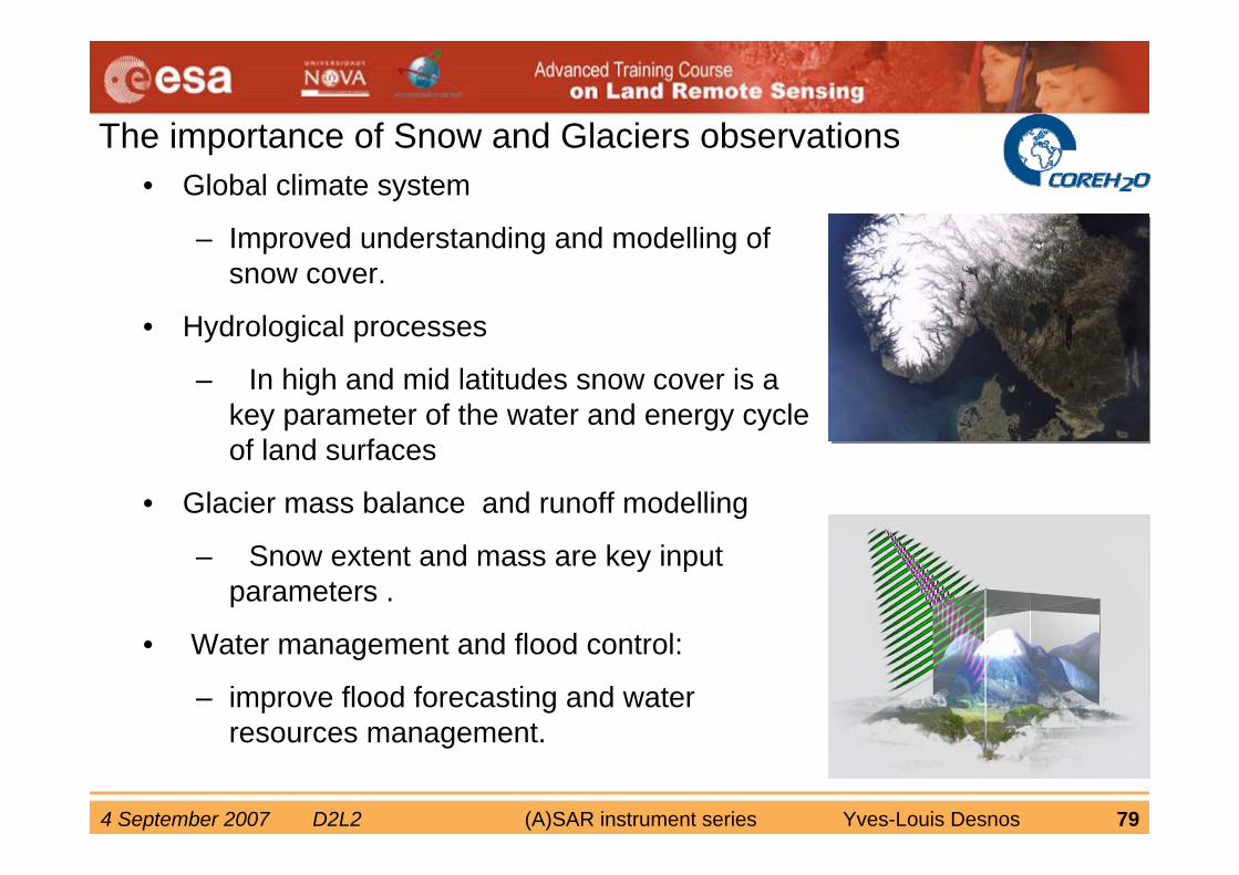
The importance of Snow and Glaciers observations• Global climate system
– Improved understanding and modelling of snow cover.
• Hydrological processes
– In high and mid latitudes snow cover is a key parameter of the water and energy cycle of land surfaces
• Glacier mass balance and runoff modelling
– Snow extent and mass are key input parameters .
• Water management and flood control:
– improve flood forecasting and water resources management.
4 September 2007 D2L2 (A)SAR instrument series Yves-Louis Desnos 80
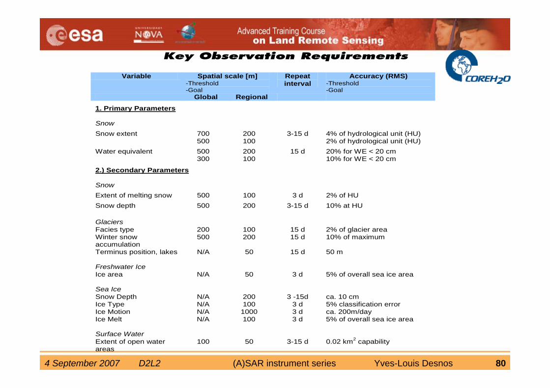
Key Observation Requirements
Variable Spatial scale [m]-Threshold -Goal
Repeat interval
Accuracy (RMS)-Threshold -Goal
Global Regional
1. Primary Parameters
Snow
Snow extent 700 500
200 100
3-15 d 4% of hydrological unit (HU) 2% of hydrological unit (HU)
Water equivalent 500 300
200 100
15 d 20% for WE < 20 cm 10% for WE < 20 cm
2.) Secondary Parameters Snow Extent of melting snow 500 100 3 d 2% of HU Snow depth 500 200 3-15 d 10% at HU Glaciers
Facies type 200 100 15 d 2% of glacier area Winter snow accumulation
500 200 15 d 10% of maximum
Terminus position, lakes N/A 50 15 d 50 m Freshwater Ice
Ice area N/A 50 3 d 5% of overall sea ice area Sea Ice Snow Depth N/A 200 3 -15d ca. 10 cm Ice Type N/A 100 3 d 5% classification error Ice Motion N/A 1000 3 d ca. 200m/day Ice Melt N/A 100 3 d 5% of overall sea ice area Surface Water
Extent of open water areas
100 50 3-15 d 0.02 km2 capability
4 September 2007 D2L2 (A)SAR instrument series Yves-Louis Desnos 81
activefeeds
beam
dire
ctio
n
ϑ ϑ
x
f
ObservationDirection
SwathWidth
Satellite Ground Track
Multiple subswa
to achieve wide sw
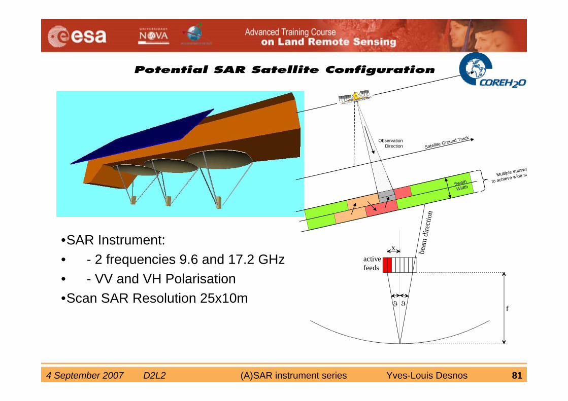
Potential SAR Satellite Configuration
•SAR Instrument:• - 2 frequencies 9.6 and 17.2 GHz• - VV and VH Polarisation•Scan SAR Resolution 25x10m
4 September 2007 D2L2 (A)SAR instrument series Yves-Louis Desnos 82
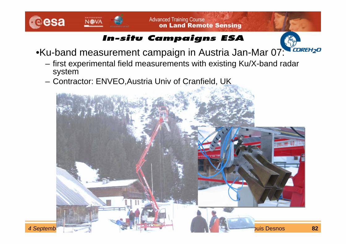
In-situ Campaigns ESA
•Ku-band measurement campaign in Austria Jan-Mar 07:– first experimental field measurements with existing Ku/X-band radar
system– Contractor: ENVEO,Austria Univ of Cranfield, UK
4 September 2007 D2L2 (A)SAR instrument series Yves-Louis Desnos 83