
Lecture by Lars van Galen · After lecture and tutorial, measure snow depth! 14. Fronts 15. ... Go...
110
Weather Systems Low pressure areas, fronts and surface weather Atmospheric rotations in (severe) weather: A deeper look into hurricanes Meteorology and Climate, Module 9 (Jan 22, 2019) Lecture by Lars van Galen 1 On Thursday ex-SWA Meteorology student Jelle Wisse of Marin will talk about his work!
Transcript of Lecture by Lars van Galen · After lecture and tutorial, measure snow depth! 14. Fronts 15. ... Go...

Weather Systems
Low pressure areas, fronts and surface weather
Atmospheric rotations in (severe) weather:
A deeper look into hurricanes
Meteorology and Climate, Module 9 (Jan 22, 2019)
Lecture by Lars van Galen
1
On Thursday ex-SWA Meteorology studentJelle Wisse of Marin will talk about his work!

Let it snow...2

Large scale – occlusion passage3

Front in visible imagery4

At 1.5 km altitude (850 hPa)
weak warm band 5

At 1.5 km altitude (850 hPa)
weak warm band (12 UTC) 6
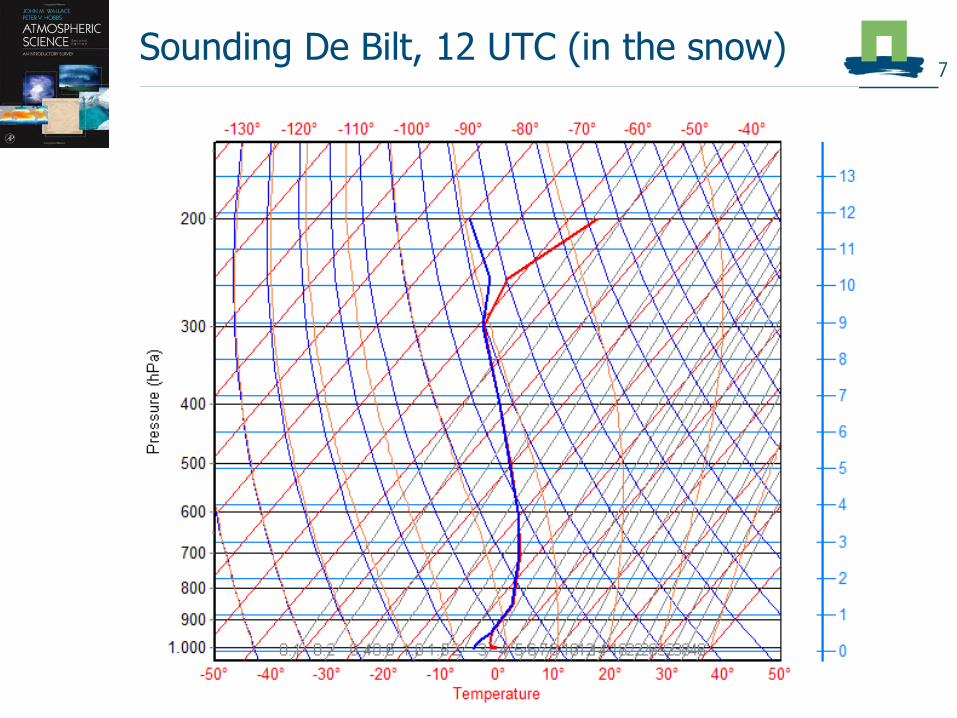
Sounding De Bilt, 12 UTC (in the snow)7

Sounding De Bilt, 12 UTC (in the snow)8

Sounding De Bilt, 12 UTC (in the snow)9
Thick clouds(8 km across)

10
ECMWF-model HIRLAM-model
How much will fall?- Accumulations for today

11
ECMWF-model HIRLAM-model
How much will fall?- Accumulations for today
3 cm 4-5 cm
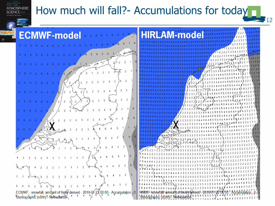
How much will fall?- Accumulations for today12
ECMWF-model HIRLAM-model

“Observation” at 11 UTC13
Measurement Hellevoetsluis

After lecture and tutorial, measure snow
depth! 14

Fronts15

Warm and cold front 16
Cold front Warm front
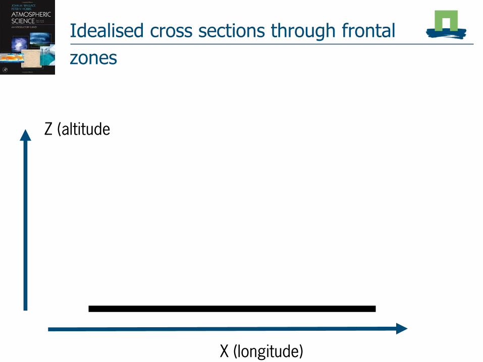
Idealised cross sections through frontal
zones
17
X (longitude)
Z (altitude

Idealised cross sections through frontal zones 18
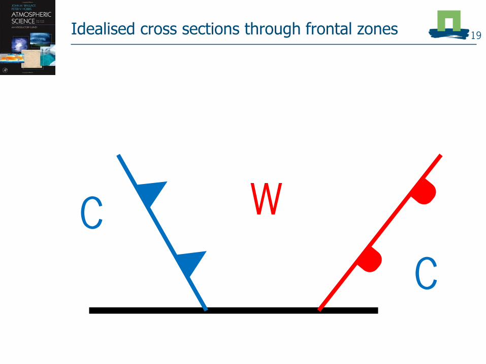
Idealised cross sections through frontal zones 19
W
C
C

Idealised cross sections through frontal zones 20
W
C
C

Frontal lifecycle21

22Classic low pressure system
Immature Mature
Warm sector

Fig 8.31
The 4 stages in the
development of cyclones
according to the
Norwegian school
conceptual model
Red arrows indicate
warm sector air flow and
blue in cold sector
relative to the moving
cyclone center
(red dot)
isobars
isotherms
Grey areas: rain 23

Frontal life cycle - vertical 24
W
C
C
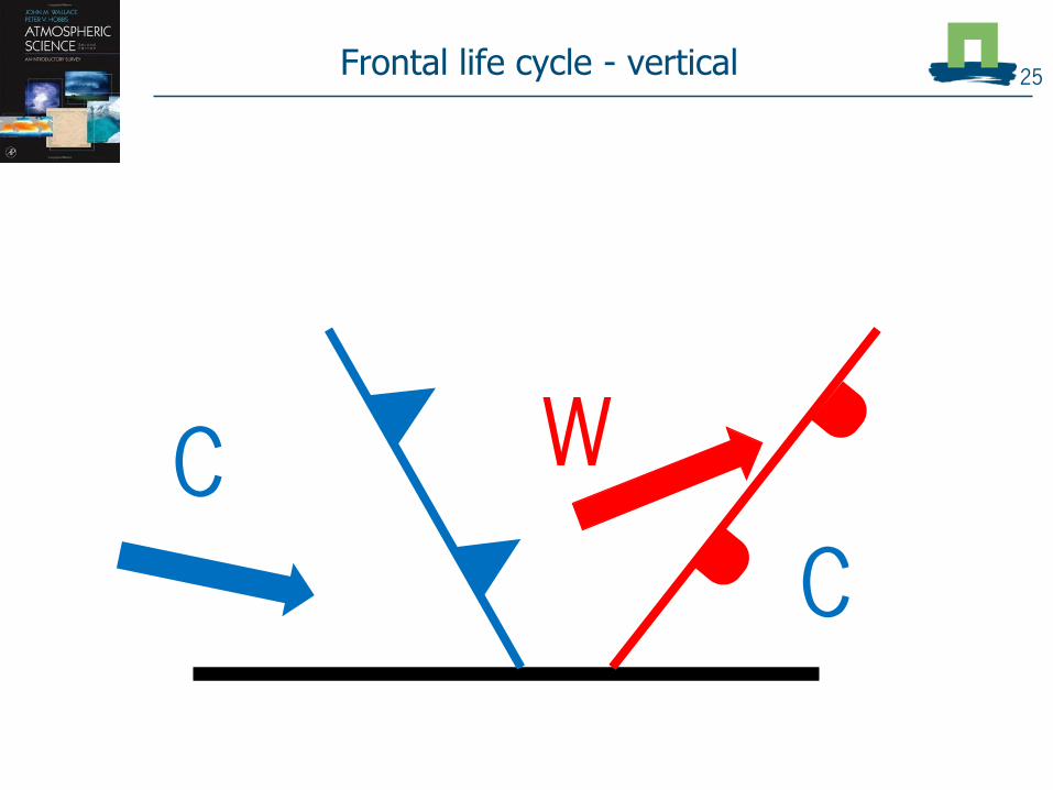
25
W
C
C
Frontal life cycle - vertical

26
W
CC
Frontal life cycle - vertical

27
W
CC
Frontal life cycle - vertical

The development of a classic low pressure area
06-01-2019 06 UTC 28
Phase 1
29
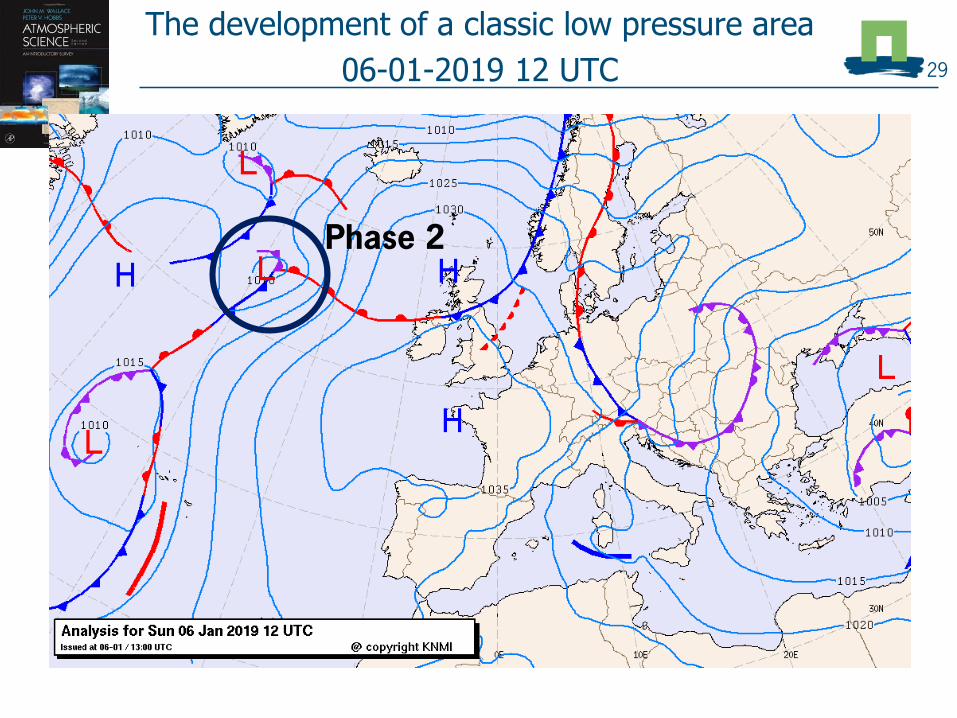
The development of a classic low pressure area
06-01-2019 12 UTC
Phase 2

30
The development of a classic low pressure area
06-01-2019 18 UTC
Phase 2 - 3

31
The development of a classic low pressure area
07-01-2019 00 UTC
Phase 3

32
The development of a classic low pressure area
07-01-2019 06 UTC
Phase 4

33
The development of a classic low pressure area
07-01-2019 12 UTC
Phase 4

34
The development of a classic low pressure area
07-01-2019 18 UTC
Phase 4

The development of a classic low pressure area
08-01-2019 00 UTC 35
Even more phase 4...

Intermezzo – in what phase is ‘our’ low
pressure area of today? 36

Front quiz!37
Goal = to recognize when fronts have passed.
Example includes a warm and a cold front
13 January 2019
Go to kahoot.it
Enter game pin (to be provided)
Enter username
Start!

Temperature of day of frontal passage
Front identification 38
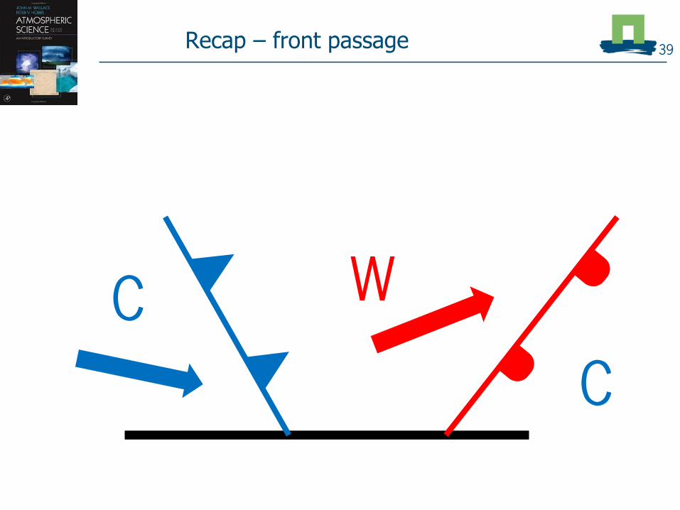
Recap – front passage 39
W
C
C

Radiation at front –
weather of the day question 40

41
Clear spells (Qnet < 0)
Radiation at front –
weather of the day question

Precipitation at front question
42

Precipitation at front question 43
4,5 mm
4,5 mm

Veering of wind44

Pressure tendency45

What the KNMI says...
Warm front at night (before 06 UTC) 46

47
What the KNMI says...
Cold front around 18 UTC

Warm and cold front 48
• Continuous light rain and drizzle
• Pressure decreases before front, steady after front
• Wind veers during front passage
• Tx and Td increase
• Short, showery and intense precipitation
• Pressure decreases before front, increase after front
• Wind veers during front passage
• Td decreases sharply, Tx not so much
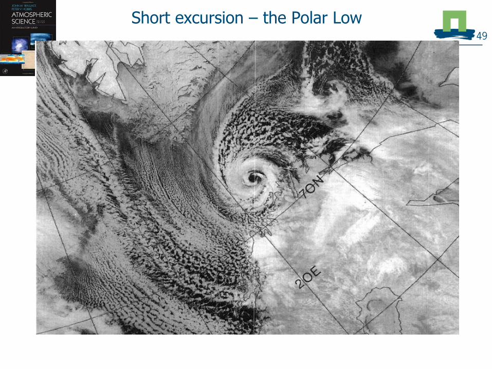
Short excursion – the Polar Low49

Polar low
Small extratropical cyclone
Located to far north (60-80N)
Short lifetime (~1-2 days)
Not driven by airmassdifferences, but by convection!
50

Polar low
Small extratropical cyclone
Located to far north (60-80N)
Short lifetime (~1-2 days)
Not driven by airmassdifferences, but by convection!
Cold air over warm sea thunderstorms organization
= polar low
51

Polar low
Small extratropical cyclone
Located to far north (60-80N)
Short lifetime (~1-2 days)
Not driven by airmassdifferences, but by convection!
Cold air over warm sea thunderstorms organization
= polar low
52

Polar low
Small extratropical cyclone
Located to far north (60-80N)
Short lifetime (~1-2 days)
Not driven by airmassdifferences, but by convection!
Cold air over warm sea thunderstorms organization
= polar low
53

Climatology of polar lows near Scandinavia
between 2002 and 2011 54
(Terpstra et al., 2016 )

Break 55

Quantifying atmospheric rotation56

Atmospheric Rotation: Scales and Forces
Dust devil
Tornado
Hurricane
Low Pressure System
57

Atmospheric rotations and horizontal scales58

Atmospheric rotations and horizontal scales59
Non-existent
Non-existent

Atmospheric rotations and horizontal scales60
Non-existent
Non-existent
Polar low

Atmospheric rotations and horizontal scales61
Main question: what forces are important at what
scales?
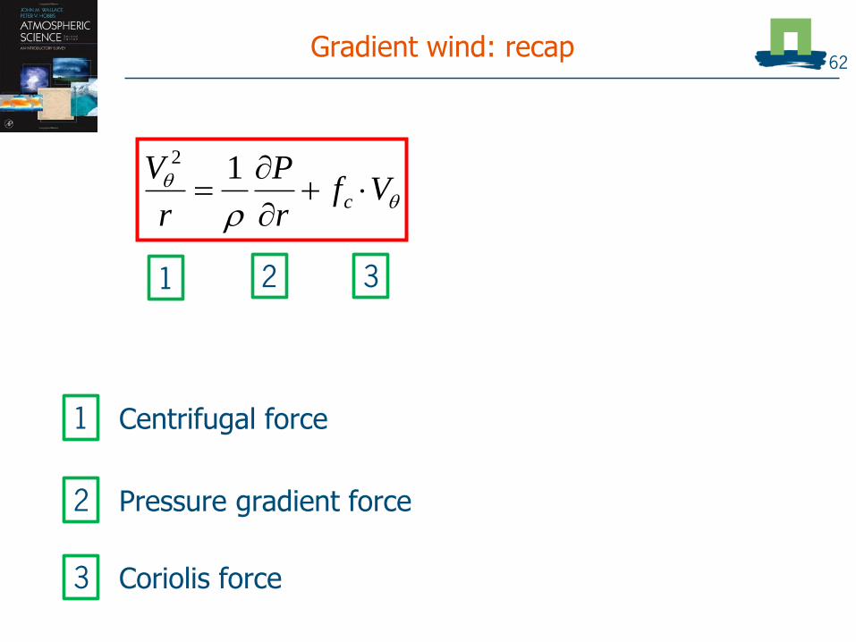
Gradient wind: recap
Centrifugal force
Vf
r
P
r
Vc
12
This is our fundamental equation
62
1 2 3
1
Pressure gradient force2
Coriolis force3
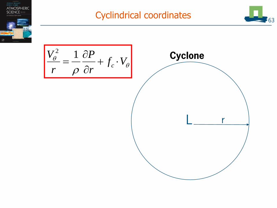
Cyclindrical coordinates
Vf
r
P
r
Vc
12
V
r
63
L
Cyclone

Gradient wind: in cylindrical coordinates
𝑟 = 𝑟𝑎𝑑𝑖𝑢𝑠 𝑜𝑓 𝑐𝑦𝑐𝑙𝑜𝑛𝑒
𝜃 = 𝑐𝑜𝑜𝑟𝑑𝑖𝑛𝑎𝑡𝑒
𝑝𝑒𝑟𝑝𝑒𝑛𝑑𝑖𝑐𝑢𝑙𝑎𝑟 𝑡𝑜 𝑟𝑎𝑑𝑖𝑢𝑠
Vf
r
P
r
Vc
12
R
rr
r
64
L

Gradient wind: in cylindrical coordinates
𝑟 = 𝑟𝑎𝑑𝑖𝑢𝑠 𝑜𝑓 𝑐𝑦𝑐𝑙𝑜𝑛𝑒
𝜃 = 𝑐𝑜𝑜𝑟𝑑𝑖𝑛𝑎𝑡𝑒
𝑝𝑒𝑟𝑝𝑒𝑛𝑑𝑖𝑐𝑢𝑙𝑎𝑟 𝑡𝑜 𝑟𝑎𝑑𝑖𝑢𝑠
𝑉𝜃 = 𝑤𝑖𝑛𝑑 𝑠𝑝𝑒𝑒𝑑
𝑝𝑒𝑟𝑝𝑒𝑛𝑑𝑖𝑐𝑢𝑙𝑎𝑟 𝑡𝑜 𝑟𝑎𝑑𝑖𝑢𝑠
Vf
r
P
r
Vc
12
R
rr
V
r
65
L
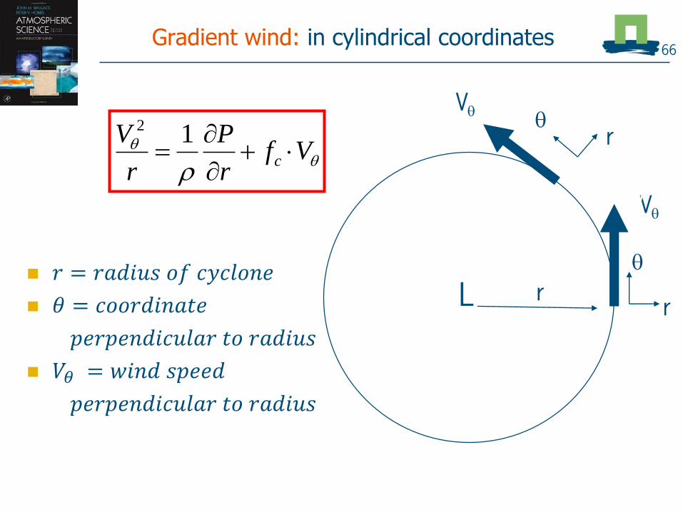
Gradient wind: in cylindrical coordinates
𝑟 = 𝑟𝑎𝑑𝑖𝑢𝑠 𝑜𝑓 𝑐𝑦𝑐𝑙𝑜𝑛𝑒
𝜃 = 𝑐𝑜𝑜𝑟𝑑𝑖𝑛𝑎𝑡𝑒
𝑝𝑒𝑟𝑝𝑒𝑛𝑑𝑖𝑐𝑢𝑙𝑎𝑟 𝑡𝑜 𝑟𝑎𝑑𝑖𝑢𝑠
𝑉𝜃 = 𝑤𝑖𝑛𝑑 𝑠𝑝𝑒𝑒𝑑
𝑝𝑒𝑟𝑝𝑒𝑛𝑑𝑖𝑐𝑢𝑙𝑎𝑟 𝑡𝑜 𝑟𝑎𝑑𝑖𝑢𝑠
Vf
r
P
r
Vc
12
V
R
V
rr
V
r
66
L
r
V
V
r

Gradient wind: in cylindrical coordinates
In NH sign of V :
+ cyclonic
- anticyclonic
Vf
r
P
r
Vc
12
V
R
r
V
r
This is our fundamental equation
V
r
r
V
r
Centrifugal acceleration introduces the scale of the motion!
67
See MetClip 7b
L
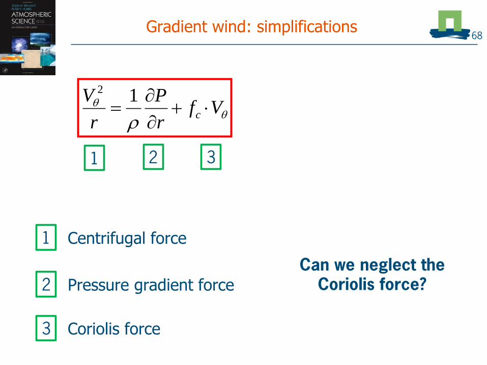
Gradient wind: simplifications
Centrifugal force
Vf
r
P
r
Vc
12
This is our fundamental equation
68
1 2 3
1
Pressure gradient force2
Coriolis force3
Can we neglect the Coriolis force?

Rossby number – quantifying length scales
Relative importance of:
Centrifugal force, Fcp
Coriolis force, Fcor
Vf
r
P
r
Vc
12
I II III
69
Carl-GustafRossby
(1898-1957)

Rossby number
Relative importance of:
Centrifugal force, Fcp
Coriolis force, Fcor
Definition:
rf
V
Vf
rV
F
FRo
cccor
cp
/
2
Vf
r
P
r
Vc
12
I II III
Ro decides if (III) can be neglected in approximations
Ro depends on scale!!
70

What balance holds?
1) Tornado
r = 100 m
v = 300 km/h
Lat = 30N
2) Polar low:
r = 300 km
v = 100 km/h
Lat = 80N
71
𝑹𝒐 =𝑽𝜽
𝒇𝒄𝒓
Ro >~5 = cyclostrophic balance: neglect Coriolis force
Ro<~5 = use no approximation; i.e. use gradient wind
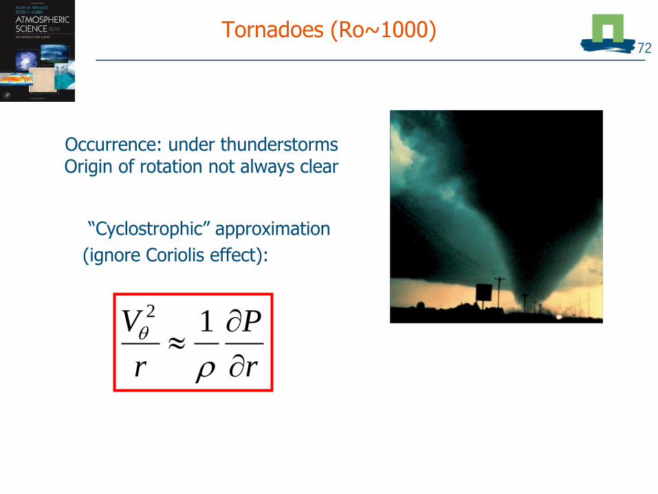
Tornadoes (Ro~1000)
“Cyclostrophic” approximation
(ignore Coriolis effect):
r
P
r
V
12
Occurrence: under thunderstormsOrigin of rotation not always clear
72

Polar low
(Ro 15)
r
P
R
V
12
“Cyclostrophic” approximation
73

Hurricanes: strong tropical cyclone
(Ro 1 - 10)
r
P
R
V
12
“Cyclostrophic” approximation
74

Synoptic Low’s or High’s (Ro 0 - 0.1)
Either gradient wind or geostrophic approximation
Vfr
Pc
10
Vf
r
P
r
Vc
12
75

Synoptic Low’s or High’s (Ro 0 - 0.1)
Either gradient wind or geostrophic approximation
Vfr
Pc
10
Vf
r
P
r
Vc
12
76
Only in case when isobars are straight (Ro 0) Centrifugal
force can be neglected

Tropical cyclones 77

Hurricanes: strong tropical cyclone
(Ro 1 - 10)
r
P
R
V
12
“Cyclostrophic” approximation
78

Tropical cyclone formation79

Tropical cyclone formation same
mechanism as polar low! 80

From a tropical disturbance...81
Warm and humid air rises and creates thunderstorms

To a hurricane82
High sea water temperatures enhance evaporation and growth of the system
>

Generation of tropical cyclones83
Rotation of the earth sets the tropical cyclone in motionand allows the system to organize

Tropical cyclone formation areas84
Hurricanes require warm sea water (> 26.5 C) and should not be too close to equator

Tropical cyclone formation areas – exceptions85
Catharina (2002)

Tropical cyclone formation areas – exceptions86
Catharina (2002)
Pali (2016)
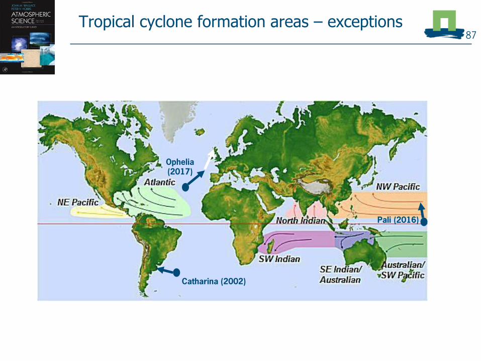
Tropical cyclone formation areas – exceptions87
Catharina (2002)
Ophelia (2017)
Pali (2016)

Hurricane Ophelia88
Non-tropical
Tropical

Ophelia southwest of Spain89
Netherlands

Ophelia southwest of Spain90
Netherlands
Ophelia

Ophelia southwest of Spain91
Netherlands
Ophelia

Tropical cyclone impact92

Animation of Hurricane Harvey (2017) satellite93

Impact
Winds
Storm Surge
Rainfall
94
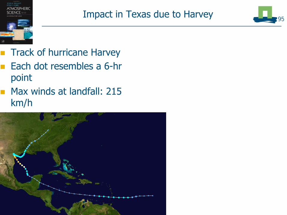
Impact in Texas due to Harvey
Track of hurricane Harvey
Each dot resembles a 6-hr point
Max winds at landfall: 215 km/h
95

Impact in Texas due to Harvey
Track of hurricane Harvey
Each dot resembles a 6-hr point
Max winds at landfall: 215 km/h
96
What caused the most impact?• Flooding due to rain?• Wind damage?• Storm surge?
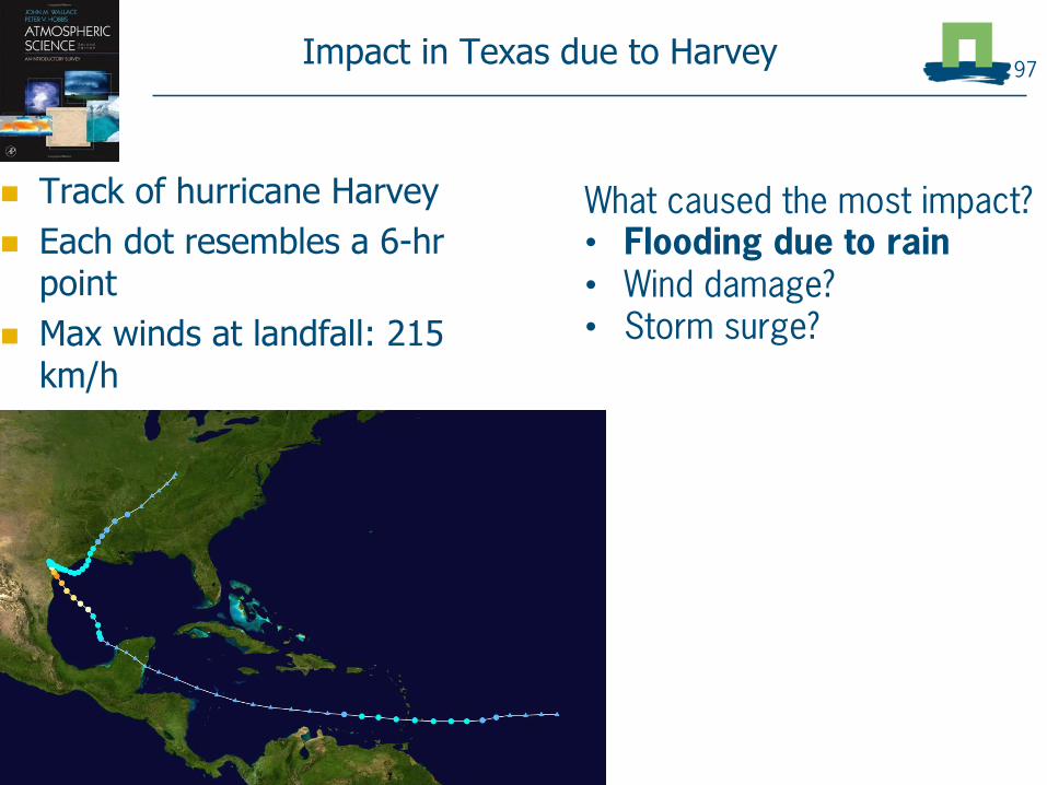
Impact in Texas due to Harvey
Track of hurricane Harvey
Each dot resembles a 6-hr point
Max winds at landfall: 215 km/h
97
What caused the most impact?• Flooding due to rain• Wind damage?• Storm surge?

Summary
Frontal systems associated with low pressure areas largely determine the day-to-day weather in Western Europe.
Rotation of cyclones on large range of scales can be classified according to Rossby number
Tropical cyclones are high-impact tropical weather systems that have a complex structure and naming
98

There’s more!
More on weather maps and interpretation in
Atmospheric Practical,
Period 4 (Feb) with excursion in last week
(scheduled in BSc-SWA program in third year)
More on theory of atmospheric motions in
MSc course Atmospheric Dynamics
99

Tropical cyclone structure100

Tropical cyclone structure101
Rainbands with drier areas, and a clear eye
Eyewall Eye
>

Structure of tropical cyclones102
Tilted depiction

Example: Hurricane Harvey (2017)
Radar image 103
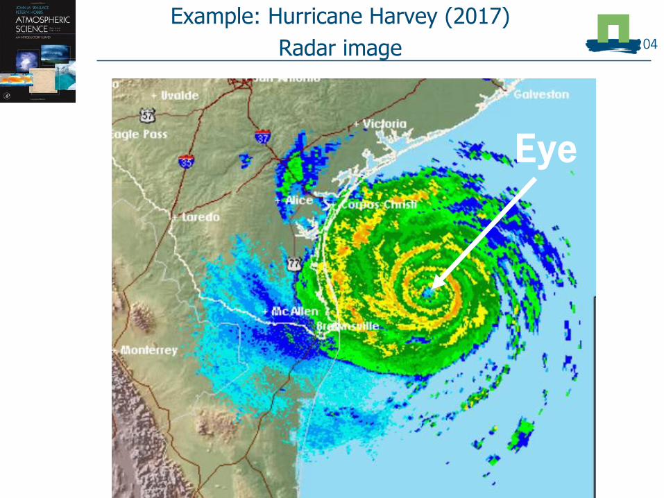
Example: Hurricane Harvey (2017)
Radar image 104
Eye

Example: Hurricane Harvey (2017)
Radar image 105
Eyewall

Example: Hurricane Harvey (2017)
Radar image 106

Tropical cyclones – the naming chaos 107
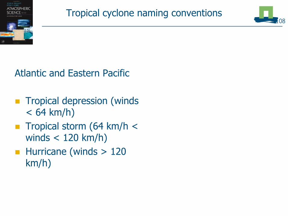
Tropical cyclone naming conventions
Atlantic and Eastern Pacific
Tropical depression (winds < 64 km/h)
Tropical storm (64 km/h < winds < 120 km/h)
Hurricane (winds > 120 km/h)
108

Tropical cyclone naming conventions
Atlantic and Eastern Pacific
Tropical depression (winds < 64 km/h)
Tropical storm (64 km/h < winds < 120 km/h)
Hurricane (120 km/h < winds < 209 km/h)
Major hurricane (winds > 209 km/h
West Pacific
Tropical depression (winds < 64 km/h)
Tropical storm (64 km/h < winds < 120 km/h)
Typhoon (winds > 120 km/h)
Super typhoon (winds > 240 km/h)
109

Tropical cyclone naming conventions
Atlantic and Eastern Pacific
Tropical depression (winds < 64 km/h)
Tropical storm (64 km/h < winds < 120 km/h)
Hurricane (120 km/h < winds < 209 km/h)
Major hurricane (winds > 209 km/h
West Pacific
Tropical depression (winds < 64 km/h)
Tropical storm (64 km/h < winds < 120 km/h)
Typhoon (winds > 120 km/h)
Super typhoon (winds > 240 km/h)
110
In Southern Hemisphere and Indian Ocean Basin, names are even different!

![[PPT]Modulation, Demodulation and Coding Course · Web viewDigital Communications I: Modulation and Coding Course Term 3 - 2008 Catharina Logothetis Lecture 8 Last time we talked](https://static.fdocuments.in/doc/165x107/5af3a5bb7f8b9a4d4d8c6d55/pptmodulation-demodulation-and-coding-viewdigital-communications-i-modulation.jpg)