
Lecture 28 Landslides (Mass Movements) John Rundle GEL 131 WQ2014.
19
Lecture 28 Landslides (Mass Movements) John Rundle GEL 131 WQ2014
-
Upload
kenya-setters -
Category
Documents
-
view
215 -
download
1
Transcript of Lecture 28 Landslides (Mass Movements) John Rundle GEL 131 WQ2014.

Lecture 28
Landslides (Mass Movements)John Rundle GEL 131 WQ2014

Global Landslide Statistics, 1980-2008http://www.preventionweb.net/english/hazards/statistics/?hid=65
Persons Affected
Economic Damage (USD in B$)
Persons Killed Number of Reported Events

Global LandslidesSummary Statistics, 1980-2008
http://www.preventionweb.net/english/hazards/statistics/?hid=65

Landslideshttp://en.wikipedia.org/wiki/Landslide
• “A landslide is a geological phenomenon which includes a wide range of ground movements.
• These include rockfalls, deep failure of slopes and shallow debris flows, which can occur in offshore, coastal and onshore environments.
• Although the action of gravity is the primary driving force for a landslide to occur, there are other contributing factors affecting the original slope stability.
• Typically, pre-conditional factors build up specific sub-surface conditions that make the area/slope prone to failure, whereas the actual landslide often requires a trigger before being released.”
“Computer simulation of a "slump" landslide in San Mateo County, California (USA) in
January 1997”

Causes of Landslideshttp://en.wikipedia.org/wiki/Landslide
“Landslides occur when the stability of the slope changes from a stable to an unstable condition. A change in the stability of a slope can be caused by a number of factors, acting together or alone.
Natural causes of landslides include:• Groundwater (pore water) pressure acting to destabilize the slope• Loss or absence of vertical vegetative structure, soil nutrients, and soil structure (e.g.
after a Wildfire(e.g.fire in forests etc.lasting for 3–4 days)• Erosion of the toe of a slope by rivers or ocean waves• Weakening of a slope through saturation by snow melt, glaciers melting, or heavy
rains• Earthquakes adding loads to barely stable slope• Earthquake-caused liquefaction destabilizing slopes• Volcanic eruptionsLandslides are aggravated by human activities, such as • Deforestation, cultivation and construction, which destabilize the already fragile
slopes.• Vibrations from machinery or traffic• Blasting• Earthwork which alters the shape of a slope, or which imposes new loads on an
existing slope in shallow soils, the removal of deep-rooted vegetation that binds colluvium to bedrock
• Construction, agricultural or forestry activities (logging) which change the amount of water which infiltrates the soil.”

Exampleshttp://pubs.usgs.gov/fs/
2004/3072/fs-2004-3072.html

Types of Landslides

Debris Flowhttp://en.wikipedia.org/wiki/Landslide
• “Slope material that becomes saturated with water may develop into a debris flow or mud flow.
• The resulting slurry of rock and mud may pick up trees, houses and cars, thus blocking bridges and tributaries causing flooding along its path.
• Debris flow is often mistaken for flash flood, but they are entirely different processes.
• Muddy-debris flows in alpine areas cause severe damage to structures and infrastructure and often claim human lives.
• Muddy-debris flows can start as a result of slope-related factors and shallow landslides can dam stream beds, resulting in temporary water blockage.
• As the impoundments fail, a "domino effect" may be created, with a remarkable growth in the volume of the flowing mass, which takes up the debris in the stream channel.
• The solid-liquid mixture can reach densities of up to 2 tons/m³ and velocities of up to 14 m/s”“Amboori debris flow, which occurred on 9
November 2001 in Kerala, India. The event killed 39 people.”

Debris Flowhttp://en.wikipedia.org/wiki/Landslide
• “These processes normally cause the first severe road interruptions, due not only to deposits accumulated on the road (from several cubic metres to hundreds of cubic metres), but in some cases to the complete removal of bridges or roadways or railways crossing the stream channel.
• Damage usually derives from a common underestimation of mud-debris flows
• In alpine valleys, for example, bridges are frequently destroyed by the impact force of the flow because their span is usually calculated only for a water discharge.
• For a small basin in the Italian Alps (area = 1.76 km²) affected by a debris flow, Chiarle and Luino (1998) estimated a peak discharge of 750 m3/s for a section located in the middle stretch of the main channel.
• At the same cross section, the maximum foreseeable water discharge had been19 m³/s, a value about 40 times lower than that calculated for the debris flow that occurred.”

Earthflowhttp://en.wikipedia.org/wiki/Landslide
• “Earthflows are downslope, viscous flows of saturated, fine-grained materials, which move at any speed from slow to fast.
• Typically, they can move at speeds from 0.17 to 20 km/h.
• Though these are a lot like mudflows, overall they are slower moving and are covered with solid material carried along by flow from within.
• They are different from fluid flows in that they are more rapid.
• Clay, fine sand and silt, and fine-grained, pyroclastic material are all susceptible to earthflows.
• The velocity of the earthflow is all dependent on how much water content is in the flow itself:
• if there is more water content in the flow, the higher the velocity will be.”
Rock slide in Guerrero, Mexico

Earthflowhttp://en.wikipedia.org/wiki/Landslide
http://pubs.usgs.gov/fs/2004/3072/fs-2004-3072.html
• “These flows usually begin when the pore pressures in a fine-grained mass increase until enough of the weight of the material is supported by pore water to significantly decrease the internal shearing strength of the material.
• This thereby creates a bulging lobe which advances with a slow, rolling motion.
• As the lobes spread out, drainage of the mass increases and the margins dry out, thereby lowering the overall velocity of the flow.
• This process causes the flow to thicken.
• The bulbous variety of earthflows are not that spectacular, but they are much more common than their rapid counterparts.
• They develop a sag at their heads and are usually derived from the slumping at the source. ”

Earthflowhttp://en.wikipedia.org/wiki/Landslide
• “Earthflows occur much more during periods of high precipitation, which saturates the ground and adds water to the slope content.
• Fissures develop during the movement of clay-like material which creates the intrusion of water into the earthflows.
• Water then increases the pore-water pressure and reduces the shearing strength of the material.”• “La Conchita, coastal area of southern
California. • This landslide and earthflow occurred in
the spring of 1995. • People were evacuated and the houses
nearest the slide were completely destroyed.
• This is a typical type of landslide.”

Debris Landslidehttp://en.wikipedia.org/wiki/Lands
lide
• “A debris slide is a type of slide characterized by the chaotic movement of rocks soil and debris mixed with water or ice (or both).
• They are usually triggered by the saturation of thickly vegetated slopes which results in an incoherent mixture of broken timber, smaller vegetation and other debris.
• Debris avalanches differ from debris slides because their movement is much more rapid.
• This is usually a result of lower cohesion or higher water content and commonly steeper slopes.
• Steep coastal cliffs can be caused by catastrophic debris avalanches.
• These have been common on the submerged flanks of ocean island volcanos such as the Hawaiian Islands and the Cape Verde Islands.”
Goodell Creek Debris Avalanche, Washington

Debris Landslidehttp://en.wikipedia.org/wiki/Landslide
• “Movement: Debris slides generally start with big rocks that start at the top of the slide and begin to break apart as they slide towards the bottom.
• This is much slower than a debris avalanche. Debris avalanches are very fast and the entire mass seems to liquefy as it slides down the slope.
• This is caused by a combination of saturated material, and steep slopes.
• As the debris moves down the slope it generally follows stream channels leaving a v-shaped scar as it moves down the hill.
• This differs from the more U-shaped scar of a slump.
• Debris avalanches can also travel well past the foot of the slope due to their tremendous speed.”
Goodell Creek Debris Avalanche, Washington

Shallow Landslideshttp://en.wikipedia.org/wiki/Landslide
• “Shallow landslides can often happen in areas that have slopes with high permeable soils on top of low permeable bottom soils.
• The low permeable, bottom soils trap the water in the shallower, high permeable soils creating high water pressure in the top soils.
• As the top soils are filled with water and become heavy, slopes can become very unstable and slide over the low permeable bottom soils.
• If there is a slope with silt and sand as its top soil and bedrock as its bottom soil, then during an intense rainstorm, the bedrock will keep the rain trapped in the top soils of silt and sand.
• As the topsoil becomes saturated and heavy, it can start to slide over the bedrock and become a shallow landslide. R. H. Campbell did a study on shallow landslides on Santa Cruz Island California.
• If permeability decreases with depth, a perched water table may develop in soils at intense precipitation.
• When pore water pressures are sufficient to reduce effective normal stress to a critical level, failure occurs.”
• Hotel Limone at the Lake Garda. • The upper block detached along a
bedding plane and is sliding down the hill, forming a jumbled pile of rock at the toe of the slide.

Deep-Seated Landslideshttp://en.wikipedia.org/wiki/Landslide
• “Landslides in which the sliding surface is mostly deeply located below the maximum rooting depth of trees (typically to depths greater than ten meters).
• Deep-seated landslides usually involve deep regolith, weathered rock, and/or bedrock and include large slope failure associated with translational, rotational, or complex movement.
• These typically move slowly, only several meters per year, but occasionally move faster.
• They tend to be larger than shallow landslides and form along a plane of weakness such as a fault or bedding plane.
• They can be visually identified by concave scarps at the top and steep areas at the toe.”
• “Deep-seated landslide on a mountain in Sehara, Kihō, Japan, beside the Kumano river between Wakayama and Mie.
• Slide was caused by torrential rain of Tropical Storm Talas”

Global Landslide Hazardhttp://en.wikipedia.org/wiki/Landslide

Mapping Landslide Potentialhttp://en.wikipedia.org/wiki/Landslide
• “Using satellite imagery in combination with GIS and on-the-ground studies, it is possible to generate maps of likely occurrences of future landslides.
• Such maps should show the locations of previous events as well as clearly indicate the probable locations of future events.
• In general, to predict landslides, one must assume that their occurrence is determined by certain geologic factors, and that future landslides will occur under the same conditions as past events.
• It is necessary to establish a relationship between the geomorphologic conditions in which the past events took place and the expected future conditions.
• Sustainable land management and development is an essential key to reducing the negative impacts felt by landslides.
• GIS offers a superior method for landslide analysis because it allows one to capture, store, manipulate, analyze, and display large amounts of data quickly and effectively.
• Because so many variables are involved, it is important to be able to overlay the many layers of data to develop a full and accurate portrayal of what is taking place on the Earth's surface.
• Researchers need to know which variables are the most important factors that trigger landslides in any given location.
• Using GIS, extremely detailed maps can be generated to show past events and likely future events which have the potential to save lives, property, and money.”
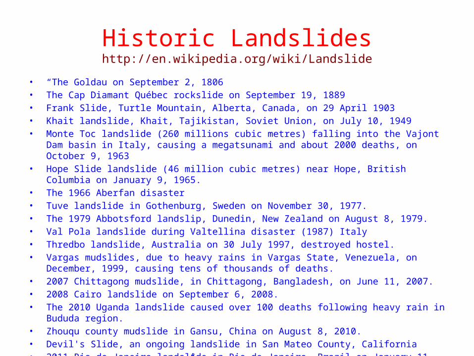
Historic Landslideshttp://en.wikipedia.org/wiki/Landslide
• “The Goldau on September 2, 1806• The Cap Diamant Québec rockslide on September 19, 1889• Frank Slide, Turtle Mountain, Alberta, Canada, on 29 April 1903• Khait landslide, Khait, Tajikistan, Soviet Union, on July 10, 1949• Monte Toc landslide (260 millions cubic metres) falling into the Vajont Dam basin in
Italy, causing a megatsunami and about 2000 deaths, on October 9, 1963• Hope Slide landslide (46 million cubic metres) near Hope, British Columbia on January
9, 1965.• The 1966 Aberfan disaster• Tuve landslide in Gothenburg, Sweden on November 30, 1977.• The 1979 Abbotsford landslip, Dunedin, New Zealand on August 8, 1979.• Val Pola landslide during Valtellina disaster (1987) Italy• Thredbo landslide, Australia on 30 July 1997, destroyed hostel.• Vargas mudslides, due to heavy rains in Vargas State, Venezuela, on December,
1999, causing tens of thousands of deaths.• 2007 Chittagong mudslide, in Chittagong, Bangladesh, on June 11, 2007.• 2008 Cairo landslide on September 6, 2008.• The 2010 Uganda landslide caused over 100 deaths following heavy rain in Bududa
region.• Zhouqu county mudslide in Gansu, China on August 8, 2010.• Devil's Slide, an ongoing landslide in San Mateo County, California• 2011 Rio de Janeiro landslide in Rio de Janeiro, Brazil on January 11, 2011, causing
610 deaths.”