LEATHERHEAD & DISTRICT LOCAL HISTORY SOCIETYldlhsarchive.co.uk/proceedings/VOL_2_NO_8_1964.pdf ·...
35
PROCEEDINGS OF THE LEATHERHEAD & DISTRICT LOCAL HISTORY SOCIETY VOL. 2 No. 8 1964 ■xx\
Transcript of LEATHERHEAD & DISTRICT LOCAL HISTORY SOCIETYldlhsarchive.co.uk/proceedings/VOL_2_NO_8_1964.pdf ·...
PROCEEDINGSOF THE
LEATHERHEAD & DISTRICT LOCAL HISTORY SOCIETY
VOL. 2 No. 8
1964
■xx\

SECRETARIAL NOTES
T he f o l l o w i n g Lectures and Visits were arranged during 1964:—
February 26th Lecture: “Recent excavations in Ewell by the Nonsuch and Ewell Antiquarian Society” , by N. H. Nail.
March 20th Annual General Meeting, followed by “Animal, Vegetable and Mineral” .April 22nd Lecture: “Bygone Bookham”, by S. E. D. Fortescue.June 4th Lecture: “In search of a Grandfather in Finland” , by Mrs. E. Taylor.July 11th Visit to Ashtead Church; described by the President.August 8th Visit to Museum of Rural Bygones, Wonersh.August 22nd Visit to Hatchlands.October 3rd Visit to Sutton Place, Guildford.October 30th Lecture: “Recent discovery of Roman Ship at Blackfriars” , by P. Marsden.
November 18th Lecture: “Wind and Watermills” , by A. Stowers.December 5th Lecture: “Edmund Tilney—a contribution to the Shakespeare quatercen-
tenary” , by F. B. Benger.
No. 7 of Volume 2 of the Proceedings was issued during the year.
EIGHTEENTH ANNUAL GENERAL MEETINGHeld at the Council Offices, Leatherhead, on Friday, 20th March, 1964
'T H E REPORT of the Executive Committee and the Accounts for the year 1963 were adopted and approved. Officers of the Society were elected as shown below.
OFFICERS FOR THE YEAR 1964President: C a p t . A. W. G. LOWTHER, F.S.A., A.R.I.B.A.Chairman: A. T. RUBY, M.B.E.Hon. Secretary: J. G. W. LEWARNE
(69 Cobham Road, Fetcham, Leatherhead, Surrey. Tel. Leatherhead 3736)Hon. Treasurer: W. T. BRISTOW
(Lloyds Bank, Leatherhead, Surrey)Hon. Programme Secretary: M r s . B. HAYNES
(Sans Nom, Fir Tree Road, Leatherhead. Tel. Leatherhead 3549) Committee Members: F. B. BENGER, S. E. D. FORTESCUE Hon. Librarian: T. C. WILLIAMS, The Mansion, Church Street, LeatherheadHon. Editor o f the Proceedings: F. B. BENGER
(Duntisbourne, Reigate Road, Leatherhead. Tel. Leatherhead 2711)
P R O C E E D I N G S
o f the
Leatherhead and District Local History Society
Vol. 2, No. 8
1 9 6 4
CONTENTS
page
Occasional N otes . . . . . . . . . . •. • • • • • • 222
Wild-Life Changes near Leatherhead. H. W. M a c k w o r t h -P r a e d , F.R .G .S . . . 223
The Leatherhead River. A. T. R u b y , M .B.E. . . . . . . . . . . 228
History of the Church and Advowson o f St. M ary and St. N icholas, Leatherhead:
C hapter III. T h e L a t e G. H . S m i t h ....................................................... 248
Secretarial N otes . . . . . . . . . • • • • • • • Cover ii
Accounts . . . . . . . . . . • • • • • ■ • • Cover iii
Illustrations:
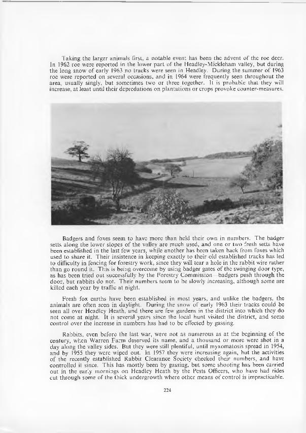
Little Switzerland Valley from Hyde Farm , Headley . . . . on page 224
M ap o f the River Mole within the Leatherhead area . . . . facing page 228
Fishing below Leatherhead Bridge, circa 1890 . . . . on page 235
Fetcham Splash, circa 1912 . . . . . . . . . . on page 237
Diagram s o f the M ole . . . . . . . . • • • • on page 239
Leatherhead Bridge and Mill, circa 1855 . . . . . . . . on page 244
Old key found near Leatherhead Bridge (colophon) . . . . on cover iv
221
OCCASIONAL NOTES
THE SHARNWELL
/ " \N T H E SO U T H E R N SID E o f the drive from D orking Road to Thorncroft House, ^ Leatherhead, alm ost opposite the lodge building, a spring o f clear water emerges from a culvert and by a short brook joins the river Mole. The source of the w ater, no doubt, is in the chalk to the east, and its clarity may be due to filtration by the gravels of Elm Bank. The older inhabitants o f Leatherhead claimed tha t the w ater was of value in the treatm ent o f m inor eye ailm ents (which the w riter may support from his own experience). It is possibly o f a mildly chalybeate character, though it is not known to have been chemically analysed. The spring is m entioned in M anning & Bray’s History o f Surrey 1804-1814 (Vol. II, p. 666) and W illiam C otton, in the valuable historical notes appended to Miss M ary D rinkw ater-B ethune’s poem The River M ole or Emlyn Stream 1839 (p. 29) adds the inform ation tha t in old deeds it was called Sharnwell. It will be recalled th a t in the earliest know n C ourt Roll o f the M anor o f Pachenesham , 1319, the nam e o f Cecily de Scharnwelle occurs (see Proceedings, Vol. II, N o. 6, pp. 170-175) and th a t Mr. John Harvey, F.S.A., in his accom panying article wrote th a t this nam e probably derived from a place— “ The Scharnwelle or m uddy spring may have been anyw here” . Before the spring was run through a culvert it probably fell direct on to the alluvium o f the river and produced a muddy patch. I t seems ju s t possible th a t the habitation o f Cecily or her forbears was hereabouts.
F. B. B.
The following note has been kindly sent by M r. T. E. C. W alker, F .S .A .:—
THE CHASE OF HAM PTON COURT
T O SELEY M A N U SC R IPTS Nos. 718, 719, 721, a t G uildford M unim ent Room, deal with the construction o f the fence round H enry V IIl’s Chase o f H am pton C ourt in
1537-8. The Chase was outside our Society’s area, but some o f the tim ber for the fence was taken from A shtead C om m on, Bookham C om m on, and the N ockett a t Eastwick Park, C annon C ourt a t Fetcham , Leatherhead Com m on, and Mickleham. A shtead and Bookham C om m on also supplied tim ber for N onsuch.1 N o paym ent for the trees is recorded, but cartage came to 2d. a mile. One o f the carters was John Rumm yng who in November 1537 received 3s. 4d. fo r conveying four loads of pale tim ber from Epsom Park and Comm on to Fairm ile and Chargate. R icherd Lethered was paid 5d. a day as a paler, H ary Lethered 5d. a day as a ditcher, and W illiam Lethered 4d. a day as a quicksetter or planter o f bushes along the fence.
We are indebted to M r. John Harvey, F.S.A ., for the following no te:—
THE ORIGIN OF THE NAM E POLESDEN LACY
T ^H E O R IG IN o f the “ m anorial or pseudo-m anorial add ition” 1 (Lacy), now mistakenly *- attached to the form er m anor o f High Polesden in G reat Bookham ,2 has hitherto re
m ained mysterious. The source has now been revealed by the publication o f volume V of the Calendar o f Inquisitions Miscellaneous.3 This shows that on 12th November, 1387, an inquisition was taken at K ingston-upon-Tham es before R obert Loxle, escheator in Surrey, and th a t it was found tha t: “ John Lacy gave no lands to the prio r or convent o f M erton, bu t during his life gave all his lands in Co. Surrey in fee simple to R obert C harleton, John Cassy, N icholas Slyfeld and John H olte o f M erton according to his charter thereof. The
I. J. Dent, The Quest for Nonsuch, p. 275.
222
prior occupies and takes the profits o f the said lands, which are in Chysynden, Hoke, Talw orth, Longeditton and Polesden, but the ju ro rs do no t know by w hat title he does so, though he claims them as his by the com m on report o f the country. They are w orth £6 net yearly. No part o f them is held o f the king in chief.” 4
The date o f the transaction by which John Lacy left his estate to feoffees m ust have been within the half-century preceding the inquisition, since N icholas Slyfeld was doubtless the lord o f tha t m anor in G reat Bookham , who succeeded his fa ther John Slyfeld in 1329 as a child, and died c. 1395. He was a Collector o f the Tax in Surrey in 1360, was one of the Knights of the Shire in the Parliam ent o f 1382-83, and sat on Com m issions o f the Peace for the county in 1389, 1390, and 1394.5
NOTES1. J. E. B. Gover, A. Mawer and F. M. Stenton, The Place-Names o f Surrey (English Place-Name Society,
Vol. XI), 1934, 100.2. For the confusion between the distinct manors of High Polesden in G reat Bookham, and Polesden
Lacy (or Lacey) in Mickleham, see J. H. Harvey, “ Polesden: the Nam e and the Place” in Surrey Archaeological Collections, Vol. L, 1949, 161-4. The two manors came to be held together by the Geary family in the eighteenth century, after which the suffix properly belonging to the Mickleham estate became transferred to the capital messuage in G reat Bookham, for whose history see F. B. Benger, “ Polesden, Great Bookham'’ in Proceedings, Leatherhead & D istrict Local History Society, Vol. 1, No. 9, 1955, pp. 25-29.
3. Calendar o f Inquisitions Miscellaneous (Chancery), V (1387-1393), H.M .S.O., 1962.4. Ibid., No. 122, p. 94, from Exchequer Enrolments of Inquisitions 256, fourteenth entry. It is perhaps
worth noting that the entry in the index wrongly identifies Polesden Lacy as being in G reat Bookham, whereas the reputed m anor as held by Merton Priory lay entirely in the parishes of Mickleham and Dorking.
5. G. N. Slyfield and J. H. Harvey, Slyfield Manor and Family o f Great Bookham, Surrey, 1953.
T H E CA R TO G R A PH IC A L SURVEY T 'H E C A R T O G R A PH IC A L SU RV EY will be continued in the next num ber, when * the tenth o f the series will deal w ith the Fetcham T ithe M ap o f 1791, which will be
described by M r. J. G. W. Lewarne.
WILD-LIFE CHANGES NEAR LEATHERHEADBy H. W. M A C K W O R T H -PR A E D , F .R .G .S ., F .R .E.S.
TT M AY N O T be thought out o f place to include in these Proceedings an account of changes that have been noticed in the relative prevalence o f the fauna o f an area within
walking distance o f Leatherhead, and which may to some extent be typical o f the district as a whole. The period covered is the fifteen years from 1950 to 1964, during which m any natural or m an-m ade events have alfected the wild-life o f Surrey, and the area o f observation taken is the western half o f the parish o f Headley. If, for instance, one leaves Leatherhead by the Reigate Road, and, on reaching the crest beyond Tyrrells W ood golf course, one turns right along the bridle path running along the crest to M ickleham G allops, there are many places from which this area can be viewed. N ear a t hand are the slopes o f the Little Switzerland valley, farm land and rough fields o f chalk dow nland, w ith some recent conifer plantations and older woods o f coppice and standards. Beyond is Headley H ea th ; 500 acres o f bracken, heather and gorse on Tertiary deposits overlying the chalk, colonized since the W ar by birch scrub, and much frequented by visitors. To the north is N ower W ood, a privately-owned and secluded area o f mixed w oodland with dense undergrowth which makes its penetration difficult. The to tal area o f ra ther over a square mile thus exhibits a considerable contrast in scenery and vegetation. D uring the years mentioned a record has been kept o f species encountered, and though observation has been far from continuous, it has probably been sufficiently consistent over the period to form an estim ate o f the fluctuations in certain species.
223
Taking the larger anim als first, a notable event has been the advent o f the roe deer. In 1962 roe were reported in the lower p a rt of the H eadley-M ickleham valley, but during the long snow o f early 1963 no tracks were seen in Headley. D uring the sum mer of 1963 roe were reported on several occasions, and in 1964 were frequently seen throughout the area, usually singly, but sometimes two or three together. It is probable th a t they will increase, a t least until their depredations on p lantations or crops provoke counter-m easures.
Badgers and foxes seem to have m ore than held their own in numbers. The badger setts along the lower slopes o f the valley are m uch used, and one or two fresh setts have been established in the last few years, while ano ther has been taken back from foxes which used to share it. Their insistence in keeping exactly to their old established tracks has led to difficulty in fencing for forestry work, since they will tear a hole in the rabbit wire rather than go round it. This is being overcome by using badger gates o f the swinging door type, as has been tried ou t successfully by the Forestry Comm ission— badgers push through the door, but rabbits do not. Their num bers seem to be slowly increasing, although some are killed each year by traffic a t night.
Fresh fox earths have been established in m ost years, and unlike the badgers, the anim als are often seen in daylight. D uring the snow o f early 1963 their tracks could be seen all over H eadley H eath, and there are few gardens in the district into which they do not come a t night. It is several years since the local hunt visited the district, and some control over the increase in num bers has had to be effected by gassing.
R abbits, even before the last war, were not as num erous as a t the beginning of the century, when W arren F arm deserved its name, and a thousand or m ore were shot in a day along the valley sides. But they were still plentiful, until myxom atosis spread in 1954, and by 1955 they were wiped out. In 1957 they were increasing again, but the activities o f the recently established R abbit Clearance Society checked their numbers, and have controlled it since. This has mostly been by gassing, but some shooting has been carried ou t in the early m ornings on Headley H eath by the Pests Officers, who have had rides cut through some o f the thick undergrow th where o ther means o f control is impracticable.
224
The R abbit C learance Society has also arranged some shoots by headlights after dark on the stubble fields in autum n, resulting in bags o f fifty or so in the season in one field alone.
Hares have declined in num bers: they were never as com m on as in the A shtead district to the north, and are now seldom seen. G rey squirrels rem ain only too com m on, but stoats and weasels have not been as num erous as formerly, and are only seen occasionally. Hedgehogs remain com m on, in spite o f heavy casualties on the roads. Moles appear to be increasing.
N o m ajor changes in reptiles and am phibians have come to notice. Slow-worms and grass-snakes are not uncom m on, but no adder has been reported recently, and the finding of a South American species o f boa-constrictor on Headley H eath after the fire in 1956, and apparently alive before it, rem ains an unexplained mystery. A drought in 1959 caused a spectator to sum m on the R .S.P.C.A . and the Fire Brigade to the aid o f stranded fishes in the Brimmer Pond on Headley H eath. A bout a dozen were evacuated to a tank in my garden, and returned the following winter. They were goldfish, which had lost their gold colour, and grown to a length o f about nine inches.
M any species of birds have vanished from the area or declined noticeably in num bers over the last fifteen years. Factors contributing to this decline would appear to include: (a) increased use o f toxic chemicals by farm ers and gardeners; (b) increased disturbance by visitors, both riders and walkers, and their dogs; (c) increased num bers o f egg-eaters, such as crows, magpies, and grey squirrels, and also o f cats; (d) scrub spreading over the clearings needed by some species; (e) the hard winter o f 1962-63 and, m ore locally (f) the fire which burnt half o f Headley Heath one day in the nesting season o f 1956. A gainst these we have (a) the changes in farming practice which have helped certain species, mainly the com m oner ones; (b) the increase in evergreen trees—yew, holly, spruce, and pine— giving winter pro tection; (c) the increase in houses and gardens, and o f w inter feeding o f birds by their occupiers; and (d) the decrease in keepering. G am ekeepers kept dow n the num ber o f jays, magpies, and crows, bu t their larders often included birds such as hawks and owls.
O f the larger birds, buzzards have no t been seen for m any years—previously there was usually a pair about the valley, and their mewing could often be heard as they soared above it. Once one was seen to “ buzz” a heron, a rem arkable sight! Sparrow-haw ks have also gone; though one was seen three times in 1964 further down the valley. The kestrel has returned recently after a gap o f a few years, bu t is no t as com m on as before. The night-jar, which used to be such a feature o f the district, is hardly even seen or heard now, though at least one pair bred in 1963. Pheasants have increased through infiltration from properties where they are reared for shooting, but partridges are only occasionally seen on the farm land, where up to ten years ago there were always three or m ore coveys. The French partridge has not been m uch in evidence since the war, bu t occasional birds are seen. W oodcock breed in the area, and are sometimes present in considerable num bers in winter. Pairs o f m allard visit the few ponds each spring, bu t none o f these is safe from foxes; possibly they may be able to breed in the fenced lagoon being made for the Boxhill drainage scheme at the southern end o f Headley H eath. Plover seldom visit the area, though common a mile to the north. Rooks have declined in num bers, but their place on the farm land has been m ore than taken in the last two or three years by large flocks o f gulls. Where these roost is not know n; perhaps the Tham es valley reservoirs, since they flight north-westwards each evening. A large flock o f feral pigeons has also been visiting the farm lands recently, often outnum bering the wild pigeons present.
O ther species which have noticeably increased over the period include the starling and house sparrow, which benefit from intensive farm ing, and garden birds, especially song thrushes, blackbirds, and tits, and also the bullfinch.
It is not the purpose o f this article to list the many other species o f birds m ore or
225
less com m only found in the area, bu t whose num bers have no t altered strikingly in the period under review, except through tem porary variations due to hard w inters; nor the rarities which visit us from tim e to time. A bout 70 species have in fact been recorded over the period.
For reasons fo r changes in the relative abundance o f insects, we need to seek more detailed causes. F or m any these lie in the changes in the food plants available to the larvae. F or butterflies for instance, three m ain factors have affected the area, two o f them connected w ith farm ing practice. Firstly the weed control on farm land has increased th rough chemical and other means, so tha t m any o f the food plants have been reduced. Secondly, there has been a change in the crops grown for silage from lucerne to various form s o f grasses. A th ird factor is the reduction in rabbit numbers. The effect o f this last is tw ofold; on the one hand the increase in plants previously eaten by the rabbits has provided m ore food plants fo r some species. But against this there is the reduction in certain o ther plants through their stifling by scrub or by grasses which were formerly eaten by the rabbits. F o r instance, the rabbits used to browse the top o f the many anthills on chalk dow nland, allowing the thym e to flourish; now it is choked by coarse grasses. The same is true o f some o f the vetches, and this particularly affects some o f the blue butterflies. Fritillaries however have increased, through the violets (which are their food- plant) not being cropped by the rabbits.
Thirty-six species o f butterflies have been recorded in the area—rather over half the num ber o f recorded British species. All are fairly com m only distributed in the south of England. Three species have increased: the Com m a is m ore plentiful than formerly, being seen several a t a tim e in gardens in the late sum mer, and again after hibernation on sunny days in early spring. The large D ark G reen Fritillary has increased, and is often seen flying over the dow nland and settling on the thistles. The D uke o f Burgundy has also increased, especially in an area where clearance o f scrub has allowed the spread o f the cowslips which are its food plant.
The fields o f lucerne, which until 1958 used to border the chalk dow nland, were harvested for silage, or grazed, several times a year, but it often happened tha t in late summer they cam e in to flower before being cropped. They were then alive with butterflies and were visited by alm ost all the sum m er species, particularly the Chalkhill and other blues, and, later on, the C louded Yellow. However, since 1958 the Chalkhill and Azure blues have not been seen in either o f their two form er habitats, while the Silver Spotted Skipper, which used to occur in one o f these, has not been seen since 1954. A nother casualty has been the W hite A dm iral, not seen since 1956, possibly because o f the spread o f scrub in the clearings which it used to frequent, as well as the decrease in its food-plant—honeysuckle —in the woods.
I t will be seen from the foregoing th a t the species o f wild-life lost exceeded the gains. This applies to plants also, and very few o f those lost will be able to return again. Some which are lost through natural occurrencies, such as severe weather, may re-colonize later. Some which are extinguished by m an-m ade events, the use o f toxic chemicals fo r instance, may be able to re-colonize if we control the use o f these. Their niche is still vacant if they are able to survive till conditions allow them to re-occupy it. But for many species there is no niche left—the birds th a t are driven ou t by the increased disturbance, the butterflies whose food plants are choked by the grass the rabbits used to eat, the orchids whose habitat is swamped by scrub—they are true losses, because the cause o f their loss is continuing and increasing all over the county. And they will no t come back if there is nowhere for them to survive and come back from.
In form er days the landow ners were able to “ carry” many species: they liked to see them ab o u t; it did not cost m uch to keep the scrub cleared and the rides open, and to
226
grow crops tha t added to the pleasantness o f the countryside, even if they were no t the m ost profitable. But now they cannot do so—woods m ust be cleared o f unprofitable trees, fields m ust be cultivated right up to the hedges, and the hedges themselves are a waste of ground, only useful to nesting birds. They m ust be grubbed ou t and replaced by wire, which does not need so much labour in m aintenance; or the fields joined together w ithout them. And pressure on land increases all the time— new roads, new building, increased use o f what little remains unbuilt on. The outlook for wild-life is poor.
It is for these reasons that all over England the years since the w ar have seen the form ation o f C ounty N aturalists’ Trusts. These T rusts include no t only naturalists bu t a host o f people who feel that the richness o f the wild-life o f their county is w orth preserving for future generations. They w ork through three m ain approaches: education; advice on conservation m ethods; and the establishm ent o f nature reserves. They are recognised as charitable organizations fo r revenue purposes, and also since 1963 they have been au th o rized to acquire land surrendered in lieu o f death duties, provided it is o f exceptional scientific interest. Unlike the N ational Trust, they do not have to consider access for visitors as im portant; their job is to look after the wild-life, and they can prohibit entry to their reserves during the breeding season, or at any time, if they th ink it will do damage.
The Surrey N aturalists’ T rust has been active since 1960; it now owns three reserves, with many others under negotiation, and is playing an increasing p a rt in giving specialist advice to land-owning bodies, including the C ounty Council and the N ational T rust. A part from lectures and filmshows, a very successful developm ent has been the setting up o f N ature Trails; these consist o f a m arked path w ith flowers labelled, anim al tracks and earths indicated, likely birds and insects shown by pictures, pits to show changes in the soil, and a guide leaflet to bring out the interdependence o f the anim al and plant life and its relation to the history and geology o f the land. Over 3,500 people, mainly school parties, visited the two trails organized by the T rust in M ay and June 1964, bu t w hat was particularly encouraging was the num ber o f school children who cam e back again a t the weekend to show their parents, and the volum e o f appreciative com m ent and letters received by the Trust.
One o f these trails was held on the ground described in this article, and another will be held there in July 1965. M ost of the visitors were school-children, mainly from towns, and they were able to see and learn m ore in an hour or two than they possibly could from classroom study— one teacher told me his pupils had got enough m aterial to base lessons on for a year at least. It is particularly notew orthy th a t apart from the inevitable wear caused by over two thousand pairs o f feet following the same narrow track, no dam age at all was done, and no t a flower was picked. There were plenty th a t could have been— there were five species o f orchids out alone—and supervision was no t intensive. In fact m ore damage was done by three adults a m onth later who walked through the area picking bunches o f orchids (and were quite knowledgeable about them —though regardless o f the harm they were doing) than by these thousands o f children, who were in some cases having their first real introduction to country things.
But this is not the only example o f the interest o f the younger generation in observing and preserving w ithout wanting to destroy. The students from the Field Studies C entre at Juniper Hall have used this area for years w ithout dam age to its wild-life. They have m apped it, observed the interdependence o f its anim al and plant life, recorded the num ber of some species and produced all sorts o f statistics: the num ber o f M eadow Brown butterflies to a hundred-m etre square was, I th ink , in the thousands, and the num ber o f ants to the same area was four hundred million ! These may not be themselves o f immediate interest to everyone, bu t w hat is im portan t is th a t these young people are keen to take an intelligent concern in the countryside and its wild-life. Let us encourage them to do so, and do it better than we have! There is no t so m uch left.
227
THE LEATHERHEAD RIVERBy A. T. RUBY, M.B.E.
1. THE RIVER“ F o r m en may come and men may go,But 1 go on for ever.” Tennyson.
HO W EV ER LITTLE the poet’s brook may have resembled the River Mole, at least the above sentim ent is com m on to both. T hat our river ran through the district in
very ancient times is evidenced by, inter alia, the steepness of its chalk banks behind the Burford Bridge Hotel, its river terraces,1 and the prehistoric implements washed down from higher ground to its present level.2 All things are possible but one can expect the river, a t least, to survive the destruction o f the evidences o f the past charm s and lively history o f the area th a t is so obviously going on a t the present day.
Rising in the A shdown Forest, the river travels north and then north-w est to the Leatherhead-D orking gap in the N orth Downs where, with twists and turns, it proceeds northw ards to Leatherhead from whence it again turns westerly to Bookham and then (with a big bend a t C obham ) in a roughly northern direction to Molesey, where it enters the Tham es. This article is concerned, prim arily, only with th a t portion o f the river— about 5^ miles in length—which traverses or borders the area o f the Leatherhead U rban D istrict, i.e. from abou t 200 yards above the northern entrance to N orbury Park to the west boundary o f Little Bookham . It will be necessary, however, to go a little upstream from that area when referring (later) to the river’s special characteristics—its “ swallows” .
M ost o f the inform ation herein contained is from m aterial in this Society’s archives or obtained from mem bers, to whom the w riter’s grateful thanks are due.
The flood plain is extensive in places and prehistoric m an passing through the area and, indeed, the medieval and later inhabitants, m ust have been far m ore conscious o f the river’s existence than , probably, are the present-day dwellers in its vicinity. In times o f heavy rain or when, fo r example, fallen tree trunks form ed dams across the stream, large stretches o f land on either side o f its banks m ust have been flooded or little better than marshes. The river rises, and falls, in times o f flood with rem arkable rapidity but before late Saxon times, when, probably, some attem pt a t drainage would have been made, the sheets o f w ater over the adjoining flats would have persisted after the river had gone down again w ithin its banks. W hen, about 1950, land drains were installed in the grounds o f Randalls H ouse for the form ation o f the W imbledon C orporation cemetery there the w riter had an opportunity o f inspecting the deep trenches cut for the drains and was afforded a colourful and dram atic view, in the sections o f those trenches, o f the great wedges o f sand or clay or gravel, or mixtures thereof, brought down in past ages and spread over the riverine boundaries. Even in 1343 the waterlogged meadows (terra aquosa) of Pachenesham M anor are specified3 and “ Floodgate M ead” is one o f the properties mentioned in 1700 as belonging to R andalls P ark .4 Accounts o f severe flooding in 1852 and abou t 1890 have been recorded in earlier issues o f these Proceedings3 and similar events (if less severe) have occurred, to the w riter’s knowledge, in the last twenty-five years. It is a tribu te to m odern drainage skills th a t no cause for anxiety now exists but a num ber of newcomers to the locality may have no idea th a t twenty-five years ago the ground on which they dwell was covered with rushes and marsh vegetation.
Except in tim e o f flood the river’s flow is far from rapid. In the whole 5^ miles within our area the drop in the O.S. contours does no t exceed 50 feet—from 125 to 75 O .D .6— a gradient of, roughly, one in six hundred. Higher up the river, between Ham Bank and Cowslip Bank (about a half-mile), M r. C. C. Fagg found,7 by levelling the dry bed o f the
228

g j OK*£ D ' A B f / l f r
d own&\ot
S LYFIELD
^ '. G ft, E A T 3 0 0 K H AM ] F E T C U A M . \ ^ BARRACKS f -m:
? : | : to co****
THORWCROfl
B5UD6I
ta iv o w si 'Q P .O \/E
\ [ l/b O C K S T \«sBP.IDC,F
N 0 M U P .Y -
BURFOM?vB.fUDGe-
.. BRIDGE NBRID<5E ST.
LfATHER-HEAD
\ l t f X Y Z - S * . T e x t .
IOOO
^ O lD H A V C E S U W E Y MAP wtfti tn i sa n ctio n ' of the Co h t m l l e k / H-M.STATIONERY OFFICE: C ttH n t C o fy r /jA t R e s w td .
2ooo ^ YAf^DS.
AUCT. A.T. K.
COWSLIP BANK iV)
XL M. Hit.
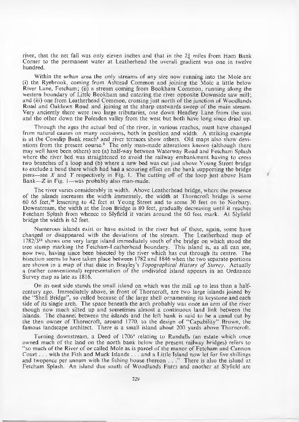
river, that the net fall was only eleven inches and tha t in the 2 | miles from H am Bank C orner to the perm anent w ater a t Leatherhead the overall gradient was one in twelve hundred.
Within the urban area the only streams o f any size now running into the M ole are (i) the Ryebrook, coming from A shtead Com m on and joining the M ole a little below River Lane, Fetcham ; (ii) a stream coming from B ookham C om m on, running along the western boundary o f Little B ookham and entering the river opposite Downside saw mill; and (iii) one from Leatherhead C om m on, crossing ju s t north o f the junction o f W oodlands Road and Oaklawn R oad and joining a t the sharp eastwards sweep o f the m ain stream. Very anciently there were two large tributaries, one down Headley Lane from the east and the other down the Polesden valley from the west but both have long since dried up.
Through the ages the actual bed o f the river, in various reaches, m ust have changed from natural causes on many occasions, both in position and width. A striking example is a t the Cowslip Bank reach8 and river terraces show others. O ld maps also show deviations from the present course.9 The only m an-m ade alterations know n (although there may well have been others) are (a) half-way between W aterway R oad and Fetcham Splash where the river bed was straightened to avoid the railway em bankm ent having to cross two branches o f a loop and (b) where a new bed was cut ju s t above Y oung Street bridge to exclude a bend there which had had a scouring effect on the bank supporting the bridge piers— see X and Y respectively in Fig. 1. The cutting off o f the loop ju s t above Ham Bank—Z in Fig. 1—was probably also man-made.
The river varies considerably in width. Above Leatherhead bridge, where the presence o f the islands increases the w idth immensely, the w idth a t T horncroft bridge is some 60-65 feet,10 lessening to 42 feet a t Y oung Street and to some 30 feet on to N orbury. D ownstream , the width at the Iron Bridge is 80 feet, gradually decreasing until it reaches Fetcham Splash from whence to Slyfield it varies around the 60 feet mark. A t Slyfield bridge the w idth is 62 feet.
N um erous islands exist or have existed in the river bu t o f these, again, some have changed or disappeared with the deviations o f the stream . The Leatherhead m ap o f 1782/311 shows one very large island immediately south o f the bridge on which stood the tree stum p m arking the Fetcham -Leatherhead boundary. This island is, as all can see, now two, having since been bisected by the river which has cut through its centre. The bisection seems to have taken place between 1782 and 1846 when the two separate portions are shown in a map of that date in Brayley’s Topographical H istory o f Surrey. Actually a (rather conventional) representation o f the undivided island appears in an O rdnance Survey map as late as 1816.
On its east side stands the small island on which was the mill up to less than a half- century ago. Immediately above, in front o f T horncroft, are two large islands joined by the “ Shell Bridge” , so called because o f the large shell ornam enting its keystone and each side o f its single arch. The space beneath the arch probably was once an arm o f the river though now much silted up and som etimes alm ost a continuous land link between the islands. The channel between the islands and the left bank is said to be a canal cut by the then owner o f T horncroft, a round 1770, to the design o f “ C apability” Brown, the fam ous landscape architect. There is a small island about 200 yards above Thorncroft.
Turning downstream , a Deed o f 17064 relating to Randalls (an estate which once owned much o f the land on the north bank below the present railway bridges) refers to “ so much of the River o f or called Mole as is parcel o f the m anor o f Fetcham and C annon C o u r t . . . with the Fish and M uck Islands . . . and a Little Island now let for five shillings and twopence per annum with the fishing house thereon . . There is also the island at Fetcham Splash. An island due south o f W oodlands Farm and another at Slyfield are
229
shown on a recent O.S. m ap. In a list12 o f properties at Slyfield conveyed by the Rev. Shortrudge to Exeter College in 1715, are m entioned three separate pieces o f land “ called the Island” , a piece called “ the Small Island” and “ several islands lying a t the upper end of Keets H am — 1 acre planted with alder and o ther trees” .
2. THE NAMEIt has fo r long been generally accepted th a t the nam e “ M ole” and the earlier name of
Emlyn, Emele (and o ther variants), also m eaning the same creature, was given to the river because o f its “ burrow ing” characteristics (albeit confined between the present Burford and Leatherhead bridges). However, in 1958 M r. M ichael Ellm an in correspondence with the then Editor o f The Guardian— organ o f the Leatherhead Residents A ssociation— described this as “ a popular fallacy o f no historical value” . M r. Ellman pointed out that bo th Surrey Place Names and The O xford Dictionary o f English Place Names agreed “ in giving the nam e M ole as a back-form ation from the village Molesey (which means the island belonging to one ‘M ul’)—the inhabitants o f tha t place having presum ably wrongly thought the river to have given its nam e to the village” . M r. Ellman went on to say that earlier form s o f the Emele variants were “ Em enan” and o ther spellings with an “n ” as the second consonant and therefore could have had no connection with the old name for a mole.
The view above expressed th a t “ M ole” is solely a back-form ation from Molesey is no t one th a t can be accepted w ithout reservation. Indeed, C am den,22 when describing the River M ole, states “ A nd then very neare Molesey w hereunto it giveth name, sheadeth himselfe into the T a m i s W hite-K ennet, also, in his “ C om pleat H istory o f England” (published 1706) states th a t from Leatherhead the river “ goes tow ards the River Thames and falls into it a t M oulsey to which it com m unicates its nam e” . So at least two historians o f their tim e would no t have agreed with the presum ption tha t the inhabitants “ wrongly though t” M olesey was named after the river.
It is correct th a t the Oxford D ictionary mentioned, under the item “ Em neth” (in N orfolk), states tha t Aemene was the old nam e o f the lower Mole and also quotes the nam e Aemenan from an item o f 1005 A .D . in an Eynsham A bbey C artulary. The writer has no t seen this item but, prima facie, an item in an Oxford C artulary is not clinching evidence o f the spelling o f a com paratively small river in Surrey—even if one other similar spelling is adduced.13
W hether the second consonant was, or was not, originally an “ n ” it is definite that by 1086 it has changed to an “ 1” . Elm bridge, which gave its nam e to the H undred, was the bridge carrying the London-C hertsey road over the River M ole and appears13 as “ A m elebrige” , 1086; “ H am elebrige” , 1175 and 1177; “ Emel(e)brig(g)e” in the Pipe Rolls o f 1191 and later. In 1414 a lease was granted14 to a John C radler o f a piece o f land in Leatherhead “ . . . between the rectory land on the east and the land (sic) Emelina Streme on the west” . In the early 16th century there was a dispute regarding Slyfield mill and the alleged turning away from it o f the stream called Emlyn Stream in contravention of a deed o f 1375.15 A bout 1450 “ Em elstrem ” appears16 and “ Em lin” and “ Emlyn” stream e is shown in 1565.17 T hat the nam e long persisted is indicated by the fact th a t a pleasant little poem entitled “ The M ole or Emlyn Stream ” could be w ritten and published (privately) in 1839.18
“ A qua de M ulesia” appears in 121419 bu t the nam e “ M ole” was not, apparently, used until the 16th century when “ M oule” first appears in H olinshed’s “ Chronicles” .13
It was in the 16th and 17th centuries th a t cultured men as a whole a t last had leisure to tu rn from pre-occupation w ith the dynastic struggles o f the m any preceding generations to a quiet contem plation o f their countryside, its m onum ents, scenic qualities and its history.20 Speed’s m ap o f Surrey, 1627, indicates the river’s “ disappearance” and it may
230
well be that it was because o f the observing and recording o f the phenom enon that the river received generally the name o f “ M ole” instead o f the less well know n local “ Em lyn” . It might even be tha t the m ap was the first indication to m any th a t the M oulsey R iver13 and the Emlyn river were one and the same stream . T hat the river’s peculiarity became well-known is shown by the fact tha t Spenser21 and C am den22 in the 16th century; M ilton23 and D rayton24 in the early 17th; and Pope25 a century later, all refer to the R iver M ole and its “ burrow ing” habit. It is easy to see why, when it it was realized th a t the “ m olelike” river was tha t which em ptied itself in to the Tham es a t Molesey, th a t “ M ole” was applied to its whole length. W hether or no t the lower river was nam ed from M olesey there could, in view o f this peculiarity, be no better nam e for the entire river (as witness its seizure by the poets) and to this extent, at least, there are grounds for the “ popular fallacy” which meets with Mr. Ellm an’s scorn.
The application o f “ M ole” to the whole length seems to have been a gradual and, naturally, an uncertain process. A n official survey o f church lands in 1649-5826 guardedly refers to “ the Leatherhead R iver” while deeds o f the early 18th century4 m ention “ the river o f or called M ole” . Nevertheless, from this time onw ards “ M ole” replaces “ Em lyn” —at least officially.
I t m ust be mentioned th a t E. W. Brayley27 published his view th a t the etymology of “ Emele” , “ Emlyn” and variants was from the British w ord “ M elin” o r “ Y -M elyn” , meaning a mill. He finds corroboration from the Domesday record which mentions twenty places along the river possessing mills. He also points ou t th a t in Elm bridge H undred the record gives three m anors called M olesham a t Molesey and equates “ M ole” with the Latin “ m ola” = a mill. The Oxford D ictionary above m entioned refers in its derivation o f “ M ole” to the item “ D orking” , which la tter nam e—it states— m eans “ the dwellers on the river D ork” ; and adds that, presum ably, the M ole was once called “ D orce” (= b r ig h t river), cf. D orchester. (It seems difficult to see why the inhabitants o f early D orking should be considered as dwelling on the m ain stream , about a mile away, with the P ippbrook flowing by their side.)
However, m ore than one view as to the origin o f o r the reason for the nam e o f the river exists. The then Editor o f The Guardian who published M r. E llm an’s letter and the w riter’s rejoinder ended with the suggestion that, perhaps, after all the little anim al was named after the River!
3. THE SWALLOWS
The “ swallows” (in the sense o f “ engulphing m edia” and no t birds) o f the R iver M oleare fam ous and have for centuries been com m ented upon by m any writers. Yet, so faras is known—apart from the long description by Brayley28— no a ttem pt to examine themclosely had ever been m ade until 1948 when M r. C. C. Fagg, F .G .S ., was able, during theyears 1948-50 while he was W arden o f the Field Studies Council’s C entre a t Juniper Hall,M ickleham, to make an extensive study o f them . The result o f his investigations is contained in his Presidential Address in 1956 to the G eographical Section o f the South-EasternU nion o f Scientific Societies.7 The w riter is m uch indebted to this A ddress for the m ajorityo f the inform ation in this section o f the present account.
On each side o f the river valley, roughly from Box Hill to T horncroft, is the risingchalk o f the N orth Downs. The m eandering stream , in some o f its reaches, approachesor even undercuts the chalk and it is here th a t the “ disappearance” o f its w aters throughfissures in the chalk takes place; leaving the bed o f the river alm ost (and sometimes com pletely) dry. This, o f course, only occurs in dry seasons and, generally, the flow o f w ateris too great for the swallows to m ake an appreciable difference as it passes over or by them.O f all the field outings organized by the Leatherhead Society one o f the m ost interesting
231
was tha t in August 1947, when M r. Fagg conducted mem bers along the river bed and was able to dem onstrate some o f the swallows actually in action. The most exciting was that under the Ham Bank (N o. 5 in Fig. 1) where the large pool rem aining in the otherwise dry river bed could clearly be seen to be running away down through the flints in the bed. The rate o f flow was, perhaps, a little slower than an emptying bath and seemingly through a fissure, not, however, detectable, about the size o f a bath plug hole. O ther swallows inspected had already em ptied their respective sections o f the bed.
For a full description o f the various swallows and a discussion o f them readers are referred to M r. Fagg’s Address. He reports that, during the period o f his investigations, there were, between H am Bank and the weir ju s t above the bridge th a t form s the northerly exit from N orbury Park , twenty-five active swallows and many extinct ones, both in the river bed and on the flood plain. M r. Fagg mentions also a large ancient swallow hole discovered by M r. F. H. E dm unds on a higher terrace and showing tha t the “ swallowing” has been in existence for thousands o f years. The sites o f the twenty-five active swallows mentioned by M r. Fagg are shown in Fig. 1, their positions being taken from the excellent figures tha t form part o f his published Address. For those who have not had an opportunity to see the river on the appropriate occasions a striking photograph of the dried-up river bed under the tunnel railway bridge appeared in The Times o f O ctober 10th, 1947.
M r. Fagg adds th a t “ the swallowed w ater, or m uch o f it, reappears in the copious perm anent springs on T horncroft Island. W hen the river is no t flowing through the gap the stretch o f perm anent w ater south o f T horncroft seems to be maintained mainly by back flow from the T horncroft springs. The springs in Fetcham pond appear to be fed by o ther fissures unconnected with the present-day swallows” . He concludes by stating th a t “ after three seasons o f close observation I am far from being able to say the last word on these fascinating phenom ena” .
4. FLORA AND FAUNA
So far as is know n, there is nothing peculiar or striking am ong the natural denizens o f the river and its im m ediate vicinity.
There is, however, an account, o f interest to botanists, by M r. H. J. Burkill29 o f an inspection m ade by him and others o f the dried up river bed in August, 1934. As described by the au thor, “ H ardly a pool was left in the stretch from N orbury Park to ju s t above T horncroft” . The stretch inspected was the half mile immediately below the northern bridge o f N orbury Park. Here the river bed consisted o f w aterw orn flints with a thin coating o f m ud and with the chalk rising occasionally to the surface; big scoured depressions, banks o f stones lying across the flow and occasional shoals o f blackish mud up to three feet high (usually subm erged) were all observed. An impressive variety of plants had sprung up since the river ceased to flow [in its bed] in the early sum mer and are listed in M r. Burkill’s R eport. M ore species were found in mid-channel am ong the stones than on the banks or the m ud showing th a t they had grown from seeds tha t had been brought there from some distance by the stream.
An anonym ous writer, “ Seventy-eight not ou t” , in an article headed “ Reminiscences o f the M ickleham Valley” in the Dorking & Leatherhead Advertiser o f 4th August, 1939, m entions having seen herons feeding between the railway tunnel and Ham Bank. A Leatherhead guide book o f about 1909 refers to otters in the stream and their former presence is testified by others, although none have been seen in recent years.
The river did, however, have a reputation for its fish. The anonym ous writer referred to in the preceding paragraph m entioned dace, roach, and chub dying in the receding w aters (a sight witnessed also by M r. Fagg in 1948).7 In a catalogue o f deeds which were a t one time in the Slyfield Chest in Leatherhead Parish Chest two o f the now missing
232
docum ents were (i) “ an account o f the royalties o f fishing belonging to the m anors o f Slyfield and Bigney” and (ii) a lease o f 1729 o f the Slyfield mills with a messuage and lands part o f the consideration for which was “ one full p a rt o f all eels to be caught . . . at the said mills or waters belonging thereto” (Proceedings, Vol. 1, N o. 4, p. 13).
The river’s piscine glory was, however, its trou t. Charles M ackay, writing about 184030 says:—
“ Leatherhead is noted above all things for its very excellent trou t. How long it has enjoyed this reputation it is difficult to say. The earliest notice we rem em ber o f its fame in this respect is in Lilly’s M em oirs o f his Life and Tim es; from which it appears th a t it was the resort o f Londoners during the tim e o f the Long Parliam ent. Lilly relates that, Sir Bulstrode W hitelocke being ill, he prophesied . . . th a t the H onourable M em ber would recover but by means o f a surfeit would relapse w ithin a m on th ; ‘the which he d id’ says Lilly ‘by eating too many trou ts a t M r. Sand’s house near Leatherhead’. In all the old topographical books the trouts o f Leatherhead are invariably m entioned” .
(M r. F. Bastian, who kindly furnished this extract, adds th a t Sir B ulstrode W hitelock (1605-75) was a prom inent figure in the Long Parliam ent and W illiam Lilly (1602-81) was the forem ost astrologer o f his time. M r. Sand’s house was, o f course, Randalls Park.)
A few years later Jam es T horne also w rote:— 31“ Leatherhead trou t are fam ous and the traveller who wishes to test their excellence
may, if he is a brother o f the angle, throw a line here—or mine hostess o f the Swan will, in the proper season, supply those who prefer the fish w ithout the labou r” .
Even as late as 1910-12 a G uide book o f Leatherhead32 could m ake this statem ent: “ The town also attracts many visitors . . . on account o f its excellent fishing, the tro u t to be obtained in the River Mole having a European reputation for their delicious flavour” .
It may be o f interest to residents in the area to know th a t M r. E dm und R. Taselli o f Leatherhead, well known in angling circles, states tha t there is still plenty o f fish, including trout, in the river, due, to a great extent, to the m aintained purity o f its waters. Indeed, in the w riter’s experience there have never been so m any anglers o f all ages as can now be seen near Young Street in a sum m er stroll by the river there.
Finally, we reproduce (but refraining from com m ent) the following item which ap peared in the Daily M ai/ o f 21st July, 1952:—
“ Able Seaman Alan M ickelburgh, 25, o f W allington, Surrey, caught w hat he thought was a 3 lb. trou t in the River M ole, near Leatherhead. His father said yesterday it was a salmon—the first known to have been caught in the M ole” .
5. THE BRIDGESProceeding dow nstream , the first present-day bridge over the river w ithin the U rban
D istrict (excluding the northern bridge entrance to N orbury Park—which actually crosses the boundary, which here and for a short distance below is form ed by the centre o f the river) is the Young Street bridge. U pstream , between tha t bridge and Burford Bridge (close to which was once the R om an bridge carrying Stane Street across the river) are (a) the two bridge entrances to N orbury P ark ; (b) the tunnel railway bridge; (c) small bridges shown on the O.S. m ap, 1955, a t Sw anworth Farm , ju s t above Cowslip F arm and H am Bank; and (d) the railway bridge and a footbridge about 650 yards above H am Bank. With all these we are not fu rther concerned.
Although Young Street bridge is now the first in our area it is right to m ention that, about a century ago, there was another bridge about 600 yards upstream from the Y oung Street one. This is shown on maps both o f 181033 and 184634 and, in the latter, is nam ed
233
Bocket Bridge. It carried w hat was, probably, a farm track from the west across to the L eatherhead-D orking road about 4/500 yards south o f the Givons G rove roundabout. This bridge does not appear on any later map and has not existed within living memory. N othing m ore is known o f it and it is m ost probable th a t it went out of use in 1867 when the railway to D orking was built and this approach to the river was replaced by the small tunnel at the bottom o f Young Street.
As to the Y o u n g St r e e t Br id g e , this, to the knowledge o f many present residents in the area, was built in 1941 when the C anadian Royal Engineers then stationed in the neighbourhood and under the com m and o f a C aptain Young constructed the road and bridge for military purposes. N o earlier bridge here is shown in two O.S. maps consulted surveyed between 1861—80 and reprinted (with corrections to date) in 1925 and 1929. Nevertheless, M r. A. J. G inger (one o f the first mem bers o f this Society and who was born in the area in the early 1880’s and spent his boyhood here) has informed the writer tha t he (M r. G inger) has a rather vague rem em brance as a boy o f an old wooden bridge which stood roughly on the site o f the present bridge and carried a path from Roaring H ouse Farm through the tunnel and up to the site of the present roundabout. This bridge m ust have disappeared at the latest in the first years o f this century and, indeed, Mr. Ginger thinks it may have been unusable or, a t least, dilapidated in his time.
The tem porary wooden bridge constructed by the C anadian troops was not replaced by any perm anent structure and served well for ten years until severe flooding in early 1951 and consequent scouring o f the banks caused the eastern supports partially to collapse. The M inistry o f T ransport agreed to a Bailey bridge being pu t in its place as a “ tem porary” measure and this was carried ou t in July 1952 as an exercise by the 316 Field Squadron, R.E.s, under a M ajor M ays.35 A fter twelve years it still serves. Much o f the scouring was due to the loop o f the river which then existed ju s t above the site and, as a remedy, a straight reach o f the river was cut to replace the loop ( Y in Fig. 1). I t was the cutting of this new bed th a t disclosed the mesolithic occupation debris.2
The next bridge dow nstream is T h o r n c r o f t B r id g e at the foot of G im crack Hill, form ing the entrance to Thorncroft. A t its eastern end is Bridge Cottage, built between 1836-44 as an entrance lodge bu t much altered and m odernized in 1951/2. T horncroft is one o f the m anors m entioned in the D om esday Book and one might have thought tha t a bridge existed here from the beginning; but, in a List o f Repairs made to the m anor in 1443/4,36 appears, as the first item, “ Paid in cash to Thos. W rinne for felling 14 oaks for a bridge no t yet made, 16d.” This suggests tha t this was the first occasion on which the m anor had its own bridge: perhaps the inhabitants had previously walked over the meadows on the west side o f the river and crossed by the tow n bridge. The present bridge m ust have been constructed much later. The interest in the m anor was transferred to M erton College, O xford (or, rather, to its founder) in 1266 and, although m uch o f it was enfranchised in the mid-18th century, tha t College still owns part o f the demesne lands with certain rights over the bridge.37
The next bridge spanning the river is the L e a t h e r h e a d B r id g e carrying the main G uildford-Leatherhead-Epsom road over the stream. Readers are referred to the short but interesting account o f this bridge which, with an illustration o f it as it looked in 1823, appeared in Proceedings, Vol. 2, No. 6, at pp. 162-3 (hereinafter referred to as “ the previous article”). T hat some o f the inform ation therein contained is repeated here is merely to keep together the story o f the river and its usage.
The earliest known reference to the existence o f a bridge here is a deed,14 dated to 1250 or earlier, relating to land in Leatherhead and witnessed by a num ber o f local worthies including “ Simon o f the Bridge” . On 24th M ay, 1361, a John Plom er of Rocheford was granted a licence to collect alms for the repair o f Ledrede Bridge.38 By his will, proved in 1485, a Thos. Puke o f Ledderhede left “ for the repair o f the bridge of Ledderhed, 4d.” 39 A nother
234
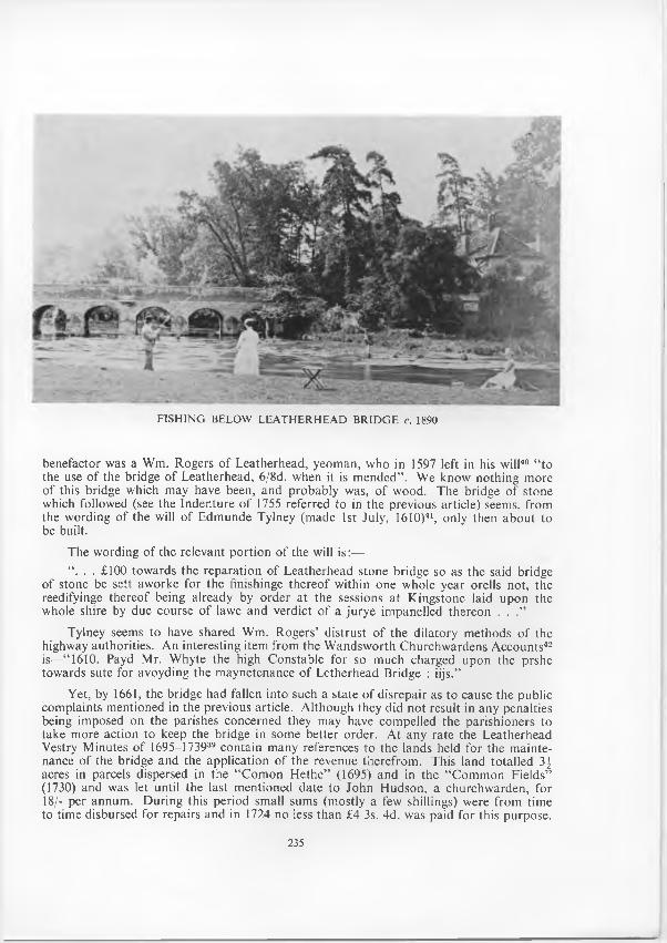
FISH IN G BELOW LEA TH ERH EA D BR ID G E c. 1890
benefactor was a Wm. Rogers o f Leatherhead, yeom an, who in 1597 left in his will40 “ to the use o f the bridge o f Leatherhead, 6/8d. when it is m ended” . We know nothing more of this bridge which may have been, and probably was, o f wood. The bridge o f stone which followed (see the Indenture o f 1755 referred to in the previous article) seems, from the wording o f the will o f Edm unde Tylney (made 1st July, 1610)41, only then about to be built.
The wording of the relevant portion o f the will is :—“ . . . £100 tow ards the reparation o f Leatherhead stone bridge so as the said bridge
of stone be sett aworke for the finishinge thereo f w ithin one whole year orells not, the reedifyinge thereof being already by order a t the sessions at K ingstone laid upon the whole shire by due course o f lawe and verdict o f a ju rye im panelled thereon . . .”
Tylney seems to have shared Wm. R ogers’ distrust o f the dilatory m ethods o f the highway authorities. A n interesting item from the W andsw orth Churchw ardens A ccounts42 is—“ 1610. Payd M r. W hyte the high C onstable for so much charged upon the prshe tow ards sute for avoyding the m aynetenance o f Letherhead Bridge : iijs.”
Yet, by 1661, the bridge had fallen into such a state o f disrepair as to cause the public com plaints mentioned in the previous article. A lthough they did no t result in any penalties being imposed on the parishes concerned they may have compelled the parishioners to take m ore action to keep the bridge in some better order. A t any rate the Leatherhead Vestry M inutes o f 1695—173939 contain m any references to the lands held for the m aintenance o f the bridge and the application o f the revenue therefrom . This land totalled 3^ acres in parcels dispersed in the “ Com on H ethe” (1695) and in the “ C om m on Fields” (1730) and was let until the last m entioned date to John H udson, a churchw arden, for 18/- per annum . D uring this period small sums (mostly a few shillings) were from time to time disbursed for repairs and in 1724 no less than £4 3s. 4d. was paid for this purpose.
235
A paym ent o f 1731 included the item s:—“ Pd. fo r Picking o f Stones and earring (sic) to
the Bridge and L abourers 1-6-10for Beer for the Labourers 2-3” .
A padlock (purpose unknow n) was bought for 1/- in 1711.A fter 1739 the next m inute relating to the bridge seems to be tha t o f 23rd June, 1760,
when the bridge was locked and the Vestry m ade the O rder tha t a yearly paym ent had to be m ade for the right to pass over it (see previous article). In 1762 it was ordered that all receipts from these keys should be brought into the accounts o f the bridge and tha t the Churchw ardens “ do fo r the future all repairs th a t shall be w anting” . This provision, ra ther naturally, w orked unsatisfactorily and (to jum p in time) in 1778 it was ordered “ th a t Public N otice be given to the gentlemen and others tha t have keys to go over Leatherhead Bridge th a t unless they pay the Churchw ardens their arrears now due before the 10th day o f O ctober next new Locks will be pu t onto the bars and no carriages to pass over the said Bridge except in tim e o f a flood” .
Some years ago the late M r. Blaxland Stubbs presented to the Society a key which, in 1936, had been found at the ford alongside the bridge by a M r. Charles H. Rose. This key (see the colophon to this issue o f the Proceedings), dated to c. 1800,43 might well be one o f the bridge keys dropped by some careless or unlucky local traveller.
Even w ith the additional “ key m oney” it would seem th a t the bridge could no t be kept in p roper repair and the Com m ission o f the Peace for Surrey appointed a Committee, which first m et on 27th June, 1774, to investigate and report on certain bridges in the County, including the Leatherhead Bridge. From the m inutes44 it appears tha t the Com mittee were first o f opinion that, though the bridge [we confine ourselves to the Leatherhead bridge] was, in its present state, dangerous to the public and should be enlarged and im proved, it was no t necessary to rebuild all o f it. It was suggested that it would be sufficient to m ake a recess in every pier large enough to secure a m an and horse from the danger o f any carriage passing a t the same time. A nother suggestion was to make four arches in the centre o f the bridge in an oval shape 20 feet wide instead o f recesses all along.
The m inutes recorded th a t Leatherhead Parish had w ritten to the Com m ittee offering to give up their p a rt o f the bridge and the lands belonging to it (or the value thereof) if the Parish could be relieved o f its liability for repairs. (A copy o f this letter, or a draft o f it, appears in the Vestry minutes). The o ther co-owner o f the bridge, i.e. Fetcham Parish — whose Vestry minutes o f the tim e do not, the w riter is informed, still exist—had also w ritten to say tha t they were tenants at rackrent and could pay nothing but that, no doubt, Sir G eorge W arren (at th a t time L ord o f the M anor) who was then in Cheshire would give som ething when inform ed o f it.
The Com m ittee held a num ber o f meetings and considered various plans, estimates, and reports but eventually they were forced to the conclusion tha t repairing the bridge was not an economic proposition. On 5th Septem ber, 1775, it was, on further consideration, Resolved: “ T hat it will be m ore for Public Utility to build a new bridge rather than repair the o ld ; th a t the m ost eligible situation for such New Bridge will be from the present E ntrance into the River Southw ard o f the Old Bridge across the Island; and the R oad to go th rough Col. G ow er’s Field in to the High T urnpike R oad; and the said Bridge is to be erected with Brick or w ith Brick and Stone; . . . T hat a sum of money necessary to build a New Bridge at Leatherhead be raised by Subscription” . An advertisement for plans and estim ates was ordered but only one later Com m ittee meeting (at which there was no quorum ) is recorded and it seems tha t the C om m ittee’s proceedings were pigeon-holed. The unfortunate parishioners continued to pu t their hands in their pockets for repairs and another Vestry m inute o f 1778 includes an order to remove the ivy growing on the walls and repairs as necessary to be made.
236
At long last, in 1782, an Act was passed and the bridge passed to the County. I t was re-built, this time o f brick, and later, in 1824, widened to its present width. As so altered it has remained to the present day except for the addition , in 1963, o f the lights on it. As first rebuilt it could have taken only one-lane traffic and the recesses on the north side, if then incorporated into the structure, were probably due to the suggestions m ade a t the second meeting of the Com m ittee— though they seem hardly large enough to have taken a m ounted man.
The Com m ittee’s resolution o f 1775 raises an interesting point. The w ording is vague but presum ably “ across the Island” refers to the suggested new bridge. I t is alm ost certain tha t the project to re-site the bridge fell through and the new one was built on the foundations o f the old: hence the traces o f medieval work tha t have been recognized in it.
The river is next traversed by the I r o n Br id g e in W aterway R oad and the two nearby R a il w a y B r id g e s . The eastern railway bridge, carrying the Leatherhead-D orking section o f the then Horsham D orking and Leatherhead Railway (later taken over by the London Brighton and South C oast Railway) was built betw een 1863—67. W aterway R oad and the Iron Bridge were constructed by the Railway C om pany as a private road, obviously to enable intending passengers coming from Fetcham , Bookham , and the west to have access to the new station (the present one, built in 1866) w ithout having to go up Bridge Street and back. T hat road and the bridge have recently been taken over by the U rban D istrict Council. The western railway bridge was built in 1885 when the London and South W estern Railway extended their line to Effingham. It was in m aking the em bankm ent for this extension that the small diversion o f the river (at X in Fig. 1) was created.
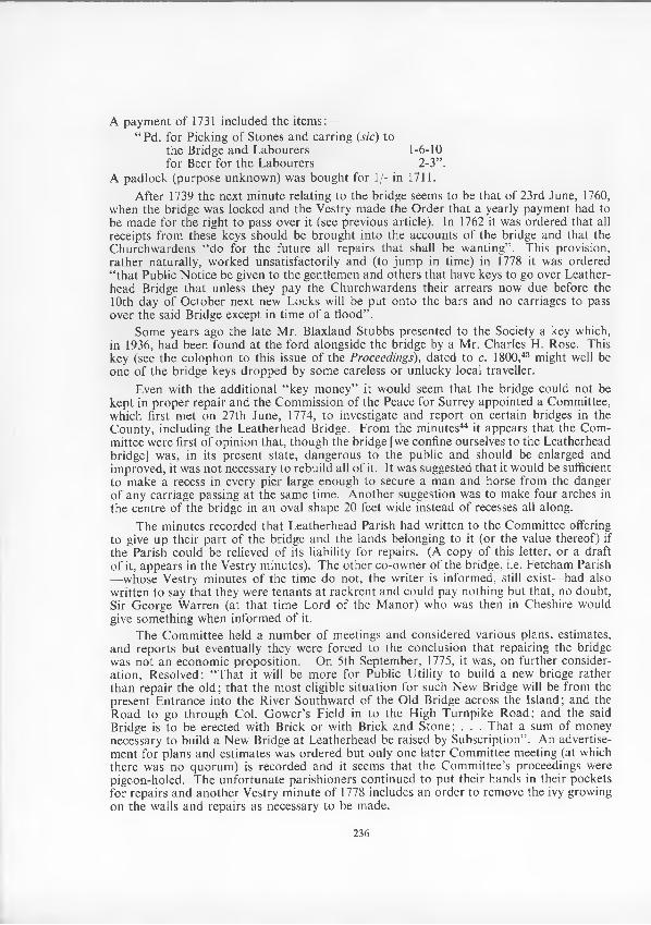
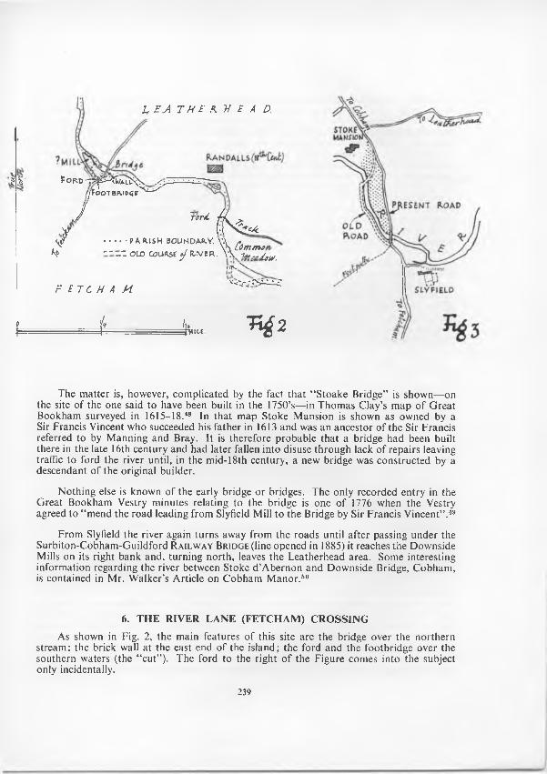
R iv e r L a n e B r id g e and F e t c h a m S p l a sh form the next crossing. H ere (see Fig. 2) there are (or were) two w atercourses, a northern one spanned by a bridge and to the south a more shallow one w ith a footbridge alongside a ford which crossed it. I t has been sug-
FETCHAM SPLASH c. 1912 Photographer unknown
237
gested tha t the la tter was the original river bed and the o ther a mill leet and man-made. This is discussed later, bu t for clarity the w riter will use the usual references to the northern water as “ the river” and to the o ther as “ the cu t” .
A t the eastern junction o f the two streams is a brick wall over which the river, when held back by the sluice gates once existing under the bridge, fell in a cascade to run through the cut and rejoin the river below the island. Traffic from the south had to cross the cut by the ford, traverse the island and then the bridge and so to the north portion o f River Lane. The whole formed a m ost picturesque scene and the objective o f many a pleasant local stroll.
D uring the second world war a stray bom b fell and damaged the bridge and the sluice gates under it. The bridge was eventually rebuilt by W imbledon C orporation, when they bought the nearby Randalls estate (to which the bridge belonged) for a cemetery, and the bridge was handed over to Leatherhead U rban District Council in November, 1952. The sluice gates were not, however, repaired, with the result that, except in times o f flood, the river is never high enough to flow over the wall and fill the cut. From the 1940’s to 1964 the cut, in consequence, deteriorated into muddy, weed-covered ground (com plete with derelict car) and the approach to the ford was buried by deliberate dum ping. A n “ eyesore” was a mild description to apply to a once delightful spot.
Visits there since Septem ber 1964 have shown th a t alm ost all o f the cut has, very recently, been buried under earth dum ped by nearby developm ent. It has been intim ated to the w riter by the U .D .C . tha t it is the intention to dredge the bed o f the cut and to lower the brick wall and so re-instate the stream through the cut. It is greatly to be hoped th a t this so much-to-be-desired restoration will indeed take place and tha t this part of the River (and the parish boundary) will not—as an easy solution to the problem — be consigned to oblivion by burial.
The early history o f the site is not easy to disentangle due not only to paucity of m aterial (this, as will be seen, applies to other features of the River) but also to its rather confusing nature. Since the available m aterial is difficult to segregate between the bridge, the ford, the wall, and the mill (formerly there) a separate section o f this Article, No. 6, is devoted to w hat is know n o f the previous story o f this river-crossing.
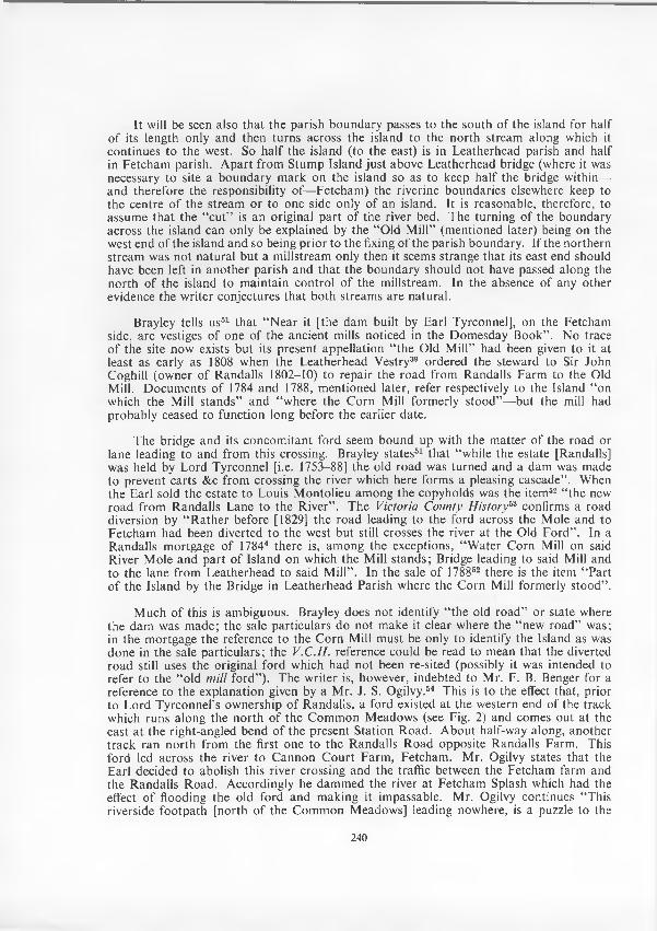
F rom this po in t the river is lost to the norm al traveller’s view am ong fields and meadows until, after approxim ately two and a th ird miles, it reaches S l y f ie l d (or S t o k e ) Br id g e .
This bridge has an interesting story as told by M anning and Bray.45 It is there stated th a t only a dangerous ford near the garden wall o f the M ansion o f Stoke (at W in Fig. 1) existed until, in the 1750’s, Sir Francis Vincent, the then owner o f tha t M ansion, built there a w ooden bridge for foot and horse passengers only. This was known as Stoke Bridge. A fter 1773 the ford had become even m ore dangerous by reason o f the penning o f the stream a t Downside Mill to increase the force o f the waters to w ork w hat were then the Iron Mills there46 and the bridge was opened to carriages. By 1786 repairs were needed (rather an understatem ent since M r. T. E. C. W alker states47 tha t in tha t year a horse and chaise were reported to have fallen through the bridge!) and the County took it over. Presum ably repairs were m ade but in 1804 the bridge was again presented as being out o f repair and a Com m ittee was appointed to build a new bridge higher up the river (see Fig. 3). This is the present Slyfield Bridge. The then owner o f Stoke M ansion, M r. Hugh Smith, gave the land for a new road to the new bridge and constructed it. In consideration the Com m ittee agreed to the re-alignm ent o f the road, to stop up the old one and to give to M r. Smith the land from the top o f the hill (where the new road began) to the foot of the new bridge for incorporation into his grounds. (See Fig. 3, stippled portion.)
238
[rue
I, £ A T H E R. ~H E A D.
V F o R D - t tp ^ A I> < W >/yFooTBMoqif^^'^
J J ~rcrd. J '/¥ (:( \ ^ ^
< # ............PAR.ISH BOUNDAB.V. Vi />. N VS Com mo\ ° - - _Z OLD COURSE y R-IVE R . W W * *
W w V
F E T C H A M v< v . r r y ^
f f v .» . " ^ 2
The m atter is, however, com plicated by the fact tha t “ Stoake Bridge” is shown— on the site o f the one said to have been built in the 1750’s—in Thom as Clay’s m ap o f G reat Bookham surveyed in 1615-18.48 In tha t m ap Stoke M ansion is shown as owned by a Sir Francis Vincent who succeeded his father in 1613 and was an ancestor o f the Sir Francis referred to by M anning and Bray. It is therefore probable th a t a bridge had been built there in the late 16th century and had later fallen into disuse through lack o f repairs leaving traffic to ford the river until, in the mid-18th century, a new bridge was constructed by a descendant o f the original builder.
N othing else is known o f the early bridge or bridges. The only recorded entry in the G reat Bookham Vestry m inutes relating to the bridge is one o f 1776 when the Vestry agreed to “ mend the road leading from Slyfield Mill to the Bridge by Sir Francis V incent” .49
From Slyfield the river again turns away from the roads until after passing under the Surbiton-C obham -G uildford R a il w a y B r id g e (line opened in 1885) it reaches the Downside Mills on its right bank and, turning north, leaves the Leatherhead area. Some interesting inform ation regarding the river between Stoke d ’A bernon and Downside Bridge, C obham , is contained in M r. W alker’s A rticle on C obham M anor.50
6. THE RIVER LANE (FETCHAM) CROSSING
As shown in Fig. 2, the m ain features o f this site are the bridge over the northern stream ; the brick wall a t the east end o f the island; the ford and the footbridge over the southern waters (the “ cu t”). The ford to the right o f the Figure comes into the subject only incidentally.
239
It will be seen also tha t the parish boundary passes to the south o f the island for half o f its length only and then turns across the island to the north stream along which it continues to the west. So half the island (to the east) is in Leatherhead parish and half in Fetcham parish. A part from Stum p Island just above Leatherhead bridge (where it was necessary to site a boundary m ark on the island so as to keep half the bridge within— and therefore the responsibility o f—Fetcham ) the riverine boundaries elsewhere keep to the centre o f the stream or to one side only o f an island. It is reasonable, therefore, to assum e th a t the “ cu t” is an original part o f the river bed. The turning o f the boundary across the island can only be explained by the “ Old M ill” (m entioned later) being on the west end o f the island and so being prior to the fixing o f the parish boundary. If the northern stream was no t natural bu t a m illstream only then it seems strange tha t its east end should have been left in another parish and th a t the boundary should not have passed along the north o f the island to m aintain contro l o f the millstream. In the absence o f any other evidence the w riter conjectures tha t both stream s are natural.
Brayley tells us51 th a t “ N ear it [the dam built by Earl Tyrconnel], on the Fetcham side, are vestiges o f one o f the ancient mills noticed in the D om esday Book” . N o trace o f the site now exists bu t its present appellation “ the Old M ill” had been given to it at least as early as 1808 when the Leatherhead Vestry39 ordered the steward to Sir John Coghill (owner o f Randalls 1802-10) to repair the road from Randalls Farm to the Old Mill. D ocum ents o f 1784 and 1788, m entioned later, refer respectively to the Island “ on which the Mill stands” and “ where the C orn Mill form erly stood”—but the mill had probably ceased to function long before the earlier date.
The bridge and its concom itant ford seem bound up with the m atter o f the road or lane leading to and from this crossing. Brayley states51 th a t “ while the estate [Randalls] was held by L ord Tyrconnel [i.e. 1753-88] the old road was turned and a dam was made to prevent carts &c from crossing the river which here forms a pleasing cascade” . When the E arl sold the estate to Louis M ontolieu am ong the copyholds was the item 52 “ the new road from Randalls Lane to the R iver” . The Victoria County H istory53 confirms a road diversion by “ R ather before [1829] the road leading to the ford across the Mole and to Fetcham had been diverted to the west but still crosses the river at the Old F ord” . In a Randalls mortgage o f 17844 there is, am ong the exceptions, “ W ater C orn Mill on said River M ole and p a rt o f Island on which the Mill stands; Bridge leading to said Mill and to the lane from Leatherhead to said M ill” . In the sale o f 178852 there is the item “ Part o f the Island by the Bridge in Leatherhead Parish where the C orn M ill formerly stood” .
M uch o f this is ambiguous. Brayley does not identify “ the old road” or state where the dam was m ade; the sale particulars do no t m ake it clear where the “ new road” was; in the m ortgage the reference to the C orn Mill m ust be only to identify the Island as was done in the sale particu lars; the V.C.H . reference could be read to m ean th a t the diverted road still uses the original ford which had no t been re-sited (possibly it was intended to refer to the “ old m ill fo rd”). The w riter is, however, indebted to M r. F. B. Benger for a reference to the explanation given by a M r. J. S. Ogilvy.54 This is to the effect that, prior to Lord Tyrconnel’s ownership o f Randalls, a ford existed at the western end o f the track which runs along the north o f the C om m on M eadows (see Fig. 2) and comes out at the east a t the right-angled bend o f the present Station Road. A bout half-way along, another track ran north from the first one to the R andalls Road opposite Randalls Farm . This ford led across the river to C annon C ourt Farm , Fetcham . M r. Ogilvy states tha t the E arl decided to abolish this river crossing and the traffic between the Fetcham farm and the R andalls R oad. Accordingly he dam m ed the river a t Fetcham Splash which had the effect o f flooding the old ford and m aking it impassable. Mr. Ogilvy continues “ This riverside foo tpath [north o f the C om m on M eadows] leading nowhere, is a puzzle to the
240
townspeople who imagine it ought to continue to the present river crossing, whereas it comes to an end where the old one was” .
From the exiguous m aterial available the early history o f the River Lane crossing can be summarized as follows.
The D om esday mill was sited on the west end o f the island standing between the no rth and south branches o f the river. This was a Fetcham mill and the boundary crossed the island from one branch o f the river to the o ther in o rder to include the mill in its proper parish. Probably a lane from the M iddle G reen, Fetcham , ran dow n to it (certainly one did in 177755) but did not cross the river. Sometime between 1753 and 1784 Earl Tyrconnel, whose m ansion stood near the river (see Fig. 2), wished to pu t a stop to the nearby farm traffic crossing a ford to the track north o f the C om m on M eadow s: perhaps he objected to the noise and, perhaps, to the language o f the drivers as they urged their horses across the water. W hatever the reason, he built the brick wall a t the east end o f the island and, alm ost certainly, installed the sluice gates below the present bridge; obviously the wall itself would not, alone, have been effective to flood the old ford and cause it to fall into disuse. The wall, ap art from its capping, is now under sand and w ater bu t the bonding of the parapet wall a t the end o f the island—and which m ust have been part o f the project— corroborates the date. A new means o f crossing the river had to be provided and the Earl constructed the present River Lane north o f the river with the bridge across to the island. With a judicious use o f the sluice gates, the wall would keep a reasonably shallow depth of water in the south channel so th a t it could be forded and thus avoid the necessity fo r a second bridge on the south.
The occupants o f C annon C ourt Farm would then have used the new crossing, reaching it by a track from the farm across the meadows to the north-w est or, ju s t possibly, by the track which now runs from the farm to M ole R oad and River Lane. N either o f the Fetcham maps of 1777 or 1791 shows any indication o f any track to or tow ards either crossing nor are there any place names which give any help. This position persisted until the bom b damage, although the bridge then involved may not have been the one originally built by the Earl.
The wooden footbridge across the Splash was, probably, first built in the later 19th century but actually no reference to it can be found. It is to the w riter’s knowledge tha t some very essential repairs required through dilapidation were executed in the 1940’s. It has been deemed, although o f no age, w orthy o f illustration as a nice example o f wooden pile construction.69
7. THE FO RD S
In all probability the River M ole has, in past times, been custom arily forded a t m any points where convenience and the state o f the w aters indicated and perm itted. There are, however, only six fords known in the Leatherhead area. All are now out o f use if not out o f memory also.
It is probable tha t the ford by Leatherhead Bridge fell, to a great extent, out o f use when the bridge was widened in 1824. It certainly ceased to be used when, in 1902, the Electricity buildings were erected and destroyed the western entrance. The eastern approach remained in existence, however, until the 1950’s (when M inchin Close was constructed), and at least afforded a watering place for such horses as were still employed. It m ust, at all times, have been a deep and wide ford and would certainly have been alm ost unusable in times o f heavy rain. A mong the m any speculations (none are certain) as to the meaning
241
and derivation o f “ L eatherhead” are “ the public riding ford” 56 and “ the place o f the high riders” .57 B oth suggest, if they have any value, th a t the ford was, generally at least, usable only by riders and waggons. It has been suggested58 tha t the chapel said to have been built in 1358 by R obert de Lederede a t his house on the site o f the Old Rising Sun, Fetcham , was instituted as a votive chapel for prayer and thanksgiving for a safe journey across the nearby river. Perhaps the bridge there (which had been in existence for over one hundred years) was then unusable since it was only four years later that the Royal Licence for its repair was obtained (see re bridge, above). If the repairs were ever made effective the chapel’s revenue m ust have suffered.
The next ford know n is th a t a t the western end o f the track on the north of the Comm on M eadows. The little th a t is discoverable about it has been set out in Section 6 o f this Article, q.v. As there stated, the ford ceased to be used in the second half of the 18th century.
The ford a t Fetcham Splash has also been discussed in Section 6, above. A t norm al times the ford was an easy one but when the river was full the flow over the wall could be rapid. The w riter has first-hand knowledge o f an occasion in the 1940’s when the river was high though no t actually in flood: a m an driving a light two-wheeled trap urged his unwilling horse in to the ford bu t alm ost a t once the trap overturned and was swept downstream , the m an and the vehicle’s contents being throw n into the w ater. The man scrambled to the bank bu t it was only w ith difficulty th a t the poor anim al was rescued on the steep banks below the footbridge. The ford can no longer be used as its southern approach was deliberately or carelessly filled in by dum ping some years ago. N o vehicle can now cross and cyclists and even motorcyclists use the footbridge to the extreme danger of themselves and o f pedestrians using it.
It will be seen from Fig. 1 tha t a t the spot where the Leatherhead-Stoke d ’A bernon boundary turns north from the river another ford is marked. This ford took Bickney (Bigney or Bignall) Lane, running from Fetcham to Stoke d ’A bernon and O xshott, across the river (see Proceedings, Vol. 2, N o. 4, p. 102 and M ap 6 in th a t issue). The portion o f Bickney Lane between tha t ford and the southern extremity o f the sharp and angular bend o f the river to the east is now shown on m aps as having the appearance o f a canal. In fact, the “ canal” is part o f the Lane which here, having probably become a sunken road, was inundated, about 1764, m ost likely by a flood which swept away the earth between the river bank and the Lane. As a result the whole Lane and the ford fell into disuse from that time.
A nother ford is m entioned in connection with Stoke Bridge (q.v., Section 5, above). A pparently, when the ford below Stoke d ’A bernon m ansion (see next paragraph) ceased to be used, traffic crossed the river near the garden wall south o f tha t building until—or, perhaps, when—a bridge was built in the late 16th century and again after tha t bridge was destroyed, a t an unknow n date, until a new one was constructed in the mid-18th century. The ford, which was a t all times dangerous, ceased to be used by 1773.
The last ford is described by M r. John Harvey, F.S.A ., in a M onograph59 on The Survey o f Great Bookham, 1614, a t page iii. M r. Harvey refers to tracks across Bookham C om m on, form ing p a rt o f the “ Royal S treet” from “ C oucham ” to “ Dorkynge” , which are know n to have existed bu t are no t shown on the 1614 map. M r. Harvey continues “ so the disuse o f the no rthern p a rt o f this rou te probably dates from the severance of the connection w ith Chertsey, which lay beyond C obham . The old road ran across the Comm on to the west o f Slyfield, crossed the w ater meadows on a bank which can still be seen and forded the M ole at a point, shown on the m ap, dow nstream from Stoke D ’Abernon
242
m anor house” . This ford, then, ceased to be used, apparently, in the 16th century its traffic being transferred, perhaps, to the new bridge at Stoke (see previous paragraph).
It would seem fairly certain tha t (in the absence o f a bridge) a crossing, when the river was high, could be attem pted only a t considerable risk or, a t least, inconvenience. D oub tless odd boats were available for use where necessary bu t there is no record anyw here of any recognized ferry.
8. THE MILLS
As elsewhere along the River Mole, the Domesday Book records several mills within the Leatherhead area. The m anors o f G reat Bookham and T horncroft had one each, those o f Fetcham five (with interests o f one-third and one-sixth respectively in tw o others), while the m anors o f Pachenesham held one-third interest in three mills. N one o f these is still in existence and even the site o f some o f them is doubtful o r actually unknown. One difficulty in tracing them is tha t no identification can be certainly m ade o f those in which part interests were held nor can it be surely know n that these parts are included in o ther mills in the area. Proceeding dow nstream , the mills o f which anything can be said are as follow.
A part from the Domesday m ention, the only reference to the mill a t T h o r n c r o f t is contained in a C alendar o f Deeds,14 No. 633, o f about 1170 when “ half a hide in the m anor o f Tornecroft and the mill” was conveyed to A m frid, son o f Fulco, fo r 25/- yearly. A D eed from the same Calendar, No. 650, c. 1270, is a g ran t by W alter de M erton to the Scholars o f land in Leatherhead with conditions as to supplies o f corn to him for life and supplies o f corn are conditions attached to leases o f the mid-17th century. Very doubtfully, such conditions suggest the continuing use o f a mill there bu t there is, a t present, no available evidence a t all as to when the mill ceased to be used or (unless “ M ill C lose” on the left bank, ju s t above the bridge70 is a pointer) o f its site.
One o f the most surprising features of the research required for this Article has been the dearth o f inform ation relating to the L e a t h e r h e a d M il l a t the east end o f the bridge. None o f the County histories mentions the mill; the V.C.H. does refer to the mill “ near Leatherhead Bridge” but it is clear this is the Fetcham M illpond Mill. The island on which the Leatherhead mill stood is described as “ w aste” in the 1782/3 m ap11 and no mill is mentioned in Leatherhead Q uit Rentals, Assessments or R ate Accounts o f the 17th, 18th, and early 19th centuries. Indeed, the earliest m ention so far found is in 190260 where it is stated that “ On the other side o f the bridge stands a disused mill ha lf falling into p icturesque ruin. Part o f it is used as a swimming b a th” . M r. A. J. G inger (m entioned above, Section 5 re Young Street bridge) states tha t in the 1890’s the mill had ceased to operate, although the wheel did turn occasionally, and confirms the use o f one o f the mill buildings as a public swimming bath. M r. G inger adds th a t it was thought the mill was then about 100 years old and had been used for tanning and dressing leather. The mill was certainly in existence in 1855 as shown in the engraving o f th a t date o f the bridge and the mill reproduced in this Article. The supposition th a t it may have been a tanning mill receives support from Brayley’s rem ark51 tha t “ On the riverside a t the east end [of the bridge] is a small tan yard” . It is true tha t M r. J. H illier61 says tha t the barely recognizable ruins are near the Running Horse Inn “ where Elinor Rumm inge [the hostess in the 16th century] busy at her ‘tunnynge’ m ust have heard the m erry clack o f an earlier wheel” but, in the absence of any evidence, it may, perhaps, be perm itted to regard this as a poetic effusion only. All tha t can be said o f the mill is tha t it was probably built in the mid-19th century—
243
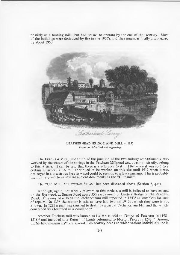
possibly as a tanning mill—but had ceased to operate by the end o f that century. M ost o f the buildings were destroyed by fire in the 1920’s and the rem ainder finally disappeared by abou t 1953.
LEA TH ER H EA D BRIDG E A N D M ILL c. 1855 From an old letterhead engraving
The F e t c h a m M il l , ju s t south o f the junction o f the two railway embankm ents, was w orked by the w aters o f the springs in the Fetcham M illpond and does not, strictly, belong to this Article. I t can be said th a t there is a reference to it in 1167 when it was sold to a certain G uarnerius. A mill continued to be w orked on this site until 1917 when it was destroyed in a disastrous fire; its wheel could be seen up to a few years ago. This is probably the mill referred to in several ancient docum ents as the “ Cutt-m ill” .
The “ Old M ill” a t F e t c h a m S pl a s h has been discussed above (Section 6, q.v.).
A lthough, again, no t strictly relevant to this Article, a mill is believed to have existed on the Ryebrook at Spring Pond some 350 yards north o f G utters Bridge on the Randalls Road. This may have been the Pachenesham mill reported in 13433 as worthless for lack o f repairs. In 1398 the m anor is said to have had two mills62 bu t which they were is not know n. In 1235 a m an was crushed to death by a cart at Pachenesham Mill and the vehicle concerned was forfeited as a deodand .63
A nother Fetcham mill was known as L a H a l e , sold to D rogo o f Fetcham in 1198— 121819 and included in a R eturn o f Lands belonging to M erton Priory in 1242.19 Among the Slyfield m unim ents64 are several 13th century deeds to which various individuals “ de la
244
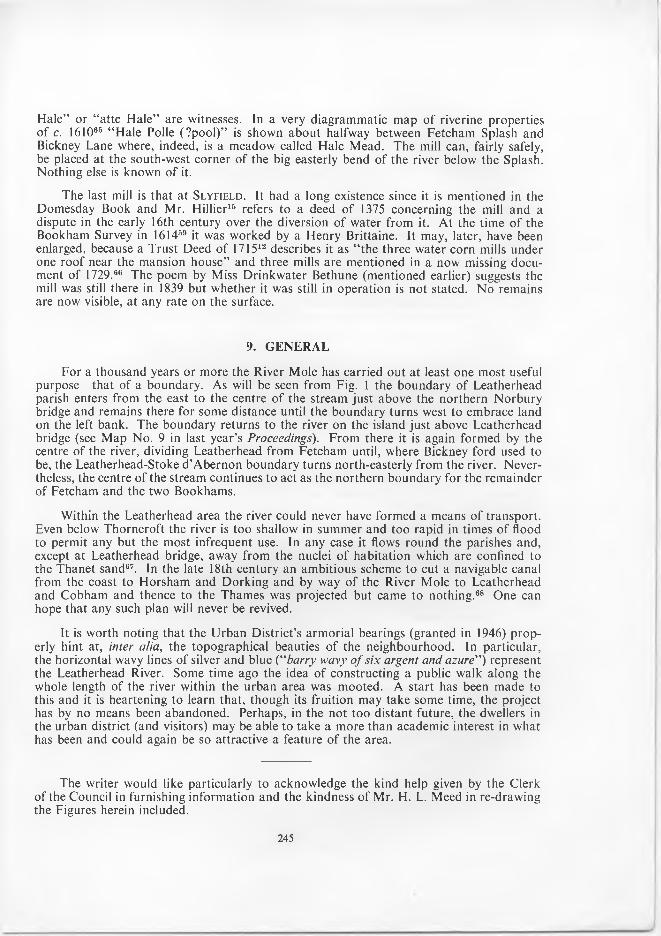
Hale” or “atte Hale” are witnesses. In a very diagrammatic map of riverine properties of c. 161065 “ Hale Polle (?pool)” is shown about halfway between Fetcham Splash and Bickney Lane where, indeed, is a meadow called Hale Mead. The mill can, fairly safely, be placed at the south-west corner o f the big easterly bend of the river below the Splash. Nothing else is known o f it.
The last mill is that at S l y f ie l d . It had a long existence since it is mentioned in the Domesday Book and Mr. Hillier15 refers to a deed o f 1375 concerning the mill and a dispute in the early 16th century over the diversion o f water from it. At the time of the Bookham Survey in 161459 it was worked by a Henry Brittaine. It may, later, have been enlarged, because a Trust Deed of 171512 describes it as “the three water corn mills under one roof near the mansion house” and three mills are mentioned in a now missing document of 1729.66 The poem by Miss Drinkwater Bethune (mentioned earlier) suggests the mill was still there in 1839 but whether it was still in operation is not stated. N o remains are now visible, at any rate on the surface.
9. G E N E R A L
For a thousand years or more the River Mole has carried out at least one most useful purpose—that of a boundary. As will be seen from Fig. 1 the boundary of Leatherhead parish enters from the east to the centre of the stream just above the northern Norbury bridge and remains there for some distance until the boundary turns west to embrace land on the left bank. The boundary returns to the river on the island just above Leatherhead bridge (see Map No. 9 in last year’s Proceedings). From there it is again formed by the centre of the river, dividing Leatherhead from Fetcham until, where Bickney ford used to be, the Leatherhead-Stoke d’Abernon boundary turns north-easterly from the river. Nevertheless, the centre of the stream continues to act as the northern boundary for the remainder of Fetcham and the two Bookhams.
Within the Leatherhead area the river could never have formed a means of transport. Even below Thorncroft the river is too shallow in summer and too rapid in times of flood to permit any but the most infrequent use. In any case it flows round the parishes and, except at Leatherhead bridge, away from the nuclei of habitation which are confined to the Thanet sand67. In the late 18th century an ambitious scheme to cut a navigable canal from the coast to Horsham and Dorking and by way o f the River Mole to Leatherhead and Cobham and thence to the Thames was projected but came to nothing.68 One can hope that any such plan will never be revived.
It is worth noting that the Urban District’s armorial bearings (granted in 1946) properly hint at, inter alia, the topographical beauties o f the neighbourhood. In particular, the horizontal wavy lines of silver and blue (“barry wavy o f six argent and azure") represent the Leatherhead River. Some time ago the idea of constructing a public walk along the whole length of the river within the urban area was mooted. A start has been made to this and it is heartening to learn that, though its fruition may take some time, the project has by no means been abandoned. Perhaps, in the not too distant future, the dwellers in the urban district (and visitors) may be able to take a more than academic interest in what has been and could again be so attractive a feature of the area.
The writer would like particularly to acknowledge the kind help given by the Clerk of the Council in furnishing information and the kindness of Mr. H. L. Meed in re-drawing the Figures herein included.
245
NOTESAccess. Accessions o f this Society.K .R.O . Kingston Record Office.Proc. Proceedings of this Society.S.A .C . Surrey Archaeological Collections.S.R.S. Surrey Record Society.
1. See the geological map, No. 2, Proc., Vol. 1, No. 10, p. 11.2. See account o f Mesolithic discoveries, Proc., Vol. 1, No. 6, p. 5ff.3. See A. T. Ruby, “The M anor of Pachenesham”, S.A .C ., LV, 1958, p. 16, n. (b).4. Access. W 36 (List of Randalls Park deeds).5. Proc., Vol. 2, No. 1, p. 35 and Vol. 1, No. 2, p. 15 respectively.6. See contour map, No. 1, Proc., Vol. 1, No. 9, p. 18.7. C. C. Fagg, F.G .S., “ Swallow Holes in the Mole G ap” , South Eastern Naturalist and Antiquary, Vol.
LXII, 1958, p. 1.8. Ibid., Fig. 6, p. 10.9. E.g. in “ Manning and Bray” (1809-14), and “Brayley” (1841-50).
10. This and the other widths given here are approximate measurements between the vertical banks, taken in July 1964.
11. See map, No. 9, Proc., Vol. 2, No. 7, p. 206.12. Access. W 28.13. Surrey Place Names, p. 4.14. Access. W 3 (Calendar of M erton College Deeds—Leatherhead).15. J. Hillier, Old Surrey Water Mills, p. 217.16. Cartulary o f Chertsey Abbey, Vol. II, published S.R.S.17. T. E. C. W alker, “Cobham : M anorial History” , S.A .C ., LVII1, pp. 60 and 61.18. By Miss Drinkwater-Bethune, dau. o f the then owner of Thorncroft.19. A. Heales, The Records o f Merton Priory, 1898.20. E.g. John Leland; Wm. Camden; Sir R obert C otton; Sir Wm. Dugdale; John Aubrey et alii.21. Faerie Queene, Book IV, Canto X I; c. 1596.
“And Mole, that like a nousling mole doth make His way still under ground till Thames he o’ertake.”
22. Britannia, 1586 (p. 297 of 1610 edition).23. A t a Vacation Exercise, 1627.
“ Rivers arise; whether thou be . . .O r sullen Mole that runneth underneath.”
24. The Polybion, 17th Song, 1613.“ Mole digs herself a path by working day and night
According to her name to show her nature right A nd underneath the earth for three miles space doth creep.”
25. Windsor Forest, 1711.“A nd sullen Mole that hides his driving flood.”
26. S.A .C ., Vol. XVII (1902), p. 111.27. E. W. Brayley, Topographical History o f Surrey, 1841, Vol. I, p. 173.28. Ibid., pp. 175-185.29. H. J. Burkill, “ F lora o f the River Mole” , The London Naturalist, 1934.30. Chas. Mackay, The Thames and its Tributaries, 1840, Vol. I, p. 212.31. James Thorne, Rambles along Rivers, 1844.32. Access. B 38.33. M anning and Bray, History and Antiquities o f Surrey, Vol. 2, p. 649.34. E. W. Brayley, Topographical History o f Surrey.35. Details from Dorking & Leatherhead Advertiser, 25 July, 1952.36. Access. W 6.37. F. B. Benger, “Thorncroft M anor” , Proc., Vol. 1, No. 6, p. 21.38. Cal. o f Patent Rolls—35 Edw. Ill, Part II, m. 24.39. Access. W 44.40. Access. X 66.41. Access. W 47.42. S.A .C ., Vol. XIX, p. 163.43. By the V. & A. Museum.
246
44. Access. W 65 (Extracts from S.R.S., Vol. XXXII, 1st Committee Book).45. Op. cit. sup., Vol. 3, Appendix p. xxxvii.46. T. E. C. W alker, op. cit., p. 62.47. Ibid., p. 67.48. Access. M 51.49. John H. Harvey, F.S.A., “A Short History of Bookham ” , Proc., Vol. 2, No. 5, p. 157.50. Op. cit. sup., pp. 60 and 62.51. Op. cit., Vol. 4, p. 433.52. Access. W 36A (copy P.R.O., C54/6847 Close Roll, 1788, part 7, ro. 4).53. Surrey, Vol. 3, p. 297.54. In A Pilgrimage in Surrey, 1914, Vol. II, p. 250.55. See map No. 7, Proc., Vol. 2, No. 5, p. 134.56. Leatherhead Guide, published by the U .D .C ., 1950, p. 43.57. Gentleman's Magazine, 1844.58. By Mr. J. S. Ogilvy, op. cit., sup. Vol. II, p. 248.59. Access. X 45.60. Gibson Thompson, Picturesque Surrey, 1902, p. 114.61. Op. cit. sup., at p. 215.62. A. T. Ruby, op. cit. sup., at p. 13.63. K.R.O., “Surrey Assize Rolls” , JI i/864, m. 16.64. Access. W 59.65. K.R.O ., M 78.66. Proc., Vol. 1, No. 4, p. 13.67. See Proc., Vol. 1, No. 10, p. 11.68. B. M. Additl. MS., 12,549; and see letter o f protest in Mr. T. E. C. W alker’s article (op. cit. sup.) at p. 78.69. E. Jervoise, The Ancient Bridges o f the South o f England, 1930, p. 28.70. See map No. 8, Proc., Vol. 2, No. 6, p. 169.
ADDENDA to the Article on JAM ES DALLAWAY in Vol. 2, No. 7
Mr. John Harvey, F.S.A., has pointed out to me tha t the last item, “ A ntiquities o f Bristow” 1834, in the list o f D allaway’s printed w ork consists o f W illiam W orcestre’s D escription o f Bristol, with an in troduction and notes by Dallaway.
Mr. Stanley G odm an tells me tha t the pane o f glass from South Stoke vicarage with a scratched inscription by Dallaway came to light again in 1963 and was handed to the editor o f the West Sussex Gazette, who proposes to give it to the new A rundel M useum.
F. B. B.
247
A HISTORY OF THE CHURCH AND ADVOWSON OF ST. MARY AND ST. NICHOLAS, LEATHERHEAD
By the late G. H. SM ITH
C h a p t e r I I I
T H E 12t h A N D 13t h C E N T U R Y A D D IT IO N S
'T 'H E FIR ST A D D IT IO N m ade to the church was a m anorial chapel, on the site ofp a rt o f the present south transept, and, no doubt, built by the lord o f Thorncroft
who held the m anor o f the D e Clares. As far as can be ascertained there is no docum entary evidence to show who built the chapel, or even any m ention o f its existence. But a m anorial chapel would be built on the side o f the church nearest the m anor house, and T horncroft was the only one to the south o f the church. M oreover, although the chapel was destroyed early in the 14th century, when the present transept was built, the Vestry Books of the 18th century m ention the south transep t as belonging to the occupier o f Thorncroft—a very curious example o f the persistence o f a tradition.
Founders o f churches, in old time, were usually buried in a stately tom b in the chancel they had built, so later m agnates built a chapel w ith an a ltar for their own com m em oration and tha t o f their families, and as a burial place fo r themselves and their descendants. M any o f these chapels were probably a thankoffering for the safe return from a foreign journey, or for preservation in tim e o f war. Surrey churches are noted for the num ber o f these m anorial chapels. In fact, w herever a transept is found in a parish church, tha t was not built when the church was erected, it can be safely assumed that it was built as a private chapel.
The w riter o f the description o f the church in the V.C.H., and the late M r. P. M. Johnston, bo th surmised tha t the present south transept was built on the foundation o f an older transept. The present writer has m ade a very careful exam ination of the outside of the east wall o f the transep t and found th a t 2 feet o f the wall next to the chancel is much older than the rem ainder o f the wall. This old wall is not so high as either the wall o f the transep t or the chancel, and it term inates against an internal quoin, or angle, o f Reigate stone. This m akes it certain th a t the East wall of the south transept is built, in part, off the foundation o f an older building, which may not have extended so far southwards. The internal quoin indicates th a t the chapel had either a rectangular projection to contain the altar, or, m ore probably, a sem i-circular apse, the foundations o f which would be destroyed when the dry-area was constructed. The chapel would be approached from the choir through a sem i-circular arched opening and have an external entrance in its west wall.
The scanty rem ains m ake it im possible to give an exact date for the building o f the chapel, but it was probably erected abou t the middle o f the 12th century.
R itual and cerem onial developm ents during the 12th century caused the next additions to be m ade to the church, the chief o f which were the grow th o f the cultus of the Sacram ent o f the A ltar, com bined with increased devotion to the Saints and the use of processions in worship.
The need for providing additional altars to com m em orate certain Saints and the difficulty o f keeping a clear way through the congregation in the nave for the procession, was m et by the construction o f the aisles about 1190. These provided a space for an altar at their eastern end and a t the same tim e gave an adequate passage room for the procession.
In order no t in terrup t the daily services, o f which there would be at least three, the building o f the aisles followed the usual custom o f the time. The walls with the windows were built first and the nave ro o f continued down over the aisle, thus forming a com m od
248
ious shop for the masons to w ork the stones for the colum ns and arches. An opening was left in the new wall for the entrance o f the w orkm en and m aterials, which was afterw ards built up. Traces o f these openings may still be found in the aisles o f some churches.
Having thus obtained a w eatherproof shop to w ork in, the m asons w ould proceed to set out the position o f the colum ns and arches on the old wall, and w ork the stones ready for fixing. The old wall was then cut through a t the east end, sufficiently for the respond, o r pier, to carry the east arch, and the stone built in. In a similar m anner the eastern colum n was erected, and the arch form ed, the old wall below being left in as a centre, or support, for the arch stones until the arch was completed. The o ther colum ns and arches were then dealt with in the same m anner, and when they were all finished the old wall between the columns and below the arches was taken dow n to the floor level, and the aisle was ready for use, with the least possible interference to the use o f the church.
The north aisle did not extend the full length o f the nave, but term inated a little to the west o f the present north entrance. The south aisle was built following the com pletion of the north aisle, but was carried to the full length o f the nave, its w estern respond can be seen in the choir vestry.
A feature o f great beauty is the carved capital o f the eastern colum n o f the north aisle, an excellent specimen o f the stiff-leaf foliage o f its period. Such individual treatm ent on one colum n or capital is often found in ancient churches, and m ay be a thankoffering of the mason.
A t the east end o f each aisle was an altar, with its screens, and it will be noticed tha t the adjacent window, although o f much later date, has a different character to the o ther windows, being carried through the eaves o f the roof, to gain additional light, and to indicate the position o f the altar.
The developm ent o f the cultus o f the Sacram ent o f the A ltar, and especially o f its ceremonial, was followed by the increasing dem and for the lay people to see the Elevation o f the H ost as a centre for devotion. This could no t be observed by m any w orshippers in the pre-Conquest church because o f the narrow openings to the choir and chancel. Therefore, as soon as the aisles were com pleted, the opening to the choir was w idened and the present arch built, and the east wall o f the tow er removed, giving the same view o f the high altar as now, except there would be a screen with central doors beneath the arch. The chancel a t this period was shorter than the present.
A unique feature o f this w ork is the carved scallop shell stops to the cham fer, or splay on the sides o f the opening beneath the arch, possibly, it has been suggested, a rem inder o f the m ason’s pilgrimage to some shrine.
A t some time in the first half o f the 13th century the church received the addition of a second m anorial chapel, this time on part o f the site now occupied by the north transept. Here, again, an exam ination o f the outside o f the east wall o f the transept shows tha t a portion o f the chapel wall was used in the 14th century transept, and some o f the quoin stones o f the north-east angle o f the chapel still rem ain, indicating th a t the chape! p ro jected about 10 feet to the north o f the chancel.
As was the case with the south chapel, we have no evidence to show who built the north chapel. A possible conjecture is th a t it was a mem ber o f the family o f De Michelem, who held land at Leatherhead a t this period; probably the land, or p a rt o f it, held by Baingiard in 1086. The De M ichelem’s land was afterw ards acquired by the de Aperdeles, one o f whom founded a chantry a t the a ltar o f St. M ary, which according to Dallaway, appears to have been in the north transept. In the 18th century the Vestry Books show that the north transept was occupied by the inhabitants o f the M ansion, in C hurch Street, and the owner o f the M ansion was responsible for the necessary repairs. M r. F. B. Benger
249
has shown tha t the M ansion stands on the site o f the form er m anor house o f the Minchin m anor. This m anor, or quasi-m anor, was formed o f land given by a de Aperdele in 1365 to the Prioress and convent o f K ilburn. A t the D issolution o f the M onasteries this m anor o f M inchin was granted in M ay 1541 to Thos. S tydolf who had purchased the m anor o f G reat Pachenesham in 1538.
There is a rem arkable squint form ed at the junction o f the east wall o f the transept and the chancel. As the squint could not have been m ade while the north wall o f the tower existed, this m ust have been rem oved when the chapel was built. The reason for a squint in this position was to enable a person in the chapel to obtain a view o f the high altar so th a t he could ring the Sanctus and Elevation bells, which is an indication tha t there was in existence a bell cham ber, as previously m entioned, over the choir.
The ringing o f these bells was ordered by an Injunction o f A rchbishop Peckham, in 1281, bu t a cerem onial usage ordered by authority had probably been in use for a long tim e previously. The bell was rung when the Sanctus was said, as a warning to those not present in church to prepare to make their devotions when the bell was again rung for the Elevations in the C onsecration. It is the same principle that is illustrated in the well- know n picture by M illet, only the picture refers to the Angelus bell.
There would be an entrance to the chapel from the north aisle, and an oak screen would separate it from the choir.
It is uncertain when the original roofs were rem oved, bu t probably in the 13th century the building was re-roofed, in a similar m anner to the present, and covered with stone slabs from the now disused quarries at Chaldon, transport from H orsham being impossible through the Weald.
The plastered wall surfaces in the interior o f the church would be painted, during this period, with stories from the Bible and the Lives of the Saints, as a means of instruction for the people. Probably the old windows were enlarged and glazed, a few, perhaps, with stained glass.
250
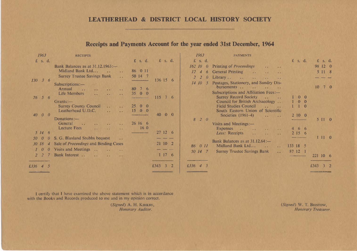
LEATHERHEAD & DISTRICT LOCAL HISTORY SOCIETY
Receipts and Payments Account for1963 RECEIPTS
£ s. d. £ s. d. £ s. d.Bank Balances as at 31.12.1963:—
Midland Bank Ltd. 86 0 11Surrey Trustee Savings Bank 50 14 7
130 3 6 136 15 6Subscriptions:—
Annual 80 7 6Life Members 35 0 0
76 5 6 115 7 6Grants:—
Surrey County Council 25 0 0Leatherhead U.D.C. 15 0 0
40 0 0 40 0 0Donations:—
General 26 16 6Lecture Fees .......................... 16 0
5 14 6 27 12 650 0 0 S. G. Blaxland Stubbs bequest — — —
30 18 4 Sale of Proceedings and Binding Cases 21 10 21 0 0 Visits and M eetin g s .......................... — — —
2 2 7 Bank Interest 1 17 6
£336 4 5 £343 3 2
I certify that I have examined the above statement which is in accordance with the Books and Records produced to me and in my opinion correct.
{Signed) A. H. K i r k b y ,Honorary Auditor.
the year ended 31st December, 19641963 PAYMENTS
£ s. d. £ s. d. £ s. d.162 10 0 Printing of Proceedings 98 12 012 4 6 General Printing .......................... 5 11 82 2 0 Library .................................................. — — —
14 10 5 Postages, Stationery, and Sundry Disbursements 10 7 0
Subscriptions and Affiliation Fees:—Surrey Record Society 1 0 0Council for British Archaeology .. 1 0 0Field Studies Council 1 1 0South Eastern Union of Scientific
Societies (1961-4) 2 10 08 2 0 5 11 0
Visits and Meetings:—E x p e n s e s ...................................... 4 6 6Less: Receipts .......................... 2 15 6
1 11 0Bank Balances as at 31.12.64:—
86 0 11 Midland Bank Ltd............................ 133 18 550 14 7 Surrey Trustee Savings Bank 87 12 1
221 10 6
£336 4 5 £343 3 2
(Signed) W . T. B r is to w , Honorary Treasurer.
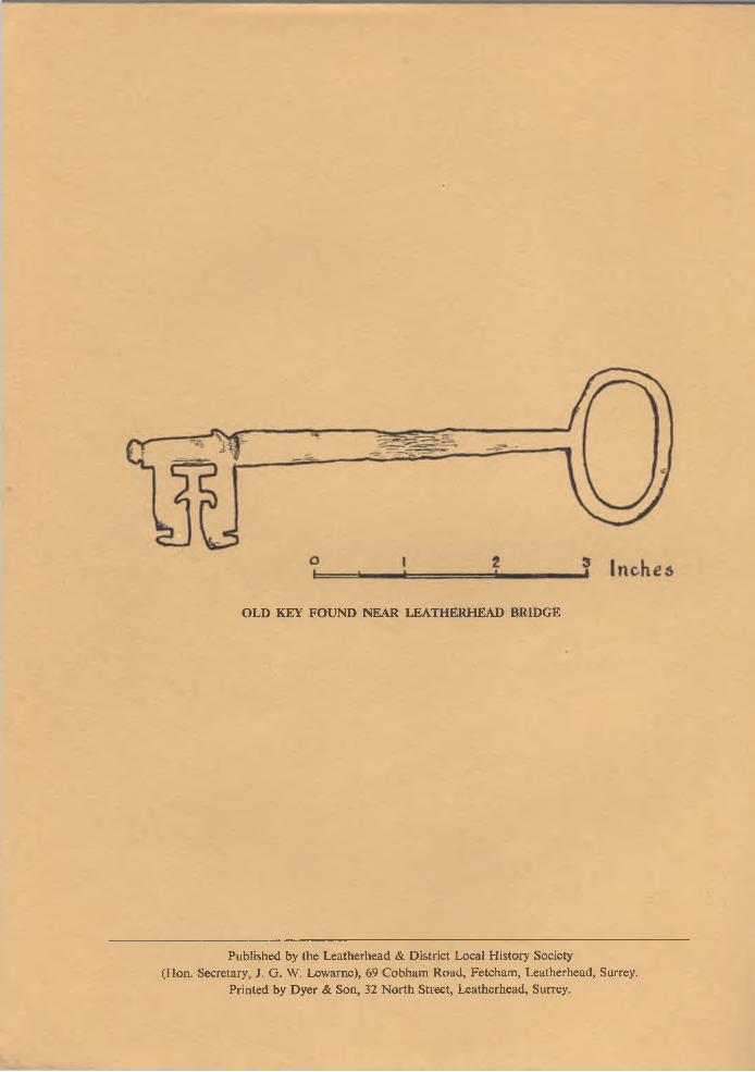
OLD KEY FOUND NEAR LEATHERHEAD BRIDGE
Published by the Leatherhead & D istrict Local H istory Society (Hon. Secretary, J. G . W. Lewarne), 69 C obham R oad, Fetcham , Leatherhead, Surrey.
Printed by D yer & Son, 32 N orth Street, Leatherhead, Surrey.