LC Paper No. CB(1)1165/16-17(05) For discussion on 26 June ... · strategy. Upon completion of...
33
LC Paper No. CB(1)1165/16-17(05) For discussion on 26 June 2017 Legislative Council Panel on Development Interim Public Consultation on the Detailed Feasibility Study for Environmentally Friendly Linkage System for Kowloon East and Progress Report on Kai Tak Development PURPOSE This paper serves to update Members on the findings of the Stage 1 of the Detailed Feasibility Study (DFS) for the Environmentally Friendly Linkage System (EFLS) for Kowloon East (KE) 1 (Enclosure 1), and to brief Members on the general progress of Kai Tak Development (KTD). BACKGROUND 2. The Kai Tak Outline Zoning Plan (OZP) approved in 2007 has incorporated an indicative alignment of an EFLS running within KTD 2 . In 2009, the Civil Engineering and Development Department (CEDD) conducted a preliminary feasibility study (PFS) on a rail-based EFLS. In the 2011-12 Policy Address, the Chief Executive announced the Energizing Kowloon East initiative to transform Kowloon East (KE) into another Core Business District (CBD) to sustain Hong Kong’s economic development. Under this initiative, the proposed EFLS is considered essential to strengthen connectivity for the transformation of KE into a CBD. 3. The PFS proposed the EFLS to take the form of a 9-kilometre long elevated monorail system with 12 stations and a link bridge across Kwun 1 Kowloon East comprises the Kai Tak Development (KTD), and the existing business areas of Kowloon Bay and Kwun Tong. 2 The EFLS alignment indicated on the latest Kai Tak OZP generally follows that incorporated in the plan since 2007.
Transcript of LC Paper No. CB(1)1165/16-17(05) For discussion on 26 June ... · strategy. Upon completion of...

LC Paper No. CB(1)1165/16-17(05)
For discussion on 26 June 2017
Legislative Council Panel on Development
Interim Public Consultation on the Detailed Feasibility Study for Environmentally Friendly Linkage System for Kowloon East
and Progress Report on Kai Tak Development PURPOSE
This paper serves to update Members on the findings of the Stage 1 of the Detailed Feasibility Study (DFS) for the Environmentally Friendly Linkage System (EFLS) for Kowloon East (KE)1 (Enclosure 1), and to brief Members on the general progress of Kai Tak Development (KTD). BACKGROUND 2. The Kai Tak Outline Zoning Plan (OZP) approved in 2007 has incorporated an indicative alignment of an EFLS running within KTD2. In 2009, the Civil Engineering and Development Department (CEDD) conducted a preliminary feasibility study (PFS) on a rail-based EFLS. In the 2011-12 Policy Address, the Chief Executive announced the Energizing Kowloon East initiative to transform Kowloon East (KE) into another Core Business District (CBD) to sustain Hong Kong’s economic development. Under this initiative, the proposed EFLS is considered essential to strengthen connectivity for the transformation of KE into a CBD. 3. The PFS proposed the EFLS to take the form of a 9-kilometre long elevated monorail system with 12 stations and a link bridge across Kwun
1 Kowloon East comprises the Kai Tak Development (KTD), and the existing business areas of Kowloon
Bay and Kwun Tong. 2 The EFLS alignment indicated on the latest Kai Tak OZP generally follows that incorporated in the plan
since 2007.

Page 2
Tong Typhoon Shelter (KTTS), namely Kwun Tong Transportation Link (KTTL), linking the former runway tip and Kwun Tong (Enclosure 2). A two-stage public consultation (PC) exercise on the preliminary EFLS proposal was conducted between 2012 and 2014. While there were general support to enhance the connectivity for KE and requests for early implementation of the EFLS, diversified views were received on the proposed elevated monorail system, which can largely be categorised into three key issues, i.e. (i) the need for an elevated rail-based EFLS; (ii) the preferred EFLS alignment and coverage; and (iii) the impact on the KTTS arising from KTTL. Regarding the need for an elevated rail-based EFLS, there were concerns about the high capital cost and weak financial performance of the proposed elevated monorail. A proposal for adopting modern tramway (Enclosure 3) at a lower construction cost as an alternative to elevated monorail was received during the PC. As the PFS did not have the level of details to address the public concerns, we recommended to conduct a DFS to address various concerns and to draw up a scheme which would be developed to meet the relevant statutory and government requirements and would be generally accepted by the stakeholders. 4. During the funding application for the DFS in mid-2015, some Legislative Council Members questioned the financial viability of the proposed monorail system. The scope of the DFS was thus expanded and the DFS would be carried out in two stages. Stage 1 of the DFS would assess various green transport (GT) modes, including Personal Rapid Transit, Cable Car / Cable Liner, Electric / Supercapacitor / Hybrid Bus, Travellator, Automated People Mover (APM), Monorail, Modern Tramway (MT) and Bus Rapid Transit (BRT), on equal basis in order to identify the most suitable GT mode for the EFLS and to conduct an interim PC on the findings of the assessment. Based on the recommended GT mode, Stage 2 of the DFS would further develop the EFLS scheme including its alignment coverage, station and depot locations, financial evaluation and procurement and implementation strategy. Upon completion of Stage 2 detailed assessment, another PC will be conducted to further collect public views. 5. The DFS commenced in October 2015 and we have now completed Stage 1 of the DFS, which includes assessment on system performance, impacts on other road users, capital cost and economic viability of the different GT mode(s). The key findings are set out in the ensuing paragraphs, and details can be found in the website of the DFS

Page 3
(www.ktd.gov.hk/efls). KEY FINDINGS OF STAGE 1 OF THE DFS 6. The total commercial gross floor area (GFA) in KE was about 2.3 million square metres (m2) in 2016. With the gradual transformation of KE into a CBD and the proposed increase in the development intensity of KTD, it is anticipated that the total commercial GFA in KE has the potential to reach about 7 million m2. Together with the growth in residential population in KTD, the daily public transport (PT) passenger trips within KE are forecasted to rise by more than one fold in 2036. 7. To facilitate successful transformation of the KE into a CBD, it would be of utmost importance to enhance the accessibility of KE and its connectivity with all major destinations in the territory. Since the MTR Kwun Tong Line and Shatin to Central Link run along the periphery of KE, the connectivity within KE mainly relies on road-based PT services and walkway system, which will hardly meet the level of service required for a CBD. It is therefore necessary to introduce EFLS as an additional transport mode in linking up the key activity nodes within KE and connecting with rail stations as well as nearby PT and pedestrian facilities. It will not only meet the newly generated traffic need arising from new developments in the area, but also improve the accessibility of KE to facilitate its development to become a premium business district. 8. To address the increase in travel demand and to provide a high level service required for the CBD, the EFLS should have sufficient capacity to meet future travel demand in KE, and be reliable, comfortable and on-time so as to provide quick and time-competitive journeys as compared with other PT services. Being a green transport mode, EFLS has to be environmentally and socially sustainable with minimal impact during both construction and operation stages. On this basis, the EFLS has to achieve four basic visionary criteria including (i) capacity; (ii) reliability; (iii) efficiency; and (iv) sustainability in order to serve as a PT backbone within KE. 9. In carrying out Stage 1 of the DFS, a two-phase evaluation approach has been used in identifying the most suitable GT mode(s) for the
Page 4
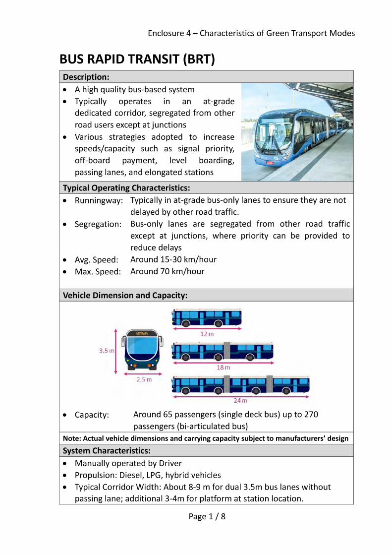
proposed EFLS. A high level screening was conducted to assess all the GT modes against the four visionary criteria based on their system characteristics as summarized at Enclosure 4. It has revealed that Personal Rapid Transit and Cable Car / Cable Liner are of lower and inadequate carrying capacity. Being environmentally friendly in using green energy, Electric / Supercapacitor / Hybrid Bus has similar operating speed as the conventional bus. Travellator is considered as a supplement to pedestrian facility for enhancing walking comfort for a short distance travel. Amongst all the GT modes assessed, the performance of Monorail, APM, MT and BRT in terms of capacity, reliability, efficiency and sustainability have to be further evaluated. 10. Based on the operating and infrastructure characteristics, the four selected transport modes have been grouped as follows:
(i) At-grade Dedicated Corridor Modes (using MT or BRT) - requiring occupation of road space of 2 to 3 traffic lanes for exclusive use;
(ii) At-grade Shared Corridor Mode (using MT) - sharing the road space with general traffic; and
(iii) Elevated Modes (using Monorail or APM). 11. Detailed assessments in terms of system performance, impacts on other road users, capital cost and economic viability for the above three groups have been carried out and are deliberated in the following paragraphs. At-grade Modes
12. For the dedicated corridor modes, apart from taking up road space currently used by vehicles (Enclosure 5), all junctions along the corridor have to be signalized with priority given to EFLS to enhance its travelling speed. It would thus cause serious traffic congestion along and in the vicinity of their proposed routes. For example, the assessment indicated that in Kowloon Bay, the speed of road traffic could be reduced to as slow as the walking speed. The community as a whole has to spend more time in daily travel due to the introduction of the dedicated corridor modes. Furthermore, to avoid disruption to the service, it is necessary to realign all underground utilities away from the

Page 5
dedicated corridor. As a result, the economic return3 for these modes are negative. 13. For the At-grade Shared Corridor Mode, as its service would be interrupted by other vehicles sharing the same road space (Enclosure 5), its operating speed or reliability performance would be no different from other road-based PT. Furthermore, to avoid disruption to the service, it is necessary to realign all underground utilities away from the shared corridor. Taken into account the extra costs on establishing and operating the MT system, the economic return for this mode is also negative. Elevated Modes
14. On the other hand, an elevated system segregating from road traffic (Enclosure 5) provides reliable service, offers better overall system performance and attracts higher daily ridership. Through maintaining the existing traffic lanes, the presence of the elevated system would not have significant impact on the operation of road traffic. Despite the capital investment cost is comparatively higher than those of the at-grade modes, the elevated system would still generate a positive economic return through considerable saving in the travelling time of PT users. WAY FORWARD FOR THE EFLS PROJECT 15. In response to the first key issue mentioned under paragraph 3, i.e. the need for an elevated rail-based EFLS, we have assessed various GT modes on equal basis under Stage 1 of the DFS. Stage 1 study concluded that the two elevated modes (Monorail or APM) should be selected as the most suitable GT modes as the EFLS for KE and be further examined in Stage 2 of the DFS. 16. To solicit public views on the findings of Stage 1 of the DFS, we launched a 2-month interim public consultation (PC) on 2 May 2017. As part of the interim PC, we briefed the following District Councils (DCs) on the
3 Economic return is measured in terms of Economic Internal Rate of Return. It is the
discount rate that equates the present value of the economic costs stream (including the capital and operation costs during construction and the subsequent 50 years of operation) to that the economic benefits stream (including travel time savings of passengers, vehicle operating cost savings, and accident cost savings), as a measure of the overall cost-effectiveness of the project to the community.

Page 6
recommendations of the Stage 1 of the DFS:
(a) Kwun Tong District Council on 9 May 2017;
(b) Wong Tai Sin District Council on 9 May 2017; and
(c) Kowloon City District Council on 18 May 2017.
There was general support from the three DCs on adoption of the elevated modes as the most suitable GT modes for the EFLS for KE. Some Members requested an early implementation of the EFLS. 17. Stage 2 of the DFS will examine in detail the proposed elevated EFLS alignment coverage, station and depot locations, capital and operating costs, procurement approach, its associated economic and financial performance and implementation programme. PROGRESS REPORT ON KTD 18. KTD covers an area of over 320 hectares involving a large-scale and highly complex development programme in the urban area. It plays an important role to help sustain Hong Kong’s economic growth and stimulate regeneration of adjacent old districts in Kwun Tong, Kowloon City and Wong Tai Sin. KTD is being implemented in phases according to their relative priorities and readiness to proceed. The first two packages of KTD projects were largely completed while the remaining package is under construction or at design stage. The latest progress of KTD is given in Enclosure 6. Development Bureau Civil Engineering and Development Department June 2017

一1
圖則名稱 Drawing title 九龍東涵蓋範圍Coverage of Kowloon East
施工
中的
沙田
至中
環線
Shat
in to
Cen
tral L
ink u
nder
Cons
truct
ion
港鐵
觀塘
線
MTR Kwun Tong Line
九龍灣商貿區Kowloon BayBusiness Area
註釋:Note:
九龍東包括啟德發展區及現時的九龍灣及觀塘商貿區Kowloon East comprises of Kai TakDevelopment and existing business areasof Kowloon Bay and Kwun Tong
啟德發展區Kai Tak Development
九龍灣商貿區Kowloon BayBusiness Area
觀塘商貿區Kwun TongBusiness Area
圖例LEGEND
啟德發展區Kai Tak Development
觀塘商貿區Kwun Tong
Business Area
啟德體育園Kai Tak Sports Park
九龍灣行動區Kowloon BayAction Area
觀塘行動區Kwun TongAction Area
醫院Hospital
九龍灣Kowloon Bay
牛頭角Ngau Tau Kok
觀塘Kwun Tong
藍田Lam Tin
彩虹Choi Hung
鑽石山Diamond Hill
樂富Lok Fu
啟德Kai Tak
土瓜灣TO KWA WAN
馬頭圍MA TAU WAI
啟德郵輪碼頭Kai Tak Cruise Terminal

圖則名稱 Drawing title 初步可行性研究的環保連接系統初步建議Preliminary EFLS proposal under Preliminary Feasibility Study
已進行諮詢的環保連接系統初步建議Preliminary EFLS Proposal -Alignment on which PublicConsultation was conducted
環保連接系統初步建議 -替代走線Preliminary EFLS Proposal -Alternative Alignment
初步建議的環保連接系統車站Preliminary EFLS Station
港鐵與環保連接系統的交匯站MTR Station Interchangewith EFLS
初步建議的環保連接系統車廠Preliminary EFLS Depot
啟德發展區Kai Tak Development
黃大仙WONG TAI SIN
鑽山石DIAMOND HILL
啟德KAI TAK
馬頭圍MA TAU WAI
土瓜灣TO KWA WAN
施工
中的
沙田
至中
環線
Shat
in to
Cen
tral L
ink u
nder
Cons
truct
ion
港鐵
觀塘
線
MTR Kwun Tong Line
彩虹CHOI HUNG
九龍灣Kowloon Bay
牛頭角NGAU TAU KOK
觀塘KWUN TONG
藍田LAM TIN
樂富LOK FU
mokwc
文字方塊
二
mokwc
文字方塊
2

路線1 第1期Line 1 Phase 1
路線1 第2期Line 1 Phase 2
路線2 第1期Line 2 Phase 1
路線2 第2期Line 2 Phase 2
圖則名稱 Drawing title 於初步可行性研究收到的現代電車之建議Modern Tramway Proposal as received under Preliminary Feasibility Study
黃大仙WONG TAI SIN
樂富LOK FU
鑽山石DIAMOND HILL
啟德KAI TAK
馬頭圍MA TAU WAI
土瓜灣TO KWA WAN
施工
中的
沙田
至中
環線
Shat
in to
Cen
tral L
ink u
nder
Cons
truct
ion
港鐵
觀塘
線
MTR Kwun Tong Line
啟德發展區Kai Tak Development
彩虹CHOI HUNG
牛頭角NGAU TAU KOK
觀塘KWUN TONG
藍田LAM TIN
九龍灣Kowloon Bay
mokwc
文字方塊
三
mokwc
文字方塊
3
Enclosure 4 – Characteristics of Green Transport Modes
Page 1 / 8
BUS RAPID TRANSIT (BRT) Description: • A high quality bus-based system • Typically operates in an at-grade
dedicated corridor, segregated from other road users except at junctions
• Various strategies adopted to increase speeds/capacity such as signal priority, off-board payment, level boarding, passing lanes, and elongated stations
Typical Operating Characteristics: • Runningway: Typically in at-grade bus-only lanes to ensure they are not
delayed by other road traffic. • Segregation: Bus-only lanes are segregated from other road traffic
except at junctions, where priority can be provided to reduce delays
• Avg. Speed: Around 15-30 km/hour • Max. Speed: Around 70 km/hour
Vehicle Dimension and Capacity:
• Capacity: Around 65 passengers (single deck bus) up to 270 passengers (bi-articulated bus)
Note: Actual vehicle dimensions and carrying capacity subject to manufacturers’ design System Characteristics: • Manually operated by Driver • Propulsion: Diesel, LPG, hybrid vehicles • Typical Corridor Width: About 8-9 m for dual 3.5m bus lanes without
passing lane; additional 3-4m for platform at station location.

Enclosure 4 – Characteristics of Green Transport Modes
Page 2 / 8
MODERN TRAMWAY (MT) Description: • Rail-based system typically operating on
street in embedded track • MT operates in both shared and
dedicated corridors, although reliability and speed significantly reduced in shared operation
• Typically powered by overhead wires, but newer systems can be “overhead wire free” using embedded power supply systems
Typical Operating Characteristics: • Runningway: Typically at-grade in embedded track • Segregation: Shared corridors use track occupying the same traffic
lanes as other vehicles. Dedicated corridors are segregated from other road traffic except at junctions, where priority can be provided to reduce delays.
• Avg. Speed: Around 20-30 km/hour • Max. Speed: Around 80 km/hour Vehicle Dimension and Capacity:
• Capacity (4 pax/m2): Around 200-240 passengers (for 32m long tram) Note: Actual vehicle dimensions and carrying capacity subject to manufacturers’ design
System Characteristics: • Manually operated by Driver • Propulsion: Electricity • Typical Corridor Width: About 7 m for dual track; additional 2.5-3m for
platform at station location.
2.3 – 2.7m
Enclosure 4 – Characteristics of Green Transport Modes
Page 3 / 8
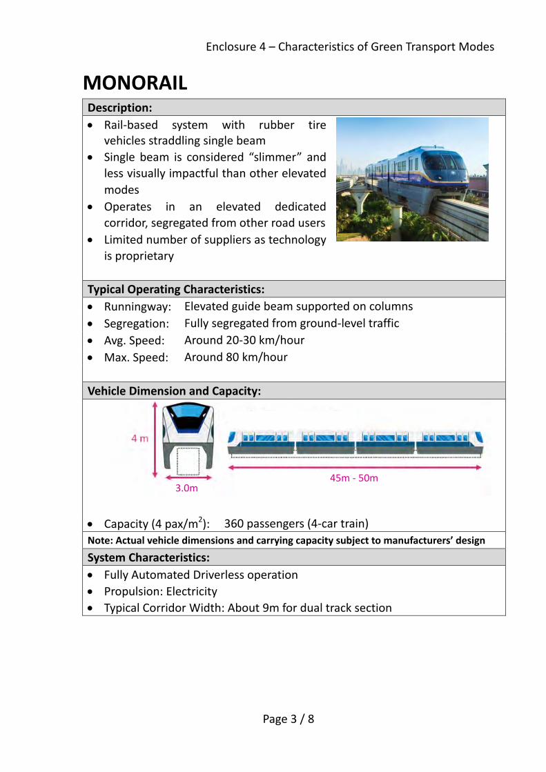
MONORAIL Description:
Rail‐based system with rubber tire vehicles straddling single beam
Single beam is considered “slimmer” and
less visually impactful than other elevated
modes
Operates in an elevated dedicated
corridor, segregated from other road users
Limited number of suppliers as technology
is proprietary
Typical Operating Characteristics:
Runningway: Elevated guide beam supported on columns
Segregation: Fully segregated from ground‐level traffic
Avg. Speed: Around 20‐30 km/hour
Max. Speed: Around 80 km/hour
Vehicle Dimension and Capacity:
Capacity (4 pax/m2): 360 passengers (4‐car train)
Note: Actual vehicle dimensions and carrying capacity subject to manufacturers’ design
System Characteristics:
Fully Automated Driverless operation
Propulsion: Electricity
Typical Corridor Width: About 9m for dual track section
45m ‐ 50m 3.0m

Enclosure 4 – Characteristics of Green Transport Modes
Page 4 / 8
AUTOMATED PEOPLE MOVER (APM) Description:
Rail‐based system with vehicles using
rubber tires running on a flat guideway on
viaduct
Operates in an elevated dedicated
corridor, segregated from other road
users
Limited number of suppliers as
technology is proprietary
Typical Operating Characteristics:
Runningway: Elevated guideway supported on columns
Segregation: Fully segregated from ground‐level traffic
Avg. Speed: Around 20‐30 km/hour
Max. Speed: Around 80 km/hour
Vehicle Dimension and Capacity:
Capacity (4 pax/m2): 400 passengers (4‐car train)
Note: Actual vehicle dimensions and carrying capacity subject to manufacturers’ design
System Characteristics:
Fully Automated Driverless operation
Propulsion: Electricity
Typical Corridor Width: About 9m for dual track section
45m ‐ 50m
Enclosure 4 – Characteristics of Green Transport Modes
Page 5 / 8
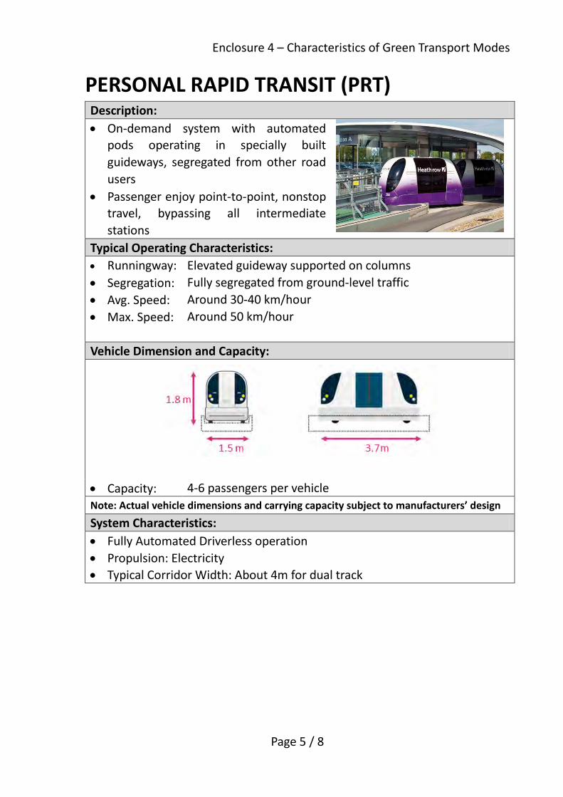
PERSONAL RAPID TRANSIT (PRT) Description: • On-demand system with automated
pods operating in specially built guideways, segregated from other road users
• Passenger enjoy point-to-point, nonstop travel, bypassing all intermediate stations
Typical Operating Characteristics: • Runningway: Elevated guideway supported on columns • Segregation: Fully segregated from ground-level traffic • Avg. Speed: Around 30-40 km/hour • Max. Speed: Around 50 km/hour Vehicle Dimension and Capacity:
• Capacity: 4-6 passengers per vehicle Note: Actual vehicle dimensions and carrying capacity subject to manufacturers’ design System Characteristics: • Fully Automated Driverless operation • Propulsion: Electricity • Typical Corridor Width: About 4m for dual track

Enclosure 4 – Characteristics of Green Transport Modes
Page 6 / 8
CABLE CAR Description: • Aerial system with cabins pulled by a
suspended cable, completely segregated from road users
• Lower capacity compared to other systems as cable strength limits number of cabins operating
• System closes during heavy rain, high winds and low visibility and maintenance
• Turning towers necessary for change of direction Typical Operating Characteristics: • Runningway: Elevated system suspended from ropeway • Segregation: Fully segregated from ground-level traffic • Avg. Speed: Around 10-20 km/hour Vehicle Capacity: • Cabin size depends on design capacity • Capacity per Cabins: Typically 10-17
passengers (ref: Ngong Ping 360’s cabins seat 10 and hold up to 17 passengers)
Note: Actual vehicle dimensions and carrying capacity subject to manufacturers’ design System Characteristics: • Fully Automated System • Propulsion: Electricity • Hauling systems by cable spanning between towers

Enclosure 4 – Characteristics of Green Transport Modes
Page 7 / 8
CABLE LINER Description: • System uses vehicles pulled by cables
below the vehicle • Operates in an elevated dedicated
corridor. Vehicles have no motors and are lighter, allowing for less bulky support viaducts
• Typically used for feeder system or for airports
• Limited number of suppliers as technology is proprietary
Typical Operating Characteristics: • Runningway: Elevated truss/guideway supported on columns • Segregation: Fully segregated from ground-level traffic • Avg. Speed: Around 35-40 km/hour
Vehicle Dimension and Capacity:
• Capacity: Around 110-115 passengers per three car train Note: Actual vehicle dimensions and carrying capacity subject to manufacturers’ design System Characteristics: • Fully Automated Driverless System • Propulsion: Electricity

Enclosure 4 – Characteristics of Green Transport Modes
Page 8 / 8
TRAVELLATOR Description: • Sometimes referred to as a moving
sidewalk or walkway, travellators reduce effective walking distances and walk times
• Travellators may be provided indoor or outdoor (typically covered), underground, at-grade, or on a footbridge
• Targeted for short-distance walk trips, for instance in airports and between major transport hubs and nearby buildings
• Slow moving speed makes travellators unsuitable for longer distance trips
Typical Operating Characteristics: • Runningway: Typically provided adjacent to conventional walkway either
on footbridge/subway or within building as an additional pedestrian facility to enhance walking comfort
• Avg. Speed: Around 2.5 km/hour System Characteristics: • Propulsion: Electricity • Width depends on designed capacity and whether luggage and carts are
allowed on the travellator • Capacity can vary significantly according to whether pedestrians walk or
stand, as well as the gap between pedestrians
Note: Actual vehicle dimensions and carrying capacity subject to manufacturers’ design

一1
圖則名稱 Drawing title 九龍東涵蓋地區Coverage of Kowloon East
行人路Footpath
行人路Footpath
兩條行車線2-lane carriageway
兩條行車線2-lane carriageway
建築物Building
建築物Building
行人路Footpath
行人路Footpath
一條行車線1-lane
carriageway
一條行車線1-lane
carriageway
地面(專線)系統At-grade
(Dedicated)System
建築物Building
建築物Building
行人路Footpath
行人路Footpath
兩條行車線2-lane carriageway
兩條行車線2-lane carriageway
建築物Building
高架橋Viaduct
架空電纜Overhead Line
建築物Building
現時路面情況Current Road Configuration
採用高架系統後With Elevated System
維持現有行車線Existing traffic lanes maintained
行人路Footpath
行人路Footpath
一條行車線1-lane
carriageway
一條行車線1-lane
carriageway
地面(共用路面)系統
At-grade (Shared)System
建築物Building
建築物Building
採用地面(專線)系統後With At-grade (Dedicated) System
採用地面(共用路面)系統後With At-grade (Shared) System
候車月台Platform
候車月台Platform
圖則名稱 Drawing title 不同環保公共交通模式於宏光道的剖面圖Cross Sections of Various Green Public Transport Modes at Wang Kwong Road
五5
架空電纜Overhead Line
與其他車輛同時共用行車道Sharing traffic lanes with other vehicles
佔用2條現有行車線Two existing traffic lanes occupied
Enclosure 6
Progress Report on Kai Tak Development PURPOSE This report updates Members on the general progress of Kai Tak Development (KTD). OVERVIEW 2. KTD, covering an area of over 320 hectares, is a mega-sized and highly complex development project in the urban area offering a unique opportunity for transforming the ex-airport site for the future growth of Hong Kong, and at the same time providing an impetus for stimulating regeneration of the adjoining older districts. It also forms part of the Energizing Kowloon East initiative of transforming the industrial areas at Kowloon Bay and Kwun Tong together with KTD into another Core Business District (CBD). A master development plan was drawn up in early 2009 for the phased implementation of KTD projects. KTD has already witnessed the substantial completion of the first two packages of projects starting from 2013. 3. We briefed the Legislative Council (LegCo) Panel on Development (the Panel) on the KTD implementation plan in January 2009 and updated Members on its progress at a regular interval between 2009 and 2016. Since 2009, we have obtained funding approvals from LegCo for a series of public works projects for KTD with an aggregate approved project estimate of about $53 billion as detailed at Annex 1. CURRENT SITUATION Major Projects Already Completed 4. Major KTD projects already completed are shown at Annex 2. At the former south apron and runway areas, Stage 1 advance infrastructure works including Shing Cheong Road and Shing Fung Road leading to the Kai Tak Cruise Terminal (KTCT) were completed for public use in May 2013. The KTCT building and its first berth, as well as the Kai Tak Fire Station cum ambulance depot at the junction of Cheung Yip Street and Hoi Bun Road, were

Page 2
commissioned in June 2013. The landscaped deck on top of KTCT building and Runway Park Phase 1 were opened to public in October 2013 and June 2014 respectively. Inaugural berthing for medium-sized cruise vessels took place at the second berth of KTCT in September 2014. Upon completion of remaining dredging works in December 2015, the second berth of KTCT is able to accommodate berthing of mega cruise vessels from 2016 onwards. The Kwun Tong Promenade was opened to public in two stages in January 2010 and May 2015 respectively. 5. At the former north apron area, Stage 1 infrastructure works were completed in December 2013 to support the public rental housing (PRH) development including Kai Ching Estate and Tak Long Estate. Other projects including two sewage pumping stations and Phases I & II of District Cooling System (DCS) covering the northern plant room, southern plant room and sea water pump room, were also completed. Stage 2 infrastructure works serving the residential sites in the Grid Neighbourhood on the eastern side of Kai Tak River, together with Trade and Industry Tower (TI Tower), were completed in April 2015. Two primary schools adjacent to the PRH development were completed in December 2015.
6. Phase 1 improvement works at Kai Tak Approach Channel (KTAC) and Kwun Tong Typhoon Shelter (KTTS), including embankment improvements, dredging and bioremediation works, to address the odour issue were completed in July 2014. At the same time, drainage and sewerage improvement works in the hinterland of KTD are completed progressively. 7. Housing supply is one of the key policy priorities of the Government. Up to now, we have delivered in batches a total of 16 residential sites, which are located at or near the Grid Neighbourhood on both sides of Kai Tak River at the former north apron area, and which were handed over in batches to the Urban Renewal Authority and the Housing Authority for development, and the Lands Department (LandsD) for land sale through public tender. The total residential gross floor area (GFA) inclusive of those for PRH made available to date in KTD is about 1 160 000 square metres (m2), providing about 23 800 flats.
8. Apart from increasing housing land supply, the continued supply of land for commercial uses is essential to sustain Hong Kong's economic growth. On top of the commercial GFA of 25 000 m2 in the residential sites as mentioned above, two new commercial sites having GFA of 276 000 m2 located on the eastern side of Kai Tak River have also been handed over to LandsD for land sale through public tender, and hence capable of providing a total of about 301 000 m2 commercial GFA. The locations of residential and

Page 3
commercial sites already disposed or being tendered are shown in Annex 3. Major Projects under Construction 9. Major projects in KTD currently under construction are summarized in the ensuing paragraphs. A location plan of these projects is at Annex 4. 10. At the former north apron area, Stage 3A infrastructure works (serving the development sites near San Po Kong and enhancing the connectivity of KTD with San Po Kong) and Stage 4 infrastructure works (serving six housing sites of the Grid Neighbourhood west of Kai Tak River and enhancing the connectivity between To Kwa Wan and Kowloon Bay) are in progress for phased completion by 2017. The upgrading and reconstruction works for the section of Kai Tak Nullah within KTD will be completed in phases by 2018. Stages 5A and 3B infrastructure works to serve more development sites at the former north apron area near Kowloon City and San Po Kong commenced construction in September and December 2016 respectively for completion both in 2020. Construction of Tai Wai to Hung Hom Section of Shatin to Central Link (SCL) in KTD is ongoing for targeted commissioning in about mid-2019. 11. Kowloon East Regional Headquarters and Operational Base cum Ngau Tau Kok Divisional Police Station are under construction for completion in 2019. The main contract for a 30-classroom secondary school commenced in March 2017 for completion in 2019.
12. At the former south apron area, the Hong Kong Children’s Hospital (HKCH) is under construction for completion in the third quarter of 2017. 13. DCS Phase III (Packages A & B) is being carried out for phased completion by end 2017 and end 2018 respectively. Due to an early sectional completion of the DCS Phase III (Package A), provision of chilled water supply to the TI Tower and two primary schools are secured to tie in with their completion in late 2015. Phase III (Packages A & B) will also supply chilled water to a number of public developments in KTD, including the HKCH, the headquarters of the Electrical and Mechanical Services Department, the SCL To Kwa Wan Station and Kai Tak Station and the Kowloon East Regional Headquarters and Operational Base cum Ngau Tau Kok Divisional Police Station. DCS Phase III (Package C) also commenced construction in September 2016 for phased completion by 2020.

Page 4
14. To facilitate early disposal of commercial and residential development sites at the former runway, infrastructure works commenced in November 2015 for staged completion by 2019. Stage 2 infrastructure works at the former runway cover re-aligning and widening of Shing Fung Road, as well as building new roads with associated infrastructures including an elevated landscaped deck and noise barriers, whereas Stage 3 infrastructure works at the former south apron area include widening of Cheung Yip Street and Shing Cheong Road together with construction of the supporting underground structure as enabling works for the future Trunk Road T2. Major Projects under Active Planning/Design 15. Major projects under active planning and design are summarized in the ensuing paragraphs. A location plan of these projects is at Annex 5. 16. Invitation of tenders for the design-and-build contract for the Inland Revenue Tower project was issued in January 2017. Subject to funding approval from LegCo, it is planned to commence construction in early 2018 for completion in 2022.
17. For the Kai Tak Sports Park (KTSP), formerly known as Multi-purpose Sports Complex project, the Home Affairs Bureau (HAB) conducted a public engagement exercise, including launching of dedicated project website, roving exhibitions in various locations and consultations with the District Councils concerned, between May and July 2016. The Environmental Impact Assessment (EIA) Report was approved under the EIA Ordinance in January 2017. The scope of the KTSP project has been refined taking into account the views collected during public engagement, which include an increase in seating capacity of the Indoor Sports Centre. Such refinements should not lead to any adverse environmental impact and HAB will confirm the environmental implications of the refinements in the application for the Environmental Permit for the KTSP under the EIA Ordinance. The planning application for relaxing the building height restriction of the Main Stadium and developing a hotel next to the Main Stadium was approved by the Town Planning Board in March 2017. Invitation of prequalification of tenderers has commenced on 28 April 2017. Funding approval from LegCo is being sought. 18. In accordance with the 2017 Policy Address, we aim at first developing the Avenue Park and Station Square at the former north apron, the waterfront promenade adjacent to HKCH at the former south apron and the

Page 5
Hoi Sham Park Extension in To Kwa Wan in the near future. 19. The New Acute Hospital at the former south apron area is under active planning.
20. Trunk Road T2 together with the proposed Central Kowloon Route (CKR) and Tseung Kwan O – Lam Tin Tunnel form Route 6 in the strategic road network, which will provide the necessary relief to the existing heavy traffic in the central and eastern Kowloon areas. As part of the Trunk Road T2 and CKR fall within KTD, their progress update is also provided for reference purpose. The road scheme of CKR was authorized in January 2016 under the Roads (Works, Use and Compensation) Ordinance (Cap. 370). Subject to funding approval of the Finance Committee in this legislative year, the CKR project can commence in the third quarter of 2017 and be completed in around 2025. Trunk Road T2 project was gazetted under the Roads (Works, Use and Compensation) Ordinance in September 2014 and authorized in November 2014. The detailed design is in progress. We intend to implement Trunk Road T2 so that its completion will tie in with that of CKR. 21. Further stages of infrastructure works at KTD are currently under design, which will be implemented in phases to suit the development pace of KTD.
22. Remaining works under Phase III of the DCS project to tie in with the overall development are also under active planning and design.
23. The odour problem at KTAC and KTTS is generally under control. In 2015, we studied alternative options in lieu of the proposed 600 m opening under the Phase 2 improvement works at KTAC and KTTS and concluded that an Interception and Pumping (IP) Scheme could effectively reduce the polluted flow from entering KTAC and KTTS and improve the water circulation, whilst achieving similar environmental performance as the originally proposed 600 m opening. We consulted Kwun Tong, Kowloon City and Wong Tai Sin District Councils and Task Force on Kai Tak Harbourfront Development (TFKT) in the third quarter of 2015 and obtained general support for the proposed alternative IP scheme. The detailed design of which is underway. Kai Tak Fantasy (KTF) 24. KTF covers an area of about 90 hectares spanning the former runway tip in KTD, the Kwun Tong Action Area (KTAA) and the enclosed
Page 6
water body between them. KTF will be a recreational landmark. It would also become a tourism and entertainment destination for public enjoyment. The Energizing Kowloon East Office (EKEO) of the Development Bureau is taking forward the KTF initiative under two studies, namely the Planning and Urban Design Review for Developments at Kai Tak Runway Tip and the Planning and Engineering Study on KTAA. EKEO will consult the public later this year on the design plan of the Runway Tip and the Preliminary Outline Development Plan of the KTAA. Besides, the Tourism Commission intends to announce the details of tender arrangement for the Tourism Node development within 2017. Environmentally Friendly Linkage System (EFLS)
25. To support the initiative of transforming KE into another CBD, the proposed EFLS will improve intra- and inter- districts connectivity of the area. Following funding approval of the Finance Committee in July 2015, the detailed feasibility study (DFS) for the EFLS commenced in October 2015. Stage 1 of the DFS, which is to provide in-depth evaluation on the most suitable green public transport mode(s) for the proposed EFLS, has been completed and suggested the adoption of elevated modes for further examination in Stage 2 of the DFS. Public consultation on Stage 1 findings is being conducted to solicit views from different stakeholders. Stage 2 of the DFS will take account of comments received in the consultation process and examine in detail the proposed EFLS alignment coverage, locations of depot and stations, environmental acceptability, capital and operating costs, procurement approach, its associated economic and financial performance and implementation programme. Cycle Track Network in KTD 26. In response to public aspirations for a wider coverage of the cycle track network in KTD for leisure and recreation purposes, we reviewed the cycle track network and proposed an extension of the network from about 6 kilometres (km) to about 13 km mainly by incorporating cycle track on public open spaces. With general public support received, a feasibility study commenced in November 2015 to examine the proposed cycle track network, its ancillary facilities including rental and parking provision, operation and management framework and implementation strategy. The study is targeted for completion in end 2017. Public Transport Services in KTD

Page 7
27. To tie in with the development progress and population growth of KTD, facilities such as taxi stands, minibus and bus stops and ferry pier have been provided. Public transport services have been adjusted and strengthened at appropriate junctures to meet public demands. 28. There are currently 8 franchised bus routes, 2 GMB routes and a scheduled ferry service running between North Point and Kwun Tong serving the completed developments such as Tak Long Estate and Kai Tak Cruise Terminal in KTD. Such routes mainly provide access to Hong Kong Island, Kowloon East and Yau Tsim Mong. Transport Department is consulting the District Councils on the introduction of 3 additional franchised bus routes to strengthen the transport linkage of KTD with Island East and Kowloon. Other Activities in the Pipeline
29. Aiming to achieve an overall visual identity and branding for the new development area, we formulated and uploaded a set of design guidelines to the “Kai Tak – Current of Vitality” web page in December 2016 to facilitate the integration of Public Creatives design elements into public facilities and street furniture items applicable to KTD. 30. There are a number of pedestrian streets in different areas of KTD, which are yet to be named. In order to promote opportunities for public participation in the development of KTD, we launched in January 2016 a competition for the naming of ten pedestrian streets within the Grid Neighourhood at the former north apron area. The result of street naming competition was announced in March 2016. Based on the result of street naming competition and the general support from Kowloon City District Council, the street naming of the ten pedestrian streets in Grid Neighbourhood was gazetted in March 2017.
31. In 2015, in view of the continual pressing demand for housing and commercial land, we conducted a technical feasibility study to explore optimizing the development potential of sites and enhancing the land use proposals in KTD. The land use proposals and development intensity of sites within KTD was reviewed. Based on the findings of the study, we proposed changes to the land use zoning and development intensity of a number of sites in KTD. Subject to the approval of the draft Kai Tak Outline Zone Plan (OZP), the planned population, residential GFA, flat production and commercial GFA will be increased by 28% (from 105 000 to 134 000), 31% (from 2 220 000m2 to 2 900 000m2), 28% (from 39 000 units to 49 900 units) and 17% (from 1
Page 8
950 000m2 to 2 280 000m2) respectively as compared with those in the approved OZP together with section 16 planning applications approved up to April 2015. Development Bureau Civil Engineering and Development Department June 2017

Annex 1 to Enclosure 6
Kai Tak Development
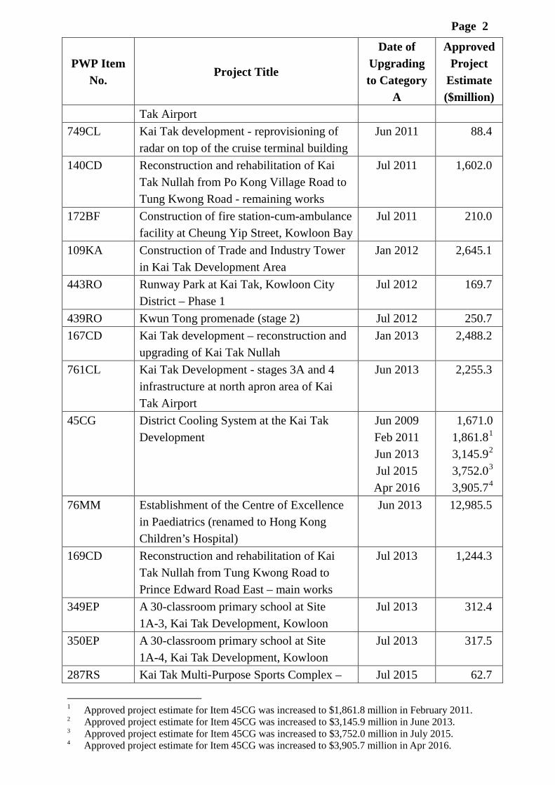
List of Public Works Programme (PWP) Items Upgraded to Category A since 2009
PWP Item No.
Project Title
Date of Upgrading to Category
A
Approved Project
Estimate ($million)
738CL Kai Tak development – detailed design and site investigation for Kai Tak Approach Channel and Kwun Tong Typhoon Shelter improvement works
May 2009 50.0
739CL Kai Tak development – stage 1 infrastructure works at north apron area of Kai Tak Airport
May 2009 566.5
740CL Kai Tak development – detailed design and site investigation for remaining infrastructure works for developments at the former runway
May 2009 32.0
741CL Kai Tak development – stage 1 advance infrastructure works for developments at the southern part of the former runway
May 2009 539.6
357DS Sewage interception scheme in Kowloon City
Jun 2009 700.3
736CL Site formation for Kai Tak cruise terminal development
Nov 2009 2,303.9
7GA Cruise terminal building and ancillary facilities for the Kai Tak cruise terminal development
Apr 2010 5,852.1
162CD Reconstruction and rehabilitation of Kai Tak Nullah from Po Kong Village Road to Tung Kwong Road — stage 1
Jul 2010 159.4
363DS Provision of interception facilities at Jordan Valley box culvert
Dec 2010 588.0
377DS Upgrading of Central and East Kowloon sewerage - phase 2
Jun 2011 503.0
745CL Kai Tak development - Kai Tak approach channel and Kwun Tong typhoon shelter improvement works (Phase 1)
Jun 2011 717.7
746CL Kai Tak development - stage 2 infrastructure at north apron area of Kai
Jun 2011 355.8
Page 2
PWP Item No.
Project Title
Date of Upgrading to Category
A
Approved Project
Estimate ($million)
Tak Airport 749CL Kai Tak development - reprovisioning of
radar on top of the cruise terminal building Jun 2011 88.4
140CD Reconstruction and rehabilitation of Kai Tak Nullah from Po Kong Village Road to Tung Kwong Road - remaining works
Jul 2011 1,602.0
172BF Construction of fire station-cum-ambulance facility at Cheung Yip Street, Kowloon Bay
Jul 2011 210.0
109KA Construction of Trade and Industry Tower in Kai Tak Development Area
Jan 2012 2,645.1
443RO Runway Park at Kai Tak, Kowloon City District – Phase 1
Jul 2012 169.7
439RO Kwun Tong promenade (stage 2) Jul 2012 250.7 167CD Kai Tak development – reconstruction and
upgrading of Kai Tak Nullah Jan 2013 2,488.2
761CL Kai Tak Development - stages 3A and 4 infrastructure at north apron area of Kai Tak Airport
Jun 2013 2,255.3
45CG District Cooling System at the Kai Tak Development
Jun 2009 Feb 2011 Jun 2013 Jul 2015 Apr 2016
1,671.0 1,861.81 3,145.92 3,752.03 3,905.74
76MM Establishment of the Centre of Excellence in Paediatrics (renamed to Hong Kong Children’s Hospital)
Jun 2013 12,985.5
169CD Reconstruction and rehabilitation of Kai Tak Nullah from Tung Kwong Road to Prince Edward Road East – main works
Jul 2013 1,244.3
349EP A 30-classroom primary school at Site 1A-3, Kai Tak Development, Kowloon
Jul 2013 312.4
350EP A 30-classroom primary school at Site 1A-4, Kai Tak Development, Kowloon
Jul 2013 317.5
287RS Kai Tak Multi-Purpose Sports Complex – Jul 2015 62.7
1 Approved project estimate for Item 45CG was increased to $1,861.8 million in February 2011. 2 Approved project estimate for Item 45CG was increased to $3,145.9 million in June 2013. 3 Approved project estimate for Item 45CG was increased to $3,752.0 million in July 2015. 4 Approved project estimate for Item 45CG was increased to $3,905.7 million in Apr 2016.

Page 3
PWP Item No.
Project Title
Date of Upgrading to Category
A
Approved Project
Estimate ($million)
pre-construction work 711CL Kai Tak development – infrastructure
works for developments at the southern part of the former runway
Jul 2015 5,757.1
65TR Detailed Feasibility Study for Environmentally Friendly Linkage System for Kowloon East
Jul 2015 92.3
797CL Kai Tak Development - stages 3B and 5A infrastructure works at former north apron area
May 2016 2,152.8
237LP Kowloon East Regional Headquarters and Operational Base cum Ngau Tau Kok Divisional Police Station
May 2016 3,186.0
271ES Construction of A 30-classroom Secondary School at Site 1A-2, Kai Tak Development
June 2016 446.7
Total 52,540.7

啟德發展計劃 –已完成的主要項目Kai Tak Development – Major Projects Already Completed
區域供冷設備District Cooling Plant
啟德郵輪碼頭大樓、第一及第二個泊位及相關基建丶及第二個郵輪泊位的餘下疏浚工程
Kai Tak Cruise Terminal Building cum
First and Second Berths and Associated Infrastructure,
and Remaining Dredging Works for Second Berth
消防局暨救護站Fire Station cum
Ambulance Depot
區域供冷設備District Cooling Plant
跑道公園(第一期)
Runway Park (Phase I)
公共租住房屋Public Rental Housing
九龍灣Kowloon Bay
觀塘Kwun Tong
馬頭角Ma Tau Kok
九龍城Kowloon City
新蒲崗
San Po Kong
啟德發展區Kai Tak Development
啟德明渠進口道及觀塘避風塘改善工程(第一期)
Improvement Works at Kai Tak
Approach Channel and Kwun Tong
Typhoon Shelter (Phase 1)
污水泵站Sewage Pumping
Stations
污水截流設施Sewage Interception Facilities
觀塘海濱花園 (第1及2期)
Kwun Tong Promenade
(Stages 1 & 2)
工業貿易大樓Trade and Industry Tower
前北面停機坪第1及2期基礎設施工程Stages 1 & 2 Infrastructure Works at
former North Apron
兩間小學2 Primary Schools
觀塘避風塘Kwun Tong Typhoon Shelter
附件六 – 附錄2
Annex 2 to Enclosure 6
跑道公園碼頭Runway Park Pier

啟德發展計劃 –已批出的住宅及商業用地Kai Tak Development – Residential and Commercial Sites Disposed
附件六 - 附錄3
Annex 3 to Enclosure 6

九龍灣Kowloon Bay
觀塘Kwun Tong
馬頭角Ma Tau Kok
九龍城Kowloon City
新蒲崗
San Po Kong
觀塘避風塘Kwun Tong Typhoon Shelter
前北面停機坪第3A期基礎設施工程及相關區域供冷管道
Stage 3A Infrastructure Works at former North Apron and
Associated District Cooling Mains
沙田至中環線Shatin to Central Link
啟德明渠改善工程Reconstruction and Upgrading of
Kai Tak Nullah
香港兒童醫院Hong Kong Children’s
Hospital
啟德發展計劃 –建造中的主要項目Kai Tak Development – Major Projects under Construction
前跑道南面發展項目第2期基礎設施工程及相關區域供冷管道
Stage 2 Infrastructure Works for Developments at the
Southern Part of the Former Runway and
Associated District Cooling Mains
前北面停機坪第4期基礎設施工程及相關區域供冷管道
Stage 4 Infrastructure Works
former North Apron and Associated
District Cooling Mains
前跑道南面發展項目第3期基礎設施工程及相關區域供冷管道
Stage 3 Infrastructure Works for Developments at the
Southern Part of the Former Runway and
Associated District Cooling Mains
東九龍總區總部及行動基地暨牛頭角分區警署Kowloon East Regional Headquarters & Operational Base
Cum Ngau Tau Kok Divisional Police Station
前北面停機坪第5A期基礎設施工程
及相關區域供冷管道Stage 5A Infrastructure
Works at former North
Apron and Associated
District Cooling Mains
附件六 – 附錄4
Annex 4 to Enclosure 6
前北面停機坪第3B期基礎設施工程Stage 3B Infrastructure Works
中學Secondary School

啟德發展計劃 – 積極規劃 / 設計中的主要項目Kai Tak Development – Major Projects under Active Planning / Design
附件六 – 附錄5
Annex 5 to Enclosure 6
九龍灣Kowloon Bay
觀塘Kwun Tong
馬頭角Ma Tau Kok
九龍城Kowloon City
新蒲崗
San Po Kong
觀塘避風塘Kwun Tong Typhoon Shelter
前跑道及南面停機坪發展項目的餘下基礎設施工程
Remaining Infrastructure Works For
Developments at the Former Runway
and South Apron
6號幹線(中九龍幹線)
Route 6 (Central Kowloon Route)
6號幹線(T2主幹路)
Route 6 (Trunk Road T2)
環保連接系統Environmentally Friendly Linkage
System (EFLS)
啟德明渠進口道及觀塘避風塘改善工程(第二期)
Improvement Works at Kai Tak
Approach Channel and Kwun Tong
Typhoon Shelter (Phase 2)
龍津石橋保育長廊Lung Tsun Stone Bridge
Preservation Corridor
啟德體育園Kai Tak Sports Park
前北面停機坪第5B期及餘下基礎設施工程及相關區域供冷管道
Stage 5B and Remaining
Infrastructure Works at former
North Apron and Associated
District Cooling Mains
啟德大道公園Avenue Park at Kai Tak
新急症醫院New Acute Hospital
飛躍啟德Kai Tak Fantasy
啟德車站廣場Station Square at Kai Tak
香港兒童醫院旁的海濱長廊Waterfront Promenade
adjacent to Hong Kong
Children’s Hospital
擴建海心公園Hoi Sham Park
Extension
稅務大樓Inland Revenue Tower