LATITUDE/LONGITUDE DATA STANDARD - US EPA · The Latitude/Longitude Data Standard is a set of data...
24
LATITUDE/LONGITUDE DATA STANDARD Standard No.: EX000017.2 January 6, 2006 This data standard is produced by the Environmental Data Standards Council (EDSC) The Environmental Data Standards Council (EDSC) is a partnership among US EPA, States and Tribal partners to promote the efficient sharing of environmental information through the development and adoption of data standards. More information about the EDSC is available at www.envdatastandards.net .
Transcript of LATITUDE/LONGITUDE DATA STANDARD - US EPA · The Latitude/Longitude Data Standard is a set of data...

LATITUDE/LONGITUDE
DATA STANDARD
Standard No.: EX000017.2
January 6, 2006 This data standard is produced by the
Environmental Data Standards Council (EDSC)
The Environmental Data Standards Council (EDSC) is a partnership among US EPA, States and Tribal partners to promote the efficient sharing of environmental information through the development and adoption of data standards. More information about the EDSC is available at www.envdatastandards.net.
Latitude/Longitude Data Standard
Std No.:EX000017.2
January 6, 2006 Page 2
Foreword
The Environmental Data Standards Council (EDSC) identifies, prioritizes, and pursues the creation of data standards for those areas where information exchange standards will provide the most value in achieving environmental results. The Council involves Tribes and Tribal Nations, state and federal agencies in the development of the standards and then provides the draft materials for general review. Business groups, non-governmental organizations, and other interested parties may then provide input and comment for Council consideration and standard finalization. Draft and final standards are available at http://www.envdatastandards.net.
1.0 INTRODUCTION
The Latitude/Longitude Data Standard is a set of data elements that can be used for recording horizontal and vertical coordinates and associated metadata that define a point on the earth. The latitude/longitude data standard establishes the requirements for documenting latitude and longitude coordinates and related method, accuracy, and description data for all places used in data exchange transaction. Places include facilities, sites, monitoring stations, observation points, and other regulated or tracked features.
1.1 Scope
The purpose of the standard is to provide a common set of data elements to specify a point by latitude/longitude. This standard describes data elements and data groupings that are used to exchange Latitude/Longitude data and information.
1.2 Revision History
Date Version Description May 31, 2001 19939:1 Initial Adoption by the Environmental Data Standards Council January 6, 2006 EX000017.2 Environmental Data Standards Council adoption of the revised
standard, format and content changes, added examples values, and renumbered the standard.
1.3 References to other data standards
This standard relies on two other standards to make it complete and provide the necessary support. As such, users should reference the normative standards listed below and consider them integral to the Latitude/Longitude Standard. These include: • Representation of Date and Time [EX000013.1] Data Standard
• Measure [EX000010.1] Data Standard
1.4 Terms and Definitions
None.
1.5 Implementation
Users are encouraged to use the XML registry housed on the Exchange Network Web site to download schema components for the construction of XML schema flows (http://www.exchangenetwork.net).

Latitude/Longitude Data Standard
Std No.:EX000017.2
January 6, 2006 Page 3
1.6 Document Structure The structure of this document is briefly described below:
a. Section 2.0 Latitude/Longitude Data Structure Diagram illustrates the hierarchical classification of the Latitude/Longitude data standard. This diagram enables business and technical users of this standard to quickly understand its general content and complexity.
b. Section 3.0 Latitude/Longitude Data Standard Table provides information on the high level, intermediate and elemental Latitude/Longitude data groupings. Where applicable, for each level of this data standard a definition, XML tag, note(s), example list of values and format are provided. The format column may include the number of characters for the associated data element, where “A” specifies alphanumeric, “N” designates numeric, and “G” and “D” are used for grouping and date/time respectively.
c. Data Element Numbering: For purposes of clarity and to enhance understanding of data standard hierarchy and relationships, each data group is numerically classified from the primary to the data element level.
d. Code and Identifier Metadata: Metadata, defined here as data about data or data elements, includes their descriptions and/or any needed context setting information required to identify the origin, conditions of use, interpretation, or understanding the information being exchanged or transferred. (Adapted from ISO/IEC 2382-17:1999 Information Technology Vocabulary—Part 17: Databases 17.06.05 metadata). Based on the business need, additional metadata may be required to sufficiently describe an identifier or a code. A note regarding this additional metadata is included in the notes column for identifier and code elements. Additional metadata for identifiers may include:
• Identifier Context, which identifies the source or data system that created or defined the identifier
Additional metadata for codes may include:
• Code List Identifier, which is a standardized reference to the context or source of the set of codes
• Code List Version Identifier, which identifies the particular version of the set of codes.
• Code List Version Agency Identifier, which identifies the agency responsible for maintaining the set of codes
• Code List Name, which describes the corresponding name for which the code represents
e. Appendix A, lists the references for Lat/Long Data Standard. Appendices “B” through “I” provide example lists of values for the designated data elements. The tables present code and name (General or Specific where applicable) plus value meaning for each listed value.

Latitude/Longitude Data Standard
Std No.:EX000017.2
January 6, 2006 Page 4
2.0 LATITUDE/LONGITUDE DATA STRUCTURE DIAGRAM
Latitude/Longitude Data Standard
1.0 Mandatory Latitude/Longitude Data 1.1 Latitude Measure 1.2 Longitude Measure 1.3 Source Map Scale Numeric 1.4 Horizontal Accuracy Measure 1.5 Horizontal Collection Method Code 1.6 Horizontal Collection Method Name 1.7 Geographic Reference Point Code 1.8 Geographic Reference Point Name 1.9 Horizontal Coordinate Reference System
Datum Code 1.10 Horizontal Coordinate Reference System
Datum Name
2.0 Optional Latitude/Longitude Data 2.1 Data Collection Date 2.2 Location Comments Text 2.3 Vertical Measure 2.4 Vertical Collection Method Code 2.5 Vertical Collection Method Name 2.6 Vertical Coordinate Reference System
Datum Code 2.7 Vertical Coordinate Reference System
Datum Name 2.8 Verification Method Code 2.9 Verification Method Name 2.10 Coordinate Data Source Code 2.11 Coordinate Data Source Name 2.12 Geometric Type Code 2.13 Geometric Type Name

Latitude/Longitude Data Standard
Std No.:EX000017.2
January 6, 2006 Page 5
3.0 LATITUDE/LOGITUDE DATA STANDARDS TABLE
1.0 Mandatory Latitude/Longitude
Definition: Mandatory Information needed for recording coordinates of a location on the earth Relationship: None Identified. Notes: None. XML Tag: MandatoryLatitudeLongitude
Name Definition Notes Format XML tags
1.1 Latitude Measure The measure of the angular distance on a meridian north or south of the equator.
N
LatitudeMeasure
1.2 Longitude Measure The measure of the angular distance on a meridian east or west of the prime meridian.
N LongitudeMeasure
1.3 Source Map Scale Numeric The number that represents the proportional distance on the ground for one unit of measure on the map or photo.
Typically expressed as a proportional ratio, i.e. 1:24,000
A
SourceMapScaleNumeric
1.4 Horizontal Accuracy Measure
The horizontal measure, in meters, of the relative accuracy of the latitude and longitude coordinates.
Refer to the Measure [EX000010.1] Data Standard.
The following items are needed:
Measure Value, Measure Unit Code, Measure QA/QC,
G HorizontalAccuracyMeasure

Latitude/Longitude Data Standard
Std No.:EX000017.2
January 6, 2006 Page 6
Name Definition Notes Format XML tags
1.5 Horizontal Collection Method Code
The code that represents the method used to determine the latitude and longitude coordinates for a point on the earth.
Example List of Values:
[See appendix B] Note: Based on the business need, additional metadata may be required to sufficiently describe a code. This additional metadata is listed in the Introduction 1.6.d.
N
HorizontalCollectionMethodCode
1.6 Horizontal Collection Method Name
The name that identifies the method used to determine the latitude and longitude coordinates for a point on the earth.
Example List of Values:
[See appendix B]
A
HorizontalCollectionMethodName
1.7 Geographic Reference Point Code
The code that represents the place for which geographic coordinates were established.
Example List of Values:
[See appendix C] Note: Based on the business need, additional metadata may be required to sufficiently describe a code. This additional metadata is listed in the Introduction section1.6.d.
N
GeographicReferencePointCode
1.8 Geographic Reference Point Name
The name that identifies the place for which geographic coordinates were established.
Example List of Values:
[See appendix C]
A
GeographicReferencePointName

Latitude/Longitude Data Standard
Std No.:EX000017.2
January 6, 2006 Page 7
Name Definition Notes Format XML tags
1.9 Horizontal Coordinate Reference System Datum Code
The code that represents the reference datum used in determining latitude and longitude coordinates.
Example List of Values:
[See appendix D] Note: Based on the business need, additional metadata may be required to sufficiently describe a code. This additional metadata is listed in the Introduction section 1.6.d.
N
HorizontalCoordinateReferenceSystemDatumCode
1.10 Horizontal Coordinate Reference System Datum Name
The name that describes the reference datum used in determining latitude and longitude coordinates.
Example List of Values:
[See appendix D]
A
HorizontalCoordinateReferenceSystemDatumName
2.0 Optional Latitude/Longitude
Definition: Optional data needed to address coordinates of a location on the earth Relationship: None Identified. Notes: None. XML Tag: OptionalLatitudeLongitude
Name Definition Notes Format XML tags
2.1 Data Collection Date
The calendar date when data were collected.
Refer to the Representation of Date and Time [EX000013.1] Data Standard.
D
DataCollectionDate
2.2 Location Comments Text
The text that provides additional information about the geographic coordinates.
A
LocationCommentsText

Latitude/Longitude Data Standard
Std No.:EX000017.2
January 6, 2006 Page 8
Name Definition Notes Format XML tags
2.3 Vertical Measure
The measure of elevation (i.e., the altitude), above or below a reference datum.
Refer to the Measure [EX000010.1] Data Standard.
The following items are needed: Measure Value, Measure Unit Code, Measure QA/QC.
G VerticalMeasure
2.4 Vertical Collection Method Code
The code that represents the process used to verify the latitude and longitude coordinates.
Example List of Values:
[See appendix E] Note: Based on the business need, additional metadata may be required to sufficiently describe a code. This additional metadata is listed in the Introduction section 1.6.d.
N
VerticalCollectionMethodCode
2.5 Vertical Collection Method Name
The name that identifies the method used to collect the vertical measure (i.e., the altitude) of a reference point.
Example List of Values:
[See appendix E]
A
VerticalCollectionMethodName

Latitude/Longitude Data Standard
Std No.:EX000017.2
January 6, 2006 Page 9
Name Definition Notes Format XML tags
2.6 Vertical Coordinate Reference System Datum Code
The code that represents the reference datum used to determine the vertical measure (i.e., the altitude).
Example List of Values:
[See appendix F]
Note: Based on the business need, additional metadata may be required to sufficiently describe a code. This additional metadata is listed in the Introduction section 1.6.d.
N
VerticalCoordinateReferenceSystemDatumCode
2.7 Vertical Coordinate Reference System Datum Name
The name of the reference datum used to determine the vertical measure (i.e., the altitude).
Example List of Values:
[See appendix F]
A
VerticalCoordinateReferenceSystemDatumName
2.8 Verification Method Code The code that represents the process used to verify the latitude and longitude coordinates.
Example List of Values:
[See appendix G]
Note: Based on the business need, additional metadata may be required to sufficiently describe a code. This additional metadata is listed in the Introduction section 1.6.d.
N
VerificationMethodCode
2.9 Verification Method Name The name that describes the process used to verify the latitude and longitude coordinates.
Example List of Values:
[See appendix G]
A
VerificationMethodName

Latitude/Longitude Data Standard
Std No.:EX000017.2
January 6, 2006 Page 10
Name Definition Notes Format XML tags
2.10 Coordinate Data Source Code
The code that represents the party responsible for providing the latitude and longitude coordinates.
Example List of Values:
[See appendix H] Note: Based on the business need, additional metadata may be required to sufficiently describe a code. This additional metadata is listed in the Introduction section 1.6.d.
N
CoordinateDataSourceCode
2.11 Coordinate Data Source Name
The name of the party responsible for providing the latitude and longitude coordinates.
Example List of Values:
[See appendix H]
A
CoordinateDataSourceName
2.12 Geometric Type Code The code that represents the geometric entity represented by one point or a sequence of latitude and longitude points.
Example List of Values:
[See appendix I] Note: Based on the business need, additional metadata may be required to sufficiently describe a code. This additional metadata is listed in the Introduction section 1.6.d.
N
GeometricTypeCode
2.13 Geometric Type Name The name that identifies the geometric entity represented by one point or a sequence of latitude and longitude points.
Example List of Values:
[See appendix I]
A
GeometricTypeName

Latitude/Longitude Data Standard
Std No.:EX000017.2
January 6, 2006 Page 11
Appendix A References
1. ISO/IEC 2382-17:1999 Information Technology Vocabulary—Part 17: Databases 17.06. 2. FGDC Spatial Data Transfer Standard (SDTS), Part 6: Point Profile, FGDC-STD-002.6. 3. ISO DIS 6709, Standard Representation of Geographic Point Location by Coordinates.

Latitude/Longitude Data Standard Std No.:EX000017.2
January 6, 2006 Page 12
Appendix B [Normative]
Horizontal Collection Method Code and Horizontal Collection Method Name - Example List of Values
See the U.S. Environmental Protection Agency Environmental Data Registry [ www.epa.gov/EDR ] for the most current list General
Code Specific
Code General Name Specific Name Value Meaning
101 Address Matching
The geographic coordinate determination method based on address matching.
001 Address Matching-House Number The geographic coordinate determination method based on address matching-house number.
002 Address Matching-Block Face The geographic coordinate determination method based on address matching-block face.
003 Address Matching-Street Centerline The geographic coordinate determination method based on address matching-street centerline.
004 Address Matching-Nearest Intersection The geographic coordinate determination method based on address matching-nearest intersection
005 Address Matching-Primary Name The geographic coordinate determination method based on address matching-primary name.
006 Address Matching-Digitized The geographic coordinate determination method based on address matching-digitized.
007 Address Matching-Other The geographic coordinate determination method based on address matching-other.
102 Census Block US Bureau of Census Block established for year noted.
008 Census Block-1990-Centroid The geographic coordinate determination method based on census block-1990-centroid.
009 Census Block/Group-1990-Centroid The geographic coordinate determination method based on census/group-1990-centroid.
010 Census Block/Tract-1990-Centroid The geographic coordinate determination method based on census/tract-1990-centroid.
011 Census-Other The geographic coordinate determination method based on census-other.
103 GPS The geographic coordinate determination method based on GPS.
012 GPS Carrier Phase Static Relative Position The geographic coordinate determination method based on GPS carrier phase static relative positioning technique.
013 GPS Carrier Phase Kinematic Relative Position The geographic coordinate determination method based on GPS carrier phase kinematic relative positioning technique.

Latitude/Longitude Data Standard Std No.:EX000017.2
January 6, 2006 Page 13
General Code
Specific Code General Name Specific Name Value Meaning
014 GPS Code (Pseudo Range) Differential The geographic coordinate determination method based on GPS
code measurements (pseudo range) differential (DGPS). 015 GPS Code (Pseudo Range) Precise Position The geographic coordinate determination method based on GPS.
code measurements (pseudo range) precise positioning service. 016 GPS Code (Pseudo Range) Standard Position
(Selective Availability Off) The geographic coordinate determination method based on GPS code measurements (pseudo range) standard positioning service (SA Off).
017 GPS Code (Pseudo Range) Standard Position (Selective Availability On)
The geographic coordinate determination method based on GPS code measurements (pseudo range) standard positioning service (SA On).
028 GPS-Unspecified Global Positioning Method, with unspecified parameters.
029 GPS, with Canadian Active Control System GPS Code Measurements (pseudo range) Standard Positioning Service Corrected using Canadian Active Control System.
104
Interpolation The geographic coordinate determination method based on
interpolation. 018 Interpolation-Map The geographic coordinate determination method based on
interpolation-map. 019 Interpolation-Photo The geographic coordinate determination method based on
interpolation-photo. 030 Interpolation - Digital Map Source (TIGER) The geographic coordinate determination method is based on a
digital map source (TIGER). 031 Interpolation-SPOT The geographic coordinate determination method uses SPOT
(Systeme Probatoire d'Observation de la Terre), a French-owned satellite launched in 1984.
032 Interpolation-MSS The geographic coordinate determination method is based on the use of a Multi-Spectral Scanner (MSS).
033 Interpolation-TM The geographic coordinate determination method is based on the use of a Thematic Mapper (TM).
020 Interpolation-Satellite The geographic coordinate determination method based on interpolation-satellite.
021 Interpolation-Other The geographic coordinate determination method based on interpolation-other.
105 Loran C The geographic coordinate determination method based on Loran C.
022 Loran C The geographic coordinate determination method based on Loran C.
106 Public Land Survey
The geographic coordinate determination method based on public land survey.
023 Public Land Survey-Quarter Section The geographic coordinate determination method based on public

Latitude/Longitude Data Standard Std No.:EX000017.2
January 6, 2006 Page 14
General Code
Specific Code General Name Specific Name Value Meaning
land survey quarter of a section.
034 Public Land Survey-Eighth Section The geographic coordinate determination method is based on a public land survey, an eighth of a section.
035 Public Land Survey-Sixteenth Section The geographic coordinate determination method is based on a public land survey, a sixteenth of a section.
036 Public Land Survey-Footing The geographic coordinate determination method is based on a public land survey footing.
107 Classical Surveying Techniques
The geographic coordinate determination method is based on classical surveying techniques.
025 Classical Surveying Techniques The geographic coordinate determination method based on classical surveying techniques.
108 Zip Code The geographic coordinate determination method based on zipcode.
026 ZIP Code-Centroid The geographic coordinate determination method based on zipcode-centroid.
037 ZIP+4 Centroid The center of an area defined by the 5-digit ZIP code and its 4-digit geographic segment extension.
038 ZIP+2 Centroid The center of an area defined by the 5-digit ZIP code and its 2-digit geographic segment extension.
109 Unknown The information is not known.
027 Unknown The information is not known. 028 GPS-Unspecified Global Positioning Method, with unspecified parameters.
Latitude/Longitude Data Standard Std No.:EX000017.2
January 6, 2006 Page 15
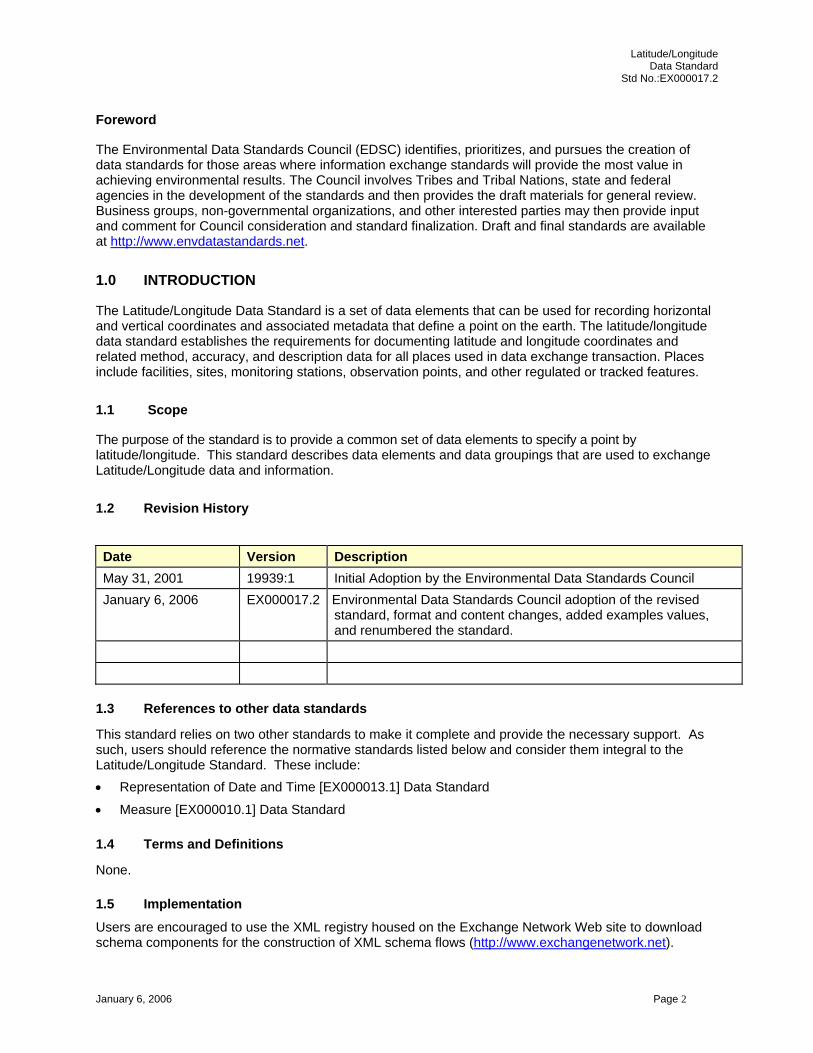
Appendix C [Normative] Reference Point Code and Reference Point Name - Example List of Values
See the U.S. Environmental Protection Agency Environmental Data Registry [ www.epa.gov/EDR ] for the most current list General
Code Specific
Code General Name Specific Name Value Meaning 101 Facility/Station
Location Entrance Point of a Facility, System, or Station
002 Plant Entrance (general) 004 Plant Entrance (personnel) 005 Plant Entrance (freight) 015 Loading Facility 019 Administrative Building
102 Facility Center/Centroid
Center of a Facility/System
016 Loading Area Centroid 020 Geographic Centroid of the Facility 025 Center of Production Facility
103 Facility Boundary Boundary point for a facility or System (Facility boundary points can be singular, or part of a series of boundary points
021 NE Corner of Parcel 022 NW Corner of Parcel 023 SE Corner of Parcel 024 SW Corner of Parcel
104 Intake Point Point where water or other substance could be drawn from environment for delivery to a facility or distribution system (substance destination could range from a single residence to a large facility)
030 Intake pipe 032 Water Well 033 Spring 037 Well Head 043 Oil Well 044 Sulfur Well 045 Gas Well
105 Treatment/storage Point
Point where substance is processed, treated, stored (point from which substance could be released into the environment
008 Storage Tank 010 Lagoon or Settling Pond 011 Liquid Waste Treatment Unit 017 Process Unit

Latitude/Longitude Data Standard Std No.:EX000017.2
January 6, 2006 Page 16
General Code
Specific Code General Name Specific Name Value Meaning
018 Process Unit Centroid 106 Release Point Point where substance is released (point where substance is
directly released into the environment) 006 Air Release Stack 007 Air Release Vent 009 Water Release Pipe 012 Atmospheric Emission 013 Solid Waste Treatment and Disposal 014 Solid Waste Storage Area 035 Potential Contaminant Source 038 End of Pipe 046 Underground Injection Well
107 Monitoring Point Point where substance is monitored or sampled 028 Water Monitoring Station 029 Air Monitoring Station 039 Grid Origin 040 Point of Record 041 Sampling Point 042 Transect Origin
108 Points not represented by 101-107, 109
Points not represented by general codes 101-107, 109 or their specific codes
001 Unknown 003 Other
109 Point of Transfer The point where one discharge point goes directly into an intake point
031 Point of Transfer

Latitude/Longitude Data Standard Std No.:EX000017.2
January 6, 2006 Page 17
Appendix D [Normative] Horizontal Reference Datum Code and Horizontal Reference Datum Name - Example List of
Values See the U.S. Environmental Protection Agency Environmental Data Registry [ www.epa.gov/EDR ] for the most current list
Code Name Value Meaning 001 NAD27 North American Datum of 1927 002 NAD83 North American Datum of 1983 003 WGS84 World Geodetic System of 1984

Latitude/Longitude Data Standard Std No.:EX000017.2
January 6, 2006 Page 18
Appendix E [Normative] Vertical Collection Method Code and Vertical Collection Method Name - Example List of Values
See the U.S. Environmental Protection Agency Environmental Data Registry [ www.epa.gov/EDR ] for the most current list
Code Name Value Meaning 001 GPS Carrier Phase Static Relative Position The geographic coordinate determination method based on GPS carrier phase static
relative positioning technique. 002 GPS Carrier Phase Kinematic Relative Position The geographic coordinate determination method based on GPS carrier phase kinematic
relative positioning technique. 003 GPS Code (Pseudo Range) Differential The geographic coordinate determination method based on GPS code measurements
(pseudo range) differential (DGPS). 004 GPS Code (Pseudo Range) Precise Position The geographic coordinate determination method based on GPS code measurements
(pseudo range) precise positioning service. 005 GPS Code (Pseudo Range) Standard Position (SA Off) The geographic coordinate determination method based on GPS code measurements
(pseudo range) standard positioning service (SA Off). 006 GPS Code (Pseudo Range) Standard Position (SA On) The geographic coordinate determination method based on GPS code measurements
(pseudo range) standard positioning service (SA On). 007 Classical Surveying Techniques The geographic coordinate determination method based on classical surveying
techniques. 008 Other Other, unspecified. 009 Altimetry A method used to determine vertical components based on altimetry. 010 Precise Leveling-Bench mark Precise leveling from a bench mark. 011 Leveling-Non Bench Mark Control Points Leveling between non bench mark control points. 012 Trigonometric Leveling Trigonometric leveling. 013 Photogrammetic Photogrammetric. 014 Topographic Map Interpolation Topographic map interpolation.
Latitude/Longitude Data Standard Std No.:EX000017.2
January 6, 2006 Page 19
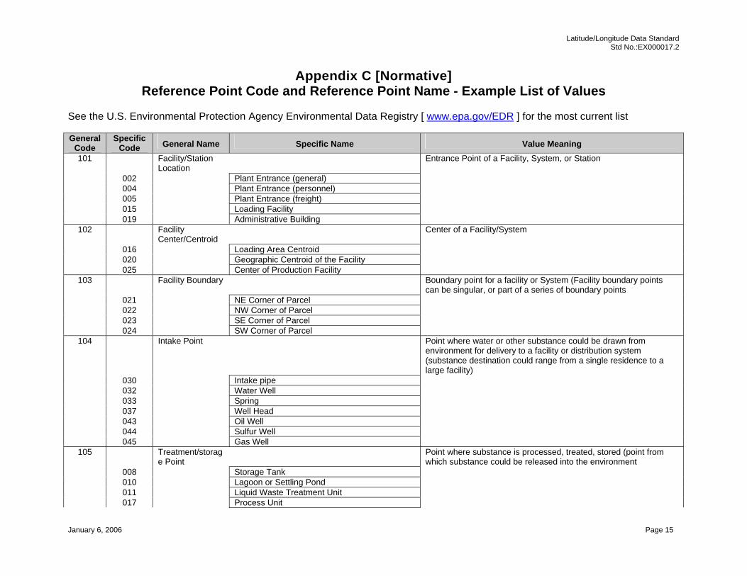
Appendix F [Normative] Vertical Reference Datum Code and Vertical Reference Datum Name - Example List of Values
See the U.S. Environmental Protection Agency Environmental Data Registry [ www.epa.gov/EDR ] for the most current list
Code Name Value Meaning 001 NAVD88 North American Vertical Datum of 1988. 002 NGVD29 National Geodetic Vertical Datum of 1929. 003 Mean Sea-Level The level of the surface of the sea at its position midway between mean high and low water. 004 Local Tidal Datum A known tidal measurement characteristic of a particular place.

Latitude/Longitude Data Standard Std No.:EX000017.2
January 6, 2006 Page 20
Appendix G [Normative] Verification Method Code and Verification Method Name - Example List of Values
See the U.S. Environmental Protection Agency Environmental Data Registry [ www.epa.gov/EDR ] for the most current list Code Name Value Meaning 004 Point in Polygon (Other) The coordinates are a point within an undefined polygon. 005 Point in Polygon (County) The coordinates are a point within the county. 006 Point in Polygon (ZIP) The coordinates are a point within the ZIP Code area. 002 Proximity to Alternative Facility Coordinates The coordinates are proximate to alternative coordinates for the facility. 003 Proximity to Polygon Centroid (Other) The coordinates are proximate to the centroid of another polygon. 001 Proximity to Polygon Centroid (County) The coordinates are proximate to the centroid of the county. 012 Proximity to Polygon Centroid (ZIP Code) The coordinates are proximate to the centroid of the ZIP Code. 010 Verified, Unknown Method The coordinates are verified by an unknown method. 008 Verified Relative to Map (1:100K or TIGER) The coordinates are verified relative to map features (1:100K or TIGER). 007 Verified Relative to Map Features (1:24K) The coordinates are verified relative to map features (1:24K). 009 Verified Relative to Map Features (Other) The coordinates are verified relative to other map features. 011 Ground Truth Conducted The coordinates were determined by ground truth. 014 Point in Bounding Box (County) The coordinates were verified as a point in the county bounding box. 013 Point in Bounding Box (ZIP) The coordinates were verified as a point in the ZIP Code bounding box.

Latitude/Longitude Data Standard Std No.:EX000017.2
January 6, 2006 Page 21
Appendix H [Normative] Coordinate Data Source Code and Coordinate Data Source Name - Example List of Values
See the U.S. Environmental Protection Agency Environmental Data Registry [ www.epa.gov/EDR ] for the most current list
Code Name Value Meaning 001 Alabama The state of Alabama. 002 Alaska The state of Alaska. 004 Arizona The state of Arizona. 005 Arkansas The state of Arkansas. 006 California The state of California. 008 Colorado The state of Colorado. 009 Connecticut The state of Connecticut. 010 Delaware The state of Delaware. 011 District of Columbia The state of District of Columbia. 012 Florida The state of Florida. 013 Georgia The state of Georgia. 015 Hawaii The state of Hawaii. 016 Idaho The state of Idaho. 017 Illinois The state of Illinois. 018 Indiana The state of Indiana. 019 Iowa The state of Iowa. 020 Kansas The state of Kansas. 021 Kentucky The state of Kentucky. 022 Louisiana The state of Louisiana. 023 Maine The state of Maine. 024 Maryland The state of Maryland. 025 Massachusetts The state of Massachusetts. 026 Michigan The state of Michigan. 027 Minnesota The state of Minnesota. 028 Mississippi The state of Mississippi. 029 Missouri The state of Missouri. 030 Montana The state of Montana. 031 Nebraska The state of Nebraska. 032 Nevada The state of Nevada. 033 New Hampshire The state of New Hampshire. 034 New Jersey The state of New Jersey. 035 New Mexico The state of New Mexico. 036 New York The state of New York. 037 North Carolina The state of North Carolina. 038 North Dakota The state of North Dakota.
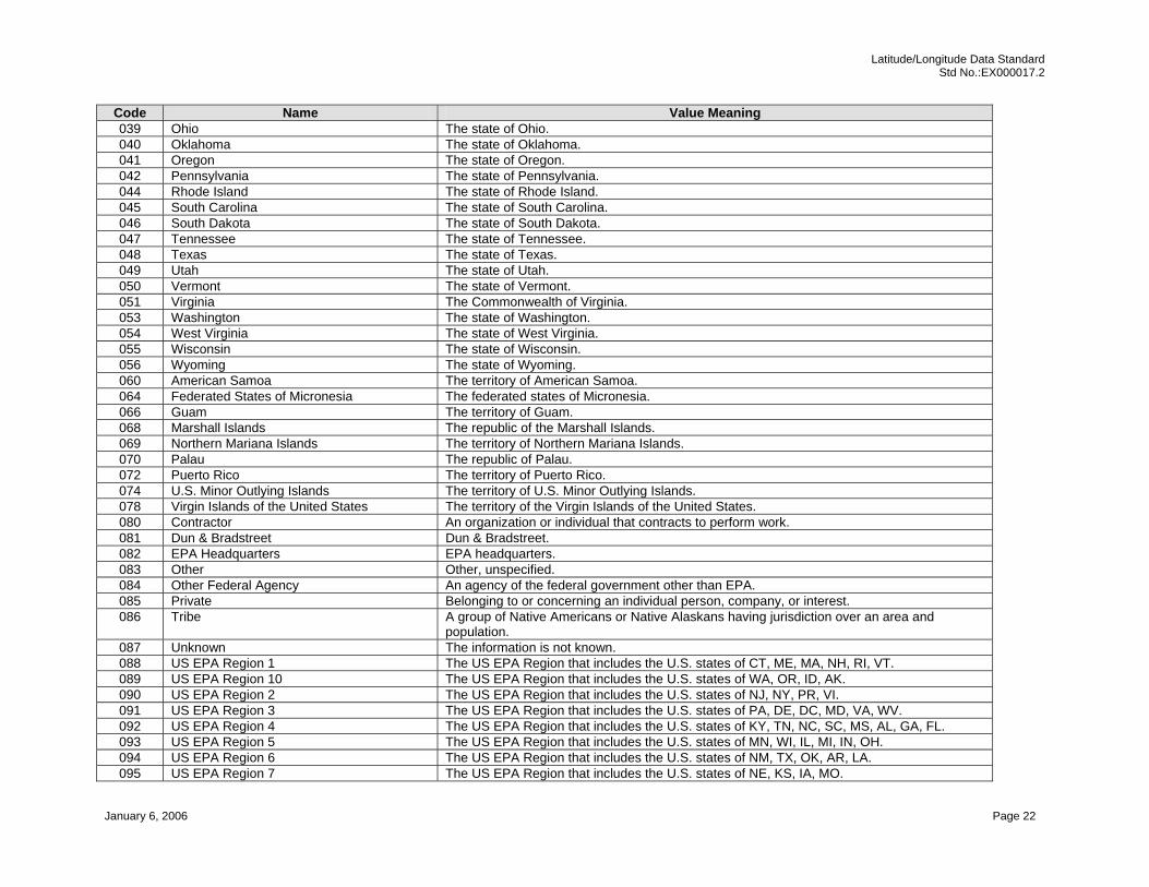
Latitude/Longitude Data Standard Std No.:EX000017.2
January 6, 2006 Page 22
Code Name Value Meaning 039 Ohio The state of Ohio. 040 Oklahoma The state of Oklahoma. 041 Oregon The state of Oregon. 042 Pennsylvania The state of Pennsylvania. 044 Rhode Island The state of Rhode Island. 045 South Carolina The state of South Carolina. 046 South Dakota The state of South Dakota. 047 Tennessee The state of Tennessee. 048 Texas The state of Texas. 049 Utah The state of Utah. 050 Vermont The state of Vermont. 051 Virginia The Commonwealth of Virginia. 053 Washington The state of Washington. 054 West Virginia The state of West Virginia. 055 Wisconsin The state of Wisconsin. 056 Wyoming The state of Wyoming. 060 American Samoa The territory of American Samoa. 064 Federated States of Micronesia The federated states of Micronesia. 066 Guam The territory of Guam. 068 Marshall Islands The republic of the Marshall Islands. 069 Northern Mariana Islands The territory of Northern Mariana Islands. 070 Palau The republic of Palau. 072 Puerto Rico The territory of Puerto Rico. 074 U.S. Minor Outlying Islands The territory of U.S. Minor Outlying Islands. 078 Virgin Islands of the United States The territory of the Virgin Islands of the United States. 080 Contractor An organization or individual that contracts to perform work. 081 Dun & Bradstreet Dun & Bradstreet. 082 EPA Headquarters EPA headquarters. 083 Other Other, unspecified. 084 Other Federal Agency An agency of the federal government other than EPA. 085 Private Belonging to or concerning an individual person, company, or interest. 086 Tribe A group of Native Americans or Native Alaskans having jurisdiction over an area and
population. 087 Unknown The information is not known. 088 US EPA Region 1 The US EPA Region that includes the U.S. states of CT, ME, MA, NH, RI, VT. 089 US EPA Region 10 The US EPA Region that includes the U.S. states of WA, OR, ID, AK. 090 US EPA Region 2 The US EPA Region that includes the U.S. states of NJ, NY, PR, VI. 091 US EPA Region 3 The US EPA Region that includes the U.S. states of PA, DE, DC, MD, VA, WV. 092 US EPA Region 4 The US EPA Region that includes the U.S. states of KY, TN, NC, SC, MS, AL, GA, FL. 093 US EPA Region 5 The US EPA Region that includes the U.S. states of MN, WI, IL, MI, IN, OH. 094 US EPA Region 6 The US EPA Region that includes the U.S. states of NM, TX, OK, AR, LA. 095 US EPA Region 7 The US EPA Region that includes the U.S. states of NE, KS, IA, MO.
Latitude/Longitude Data Standard Std No.:EX000017.2
January 6, 2006 Page 23
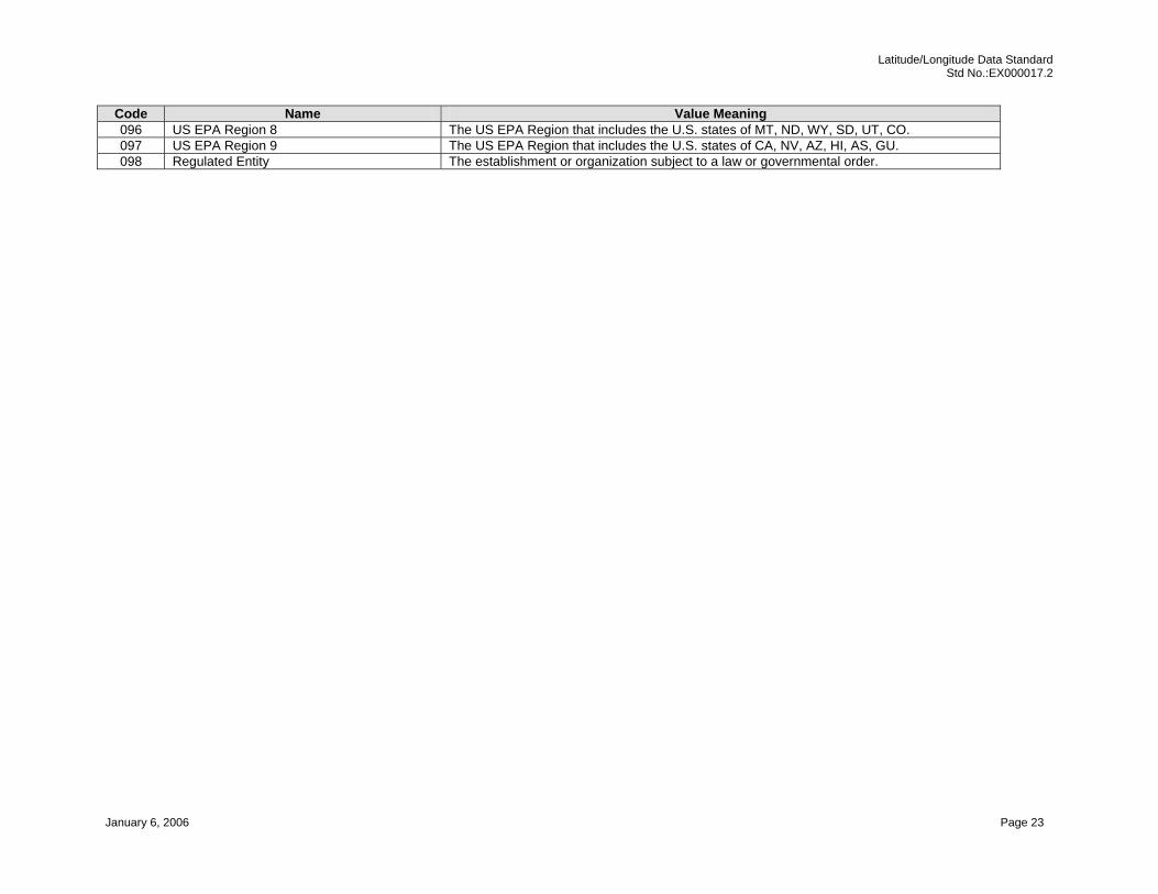
Code Name Value Meaning 096 US EPA Region 8 The US EPA Region that includes the U.S. states of MT, ND, WY, SD, UT, CO. 097 US EPA Region 9 The US EPA Region that includes the U.S. states of CA, NV, AZ, HI, AS, GU. 098 Regulated Entity The establishment or organization subject to a law or governmental order.

Latitude/Longitude Data Standard Std No.:EX000017.2
January 6, 2006 Page 24
Appendix I [Normative] Geometric Type Code and Geometric Type Name - Example List of Values
See the U.S. Environmental Protection Agency Environmental Data Registry [ www.epa.gov/EDR ] for the most current list
Code Name Value Meaning 001 Point The point referenced by geographic coordinates. 002 Line The line referenced by geographic coordinates. 003 Area The area referenced by geographic coordinates. 004 Region The geometric entity, described by locational coordinates, that includes two or more related areas is a region. 005 Route The geometric entity, described by locational coordinates, that form a contiguous network is a route.