Last-decade progress in understanding and modeling the ...
14
Hydrol. Earth Syst. Sci., 24, 5745–5758, 2020 https://doi.org/10.5194/hess-24-5745-2020 © Author(s) 2020. This work is distributed under the Creative Commons Attribution 4.0 License. Last-decade progress in understanding and modeling the land surface processes on the Tibetan Plateau Hui Lu 1,4 , Donghai Zheng 2 , Kun Yang 1,3 , and Fan Yang 1 1 Ministry of Education Key Laboratory for Earth System Modeling, Department of Earth System Science, Tsinghua University, Beijing 100084, China 2 National Tibetan Plateau Data Center, Key Laboratory of Tibetan Environmental Changes and Land Surface Processes, Institute of Tibetan Plateau Research, Chinese Academy of Sciences, Beijing 100101, China 3 Center for Excellence in Tibetan Plateau Earth Sciences, Chinese Academy of Sciences, Beijing 100101, China 4 Ministry of Education Ecological Field Station for East Asian Migratory Birds, Beijing 100084, China Correspondence: Hui Lu ([email protected]) Received: 3 July 2020 – Discussion started: 21 July 2020 Revised: 29 September 2020 – Accepted: 6 October 2020 – Published: 1 December 2020 Abstract. Land surface models (LSMs) that simulate wa- ter and energy exchanges at the land–atmosphere interface are a key component of Earth system models. The Tibetan Plateau (TP) drives the Asian monsoon through surface heat- ing and thus plays a key role in regulating the climate system in the Northern Hemisphere. Therefore, it is vital to under- stand and represent well the land surface processes on the TP. After an early review that identified key issues in the under- standing and modeling of land surface processes on the TP in 2009, much progress has been made in the last decade in de- veloping new land surface schemes and supporting datasets. This review summarizes the major advances. (i) An enthalpy- based approach was adopted to enhance the description of cryosphere processes such as glacier and snow mass balance and soil freeze–thaw transition. (ii) Parameterization of the vertical mixing process was improved in lake models to en- sure reasonable heat transfer to the deep water and to the near-surface atmosphere. (iii) New schemes were proposed for modeling water flow and heat transfer in soils accounting for the effects of vertical soil heterogeneity due to the pres- ence of high soil organic matter content and dense vegeta- tion roots in surface soils or gravel in soil columns. (iv) Sup- porting datasets of meteorological forcing and soil parame- ters were developed by integrating multi-source datasets in- cluding ground-based observations. Perspectives on the fur- ther improvement of land surface modeling on the TP are provided, including the continuous updating of supporting datasets, parameter estimation through assimilation of satel- lite observations, improvement of snow and lake processes, adoption of data-driven and artificial intelligence methods, and the development of an integrated LSM for the TP. 1 Introduction Land surface models (LSMs) are a key component of Earth system models, which simulates the water and energy ex- changes at the land–atmosphere interface (Dickinson et al., 2006; Hurrell et al., 2013). Moreover, the LSM is a pow- erful tool to provide a better understanding of the interac- tions among hydrological, ecological, and biogeochemical processes (Pan et al., 2012). Over the past decades, the LSMs have evolved from a simple bucket model (Manabe, 1969) to more sophisticated model systems (Dai et al., 2003; Dick- inson et al., 1993; Oleson et al., 2010; Sellers et al., 1986, 1996) that have incorporated many physical and physiologi- cal processes occurring in the atmosphere–snow–vegetation– soil–aquifer system. Meanwhile, several offline multi-model intercomparison projects have been conducted to identify the strength and weakness of LSMs, such as the Project for the Intercomparison of Land-Surface Parameterization Schemes (PILPS) (Henderson-Sellers et al., 1995, 1993), the Global Soil Wetness Project (GSWP) (Dirmeyer et al., 1999; Dirmeyer, 2011), and the African Monsoon Multidis- ciplinary Analysis (AMMA) Land Surface Model Intercom- parison Project (ALMIP) (Boone et al., 2009). A general con- Published by Copernicus Publications on behalf of the European Geosciences Union.
Transcript of Last-decade progress in understanding and modeling the ...

Hydrol. Earth Syst. Sci., 24, 5745–5758, 2020https://doi.org/10.5194/hess-24-5745-2020© Author(s) 2020. This work is distributed underthe Creative Commons Attribution 4.0 License.
Last-decade progress in understanding and modeling theland surface processes on the Tibetan PlateauHui Lu1,4, Donghai Zheng2, Kun Yang1,3, and Fan Yang1
1Ministry of Education Key Laboratory for Earth System Modeling, Department of Earth System Science,Tsinghua University, Beijing 100084, China2National Tibetan Plateau Data Center, Key Laboratory of Tibetan Environmental Changes and Land Surface Processes,Institute of Tibetan Plateau Research, Chinese Academy of Sciences, Beijing 100101, China3Center for Excellence in Tibetan Plateau Earth Sciences, Chinese Academy of Sciences, Beijing 100101, China4Ministry of Education Ecological Field Station for East Asian Migratory Birds, Beijing 100084, China
Correspondence: Hui Lu ([email protected])
Received: 3 July 2020 – Discussion started: 21 July 2020Revised: 29 September 2020 – Accepted: 6 October 2020 – Published: 1 December 2020
Abstract. Land surface models (LSMs) that simulate wa-ter and energy exchanges at the land–atmosphere interfaceare a key component of Earth system models. The TibetanPlateau (TP) drives the Asian monsoon through surface heat-ing and thus plays a key role in regulating the climate systemin the Northern Hemisphere. Therefore, it is vital to under-stand and represent well the land surface processes on the TP.After an early review that identified key issues in the under-standing and modeling of land surface processes on the TP in2009, much progress has been made in the last decade in de-veloping new land surface schemes and supporting datasets.This review summarizes the major advances. (i) An enthalpy-based approach was adopted to enhance the description ofcryosphere processes such as glacier and snow mass balanceand soil freeze–thaw transition. (ii) Parameterization of thevertical mixing process was improved in lake models to en-sure reasonable heat transfer to the deep water and to thenear-surface atmosphere. (iii) New schemes were proposedfor modeling water flow and heat transfer in soils accountingfor the effects of vertical soil heterogeneity due to the pres-ence of high soil organic matter content and dense vegeta-tion roots in surface soils or gravel in soil columns. (iv) Sup-porting datasets of meteorological forcing and soil parame-ters were developed by integrating multi-source datasets in-cluding ground-based observations. Perspectives on the fur-ther improvement of land surface modeling on the TP areprovided, including the continuous updating of supportingdatasets, parameter estimation through assimilation of satel-
lite observations, improvement of snow and lake processes,adoption of data-driven and artificial intelligence methods,and the development of an integrated LSM for the TP.
1 Introduction
Land surface models (LSMs) are a key component of Earthsystem models, which simulates the water and energy ex-changes at the land–atmosphere interface (Dickinson et al.,2006; Hurrell et al., 2013). Moreover, the LSM is a pow-erful tool to provide a better understanding of the interac-tions among hydrological, ecological, and biogeochemicalprocesses (Pan et al., 2012). Over the past decades, the LSMshave evolved from a simple bucket model (Manabe, 1969) tomore sophisticated model systems (Dai et al., 2003; Dick-inson et al., 1993; Oleson et al., 2010; Sellers et al., 1986,1996) that have incorporated many physical and physiologi-cal processes occurring in the atmosphere–snow–vegetation–soil–aquifer system. Meanwhile, several offline multi-modelintercomparison projects have been conducted to identifythe strength and weakness of LSMs, such as the Projectfor the Intercomparison of Land-Surface ParameterizationSchemes (PILPS) (Henderson-Sellers et al., 1995, 1993),the Global Soil Wetness Project (GSWP) (Dirmeyer et al.,1999; Dirmeyer, 2011), and the African Monsoon Multidis-ciplinary Analysis (AMMA) Land Surface Model Intercom-parison Project (ALMIP) (Boone et al., 2009). A general con-
Published by Copernicus Publications on behalf of the European Geosciences Union.

5746 H. Lu et al.: Progress in land surface studies on the TP
clusion is that there are still big differences among variousLSMs, and none of them outperforms others for all condi-tions. Jimenez et al. (2011) and Xia et al. (2014) also re-ported that large discrepancies exist between various LSMsimulations even when driven with the same meteorologicalforcing. Therefore, further improvement of LSMs remainsimperative.
The Tibetan Plateau (TP), well-known as the Third Poleand the Asian water tower, shows very strong interactionsamong its hydrosphere, cryosphere, biosphere, and atmo-sphere that manifest TP’s impact on surrounding regions andregional or global climate system (Wu et al., 2015; Yao etal., 2015). The land surface processes in the TP thus showunique features due to the multispherical interactions. Theland–atmospheric exchange on the TP is generally intensedue to strong solar radiation, which is further considerablyregulated by the complex terrain. Typical processes of thecryosphere (such as glacier, soil freeze–thaw, and snow pro-cesses), lake–air interactions, and vertical soil heterogeneitycoexist and consist of the TP’s complex land surface pro-cesses that are not well represented by current LSMs. Thecoupled land–atmospheric numerical experiments (Gao etal., 2015; Zhao et al., 2018) demonstrate also the importantrole of the TP’s land surface processes on affecting the simu-lations of atmospheric processes and variables. These numer-ical experiments further highlight the necessity to improvecurrent LSMs to better represent the TP’s complex land sur-face processes.
After Yang et al. (2009) identified key issues in the un-derstanding and modeling of land surface processes on theTP, many endeavors have been made to evaluate and validatethe performance of current LSMs, as well as to identify themodel deficiencies and to propose solutions (L. Wang et al.,2016; Zheng et al., 2017b, 2016). Based on the evaluation re-sults, the LSMs have been improved from two aspects. Oneis to improve the existing schemes, such as improvement ofparameter values (Dai et al., 2013; Shangguan et al., 2014,2013, 2017), development of more realistic and reliable pro-cess representations (Wang and Yang, 2018; W. Wang et al.,2020), and usage of better mathematic solutions (Wang etal., 2017; Luo et al., 2018). The other is to extend modelingcapability through adding new schemes and functions thatare missing or ignored in current LSMs (Chen et al., 2012;Zheng et al., 2015a, b; Zhu et al., 2017). In addition, newmeteorological forcing datasets have also been developed byintegrating multi-source datasets including ground-based ob-servations (He et al., 2020).
To the best of our knowledge, there is no systematic re-view of the last decade’s progress in understanding and mod-eling the land surface processes on the TP. The presentedtopics in this paper cover the new development of land sur-face schemes for the TP (Sect. 2) and the supporting datasetssuch as meteorological forcing and soil datasets (Sect. 3).Finally, perspectives on the further improvement of land sur-face modeling on the TP are given (Sect. 4).
2 Advances of land surface modeling on the TP
2.1 Cryosphere processes
Deficiencies in representing soil freeze–thaw and glacier andsnow processes in cold and high mountainous regions are themain sources of uncertainties in applying the LSMs to theTP’s cryosphere. Land surface processes in the cryosphere,including the phase change of water and water–heat interac-tions, are more complex than those in unfrozen areas. Zhenget al. (2017b) showed that the rates of water phase change aredifferent in freezing and thawing periods, and the concept ofphase change efficiency is introduced for improving the sim-ulation of soil freeze–thaw processes as confirmed by Yanget al. (2018). A major advance in representing the transitionprocess of water phase change on the TP is the introductionof enthalpy in the energy governing equations for heat trans-fer. The introduction of enthalpy not only makes the gov-erning equation simpler but also makes the solution morestable. Enthalpy was used as a prognostic variable insteadof temperature to simulate snow accumulation and melting(Sun et al., 1999), lake ice formation and melting (Sun etal., 2007), as well as soil freeze–thaw processes (Li and Sun,2008). Based on these pioneer practices, Bao et al. (2016) de-veloped a frozen soil scheme, and Wang et al. (2017) furthercoupled this scheme with a snow scheme originally from Sunet al. (1999), in which enthalpy was adopted as a prognos-tic variable instead of snow–soil temperature for simulatingheat transfer. The coupled model of Wang et al. (2017) wasproven to be able to realistically capture the measured soil–snow water and temperature dynamics on the TP, confirmingthe advantage of adopting the enthalpy as the prognostic vari-able for snow and frozen soil simulations.
The enthalpy concept was also applied to the develop-ment of a glacier mass balance model, i.e., the Water andEnthalpy Budget-based Glacier mass balance Model (WEB-GM) (Ding et al., 2017). The WEB-GM contains a dynamicscheme to judge precipitation type (rain, sleet, snow) basedon wet-bulb temperature, relative humidity, and elevation(Ding et al., 2014), a new albedo scheme to consider the im-pacts of shallow snow, and a parameterization scheme for tur-bulent heat transfer (Yang et al., 2008). Compared to the tra-ditional temperature-based glacier mass balance model (i.e.,Fujita model), the WEB-GM model performs better in simu-lating glacier surface temperature, turbulent heat fluxes, andglacier mass balance at the Parlung No. 4 Glacier in thesoutheast TP (Fig. 1).
Since soil water flow and heat transport are strongly cou-pled in the freeze–thaw transition processes, Wang and Yang(2018) incorporated a fully coupled soil water–heat trans-port scheme into the CLM4.5 model, whereby the interac-tion between soil water flow and heat transport, as well asthe soil water vapor diffusion process, is considered. The re-sults show that the measured frozen soil dynamics (e.g., soilmoisture and temperature) in the TP are better captured in
Hydrol. Earth Syst. Sci., 24, 5745–5758, 2020 https://doi.org/10.5194/hess-24-5745-2020

H. Lu et al.: Progress in land surface studies on the TP 5747
Figure 1. Comparisons of the WEB-GM and Fujita model in sim-ulating glacier melt (a), surface temperature (b), sensible (c), andlatent heat fluxes (d) at the Parlung No. 4 Glacier. The figure is re-produced from Ding et al. (2017).
comparison to the original isothermal scheme, which alsohighlight the importance of considering the process of wa-ter vapor diffusion in cold regions that is generally neglectedin current LSMs. Considering that the snow cover on theTP is generally thin (∼ a few centimeters) and therefore thesubsurface albedo has a large influence on the snow sur-face albedo, a new snow albedo scheme was developed re-cently, with which simulations of snow ablation were im-proved (W. Wang et al., 2020).
2.2 Lake processes
In recent years, modeling of lake–air interactions has drawnmore and more attention, and hydrometeorological modelssuch as WRF and CLM have included lake models as a com-ponent. The WRF-lake model generally performs well forshallow lakes (Gu et al., 2015). However, Fang et al. (2017)showed that the WRF-lake model performs poorly when ap-plied to Lake Nam Co, a deep lake, on the TP. Compared tothe in situ measurements, the simulated lake surface temper-ature is too low, the lake ice appears too early, and the season-ality of lake temperature in deep water is too smooth. Thesebiases indicate that the WRF-lake model underestimates theprocess of strong vertical mixing between surface water anddeep water. On the other hand, Lazhu et al. (2016) found
that a semiempirical lake model, FLake, can reproduce wellthe measurements of surface temperature, surface turbulentfluxes, and ice phenology in the Lake Nam Co. The perfor-mance evaluations of the above two models indicate that asemiempirical model like FLake may be superior for the ap-plication to deep lakes on the TP. The FLake simulations alsoshowed that the actual lake evaporation is less than the poten-tial evaporation that is traditionally used as a surrogate of theformer (Lazhu et al., 2016). Huang et al. (2019) also com-pared the performance of FLake, WRF-lake, and CoLM-lakemodels for their applications to Lake Nam Co, which furtherinvestigated the sensitivity of lake models to several key pa-rameters, such as light extinction coefficient, turbulent mix-ing, and temperature of maximum water density. The resultsdemonstrated that the simulations can be largely improvedvia model calibrations.
Based on the above model evaluations, lake models havebeen improved through better representing the processes oflake–air interaction and lake interior vertical mixing on theTP. Based on in situ measurements, B. Wang et al. (2015)evaluated the performance of two lake–air exchange modelsin the small Lake Nam Co and showed that the simulatedsurface heat fluxes can be enhanced by increasing the valuesof Charnock and roughness Reynolds numbers from 0.013and 0.11 to 0.031 and 0.54, respectively. Zhang et al. (2019)developed a new scheme to improve vertical mixing in thelake interior based on a K-profile parameterization (KPP)associated with internal wave activity and shear instability.The KPP was incorporated into the CLM lake model (CLM-KPP), which represents better the transition between stratifi-cation and turnover and effectively reproduces strong mixingbetween the lake surface and deep water during windy condi-tions, leading to improved simulation of water surface tem-perature in comparison to the original model (CLM-ORG)(Fig. 2).
In addition to the improvements in those general pro-cesses, lake models were developed to consider some typi-cal processes for the TP lakes. Dai et al. (2018) developedthe CoLM-Lake with a focus on freezing and thawing tran-sition of lakes, which was tested at 10 lakes worldwide, andthe results show that the model can perform well if modelparameters are calibrated. Considering that there are a num-ber of salt lakes in the TP, Su et al. (2019) incorporated thesalinity effects on the temperatures of maximum water den-sity and freezing point into the FLake model and validated itsperformance in the brackish endorheic Qinghai Lake. The re-sults showed that consideration of salinity effects reduces thesimulated maximum ice thickness and advances the break-update, which are closer to the in situ buoy measurements.
2.3 Soil subsurface processes
Soil subsurface processes in the TP are largely affected bythe vertical heterogeneity. The vertical stratification is causedby the presence of high soil organic matter (SOM) content
https://doi.org/10.5194/hess-24-5745-2020 Hydrol. Earth Syst. Sci., 24, 5745–5758, 2020

5748 H. Lu et al.: Progress in land surface studies on the TP
Figure 2. Comparisons of the original (CLM-ORG) and revised(CLM-KPP) CLM lake models in simulating water surface temper-ature (WST) (a) and their differences in simulating water diffusiv-ity (log10Kw) (b) in Lake Nam Co. The figure is reproduced fromZhang et al. (2019).
and dense vegetation roots in surface soils (Yang et al., 2005;Zheng et al., 2015a, b) or gravel (Yi et al., 2018) in soilcolumns. Their existences considerably influence soil ther-mal and hydraulic properties and therefore soil state and landsurface fluxes.
The existence of SOM in the surface soils leads to lowerthermal conductivity and larger heat capacity (Zheng et al.,2015b; Chen et al., 2012). Chen et al. (2012) evaluated threewidely used thermal conductivity schemes (e.g., Farouki,1981; Johansen, 1975; Yang et al., 2005) implemented bycurrent LSMs using laboratory measurements. The resultsshowed that all three schemes overestimate the measuredthermal conductivity for Tibetan soils including SOM con-tent, and the scheme of Yang et al. (2005) was further mod-ified to include the SOM effect that reduces the noted over-estimations (Fig. 3). Similar work was done by Zheng et al.(2015b) to incorporate the SOM effect into the scheme of Jo-hansen (1975). Luo et al. (2017) showed that considerationof SOM effect in the thermal scheme can also improve thesoil temperature simulations produced by the CLM4.5 modelfor two Tibetan grassland sites. Zheng et al. (2015b) furtherdemonstrated that consideration of SOM effect tends to pro-duce larger sensible heat flux and smaller latent heat flux,and the amplitude of the diurnal surface temperature cycle isincreased.
The existence of SOM in the surface soils also increasessoil porosity and water-holding capacity (Chen et al., 2012;Zheng et al., 2015a). Previous studies (Chen et al., 2013;C. W. Li et al., 2018, 2017; Su et al., 2013) have shown that
Figure 3. Scatterplots of laboratory-measured (OBS, shown on thex axis) and estimated thermal conductivity produced by the schemesof Farouki (1981) (a), Johansen (1975) (b), Yang et al. (2005) (c),and Chen et al. (2012) (d) for four alpine grassland stations. Thefigure is reproduced from Chen et al. (2012).
current LSMs generally underestimate the surface soil mois-ture in the TP by ignoring the SOM effect in the hydraulicparameterization. Chen et al. (2012) and Zheng et al. (2015a)showed that the presence of SOM content in the surface layerof Tibetan soils leads to larger porosity and higher water-holding capacity, and the saturated hydraulic conductivityis found exponentially decreased with soil depth (Zheng etal., 2015a). Accordingly, a new hydraulic parameterizationwas developed by Zheng et al. (2015a) to include the aboveSOM effect, which reduces the noted underestimation of sur-face soil moisture under wet conditions. However, an over-estimation of surface soil moisture was noted for the dryingperiod, which can be addressed by implementing either theexponential or asymptotic vertical root distribution functionthat is able to represent the presence of abundant roots inthe surface layer (Zheng et al., 2015a, c). Besides affectingthe water uptake, Gao et al. (2015) inferred that the presenceof the rhizosphere in the surface layer could reduce the sat-urated hydraulic conductivity and infiltration that increasesthe water-holding capacity, which can also mitigate the drybiases noted for the simulation of surface soil moisture onthe TP.
The existence of gravels is another characteristic thatshould be considered in some part of the TP (Yi et al., 2018),in which soils are usually not well-developed and large grav-els (particle size ≥ 2 mm) may occupy considerable volumes.The existence of gravels tends to decrease the water-holdingcapacity and increase the hydraulic conductivity and ther-mal conductivity. Laboratory experiments were conducted by
Hydrol. Earth Syst. Sci., 24, 5745–5758, 2020 https://doi.org/10.5194/hess-24-5745-2020

H. Lu et al.: Progress in land surface studies on the TP 5749
Yi et al. (2018) that for the first time the impact of grav-els on soil hydraulic and thermal parameters as well as thesoil water content and frozen soil depth was quantified. Anew soil hydraulic and thermal scheme was also developedby Pan et al. (2017) for simulating the freeze–thaw processin gravel-containing soils. The scheme was incorporated intothe CLM4.0 model that captures well the measured freeze–thaw dynamics in two typical Tibetan sites that contain dif-ferent levels of gravel content in the soil columns.
2.4 Hydrological processes
The understanding and modeling of hydrological characteris-tics on the TP, such as the runoff seasonality and parameteri-zation of subsurface and groundwater flow, was also muchimproved. Bai et al. (2016) evaluated the performance ofGlobal Land Data Assimilation System (GLDAS) productsin representing the streamflow dynamics of five Tibetan riverbasins based on the gauged measurements. It demonstratedthat the four LSMs (CLM, VIC, Noah, and MOSAIC) im-plemented by the GLDAS capture well the trend of annualstreamflow dynamics but fail to reproduce the seasonal pat-tern such as the timing of peak flow. Zheng et al. (2018,2016) showed that the seasonality of the runoff regime inthe eastern Tibetan river basins is mainly controlled by thesoil freeze–thaw mechanism (Fig. 4a–b). An annual hystere-sis loop between measured or simulated runoff and precipi-tation was also reported (Fig. 4c–d), which is related to boththe amount and the state of water stored in the soils. Zheng etal. (2017a) further showed that the soil water storage-basedrunoff parameterizations outperform the groundwater table-based schemes in representing the runoff dynamics in theseasonally frozen Tibetan river basins as confirmed by Yuanet al. (2018). Both Bai et al. (2016) and Zheng et al. (2017a)also highlight the importance of including groundwater andlateral flow schemes in current LSMs. Recently, a groundwa-ter scheme (Xie et al., 2012; Y. Zeng et al., 2016; Y. J. Zenget al., 2016; Xie et al., 2018) has been developed and coupledinto the CLM4.5 model, and the results demonstrated that thescheme can simulate well the groundwater level and lateralflow. Nevertheless, it is still a big challenge to simulate wellthe hydrological processes across all the Tibetan rivers dueto the lack of gauged measurements (including precipitationand streamflow) in most parts of the TP.
2.5 Representation of subgrid topographic effects
The TP is characterized by high elevation and complex ter-rain, which exert obvious subgrid topographic effects on ra-diative and moment transfer processes. A 3D Monte Carlophoton tracing program for radiation transfer was developedby Liou et al. (2007) and applied to simulate the surface so-lar fluxes on the TP. It was found that the inclusion of sub-grid variability can lead to a significant solar flux deviationfrom the conventional smoothed topography simulation. Lee
et al. (2013) further improved this 3D model and applied itto investigate the topographic effect on surface radiative en-ergy budget on the TP. The results demonstrated that the TPwould receive more solar flux that leads to stronger convec-tion and enhanced snowmelt rate when the 3D topographiceffects were considered. Recently, Lee et al. (2019) investi-gated the climate effects of the 3D radiation–topography in-teractions by incorporating their model into the CommunityClimate System Model version 4 (CCSM4). After includingthis topographic effect, the energy budget and air temperaturesimulated by the CCSM4 could be significantly improved.Gu et al. (2020) also coupled a subgrid terrain radiative forc-ing scheme into the Regional Climate Model Version 4.1(RegCM4.1). They found that adopting this scheme in theRegCM4.1 could produce a better simulation of the energybudget on the TP, which thus led to a better simulation ofEast Asian summer monsoon and precipitation over China.
Representing the effect of subgrid terrain variability on themoment transfer is very important for improving the sim-ulation of wind speed, water vapor transfer, and precipita-tion over the TP. Wang et al. (2017) demonstrated that watervapor transfer over the southern Tibetan Plateau is overesti-mated by current climate models. Lin et al. (2018) also foundsimilar biases in WRF simulations and demonstrated that thecomplex terrain of the Himalaya can retard water vapor trans-fer through exerting an orographic drag on the atmosphere.Han et al. (2015) suggested an aerodynamic length of about10 m is needed to reflect the drag, which, however, is diffi-cult to apply such a “big number” directly to the frameworkof Monin–Obukhov similarity theory. Alternatively, Zhou etal. (2018, 2019) implemented a turbulent orographic formdrag scheme (Beljaars et al., 2004) in the WRF model, whichreduce the positive biases in the surface wind simulation,leading to the reduction of water vapor transfer from the sur-roundings to the TP. This parameterization is also critical forthe successful simulation of precipitation distribution fromthe low altitudes to high latitudes of the central Himalaya (Y.Wang et al., 2020).
3 Improvement of supporting data
Offline simulation is generally adopted to test model per-formance, and meteorological forcing, as well as static landparameter datasets, is required for running the LSM. Thereare several global forcing datasets dedicated to driving theLSMs, such as GLDAS (Rodell et al., 2004), ERA-Interim(Dee et al., 2011), and Modern-Era Retrospective Anal-ysis for Research and Applications (MERRA) (Gelaro etal., 2017; Rienecker et al., 2011). Wang and Zeng (2012)compared the performance of several precipitation datasetsderived from GLDAS, MERRA, NCEP/NCAR-1, CFSR,ERA-40, and ERA-Interim for their applications to theTP. The results showed that the GLDAS performs bet-ter than other datasets due to the fact that the GLDAS
https://doi.org/10.5194/hess-24-5745-2020 Hydrol. Earth Syst. Sci., 24, 5745–5758, 2020

5750 H. Lu et al.: Progress in land surface studies on the TP
Figure 4. Monthly mean measured (R_obs) and simulated runoff (a, b) and annual precipitation–runoff hysteresis loops (c, d) plotted frommeasured and simulated runoff produced by the improved Noah LSM with (Noah) and without (Noah-wo-FT) the soil freeze–thaw mech-anism for the source regions of Yellow (SRYR, 1984–2009) (a, c) and Yangtze rivers (SRYZ, 1984–2005) (b, d). The figure is reproducedfrom Zheng et al. (2018).
has merged products from the ground- and satellite-basedmeasurements. However, the development of these datasetsonly utilized measurements from a limited number of Chi-nese weather stations (∼ 200 stations), and their perfor-mance can be improved if more ground-based measure-ments are used (Wang and Zeng, 2012; A. H. Wang etal., 2016; W. Wang et al., 2016). On the other hand, theglobal land parameter datasets such as the soil data derivedfrom the FAO Soil Map (FAO, 2003), Harmonized WorldSoil Database (HWSD) (FAO/IIASA/ISRIC/ISS-CAS/JRC,2012), and SoilGrid (Hengl et al., 2014) show similar prob-lems. Accordingly, several meteorological forcing and soildatasets have been developed specifically for mainland Chinavia merging more available ground-based measurementsduring the last decade. These improved forcing data andother supporting data generally outperform the correspond-ing global dataset not only in accuracy but also in both spa-tial and temporal resolution, which make a finer-scale landsurface simulation possible and contribute to substantial im-provements of land surface modeling in China.
3.1 Improvement of meteorological forcing data
The accuracy of LSM simulations highly depends on thequality of meteorological forcing data. Among them, the ac-curacy of precipitation and radiation data is more often ad-dressed. For lake simulations, particularly for modeling lake
ice, it is also crucial to provide accurate information on windspeed.
Table 1 lists several commonly used precipitation datasetsin China. Among them, the CN05.1 was produced by ChinaMeteorological Administrator through the interpolation frommore than 2000 gauge stations over mainland China (Wuand Gao, 2013). The China Meteorological Forcing Dataset(CMFD) was developed by the Institute of Tibetan PlateauResearch, Chinese Academy of Sciences (ITPCAS), viamerging a variety of data sources including reanalysis data,satellite-based products, and ground-based measurements(He et al., 2020; Yang and He, 2019). Figure 5 shows thecomparison of mean annual precipitation derived from thesix forcing datasets for the TP during the period between1985 and 2014. Large differences can be noted among thesix precipitation datasets. According to the CN05.1 that pro-duced based on the interpolation of ground-based measure-ments, the mean annual precipitation is about 410 mm on theTP with a larger amount in the southeast and smaller amountin the northwest. Compared to the CN05.1, both the ERA-Interim and MERRA2 largely overestimate the precipitationin the southeastern part of the Himalaya, and the precipitationin the southeastern part of the TP is generally overestimatedby the MERRA2. On the contrary, the GLDAS-1 underes-timates the precipitation in the southeastern part of the TP,which is resolved in the GLDAS-2. However, the overesti-mation of precipitation in the central part of Himalaya canbe noted for the GLDAS-2. Overall, the CMFD integrating
Hydrol. Earth Syst. Sci., 24, 5745–5758, 2020 https://doi.org/10.5194/hess-24-5745-2020
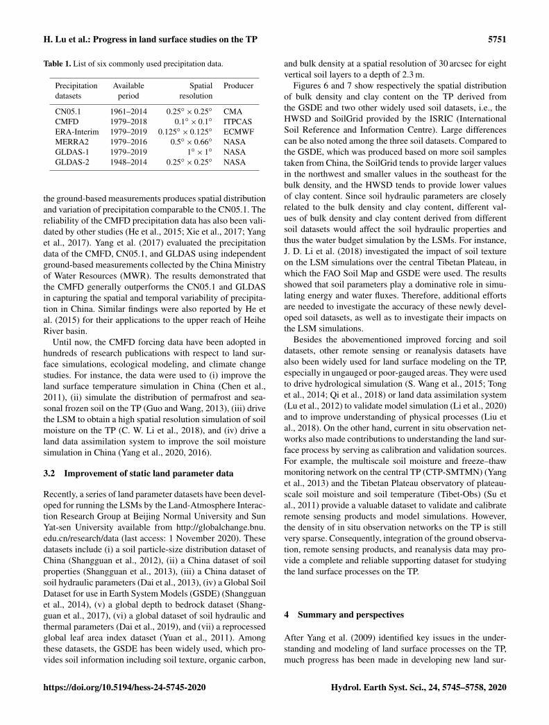
H. Lu et al.: Progress in land surface studies on the TP 5751
Table 1. List of six commonly used precipitation data.
Precipitation Available Spatial Producerdatasets period resolution
CN05.1 1961–2014 0.25◦× 0.25◦ CMA
CMFD 1979–2018 0.1◦× 0.1◦ ITPCAS
ERA-Interim 1979–2019 0.125◦× 0.125◦ ECMWF
MERRA2 1979–2016 0.5◦× 0.66◦ NASA
GLDAS-1 1979–2019 1◦× 1◦ NASA
GLDAS-2 1948–2014 0.25◦× 0.25◦ NASA
the ground-based measurements produces spatial distributionand variation of precipitation comparable to the CN05.1. Thereliability of the CMFD precipitation data has also been vali-dated by other studies (He et al., 2015; Xie et al., 2017; Yanget al., 2017). Yang et al. (2017) evaluated the precipitationdata of the CMFD, CN05.1, and GLDAS using independentground-based measurements collected by the China Ministryof Water Resources (MWR). The results demonstrated thatthe CMFD generally outperforms the CN05.1 and GLDASin capturing the spatial and temporal variability of precipita-tion in China. Similar findings were also reported by He etal. (2015) for their applications to the upper reach of HeiheRiver basin.
Until now, the CMFD forcing data have been adopted inhundreds of research publications with respect to land sur-face simulations, ecological modeling, and climate changestudies. For instance, the data were used to (i) improve theland surface temperature simulation in China (Chen et al.,2011), (ii) simulate the distribution of permafrost and sea-sonal frozen soil on the TP (Guo and Wang, 2013), (iii) drivethe LSM to obtain a high spatial resolution simulation of soilmoisture on the TP (C. W. Li et al., 2018), and (iv) drive aland data assimilation system to improve the soil moisturesimulation in China (Yang et al., 2020, 2016).
3.2 Improvement of static land parameter data
Recently, a series of land parameter datasets have been devel-oped for running the LSMs by the Land-Atmosphere Interac-tion Research Group at Beijing Normal University and SunYat-sen University available from http://globalchange.bnu.edu.cn/research/data (last access: 1 November 2020). Thesedatasets include (i) a soil particle-size distribution dataset ofChina (Shangguan et al., 2012), (ii) a China dataset of soilproperties (Shangguan et al., 2013), (iii) a China dataset ofsoil hydraulic parameters (Dai et al., 2013), (iv) a Global SoilDataset for use in Earth System Models (GSDE) (Shangguanet al., 2014), (v) a global depth to bedrock dataset (Shang-guan et al., 2017), (vi) a global dataset of soil hydraulic andthermal parameters (Dai et al., 2019), and (vii) a reprocessedglobal leaf area index dataset (Yuan et al., 2011). Amongthese datasets, the GSDE has been widely used, which pro-vides soil information including soil texture, organic carbon,
and bulk density at a spatial resolution of 30 arcsec for eightvertical soil layers to a depth of 2.3 m.
Figures 6 and 7 show respectively the spatial distributionof bulk density and clay content on the TP derived fromthe GSDE and two other widely used soil datasets, i.e., theHWSD and SoilGrid provided by the ISRIC (InternationalSoil Reference and Information Centre). Large differencescan be also noted among the three soil datasets. Compared tothe GSDE, which was produced based on more soil samplestaken from China, the SoilGrid tends to provide larger valuesin the northwest and smaller values in the southeast for thebulk density, and the HWSD tends to provide lower valuesof clay content. Since soil hydraulic parameters are closelyrelated to the bulk density and clay content, different val-ues of bulk density and clay content derived from differentsoil datasets would affect the soil hydraulic properties andthus the water budget simulation by the LSMs. For instance,J. D. Li et al. (2018) investigated the impact of soil textureon the LSM simulations over the central Tibetan Plateau, inwhich the FAO Soil Map and GSDE were used. The resultsshowed that soil parameters play a dominative role in simu-lating energy and water fluxes. Therefore, additional effortsare needed to investigate the accuracy of these newly devel-oped soil datasets, as well as to investigate their impacts onthe LSM simulations.
Besides the abovementioned improved forcing and soildatasets, other remote sensing or reanalysis datasets havealso been widely used for land surface modeling on the TP,especially in ungauged or poor-gauged areas. They were usedto drive hydrological simulation (S. Wang et al., 2015; Tonget al., 2014; Qi et al., 2018) or land data assimilation system(Lu et al., 2012) to validate model simulation (Li et al., 2020)and to improve understanding of physical processes (Liu etal., 2018). On the other hand, current in situ observation net-works also made contributions to understanding the land sur-face process by serving as calibration and validation sources.For example, the multiscale soil moisture and freeze–thawmonitoring network on the central TP (CTP-SMTMN) (Yanget al., 2013) and the Tibetan Plateau observatory of plateau-scale soil moisture and soil temperature (Tibet-Obs) (Su etal., 2011) provide a valuable dataset to validate and calibrateremote sensing products and model simulations. However,the density of in situ observation networks on the TP is stillvery sparse. Consequently, integration of the ground observa-tion, remote sensing products, and reanalysis data may pro-vide a complete and reliable supporting dataset for studyingthe land surface processes on the TP.
4 Summary and perspectives
After Yang et al. (2009) identified key issues in the under-standing and modeling of land surface processes on the TP,much progress has been made in developing new land sur-
https://doi.org/10.5194/hess-24-5745-2020 Hydrol. Earth Syst. Sci., 24, 5745–5758, 2020

5752 H. Lu et al.: Progress in land surface studies on the TP
Figure 5. Spatial distribution of mean annual precipitation derived from six forcing datasets for the Tibetan Plateau (1985–2014): (a) CN05.1,(b) CMFD, (c) ERA-Interim, (d) MERRA2, (e) GLDAS version1, and (f) GLDAS version 2. Statistic values, such as minimum (Min),maximum (Max), mean (Mean), standard deviation (SD), and coefficient of variation (CV), are also shown in each plot.
Figure 6. Spatial distribution of soil bulk density on the TP derivedfrom (a) GSDE, (b) HWSD, and (c) SoilGrid. Corresponding his-tograms are also shown in (d)–f).
face schemes and supporting datasets in the past decade. Themain advances are summarized in this mini-review:
– (i) an enthalpy-based approach was adopted to enhancethe description of cryosphere processes such as glacierand snow mass balance and soil freeze–thaw transitions;
Figure 7. Same as Fig. 6 but for soil clay content (%).
– (ii) parameterization of vertical mixing process was im-proved in lake models to ensure reasonable heat transferinto deep water;
– (iii) new schemes were proposed for modeling waterflow and heat transfer in the soils accounting for the ef-fect of vertical soil heterogeneity due to the presence ofhigh soil organic matter content and dense vegetationroots in surface soils or gravel in soil columns;
Hydrol. Earth Syst. Sci., 24, 5745–5758, 2020 https://doi.org/10.5194/hess-24-5745-2020

H. Lu et al.: Progress in land surface studies on the TP 5753
– (iv) supporting datasets of meteorological forcing andsoil parameter datasets were developed by integratingmore ground-based measurements.
Based on the review, the following research perspectivesin land surface modeling on the TP are given.
1. Continuous improvement of meteorological forcing andland parameter datasets. The quality of current datasetsis generally good for eastern China but not so reliablefor the Tibetan Plateau and northwestern China, becauseof limited access to station data. With the progress indata sharing policy, it is possible to merge more stationdata from these remote regions. In addition, new experi-mental activities (e.g., the Second Scientific Expeditionto the Tibetan Plateau and the Third Atmospheric Sci-ence Experiment on the Tibetan Plateau) may providenew observations to improve and validate the quality ofthe forcing datasets. Also, high-resolution modeling canprovide a new meteorological data source to improvethe data quality in regions with complex terrain (Li etal., 2020; Y. Wang et al., 2020).
2. Estimation of land parameters at model grid scalethrough data assimilation and/or multi-objective opti-mization. Parameter upscaling faces big challenges withfield sampling. By contrast, satellite data can avoid thiskind of issues, although the remote sensing productsmay also encounter uncertainties. Satellite data assim-ilation and/or multi-objective optimization may providea new feasible way to estimate model parameters. A re-cent work (Luo et al., 2020) proves the concept, show-ing inverse estimation with in situ data is indeed able toreproduce the spatial pattern of soil organic carbon con-tent measured in a mesoscale area of the TP, and somepioneering studies (Corbari et al., 2015; Pinnington etal., 2018; Yang et al., 2016) show the potential of thistype of methods.
3. Development of new schemes and integration of mul-tiple schemes into a single LSM. Some parameteriza-tions are still questionable or even excluded, such asrhizosphere effect, complex terrain, and high-elevationlakes, which are typical for the TP. For example, theparameterization of the light extinction coefficient andturbulent mixing in lakes are critical to freeze-up sim-ulation, but their values are empirically given (Huanget al., 2019). Meanwhile, since the vegetation types onthe TP have unique characteristics and are very sensitiveto climate change, the parameterization of vegetation-related processes should be improved as demonstratedby Li et al (2019). The role of these processes should beunderstood and parameterized with new observations.Coupling new schemes into a LSM can increase the di-versity of the LSM community and thus better quantifythe uncertainties of LSMs.
4. Adoption of data-driven methods and artificial intelli-gence in land surface process study. Big-data methodscould provide vast data and clues in model develop-ment, parameter optimization, and so on (Guo, 2017),while artificial intelligence could help in process under-standing (Reichstein et al., 2019). As demonstrated byJing et al. (2020), the integration of physical process-based models with data-driven approaches shows highpotential to improve the understanding and simulationof land surface processes.
Data availability. All data that were used were cited inSect. 3. The CMFD is available at http://dx.doi.org/10.11888/AtmosphericPhysics.tpe.249369.file (Yang and He, 2019).CN05.1 data are available from Xuejie Gao ([email protected])upon reasonable request. The ERA-Interim datasets aredistributed by ECMWF (Dee et al., 2011), available athttp://apps.ecmwf.int/datasets/. GLDAS data are free fromhttps://disc.gsfc.nasa.gov/datasets?page=1&keywords=GLDAS(Rodell et al., 2004). MERRA2 data are available fromhttps://disc.gsfc.nasa.gov/datasets?keywords=MERRA-2&page=1(Gelaro et al., 2017). The HWSD is available at http://webarchive.iiasa.ac.at/Research/LUC/External-World-soil-database/HTML(FAO/IIASA/ISRIC/ISS-CAS/JRC, 2012). The GSDE is availablefrom http://globalchange.bnu.edu.cn/research/data (Shangguan etal., 2014).
Author contributions. HL and KY conceptualized the work. HLdrafted the paper. DZ and KY revised the paper. HL, DZ, KY, andFY collected data and contributed to analyses and discussions.
Competing interests. The authors declare that they have no conflictof interest.
Acknowledgements. The authors would like to thank Xuejie Gao,Baohong Ding, Yingying Chen, Wei Shangguan, and Jiming Jin fortheir assistance.
Financial support. This research has been supported by the Na-tional Key Research and Development Program of China (grantno. 2017YFA0603703), the National Natural Science Founda-tion of China (grant no. 91747101), the Second Tibetan PlateauScientific Expedition and Research Program (STEP) (grant no.2019QZKK0206), and the Strategic Priority Research Program ofChinese Academy of Sciences (grant no. XDA20100103).
Review statement. This paper was edited by Xing Yuan and re-viewed by three anonymous referees.
https://doi.org/10.5194/hess-24-5745-2020 Hydrol. Earth Syst. Sci., 24, 5745–5758, 2020

5754 H. Lu et al.: Progress in land surface studies on the TP
References
Bai, P., Liu, X. M., Yang, T. T., Liang, K., and Liu, C. M.: Evalu-ation of streamflow simulation results of land surface models inGLDAS on the Tibetan plateau, J. Geophys. Res.-Atmos., 121,12180–12197, 2016.
Bao, H., Koike, T., Yang, K., Wang, L., Shrestha, M., and Lawford,P.: Development of an enthalpy-based frozen soil model and itsvalidation in a cold region in China, J. Geophys. Res.-Atmos.,121, 5259–5280, https://doi.org/10.1002/2015jd024451, 2016.
Beljaars, A. C. M., Brown, A. R., and Wood, N.: A newparametrization of turbulent orographic form drag, Q. J. Roy.Meteor. Soc., 130, 1327–1347, https://doi.org/10.1256/qj.03.73,2004.
Boone, A., de Rosnay, P., Balsamo, G., Beljaars, A., Chopin, F.,Decharme, B., Delire, C., Ducharne, A., Gascoin, S., Grippa,M., Guichard, F., Gusev, Y., Harris, P., Jarlan, L., Kergoat, L.,Mougin, E., Nasonova, O., Norgaard, A., Orgeval, T., Ottle, C.,Poccard-Leclercq, I., Polcher, J., Sandholt, I., Saux-Picart, S.,Taylor, C., and Xue, Y. K.: The Amma Land Surface Model Inter-comparison Project (Almip), B. Am. Meteorol. Soc., 90, 1865–1880, 2009.
Chen, Y. Y., Yang, K., He, J., Qin, J., Shi, J. C., Du, J. Y.,and He, Q.: Improving land surface temperature modeling fordry land of China, J. Geophys. Res.-Atmos., 116, D20104,https://doi.org/10.1029/2011JD015921, 2011.
Chen, Y. Y., Yang, K., Tang, W. J., Qin, J., and Zhao, L.: Parameter-izing soil organic carbon’s impacts on soil porosity and thermalparameters for Eastern Tibet grasslands, Sci. China Earth Sci.,55, 1001–1011, 2012.
Chen, Y. Y., Yang, K., Qin, J., Zhao, L., Tang, W. J., and Han, M.L.: Evaluation of AMSR-E retrievals and GLDAS simulationsagainst observations of a soil moisture network on the central Ti-betan Plateau, J. Geophys. Res.-Atmos., 118, 4466–4475, 2013.
Corbari, C., Mancini, M., Li, J., and Su, Z.: Can satel-lite land surface temperature data be used similarly toriver discharge measurements for distributed hydrologi-cal model calibration?, Hydrolog. Sci. J., 60, 202–217,https://doi.org/10.1080/02626667.2013.866709, 2015.
Dai, Y., Wei, N., Huang, A., Zhu, S., Shangguan, W., Yuan, H.,Zhang, S., and Liu, S.: The lake scheme of the Common LandModel and its performance evaluation, Chinese Sci. Bull., 63,3002–3021, 2018.
Dai, Y., Xin, Q., Wei, N., Zhang, Y., Wei, S., Yuan, H., Zhang,S., Liu, S., and Lu, X.: A Global High-Resolution DataSet of Soil Hydraulic and Thermal Properties for Land Sur-face Modeling, J. Adv. Model. Earth Sy., 11, 2996–3023,https://doi.org/10.1029/2019ms001784, 2019.
Dai, Y. J., Zeng, X. B., Dickinson, R. E., Baker, I., Bonan, G. B.,Bosilovich, M. G., Denning, A. S., Dirmeyer, P. A., Houser, P. R.,Niu, G. Y., Oleson, K. W., Schlosser, C. A., and Yang, Z. L.: TheCommon Land Model, B. Am. Meteorol. Soc., 84, 1013–1023,2003.
Dai, Y. J., Shangguan, W., Duan, Q. Y., Liu, B. Y., Fu, S. H., andNiu, G.: Development of a China Dataset of Soil Hydraulic Pa-rameters Using Pedotransfer Functions for Land Surface Model-ing, J. Hydrometeorol., 14, 869–887, 2013.
Dee, D. P., Uppala, S. M., Simmons, A. J., Berrisford, P., Poli,P., Kobayashi, S., Andrae, U., Balmaseda, M. A., Balsamo, G.,Bauer, P., Bechtold, P., Beljaars, A. C. M., van de Berg, L.,
Bidlot, J., Bormann, N., Delsol, C., Dragani, R., Fuentes, M.,Geer, A. J., Haimberger, L., Healy, S. B., Hersbach, H., Hólm,E. V., Isaksen, L., Kållberg, P., Köhler, M., Matricardi, M., Mc-Nally, A. P., Monge-Sanz, B. M., Morcrette, J.-J., Park, B.-K.,Peubey, C., de Rosnay, P., Tavolato, C., Thépaut, J.-N., and Vi-tart, F.: The ERA-Interim reanalysis: configuration and perfor-mance of the data assimilation system, Q. J. Roy. Meteor. Soc.,137, 553–597, https://doi.org/10.1002/qj.828, 2011 (data avail-able at: http://apps.ecmwf.int/datasets/, last access: 01 Novem-ber 2020).
Dickinson, R. E., Kennedy, P. J., and Henderson-Sellers, A.:Biosphere-Atmosphere Transfer Scheme (BATS) version 1e ascoupled to the NCAR community climate model, National Cen-ter for Atmospheric Research, Climate and Global Dynamics Di-vision, 1993.
Dickinson, R. E., Oleson, K. W., Bonan, G., Hoffman, F., Thornton,P., Vertenstein, M., Yang, Z. L., and Zeng, X. B.: The Commu-nity Land Model and its climate statistics as a component of theCommunity Climate System Model, J. Climate, 19, 2302–2324,2006.
Ding, B. H., Yang, K., Qin, J., Wang, L., Chen, Y. Y., and He, X. B.:The dependence of precipitation types on surface elevation andmeteorological conditions and its parameterization, J. Hydrol.,513, 154–163, https://doi.org/10.1016/j.jhydrol.2014.03.038,2014.
Ding, B. H., Yang, K., Yang, W., He, X. B., Chen, Y. Y., Lazhu,Guo, X. F., Wang, L., Wu, H., and Yao, T. D.: Development of aWater and Enthalpy Budget-based Glacier mass balance Model(WEB-GM) and its preliminary validation, Water Resour. Res.,53, 3146–3178, 2017.
Dirmeyer, P. A.: A History and Review of the Global Soil WetnessProject (GSWP), J. Hydrometeorol., 12, 729–749, 2011.
Dirmeyer, P. A., Dolman, A. J., and Sato, N.: The pilot phase of theGlobal Soil Wetness Project, B. Am. Meteorol. Soc., 80, 851–878, 1999.
Fang, N., Yang, K., Lazhu, Chen, Y., Wang, J., and Zhu, L.: Re-search on the Application of WRF-Lake Modeling at Nam CoLake on the Qinghai-Tibetan Plateau, Plateau Meteorology, 36,610–618, 2017.
FAO: The Digitized Soil Map of the World IncludingDerived Soil Properties (version 3.6), available at:http://www.fao.org/geonetwork/srv/en/metadata.show?id=14116&currTab=distribution, last access: 01 November 2020),FAO, Rome, Italy, 2003.
FAO/IIASA/ISRIC/ISS-CAS/JRC: Harmonized World SoilDatabase (version 1.2), available at: http://webarchive.iiasa.ac.at/Research/LUC/External-World-soil-database/HTML/ (lastaccess: 1 November 2020), FAO, Rome, Italy and IIASA,Laxenburg, Austria, 2012.
Farouki, O. T.: The Thermal-Properties of Soils in Cold Regions,Cold Reg. Sci. Technol., 5, 67–75, 1981.
Gao, Y. H., Li, K., Chen, F., Jiang, Y. S., and Lu, C. G.: Assess-ing and improving Noah-MP land model simulations for the cen-tral Tibetan Plateau, J. Geophys. Rese.-Atmos., 120, 9258–9278,2015.
Gelaro, R., McCarty, W., Suarez, M. J., Todling, R., Molod, A.,Takacs, L., Randles, C. A., Darmenov, A., Bosilovich, M. G., Re-ichle, R., Wargan, K., Coy, L., Cullather, R., Draper, C., Akella,S., Buchard, V., Conaty, A., da Silva, A. M., Gu, W., Kim, G.
Hydrol. Earth Syst. Sci., 24, 5745–5758, 2020 https://doi.org/10.5194/hess-24-5745-2020

H. Lu et al.: Progress in land surface studies on the TP 5755
K., Koster, R., Lucchesi, R., Merkova, D., Nielsen, J. E., Par-tyka, G., Pawson, S., Putman, W., Rienecker, M., Schubert, S. D.,Sienkiewicz, M., and Zhao, B.: The Modern-Era RetrospectiveAnalysis for Research and Applications, Version 2 (MERRA-2), J. Climate, 30, 5419–5454, https://doi.org/10.1175/JCLI-D-16-0758.1, 2017 (data available at: https://disc.gsfc.nasa.gov/datasets?keywords=MERRA-2&page=1, last access: 1 Novem-ber 2020).
Gu, C., Huang, A., Wu, Y., Yang, B., Mu, X., Zhang, X., andCai, S.: Effects of Subgrid Terrain Radiative Forcing on theAbility of RegCM4.1 in the Simulation of Summer Precipita-tion Over China, J. Geophys. Res.-Atmos., 125, e2019JD032215,https://doi.org/10.1029/2019jd032215, 2020.
Gu, H., Jin, J., Wu, Y., Ek, M. B., and Subin, Z. M.: Calibra-tion and validation of lake surface temperature simulations withthe coupled WRF-lake model, Climatic Change, 129, 471–483,https://doi.org/10.1007/s10584-013-0978-y, 2015.
Guo, D. L. and Wang, H. J.: Simulation of permafrostand seasonally frozen ground conditions on the TibetanPlateau, 1981–2010, J. Geophys. Res.-Atmos., 118, 5216–5230,https://doi.org/10.1002/jgrd.50457, 2013.
Guo, H.: Big Earth data: A new frontier in Earthand information sciences, Big Earth Data, 1, 4–20,https://doi.org/10.1080/20964471.2017.1403062, 2017.
Han, C. B., Ma, Y. M., Su, Z. B., Chen, X. L., Zhang, L., Li, M.S., and Sun, F. L.: Estimates of effective aerodynamic roughnesslength over mountainous areas of the Tibetan Plateau, Q. J. Roy.Meteor. Soc., 141, 1457–1465, https://doi.org/10.1002/qj.2462,2015.
He, J., Yang, K., Tang, W., Lu, H., Qin, J., Chen, Y., and Li,X.: The first high-resolution meteorological forcing datasetfor land process studies over China, Scientific Data, 7, 25,https://doi.org/10.1038/s41597-020-0369-y, 2020.
He, S. W., Nan, Z. T., and Hou, Y. T.: Accuracy evaluation of twoprecipitation datasets over upper reach of Heihe River Basin,northwestern China, available at: http://www.scar.ac.cn/EN/10.3724/SP.J.1226.2015.00157 (last access: 1 November 2020), Sci.Cold Arid. Reg., 7, 157–169, 2015.
Henderson-Sellers, A., Yang, Z. L., and Dickinson, R. E.: TheProject for Intercomparison of Land-Surface ParameterizationSchemes, B. Am. Meteorol. Soc., 74, 1335–1349, 1993.
Henderson-Sellers, A., Pitman, A. J., Love, P. K., Irannejad, P., andChen, T. H.: The Project for Intercomparison of Land SurfaceParameterization Schemes (PILPS): Phase 2 and Phase 3, B. Am.Meteorol. Soc., 76, 489–503, 1995.
Hengl, T., de Jesus, J. M., MacMillan, R. A., Batjes, N. H.,Heuvelink, G. B. M., Ribeiro, E., Samuel-Rosa, A., Kem-pen, B., Leenaars, J. G. B., Walsh, M. G., and Gon-zalez, M. R.: SoilGrids1km – Global Soil InformationBased on Automated Mapping, PLOS One, 9, e114788,https://doi.org/10.1371/journal.pone.0105992, 2014.
Huang, A., Lazhu, Wang, J., Dai, Y., Yang, K., Wei, N., Wen, L.,Wu, Y., Zhu, X., Zhang, X., and Cai, S.: Evaluating and Improv-ing the Performance of Three 1-D Lake Models in a Large DeepLake of the Central Tibetan Plateau, J. Geophys. Res.-Atmos.,124, 3143–3167, https://doi.org/10.1029/2018jd029610, 2019.
Hurrell, J. W., Holland, M. M., Gent, P. R., Ghan, S., Kay, J. E.,Kushner, P. J., Lamarque, J. F., Large, W. G., Lawrence, D., Lind-say, K., Lipscomb, W. H., Long, M. C., Mahowald, N., Marsh,
D. R., Neale, R. B., Rasch, P., Vavrus, S., Vertenstein, M., Bader,D., Collins, W. D., Hack, J. J., Kiehl, J., and Marshall, S.: TheCommunity Earth System Model A Framework for Collabora-tive Research, B. Am. Meteorol. Soc., 94, 1339–1360, 2013.
Jimenez, C., Prigent, C., Mueller, B., Seneviratne, S. I., McCabe,M. F., Wood, E. F., Rossow, W. B., Balsamo, G., Betts, A.K., Dirmeyer, P. A., Fisher, J. B., Jung, M., Kanamitsu, M.,Reichle, R. H., Reichstein, M., Rodell, M., Sheffield, J., Tu,K., and Wang, K.: Global intercomparison of 12 land surfaceheat flux estimates, J. Geophys. Res.-Atmos., 116, D02102,https://doi.org/10.1029/2010jd014545, 2011.
Jing, W. L., Di, L. P., Zhao, X. D., Yao, L., Xia, X. L., Liu, Y. X.,Yang, J., Li, Y., and Zhou, C. H.: A data-driven approach to gen-erate past GRACE-like terrestrial water storage solution by cali-brating the land surface model simulations, Adv. Water Resour.,143, 103683, https://doi.org/10.1016/j.advwatres.2020.103683,2020.
Johansen, O.: Thermal conductivity of soils, PhD dissertation, Uni-versity of Trondheim, Trondheim, Norway, 236 pp., 1975.
Lazhu, Yang, K., Wang, J. B., Lei, Y. B., Chen, Y. Y., Zhu, L. P.,Ding, B. H., and Qin, J.: Quantifying evaporation and its decadalchange for Lake Nam Co, central Tibetan Plateau, J. Geophys.Res.-Atmos., 121, 7578–7591, 2016.
Lee, W.-L., Liou, K. N., and Wang, C.-c.: Impact of 3-D topogra-phy on surface radiation budget over the Tibetan Plateau, Theor.Appl. Climatol., 113, 95–103, https://doi.org/10.1007/s00704-012-0767-y, 2013.
Lee, W.-L., Liou, K.-N., Wang, C.-c., Gu, Y., Hsu, H.-H., andLi, J.-L. F.: Impact of 3-D Radiation-Topography Interactionson Surface Temperature and Energy Budget Over the TibetanPlateau in Winter, J. Geophys. Res.-Atmos., 124, 1537–1549,https://doi.org/10.1029/2018jd029592, 2019.
Li, C., Lu, H., Leung, L. R., Yang, K., Li, H., Wang, W., Han, M.,and Chen, Y.: Improving Land Surface Temperature Simulationin CoLM Over the Tibetan Plateau Through Fractional Vegeta-tion Cover Derived From a Remotely Sensed Clumping Indexand Model-Simulated Leaf Area Index, J. Geophys. Res.-Atmos.,124, 2620–2642, https://doi.org/10.1029/2018jd028640, 2019.
Li, C. W., Lu, H., Yang, K., Wright, J. S., Yu, L., Chen, Y. Y., Huang,X. M., and Xu, S. M.: Evaluation of the Common Land Model(CoLM) from the Perspective of Water and Energy Budget Simu-lation: Towards Inclusion in CMIP6, Atmosphere-Basel, 8, 141,https://doi.org/10.3390/atmos8080141, 2017.
Li, C. W., Lu, H., Yang, K., Han, M. L., Wright, J. S., Chen,Y. Y., Yu, L., Xu, S. M., Huang, X. M., and Gong, W.: TheEvaluation of SMAP Enhanced Soil Moisture Products Us-ing High-Resolution Model Simulations and In-Situ Observa-tions on the Tibetan Plateau, Remote Sens.-Basel, 10, 535,https://doi.org/10.3390/rs10040535, 2018.
Li, D., Yang, K., Tang, W. J., Li, X., Zhou, X., and Guo, D. L.: Char-acterizing precipitation in high altitudes of the western Tibetanplateau with a focus on major glacier areas, Int. J. Climatol., 40,5114–5127, https://doi.org/10.1002/joc.6509, 2020.
Li, J. D., Chen, F., Zhang, G., Barlage, M., Gan, Y. J., Xin,Y. F., and Wang, C.: Impacts of Land Cover and Soil Tex-ture Uncertainty on Land Model Simulations Over the Cen-tral Tibetan Plateau, J. Adv. Model. Earth Sy., 10, 2121–2146,https://doi.org/10.1029/2018MS001377, 2018.
https://doi.org/10.5194/hess-24-5745-2020 Hydrol. Earth Syst. Sci., 24, 5745–5758, 2020

5756 H. Lu et al.: Progress in land surface studies on the TP
Li, Q. and Sun, S.: Development of the universal and simplified soilmodel coupling heat and water transport, Sci. China Ser. D, 51,88–102, https://doi.org/10.1007/s11430-007-0153-2, 2008.
Lin, C. G., Chen, D. L., Yang, K., and Ou, T. H.: Impactof model resolution on simulating the water vapor transportthrough the central Himalayas: implication for models’ wetbias over the Tibetan Plateau, Clim. Dynam., 51, 3195–3207,https://doi.org/10.1007/s00382-018-4074-x, 2018.
Liou, K. N., Lee, W.-L., and Hall, A.: Radiative transfer in moun-tains: Application to the Tibetan Plateau, Geophys. Res. Lett.,34, L23809, https://doi.org/10.1029/2007GL031762, 2007.
Liu, W., Sun, F., Li, Y., Zhang, G., Sang, Y.-F., Lim, W.H., Liu, J., Wang, H., and Bai, P.: Investigating water bud-get dynamics in 18 river basins across the Tibetan Plateauthrough multiple datasets, Hydrol. Earth Syst. Sci., 22, 351–371,https://doi.org/10.5194/hess-22-351-2018, 2018.
Lu, H., Koike, T., Yang, K., Hu, Z. Y., Xu, X. D., Rasmy, M., Kuria,D., and Tamagawa, K.: Improving land surface soil moisture andenergy flux simulations over the Tibetan plateau by the assimila-tion of the microwave remote sensing data and the GCM outputinto a land surface model, Int. J. Appl. Earth Obs., 17, 43–54,https://doi.org/10.1016/j.jag.2011.09.006, 2012.
Luo, Q., Yang, K., Chen, Y., and Zhou, X.: Method developmentfor estimating soil organic carbon content in an alpine regionusing soil moisture data, Sci. China Earth Sci., 63, 591–601,https://doi.org/10.1007/s11430-019-9554-8, 2020.
Luo, S. Q., Fang, X. W., Lyu, S. H., Zhang, Y., and Chen, B. L.:Improving CLM4.5 Simulations of Land-Atmosphere Exchangeduring Freeze-Thaw Processes on the Tibetan Plateau, J. Meteo-rol. Res.-Prc., 31, 916–930, 2017.
Luo, S. Q., Chen, B. L., Lyu, S. H., Fang, X. W., Wang, J. Y., Meng,X. H., Shang, L. Y., Wang, S. Y., and Ma, D.: An improve-ment of soil temperature simulations on the Tibetan Plateau,available at: http://www.scar.ac.cn/EN/10.3724/SP.J.1226.2018.00080 (last access: 1 November 2020), Sci. Cold Arid. Reg., 10,80–94, 2018.
Manabe, S.: Climate and Ocean Circulation: I. The Atmo-spheric Circulation and Hydrology of the Earth’s Surface,Mon. Weather Rev., 97, 739–774, https://doi.org/10.1175/1520-0493(1969)097<0739:CATOC>2.3.CO;2, 1969.
Oleson, K. W., Lawrence, D. M., Gordon, B., Flanner, M. G.,Kluzek, E., Peter, J., Levis, S., Swenson, S. C., Thornton, E., andFeddema, J.: Technical description of version 4.0 of the Commu-nity Land model (CLM), The National Center for AtmosphericResearch (NCAR), 2010.
Pan, M., Sahoo, A. K., Troy, T. J., Vinukollu, R. K., Sheffield, J.,and Wood, E. F.: Multisource Estimation of Long-Term Terres-trial Water Budget for Major Global River Basins, J. Climate, 25,3191–3206, 2012.
Pan, Y. J., Lyu, S. H., Li, S. S., Gao, Y. H., Meng, X. H., Ao, Y. H.,and Wang, S. J.: Simulating the role of gravel in freeze-thaw pro-cess on the Qinghai-Tibet Plateau, Theor. Appl. Climatol., 127,1011–1022, 2017.
Pinnington, E., Quaife, T., and Black, E.: Impact of remotelysensed soil moisture and precipitation on soil moisture pre-diction in a data assimilation system with the JULES landsurface model, Hydrol. Earth Syst. Sci., 22, 2575–2588,https://doi.org/10.5194/hess-22-2575-2018, 2018.
Qi, W., Liu, J. G., and Chen, D. L.: Evaluations and Improve-ments of GLDAS2.0 and GLDAS2.1 Forcing Data’s Appli-cability for Basin Scale Hydrological Simulations in the Ti-betan Plateau, J. Geophys. Res.-Atmos., 123, 13128–13148,https://doi.org/10.1029/2018jd029116, 2018.
Reichstein, M., Camps-Valls, G., Stevens, B., Jung, M., Denzler,J., Carvalhais, N., and Prabhat: Deep learning and process un-derstanding for data-driven Earth system science, Nature, 566,195–204, https://doi.org/10.1038/s41586-019-0912-1, 2019.
Rienecker, M. M., Suarez, M. J., Gelaro, R., Todling, R., Bacmeis-ter, J., Liu, E., Bosilovich, M. G., Schubert, S. D., Takacs, L.,Kim, G. K., Bloom, S., Chen, J. Y., Collins, D., Conaty, A.,Da Silva, A., Gu, W., Joiner, J., Koster, R. D., Lucchesi, R.,Molod, A., Owens, T., Pawson, S., Pegion, P., Redder, C. R., Re-ichle, R., Robertson, F. R., Ruddick, A. G., Sienkiewicz, M., andWoollen, J.: MERRA: NASA’s Modern-Era Retrospective Anal-ysis for Research and Applications, J. Climate, 24, 3624–3648,2011.
Rodell, M., Houser, P. R., Jambor, U., Gottschalck, J., Mitchell,K., Meng, C. J., Arsenault, K., Cosgrove, B., Radakovich, J.,Bosilovich, M., Entin, J. K., Walker, J. P., Lohmann, D., andToll, D.: The global land data assimilation system, B. Am. Me-teorol. Soc., 85, 381–394, https://doi.org/10.1175/BAMS-85-3-381, 2004 (data available at: https://disc.gsfc.nasa.gov/datasets?page=1&keywords=GLDAS, last access: 1 November 2020).
Sellers, P. J., Mintz, Y., Sud, Y. C., and Dalcher, A.: A Simple Bio-sphere Model (Sib) for Use within General-Circulation Models,J. Atmos. Sci., 43, 505–531, 1986.
Sellers, P. J., Randall, D. A., Collatz, G. J., Berry, J. A., Field, C.B., Dazlich, D. A., Zhang, C., Collelo, G. D., and Bounoua, L.:A revised land surface parameterization (SiB2) for atmosphericGCMs .1. Model formulation, J. Climate, 9, 676–705, 1996.
Shangguan, W., Dai, Y. J., Liu, B. Y., Ye, A. Z., and Yuan, H.: Asoil particle-size distribution dataset for regional land and climatemodelling in China, Geoderma, 171, 85–91, 2012.
Shangguan, W., Dai, Y. J., Liu, B. Y., Zhu, A. X., Duan, Q. Y., Wu,L. Z., Ji, D. Y., Ye, A. Z., Yuan, H., Zhang, Q., Chen, D. D., Chen,M., Chu, J. T., Dou, Y. J., Guo, J. X., Li, H. Q., Li, J. J., Liang,L., Liang, X., Liu, H. P., Liu, S. Y., Miao, C. Y., and Zhang, Y.Z.: A China data set of soil properties for land surface modeling,J. Adv. Model. Earth Sy., 5, 212–224, 2013.
Shangguan, W., Dai, Y. J., Duan, Q. Y., Liu, B. Y., and Yuan, H.:A global soil data set for earth system modeling, J. Adv. Model.Earth Sy., 6, 249–263, 2014.
Shangguan, W., Hengl, T., de Jesus, J. M., Yuan, H., andDai, Y. J.: Mapping the global depth to bedrock forland surface modeling, J. Adv. Model. Earth Sy., 9, 65–88, https://doi.org/10.1002/2016MS000686, 2017 (data avail-able at: http://globalchange.bnu.edu.cn/research/data, last ac-cess: 1 November 2020).
Su, D., Hu, X., Wen, L., Lyu, S., Gao, X., Zhao, L., Li, Z., Du, J.,and Kirillin, G.: Numerical study on the response of the largestlake in China to climate change, Hydrol. Earth Syst. Sci., 23,2093–2109, https://doi.org/10.5194/hess-23-2093-2019, 2019.
Su, Z., Wen, J., Dente, L., van der Velde, R., Wang, L., Ma,Y., Yang, K., and Hu, Z.: The Tibetan Plateau observatoryof plateau scale soil moisture and soil temperature (Tibet-Obs) for quantifying uncertainties in coarse resolution satellite
Hydrol. Earth Syst. Sci., 24, 5745–5758, 2020 https://doi.org/10.5194/hess-24-5745-2020
H. Lu et al.: Progress in land surface studies on the TP 5757
and model products, Hydrol. Earth Syst. Sci., 15, 2303–2316,https://doi.org/10.5194/hess-15-2303-2011, 2011.
Su, Z., de Rosnay, P., Wen, J., Wang, L., and Zeng, Y.: Evalua-tion of ECMWF’s soil moisture analyses using observations onthe Tibetan Plateau, J. Geophys. Res.-Atmos., 118, 5304–5318,https://doi.org/10.1002/jgrd.50468, 2013.
Sun, S., Yan, J., Xia, N., and Sun, C.: Development of amodel for water and heat exchange between the atmo-sphere and a water body, Adv. Atmos. Sci., 24, 927–938,https://doi.org/10.1007/s00376-007-0927-7, 2007.
Sun, S. F., Jin, J. M., and Xue, Y. K.: A simple snow-atmosphere-soil transfer model, J. Geophys. Res.-Atmos., 104, 19587–19597, https://doi.org/10.1029/1999jd900305, 1999.
Tong, K., Su, F. G., Yang, D. Q., and Hao, Z. C.: Evaluation ofsatellite precipitation retrievals and their potential utilities in hy-drologic modeling over the Tibetan Plateau, J. Hydrol., 519, 423–437, https://doi.org/10.1016/j.jhydrol.2014.07.044, 2014.
Wang, A. H. and Zeng, X. B.: Evaluation of multireanal-ysis products with in situ observations over the Ti-betan Plateau, J. Geophys. Res.-Atmos., 117, D05102,https://doi.org/10.1029/2011JD016553, 2012.
Wang, A. H., Zeng, X. B., and Guo, D. L.: Estimates of GlobalSurface Hydrology and Heat Fluxes from the Community LandModel (CLM4.5) with Four Atmospheric Forcing Datasets, J.Hydrometeorol., 17, 2493–2510, 2016.
Wang, B., Ma, Y., Chen, X., Ma, W., Su, Z., and Menenti,M.: Observation and simulation of lake-air heat and watertransfer processes in a high-altitude shallow lake on the Ti-betan Plateau, J. Geophys. Res.-Atmos., 120, 12327–12344,https://doi.org/10.1002/2015jd023863, 2015.
Wang, C. H. and Yang, K.: A New Scheme for Considering SoilWater-Heat Transport Coupling Based on Community LandModel: Model Description and Preliminary Validation, J. Adv.Model. Earth Sy., 10, 927–950, 2018.
Wang, L., Li, X. P., Chen, Y. Y., Yang, K., Chen, D. L., Zhou, J., Liu,W. B., Qi, J., and Huang, J. B.: Validation of the global land dataassimilation system based on measurements of soil temperatureprofiles, Agr. Forest Meteorol., 218, 288–297, 2016.
Wang, L., Zhou, J., Qi, J., Sun, L. T., Yang, K., Tian, L. D., Lin,Y. L., Liu, W. B., Shrestha, M., Xue, Y. K., Koike, T., Ma, Y.M., Li, X. P., Chen, Y. Y., Chen, D. L., Piao, S. L., and Lu, H.:Development of a land surface model with coupled snow andfrozen soil physics, Water Resour. Res., 53, 5085–5103, 2017.
Wang, S., Liu, S. X., Mo, X. G., Peng, B., Qiu, J. X., Li, M. X.,Liu, C. M., Wang, Z. G., and Bauer-Gottwein, P.: Evaluation ofRemotely Sensed Precipitation and Its Performance for Stream-flow Simulations in Basins of the Southeast Tibetan Plateau, J.Hydrometeorol., 16, 2577–2594, https://doi.org/10.1175/Jhm-D-14-0166.1, 2015.
Wang, W., Cui, W., Wang, X. J., and Chen, X.: Evaluation ofGLDAS-1 and GLDAS-2 Forcing Data and Noah Model Sim-ulations over China at the Monthly Scale, J. Hydrometeorol., 17,2815–2833, 2016.
Wang, W., Yang, K., Zhao, L., Zheng, Z., Lu, H., Mamtimin, A.,Ding, B., Li, X., Zhao, L., Li, H., Che, T., and Moore, J. C.:Characterizing surface albedo of shallow fresh snow and its im-portance for snow ablation on the interior of the Tibetan Plateau,J. Hydrometeorol., 21, 815–827, https://doi.org/10.1175/JHM-D-19-0193.1, 2020.
Wang, Y., Yang, K., Pan, Z. Y., Qin, J., Chen, D. L., Lin, C. G.,Chen, Y. Y., Lazhu, Tang, W. J., Han, M. L., Lu, N., and Wu,H.: Evaluation of Precipitable Water Vapor from Four SatelliteProducts and Four Reanalysis Datasets against GPS Measure-ments on the Southern Tibetan Plateau, J. Climate, 30, 5699–5713, https://doi.org/10.1175/Jcli-D-16-0630.1, 2017.
Wang, Y., Yang, K., Zhou, X., Chen, D. L., Lu, H., Ouyang, L.,Chen, Y. Y., Lazhu, and Wang, B. B.: Synergy of orographicdrag parameterization and high resolution greatly reduces biasesof WRF-simulated precipitation in central Himalaya, Clim. Dy-nam., 54, 1729–1740, 2020.
Wu, G., Duan, A., Liu, Y., Mao, J., Ren, R., Bao, Q., He, B.,Liu, B., and Hu, W.: Tibetan Plateau climate dynamics: re-cent research progress and outlook, Natl. Sci. Rev., 2, 100–116,https://doi.org/10.1093/nsr/nwu045, 2015.
Wu, J. and Gao, X.-J.: A gridded daily observation dataset overChina region and comparison with the other datasets, availableat: http://www.geophy.cn/EN/10.6038/cjg20130406 (last access:1 November 2020), Chinese Journal of Geophysics-Chinese Edi-tion, 56, 1102–1111, 2013.
Xia, Y., Sheffield, J., Ek, M. B., Dong, J., Chaney, N., Wei, H.,Meng, J., and Wood, E. F.: Evaluation of multi-model sim-ulated soil moisture in NLDAS-2, J. Hydrol., 512, 107–125,https://doi.org/10.1016/j.jhydrol.2014.02.027, 2014.
Xie, Z., Hu, Z., Gu, L., Sun, G., Du, Y., and Yan, X.: Meteorologi-cal Forcing Datasets for Blowing Snow Modeling on the TibetanPlateau: Evaluation and Intercomparison, J. Hydrometeorol., 18,2761–2780, https://doi.org/10.1175/JHM-D-17-0075.1, 2017.
Xie, Z. H., Di, Z. H., Luo, Z. D., and Ma, Q.: A Quasi-Three-Dimensional Variably Saturated Groundwater Flow Model forClimate Modeling, J. Hydrometeorol., 13, 27–46, 2012.
Xie, Z. H., Liu, S., Zeng, Y. J., Gao, J. Q., Qin, P. H., Jia, B. H.,Xie, J. B., Liu, B., Li, R. C., Wang, Y., and Wang, L. H.: AHigh-Resolution Land Model With Groundwater Lateral Flow,Water Use, and Soil Freeze-Thaw Front Dynamics and its Ap-plications in an Endorheic Basin, J. Geophys. Res.-Atmos., 123,7204–7222, https://doi.org/10.1029/2018JD028369, 2018.
Yang, F., Lu, H., Yang, K., He, J., Wang, W., Wright, J. S.,Li, C., Han, M., and Li, Y.: Evaluation of multiple forcingdata sets for precipitation and shortwave radiation over majorland areas of China, Hydrol. Earth Syst. Sci., 21, 5805–5821,https://doi.org/10.5194/hess-21-5805-2017, 2017.
Yang, K. and He J.: China meteorological forcing dataset(1979-2018), National Tibetan Plateau Data Center,https://doi.org/10.11888/AtmosphericPhysics.tpe.249369.file,2019.
Yang, K., Koike, T., Ye, B. S., and Bastidas, L.: Inverse analysisof the role of soil vertical heterogeneity in controlling surfacesoil state and energy partition, J. Geophys. Res.-Atmos., 110,D08101, https://doi.org/10.1029/2004JD005500, 2005.
Yang, K., Koike, T., Ishikawa, H., Kim, J., Li, X., Liu, H. Z., Liu,S. M., Ma, Y. M., and Wang, J. M.: Turbulent flux transfer overbare-soil surfaces: Characteristics and parameterization, J. Appl.Meteorol. Clim., 47, 276–290, 2008.
Yang, K., Chen, Y.-Y., and Qin, J.: Some practical notes on the landsurface modeling in the Tibetan Plateau, Hydrol. Earth Syst. Sci.,13, 687–701, https://doi.org/10.5194/hess-13-687-2009, 2009.
Yang, K., Qin, J., Zhao, L., Chen, Y. Y., Tang, W. J., Han, M. L.,Lazhu, Chen, Z. Q., Lv, N., Ding, B. H., Wu, H., and Lin, C. G.:
https://doi.org/10.5194/hess-24-5745-2020 Hydrol. Earth Syst. Sci., 24, 5745–5758, 2020

5758 H. Lu et al.: Progress in land surface studies on the TP
A Multiscale Soil Moisture and Freeze–Thaw Monitoring Net-work on the Third Pole, B. Am. Meteorol. Soc., 94, 1907–1916,https://doi.org/10.1175/bams-d-12-00203.1, 2013.
Yang, K., Zhu, L., Chen, Y. Y., Zhao, L., Qin, J., Lu, H., Tang, W.J., Han, M. L., Ding, B. H., and Fang, N.: Land surface modelcalibration through microwave data assimilation for improvingsoil moisture simulations, J. Hydrol., 533, 266–276, 2016.
Yang, K., Wang, C. H., and Li, S. Y.: Improved Simula-tion of Frozen-Thawing Process in Land Surface Model(CLM4.5), J. Geophys. Res.-Atmos., 123, 13238–13258,https://doi.org/10.1029/2017jd028260, 2018.
Yang, K., Chen, Y. Y., He, J., Zhao, L., Lu, H., Qin, J., Zheng, D.H., and Li, X.: Development of a daily soil moisture product forthe period of 2002–2011 in Chinese Mainland, Sci. China EarthSci., 63, 1113–1125, https://doi.org/10.1007/s11430-019-9588-5, 2020.
Yao, T., Wu, F., Ding, L., Sun, J., Zhu, L., Piao, S. L., Deng,T., Ni, X., Zheng, H., and Ouyang, H.: Multispherical interac-tions and their effects on the Tibetan Plateau’s earth system:a review of the recent researches, Natl. Sci. Rev., 2, 468–488,https://doi.org/10.1093/nsr/nwv070, 2015.
Yi, S., He, Y., Guo, X., Chen, J., Wu, Q., Qin, Y., and Ding,Y.: The physical properties of coarse-fragment soils and theireffects on permafrost dynamics: a case study on the cen-tral Qinghai–Tibetan Plateau, The Cryosphere, 12, 3067–3083,https://doi.org/10.5194/tc-12-3067-2018, 2018.
Yuan, H., Dai, Y. J., Xiao, Z. Q., Ji, D. Y., and Shangguan, W.: Re-processing the MODIS Leaf Area Index products for land surfaceand climate modelling, Remote Sens. Environ., 115, 1171–1187,2011.
Yuan, X., Ji, P., Wang, L., Liang, X.-Z., Yang, K., Ye, A.,Su, Z., and Wen, J.: High-Resolution Land Surface Mod-eling of Hydrological Changes Over the Sanjiangyuan Re-gion in the Eastern Tibetan Plateau: 1. Model Developmentand Evaluation, J. Adv. Model. Earth Sy., 10, 2806–2828,https://doi.org/10.1029/2018ms001412, 2018.
Zeng, Y., Xie, Z., Yu, Y., Liu, S., Wang, L., Jia, B., Qin,P., and Chen, Y.: Ecohydrological effects of stream–aquiferwater interaction: a case study of the Heihe River basin,northwestern China, Hydrol. Earth Syst. Sci., 20, 2333–2352,https://doi.org/10.5194/hess-20-2333-2016, 2016.
Zeng, Y. J., Xie, Z. H., Yu, Y., Liu, S., Wang, L. Y., Zou, J., Qin, P.H., and Jia, B. H.: Effects of anthropogenic water regulation andgroundwater lateral flow on land processes, J. Adv. Model. EarthSy., 8, 1106–1131, 2016.
Zhang, Q., Jin, J., Wang, X., Budy, P., Barrett, N., and Null, S. E.:Improving lake mixing process simulations in the CommunityLand Model by using K profile parameterization, Hydrol. EarthSyst. Sci., 23, 4969–4982, https://doi.org/10.5194/hess-23-4969-2019, 2019.
Zhao, P., Xu, X., Chen, F., Guo, X., Zheng, X., Liu, L., Hong, Y., Li,Y., La, Z., Peng, H., Zhong, L., Ma, Y., Tang, S., Liu, Y., Liu, H.,Li, Y., Zhang, Q., Hu, Z., Sun, J., Zhang, S., Dong, L., Zhang, H.,Zhao, Y., Yan, X., Xiao, A., Wan, W., Liu, Y., Chen, J., Liu, G.,Zhaxi, Y., and Zhou, X.: The third atmospheric scientific exper-iment for understanding the Earth-atmosphere coupled systemover the Tibetan Plateau and its effects, B. Am. Meteorol. Soc.,99, 757–776, https://doi.org/10.1175/bams-d-16-0050.1, 2018.
Zheng, D., van der Velde, R., Su, Z., Wang, X., Wen, J., Booij,M. J., Hoekstra, A. Y., and Chen, Y.: Augmentations to theNoah Model Physics for Application to the Yellow River SourceArea. Part I: Soil Water Flow, J. Hydrometeorol., 16, 2659–2676,https://doi.org/10.1175/jhm-d-14-0198.1, 2015a.
Zheng, D., van der Velde, R., Su, Z., Wang, X., Wen, J., Booij, M. J.,Hoekstra, A. Y., and Chen, Y.: Augmentations to the Noah ModelPhysics for Application to the Yellow River Source Area. Part II:Turbulent Heat Fluxes and Soil Heat Transport, J. Hydromete-orol., 16, 2677–2694, https://doi.org/10.1175/jhm-d-14-0199.1,2015b.
Zheng, D., Van der Velde, R., Su, Z., Wen, J., Booij, M.J., Hoekstra, A. Y., and Wang, X.: Under-canopy turbu-lence and root water uptake of a Tibetan meadow ecosystemmodeled by Noah-MP, Water Resour. Res., 51, 5735–5755,https://doi.org/10.1002/2015wr017115, 2015c.
Zheng, D., Van der Velde, R., Su, Z., Wen, J., and Wang, X.: As-sessment of Noah land surface model with various runoff param-eterizations over a Tibetan river, J. Geophys. Res.-Atmos., 122,1488–1504, https://doi.org/10.1002/2016jd025572, 2017a.
Zheng, D., van der Velde, R., Su, Z., Wen, J., Wang, X., and Yang,K.: Evaluation of Noah Frozen Soil Parameterization for Appli-cation to a Tibetan Meadow Ecosystem, J. Hydrometeorol., 18,1749–1763, https://doi.org/10.1175/jhm-d-16-0199.1, 2017b.
Zheng, D., van der Velde, R., Su, Z., Wen, J., Wang, X., andYang, K.: Impact of soil freeze-thaw mechanism on the runoffdynamics of two Tibetan rivers, J. Hydrol., 563, 382–394,https://doi.org/10.1016/j.jhydrol.2018.06.024, 2018.
Zheng, D. H., Van der Velde, R., Su, Z. B., Wen, J., Wang, X., Booij,M. J., Hoekstra, A. Y., Lv, S. H., Zhang, Y., and Ek, M. B.: Im-pacts of Noah model physics on catchment-scale runoff simula-tions, J. Geophys. Res.-Atmos., 121, 807–832, 2016.
Zhou, X., Yang, K., and Wang, Y.: Implementation of a turbu-lent orographic form drag scheme in WRF and its applica-tion to the Tibetan Plateau, Clim. Dynam., 50, 2443–2455,https://doi.org/10.1007/s00382-017-3677-y, 2018.
Zhou, X., Yang, K., Beljaars, A., Li, H., Lin, C., Huang, B., andWang, Y.: Dynamical impact of parameterized turbulent oro-graphic form drag on the simulation of winter precipitationover the western Tibetan Plateau, Clim. Dynam., 53, 707–720,https://doi.org/10.1007/s00382-019-04628-0, 2019.
Zhu, S. G., Chen, H. S., Zhang, X. X., Wei, N., Wei, S. G., Yuan, H.,Zhang, S. P., Wang, L. L., Zhou, L. H., and Dai, Y. J.: Incorporat-ing root hydraulic redistribution and compensatory water uptakein the Common Land Model: Effects on site level and global landmodeling, J. Geophys. Res.-Atmos., 122, 7308–7322, 2017.
Hydrol. Earth Syst. Sci., 24, 5745–5758, 2020 https://doi.org/10.5194/hess-24-5745-2020


![A Decade of Research Progress in Chickpea and …oar.icrisat.org/11056/1/110-122.pdfA decade of research progress in chickpea and lentil breeding and genetics [103] due to increasing](https://static.fdocuments.in/doc/165x107/5e6975c4bb7b2f2a5b023886/a-decade-of-research-progress-in-chickpea-and-oar-a-decade-of-research-progress.jpg)