LAST CHANCE GRADE FEASIBILITY STUDY - dot.ca.gov · LAST CHANCE GRADE FEASIBILITY STUDY . 5:30 p.m....
54
LAST CHANCE GRADE FEASIBILITY STUDY Community Workshop
Transcript of LAST CHANCE GRADE FEASIBILITY STUDY - dot.ca.gov · LAST CHANCE GRADE FEASIBILITY STUDY . 5:30 p.m....

LAST CHANCE GRADE FEASIBILITY STUDY Community Workshop

WELCOME AND INTRODUCTIONS

AGENDA
LAST CHANCE GRADE FEASIBILITY STUDY
5:30 p.m. Sign-in and Open House
5:45 p.m. Presentation
6:15 p.m. Small Group Discussion
7:00 p.m. Small Group Reports
7:25 p.m. Next Steps and Closing Comments
7:30 p.m. Adjourn
Presentation Overview
• What’s been going on at Last Chance Grade? – History and Geology – Partnering
• What are we doing about it? – Feasibility Study and Preliminary Alternatives – Timelines
• What do we need from you? – Public Input/Small Group Discussion
LAST CHANCE GRADE FEASIBILITY STUDY

HISTORY

TIMELINE • 1894 County Road • 1923 State Route 1 • 1933 and 1937 realigned to current Route 101 • Landslides 1-3 times per decade • 1970’s $ increasing • 1980’s initiated studies • 2009 Safety Project • 2011 Federally Declared Storm Event • 2012 Federally Declared Storm Event
LAST CHANCE GRADE FEASIBILITY STUDY

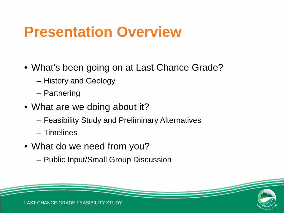
March 2011 ER Storm Event: • 3 Slipouts - PM’s 15.0 to 15.3 • 1 EO Project & 2 PR Projects
• Spring 2011 Caltrans Closed South Bound Shoulder
• 10/11 FHWA Emergency Relief Funds
• Upcoming Project: Soil Nail Wall 2016/17
POST MILE 15.1 – MARCH 2011 STORM EVENT
LAST CHANCE GRADE FEASIBILITY STUDY
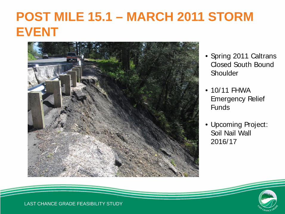
March 2012 Storm Event: • Failure accelerated at PM 15.3
and new slipout at PM 15.0 • 2 EO Project and 1 PR Project • PM 15.3 EO Wall Project at 15.3
- $4.8 million

POST MILE 15.0 – MARCH 2012 STORM EVENT
• Emergency Soil Nail
Project Completed Spring 2012
• 11/12 FHWA Emergency Relief Funds
• Upcoming Project 16/17: Soldier Pile Wall
LAST CHANCE GRADE FEASIBILITY STUDY

PUBLIC APPEALS: “Make LCG Safe & Reliable”
• 16 Letters from North Coast Agencies, Tribes and Businesses
• Congressman Jared Huffman • State Senator Jim Nielson • DNLTC Requests Economic Impact Study • Citizen’s Advisory Group Formation

LAST CHANCE GRADE COST HISTORY
LAST CHANCE GRADE FEASIBILITY STUDY
Date Description Costs 1981-1996 Corridor Study Yearly Cost Summary $4,084,000
1981-1996 Field Maintenance Cost $3,980,000
1997 Wilson Creek Retaining Wall $100,000
1998 Slipout Repair $207,802
1998 Washout Repair $270,740
1999 Last Chance Grade Retaining Wall $877,446
1999-2000 Wilson Creek Retaining Wall, Drainage $2,901,165
2000 OGAC $63,281
2001-2002 Drainage Revisions $95,718
2009 Reconstruct Roadway and Place OGFC $13,038,070
2010 Construct Retaining Walls $13,764,187
2012 Repair Slipouts $7,157,907
2012 Rubberized HMA Overlay $1,222,421
TOTAL $36,192,000
(1981 to Present)
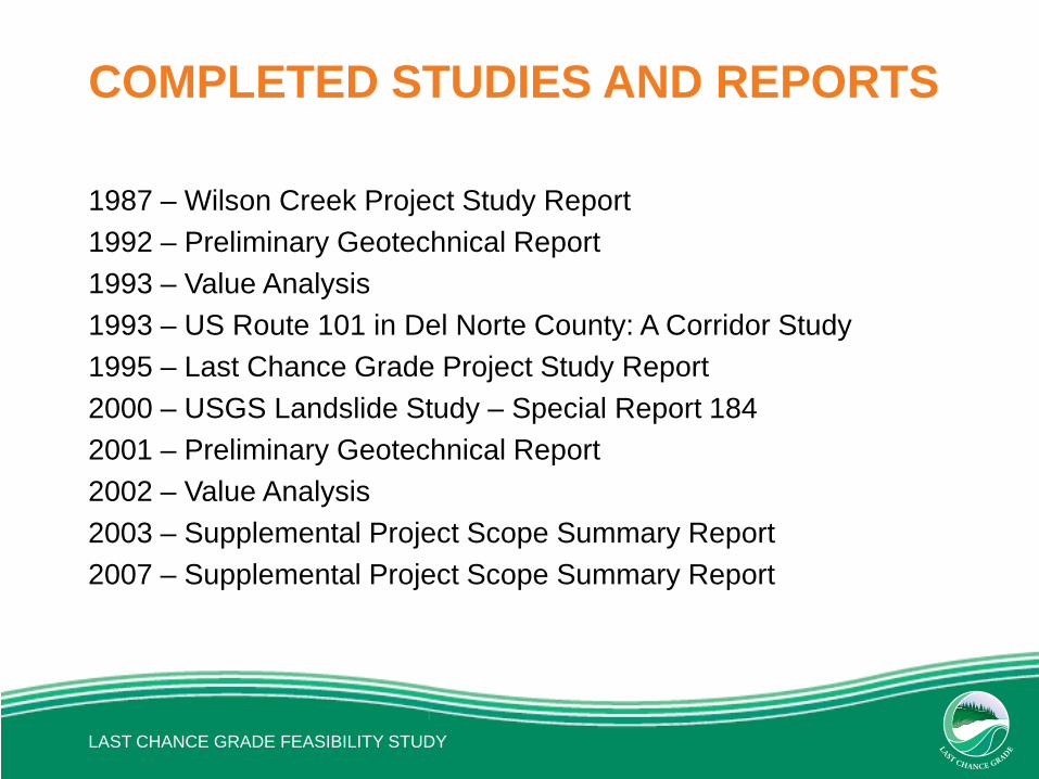
COMPLETED STUDIES AND REPORTS
1987 – Wilson Creek Project Study Report 1992 – Preliminary Geotechnical Report 1993 – Value Analysis 1993 – US Route 101 in Del Norte County: A Corridor Study 1995 – Last Chance Grade Project Study Report 2000 – USGS Landslide Study – Special Report 184 2001 – Preliminary Geotechnical Report 2002 – Value Analysis 2003 – Supplemental Project Scope Summary Report 2007 – Supplemental Project Scope Summary Report
LAST CHANCE GRADE FEASIBILITY STUDY
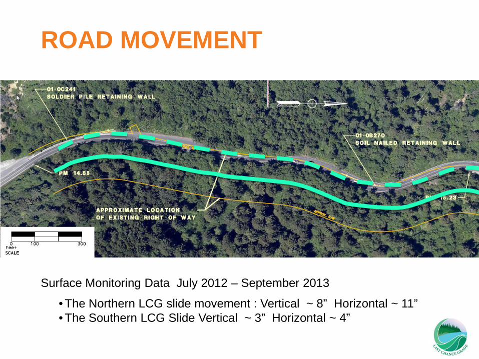
• The Northern LCG slide movement : Vertical ~ 8” Horizontal ~ 11” • The Southern LCG Slide Vertical ~ 3” Horizontal ~ 4”
ROAD MOVEMENT
Surface Monitoring Data July 2012 – September 2013

GEOLOGY

US LANDSLIDE OVERVIEW MAP


LAST CHANCE GRADE FEASIBILITY STUDY
DN-101
BROKEN FORMATION
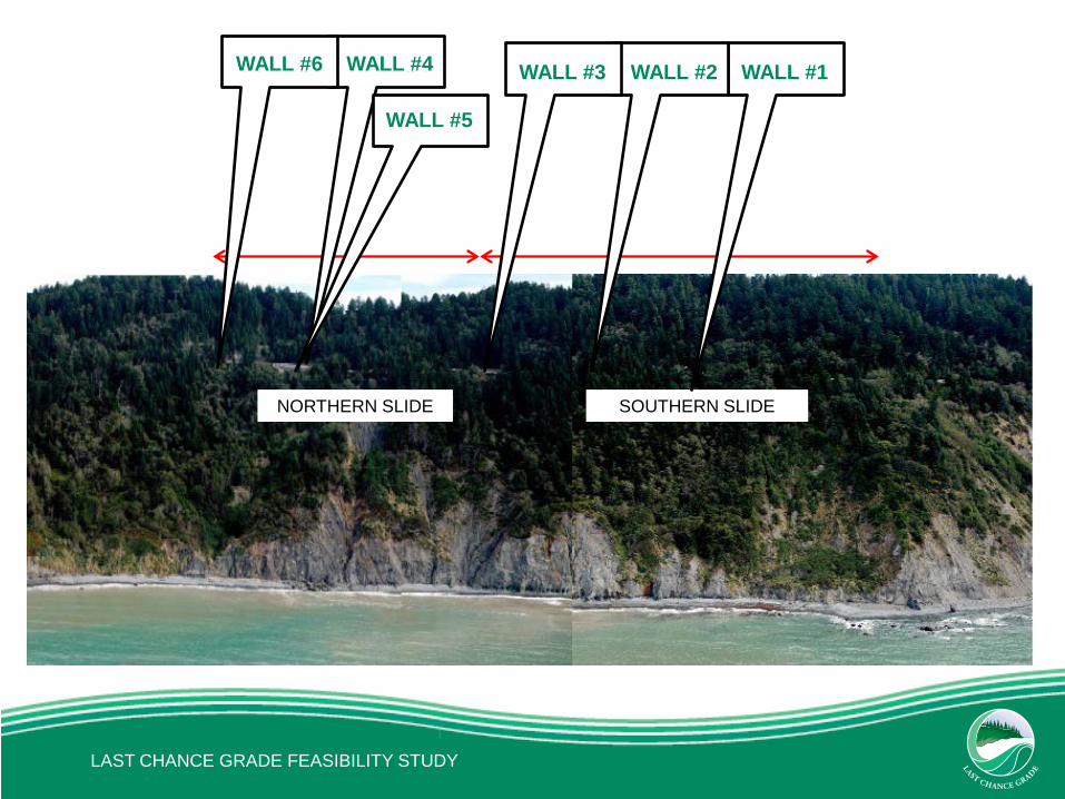
NORTHERN SLIDE SOUTHERN SLIDE
WALL #6 WALL #4 WALL #3 WALL #2 WALL #1
WALL #5
LAST CHANCE GRADE FEASIBILITY STUDY

Margins between slides extend through Wall #3
Wall #3
LAST CHANCE GRADE FEASIBILITY STUDY

WALL #6 WALL #4 WALL #3 WALL #2 WALL #1
WALL #5
LAST CHANCE GRADE FEASIBILITY STUDY

Last Chance Grade is also… • Adjacent to an Internationally
Unique Biosphere and World Heritage Site
• In an Area of Cultural Importance
• Vital to Community Connectivity
and the County Economy

IN SUMMARY…
• Project/Closure History • Geology • Increasing Costs and Storm Event Frequency • Public Concern • Potential Community and Economic Impacts • Environmental and Cultural Sensitivity
LAST CHANCE GRADE FEASIBILITY STUDY
... COMPLEX PROBLEM
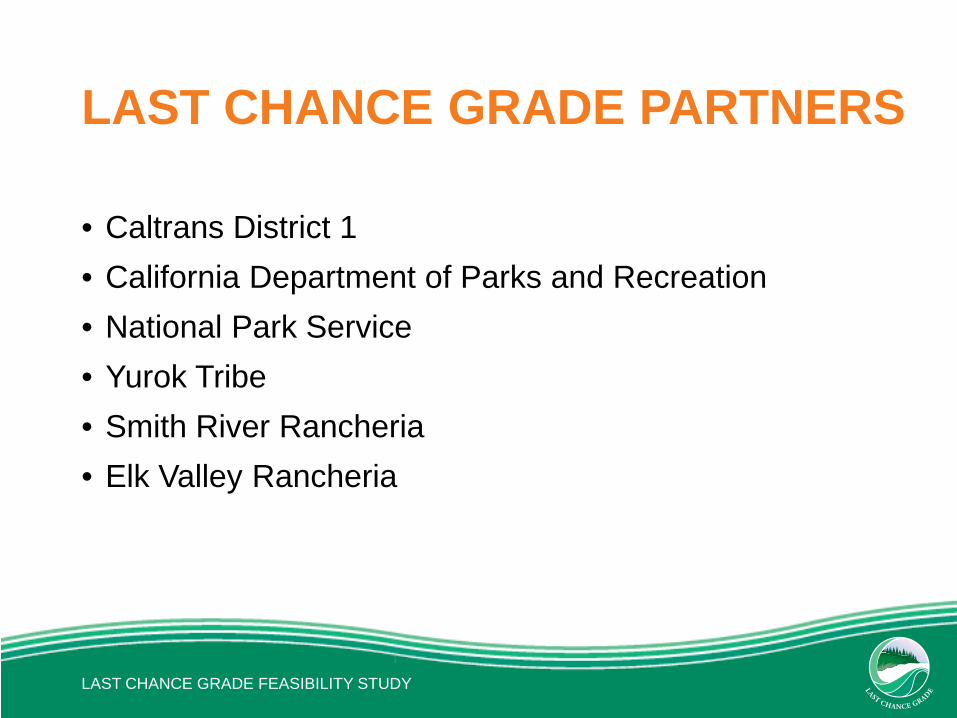
LAST CHANCE GRADE PARTNERS
• Caltrans District 1 • California Department of Parks and Recreation • National Park Service • Yurok Tribe • Smith River Rancheria • Elk Valley Rancheria
LAST CHANCE GRADE FEASIBILITY STUDY

LAST CHANCE GRADE FEASIBILITY STUDY
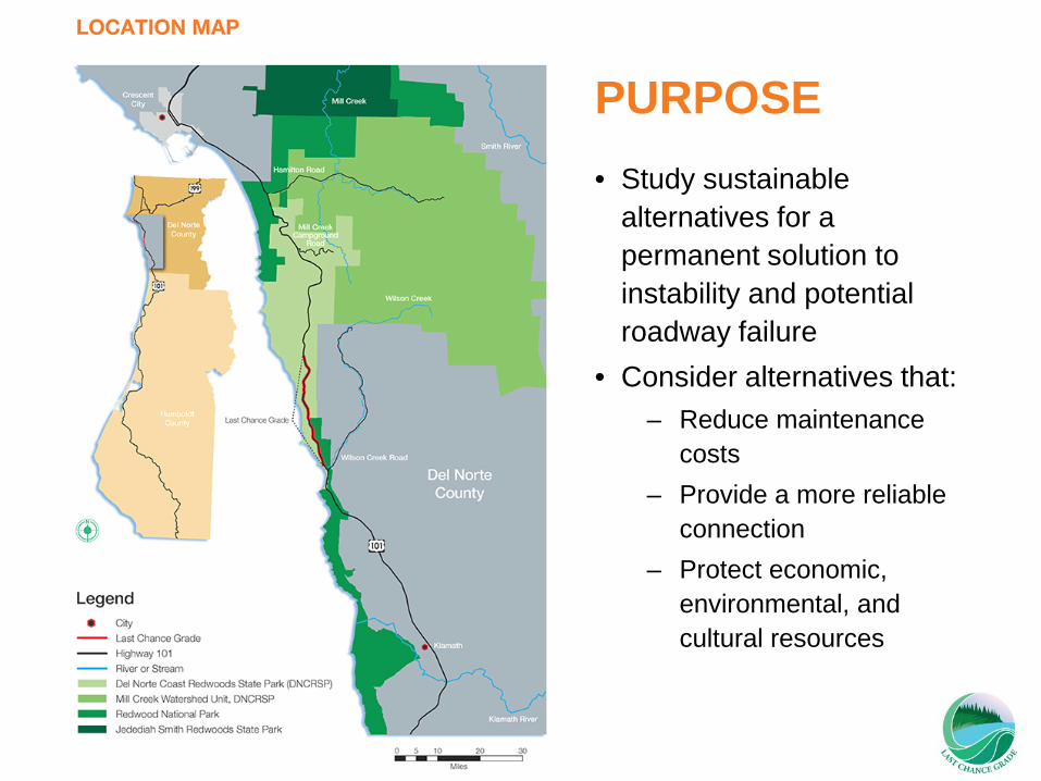
PURPOSE • Study sustainable
alternatives for a permanent solution to instability and potential roadway failure
• Consider alternatives that: – Reduce maintenance
costs – Provide a more reliable
connection – Protect economic,
environmental, and cultural resources
LAST CHANCE GRADE FEASIBILITY STUDY
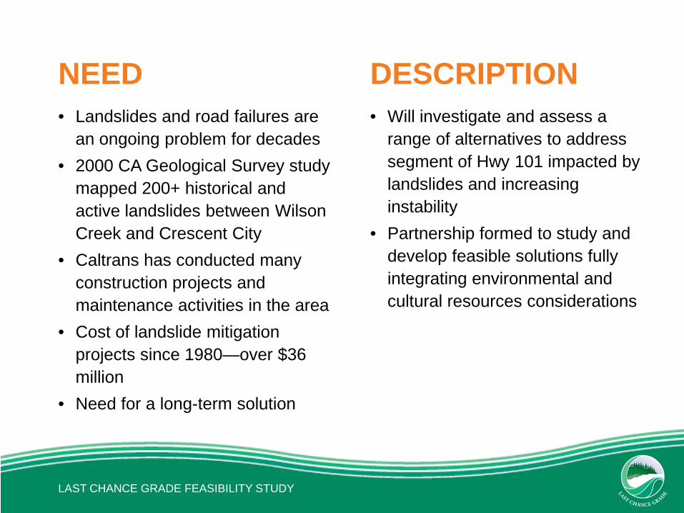
NEED • Landslides and road failures are
an ongoing problem for decades • 2000 CA Geological Survey study
mapped 200+ historical and active landslides between Wilson Creek and Crescent City
• Caltrans has conducted many construction projects and maintenance activities in the area
• Cost of landslide mitigation projects since 1980—over $36 million
• Need for a long-term solution
DESCRIPTION • Will investigate and assess a
range of alternatives to address segment of Hwy 101 impacted by landslides and increasing instability
• Partnership formed to study and develop feasible solutions fully integrating environmental and cultural resources considerations

LAST CHANCE GRADE FEASIBILITY STUDY

ALTERNATIVES

FACTORS CONSIDERED • Overall Roadway Length • Added Roadway Length and Travel Time • Construction Footprint and Schedule • Roadway excavation and fill • Structures Included (Bridges, Culverts, Tunnels) • Cost • Protection of Cultural, Environmental and Scenic Resources • Old-Growth Redwood Trees • Length of Roadway within State/National Parks • Watershed Crossings
LAST CHANCE GRADE FEASIBILITY STUDY

DESIGN CONSIDERATIONS • 7% maximum grade • Route Concept
– 2 Lane conventional highway with truck passing lanes – 12 ft. lanes, 8 ft. shoulders
• Design Speed—55 MPH • Turning Radius—1,100 ft. minimum • Structures limited to maximum 200 ft. height • Cut/fill 200 ft. maximum height • Cut slopes 1.5/1 ratio • Maximize protection of sensitive cultural, environmental and
scenic resources
LAST CHANCE GRADE FEASIBILITY STUDY

GEOLOGICAL SURVEY
Note: Landslides shown were derived from USGC study of the 101 corridor along Last Chance Grade. Landslides have not been fully mapped along Alternative E.

LAST CHANCE GRADE FEASIBILITY STUDY

PRELIMINARY ALTERNATIVES FOR STUDY

ALTERNATIVE A1 Rudisill Road to LCG Tunnel (Includes 2,010 ft. tunnel) Travel time (Wilson Creek Rd to Hamilton Rd)
• Total Length: 11.1 mi • Added Time: 1.2 min
New Construction • Length: 3.3 mi • Footprint: 76 acres • Schedule: 3 years
Cost (in Millions) • Minimum: $340M • Maximum: $460M
Existing Habitat Type: • Coastal scrub/grassland /spruce: 7 acres • Riparian: 1 acre • Clear cut: 13 acres • Young Redwood Forest: 54 acres • Mature Redwood Forest: 0 acres • Old Growth Redwood Forest: 1 acre

ALTERNATIVE A2 Rudisill Road to Damnation Trailhead Travel time (Wilson Creek Rd to Hamilton Rd)
• Total Length: 10.9 mi • Added Time: 0.9 min
New Construction • Length: 3.3 mi • Footprint: 80 acres • Schedule: 2 years
Cost (in Millions) • Minimum: $210M • Maximum: $250M
Existing Habitat Type: • Coastal scrub/grassland /spruce: 7 acres • Riparian: 1 acre • Clear cut: 13 acres • Young Redwood Forest: 56 acres • Mature Redwood Forest: 0 acres • Old Growth Redwood Forest: 3 acres

ALTERNATIVE B1 Wilson Creek Bridge to LCG Hill Tunnel (Includes 2,010 ft. tunnel) Travel time (Wilson Creek Rd to Hamilton Rd)
• Total Length: 10.6 mi • Added Time: 0.5 min
New Construction • Length: 3.6 mi • Footprint: 89 acres • Schedule: 2 years
Cost (in Millions) • Minimum: $360M • Maximum: $480M
Existing Habitat Type: • Coastal scrub/grassland /spruce: 12 acres • Riparian: 1 acre • Clear cut: 10 acres • Young Redwood Forest: 65 acres • Mature Redwood Forest: 0 acres • Old Growth Redwood Forest: 1 acre

ALTERNATIVE B2 Wilson Creek Bridge to Damnation Trailhead Travel time (Wilson Creek Rd to Hamilton Rd)
• Total Length: 10.3 mi • Added Time: 0.2 min
New Construction • Length: 3.6 mi • Footprint: 93 acres • Schedule: 2 years
Cost (in Millions) • Minimum: $220M • Maximum: $260M
Existing Habitat Type: • Coastal scrub/grassland /spruce: 12 acres • Riparian: 1 acre • Clear cut: 10 acres • Young Redwood Forest: 67 acres • Mature Redwood Forest: 0 acres • Old Growth Redwood Forest: 3 acres

ALTERNATIVE C3 Rudisill Road to South of Mill Creek Access Travel time (Wilson Creek Rd to Hamilton Rd)
• Total Length: 11.9 mi • Added Time: 2.1 min
New Construction • Length: 8.1 mi • Footprint: 249 acres • Schedule: 3 years
Cost (in Millions) • Minimum: $490M • Maximum: $570M
Existing Habitat Type: • Coastal scrub/grassland /spruce: 7 acres • Riparian: 1 acre • Clear cut: 13 acres • Young Redwood Forest: 205 acres • Mature Redwood Forest: 23 acres • Old Growth Redwood Forest: 0 acres

ALTERNATIVE C4 Rudisill Road to North of Mill Creek Access Travel time (Wilson Creek Rd to Hamilton Rd)
• Total Length: 11.7 mi • Added Time: 1.8 min
New Construction • Length: 8.9 mi • Footprint: 269 acres • Schedule: 4 years
Cost (in Millions) • Minimum: $540M • Maximum: $630M
Existing Habitat Type: • Coastal scrub/grassland /spruce: 7 acres • Riparian: 1 acre • Clear cut: 13 acres • Young Redwood Forest: 205 acres • Mature Redwood Forest: 43 acres • Old Growth Redwood Forest: 0 acres
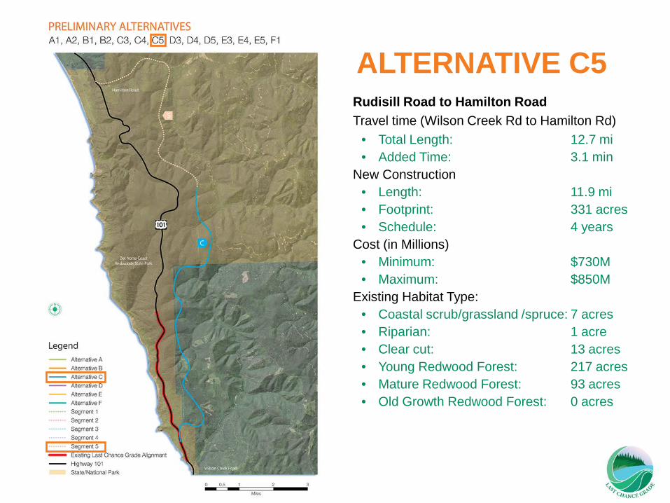
ALTERNATIVE C5 Rudisill Road to Hamilton Road Travel time (Wilson Creek Rd to Hamilton Rd)
• Total Length: 12.7 mi • Added Time: 3.1 min
New Construction • Length: 11.9 mi • Footprint: 331 acres • Schedule: 4 years
Cost (in Millions) • Minimum: $730M • Maximum: $850M
Existing Habitat Type: • Coastal scrub/grassland /spruce: 7 acres • Riparian: 1 acre • Clear cut: 13 acres • Young Redwood Forest: 217 acres • Mature Redwood Forest: 93 acres • Old Growth Redwood Forest: 0 acres

ALTERNATIVE D3 Wilson Creek Bridge to South of Mill Creek Access Travel time (Wilson Creek Rd to Hamilton Rd)
• Total Length: 11.3 mi • Added Time: 1.4 min
New Construction • Length: 8.3 mi • Footprint: 262 acres • Schedule: 3 years
Cost (in Millions) • Minimum: $510M • Maximum: $590M
Existing Habitat Type: • Coastal scrub/grassland /spruce: 12 acres • Riparian: 1 acre • Clear cut: 10 acres • Young Redwood Forest: 216 acres • Mature Redwood Forest: 23 acres • Old Growth Redwood Forest: 0 acres

ALTERNATIVE D4 Wilson Creek Bridge to North of Mill Creek Access Travel time (Wilson Creek Rd to Hamilton Rd)
• Total Length: 11.1 mi • Added Time: 1.1 min
New Construction • Length: 9.1 mi • Footprint: 282 acres • Schedule: 4 years
Cost (in Millions) • Minimum: $560M • Maximum: $650M
Existing Habitat Type: • Coastal scrub/grassland /spruce: 12 acres • Riparian: 1 acre • Clear cut: 10 acres • Young Redwood Forest: 216 acres • Mature Redwood Forest: 43 acres • Old Growth Redwood Forest: 0 acres

ALTERNATIVE D5 Wilson Creek Bridge to Hamilton Road Travel time (Wilson Creek Rd to Hamilton Rd)
• Total Length: 12.1 mi • Added Time: 2.4 min
New Construction • Length: 12.2 mi • Footprint: 344 acres • Schedule: 4 years
Cost (in Millions) • Minimum: $750M • Maximum: $870M
Existing Habitat Type: • Coastal scrub/grassland /spruce: 12 acres • Riparian: 1 acre • Clear cut: 10 acres • Young Redwood Forest: 228 acres • Mature Redwood Forest: 93 acres • Old Growth Redwood Forest: 0 acres

ALTERNATIVE E3 Wilson Creek Road to South of Mill Creek Access Travel time (Wilson Creek Rd to Hamilton Rd)
• Total Length: 14.3 mi • Added Time: 4.9 min
New Construction • Length: 11.3 mi • Footprint: 299 acres • Schedule: 4 years
Cost (in Millions) • Minimum: $680M • Maximum: $790M
Existing Habitat Type: • Coastal scrub/grassland /spruce: 0 acres • Riparian: 22 acres • Clear cut: 0 acres • Young Redwood Forest: 254 acres • Mature Redwood Forest: 23 acres • Old Growth Redwood Forest: 0 acres

ALTERNATIVE E4 Wilson Creek Road to North of Mill Creek Access Travel time (Wilson Creek Rd to Hamilton Rd)
• Total Length: 14.1 mi • Added Time: 4.7 min
New Construction • Length: 12.0 mi • Footprint: 319 acres • Schedule: 4 years
Cost (in Millions) • Minimum: $730M • Maximum: $850M
Existing Habitat Type: • Coastal scrub/grassland /spruce: 0 acres • Riparian: 22 acres • Clear cut: 0 acres • Young Redwood Forest: 254 acres • Mature Redwood Forest: 43 acres • Old Growth Redwood Forest: 0 acres
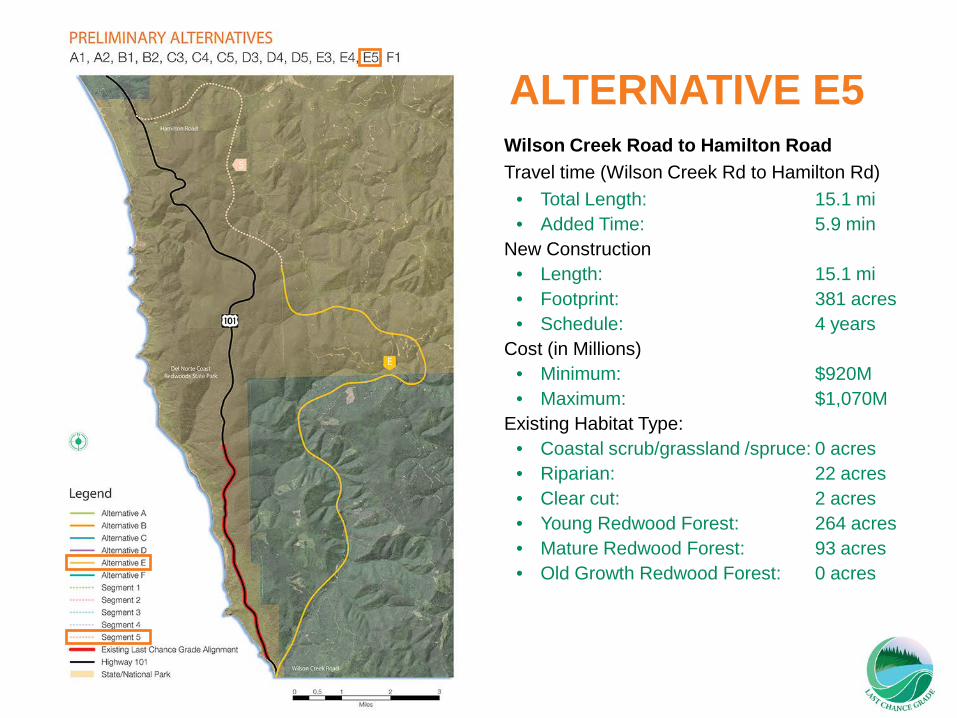
ALTERNATIVE E5 Wilson Creek Road to Hamilton Road Travel time (Wilson Creek Rd to Hamilton Rd)
• Total Length: 15.1 mi • Added Time: 5.9 min
New Construction • Length: 15.1 mi • Footprint: 381 acres • Schedule: 4 years
Cost (in Millions) • Minimum: $920M • Maximum: $1,070M
Existing Habitat Type: • Coastal scrub/grassland /spruce: 0 acres • Riparian: 22 acres • Clear cut: 2 acres • Young Redwood Forest: 264 acres • Mature Redwood Forest: 93 acres • Old Growth Redwood Forest: 0 acres

ALTERNATIVE F1 LCG Tunnel - Full Tunnel Parallel to E (5,422 foot tunnel) Travel time (Wilson Creek Rd to Hamilton Rd)
• Total Length: 10.0 mi • Added Time: 0.2 min
New Construction • Length: 1.3 mi • Footprint: 4 acres • Schedule: 6.5 years
Cost (in Millions) • Minimum: $450M • Maximum: $700M
Existing Habitat Type: • Coastal scrub/grassland /spruce: 2 acres • Riparian: 0 acres • Clear cut: 0 acres • Young Redwood Forest: 0 acres • Mature Redwood Forest: 1 acre • Old Growth Redwood Forest: 1 acre

PRELIMINARY ALTERNATIVES SUMMARY

Economic Impact Study • Travel delays of 320 miles
• Increase in $1.3 mil /day ($450 mil/yr) travel delay &
vehicle operating costs
• Reduction in $300 to $400 mil in DN Annual Output
• Loss of 3,000 to 4,000 jobs and $100 to $130 mil/yr. in wages
• Total Potential Impacts = Sound Investment

SMALL GROUP DISCUSSION
CONCLUSION AND NEXT STEPS

NEXT STEPS
• Final Feasibility Study • Begin Project Study Report (July 2015) • Refine Alternatives • Complete Project Study Report (July 2016) • Seek Funding • Begin Environmental Studies and Documents
LAST CHANCE GRADE FEASIBILITY STUDY
LAST CHANCE GRADE FEASIBILITY STUDY
FOR MORE INFORMATION
Website: www.dot.ca.gov/dist1/d1projects/last_chance_grade/ Contact: [email protected] (707) 445-6464, TTY 711