Large woody debris and river morphology in scour pool ...
131
Large woody debris and river morphology in scour pool formation, dam removal, and delta formation Vivian Leung A dissertation submitted in partial fulfillment of the requirements for the degree of Doctor of Philosophy University of Washington 2019 Reading Committee: David R. Montgomery, Chair John Wesley Lauer Katharine W. Huntington Program Authorized to Offer Degree: Earth and Space Sciences
Transcript of Large woody debris and river morphology in scour pool ...

Large woody debris and river morphology in scour pool formation, dam removal, and delta
formation
Vivian Leung
A dissertation
submitted in partial fulfillment of the
requirements for the degree of
Doctor of Philosophy
University of Washington
2019
Reading Committee:
David R. Montgomery, Chair
John Wesley Lauer
Katharine W. Huntington
Program Authorized to Offer Degree:
Earth and Space Sciences

© Copyright 2019
Vivian Leung
University of Washington
Abstract
Large woody debris and river morphology in scour pool formation, dam removal, and delta
formation
Vivian Leung
Chair of the Supervisory Committee:
David R. Montgomery
Department of Earth and Space Sciences
The interactions between large woody debris, fluid flow, and sediment transport are a first-order
control on river processes, affecting channel morphology at multiple scales. This thesis
investigates how wood geometry and orientation affect scour pool formation around individual
pieces of woody debris. We find that the presence or absence of roots on woody debris is the
main determinant of scour pool size. The size of scour pools and flow disturbances around
woody debris also increases as root cross-sectional area relative to flow increases. The Elwha
River Restoration project, which includes two large dam removals, provides an opportunity to
investigate how woody debris and logjam dynamics change in response to large-scale wood
influxes and changes in channel connectivity. Tracking of individually tagged pieces of woody
debris shows wood traveled from the upstream reservoir location to the channel reach
downstream of both dams after dam removal. The two former reservoirs followed very different

logjam development trajectories, with very little logjam development on the upstream reservoir
and unexpectedly rapid log jam development on the downstream reservoir. These differences
reflect a greater influx of wood into the downstream reservoir and sediment erosion patterns that
exposed 1 - 3 m diameter stumps rooted in the pre-dam valley floor that became anchors for
logjam formation. One of the questions for Elwha River Restoration project planning was how
woody debris buried in reservoir sediments would affect patterns of reservoir delta erosion
during and after dam removal. I use flume experiments to investigate the effects of woody debris
on dam removal and delta morphodynamics. Experimental runs with woody debris as compared
to experiments without woody debris show increases in channel roughness, channel mobility,
and the number of active channels on the delta. Several types of physical aquatic habitats
increase with woody debris, including hydraulic variability, number of pools, and lengths of
channel edges and delta shorelines. Together these results advance our understanding of how
woody debris interacts with channel and delta morphodynamics, and suggest that wood
interactions at multiple scales should be considered in dam removals, river restoration projects,
and delta restoration projects

i
TABLE OF CONTENTS
List of Figures ............................................................................................................................ ii
List of Tables ............................................................................................................................. iv
Chapter 1. Introduction .............................................................................................................. 1
Chapter 2. The effects of woody debris on streambed morphology: flume experiments on the
spatial patterns of fluid flow and sediment transport around individual pieces of wood debris... 9
Chapter 3. Wood Debris Sources and Logjam Distribution and Dynamics Before and After Dam
Removal, Elwha River, WA ...................................................................................................... 40
Chapter 4. Flume experiments on the effects of buried woody debris on delta processes and
sediment exhumation during a phased base-level drop ............................................................. 88
Chapter 5. Conclusions .............................................................................................................. 120
ii
List of Figures
Fig. 2.1 Flow visualization of streambed flow around model woody debris using potassium
permanganate crystals ................................................................................................................ 28
Fig. 2.2 Model wood debris used in experiments ..................................................................... 29
Fig. 2.3 Field data of wood debris orientation relative to flow ................................................ 30
Fig. 2.4 Scour and deposition patterns around wood debris with different types of roots ....... 31
Fig. 2.5 Scour and deposition patterns around wood debris at different orientations relative to
flow ............................................................................................................................................ 32
Fig. 2.6 Scour and deposition sizes plotted against root cross-sectional areas relative to flow 33
Fig. 2.7 Bed topography of streambed morphology experiments of model wood with different
types of roots and model wood at different orientations relative to flow .................................. 34
Fig. 2.8 Bed topography from field surveys of wood with different types of roots and different
orientations relative to flow ....................................................................................................... 35
Fig. 2.9 Scour volumes plotted again root cross-sectional area relative to flow from flume
experiments and field measurements ......................................................................................... 36
Fig. 2.A.1 Sheet laser setup used to measure streambed morphology in experiments ............. 37
Fig. 2.A.2 Field topography measurements setup .................................................................... 38
Fig. 2.A.3 Flow structures around model trees ......................................................................... 39
Fig. 3.1 Elwha River watershed and location map ................................................................... 73
Fig. 3.2 Study area map showing forest cover, channel locations, logjam locations, and river
segment boundaries .................................................................................................................... 74
Fig. 3.3 Discharge measurements during study period ............................................................. 75
Fig. 3.4 Comparison of field vs. air photo logjam measurements ............................................ 76
Fig. 3.5 Logjam areas by river km and by river segment ......................................................... 77
Fig. 3.6 Logjam heights plotted against logjam area ................................................................ 79
Fig. 3.7 Travel distances for individually marked pieces of woody debris .............................. 80
Fig. 3.8 Logjam area by type and river km ............................................................................... 81
Fig. 3.9 Logjam distributions and active channel locations before and after select floods ...... 82
Fig. 3.10 Conceptual wood budget for Elwha River before and after dam removal ................ 86
iii
Fig. 4.1 Schematic of experimental setup ................................................................................. 110
Fig. 4.2 Experimental lake levels over time ............................................................................. 111
Fig. 4.3 Comparisons between flume and field spatial patterns of wood distribution.............. 112
Fig. 4.4 Channel cross-sections at 3 locations throughout each experiment ............................ 113
Fig. 4.5 Overhead photos of channel and delta planform, corresponding to times topography
measurements were taken .......................................................................................................... 114
Fig. 4.6 Channel mobility during the last 90 min. of each experiment..................................... 115
Fig. 4.7 Channel occupation maps of the last 90 min. of each experiment .............................. 116
Fig. 4.8 Overhead photos during the 2nd
dam removal segment ............................................... 117
Fig. 4.9 Slope-maps of the Sediment Only Run and the 2% Wood Run .................................. 118
Fig. 4.10 Overhead photos of channel and delta patterns comparing the Sediment Only Run, the
2% Wood Run, and the 3.5% Wood Run .................................................................................. 119

iv
List of Tables
Table 3.1.Logjam area per river km in 2012 and 2016 by river segment ......................... 89

v
ACKNOWLEDGEMENTS
This dissertation would not have been possible without the support of many people and
institutions along the way. First of all, thank you Dave for countless conversations about all
aspects of research and for giving me the freedom to develop my own research ideas, travel all
over the country for extended periods to run flume experiments, do fieldwork, work for the
Lower Elwha Klallam tribe, and try out teaching at liberal arts colleges. (thanks also for
immediately forbidding me to collect bedload and woody debris transport data during a flood
when I was first coming up with ideas of what to study) Thank you Alberto and Gerard for
inspiring my interest in fluid dynamics and many conversations on how to structure my research.
Thank you Kate for excellent advice on how to structure scientific arguments and the best way to
situate my research among the broader field. Thank you Wes for joining me in the field and all
the discussions about how Elwha research could progress, and ideas to focus on for each chapter.
Thank you David for inviting me to do fieldwork, fieldwork, and then more fieldwork on the
Niobrara and all the times we talked about sand. Thanks also David and Jim for helping me build
and refine flume experiments at Pickle. Thanks Joel for reading almost everything I wrote at the
beginning of grad school, all the times we’ve talked science, and building the ExperiMentors
project (it’s still a terrible pun). Mike, Randall, Mel, and Sonny, collaborating with you on post
dam removal research has been the most amazing scientific and professional experience. I
learned so much about how to read a river, science outside of academia, and how to work in
large, interdisciplinary teams. And thanks for all the salmon. The Elwha research community, all
of ESS, UW grad students – esp. Beth, Bre, Hope, and Amanda, Dave’s former students, Sarah
B., Antoinette, and everyone at SAFL, LEKT DNR, all the people who’ve gone into the field
with me, McCormick/Suki/Mariela/MIT, MHC geology, UR geography, and my UW/MHC/UR,
and WA middle school students, and countless others have all greatly supported and enhanced
my grad school experience.
The research in this dissertation was supported by many grants from and collaborations with
UW ESS, the UW graduate student union, the QRC, the OACIS GK-12 program in
Oceanography, NSF GFRP, the NCED Visitor’s Program, Washington Middle School, Olympic
National Park, the Hoh River Trust, Friday Harbor Laboratories, St. Anthony Falls Laboratory,
the Lower Elwha Klallam Tribe Department of Natural Resources, Mount Holyoke College, and
the University of Richmond.
Finally, the greatest thanks to all my family and friends who have supported me along the way.
Janet, you’ve been a voice of sanity for so many things, I am so lucky and grateful that we’ve
been friends for so long. Nicky, Lisa, Eve, Christine D., Christine C., Amy, Shuai, DJ, Hannah
H., Aki, Sam H., Kristen, Kyra, Lexa, the knitters, Cat Power, Johnson Rink, and Tamora Pierce
have all been instrumental in finding balance outside of science (plus all the times I still end up
talking about science). Yogi :) :). Jon, Amanda, Jason, Stephanie, Sarah H., Jacob, Adeline, and
everyone else who has let me badger them into more writing groups, you’re all amazing. Julia,
Christine D., Craig, Roy, Megan, Deb, Hannah J., SHOW - thanks for getting me in the air so
much. Finally, mom, dad, and grandma, I don’t know how to begin to thank you for all your
sacrifices and moral support throughout my life. I would not be where I am without everything
you’ve done along the way.

vi
To mom, dad, and grandma

1
Ch. 1 Introduction
Woody debris in rivers is common wherever drainage basins have trees. Woody debris
are among the largest obstacles in river channels and hence can have a large effect on channel
morphology. On a reach scale, woody debris affects sediment scour, deposition, and sorting
patterns, and can increase sediment storage (Brooks et al., 2004; Cherry and Beschta, 1989;
Davidson and Eaton, 2013). Woody debris also increases the number of pools in a system,
increases channel roughness, and increases hyporheic flow (Montgomery et al., 1995; Mutz et al.,
2007; Sawyer et al., 2011). Wood that accumulates in logjams can anchor stable islands and
change channel planform (Abbe and Montgomery, 2003; Collins et al., 2012). Aquatic habitat
increases with woody debris, including the amount of cover (Shirvell, 1990), velocity variability
(Beechie et al., 2005), and the number of pools (Montgomery et al., 1995). Increasing hyporheic
flow also increases dissolved oxygen in the stream bed, affecting fish eggs and benthic
invertebrates (Mutz et al., 2007; Sawyer et al., 2011).
Historical records show large amount of woody debris in rivers, including rafts that
blocked the entire channel (Collins et al., 2003). Much of this wood was removed from rivers as
salvage wood or to increase navigability (Collins et al., 2002, 2003; Lien, 2000). As the
ecological benefits of woody debris have become apparent, wood has been returned to rivers in
restoration projects that add individual pieces of woody debris or engineered logjams into
channels (Abbe et al., 2003; Kail et al., 2007; Roni et al., 2015).
This dissertation addresses how wood influences the interplay between sediment
transport, water, and channel form in river systems. Ch. 2 uses flume experiments and field
surveys to test how wood orientation and geometry affect flow patterns and channel morphology
around individual pieces of woody debris. Ch. 3 investigates wood transport and logjam

2
dynamics before, during, and after the Elwha River Restoration project dam removals. Ch. 4
addresses how woody debris affects planform and channel morphodynamics in dam removals
and deltas.
Individual pieces of wood debris are often the largest obstacle in rivers, affecting flow
and channel patterns. Ch. 1 uses flume experiments and field surveys on the Hoh River,
Washington state to investigate fluid flow patterns and the shape of scour pools around
individual pieces of wood. Experiments and field surveys show that the area and volume of scour
pools is correlated to the root blockage area relative to flow. The presence or absence of roots is
a key factor controlling how much scour occurs. Model trees with solid, star-shaped, and porous
roots all have much larger scour areas than model trees without roots. Similarly, the sediment
transport experiments and field surveys all show much deeper scour over a larger area for woody
debris with roots than for woody debris without roots. These results suggest that river restoration
projects focusing on increasing aquatic habitat by adding individual pieces of woody debris to
rivers should emphasize the use of woody debris with roots to maximize habitat changes.
The addition of large amounts of woody debris in channels is often the result of
unanticipated events such as dam failures, large landslides, or volcanic eruptions. The Elwha
River Restoration project, which includes the removal of Glines Canyon Dam and Elwha Dam
offers an opportunity to investigate a planned event that adds large amounts of woody debris to a
river system. The Glines Canyon Dam removal is the largest dam removal to date by both height
and by the amount of stored sediment (Warrick et al., 2015), storing an estimated 16.1 million m3
(± 2.4 million m3) of sediment (Randle et al., 2015). When the dams were in place, woody debris
and coarse sediment were trapped in the reservoirs behind both dams, leading to channel
coarsening (Pohl, 2004) and less woody debris below both dams (Duda et al., 2011; McHenry et

3
al., 2007; Ward et al., 2008). Elwha Dam and Glines Canyon Dam were taken down in phased
dam removals between 2011 and 2014, with the goals of restoring native anadromous fish
populations and the Elwha River ecosystem (Elwha River Ecosystem and Fisheries Restoration
Act, 1992). Although there were no estimates of the amount of woody debris stored in the
reservoirs (Chenoweth et al., 2011), the amount of woody debris in the system was expected to
increase as buried wood was exhumed from the reservoirs, woody debris from the upstream
watershed was transported through former reservoir and dam locations, and increased channel
migration downstream of both dams resulted in more erosion of floodplain forest (Duda et al.,
2011; McHenry et al., 2007). Management of sediment erosion and floodplain forest
development on Mills, the reservoir formed by Glines Canyon Dam, and Aldwell, the reservoir
formed by Elwha Dam, were some of the main considerations for dam removal and habitat
restoration planning (Chenoweth et al., 2011; Randle and Bountry, 2010; Ward et al., 2008). In
the first few years after dam removal, it was expected that channel planform and physical habitat
on Mills and Aldwell would be very unstable due to the lack of vegetation (Chenoweth et al.,
2011; Ward et al., 2008). Using field surveys and air photos, I measured logjam area in the two
former reservoirs and river channels downstream of both dams before, during, and after both
dam removals. These data show logjam areas increasing in all sections of the river downstream
of the former dam locations. Tracking of individually tagged pieces of woody debris shows that
woody debris after dam removal was able to travel from the upper reservoir location through the
interdam reach, and through the lower reservoir to the river channel below both dam locations.
Logjams developed on both Mills and Aldwell after dam removal but with two very different
patterns. There were very few logjams that formed in Mills, until a 12 – year recurrence interval
flood in 2015. Contrary to pre-project expectations of unstable reservoir sediment for many years
4
after dam removal, large logjams developed on Aldwell in the first year of dam removal. These
logjams are anchored on large old-growth tree stumps on the pre-dam valley floor that were
uncovered during dam removal.
During the Elwha dam removal planning process, one of the reservoir sediment erosion
questions was how woody debris buried in the reservoir sediments would affect patterns and
rates of reservoir sediment exhumation (Randle and Bountry, 2010). The sediment management
team expected that buried wood would get exhumed during the removal process (Childers et al.,
2000) and hypothesized that it would act as an armor layer restricting lateral channel erosion on
reservoir deltas (Randle and Bountry, 2010). Although there has been a considerable amount of
research on the effects of woody debris in rivers (Gurnell et al., 2002; Montgomery et al., 2003;
Ruiz-Villanueva et al., 2016; Wohl, 2017) very little research has been done on how woody
debris affects deltas (Huff, 2015; Phillips, 2012). In Ch. 3 I use flume experiments to investigate
how the exhumation of buried woody debris affects dam removal and delta morphodynamics.
These experiments show that woody debris increases the rate of lateral channel migration and the
number of delta channels, compared to systems without woody debris. Physical aquatic habitat
also increases with woody debris, with increases in the number of pools, the amount of channel
edge habitat, and the amount of delta shoreline habitat. These results suggest that woody debris
can play an important role in dam removals and delta morphodynamics and should be taken into
consideration for dam removals and delta restoration projects in forested regions.
Ch. 2 – 4 are written as 3 stand-alone papers that, although primarily my work and
analyses, will be submitted for publication with co-authors who helped with field work, flume
experiments, and framing the investigations. Ch. 2, on scour pool formation around individual
pieces of woody debris will be published with co-author David R. Montgomery. Ch. 3, on
5
logjam development and woody debris dynamics during the Elwha River dam removals, will be
published with co-authors Randall McCoy, Mike McHenry, and David R. Montgomery. Ch. 4,
on how woody debris interacts with dam removals and deltas, will be published with co-authors
David C. Mohrig, Jim L. Buttles, Joel P. Johnson, and David R. Montgomery. Together these
chapters document the fundamental role of, and advance understanding of, interactions between
woody debris stability and transport, sediment scour and transport, and flow hydraulics at scales
from individual pools to the evolution of deltaic systems.
Bibliography
Abbe, T.B., Brooks, A.P., Montgomery, D.R., 2003. Wood in river rehabilitation and
management, in: Gregory, S.V., Boyer, K.L., Gurnell, A.M. (Eds.), The Ecology and
Management of Wood in World Rivers. American Fisheries Society, Bethesda, Maryland, pp.
367–389.
Abbe, T.B., Montgomery, D.R., 2003. Patterns and processes of wood debris accumulation in the
Queets river basin, Washington. Geomorphology 51, 81–107. https://doi.org/10.1016/S0169-
555X(02)00326-4
Beechie, T.J., Liermann, M., Beamer, E.M., Henderson, R., 2005. A Classification of habitat
types in a large river and their Uue by juvenile salmonids. Transactions of the American
Fisheries Society 134, 717–729. https://doi.org/10.1577/T04-062.1
Brooks, A.P., Gehrke, P.C., Jansen, J.D., Abbe, T.B., 2004. Experimental reintroduction of
woody debris on the Williams River, NSW: geomorphic and ecological responses. River
Research and Applications 20, 513–536. https://doi.org/10.1002/rra.764
Chenoweth, J., Acker, S.A., McHenry, M., 2011. Revegetation and Restoration Plan for Lake
Mills and Lake Aldwell. Olympic National Park and the Lower Elwha Klallam Tribe, Port
Angeles, WA.
Cherry, J., Beschta, R.L., 1989. Coarse woody debris and channel morphology: a flume study.
Journal of the American Water Resources Association 25, 1031–1036.
https://doi.org/10.1111/j.1752-1688.1989.tb05417.x
6
Childers, D., Kresch, D.L., Gustafson, S.A., Randle, T.J., Melena, J.T., Cluer, B., 2000.
Hydrologic data collected during the 1994 Lake Mills Drawdown Experiment, Elwha River,
Washington (Report No. 99–4215), Water-Resources Investigations Report. United States
Geological Survey.
Collins, B.D., Montgomery, D.R., Fetherston, K.L., Abbe, T.B., 2012. The floodplain large-
wood cycle hypothesis: A mechanism for the physical and biotic structuring of temperate
forested alluvial valleys in the North Pacific coastal ecoregion. Geomorphology 139–140, 460–
470. https://doi.org/10.1016/j.geomorph.2011.11.011
Collins, B.D., Montgomery, D.R., Haas, A.D., 2002. Historical changes in the distribution and
functions of large wood in Puget Lowland rivers. Canadian Journal of Fisheries and Aquatic
Sciences 59, 66–76. https://doi.org/10.1139/f01-199
Collins, B.D., Montgomery, D.R., Sheikh, A.J., 2003. Reconstructing the historical riverine
landscape of the Puget lowland, in: Montgomery, D.R., Bolton, S., Booth, D.B., Wall, L. (Eds.),
Restoration of Puget Sound Rivers. University of Washington Press, Seattle and London, pp. 79–
128.
Davidson, S.L., Eaton, B.C., 2013. Modeling channel morphodynamic response to variations in
large wood: Implications for stream rehabilitation in degraded watersheds. Geomorphology 202,
59–73. https://doi.org/10.1016/j.geomorph.2012.10.005
Duda, E.J.J., Warrick, J.A., Magirl, C.S., 2011. Coastal habitats of the Elwha River,
Washington—Biological and physical patterns and processes prior to dam removal (No. 2011–
5120), Scientific Investigations Report. U.S. Geological Survey.
Elwha River Ecosystem and Fisheries Restoration Act, 1992.
Gurnell, A.M., Piégay, H., Swanson, F.J., Gregory, S.V., 2002. Large wood and fluvial processes.
Freshwater Biology 47, 601–619. https://doi.org/10.1046/j.1365-2427.2002.00916.x
Huff, S.A., 2015. Modeling the influence of large woody debris on delta morphology and
longshore sediment transport using the Brazos delta (Thesis). Rice University, Houston, TX.
Kail, J., Hering, D., Muhar, S., Gerhard, M., Preis, S., 2007. The use of large wood in stream
restoration: experiences from 50 projects in Germany and Austria: large wood in stream
restoration. Journal of Applied Ecology 44, 1145–1155. https://doi.org/10.1111/j.1365-
2664.2007.01401.x
Lien, C., 2000. Olympic battleground: the power politics of timber preservation, 2nd ed.
Mountaineers, Seattle, Wash.
7
McHenry, M., Pess, G., Abbe, T., Coe, H., Goldsmith, J., Liermann, M., McCoy, R., Morley, S.,
Peters, R., 2007. The physical and biological effects of engineered logjams (ELJs) in the Elwha
River, Washington (Elwha River Engineered Logjam Monitoring Report). Salmon Recovery
Funding Board (SRFB) Interagency Committee for Outdoor Recreation (IAC).
Montgomery, D.R., Buffington, J.M., Smith, R.D., Schmidt, K.M., Pess, G., 1995. Pool spacing
in forest channels. Water Resources Research 31, 1097–1105.
https://doi.org/10.1029/94WR03285
Montgomery, D.R., Collins, B.D., Buffington, J.M., Abbe, T.B., 2003. Geomorphic effects of
wood in rivers, in: Gregory, S.V., Boyer, K.L., Burnell, A. (Eds.), The Ecology and Management
of Wood in World Rivers, American Fisheries Society Symposium 37. American Fisheries
Society, Bethesda, Maryland, pp. 367–389.
Mutz, M., Kalbus, E., Meinecke, S., 2007. Effect of instream wood on vertical water flux in low-
energy sand bed flume experiments. Water Resources Research 43.
https://doi.org/10.1029/2006WR005676
Phillips, J.D., 2012. Log-jams and avulsions in the San Antonio River Delta, Texas. Earth
Surface Processes and Landforms 37, 936–950. https://doi.org/10.1002/esp.3209
Pohl, M., 2004. Channel bed mobility downstream from the Elwha Dams, Washington. The
Professional Geographer 56, 422–431. https://doi.org/10.1111/j.0033-0124.2004.05603010.x
Randle, T.J., Bountry, J.A., 2010. Elwha River Restoration: sediment adaptive management.
Presented at the 2nd Joint Federal Interagency Conference, Las Vegas, NV.
https://www.researchgate.net/publication/265498961
Randle, T.J., Bountry, J.A., Ritchie, A., Wille, K., 2015. Large-scale dam removal on the Elwha
River, Washington, USA: Erosion of reservoir sediment. Geomorphology 246, 709–728.
https://doi.org/10.1016/j.geomorph.2014.12.045
Roni, P., Beechie, T., Pess, G., Hanson, K., 2015. Wood placement in river restoration: fact,
fiction, and future direction. Canadian Journal of Fisheries and Aquatic Sciences 72, 466–478.
https://doi.org/10.1139/cjfas-2014-0344
Ruiz-Villanueva, V., Piégay, H., Gurnell, A.M., Marston, R.A., Stoffel, M., 2016. Recent
advances quantifying the large wood dynamics in river basins: New methods and remaining
challenges. Reviews of Geophysics 54, 611–652. https://doi.org/10.1002/2015RG000514
Sawyer, A.H., Bayani Cardenas, M., Buttles, J., 2011. Hyporheic exchange due to channel-
spanning logs: hyporheic flow and channel spanning logs. Water Resources Research 47.
https://doi.org/10.1029/2011WR010484
8
Shirvell, C.S., 1990. Role of instream rootwads as juvenile coho salmon (Oncorhynchus kisutch)
and steelhead trout (O . mykiss) cover habitat under varying streamflows. Canadian Journal of
Fisheries and Aquatic Sciences 47, 852–861. https://doi.org/10.1139/f90-098
Ward, L., Crain, P., Freymond, B., McHenry, M., Morrill, D., Pess, G., Peters, R., Shaffer, J.A.,
Winter, B., Wunderlich, B., 2008. Elwha River Fish Restoration Plan- developed pursuant to the
Elwha River Ecosystem and Fisheries Restoration Act, Public Law 102-495, NOAA Tech.
Memo. NMFS-NWFSC-90. U.S. Dept. Commer.
Warrick, J.A., Bountry, J.A., East, A.E., Magirl, C.S., Randle, T.J., Gelfenbaum, G., Ritchie,
A.C., Pess, G.R., Leung, V., Duda, J.J., 2015. Large-scale dam removal on the Elwha River,
Washington, USA: Source-to-sink sediment budget and synthesis. Geomorphology 246, 729–750.
https://doi.org/10.1016/j.geomorph.2015.01.010
Wohl, E., 2017. Bridging the gaps: An overview of wood across time and space in diverse rivers.
Geomorphology 279, 3–26. https://doi.org/10.1016/j.geomorph.2016.04.014

9
Ch. 2 The effects of woody debris on streambed morphology: flume experiments on the
spatial patterns of fluid flow and sediment transport around individual pieces of wood
debris
V. Leung*1,2
and D.R. Montgomery1
1 University of Washington, Department of Earth and Space Sciences, Seattle, WA, USA
2 University of Richmond, Department of Geography and the Environment, Richmond, VA,
USA
*corresponding author : [email protected]
Abstract
The interaction of woody debris, fluid flow and sediment transport in rivers creates local
streambed morphology, such as large pools that are important fish habitat and sediment deposits
that bury and stabilize woody debris. We used two sets of flume experiments and field
measurements on a gravel-bedded river to investigate how wood geometry and orientation affect
local flow and scour pool formation. For the first set of experiments, fluid flow patterns on the
bottom boundary layer, where bedload sediment transport occurs, were visualized using solid
dye crystals. The second set of experiments and the field measurements investigated streambed
morphology around wood debris, as well as distributions of wood debris geometry and
orientation in nature. We find that: 1) the presence of roots on woody debris leads to greater
areas of flow disturbance and sediment scour; 2) the size of scour pools and flow disturbances
around wood debris increase as the root cross-sectional area, oriented orthogonal to flow,
increases. A better understanding of the underlying sediment physics and fluid dynamics around

10
naturally occurring woody debris in rivers can lead to improved hazard prediction of mobile
wood during floods and to improved design criteria for engineered logjams placed to protect
infrastructure and improve aquatic habitat.
Introduction
Woody debris has been recognized to have a fundamental role in river dynamics,
comparable to the role of water discharge and sediment transport, significantly impacting aquatic
habitat (Montgomery et al., 2003). Wood debris also plays a key role in creating physical habitat
for fish spawning, feeding and hiding. Individual logs and logjams are significant obstacles in
channels, causing local flow disturbances, sediment scour and deposition (Cherry and Beschta,
1989; Daniels and Rhoads, 2003). Wood and logjams increase channel roughness, decrease
sediment transport and increase reach scale sediment storage (Davidson and Eaton, 2013; Gippel
et al., 1996; Mutz, 2000). At the reach scale, woody debris affects hydraulics, sediment transport
and streambed morphology and has a significant effect on aquatic habitat (Gregory et al., 2003).
Woody debris increases the hydraulic and topographic complexity of the channel and riparian
zone, leading to a greater diversity of aquatic habitats such as pools or slow water refugia (Roni
and Quinn, 2001). Large woody debris also helps to retain gravels that are used by spawning
salmon (Brooks et al., 2004) and increases hyporheic flow, increasing the dissolved oxygen that
reaches salmon eggs incubating within the streambed (Mutz et al., 2007; Sawyer et al., 2011). In
forest rivers, many large pools that form important fish habitat, are controlled by scour around
large woody debris (Abbe and Montgomery, 2003; Montgomery et al., 1995).
In this study, we use two sets of flume experiments and field measurements on a gravel-
bedded river to test how woody debris geometry affects patterns of local sediment scour and
11
deposition and how wood debris orientation relative to flow affects patterns of local sediment
scour and deposition. The fluid flow experiments investigate the effects of woody debris on
channel morphology by using flow patterns around wood debris as a proxy for sediment erosion
and deposition. These flume experiments focus on the flow patterns at the bottom boundary,
where sediment transport occurs. The streambed morphology experiments investigate the effects
of woody debris on channel morphology by measuring scour and sediment deposition under
controlled laboratory conditions. These flume experiments focus on the scour and sediment
deposition patterns around woody debris that form under constant uni-directional flow, with uni-
modal sediment. The streambed morphology fieldwork investigates scour and sediment
deposition around individual pieces of woody debris on a gravel-bedded river. A better
understanding of the underlying sediment physics and fluid dynamics around naturally occurring
woody debris in rivers can lead to improved hazard prediction of mobile wood during floods and
to improved design criteria for engineered logjams placed to protect infrastructure and improve
aquatic habitat.
Background
Historically, large woody debris was routinely removed from rivers in the Pacific Northwest
to improve navigation, facilitate fish passage and protect infrastructure (Bisson et al., 1987;
Collins et al., 2003; Nagayama and Nakamura, 2010). In-stream wood loads were also reduced
by anthropogenic activities such as floodplain logging, channelization and levee building that
affected local recruitment of riparian trees (Czarnomski et al., 2008; Faustini and Jones, 2003).
In many places, wood has been removed from floodzones in order to reduce flood hazards
(Comiti et al., 2016). Wood moving in floods can amplify flood risks by altering local flow
12
patterns through logjam formation and the increased impact force from wood moving in the
water (Ishikawa et al., 1991; Johnson et al., 2000).
Sediment transport around woody debris is episodic and often occurs during flood events,
making it difficult to take active measurements. Combining flume experiments and fieldwork
allows for a general understanding of sediment transport around woody debris that includes both
the episodic nature of flooding and the complexities of natural systems. Understanding factors
controlling how wood debris affects local streambed morphology can provide scientific insights
into channel morphodynamics as well as guidance and criteria for use in river restoration and
engineering projects.
Wood debris in natural systems is deposited as individual pieces and in logjams. River
restoration projects use anchored individual pieces of wood, unanchored individual pieces of
wood, and engineered logjam structures (Hilderbrand et al., 1998; Kail et al., 2007; Lester and
Boulton, 2008; Roni et al., 2015). Logjams and wood debris can affect flow patterns in a variety
of ways, including flow deceleration (Davidson and Eaton, 2013; Nakano et al., 2018), changes
in helical motion (Daniels and Rhoads, 2003, 2007), and increased drag (Manners and Doyle,
2008). Pools associated with logjams tend to be short, deeper, and in straighter channel reaches
than pools not associated with logjams (Abbe and Montgomery, 1996; Davidson and Eaton,
2013). The shapes of pools associated with logjams varies depending on logjam and channel
configurations, with bar apex logjams forming crescent shaped pools, meander logjams forming
long, narrow, and deep pools, and bar top logjams seldom forming pools (Abbe and Montgomery,
1996).
While woody debris in the field is most often oriented parallel to flow with the roots pointed
upstream, other orientations relative to flow occur as well. Additionally, in low-energy streams
13
with little transport capacity, trees may often remain at whatever angle occurred when they first
fell into the stream (Abbe and Montgomery, 2003). Using flume experiments with model wood
without roots, Cherry and Beschta (1989) found that for model wood with one end anchored at
the stream bank, scour depth, scour area, and scour shape all varied depending on wood
orientation relative to flow. The largest amount of scour occurred with wood oriented
perpendicular to flow. In field experiments, Hilderbrand et al. (1998) similarly found that adding
wood without roots at different orientations relative to flow in a stream resulted in a range of
pool shapes and sizes. For individual pieces of woody debris with the roots pointing upstream,
Abbe and Montgomery (1996) developed a theoretical model of flow structures around a single
key piece in the center of a channel that includes a horseshoe vortex and flow separation around
the roots resulting in a crescent shaped scour pool. We are unaware of any experimental research
on the effects of wood with roots on scour pools.
Methods
Fluid Flow Experiments
Experimental work was carried out at the Flow Lab at the University of Washington’s
Friday Harbor Laboratories, in a 70 cm wide paddle wheel driven annular flume with a 6 m long
working section. All experiments involved a flat, immobile bed without sediment, and individual,
stationary model trees. For each experimental run the flume was turned on and run until flow
velocity was no longer increasing. Reynolds numbers for the experiments ranged from 920 to
11,000, and Froude numbers ranged from 0.03 to 0.18. Flow visualization used potassium
permanganate crystals which sink to the base of the flow and bleed a magenta dye that shows the
direction of local fluid flow. These were used to visualize horizontal flow patterns on the bottom
boundary layer, the focus of the experiment since sediment deposition and suspension occurs at

14
the bottom boundary layer of a river. Using the potassium permanganate dye tracers, it’s possible
to visualize the detailed flow field around the wood debris (Fig. 1a). In particular, it is possible to
delineate ‘scour zones’ where most of the dye is being advected downstream and scour would
occur and ‘deposition zones’ where most of the dye is being slowly recirculated in place and
where sediment deposition would occur (Fig. 1b). The advection zones correlate to areas where
scour would occur and the recirculation zones correlate to areas where sediment deposition
would occur. Overhead photographs for the experiment were taken using a digital camera.
Model trees for the experiments were created from PVC, wood, and wire. Tree trunks were
created from 2.1 cm diameter PVC pipe and were 29 cm long. Natural roots on wood debris
come in a range of shapes and sizes. Depending on tree age, species, and growth patterns, roots
may be an almost solid mass or have a semi-porous structure of interwoven roots. Some species
have a star-shaped root structure with a small number of large roots that decrease in diameter as
they get farther from the trunk. Root shape also changes over time with smaller roots and roots
farther from the trunk breaking off as wood debris is transported and decays. In order to have a
more realistic model wood debris, models were created with no roots, solid rootwads, rootwads
of wire mesh, to model a uniformly porous rootwad, and rootwads of a solid star shape to model
a root structure that decreases in root density as distance from the trunk increases. Finally,
semicircular solid and wire mesh rootwads were created to model trees that are partially buried
in the river bottom. Due to the low density of the PVC and wooden roots, some of the model
trees were weighted with metal rods inside the PVC pipes.
The first set of flume experiments tested the effects of root shape, width, diameter and
porosity on the local fluid flow field with all the model trees set parallel to flow with their
rootwads pointed upstream. The second set of experiments looks at changes in the local flow
15
field when model trees are set at different angles in the flow. In rivers, individual pieces of
woody debris are most often found parallel to flow with their rootwads pointed upstream (Abbe
and Montgomery, 2003). Wood debris tends to float downstream with rootwads pointed
downstream until the roots ground out and get stuck in the riverbed. At this point the rootwad
acts as an anchor and the trunk, which is still floating in the river, continues to move downstream,
causing the tree to pivot around the rootwad until the trunk points downstream.
Streambed Morphology Experiments
Experimental work was carried out at the St. Anthony Falls Laboratory of the University of
Minnesota, in a 1.22 m wide flume with a 7 m long working section. All experiments involved a
15 cm deep mobile sediment bed, constant discharge and individual stationary trees. Similar to
the fluid flow experiments, eight types of model trees were created from plastic, wood and wire
mesh, with rootwads in a range of shapes and sizes that corresponded to different types of
rootwads found in nature, including model wood debris without roots.
Topographic measurements used vertical sheet lasers set perpendicular to flow (A.1). The
lasers and an oblique camera were mounted on a moving cart. Topographic measurements were
taken every cm for the areas with greatest scour and sediment deposition and every 10 cm
downstream from there. The flume had large low bars that moved during the experiment, so it
was not possible to difference the streambed topography at the beginning and end of each
experiment to calculate scour or sediment deposition volumes. Scour pool boundaries were
manually delineated, and a surface was created using only those points. This top surface and the
experimental streambed surface were differenced to calculate the scour volume. For the
experiments, model trees were set parallel to the flow with roots pointed upstream, 45° relative
to flow, perpendicular to flow, 135° relative to flow, and parallel to flow with roots pointed

16
downstream. Despite the model wood being denser than water and some wood burial occurring
during the experiments, some of the model wood moved from the original orientation relative to
flow. Each experiment started with water flowing over sediment, then a piece of wood debris
was placed in the flume. In the experiments, Reynolds numbers ranged from 5,151 to 14,141,
and Froude numbers ranged from 0.53 to 0.71. The flume was drained before topographic
measurements were taken.
Streambed Morphology around Individual Pieces of Wood Debris
Field measurements were collected in the Hoh River, in WA state, which has headwaters
in the mountains of Olympic National Park, runs through the Hoh Rain Forest, a temperate rain
forest, and flows into the Pacific Ocean. The Hoh River watershed is approximately 298 mi2.
Average annual precipitation ranges from 93 – 240 in, depending on location (Klinger et al.,
2007). The highest flows typically occur during the late fall/early winter storm season, with
moderate flows during the late spring snowmelt, and the lowest flows typically in late summer.
In recent decades, peak flows have been increasing while summer flows have been decreasing
(Hoh Tribe, 2016).
Field measurements of streambed morphology around woody debris were taken on gravel
and cobble bars during low flow and show the cumulative scour and sediment deposition of
multiple flow events. Field measurements were taken on several sites on the Hoh River, near the
boundary of Olympic National Park during low flow in Sept. 2010 and Aug. – Sept. 2011. Peak
discharges in the previous winter storm season were 30,400 cfs in 2010 and 40,300 cfs in 2011.
Measurements were taken on cobble bars, banks and side channels that were either dry or had
extremely low flow. It was not discernible how long the wood debris had been in place on the
17
cobble bars. A laser theodolite was used to take 30 – 100 topographic points around each piece
of wood debris (A.2). Topographic measurements were taken around individual pieces of wood
debris that were specifically chosen for having larger amounts of associated scour.
Additionally, the geometry and orientation of every piece of individual wood debris on 4
medium sized bars were surveyed in order to investigate the range of wood debris sizes and
deposition orientations that occur in the field site. This survey also included the geometry and
orientation of key pieces in logjams where the key pieces were interpreted to be the first pieces
of wood deposited, and therefore wood orientation was not affected by other pieces of wood
debris. Tree orientation relative to flow is defined so that 0° is parallel to flow, with the roots
pointed upstream, and 180° is parallel to flow with the roots pointed downstream. For trees
without roots, orientations of 0° vs. 180° and 45° vs. 135° are indistinguishable, and were
marked as 0° and 45°, respectively.
Results
In the fluid flow experiments, the scour and deposition zones spanned a range of sizes
and shapes. The scour zones were mostly crescent shaped, with the arms of the crescent pointed
downstream. For experimental runs with the model tree trunk parallel to flow, the scour zones
were quasi-symmetrical (Fig. 4). As root blockage area increased, going from no roots, to mesh
roots, star shaped roots and solid roots, the sizes of both the scour zones and the deposition zones
increased. The model tree without roots had smaller scour and deposition zones than the model
trees with roots. Model trees with porous roots had deposition zones that were farther
downstream than model trees with solid roots (Fig. 4). Model trees with solid roots developed a

18
horseshoe vortex wrapped around the roots at the streambed (A.3 A, B). Model trees with porous
roots had less coherent flow structures (A.3 C).
For experimental runs with the model tree trunk in a range of orientations relative to flow,
the scour and deposition zones varied considerably in shape and size (Fig. 5). The scour and
deposition were quasi-symmetrical only when the model wood debris was at 0° or 180°, parallel
to the flow direction. The scour zones were mostly crescent shaped, with the arms pointed
downstream. The deposition zones are mostly shaped like round-ish blobs superimposed on the
roots. For model wood debris with roots, as model wood orientation changes, the root cross-
sectional area relative to the flow direction changes. The largest root cross-sectional areas occur
when the wood is oriented at 0° and 30°, and smallest root-cross-sectional areas occur when the
wood is oriented at 90°. In a few instances where root depth was larger than root diameter, the
opposite pattern developed. Larger root cross-sectional areas correspond to larger scour zones
and larger deposition zones (Fig. 6).
For streambed morphology measurements, both in the field and experimentally, scour
pools had a very well-defined upstream boundary, with a sharp slope change between the pool
and the rest of the streambed. In contrast, the scour pools had poorly defined downstream
boundaries; as the scour pool gradually became shallower downstream, the sediment deposition
was superimposed onto an already uneven streambed surface, and there were no clearly defined
slope changes between the pool and the rest of the streambed surface. This only affects scour
pool volume measurements a little, since the downstream ends of the pool were very shallow,
with most of the scour pool volume on the upstream. Where the downstream boundary was
imprecise, it resulted in only small changes in the volume measurements (i.e., <15%). In a few
cases, fine sediment was deposited at the downstream end of the woody debris, but since the
19
streambed was mostly gravel and cobble, it is likely that the fine sediment deposition occurred
under different flow conditions than when pool scour occurred.
In the streambed morphology experiments, the scour pools around individual pieces of
model wood varied considerably in shape, volume, and depth (Fig. 7). For model wood without
roots, the scour pools were mostly small and shallow. Scour pool area increased as the model
trunk cross-sectional area increased. For model wood with roots, the scour zone was deepest
around the roots, and scour pools were larger than the scour areas around model wood without
roots. The scour pools are round at the upstream end and have one or two pointed arms at the
downstream end. When the model tree trunk is parallel to flow, the scour pools are more
symmetrical. Scour pool volumes ranged from 3 × 10⁻⁵
m3 to 1.5 × 10
-4 m
3 for model wood
without roots and 3 × 10⁻⁴
m3
to 6 × 10⁻⁴
m3
for model wood with roots.
In the streambed morphology measurements in the field, the scour pools around
individual pieces of wood varied considerably in shape, volume, and depth (Fig. 8). For pieces of
woody debris without roots, the scour pools are mostly small and shallow, while for pieces of
wood with roots, the scour pools were larger and deeper. The scour pools around wood with
roots were mostly round on the upstream end and had one or two pointed lobes on the
downstream end. For both the experimental and the field measurements, scour pool volume
systematically increased with increasing root cross-sectional area (Fig. 9).
In the field study site, individual pieces of woody debris were deposited in all
orientations relative to the flow direction. For four bars where every individual piece of wood
was surveyed, 81% of a total of 118 pieces of woody debris had roots and 19% did not have
roots. For woody debris with roots, about half of the pieces, 54%, were deposited at 0° parallel to
flow with the root end pointed upstream. Most of the other woody debris, 27%, was deposited at
20
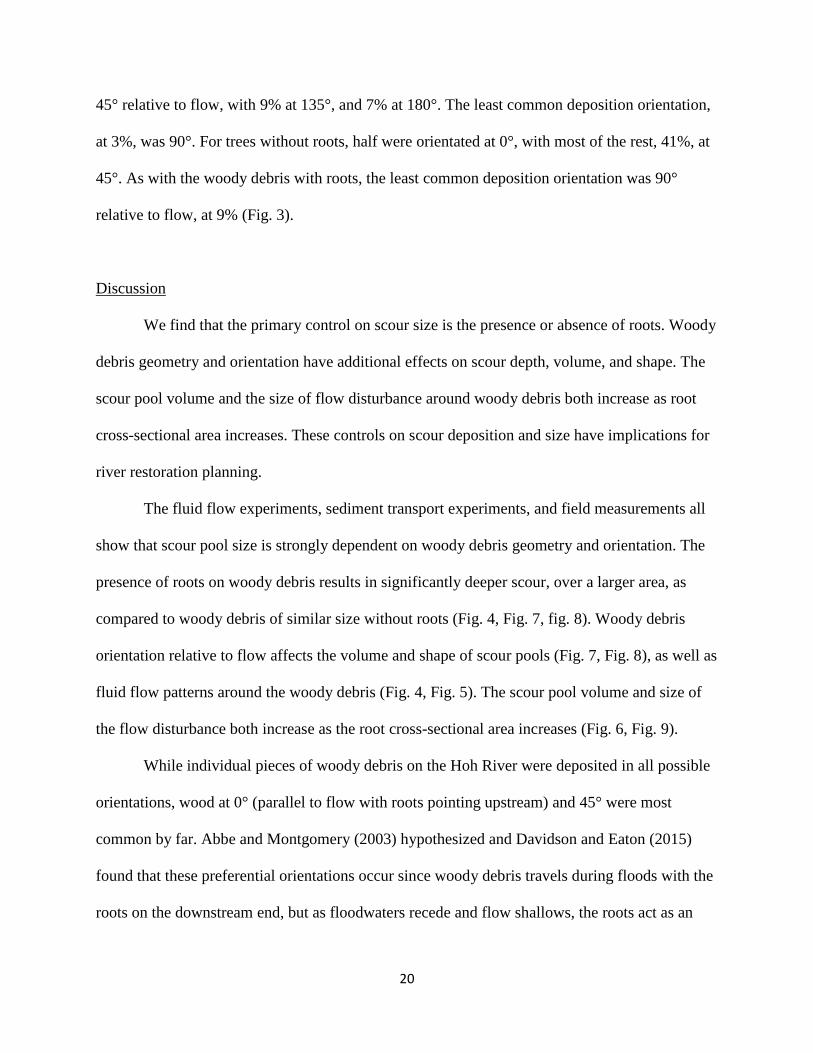
45° relative to flow, with 9% at 135°, and 7% at 180°. The least common deposition orientation,
at 3%, was 90°. For trees without roots, half were orientated at 0°, with most of the rest, 41%, at
45°. As with the woody debris with roots, the least common deposition orientation was 90°
relative to flow, at 9% (Fig. 3).
Discussion
We find that the primary control on scour size is the presence or absence of roots. Woody
debris geometry and orientation have additional effects on scour depth, volume, and shape. The
scour pool volume and the size of flow disturbance around woody debris both increase as root
cross-sectional area increases. These controls on scour deposition and size have implications for
river restoration planning.
The fluid flow experiments, sediment transport experiments, and field measurements all
show that scour pool size is strongly dependent on woody debris geometry and orientation. The
presence of roots on woody debris results in significantly deeper scour, over a larger area, as
compared to woody debris of similar size without roots (Fig. 4, Fig. 7, fig. 8). Woody debris
orientation relative to flow affects the volume and shape of scour pools (Fig. 7, Fig. 8), as well as
fluid flow patterns around the woody debris (Fig. 4, Fig. 5). The scour pool volume and size of
the flow disturbance both increase as the root cross-sectional area increases (Fig. 6, Fig. 9).
While individual pieces of woody debris on the Hoh River were deposited in all possible
orientations, wood at 0° (parallel to flow with roots pointing upstream) and 45° were most
common by far. Abbe and Montgomery (2003) hypothesized and Davidson and Eaton (2015)
found that these preferential orientations occur since woody debris travels during floods with the
roots on the downstream end, but as floodwaters recede and flow shallows, the roots act as an

21
anchor against the bed with the trunk still affected by flow and moving downstream until the
wood is oriented parallel to flow with the roots pointing upstream. Wood size and shape varies
depending on tree species, age, and growing conditions. As woody debris is transported
downstream and over time, the rootball also becomes smaller as outer parts are broken during
transport or by mobile sediment.
The local effects of streambed scour associated with woody debris influence pre-existing
topography such as streambanks and large bars, as well as localized topography that develops
concurrently with the woody debris, influenced scour of pools and deposition of dunes and small
bars. Scour pools are formed superimposed on this topography, which in some cases affects the
shape and size of the scour pool. For example, in both the field and experimental measurements,
some of the wood debris was at the base or on the edge of a streambank (Fig. 7, Fig. 8). This led
to restricted flow patterns and preferential erosion on the open side of the wood. While this
topography forms naturally, it may affect scour pool volume and depth, as compared to wood
debris in flatter parts of the streambed.
Discharge variability appears to exert a limited effect on scour pool size. The streambed
morphology experiments had a very narrow range of flow conditions and the scour
measurements in the field were taken after unknown flow velocities and flow depths, with an
unknown sequence of flood events. However both the flume experiments and the field data show
a similar relationship between scour volume and root cross-sectional area (Fig. 9).
Differences in scour pool volume and shape affect flow patterns in the channel, and
consequently sediment transport patterns and sediment sorting. These differences in channel bed
morphology influence the type and availability of aquatic habitats. Increased depth variability
and channel roughness from scour pools creates a more diverse range of aquatic habitats.

22
Preferential sediment sorting can concentrate the gravel sizes important for salmon and other fish
that spawn in redds. The increased roughness also drives more hyporheic flow (Mutz et al., 2007;
Sawyer et al., 2011), resulting in more dissolved oxygen available for insects, fish eggs, and
juvenile fish living in the interstitial gravel spaces in the streambed.
As the relationship between wood and habitat has become better understood, putting wood
back into rivers has become a widely accepted tool in river management (Lester and Boulton,
2008; Nagayama and Nakamura, 2010). Wood is reintroduced in rivers either as individual
pieces, free-floating or anchored, or as engineered logjams (ELJs) that mimic natural logjams.
Engineered logjams have become a widely accepted tool in river management for the purpose of
decreasing the rate of riverbank migration and for improving aquatic habitat (Abbe et al., 2003;
Brooks et al., 2004; Lester and Boulton, 2008). Sediment deposits around woody debris build up
riverbanks and counteracts bank migration on the bank where the wood is located. Logjams and
individual logs are also used to create the large pools and complex streambed morphology that
are important fish habitat and to accumulate the smaller grain sizes used by spawning
anadromous fish (Kail et al., 2007).
Consequently, the different possible scour pool volumes and shapes are important for
assessing and restoring aquatic habitat. For example, different fish species and life stages prefer
different pool sizes. Hence the species and size of woody debris in a river may result in pools
more or less suitable for particular types of fish. River restoration infrastructure may also be
designed in order to form the sizes and shapes of scour pools that would have occurred naturally
(Roni et al., 2015). Restoration projects focusing on improving aquatic habitat have become
increasingly common (Abbe et al., 2003; Kail et al., 2007; Roni et al., 2015) but many structures
are placed in orientations that minimize their effects on flow structures and channel morphology

23
(Kail et al., 2007). If individual pieces of woody debris are added as part of a restoration project,
with pieces anchored or cabled in place, trunk orientation will affect the size and shape of scour
pools that form. For restoration projects focusing on aquatic habitat that add individual,
unconstrained woody debris, projects should plan for the wood to reorient to 0° or 45° relative to
flow.
Restoration efforts are also increasingly supplementing woody debris in rivers by adding
wood from outside the floodplain. There is often a financial incentive to add woody debris
without roots as part of river restoration projects. Trees with roots are more expensive as it
requires more time and skill to excavate intact roots. Wood transportation costs are also greater,
as trees with roots can’t pack as densely on a truck as trees without roots. While wood without
roots will still create some fish habitat, wood with roots will create considerably more.
Our experiments and fieldwork focused on wood debris with a single trunk and varying root
geometries. In areas where other tree geometries are common, such as trees with multiple large
trunks, it is likely that the geometry of the trunks will have as much or greater of an effect than
roots on scour pool size(Dixon and Sear, 2014). This study also focuses on a cobble and gravel
river. Mutz (2000) found that sand-bedded rivers have fewer logjams, potentially due to sand
being more easily erodible. We hypothesize that similar scour patterns would form in sandy
rivers but scour depths and volumes would be less than in cobble or gravel rivers. Additionally
our results do not take sediment cohesion into account, so it is unlikely that these findings are
applicable in silt or mud-rich systems.
Conclusion

24
Analysis of fluid flow and channel morphodynamics around individual pieces of woody
debris reveal the systematic influence and importance of wood geometry and orientation on flow
disturbance, scour pool size, and scour pool shape. The presence of roots on woody debris results
in significantly deeper scour, over a larger area, as compared to woody debris of similar size
without roots. Woody debris orientation relative to flow affects the volume and shape of scour
pools, as well as fluid flow patterns around the wood debris. The scour pool volume and size of
the flow disturbance both increase as the root cross-sectional area increases. Quantifying the
relationships between wood geometry, wood orientation, scour pool size, and scour pool shape
can provide insights into channel morphodynamics, as well as guidance and criteria for use in
river assessment, restoration, and engineering.
Acknowledgements
We thank Sarah Daley, Richard Barnes, Scott Becker, Dan Scott, Jeremy Salinas, and Anthony
McCall for assistance in the field. We thank Peter Rhines for discussions and comments on the
fluid flow experiments. This work was supported in part by the Hoh River Trust, the Quaternary
Research Center, Olympic National Park, the NSF National Center for Earth-surface Dynamics,
the NSF Graduate Research Fellowship Program, the NSF GK-12 program, and the Friday
Harbor Laboratories ARCS fellowship.
Bibliography
Abbe, T.B., Brooks, A.P., Montgomery, D.R., 2003. Wood in river rehabilitation and
management, in: Gregory, S.V., Boyer, K.L., Gurnell, A.M. (Eds.), The Ecology and
Management of Wood in World Rivers. American Fisheries Society, Bethesda, Maryland,
pp. 367–389.
Abbe, T.B., Montgomery, D.R., 2003. Patterns and processes of wood debris accumulation in the
Queets river basin, Washington. Geomorphology 51, 81–107.
https://doi.org/10.1016/S0169-555X(02)00326-4

25
Abbe, T.B., Montgomery, D.R., 1996. Large woody debris jams, channel hydraulics and habitat
formation in large rivers. Regulated Rivers: Research & Management 12, 201–221.
Bisson, P.A., Bilby, R.E., Bryant, Ma.D., Dolloff, C.A., Grette, G.B., House, R.A., Murphy,
M.L., Koski, K.V., Sedell, J.R., 1987. Large woody debris in forested streams in the
Pacific northwest: past, present, and future, in: Salo, E.O., Cundy, T.W. (Eds.),
Streamside Management: Forestry and Fishery Interactions. Institute of Forest Resources,
University of Washington, Seattle, Washington, pp. 143–190.
Brooks, A.P., Gehrke, P.C., Jansen, J.D., Abbe, T.B., 2004. Experimental reintroduction of
woody debris on the Williams River, NSW: geomorphic and ecological responses. River
Research and Applications 20, 513–536. https://doi.org/10.1002/rra.764
Cherry, J., Beschta, R.L., 1989. Coarse woody debris and channel morphology: a flume study.
Journal of the American Water Resources Association 25, 1031–1036.
https://doi.org/10.1111/j.1752-1688.1989.tb05417.x
Collins, B.D., Montgomery, D.R., Sheikh, A.J., 2003. Reconstructing the historical riverine
landscape of the Puget lowland, in: Montgomery, D.R., Bolton, S., Booth, D.B., Wall, L.
(Eds.), Restoration of Puget Sound Rivers. University of Washington Press, Seattle and
London, pp. 79–128.
Comiti, F., Lucía, A., Rickenmann, D., 2016. Large wood recruitment and transport during large
floods: A review. Geomorphology 269, 23–39.
https://doi.org/10.1016/j.geomorph.2016.06.016
Czarnomski, N.M., Dreher, D.M., Snyder, K.U., Jones, J.A., Swanson, F.J., 2008. Dynamics of
wood in stream networks of the western Cascades Range, Oregon. Canadian Journal of
Forest Research 38, 2236–2248. https://doi.org/10.1139/X08-068
Daniels, M.D., Rhoads, B.L., 2007. Influence of experimental removal of large woody debris on
spatial patterns of three-dimensional flow in a meander bend. Earth Surface Processes
and Landforms 32, 460–474. https://doi.org/10.1002/esp.1419
Daniels, M.D., Rhoads, B.L., 2003. Influence of a large woody debris obstruction on three-
dimensional flow structure in a meander bend. Geomorphology 51, 159–173.
https://doi.org/10.1016/S0169-555X(02)00334-3
Davidson, S.L., Eaton, B.C., 2013. Modeling channel morphodynamic response to variations in
large wood: Implications for stream rehabilitation in degraded watersheds.
Geomorphology 202, 59–73. https://doi.org/10.1016/j.geomorph.2012.10.005
Dixon, S.J., Sear, D.A., 2014. The influence of geomorphology on large wood dynamics in a low
gradient headwater stream. Water Resources Research 50, 9194–9210.
https://doi.org/10.1002/2014WR015947
Faustini, J.M., Jones, J.A., 2003. Influence of large woody debris on channel morphology and
dynamics in steep, boulder-rich mountain streams, western Cascades, Oregon.
Geomorphology 51, 187–205. https://doi.org/10.1016/S0169-555X(02)00336-7
Gippel, C.J., Finlayson, B.L., O’Neill, I.C., 1996. Distribution and hydraulic significance of
large woody debris in a lowland Australian river. Hydrobiologia 318, 179–194.
https://doi.org/10.1007/BF00016679
Gregory, S., Boyer, K.L., Gurnell, A.M. (Eds.), 2003. The ecology and management of wood in
world rivers, American Fisheries Society symposium. American Fisheries Society,
Bethesda, Md.
Hilderbrand, R.H., Lemly, A.D., Dolloff, C.A., Harpster, K.L., 1998. Design considerations for
large woody debris placement in stream enhancement projects. North American Journal

26
of Fisheries Management 18, 161–167. https://doi.org/doi.org/10.1577/1548-
8675(1998)018<0161:DCFLWD>2.0.CO;2
Hoh Tribe, 2016. 2016 State of Our Watersheds Report Hoh River Basin.
Ishikawa, Y., Kusano, S., Fukuzawa, M., 1991. Mudflow and floating logs disaster in
Inchinomiya town, Kumamoto Pref. in 1990, in: Proceedings of the Japan-U.S.
Workshop on Snow Avalanche, Landslide, Debris Flow Prediction and Control:
September 30 - October 2, 1991. Presented at the Japan-U.S. Workshop on Snow
Avalanche, Landslide, Debris Flow Prediction and Control, Tsukuba, Japan, pp. 487–496.
Johnson, S.L., Swanson, F.J., Grant, G.E., Wondzell, S.M., 2000. Riparian forest disturbances by
a mountain flood - the influence of floated wood. Hydrological Processes 14, 3031–3050.
https://doi.org/10.1002/1099-1085(200011/12)14:16/17<3031::AID-HYP133>3.0.CO;2-
6
Kail, J., Hering, D., Muhar, S., Gerhard, M., Preis, S., 2007. The use of large wood in stream
restoration: experiences from 50 projects in Germany and Austria: large wood in stream
restoration. Journal of Applied Ecology 44, 1145–1155. https://doi.org/10.1111/j.1365-
2664.2007.01401.x
Klinger, T., Gregg, R., Hermann, K., Hoffman, K., Kershner, J., Coyle, J., Fluharty, D., 2007.
Assessment of coastal water resources and watershed conditions at Olympic National
Park, Washington (Natural Resource Technical Report NPS/NRPC/WRD/NRTR -
2008/068). National Park Service, Fort Collins, Colorado.
Lester, R.E., Boulton, A.J., 2008. Rehabilitating agricultural streams in Australia with wood: a
review. Environmental Management 42, 310–326. https://doi.org/10.1007/s00267-008-
9151-1
Manners, R.B., Doyle, M.W., 2008. A mechanistic model of woody debris jam evolution and its
application to wood-based restoration and management. River Research and Applications
24, 1104–1123. https://doi.org/10.1002/rra.1108
Montgomery, D.R., Buffington, J.M., Smith, R.D., Schmidt, K.M., Pess, G., 1995. Pool spacing
in forest channels. Water Resources Research 31, 1097–1105.
https://doi.org/10.1029/94WR03285
Montgomery, D.R., Collins, B.D., Buffington, J.M., Abbe, T.B., 2003. Geomorphic effects of
wood in rivers, in: Gregory, S.V., Boyer, K.L., Burnell, A. (Eds.), The Ecology and
Management of Wood in World Rivers, American Fisheries Society Symposium 37.
American Fisheries Society, Bethesda, Maryland, pp. 367–389.
Mutz, M., 2000. Influences of woody debris on flow patterns and channel morphology in a low
energy, sand-bed stream reach. International Review of Hydrobiology 85, 107–121.
Mutz, M., Kalbus, E., Meinecke, S., 2007. Effect of instream wood on vertical water flux in low-
energy sand bed flume experiments. Water Resources Research 43, W10424.
https://doi.org/10.1029/2006WR005676
Nagayama, S., Nakamura, F., 2010. Fish habitat rehabilitation using wood in the world.
Landscape and Ecological Engineering 6, 289–305. https://doi.org/10.1007/s11355-009-
0092-5
Nakano, D., Nagayama, S., Kawaguchi, Y., Nakamura, F., 2018. Significance of the stable
foundations provided and created by large wood for benthic fauna in the Shibetsu River,
Japan. Ecological Engineering 120, 249–259.
https://doi.org/10.1016/j.ecoleng.2018.05.032

27
Roni, P., Beechie, T., Pess, G., Hanson, K., 2015. Wood placement in river restoration: fact,
fiction, and future direction. Canadian Journal of Fisheries and Aquatic Sciences 72,
466–478. https://doi.org/10.1139/cjfas-2014-0344
Roni, P., Quinn, T.P., 2001. Density and size of juvenile salmonids in response to placement of
large woody debris in western Oregon and Washington streams. Canadian Journal of
Fisheries and Aquatic Sciences 58, 282–292. https://doi.org/10.1139/cjfas-58-2-282
Sawyer, A.H., Bayani Cardenas, M., Buttles, J., 2011. Hyporheic exchange due to channel-
spanning logs. Water Resources Research 47, W08502.
https://doi.org/10.1029/2011WR010484

28
Figures
Fig. 1 A) Overhead view of flow visualization around wood debris using potassium
permanganate crystals. B) Scour and deposition zones delineated from areas of dye advection
and recirculation.

29
Fig. 2 Model wood debris with varying root sizes and geometries.

30
Fig. 3 Wood debris orientation relative to flow, for all individual pieces of wood debris on four
bars in the Hoh River.

31
Fig. 4 Scour and deposition zones around wood debris with different types of rootwads. Wood
debris without roots has significantly smaller scour and deposition zones as compared to wood
debris with any type of roots. Increased root density increases the size of the scour and
deposition zones. Additionally the scour zone moves farther away from the roots as root
blockage area decreases. Scour and deposition zones are delineated as shown in Fig. 1.
Scour zone
Deposition zone
No
Roots
Wire Mesh
Roots
Star
Shaped Roots
Circular
Roots
Partially
Buried Roots
Increasing root cross-sectional area
flow

32
Fig. 5 Wood debris orientation relative to flow affects the size and shape of both the scour and
deposition zones. The size of the flow disturbance correlates to the cross sectional area of the
wood debris relative to flow. Scour and deposition zones are delineated as shown in Fig. 1.
Scour zone
Deposition zone
flow

33
Fig. 6 Planform scour zones (A) and deposition zones (B) plotted against root cross-sectional
area relative to flow.
0
10
20
30
40
50
60
0 200
10
20
30
40
50
60
0 20
Root blockage area [cm2]
Pla
nfo
rm s
cour
zone [
cm
2]
Pla
nfo
rm d
epositio
n z
one [
cm
2]
Root blockage area [cm2]
A B

34
Fig. 7 Bed topography from streambed morphology experiments with wood debris without roots
(A) and with roots (B) in a range of orientations. Flow is from right to left. Scour zones are
outlined in black. Wood debris without roots (A) has significantly shallower sediment scour and
deposition over a smaller area as compared to wood debris with roots (B). Wood debris
orientation relative to flow affects the size and shape of scour and sediment deposition.
35
Fig. 8 Field-surveyed streambed morphology around wood debris without roots (A) and with
roots (B) with flow direction going from right to left. Black dots are theodolite survey points.
Scour zones are outlined in black. Wood debris without roots (A) has significantly shallower
sediment scour and deposition over a smaller area as compared to wood debris with roots (B).

36
Wood debris orientation relative to flow affects the size and shape of scour and sediment
deposition.
Fig. 9 Scour volume plotted against root cross-sectional area relative to flow, for flume
experiments and field measurements. Dashed lines show best fit line, y = 0.6192x1.179
, calculated
by fitting points on a log-log plot.
37
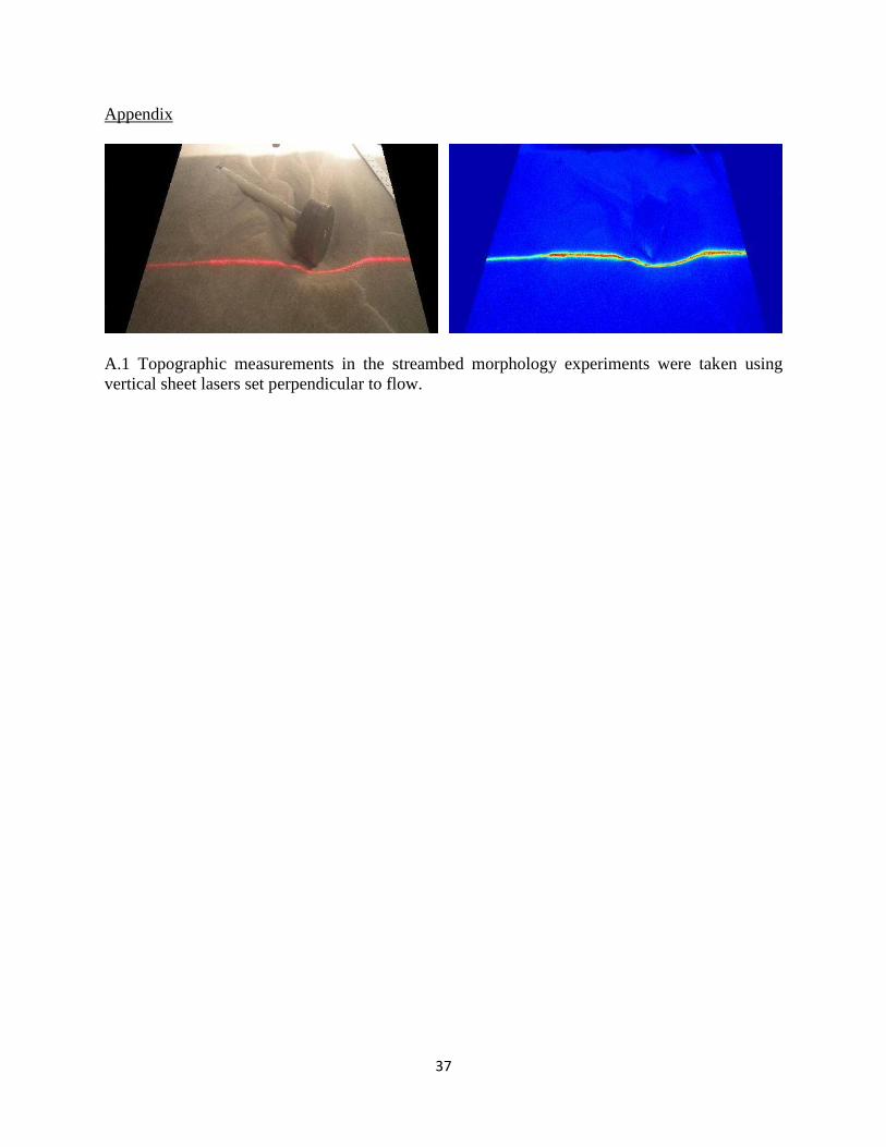
Appendix
A.1 Topographic measurements in the streambed morphology experiments were taken using
vertical sheet lasers set perpendicular to flow.
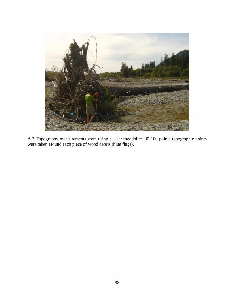
38
A.2 Topography measurements were using a laser theodolite. 30-100 points topographic points
were taken around each piece of wood debris (blue flags).
39
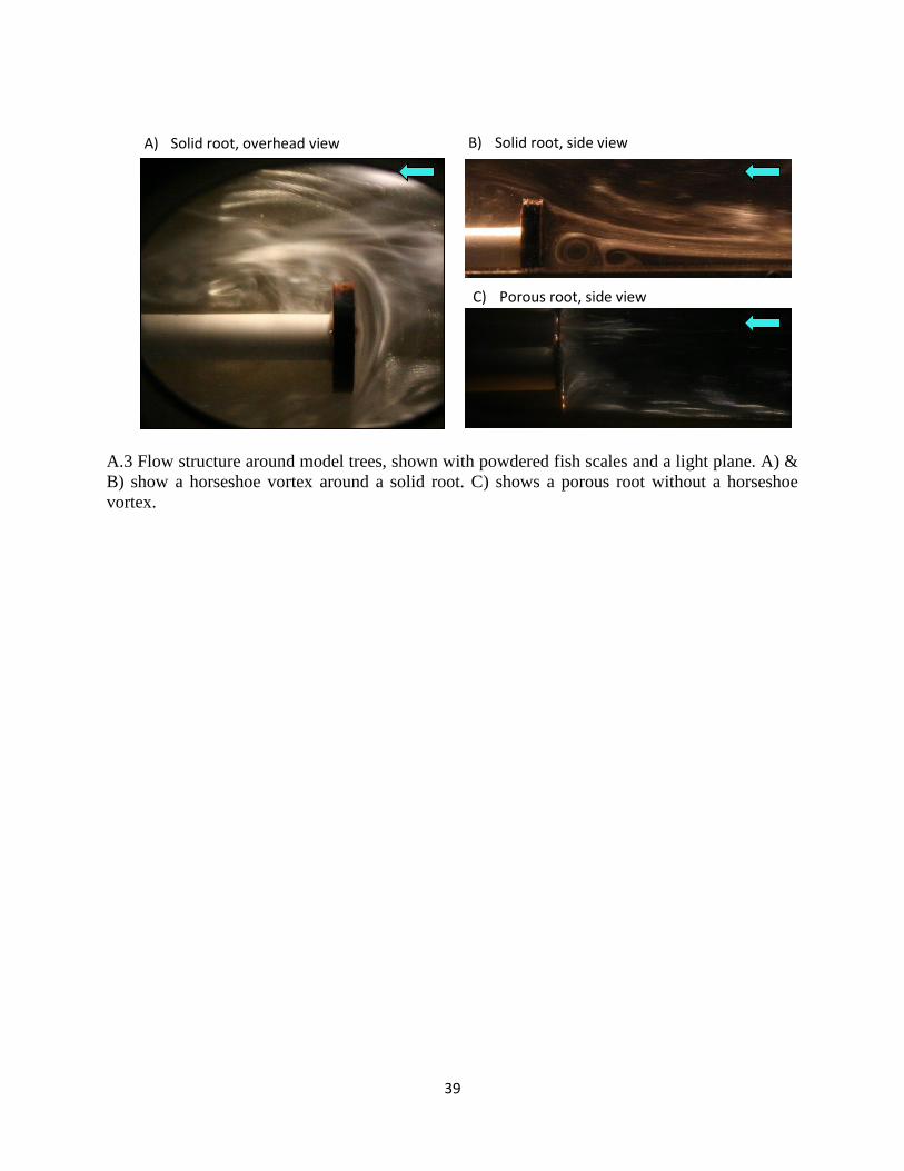
A.3 Flow structure around model trees, shown with powdered fish scales and a light plane. A) &
B) show a horseshoe vortex around a solid root. C) shows a porous root without a horseshoe
vortex.
B) Solid root, side view A) Solid root, overhead view
C) Porous root, side view

40
Ch. 3 Wood Debris Sources and Logjam Distribution and Dynamics Before and After Dam
Removal, Elwha River, WA
V. Leung*1,2
, R. McCoy3, M. McHenry
3, D. R. Montgomery
1
1 University of Washington, Department of Earth and Space Sciences, Seattle, WA, USA
2 University of Richmond, Department of Geography and the Environment, Richmond, VA,
USA
3 Lower Elwha Klallam Tribe, Natural Resources Department, Port Angeles, WA, USA
*corresponding author: [email protected]
Abstract
Logjam distribution and dynamics on the Elwha River before, during, and after the Elwha River
Restoration project dam removals are measured through aerial photographs and field surveys.
Prior to dam removal, local wood recruitment dominated logjam dynamics through bank erosion,
channel migration and avulsions. Several large logjams formed in side channels during floods,
and gradually revegetated, producing new floodplain forest. Removal of the Elwha and Glines
Canyon dams resulted in increased downstream flux of sediment and wood from the upstream
watershed and material that was previously stored in the reservoirs behind the dams. During the
first year of dam removal, 208 pieces of wood debris were individually tagged in the former
Lake Mills, the reservoir behind the Glines Canyon Dam, and the upper part of the Middle Reach
(between the dams). After dam removal, 62 tagged pieces were relocated, showing wood
transport out of Mills into the Middle Reach, with a few pieces that traveled to the former Lake

41
Aldwell, the reservoir behind the Elwha Dam, and the Lower Reach (between the Elwha Dam
and the coast). During and immediately after dam removal, logjam area increased in the channel
main-stem, logjams developed unexpectedly rapidly in the former Lake Aldwell reservoir, and
very little logjam development occurred in the former Lake Mills reservoir. In the river channels
between Aldwell and Mills (Middle Reach), logjam area increased with increased upstream
wood flux and more local recruitment as the higher sediment load increased lateral channel
mobility. However, logjam development in the two former reservoirs followed very different
trajectories due to rapid erosion of sediment stored in the former Aldwell reservoir, a greater
upstream flux of wood into Aldwell, and the presence of rooted 1-3 m diameter tree stumps in
the Aldwell sediments that became anchor points for logjam formation.
Introduction
Wood debris has been recognized to significantly impact aquatic habitat and play a
fundamental role in forest river dynamics that complements those of water discharge and
sediment transport (Gurnell et al., 2002; Montgomery et al., 2003; Ruiz-Villanueva et al., 2016).
The interactions among large wood debris, fluid flow and sediment transport in rivers are first-
order controls on river processes, affecting channel roughness, streambed morphology and
sediment transport (Montgomery et al., 2003).
A number of studies have documented the effects of large-scale wood removal from
channels and floodplains due to widespread floodplain logging, dams, levees, and floodplain
channelization that affected channel morphodynamics (Collins et al., 2002; Collins and
Montgomery, 2002; Sedell and Froggatt, 1984). In contrast, large-scale wood influx events are
often unanticipated (e.g., landslides, avulsions, large floods or forest fires) and therefore field

42
investigations of large events are rare. The Elwha River dam removals, the largest dam removal
to date, provide an opportunity to quantify how logjam dynamics changed in response to changes
in channel connectivity and large scale wood influxes.
In this study, we investigate the effects of dam removal on the Elwha River, Washington,
USA on logjam dynamics and analyze rates and patterns of logjam change before, during, and
after dam removal to test two hypotheses: (1) that as longitudinal river connectivity is restored
after dam removal, there will be an increase in LWD entering the river from the upstream
watershed, and an increase in total logjam area in the active channel; (2) new logjams will
develop slowly on the former reservoir lakebeds as the high unconsolidated sediment to water
ratio and lack of floodplain forest will lead to substantial channel migration and instability before
vegetation becomes re-established.
Background
Morphodynamics of wood debris in rivers
Individual logs and logjams are significant obstacles in channels, causing local flow
disturbances, sediment scour and deposition (Cherry and Beschta, 1989; Daniels and Rhoads,
2003). At the reach scale, wood and logjams increase channel roughness, decrease sediment
transport and increase sediment storage (Davidson and Eaton, 2013; Gippel et al., 1996), and
influence streambed morphology and aquatic habitat (Nagayama and Nakamura, 2010). In
particular, wood debris increases the hydraulic and topographic complexity of channels and
riparian zones, leading to greater diversity of aquatic habitats such as pools or slow water refugia
(Nagayama and Nakamura, 2010; Roni and Quinn, 2001). Not only does large wood debris help
retain gravel used by spawning salmon (Brooks et al., 2004), but the majority of large pools in
43
forest channels are found in conjunction with large wood debris (Abbe and Montgomery, 2003;
Montgomery et al., 1995, 2003).
Across the Pacific Northwest, large wood debris influx into rivers has been greatly
reduced due to anthropogenic activities, including upland logging and dams reducing upstream
sources of wood, and floodplain logging, levees, channelization, and navigation related snag
removal reducing local sources of wood (Collins et al., 2002). In addition, wood currently
entering rivers is often smaller than historic wood sizes as most old growth forests have been
logged. This reduced wood influx and size has led to fewer, smaller logjams in most rivers
(McHenry et al., 1998).
Historically, large wood debris was routinely removed from rivers in the Pacific
Northwest to improve navigation and facilitate unimpeded fish passage (Bisson et al., 1987;
Collins et al., 2003; Nagayama and Nakamura, 2010). Anthropogenic activities such as
floodplain logging, channelization and levee building reduced in-stream wood loads by affecting
local recruitment of riparian trees (Czarnomski et al., 2008; Faustini and Jones, 2003). As
relationships between in-stream wood and aquatic habitat have become better understood, the
practice of putting wood back into rivers has become a widely accepted goal in river
management (Lester and Boulton, 2008; Nagayama and Nakamura, 2010). Wood is reintroduced
in rivers either as individual pieces, whether free-floating, anchored, or as engineered logjams
(ELJs) (Abbe et al., 2003; Kail et al., 2007). Engineered logjams that mimic aspects of natural
logjams have been widely used in the Pacific Northwest to decrease riverbank erosion and
protect infrastructure from channel migration while improving aquatic habitat (Abbe and
Montgomery, 2003). Such approaches have been used to force localized bed scour and thereby

44
create large pools and complex streambed morphology that shape fish habitat, as well as to
promote the accumulation of grain sizes used by spawning anadromous fish (Roni et al., 2015).
Study area
The 72-km long Elwha River flows north from the Olympic Mountains to the Strait of
Juan de Fuca (Fig. 1), draining a 833 km2 watershed, the majority of which is within Olympic
National Park (Duda et al., 2008). Downstream of the park boundary, the floodplain and
watershed are owned by a mix of private, government and tribal entities. Peak discharges occur
in the winter storm season between October and March, with secondary peaks in May and June
due to snowmelt (Fig. 3a). The 2, 10 and 100-year recurrence interval floods are calculated to be
400, 752 and 1240 m3/s, respectively, and the median summer discharge is typically 20–40 m
3/s
(Duda et al., 2011). Sediment sources include unconsolidated glacial till, glacial outwash,
alluvial deposits and proglacial lacustrine deposits (Tabor and Cady, 1978).
This study focused on 4 sections of the Elwha River: the Lower Reach, the former Lake
Aldwell, the Middle Reach, and the former Lake Mills (Fig. 2). The 7.4 km-long Lower Reach
extends from the Strait of Juan de Fuca to the former Elwha Dam. Here the river is confined to a
bedrock canyon for 1.3 km before widening into an anabranching channel with vegetated islands
and a patchwork forest floodplain. Aldwell, the site that was formerly Lake Aldwell, is between
the former Elwha dam and the 101 highway bridge that crosses the Elwha at rkm 12.1. The
Middle Reach stretches between the 101 highway bridge and the former site of the Glines
Canyon dam at rkm 21.1. Here the river alternates between confined bedrock canyon reaches and
wider anabranching reaches with vegetated islands and multiple channels. Mills, the site that was
formerly Lake Mills, is between the former Glines Canyon dam site and Cat Creek at the outlet
of Rica canyon at rkm 24.7 in Olympic National Park. Field work reported here builds on
45
extensive research and data collection on the Elwha River basin (Duda et al., 2008, 2011; Ritchie
et al., 2018b; Warrick et al., 2015).
With elevations within 200 feet of sea level, the floodplain forest in the study reaches is
dominated by Douglas fir (Pseudotsuga menziesii) and deciduous species, including bigleaf
maple (Acer macrophyllum), black cottonwood (Populus trichocarpa) and red alder (Alnus rubra)
(Duda et al., 2011; Kloehn et al., 2008). Younger forests are typically found close to the active
river channel and often contain early succession red alder and willow species (Salix spp.).
Additional conifer species in the floodplain forest include western red cedar (Thuja plicata),
grand fir (Abies grandis) and Sitka spruce (Picea sitchensis) (Duda et al., 2011; Shafroth et al.,
2016).
The Elwha River was dammed in 1913 and 1927, respectively, by the 32 m tall Elwha
Dam at rkm 7.9 and the 64 m tall Glines Canyon Dam at rkm 21.6 (Fig. 1). The dams were
originally built for hydropower for paper mills in the area. Downstream of both dams, the Lower
Reach had been starved of sediment for almost a century, with the streambed consequently
coarsening and becoming armored (Draut et al., 2011; Kloehn et al., 2008). The Lower Reach
floodplain has also lost physical and ecological complexity due to human activities, especially
floodplain logging and diking (McHenry et al., 2007). Some of the floodplain dikes and other
channel modifications have been removed as part of river restoration projects conducted by the
Lower Elwha Klallam Tribe (LEKT) Department of Natural Resources (Warrick et al., 2011).
Additionally, 45 engineered logjams were constructed in the Elwha River between rkm 1.7 and
rkm 3.6 between 1999 and 2014, in order to improve aquatic habitat, protect floodplain
infrastructure and promote an anastomosing channel pattern that provides important side-channel
habitat for salmonids (McHenry et al., 2007; Natural Systems Design, 2016). Pieces of wood
46
debris used to build ELJs were imported to the floodplain from local tree farms, and consisted of
pieces with and without roots in a range of sizes. These were primarily built to increase fish
habitat by creating deep pools and increasing the amount of spawning size gravel in the reach.
Some ELJs were also built to stabilize banks, protect infrastructure, and direct more flow into
side channels. ELJs were built at densities that at the time were considered representative of
logjam densities for the Elwha River prior to dam construction. Several types of ELJs were built.
Most have posts driven up to 30 ft. into the channel bed, with key pieces cabled into place and
buried beneath a large mound of cobbles and gravel as additional ballast for stabilization. Some
of the later ELJ's also have pieces of wood sticking out into the flow so that additional, naturally
recruited wood pieces will get caught and racked on to the logjam. Several older ELJs
constructed with different designs were rebuilt to be more stable after the channel started
undermining them. In the first 5 years after dam removal, all ELJs remained stable. Due to
construction designs that emphasize stability, ELJ's in this reach behave somewhat differently
than natural log jams. The ELJs have very dense cores consisting of crisscrossed logs covered
with gravel and cobble-size sediment. The dense core influences flow patterns and pool
locations. The ELJs are also both taller and smaller in area than natural log jams.
Elwha River Restoration project history
In 1992 Congress passed the Elwha River Ecosystem & Fisheries Restoration Act, with
the goal of restoring the Elwha River ecosystem and native anadromous fisheries in a safe,
environmentally sound and cost effective manner, primarily by removing the Elwha and Glines
Canyon dams. Project goals included restoring longitudinal river connectivity, restoring
anadromous fisheries, increasing marine-derived nutrient cycling, and restoring the reservoirs to

47
conditions consistent with valley and floodplain settings in the rest of the Elwha River valley or
similar unaltered rivers in the Olympic Peninsula (Chenoweth et al., 2011; Ward et al., 2008). In
September 2011, the Elwha River Restoration project began a multi-year, phased removal of
both dams in order to restore ecosystem function and native anadromous fish populations. Elwha
Dam was fully removed in September 2012 and Glines Canyon Dam was fully removed in
September 2014 (Warrick et al., 2015).
At the beginning of dam removal Lake Aldwell was estimated to store 4.9 +/- 1.4 million
m3 of sediment and Lake Mills was estimated to store 16.1 +/- 2.4 million m
3 of sediment
(Randle et al., 2015). One third to half of the stored sediment was predicted to erode in the first
few years after dam removal (Randle and Bountry, 2010). Sediment dynamics during dam
removal can be divided into 3 parts (Fig. 3b): Stage 1 – where dam removal started on both dams
but there were still partial reservoirs behind both dams; Stage 2 – when Lake Aldwell was fully
drained and sediment starting spilling downstream of the Elwha Dam site; and Stage 3 – when
Lake Mills was fully drained and sediment started spilling downstream of the Glines Canyon
dam site (Warrick et al., 2015). A revegetation project involving planting native species and
removing invasive species has been underway since 2011 in both former lake beds (Chenoweth
et al., 2011).
In order to restore long-term physical processes leading to a natural channel morphology
and better quality instream habitat, local sources of wood debris must be developed and
maintained, in addition to allowing wood flux from upstream (Chenoweth et al., 2011; Collins et
al., 2002; Latterell and Naiman, 2007). Dam removal allowed wood debris from the upstream
watershed areas to travel down to the Middle Reach and Lower Reach, instead of settling behind
the dams. Additionally, wood that had been stored in the reservoirs was expected to be exhumed

48
from the former lakebeds during and after dam removal (Chenoweth et al., 2011; Ward et al.,
2008). Dam removal was expected to increase lateral channel migration due to the high sediment
flux as the reservoir sediments started to erode (U.S. Department of the Interior, 1995).
Increasing lateral channel migration will erode more forest floodplain, increasing local
recruitment of debris (Latterell and Naiman, 2007). Historically, rivers in formerly glaciated
valleys in the Pacific Northwest had an anastomosing channel pattern with stable islands
developed on and behind large, stable logjams (Collins and Montgomery, 2002). These logjams
resisted erosion and could stay intact for thousands of years, creating ‘hardpoints’ that had
enough floodplain stability that trees had time to grow to grow to prodigious sizes (Montgomery
and Abbe, 2006). These old growth trees were considerably larger than other wood debris or
most other obstacles in the rivers and often initiated and maintained long-term stable logjams
(Collins and Montgomery, 2002).
Steps to restore anadromous fisheries have focused on removing migration barriers and
in-stream hazards, and improving aquatic habitat for salmon and bull trout (Crain and Brenkman,
2010; Peters et al., 2014; Ward et al., 2008). Physical migration barriers removed included the
removal of Glines Canyon Dam, Elwha Dam, and large boulders thought to block or impede
most upstream migration (Bountry et al., 2015). Physical habitat improvements resulting from
dam removal included increasing the number of deep pools, accumulations of spawning-sized
gravels, hyporheic flow through salmon redds, and the amount of side-channel, slack water, and
estuary habitat (East et al., 2015; Peters et al., 2017).
Methods
Longitudinal wood distribution methods

49
We have monitored wood debris and logjams since 2001 on the Lower Reach and since 2012 on
Aldwell, the Middle Reach and Mills, providing 10 years of wood monitoring data before dam
removal and 5 years of data during and after dam removal. These air photo and field surveys are
a continuation of the work discussed in McHenry et al. (2007). In these surveys, logjams were
defined as accumulations of at least 10 pieces of debris that are each at least 3 m long and 0.3 m
in diameter or are tree stumps at least 0.5 m in diameter. Field surveys took place in late summer
and fall, after the spring snowmelt and before the winter storm season. Logjam locations were
taken using a Trimble GeoXT, Geo7X or GeoXH. Logjam surveys were conducted by foot and
by raft, with stops at each logjam where researchers climbed onto the logjam to make field
measurements. Some logjams were inaccessible due to limited launch and landing sites, limited
access points by foot, or dense and thorny vegetation. ELJs were not included in logjam area
measurements. Field surveys did not include side channels and floodplain to the east or west of
mainstem channels, but in some years did include floodplain islands. Therefore floodplain
logjam measurements should be considered as a lower bound for the amount of wood stored in
the floodplain. Field measurements of average logjam length in the along-stream direction,
average logjam width in the cross-stream direction, and average logjam height were taken using
a laser range finder. For logjams that were irregularly shaped with large void spaces, the field
measurements of logjam dimensions were an estimate of the length, width and height of a
densely packed rectangular logjam holding an equivalent volume of LWD. For certain logjams
that were inaccessible in the field, or were especially large or complex in shape, the length and
width measurements were taken from air photos. If possible, air photos taken in fall or winter
were chosen to minimize canopy cover obscuring parts of logjams. Vegetated parts of logjams

50
were considered to be stored floodplain wood and therefore not included in logjam area
calculations. Logjam length and width measurements from air photos, following the same logjam
size criteria as with field surveys, are combined with field survey data in order to cover the
greatest number of sampling times possible. ELJs were not included in these logjam
measurements.
Logjams are inherently complex structures with rough and uneven boundaries. Consequently,
there are uncertainties to quantifying metrics such as logjam dimensions. We estimate that the
measurements of logjam dimensions have a 15 % margin of error. This margin of error is
calculated by combining differences in the internal and external boundary points for measuring
logjam length, width and height in the field and differences resulting from aligning
measurements within 5 degrees of the along-stream and cross-stream directions in the field.
Since some logjams were inaccessible to the field surveys, logjam area measurements off air
photos are more comprehensive.
Starting in 2013, logjam geomorphic setting was also recorded. Logjam types were based
on the geomorphic setting and forcing mechanism for each particular logjam, following the
nomenclature of Abbe and Montgomery (2003). Logjam types found on the Elwha River are bar
apex, meander, stumps, key piece, live trees, boulder, and channel spanning. A bar apex jam is
one where the wood debris is deposited on the topographic high of the front of a bar. A meander
jam is one where the wood debris is deposited on the outer curve of a meander bend. Stumps,
key pieces, live trees and boulders are logjams where the wood is anchored on each of those
things. Channel spanning logjams are logjams that extend fully across a channel.
In 2012, 208 individual pieces of wood debris were marked using numbered aluminum tree
tags, expanding on work discussed in McHenry et al. (2007). Each piece of wood debris had two

51
tags hammered in, one at each end of the trunk. Tags were placed 180 degrees from each other,
rotated along the trunk axis, in order to increase the chances of spotting a tag in all wood
orientations. Only wood debris pieces that were at least 3m long and 0.3m in diameter, or tree
stumps at least 0.5 m in diameter were tagged. Pieces of wood debris on the higher terraces in
Mills were not tagged, as those terraces were not expected to erode during the study. All other
wood debris of that size that were not in logjams and were reachable by foot, a total of 116
pieces, were tagged between rkm 18.4 and rkm 23.3. 30 additional pieces of LWD were tagged
at Wolf Creek (rkm 23.8 – 24.6). In the Middle Reach, between rkm 18.4 and rkm 20.4, all wood
debris of the right size that were not in logjams and were reachable by foot, a total of 62 pieces,
were tagged. In 2015, rkm 0 to rkm 23.5, almost the entire study reach, was re-surveyed for the
tagged trees, 62 of which were located.
Logjam evolution methods
Logjam perimeters in upper Aldwell was mapped off of Elwha PlaneCAM air photos
(Ritchie et al., 2018a) over four flood events in order to investigate logjam evolution, relative to
varying discharges. We focused on the upstream section of Aldwell because it has been the area
with the most extensive new logjam development since dam removal began. Before and after
photosets were chosen for four flow events: a flood in Mar. 14th
, 2015 with peak discharge of 76
m3/sec as a low-flow ‘control’; two medium floods, a 297 m
3/s flood on Sept. 29
th, 2013 before
Glines was fully removed and a 230 m3/sec flood on Feb. 16
th, 2016 after both dams were
removed; and the largest flood to date since dam removal began, a 733 m3/sec flood in Nov. 17
th,
2015.

52
For these surveys, more precise logjam area measurements were made by mapping logjam
perimeters from Elwha PlaneCAM aerial photosets in ARC GIS. Logjams were mapped using
the same criteria as those used in the field surveys. We only considered logjams with at least ten
pieces of wood debris, each at least 3m long and 0.3 m in diameter, or stumps at least 0.5 m in
diameter. Only logs that were physically touching were considered part of the same logjam.
Individual pieces of wood partially sticking out of a logjam were mapped as part of the logjam.
Large areas of bare sediment within a logjam were not counted as part of logjam area but small
void spaces were included. Logjams were mapped at 1:500 map scale in Arc-GIS. We estimate
up to 10 % error associated with human error in mapping logjam perimeters.
Results
Longitudinal wood distributions results
During and after dam removal, logjam area increased in all sections of the field site (Fig. 5b).
From 2012 to 2016 logjam area increased steadily in all four river sections, except for a slight
decrease in total logjam area from 2013 to 2014. Logjam area per rkm increased in the Lower
Reach by 174%, in Aldwell by 245%, in the Middle Reach by 399 %, and in Mills by 3386%
between 2012 and 2016 (Table 1). The greatest logjam area increases happened after 2014,
following the end of dam removal, except in the Middle Reach where logjam area increased by
similar amounts during and after the end of dam removal. Logjam area varies significantly by
location, with a one-rkm-long reach having logjam area of 22,695 m2, many one-rkm-long
reaches with logjam area under 5000 m², and some reaches without any logjams. Reaches with

53
the lowest concentration of logjams both before and after dam removal include bedrock canyons
and straight channel reaches.
Starting in March 2012, when Lake Aldwell was fully drained, wood debris from Lake
Aldwell and the Middle Reach began to be transported into the Lower Reach (Randle et al.,
2015). Starting in October 2014, when Lake Mills was fully drained and sediment started spilling
over the remaining ~16 m of Glines Canyon Dam, wood debris from Mills and the upstream
watershed began to be transported into and through the Middle Reach.
Logjam area per rkm in the Lower Reach increased from 893 m2/rkm in 1999 to 5,543
m2/rkm in 2008, primarily between rkm 1 and 3 where an avulsion happened (Fig. 5a) (Draut et
al., 2011). Since then, logjam area decreased in the avulsion reach primarily due to wood
accumulations in Hunts Road Island that remained in place and were gradually overgrown with
vegetation, thereby becoming stored floodplain wood.
In the Middle Reach, logjam area increased over the majority of the reach. Logjam area
in the Middle Reach started out lower than in the Lower Reach. While the amount of logjam
area increases were similar in both sections, the greatest proportional increase occurred in the
Middle Reach, with a 174 % increase in the Lower Reach and a 399 % increase in the Middle
Reach.
The two former reservoirs (Aldwell and Mills) reacted very differently during and after
dam removal. By 2012, the first field survey after dam removal began, Aldwell already had
9,340 m2 of logjams, a significant amount of wood accumulation. By 2014 this increased 46% to
13,643 m2, with an increase of 245% to 32,213 m
2 by 2016. In contrast Mills only had 3 logjams
covering 260 m2 in 2012 with an increase of 85% to 480 m
2 in 2014, and an increase of 3,376%
to 9,036 m2 in 2016.
54
In Aldwell, a large number of logjams formed in rkm 10.1 – 12.1, the upstream most 2
km of the former reservoir, but few logjams formed in the rest of the former reservoir. Some
logjams developed on higher terraces, forming early on during dam removal when water and
dam elevations were higher (Fig. 2). New logjam development after dam removal was
concentrated in lower channel elevations where the channel remains active.
After dam removal little happened in Mills in terms of logjam formation in the central
part of the reservoir, where the active channel is located. Mills has very large deposits of wood
all around the edges of the former reservoir. This was primarily floating wood that was
windblown across the reservoir surface and deposited during the initial drawdown. The exhumed
wood from Mills and Aldwell had been on or buried in the lake bottom and was presumably
waterlogged and therefore had a higher density than the wood in the rest of the river valley. In
Mills, a small number of logjams formed during the dam removal but most of the new logjams
did not form until after a 12-year recurrence interval flood in 2015. Mills also has stumps, but
most of them were buried under lake sediments until after the end of dam removal. High terraces
remain on the edge of Mills. Some wood was stranded on these terraces as reservoir water levels
dropped, and some wood debris is likely to be buried within the terraces. Larger stumps that
were exhumed earlier in the dam removal process were mostly high on the valley walls above the
active channel, particularly just upstream of the former dam location and at rkm 24.5 by Wolf
Creek.
Both reservoirs contained tree stumps buried in the lake sediment that still had roots in
place on the pre-dam valley floor. However, the stumps in Aldwell are considerably larger than
most of those in Mills. In Aldwell the stumps reach up to 3 m in diameter, with a substantial
number over 1 m in diameter. Mills has a few stumps greater than 1m in diameter, primarily on

55
the valley walls by Wolf Creek, but most are under 1m in diameter, especially in the vicinity of
the active channel on the valley floor.
The field site includes several types of logjams, including bar apex logjams, channel-
spanning logjams, meander logjams (Abbe and Montgomery, 2003), and logjams anchored by
key pieces, boulders, living trees, and tree stumps. Most logjams resulted from several types of
geomorphic features. In terms of the primary geomorphic logjam type, most logjam types are
represented throughout the study reaches (Fig. 8a). Channel spanning logjams are most common
in rkm 3 and include many channels filled with woody debris on a large floodplain island
between two branches of the river. The majority of new logjams in Aldwell are anchored by
stumps. In 2014, logjam area increased for logjams anchored by stumps, and channel spanning
logjam area decreased.
From 2012 - 2014 the largest logjam area increases occurred at rkm 11 & 12 for logjams
anchored on stumps, and rkm 17 for logjams anchored by boulders. In Aldwell, at rkm 11 and 12,
most of the new logjams formed due to large, old-growth tree stumps uncovered during the dam
removal (Fig. 8b). Logjams formed on old-growth tree stumps are extremely rare in the rest of
the study site.
A comparison of field and air photo measurements in fall 2012 show that logjam area per
rkm measured from air photos is 17% greater than field measurements in the Lower Reach, 39%
greater in Aldwell, and 10% less in the Middle Reach (Fig. 4). Logjam area is an imperfect
measure of wood accumulation since logjams can range up to 5 or more logs thick. Additionally,
many of the logjams in the study area are partially buried. Field observations of logjams in
Aldwell with scour pools suggest that up to half of a logjam may be buried beneath sediment. In
the 2012 and 2014 field data, logjam area ranged from 10 – 1377 m², with the majority of

56
logjams under 400 m². Logjam height ranged from 0.2 – 5.5 m, with the majority of logjams
between 0.5 and 3 m in height. There was no discernible relationship between logjam area and
logjam height (Fig. 6).
There was considerable downstream transport of the individually tagged pieces of wood
debris, with pieces tagged in Mills and the upper part of the Middle Reach travelling downstream
to parts of the Middle Reach, Aldwell and the Lower Reach (Fig. 7a). Wood debris length ranged
up to 58 m with a median length of 7.2 m. Most of the tagged pieces were transported out of
Mills, with only 4 pieces relocated in Mills. Most of the re-found wood, 51 pieces, were
deposited in the Middle Reach between rkm 16.2 and rkm 20.4, 5 pieces were deposited in the
upstrea end of Aldwell and 2 pieces reached the Lower Reach. The farthest downstream piece of
tagged LWD was found in rkm 1. 15 pieces of tagged wood moved 0.1 rkm or less and were
interpreted to not have moved. Median wood travel distance was 2.5 rkm and mean travel
distance was 3.6 rkm. The farthest wood travel distance was 22.1 rkm.
There are no measurements of the amount of wood exiting the Elwha River into the Strait
of Juan de Fuca before or after dam removal. The size of the delta increased after dam removal
and initiated sediment accretion on nearby beaches(Gelfenbaum et al., 2015; Warrick et al.,
2019).
Logjam evolution
Wood mobility and logjam area changes varied greatly depending on the size of flood events. In
upper Aldwell, most of the logjams that were washed away or newly formed were located near
areas of active channel migration during floods. About half of the wood debris that was washed
away was in an area where the active channel moved to during the flood.
57
The March 14th
, 2015 flood event of 76 m3/sec was included primarily as a low-flow control
to assess the mobility of wood at low flow levels. There was no significant active channel
migration, no significant changes in logjam distribution, and no significant changes in total
logjam area (Fig. 9a).
The 297 m3/sec flood on September 28
th, 2013 resulted in a moderate amount of active
channel movement and some changes in logjam distribution. Three logjams were washed away
and 1 larger logjam formed, although the total logjam area did not change significantly (Fig. 9b).
Additionally, 1 logjam increased in area, 3 logjams lost wood in some parts but gained a similar
amount of wood in other parts, and 6 logjams were not affected by the flood. About half of the
wood that mobilized was in an area that the channel moved to after the flood.
The 230 m3/sec flood on February 16
th, 2016 also resulted in a moderate amount of active
channel movement but no significant changes in logjam distribution or total logjam area (Fig. 9c).
There were very slight increases in logjam area in 4 logjams, very slight decreases in logjam area
in 2 logjams and no changes in 7 logjams.
The 733 m3/sec flood on November 17
th, 2015 was the largest flood to date since dam
removal began. This flood resulted in substantial active channel movement and a 74% increase
in logjam area (Fig. 9d). One logjam grew considerably, two new logjams formed, one lost wood
in some parts but gained a similar amount of wood in other parts, and one decreased in size. Four
logjams merged into two logjams, and both grew slightly. Two logjams split into four smaller
logjams, three of which lost wood in some parts but gained a similar amount of wood in other
parts, and one that grew in size. Most of the wood was deposited in the upstream end of the study
area. About half of the wood that was washed away was in an area that the channel moved to
after the flood.

58
Discussion
Restoration goals for former dam impoundments
The main physical process restoration goals of the Elwha restoration project were to
restore longitudinal river connectivity by removing the Elwha and Glines Canyon dams, and to
restore the watershed to a natural condition consistent with the pre-dammed Elwha River
(Chenoweth et al., 2011; Elwha River Ecosystem and Fisheries Restoration Act, 1992; Randle
and Bountry, 2010; Ward et al., 2008). The largest morphodynamic concern related to dam
removal involved the coarse sediment impounded in the dam reservoirs for almost a hundred
years (Randle and Bountry, 2010; U.S. Department of the Interior, 2005). Project management
objectives were to erode as much of this sediment as possible, not raise the downstream flood
stage, keep infrastructure intact, and leave the reservoirs with topography that is stable and
consistent with natural landscapes (Chenoweth et al., 2011; Randle and Bountry, 2010). Short-
term management goals were for sediment exhumation to occur fast enough to minimize
sustained sediment impacts on aquatic ecology but slow enough to prevent or mitigate damage to
the downstream treatment plant and other infrastructure (Chenoweth et al., 2011; Randle and
Bountry, 2010; U.S. Department of the Interior, 2005; Ward et al., 2008). Long-term
management goals were to restore floodplain – channel connectivity and ecosystem processes
(Chenoweth et al., 2011; Ward et al., 2008), particularly as related to anadromous fish, and to
create an anastomosing planform similar to other broader parts of the floodplain, and as is
characteristic of rivers in the region (Collins et al., 2012). As expected, the majority of the
reservoir sediment erosion occurred in the first 5 years after dam removal (Ritchie et al., 2018b).
59
Dam removal was expected to leave former lakebed surfaces devoid of vegetation,
consisting mainly of unconsolidated sediment (Chenoweth et al., 2011; Randle and Bountry,
2010). Especially in the first few years after removal, it was expected that channel planform and
physical habitat would be very unstable (Chenoweth et al., 2011; McHenry and Pess, 2008;
Ward et al., 2008). Part of the revegetation plan’s purpose was to stabilize sediment and channel
banks by planting herbaceous and woody plants in the reservoirs, and potentially by building
ELJs, depending on additional funding. It was expected that plant revegetation would occur
slowly, especially on high terraces and in the centers of the reservoirs, areas that had more
extreme temperatures, wind exposures, and were farthest from seed sources from the surrounding
forest (Chenoweth et al., 2011).
New Logjam Formation on the Former Reservoir Lakebeds after Dam Removals
Contrary to pre-project expectations (Chenoweth et al., 2011; McHenry and Pess, 2008),
new logjams developed unexpectedly rapidly in Aldwell. Logjams developed more slowly in
Mills with very little logjam formation until a 12–year recurrence interval flood in 2015. The
presence of large logjams in Aldwell as compared to Mills is likely due to a combination of a
larger wood influx, the widespread presence of large old-growth tree stumps in Aldwell, and the
timing of sediment exhumation from each reservoir.
Mills lies upstream of Aldwell and its catchment area is therefore smaller. Aldwell
received the majority of the exhumed wood from Mills, excluding any pieces temporarily
deposited in the Middle Reach. There are not any comparable upstream wood sources for Mills.
Additionally, when dam removal began, the Middle Reach underwent 1 – 1.5 m of widespread
riverbed aggradation (East et al., 2015) and increased channel sinuosity primarily due to lateral
60
channel migration in unconfined parts of the floodplain (Ritchie et al., 2018b), leading to
increased local recruitment from bank erosion. The channel upstream of Mills did not have
additional sediment sources to cause increased channel mobility and local recruitment.
The differences in logjam spacing within Aldwell point to the presence of stumps as the
primary factor driving large logjam development. The stumps in Aldwell are also considerably
larger than most of the stumps in Mills. This stump size difference may be due to the difference
in elevation or may be due to Mills having had a narrow and more active floodplain that didn’t
allow trees to grow as old and large.
Stumps on the valley floor are largest and most closed spaced in rkm 11 and rkm 12, the
location with the largest logjam areas per rkm and where the majority of logjams are anchored on
stumps, with most logjams anchored on multiple stumps (Fig. 8). While Mills does have some
in-place stumps greater than 1 m in diameter, those stumps are concentrated in rkm 24.5, too
high on the valley walls to interact with the active channel.
The pre-dam valley bottom in Mills was covered in more sediment for a longer time than
the pre-dam valley bottom in Aldwell. Compared to Aldwell’s 10-15 ft. of sediment before dam
removal, Mills contained a much thicker sediment layer above the pre-dam valley floor, up to 70
ft. thick at the upstream end, primarily because Mills is upstream of Aldwell, and therefore
captured most of the coarse sediment between 1927 and 2014 (Randle et al., 2015). Elwha Dam
was also fully removed before Glines Canyon dam was fully removed in 2014. Aldwell was a
shallower lake with less accumulated sediment and by fall 2012 enough sediment had eroded
from the upstream end of Aldwell to expose significant sections of the pre-dam valley floor. In
contrast, in Mills parts of the pre-dam valley slopes were exposed in 2012 but most of the pre-
dam valley floor was not exposed until after the full dam removal in 2014 (Ritchie et al., 2018a).

61
Glines Canyon dam was only fully removed in Sept. 2014 as compared to the Elwha Dam’s full
removal in spring 2012 for Aldwell. So the sediment eroded over a longer period of time for
Mills and the stumps were exposed at a later point.
In Aldwell, the 297 m3/sec in 2013 and the 230 m
3/sec floods in 2016 showed markedly
different responses for wood movement. While both floods produced moderate amounts of active
channel migration and similar low levels of total logjam area change, only the 2013 flood was
associated with significant changes in wood movement. In 2013 the Glines Canyon dam removal
was still in progress so there would be more wood and sediment entering Aldwell from upstream,
creating a more dynamic river system. The October 2013 297 m3/sec flood was also one of the
bigger floods since the beginning of dam removal, so we would expect greater change in wood
distribution, whereas the March 2016 230 m3/sec flood was only a few months after the
November 2015 733 m3/sec flood, which was the largest flood on the Elwha since dam removal.
Comparatively little wood or sediment likely entered upper Aldwell between November 2015
and March 2016, resulting in a less dynamic system. Hence, the sequencing of flood events
matters to wood transport and log jam dynamics.
In upper Aldwell, most of the logjams that were washed away or newly formed were
located near areas of active channel migration during floods (Fig. 9). This corresponds to what
was seen in flume experiments — wood movement and channel migration are strongly correlated
(Ch. 4).
Other factors important in floodplain development and channel planform change include
emergent vegetation and succession leading to a floodplain forest (Shafroth et al., 2016).
Revegetation of Aldwell and Mills has accelerated since the end of dam removal, with natural
revegetation occurring primarily on the lakebed muds, especially on the valley slopes on the

62
edges of the former reservoirs, while the revegetation project has focused on removing invasive
species and planting native seedlings on higher terraces, and live staking more active parts of the
floodplain (Bountry et al., 2015; Chenoweth et al., 2011). Woody vegetation and forest
development typically occurs on decadal timescales, so can only be assessed in the future
(Konrad, 2012). Based on logjam development in the former reservoirs depending largely on
stable anchor points, we anticipate that long-term logjam locations will correlate with sediment
stability and the development of woody vegetation and an anastomosing channel pattern.
Change in longitudinal distribution of wood debris
Before dam removal, the Elwha and Glines Canyon dams allowed water and washload to
travel downstream, but prevented most bedload, suspended load, and LWD from traveling
downstream (U.S. Department of the Interior, 1995). The river was essentially divided into three
systems separated by two reservoirs that blocked downstream transmission of LWD and coarse
sediment: 1) the watershed upstream of Lake Mills and Lake Mills delta, 2) the Middle Reach
system consisting of the Middle Reach and Lake Aldwell delta, and 3) the Lower Reach system
consisting of the Lower Reach and the ocean delta (Fig. 10). As a result the Middle Reach and
Lower Reach systems had much larger source areas for runoff than for LWD and sediment.
Wood debris recruitment into the Elwha River comes primarily from lateral bank erosion,
avulsions, landslides and re-mobilization of previously deposited wood debris (Benda et al.,
2003; McHenry et al., 2007). Once in the river, logs are transported primarily during high-flow
events and can be stored transiently in logjams and in the floodplain (McHenry et al., 2007;
Warrick et al., 2011). A small amount decays and breaks down while in the active channel, a

63
considerable amount of transported wood can be stored in the floodplain, and the rest eventually
reaches the delta at the Strait of Juan de Fuca.
Dam removal restored longitudinal channel connectivity for LWD and sediment. Once
the reservoirs were fully drained, LWD and coarse sediment from Aldwell and Mills started
traveling over the former Elwha Dam and Glines Canyon Dam sites. As dam removal progressed,
sediment and wood from the upstream watershed and the Middle Reach also started traveling
into and through the former reservoirs.
In the Elwha River channel study reaches, there are several types of wood input, which
can be broadly divided into: 1) wood input from the immediate reach and 2) wood input from
upstream (Fig. 10). Wood sourced from the immediate reach includes stored floodplain wood
that is re-mobilized and local recruitment of live trees as channels expand, migrate, and avulse
into floodplain forest. Wood input from upstream can include exhumed reservoir wood, stored
floodplain wood re-mobilized from the upstream watershed, landslides in the upstream
watershed and local recruitment from the upstream watershed. As very little wood was
transported over the dams when they were in operation, we can assume that before dam removal
all wood input was from local recruitment and re-mobilized floodplain wood (Duda et al., 2011;
McHenry et al., 2007). After dam removal wood entered each reach from both the immediate
reach and from upstream sources.
After dam removal wood flux was expected to increase for most sources of LWD,
including wood from the upstream watershed, tributaries, exhumed wood, local recruitment and
floodplain wood (Randle and Bountry, 2010; Ward et al., 2008). This is consistent with the
observed logjam area increases in all four study sections after dam removal (Fig. 5). The trend of
64
logjam area decreasing upriver is also consistent with the size of the watershed supplying LWD
to each study section decreasing upstream.
As dam removal progressed, sediment flux increased and likely led to changes in local
sources of wood (Magirl et al., 2015; Randle et al., 2015). Floodplain wood and locally recruited
wood flux increased due to increased bank erosion, lateral channel migration and avulsions into
floodplain forest (Draut et al., 2011; East et al., 2015; Warrick et al., 2015). Increased sediment
flux, as expected during dam removals, often increases lateral channel migration and avulsions
(Constantine et al., 2014), increasing the amount of locally recruited woody debris. The braiding
index of both the Middle Reach and Lower reach increased during the 1st year of dam removal,
then decreased during the 2nd
year of dam removal (Ritchie et al., 2018b). Main-stem channel
sinuosity stayed constant during the first two years of dam removal but increased the last year of
dam removal and continued increasing the 2 years following the end of dam removal. Increases
in channel sinuosity in the Lower Reach were partially due to new ELJs that directed flow
towards a longer anabranch in WY 2015 and 2016, while increases in sinuosity in the Middle
Reach were primarily due to lateral channel migration (Ritchie et al., 2018a).
When Glines Canyon Dam and Elwha Dam were in place, water and suspended sediment
could travel over the dams (Fig. 10a). Bedload and a small amount of LWD was deposited in
deltas on the upstream end of both reservoirs. Most of the LWD entering the reservoirs was
unable to travel over the dam sites due to log booms in both reservoirs, except for a few rare
releases of LWD over the dams during storms (M. McHenry and P. Crain, personal
communication). Some of the wood that floated into the reservoirs slowly became waterlogged,
sank in the reservoirs, and became incorporated into lakebed sediments.

65
In Lake Mills and Lake Aldwell before dam removal, wood debris from tributaries and
the upstream watershed entered the lake and were corralled by log booms until they were
removed by the dam operators or until they were waterlogged and sank onto the lakebed
(Chenoweth et al., 2011). A few small logjams formed on the reservoir delta on the upstream end
of both reservoirs (Chenoweth et al., 2011; Childers et al., 2000; Ritchie et al., 2018a).
In Aldwell, during and after dam removal, a few pieces of wood debris with tree trunks
were exhumed from the lakebed sediments but most of the wood debris in the lake sediments
was old-growth stumps still rooted in the pre-dam valley floor. After dam removal, wood
entering Mills could form logjams or be transported downstream into the Middle Reach (Fig. 10).
Wood debris was also exhumed from the Mills lakebed during and after dam removal, most of
which traveled downstream into the Middle Reach (Fig. 7). Some of the transported wood
accumulated in Aldwell and a few pieces reached the Lower Reach (Fig. 7).
In the Middle Reach before dam removal, wood entered from tributaries, local
recruitment or as re-mobilized floodplain wood. After dam removal, there was additional wood
flux from the upstream watershed, tributaries in Mills and wood exhumed from the Mills lakebed
(Fig. 10). Lateral channel mobility also increased after dam removal, potentially leading to more
local recruitment and re-mobilized floodplain wood as channels eroded into floodplain forest
(Ritchie et al., 2018b).
In the Lower Reach before dam removal, wood flux entered from local recruitment or re-
mobilized floodplain wood. The largest wood input occurred after the 1017 m3/s 40-year flood
on Dec. 3rd
, 2007 (Fig. 5). By the time dam removal began, most of that wood had been
overgrown by trees and was stored in the floodplain. After dam removal, there was additional
wood flux from the upstream watershed, Mills, the Middle Reach and Aldwell (Fig. 10).
66
Before dam removal most wood came from local recruitment during bank erosion,
avulsions, and floodplain channel widening during floods (McHenry et al., 2007). Very little
wood passed over Elwha Dam or Glines Canyon dam except in rare cases during large floods, as
both reservoirs had log booms holding floating wood back in the reservoir (Chenoweth et al.,
2011). In 2006 and 2007 during several large floods, including a 40-year recurrence interval
flood, the majority of flow at rkm 2.9 switched from the Elwha main channel to the Hunt’s Road
channel (Draut et al., 2011). Several other channels were also created or widened on islands
between the two channels. Large amounts of wood were deposited along channel banks and in
some cases logjams completely filled in channels.
In the Lower Reach, logjam area increases during and after dam removal (2012-2016)
were of the same magnitude as logjam area increases between 2001 and 2008 resulting from the
large channel avulsion. The spatial (longitudinal) pattern of logjam area changes, however, were
different before and after dam removal. Logjam area increases before dam removal are
concentrated in rkm 2 and 3, in the reaches where the avulsion occurred. In contrast, after dam
removal, logjam area increased over a much larger stretch of the Lower Reach, from rkm 2-5
(Fig. 5a).
While it is difficult to separate the post-dam-removal influence of increased upstream
wood flux and increased wood input from the immediate reach, both types of wood input
increased after dam removal. Local recruitment and re-mobilization of floodplain wood depends
on lateral erosion into the floodplain forest, and therefore on flood and flow conditions in the
channel (Latterell and Naiman, 2007). The avulsion in the Lower Reach between 2006 and 2009
resulted in a large amount of forested floodplain erosion and local recruitment of wood debris
(Fig. 5). The fact that the 40-year flood resulted in more logjam area increases in the Lower
67
Reach than was seen after dam removal indicates that local recruitment is a primary source of
wood in that reach of the Elwha.
Conclusions
The removal of the Elwha and Glines Canyon dams on the Elwha River provided an
opportunity to quantify logjam dynamics related to changes in channel connectivity, increased
sediment flux and increased wood debris flux. We found logjam area per rkm increased in all
parts of the study area, with the greatest increases in rkm 12, the upstream end of Aldwell. Total
logjam area in the study reach grew from 28,606 m3 at the beginning of dam removal to 102,979
m3 in 2016. In the Lower Reach, logjam area reached 5,543 m
3/rkm after a 40-yr flood, dropped
to 1,987 m3/rkm as floodplain channels reforested, and increased after dam removal to 5,440
m3/rkm. In the river channels between Aldwell and Mills, logjam area increased with increased
upstream wood flux, higher sediment load and increased lateral channel mobility. During and
immediately after dam removal, logjam area increased in the channel main-stem, logjams rapidly
developed in the former Lake Aldwell reservoir, and very little logjam development occurred in
the former Lake Mills reservoir. Logjam development in the two former reservoirs followed very
different trajectories due to a greater upstream flux of wood into Aldwell, as well as earlier
erosion of sediment stored in the former Aldwell reservoir, exposing 1 -3 m diameter tree stumps
in the pre-dam valley floor that became anchor points for logjam formation. The similarities in
logjam area per rkm after a 40-yr flood and after dam removal has implications for the
preservation of riparian buffer zones and erodible floodplain forest in cases where dam removal
is not possible.

68
Acknowledgements
We thank Sonny Sampson, Mel Elofson, Heidi Hugunin, Anna Geffre, Andy Ritchie, and Ian
Miller, Washington Conservation Corps, and the Lower Elwha Klallam Tribe field crew for
assistance in the field. This work was supported in part by the NSF Graduate Research
Fellowship Program, Olympic National Park, and the Lower Elwha Klallam Tribe Department of
Natural Resources.
Bibliography
Abbe, T.B., Brooks, A.P., Montgomery, D.R., 2003. Wood in river rehabilitation and
management, in: Gregory, S.V., Boyer, K.L., Gurnell, A.M. (Eds.), The Ecology and
Management of Wood in World Rivers. American Fisheries Society, Bethesda, Maryland,
pp. 367–389.
Abbe, T.B., Montgomery, D.R., 2003. Patterns and processes of wood debris accumulation in the
Queets river basin, Washington. Geomorphology 51, 81–107.
https://doi.org/10.1016/S0169-555X(02)00326-4
Benda, L., Veldhuisen, C., Black, J., 2003. Debris flows as agents of morphological
heterogeneity at low-order confluences, Olympic Mountains, Washington. Geological
Society of America Bulletin 115, 1110–1121. https://doi.org/10.1130/B25265.1
Bisson, P.A., Bilby, R.E., Bryant, Ma.D., Dolloff, C.A., Grette, G.B., House, R.A., Murphy,
M.L., Koski, K.V., Sedell, J.R., 1987. Large woody debris in forested streams in the
Pacific northwest: past, present, and future, in: Salo, E.O., Cundy, T.W. (Eds.),
Streamside Management: Forestry and Fishery Interactions. Institute of Forest Resources,
University of Washington, Seattle, Washington, pp. 143–190.
Bountry, J., Crain, P., Chenoweth, J., Randle, T., Ritchie, A., 2015. Role of adaptive sediment
management in Elwha Dam removal, in: Proceedings of the 5th Federal Interagency
Hydrologic Modeling Conference and the 10th Federal Interagency Sedimentation
Conference. Reno, NV.
Brooks, A.P., Gehrke, P.C., Jansen, J.D., Abbe, T.B., 2004. Experimental reintroduction of
woody debris on the Williams River, NSW: geomorphic and ecological responses. River
Research and Applications 20, 513–536. https://doi.org/10.1002/rra.764
Chenoweth, J., Acker, S.A., McHenry, M., 2011. Revegetation and Restoration Plan for Lake
Mills and Lake Aldwell. Olympic National Park and the Lower Elwha Klallam Tribe,
Port Angeles, WA.
Cherry, J., Beschta, R.L., 1989. Coarse woody debris and channel morphology: a flume study.
Journal of the American Water Resources Association 25, 1031–1036.
https://doi.org/10.1111/j.1752-1688.1989.tb05417.x
Childers, D., Kresch, D.L., Gustafson, S.A., Randle, T.J., Melena, J.T., Cluer, B., 2000.
Hydrologic data collected during the 1994 Lake Mills Drawdown Experiment, Elwha

69
River, Washington (Report No. 99–4215), Water-Resources Investigations Report.
United States Geological Survey.
Collins, B.D., Montgomery, D.R., 2002. Forest development, wood jams, and restoration of
floodplain rivers in the Puget lowland, Washington. Restoration Ecology 10, 237–247.
https://doi.org/10.1046/j.1526-100X.2002.01023.x
Collins, B.D., Montgomery, D.R., Fetherston, K.L., Abbe, T.B., 2012. The floodplain large-
wood cycle hypothesis: A mechanism for the physical and biotic structuring of temperate
forested alluvial valleys in the North Pacific coastal ecoregion. Geomorphology 139–140,
460–470. https://doi.org/10.1016/j.geomorph.2011.11.011
Collins, B.D., Montgomery, D.R., Haas, A.D., 2002. Historical changes in the distribution and
functions of large wood in Puget Lowland rivers. Canadian Journal of Fisheries and
Aquatic Sciences 59, 66–76. https://doi.org/10.1139/f01-199
Collins, B.D., Montgomery, D.R., Sheikh, A.J., 2003. Reconstructing the historical riverine
landscape of the Puget lowland, in: Montgomery, D.R., Bolton, S., Booth, D.B., Wall, L.
(Eds.), Restoration of Puget Sound Rivers. University of Washington Press, Seattle and
London, pp. 79–128.
Constantine, J.A., Dunne, T., Ahmed, J., Legleiter, C., Lazarus, E.D., 2014. Sediment supply as a
driver of river meandering and floodplain evolution in the Amazon Basin. Nature
Geoscience 7, 899–903. https://doi.org/10.1038/ngeo2282
Crain, P., Brenkman, S., 2010. Elwha River Restoration Project: Bull Trout Protection and
Restoration Plan. National Park Service, Olympic National Park, Port Angeles, WA.
Czarnomski, N.M., Dreher, D.M., Snyder, K.U., Jones, J.A., Swanson, F.J., 2008. Dynamics of
wood in stream networks of the western Cascades Range, Oregon. Canadian Journal of
Forest Research 38, 2236–2248. https://doi.org/10.1139/X08-068
Daniels, M.D., Rhoads, B.L., 2003. Influence of a large woody debris obstruction on three-
dimensional flow structure in a meander bend. Geomorphology 51, 159–173.
https://doi.org/10.1016/S0169-555X(02)00334-3
Davidson, S.L., Eaton, B.C., 2013. Modeling channel morphodynamic response to variations in
large wood: Implications for stream rehabilitation in degraded watersheds.
Geomorphology 202, 59–73. https://doi.org/10.1016/j.geomorph.2012.10.005
Draut, A.E., Logan, J.B., Mastin, M.C., 2011. Channel evolution on the dammed Elwha River,
Washington, USA. Geomorphology 127, 71–87.
https://doi.org/10.1016/j.geomorph.2010.12.008
Duda, E.J.J., Warrick, J.A., Magirl, C.S., 2011. Coastal habitats of the Elwha River,
Washington—Biological and physical patterns and processes prior to dam removal (No.
2011–5120), Scientific Investigations Report. U.S. Geological Survey.
Duda, J.J., Freilich, J.E., Schreiner, E.G., 2008. Baseline studies in the Elwha River ecosystem
prior to dam removal: introduction to the special issue. Northwest Science 82, 1–12.
https://doi.org/10.3955/0029-344X-82.S.I.1
East, A.E., Pess, G.R., Bountry, J.A., Magirl, C.S., Ritchie, A.C., Logan, J.B., Randle, T.J.,
Mastin, M.C., Minear, J.T., Duda, J.J., Liermann, M.C., McHenry, M.L., Beechie, T.J.,
Shafroth, P.B., 2015. Large-scale dam removal on the Elwha River, Washington, USA:
River channel and floodplain geomorphic change. Geomorphology 246, 687–708.
https://doi.org/10.1016/j.geomorph.2015.04.027
Elwha River Ecosystem and Fisheries Restoration Act, 1992.
70
Faustini, J.M., Jones, J.A., 2003. Influence of large woody debris on channel morphology and
dynamics in steep, boulder-rich mountain streams, western Cascades, Oregon.
Geomorphology 51, 187–205. https://doi.org/10.1016/S0169-555X(02)00336-7
Gelfenbaum, G., Stevens, A.W., Miller, I., Warrick, J.A., Ogston, A.S., Eidam, E., 2015. Large-
scale dam removal on the Elwha River, Washington, USA: Coastal geomorphic change.
Geomorphology 246, 649–668. https://doi.org/10.1016/j.geomorph.2015.01.002
Gippel, C.J., Finlayson, B.L., O’Neill, I.C., 1996. Distribution and hydraulic significance of
large woody debris in a lowland Australian river. Hydrobiologia 318, 179–194.
https://doi.org/10.1007/BF00016679
Gurnell, A.M., Piégay, H., Swanson, F.J., Gregory, S.V., 2002. Large wood and fluvial processes.
Freshwater Biology 47, 601–619. https://doi.org/10.1046/j.1365-2427.2002.00916.x
Kail, J., Hering, D., Muhar, S., Gerhard, M., Preis, S., 2007. The use of large wood in stream
restoration: experiences from 50 projects in Germany and Austria: large wood in stream
restoration. Journal of Applied Ecology 44, 1145–1155. https://doi.org/10.1111/j.1365-
2664.2007.01401.x
Kloehn, K.K., Beechie, T.J., Morley, S.A., Coe, H.J., Duda, J.J., 2008. Influence of dams on
river-floodplain dynamics in the Elwha River, Washington. Northwest Science 82, 224–
235. https://doi.org/10.3955/0029-344X-82.S.I.224
Konrad, C.P., 2012. Reoccupation of floodplains by rivers and its relation to the age structure of
floodplain vegetation. Journal of Geophysical Research: Biogeosciences 117.
https://doi.org/10.1029/2011JG001906
Latterell, J.J., Naiman, R.J., 2007. Sources and dynamics of large logs in a temperate floodplain
river. Ecological Applications 17, 1127–1141. https://doi.org/10.1890/06-0963
Lester, R.E., Boulton, A.J., 2008. Rehabilitating agricultural streams in Australia with wood: a
review. Environmental Management 42, 310–326. https://doi.org/10.1007/s00267-008-
9151-1
Magirl, C.S., Hilldale, R.C., Curran, C.A., Duda, J.J., Straub, T.D., Domanski, M., Foreman, J.R.,
2015. Large-scale dam removal on the Elwha River, Washington, USA: Fluvial sediment
load. Geomorphology 246, 669–686. https://doi.org/10.1016/j.geomorph.2014.12.032
McHenry, M., Pess, G., Abbe, T., Coe, H., Goldsmith, J., Liermann, M., McCoy, R., Morley, S.,
Peters, R., 2007. The physical and biological effects of engineered logjams (ELJs) in the
Elwha River, Washington (Elwha River Engineered Logjam Monitoring Report). Salmon
Recovery Funding Board (SRFB) Interagency Committee for Outdoor Recreation (IAC).
McHenry, M.L., Pess, G.R., 2008. An overview of monitoring options for assessing the response
of salmonids and their aquatic ecosystems in the Elwha River following dam removal.
Northwest Science 82, 29–47. https://doi.org/10.3955/0029-344X-82.S.I.29
McHenry, M.L., Shott, E., Conrad, R.H., Grette, G.B., 1998. Changes in the quantity and
characteristics of large woody debris in streams of the Olympic Peninsula, Washington,
U.S.A. (1982–1993). Canadian Journal of Fisheries and Aquatic Sciences 55, 1395–1407.
Montgomery, D.R., Abbe, T.B., 2006. Influence of logjam-formed hard points on the formation
of valley-bottom landforms in an old-growth forest valley, Queets River, Washington,
USA. Quaternary Research 65, 147–155. https://doi.org/10.1016/j.yqres.2005.10.003
Montgomery, D.R., Buffington, J.M., Smith, R.D., Schmidt, K.M., Pess, G., 1995. Pool spacing
in forest channels. Water Resources Research 31, 1097–1105.
https://doi.org/10.1029/94WR03285
71
Montgomery, D.R., Collins, B.D., Buffington, J.M., Abbe, T.B., 2003. Geomorphic effects of
wood in rivers, in: Gregory, S.V., Boyer, K.L., Burnell, A. (Eds.), The Ecology and
Management of Wood in World Rivers, American Fisheries Society Symposium 37.
American Fisheries Society, Bethesda, Maryland, pp. 367–389.
Nagayama, S., Nakamura, F., 2010. Fish habitat rehabilitation using wood in the world.
Landscape and Ecological Engineering 6, 289–305. https://doi.org/10.1007/s11355-009-
0092-5
Natural Systems Design, 2016. Lower Elwha River Restoration Project, phase II (unpublished
report to the Lower Elwha Klallam Tribe). Port Angeles, WA.
Peters, R.J., Duda, J.J., Pess, G.R., Zimmerman, M., Crain, P., Hughes, Z., Wilson, A., Lierman,
M.C., Morley, S.A., McMillan, J.R., Denton, K., Morrill, D., Warheit, K., 2014.
Guidelines for Monitoring and Adaptively Managing Restoration of Chinook Salmon
(Oncorhynchus tshawytscha) and Steelhead (O. mykiss) on the Elwha River. U.S. Fish
and Wildlife Service.
Peters, R.J., Liermann, M., McHenry, M.L., Bakke, P., Pess, G.R., 2017. Changes in Streambed
Composition in Salmonid Spawning Habitat of the Elwha River during Dam Removal.
Journal of the American Water Resources Association 53, 871–885.
https://doi.org/10.1111/1752-1688.12536
Randle, T.J., Bountry, J.A., 2010. Elwha River Restoration: sediment adaptive management.
Presented at the 2nd Joint Federal Interagency Conference, Las Vegas, NV.
https://www.researchgate.net/publication/265498961
Randle, T.J., Bountry, J.A., Ritchie, A., Wille, K., 2015. Large-scale dam removal on the Elwha
River, Washington, USA: Erosion of reservoir sediment. Geomorphology 246, 709–728.
https://doi.org/10.1016/j.geomorph.2014.12.045
Ritchie, A.C., Curran, C.A., Magirl, C.S., Bountry, J., Haddad, R., Randle, T.J., Duda, J., 2018a.
Data in support of 5-year sediment budget and morphodynamic analysis of Elwha River
following dam removals. U.S. Geolgical Survey data release.
https://doi.org/10.5066/F7PG1QWC
Ritchie, A.C., Warrick, J.A., East, A.E., Magirl, C.S., Stevens, A.W., Bountry, J.A., Randle, T.J.,
Curran, C.A., Hilldale, R.C., Duda, J.J., Gelfenbaum, G.R., Miller, I.M., Pess, G.R.,
Foley, M.M., McCoy, R., Ogston, A.S., 2018b. Morphodynamic evolution following
sediment release from the world’s largest dam removal. Scientific Reports 8.
https://doi.org/10.1038/s41598-018-30817-8
Roni, P., Beechie, T., Pess, G., Hanson, K., 2015. Wood placement in river restoration: fact,
fiction, and future direction. Canadian Journal of Fisheries and Aquatic Sciences 72,
466–478. https://doi.org/10.1139/cjfas-2014-0344
Roni, P., Quinn, T.P., 2001. Density and size of juvenile salmonids in response to placement of
large woody debris in western Oregon and Washington streams. Canadian Journal of
Fisheries and Aquatic Sciences 58, 282–292. https://doi.org/10.1139/cjfas-58-2-282
Ruiz-Villanueva, V., Piégay, H., Gurnell, A.M., Marston, R.A., Stoffel, M., 2016. Recent
advances quantifying the large wood dynamics in river basins: New methods and
remaining challenges. Reviews of Geophysics 54, 611–652.
https://doi.org/10.1002/2015RG000514
Sedell, J.R., Froggatt, J.L., 1984. Importance of streamside forests to large rivers: The isolation
of the Willamette River, Oregon, U. S. A., from its floodplain by snagging and
72
streamside forest removal. Internationale Vereinigung für Theoretische und Angewandte
Limnologie 22, 1828–1834. https://doi.org/10.1080/03680770.1983.11897581
Shafroth, P.B., Perry, L.G., Rose, C.A., Braatne, J.H., 2016. Effects of dams and geomorphic
context on riparian forests of the Elwha River, Washington. Ecosphere 7.
https://doi.org/10.1002/ecs2.1621
Tabor, R.W., Cady, W.M., 1978. Geologic map of the Olympic Peninsula, Washington. IMAP
994. https://doi.org/10.3133/i994
U.S. Department of the Interior, 2005. Record of Decision on Final Supplemental Environmental
impact statement (SEIS) on Elwha Ecosystem Restoration implementation.
U.S. Department of the Interior, 1995. Elwha River Ecosystem Restoration, Final Environmental
Impact Statement (No. NPS D-271A). U.S. Department of the Interior, National Park
Service, Olympic National Park, Port Angeles, WA.
Ward, L., Crain, P., Freymond, B., McHenry, M., Morrill, D., Pess, G., Peters, R., Shaffer, J.A.,
Winter, B., Wunderlich, B., 2008. Elwha River Fish Restoration Plan- developed
pursuant to the Elwha River Ecosystem and Fisheries Restoration Act, Public Law 102-
495, NOAA Tech. Memo. NMFS-NWFSC-90. U.S. Dept. Commer.
Warrick, J.A., Bountry, J.A., East, A.E., Magirl, C.S., Randle, T.J., Gelfenbaum, G., Ritchie,
A.C., Pess, G.R., Leung, V., Duda, J.J., 2015. Large-scale dam removal on the Elwha
River, Washington, USA: Source-to-sink sediment budget and synthesis. Geomorphology
246, 729–750. https://doi.org/10.1016/j.geomorph.2015.01.010
Warrick, J.A., Stevens, A.W., Miller, I.M., Harrison, S.R., Ritchie, A.C., Gelfenbaum, G., 2019.
World’s largest dam removal reverses coastal erosion. Scientific Reports 9, 13968.
https://doi.org/10.1038/s41598-019-50387-7
Warrick, Jonathan A., Draut, A.E., McHenry, M.L., Miller, I.M., Magirl, Christopher S., Beirne,
M.M., Stevens, A.W., Logan, J.B., 2011. Geomorphology of the Elwha River and its
delta, in: Duda, J.J., Warrick, J. A., Magirl, C. S. (Eds.), Coastal Habitats of the Elwha
River, Washington—Biological and Physical Patterns and Processes Prior to Dam
Removal, Scientific Investigations Report 2011‑ 5120,. U.S. Geological Survey, pp. 47–
74.
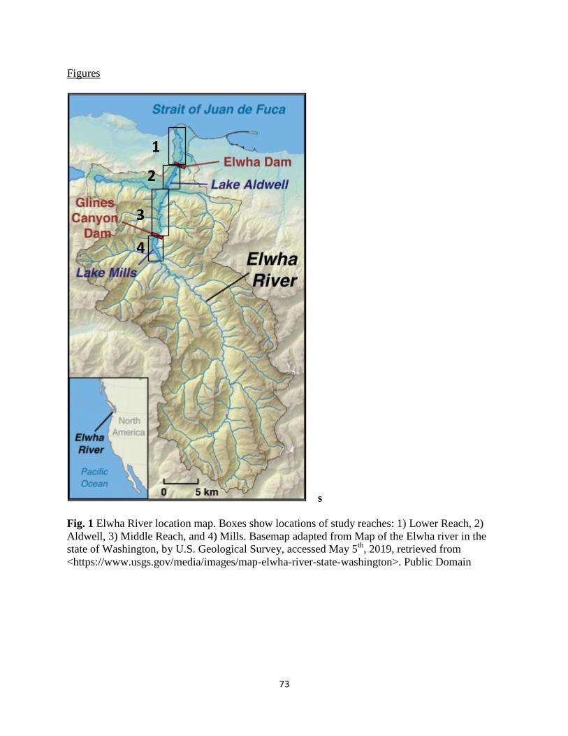
73
Figures
s
Fig. 1 Elwha River location map. Boxes show locations of study reaches: 1) Lower Reach, 2)
Aldwell, 3) Middle Reach, and 4) Mills. Basemap adapted from Map of the Elwha river in the
state of Washington, by U.S. Geological Survey, accessed May 5th
, 2019, retrieved from
<https://www.usgs.gov/media/images/map-elwha-river-state-washington>. Public Domain
1
4
3
2

74
Fig. 2 Study area map showing forest cover (tan), the mainstem river channel (green), side
channels (magenta), 2014 logjam locations (black dots), and boundaries between the Lower
Reach, Aldwell, the Middle Reach, and Mills (black bars).
Elwha dam, rkm 7.4
Elwha dam, rkm 7.4
Glines dam, rkm 21.1
Hwy 101, rkm 12.1
Hwy 101, rkm 12.1

75
Fig. 3 Daily discharge measured at USGS station 12045500 Elwha River at McDonald Bridge,
near Port Angeles, WA for A) water years 2011-2016, and B) during the 3 stages of dam
removal.
dam removal period
A
B Stage 1 dam removal starts
Stage 2 Elwha dam spilling sediment
Stage 3 Glines Canyon Dam spilling sediment

76
A
B
C
Fig. 4 Comparison of logjam area measurements in the field and logjam area measurements from
air photos by: A) river km, B) river segment, and C) best fit line of y = 0.8216x + 22.87

77

78
Fig. 5 Logjam area by river kilometer before (pink/purple) and after dam removal (blue/green).
Data before dam removal only exists for the Lower Reach. The rapid logjam area increase in rkm
3 in 2008 was related to an avulsion of the main channel and side channels that widened and
developed channel-spanning logjams. After dam removal, all rkms in the Lower Reach showed a
gradual increase in logjam area. The largest accumulations of logjams after dam removal
occurred in rkm 11 and 12, on the upstream end of Aldwell.
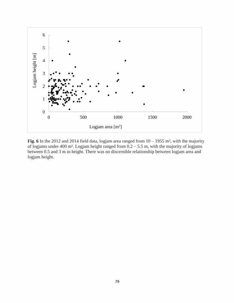
79
Fig. 6 In the 2012 and 2014 field data, logjam area ranged from 10 – 1955 m², with the majority
of logjams under 400 m². Logjam height ranged from 0.2 – 5.5 m, with the majority of logjams
between 0.5 and 3 m in height. There was no discernible relationship between logjam area and
logjam height.
0
1
2
3
4
5
6
0 500 1000 1500 2000
Logja
m h
eight
[m]
Logjam area [m2]

80
Fig.7 Travel distance between 2012 and 2015 for individually marked pieces of wood.
B

81
Fig. 8 Logjams area by type and position in the study area. Channel spanning logjams are most
common in rkm 3 and logjams anchored by stumps are most common in rkm 11 and 12. In 2014,
logjam area increased for logjams anchored by stumps and decreases in channel spanning
logjams.
0
500
1000
1500
2000
2500
3000
3500
4000
4500
5000
0 5 10 15 20 25
Logja
m a
rea
[m2]
River km
2012 Logjam types Bar apexchannel spanningBouldersStumpsMeanderKey piecesLive treesDrift / bar topBridge pier
0
1000
2000
3000
4000
5000
0 5 10 15 20 25
Logja
m a
rea
[m2]
River km
2014 logjam types Bar apexChannel spanningBouldersStumpsMeanderKey piecesLive treesDrift / bar top
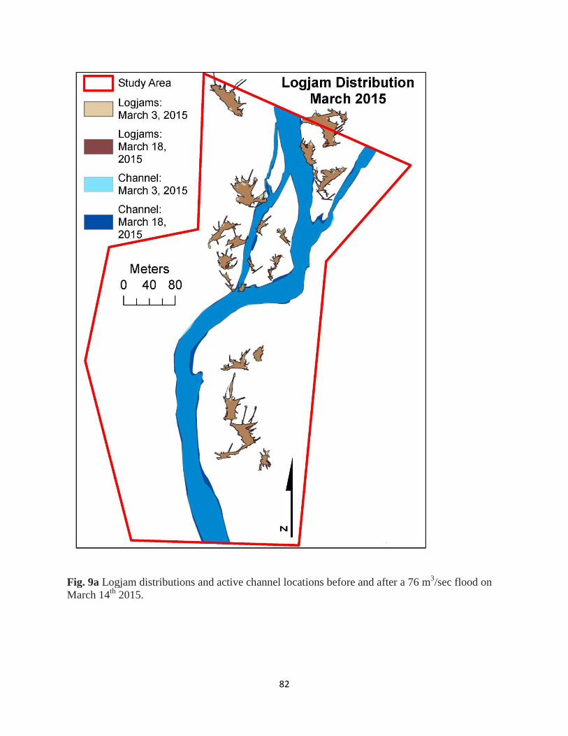
82
Fig. 9a Logjam distributions and active channel locations before and after a 76 m3/sec flood on
March 14th
2015.

83
Fig. 9b Logjam distributions and active channel locations before and after a 297 m
3/sec flood on
Sept. 29th
, 2013

84
Fig. 9c Logjam distributions and active channel locations before and after an 230 m3/sec flood
on Feb. 16th
, 2016.

85
Fig. 9d Logjam distributions and active channel locations before and after a 733 m3/sec flood on
Nov. 17th
, 2015.
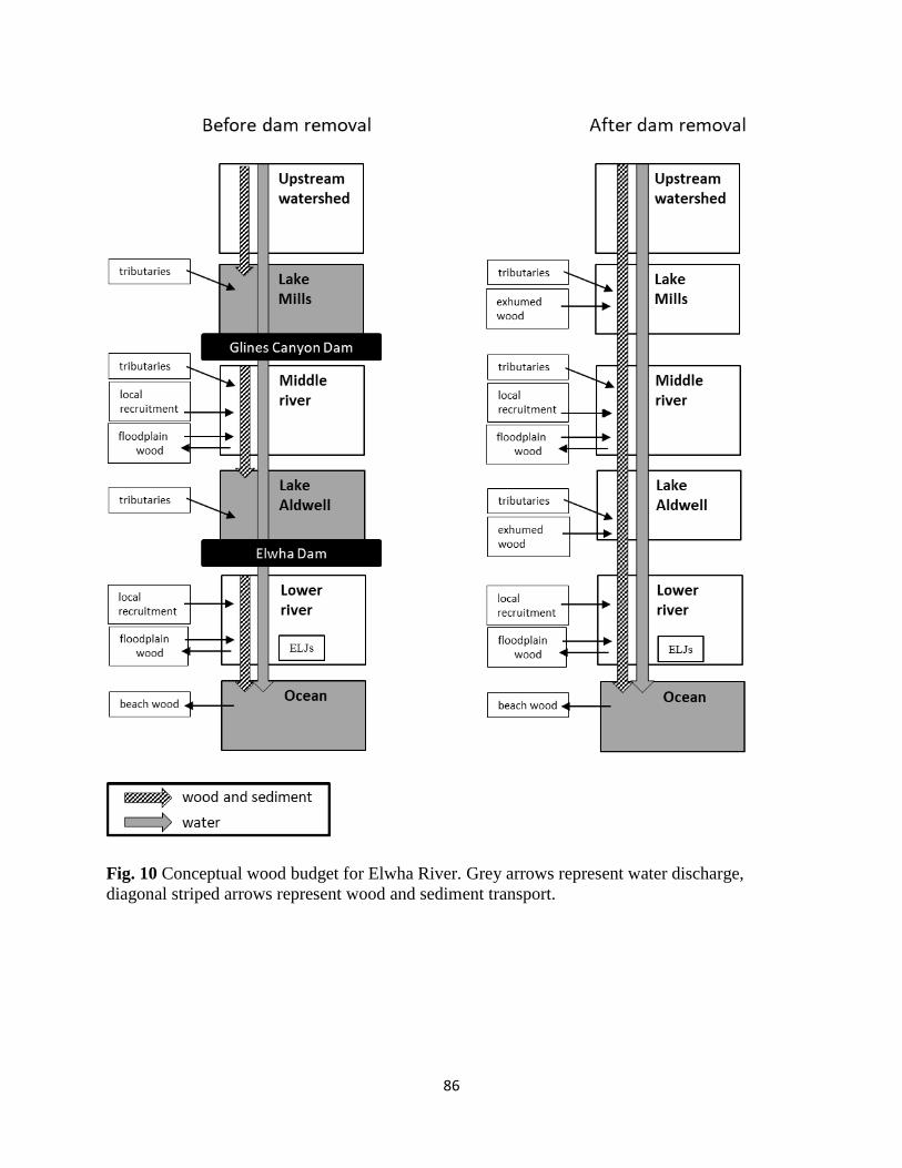
86
Fig. 10 Conceptual wood budget for Elwha River. Grey arrows represent water discharge,
diagonal striped arrows represent wood and sediment transport.

87
Tables
River reach Logjams 2012
[m2/rkm]
Logjam 2016
[m2/rkm]
Logjam area/rkm
% increase
Lower Reach 1,987 5,440 174
Aldwell 1,987 6,854 245
Middle Reach 478 2,386 399
Mills 72 2,510 3,386
Table 1. Logjam area per rkm in 2012 and 2016 by river reach.

88
Ch. 4 Flume experiments on the effects of buried wood debris on delta processes and
sediment exhumation during a phased base-level drop
V. Leung*1,2
, D. C. Mohrig3, J. L. Buttles
3, J. P. Johnson
3, D. R. Montgomery
1
1 University of Washington, Dept. of Earth and Space Sciences, Seattle, WA, USA
2 University of Richmond, Department of Geography and the Environment, Richmond, VA,
USA
3 University of Texas at Austin, Jackson School of Geosciences, Austin, TX, USA
*corresponding author: [email protected]
Abstract
The interactions between large woody debris, fluid flow and sediment transport in rivers
are a first-order control on river processes, affecting channel roughness, streambed morphology
and sediment transport. While there has been a large body of research on how wood debris
interacts with channel morphodynamics there has been very little research on how wood affects
dam removals. We use flume experiments to investigate the effects of buried wood on delta
during staged base level drops, similar to the phased Glines Canyon dam removal on the
Elwha River. Experimental runs with buried wood show significant changes in delta
morphodynamics compared to the control experimental run with only sediment, including
increases in channel roughness, channel mobility, the number of active channels on the delta, and
delta area. Ecologically, this suggests that increased wood loading leads to increases in aquatic
habitat quality and quantity with increased cover, increased depth variability, more logjams and
pools, increased channel-edge length, and greater delta area.

89
Introduction
Dam removals have become an increasingly common alternative for older unsafe or
obsolete dams that also provides a way to rehabilitate river ecosystems (Cheng and Granata,
2007; Duda et al., 2011; Major et al., 2012; Pizzuto, 2002; Tsutsumi and Laronne, 2017). Often
these dams have significant amounts of sediment and, in forested watersheds, wood debris stored
in the reservoirs (Duda et al., 2011; Pearson et al., 2011; Walter and Merritts, 2008). Much of the
modeling, experimental and field studies of dam removals has focused on how sediment will be
evacuated during and after dam removal (Bromley, 2008; Cui et al., 2014; Pizzuto, 2002;
Sawaske and Freyberg, 2012). Numerical and experimental modeling on dam removals have
suggested that as reservoir water level drops during a dam removal, a single channel will incise
rapidly, with a knickpoint that moves upstream (Cantelli et al., 2004). In staged dam removals,
during the stages where a reservoir pool remains behind the dam, a delta forms on the upstream
end of the reservoir pool. These models and theories have thus far not taken into account the
interactions between wood debris, sediment and rapidly falling base level that would occur
during a dam removal. While there has been a large body of research on how wood debris
interacts with channel morphodynamics (Collins et al., 2012; Comiti et al., 2016; Gurnell et al.,
2002; Montgomery and Abbe, 2006; Wohl, 2017), there has been very little research on how
wood affects dam removals (Pearson et al., 2011; Tsutsumi and Laronne, 2017; Warrick et al.,
2015) or delta morphodynamics (Huff, 2015; Phillips, 2012).
Here we report the results of a set of physical experiments that explored how exhumed
wood debris affects delta morphodynamics during a phased base level drop. We identify some of
the key changes in channel mobility and delta morphodynamics related to wood debris that
90
affects delta planform and habitat quality. These experiments, which are broadly based upon the
multi-stage removal of the Glines Canyon Dam on the Elwha River, provide a way to isolate the
effect of wood debris on delta morphodynamics in a net erosional, falling base level system.
Dam removal and drainage of the reservoir (Lake Mills) occurred through a multi-stage removal
process over three years, in order to protect downstream infrastructure, protect downstream
anadromous fish populations during more susceptible life stages, and evacuate as much sediment
as possible during the dam removal process (Ward et al., 2008). Sediment management
predictions for the Glines Canyon dam removal were that a single channel would incise rapidly
as water level dropped. Several ‘hold periods’, with constant water level, were planned so that
the channel had time to erode laterally across the reservoir pool delta and remove more sediment
(Bromley, 2008; Randle and Bountry, 2010). Our experiments are an idealized and simplified
model of the first phase of dam removal, during which partial sections of the dam were removed,
followed by 2-4 week ‘holding periods’ when the lake (reservoir) level was held constant. In this
phase of dam removal suspended sediment was transported over the dam but bedload sediment
transport mostly stayed within the reservoir.
These experiments were designed to investigate the effects of wood debris on channel
dynamics and delta planform during a partial dam removal and focus on the interactions between
wood, sediment and water in natural rivers. While the experiments are broadly based on the
phased baselevel drops during the Glines Canyon dam removal on the Elwha River, these
experiments are simplified analog models, where none of the runs were intended to replicate
details of actual conditions.
Background
91
There is very limited field data on the effects of woody debris on dam removals and
reservoir erosion (Tsutsumi and Laronne, 2017). In the Merrimack Village Dam removal on the
Souhegan River (New Hampshire), large woody debris was recruited from vegetated reservoir
banks as the channel widened (Pearson et al., 2011). This woody debris induced minor amounts
of sediment deposition, forming a pool and a riffle, and initiating point bar deposits. During later
high flows, the woody debris armored banks, limiting channel widening (Pearson et al., 2011).
During the planning process for the Elwha River dam removals, the adaptive sediment
management plan for the removal included provisions to increase erosion using high-pressure
hoses if woody debris were to induce bank armoring (Randle and Bountry, 2010). Woody debris
and in-place stumps exhumed during the dam removal process contributed to increases in logjam
area downstream of the dams (Warrick et al., 2015). We are unaware of any experimental
research on the effects of woody debris on dam removal morphodynamics.
Similarly, there is very little research on how woody debris interacts with delta
morphodynamics, although there is a small amount of research on how woody debris interacts
with estuaries. On the Brazos River (Texas), Huff (2015) found that woody debris stabilized
delta morphology by decreasing longshore transport. Areas of the delta with a volumetric
concentration of woody debris greater than 0.4 resulted in delta progradation rather than erosion
(Huff, 2015). On the San Antonio River delta (Texas), Phillips (2012) found that channel
spanning logjams sometimes displaced flow and triggered crevasses but that a large recurring
logjam at an ongoing avulsion was not the cause of the avulsion. In estuaries, Gonor et al. (1988)
theorized that woody debris affect local flow patterns, created riffles, and provided cover in
estuaries. In the Snowy River estuary, Hinwood and McLean (2017) found that woody debris led
to very localized scour and sediment deposition but did not have large scale impacts on estuary
92
hydrology or geomorphology. They theorized that woody debris impacts were so low because
tidal channels in the estuary were wide and deep relative to the wood, water velocities were low,
and woody debris was deposited as single pieces, not in logjams. In an estuary restoration project,
Cornu et al. (2008) found that woody debris added to a tidal wetland redirected flow and caused
channel scour but it was unclear which changes would persist since woody debris in the project
moved upstream and downstream during extreme winter high tides. We are unaware of any
experimental research on the effects of woody debris on delta morphodynamics.
Woody debris may interact with channel morphodynamics in dam removals and deltas in
ways similar to wood debris interactions with channel form in rivers. River channel planform
and floodplain morphology affects a range of geomorphic and ecological characteristics,
including water and sediment routing, methods of channel migration and the structure and
abundance of riparian and aquatic habitats. Traditionally, river channel planform has been
explained by the physics of water and sediment discharge and floodplain cohesion. Recent
research has shown the influence of vegetation and large wood on river planform and floodplain
morphology (Collins et al., 2012; Gurnell et al., 2002; Montgomery and Abbe, 2006; Wohl,
2011). At a valley scale, stable wood and logjams accumulate sediment and can form the basis
for stable islands that divert flow, cause avulsions, and create an anastomosing river pattern
(Collins et al., 2012; Sear et al., 2010; Wohl, 2011). The multiple channels and stable islands in
anastomosing rivers result in increased diversity of hydrologic environments, geomorphic
features, hyporheic exchange, floodplain elevations, riparian environments and aquatic habitat.
Historical and field studies have shown that river channel planforms can change from
multichannel anastomosing to wider braided systems when riparian logging and removal of in-
channel wood occurs (Collins et al., 2012). These changes in river channel planform likely result

93
from loss of in-stream wood from direct removal and decreased wood recruitment and decreased
bank cohesion due to the loss of riparian trees. Flume experiments on vegetation in rivers have
demonstrated that riparian vegetation and root cohesion can create stable islands and multiple
narrower channels (Tal and Paola, 2007). When wood debris is introduced as well, flume
experiments suggest that island and bank stability increase even more (Bertoldi et al., 2015).
Methods
Each experiment started with a hand-built initial lakebed surface with a top set slope of
5.5° and a filled model lake (Fig. 1). Model wood was set in the lakebed in a quasi-horizontal
manner, mimicking the way wood sinking into a lakebed would deposit primarily horizontally,
by taking handfuls of mixed wet sediment and model wood and smoothing each handful down
onto the lakebed. Dam level and lake level in the experiments were controlled by removable
foam blocks set in the model dam. During each experiment base level was reduced by 3.5 cm,
and then the lake level was held constant during a 3-hour long ‘hold period’, followed by another
3.5 cm base level drop and subsequent 3 hour long holding time (Fig. 2). The foam blocks were
slowly removed by hand and attempts were made for all of the 1st base level drops to take
approximately 45 min. and all of the 2nd
base level drops to take approximately 23 min. During
hold periods, base water level was held constant, so the experimental delta behavior is more
analogous to natural deltas.
We report results from three experiments, the Sediment Only Run, the 2% Wood Run and
the 3.5% Wood Run, in which the only variable that differed was the amount of model wood
debris buried in the reservoir lakebed at the start of the experiment (wood percentages are
measured by percentage of the surface covered in wood). Historically, estuaries and deltas have

94
been places where extremely large log rafts have formed (Collins et al., 2003; Collins and
Montgomery, 2002). Logjams, rafts, and single pieces of wood are transported, deposited, and
remobilized differently from each other, but the amount of wood in historical records suggests
that the 2% and 3.5% wood debris used in the experiment are plausible. Fig. 3 shows similar
distributions of wood in the 2% Wood Run as compared to individual pieces of wood in Mills on
the Elwha River after dam removal. Wood in a lakebed is likely to have deposited more random
orientations than in fluvial reaches, since the wood floats around the reservoir before sinking to
the lakebed without being subjected to the currents and channel topography that affect logjam
formation. All channel and delta morphodynamics in the experiment are a result of sediment and
woody debris being reworked from the original initial surface as sediment and woody debris
were not fed into the upstream end of the experiment.
Data reported in this paper come from time lapse photography collected using an overhead
digital camera. Images were corrected for lens distortion. Upstream water discharge was mixed
with a blue dye source, allowing for color-based image classification of wetted channel area. Dye
intensity varied over time in the experiments. Channel occupation over time and channel
mobility was calculated based on mapping wetted channel area maps. Topography was measured
at 9 times in each experiment using a Keyence laser pointing vertically down, mounted on a
robotic cart set to a 2 mm by 2mm measurement grid for the Sediment Only Run and the 2 %
Wood Run, and a Leica C-10 LIDAR, set above and downstream of the experiment and pointed
obliquely towards the experiment, for the 3.5% Wood Run. Error associated with the Keyence
laser is +/- 300 microns and error associated with the Leica lidar is +/- 3 mm. The lasers
measured the surface of the sediment and model wood, which include any air gaps behind or
under model wood. Additionally, for the Sediment Only Run and the 2% Wood Run, any banks
95
that are under cut will not show in the topography scans. The flume was drained before each
topographic measurement.
The only differences between the experimental runs were the amount of buried wood in
the delta at the beginning of the experiments. All other variables were held constant. The
experiments thus show the effect of exhumed wood on channel and delta morphodynamics
during a rapid, phased base level drop.
Results
Each experiment developed two distinct sections: an upstream erosional section and a
depositional delta section. As model wood was exhumed during the experiments for the 2%
Wood and 3.5% Wood runs, some pieces would travel downstream and some would be partially
or completely exposed but remain in place. Some of the mobile pieces traveled directly to or past
the delta, some traveled downstream in multiple “hops”, and some agglomerated with other
pieces of wood to form logjams. Smaller logjams of 2 – 4 pieces were often less stable, unless
anchored by a piece that was partially buried in the channel bank. The 3.5% Wood Run rapidly
developed many small logjams in the fluvial section that grew into channel-spanning logjams.
The deltas in all three experiments were more mobile than the upstream fluvial channels, and
logjams on deltas tended to be smaller and less stable than logjams in the fluvial sections.
The upstream erosional channel had different channel cross-section shapes in the three
experiments. The Sediment Only Run and the 2% Wood Run had more rectangular cross-
sections while the 3.5% Wood Run had more rounded channel cross-sections (Fig. 4). Compared
to the Sediment Only Run, channels were wider in the 2% Wood Run, and narrower and deeper
in the 3.5% Wood Run (Fig. 4, Fig. 5).

96
A significant morphologic difference between the three experimental runs arose in the
number of bifurcations and channels on the delta surface. In the Sediment Only Run a single
main channel developed on the delta for the majority of the experiments (Fig. 5A). There were
only two instances where the channel bifurcated, once during the first dam segment removal and
again during the second dam segment removal. In the 2 % Wood Run and the 3.5 % Wood Run
bifurcations were extremely common, with multiple channels on the delta surface for the
majority of the experiments (Fig. 5B, 5C). The 2 % Wood Run fluctuated between one to five
channels on the delta surface and the 3.5 % Wood Run fluctuated between one to six channels on
the delta surface. Multiple channels were common starting from about halfway through the first
dam segment removal and continuing through both hold periods and the second dam segment
removal. These channels concentrate flow and sediment deposition, leading to “lobe-ier” deltas
in the experiments with wood (Fig. 5).
A major difference between the three experimental runs was in the amount and type of
channel mobility. Fig. 6 shows the changes in wetted area between time steps. The Sediment
Only Run’s lateral channel mobility primarily comes about through incremental lateral bank
erosion, shown in Fig. 6 as a lower level of wetted area change per time. The 2 % Wood and 3.5 %
Wood runs have lateral channel mobility that includes both incremental lateral bank erosion as
well as abrupt avulsions and bifurcations creating new channels. Fig. 6 shows a higher overall
level of wetted area change for both wood runs, as well as spikes corresponding to major
avulsions and new channels being created. Additionally, the amount of time that different parts
of the delta are covered in channels varies greatly by experiment. Channel occupation maps of
the last 90 min. of the second hold period (Fig. 7) show that in the Sediment Only run there is a
single main channel and it stays predominantly in the same section of the delta during this time

97
period. Conversely, for the 2% and 3.5% Wood runs there are multiple narrower channels that
migrate often and cover a much greater fraction of the total delta area (Fig. 7).
In these experiments abrupt channel movements correlate with wood movement. In the
Sediment Only Run the single main channel moved slowly, sweeping side to side across the delta
during the hold periods. Figure 7, which includes data from the last 90 min. of the 2nd hold
period, shows that in the Sediment Only Run the main channel stayed primarily in the same
location on the delta during that entire time period. In contrast both the 2 % Wood Run and the
3.5 % Wood Run exhibited more frequent channel movements (Fig. 6) that covered a larger
fraction of the delta (Fig. 7). These larger, abrupt channel migrations correlated to wood debris
movement, as individual pieces of wood debris moving downstream affect thalweg position and
channel location. Pieces of wood debris often deflected flow across the channel or caused flow
divergences that created islands in the flow or a channel bifurcation. When that wood debris was
eroded there were no longer any obstacles causing flow deflection or flow divergence at that
location, which often led to a change in the thalweg position or channel planform. Similarly
when pieces of wood debris deposited in a new location there were thalweg and channel
planform changes that initiated from the flow deflections and divergences caused by the wood in
the new location. In certain circumstances there was enough accumulated sediment from the
original flow divergences that the channel planform continued to be directed by the topographic
changes even after the wood debris was eroded. In the upstream fluvial section during the last 90
min. of the second hold period, the 3.5 % Wood Run had no wood debris movement while the 2 %
Wood Run had pieces of wood debris that eroded and deposited within the section. Fig. 7 shows
that the upstream erosional section was extremely stable in the 3.5 % Wood Run with almost no
channel movements while the 2 % Wood Run had a considerable amount of channel shifting.
98
The 3.5 % Wood Run also had stable wood debris that correlated with the most stable
channel planform. The upstream erosional section of the 3.5 % Wood Run had almost no wood
movement during the last 90 min. of the 2nd hold period and the channel stayed in effectively the
same location during that entire time (Fig. 7). At 55 min. into the 1st hold period a channel
spanning logjam formed at the upstream end of the delta. For the remainder of the first hold
period that logjam stayed intact and there was effectively no wood movement on the delta
surface downstream of the logjam. There were two channels on the delta that bifurcated from the
channel spanning logjam when it first formed. These two channels fluctuated in width and very
occasionally had small, ephemeral offshoot channels that developed during the remainder of the
first hold period but primarily stayed in the same location and did not form any major
bifurcations. During the second dam segment removal the two pre-existing delta channels both
prograded as base level fell (Fig. 8C). Both channels had secondary bifurcations and avulsions
that formed as wood debris was exhumed from the delta surface but the upstream delta channel
planform stayed stable throughout the dam segment removal and into the 2nd hold period until a
newly exhumed piece of wood debris blocked of the left-hand channel of the main bifurcation.
Discussion
Woody debris interactions with channel shape and distribution
Experimental runs with wood debris exhibited increased roughness affecting sediment
transport, modes of channel mobility, and overall channel behavior and delta planform. Increased
amounts of exhumed wood led to increased channel roughness, both directly from individual
pieces of woody debris and indirectly from increased channel splitting in the runs with woody
debris (Fig. 9). The increased roughness led to increased flow deflection, channel bifurcation,

99
and avulsion, resulting in a more mobile, multithreaded delta planform pattern. Individual pieces
of wood and small logjams caused both local sediment accumulation immediately downstream
and sharp deflections of the thalweg across the active channel. These effects cumulatively
increased the number of bifurcations and avulsions. The amount of lateral bank erosion also
increased as the thalweg was directed toward banks for a much greater percentage of time.
Together this means that even though the overall system is incisional, with falling base
level, a steady discharge and no upstream sediment inputs, conditions where we would normally
expect relatively immobile incising channels on the delta, channels instead rapidly avulsed
across the delta. Every time pieces of wood move downstream or logjams formed, broke up,
gained or lost pieces, changes in the pattern of local sediment accumulation and thalweg location
resulted in much more dynamic and active channel systems. Conversely, when wood did not
move, channel planform generally did not change. The largest and most stable logjam in the
experiments, a channel spanning logjam in the 3.5 % Wood Run, was able to control flow at a
bifurcation even in an active, incising system. Delta area also grew faster with the increased
channel mobility and avulsions creating channels angled away from the original channel (Fig. 8).
Channel cross-sections in the upper erosional channel were narrower and deeper in the
3.5% Wood Run but wider in the 2% Wood Run, in comparison to the Sediment Only Run (Fig.
4). Previous field and flume experiments showed that individual pieces of wood can deflect flow
and erode both downwards into the streambed and laterally into streambanks (Ch. 1). When there
is less wood in the channel, most small logjams or individual pieces not in contact with other
pieces of wood tend to deflect flow laterally across the channel. These flow deflections increase
the flow velocity directed towards channel edges and thereby increase channel width. As wood
concentration increases, individual pieces of wood and logjams also act to protect banks from

100
erosion by blocking high flow velocities from reaching the channel edge, resulting in narrower
channel widths. These experiments are all net erosional in the fluvial channel section, as there
was no sediment fed into the upstream end of the experiment. If a high enough spatial density of
wood is protecting channel banks from erosion, the channels also deepen as the streambed
becomes easier to erode than channel banks. In these experiments wood was placed quasi-
horizontally to correspond to the most likely wood orientations in nature for waterlogged wood
sinking onto a lakebed. It is likely that logs buried in floodplains are also mostly horizontal as
most wood is transported downstream and deposited individually or in logjams horizontally. As
such, eroding and un-burying a piece of wood on the streambed requires scouring vertically
down to the depth of the trunk or root diameter. Eroding and un-burying a piece of wood
laterally from a streambank requires scouring the entire length of the tree trunk.
Implications for ecology, dam removals, and deltas
These experiments suggest significantly improved aquatic habitat as exhumed wood
concentration increases. Logjams correlate to the number of pools in the system, which is
important for fish feeding, and rearing, and as cold water refugia during summer low flow
conditions. Pools associated with logjams are especially useful for feeding fish as they combine
cover with proximity to food sources. The experimental runs with wood debris also show more
overall depth variability in the channel, contributing to more types of microhabitats and more
boundaries between different habitat zones, things important for creating productive feeding
zones (Fig. 10). The increased number of channels on the delta translates to an increase in the
total length of channel edges, an important aspect of aquatic habitat as they typically combine
cover, slower flow and proximity to multiple food sources. Similarly, reaches with more wood

101
had greater total shoreline lengths, leading to more shoreline edge habitat. Finally the total delta
area increases as exhumed wood percentage increases so the total habitat area also increases.
These experiments suggest that future dam removals may experience increased lateral
delta erosion in reservoir sediments, if sufficient amounts of wood are stored in the
impoundment. Depending on reservoir geometry, increased lateral erosion during dam removal
can result in the erosion of 40% or more of impounded sediments (Tsutsumi and Laronne, 2017).
In some cases, sediment management goals may be to decrease rates of sediment evacuation in
order to remediate contaminated sediment (U.S. Environmental Protection Agency, 2004). In the
case of the Elwha River Restoration, sediment management goals for the dam removals included
eroding and redistributing coarse delta sediments over the reservoir so that the resulting
floodplain topography would be stable and suitable for new plant growth (Randle and Bountry,
2010). The sediment management plan included the removal of a logjam to increase lateral
erosion and adaptive management criteria to erode islands and break up channel bed armoring
with high-pressure hoses. The sediment management team was particularly concerned that
woody debris exhumed from the reservoir would armor channel banks and prevent lateral
erosion (T. Randle and J. Bountry personal communication 2011). Unfortunately it is difficult to
estimate the volume of a woody debris buried in a reservoir without extensive coring or
geophysical surveys of reservoir deposits (Tsutsumi and Laronne, 2017). In some cases the
amount of woody debris in a reservoir can be estimated based on the amount of floating wood in
a reservoir or based on woody debris exposed during a reservoir drawdown (Chenoweth et al.,
2011). In such cases, woody debris interactions with dam removal morphodynamics may be
considered during sediment management planning for dam removals.

102
These experiments suggest that woody debris can have an important role in delta
morphodynamics, affecting channel planform, sediment routing, and delta evolution. In the case
of incisional systems with dropping base level, woody debris can create multiple channels on a
delta (Fig. 5) instead of a single channel incising into delta deposits (Cantelli et al., 2004).
Woody debris increases bar formation, channel bifurcations, and avulsions, leading to lateral
channel mobilitiy (fig. 6) and wider deltas (Fig. 8). These patterns are similar to how woody
debris interacts with fluvial systems, with woody debris increasing the number of active channels
(Collins et al., 2012; Sear et al., 2010; Wohl, 2011) and facilitating bar and island formation
(Abbe and Montgomery, 1996; Bertoldi et al., 2015; Collins et al., 2012). Understanding
interactions between woody debris, sediment transport, and delta channel networks is important
for predicting delta evolution and for planning delta restoration projects that aim to reduce
coastal flooding (Kim et al., 2009; Paola et al., 2011) or create new habitat (Cornu et al., 2008).
Limitations
These experiments were run at a constant discharge, without sediment fed into the system.
Experimental conditions are most similar to staged dam removals taking place during low
discharges. Dam removals often occur during these times, so that the removal is more controlled
but oftentimes other scheduling constraints, such as fish migrations, result in dam removals
occurring during higher or more variable discharges (Tsutsumi and Laronne, 2017). Wood
mobilization is most likely to happen by mobilization of in-channel wood and from wood
recruited from the floodplain and floodplain forest as avulsions occur. Wood recruitment from
local bank erosion also increases as discharge increases. Wood that was stored in the floodplain
can be remobilized as scour and erosion occur. Once in motion, wood transport distances are
103
greater than during low flow, as increased water depth reduces the amount of contact in transit
wood has with streambed topography. In-flux wood is much more likely to interact with
floodplain vegetation during high discharges. During higher discharges, sediment transport and
changes in channel form are greater than during lower discharges. The amount of the floodplain
that interacts with the active channel is likely to increase, both from overbank flow and from
increased flow in side channels and abandoned channels. Wood flux generally increases as
discharge increases. Wood flux during floods is often supply limited (Comiti et al., 2016), so
increases in wood transport are highly dependent on upstream conditions, particularly whether
there are landslides on forested hillslopes. Depending on the increase in wood flux, wood
transport may be congested (Braudrick et al., 1997), leading to more trees uprooted from the
floodplain and greater deposition of wood levees that constrain channel flow (Johnson et al.,
2000). Bertoldi et al. (2015) found that at constant discharges in flume experiments, the amount
of wood stored in the channel depends on log input rate, with a non-linear threshold effect, in
which the amount of stored wood increased sharply when larger logjams start to form. At peak
discharge, mobile wood will deposit only in the most stable locations, creating more large
logjams. As larger logjams are more stable, they can deflect larger amounts of flow farther
laterally, and may increase the number and spacing of active channels. The logjam and channel
planform changes during the largest floods are most likely the upper limits of channel mobility
and channel distribution changes possible in the system.
In these experiments, sediment primarily travelled as bedload, with a barely detectable
amount of sediment traveling as suspended load. As a consequence, delta dynamics are
dominated by delta top and delta front progradation, with very little of the prodelta developed.
The delta front is very steep, at the angle of repose, at almost all times in the experiment. In

104
contrast, natural systems have a considerable amount of suspended load. Turowski et al. (2010)
found that often 0 - 50% of sediment is transported as bedload in natural systems, with high
variability between events and years, and that the percentage of sediment traveling as bedload
increased during floods (Turowski et al., 2010). These experiments also only used non-cohesive
sand, in contrast to natural systems which often contain a mix of cohesive and non-cohesive
sediments. Using simulations in Delft3D, van der Vegt et al. (2016) found that changes in the
percentage of bedload and suspended load transport, and the percentage of cohesive and non-
cohesive sediments affect delta shape, delta channel cross-sections, and avulsion frequency.
Bedload and non-cohesive sediment dominated deltas have a more extensive delta top with a
steeper delta front, while suspended load and cohesive sediment dominated deltas have a more
developed prodelta with a shallower delta front. Delta channels are shallower and wider on
bedload and non-cohesive sediment dominated systems, and deeper and narrower on suspended
load and cohesive dominated systems. Avulsions occur more frequently on bedload and non-
cohesive sediment dominated systems than on suspended load and cohesive sediment dominated
systems. Consequently, bedload and non-cohesive sediment dominated systems are reworked
more frequently and have a smoother delta contour. In suspended load and cohesive sediment
dominated systems, delta channels are able to extend farther over time, resulting in a more lobate
delta. Our experiments indicate that wood load also influences delta morphology.
The Sediment Only Run in these experiments does not have sediment fed in with the
water discharge, although sediment eroded from the erosional section travels to the depositional
delta section. Sediment grain size is also uniform in these experiments unlike in natural systems.
Consequently, channel mobility in these experiments is dominated by lateral bank erosion, with
very few avulsions or bifurcations. Wood debris greatly increases channel roughness, resulting in

105
increased topographic and hydraulic variability and heterogeneous sediment storage. Sediment
can accumulate in the lee of wood debris, leading to more bifurcations, avulsions and a more
lobate delta front. In a system with wood debris that is also suspended load or cohesive sediment
dominated, there would likely be a more developed prodelta than in a bedload, non-cohesive
sediment, or bedload, non-cohesive sediment, and wood debris dominated system but a less
developed prodelta than in a suspended load or cohesive sediment dominated system without
wood debris. Bifurcations and avulsions would be less frequent than in bedload, non-cohesive
sediment, or bedload, non-cohesive sediment, and wood dominated systems, leading to a more
lobate delta planform. Channel cross sections shape and delta top growth rates would likely be
between that of bedload or noncohesive sediment and suspended load or cohesive sediment
dominated systems.
Conclusions
This investigation provides insight into channel development, delta morphodynamics, and
physical processes related to wood debris during base level drops, such as in dam removals or
reservoir drawdowns. In the upstream erosional sections, channel cross-sections are shallower,
wider, and less stable when there is a small amount of wood debris, and deeper, narrower, and
more stable when there is a large amount of wood debris. Increased roughness from wood
deflected flow, increased hydraulic variability, and increased the number of bifurcations and
avulsions, resulting in a more mobile, multi-threaded delta planform. The largest and most stable
logjam in the experiments, a channel spanning logjam in the 3.5 % Wood Run, was able to
control flow at a bifurcation even in an active, incising system. When there was wood in the
system, experimental deltas developed up to six delta channels that migrated rapidly laterally and

106
frequently bifurcated and avulsed. In contrast, the single main delta channel only slowly
migrated laterally and only bifurcated twice during the entire experiment. Several types of
physical aquatic habitat increased in the presence of wood, including hydraulic variability, pools,
side-channel habitat, channel edge habitat and delta shoreline habitat. The changes in channel
planform and channel mobility in these experiments suggest that wood debris can play an
important role in dam removal and delta morphodynamics, and should be considered in planning
for dam removals and delta restoration projects.
Acknowledgements
We thank Wonsuck Kim, Tim Randle, Jennifer Bountry, Mike McHenry, and George Pess for
discussions of these experiments. This work was supported in part by the NSF Graduate
Research Fellowship Program.
Bibliography
Abbe, T.B., Montgomery, D.R., 1996. Large woody debris jams, channel hydraulics and habitat
formation in large rivers. Regulated Rivers: Research & Management 12, 201–221.
Bertoldi, W., Welber, M., Gurnell, A.M., Mao, L., Comiti, F., Tal, M., 2015. Physical modelling
of the combined effect of vegetation and wood on river morphology. Geomorphology
246, 178–187. https://doi.org/10.1016/j.geomorph.2015.05.038
Braudrick, C.A., Grant, G.E., Ishikawa, Y., Ikeda, H., 1997. Dynamics of wood transport in
streams: A flume experiment. Earth Surface Processes and Landforms 22, 669–683.
https://doi.org/10.1002/(SICI)1096-9837(199707)22:7<669::AID-ESP740>3.0.CO;2-L
Bromley, J.C., 2008. The morphodynamics of sediment movement through a reservoir during
dam removal (PhD). University of Nottingham, United Kingdom.
Cantelli, A., Paola, C., Parker, G., 2004. Experiments on upstream-migrating erosional
narrowing and widening of an incisional channel caused by dam removal: erosional
narrowing/widening of a channel. Water Resources Research 40, W03304.
https://doi.org/10.1029/2003WR002940
Cheng, F., Granata, T., 2007. Sediment transport and channel adjustments associated with dam
removal: Field observations: dam removal, sediment transport, and channel adjustment.
Water Resources Research 43. https://doi.org/10.1029/2005WR004271
107
Chenoweth, J., Acker, S.A., McHenry, M., 2011. Revegetation and Restoration Plan for Lake
Mills and Lake Aldwell. Olympic National Park and the Lower Elwha Klallam Tribe,
Port Angeles, WA.
Collins, B.D., Montgomery, D.R., 2002. Forest development, wood jams, and restoration of
floodplain rivers in the Puget lowland, Washington. Restoration Ecology 10, 237–247.
https://doi.org/10.1046/j.1526-100X.2002.01023.x
Collins, B.D., Montgomery, D.R., Fetherston, K.L., Abbe, T.B., 2012. The floodplain large-
wood cycle hypothesis: A mechanism for the physical and biotic structuring of temperate
forested alluvial valleys in the North Pacific coastal ecoregion. Geomorphology 139–140,
460–470. https://doi.org/10.1016/j.geomorph.2011.11.011
Collins, B.D., Montgomery, D.R., Sheikh, A.J., 2003. Reconstructing the historical riverine
landscape of the Puget lowland, in: Montgomery, D.R., Bolton, S., Booth, D.B., Wall, L.
(Eds.), Restoration of Puget Sound Rivers. University of Washington Press, Seattle and
London, pp. 79–128.
Comiti, F., Lucía, A., Rickenmann, D., 2016. Large wood recruitment and transport during large
floods: A review. Geomorphology 269, 23–39.
https://doi.org/10.1016/j.geomorph.2016.06.016
Cornu, C., van de Wetering, S., French, R., Gray, A., Lemke, J., Miller, B., 2008. Effectiveness
monitoring for LWD placement in South Slough tidal wetlands. Oregon Watershed
Enhancement Board, Salem, OR.
Cui, Y., Wooster, J.K., Braudrick, C.A., Orr, B.K., 2014. Lessons learned from sediment
transport model predictions and long-term postremoval monitoring: marmot dam removal
project on the Sandy River in Oregon. Journal of Hydraulic Engineering 140, 04014044-
1–16. https://doi.org/10.1061/(ASCE)HY.1943-7900.0000894
Duda, E.J.J., Warrick, J.A., Magirl, C.S., 2011. Coastal habitats of the Elwha River,
Washington—Biological and physical patterns and processes prior to dam removal (No.
2011–5120), Scientific Investigations Report. U.S. Geological Survey.
Gonor, J.J., Sedell, J.R., Benner, P.A., 1988. What We Know About Large Trees in Estuaries, in
the Sea, and on Coastal Beaches, in: From the Forest to the Sea: A Story of Fallen Trees,
USDA Forest Service General Technical Report GTR-PNW-229. USDA Forest Service,
Pacific Northwest Research Station, pp. 83–112.
Gurnell, A.M., Piégay, H., Swanson, F.J., Gregory, S.V., 2002. Large wood and fluvial processes.
Freshwater Biology 47, 601–619. https://doi.org/10.1046/j.1365-2427.2002.00916.x
Hinwood, J.B., McLean, E.J., 2017. Large wood in the Snowy River estuary, Australia.
Geomorphology 279, 209–225. https://doi.org/10.1016/j.geomorph.2016.10.023
Huff, S.A., 2015. Modeling the influence of large woody debris on delta morphology and
longshore sediment transport using the Brazos delta (Thesis). Rice University, Houston,
TX.
Johnson, S.L., Swanson, F.J., Grant, G.E., Wondzell, S.M., 2000. Riparian forest disturbances by
a mountain flood - the influence of floated wood. Hydrological Processes 14, 3031–3050.
https://doi.org/10.1002/1099-1085(200011/12)14:16/17<3031::AID-HYP133>3.0.CO;2-
6
Kim, W., Mohrig, D., Twilley, R., Paola, C., Parker, G., 2009. Is It feasible to build new land in
the Mississippi River delta? Eos Trans. AGU 90, 373–374.
https://doi.org/10.1029/2009EO420001
108
Major, J.J., O’Connor, J.E., Podolak, C.J., Keith, M.K., Grant, G.E., Spicer, K.R., Pittman, S.,
Bragg, H.M., Wallick, J.R., Tanner, D.Q., Rhode, A., Wilcock, P.R., 2012. Geomorphic
response of the Sandy River, Oregon, to removal of Marmot Dam (No. 1792), U.S.
Geological Survey Professional Paper.
Montgomery, D.R., Abbe, T.B., 2006. Influence of logjam-formed hard points on the formation
of valley-bottom landforms in an old-growth forest valley, Queets River, Washington,
USA. Quaternary Research 65, 147–155. https://doi.org/10.1016/j.yqres.2005.10.003
Paola, C., Twilley, R.R., Edmonds, D.A., Kim, W., Mohrig, D., Parker, G., Viparelli, E., Voller,
V.R., 2011. Natural processes in delta restoration: application to the Mississippi delta.
Annu. Rev. Mar. Sci. 3, 67–91. https://doi.org/10.1146/annurev-marine-120709-142856
Pearson, A.J., Snyder, N.P., Collins, M.J., 2011. Rates and processes of channel response to dam
removal with a sand-filled impoundment: rates and processes of channel response. Water
Resources Research 47. https://doi.org/10.1029/2010WR009733
Phillips, J.D., 2012. Log-jams and avulsions in the San Antonio River Delta, Texas. Earth Surf.
Process. Landforms 37, 936–950. https://doi.org/10.1002/esp.3209
Pizzuto, J., 2002. Effects of Dam Removal on River Form and Process. BioScience 52, 683.
https://doi.org/10.1641/0006-3568(2002)052[0683:EODROR]2.0.CO;2
Randle, T.J., Bountry, J.A., 2010. Elwha River Restoration: sediment adaptive management.
Presented at the 2nd Joint Federal Interagency Conference, Las Vegas, NV.
Sawaske, S.R., Freyberg, D.L., 2012. A comparison of past small dam removals in highly
sediment-impacted systems in the U.S. Geomorphology 151–152, 50–58.
https://doi.org/10.1016/j.geomorph.2012.01.013
Sear, D.A., Millington, C.E., Kitts, D.R., Jeffries, R., 2010. Logjam controls on
channel:floodplain interactions in wooded catchments and their role in the formation of
multi-channel patterns. Geomorphology 116, 305–319.
https://doi.org/10.1016/j.geomorph.2009.11.022
Tal, M., Paola, C., 2007. Dynamic single-thread channels maintained by the interaction of flow
and vegetation. Geology 35, 347–350. https://doi.org/10.1130/G23260A.1
Tsutsumi, D., Laronne, J.B. (Eds.), 2017. Gravel-bed rivers: processes and disasters, First edition.
ed. John Wiley & Sons, Chichester, UK ; Hoboken, NJ.
Turowski, J.M., Rickenmann, D., Dadson, S.J., 2010. The partitioning of the total sediment load
of a river into suspended load and bedload: a review of empirical data: The partitioning
of sediment load. Sedimentology 57, 1126–1146. https://doi.org/10.1111/j.1365-
3091.2009.01140.x
U.S. Environmental Protection Agency, 2004. Milltown Reservoir sediments operable unit of the
Milltown Reservoir Clark Fork River Superfund Site - Record of Decision, part 1:
declaration.
van der Vegt, H., Storms, J.E.A., Walstra, D.J.R., Howes, N.C., 2016. Can bed load transport
drive varying depositional behaviour in river delta environments? Sedimentary Geology
345, 19–32. https://doi.org/10.1016/j.sedgeo.2016.08.009
Walter, R.C., Merritts, D.J., 2008. Natural streams and the legacy of water-powered mills.
Science 319, 299–304. https://doi.org/10.1126/science.1151716
Ward, L., Crain, P., Freymond, B., McHenry, M., Morrill, D., Pess, G., Peters, R., Shaffer, J.A.,
Winter, B., Wunderlich, B., 2008. Elwha River Fish Restoration Plan- developed
pursuant to the Elwha River Ecosystem and Fisheries Restoration Act, Public Law 102-
495, NOAA Tech. Memo. NMFS-NWFSC-90. U.S. Dept. Commer.

109
Warrick, J.A., Bountry, J.A., East, A.E., Magirl, C.S., Randle, T.J., Gelfenbaum, G., Ritchie,
A.C., Pess, G.R., Leung, V., Duda, J.J., 2015. Large-scale dam removal on the Elwha
River, Washington, USA: Source-to-sink sediment budget and synthesis. Geomorphology
246, 729–750. https://doi.org/10.1016/j.geomorph.2015.01.010
Wohl, E., 2017. Bridging the gaps: An overview of wood across time and space in diverse rivers.
Geomorphology 279, 3–26. https://doi.org/10.1016/j.geomorph.2016.04.014
Wohl, E., 2011. Threshold-induced complex behavior of wood in mountain streams. Geology 39,
587–590. https://doi.org/10.1130/G32105.1
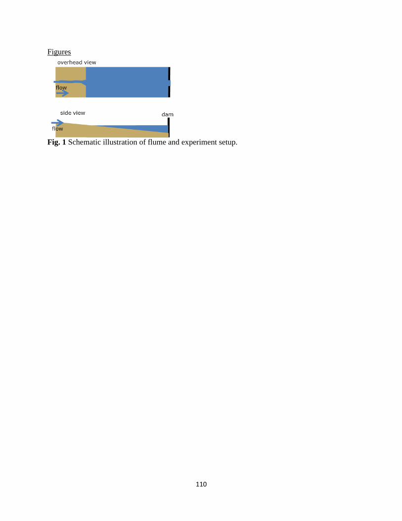
110
Figures
Fig. 1 Schematic illustration of flume and experiment setup.

111
Fig. 2 Variation in experimental lake levels over time during experimental runs.

112
Fig. 3 Comparisons between flume-scale and field-scale spatial patterns of wood distribution for:
A) 2% Wood Run and B) individual pieces of LWD in Mills on the Elwha River after dam
removal,
0 8.5 17 25.5 344.25Meters
20 cm
A B
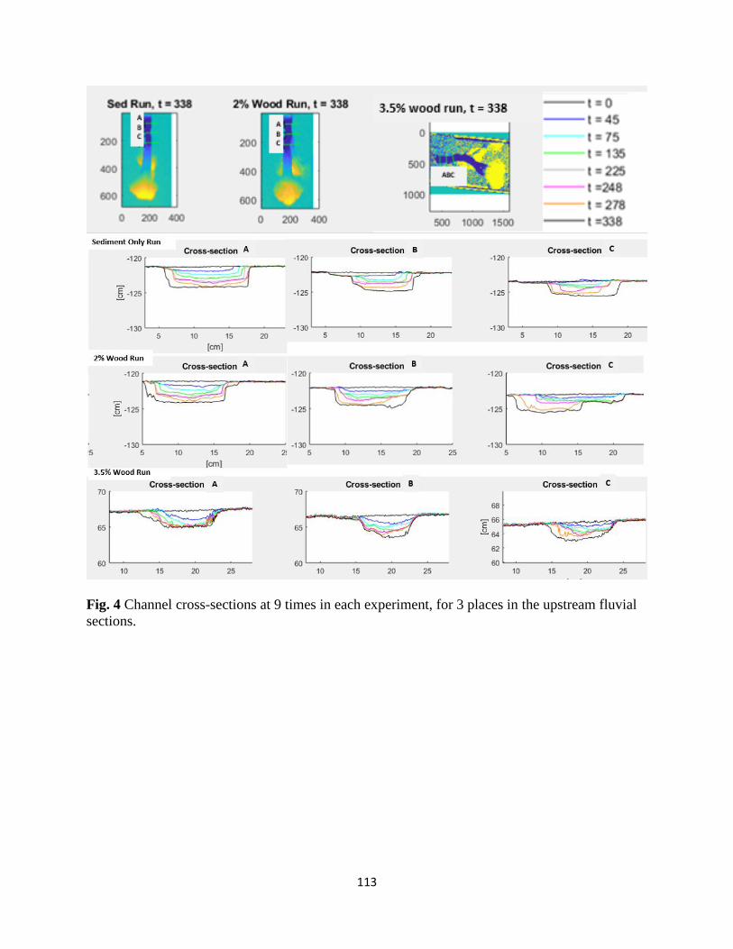
113
Fig. 4 Channel cross-sections at 9 times in each experiment, for 3 places in the upstream fluvial
sections.

114
A) Sediment Only Run
B) 2 % Wood Run
B) 3.5% Wood Run
Fig. 5 Channel and delta planform at specific times in the experiments, corresponding to times
that topography measurements were taken. Column A is the Sediment Only Run, column B is the
2% Wood Run and column C is the 3.5% Wood Run.

115
Fig. 6 Channel mobility during the last 90 minutes of the 2
nd hold period showing greater
channel mobility in the two experimental runs with exhumed wood debris. Change in wetted
channel area (by pixels) is plotted against time.

116
Fig. 6 Channel occupation maps of the last 90 min. of the 2nd
hold period. Black and dark grey
shows areas where the wetted channel is the majority of the time and light grey shows areas
where the wetted channel is for less of the time.

117
A) Sediment Only Run
B) 2 % Wood Run
C) 3.5% Wood Run
Fig. 8 Overhead photo sequences of the 2nd
dam segment removal, with photos taken every 6
minutes. The Sediment Only Run (column A) had a single main channel that prograded as base
level droped. The 2 % Wood Run (column B) had multiple channels that prograded
simultaneously as base level dropped. The 3.5 % Wood Run (column C) had a stable bifurcation
during the dam segment removal and both channels of that bifurcation prograded as base level
dropped. Additional channel bifurcations also developed farther along the delta as base level
dropped. The 3.5 Wood Run developed a significantly larger delta at the end of the 2nd
dam
segment removal as compared to the other two experimental runs.
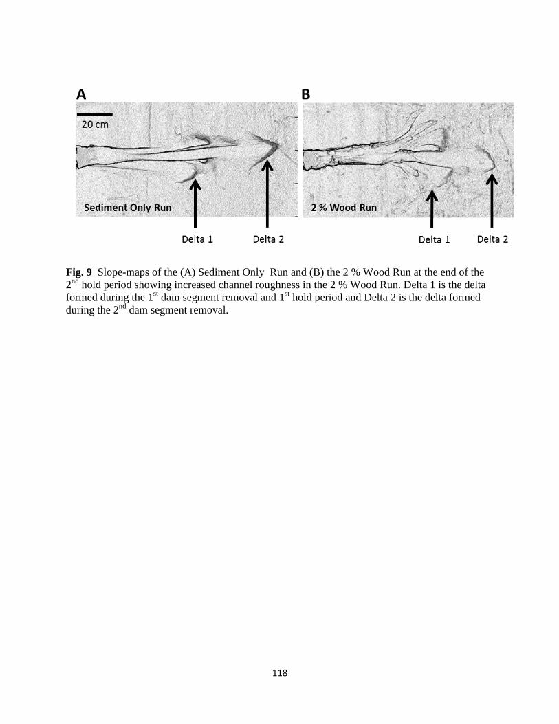
118
Fig. 9 Slope-maps of the (A) Sediment Only Run and (B) the 2 % Wood Run at the end of the
2nd
hold period showing increased channel roughness in the 2 % Wood Run. Delta 1 is the delta
formed during the 1st dam segment removal and 1
st hold period and Delta 2 is the delta formed
during the 2nd
dam segment removal.

119
Fig. 10 Overhead photos during the 2nd
hold period showing increased bifurcations and multiple
simultaneously occupied channels on the delta for the experimental runs with exhumed wood
debris. Experimental runs with exhumed wood show more pools, more logjam complexity, more
topographic depth variability, more channel edge lengths and more delta shoreline length.

120
Ch. 5 Conclusions
Woody debris interacts dynamically with river systems, creating pools, stabilizing
floodplains, and changing channel planform. In turn, wood mobility, deposition, and logjam
formation are affected by flow, sediment transport, and existing channel morphology. These
influences occur at multiple scales, from individual pieces of woody debris at reach scales, to
logjams, channel planform, and the evolution of deltaic systems. At the local level, the presence
or absence of roots is the main determinant for scour pool size. An individual piece of woody
debris with any type of root will create a larger scour pool than a piece of woody debris without
roots. The scour pool size is also correlated with the root cross-sectional area relative to flow. On
the Elwha River, logjams have developed unexpectedly rapidly on former reservoir surfaces after
dam removal. Logjam area has increased in all sections of the river downstream of the former
dam locations. In the Lower Reach, below both dams, logjam area increases after dam removal
are similar in magnitude to logjam area increases after an avulsion associated with a 40-year
flood. However logjam area only increased in the two rkm nearest to the avulsion, in contrast to
logjam area increasing after dam removal in every part of the river except for bedrock canyon
reaches. For reservoir sediment morphodynamics during dam removals and delta
morphodynamics, relatively small amounts of woody debris can have large effects on channel
plan form, channel mobility, and delta development. Woody debris can play an important role in
dam removals and delta morphodynamics and should be taken into consideration for dam
removals and delta restoration projects in forested regions. Flume experiments with woody
debris have up to six delta channels that avulse and migrate rapidly, in contrast to experiments
with only sediment where one main channel rarely bifurcates and migrates far more
slowly. Ecologically, this suggests that more woody debris leads to increases in aquatic habitat

121
quality and quantity with increased cover, increased depth variability, more logjams and pools,
increased channel-edge length, and greater delta area. Together, these results broaden the
geomorphic understanding of interactions between woody debris stability and transport,
sediment scour and transport, and flow hydraulics at scales from individual pools to the
evolution of deltaic systems.