The Global Energy Balance Archive (GEBA) version 2017: a ...

Tigray Livelihood Paper No. 9
Large-Scale Geological mapping of
the Geba basin, northern Ethiopia
Tesfamichael Gebreyohannes, Florimond De Smedt, Miruts Hagos,
Solomon Gebresilassie, Kassa Amare, Kurkura Kabeto,
Abdulwassie Hussein, Jan Nyssen, Hans Bauer,
Jan Moeyersons, Jozef Deckers, Mitiku Haile, Nurhussen Taha
March 2010
VLIR – Mekelle University IUC Program

2

3
Contents Abstract ......................................................................................................................................................... 5
1. Introduction ............................................................................................................................................... 5
2. Geology of northern Ethiopia ................................................................................................................... 9
2.1 General ............................................................................................................................................... 9
2.2 Flood basalt volcanics ...................................................................................................................... 12
2.3 Amba-Aradam Formation ................................................................................................................. 12
2.4 Antalo Supersequence ...................................................................................................................... 13
2.5 Adigrat Sandstone Formation ........................................................................................................... 14
2.6 Enticho Sandstone and Edaga Arbi Tillites ...................................................................................... 15
2.7 Metamorphic (basement) rocks ........................................................................................................ 17
3. Geological setting of the Geba basin ...................................................................................................... 19
3.1 Quaternary Deposits ......................................................................................................................... 22
3.2 Tertiary Volcanics and Doleritic rocks ............................................................................................. 23
3.2.1 Volcanic rocks ........................................................................................................................... 23
3.2.2 Dolerite sills and dykes ............................................................................................................. 25
3.3 Mesozoic sedimentary rocks............................................................................................................. 26
3.3.1 Upper Sandstone Formation ...................................................................................................... 26
3.3.2 Antalo Supersequence ............................................................................................................... 27
3.3.3 Transitional unit ........................................................................................................................ 29
3.3.4 Lower Sandstone Formation (Adigrat Sandstone) .................................................................... 30
3.4 Paleozoic sedimentary rocks............................................................................................................. 32
3.4.1 Edaga Arbi Tillites .................................................................................................................... 32
3.4.2 Enticho Sandstone ..................................................................................................................... 32
3.5 Precambrian rocks ............................................................................................................................ 33
3.5.1 Granitic Intrusion ...................................................................................................................... 33
3.5.2 Carbonate unit ........................................................................................................................... 34
3.5.3 Slates and Phyllites / Meta-sediments ....................................................................................... 34
3.5.4 Meta-conglomerate .................................................................................................................... 35
3.5.5 Meta-greywacke ........................................................................................................................ 35
3.5.6 Meta-volcanic/volcanoclastic rocks .......................................................................................... 35
4. Structural Setup of the Geba catchment .................................................................................................. 37
4.1 Negash Geosynclinal fold ................................................................................................................. 38
4.2 Foliations and Lineations .................................................................................................................. 39
4.3 Faults and Lineaments ...................................................................................................................... 39
5. Conclusions ............................................................................................................................................. 41
6. References ............................................................................................................................................... 43

4

5
Abstract
As part of the groundwater investigation of the Geba basin, a large scale geological mapping
campaign was undertaken to identify and characterize the existing lithological units and
structural setup. Additional information for the geological mapping was obtained from
topographic maps and aerial photographs from the Ethiopian Mapping Agency, and satellite
images from the Royal Museum for Central Africa in Tervuren, Belgium. The geology of the
basin is divided in to several unites. The basement rock is classified into six units i.e. Intrusive,
Meta-sediment, Meta-limestone, Meta-conglomerate, Meta-greywacke, and Meta-volcanic. The
Mesozoic sediments are divided in four groups: Upper Sandstone Formation, Antalo
Supersequence, Transition unit, and Lower Sandstone Formation. Two units of Paleaozoic
sediments are identified: Enticho Sandstone and Edaga Arbi Teillites, and two units of Tertiary
igneous rocks: Volcanics and Dolerite dyke/sill. Also two Quaternary deposits are described:
Alluvial sediments and Carbonate precipitates. Major geological structures are also mapped and
described. The most prominent are the Neoproterozoic Negash Geosyncline folds and foliations,
and the Neotectonic Wukro, Mekelle, and Chelekot fault belts.
Citation:
Tesfamichael G., De Smedt F., Miruts H., Solomon G., Kassa A., Kurkura K., Abdulwassie H.,
Bauer H., Nyssen J., Moeyersons J., Deckers J., Mitiku H. and Nurhussen T. (2010) Large-scale
geological mapping of the Geba basin, northern Ethiopia. Tigray Livelihood Paper No 9, VLIR –
Mekelle University IUC Program, 46 pp. ISBN 978-90-8826-134-3

6

7
1. Introduction
The Geba basin is one of the least investigated areas in Ethiopia in terms of geological
characteristics. Apart from the early days regional geological investigations by the Geological
Survey of Ethiopia, there have been some recent investigation mainly focusing on the
metamorphic terrains in the northern part of the catchment. Notable research has been made on
the basement rocks of the Mai Kinetal and Negash-Hawzen areas by Asrat (1997), Asrat et al.
(2001, 2003), Alene (1998), Alene et al. (1999, 2000a, 2000b, 2006), Berhe (1990), Beyth
(1972a), Beyth et al. (2003), and Kazmin et al. (1978), and on the sediments of the Mekelle
Outlier by Beyth (1972b), Bosellini et al. (1997), Worash and Valera (2001), and Sacchi et al.
(2007). Most of these studies focus on the interpretation of the mode of formation and evolution
and age of the rocks. To this end many of these studies made geochemical, isotope and
paleontological analysis on samples collected from the volcanic, basement, and sedimentary
rocks. These investigations have led to some useful information on the geological setting of the
region.
The geology of northern Ethiopia is further complicated by the abundance of Neoproterozoic to
Neotectonic structures such as folds, faults and shear zones, and lineaments. Hence, it is believed
that a geological mapping of the Geba basin, which encompasses all types of geological units
and the major geological structures of the region, will be of paramount importance for any kind
of natural resources investigation and more so for groundwater resources assessment.
We have made a major geological mapping campaign of the Geba basin during the period 2005-
2008. The basic objective of this campaign was to describe the various lithological units and to
characterize the structural setup of the basin with special emphasis to their role in controlling the
groundwater flow and storage. This campaign resulted in a digital geological map (in ArcGIS
shape and raster format) describing the lithology and geological structures in the Geba
catchment.
In order to derive a geological map of the basin, aerial photographs, orthophotos and topographic
maps (all on scale 1:50,000) were collected from the Ethiopian Mapping Agency. The

8
topographic maps date from 1996, and are based on aerial photographs taken in 1994. In addition
four, cloud free Landsat ETM+ satellite images of January 27 and February 5, 2000, were
received from the Royal Museum for Central Africa in Tervuren, Belgium. Base map preparation
and interpretation of the photographs and satellite images was undertaken before the field work.
There are 17 topographic sheets covering about 730 km2 each which fall fully or partly within
the Geba basin. In the western part of the catchment, near the Geba outlet, orthophoto maps were
used as there were no topographic maps for this area. Afterwards, field work was carried out for
a period of three years (2005 to 2007). Several selected traverses were investigated throughout
the Geba basin and over 100 rock samples were collected. Some 71 rock samples were sent to
the Ethiopian Geological Survey Central Laboratory in Addis Ababa for geochemical and
petrographic analysis, though the result of this analysis could not be included in the study as this
work was not finished yet. Field information was compiled in GIS using ArcView and ArcGIS
software to generate the geological map, which shows lithological units, major geological
structures, river drainage network, contour lines, bed/foliation orientation, infrastructures, and
catchment boundary.
9
2. Geology of northern Ethiopia
2.1 General
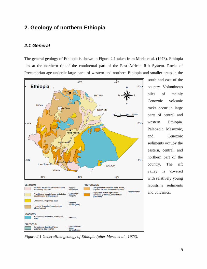
The general geology of Ethiopia is shown in Figure 2.1 taken from Merla et al. (1973). Ethiopia
lies at the northern tip of the continental part of the East African Rift System. Rocks of
Precambrian age underlie large parts of western and northern Ethiopia and smaller areas in the
south and east of the
country. Voluminous
piles of mainly
Cenozoic volcanic
rocks occur in large
parts of central and
western Ethiopia.
Paleozoic, Mesozoic,
and Cenozoic
sediments occupy the
eastern, central, and
northern part of the
country. The rift
valley is covered
with relatively young
lacustrine sediments
and volcanics.
Figure 2.1 Generalized geology of Ethiopia (after Merla et al., 1973).

10
According to Kazmin et al. (1978) there are three metamorphic complexes in Ethiopia, namely
the Lower, the Middle, and the Upper Complex. The Lower Complex, composed of high grade
gneisses, represents older cratonic basement and is exposed in southern Ethiopia. The Middle
Complex identified in the southern, eastern, and possibly in the western parts of Ethiopia, is
composed of clastic sediments and presumably is Lower to Middle Proterozoic platform cover.
The Upper Complex is the youngest metamorphic assemblage in Ethiopia consisting of low
grade rock successions of ophiolictic rocks, andesitic metavolcanics, and associated
metasediments, clastic and to lesser extent carbonate sediments (Kazmin, 1978). In terms of the
regional context, the low-grade metamorphic rocks of northern Ethiopia fall into the Arabian-
Nubian Shield category, while the medium to high-grade rocks of the south, west and east
Ethiopian metamorphic terrain fall into the Mozambique Belt.
Regional geological mapping of parts of northern Ethiopia by Levitte (1970) and Garland (1980),
and compilation work by Kazmin (1972), are standard references for the geology of the region.
These works describe the occurrence of widespread meta-volcanic and meta-sedimentary rocks
and mafic to felsic intrusions in the area, as part of the Upper Complex of Ethiopia (Kazmin,
1972). Within the Upper Complex, there are two major litho-stratigraphic groups, namely the
Tsaliet and Tamben Groups (Levitte, 1970; Garland, 1980). Other formations are only of local
importance.
Northern Ethiopia is characterized by highly diversified and laterally extensive coverage of
sedimentary rocks of varying genesis. The oldest and sparsely distributed Paleozoic sedimentary
rocks known as Enticho Sandstone and Edaga Arbi Tillites are exposed in several places in the
region. Edaga Arbi Tillite is the younger of the two and is well exposed in the Edaga Arbi village
between Abi Adi and Axum. Typical exposures of the tillit are also found around Abi Adi,
Wukro, Abreha-We-Atsbeha, and Hawzen areas. Enticho Sandstone is mainly exposed in
Enticho between Adigrat and Axum, but also around Adigrat, Senkata, and Atsbi. The other parts
are covered by Mesozoic sedimentary rocks. In northern Ethiopia the Mesozoic sedimentary
succession, unconformably overlying the Precambrian basement, forms a nearly circular 8,000
km2 area around Mekelle (Beyth, 1972b). The outlier is composed of a horizontal Triassic basal
clastic unit (Adigrat Sandstone), a Jurassic carbonate-marl-shale succession (Antalo

11
Supersequence), and an early Cretaceous
Sandstone (Amba-Aradam Formation). The
flood basalt of Tertiary age unconformably
overlies the sedimentary rocks, which in
places are intruded by a network of dolerite
sills and dykes (Bosellini et al., 1997).
Figure 2.2 shows the generalized
stratigraphic sequence of northern Ethiopia
with some degree of emphasis to the
Mekelle basin sediments and the flood
basalt volcanics of northern Ethiopia. The
stratigraphic sequence of northern Ethiopia
can, therefore, be summarized as follows:
1. Flood basalt volcanic;
2. Amba-Aradam (upper sandstone)
Formation;
3. Antalo Supersequence;
4. Adigrat Sandstone Formation;
5. Enticho Sandstone and Edaga
Arbi Tillites;
6. Metamorphic (basement) rocks.
Figure 2.2 Generalized stratigraphy of the Mekelle basin and northern Ethiopia flood basalt
province; compiled from Arkin et al. (1971), Beyth (1972b), and Merla et al. (1979).

12
2.2 Flood basalt volcanics
In the Lower Tertiary period, the region comprising the Red Sea, Gulf of Aden, and the
Ethiopian rifts, became the site of intense magmatic and tectonic activity. Hence, significant
flood basalts/trap series of volcanic rocks cover a large part of the geology of northern Ethiopia.
Lavas in these regions were extruded during the Oligocene, mainly between 31 and 26 Ma (Pik
et al., 1999; Ukstins et al., 2002). These are part of the larger Ethiopia/Yemen Igneous Province,
which is related to the Afar plume and the Red Sea-Gulf of Aden-Ethiopia triple junction.
Flood Basalt magmatism resulted in a basaltic lava pile of more than 2,000 m thick with an
estimated volume of 106 km
3 (Rochette et al., 1998). The upper parts of this pile are partly inter-
layered with rhyolitic volcanics (Ayalew et al., 2002; Kabeto et al., 2004). Traditionally, the
Ethiopian Flood basalt province is divided in to four stratigraphic units (Mohr and Zanettin,
1988), which are from bottom to top the Ashange, Aiba, Alage, and Termaber Formations
(Figure 2.2).
Flood basalt magmatism was succeeded during the Mio-Pliocene by rifting of the Afar region,
resulting in wide spread bimodal alkaline volcanism and crustal uplift. The rift-related uplift of
the Ethiopian plateau continues until today and has led to substantial erosion of the flood basalt
pile. In the northern part of the region (Tigray and Eritrea) only erosional remnants of flood
basalts are left and the sub-volcanic level is widely exposed. In the Mekelle region abundant
mafic sills (Mekelle Dolerites) occur within the Mesozoic to Paleozoic sedimentary strata
(Küster et al., 2005).
2.3 Amba-Aradam Formation
The sedimentary rocks of northern Ethiopia fall under two major episodes of deposition:
Paleozoic era and Mesozoic era. The major sedimentary deposition of the region, including the
south-eastern part of Asia, occurred during the wide geologic span of the Mesozoic era. The so-
called Amba-Aradam Formation is the youngest of all Mesozoic sedimentary rocks of the region
found unconformably overlying the Upper Jurassic sedimentary succession (Figure 2.2 and 2.3).
The same Upper Sandstone occurs in central Ethiopia (Blue Nile gorge) (Assefa, 1991), Eritrea

13
(Danakil Horst) (Hutchinson and Engels, 1970), and southeast Ethiopia (Harar plateau, Dire
Dawa, Chercher Mountains) (Gortani, 1973). In Tigray, the Amba-Aradam Formation is 100 to
200 m thick and is overlain by trap basalts (Ethiopian Flood Basalt). It mainly consists of
fluviatile sandstone and shale, purple, violet or yellow, with numerous laterite soils rich in
vadose pisoids (Bosellini et al., 1997). The laterite at the base of the formation is quite thick.
Bosellini et al. (1997) describe the sandstone as coarse grained, and commonly associated with
quartz conglomerate lenses, and immature with respect to the underlying Adigrat Sandstone.
2.4 Antalo Supersequence
The Antalo Supersequence is a carbonate dominated thick succession of limestone, shale and
marl. The stratigraphy of the Antalo Supersequence is as shown in Figure 2.3. It consists of the
Antalo Sequence and the Agulae Shale (Agulae Group of Bosellini et al., 1997). The Agulae
Shale represents the top most part of the Supersequence and is composed of a number of facies
cycles, which have a thickness of 10 to 50 m. The Agulae Shale is composed of finely laminated
black shale, marl, limestone, and local evaporite units mainly composed of gypsum. It is
presumed to be a lagoonal/sabkha formation deposited in relatively arid paleoclimatic conditions
that occurred during the regression. The lower section of the Antalo Supersequence, the Antalo
Sequence, is a sequence of limestone and marl with occasional shale and calcareous sandstone
layers. According to Worash (2001), it can be grouped into four depositional sequences (from
top to bottom: A1, A2, A3 and A4), each having a number of parasequences with a typical
thickening and shallowing upward pattern (Figure 2.3). A1 is the basal near shore facies
consisting of grainstones, wackestones, and some marl layers. Its upper part displays a coral
stromatoporoid rich layer. A2 consists of arenaceous limestone deposited in a storm-controlled
estuarine environment. A3 is a relatively deep-water facies made up of micritic limestone. It
shows some intercalation of wackestone and coquina beds. A3 is generally considered to be a
sub-tidal facies affected by storms as documented by storm layers (coquina beds). A4 is a marl–
limestone sequence whose basal part is represented by cherty limestone.
The entire thickness of the Antalo Supersequence is estimated to be about 1100 m (Bosellini et
al., 1997), though there is a very great variation in thickness along the east-west direction of the
outcrop.

14
Figure 2.3 Composite stratigraphy of the Antalo Supersequence in the Mekelle Outlier (adapted
from Bosellini et al., 1995): (1) marl, (2) coral-stromatoporoid rich limestone, (3) cross-bedded
sandstone, (4) limestone, (5) cross-bedded oolitic limestone, (6) transgressive system tract, (7)
high-stand system tract, and (8) low-stand system tract.
2.5 Adigrat Sandstone Formation
The Adigrat Sandstone is the bottom most and the oldest of the Mesozoic sedimentary
succession of the Mekelle Outlier. It locally overlies the horizontal Paleozoic sedimentary rocks
of the Enticho Sandstone and the Edaga Arbi Tillites (Dow et al., 1971; Saxena and Assefa,
1973). At some places, it unconformably overlies the basement complex of the area. Like the
Antalo Supersequence, the Adigrat Sandstone is also significantly thinning westward and
completely disappears north of the Adigrat Axum road. It is estimated to have a maximum
thickness of 700 m in the Mekelle Outlier, around Abi Adi.

15
The Adigrat Sandstone in the Mekelle Outlier is represented by medium-grained sandstone,
which is yellowish to red and pink in color, well-sorted, well-rounded and ripple-marked (Dow
et al., 1971). Beyth (1972b) further classified the Adigrat Sandstone Formation in the Mekelle
Outlier into four major units: (1) yellow to red colored, fine to medium-grained sandstone
interbedded with variegated siltstones and claystones; (2) white, medium to coarse-grained,
cross-bedded sandstone containing well distributed lenses of ferruginous silt; (3) red, medium to
coarse grained, poorly sorted, cross-bedded ferrugineous sandstone, containing quartz pebbles
and wood fragments; and (4) 1 to 15 m thick beds of white, yellow to brown colored, fine to
medium-grained, well sorted, cross-bedded sandstone, containing quartz pebbles.
Table 2.1 shows the correlation of the Adigrat Sandstone Formation in several basins of Ethiopia
and the Eastern Africa region. The Adigrat Sandstone Formation reaches a maximum thickness
of 200 m in the Ogaden Basin, 800 m in the Blue Nile basin, and 1770 m in the Danakil Alps on
the Red Sea cost (Tamrat and Tibebe, 1997; Worku and Astin, 1992; Bosellini et al., 1997). The
Adigrat Sandstone Formation is equivalent to the Mazera Sandstone of Kenya, the Negrenegre
Sandstone of Tanzania, the Minjur Sandstone of Saudi Arabia, and the Kohan Series of Yemen.
2.6 Enticho Sandstone and Edaga Arbi Tillites
Dow et al. (1971) describe two Paleozoic formations (Enticho Sandstone and Edaga Arbi
Tillites), both connected with a glacial environment and discordantly covered by the Adigrat
Sandstone with a non identifiable chronological gap. Garland (1980) favored a “close
lithological relation” of the three units and thus lumped them into a major “Adigrat Group”. Dow
et al. (1971) describe a unit made only of sandstone and conglomerate (Enticho Sandstone,
thickness less than 160 m) and one unit rich in tillites (Edaga Arbi Tillite, thickness 150 to 180
m) with boulders up to 6 m in diameter. The tillite bearing unit generally overlies the other one,
though the two are often described as interfingering. The Paleozoic sequence as a whole overlies
the basement with a clear unconformity, whereas a slight angular unconformity is described at
the top.

16
Table 2.1 Correlation chart of the Adigrat Sandstone Formation (after Wolela, 2008)
The origin of the Edaga Arbi Tillite is a glacial process, according to Dow et al. (1971).
Evidence includes the massive, almost completely unsorted nature of the deposit, the random
distribution of megaclasts which are of great variety, and reflect the composition of the
provenance, the great size range of the components from fine rock powder to erratic blocks up to
6 m, the presence of boulders known to have travelled large distances, the remarkably uniform
nature of the deposit over hundreds of square kilometers, and the striking examples of grooves
and striations. The glacial origin of the Enticho Sandstone is less obvious, but supported by some
convincing evidences including lithological similarity.

17
2.7 Metamorphic (basement) rocks
The Arabian–Nubian Shield (dominated by juvenile Pan-African (900 to 500 Ma) accreted island
arc, back-arc and oceanic plateaus terranes, and abundant ophiolites, all metamorphosed under
greenschist condition) and the Mozambique Belt (characterized by medium- to high-grade
gneisses and granulites, and scarce juvenile Pan-African materials, especially ophiolites) are
collectively referred to as the East African Orogen (Stern, 1994, Almond, 1983). The current
understanding is that the Arabian–Nubian Shield and the Mozambique Belt were formed in
structural and metamorphic continuity during Tibetan-style collision between East and West
Gondwana, which occurred along the Mozambique Belt (Chen, 2001; Muhongo et al., 2001,
Vail, 1983), and a contemporaneous Andean-type oblique collision which occurred in the
Arabian–Nubian Shield (Divi et al., 2001). This accounts for the differences in lithospheric
thickness, grade of metamorphism, and intensity of deformation, which is generally higher in the
Mozambique Belt relative to the Arabian–Nubian Shield (Stern, 1994).
A detailed classification of the basement rocks in northern Ethiopia has been made by Gass
(1981), Kroner (1985), and Shackleton (1986). According to these researchers, the
Neoproterozoic sequence of Tigray forms the southern end of the Arabian-Nubian Shield. In
Tigray, low-grade, meta-volcanic, meta-volcanoclastic, and meta-sedimentary rocks are intruded
by syn- to late-tectonic granitoids (Beyth, 1972a; Kazmin et al., 1978; Tadesse, 1996; Alene,
1998), the meta-volcanic and meta-volcanoclastic rocks together forming the largest unit. The
petrographic details and petrogenesis of the Tigray sequence are mostly unknown. However,
recent geochemical studies (Tadesse et al., 1999; Alene et al., 2000a) support the general arc
accretion model.
The Neoproterozoic assemblage of the region is composed of four major lithologic units which
are shown in Figure 2.4 modified after Miller et al. (2003) and Beyth (1972a), the oldest being
the meta-volcanic/meta-volcanoclastic unit (also called the Tsaliet Group), followed by phyllite,
slate, and carbonate, which fall under the Tamben Group, and the syn- to post-tectonic plutonic
units, granite to granodioritic composition (Alene et al., 2000a; Garland, 1980).

18
Figure 2.4 Basement succession of northern Ethiopia, modified after (a) Miller et al. (2003), and
(b) Beyth (1972a).

19
3. Geological setting of the Geba basin
The geology of the Geba basin is highly diversified and complicated. Almost all lithologic units
of northern Ethiopia are exposed in the basin. The petrogenesis of the rocks, particularly the
basement complex, is not well known, and creates a problem for the litho-stratigraphic study of
the area. The lithologic description of the catchment in this report is, therefore, mainly based on
field observation. But, as stated at the beginning of this chapter, the digital geological map of the
basin is produced not only based on field surveys, but also on aerial photo and satellite image
interpretation, and rock sample analysis.
In this study, lithological classification of the geology of the basin is made based on age and
mode of formation as:
I. Quaternary deposits
II. Tertiary volcanics and Doleritic sills/dykes
III. Mesozoic sedimentary rocks
IV. Paleozoic sedimentary rocks
V. Precambrian rocks
Further sub-classification of each group is made based on lithological characteristics and
stratigraphy.
The resulting geological map of the basin is given in Figure 3.1, showing the different rock
exposures and major geological structures. A geological cross-section through the central part of
the basin is shown in Figure 3.2. The cross-section cuts the Mesozoic sediments, starting from
the Hagere-Selam highlands through the Geba Valley and the Mekelle basin to the Eastern part
of the catchment near the rift valley escarpment. A generalized lithological log of the basin is
also given in Figure 3.3.

20
Figure 3.1 Geological map of the Geba basin.
Figure 3.2 Geological cross-section along the central part of the Geba basin (roughly E-W
direction): tpb is trap basalt volcanic, ups is upper sandstone, dlt is dolerite, shl is shale; sml is
shal-marl-limestone, mls is marl-limestone, lsm is limestone-marl, and ast is Adigrat Sandstone.

21
Figure 3.3 Generalized lithological log of the Geba basin.

22
3.1 Quaternary Deposits
Two types of Quaternary deposits, alluvial sediments and carbonate precipitates, are mapped and
described in the Geba basin covering a small portion of the catchment. Despite their limited areal
coverage, these geological units play an important role in understanding the surface and sub-
surface water movement and accumulation in the past and at present. Hence, a brief account is
given below.
Alluvial sediments: The relief and topography of the Geba basin is not as such convenient for
the accumulation of extensive alluvial deposits. However, such sediments of limited areal extent
are found mainly in some flood plains of the Geba River and its tributaries. Figure 3.4a shows an
exposure of alluvial sediments, 6 to 8 m thick, found in the middle section of the Geba River,
upstream of the Geba Avergele Bridge. A relatively smaller, 2 to 4 m thick exposure of alluvial
sediment is also found at the northern part of the catchment around Hawzen, in the upstream
section of the Suluh River. Smaller patches of veneer alluvial sediments can also be found along
valleys of streams and some fault controlled depressions like the Mekelle and Wukro basins. The
Alluvial sediments are composed of fluvial sediments ranging from well-sorted, well-rounded
pebbles and boulders, to poorly sorted mixtures of clay, silt, sand, and pebbles. Only those
exposures of relatively large areal extent have been included in the geological map.
Carbonate precipitates: Carbonate precipitates, like Travertine and stalagmite-stalactites are
formed from the precipitation of dissolved calcium carbonate on the outlet of springs and at falls,
and rapids of flowing rivers. The picture in Figure 3.4b depicts an exposure of a travertine
deposit. These rocks are very limited in size and spatial distribution. In the Geba basin, a large
number of travertine deposits are found in the carbonate terrains of the Mesozoic sediments of
the Mekelle Outlier and the Precambrian carbonate rocks of the Tamben-Avergele lowlands and
the Wukro-Negash area. Many falls and rapids, and old (some still flowing) springs around
Mekelle area have been found to have developed significant travertine deposits. Travertines are
good indicators for the humid conditions that existed in the area in the recent past. According to
Moeyersons et al. (2005), environmental deterioration leading to travertine incision in the basin
started around 3,000 years BP (before present) due to forest recession. Stalagmite-stalactite

23
precipitates are commonly found in caves and hanging cliffs of limestone. At some places, as the
Alula Aba Nega spring near Agbe (130
33” E, 390
05” N), recent ongoing stalagmite-stalactite
precipitation process can be observed in limestone caves.
Figure 3.4 Quaternary deposits: (a) Alluvial deposits, Geba River bank at Avergele, (b)
Travertine deposit, 10 km west of Mekelle.
3.2 Tertiary Volcanics and Doleritic rocks
The Tertiary period in North Ethiopia is mainly known for the intense magmatic and tectonic
activity, which has continued, virtually without interruption, to the present day. During this
period there has been a tectonic uplift of the whole Horn of Africa region and the present day
Arabian Peninsula, which is followed by flood basalt volcanism and rifting to create the present
day Red Sea, Gulf of Aden and the Afar depression. Significant portions of the Geba basin are
still covered by remnants of this flood basalt volcanism. The Tertiary period is also known for
the emplacement of mafic sills/dykes, known as the Mekelle Dolerites, into the Mesozoic
sediments of the Mekelle Outlier.
3.2.1 Volcanic rocks
These basic volcanic rocks are found in the northern-most part of the catchment just over the
highlands of Mugulat, south-west of Adigrat, around the west-central areas on the Hagere-Selam
highlands, and to some extent in the south-end of the catchment on top of the Amba-Aradam

24
mountain. All these exposures have one unique feature in common, i.e. they are horizontally
lying over the Upper (Amba-Aradam) Sandstone (in the south and central part) and the Lower
(Adigrat) Sandstone (in the north), which is a good indication for the absence of significant
erosion between the last episode of the deposition and the beginning of the eruption of the
basaltic lavas.
In almost all of these areas, the volcanic rocks show two phases of eruption: a fine-grained
aphanitic basalt at the base followed by a course-grained phaneritic basalt at the top. A
discontinuous layer of thin Tertiary lacustrine deposit has been observed within most of the
volcanic successions, separating the lower fine-grained from the upper course-grained basalt.
In Hagere-Selam, at the base just on top of the Upper Sandstone, there is 40 to 50 m thick black,
massive, fine-grained basalt, the so-called aphanitic basalt shown on the photograph depicted in
Figure 3.5. Although the chemical and petrographic analyses have not yet been made, this sub-
unit is very likely the oldest basaltic rock found in the area. On top of the aphanitic basalt, there
is a unique Tertiary sedimentary rock, about 15 m thick. It is white colored and well bedded, and
consists mainly of very fine grained lacustrine sedimentary rocks. At the middle of this deposit,
there is black, relatively coarse grained sandstone, which is most probably belonging to the
greywacke category. This layer also contains significant amounts of gastropods and some
undifferentiated small fossils. A major characteristic is that these lake deposits have been
silicified. At the top is coarse-grained, black basalt, which is also called phaneritic basalt. This
sub-unit is 60 to 80 m thick and covers a large portion of the volcanic terrain in the Geba basin.
It is also characterized by cliff forming morphology. Unlike the lower part, some minerals like
pyroxene, plagioclase and amphiboles are readily visible.

25
Figure 3.5 Aphanetic Tertiary basalt exposure with weakly developed columnar joints near
Hagere-Selam, 50 km west of Mekelle.
3.2.2 Dolerite sills and dykes
The second type of mafic rocks in the catchment are present in the form of sills and dykes. The
sills intrude mainly the upper part of the Jurassic limestone-shale succession (Agulae Shale) and
display a generally concordant to sub-concordant relationship with the flat laying sedimentary
rocks, as shown on the photograph depicted in Figure 3.6. The thickness of the sills may reach 80
to130 m with a large areal extent of up to 20 km and more along the strike. Depending on local
erosional morphology, the sills either form steep cliffs or flat mountain tops. Although it is not
well identified, the major conduits for the nearby doleritic sills seem to be the WNW-ESE
aligned faults and the NNE-SSW aligned fractures. These exposures are mainly concentrated in
the Mekelle Outlier particularly in the areas bounded by the Mekelle Fault in the north and the
Chelekot Fault in the south, as shown on the geological map (Figure 3.1).
The chemical and textural variation of the sills and dykes is highly diversified. Basaltic to
gabbroic dolerites predominate the sills, but andesitic to intermediate sill compositions are also
present. The texture is highly variable; purely aphanitic to phaneritic grain sizes are common.

26
Figure 3.6 Dolerite sill in the Antalo Limestone; the picture is taken at Que-an village, 15 km
east of Mekelle.
3.3 Mesozoic sedimentary rocks
3.3.1 Upper Sandstone Formation
The Upper Sandstone Formation, also called Amba-Aradam Formation, is the youngest of the
Mesozoic sedimentary succession exposed in the Geba catchment. The maximum thickness is
about 50 m and is exposed only in two localities: on the Hagere-Selam highlands starting from
Ale-Asa, east of Hagere-Selam town, up to Enda Mariam east of Agbe, and on the Amba-
Aradam mountain at the south boundary of the Geba basin. This Formation is underlain by the
Agulae Shale, discussed below, and overlain by the trap basalt. It mainly consists of fluviatile
sandstone and shale, and is variegated (i.e. with white, purple, red and yellow colors), coarse
grained, compact, and altered in some localities.
The Upper Sandstone in Tigray is undated. Previous studies reasonably extended the Late
Jurassic age of the Upper Sandstone found at Harar (Merla and Minucci, 1938; Dainelli, 1943) to
suggest an Early Cretaceous age for the Upper Sandstone in Tigray. This is based on the
stratigraphic continuity between the Upper Sandstone and the underlying Antalo succession and
the angular unconformity observed between these layers.

27
3.3.2 Antalo Supersequence
The Antalo Supersequence is a major sedimentary succession of the Mekelle Outlier, composed
of several layers of limestone, shale, marl, and minor amounts of gypsum and sandstone
intercalations. Several investigations of different scales have been carried out on these sediments.
However, there is no common understanding on the naming of these successions and the
subsequent subgroups. Therefore, in this study, the classification of the whole succession into
several units has been made based on the dominant lithology (or lithologies).
Agulae Shale is the second youngest rock of the Mesozoic sedimentary succession exposed in
the Geba catchment. This shale (Agulae Group of Bosellini et al., 1997) conformably overlies
the Limestone (Antalo) Formation (described below) as shown on the photograph depicted in
Figure 3.7. This group is comprised of mainly shale with minor intercalations of marly
limestone, mudstone, and evaporite layers. The maximum thickness of the unit reaches about 400
m at Ale-Asa village, on the Mekelle Hagere-Selam road and covers significant parts of the
Mesozoic sediments of the Mekelle Outlier. The shale and the limestone dominated sections are
exposed mostly in the
central and south to
south western part of
the catchment, while
evaporite deposits are
more common in the
southwestern part of
the Mekelle Outlier,
along the Mekelle
Hagere-Selam road.
Figure 3.7 Agulae Shale underlain by Antalo Limestone northeast of Quiha near the rift valley
escarpment.

28
The lower part of the Agulae Shale is dominated by laminated shale characterized by a light to
dark gray colored fissile layers, and black lime mudstone cupped by a relatively thick limestone,
as compared to the other limestone layers in the group. On the other hand, the shale unit
observed along the road from Mekelle to Hagere-Selam consists of an evaporite deposit at the
lower part. The evaporite deposit, gypsum, shows a nodular and chicken wire structure, and is
interbedded with shale and thin layers of limestone. In the quarry site of the Messebo cement
factory (130
38” E, 390
21” N), up to four distinct layers of gypsum are observed. As shown on
the photograph depicted in Figure 3.8, this group is also characterized by intercalations of up to
10 m thick limestone layers.
Figure 3.8 Thick limestone layer within the Agulae Shale; the picture is taken 15 km west of
Mekelle along the old road from Mekelle to Hagere-Selam.
The Agulae Shale is also intruded by a network of dolerite sills and dikes of thickness ranging
from few centimeters to 130 m, which in some localities make the mapping and stratigraphic
interpretation quite complicated.
The Antalo Formation is the major stratigraphic succession of the Antalo Supersequence
mentioned above. It is also a major stratigraphic unit covering large part of the Mekelle Outlier.
The Antalo Formation is classified into four sequences by Worash and Valera (2001) and seven
members by Russo et al. (1997). In this study the Antalo Formation is grouped into three units
based on the dominant lithology (or lithologies) observed in the field.

29
Considerable lithological variation is observed from the bottom to the top in the Antalo
Formation. The lower part of the formation is characterized by about a 250 to 350 m thick
limestone layer, intercalated with marl, mapped as “Limestone-Marl”. Thin intercalations of
shale layers are also observed at the top of this unit, where the proportion and thickness of the
limestone is greatly reduced.
The overlying unit is composed of marl and marly limestone, rich in brachiopods and
ammonites, with scattered coquinas (storm layers). This unit is mapped as “Marl-Limestone”.
This unit is light yellowish in color when fresh, and yellow to yellowish green when weathered
and wet. Commonly, the marl at the base is followed upward by fossiliferous marly limestone,
nodular and wavy bedded, strongly bioturbated, rich in marine fossils, and occasionally caped by
coquina limestone.
The top of the Marl-Limestone unit occurs as a laterally continuous cliff in the Messebo section
near Mekelle. The thickness exceeds 200 m around Mekelle and decreases westward. It consists
of shale and marlstone at the base and intercalates upward with fossiliferous limestone. Near the
Geba bridge and at the Mekelle fault scarp, the limestone is characterized by black color,
microcrystalline texture, hardness, and varying thickness. The lower part is dark gray, thinly
bedded, and at the bottom intercalated with marl and shale, while at the top it is black and thickly
bedded.
The top most unit, mapped as ”Shale-Marl-Limestone” is well exposed along the main road from
Mai-Mekden to Agulae. It is composed of a thick succession of marl, shale, and marly limestone,
with thin beds of fossiliferous limestone. A distinct limestone cliff of about 8 m thick cups the
lower section and is characterized by yellowish to dark gray, highly karstified, and well bedded
limestone.
3.3.3 Transitional unit
The Transitional unit is a transition between the Antalo Formation and the underlying Lower
Sandstone. The Transition unit is mainly composed of calcareous sandstone at the base and

30
sandy limestone at the top with intercalations of shale layers of 20 to 30 m thick. This unit is
exposed in the central north part of the catchment, at the vicinity of the Wukro Fault belt, west of
Wukro town. The unit is best exposed north of the road from Wukro to Abreha-We-Atsbeha. The
sandstone in this unit is characterized by its probably metamorphic province origin pebbles of
feldspar and mica, reddish and deeply bioturbated nature, its calcite cement, and its friability.
The common presence of brachiopods, pelecepodes, and echinoids, coupled with occurrence of
oolite layers alternating with marl, suggest a shallow environment of deposition. On the other
hand, the occurrence of some laterite soils and ferruginous hard grounds, spotted in vertical
borings, points to repeated local withdrawals of the sea during the initial stage of the Jurassic
transgression. The age, according to the fairly rich foraminifer fauna, is Late Callovian to Early
Oxfordian (Bosellini et al., 1997).
3.3.4 Lower Sandstone Formation (Adigrat Sandstone)
The Lower Sandstone Formation (also called Adigrat Sandstone Formation) is the oldest of the
Mesozoic sedimentary succession exposed in the Geba catchment. It rests unconformably on the
Precambrian basement rocks, with the exception in a few localities where it overlies the
Paleozoic sediments. The maximum thickness of the Lower Sandstone in the Geba basin reaches
about 700 m in the vicinity of Abi Adi. It is exposed only at the peripheries of the Mekelle
Outlier and in some deeply incised gorges of the Geba River and its tributaries. Clear exposures
of the formation are found around Abi Adi, Wukro, and Haiki Meshal. Figure 3.9 depicts a
picture of the Lower Sandstone near Abi Adi. The lower section of the sandstone unit is soft and
friable, with variegated color (whitish, yellowish, light reddish, and dark reddish). This section is
also well-sorted but generally less matured as it contains some clay at the lower-most section,
while the middle part of this lower section is less sorted (with pebbles). The upper part of the
sandstone is generally white colored, highly friable, and well sorted. The middle section is a
relatively hard and cliff forming sandstone with colors ranging from white to dark red.

31
Figure 3.9 Lower Sandstone exposure near Abi Adi.
In the lower and middle part of the unit, Paleosols of thickness ranging from 75 cm to 5 m are
observed. The Paleosols are characterized by rich clay content, slickensides, rootlets, Mn-stains,
and prism cracks. The white color dominates over the red color when going up in the unit and
multiple small cross beddings become more common. These are also characterized by fine to
medium grained sandstone with both planar and trough cross-beddings.
Both the lower and the upper boundaries of the Lower Sandstone succession are very likely
diachronous (Bossellini, 1997). The age of the lower boundary is particularly impossible to date,
as it was controlled by the Gondwana relief and by rifting. The age of the upper boundary should
be taken as the age of the transgression, and is dictated by the gradual on-lapping of marine
sediment on the East African continent. In this locality the Lower Sandstone is probably Triassic
in age, and was deposited in a piedmont area or in some intermountain basins, as suggested by
the great thickness and abrupt and rapid changes over short distance.

32
3.4 Paleozoic sedimentary rocks 3.4.1 Edaga Arbi Tillites
The Edaga Arbi Tillite is one of the Paleozoic sedimentary rocks exposed in the catchment. It
normally consists of poorly sorted, unstratified, and poorly consolidated sediments, forming
small conical hills or irregular slopes below the cliffs of the Lower Sandstone Formation. This
rock unit is exposed north of Wukro, west of Abreha We Atsbeha, west of Edaga-Hamus, and
more extensively around the town of Abi Adi.
At the very top part, the Tillite is a purple, red, olive-green and gray colored, friable silty shale,
with green layers. In the middle, it is dark grey to black, friable, silty shale, composed of very
small angular quartz fragments, in a matrix of clay, and with erratic beds of calcareous silt or
silty limestone. The lower part is characterized by floats of metavolcanics and rounded granites
or gneiss boulders up to 6 m in diameter.
3.4.2 Enticho Sandstone
The Enticho Sandstone is the lower most sedimentary unit exposed in the Geba catchment. It
generally forms dome-shaped hills and flat-topped plateaus unconformably overlying the
basement rocks, as shown on the photograph depicted in Figure 3.10. The maximum thickness of
the Enticho Sandstone in the Geba basin is about 100 m, while previous studies report a
thickness of about 160 m in the Tigray region. It covers very large areas particularly in the
northern part of the catchment around Senkata, Edaga-Hamus, and on the Atsbi plateau. The
sandstone unit is characterized in the lower part by white, medium-grained sandstone, coarsely
cross–bedded with silty beds and some ferruginous layers. The upper part is white, coarse-
grained, coarsely cross-bedded, calcareous sandstone, with lenses of polymictic conglomerates,
pebbles, and large granite boulders.
In most cases, the Enticho Sandstone is found interfingered with Tillite deposits. Hence, these
rocks are not considered as separate stratigraphic horizons but as two different facies of the same
age.

33
Figure 3.10: Enticho Sandstone overlying the basements rocks, northwest of Atsbi town.
3.5 Precambrian rocks
The basement rocks of Ethiopia are considered to be a continuation of two folded belts, the
Mozambique belt and the Arabian-Nubian Shield. The basement rocks of the Geba belong to the
second type of Precambrian rocks. The Arabian-Nubian Shield consists of a thick and
heterogeneous unit of volcanic rocks situated in a geosynclinal basin overlain by meta-
conglomerates, greywackes, and meta-sediments. The greater part is formed by a heterogeneous
series of rocks with obvious volcanic associations, considered to be a result of back-arc
volcanism, and consisting of metamorphosed basic to acidic lavas, breccias, agglomerates, and
some bedded tuffs. The description of the Precambrian rocks is given below from bottom up.
3.5.1 Granitic Intrusion
Granitic syn- to post-tectonic intrusions of quartz diorite, granodiorite, and granite, are found in
the northern, central, and western part of the catchment. The most extensive of these is the
Negash intrusive, exposed north of Negash and west of the Negash-Senkata road. It forms a
circular outcrop covering a total area of about 50 km2. It is coarse-grained and the prominent
minerals of this rock are microcline, plagioclase, biotite, and green hornblende. The second
extensive exposure is mapped at the Geba outlet. This exposure is part of a rather larger
granodiorite exposure, most part of which lies outside of the Geba basin. It is course-grained,
felsic at the peripheries, and slowly turning basic towards the center.

34
3.5.2 Carbonate unit
This formation, which is found only in the Negash Geosyncline, is thought to be the second
youngest Precambrian formation in the catchment. It has a maximum thickness of about 60 m. It
is closely folded into a gentle overturned syncline, and related to the underlying dolomites and
slates that almost certainly mark an angular unconformity. It is a purely black, well bedded and
undisturbed limestone, partly detrital and veined with calcite. Although the spacing is not as
close as the underlying slates and phyllites, it is well foliated with an average foliation
orientation of N100E. The majority of the formation is microcrystalline with no indications of
algae or fossils.
Another limestone unit is exposed at the western margin of the Geba basin. This limestone is
highly deformed, light grey to white colored, and at places invaded by calcite veins. In some
places it is highly re-crystallized to reach the marble quality stage.
3.5.3 Slates and Phyllites / Meta-sediments
In previous studies of the Mekelle area, a sequence of slate and dolomite in the Negash syncline
(130 51’’N, 39
0 37’’E) was explained as a facies of the Tamben Group. The rocks in this
formation are basically slates, but in some places significant amounts of phyllites and
interbedded limestone and dolomite are present. Typically, these slates and phyllites are
emplaced along the Negash Geosynclinal fold and to some extent on the flank facing the Abreha-
We-Atsbeha church and around Atsbi town. These rocks are found just in contact with the
massive greenstone at the eastern side of the fold and with meta-conglomerate at the other side.
They are highly foliated, with nearly vertically inclined beds. The core of the over-turned fold
also contains the slate and phyllite unit except that the slates are yellowish light in color and rich
in pebbles (so called “diamictite”). On both sides of the fold, bounding black limestone is
present, frequently repeating/interbedded with sugary texture, yellowish dolomite.

35
3.5.4 Meta-conglomerate
In addition to the meta-volcanic/volcanoclastic rocks, the area is dominated by epidotized
conglomerates. In most part of the basement complex, particularly on the Atsibi and Negash
plateaus, these rocks show a considerable facies change and presence of a much thicker sequence
of meta-conglomerates. The coarse epidotized conglomerate apparently marks a shallow water or
littoral deposit.
Both the clasts and the matrixes are volcanic in origin, and basic to acidic in composition.
Significant water action occurred in the rocks, while the clasts are more rounded and easily
observable as compared to the meta-volcanoclasts. The clast size is highly variable, ranging from
a few millimeters to about 30 cm. The boulders are not well rounded; instead they are ellipsoidal
in shape, aligned to the least principal axis of the stress.
3.5.5 Meta-greywacke
The meta-greywacke is found on the plain of the Atsbi horst, just midway between Wukro and
Atsbi. These are relatively coarse grained, light grey to brown color rocks, of sandy texture, with
often a fining upward sequence. Although there are no petrographic and chemical analyses, field
observation confirms that these rocks are probably derived from pyroclastic materials (rich in
silica) ejected during the back-arc volcanism, and immediately transported and reworked by
running water. Sometimes, these rock exposures can be easily confused for coarse-grained meta-
volcanic rocks, except that meta-greywackes exhibit sedimentary structures like bedding and
grading.
3.5.6 Meta-volcanic / volcanoclastic rocks
The basic lavas are sporadically distributed throughout the basement rocks in the Geba basin and
are more common around the Negash area, at the western side of the Mekelle-Adigrat main road,
and at the eastern flank of the Negash Geosyncline. These lavas are green or grayish green,
usually massive, porphyritic and epidotized, and sometimes amygdaloidal. The visible
phenocrysts in hand specimens vary in number and are mainly feldspars, but phenocrysts of

36
pyroxene are occasionally observed. The meta-volcanic/volcanoclastic rocks are also rich in
acidic composition, dark grey to brownish, and show a fine to medium-grained texture.
The other dominantly observed rock categories of this unit are the massive coarse epidotized
siliceous agglomerates/meta-volcanoclasts. These are mostly found in the north-eastern part of
the basin near Haiki-Meshal, and consist of angular to sub-angular, about 20 cm in size
fragments of basic to acidic compositions. Often there is no clear distinction between these
fragments and the matrix, except for a simple color variation. In some places, acidic fragments
are engulfed in a basic matrix and vice versa.

37
4. Structural Setup of the Geba catchment
As the Geba basin is constituted by the Arabian-Nubian Shield, the Paleozoic and Mesozoic
sediments and the flood basalt volcanics, diversified structural complexes are commonly
observed. Very old (Neoproterozoic) structures like the Negash Geosynclinal fold, and the
foliations and the Neotectonic structures like the Chelekot, Mekelle and Wukro faults and
lineaments are some among the major geological structures to be mentioned. Geological
structures of the Geba basin have been identified and traced using aerial photographs and
satellite imageries. Aerial photographs are more handy for smaller structures, while satellite
images are more useful to detect regional structures. The major geological structures are shown
in Figure 4.1. The interplay of all these independently formed structures makes the area
structurally very complex and unique.
Figure 4.1 Geological structures of the Geba basin.

38
4.1 Negash Geosynclinal fold
The Negash Geosynclinal fold is one of the prominent structures large enough to be observed
even on satellite images taken from high altitude. Figure 4.2 shows a Google Earth image where
the Negash Geosynclinal fold is clearly visible, running roughly N-S. It is an overturned fold,
with the fold axis aligned parallel to the foliation direction, which is roughly N-S. The fold is
plunging southward by about 15 to 200 and terminates at the major Wukro fault. This structure
mainly affects the so called Tamben group. The inner core of the fold is constituted by the
youngest meta-sediment (diamectites) and the outer core by the interbedded yellowish dolomite.
The bedding-foliation surface interaction follows the general relationship and becomes
orthogonal at the hinge zone and parallel at both limbs.
Figure 4.2 The Negash Geo-syncline (Image: Google Earth, visited on January 12, 2009).

39
4.2 Foliations and Lineations
Other prominent but small scale structures observed in the basement complexes of the area are
the foliations and lineations. These are frequently scrutinized penetrative structures throughout
the rock body. The alignment of the foliation is uniform through the entire area, except in some
areas which are locally disturbed, and along the contact between the basement rocks and the
Negash granitic intrusion, where their orientation deviates from the normal N10-200E direction.
Although this structure is common in the meta-volcanics and meta-sediment, the later is highly
susceptible to deformation, so that good alignment foliation are more present in the meta-
sediment. Other structures in the area, are the linear alignment of minerals and grains. During
deformation, minerals and grains tend to be aligned to the least principal stress axis, and the
minerals and grains developed during deformation follow the same stress direction.
4.3 Faults and Lineaments
Faults and lineaments are Late Cretaceous and early Tertiary structures developed in the area
particularly in the sedimentary succession of the Mekelle Outlier. These are pre-rift structures
aligned obliquely with the NNW-SSE directed marginal faults of the rift. At present the area is
dissected by three sub-parallel faults forming four major blocks. The Amba-Aradam block is the
most southern block, bounded by the Fulcea fault from the south and the Chelekot fault from the
north. Next are the Mekelle, the Agulae-Wukro, and the Negash blocks bounded by the
Chelekot-Mekelle, Mekelle-Wukro, and Wukro-Senkata faults, respectively. Figure 4.2 shows
that all the faults have a uniform alignment with an average orientation in WNW-ESE direction.
The geometry of these faults shows that the maximum vertical displacement is at the midway of
the faults, and that there is no significant dropdown at the fault terminus.
Other features associated with the fault structures are the drug folds found at the base of the fault
scarp. These are concave upward folds formed as a result of opposite vertical movement of the
hanging- and foot-wall blocks. These structures are responsible for the development of local
basins along the faults.

40

41
5. Conclusions
The geology of the Geba basin was assessed by compiling existing data and especially by field
reconnaissance. The results have been compiled in GIS form, showing the exposure and extent of
the different formations. The overall results are also presented in the form of a A0 size map on
scale 1:150,000. The geology of the Geba basin comprises Precambrian, metamorphosed
volcanics/volcanoclastics, intrusives and sediments in the north and southwest, Paleozoic and
Mesozoic sediments in the center, some patches of Tertiary volcanic and shallow intrusives
(Dolerites) in the centre and north parts, and localized quaternary sediments along the valleys of
the major rivers. More than half of the Geba basin is covered by Mesozoic sediments, and about
a quarter by Precambrian rocks, while the remaining consists of Tertiary volcanics and Dolerites,
or alluvial sediments.
The basement rocks are slightly metamorphosed (low grade) with occasional intense shearing at
the contact zones between meta-sediments and intrusives, like in the Negash plutonic intrusion.
Several folds of local and regional scale are observed in the basement rocks. In the meta-
sediments foliations are well developed, which generally strike in N-S direction.
The Mesozoic sediments within the Geba basin make up about 50% of the total area of the
Mekelle Outlier, but the thickness varies from east to west. These sediments are also highly
disturbed by the Chelekot, Mekelle, and Wukro Fault belts, roughly in WNW-ESE direction.
These three faults belts together with the Fulcea fault south of the Geba basin resulted in the
formation of three blocks: the Chelekot, Mekelle, and Agulae-Wukro blocks. Several small-scale
faults, generally aligned parallel to the major fault-belts, but rarely perpendicular, are also
present.
The Tertiary volcanics are mainly exposed around Hagere-Selam and Mugulat highlands. These
are remnants of the flood basalt pile which once covered the area. Lacustrine sediments in the
middle of the basalt succession indicate the significant time span between these volcanic
eruptions. Dolerite sills/dykes, probably of the same age as the volcanic rocks, intrude the
Mesozoic sediments, in the form of sills and rarely dykes. The fact that the Dolerite sills/dykes

42
are present on the Agulae Shale of the Mekelle Outlier indicates that these are syn- to post-
tectonic intrusives associated with the development of the Chelekot, Mekelle, and Wukro fault
belts.
The small coverage by the Quaternary sediments in the basin signifies the erosive character of
the mountainous topography. Travertine deposits are observed on carbonate terrains throughout
the Geba basin, but especially on the Mekelle plateau and in the Tamben-Avergele lowlands.

43
6. References
Alene M., 1998. Tectonomagnetic evolution of the Neoproterozoic rock of the Mai Kenetal-Negash area,
Tigrai, Northern Ethiopia. Unpublished PhD Thesis, University of Turin, 260 pp.
Alene M. Conti A., Sacchi R., and Zuppi G., 1999. Stable isotope composition (13
C and 18
O) of
Neoproterozoic limestone and dolomites from Tigrai, northern Ethiopia. Bull. Soc. Geol. Ital. 118,
611-615.
Alene M., Ruffini R., and Sacchi R., 2000a. Geochemistry and geotectonic setting of Neoproterozoic
rocks from northern Ethiopia (Arabian-Nubian Shield), Gondwana Res. 3, 333-347.
Alene M., Secco L., Dal Negro A., and Sacchi R., 2000b. Crystal chemistry of clinopyroxene in
Neoproterozoic metavolcanic rocks of Tigray, Northern Ethiopia. Bull. Soc. It., 119 pp.
Alene M., jenkin G., Leng M., and Darbyshir F., 2006. The Tamben Group, Ethiopia: an early
Cryogenian (Ca. 800-735 Ma) Neoproterozoic sequence in the Arabian-Nubian Shield.
Precambrian Res. 147, 79-99.
Almond D.C., 1983. The concept of the Pan African Episode and Mozambique belt, in relation to the
geology of east and northeast Africa. King Abdulaziz University, Jeddah, Saudi Arabia. Faculty of
Earth Science Bulletin 6, 71-78.
Arkin Y., Beyth M., Dow D.B., Levitte B., Haile T., and Hailu T., 1971. The Geological map of Mekele
area. Min. Mines, Addis Ababa.
Asrat A., 1997. Geology and geochemistry of the Negash pluton and their metalogenic significance,
central Tigray. Unpub. MSc Thesis, Adis Ababa University, Ethiopia, 167 pp.
Asrat A., Barbey P., and Gleizes G., 2001. The Precambrian geology of Ethiopia: a review. Africa
Geoscience Review 18, 271-288.
Asrat A., Gleizesc G., Barbeya P., and Ayalew D., 2003. Magma emplacement and mafic–felsic magma
hybridization: structural evidence from the Pan-African Negash pluton, Northern Ethiopia. Journal
of Structural Geology 25, 1451-1469.
Assefa G., 1991. Lithostratigraphy and environment of deposition of the Late Jurassic–Early Cretaceous
sequence of the central part of Northwestern Plateau, Ethiopia. Neues Jahrbuch fur Geologie und
Paleontologie Abhandunglen 182, 255-284.
Ayalew D., Barbey P., Marty B., Reisberg L., Yirgu G., and Pik R., 2002. Source, genesis, and timing of
giant ignimbrite deposits associated with Ethiopian continental flood basalts. Geochim.
Cosmochim. Acta 66, 1429-1448.

44
Berhe S.M., 1990. Ophiolites in northeast and east Africa: Implications for Proterozoic crustal growth.
Journal Geological Society London 147, 41-57.
Beyth M., 1972a. The geology of central and western Tigre. PhD Thesis, University of Bon, Germany,
155 pp.
Beyth M., 1972b. Palaeozoic-Mesozoic sedimentary basin of Mekele Outlier, Northern Ethiopia. AAPG
Bull. 56, 2426-2439.
Beyth M., Avigad D., Wetzel H.-W., Matttews A., and Berhe S.M., 2003. Crustal exhumation and
indications for Snowball Earth in the East African Orogen: North Ethiopia and east Eritrea.
Precambrian Res. 123, 187-201.
Bossellini A., Russo A., Fantozzi P.L., Getaneh A., and Solomon T., 1997. The Mesozoic succession of
the Mekele Outlier (Tigre Province, Ethiopia). Mem. Sci. Geol. 49, 95-116.
Chen T., 2001. The Mozambique Belt: the link between East and west Gondwana in the Neoproterozoic
and possible connection with the Trans-Antarctic Mountains. Gondwana Research 4, 594-595.
Dainelli G., 1943. Geologia dell’Africa Orientale. Reale Acc. Italia, 4 vols., Roma.
Divi R.S., Zakir F.A., and Al-Mishwat A.T., 2001. Structure and Metallogenic framework of the Arabian
Shield, the northern join between East and West Gondwana. Gondwana Research 4, 607-608.
Dow D.B., Beyth M. and Tsegaye H., 1971. Palaeozoic glacial rocks recentl discovered in northern
Ethiopia. Geol. Mag. 108, 53-59.
Garland C.R., 1980. Geology of the Adigrat Area. Ministry of Mines, Addis Ababa Memoir No.1, 51 pp.
Gass I.G., 1981. Pan African (Upper Proterozoic) plate tectonics of Arabian-Nubian Shield. In:
Precambrian plate tectonics. Elsevier, Amsterdam, 387-405.
Gortani M., 1973. La fauna mesocretacea degli Strati di Graua. In Missione Geologica dell AGIP nella
Dancalia Meridionale sugli Altipiani Hararini (1936–1938). Accademia Nazionale Dei Lincei, Atti
Convegni Lincei 4, 3-98.
Hutchinson RW, and Engles GG., 1970. Tectonic significance of regional geology and evaporate
lithofacies in northeastern Ethiopia. Philosophical Transactions Royal Society London 267, 313-
329.
Kabeto K., Sawada Y., Bussert R., Kuster D., 2004. Geology and Geochemistry of Maichew Volcanics,
northwestern Ethiopian Plateau. Int. Conf. on East African Rift System, June 2004, Addis Ababa,
Ethiopia: Extended Abstr. 110-114.
Kazmin V., 1972. The geology of Ethiopia. Ethiopian Institute of Geological Surveys. Note No. 821-051-
12, 208 pp.
Kazmin V., 1978. Geology of Ethiopian basement and possible relation between the Mozambique and the
Red Sea Belts. Egyptian Journal of Geology 22, 73-86.

45
Kazmin V., Shiferaw A., and Balcha T., 1978. The Ethiopian Basement: Stratigraphy and possible
manner of evolution. Geol. Rundsch 67, 532-548.
Kroner A., 1985. Ophiolites and the evolution of tectonic boundaries in the Late Proterozoic Arabian-
Nubian shield of north-east Africa and Arabia. Precamb. Res., 27 pp.
Kuster D., Dwivedi S.B., Kabeto K., Mehari K., and Matheis G., 2005. Petrogenetic reconnaissance
investigation of mafic sills associated with flood basalts, Mekelle basin, northern Ethiopia:
implications for Ni-Cu exploration. Journal of Geochemical Exploration 85, 63-79.
Levitte D., 1970. The geology of central part of Mekelle sheet (ND37-11). Ethiopian Institute of
Geological Survey. Note No. 821-201-12, 66 pp.
Merla G., and Minucci E. (1938). Missione Geologica nel Tigrai. Reale Accademia d’Italia, Roma, 319
pp.
Merla G., Abbate E., Canuti P., Sagri M., and Tacconi P., 1973. Geological Map of Ethiopia and Somalia,
1:2,000,000, Consiglio Nazionale delle Ricerche Italy.
Merla G., Abbate E., Azzaroli A., Bruni P., Canuti P., Fazzuoli M., Sagri M., and Tacconi, P., 1979.
Comments to the geological map of Ethiopia and Somalia. Consiglio Nazionale delle Ricerche ,
Firenze, 95 pp.
Miller N.R., Alene M., Sacchi R., Stern R.J., Conti A., Kroner A., and Zuppi G., 2003. Significance of the
Tamben Group (Tigrai, N. Ethiopia) for snowball Earth events in the Arabian–Nubian Shield.
Precambrian Res. 121, 263–283.
Moeyersons J., Nyssen J., Poesen J., Deckers J., and Haile M., 2005. Age and backfill/overfill
stratigraphy of two tufa dams, Tigray Highlands, Ethiopia: Evidence for Late Pleistocene and
Holocene wet conditions. Palaeogeography, Palaeoclimatology, Palaeoecology 230, 165-181.
Mohr P., and Zanettin B., 1988. The Ethiopian Flood Basalt Province. In: Macdougall, J.D. (Ed.),
Continental Flood Basalts. Kluwer Acad. Publ.,. 63-110.
Muhongo S., Kro¨ner A., and Nemchin A.A., 2001. Single zircon evaporation and SHRIMP ages for
granulite facies rocks in the Mozambique belt of Tanzania. J. Geol. 109, 171- 190.
Pik R., Deniel C., Coulon C., Yirgu G., and Marty B., 1999. Isotopic and trace element signatures of
Ethiopian flood basalts: evidence for plume-lithosphere interactions. Geochim. Cosmochim. Acta
63, 2263-2279.
Rochette P., Tamrat E., Fe´raud G., Pik R., Courtillot V., Ketefo E., Coulon C., Hofmann C., Vandamme
D., and Yirgu G., 1998. Magnetostratigraphy and timing of the Oligocene Ethiopian traps. Earth
Planet Sci. Lett. 164, 497-510.
Russo A., Fantozzi P.L., and Solomon T., 1997. Geological map of Mekelle Outlier (Western Sheet),
1:100,000. Italian cooperation - Addis Ababa University.
46
Sacchi R., Alene M., Barbieri M., and Conti A., 2007. On the Palaeozoic Tillite of the Adigrat Group
(Tigrai, Ethiopia). Periodico di mineralogia 76, 241-251.
Saxena G.N. and Assefa G., 1973. New evidence on the age of the glacial rocks ofnorthern Ethiopia.
Geol. Mag., 120, 549-554.
Shackleton R.M., 1986. Precambrian collision tectonics in Africa. In: collision tectonics- Geological
Society London, Special publication 19, 329-341.
Stern R.J., 1994. Arc Assembly and Continental Collision in the Neoproterozoic East African Orogen:
Implications for the Consolidation of Gondwanaland. Annual Reviews of Earth and Planetary
Sciences 22, 319-351.
Tadesse T., 1996. Structure across a possible intra-oceanic suture zone in the low-grade Pan-African
rocks of northern Ethiopia. Journal of African Earth Sciences 23(3), 375-381.
Tadesse T., Hoshino M., and Sawada Y., 1999. Geochemistry of low-grade metavolcanic rocks from the
Pan-African of the Axum area, northern Ethiopia. Precambrian Res. 99, 101-124.
Tamrat M., and Tibebe G.S., 1997. The geology of Ginde Mendebert-Jeldu and Amuru-Jarti areas (east
Wellega and wetern Shoa), Abay Basin. Ministry of Mines and Energy, Addis Ababa.
Ukstins I.A., Renne P.R., Wolfenden E., Baker J., Ayanew D., and Menzies M., 2002. Matching
conjugate volcanic rifted margins: 40
Ar/39
Ar chronostratigraphy of pre- and syn-rift bimodal flood
volcanism in Ethiopia and Yemen. Earth Planet Sci. Lett. 198, 289-306.
Vail J.R., 1983. Pan African Crustal accretion in northeast Africa. Journal African Earth Sciences 1, 285-
294.
Wolela A., 2008. Sedimentation of the Triassic-Jurassic Adigrat Sandstone Formation, Blue Nile (Abay)
basin, Ethiopia. Journal of African Earth Sciences 52, 30-42.
Worash G., and Valera R., 2001. Rare earth element geochemistry of the Antalo Supersequence in the
Mekele Outlier (Tigray region, northern Ethiopia). Chem. Geol. 182, 395-407.
Worku, T., and Astin, T.R., 1992. The Karroo sediments (Late Palaeozoic to Early Jurassic) of Ogaden
Basin, Ethiopia. Sediment. Geol. 76, 7–21.