L'église et le couvent des Capucins d'Embrun (Hautes-Alpes ...
Upload
judith-turnerCategory
view
214download
3
Landslips near La Faurie andVeynes, Hautes-Alpes, France
by JUDITH TURNER
Received 20 February 1965; taken as read 6 November 1965
ABSTRACT: Three landslips of Upper Jurassic and Cretaceous rocks near Veynes,Hautes-Alpes, are described. They are thought to be analogous to those described inPersia by Harrison & Falcon (1934).
THE UPPER JURASSIC AND CRETACEOUS, largely calcareous, rocks of thesubalpine chains of south-eastern France are typically folded in parallel,concentric style. 'Boxfolds' are developed, locally with overturning of oneor both limbs which may also be thinned tectonically. The massive limestones at the top of the Jurassic sequence commonly define the folds so thatwhere overturning of a flank occurs they overlie the less resistant, Cretaceous, marls and marly limestones. These are more easily eroded than thelimestones so that an initially stable structure becomes unstable duringerosion. The inverted limb, or even the whole upper part of the anticline,may then slide on to the core of the adjacent syncline as a landslide, withanomalous dips resulting from the movement. This phenomenon is called'decoiffement' by French-speaking geologists, a term suggested by Lugeon(1949) to describe 'displacement of beds, more or less parallel to the surfaceof the slope' and occurring as the ultimate effect of the folding, so thatwhile erosion was forming the valleys the still mobile flanks of anticlineswere being undermined. It is possible that here the slides are more recentthan this, i.e. postglacial. The structures are comparable in mode offormation to the gravity collapse structures described by Harrison &Falcon (1934, 1936) from Persia. They occur in rocks of very similarlithology and their order of magnitude is also roughly on the same scale.
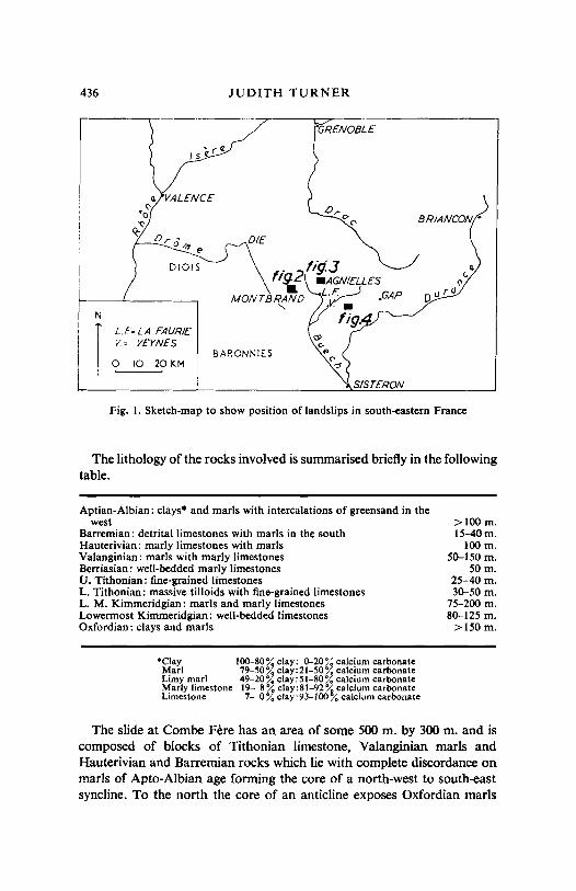
Three such landslips are described below, near the villages of La Faurieand Veynes, Hautes-Alpes (see Fig. 1). On older geological maps two ofthese were shown as being fault bounded, but they are more simplyexplained as relatively recent, sub-aerial slides. The first landslip to bedescribed is at Combe Fere, a farm one kilometre north-west of Montbrandand six kilometres west of La Faurie (Figs. 1, 2, and 3); the second issituated near Agnielles, four kilometres north-east of La Faurie (Figs. 1,4, and 5) and the third four kilometres east-south-east of Veynes (Figs. 1and 6).
435
436 JUDITH TURNER
r------.-----------
BRIANCON·
SISTERON
0",o
C'
DIE
5\- I' 21i13\, '9 .AGNIELLES
MONTBRA'tD L.F..-J .GAP<, .v.
fig.
01015
U'LA FAURE IV= VEYNES
<M I BARONNIESo 10 20~
Fig. I. Sketch-map to show position of landslips in south-eastern France
The lithology of the rocks involved is summarised briefly in the followingtable.
Aptian-Albian: clays· and marls with intercalations of greensand in thewest
Barremian: detrital limestones with marls in the southHauterivian: marly limestones with marlsValanginian: marls with marly limestonesBerriasian: well-bedded marly limestonesU. Tithonian: fine-grained limestonesL. Tithonian: massive tilloids with fine-grained limestonesL. M. Kimmeridgian: marls and marly limestonesLowermost Kimmeridgian: well-bedded limestonesOxfordian: clays and marls
>IOOm.15-40m.
100 m.50-150 m.
50m.25-40 m,30-50 m.
75-200 m.80-125 m.
>150m.
"ClayMarlLimy marlMarly limestoneLimestone
100-80% clay: 0-20~~ calcium carbonate79-50% clay:21-50% calcium carbonate49-20 % clay: 51-80 % calcium carbonate19- 8% c1ay:81-92% calcium carbonate7- 0% clay:93-100% calcium carbonate
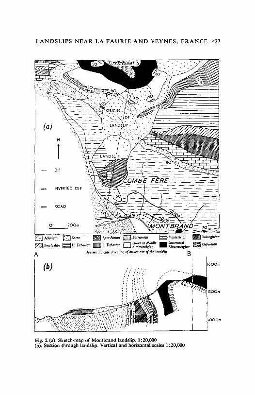
The slide at Combe Fere has an area of some 500 m. by 300 m. and iscomposed of blocks of Tithonian limestone, Valanginian marls andHauterivian and Barremian rocks which lie with complete discordance onmarls of Apto-Albian age forming the core of a north-west to south-eastsyncline. To the north the core of an anticline exposes Oxfordian marls
LANDS LIPS NEAR LA FAURIE AND VEYNES, FRANCE 437
ROAD
DIP
1000..
160010
.. ,.<:.:.:.} ::
~ Valonr'nfan
~ Oxfordion
BIII
D ·scret: §l Apto-AJblon [3].80rremlan ~ Hauterivian
= . . 1lllllD · 0 Low.r 10 Mlddl. • Low.rmoslt:=:::::::i U. T,thoman, L TIthonIan Kimmeridgian Kimmeridgian
ArrowJ indicate directionof movement 0( ,the landstlp
N
I
INVERTED DIP
o 200m
(a)
(b)
E:;] ~Iuvium~~BerrlosJa(t
A
Fig. 2 (a). Sketch-map of Montbrand landslip. 1:20,000(b). Section through landslip. Vertical and horizontal scales 1:20,000
438 JUDITH TURNER
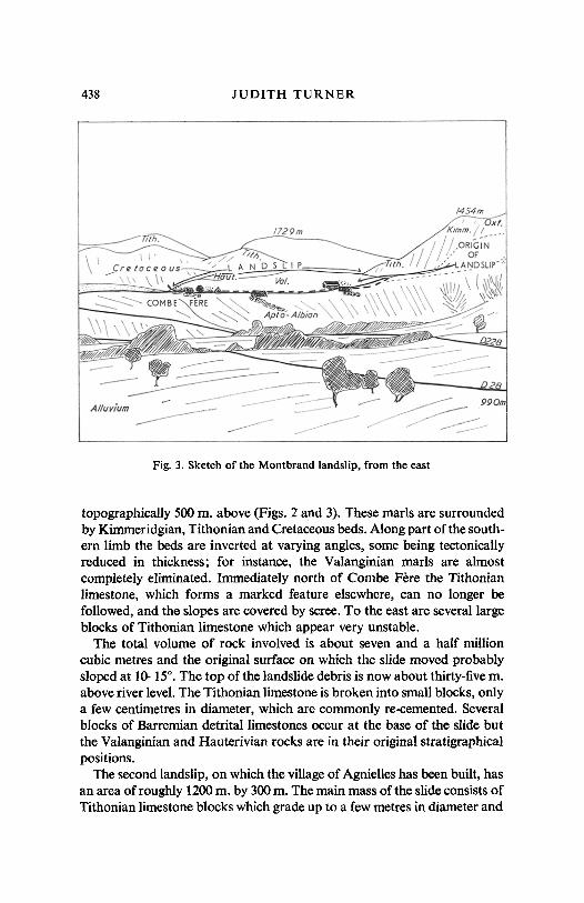
Fig. 3. Sketch of the Montbrand landslip, from the east
topographically 500 rn, above (Figs. 2 and 3). These marls are surroundedby Kimmeridgian, Tithonian and Cretaceous beds. Along part of the southern limb the beds are inverted at varying angles, some being tectonicallyreduced in thickness; for instance, the Valanginian marls are almostcompletely eliminated. Immediately north of Combe Fere the Tithonianlimestone, which forms a marked feature elsewhere, can no longer befollowed, and the slopes are covered by scree. To the east are several largeblocks of Tithonian limestone which appear very unstable.
The total volume of rock involved is about seven and a half millioncubic metres and the original surface on which the slide moved probablysloped at 10-150
• The top of the landslide debris is now about thirty-five m.above river level. The Tithonian limestone is broken into small blocks, onlya few centimetres in diameter, which are commonly re-cemented. Severalblocks of Barremian detrital limestones occur at the base of the slide butthe Valanginian and Hauterivian rocks are in their original stratigraphicalpositions.
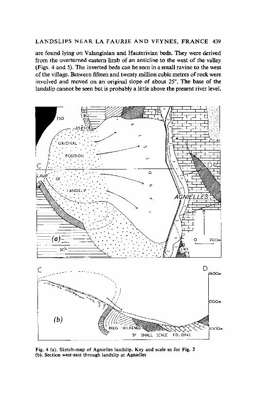
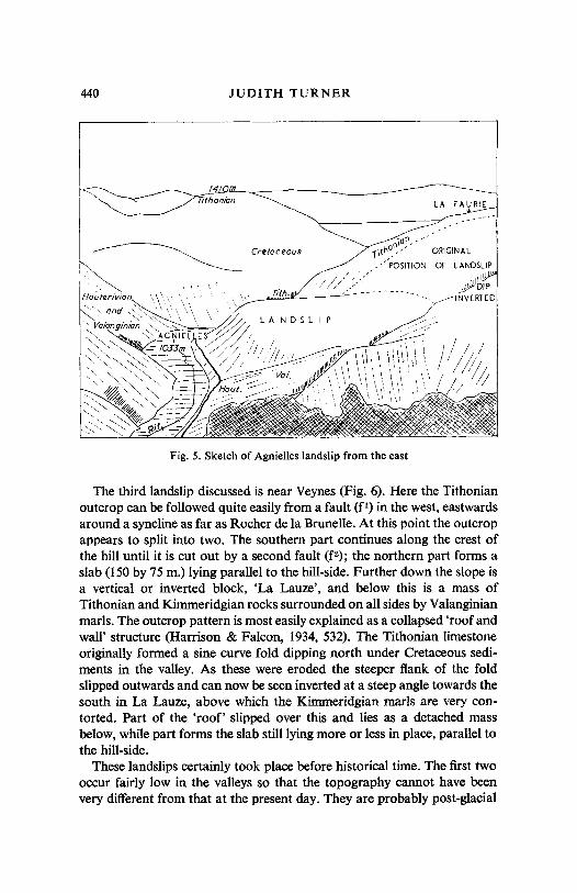
The second landslip, on which the village of Agnielles has been built, hasan area of roughly 1200m. by 300m. The main mass of the slide consists ofTithonian limestone blocks which grade up to a few metres in diameter and
LANDSLIPS NEAR LA FAURIE AND VEYNES, FRANCE 439
are found lying on Valanginian and Hauterivian beds. They were derivedfrom the overturned eastern limb of an anticline to the west of the valley(Figs. 4 and 5). The inverted beds can be seen in a small ravine to the westof the village, Between fifteen and twenty million cubic metres of rock wereinvolved and moved on an original slope of about 25°. The base of thelandslip cannot be seen but is probably a little above the present river level.
z
. ' .(0)
.. , ....
cLAII,P',': OF ..-: : ' ... .'. '.,~ 0
' ••••••••.••••••: '.'. .:<>,>, ~, ,
•. LANDSL~P '.': '••~•. , ' .. -., " . ~ . ,
;~~~!~~~i .' ,"): :j"..--; ::,' ..
:-:-,.~-,-<., ....
. . . . " .
c DIboom
(b)
Fig. 4 (a). Sketch-map of Agnielles landslip. Key and scale as for Fig. 2(b). Section west-east through landslip at Agnielles
440 JUDITH TURNER
Cretac eous
Ttih .
LA ND SLIP
Fig. 5. Sketch of Agnielles landslip from the east
LA , AURIE
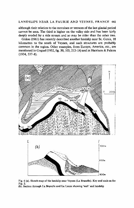
The third landslip discussed is near Veynes (Fig. 6). Here the Tithonianoutcrop can be followed quite easily from a fault (fl) in the west, eastwardsaround a syncline as far as Rocher de la Brunelle. At this point the outcropappears to split into two. The southern part continues along the crest ofthe hill until it is cut out by a second fault (f2); the northern part forms aslab (150 by 75 m.) lying parallel to the hill-side. Further down the slope isa vertical or inverted block, 'La Lauze' , and below this is a mass ofTithonian and Kimmeridgian rocks surrounded on all sides by Valanginianmarls. The outcrop pattern is most easilyexplained as a collapsed ' roof andwall' structure (Harrison & Falcon, 1934, 532). The Tithonian limestoneoriginally formed a sine curve fold dipping north under Cretaceous sediments in the valley. As these were eroded the steeper flank of the foldslipped outwards and can now be seen inverted at a steep angle towards thesouth in La Lauze, above which the Kimmeridgian marls are very contorted. Part of the 'roof' slipped over this and lies as a detached massbelow, while part forms the slab still lying more or less in place, parallel tothe hill-side.
These landslips certainly took place before historical time. The first twooccur fairly low in the valleys so that the topography cannot have beenvery different from that at the present day. They are probably post-glacial
LANDSLIPS NEAR LA FAURIE AND VEYNES, FRANCE 441
although their relation to the moraines or terraces of the last glacial periodcannot be seen. The third is higher on the valley side and has been fairlydeeply eroded by a side stream and so may be older than the other two.
Gidon (1961) has recently described another landslip near St. Genis, 18kilometres to the south of Veynes, and such structures are probablycommon in the region. Other examples, from Europe, America, etc., arementioned in Goguel (1952,fig. 50, 103,212-14) and in Harrison & Falcon(1934, 537-8).
E
(b)F
1400m
___~~ ---' aOOm
Fig. 6 (a). Sketch-map of the landslip near Veynes (La Brunelle). Key and scale as forFig. 2.(b). Section through La Brunelle and La Lauze showing 'wall' and landslip
442 JUDITH TURNER
ACKNOWLEDGMENTS
I would like to thank Professor T. N. George and Dr. Gilbert Wilson forthe help and encouragement given during the preparation of the manuscript.
REFERENCESGIDOS, M. 1961. Existence de decoiffements dans la basse vallee du Buech (Hautes-
Alpes). Trav. Lab. Geol. Univ. Grenoble, 37, 88.G<JGCEL. J. 1952. Traite de Tectonique. Paris.HARRISO~, J. V. & N. L. FALCON. 1934. Collapse Structures. Geol. Mag., 71,529.--- & ----. 1936. Gravity Collapse Structures and Mountain Ranges, as
Exemplified in South-Western Iran. Quart. J. geol. Soc. Lond., 92, 91.LUGEON, M. 1949. Question de mode en geologie et autres histoires: Ie decoiffernent.
Ann. Hebert et Haug ; 7, 261.
Miss J. TurnerDepartment of GeologyThe UniversityGlasgow W.2