Landscape Scale Planning for Transportation and · PDF fileLandscape Scale Planning for...
26
Sustainability Session Landscape Scale Planning 885 ICOET 2011 Proceedings Landscape Scale Planning for Transportation and Conservation INTEGRATING TRANSPORTATION PLANNING, CONSERVATION, AND REGULATORY ACTIONS Roberta Gerson (916-978-6191, [email protected]), Regional Transportation Coordinator, U.S. Fish and Wildlife Service, Pacific Southwest Regional Office, 2800 Cottage Way, Rm. W-2606, Sacramento, California 95825 USA Amy Pettler Bailey (916 651-8166 [email protected]), Senior Endangered Species Coordinator, California Department of Transportation, Division of Environmental Analysis, MS-27, P.O. Box 942874, Sacramento, California 94274-0001 USA ABSTRACT In 2005, Congress passed a new surface transportation law known as SAFETEA-LU, Safe, Accountable, Flexible, Efficient Transportation Equity Act: A Legacy for Users. Section 6001 of the Act requires long-range statewide transportation plans and metropolitan transportation plans include a discussion of potential environmental mitigation activities and potential areas to carry out these activities. The challenge for practitioners is how to translate project level conservation needs into a regional planning process when perspectives are different. Natural resource considerations are generally considered during transportation infrastructure project development, not during the development of long- range planning. Caltrans evaluated their program to find opportunities to take a more ecological approach to long range planning. In the process, the CA Transportation Plan and Regional Transportation Planning Guidelines were revised to reflect the policies associated with early considerations for environmental resources as well as best practices and available tools. This exploration encouraged the FWS Regional Office in California to prepare a guidance document for planning agencies to help integrate conservation with infrastructure plans. The California Essential Habitat Connectivity (CEHC) project was a multi-agency collaborative project to develop a statewide wildlife habitat connectivity map and strategy. Regional Advance Mitigation Planning (RAMP) and Statewide Advance Mitigation Initiative (SAMI) are collaborative multi-agency groups who explore scientific innovations and policy hurdles in developing and implementing a landscape- level framework and mitigate environmental impacts far in advance of projects. Modifications to policies and guidelines indicate to the practitioners that long range planning is not business as usual. Multi-agency partnerships among are the key to building trust to achieve an ecosystem/landscape approach to natural resource conservation. It takes time to frontload conservation planning and transportation planning at a regional scale and to institutionalize practices and understanding. Using a regional conservation strategy early in transportation planning will result in better informed infrastructure planning and greater flexibility in meeting regulatory mitigation/conservation needs. INTRODUCTION In 2005, Congress passed a new surface transportation law known as SAFETEA-LU, Safe, Accountable, Flexible, Efficient Transportation Equity Act: A Legacy for Users. Implementing Section 6001 obligations of SAFETEA-LU requires that long-range statewide transportation plans and metropolitan transportation plans shall include a discussion of potential environmental mitigation activities and potential areas to carry out these activities, including activities that may have the greatest potential to restore and maintain the environmental functions affected by the long-range statewide transportation plan. It further states that the discussion may focus on policies, programs, or strategies, rather than focusing at the project level and that the discussion shall be developed in consultation with Federal, State, and Tribal land management, wildlife, and regulatory agencies. Natural resource considerations are generally considered project by project, not during long-range planning. Additionally, compliance with federal regulations, such as the Endangered Species Act, requires offsetting adverse effects from project activities through avoidance and minimization conservation measures, and may include off-site land acquisitions as compensation/mitigation, but these considerations typically occur later in the project development process. Advancing the analysis of these considerations in new ways is consistent with the intent of SAFETEA-LU. This can include considerations of scale, coordination between planners and biologists and translating regulatory needs into the planning level.
Transcript of Landscape Scale Planning for Transportation and · PDF fileLandscape Scale Planning for...
Sustainability Session
Landscape Scale Planning 885 ICOET 2011 Proceedings
Landscape Scale Planning for
Transportation and Conservation
INTEGRATING TRANSPORTATION PLANNING, CONSERVATION, AND REGULATORY ACTIONS
Roberta Gerson (916-978-6191, [email protected]), Regional Transportation Coordinator, U.S.
Fish and Wildlife Service, Pacific Southwest Regional Office, 2800 Cottage Way, Rm. W-2606,
Sacramento, California 95825 USA
Amy Pettler Bailey (916 651-8166 [email protected]), Senior Endangered Species Coordinator,
California Department of Transportation, Division of Environmental Analysis, MS-27, P.O. Box
942874, Sacramento, California 94274-0001 USA
ABSTRACT
In 2005, Congress passed a new surface transportation law known as SAFETEA-LU, Safe, Accountable, Flexible,
Efficient Transportation Equity Act: A Legacy for Users. Section 6001 of the Act requires long-range statewide
transportation plans and metropolitan transportation plans include a discussion of potential environmental mitigation
activities and potential areas to carry out these activities. The challenge for practitioners is how to translate project
level conservation needs into a regional planning process when perspectives are different. Natural resource
considerations are generally considered during transportation infrastructure project development, not during the
development of long- range planning.
Caltrans evaluated their program to find opportunities to take a more ecological approach to long range planning. In
the process, the CA Transportation Plan and Regional Transportation Planning Guidelines were revised to reflect the
policies associated with early considerations for environmental resources as well as best practices and available tools.
This exploration encouraged the FWS Regional Office in California to prepare a guidance document for planning
agencies to help integrate conservation with infrastructure plans. The California Essential Habitat Connectivity (CEHC)
project was a multi-agency collaborative project to develop a statewide wildlife habitat connectivity map and strategy.
Regional Advance Mitigation Planning (RAMP) and Statewide Advance Mitigation Initiative (SAMI) are collaborative
multi-agency groups who explore scientific innovations and policy hurdles in developing and implementing a landscape-
level framework and mitigate environmental impacts far in advance of projects.
Modifications to policies and guidelines indicate to the practitioners that long range planning is not business as usual.
Multi-agency partnerships among are the key to building trust to achieve an ecosystem/landscape approach to natural
resource conservation. It takes time to frontload conservation planning and transportation planning at a regional scale
and to institutionalize practices and understanding. Using a regional conservation strategy early in transportation
planning will result in better informed infrastructure planning and greater flexibility in meeting regulatory
mitigation/conservation needs.
INTRODUCTION
In 2005, Congress passed a new surface transportation law known as SAFETEA-LU, Safe, Accountable, Flexible,
Efficient Transportation Equity Act: A Legacy for Users. Implementing Section 6001 obligations of SAFETEA-LU requires
that long-range statewide transportation plans and metropolitan transportation plans shall include a discussion of
potential environmental mitigation activities and potential areas to carry out these activities, including activities that
may have the greatest potential to restore and maintain the environmental functions affected by the long-range
statewide transportation plan. It further states that the discussion may focus on policies, programs, or strategies,
rather than focusing at the project level and that the discussion shall be developed in consultation with Federal, State,
and Tribal land management, wildlife, and regulatory agencies. Natural resource considerations are generally
considered project by project, not during long-range planning. Additionally, compliance with federal regulations, such
as the Endangered Species Act, requires offsetting adverse effects from project activities through avoidance and
minimization conservation measures, and may include off-site land acquisitions as compensation/mitigation, but these
considerations typically occur later in the project development process. Advancing the analysis of these considerations
in new ways is consistent with the intent of SAFETEA-LU. This can include considerations of scale, coordination
between planners and biologists and translating regulatory needs into the planning level.

ICOET 2011 Proceedings 886 Session SUS-6
Given that SAFETEA-LU 6001 is not prescriptive in how its requirements might be accomplished, the California
Department of Transportation (Caltrans) works collaboratively with partner agencies and internally to institutionalize
these requirements. This collaboration has stimulated discussion and a blended recognition of different perspectives
and has resulted in revisions to policy, development of guidance, identification of the need for technology and an
understanding where difficulties may exist. This paper will discuss specific examples of procedural improvements
Caltrans and U.S. Fish and Wildlife FWS (FWS) have implemented and what we have learned along the way.
CHALLENGES AND DILEMMAS
With the onset of SAFETEA-LU, transportation agencies need to develop a consistent and meaningful approach to
considering natural resources early in planning and to integrate natural resources into all phases of long range
planning. For Federal agencies there is also the challenge of addressing the Endangered Species Act Section 7 (a)(1)
duty of conserving endangered and threatened species and the ecosystems and habitat on which they depend. This
program level goal is consistent with the SAFETEA-LU 6001 intent of addressing broader conservation goals such as
recovery of species early and in a regional or larger planning scale.
Why is this a difficult challenge? Let’s consider the basic structure of transportation planning with California as our
case example. The California Transportation Plan (CTP) develops the policy at the state level, the Regional
Transportation Plan (RTP) Guidelines provide guidance to implement the policy set by the CTP, the System Plans inform
the RTPs, and the Metropolitan Planning Organizations (MPOs) work with the public on developing the RTPs. System
plans include the Transportation Corridor Report (TCR), Corridor System Management Plans (CSMP’s) or Route Concept
Report (RCR), the District System Management Plans (DSMPs) and the Transportation System Development Plan
(TSDP) which then inform the RTPs. If you have kept up with this alphabet soup you are likely a Transportation Planner.
The transportation planner hears this and says “That’s Right”. The natural resource regulatory biologist says “Huh?
Where do our concerns fit in?” Sometimes it is all about understanding each other’s mission, processes, and
terminology. Major challenges include difference in perspectives, terminology and the educational gap in terms of
understanding the procedures within transportation planning in order for the agency staff to understand how and where
they might fit in to the process. For Caltrans planning staff understanding all the nuances of environmental regulation
helps clarify the need for early participation of FWS staff.
Perspectives
A major dilemma stems from different perspectives; mission statements and objectives are at odds with one another.
Transportation planning agencies are focused on moving people and goods efficiently and economically. Natural
resource agencies have the mission of conserving the natural environment and habitats necessary for the protection of
plants, fish, and animals. Environmental considerations do not inform transportation solutions. Natural resource
conservation is an externality; it is not currently one of the drivers that dictates what highway improvements are
needed. Conversely, conservation strategies developed by regulatory agencies typically focus on recovery of the
species and habitat conservation and not necessarily on the anticipated travel demand.
The FWS Regional Office in California prepared a guidance document, “A Guide to Integrating Conservation Planning
and Transportation Planning and SAFETEA-LU 6001- metropolitan/local regional planning,” (Gerson 2011) for planning
organizations to help integrate conservation into infrastructure plans. This guidance paper shares FWS’s perspective of
SAFETEA-LU concepts with Caltrans planning staff and transportation planning organizations. It is the first step in
translating regulations at a local level scale to the regional level and making the transportation planner more familiar
with the regulatory demands at the project delivery end of transportation projects.
Traditionally it may have been thought that FWS can meet their mission at the project level. However, to aid in the
survival and recovery of threatened and endangered species, it is more effective to evaluate the species across their
geographic distribution range and to include a larger regional conservation perspective.
Perspectives also differ within Caltrans depending on what professional background people have. This w as
highlighted recently during a brainstorming session between transportation planners and environmental biologists,
while evaluating a new transportation corridor planning method. This method would include a concise narrative
describing any major environmental issues and conditions found along the corridor route. Categories would include,
but are not be limited to, environmental functions such as habitat connectivity, special status species, wetlands,
climate change issues such as sea-level rise, and special land designations. Each category would then be rated
(low, medium or high) as to probability of issues related to that environmental function arising during project
development and environmental analysis.

Landscape Scale Planning 887 ICOET 2011 Proceedings
During the conceptual development of this planning aid, different perspectives within Caltrans rapidly became evident
between the environmental analysis branch and the transportation planning branch in determining environmental
categories. For example, as environmental function categories were developed, the transportation planners identified
‘bodies of water’, immediately thinking of water quality and stormwater issues during project construction. Although
relevant, the biologists, who typically work at the project level and deal with natural resource agencies, were inclined to
replace that term ‘bodies of water’ with ‘wetlands’, associated with Endangered Species Act (ESA) species and Clean
Water Act categorizations.
There is a knowledge gap in how resource agencies understand the transportation process and how transportation
planners understand resource agencies’ needs and requirements. For example, a regulatory biologist for a resource
agency generally interacts at the project development and permitting stages, long after long-range planning is
completed, and often past the CEQA/NEPA document development. This current sequencing may result in the resource
agency staff having to deal with a transportation corridor bisecting an important wildlife movement corridor or going
through important special status species habitat. The resource agency recommends a remedy like a wildlife crossing
as part of the project and might wonder why they are told it can’t be done. The transportation agency says there is no
funding programmed in the project for what they consider a major modification to the project funding and scope.
Regional transportation planning has the same benefits and objectives as regional conservation strategy planning—
looking at the big picture of an area and identifying a plan that allows for optimum strategies for the area to achieve the
goal efficiently and economically.
Funding/‘It’s Too Late’
This leads us to funding and the ‘it’s too late’ dilemma. Pursuant to the ESA, the FWS may need to permit or authorize
proposed projects that may affect threatened and endangered species or critical habitat. This permitting/authorization
occurs at the project approval phase of transportation project. But by that phase, regional planning is complete and
design alternative selections of the individual project are either completed or nearly completed. Long-range planning
and project funding have been allocated and costs of the project have been estimated. It is generally at this point when
the transportation agency requests an ESA consultation to receive a permit or authorization from a regulatory agency.
The FWS biologist consults on the project, conducts an analysis of impacts of the project to listed species, and reviews
and recommends possible avoidance and minimization (conservation) measures to reduce natural resource adverse
effects from the proposed project. The dilemma occurs when: planning, programming and preliminary design has been
developed throughout the planning stages, with little consideration of the need to incorporate conservation measures.
Now, at the project delivery stage there is less flexibility in the design to incorporate certain conservation measures.
The ideal situation is where natural resource areas of concern are identified and conservation becomes part of the
transportation planning process. As a result there is more predictability of the issues at hand which can yield time and
cost savings “down the road.”
Incorporating conservation measures to avoid or minimize adverse effects to threatened and endangered species or
sensitive habitats when possible at the regional planning level or long range planning level may help expedite the
subsequent permitting process while promoting the conservation of natural resources and may be more reasonable
economically. The programmatic scale of the planning effort allows for the application of a consistent set of avoidance
and minimization measures at the individual project level. To effectively mitigate for potentially significant adverse
effects due to habitat fragmentation, careful planning is needed in the placement, configuration, and design of
transportation corridors. Thoughtful planning for listed species such as San Joaquin kit fox, desert tortoise and bighorn
sheep that require vast acreages to maintain viable populations would likely confer conservation benefits to less widely
distributed species as well.
Thinking about avoidance, minimization or mitigation measures at the regional or transportation corridor level may also
help resolve the Funding/It’s too late dilemma. Infusing initiation of the discussion of environmental considerations
early in planning can inform programming decisions and allow transportation agencies to realize the costs to address
regional and cumulative effects of the transportation system. Developing avoidance or minimization measures at the
project delivery phase may be cost prohibitive or have engineering constraints, leading to higher costs for mitigation.
Early engagement may also provide opportunities for partnering on conservation strategies with other agencies.
Early Coordination
The last dilemma: although resource agencies promote early coordination and early conservation planning, many have
no funding mechanism to provide meaningful input at early stages of transportation planning. In a recent government

ICOET 2011 Proceedings 888 Session SUS-6
report, Highways and Environment: Transportation Agencies Are Acting to Involve Others in Planning and
Environmental Decisions, (Government Accountability Office 2008), several challenges were cited in getting such input,
including (1) the limited availability of funding and staff at resource agencies; (2) limited incentives for resource
agencies to contribute during planning, since early involvement is not part of these agencies' missions or experience;
and (3) unfamiliarity on the part of resource agencies and planners with each other's roles and processes. State
Department of Transportation and Metropolitan Plan Organization (MPO) planners' progress in developing consultation
relationships with resource agencies has varied, and those that had strong prior relationships with resource agencies
are advancing more quickly.
But, getting resource agencies to the table to participate in early coordination at landscape level planning can be
difficult. The regulatory aspect of the ESA can promote a reactive, rather than a proactive, approach. It may be helpful
for the planning agency to provide the FWS with opportunities for early engagement, including orienting meetings
specifically to address the FWS’s responsibilities and issues. As a part of active engagement, we suggest MPOs think
about what information they are looking for, and outline how and when the natural resource agencies will participate.
Interaction needs to be an iterative process throughout the development of long-range plans, and goals generated must
be reflected in the planning documents.
Data Needs
Understanding what data are appropriate to use in a regional level analysis is another area that needs to be better
understood. Understanding why an individual travels down a road might be important to know for transportation
planning but it doesn’t directly inform planners as to what freeway improvements are needed. Similarly, knowing a
specific observed location of a species doesn’t necessarily translate directly into a Route Concept Report in terms of
what potential considerations are needed for that particular species. A lot of traffic data are collected and analyzed
and demand is modeled in order to provide information for a 20 year horizon; natural resource consi derations at the
regional level have similar data needs. Also, different regions have different data available which may result in the
different types of data used early in planning. The issue of scaling up data to help support or inform regional
scenarios is something that takes time and additional effort. Since natural resource data often reflects systems or
species that may move or change over time, identifying the appropriate level of data and how it should be used in a
20 year planning horizon requires collaboration and coordination between the Transportation Planners, Resource
Agency Staff and Biologists. The following are some California initiatives that Caltrans and FWS, and others, are
implementing, to bridge the data gap between regional approaches to transportation planning and project-specific
conservation measures.
ELEMENTS OF THE SOLUTION
California has collaborated on a set of solutions to address the challenges of differing perspectives, early coordination,
data needs, advancing the considerations of environmental resources in transportation planning policy and practice.
California Essential Habitat Connectivity Project (CEHC)
One issue that is difficult to address at a project by project level is habitat connectivity. Since much of the
infrastructure built in California and other states preceded environmental laws and regulations and fragmented
important wildlife habitat, we now find ourselves in the position of having to modify existing infrastructure to address
habitat fragmentation and to provide habitat connectivity for species movement. Identifying important movement
corridors facilitates planning infrastructure improvements. Therefore, Caltrans partnered with CA Department of Fish
and Game (DFG) in scoping a State Planning and Research Special Project to model essential habitat connectivity in
the state. This was a multi-agency collaborative project to develop a statewide wildlife habitat connectivity map and
strategy (Spencer, 2010). This effort highlighted several different ideas on how this could be done for the state and
provided an opportunity to develop a framework that would consider these different perspectives. Using innovative
Geographic Information System (GIS) modeling technology, a technical advisory team identified large blocks of existing
natural ecosystems and modeled potential linkages to provide spatial and functional connectivity for long-term species
protection and biodiversity. A map was created and the team developed a strategy framework for the next steps for
planning at the regional and project level.
Regional Advance Mitigation Planning and Statewide Advance Mitigation Initiative Efforts
Development of a method for advancing mitigation considerations in regional planning is a new challenge. Caltrans
along with other infrastructure and regulatory agencies in CA are evaluating ways to advance the analysis and
Landscape Scale Planning 889 ICOET 2011 Proceedings
implementation of mitigation for laws such as Endangered Species Act (state and federal), Clean Water Act, National
Environmental Policy Act, and California Environmental Quality Act through two initiatives.
Regional Advance Mitigation Planning (RAMP) is a collaborative multi-agency group who explores scientific innovations
and policy hurdles in developing a statewide strategy for long term conservation and to mitigate environmental impacts
far in advance of project activities, using a landscape/ecosystem strategy and spatial modeling and mapping. The
development of a MARXAN model GIS analysis is being used in concert with a planning framework (Thorne 2009). This
is another example of trying to create ways to scale natural resource data up in a way that is useful for planning at the
regional level and trying to consider environmental resources, consultation and mitigation opportunities early in the
planning process. Implementing mitigation in advance of infrastructure projects does present some challenges that the
multi-agency group is trying to address, including: funding, responsibilities of implementation and regulatory
assurances, and a process to account for mitigation credit and debit.
Statewide Advance Mitigation Initiative (SAMI), led by Caltrans, is a collaborative multi-agency effort which focuses on
the implementation of project mitigation in advance of project development through the preservation and/or
restoration of acquired lands and is designed to compensate/mitigate project impacts that cannot be avoided or
minimized to a reasonable level on-site.
These efforts will be achieved through the establishment of mitigation banks, conservation banks, and/or in-lieu fee
programs. Memorandums of Understanding have been signed by multi-agencies for collaboration which have fostered
the institutional support to work collaboratively internally and externally to develop this initiative. Frameworks are being
developed and/or finalized to identify proposals for supportive policy and legislative revisions, and developing
procedural guidance documents and pilot projects. New, innovative GIS modeling techniques are being developed and
tested and will provide an opportunity for institutionalizing advance mitigation procedures within Caltrans and perhaps
other agencies.
With all the new GIS technology being developed, it is getting easier to identify environmental resources and develop
alternatives that have fewer impacts on special status species and ecosystems. GIS analysis can help identify those
areas of environmental concern and help compare proposed plans to help inform Blueprint Plans or Scenario Planning.
Planning Policy and Guidelines, Blueprint Planning and Scenario Planning
In addition to the initiatives described above, Caltrans is working on several fronts to institutionalize and provide guidance
on SAFETEA-LU 6001 requirements. The Draft Update of the California Transportation Plan 2030 was specifically updated
to reflect new SAFETEA-LU requirements. This document helps sets the policy for the state and promotes an integrated
approach to transportation planning through various planning approaches, data considerations and identification of
agencies to consult with and methods for engagement. Future iterations of the CA Transportation Plan will likely continue
to discuss new policies, strategies and best practices associated with environmental considerations. Utilizing data in
statewide planning is a new idea that is being explored in a statewide planning effort called the California Interregional
Blueprint (CIB). The CIB intends to integrate statewide and regional transportation and land use goals and provides a new
opportunity to further integrate environmental considerations early in statewide planning.
Two Senate Bills passed in California are furthering the integration of environmental considerations into long-range
transportation planning. Senate Bill (SB) 375 (Steinberg 2008) establishes the requirement for MPOs to develop
sustainable community strategies (SCS) and alternative planning strategies (APS) to promote compact and infill
development and Greenhouse Gas (GHG) emission reduction. SB 391 (Liu 2009) also requires the State’s long-range
transportation plan to meet California’s climate change goals under Assembly Bill (AB) 32 (Nunez 2006). These two
bills primarily promote the integration of land use, transportation and GHG reduction planning. However, these
considerations are likely to have additional conservation benefits associated with sustainable planning strategies that
include conservation of habitat, wetlands, and farmland. In response, the Regional Transportation Planning (RTP)
Guidelines were updated in 2010 to reflect the new requirement for MPO’s to develop strategies for regional GHG
reduction in RTPs.
Specific consideration of natural resources as a component of the Sustainable Communities Strategies and the
Regional Transportation Plan Checklist was revised with specific references to SAFETEA-LU: Consultation/Cooperation
and specifying mitigation activities. These considerations may include early consideration of neighboring land uses
and/or integrating other plans such as existing Habitat Conservation Plans or recognized protected conservation areas
and taking an ecosystem strategy approach into transportation corridor studies expected over the life of the long range
transportation plan. Project by project conservation measures often overlook regional and ecosystem scale impacts to
sensitive species and habitat, thereby missing critical opportunities for efficient and biologically relevant
ICOET 2011 Proceedings 890 Session SUS-6
conservation. The key is to identify ecologically important natural resources that should be protected and avoide d,
while flexibility still exists in how the region is planning to grow. For example, scenario planning was used by several
counties in the San Joaquin Valley, which entered into a partnership with the University of California (UC) Davis. The
Information Center for the Environment (ICE) at UC Davis provided geographic information system (GIS) data and
growth allocation build-out scenarios. The region faces many challenges with respect to its capacity to
accommodate a dramatic increase in population while maintaining its environmental infrastructure and preserving
its diminishing natural resources. In this study, all scenarios applied the same set of parameters, including
specifically identified natural resource conservation/protection parameters (Beardsley, Roth, and McCoy 2007). The
use of natural resource data in scenario planning and outreach during the RTP process can help integrate natural
resources into the decision making process early. Caltrans also has a Blueprint Planning Grant Program that
provides additional funds to regional transportation authorities to improve integrated planning. System Planning
Guidelines are also being evaluated to further institutionalize similar environmental analysis procedures to inform
route concept reports and long range corridor plans.
DISCUSSION
It is not business as usual. Conservation lands acquired early in the planning stage of projects can use a regional
conservation strategy, resulting in less time and less cost for the action agency during the regulatory process. While
advancing environmental planning and mitigation for transportation has these anticipated savings, changes in
programming estimation practices as well as fiscal assurance discussions and contractual agreements with the
resource agencies may be necessary to codify the investment.
For resource agencies, it results in greater conservation value, effective linkages for species movement, and no
temporal loss from construction activities. Using the FWS’ MPO guidance paper will assist transportation planners by
understanding natural resource regulatory needs and be able to anticipate and incorporate avoidance, minimization,
and mitigation measures when possible in the early planning stages of transportation plans and projects.
Understanding perspectives will likely help the conversation early on and will help identify the challenges that may still
exist with early considerations, funding, or advancing mitigation activities.
The CEHC is the first step identifying species movement linkages statewide; advance mitigation develops the
framework to conserve important habitat on a regional scale while achieving transportation objectives and providing
compensation for potential adverse effects of those projects’ activities; and the FWS’ MPO guidance paper introduces
long-range transportation planning agencies to regulatory resource agency needs. All steps build on each other.
There is a need to institutionalize these practices so considering environmental resources early,
coordination/consultation, and identifying mitigation strategies become business as usual. Continuing to promote
Blueprint Planning, scenario planning, data development, education/training, time for coordination and associated
funding is essential. Truly integrating the goals of transportation planning, goals of conservation planning, and
developing communities requires time, money, expertise and an understanding of different perspectives.
State regulation may further the implementation of SAFETEA-LU 6001 considerations. SB 375 and SB 391 are fueling
state priorities for discretionary planning funding as well as providing a framework for regional and local land use
decisions to trend towards compact development and sustainable strategies in growth decisions.
Once techniques, tools, data, and procedures are developed, outreach and training of the different professions involved
in integrated planning should be conducted. Each profession has something to contribute to these considerations in
long range planning.
These steps taken to improve procedures, policy, practice and collaboration for environmental considerations in long
range planning have proven to provide benefits in the short term. Through collaboration the transportation and
resource agency communities and professionals in California have developed common approaches to understanding
difficult conservation issues, to bridge the gap in understanding of missions and goals, and to partner on research,
analysis frameworks and procedures.
CONCLUSION
Multi-agency partnerships among resource/regulatory/and infrastructure agencies are the key to building trust to
achieve an ecosystem/landscape approach to natural resource conservation. It takes time to frontload conservation
planning and transportation planning at a regional scale and to institutionalize practices and understanding. Using a
regional conservation strategy early in transportation planning will result in better informed infrastructure planning and

Landscape Scale Planning 891 ICOET 2011 Proceedings
greater flexibility in meeting mitigation/conservation needs. Lastly, as professionals attempt to address environmental
concerns early in planning, the expertise, tools, and the institutional support will likely improve. These initial short term
successes will help fuel the long term process of integrating the broad goals of conservation and transportation needs.
BIOGRAPHICAL SKETCHES
Roberta Gerson is the U.S. Fish and Wildlife Service’s (FWS) Regional Transportation Coordinator, Sacramento,
California. She is responsible for administering the California Department of Transportation (Caltrans)/FWS
reimbursable agreement, troubleshooting and negotiating Caltrans project issues under Section 7 of the Endangered
Species Act when issues are elevated, and working with Caltrans and FWS Field Offices for better coordination and
collaboration. Roberta has a B.S. in Biology and an M.S. in Forestry. She has worked in a myriad of positions, as a
University of California and Florida research biologist, to a timber forester and investigator with the U.S. Forest Service,
to her past 11 years in Section 7 with the U.S. Fish and Wildlife Service in California.
Amy Pettler Bailey is currently a senior wildlife biologist for the California Department of Transportation Division of
Environmental Analysis. She acts as a liaison to Caltrans district biologists by providing technical assistance, guidance
on policy and regulations, and tool and handbook development. This includes overseeing and setting guidance and
guidelines for endangered species coordination and wildlife biology as they pertain to transportation project
development and implementation process. A more recent focus has been on finding ways to integrate statewide and
regional planning efforts as they related to natural resources per SAFETEA-LU. Prior to her current position, Amy has
had experience in planning with city, state and federal entities and is a certified planner. She graduated from University
of California at Santa Barbara with a degree in Environmental Studies and Business Economics.
REFERENCES
Beardsley, K., N.E. Roth, and M.C. McCoy .2007. Impacts of Different Road Ecology Center, John Muir Institute of the
Environment, University of California, Davis. Growth Scenarios in the San Joaquin Valley of California.
California Assembly Bill 32. 2005-2006 Reg. Session (September 27, 2006).
California Senate Bill 375. 2007-2008 Reg. Sess. (September 30, 1998).
California Senate Bill 391. 2008-2009 Reg. Sess. (October 11, 2009).
California Regional Transportation Plan Checklist www.dot.ca.gov/hq/tpp/offices/orip/rtp/index.html
Gerson, Roberta. 2011. A Guide to Integrating Conservation Planning and Transportation Planning and SAFETEA-LU
6001- metropolitan/local regional planning. Roberta Gerson, U.S. Fish and Wildlife Service, Pacific Southwest
Region, Sacramento, California.
Government Accounting Office. (GAO). 2008. Highways and Environment: Transportation Agencies Are Acting to Involve
Others in Planning and Environmental Decisions, GAO-08-512R.
Spencer, W.D., P. Beier, K. Penrod, K. Winters, C. Paulman, H. Rustigian-Romsos, J. Strittholt, M. Parisi, and A. Pettler.
2010. California Essential Habitat Connectivity Project: A Strategy for Conserving a Connected California. Prepared
for California Department of Transportation, California Department of Fish and Game, and Federal Highways
Administration.
Thorne, J.H., P.R. Huber, E.H. Girvetz, J. Quinn, M. McCoy. 2009. Integration of regional mitigation assessment and
conservation planning. Ecology and Society 14(1).
BIBLIOGRAPHY
California Transportation Plan 2030: Addendum to the California Transportation Plan 2025 for SAFETEA-LU
Compliance http://www.dot.ca.gov/hq/tpp/index_files/ctp_2030_oct_2007.pdf
Defenders of Wildlife. 2004. Second Nature, Improving Transportation Without Putting Nature Second. Patricia A.
White and Michelle Ernst, authors.

ICOET 2011 Proceedings 892 Session SUS-6
Government Accounting Office. (GAO) 2004. Report to Congressional Requesters, State and Metropolitan Planning
Agencies Report Using Varied Methods to consider Ecosystem Conservation, GAO-04-536.
Minnesota Department of Natural Resources. 2006. Using Natural Resources Information in comprehensive Planning.
A companion to the Metropolitan Council’s Local Planning Handbook.
http://files.dnr.state.mn.us/assistance/nrplanning/community/nrplanning_guide/handbook.pdf
Portage County Planning Commission. Paris Township Zoning Study.
http://www.paris-township.com/Zoning/Paris_study/
Regional Transportation Planning Guidelines 2010
http://www.catc.ca.gov/programs/rtp/2010_RTP_Guidelines.pdf
Statewide Advance Mitigation Initiative Memorandums of Understanding, 2010.
http://www.dot.ca.gov/ser/downloads/MOUs/sami.pdf
San Diego Association of Governments (SANDAG). TransNet Program. http://www.sandag.org/
U.S. Fish and Wildlife Service. 2000. Memorandum on Department of Transportation Final Programmatic Guidance.
U.S. Department of Transportation. 2006. Eco-logical: An Ecosystem Approach to Developing Infrastructure Projects.
Available online: http://www.environment.fhwa.dot.gov
U.S. Fish and Wildlife Service. 2008. Conservation in Transition – Leading Change in the 21st Century."
Western Transportation Institute - Montana State University (WTI) 2007. Developing the “Integrated Transportation and
Ecological Enhancements for Montana” (ITEEM) Process: Applying the Eco-Logical Approach.
http://www.mdt.mt.gov/research/docs/reasearch_proj/integrated_transportation.pdf

Landscape Scale Planning 893 ICOET 2011 Proceedings
ROAD ECOLOGY STATUS IN CHINA: THE EFFECT OF ROADS ON
WILDLIFE AND CORRESPONDING SOLUTIONS
Qi-Lin Li, Ph.D. ([email protected]), Lecturer, Hainan Key Laboratory for Herpetological Research,
Qiongzhou University, Sanya, Hainan Province 572022, People's Republic of China
Chi-Xian Lin ([email protected]), Professor, Hainan Key Laboratory for Herpetological
Research, Qiongzhou University, Qiongzhou University, Sanya, Hainan Province 572022,
People's Republic of China
Yu Du ([email protected]), Lecturer, Hainan Key Laboratory for Herpetological Research,
Qiongzhou University, Qiongzhou University, Sanya, Hainan Province 572022, People's Republic
of China
Li Zhang, Ph.D. ([email protected]), Associate Professor, Beijing Normal University, Beijing
100875, People's Republic of China
ABSTRACT
Roads exert various effects of concern to conservation. They lead to habitat fragmentation, change the behavior of animals
and cause road mortality of wildlife. All these impacts may influence the long-term viability of populations and eventually,
biodiversity. Road ecology in China has been developing regularly since the early part of this century.
In Qinghai Province, the Qinghai-Tibet Railway and Highway hindered Tibetan antelopes from moving westward and backward
during their breeding migration at the beginning. They even gave birth along the railway. Nonetheless, as time has gone by,
Tibetan wildlife is getting used to the traffic, they have adapted themselves to the changes in the surroundings by learning
and adjusting their behavior. Their percentage of railway passage utilization gradually increased and the span of antelope
wondering and stopping before crossing the railway line was steadily reduced. Tibetan wildlife is getting used to the railway.
In Yunnan Province, Asian Elephants frequently occurs on the Simao-Xiaomengyang Highway and the 213 National Road. In
order to avoid crashes with vehicles, elephants decreased their home range, changed into a nocturnal behavioral rhythm,
and began to use the artificial corridors set up especially for large mammals. The utilization rate of corridors was 44%, and
elephants preferred the bridge and tunnel corridors which were placed along their original movement routes. On Xiao-Mo
Highway, humidity and temperature play an important role on the roadside activeness of sub-tropical snakes. Parallel
elementary road surveys have been carried out in other areas of China.
With the domestic road network developing rapidly, we still lack corresponding researchers to clarify the road impact on
wildlife in detail. However, China has a benign commence. As the state environmental protection efforts continue to increase,
we have good reasons to believe that China's road ecology will rapidly grow to a new level.
INTRODUCTION
Since the construction of Qinghai-Tibet Railway, considerable attention has been paid to the potential detrimental effect of
that railway on the roadside wildlife, especially on migrating female Tibetan Antelopes (Pantholops hodgsonii) during their
breeding period. So the railway builders designed several passageways to provide the wildlife with access to going through
Qinghai-Tibet Railway and Highway (QTR&HW) as smoothly as possible. Meanwhile, Chinese researchers have been
monitoring the situation annually since the time construction began in 2001, through its completion in 2006 and on to the
present. In 2001, during their breeding migration, female antelopes could not go through the QTRW which was under
construction, so they gave birth on the east side of QTHW. The period of migration in 2002 was more prolonged than in 2001,
and antelopes approached and retreated back and forth, needing at least 45 min to successfully cross, with the success
sprinting ratio of only 30.2%. In 2003, females still produced calves along the QTR&HW (Qiu and Feng 2004). The main
impacts on the seasonal migration of Tibetan antelopes were the physical barrier of the infrastructure, human activities, un-
cleared land surface, un-recovered vegetation, traffic flow and so on (Xia et al 2005). In 2004, even though they felt strange
when encountering the railway as usual, they began to use the railway passages. 56.1% of the population utilized the Hoh-xil
passageways while others directly traversed the railway. As time went by, their percentage of railway passage utilization
gradually increased (Table 1). In 2005, as the construction workers, machinery, equipment and transport vehicles withdrew
step by step, human disturbance was significantly reduced, so the utilization rate remarkably improved (Li and Yang 2007;
Xia et al 2007). At the same time, they could adapt themselves to the changes in the surroundings by learning and by
adjusting their behavior. Most of their activities took place in the morning in order to avoid the effects of traffic (Yin et al
2006, 2007). In 2007 and 2008, antelopes exploited a new passage- Chumaer Lake Underpass to cross the railway (Zhang
et al 2009). Moreover, the span of antelope wondering and stopping before crossing the railway line was steadily reduced (Li
et al 2008). Tibetan wildlife was getting used to the railway (Yang and Xia 2008).

ICOET 2011 Proceedings 894 Session SUS-6
Table 1. The railway passage utilization percentage of antelopes during their seasonal migration
In Yunnan Province, Asian Elephants (Elephas maximus) frequently occurs in Wild Elephant Valley, which is located in
the vicinity of Simao-Xiaomengyang Highway (SXHW) and the 213 National Road (near Mengyang Nature Reserve of
Xishuangbanna National Nature Reserve). In order to avoid collision with vehicles, elephants decreased their home
range, changed into a nocturnal behavioral rhythm, and began to use the artificial corridors set up especially for large
mammals. After one year of observation, the researchers from Beijing Normal University (BNU) found that the number
of crossroad routes used by Asian elephants diminished from 28 to 23 following the construction of SXHW. The
utilization rate of corridors was 44%, and elephants preferred the bridge and tunnel corridors which were placed
alongside their original movement routes (Figure 1; Pan et al 2009). A total of 20 individuals of10 snake species were
recorded on the Xiao-Mo Highway. The detection likelihood of snakes on roads with natural forest nearby was
significantly lower than roads where the roadside was farmland or rubber tree plantations. The primary meteorological
factors leading to the presence of snakes on roads might be the lower maximum temperature and the higher maximum
humidity two days prior to the survey date. It was evident that humidity and temperature, other than precipitation, play
important roles on the activeness of sub-tropical snakes (Sun and Zhang 2010).
Figure 1. Area in which elephants’ appearance diminished after the construction of the
Sixiao Highway (Pan et al 2009)

Landscape Scale Planning 895 ICOET 2011 Proceedings
Some similar elementary road surveys were conducted in other areas of China: the Tourist Highway around Changbai
Mountain in Jilin Province (Li 2010), the highways in Three Parallel Rivers of Yunnan Protected Areas (Li 2010), the 213
National Road in Zoige Alpine Wetland in Sichuan Province (Dai et al 2006), etc. The species referred to included
insects, amphibians, reptiles, birds and mammals.
As of 2010, the length of China’s road network is 3.984 million km, while the freeway length is 74 thousand km.
Domestic road construction is growing fast. Objectively speaking, the study of road ecology, especially the fauna part in
China, is still in its initial stage. In order to effectively and efficiently protect wildlife along the road, it is vital to
systematically establish a nationwide database on the detailed roadside animals of their occurrence, roadkill, species,
time, location, and so on. On the basis of careful and massive analysis over time, then researchers can put forward
various corresponding mitigation measures for road management units to choose from. In addition, strict laws are
urgently required to regulate the behavior of road construction units. Despite having a long way to go, China has a
benign commence. As the state environmental protection efforts continue to increase, we have good reasons to believe
that China's road ecology will rapidly boom to a new level.
SUMMARY
This paper provides an overview of the road ecology status in China, a country with swift transportation expansion,
especially the road net. Road avoidance and roadkill may be the most severe effects of traffic. In order to mitigate the
various harmful highway impacts, road builders put up speed limit signs, banning horns, wildlife warning signs, reduced
angle of subgrade slopes, designed and set up wildlife channels (including bridges, tunnels, culverts). Among them,
animal passages were the most successful measure.
ACKNOWLEDGEMENTS
This research is funded by the Zoology as the Provincial Support Key Subject.
BIOGRAPHICAL SKETCHES
Qilin Li is a lecture of Biology at Qiongzhou University, China. She received her Ph.D. in ecology (2010) at Beijing
Normal University, China. Her research interest includes road ecology, behavioral ecology, and conservation biology.
Chi-Xian Lin is a professor of Biology and dean of Biological Science and Technology at Qiongzhou University, deputy of
Hainan Key Laboratory for Herpetological Research, outstanding team leader in Zoology Teaching as the Provincial
Support Key Subject. His research interest includes conservation biology and physiological ecology on squamate reptiles.
Yu Du is a lecture of Biology at Qiongzhou University, China. His research interest includes conservation biology and
physiological ecology on squamate reptiles.
Li Zhang is an associate professor at Beijing Normal University, China. He has more than 10 years experience in wildlife
conservation and animal behavior. As the Senior Species Program Director, Conservation International - China Program,
he established, led, developed and implemented CI’s country strategy on species conservation and wildlife trade
related programs; liaison with relevant Chinese governmental agencies including State Forestry Administration, State
Fishery Administration, State Customs Administration, CITES Management Authority, State Forest Police Administration
and NGOs on species conservation and wildlife law enforcement; manage daily operations for Beijing and field offices.
REFERENCES
Dai, Q., Z.P. Yuan, J.D. Zhang, Y. Yang, M. Zhang, Q. Zhang, H.J. Gu, Z.J. Liu, Y. Jian, and Y.Z. Wang. 2006. Road and
road construction effects on habitat use of small mammals and birds in Zoige alpine wetland. Biodiversity Science
14 (2): 121-127. [In Chinese with English abstract]
Li, Q.L. 2010. The impact of operating highways surrounding reserves on wildlife: Case studies on the tourist highway
around Changbai Mountain in Jilin Province and highways in Three Parallel Rivers of Yunnan Protected Areas. PhD
Dissertation. Beijing Normal University, Beijing, China. [In Chinese with English abstract]
Li, Y.Z., and Q.S. Yang. 2007. The assessment of wildlife passage placement on the Qinghai-Tibet Railway.
Environmental Protection and Occupational Safety and Healthy Research Institute, China Academy of Railway
Sciences, Beijing. [In Chinese]

ICOET 2011 Proceedings 896 Session SUS-6
Li, Y.Z., T.J. Zhou, and H.B. Jiang. 2008. Utilization Effect of Wildlife Passages in Golmud-Lhasa Section of Qinghai-Tibet
Railway. China railway science 29(4): 127-131. [In Chinese with English abstract]
Pan, W.J., L. Lin, A.D. Luo, and L. Zhang. 2009. Corridor use by Asian elephants, China. Integrative Zoology 4: 220-231.
Qiu, L., and Z.J. Feng. 2004. Effects of traffic during daytime and other human activities on the migration of Tibetan
Antelope along the Qinghai-Tibet highway, Qinghai-Tibet Plateau. Acta Zoologica Sinica 50(4): 669-674. [In Chinese
with English abstract]
Sun, G., L. Zhang. 2010. The impact of Xiao-Mo highway and local roads in Xishuangbanna on Snakes’ activities. Acta
Ecologica Sinica 30(24): 7079-7086. [In Chinese with English abstract]
Xia, L., and Q.S. Yang. 2008. Tibetan wildlife is getting used to the railway. Nature 452(17): 810-811.
Xia, L., Q.S. Yang, Z.C. Li, Y.H. Wu, and M.Y. Liang. 2005. Disturbance of Transportation Facilities to Seasonal Migration
of Tibetan Antelopes in Hoh-xil National Nature Reserve. Sichuan Journal of Zoology 24(2): 147-151. [In Chinese
with English abstract]
Xia, L., Q.S. Yang, Z.C. Li, Y.H. Wu, and Z.J. Feng. 2007. The effect of the Qinghai-Tibet railway on the migration of
Tibetan antelope Pantholops hodgsonii in Hoh-xil National Nature Reserve, China. Oryx 41(3): 352-357.
Yin, B.F., H.Y. Huai, Y.L. Zhang, L. Zhou, and W.H. Wei. 2006. Influence of the Qinghai-Tibetan railway and highway on
the activities of wild animals. Acta Ecologica Sinica 26(12): 3917-3923 . [In Chinese with English abstract]
Yin, B.F., Z.Y. Yu, S.M. Yang, H.Y. Huai, Y.L. Zhang, and W.H. Wei. 2007. Effects of Qinghai-Tibetan highway on the
activities of Pantholops hodgsoni, Procapra picticaudata and Equus kiang. Acta Ecologica Sinica 26(12): 3917-
3923. [In Chinese with English abstract]
Zhang, H.F., T. Fen, M.Z. Ji, F. Kong and X.M. Wu. 2009. Monitoring the little bridge utilization by plateau wildlife such as
Tibetan Antelopes. Bulletin of Biology 44(10): 8-10. [In Chinese]

Landscape Scale Planning 897 ICOET 2011 Proceedings
LARGE-SCALE INFRASTRUCTURE AND SPATIAL PLANNING – A LANDSCAPE APPROACH:
THE GÖTALAND LINE EXAMPLE
Henrik Wahlman (+46 36-19 20 07, [email protected]), Degree of Master of Science
(One Year) in Ecology, Environmental specialist, Swedish Transport Administration, Kaserngatan
10, 551 91 Jönköping, Sweden
ABSTRACT
When assessing environmental impact of infrastructure, an object-centered thinking focusing on individual projects has
traditionally been the method of choice. The Swedish Transportation Administration (STA) has noted several aspects of
the environment that is difficult to handle with such an approach, including large-scale ungulate movement, cumulative
effects etc. Several recent or ongoing projects are now trying for another angle. In sustainable development, planning
should consider the context of the landscape including biological, cultural and visual aspects and their dependency on
each other. This spatial planning has been done with great success in the early planning stages of a new, 230
kilometer high-speed railroad. This complex railroad project, called the Götaland line, will eventually connect Sweden’s
two biggest cities Stockholm and Gothenburg.
The STA used a new cross-disciplinary landscape characterization approach in The Götaland line project. The main
questions included where not to put the railroad, what type of nature values are affected and in what way, and which
mitigation measures have to be taken to lessen the negative impact? This was done for natural, cultural and visual
aspects. We used green infrastructure to describe the natural aspects, analyzed using several broad-scale GIS-based
tools. Among aspects analyzed were rich landscapes (tracts) with higher concentrations of biodiversity, large-scale
systems of targeted habitats and functional habitats for key species. Sensitivity to effects from a high-speed railroad
was assessed, as was the possibility to mitigate potential conflicts.
A landscape characterization, incorporating natural, cultural and visual aspects was created and used as a common
ground for discussion within the STA and with external parties. From a biological perspective, previously unknown
biodiversity hotspots that lacked legislated protection were identified, as were several habitat -systems and
functional habitats.
These findings gave us a new understanding of the landscape and how it fit together, and made it possible to take
“evasive” action to preserve landscape connectivity and lessen the potential impact. It was to a large extent possible to
exclude core biodiversity areas and systems from the corridor, which were then passed on to later planning stages.
Knowing which areas or objects with high conservational/biological value that cannot be avoided makes it possible to
start more extensive analysis on how to handle these specific areas/objects early in the next planning phase, avoiding
future bottlenecks. The cross-disciplinary discussions during the project deepened the understanding of the landscape
and made it possible to better balance natural, cultural and visual aspects against one another, which will facilitate
discussions with other agencies, the public and other interested parties.
A major benefit of this approach in large-scale projects is the possibility to plan for a more resilient infrastructure that
safeguards areas and systems with high biodiversity, regardless of if they are protected by legislation or not. This
makes it possible to reduce impact on important landscapes and ecosystems by avoiding them from the start, and to
minimize conflicts in later planning stages. Knowing the landscape early on makes it possible to influence budget,
alignment and modeling. Cross-disciplinary work, finding common ground, reduces potential conflicts between fields of
expertise in the process.
BACKGROUND
Infrastructure planning in Sweden has traditionally had a fragmented perspective. The planning has focused on
individual projects, and particularly how they affect areas protected by law. This approach has been common within
both the Swedish Transport Administration and institutions that issue legal permissions, such as county administrative
boards and environmental courts. There has been little consideration for how the landscape would be affected as a
whole, which has mainly resulted in two problems:
1. Certain issues have been on a scale that is unmanageable at the normal project level.
2. Necessary knowledge is attained too late in the projects, greatly reducing its impact on the final results (see
figure 1).

ICOET 2011 Proceedings 898 Session SUS-6
Figure 1. Knowledge about the landscape and its inherent elements and their connections is
gained too late in the process. Therefore, there is little chance of this knowledge affecting the
design of the road or railway, which ultimately will lead to problems.
The scale-related problem is clearly noticeable in, among other things, processes such as large scale ungulate and
predator movements. Interconnected habitats on the landscape scale that are not legally protected are overlooked in
the planning stage. In addition, tracts with higher biodiversity are easily overlooked. In order to preserve Sweden’s
biological diversity it is important to manage this larger scale, not least for government agencies.
Several large infrastructure projects have been affected by large cost-increases as a result of late discoveries of
important natural values, which have led to appeals and time-consuming legal proceedings. There has not been any
scope for adjusting the projects in order to avoid these values. Instead, projects are aimed at ad hoc solutions,
“building away” the problems. For these reasons, a different way of planning is needed.
The Götaland Line Project
For the reasons described above, a new approach is being tested in the early planning stages of a new major project.
The Götaland Line will connect Sweden’s two largest cities, Stockholm and Gothenburg, with a new double track high-
speed rail line. The line is planned for a speed of 250km/h, alternatively 320km/h, and is intended to achieve a two
hour journey between Stockholm and Gothenburg. The project has been divided into several sub-projects, and the new
work method has been implemented for the longest stretch, the 230km stretch between Linköping and Borås (see
figure 2). The process was started in Ostlänken (Askling et al 2006), one of the other sub-projects of the Götaland line.
But the method has been further developed for the stage between Linköping and Borås.
The project is complex both from a technical and a planning standpoint. The line runs through three counties and eight
municipalities, and will mainly run through previously unbuilt terrain. It is the largest infrastructure project in Sweden in
150 years, and its potential impact on the landscape is substantial. The new planning method is introduced at an early
stage, during the pre-study stage of the project when the possibility to affect the outcome still is large.

Landscape Scale Planning 899 ICOET 2011 Proceedings
Figure 2. The pre-study area (dashed line) of the Götaland line in Sweden. (Banverket 2009).
A NEW PROCESS – LANDSCAPE AS THE DECIDING FACTOR
The Swedish Transport Administration’s goal is to care for society’s need for transportation in a sustainable way – to be
developers of society. A new method was needed in order to safeguard the unique characteristics of the landscape
which the project is passing through, and to maintain existing key processes and connections. Therefore, method
development was implemented in the project. Success factors for the project included:
Landscape characteristics should, as far as possible, govern the location of the line
Work should be conducted cross-disciplinary, with the goal of gaining an overall picture of the landscape.
The basis of knowledge should be both extensive and in-depth yet on a large scale.
The method should, among other things, answer the question “where are the landscape’s values so high that the rail
line should not be passing through?” In addition, it should provide a basis for assessments as to where there may be
cost-increasing areas and/or areas that may complicate the legal permission process.
A new cross-disciplinary approach - landscape characterization
Experts from three fields of expertise where assigned to the project; biological diversity, cultural heritage, and the
landscape’s shape and spatiality. The experts where hired from consulting agencies. All of them have extensive
expertise of large scale processes within their respective fields, as well as in-depth level expertise. The work was then
conducted within a coordinated team. The team collaborated to develop the LCA (Landscape Character Assessment)
which was vital during the course of the project in order to maintain a dialogue regarding the interaction between rail
line and landscape. The LCA was developed since the rail line affects different landscapes in different ways. Adjustment
of the rail line might be needed in order to make the line suit the landscape appropriately, rather than trying to change
the landscape once the location of the rail line has been decided, which has been the traditional approach.
The project started with an overall field survey. The field survey was conducted in order to experience the landscape
together and gain a deeper understanding through intense dialogue. Participants in this initial field trip (and further,

ICOET 2011 Proceedings 900 Session SUS-6
supplementary journeys) included, besides the experts mentioned above, members of the project management as well
as various technical specialists (geo-technicians, corporate promoters, and more). All impressions from the journey
were compiled, after which an initial map with landscape characteristics was developed. The landscape
characterization depends on the following factors in particular:
Topography
Land-use
Buildings
Geology
Water and vegetation
Scale and Structure
The landscape characteristics and their contents are then developed in a dynamic process between the various fields of
expertise and in consultation with other affected government agencies and organizations. The characteristics are
supplemented by the findings from the thematic analyses within each respective field. A three-point scale has been
invented to describe how sensitive the landscape is to external influence. This scale was developed to be as comparable
as possible between natural and cultural values. Cultural landscapes where classified as either of the following:
Experienceable landscapes
Readable landscapes
Document landscapes
The landscape’s sensitivity with regard to biodiversity is presented in a similar way as:
Functional landscapes represents landscapes with a low degree of fragmentation. Dispersal functions and
connections are expected to function properly. Acreage and quality of important natural environments and
habitats are sufficient for demanding species to survive in the long term. The most important landscapes are
the ones where all main naturally occurring types of natural habitats (e.g. wetlands, forest, pastures etc) have
a low degree of fragmentation. New infrastructure in this type of landscape will almost always result in a loss in
habitat and increased fragmentation.
Sensitive landscapes is often fragmented, but certain natural habitats or combinations of natural habitats
exist to such an extent, or are of such structure, that ecological connections are bound to exist between and
within them. In sensitive landscape it is often possible to avoid a loss in habitat, which is why conclusions and
measures regarding barrier effects, disturbances and traffic-related deaths, etc. are the most important.
Fragmented landscape often accommodates valuable objects, but these are more or less isolated from each
other. The landscape has to a large extent lost its ecological function and needs to be restored. When new
infrastructure is built, the landscape level is not as important. Instead, the work focuses on avoiding a loss in
habitat.
New thematic methods – Green infrastructure
The method is based on geographical information systems (GIS). In order to find large-scale connections in a fast and
cost-efficient way, large investments cannot be made within the framework of individual projects. Therefore, nationwide
inventories were mainly used instead, the most important ones being the national forest survey (of key habitats) for
values in forest landscape and the national inventory of meadows and pastures for values in cultural landscape.
Besides these general analyses, a number of analyses were made for prioritized species and environments, with a
focus on those that are sensitive of disturbances caused by railways.
The method involves several different analyses. These analyses include core tracts, core systems and core habitats,
among others (figure 3).

Landscape Scale Planning 901 ICOET 2011 Proceedings
Figure 3. Fundamental description of core tracts, core systems and core habitats. Illustration:
Calluna AB.
Biological infrastructure describes functional connections. This small scale includes core habitats consisting of valuable
areas that are important for the biological diversity. A core tract consists of an area with a higher density of core
habitats than the surrounding landscape. If the core habitats are sufficiently close to one another, animals and plants
can move between them, meaning that there is an ecological connection. This is called a core system, which is an
important intermediate level that describes functional units in the landscape.
Analyses of functional habitats were also made for selected species. Functional habitat has a different meaning for
different species; it might regard the proportion of deciduous forest within a certain landscape cut-out or a minimum
surface of undisturbed acreage on a shore meadow to allow breeding for a certain bird species.
RESULTS
Green infrastructure
Analysis was performed for several different parameters. Only a brief summary of the results are given here and maps
are presented in appendix 1. Core tracts were found within the study area for both broadleaf forests and pine forests as
well as for meadows and pastures. These were mostly situated in the east. In the western parts high biodiversity areas
were found to be large bogs and fens and they were to a higher degree already known and protected. Core systems
were found on both sides of Lake Vättern.
What were the findings of the project?
Large, previously unknown tracts of high-level biological diversity were identified during this project. An interesting
picture emerged when these hotspots were compared with areas previously protected by law (figure 4).

ICOET 2011 Proceedings 902 Session SUS-6
Figure 4. On the inset one can see the areas with large natural values, which have a strong legal
protection, as well as core tracts where there are large values connected to both cultural
landscape and forest landscape. It is striking how many of these high value tracts are
unprotected. This is probably due to the fact that the individual objects/areas with a high level of
biodiversity are small, even though there are many of them at the landscape level.
Large delimitates were made after studying the knowledge base developed for the project and the discussions
regarding the thematic studies and landscape characterizations. The pre-study area was greatly reduced with regard to
the landscape, and many of its most valuable areas could be completely excluded from the corridor that was chosen for
the subsequent planning stage (figure 5). The areas which for various reasons could not be avoided were highlighted,
with a clear request for in-depth investigation early on in the following planning stage.
BENEFITS
By using the applied method, a better resilience can be achieved in the landscape as biodiversity (and other) hotspots
can be identified early on and thus be avoided. These valuable landscapes are often cost-increasing and complicated
to handle in the legal permission process.
Valuable areas that cannot be avoided can be highlighted, and in-depth investigations regarding how these can be
traversed can be conducted in the following stage. This prevents bottlenecks from appearing in the process, which in
turn lowers costs.
In addition, better knowledge about the landscape makes it possible to affect the budget, the layout of line and gauge,
and to enable necessary investments later on in the project.
Cross-disciplinary work, finding common ground, reduces potential conflicts between fields of expertise in the process.

Landscape Scale Planning 903 ICOET 2011 Proceedings
Figure 5. The original “peanut”-shaped area has been greatly reduced. Shaded areas are valuable
areas that have been excluded and crosshatched areas are those that have been highlighted as
important to investigate early on in the following planning stage. Red areas within the delimited
pre-study area are also valuable and should be avoided when deciding on, for example, corridors in
the following stage.
WHAT NOW?
As of now, nationwide analyses of large-scale connections for different animal groups and habitats are missing in
Sweden. Government agencies and interest groups alike have applauded the methods used for the Götaland line. The
Swedish Government has understood the need to elucidate the landscape in a better way, as early as in the national
transport plan, and has therefore tasked the Swedish Transport Administration with developing a new method of
working towards this goal. The project, which is called “a new method for environment assessment of national plans” is
now under way.
During the work on this Government assignment, the methods from the Götaland line have been upscaled. A current
pilot project encompasses an entire county, and the method has been made more in-depth in order to cover all
infrastructures. The goal is to cover infrastructure projects that run the risk of becoming time-consuming and affected
by cost-increases. Could it be possible to solve the need for transportation in other ways in places where the landscape
is very sensitive to new infrastructure? The project will be completed this autumn.
BIOGRAPHICAL SKETCH
Henrik Wahlman, with a Degree of Master of Science (One Year) in Ecology, is a landscape ecologist. He started
working for NRA in September 2010. From 1998 to 2010 he worked as a consultant with both inventories, natural
values in legal process etc, specializing in large scale GIS-analysis of ecological connectivity.

ICOET 2011 Proceedings 904 Session SUS-6
REFERENCES
The Swedish Rail Administration, 2009. Götalandsbanan delen Linköping – Borås. Genom Götalands hjärta -
underlagsrapport landskap (The Götaland line, Linköping – Borås. Through the heart of Götaland – base data
report on landscapes). Journal number: F08-12021/SA20.
Askling J., Helldin J-O., Wahlman H., Kjellander P. & Seiler A. 2006. Ostlänken: Biologisk infrastruktur och vilt –
Biologisk mångfald och viltförvaltning i ett landskapsperspektiv (The Eastern Link: Biological infrastructure and
wildlife – Biodiversity and wildlife administration in a landscape perspective). Calluna AB and Grimsö Wildlife
Research Station, Linköping/Riddarhyttan.
COPYRIGHT PERMISSION AND ACKNOWLEDGEMENTS
Figure 1 with permission from Bengt Schibbye.
APPENDIX 1, GREEN INFRASTRUCTURE
Core tracts forest
Core tracts for forest where darker colors indicate a higher amount of old growth forest or forests otherwise valuable for
biodiversity. Core habitats were analyzed within a circle with a radius of 2500m. Large core tracts are situated on the
east side of lake Vättern along the fault scarp (1), on the high grounds of Hålaveden where old growth forests of both
pine and broadleaf forest are common (2). South of Linköping the large broadleaf forests of the Oak Landscape (some
of the largest in Europe) fans out (3).
1
2
3

Landscape Scale Planning 905 ICOET 2011 Proceedings
Core tracts for the cultural landscape (Meadows and pastures)
Core tracts for meadows and pastures where darker color indicate higher amount of core habitats. Core habitats were
analyzed within a circle with a radius of 2500m. Large areas were found predominantly in the east. It’s the Oak
landscape south of Linköping (1) and the many small meadows in Hålaveden and up towards Västra harg (2). There is
also a rich tracts south of Lake Sommen (3).
3
1
2

ICOET 2011 Proceedings 906 Session SUS-6
Värdesystem för odlingslandskapet
When comparing functional systems for species
dependent on grazed or mown habitats the following
image emerge. On the national level some of the largest
functional systems in Sweden are situated where the
Götaland line is planned. The analysis is based on a
”phantom species” with a dispersal distance of 1000 m.
This distance was deduced from a screening of articles
about threshold values. The colors are random but each
color represents a unique, continuous system.
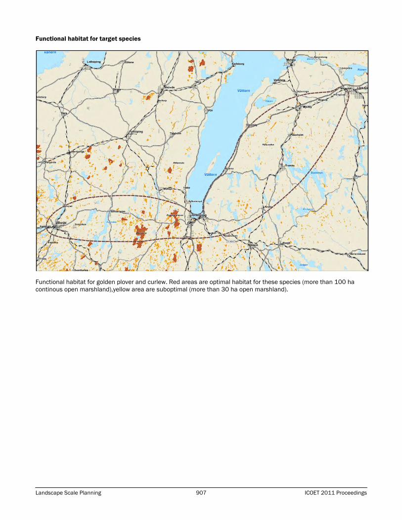
Landscape Scale Planning 907 ICOET 2011 Proceedings
Functional habitat for target species
Functional habitat for golden plover and curlew. Red areas are optimal habitat for these species (more than 100 ha
continous open marshland),yellow area are suboptimal (more than 30 ha open marshland).

ICOET 2011 Proceedings 908 Session SUS-6
CALIFORNIA HIGH SPEED RAIL: EARLY AGENCY COORDINATION
FOR ENHANCED ENVIRONMENTAL BENEFIT
Clifton Meek (415-972-3370, [email protected]), U.S. Environmental Protection Agency, Region
9, 75 Hawthorne Street, San Francisco, CA 94105, USA
Sarvy Mahdavi (415-972-3173, [email protected]), U.S. Environmental Protection Agency,
Region 9, 75 Hawthorne Street, San Francisco, CA 94105, USA
ABSTRACT
With $9.9 billion in state funding and over $4.1 billion in federal funding already committed to the project, High Speed
Rail is well on its way to becoming a reality in California. If planned and constructed in an environmentally sensitive
way, California High Speed Rail could be an environmentally superior mode of travel. It is estimated that high-speed
trains need only one-third the energy per person compared with that of an airplane and one-fifth of an automobile trip,
thereby reducing energy-use, reducing emissions, and reducing congestion on roadways. There is continuing concern,
however, about the potential environmental impacts inherent in such a large infrastructure project. These concerns
have propelled a slew of early inter-agency coordination activities on both regulatory and non-regulatory initiatives with
the goal of reducing the environmental impact and increasing the environmental benefit of the project to the greatest
extent possible. These inter-agency initiatives include early coordination on nine project-level Environmental Impact
Statements, development of comprehensive mitigation strategies, and partnerships to promote sustainability
throughout the High Speed Rail system.
INTRODUCTION
In 2008, California voters gave the green light for the state to issue $9.9 billion in bonds to plan and start building the
California High Speed Rail system. The American Reauthorization and Recovery Act provided an additional $2.55
billion and FY 10 appropriations provided more than $1.64 billion for the program, largely as a result of High Speed Rail
projects being cancelled in Wisconsin, Ohio, and Florida. This multi-billion-dollar effort will likely be the nation's largest
infrastructure project of the next decade. It will also be the nation's first truly high speed rail system with its own
separate right-of-way, allowing it to reach speeds of 220 mph.
With thoughtful planning and construction, California High Speed Rail could be an environmentally superior mode of
travel, since it will use substantially less energy per passenger, and is expected to be powered by electricity generated
from renewable sources, emitting far smaller quantities of greenhouse gases, particulates, and smog-forming gases
than transporting the same number of people by air. High Speed Rail is also expected to promote infill and transit
oriented development consistent with California's adopted sustainable growth policies. A programmatic analysis
determined that High Speed Rail would have less environmental impact than the alternative of further highway and
airport expansion to meet future intercity demand. However, there is continuing concern about the potential impacts to
ecosystems and habitats if the entire system is completed. Waters, wetlands, vernal pools, wildlife habitat, and
parklands all stand to be heavily affected if the project moves forward without proper mitigation strategies in place.
Conversely, exceptional environmental benefit, both in terms of ecosystem enhancement and sustainability, could be
realized if the project is planned well, taking into account all available avoidance and minimization techniques, as well
as abundant mitigation opportunities.
This is the impetus behind multiple early coordination activities that many agencies, including the U.S. Environmental
Protection Agency (EPA), are participating in to provide recommendations and feedback to the California High Speed
Rail Authority (CHSRA) and Federal Railroad Administration (FRA). Two full-time staff at EPA, funded by CHSRA, are
dedicated solely to this project, providing early inter-agency coordination on the development of nine project-level
Environmental Impact Statements for the entire system, reviewing the impacts of the proposed route on environmental
resources, and coordinating on comprehensive mitigation strategies. Additionally, EPA is working with federal, state,
and local agencies in the early planning stages to "green" the entire project, from energy use to water quality, climate
change, land use, stormwater impacts, fish and wildlife impacts, and overall sustainability policy. This inter-agency
team is focusing on both regulatory and voluntary approaches and partnerships to promote sustainability in facility
locations, design, station-area planning, construction, operations, and maintenance of the track corridor to be built
through urban, rural, and agricultural areas.

Landscape Scale Planning 909 ICOET 2011 Proceedings
DISCUSSION
Regulatory Initiatives to Reduce Environmental Impacts of the High Speed Train System
NEPA/404/408 Integration Process Memorandum of Understanding
In December 2010, A Memorandum of Understanding (MOU) was signed by the United States Department of
Transportation (DOT), FRA, CHSRA, United States Army Corps of Engineers (USACE), and EPA in order to facilitate
compliance and integration of environmental review required under the National Environmental Policy Act, section 404
of the Clean Water Act, and section 408 of the Rivers and Harbors act. The integration of these processes is intended
to expedite project decision-making while also reducing the potential environmental impacts of the project. Currently,
EPA and USACE are providing early coordination on Environmental Impact Statements and Clean Water Act Section 404
permitting for all nine planned segments of High Speed Rail throughout the state. The MOU establishes formal
checkpoints for coordination throughout the review process including at Purpose and Need, Range of Alternatives,
determination of the Least Environmentally Damaging Practicable Alternative, and the Draft Mitigation Framework. It
also sets up a formal process for dispute resolution should any conflicts arise during coordination. By using active inter-
agency coordination to focus efforts on reaching an environmentally sound project, conflicts can be resolved early in
the project planning process, avoiding unnecessary delays during project permitting.
Comprehensive Mitigation for Aquatic and Biological Resource Impacts
Identifying mitigation priorities in the Central Valley, where the first segments of High Speed Rail are planned to be built,
is a key priority. Many natural resource agencies and conservation organizations have identified and assessed the
existing resources in the Central Valley and already have a strategic plan for focusing conservation efforts on priority
species, habitats, and aquatic resources. They also have relationships with landowners, recreational groups, and
farmers and ranchers who can facilitate the most effective implementation of mitigation. The goal of the mitigation
efforts currently being initiated is to combine multiagency mitigation requirements into one comprehensive
conservation scenario to address impacts from High Speed Rail in the Central Valley and, ultimately, throughout the
entire project corridor. This approach would result in much larger scale mitigation projects than would have otherwise
been accomplished as it allows for the leveraging and complementing of existing conservation efforts. It also provides
an opportunity to strategically locate mitigation sites to expand on existing protected areas, resulting in improved
habitat connectivity and increased overall size of conservation lands. Additionally, there is a focus on ensuring that the
design of high speed rail takes advantage of opportunities to remove wildlife movement barriers, locate animal
crossings along natural migration routes, and design crossings with suitable habitat and topography to accommodate
multiple species. By coordinating on mitigation sites and wildlife connectivity early in the process, mitigation can be
influenced by knowledgeable local partners as well as long-term planning efforts such as Habitat Conservation Plans
and the California Department of Fish and Game’s Essential Habitat Connectivity Project. Ultimately, the goal is to
create a network of connected mitigation lands that will increase the quantity and quality of habitat and protect
important aquatic resources throughout the High Speed Rail corridor.
Non-Regulatory Initiatives to Create an Environmentally Sustainable High Speed Rail System
High Speed Rail Sustainability
EPA recently facilitated the creation of a partnership with several agencies who share a common goal of achieving an
environmentally sustainable High-Speed Rail system in California. Members of this partnership include CHSRA, DOT,
FRA, U.S. Department of Housing and Urban Development (HUD), Federal Transit Administration (FTA), U.S. Department
of Energy, National Renewable Energy Laboratory (NREL), and EPA. The goals of the partnership are to plan, site,
design, construct, operate, and maintain a High Speed Rail System in California using environmentally preferable
practices that preserve California’s natural resources, as well as minimize air and water pollution, energy usage, and
other environmental impacts. The far-reaching benefits of a well-planned High Speed Rail System in California include:
the promotion of sustainable housing and development patterns which incorporate local goals and interests while also
reducing indirect impact on nearby ecosystems; integration of station access and amenities into the fabric of
surrounding neighborhoods; stimulating multimodal connectivity; reducing per passenger transportation emissions
across California, thereby reducing associated environmental and health impacts; and protecting ecologically sensitive
and agricultural lands.
ICOET 2011 Proceedings 910 Session SUS-6
To achieve the goals listed above, the member agencies have identified five major areas for collaboration:
Sustainable, Livable Communities. The member agencies continue to engage in an open dialogue to ensure that
the High Speed Rail System is consistent with ongoing efforts to promote sustainable, livable communities
throughout California. To ensure that High Speed Rail stations are well integrated into communities, FRA and
CHSRA are coordinating with HUD, FTA, EPA, and NREL for feedback on station planning documents, parking
strategies, and approaches to integrate High Speed Rail infrastructure into communities. Partnerships with local
and regional organizations are also being developed in order to promote best practices in planning for High Speed
Rail impacts, including induced growth in station-areas and neighboring communities.
Material Selection, Design, and Construction. The High Speed Rail System has potential to serve as one of the
country’s best examples of a large-scale green infrastructure project. There is a great opportunity to minimize
embodied energy, use of natural resources, waste generation, and pollution through selection of environmentally
preferable materials, and through the use of best practices for design and construction of High Speed Rail system
infrastructure. CHSRA is collaborating with EPA in the hopes of reducing environmental impacts resulting from
manufacturing, transport, and use of building materials. Wherever possible, we are pushing for the reuse of
industrial materials, as well as the use of green construction materials such as Ashcrete instead of traditional
concrete. Pavements and structures made with recycled materials can be stronger, more durable, and less costly,
while also saving substantial energy, resources, water, and greenhouse gas emissions.
Renewable Energy and Energy Efficiency. Construction and operation of the High Speed Rail System will require a
large amount of energy, and ample opportunities exist to promote energy efficiency and renewable energy. CHSRA
is partnering with NREL and EPA to identify these opportunities through development of a strategic energy plan,
which will assist CHSRA in achieving its goal of operating the High Speed Rail System with 100% renewable energy.
Water Resources Management. A well-planned High Speed Rail System has the potential to improve watershed
health across much of the state. To the extent feasible, water resources management is being considered from a
watershed perspective. The member agencies have agreed to promote best practices for water efficiency and
conservation in siting, planning, design, construction, operation and maintenance of the High Speed Rail System. In
addition, green infrastructure approaches to stormwater management will be promoted within the High Speed Rail
footprint and through partnering with local organizations in areas that will likely experience induced development
as a result of the High Speed Rail System.
Systemwide Sustainability Policy. CHSRA is collaborating with the other member agencies on developing a system-
wide, holistic, sustainability policy, which will inform the planning, siting, design, construction, operation, and
maintenance of the High Speed Rail System. The policy will be based on existing research and publications and will
likely be included by reference in future CHSRA environmental documents (Station Area Plans, Contractor
Specifications, Environmental Impact Statements, etc.).
BIOGRAPHICAL SKETCHES
Clifton Meek is a Life Scientist within U.S. EPA Region 9’s Community and Ecosystems Division where he works as
biological resources lead for the Environmental Review Office Transportation Team. Previous career experience
includes positions with the U.S. Fish and Wildlife Service and The Nature Conservancy, as well as several years at a
private environmental consulting firm. Clifton has a Bachelors degree in Ecology and Environmental Health from NYU’s
Gallatin School, as well as a Masters degree in Conservation Biology from the University of Cape Town, South Africa.
Sarvy Mahdavi is an Environmental Specialist at the U.S. EPA Region 9’s Wetlands Office. Working closely with the
Environmental Review Office, she represents EPA as the co-lead environmental reviewer for the High Speed Rail
project. Previous EPA experience includes review of State Implementation Plans per Clean Air Act for various regions in
CA, development of green initiatives to promote development at previously contaminated Superfund sites, enforcement
of RCRA Subtitle I Compliance, coordination and communications of media relations and press events. Sarvy has a
Bachelor of Science in Environmental Economics and Policy from UC Berkeley and a Masters of Environmental Science
and Management from the Bren School at UC Santa Barbara.