Landscape Information Modeling -...
10
515 Building Information Modelling - Volume 2 - Computation and Performance - eCAADe 31 | Landscape Information Modeling Plants as the components for information modelling Veronika Zajíčková 1 , Henri Achten 2 Czech Technical University in Prague, Czech Republic 1 http://cz.linkedin.com/pub/veronika-zajíčková/67/741/b20, 2 http://www.molab.eu 1 [email protected], 2 [email protected] Abstract. In this paper we report on a recently started PhD project in which we investigate the extension of the concept of “Building Information Model” (BIM) to the domain of landscape design. The potential benefits of BIM in the field of architecture have been reported many times (e.g., Ibrahim et al., 2004; Eastman et al., 2008; Abdelmohsen et al., 2011). However, in landscape design an information model in the way of BIM seems to be missing. Benefits of a Landscape Information Model would be (a) formalisation of knowledge in landscape design; (b) information model to support multiple participants in landscape design; (c) improved information exchange between landscape design, architecture, and urban design. In this paper we set out the basic outline of the research. Keywords. BIM; landscape design; LIM. LANDSCAPE INFORMATION MODEL In this paper we report on a recently started PhD project in which we investigate the extension of the concept of “Building Information Model” (BIM) to the domain of landscape design. The potential benefits of BIM in the field of architecture have been report- ed many times (e.g., Ibrahim et al., 2004; Eastman et al., 2008; Abdelmohsen et al., 2011). As a technology, various instances of BIM can be found throughout many applications in the Building & Construction Industry. To the best of our knowledge, there is no similar application of the BIM principle for landscape design. In our view, there are three major benefits in the application of BIM principles to landscape de- sign: • Provision of an information model for the do- main of landscape design. • An information model that would support multi- ple participants in the landscape design process. • Integration of landscape design with urban and building designs. In our research project, creation of an information model for landscape design proceeds in two phases: first, the definition of an ontology of relevant con- cepts and objects for landscape; and second, the formalisation of this ontology into an information model. This process allows knowledge capture and representation which right now is not available. Similarly as in architectural and urban design, in landscape design multiple parties are involved (landscape designers, municipality, urban planners, and so on). Reliable exchange of information during the design, realisation, and management phases will increase effectiveness and reduce errors and the risk of (costly) corrections. Finally, when an information model for land- scape would be available, it would allow easier
-
Upload
nguyennguyet -
Category
Documents
-
view
221 -
download
2
Transcript of Landscape Information Modeling -...

515Building Information Modelling - Volume 2 - Computation and Performance - eCAADe 31 |
Landscape Information Modeling
Plants as the components for information modelling
Veronika Zajíčková1, Henri Achten2
Czech Technical University in Prague, Czech Republic1http://cz.linkedin.com/pub/veronika-zajíčková/67/741/b20, 2http://[email protected], [email protected]
Abstract. In this paper we report on a recently started PhD project in which we investigate the extension of the concept of “Building Information Model” (BIM) to the domain of landscape design. The potential benefits of BIM in the field of architecture have been reported many times (e.g., Ibrahim et al., 2004; Eastman et al., 2008; Abdelmohsen et al., 2011). However, in landscape design an information model in the way of BIM seems to be missing. Benefits of a Landscape Information Model would be (a) formalisation of knowledge in landscape design; (b) information model to support multiple participants in landscape design; (c) improved information exchange between landscape design, architecture, and urban design. In this paper we set out the basic outline of the research.Keywords. BIM; landscape design; LIM.
LANDSCAPE INFORMATION MODELIn this paper we report on a recently started PhD project in which we investigate the extension of the concept of “Building Information Model” (BIM) to the domain of landscape design. The potential benefits of BIM in the field of architecture have been report-ed many times (e.g., Ibrahim et al., 2004; Eastman et al., 2008; Abdelmohsen et al., 2011). As a technology, various instances of BIM can be found throughout many applications in the Building & Construction Industry. To the best of our knowledge, there is no similar application of the BIM principle for landscape design. In our view, there are three major benefits in the application of BIM principles to landscape de-sign:• Provision of an information model for the do-
main of landscape design.• An information model that would support multi-
ple participants in the landscape design process.
• Integration of landscape design with urban and building designs.
In our research project, creation of an information model for landscape design proceeds in two phases: first, the definition of an ontology of relevant con-cepts and objects for landscape; and second, the formalisation of this ontology into an information model. This process allows knowledge capture and representation which right now is not available.
Similarly as in architectural and urban design, in landscape design multiple parties are involved (landscape designers, municipality, urban planners, and so on). Reliable exchange of information during the design, realisation, and management phases will increase effectiveness and reduce errors and the risk of (costly) corrections.
Finally, when an information model for land-scape would be available, it would allow easier
516 | eCAADe 31 - Computation and Performance - Volume 2 - Building Information Modelling
integration of landscape design with urban and architectural design through exchange of infor-mation models. This is important to note, because landscape design is naturally involved in urban structures: parks, green areas, public spaces, and the immediate surroundings of buildings are often subject of landscape design. Therefore a more flu-ent link through a Landscape Information Model between architecture, urban design, and landscape design would be very beneficial.
CHARACTERISTICS OF LANDSCAPE DESIGNIn our view, a landscape information model consists of two major components: first, the information and knowledge about sites (terrain, ground conditions, weather, micro- and macro-climate, and so forth), and second the information and knowledge about landscape objects (“soft” materials such as vegeta-tion, and “hard” materials of built objects).
Landscape design is a multi-disciplinary field in which areas such as ecology, geography, geology, horticulture, and botany are used. This means that knowledge from quite a lot of areas has to be cap-tured in an information model. Because of the bio-logical nature of landscape design, it is inherently dynamic in time: changes in the terrain, weather, and most of all the “soft” materials have to be taken into account. Therefore the design of a landscape does not just feature a “final” or “fixed” state, but more resembles the design of a process in which the individual development of components and interac-tions between components have to be balanced.
LANDSCAPE AND NATURAL ELEMENTS IN URBAN CONCEPTSLandscape design in urban structures serves the fol-lowing purposes:• Maintaining and enhancing ecological stability. • Maintaining and enhancing ecological biodi-
versity.• Protection of soil (environment for the realiza-
tion of natural processes).• Protection of natural monuments and valuable
and threatened species.• Management of water regime.• Hygiene environment (in particular attention
to air pollution, noise and dust fallout) - trans-port solution.
• Care for uniqueness, aesthetic and cultural val-ues of landscape identity.
The functions of greeneryThe “soft” materials (greenery) have a distinct role in the design of landscapes (Sklenička, 2003):• Environmental (system of wildlife corridors,
insulation - emissions and partly noise, regula-tion of temperature and air humidity, air flow - acceleration due to temperature differences between greenery and buildings, sanitation - clean air, produce oxygen, ...)
• Recreational, aesthetic, social.• Water managing.• Soil-protecting, meliorating.• Architectural -creation of space - part of the
urban image (counterweight to artificial urban-ized environment).
• Economic - production.• Microclimatic.• Fire-preventing.We can distinguish between greenery in main func-tion, and in additional function. In the main func-tion, greenery is applied in parks, natural non-forest areas, cemeteries, gardeners, green insulation, bo-tanical gardens, and zoological gardens. In the ad-ditional function, greenery is applied in residential areas and private green spaces. Our major focus will be on greenery in main function.
Compositional elements of garden and landscape architectureThe compositional elements of garden and land-scape architecture consist of technical elements (“hard”) and vegetation elements (“soft”).
The technical elements are:• Terrain.• Water (water features, irrigation, drainage).• Solid surfaces, paving.

517Building Information Modelling - Volume 2 - Computation and Performance - eCAADe 31 |
• Exterior furnishings.The vegetation elements are:• High vegetation - tree layer.• Medium vegetation - shrub layer.• Low vegetation - ground cover plants, lawn,
herbs (perennials, annuals).Vegetation is a live, volatile and organic component of the composition and it is dependent on the con-ditions of surrounding environment. When design-ing the garden/landscape we have to take into ac-count all the conditions that could possibly affect the behaviour of the vegetation elements.
Conditions for inclusion of vegetation ele-ments in the architectural designHere we have to begin with the introduction and acclimatization of species. In the region of central Europe there are about 80 native species but more than two thousand non-native species can actually grow here.
When some foreign species are introduced we have to let them adapt to local conditions. Accord-ing to E. Quitt (1971), our region has several climatic regions:1. VT - very warm, dry (average temperature
9-10°C, annual rainfall 500-600)2. T1 - warm, dry (a.t. 8-9°C, annual rainfall <500)3. T2 - warm, light dry (a.t. 8-9°C, annual rainfall
500-600)4. T3 - warm, light humid (a.t. 7-9°C, annual rain-
fall 550-700)5. MT1 - moderate warm, dry (a.t.7-8,5°C, annual
rainfall 450-550)6. MT2 - moderate warm, light dry (a.t.7-8°C, an-
nual rainfall 550-700)7. MT3 - moderate warm, humid, lowlands (a.t.7-
8°C, annual rainfall 700-900)8. MT4 - moderate warm, humid (a.t. 6-7°C, an-
nual rainfall 650-750)9. MCh - moderate cold, humid (a.t. 5-6°C, annual
rainfall 700-800)10. Ch - cold, humid (a.t. below 5°C, annual rainfall
over 800)
Vegetation is distributed according to their ability of growing in the similar climatic conditions. This is called zoning.
ASPECTS OF TREE VEGETATION CLAS-SIFICATIONIn the following section we provide an overview of generally conceived major properties of tree veg-etation that may form a starting point for a general information structure (Michálková, 2011) (Table 1).
The dynamic character of the vegetation elementsAs we mentioned previously the vegetation is very dynamic element of the design. We have to predict its changes during the whole life-cycle (size, shape) as well as its seasonal cycle.• Development/growth: Youth, Period of fertility,
Period of death.• Reshaping: compact design changes in the last
stage to the irregular shapes.• Seasonal cycle - behaviour, requirements, and
appearance throughout the aspects of spring, summer, autumn, winter.
OUR APPROACHThe strategy of the research project consists of two parallel tracks: one track is breadth-first and top-down, in which we aim to comprehensively describe the domain of landscape design; the second track is depth-first and bottom-up, in which we aim to deve-lop specific information models for representative components of landscape.
The top-down approach provides the general framework for the landscape information model, and ensures that we do not oversee relevant as-pects. The bottom-up approach ensures that we can define realistic and applicable information models.
BUILDING INFORMATION MODELAlthough Building Information Modeling (BIM) has its roots in the mid 1980s, its popularity within the Architectural, Engineering and Construction indus-tries has risen only recently- that is reason why in-

518 | eCAADe 31 - Computation and Performance - Volume 2 - Building Information Modelling
formation modeling is still being developed for the buildings mainly - the construction management and facility operations.
That may explain that in our investigation we did not find any indication of existence of a survey or a research in our direction. Firstly we needed to get a deeper knowledge of the term “BIM” and also the software that supports this system of work.
What we found about BIM could be generalised to this: Building Information Modeling covers more than geometry- it extends the traditional approach to the building design (two-dimensional drawings as plans, elevations, sections, etc.) beyond 3-D to time as the fourth and cost as the fifth dimension, and sixth dimension is the life cycle management. It also covers spatial relationships, light analysis, geo-graphic information, quantities and properties of building components (for example manufacturers’ details).
There are two major BIM software developing
companies Graphisoft (ArchiCAD) and Autodesk (Revit) that bring their products to our market. Ad-ditionally there are also Nemetschek (Allpan Archi-tecture) and Bentley (Microstation V8i).
LANDSCAPE MODELLING SOFTWAREWe have found several smart “CAD based” programs, but all of them are used for 2D design (the tradition-al way). One case is for example ArborCAD, which is special purpose CAD software for the needs of ar-borists. It is based on the landscape software LAND-WorksCAD. It has a lot of features specially aimed at information about plants, trees, and their properties.
Additionally there are also some applications that work with plants as dynamic objects: • NatFX is a plug-in (for Alias|Wavefront’s Maya)
designed for modeling and animating 3D plants (age, season, and scale). Animation is possible either as a realistic effect (with bo-tanical constraints) or as a cartoon effect (by-
Table 1
Aspects of tree vegetation
classification.
Composition type• Basic, skeletal trees - long-living they stay on the spot throughout the parks lifetime - oak, linden,
maple, elm.• Additional trees.• Filling, temporary - fast-growing species.• Under-layer (middle and lower floors).• Ground covering species.
Visual characteristics• Size.• Habitus (shape variable within species).• Structure.• Texture - the period of dormancy.• Color - foliage, flowers, fruits.
Size of tree• Small 5-10 m fruit trees, ornamental cultivars.• Medium 10 (15)-20M hornbeam, birch, rowan, birch, spruce, pine, fir.• Large 20-30 (40) m to 40m: Buba, lime, ash, poplar, elm, maple.
Branching structure• Branching dense, sparse.• Direct branches, gnarled.

519Building Information Modelling - Volume 2 - Computation and Performance - eCAADe 31 |
passing the constraints), using natFX’s built-in plant skeletons. All natFX trees and plants are fully textured, based on scans of actual leaves, stems, and bark. NatFX is currently available as a plug-in.
• EASYnat by Bionatics is an add-in that can be used within AutoCAD or 3Dmax. Currently the trees are parametrically generated from the in-put data (height, width, age and season) (Fig-ures 1 and 2).
Figure 1
EASYnat examples of render-
ings of the Horsechestnut tree
models.
Foliage texture• Texture fine (small leaves)• Coarse texture (large-leaved trees - maples, horse chestnut, sycamore)• Airy texture (platane).
Growth and growing characteristics• Age.• Growth rate.• Environmental requirements.
Lifetime• Short-living (about 80 years ,willows, poplars, alder, birch), fast-growing.• Average, (200-300 years, maple, hornbeam, rowan, spruce, pine), survivor type.• Long-living (600-800 years, oak, linden, beech, yew).
Environmental requirements• Temperature: thermophilic (oak, beech, maple), cryophilous (spruce), no particular requirements-
pine, birch, sycamore.• Moisture: Xerophilic (rowan tree), Mezophilic (ash tree), Hydrophilic (willow).• Light: Heliophile (larch, pine, birch), Average, Heliophobic (yew, hornbeam).• Nutrients: most of the plants have average demand for nutrients, but some may demand alkaline
soils - Addition of Ca or acidic that requires addition of peat. Some species tolerates salinity - that ones are suitable for street alleys (acacia).
Table 1 continued
Aspects of tree vegetation
classification.

520 | eCAADe 31 - Computation and Performance - Volume 2 - Building Information Modelling
EASYnat could be suitable for our further re-search - for implementation into object orientated software like Revit or ArchiCAD and development of their attributes and actions. The plants should have more attributes and while simulating the grow process, they should react and interact with its sur-roundings.
UNIFIED MODELLING LANGUAGEBIM involves representing a design as combina-tions of ‘objects’ that carry their geometry, relations and attributes. Such objects and relations can be described by UML (Unified Modelling Language). UML is a standardized general-purpose modeling language in the field of object-oriented software engineering. It is a tool for defining the structure of a system through several types of diagrams. UML enables to model an application specifically and in-dependently of a target platform (Fowler and Scott, 2000; Blaha and Rumbaugh, 2004).
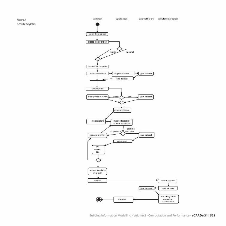
UML diagrams represent two different views of a system model: static (structural) and dynamic (be-havioral) diagrams (Schmuller, 2001). There are more than ten different types of UML diagrams. In our in-quiry we are interested in class diagrams, object dia-grams and activity diagrams (Figure 3).
In our research we aim to advance the informa-tion model of the vegetation to be comprehensive. This means that we not only model the general at-tributes of vegetation (for example for trees family, genus, species, cultivar, decicious/evergreen, sea-son), but also the time dynamic attributes (for exam-
ple for trees height, canopy perimeter, trunk perime-ter), surrounding reaction (for example for trees soil requirements, geographic location, moisture), and interaction (for example for trees spread, ecologi-cally close trees, and antagonistic plants).
In real life coding examples, the difference be-tween inheritance and aggregation can be confus-ing. If you have an aggregation relationship, the aggregate (the whole) can access only the PUBLIC functions of the part class. On the other hand, inher-itance allows the inheriting class to access both the PUBLIC and PROTECTED functions of the superclass.
DESCRIPTION OF POTENTIAL APPLICA-TION OF UML DIAGRAMSWe have applied the class diagrams to our study case: we needed to state the classes and all the atributes that our classes should have. Then we have created one instance of that class and the relations (Figure 4).
These diagrams we use to map the classes that appear in our application study. While describing the plants as object for BIM you have to take in ac-count all their properties and attributes -such as height, perimeter of canopy, perimeter of a trunk, classification in the meaning of family- genus- spe-cies- cultivar, to state if the plant is decidious or ev-ergreen, the aspect of season (mainly to state the ex-istence and color of the leaves), the age of the plant and its habitus an finally for most efficient work with the objects the detailing and the way of graphic ap-pearance.
3rd 5th 7th 10th 15th 20th 50th year
Figure 2
EASYnat simulation of a
growth of a Horsechestnut
tree.
521Building Information Modelling - Volume 2 - Computation and Performance - eCAADe 31 |
Figure 3
Activity diagram.

522 | eCAADe 31 - Computation and Performance - Volume 2 - Building Information Modelling
The same (properties and attributes) we should state for the other objects that we would like to in-volve in our application.
In this preliminary diagram (Figure 5) you can see buildings (can cover the minor architectural works in the countryside), site equipment (such as benches, trash cans, lightning, equipment for cy-
clists-parking places) and infrastructure objects.
DISCUSSIONIn the paper we have presented our first findings to-wards a Landscape Information Model. The work is still in a very preliminary phase, but we hope to have laid some foundations. As trees are dominant visual
Figure 4
Class and instance diagrams.
Figure 5
Diagram of relations between
classes.

523Building Information Modelling - Volume 2 - Computation and Performance - eCAADe 31 |
elements in landscape design, we have started with more concrete knowledge capture of trees. In the next steps we aim to implement a parametric data model of trees in Revit.
REFERENCES Abdelmohsen, S, Lee, J and Eastman, C 2011, ‘Automated
Cost Analysis of Concept Design BIM Models’, Comput-er Aided Architectural Design Futures 2011 [Proceedings of the 14th International Conference on Computer Aided Architectural Design Futures], Liege, Belgium, 4-8 July 2011, pp. 403-418.
Blaha, M, Rumbaugh, J 2004. Object-oriented modeling and design with UML, Prentice Hall, Upper Saddle River.
Eastman, C, Teicholz, P, Sacks, R and Liston, K 2008, BIM Handbook: A Guide to Building Information Modeling for Owners, Managers, Designers, Engineers and Contrac-tors, Wiley, Chichester.
Fowler, M and Scott, K 2000, UML Distilled: A Brief Guide to the Standard Object Modelling Language, Addison-Wes-ley, Amsterdam.
Ibrahim, M, Krawczyk, R and Schipporeit, G 2004, ‘Two Ap-proaches to BIM: A Comparative Study’, Architecture in the Network Society [22nd eCAADe Conference Pro-ceedings], Copenhagen, Denmark, 15-18 September 2004, pp. 610-616
Michálková, R 2011, Tvorba zeleně, VOŠZa a SzaŠ, Mělník. Quitt, E 1971, Climate Regions of Czechoslovakia, Studia
Geographica 16:1-74, Geografický ústav ČSAV, Brno.Schmuller, J 2001, Myslíme v jazyku UML: knihovna pro-
gramátora, Grada, Praha.
Sklenička, P 2003, Základy krajinného plánování, Naděžda Skleničková, Praha
[1] http://www.bionatics.com/Site/product/index.php?langue=en&UrlSuite=%2FSite%2Fproduct%2Fshop%2Fplant%2Fdetail.php%3FCommunity%3D2%26ProductLineId%3D10%26Category%3D11%26SubCategory%3D112%26PlantId%3Daescu_b
[2] http://en.wikipedia.org/wiki/Class_diagram[3] http://www.smartdraw.com/resources/tutorials/uml-
class-diagrams/#/resources/tutorials/Introduction-to-UML
[4] http://bim.wikispaces.com/file/view/Landscape+Information+Model+Building.pdf [5] http://www.cadinterna-tional.com/cadinternational/product.php?prod=AB&prodtype=PR#overview
[6] http://www.uml-diagrams.org/class-diagrams.html; http://www.visual-paradigm.com/product/vpuml/tutorials/
[7] http://www.bimmanager.com/wp-content/up-loads/2009/11/BIM-Process-Exchange-IDM.pdf
[8] http://www.bimthinkspace.com/2008/11/effects-of-bim-on-project-lifecycle-phases.html
[9] http://www.cad-addict.com/2010/03/from-cad-to-bim-part-ii-from-cad-2d-to.html
[10] http://databaze.dendrologie.cz/index.php?menu=5&id=67
[11] http://www.cgw.com/Publications/CGW/2001/Volume-24-Issue-8-August-2001-/Bionatics-Grows-Virtual-Plants.aspx
[12] http://forums.cgarchitect.com/6326-trying-out-plant-plugins.html

524 | eCAADe 31 - Computation and Performance - Volume 2 - Building Information Modelling