Landscape Design for bird conservation in Buntine ... · Landscape design for bird conservation in...
131
Landscape design for bird conservation in Buntine-Marchagee Catchment, Western Australia CSIRO report on Component 1 of Project CSE9: Testing approaches to landscape design in cropping lands for Land & Water Australia and WA Department of Conservation and Land Management June 2004
Transcript of Landscape Design for bird conservation in Buntine ... · Landscape design for bird conservation in...

Landscape design for bird conservation in
Buntine-Marchagee Catchment,
Western Australia
CSIRO report on Component 1 of Project CSE9: Testing approaches to landscape design in cropping lands
for Land & Water Australia and WA Department of Conservation and Land Management
June 2004

Landscape design for bird conservation in
Buntine-Marchagee Catchment, Western
Australia
Component 1 Report Andrew Huggett Blair Parsons Lyn Atkins John Ingram CSIRO Sustainable Ecosystems Private Bag 5, PO Wembley WA 6913 [email protected] © CSIRO Sustainable Ecosystems, 2004 Photographs courtesy of CSIRO Sustainable Ecosystems and WA Department of Conservation and Land Management Cover photographs (clockwise from top left): Western Yellow Robin – the focal species for remnant condition in Buntine-Marchagee Catchment (Photo courtesy Bert and Babs Wells, CALM); Malleefowl – a threatened species recorded during CSIRO surveys in Buntine-Marchagee Catchment (Photo courtesy Bert and Babs Wells, CALM); Southern Scrub-robin – a species that prefers large areas of shrubland that are well connected and is most sensitive to shrubland patch size and isolation distance in Buntine-Marchagee Catchment; Centre map – suggested sites (shown in red) for habitat linkages in Buntine-Marchagee Catchment.

Component 1 Report: Landscape Design for Bird Conservation in Buntine-Marchagee Catchment, Western Australia
ACKNOWLEDGEMENTS
This document reports on Component 1 (focal bird species analysis and landscape design)
of Project CSE9 (Testing approaches to landscape design in cropping lands). This was
commissioned and funded by Land & Water Australia (Native Vegetation R&D Program)
and Western Australian Department of Conservation and Land Management (CALM).
The CSIRO Component 1 study team comprised Dr Andrew Huggett, Blair Parsons, Lyn
Atkins, and John Ingram. Andrew managed the project, undertook statistical analyses,
contributed text and prepared this report. Blair performed the focal species analysis from
bird survey data collected by John, Andrew and Blair, developed the landscape design,
and contributed associated text. Lyn carried out and supervised field vegetation surveys,
contributed associated text, and photographed vegetation associations shown in Appendix
3. John prepared report appendices.
We acknowledge the cooperation and assistance of many individuals and organisations in
the preparation and communication of this report. They include Alison & John Doley,
Vern Muller, the Crago family, Helen Nankivell, Michael O’Callaghan, Neil and Joanne
Diamond, Alan Barnes, John & Robyn Stacy and other farming families in the study area.
We especially thank Alison & John Doley and the Diamonds for their hospitality during
fieldwork. Jodie Watts (Buntine-Marchagee Recovery Catchment Officer), Kelly Gillen,
Anthony Desmond, Stuart Halse, Susie Murphy-White, Ken Atkins, and Ken Wallace of
CALM provided key biophysical data, management insights, practical advice to, and
stimulating discussions on, the project. Fiona Falconer advised on community
consultation issues. Ted Griffen, Mike Clarke and Russell Speed of WA Department of
Agriculture provided some helpful insights and useful data. WA Department of Land
Administration supplied salinity hazard data.
We also thank CSIRO Sustainable Ecosystems’ Drs David Freudenberger (Principal
Investigator, Project CSE9), Ted Lefroy and Jeff Short (project proposal development and
advice), Lesley Brooker (spatial analysis and landscape design advice), Michael Brooker
(some bird surveys), Drs A.O. (Nick) Nicholls and Mike Austin (statistical analysis and
advice), and Margaret Cawsey (database development). To all we are grateful.
i

Component 1 Report: Landscape Design for Bird Conservation in Buntine-Marchagee Catchment, Western Australia
GLOSSARY
Autecology: The study of the individual organism in relation to its environment (Krebs
1985).
Connectedness, Connectivity: The degree to which remnants are linked to one another
by intervening native or other perennial vegetation such as road verges, vegetation
linkages, corridors, windbreaks, etc.
Core habitat, Core habitat patch: An area of habitat within a single remnant that is
sufficiently large or well connected for a focal bird species to have a 10% chance of
occurrence.
Corridor: Linear strip of vegetation in fragmented landscapes used by animals as habitat
and/or travel routes (Sieving et al. 2000) typically featuring structurally complex and
floristically diverse vegetation and microhabitat.
Declining species: Bird species identified by Saunders and Ingram (1995) as "decliners"
in the Western Australian wheatbelt.
Farmland species: Bird species identified by Saunders and Ingram (1995) as "farmland
species" in the Western Australian wheatbelt.
Focal species candidate: For the purposes of this report, a resident, declining bird
species, that is not a farmland, water or nocturnal bird species.
Isolation distance: The minimum straight-line distance between remnants, measured
from the edge of the remnant.
Key habitat: All habitat of sufficient size or connectedness in which the focal bird
species least sensitive to a specific threat has a 10% chance of occurring.
Linkage: A linear strip of vegetation that connects two or more remnants; this strip may
in time provide a corridor function to facilitate the movement of animals between
remnants providing adequate structural complexity and habitat diversity is available.
Neighbourhood: A set of habitat patches falling within a given radius of core habitat, as
defined by the requirements of the focal species
Occupied remnant: A remnant of native vegetation in which a bird species was recorded
at least once during survey.
ii

Component 1 Report: Landscape Design for Bird Conservation in Buntine-Marchagee Catchment, Western Australia
Patch: A discrete area of bird habitat type, vegetation association, or vegetation sub-type
within a remnant of native vegetation.
Proximity: The minimum straight-line distance between remnants, measured from the
edge of the remnant.
Reconstruction: The re-building of a landscape involving the planting of native
vegetation to re-connect remnants, usually for the purposes of biodiversity conservation,
soil conservation and/or water management.
Remnant: A discrete or semi-discrete area of native vegetation surrounded by cleared or
otherwise alienated land.
Resident species: For the purposes of this report, a sedentary bird species that usually
lives within a relatively small area of bush (home range).
Restoration: The gradual return of ecological structure and function to bushland or
wetland previously fragmented by clearing, habitat modification, etc, and usually
involving the protection of existing habitat and the planting and maintenance of new
habitat
Sedentary: For the purposes of this report, a bird species that lives its whole life within a
relatively small area of bush, usually no more than 1-10 ha.
Study area: The study area referred to in this report is Buntine-Marchagee Catchment
(as shown in Figures 1 and 2).
iii

Component 1 Report: Landscape Design for Bird Conservation in Buntine-Marchagee Catchment, Western Australia
EXECUTIVE SUMMARY
This is a study of the spatial and habitat requirements of sedentary birds occupying
remnant native vegetation in Buntine-Marchagee Catchment. The study presents a
landscape design for the conservation of this avifauna based on a modified focal species
approach (Lambeck 1997). This study is Component 1 of the Testing approaches to
landscape design in cropping lands project. It has been undertaken by CSIRO Sustainable
Ecosystems for Land & Water Australia and WA Department of Conservation and Land
Management (CALM).
Buntine-Marchagee Catchment (181,008 ha) is situated in the northern wheatbelt of
Western Australia, approximately 280 km north of Perth. Farmed principally for wheat
and sheep, this catchment consists of sandplain shrubland, heath and Banksia woodland
and shrubland, York Gum, Gimlet and Salmon Gum woodlands and mallee on valley
slopes and lateritic ridges, and Acacia/Melaleuca shrubland and samphire-dominated
wetland (13,500 ha) in the saline valley floors. Buntine-Marchagee Catchment was
identified as one of six Natural Diversity Recovery Catchments by CALM in 1999
because of significant biodiversity values associated with its system of saline braided
channels.
This study used presence/absence bird data for a focal species analysis obtained from 316
remnants in Buntine-Marchagee Catchment studied by CSIRO Sustainable Ecosystems
from 2001 to 2002. Resident bush birds identified as ‘decliners’ (Saunders and Ingram
1995) were treated as focal species candidates (42 species) and divided into generalists,
heath/shrubland/mallee specialists and woodland specialists. Point-count surveys were
conducted across saline drainage lines to evaluate focal bird species’ use of these zones. A
total of 18,068 individual birds from 110 species were recorded during this study.
Detailed vegetation surveys were conducted in all 503 remnants in the catchment.
Five bird species were selected as focal species based on their sensitivity to key landscape
attributes: Grey Butcherbird Cracticus torquatus (remnant area), Southern Scrub-robin
Drymodes brunneopygia (heath/shrub/mallee habitat patch size and isolation), Red
Wattlebird Anthochaera carunculata (woodland patch size), Brown-headed Honeyeater
iv

Component 1 Report: Landscape Design for Bird Conservation in Buntine-Marchagee Catchment, Western Australia
Melithreptus brevirostris ssp. leucogenys (woodland patch isolation), and Western Yellow
Robin Eopsaltria griseogularis (remnant condition).
Focal bird species knowledge gained from the analysis was used in a comprehensive 10-
step landscape design procedure aimed at retaining existing avifauna and enhancing and
re-connecting their habitat. The design recommends:
• A total of 1,361.5 ha of new native vegetation in the catchment, equating to 6.1%
of existing remnant native vegetation (22,340 ha);
• Of this new vegetation, 1,093 ha of ‘stepping stone’ habitat should be planted to
link neighbourhoods. This comprises 712 ha of heath/shrub/mallee habitat (see
map below) and 381 ha of woodland habitat;
• A total of 268.5 ha of new 60 metre-wide linkages to increase the connectedness
of habitat within neighbourhoods; and
• Priority habitat protection and management of 4,568 ha of existing remnants.
This study has contributed several new elements to the design of Western Australian
farming landscapes for bird conservation. These include innovative field survey and
spatial and focal species analyses (including an assessment of remnant condition), and the
provision of a practical, ‘road-tested’ landscape design for habitat restoration.
There have also been some important collective lessons learnt from these catchment-
based studies in Western Australia. These include understanding the importance of spatial
and temporal variation in scale on the identification of focal species and the development
of effective landscape designs, avoidance of heavily prescriptive landscape designs,
recognition of the need to assess other threats (and interactions between these threats) to
the survival of declining sedentary birds, and reiteration of the need for ongoing
monitoring and evaluation of the performance of landscape designs.
Regional scale focal species analysis offers some potential advantages over catchment-
based studies. These include accounting for the effects of spatial and temporal scale on
especially bird-based applications of the focal species approach, estimation of long-term
population and metapopulation viability of focal species, timely provision of regional
scale focal species knowledge for on-ground use by catchment groups, and utility as a
v

Component 1 Report: Landscape Design for Bird Conservation in Buntine-Marchagee Catchment, Western Australia
regional conservation planning tool to help prioritise action and efficiently allocate scarce
conservation management resources.
A suite of recommendations for the conservation of avian diversity and sustainable
management of Buntine-Marchagee’s natural resources are put forward. These utilise the
results of the landscape design procedure together with stakeholder consultations
conducted during development of the design. They include general guidelines for
understanding the importance of landscape management planning in the conservation of
natural resources and a suite of monitoring and review actions. In addition, a number of
priority actions are recommended for adoption in the catchment. These focus on
protecting and retaining existing native bird assemblages while also improving their
prospects of survival and possible long-term recovery. Finally, this study presents some
directions for future research in Buntine-Marchagee Catchment. These include focusing
the landscape conservation effort, new ecological research, landholder participation and
training, and working together with other organisations.
Suggested heath/shrub/mallee ‘stepping stones’ to link neighbourhoods in Buntine-Marchagee Catchment.
±0 10 205 km
Suggested "stepping stones"
Core heath/shrub/mallee habitat
Heath/shrub/mallee neighbourhoods
Catchment Boundary
vi

Component 1 Report: Landscape Design for Bird Conservation in Buntine-Marchagee Catchment, Western Australia
TABLE OF CONTENTS
ACKNOWLEDGEMENTS i
GLOSSARY ii
EXECUTIVE SUMMARY iv
TABLE OF CONTENTS vii
1. INTRODUCTION 9 1.1. OBJECTIVES 9
1.2. STUDY AREA 10
1.3. STAKEHOLDERS 13
1.4. CSIRO IN THE WA WHEATBELT 14
2. METHODS 17 2.1. BIRD SURVEYING 17
2.2. VEGETATION SURVEYING AND MAPPING 20
2.3. THE FOCAL SPECIES APPROACH 23 2.3.1. Development and application of the focal species approach 23 2.3.2. Focal species analysis procedure 24 2.3.3. Statistical analysis 28
2.4. LANDSCAPE DESIGN 28 2.4.1. Designing landscapes for birds and people 28 2.4.2. The landscape design procedure 29
2.5. COMMUNITY CONSULTATION 33
3. RESULTS 36 3.1. CHARACTERISTICS OF REMNANTS 36
3.2. BIRD SURVEYS 37 3.2.1. Area searches 37 3.2.2. Point-count transects 37 3.2.3. Birds of conservation significance 40
3.3. VEGETATION OF THE STUDY AREA 43 3.3.1. Vegetation association classes and floristics 43 3.3.2. Conservation status 44
3.4. FOCAL SPECIES ANALYSIS 46 3.4.1. Candidate focal bird species 46
vii

Component 1 Report: Landscape Design for Bird Conservation in Buntine-Marchagee Catchment, Western Australia
3.4.2. Remnant area 48 3.4.3. Habitat patch size 50 3.4.4. Habitat patch isolation 53 3.4.5. Remnant condition 56
3.5. LANDSCAPE DESIGN 58 3.5.1. Design overview 58 3.5.2. Creation of habitat ‘stepping stones’ 58 3.5.3. Creation of habitat linkages within neighbourhoods 65 3.5.4. Habitat protection and management 69
4. DISCUSSION 72 4.1. CATCHMENT-BASED STUDIES 72
4.2. REGIONAL SCALE ANALYSIS 75
5. RECOMMENDATIONS 77 5.1. LANDSCAPE MANAGEMENT PLANNING 77
5.2. PRIORITY ACTIONS 79 5.2.1. Overview 79 5.2.2. Priority 1: Protect and enhance existing habitat and species of conservation
significance through on-ground action 79 5.2.3. Priority 2: Prioritise habitat protection and management activities 81 5.2.4. Priority 3: Create habitat ‘stepping stones’ to link neighbourhoods 81 5.2.5. Priority 4: Establish linkages to improve the connectedness of habitat within
neighbourhoods 82
5.3. MONITORING AND REVIEW 83
5.4. DIRECTIONS FOR FUTURE RESEARCH 85
6. REFERENCES 87
7. APPENDICES 93 APPENDIX 1: Communication activities completed during this study 94
APPENDIX 2: Land birds found in the Western Australian wheatbelt 97
APPENDIX 3: Descriptions of native vegetation associations recorded in
Buntine-Marchagee Catchment 101
APPENDIX 4: Perennial plant species recorded in quadrat-based floristic
surveys of selected remnants in Buntine-Marchagee Catchment 115
APPENDIX 5: Native vegetation associations and bird species recorded in each
remnant surveyed in Buntine-Marchagee Catchment 129
viii

Component 1 Report: Landscape Design for Bird Conservation in Buntine-Marchagee Catchment, Western Australia
1. INTRODUCTION
1.1. OBJECTIVES
This report presents a landscape design for conserving native birds in Buntine-Marchagee
Catchment. This design provides an improved “focal species” (sensu Lambeck 1997)
approach for determining where to strategically revegetate this catchment to assist the
long-term survival of bird species considered to be most at risk of decline and local
extinction in this fragmented agricultural landscape.
The specific objectives of this study are therefore to:
• Construct logistic regression models to identify focal bird species using data from
bird and vegetation surveys undertaken in this project;
• Use these models to assess the predicted probability of occurrence of focal bird
species according to the key variables of remnant area, habitat patch size, habitat
patch isolation, and remnant condition;
• Develop a landscape design for bird conservation in the study area based on
ecological information provided by the focal species analysis;
• From this design and community consultation, provide practical recommendations
for strategic revegetation within the catchment that seek to retain the existing
complement of native avifauna, protect, enhance and, where possible, re-connect
their habitat, and promote their long-term recovery.
This study is Component 1 in a series of three reports prepared under Project CSE9 –
Testing approaches to landscape design in cropping lands. Components 2 (Habitat
neighbourhoods for conserving viable populations of birds – Brooker and Lefroy 2004)
and 3 (Application of the focal species approach to other taxa) are reported separately.
9

Component 1 Report: Landscape Design for Bird Conservation in Buntine-Marchagee Catchment, Western Australia
1.2. STUDY AREA
The study area comprises two sub-catchments – Buntine and Marchagee – situated within
the Moore River Catchment in the northern wheatbelt of Western Australia,
approximately 280 km north of Perth (Figures 1 and 2). These catchments cover an area
of 181,008 ha (181 km2) and together are approximately 40 km long and 60 km wide. A
series of braided channels featuring salt lakes drain Buntine-Marchagee Catchment. These
saline drainage lines mildly incise broad valleys separated by gently undulating rises and
breakaways. The catchment lies about 65 km east of the Darling Fault on the Archaean
granite and granitic gneisses of the Yilgarn block (Kitchener 1979). Main soil types are
sands underlain by laterite in places, grey clays (on decaying granite), and red soils of
colluvial origin or formed on granite (see Kitchener 1979).
Figure 1: Location of the study area within the Western Australian wheatbelt, showing a total of nine sub-catchments used in focal species studies by CSIRO (Landsat TM satellite image courtesy CSIRO Mathematical & Information Sciences)
10

Component 1 Report: Landscape Design for Bird Conservation in Buntine-Marchagee Catchment, Western Australia
Figure 2: Location of the study area showing towns, remnant native vegetation, and the chain of braided lakes (Landsat TM satellite image courtesy CSIRO Mathematical & Information Sciences)
Wubin
Coorow
Gunyidi
Buntine
Watheroo
Marchagee
Dalwallinu
Remnant VegetationBuntine Marchagee Catchment0̄ 10 205
km
Mean annual rainfall in the study area is 362 mm of which 225 mm falls in May-August
(Anon 1975). Mean daily maximum temperature is 25.8°C while the mean daily
minimum temperature is 12°C with frost possible from May-September (Anon 1975).
Winds are generally light (1-10 kph) and from the south-east in summer but directionally
variable in winter (Anon 1975).
The native vegetation of Buntine-Marchagee Catchment is floristically diverse,
comprising 24 associations from six broad formations - heathland, shrubland, sedgeland,
grassland, woodland and wetland (Section 3.3.1). The current conservation status of this
vegetation is discussed in Section 3.3.2. There are at least six CALM reserves (Buntine
Nature Reserve [NR], Nugadong NR, Bryant Park NR, NR 21175, NR 28669, and NR
38401), two large shire reserves (Wubin townsite and Wubin Rocks), and several smaller
shire reserves set aside for sand and gravel extraction in the study area. Much of the
native vegetation in the catchment however occurs on privately owned land, especially in
11

Component 1 Report: Landscape Design for Bird Conservation in Buntine-Marchagee Catchment, Western Australia
the southwest and northwest of the catchment (see Section 3.1). Approximately 12.3%
(22,340 ha) of the study area supports native vegetation.
In biogeographical terms, native vegetation of the study area can be divided into two
distinct groups that correspond with the Interim Biogeographical Regions of Australia
(IBRA – Environment Australia 2000) classification. Vegetation of the Avon Wheatbelt
IBRA occurs within the Avon Botanical District (Beard 1990) on Archaean granites of the
Yilgarn Block. The uplands feature yellow sands and laterite with Tamma (Allocasuarina
spp.), Wodjil (Acacia spp.), and Melaleuca shrublands occurring on the shallower lateritic
soils. The deeper sands typically support Acorn Banksia (Banksia prionotes) and Woody
Pear (Xylomelum angustifolium). Granite outcrops occur in parts of the catchment with a
mosaic of tamma, Acacia shrubland and York gum/Jam woodland. Woodlands of
commonly Salmon Gum, York Gum or Gimlet occur on the red loamy soils of midslopes
and ridges. Mallee vegetation of typically Eucalyptus subangusta over Melaleuca shrubs
usually occupies the transition zone between shrublands and woodlands on shallow
duplex soils (Beard 1990). In the valley floors, saline grey sandy soils support salt-
tolerant samphires (Halosarcia spp.), sedges, Melaleuca and Acacia species, often with
adjacent York Gum woodlands.
Vegetation of the second IBRA group, the Geraldton Sandplain bioregion, is situated
within the Irwin Botanical District (Beard 1990). This occurs in a broad arc from the
study area’s northwest corner to its central southern boundary. Soils supporting this
vegetation are deep yellow aeolian sands deposited higher in the landscape and greyish
sands in the lower parts (Beard 1990). The yellow sands feature Banksia woodlands,
commonly of B. prionotes, Candle Banksia B. attenuata, and Firewood Banksia B.
menziesii, and often in association with Woody Pear, Sandplain Cypress Actinostrobus
arenarius, and Adenanthos strictus. Mixed stands of Pear-fruited Mallee Eucalyptus
pyriformis over Eremaea and Melaleuca dominated shrub and heathlands also occur on
these soils. Along interconnected lakes and playas low in the landscape the vegetation is
characterised by Halosarcia communities, Swamp Sheoak Casuarina obesa fringing
Melaleuca thyoides stands in saline areas, and River Red Gum E. camaldulensis in
brackish or less saline zones.
12

Component 1 Report: Landscape Design for Bird Conservation in Buntine-Marchagee Catchment, Western Australia
The first recorded European exploration of Buntine-Marchagee catchment was by the
Gregory brothers in 1846 (Beard 1976). From 1894 settlers arrived in the western part of
the district upon completion of the Midland Railway which linked Perth with Geraldton
(Kitchener 1979). From 1913 the Government Railway through Wubin and Perenjori
brought settlers to the eastern part of the catchment (Kitchener 1979). The last phase of
clearing native vegetation for wheat and sheep farming in the catchment was the 1970s
(Kitchener 1979) and probably the early 1980s. In recent years, a number of new farming
systems aimed at mitigating the loss of productive agricultural land to salinity such as oil
mallees and lucerne cropping have been pursued in the parts of the study area.
A major initiative to protect and recover the natural biodiversity values of the study area
commenced in 1999. This project – Buntine-Marchagee Natural Diversity Recovery
Catchment – began under the WA State Salinity Strategy and is run by a steering
committee of government agencies, universities, and landholder groups. Principal partners
include CALM, WA Department of Agriculture, CSIRO Sustainable Ecosystems, CSIRO
Plant Industry, WA Department of Environment, Marchagee Catchment Group, Waddy
Forest LCDC, Liebe Group, Moore Catchment Council, University of Western Australia
and Murdoch University. A range of specialist hydrological, agronomic, farm forestry and
biodiversity studies are being undertaken as part of this initiative, together with intensive
community consultation and planning for strategic on-ground revegetation and habitat
restoration programs (see Section 5).
1.3. STAKEHOLDERS
There are approximately 106 landholders in Buntine-Marchagee Catchment with an
average property size of 1,879 ha (CALM 2003). Privately owned property covers 93.7%
(169,527 ha) of the catchment and there are 2,225 ha (1.2% of the catchment) of land
managed by CALM, principally as nature reserves (CALM 2003). There are also 1,726 ha
of unallocated crown land which comprises mostly salt lakes and 4,888 ha of ‘other’ type
reserves in the study area (CALM 2003). These ‘other’ reserves include parcels of land
managed by Coorow, Dalwallinu and Moora Shires, water reserves managed by WA
Water Authority, road reserves (Main Roads WA) and old railway reserves. Several of
these reserves contain remnants of native vegetation that provide important habitat for
sedentary bush birds and other fauna (see Sections 3 and 4).
13

Component 1 Report: Landscape Design for Bird Conservation in Buntine-Marchagee Catchment, Western Australia
Mixed cropping and sheep grazing are the main agricultural enterprises in the study area.
Some farms have commenced investigating the use of other crops such as oil mallees and
lucerne.
1.4. CSIRO IN THE WA WHEATBELT
CSIRO Division of Wildlife and Rangelands Research (now CSIRO Sustainable
Ecosystems) commenced studying the biology of Western Australian wheatbelt lands in
1969. Ian Rowley started working on the Galah Cacatua roseicapilla at Manmanning in
the north-central wheatbelt and on Major Mitchell’s Cockatoo C. leadbeateri (with
Graeme Chapman) at Mukinbudin in the north-eastern wheatbelt (Rowley, pers comm).
The emphasis on cockatoo biology continued through the 1970s largely in response to the
agricultural ‘pest’ status of cockatoos in the wheatbelt. Denis Saunders studied the
reproductive biology of the Short-billed Black-Cockatoo (Carnaby’s Cockatoo)
Calyptorhynchus latirostris at Manmanning and Coomallo Creek near Jurien Bay. Denis
also commenced a study of the reproductive and foraging biology of Red-tailed Black-
Cockatoo C. banksii ssp. samueli in 1975 at Three Springs in the northern wheatbelt. In
1978, this study was extended to four other cockatoo species in remnant Salmon/York
Gum woodland in this part of the wheatbelt and at Kirwan, south-east of Dalwallinu, by a
number of CSIRO wildlife biologists including Ian Rowley, Denis Saunders, Graeme
Smith and John Ingram.
In 1985, the emphasis shifted to landscape-based ecological research. Denis Saunders and
colleagues - Richard Hobbs, Graham Arnold and Graeme Smith – studied the effects of
habitat loss and fragmentation on native plant and animal communities at and near
Durokoppin Nature Reserve north of Kellerberrin in the central wheatbelt. They
investigated the conservation potential of native vegetation remnants and ways of
integrating nature conservation into agricultural land management. Their ground-breaking
research applied ecological theory to the management of fragmented ecosystems based on
the retention of existing biota and inclusion of conservation farming practices.
By 1998 the first of several catchment-based studies of the spatial and ecological
requirements of birds and their habitat was underway at Wallatin Creek in the central
14

Component 1 Report: Landscape Design for Bird Conservation in Buntine-Marchagee Catchment, Western Australia
wheatbelt. These studies sought to apply the principles and practices of landscape
ecology, spatial analysis and landscape design for nature conservation to the management
of declining woodland, shrubland and heathland birds by farmers on their properties.
Denis Saunders, Robert Lambeck, Richard Hobbs, Lesley Brooker, Lyn Atkins, John
Ingram and Greening Australia (WA) were involved in this work. A total of nine
catchments, including Dongolocking (Lambeck 1998), Wallatin Creek (Lambeck 1999;
Parsons et al. 2003), South Tammin (Frost et al. 1999), Tin Dog Creek/Dowerin Lakes
(Frost et al. 1999), Wyalkatchem (Brooker et al. 2001b), Morbinning (Brooker et al.
2001a), Gabbi Quoi Quoi (Brooker et al. 2001b), Latham (Brooker et al. 2002), and
Buntine-Marchagee (current study) have now been studied in this way.
Central to these studies has been the development of the focal species approach, an
extension of the umbrella species concept (see Simberloff 1998). Robert Lambeck
introduced the focal species approach (Section 2.3 this study) to help develop
recommendations for the conservation of woodland birds and their habitat in the
Dongolocking, Wallatin Creek, and South Tammin and Dowerin Catchments. Lesley
Brooker modified the focal species approach and used spatial analysis of simulated and
field data and modeling techniques to develop landscape designs for bird conservation in
Morbinning (Brooker et al. 2001a), Gabbi Quoi Quoi (Brooker et al. 2001b), and Latham
Catchments (Brooker 2002; Brooker et al. 2002). It is important to note that CSIRO focal
species studies have not yet examined all threats to the conservation of bird and other
fauna in agricultural landscapes. Thus, these studies represent an incomplete application
of the focal species approach (see Section 2.3).
Other CSIRO wildlife ecology projects undertaken in the Western Australian wheatbelt
have included work on plant populations and communities (Colin Yates, Lyn Atkins, Joe
Leone), mammals (echidnas - Max Abensperg-Traun; kangaroos - Graham Arnold, Dion
Steven, John Weeldenburg), reptiles (geckoes – Stephen Sarre), and invertebrates
(scorpions - Graeme Smith, Jana Ross; ants and termites - Max Abensperg-Traun, Lisa
Lobry de Bruyn, H.C. Park).
Recent ornithological research and landscape design studies have been undertaken in the
northern and central wheatbelt zones by Andrew Huggett and Blair Parsons (Buntine-
15

Component 1 Report: Landscape Design for Bird Conservation in Buntine-Marchagee Catchment, Western Australia
Marchagee and Wallatin Creek Catchments). This work has further refined the bird-based
focal species approach and provided practical guidelines for farmers to strategically
protect, enhance and re-connect remnant native vegetation on their properties (see Parsons
et al. 2003; Section 5 of this study).
16

Component 1 Report: Landscape Design for Bird Conservation in Buntine-Marchagee Catchment, Western Australia
2. METHODS
2.1. BIRD SURVEYING
Bird data used in the focal species analysis for Buntine-Marchagee Catchment were
obtained from extensive surveys carried out between August 2001 and October 2002. The
first round of surveys sampled 149 remnants (over 12,700 ha) in spring/early summer
(late-August to early-November 2001). Surveys conducted during autumn 2002 (April-
May 2002) sampled 99 remnants (over 2,600 ha). The final round of surveys was
conducted during spring (September-October) 2002 in 213 remnants (over 16,000 ha). A
total of 316 or 62.8% of the 503 remnants (18,500 ha) of native vegetation in the study
area was surveyed for birds over 25 weeks of field effort. These remnants were selected
from two spatially and geographically discrete zones of remnant native vegetation in the
study area – the eastern and western sectors. Time and associated cost constraints did not
permit all 503 remnants to be surveyed for birds.
Remnant native vegetation was surveyed for birds using the area search technique (see
Shields and Recher 1984; Loyn 1987; Huggett 2000). Satellite images were used to
identify the boundaries of different vegetation communities present in remnants before
surveys were undertaken. A survey route was planned that comprehensively sampled the
avian diversity of each major vegetation community in remnants (Figure 3). A
proportional rather than fixed survey effort was undertaken. This involved the expenditure
of more survey time in large remnants covering a greater area than undertaken in smaller
remnants. The presence or absence of bird species was recorded for each sampled
remnant. In the spring 2002 surveys, the relative abundance of sampled bird populations
was also recorded.
Transect-based point-count surveys (see Shields and Recher 1984) were conducted across
saline drainage lines in spring 2002 to determine if focal bird species were using these
areas as habitat or conduits for movement. Saline wetlands, braided channels and
associated samphire vegetation cover 13,500 ha of the study area and so represent
important potential bird habitat. Four 1-2 km long transects were positioned across a
major saline drainage channel in the centre of the catchment (Figure 4). Ten-minute point-
17

Component 1 Report: Landscape Design for Bird Conservation in Buntine-Marchagee Catchment, Western Australia
counts were made of all birds observed or heard within a 100 m radius in each compass
direction of each count station located at 200 m intervals along each transect. The
transects started in upland vegetation communities adjacent to the saline channel (e.g.
York Gum woodland, Melaleuca/Acacia shrublands), moved through saline communities
such as samphire vegetation, descended into salt pans in the centre of the channel and then
emerged into upland vegetation on the other side.
Figure 3: An example of a bird survey route undertaken during an area search in Buntine-Marchagee Catchment. The remnant shown in this example is Nugadong Nature Reserve, situated in the south-east of the catchment.
Mixed woodlandTamma/Wodjil/Melaleuca shrublands
Melaleuca/Acacia shrublands
Mallee (with understorey)
± 0 0.5 10.25km
18

Component 1 Report: Landscape Design for Bird Conservation in Buntine-Marchagee Catchment, Western Australia
Figure 4: Location of point-count transects across a saline drainage channel within Buntine-Marchagee Catchment. Note the salt pans in the centre of the channel.
!!
!!
!!
!!
!!
!!
!!
!
! ! ! ! ! ! ! ! !
! ! ! ! ! ! ! ! ! ! !
! ! ! ! ! ! ! ! !
± 0 2.5 51.25km
Transect 1
Transect 2
Transect 3
Transect 4
19

Component 1 Report: Landscape Design for Bird Conservation in Buntine-Marchagee Catchment, Western Australia
Previous focal species studies conducted by CSIRO Sustainable Ecosystems (e.g. Brooker
et al. 2002; Parsons et al. 2003) used combined presence/absence data from several
catchments. In this study only data from Buntine-Marchagee Catchment were used in the
focal species analysis because of compositional differences between the avifauna of this
catchment and those of the other catchments. A possible reason for this contrast is that
Buntine-Marchagee Catchment comprises mainly shrubland/mallee communities while
the other catchments support mostly woodland communities (Section 3.3). Buntine-
Marchagee Catchment also contains substantial areas of Banksia woodland which are
generally absent from the other catchments studied.
2.2. VEGETATION SURVEYING AND MAPPING
Two different sampling approaches were used to survey and map the native vegetation of
the study area – vegetation association surveying and quadrat-based floristic surveys.
Both methods provided information about the attributes and spatial configuration of
remnant native vegetation which was needed to undertake the focal bird species analysis
and landscape design components of this study (Sections 3.4 and 3.5).
The vegetation associations of all 503 remnants of native vegetation were surveyed and
association boundaries mapped by CSIRO Sustainable Ecosystems (Lyn Atkins) and
CALM contractors from September 2001 to December 2002. Landsat TM satellite images
and aerial photographs were used to identify and map the boundaries of a suite of plant
communities or patches present in each remnant (see Figures 5 and 6). Each remnant was
visited to confirm the accuracy of patch boundaries assigned from Landsat images and
describe the vegetation associations present. Patch boundaries were then digitised using
hand-drawn maps prepared during this ground-truthing process. The different associations
(patches) identified were assigned to broader vegetation association classes (Section
3.3.1).
Bird habitat boundaries of heath/shrub/mallee and woodland were derived from
vegetation association boundaries. Landscape variables of remnant area, habitat patch
area, and distance to nearest bird-occupied remnant were obtained from GIS calculations
of the digitised remnants (ArcView GIS version 8.2, 2002). Bird and vegetation survey
20

Component 1 Report: Landscape Design for Bird Conservation in Buntine-Marchagee Catchment, Western Australia
data were linked to the remnant vegetation dataset which facilitated spatial analysis of all
data (Figure 7).
A range of other data were collected during these surveys, including dominant plant
species present, topographic position, soil type and disturbance, vegetation strata
(percentage projective foliage cover and shrub height), ground microhabitat (fallen
timber, leaf litter, rocky outcrops), weediness, tree health, logging and grazing history,
and intactness of understorey (Figure 8). This information enabled a remnant condition
score to be calculated for most surveyed remnants (Section 3.4).
Figures 5 (left) and 6 (right): Figure 5 shows a Landsat TM image of a remnant (BM313 – 140 ha) - the dark areas are shrubland and the bright green areas are mallee/ mixed woodland; contrast this with Figure 6 - an aerial photograph of the same remnant but with less distinct delineation between woodland and shrubland associations.
21

Component 1 Report: Landscape Design for Bird Conservation in Buntine-Marchagee Catchment, Western Australia
Figure 7: An example of the bird and vegetation survey data as applied to a specific remnant (BM428 – 56 ha of Gimlet woodland, mallee and shrubland, Wubin-Gunyidi Road).
±0 0.5 10.25 km
Vegetation Association
Gimlet Woodland
Mallee with understorey
Tamma Wodjil Melaleuca shrublands
Bird List Common Bronzewing Crested Pigeon Galah Long-billed Corella Australian Ringneck Variegated Fairy-wren Striated Pardalote Weebill Western Gerygone Inland Thornbill Chestnut-rumped Thornbill Yellow-rumped Thornbill Spiny-cheeked Honeyeater Yellow-throated Miner Singing Honeyeater Brown-headed Honeyeater Brown Honeyeater White-fronted Honeyeater Red-capped Robin Southern Scrub-robin White-browed Babbler Rufous Whistler Grey Shrike-thrush Willie Wagtail White-winged Triller Pied Butcherbird Tree Martin
Figure 8: A sample vegetation survey datasheet used in the Buntine-Marchagee Catchment study.
22

Component 1 Report: Landscape Design for Bird Conservation in Buntine-Marchagee Catchment, Western Australia
The second vegetation sampling approach used in this study was quadrat-based floristic
surveys. A total of 162 quadrats (10x10 m) were placed in 66 bird-surveyed remnants
across the catchment. All perennial plant species present in each quadrat were recorded,
together with data on percentage projective foliage cover, shrub height, soil type, and
vegetation strata attributes. This information was collected to help characterise the
structural complexity and floristic composition of bird habitat in the study area.
2.3. THE FOCAL SPECIES APPROACH
2.3.1. Development and application of the focal species approach
In Australia, the focal species approach has been principally applied in agricultural
landscapes such as the Western Australian wheatbelt (Lambeck 1998, 1999; Frost et al.
1999; Brooker et al. 2001a, b; Brooker et al. 2002; Parsons et al. 2003; current study),
ACT/NSW southern tablelands (Freudenberger 1999; Watson et al. 2001) and NSW
southwest slopes (Freudenberger 2001). Birds have been the target taxon for these
applications, primarily because they are relatively easy to detect, identify and
systematically survey.
The focal species approach as used in this project has been refined from Lambeck’s
earlier work conducted by CSIRO Sustainable Ecosystems (see Lambeck 1997; Lambeck
1998; Brooker et al. 2001a, b; Brooker et al. 2002; Parsons et al. 2003). The original aim
of the approach was to “define the attributes required to meet the needs of the biota in a
landscape” (Lambeck, 1997). There have been several in-depth reviews of the focal
species approach and its application in both eastern and western Australian landscapes
(see Brooker 2002; Lambeck 2002; Lindenmayer et al. 2002; Lindenmayer and Fischer
2003; Maron and Lill submitted ms).
The focal species approach involves assessing the threatening processes for a given area
and then selecting a number of “focal species” that are most sensitive to these threats.
Commonly these threats include habitat loss, habitat fragmentation, habitat degradation
from livestock grazing, predation from introduced predators and fire (in this study, we
consider the loss of remnant condition or quality – see below). By focusing on the most
23

Component 1 Report: Landscape Design for Bird Conservation in Buntine-Marchagee Catchment, Western Australia
sensitive species, it is assumed that the needs of all other species (i.e. those who are less
sensitive to the given threats) present in the landscape are also met. The group of species
selected whose combined needs address the threats identified have been termed a “focal
community” (sensu Brooker 2002).
2.3.2. Focal species analysis procedure
Identify threats In agricultural landscapes of Western Australia the major threats to the persistence of
native plants and animals are the loss, modification and fragmentation of habitat, the loss
of critical resources, and inappropriate rates and intensities of ecological processes such
as fire, nutrient cycling and predation (Saunders et al. 1991; Lambeck 1997). In Buntine-
Marchagee Catchment three threats that apply specifically to birds were addressed during
the focal species analysis. These are:
• Insufficient habitat size;
• Isolation of habitat and lack of habitat connectivity; and
• Degradation of habitat (ie. loss of condition).
Insufficient habitat size: Each breeding unit of animals requires some minimum area of
habitat in which to obtain essential life cycle resources. Fragmentation of the agricultural
landscape in Western Australia has drastically reduced the amount of habitat available for
fauna breeding, foraging and refuge over the past century to a point where single blocks
of remnant bushland are not sufficient to support a viable population of some animal
species (see Arnold and Weeldenberg 1998; Cale 1999, 2003; Brooker and Brooker
2003).
For some taxa such as invertebrates, the minimum required area of habitat may be small
and consequently they may be relatively unaffected by habitat fragmentation. For others
such as mammals, their total area requirements may be considerably larger. However, if
fauna are able to move over greater distances they may be able to utilise several remnants
to satisfy their daily requirements and therefore tolerate higher levels of habitat
fragmentation (see, for example, Loyn 1987; Lindenmayer 1993; Radford et al. submitted
ms). Species between these two extremes will be most affected by habitat fragmentation.
24

Component 1 Report: Landscape Design for Bird Conservation in Buntine-Marchagee Catchment, Western Australia
That is, species that are greater in size than invertebrates and require more resources but
are unable or unwilling to move between remnants to access these resources (see St. Clair
et al. 1998; Cale 1999; Huggett 2000). The daily resource requirements of these small-
and medium-sized sedentary species often need to be obtained from within a single
remnant (see Huggett 2000; Lambeck 2002). Therefore, focal species limited by habitat
size will be those organisms with an insufficient area of intact habitat to meet their daily
resource requirements.
Isolation of habitat and lack of habitat connectivity: Although some species may have
sufficient habitat for their daily resource requirements, this habitat can be too isolated to
support a viable population in the long-term. That is, the population may be too far away
from others for recruitment of new dispersing individuals into the breeding stock. Focal
species limited by isolation will be those with the least ability to travel long distances (see
Brooker et al. 1999). Other species may be able to travel long distances between remnants
only if those remnants are not separated by a matrix that is too hostile to permit movement
(Law and Dickman 1998; St. Clair et al. 1998; Fahrig 2001), such as pasture or cropping
land. Dispersal-limited species will require increased connectivity between habitat patches
through the provision of native vegetation of suitable configuration and structure to
facilitate their movement between these patches (Ford et al. 1995; Bennett 1999; van der
Ree 2002; van der Ree et al. 2004).
Degradation of habitat: Prime causal factors implicated in the degradation of habitat in
agricultural landscapes include grazing, inappropriate fire regimes and secondary salinity
(Saunders and Briggs 2002). These factors often result in the modification of habitat in a
way that is deleterious to many species. Signs that a remnant is in poor condition may
include the absence of a natural understorey and fallen timber, disturbed soil without a
significant litter cover, high weed density, and absence of regeneration of native species.
Identify the focal species Birds were used as the target taxon for identifying focal species in this study. The reasons
birds were selected in preference to other taxa include:
• A relatively diverse and abundant avifauna is still present within the wheatbelt,
unlike other taxa such as mammals (Woinarski and Braithwaite 1990);
25

Component 1 Report: Landscape Design for Bird Conservation in Buntine-Marchagee Catchment, Western Australia
• Birds are relatively easy to survey compared to other taxa (Watson et al. 2001)
and can often be readily identified by the non-scientific community;
• Many birds are placed toward the top of the food chain and should theoretically
encompass the needs of a wide range of lower order taxa (Freudenberger 1999).
However, there is a need for further evaluation of the applicability of the focal species
approach to other fauna (see Parsons et al. 2003; Section 5 of this study). In this study we
assume only that satisfying the habitat requirements of the focal bird species will also
meet the needs of the associated (heath/shrub/mallee and woodland) bird communities.
Whether the resultant landscape design will benefit birds of other habitats such as
farmland and water bodies or nocturnal birds or birds that were too scarce to include in
the analysis is unknown.
Bird species used in the analysis involved only strictly resident species identified by
Saunders and Ingram (1995) as "decliners", excluding farmland species, waterbirds and
nocturnal birds (Section 3.2). This group of 42 bird species are termed "focal species
candidates". All focal species candidates were then divided into generalists,
heath/shrub/mallee specialists, and woodland specialists for the purposes of the analysis.
This division was based largely on expert opinion with presence/absence data from
Buntine-Marchagee Catchment assisting in this process where the species preference was
ambiguous.
Quantify their requirements To complete the focal species analysis three key landscape attributes were calculated for
each remnant within the study area. These are remnant area, habitat patch size, habitat
patch isolation, and remnant condition. Calculation of habitat patch isolation distance (ie.
distance to nearest bird-occupied patch) was species-specific and involved four steps:
• All 316 remnants surveyed for birds were mapped for the presence of each of 18
candidate focal bird species selected from the original list of 42 species (see
above);
• A visual assessment of the spatial distribution of remnants and habitat patches was
undertaken to determine the location of remnants and patches in the eastern and
26

Component 1 Report: Landscape Design for Bird Conservation in Buntine-Marchagee Catchment, Western Australia
western sectors of the study area relative to other native vegetation bordering these
zones;
• Distance to nearest bird-occupied habitat patch was calculated from GIS data for
all remnants surveyed for birds in the study area;
• These isolation values were used to plot predicted probability of occurrence curves
for the focal bird species.
Remnant condition was estimated using a scoring system that recorded the percentage
projective foliage cover of trees, shrubs, herbs, and weeds, percentage litter cover,
presence of fallen timber, and grazing history in each remnant (Table 1). This was
undertaken for woodland, heathland/shrubland, and mallee habitats. Cover values were
estimated in the field using ‘Muir’ classes for each of these habitat patch types in each
remnant. Field data was therefore obtained at patch level and condition was assessed on a
remnant basis using total patch area proportionate to remnant size. Weightings were
applied to reflect the relative importance of specific attributes such as tree and shrub
cover, litter and fallen logs as habitat for birds. Three classes of condition were used –
poor (0-9.9 points), moderate (10-12.9 points), and good (13-22 points).
Table 1: Estimation of remnant condition using a weighted scoring system in Buntine-Marchagee Catchment. Weightings are applied as multipliers to primary scores for attributes.
Primary score Attribute 0 1 2 3
Secondary score (weighting)
Tree cover
<2%, 2-10%
10-30% 30-70%, stressed or dead
30-70%, healthy
X2 (woodland)
Shrub cover <2% 2-10% 10-30% 30-70%, >70%
X2 (shrub/heath)
Litter cover <2% 2-10% 10-30% 30-70%, >70%
X2 (all associations)
Fallen timber Absent Some Present Perennial grasses/herbs
<2% 2-10% 10-30% 30-70%, >70%
Weed cover >50% 10-50% <10%
Grazing history current Past (+15 yr)
nil X1.5 (all associations)
27

Component 1 Report: Landscape Design for Bird Conservation in Buntine-Marchagee Catchment, Western Australia
2.3.3. Statistical analysis
The effects of landscape attributes (remnant area, habitat patch size, patch isolation
distance, and remnant condition) on the occurrence of individual bird species were
analysed using generalised linear models (Aitkin et al. 1990; GenStat® 2002). The
presence/absence of each bird species was modeled using multiple logistic regression
(logit link function), assuming binomially distributed errors (Aitkin et al. 1990). In order
to quantify the requirements of the focal species, the variable of interest was modeled
independently. Change in deviance from the mean was obtained for each variable
modeled to indicate the spread or dispersion of results around the centre of the distribution
(see Zar 1999). Change in deviance from the mean was used to assess the significance of
the effect of adding a variable to the model.
The regression models for each bird species were then used to generate probability of
occurrence curves, from which the most critical species (the focal species) was identified
and its requirements quantified. For all threats, a 10% probability of occurrence was
defined as a target or benchmark. Focal species were excluded from analysis if they
occurred in less than ten remnants (i.e. less than 10 records) within the study area.
2.4. LANDSCAPE DESIGN
2.4.1. Designing landscapes for birds and people
Identifying focal bird species and acquiring knowledge of their landscape, biology,
ecology and habitat requirements provide one basis for habitat restoration and landscape
re-construction efforts in fragmented agricultural systems (Parsons et al. 2003;
Freudenberger and Brooker 2004). In Buntine-Marchagee Catchment, this information
was used to develop a landscape design to protect and enhance existing habitat and
increase its connectedness and condition at the property and catchment scales.
A key criterion for the landscape design was practicality. The design needed to be capable
of being adopted and implemented by Buntine-Marchagee farmers under sustainable farm
business management principles and practices (see NACC 2004; Bennett and Mac Nally
in press). This required the design to be flexible, innovative and considerate of existing
economic, social and environmental factors and the interplay between these elements,
28

Component 1 Report: Landscape Design for Bird Conservation in Buntine-Marchagee Catchment, Western Australia
especially in a landscape of increasing secondary salinity and ongoing loss of productive
agricultural land (see Cocks 2003; Halse et al. 2003; NACC 2004). Therefore, newly
gained focal species knowledge was applied in such a way that was appropriate to the
expectations and goals of the local community. This knowledge has produced a landscape
design that builds on the achievements of earlier revegetation efforts in the catchment
through relatively simple actions that are capable of being translated into environmental
and farm productivity benefits (Section 5).
Figure 9 presents a schematic overview of the landscape design process undertaken in this
study. This procedure suggests rather than prescribes a landscape design for configuring
the Buntine-Marchagee landscape using knowledge of the requirements of the focal bird
species. In doing so, the design recognises that a landscape may be organised in countless
ways to cater for a wide range of different land management objectives, values and
outcomes. This design deals with a selected number of threats for a specific group of bird
species. It aims to deliver spatially explicit recommendations to protect and enhance
remnant native vegetation and improve habitat connectedness and condition.
2.4.2. The landscape design procedure
The landscape design procedure used in this study comprises ten key steps modified from
Brooker (2002). These encompass four domains of landscape design using the focal
species approach – focal species analysis, landscape design, community consultation, and
implementation. These are outlined below:
Step 1: Determine the aim of revegetation and habitat protection
The aim of revegetation in Buntine-Marchagee Catchment was to retain the avian
diversity (species richness) that currently occurs in the catchment.
Step 2: Identify threats
Three specific threats were targeted in this study: insufficient habitat, habitat isolation and
habitat degradation (condition).
29

Component 1 Report: Landscape Design for Bird Conservation in Buntine-Marchagee Catchment, Western Australia
Step 3: Quantify the requirements of the focal species candidates
This step involved investigating how each focal species candidate was affected by the
above threats. Minimum habitat requirements for candidate focal species were defined as
the remnant area, habitat patch size, habitat patch isolation, and remnant condition at
which each species had a modelled 10% probability of occurrence.
Step 4: Select focal species for each threat
The focal species chosen were those that were most sensitive to the threats operating
within the catchment at a 10% probability level. Note that only species that are still
present within the catchment were selected.
30

Component 1 Report: Landscape Design for Bird Conservation in Buntine-Marchagee Catchment, Western Australia
Figure 9: The focal species approach used to design a landscape for bird conservation in Buntine-Marchagee Catchment.
Quantify the requirements of focal species candidates
Assess patch connectedness within
neighbourhoods
Choose core remnants
Select neighbourhoods within close proximity
to each other for joining
Create patch neighbourhoods
Select areas with poor connectedness
Increase connectedness using corridors
Join neighbourhoods using stepping stones of new habitat; where possible, enlarge small
(<31 ha) remnants
Identify remnants with inadequate habitat condition scores
Prioritise remnants for habitat management
Implement final design
Focal Species Analysis
Determine the aim of revegetation and habitat protection To retain the existing bird fauna of Buntine-Marchagee Catchment
Landscape Design
Community Consultation
Implementation
Formulate draft landscape design
Complete each of these three procedures
Remnant management CorridorsStepping Stones
Create patch neighbourhoods
Woodland birds Patch size
Patch isolation Condition
Heath/shrub/mallee birds Patch size
Patch isolation Condition
Generalist birds Remnant area
Condition
Identify threats Insufficient habitat size
Isolation of habitat and lack of habitat connectivity Degradation of habitat (condition)
Select focal species for each threat
Assess remnant areas Assess habitat patch sizes and isolation
‘Road-test’ the landscape design. Use feedback from landholders and land managers to “fine-tune” design
Audit and review
31

Component 1 Report: Landscape Design for Bird Conservation in Buntine-Marchagee Catchment, Western Australia
Step 5: Assess habitat patch sizes
The patch size requirements of the habitat specialist focal species were used to identify
suitable patches to act as core habitat used in the formation of neighbourhoods. The
remnant size requirements of the habitat generalist focal species were used to identify
suitable remnants to target for habitat management. For each habitat patch type
(heath/shrub/mallee and woodland), neighbourhoods were created by extending a buffer
around core habitat at a distance specified by the requirements of the focal species most
sensitive to isolation.
Step 6: Create stepping stones
Stepping stones were created to link neighbourhoods within the study area. The area or
size of these stepping stones was greater than or equal to the minimum size requirement
for the focal species most sensitive to habitat patch size. They were placed in areas where
neighbourhoods could be linked using one stepping stone only. The stepping stones were
also preferentially placed in areas that built on existing habitat, made use of fence-lines
and were not at risk to salinity.
Step 7: Create potential corridors
A computer dispersal simulation model was used to assess connectedness between all
nearest-neighbour patches (see Brooker et al. 2001a, b). Linkages where dispersal success
of the ‘hypothetical’ bird was less than 50% and less than 750 m in length (length
determined using expert opinion) were targeted for corridor creation. The objective of the
planned corridors was to increase the connectedness of existing remnants within each
neighbourhood. The corridors were also preferentially placed in areas that built on
existing habitat and made use of fence-lines and roadside vegetation.
Step 8: Protect and manage existing remnants
Remnants targeted for habitat management were those that formed core habitat for the
most sensitive generalist focal bird species. These remnants were then prioritised based on
the requirements of the focal species most sensitive to habitat degradation. All remnants
with a condition score less than that required by the focal species were identified as being
of highest priority for management. Remnant management may include actions such as
fencing, weed control and rehabilitation of rubbish dumps.
32

Component 1 Report: Landscape Design for Bird Conservation in Buntine-Marchagee Catchment, Western Australia
Step 9: Use feedback from landholders and land managers to ‘road-test’ the
landscape design
Catchment landholders and land managers were encouraged to assess and contribute to
the draft landscape design (Section 2.5). This aimed to ensure the inclusion of stakeholder
issues and concerns regarding the impact of the draft landscape design on farm production
costs, water use, roading, capital costs associated with new fencing, tree and shrub
planting, pest control, and long-term biodiversity conservation and sustainable farm
management planning.
Step10: Implement final design
A plan for implementing the landscape design was formulated that contained stepping
stones, corridors and remnants identified for habitat management. These suggestions were
developed using the requirements of focal bird species as well as practical information
offered by landholders and land managers. Provisions for auditing and review of the
performance of this plan were made.
2.5. COMMUNITY CONSULTATION
Effective participatory involvement by communities in the design, implementation and
performance monitoring of biodiversity conservation plans is an essential feature of
sustainable natural resource management (ANZECC 2001; Environment Australia 2001).
However, the uptake of landscape designs and indeed most decision support tools
formulated by research agencies for landholders has been poor (McCown et al. 2002). We
therefore sought to engage landholders and land managers in the formulation of the
Buntine-Marchagee draft landscape design. Previous landscape designs derived from the
focal species approach have been heavily theoretically based. Also, they have not
provided examples of specific suggested sites for strategic revegetation or the opportunity
to negotiate these with the landholders being asked to implement them.
The landscape design for Buntine-Marchagee Catchment sought to provide landholders
with actual examples of where to consider undertaking revegetation on their properties.
Emphasis was placed on supplying landholders with a flexible yet strategic suite of
revegetation and habitat restoration options to achieve biodiversity benefits for their
enterprise and address pressing land management issues such as habitat loss and
33

Component 1 Report: Landscape Design for Bird Conservation in Buntine-Marchagee Catchment, Western Australia
fragmentation, salinity mitigation, pest management, and soil erosion control. The design
had to be easy to understand, implement and modify according to changing farm
management priorities.
To facilitate this process, we held a workshop and field day for landholders in conjunction
with CALM’s Buntine-Marchagee Recovery Catchment team in October 2003 at Coorow.
Each landholder had the opportunity to inspect the draft landscape design as it applied to
their property and suggest practical improvements in line with farm operational
constraints, biodiversity conservation goals, and other sustainable land management
planning initiatives. Landholders were able to contribute to the landscape design and their
ideas were captured at the workshop, using SMART Board™ technology (Smart
Technologies Inc. 2003; Figure 10). These ideas and suggestions were later incorporated
into the final landscape design.
An important feature of the draft landscape design was the reason behind the making of a
specific recommendation. Provided this was clearly understood by the landholder, viable
alternatives could be suggested that may still fulfil the objective. In the example below,
the goal of the proposed potential corridor was to increase connectivity among existing
remnants for dispersal-limited bird species. An alternative site was suggested and
included in the final design that connected remnants of approximately equal size and
condition with less impact on the effective operation of the farm.
A comprehensive range of other communication activities and products were delivered
during this study. These are detailed in Appendix 1.
34

Component 1 Report: Landscape Design for Bird Conservation in Buntine-Marchagee Catchment, Western Australia
Figure 10: Capturing landholder input to improve the draft landscape design – re-locating a proposed potential corridor. The red corridor in the centre of the image was deemed unsuitable by the landholder on cost and livestock water access grounds. An alternative location for the proposed corridor was suggested on the right of the image. Notes on fencing are also illustrated.
35

Component 1 Report: Landscape Design for Bird Conservation in Buntine-Marchagee Catchment, Western Australia
3. RESULTS
3.1. CHARACTERISTICS OF REMNANTS
A total of 503 remnants of native vegetation were delineated in Buntine-Marchagee
Catchment. These varied in size from 1 ha to 3,808 ha (Buntine Nature Reserve). The
median size of remnants was 11 ha, with a mean of 44.5 ha, or 37 ha if Buntine Nature
Reserve was excluded. Figure 11 shows the distribution of remnant size classes within the
catchment.
Figure 11: Distribution of remnant size classes in Buntine-Marchagee Catchment.
Remnant size class (ha)
0-25 26-50 51-75 76-100 101-200 201-500 501-4000
Tota
l are
a of
siz
e cl
ass
(ha)
0
2000
4000
6000
8000
n = 64
n = 365
n = 20n = 17
n = 19
n = 13
n = 5
Remnant native vegetation comprised about 12.3% of the total catchment area (181,008
ha). Of this, shrubland bird habitat (i.e. heathland, shrubland and mallee associations)
occupied about 71% (15,775 ha) of total remnant area (22,340 ha), and woodland bird
habitat (mainly York Gum, Salmon Gum, Gimlet and Banksia/woody pear vegetation
associations) comprised about 26% (5,770 ha). In addition, 13,500 ha of land in the
catchment was saline wetland. This consisted of saline flats, samphire vegetation, and
saline and brackish lakes.
36

Component 1 Report: Landscape Design for Bird Conservation in Buntine-Marchagee Catchment, Western Australia
3.2. BIRD SURVEYS
3.2.1. Area searches
Bird presence/absence data was obtained for all of the 316 remnants that were surveyed in
Buntine-Marchagee Catchment. A total of 110 bird species were recorded in the
catchment during this study. Eighteen of the 42 focal species candidates were present
while 17 candidate species were not recorded (Appendix 2). These included several
woodland birds used as focal species for other catchments such as Jacky Winter Microeca
fascinans, Varied Sittella Daphoenositta chrysoptera, and Rufous Treecreeper
Climacteris rufa. A further seven species were unable to be used in the focal species
analysis because less than ten records of each of these species were obtained during the
surveys. These are Malleefowl Leipoa ocellata, Blue-breasted Fairy-wren Malurus
pulcherrimus, Shy Heathwren Hylacola cauta, Rufous Fieldwren Calamanthus
campestris, White-eared Honeyeater Lichenostomus leucotis, Golden Whistler
Pachycephala pectoralis, and Grey Currawong Strepera versicolor.
A total of 18,068 individual birds were recorded during area searches and point-count
transects (see below) undertaken in September and October 2002 (Table 2). The most
common species recorded were the Galah Cacatua roseicapilla followed by the Red-
capped Robin Petroica goodenovii (Plate 1). On five occasions, more than 100 galahs
were counted in a single survey in woodland. The next highest count was the Brown
Honeyeater Lichmera indistincta with 91 records for a remnant consisting largely of
Banksia woodland on the western side of the catchment.
3.2.2. Point-count transects
Transect-based point-count surveys across a major saline drainage channel suggested that
in spring/summer few bird species were using these areas as habitat or for moving
between remnants in the northern and southern sectors of the catchment. However,
increased replication of point-count survey effort across all seasons, under different
rainfall regimes, and in different parts of the saline drainage network is needed before
conclusions can be drawn on the utility of these systems to birds in the study area.
37

Component 1 Report: Landscape Design for Bird Conservation in Buntine-Marchagee Catchment, Western Australia
Table 2: Relative abundance of selected bird species recorded in September-October 2002 in the study area. Mean count includes records where the species was present only.
Status Species Total count Mean count Max. count
Increasers Galah Cacatua roseicapilla
2,874 21 190
Red-capped Robin Petroica goodenovii
1,064 6 22
Yellow-rumped Thornbill Acanthiza chrysorrhoa
1,012 6 24
Australian Ringneck Barnadius zonarius
918 6 35
Decliners Brown-headed Honeyeater Melithreptus brevirostris
129 3.5 12
Southern Scrub-robin Drymodes brunneopygia
67 2 7
Grey Butcherbird Cracticus torquatus
32 1.5 3
Red Wattlebird Anthochaera carunculata
24 2 5
Rare Shy Heathwren Hylacola cauta
5 1 1
Malleefowl Leipoa ocellata
4 1 1
Rufous Fieldwren Calamanthus campestris
1 1 1
A comparison of the species richness and relative abundance of focal bird candidates
along transects through the saline channel revealed that, relative to survey effort (ie.
number of points surveyed), York Gum with Jam or mallee, shrublands, and mallee with
understorey were occupied by more focal bird species candidates than other vegetation
communities in the study area (Figure 12). These communities also supported more
individuals of focal and non-focal bird species from a wider taxonomic range than other
communities such as samphire vegetation and salt pans.
Of the 18 focal bird species surveyed in the study area, only one (Red-capped Robin) was
found in salt pan vegetation. Five different focal bird species candidates were observed in
samphire communities however none of these species are threatened, rare or sparsely
distributed in the catchment. These species represented a subset of birds recorded in
nearby shrubland, mallee and woodland habitats. No wading birds were recorded in the
salt pans or samphire vegetation. The birds selected as the focal species for the study area
(see Section 3.4) were absent from both samphire and salt pan vegetation. This contrasted
38

Component 1 Report: Landscape Design for Bird Conservation in Buntine-Marchagee Catchment, Western Australia
with other vegetation communities such as Mallee with understorey which contained two
of the four focal species (Brown-headed Honeyeater Melithreptus brevirostris ssp.
leucogenys [Plate 2] and Grey Butcherbird Cracticus torquatus), and shrublands (Grey
Butcherbird). It was not possible to determine from the results of these surveys whether
there are bird species threatened by the spread of secondary salinity.
Plate 1: A pair of Red-capped Robins Petroica goodenovii at nest. This species was one of the most abundant birds in the catchment during 2001-2002. The adult male is to the right of the female. Photograph courtesy Bert and Babs Wells, CALM.
Plate 2: A Brown-headed Honeyeater Melithreptus brevirostris ssp. leucogenys tending to its young. This species was observed in mallee with understorey during point-count surveys in the study area in 2002. Photograph courtesy Bert and Babs Wells, CALM.
39

Component 1 Report: Landscape Design for Bird Conservation in Buntine-Marchagee Catchment, Western Australia
3.2.3. Birds of conservation significance
Several birds of conservation significance were recorded in Buntine-Marchagee
Catchment during this study. Of these, a single Rufous Fieldwren was observed in a large
privately owned remnant of intact heathland and shrubland in the southwest of the
catchment (BM448, about 1,400 ha). This species has not been recorded in the catchment
since 1976 (Dell 1979) and is known to be patchily distributed across its geographical
range (Barrett et al. 2003). The Shy Heathwren was observed in five remnants of mostly
low heathy shrubland, including Buntine Nature Reserve and four privately owned
remnants. The nationally endangered Malleefowl Leipoa ocellata was observed in 11
different remnants in mainly the north/northeastern and southwestern parts of the
catchment, with most birds located in Melaleuca and Allocasuarina shrubland (Plates 3
and 4).
Other species of local and regional conservation significance observed in the study area
belong to a cohort of birds that are declining or at risk of population decline across the
WA wheatbelt (Saunders and Ingram 1995; Johnstone and Storr 1998). These include
Southern Scrub-robin, Redthroat, Crested Bellbird, Western Yellow Robin, Grey
Butcherbird, Brown-headed Honeyeater, Australian Bustard Ardeotis australis, Red-
tailed Black-Cockatoo Calyptorhynchus banksii, Short-billed Black-Cockatoo C.
latirostris, Blue-breasted Fairy-wren Malurus pulcherrimus, Red Wattlebird, Tawny-
crowned Honeyeater Phylidonyris melanops, White-fronted Honeyeater P. albifrons, and
Golden Whistler Pachycephala pectoralis.
40

Component 1 Report: Landscape Design for Bird Conservation in Buntine-Marchagee Catchment, Western Australia
Plate 3: An active Malleefowl mound. This mound was discovered in dense Melaleuca shrubland in the northern part of the catchment.
Plate 4: Malleefowl Leipoa ocellata – a nationally threatened species that can be found in parts of Buntine-Marchagee Catchment. Photograph courtesy Bert and Babs Wells, CALM.
41

Component 1 Report: Landscape Design for Bird Conservation in Buntine-Marchagee Catchment, Western Australia
Figure 12: Variation in the relative abundance and species richness of land birds surveyed along transects across a saline drainage channel in September 2002 in the study area. Note that the only focal species candidate observed in salt pan was the Red-capped Robin, the second most abundant bird species surveyed in the study area. The number in brackets beside each species is the total number of individuals of the species that was recorded in the habitat type.
Mallee with understorey4 points surveyed19 species (44 individuals)including:Common Bronzewing (1)Red-capped Robin (3)Rufous Whistler (1)Weebill (11)Chestnut-rumped Thornbill (3)Variegated fairy-wren (5)Brown-headed Honeyeater (1)Grey Butcherbird (2)
Mallee without understorey1 point surveyed2 species (3 individuals):Singing Honeyeater (2)Spiny-cheeked Honeyeater (1)
Shrublands(Melaleuca/Acacia/Tamma/Wodjil)19 points surveyed28 species (171 individuals)including :Common Bronzewing (1)Red-capped Robin (16)Rufous Whistler (1)Grey Shrike-thrush (3)Weebill (8)Redthroat (2)Grey Butcherbird (1)
Samphire vegetation8 points surveyed17 species (56 individuals)including:Red-capped Robin (1)Rufous Whistler (1)Weebill (2)Variegated Fairy-wren (3)Spiny-cheeked Honeyeater (1)
Salt pan (little or no vegetation)6 points surveyed7 species (23 individuals)including:Red-capped Robin (1)
York gum with Jam or Mallee5 points surveyed20 species (68 individuals)including:Common Bronzewing (2)Red-capped Robin (5)Rufous Whistler (2)Grey Shrike-thrush (2)Weebill (11)Chestnut-rumped Thornbill (4)Spiny-cheeked Honeyeater (2)
Mixed woodland1 point surveyed8 species (16 individuals)including:Rufous Whistler (1)Grey Shrike-thrush (1)Weebill (3)Spiny-cheeked Honeyeater (1)
42

Component 1 Report: Landscape Design for Bird Conservation in Buntine-Marchagee Catchment, Western Australia
3.3. VEGETATION OF THE STUDY AREA
3.3.1. Vegetation association classes and floristics
A total of 24 different classes or groupings of native vegetation associations were defined
in Buntine-Marchagee Catchment using the results of the vegetation surveying work
(Figure 13). Each of these classes was derived from six broad vegetation formations -
heathland, shrubland, sedgeland, grassland, woodland and wetland.
Figure 13: Native vegetation association classes or groupings and their relationships in Buntine-Marchagee Catchment. Note that the samphire class includes halophytic vegetation associated with bush remnants rather than samphire vegetation that occurs in paddocks.
Shrubland is the main vegetation formation occurring in the study area (14,676 ha),
followed by woodland (3,423 ha), mallee (3,161 ha), samphire (390 ha), and heathland
(335 ha). The remaining formations are other vegetation such as sedgeland (212 ha),
native grassland (20 ha), and wetland (12 ha). Appendix 3 provides illustrated
descriptions of each vegetation association class in the study area and the number of
remnants supporting each class.
43

Component 1 Report: Landscape Design for Bird Conservation in Buntine-Marchagee Catchment, Western Australia
Detailed quadrat-based floristic surveys in 66 bird-surveyed remnants in the study area
provided data on perennial plant species composition, structural diversity, habitat
complexity, and soil type. Appendix 4 lists all perennial plant species recorded in each of
the 162 quadrats placed in this survey. Data on floristic composition, vegetation structural
complexity, and environmental attributes are held by CSIRO Sustainable Ecosystems in a
separate MS Access database.
Appendix 5 displays GIS maps of native vegetation associations together with bird
species recorded in each remnant surveyed in Buntine-Marchagee Catchment. This
comprehensive integration of vegetation and bird data provides the basis for the focal
species analysis and subsequent landscape design (Sections 3.4 and 3.5). It is also a
valuable resource for landholders and catchment managers to discover what bird species
and vegetation types occur on specific properties in the catchment.
3.3.2. Conservation status
Most native plant species and communities in Buntine-Marchagee Catchment are
relatively common and occur elsewhere in the Western Australian wheatbelt. However,
there are a number of rare and priority plants in the study area and these require special
consideration in property planning and management activities. These are outlined below.
There are currently 26 known rare or threatened plant taxa (species, subspecies, varieties
and hybrids) in the study area (CALM, 2004) (Plate 5). Twelve of these taxa are classified
as Declared Rare Flora (DRF), five are termed Priority One (ie. poorly known but with
few populations, at least some of which are under threat), one is Priority Two (ie. poorly
known but with few populations, some of which are not considered to be under immediate
threat), eight are Priority Three (ie. poorly known but with several populations, some of
which are not under immediate threat), and one is Priority Four (ie. rare but not
threatened) species.
Current CALM native vegetation protection policies prohibit the disclosure of the specific
location of these plants. Landholders with populations of DRF taxa are usually aware of
their presence and measures are taken to protect the plants. DRF taxa are native plants
considered to be rare and threatened, that is they are in danger of extinction within 10-20
44

Component 1 Report: Landscape Design for Bird Conservation in Buntine-Marchagee Catchment, Western Australia
years if current threatening processes continue. Of the 12 known DRF taxa in the
catchment, two species - Caladenia drakeoides and Ptilotus fasciculatus occur
exclusively near salt lakes and are therefore threatened by rising saline watertables. A
further two Priority One taxa - Acacia trinalis and Gnephosis setifera and two Priority
Three taxa - Sarcocornia globosa and Triglochin stowardii also occur near salt lakes in
the catchment.
Plate 5: A Declared Rare plant in Buntine-Marchagee Catchment
In the current study only one new discovery of a Declared Rare species - Acacia
recurvata - previously known only from well north of the catchment - was made.
However, surveys made numerous discoveries of new populations of the Priority Four
species, Banksia benthamiana.
There are no known Threatened Ecological Communities (TECs, or naturally occurring,
habitat-specific biological assemblages under threat) in the study area. However, the
catchment features a number of freshwater and brackish natural lakes that are potential
TECs given the diversity of aquatic invertebrate life present and the burgeoning threat to
these systems posed by secondary salinity (Davis et al. 2003; Halse et al. 2003). Also,
there are some granite outcrops supporting a diverse suite of proteaceous and myrtaceous
shrubs and trees providing nectar and insects for nomadic honeyeaters such as White-
fronted Honeyeater Phylidonyris albifrons and Tawny-crowned Honeyeater P. melanops
that were recorded in relatively low numbers during this study. More information on
TECs is available from
45

Component 1 Report: Landscape Design for Bird Conservation in Buntine-Marchagee Catchment, Western Australia
http://www.calm.wa.gov.au/plants_animals/critical_communities.html.
In Buntine-Marchagee Catchment some native vegetation associations are of particular
local and regional importance to birds. ‘Banksia/Woody Pear shrubland’ supplies an
important source of nectar for honeyeaters in late summer and autumn when other food
supplies are scarce or depleted. The ‘mallee with understorey’ and woodlands with
understorey associations provide critical cover and nesting resources for the nationally
threatened Malleefowl. Several declining WA wheatbelt bird species such as Western
Yellow Robin Eopsaltria griseogularis, Redthroat Pyrrholaemus brunneus, Crested
Bellbird Oreoica gutturalis, and Southern Scrub-robin Drymodes brunneopygia depend
on intact shrubland, mallee and woodland habitats that occur especially in the
southwestern and north/northeastern parts of the catchment (see Sections 3.4 and 3.5).
‘River Red Gum woodland’ is an uncommon vegetation association that has been
substantially reduced in area by land clearing and salinisation of lakes in the catchment.
These woodlands often have areas of standing fresh or brackish water which provide
important regional drought refuges for waterbirds, including in some instances,
international migratory waders (Halse et al. 1993; Barrett et al. 2003). They provide quite
unique wetland habitats for amphibians, reptiles, invertebrates and other fauna in the
wheatbelt.
3.4. FOCAL SPECIES ANALYSIS
3.4.1. Candidate focal bird species
Eighteen of the 42 candidate focal bird species were included in the initial stages of the
focal species analysis (Table 3). A further seven species - Malleefowl, Blue-breasted
Fairy-wren, Shy Heathwren, Rufous Fieldwren, White-eared Honeyeater, Golden
Whistler and Grey Currawong - were not used in the analysis because of insufficient
records of occurrence. Broad habitat preferences were assigned to each candidate focal
species on the basis of expert knowledge of the ecology of the species.
46

Component 1 Report: Landscape Design for Bird Conservation in Buntine-Marchagee Catchment, Western Australia
Table 3: Candidate focal bird species used in the focal species analysis in Buntine-Marchagee Catchment, showing the number of records of occurrence obtained from surveys undertaken in this study and the broad habitat preferences of each species
Species Records Preferred habitat
Grey Butcherbird Cracticus torquatus
30 Generalist
Western Yellow Robin Eopsaltria griseogularis
32 Generalist
Common Bronzewing Phaps chalcoptera
109 Generalist
Rufous Whistler Pachycephala rufiventris
127 Generalist
Brown Honeyeater Lichmera indistincta
135 Generalist
Grey Shrike-thrush Colluricincla harmonica
137 Generalist
Weebill Smicrornis brevirostris
190 Generalist
Red-capped Robin Petroica goodenovii
198 Generalist
Red Wattlebird Anthochaera carunculata
23 Woodland
Brown-headed Honeyeater Melithreptus brevirostris ssp. leucogenys
49 Woodland
Inland Thornbill Acanthiza apicalis
94 Woodland
Chestnut-rumped Thornbill Acanthiza uropygialis
99 Woodland
Southern Scrub-robin Drymodes brunneopygia
31 Heath/Shrub/Mallee
Redthroat Pyrrholaemus brunneus
38 Heath/Shrub/Mallee
Crested Bellbird Oreoica gutturalis
50 Heath/Shrub/Mallee
Spiny-cheeked Honeyeater Acanthagenys rufogularis
89 Heath/Shrub/Mallee
White-browed Babbler Pomatostomus superciliosus
124 Heath/Shrub/Mallee
Variegated Fairy-wren Malurus lamberti
160 Heath/Shrub/Mallee
47

Component 1 Report: Landscape Design for Bird Conservation in Buntine-Marchagee Catchment, Western Australia
3.4.2. Remnant area
Bird species identified as ‘generalists’ in the study area were analysed to determine which
species was most sensitive to the area of entire remnants rather than to the area of habitat
patches. The occurrence of all eight generalist species was significantly related to the
natural log of remnant area, thus indicating the influence of remnant size on the
occurrence of these species in the study area (Table 4).
Table 4: Changes in deviance from the mean for generalist focal species candidates with respect to remnant area
Species
Number of records obtained
Change in deviance
Statistical significance (P)
Grey Butcherbird 30 32.99 <0.001
Common Bronzewing 109 53.30 <0.001
Western Yellow Robin 32 53.90 <0.001
Weebill 190 58.02 <0.001
Red-capped Robin 198 92.75 <0.001
Grey Shrike-thrush 137 109.84 <0.001
Rufous Whistler 127 113.56 <0.001
Brown Honeyeater 135 113.65 <0.001
The Grey Butcherbird was the least tolerant species (Figure 14, Plate 6), requiring
approximately 31 ha of remnant to have a 10% probability of occurrence. The Western
Yellow Robin was the next most sensitive species to remnant area, requiring about 30 ha
of remnant (Plate 7). The Grey Butcherbird was used as the focal species for remnant area
ahead of the Western Yellow Robin because it appeared to be more sensitive to change in
remnant area along the entire curve rather than just at the 10% point (see Figure 14).
Focal species candidates least sensitive to remnant area were Rufous Whistler (4 ha),
Grey Shrike-thrush (3 ha) and Common Bronzewing (2 ha).
48

Component 1 Report: Landscape Design for Bird Conservation in Buntine-Marchagee Catchment, Western Australia
Figure 14: Predicted probability of occurrence for generalist focal species candidates with respect to remnant area
Remnant Area (ha)
0 100 200 300 400 500
Pre
dict
ed P
roba
bilit
y of
Occ
urre
nce
(%)
0
10
20
30
40
50
60
70
80
90
100
Common BronzewingBrown HoneyeaterRufous WhistlerWestern Yellow RobinGrey Butcherbird
Plate 6: Grey Butcherbird Cracticus torquatus – the focal species for remnant area in Buntine-Marchagee Catchment. Photograph courtesy Bert and Babs Wells, CALM.
49

Component 1 Report: Landscape Design for Bird Conservation in Buntine-Marchagee Catchment, Western Australia
Plate 7: Western Yellow Robin Eopsaltria griseogularis – sensitive to remnant area in Buntine-Marchagee Catchment. Photograph courtesy Bert and Babs Wells, CALM.
3.4.3. Habitat patch size
Two groups of birds with specialised habitat requirements - heath/shrub/mallee and
woodland species - were identified in the study area. These habitat specialists were
analysed to determine which species were most sensitive to change in habitat patch size.
The occurrence of all seven heath/shrub/mallee species was significantly related to the
natural log of heath/shrub/mallee patch size, indicating that the size of heath/shrub/mallee
patches significantly influenced the occurrence of these species in the study area (Table
5). The Blue-breasted Fairy-wren was discarded from further analysis because of
insufficient records (12) and results that did not conform with long-term ecological
knowledge of this species (see Brooker et al. 2001b, 2002; Brooker and Brooker 2002,
2003).
50

Component 1 Report: Landscape Design for Bird Conservation in Buntine-Marchagee Catchment, Western Australia
Table 5: Changes in deviance from the mean for heath/shrub/mallee focal species candidates with respect to heath/shrub/mallee patch size
Species
Number of records obtained
Change in deviance
Statistical significance (P)
Blue-breasted Fairy-wren 12 19.23 < 0.001
Redthroat 38 73.57 < 0.001
White-browed Babbler 124 76.13 < 0.001
Spiny-cheeked Honeyeater 89 79.97 < 0.001
Southern Scrub-robin 31 86.83 < 0.001
Crested Bellbird 50 89.62 < 0.001
Variegated Fairy-wren 160 95.34 < 0.001
The Southern Scrub-robin was the least tolerant species, requiring approximately 29 ha of
heath/shrub/mallee habitat to have a 10% probability of occurrence (Figure 15 and Plate
8). The Redthroat (20 ha - Plate 9) and Crested Bellbird (15 ha - Plate 10) were the next
most sensitive specialists to heath/shrub/mallee patch size. The least sensitive specialists
were Variegated Fairy-wren and White-browed Babbler (each less than 1 ha), and Spiny-
cheeked Honeyeater (2.5 ha).
Figure 15: Predicted probability of occurrence for specialist focal species candidates with respect to heath/shrub/mallee patch size
Heath/Shrub/Mallee Area (ha)
0 100 200 300 400 500
Pre
dict
ed P
roba
bilit
y of
Occ
urre
nce
(%)
0
10
20
30
40
50
60
70
80
90
100
Variegated Fairy-wrenWhite-browed BabblerSpiny-cheeked HoneyeaterCrested BellbirdRedthroatSouthern Scrub-robin
51

Component 1 Report: Landscape Design for Bird Conservation in Buntine-Marchagee Catchment, Western Australia
Plate 8: Southern Scrub-robin Drymodes brunneopygia - the focal species for heath/shrub/mallee patch size in Buntine-Marchagee Catchment. Photograph courtesy Bert and Babs Wells, CALM.
Plates 9 (left) and 10 (right): Redthroat Pyrrholaemus brunneus (left) and Crested Bellbird Oreoica gutturalis (right) – shrubland specialists sensitive to heath/shrub/mallee patch size in Buntine-Marchagee Catchment. Photographs courtesy Bert and Babs Wells, CALM.
52

Component 1 Report: Landscape Design for Bird Conservation in Buntine-Marchagee Catchment, Western Australia
Two woodland specialists were found to be moderately sensitive to woodland patch size
in the study area, although further work is needed to confirm this relationship. The Red
Wattlebird, a large aggressive honeyeater with a diverse diet (Johnstone and Storr 1998)
and recorded in this study in Banksia/Woody Pear woodland and other nectar-producing
vegetation, appeared to be sensitive to woodland patch size (Plate 11). It required 31 ha to
have a 10% chance of occurring in Buntine-Marchagee Catchment. The Brown-headed
Honeyeater appeared to need woodland patches of less than 10 ha. A previous study in
Gabbi Quoi Quoi catchment about 80 km to the southeast of Buntine-Marchagee found
that woodland specialists most sensitive to woodland patch size were Varied Sittella (30
ha critical patch size for 10% chance of occurrence), Dusky Woodswallow Artamus
cyanopterus (30 ha), and Grey Currawong (20 ha) (Brooker et al. 2001b).
Plate 11: Red Wattlebird Anthochaera carunculata – a woodland specialist in Buntine-Marchagee Catchment sensitive to woodland patch size. Photograph courtesy Bert and Babs Wells, CALM.
3.4.4. Habitat patch isolation
The habitat specialist species identified above were also analysed to determine which
species were most sensitive to habitat patch isolation. The occurrence of three
heath/shrub/mallee species - Southern Scrub-robin, Redthroat and Crested Bellbird - was
significantly related to the natural log of habitat patch isolation (Table 6). This indicated
that heath/shrub/mallee patch isolation significantly influenced the occurrence of these
species in the study area.
53

Component 1 Report: Landscape Design for Bird Conservation in Buntine-Marchagee Catchment, Western Australia
Table 6: Changes in deviance from the mean for heath/shrub/mallee focal species candidates with respect to heath/shrub/mallee patch isolation (distance to nearest occupied remnant).
Species Number of records obtained
Change in deviance
Statistical significance (P)
Brown-headed Honeyeater 49 27.33 <0.001 Crested Bellbird 50 19.33 <0.001 Grey Butcherbird 30 0.96 0.328 Redthroat 38 15.09 <0.001 Red Wattlebird 23 5.64 0.017 Southern Scrub-robin 31 18.53 <0.000 Western Yellow Robin 32 0.52 0.472
The Southern Scrub-robin was the least isolation-tolerant species, requiring an occupied
remnant within 1,150 m for a predicted probability of occurrence of 10% (Figure 16). The
Redthroat was the next most sensitive species to heath/shrub/mallee patch isolation (1,500
m), followed by Crested Bellbird (2,400 m).
Only one woodland species responded significantly to change in isolation of woodland
habitat patches. The Brown-headed Honeyeater showed a change in deviance from the
mean. It required an occupied remnant within 1,900 m for a predicted probability of
occurrence of 10% (Figure 17).
54

Component 1 Report: Landscape Design for Bird Conservation in Buntine-Marchagee Catchment, Western Australia
Figure 16: Predicted probability of occurrence for three heath/shrub/mallee species with respect to distance to nearest occupied remnant.
Isolation distance (m)
0 500 1000 1500 2000 2500 3000
Pro
babi
lity
of O
ccur
renc
e (%
)
0
5
10
15
20
25
30
35
40
Crested BellbirdRedthroatSouthern Scrub-robin
Figure 17: Predicted probability of occurrence for the woodland specialist Brown-headed Honeyeater with respect to distance to nearest occupied remnant. Confidence intervals of 95% are shown.
Isolation distance (m)
0 1000 2000 3000 4000
Pre
dict
ed P
roba
bilit
y of
Occ
urre
nce
0.0
0.1
0.2
0.3
0.4
0.5
95% confidence intervals
1900 m
55

Component 1 Report: Landscape Design for Bird Conservation in Buntine-Marchagee Catchment, Western Australia
3.4.5. Remnant condition
The generalist species were analysed to determine which species was most sensitive to the
condition of entire remnants. The occurrence of four generalist species was significantly
related to remnant score (Table 7).
Table 7: Changes in deviance from the mean for generalist focal species candidates with respect to remnant condition.
Species
Number of
records obtained
Change in deviance
Statistical
significance (P) Western Yellow Robin 32 10.11 0.001
Rufous Whistler 127 16.2 < 0.001
Grey Shrike-thrush 137 23.77 < 0.001
Brown Honeyeater 135 44.88 < 0.001
The Western Yellow Robin was the least tolerant species, requiring remnants with scores
of 13 or greater for a predicted probability of occurrence of 10% (Figure 18). The Brown
Honeyeater was the next most sensitive focal species candidate to remnant condition with
a score of 5.6. Species least sensitive to remnant condition in this analysis were Grey
Shrike-thrush (2.6) and Rufous Whistler (1.1). Figure 19 represents the relationship found
between remnant area and remnant condition in Buntine-Marchagee Catchment.
56

Component 1 Report: Landscape Design for Bird Conservation in Buntine-Marchagee Catchment, Western Australia
Figure 18: Predicted probability of occurrence for generalist species with respect to remnant condition. Note that Western Yellow Robin is the focal species for remnant condition in this study, requiring a score of 13 or more to have a 10% chance of occurrence.
Remnant Score
0 2 4 6 8 10 12 14 16 18 20 22
Pre
dict
ed P
roba
bilit
y of
Occ
urre
nce
(%)
0
10
20
30
40
50
60
70
80
90
100
Grey Shrike-thrushRufous WhistlerBrown HoneyeaterWestern Yellow Robin
Figure 19: Scatter plot showing the relationship between remnant area and remnant condition in Buntine Marchagee Catchment. Remnant condition is represented by habitat score.
Remnant Area
1 10 100 1000
Hab
itat S
core
0
2
4
6
8
10
12
14
16
18
20
22
57

Component 1 Report: Landscape Design for Bird Conservation in Buntine-Marchagee Catchment, Western Australia
3.5. LANDSCAPE DESIGN
3.5.1. Design overview
The landscape design presented in this study seeks to protect and retain the existing
complement of native avifauna in Buntine-Marchagee Catchment. The design provides a
basis for strategically enhancing and re-connecting remnant native vegetation to facilitate
bird movement, dispersal and survival. The long-term conservation planning objective is
to recover bird populations and communities and other biota in the northern Western
Australian wheatbelt (see CALM 2003; Section 5 of this study).
The landscape design is based on the results of the focal species analysis presented in
Section 3.4. These results identified arbitrary ‘thresholds’ or cut-off points (see Fahrig
2002; Radford and Bennett 2004; Huggett submitted ms) in the response of focal bird
species to remnant area, habitat patch size and isolation, and remnant condition. There are
three core elements to the design, namely:
• Creation of ‘stepping stones’ of habitat to link neighbourhoods, utilising existing
remnant native vegetation;
• Creation of linkages to enhance the connectedness of habitat within
neighbourhoods;
• Prioritisation of remnants for habitat protection and management.
3.5.2. Creation of habitat ‘stepping stones’
The spatial and ecological requirements of the habitat specialist focal bird species were
used to plan for new habitat to link neighbourhoods. A neighbourhood in this context is a
set of habitat patches occurring within a specific radius of core habitat, as defined by the
requirements of the focal species. Core habitat in this study is woodland or
heath/shrub/mallee habitat of sufficient size for a focal bird species to have a 10% chance
of occurrence. One way of linking neighbourhoods is to plant ‘stepping stones’ or blocks
or strips of native trees, shrubs, grasses and other ground cover in between the
neighbourhoods (see Brooker et al. 2001b; Turner et al. 2001; Wiens et al. 2002). This
new habitat needs to be inserted in specific locations such as existing remnants (see
58

Component 1 Report: Landscape Design for Bird Conservation in Buntine-Marchagee Catchment, Western Australia
below) rather than randomly allocated across the landscape and can substantially improve
the level of connectedness and amount of habitat available for fauna use.
The requirements of the Southern Scrub-robin were used to identify areas most suitable
for planting ‘stepping stone’ heath/shrub/mallee habitat. The focal species analysis
revealed that, for Southern Scrub-robins to have a 10% chance of occurrence,
heath/shrub/mallee patches need to be greater than or equal to 29 ha in size and located no
more than 1,150 m apart. The requirements of the Red Wattlebird and Brown-headed
Honeyeater were used to identify areas most suitable for planting new woodland ‘stepping
stones’. The focal species analysis also revealed that, for the Red Wattlebird to have a
10% chance of occurrence, woodland patches must be greater than or equal to 31 ha in
size. The Brown-headed Honeyeater needed these patches to be within 1,900 m of each
other or less.
The delineation of these arbitrary ‘thresholds’ or benchmarks allowed identification of
core habitat, i.e. patches larger than 29 ha for heath/shrub/mallee and more than 31 ha for
woodland. A total of 12,730 ha (88 patches) of core heath/shrub/mallee habitat and 3,854
ha (41 patches) of core woodland habitat were identified. Neighbourhoods were then
created for each of these habitats by extending a theoretical line out from all core habitat
at a distance equal to the benchmark set by the most isolation-sensitive focal species
(Figure 20).
More neighbourhoods were created through this process for heath/shrub/mallee than for
woodland. This was because substantially more heath/shrub/mallee habitat (18,172 ha)
occurs in the catchment than does woodland (3,423 ha). It also reflects a higher sensitivity
to isolation (and shorter distances from core habitat) displayed by heath/shrub/mallee
focal bird species than woodland focal species in this study (Figures 21 and 22).
59

Component 1 Report: Landscape Design for Bird Conservation in Buntine-Marchagee Catchment, Western Australia
Figure 20: An example of a habitat patch neighbourhood in Buntine-Marchagee Catchment.
0 2 41km
´
Core Habitat
Core Habitat
Core Habitat
Small patch
Small patch
Isolation distance
Once the neighbourhoods were created, ‘stepping stones’ of new habitat were placed
between neighbourhoods within close proximity of each other. That is, neighbourhoods
were linked only if they were close enough to be linked using one ‘stepping stone’. These
planned patches of new habitat were strategically placed in areas that utilised existing
native vegetation, fence lines, and were not at risk to salt action (Figure 23). A total of 43
‘stepping stones’ (1,093 ha) comprising 31 of heath/shrub/mallee habitat (712 ha) and 12
of woodland habitat (381 ha) are suggested in Buntine-Marchagee Catchment. Figures 24-
27 show the location of these ‘stepping stones’ in heath/shrub/mallee and woodland
habitats together with the resultant theoretical improvement in the linkage of
neighbourhoods. The total number of neighbourhoods would fall from 41 to 9
(heath/shrub/mallee) and from 24 to 11 (woodland) if all recommended ‘stepping stones’
were implemented (see Figures 25 and 27, respectively).
60
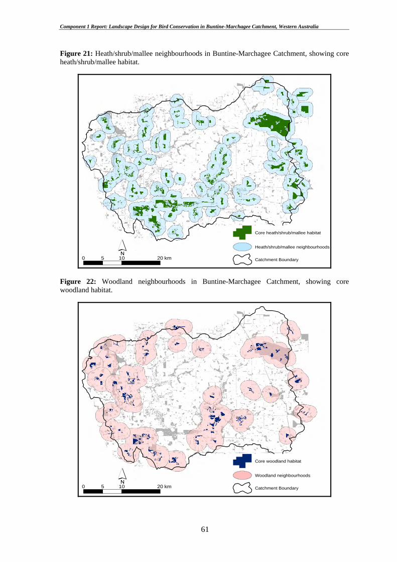
Component 1 Report: Landscape Design for Bird Conservation in Buntine-Marchagee Catchment, Western Australia
Figure 21: Heath/shrub/mallee neighbourhoods in Buntine-Marchagee Catchment, showing core heath/shrub/mallee habitat.
´0 10 205 km
Core heath/shrub/mallee habitat
Heath/shrub/mallee neighbourhoods
Catchment Boundary
Figure 22: Woodland neighbourhoods in Buntine-Marchagee Catchment, showing core woodland habitat.
´0 10 205 km
Core woodland habitat
Woodland neighbourhoods
Catchment Boundary
61

Component 1 Report: Landscape Design for Bird Conservation in Buntine-Marchagee Catchment, Western Australia
Figure 23: An example of a suggested heath/shrub/mallee ‘stepping stone’ for linking two neighbourhoods in Buntine-Marchagee catchment. Here the ‘stepping stone’ (red) is positioned to link existing habitat and avoid sites of high salinity risk (purple). This helps target the revegetation effort in the catchment.
±0 0.6 1.0.3 km2
Suggested "stepping stones"
Core heath/shrub/mallee habitat
Other heath/shrub/mallee habitat
Heath/shrub/mallee neighbourhoods
At risk to salinity
Neighbourhood 1
Neighbourhood 2
62

Component 1 Report: Landscape Design for Bird Conservation in Buntine-Marchagee Catchment, Western Australia
Figures 24 (top) and 25 (bottom): Suggested heath/shrub/mallee ‘stepping stones’ (top) and the theoretical improvement in neighbourhood linkage after incorporating them into the Buntine-Marchagee landscape (bottom).
±0 10 205 km
Suggested "stepping stones"
Core heath/shrub/mallee habitat
Heath/shrub/mallee neighbourhoods
Catchment Boundary
±0 10 205 km
Suggested "stepping stones"
Core heath/shrub/mallee habitat
Heath/shrub/mallee neighbourhoods
Catchment Boundary
63

Component 1 Report: Landscape Design for Bird Conservation in Buntine-Marchagee Catchment, Western Australia
Figures 26 (top) and 27 (bottom): Suggested woodland ‘stepping stones’ (top) and the theoretical improvement in neighbourhood linkage after incorporating them into the Buntine-Marchagee landscape (bottom).
±0 10 205 km
Suggested "stepping stones"
Core woodland habitat
Woodland neighbourhoods
Catchment Boundary
±0 10 205 km
Suggested "stepping stones"
Core woodland habitat
Woodland neighbourhoods
Catchment Boundary
64

Component 1 Report: Landscape Design for Bird Conservation in Buntine-Marchagee Catchment, Western Australia
3.5.3. Creation of habitat linkages within neighbourhoods
Creating linkages in the landscape design aimed to increase the degree of connectedness
of habitat within neighbourhoods. The existing level of habitat connectedness in the
catchment was assessed to help select sites for the creation of habitat linkages. This was
undertaken using a spatially explicit dispersal simulation (SEDS) model (see Brooker et
al. 1999) which measured the number of times a disperser from one patch was able to
reach a neighbouring patch based on 100 hypothetical attempts. This gave a measure of
the relative probability of dispersal between all nearest neighbour habitat patches or in
other words, a measure of the connectedness of the landscape from a bird’s perspective.
The maximum distance that a dispersing bird would travel over cleared land (its ‘gap
tolerance’) was set at 60 m for heath/shrub/mallee birds and 120 m for woodland birds.
Most remnants in the catchment are relatively poorly connected. Sites were selected for
creation of habitat linkages from the results of SEDS trials using criteria of dispersal
success rates of less than 50% and theoretical linkages shorter than 750 m (Figure 28),
and in light of economic and production factors such as location of fencelines, prime
farming land and cost (Figure 29). A total of 268.5 ha (92 sites) of new 60 metre-wide
habitat linkages comprising 209.9 ha of heath/shrub/mallee (73 sites) and 58.6 ha (19
sites) of woodland were proposed in Buntine-Marchagee Catchment (Figure 30).
65

Component 1 Report: Landscape Design for Bird Conservation in Buntine-Marchagee Catchment, Western Australia
Figure 28: A map of Wubin townsite and surrounds showing remnant vegetation and SEDS trials conducted to help select sites for creation of new habitat linkages. The number of times a dispersal event was successful out of 100 attempts is shown numerically. Trials shown in red are those that were targeted for the landscape design (i.e. less than a 50% success rate, shorter than 750 m).
04
7
39 52
60
26
51
91
40
23
71
1573
61
43 68
76
80
0
00
00
0
0
0
0
0
0
0
0
7
0
0
0
0
60
51
0
±0 2.5 51.25 km
Targets for linkage
Dispersal trials
Remnant vegetation
Other vegetation
66

Component 1 Report: Landscape Design for Bird Conservation in Buntine-Marchagee Catchment, Western Australia
Figure 29: An example of a theoretical habitat linkage (yellow) modified to incorporate economic and production factors. The original linkage has been altered to follow a fenceline and utilise existing remnant native vegetation.
Leng
th =
535
m
Disp
ersa
l suc
cess
= 3
4%
±0 0.25 0.50.125 km
Theoretical linkage
Suggestion for on-ground works
Remnant vegetation
67

Component 1 Report: Landscape Design for Bird Conservation in Buntine-Marchagee Catchment, Western Australia
Figure 30: Suggested sites for the placement of habitat linkages in Buntine-Marchagee Catchment. Target areas for this work include the central and western drainage systems, major remnants in the southwest and east, and Banksia-Woody Pear woodlands and shrublands in the west/northwestern sectors.
±0 8 164 km
Suggestion for on-ground works
Remnant Vegetation
Other vegetation
Catchment Boundary
68

Component 1 Report: Landscape Design for Bird Conservation in Buntine-Marchagee Catchment, Western Australia
3.5.4. Habitat protection and management
Constraints on the availability of time, money and technical expertise and competing
natural resource management goals commonly require land managers to prioritise their
management objectives. The landscape design recognises the need to strategically
prioritise the protection and management of core habitat of focal bird species in Buntine-
Marchagee Catchment. The design employs the results of the focal species analysis to
identify core remnants for protection and management.
The Western Yellow Robin was the least tolerant species with respect to remnant
condition, with a score of at least 13 required for a 10% chance of occurrence. This
benchmark was used in combination with that of the area-sensitive Grey Butcherbird (31
ha) to identify core remnants for management and protection. That is, all core habitat
greater than or equal to 31 ha in area with a condition score of less than or equal to 13 was
targeted for management.
A total of 54 core remnants (4,568 ha) were delineated using the above criteria and then
divided into three groups or classes based on their remnant condition score, exposure to or
existing level of threat, and contribution to landscape connectedness (Figure 31).
Remnants assigned to the ‘very high’ management priority class offered structurally
complex and floristically diverse bird habitat but which was at risk of decline in condition
from encroaching salinity, land clearing (including road verges), ongoing livestock
grazing, fire, weed and feral animal incursion, rubbish dumping, or sand/gravel extraction.
There were 18 remnants (2,016 ha) of ‘very high’ priority class in the catchment and
several of these occurred in the central sector of the catchment where the potential for
neighbourhood and habitat linkage was high and the threats from rising salinity and
livestock grazing were substantial. They were allocated to the ‘moderate’ remnant
condition score class (10-12.9 points – see Table 1, Section 2.3.2). ‘High’ management
priority remnants (18, comprising 1,254 ha) provided bird habitat of similar quality to the
‘very high’ class but at less risk of loss of condition from the above threats. A further 18
(1,298 ha) remnants were of ‘moderate’ management priority. Remnants in ‘good’
condition (13-22 points remnant condition score) were assigned ‘low’ priority for habitat
protection and management. These were remnants with high habitat structural complexity
69

Component 1 Report: Landscape Design for Bird Conservation in Buntine-Marchagee Catchment, Western Australia
and floristic diversity and low levels of disturbance or salinity risk. There were 61
remnants of low priority for management totalling 13,790 ha which included Buntine
Nature Reserve and large privately owned remnants in the catchment’s southwest.
70

Component 1 Report: Landscape Design for Bird Conservation in Buntine-Marchagee Catchment, Western Australia
Figure 31: Priority remnants for habitat protection and management in Buntine-Marchagee Catchment. Note the concentration of ‘very high’ priority class remnants in the central drainage system of the catchment.
±0 8 164 km
Priority Class
Very High
High
Moderate
Low
Catchment Boundary
71

Component 1 Report: Landscape Design for Bird Conservation in Buntine-Marchagee Catchment, Western Australia
4. DISCUSSION
4.1. CATCHMENT-BASED STUDIES
The Buntine-Marchagee Catchment project has been the ninth catchment-based study by
CSIRO in the Western Australian wheatbelt to utilise the focal species approach for
nature conservation planning. These studies have employed measures of habitat loss and
fragmentation such as patch size, isolation, connectivity and condition in focal species
applications to guide habitat restoration action at the catchment or sub-catchment scale.
Focal species analyses have attempted to identify critical values or cutoff points in the
response of declining sedentary bird species to these measures or threats (see Brooker et
al. 2002). Subsequent landscape designs have been built around these critical points or
sensitivities to threats modeled for individual bird species.
The current study has built on this work by making a number of significant new
contributions to focal species analysis and landscape design for bird conservation in
fragmented agricultural systems. Of particular practical value to landholders and
catchment managers alike has been the provision of an innovative and interactive
landscape design for habitat restoration. This puts forward a set of balanced, achievable,
spatially explicit, and innovative management recommendations developed from an
iterative process of community consultation and refinement of the draft landscape design.
Structured around the key goals of protecting, enhancing and linking remnant native
vegetation, the Buntine-Marchagee landscape design allows landholders, catchment
groups, NACC, and land management agencies such as CALM to strategise their
revegetation effort by knowing where to manage existing native vegetation and place new
vegetation to achieve the best biodiversity and production outcomes for their investment.
Other contributions of this study have been the introduction of some new steps in the field
survey, spatial and focal species analyses, and landscape design phases. Bird surveys not
only determined species presence/absence but in 2002 included a measure of relative
abundance of birds across different habitats including the catchment’s saline wetlands.
Comprehensive sampling of floristic composition and vegetation structure including
quadrat-based sub-sampling enabled the characterisation of plant communities as bird
habitat and helped identify remnants for priority habitat protection and linkage in the
72

Component 1 Report: Landscape Design for Bird Conservation in Buntine-Marchagee Catchment, Western Australia
landscape design. An assessment of the conservation significance of the catchment for
native avifauna and vegetation was also undertaken.
The focal species analysis in this study included a fourth attribute or threat – remnant
condition. Previous focal species studies in Western Australia had not examined the
importance of this threat in influencing the location and type of habitat restoration
activities undertaken at the catchment scale. Spatial analysis techniques enabled the
production of maps of vegetation associations and bird species lists for many remnants in
the catchment (Appendix 5). This will be an invaluable source of data for natural resource
management planning at the paddock, property and catchment scales.
The Buntine-Marchagee study also used a 10-step landscape design procedure that
employed the ‘stepping stone’ concept and allowed for critical ‘road-testing’ of the draft
design with the local community. The latter innovation built operational flexibility and
public transparency into the final landscape design by enhancing the design’s overall
feasibility and increasing the potential for landholder acceptance of its recommended
priority actions. The study also provided a suite of monitoring and review
recommendations and future directions for biodiversity-related research in the catchment.
There have been some important lessons learnt from these catchment-based studies in
Western Australia. First, there is a need to consider the influence of spatial and temporal
variation in scale on the identification of focal species and the development of effective
landscape designs (see Section 5.1). Implicit in this is a recognition that designs prepared
for individual properties, sub-catchments and catchments may inadequately cater for
species undergoing regional population decline and range contraction (see Brooker and
Lefroy 2004). This is because the processes of habitat loss, modification and
fragmentation and the consequent threats of increasing isolation of core habitat, reduced
patch size, and remnant condition often operate across a range of different spatial and
temporal scales (Fischer et al. 2004). Also, considerable knowledge is needed of the
autecology of bird species such as life history attributes (ie. reproductive strategy,
foraging resources, habitat use, home range, diet, population viability) and response to
disturbance events in order for conservation planning to be effective (Huggett 2000; Ford
et al. 2001).
73

Component 1 Report: Landscape Design for Bird Conservation in Buntine-Marchagee Catchment, Western Australia
Second, there is a tendency for landscape designs and management plans to be quite
prescriptive in their provision of advice to landholders and catchment groups. The current
study has attempted to reduce the amount of planning prescription through direct
consultation with the Buntine-Marchagee Catchment community to determine what
actions could be realistically achieved given the operational constraints of cost, time, and
limited technical support. Future landscape planning in wheatbelt catchments could
pursue alternative avenues to the development of these plans that embrace, for example,
new collaborative learning models.
Third, there are other threats to the survival of declining sedentary birds that have not yet
been examined for their utility in focal species analyses in the Western Australian
wheatbelt. These include predation, competition, salinity, livestock grazing pressure, and
inappropriate fire regimes. A challenge for landscape restoration planning in these
systems is describing the dynamics of interactions between these threats and the use of
this information in landscape design. We have also not yet tested the focal species
approach using other taxa such as nomadic or migratory land birds, reptiles, mammals,
invertebrates and vascular plants. Component 3 of the CSE9 Project seeks to address this
issue.
Finally, we have learnt that there is an ongoing need for monitoring and evaluation of the
performance of our landscape designs. That is, we need to know what is the extent of the
on-ground implementation of these designs, what have been the barriers (and pathways)
to their implementation, how can these designs be improved upon, and have the designs
been implemented within budget and over what timeframes? What has been the total cash
and in-kind cost of implementing the designs? Have there been tangible (and intangible)
benefits to biodiversity and agricultural production that have accrued from these actions?
A useful step would be to review the performance of each catchment-based landscape
design in achieving its stated objectives. Information gained from this review could be
used to develop guidelines for monitoring and evaluating the performance of future
landscape designs.
74

Component 1 Report: Landscape Design for Bird Conservation in Buntine-Marchagee Catchment, Western Australia
4.2. REGIONAL SCALE ANALYSIS
Catchment-based studies using the focal species approach require substantial investment
of time, money and technical expertise to produce detailed plans for habitat restoration.
They are not without their limitations (see reviews and critiques in Lindenmayer et al.
2002; Lindenmayer and Fischer 2003; Brooker and Lefroy 2004).
An alternative approach proposed by Brooker and Lefroy (2004) is the use of regional-
based focal species analysis to help prepare management plans at the paddock, property
and sub-catchment/catchment scales. This approach offers some potential advantages over
catchment-based studies. First, it attempts to account for the effects of spatial and
temporal scale on applications of the focal species approach, particularly involving the
use of birds. Threats such as the increased isolation of core remnants operate over larger
scales than sub-catchments or catchments thus making focal species-based conservation
plans difficult to implement (see Brooker and Lefroy 2004). There is a need then to
consider the broader regional landscape when measuring threats such as habitat patch
isolation and reduced habitat connectivity. Also, data from regional landscapes is often
needed to identify the ‘most threatened’ species in sub-catchments because these species
are usually very rare or difficult to detect.
A second advantage of regional scale analysis is its ability to estimate the long-term
viability of populations or metapopulations of focal species (Brooker and Lefroy 2004).
Metapopulation viability is central to the success or failure of conservation programs and
needs to be considered at a regional scale that captures the full complement of
metapopulations of a particular focal species (see Luoto and Brooker submitted ms).
Regional scale metapopulation studies can explore whether the total amount of habitat
contained in neighbourhoods of remnants is sufficient to promote long-term viability of
focal species populations (Brooker and Lefroy 2004) or whether these populations are
likely to go extinct with or without habitat restoration. This requires detailed knowledge
of the size of populations, their demographic structure, and landscape attributes and
threats, and expertise in predictive modeling (see Lindenmayer and Possingham 1995;
Luoto and Brooker submitted ms).
75

Component 1 Report: Landscape Design for Bird Conservation in Buntine-Marchagee Catchment, Western Australia
Third, regional scale focal species analysis can provide a central databank of knowledge
for use by catchment groups and agencies wanting to commence on-ground habitat
restoration works now. This would remove the need for these groups to wait for the time-
consuming collection and analysis of data and the identification of focal species before
starting habitat restoration activities (Brooker and Lefroy 2004). Follow-up monitoring to
assess the effectiveness of actions can be then undertaken by these groups after on-ground
works are underway. This has some obvious cost and infrastructural investment savings
but would require the involvement of an established, regionally-based organisation with
the technical capacity to collect and manage spatial and ecological data to a high standard.
Finally, regional scale focal species analysis can be used as a strategic conservation
planning tool by land managers. It would help prioritise conservation action by
identifying and ranking areas requiring urgent habitat restoration or comprising species
rich assemblages, rare species or species under-represented in public conservation
reserves (e.g. the saline wetlands and fringing shrublands and woodlands of Buntine-
Marchagee Catchment and the Salmon Gum, Gimlet and York Gum woodlands of
Wallatin Creek Catchment) against those areas in less urgent need of attention (e.g. low
salinity risk areas with vegetations associations well represented in the formal
conservation reserve system). This would allow managers to allocate different levels of
scarce resources to conservation programs in these parts of the regional wheatbelt
landscape (see Brooker and Lefroy 2004).
76

Component 1 Report: Landscape Design for Bird Conservation in Buntine-Marchagee Catchment, Western Australia
5. RECOMMENDATIONS
5.1. LANDSCAPE MANAGEMENT PLANNING
The sustainable management of natural resources for biodiversity conservation and
agricultural production requires an understanding of the importance of scale and
landscape context. Ecological processes that influence the shape and structure of
landscapes operate at different scales – from the site (paddock) and property through to
sub-catchment, catchment, region and State scale. Farm management activities can also
occur at a range of different scales from paddock-based weed control to regional-scale salt
mitigation schemes.
The position of a property within the local and regional landscape is also important. For
example, a farmer located downstream from a large eroding quarry or saline seep may
need to place more emphasis on and allocate more resources to measures to protect the
water quality and soil chemistry of his property than might a farmer whose property is
located within a forested catchment without salinity problems.
Planning for the long-term protection of native biodiversity is similarly challenged by the
need to consider the nature of the landscape within which native plants and animals occur.
Questions such as how much habitat do populations and communities need to persist and
survive (see With and King 1999; Fahrig 2001); should emphasis be placed on conserving
threatened or regionally declining species, or on landscapes supporting plants and animals
that are poorly represented in the formal conservation reserve system (see Prober and
Thiele 1995; Margules and Pressey 2000; Mac Nally et al. 2002).
Effective landscape management planning therefore requires current information on the
amount, type, condition, and connectedness of remnant and planted native vegetation on
properties and across catchments and regions. Knowledge of the nature and severity of
threatening processes such as hydrological change (waterlogging and salinity), land
clearing causing habitat loss and fragmentation, weed and feral animal incursion, and
inappropriate fire and grazing regimes is a fundamental prerequisite to such planning (see
WA State Salinity Council 2000; Wallace et al. 2003; NACC 2004). An understanding of
77

Component 1 Report: Landscape Design for Bird Conservation in Buntine-Marchagee Catchment, Western Australia
the effect of time on the response of native fauna and flora to disturbance in agricultural
landscapes is also required.
There are a number of steps landholders in Buntine-Marchagee Catchment can take to
sustainably manage their natural resources using this landscape approach. These include
but are not confined to:
• Develop and implement an integrated, long-term farm management plan for the
property, in consultation with the Buntine-Marchagee Natural Diversity Recovery
Catchment team (comprising CALM, CSIRO Sustainable Ecosystems, CSIRO
Land and Water, WA Agriculture, WA Department of Environment, University of
Western Australia, Murdoch University and catchment groups);
• Raise awareness and knowledge of the native plant and animal ecology of the
property and neighbouring properties, and include in the above plan actions to
protect existing plant and animal populations and encourage the re-establishment
of species once present in the catchment;
• Take an active role in establishing new or improving existing networks with other
community-based catchment groups to help find out about government and
community programs and funding sources operating across the region, e.g.
activities of Buntine-Marchagee Natural Diversity Recovery Catchment project
(subscribe to the free and very informative newsletter Buntine-Marchagee
Catchment News produced by CALM Mid-west Region), Northern Agricultural
Catchment Council, Greening Australia WA, WWF Woodland Watch program,
the Southwest Australia Ecoregion Initiative, Federal government salinity control,
water management, and Natural Heritage Trust programs;
• Build and maintain strong links with on-ground agencies, universities and groups
with expertise in strategic revegetation for wildlife, landscape management
planning, nature conservation study, landscape health monitoring, and
communication;
• Think beyond the property boundary when undertaking even everyday farm
management activities that might impact adversely (or positively) on neighbours
78

Component 1 Report: Landscape Design for Bird Conservation in Buntine-Marchagee Catchment, Western Australia
and the broader catchment; avoid activities likely to reduce the quality of the
landscape.
5.2. PRIORITY ACTIONS
5.2.1. Overview
The avian diversity of Buntine-Marchagee Catchment is rich (110 species) but vulnerable
to the consequences of habitat loss, modification and fragmentation – reduced size of core
habitat, increasing isolation of this habitat, and deteriorating habitat quality. The survival
of particularly sedentary shrubland and woodland birds in this landscape continues to be
threatened by the clearance of existing links between remnants such as road verge
vegetation (see Newbey 2000), grazing of remnants by livestock, weed and feral animal
invasion, and encroaching secondary salinity.
To address these threats and in addition to the above broad steps we recommend a suite of
priority actions for adoption in this catchment. These focus on protecting and retaining
existing native bird assemblages while also improving their prospects of survival and
possible long-term recovery. These actions are based on the outcomes of the focal bird
species analysis and landscape design presented in Sections 3.4 and 3.5 of this report and
on additional conservation significance information.
5.2.2. Priority 1: Protect and enhance existing habitat and species of conservation significance through on-ground action
The principal goal here is to enhance and protect all existing core habitat in the catchment
from encroaching salinity, clearing including road verges, livestock grazing, weeds and
feral animals, and inappropriate fire regimes. Specifically, we recommend landholders
should aim to:
• Assess habitat condition in all core habitat patches;
• Rehabilitate core habitat that is currently in poor condition thus enhancing the
quality of habitat for focal bird species and other fauna;
• Fence core habitat remnants to exclude livestock and prevent accidental or
intentional clearing;
79

Component 1 Report: Landscape Design for Bird Conservation in Buntine-Marchagee Catchment, Western Australia
• Revegetate core habitat remnants where the understorey has been lost or become
degraded (i.e. weed infested, heavily grazed, regularly burnt) to enhance habitat
quantity and quality – use local native seed;
• Prevent the removal of fallen timber for firewood;
• Prevent erosion of soil and ground cover; and
• Undertake regular weed and feral animal (fox, cat, rabbit, and pig) control
programs.
Other threats such as rubbish dumping and eroding sand/gravel pits also need analysis.
However, it is generally sound property management practice to avoid dumping rubbish in
bushland and to infill and revegetate gravel pits and old tips to minimise soil erosion,
sedimentation of drainage lines, and dispersal of weed seeds into native bushland.
We also recommend that habitat supporting existing populations and communities of
threatened fauna and flora be protected as a matter of priority and as required under
existing Western Australian and Federal government legislation. This includes Melaleuca
and Allocasuarina shrubland and mallee/woodland with understorey supporting
Malleefowl in the north/northeastern and southwestern parts of the catchment;
Banksia/Woody Pear shrubland that provides a seasonal food supply for honeyeaters and
other fauna in the western and southern sectors; shrubland, mallee and woodland of the
southwestern sector especially within large privately owned remnants; and woodland and
shrubland of the eastern zone, including Buntine and Nugadong Nature Reserves.
Measures specified in the Action Plan for Australian Birds (Garnett and Crowley 2000)
for individual threatened species such as Malleefowl should be implemented.
We also recommend the protection of existing freshwater and brackish lake systems and
their fringing vegetation communities, especially in the western part of the catchment.
These provide important habitat for local waterbirds especially during drought and food
and temporary refugia for intercontinental migratory wading birds that are subject to
international conservation treaties. Areas of River Red Gum woodland within this zone
need specific protection and conservation management. Work is needed to determine the
sensitivity of freshwater organisms such as waterbirds, frogs, reptiles and aquatic
invertebrates including molluscs to increasing salt levels. Once quantified, these levels
may be able to used as targets for sustainable land management.
80

Component 1 Report: Landscape Design for Bird Conservation in Buntine-Marchagee Catchment, Western Australia
5.2.3. Priority 2: Prioritise habitat protection and management activities
We recommend that a number of core remnants in the study area be prioritised for active
habitat protection and management. Based on the requirements of the condition-sensitive
focal bird species (Western Yellow Robin) and the area-sensitive Grey Butcherbird, we
identify all core habitat of 31 ha or more with a condition score of 13 or less as requiring
priority protection and management. This involves 4,568 ha (54 remnants) comprising
2,016 ha (18 remnants) of ‘very high’ priority class habitat, 1,254 ha (18 remnants) of
‘high’ priority class, and 1,298 ha (18 remnants) of ‘moderate’ priority class. Figure 31
specifies where this work would be best targeted in the catchment.
There are also some basic but important actions landholders and catchment managers can
take to improve the overall quality of the Buntine-Marchagee landscape for biodiversity,
soil, water and salt management, and for humans (see Priority 1 actions).
5.2.4. Priority 3: Create habitat ‘stepping stones’ to link neighbourhoods
Using the requirements of both the heath/shrubland/mallee and woodland birds, undertake
strategic habitat re-establishment to link neighbourhoods based on the requirements of the
focal species (see below) and the associated landscape design (Section 3.5). Specifically
aim to:
• Work from key habitat patches situated closest to the edge of the neighbourhood;
• Work with patches of greatest size (i.e. preferably greater than key habitat size)
when enhancing or linking native vegetation;
• When expanding or establishing new habitat, work towards providing habitat large
enough to create core habitat (i.e. greater than 40 ha);
• Don’t enlarge core patches - they are already of sufficient size;
• Work with patches that are in best condition first;
• Ensure that habitat is being established within the appropriate landform type; and
• Avoid areas at risk of salinity when establishing new vegetation.
We recommend that a total of 43 ‘stepping stones’ of native vegetation (1,093 ha) be
planted to link neighbourhoods in the study area. This total consists of 712 ha of
heath/shrub/mallee habitat (31 ‘stepping stones’) and 381 ha of woodland habitat (12
81

Component 1 Report: Landscape Design for Bird Conservation in Buntine-Marchagee Catchment, Western Australia
‘stepping stones’). These recommendations are based on the need for heath/shrub/mallee
patches to be 29 ha or larger and positioned no more than 1,150 m apart (ie. the
requirements of the Southern Scrub-robin). Woodland patches need to be 31 ha or larger
(ie. the Red Wattlebird’s requirements) and within 1,900 m of each other (ie. the Brown-
headed Honeyeater’s requirements). Figures 24 and 26 indicate where these ‘stepping
stones’ should be placed in the Buntine-Marchagee landscape.
5.2.5. Priority 4: Establish linkages to improve the connectedness of habitat within neighbourhoods
We recommend that 268.5 ha (92 sites) of new habitat linkages be planted to increase the
level of connectedness of habitat within neighbourhoods in the study area. This total
comprises 209.9 ha (73 sites) of heath/shrub/mallee and 58.6 ha (19 sites) of woodland
habitat. Figure 30 indicates where the new habitat linkages should be inserted in Buntine-
Marchagee Catchment. Some specific guidelines for this work include:
• Use native vegetation of local provenance;
• Link larger-sized remnants first;
• Link smaller remnants to bring them up to key habitat size.
• Ensure that all linkages are 60 metres in width or greater;
• Work to link patches that are in best condition first;
• Ensure that linkages are being established within the appropriate landform type;
and
• Avoid areas at risk of salinity when linking vegetation patches.
Summary: We recommend that a total of 1,361.5 ha of new native vegetation be inserted
into Buntine-Marchagee Catchment to help restore habitat for focal bird species and other
fauna. This amounts to 6.1% of all native vegetation (22,340 ha) currently in the
catchment. If fully implemented this landscape design will result in the fencing of 4,568
ha (54 core remnants) comprising 2,016 ha (18 remnants) of ‘very high’ priority habitat
protection and management class, 1,254 ha (18 remnants) of ‘high’ priority class, and
1,298 ha (18 remnants) of ‘moderate’ priority class. This level of cumulative habitat
restoration effort has the potential to provide substantial positive gains for both
82

Component 1 Report: Landscape Design for Bird Conservation in Buntine-Marchagee Catchment, Western Australia
biodiversity conservation and sustainable agricultural production over the longer term in
Buntine-Marchagee Catchment.
5.3. MONITORING AND REVIEW
A common way of assessing the performance of intervention measures employed as part
of a landscape (or other) management plan is through a monitoring program. Specific
protocols and checkpoints are built into the program which scrutinises performance of the
plan over time against a set of objective criteria. We put forward a preliminary suite of
monitoring and review actions for use in the implementation of the landscape design and
associated work in the study area. We highlight the interim nature of these
recommendations and the need for further discussion among project stakeholders to
review specific actions and record progress achieved in implementing the proposed on-
ground works.
We recommend that consideration be given to the adoption of a suite of monitoring and
review actions in the study area (see below).
Ecological research and performance of past revegetation effort
• Review the value of past ecological research in the study area measured against
triple bottom line (ie. economic, social, and environmental) criteria to attempt to
determine the benefits of this research to CALM and catchment groups –
universities could be involved in this work; and
• Undertake a review of past revegetation effort including older plantings
(windbreaks, erosion control, salt control, multi-purpose) and newer plantings
(‘biodiversity plantings’, oil mallees, tagasaste) using cost, labour, original
purpose, effectiveness in achieving purpose, beneficial outcomes, community
response, and time to establishment as criteria for assessing value of the effort –
establish database to record and permit a cost-benefit analysis of this review.
Performance of the proposed landscape design (assuming full
implementation)
• Conduct detailed reviews of the triple bottom line performance of this design to
achieve its stated objectives (specific criteria should be developed in consultation
with project stakeholders);
83

Component 1 Report: Landscape Design for Bird Conservation in Buntine-Marchagee Catchment, Western Australia
• Specifically monitor the theoretical improvement in focal bird species’ occupancy
rate that should accrue over time with re-creation/re-connection of patch
neighbourhoods; this will require further work to determine a suitable monitoring
approach and techniques;
• Monitor community response to the plan and the extent to which it is taken up;
and
• Decide on an appropriate review period for the plan – we suggest an annual review
initially, followed by updates once every second or third year, depending on
stakeholder requirements. The plan should be fully re-assessed at the end of Year
Five.
Role and function of existing ‘corridors’ of vegetation
• Assess whether native and exotic fauna use ‘corridors’ and if so, how, ie. the type
of use occurring (ie. foraging and breeding habitat or movement/dispersal conduits
only); role in edge-related predation; appropriate corridor configuration and
vegetation structure and composition (potential ecological corridor design
criteria); and
• Assess landscape-level values and roles of ‘corridor’ vegetation in biodiversity
conservation, salinity mitigation, and farm forestry – what are the benefits to the
catchment community?
Development of new approaches to nature conservation in agricultural
landscapes
• Monitor progress achieved in the development of new approaches to nature
conservation around Australia and abroad and in the refinement of existing
procedures such as the focal species approach and other variants; be aware of
potential applications of new technologies to landscape management; and
• Monitor trends in community consultation and effective communication and
networking techniques, including working with government and non-government
agencies and other community Landcare groups; stay informed of new
government initiatives.
84

Component 1 Report: Landscape Design for Bird Conservation in Buntine-Marchagee Catchment, Western Australia
Resourcing project works
• Regularly monitor the availability of project funds from government, non-
government and private sources to ensure works are adequately resourced and
maintained over time; and
• Ensure adequate feedback is obtained from and provided to funding bodies and
their review panels.
5.4. DIRECTIONS FOR FUTURE RESEARCH
We put forward a number of suggestions for future research and on-ground action in
Buntine-Marchagee Catchment. These aim to help focus the nature conservation effort in
this catchment by targeting the recovery potential already present in the landscape. Our
contributions are also intended to stimulate further discussion among stakeholders –
several of these suggestions originate from feedback received during previous meetings
and field discussions.
Focus the landscape conservation effort
• Evaluate the effectiveness of past revegetation and research effort. Decide on
future work directions likely to yield the best return for time, money, and
emotional investment;
• Using information from the focal bird species and landscape design work, target
areas that have the best chance of recovery and restoration over time; recognise
that not all species or sites in Buntine-Marchagee Catchment can be re-established
or managed for recovery; and
• Put in place a mechanism to monitor the performance of new projects commenced
in the study area; carry out regular reviews of these projects, possibly on a
commercial project management basis.
Consider inviting new ecological research
• Decide on current information gaps (e.g. corridor function and role, ecology of
woodland/shrubland bird habitat use and movement, salinity impacts and ecology
of saline systems, biodiversity conservation value of revegetation plantings, etc)
and ways of effectively addressing them;
85

Component 1 Report: Landscape Design for Bird Conservation in Buntine-Marchagee Catchment, Western Australia
• Be clear on strategic research goals, available resources (time, money, on-site
‘bush knowledge’), and the need for outcome-focused research with strong
potential for on-ground application; and
• Consider the value of developing relationships with CSIRO and university-based
researchers and students to provide a ready labour source for monitoring-based
work.
Landholder participation and training
• Review current landholder motivation and willingness/availability to be actively
involved in new research and revegetation work, including attending training
events; and
• Scope the potential for landholders to be trained in basic GIS techniques to map
broad vegetation classes on their properties (CSIRO currently holds a large
dataset).
Working together with other organisations
• Review information needs from, and quality of interaction with, other
organisations and groups involved in nature conservation and natural resource
management in the wheatbelt;
• Obtain detailed advice on the floristic composition and structure (ie. ground cover,
understorey shrubs, mid- and over-canopy trees) of native plants to be used in past
revegetation programs run by CALM, Greening Australia and others; and
• Seek to establish new and enhance existing relationships and communication
networks with other natural resource management and nature conservation
organisations including government; ensure regular visits and meetings to stay in
touch with latest techniques, programs, and funding avenues.
86

Component 1 Report: Landscape Design for Bird Conservation in Buntine-Marchagee Catchment, Western Australia
6. REFERENCES
Aitkin, M., Anderson, D., Francis, B., Hinde, J., 1990. Statistical Modelling in GLIM. Oxford University Press, UK.
Anon, 1975. Climatic averages, Western Australia. Bureau of Meteorology, Canberra.
ANZECC, 2001. Review of the National Strategy for the Conservation of Australia’s Biological Diversity, Australian & New Zealand Environment & Conservation Council, 102 pp., Canberra.
ArcView GIS 8.2, 2002. ArcView GIS Version 8.2 User’s Manual.. Environmental Systems Research Institute Inc., California, USA.
Arnold, G.W. and Weeldenburg, J.R., 1998. The effects of isolation, habitat fragmentation, and degradation by livestock grazing on the use by birds of patches of Gimlet Eucalyptus salubris woodland in the wheatbelt of Western Australia. Pacific Conservation Biology 4, 155-163.
Barrett, G.W., Silcocks, A., Barry, S., Cunningham, R. and Poulter, R., 2003. The New Atlas of Australian Birds. Birds Australia (formerly RAOU), Melbourne.
Beard, J.S., 1976. The vegetation of the Perenjori area, Western Australia. Vegmap Publications, Perth.
Beard, J.S., 1990. The Plant Life of Western Australia. Kangaroo Press, Sydney.
Bennett, A.F., 1999. Linkages in the Landscape. The Role of Corridors and Connectivity in Wildlife Conservation. IUCN – The World Conservation Union, Gland, Switzerland.
Bennett, A.F. and Mac Nally, R., Identifying priority areas for conservation action in agricultural landscapes, in press in Pacific Conservation Biology
Brooker, L., 2002. The application of focal species knowledge to landscape design in agricultural lands using the ecological neighbourhood as a template. Landscape and Urban Planning 60, 185-210.
Brooker, L. and Brooker M., 2002. Dispersal and population dynamics of the Blue-breasted Fairy-wren Malurus pulcherrimus in fragmented habitat in the Western Australian wheatbelt. Wildlife Research 29, 225-233.
Brooker, L. and Brooker, M., 2003. Local distribution, metapopulation viability and conservation of the Blue-breasted Fairy-wren in fragmented habitat in the Western Australian wheatbelt. Emu 103, 185-198.
Brooker, L.C., Brooker, M.G. and Cale, P., 1999. Animal dispersal in fragmented habitat: measuring habitat connectivity, corridor use and dispersal mortality. Conservation Ecology [online] 3 (1):4 (http://www.consecol.org/Journal/vol3/iss1/art4).
Brooker, L., Atkins, L. and Ingram, J., 2001a. Enhancing Biodiversity Values in Agricultural Lands. Morbinning Sub-Catchment and Surrounds. A CSIRO report commissioned by Greening Australia Western Australia. CSIRO Sustainable Ecosystems, Perth.
Brooker, L., Atkins, L. and Ingram, J., 2001b. Enhancing Biodiversity Values in Agricultural Landscapes. Part II Gabbi Quoi Quoi Sub-Catchment and Surrounds. A
87

Component 1 Report: Landscape Design for Bird Conservation in Buntine-Marchagee Catchment, Western Australia
CSIRO report commissioned by Greening Australia Western Australia. CSIRO Sustainable Ecosystems, Perth.
Brooker, L., Lefroy T., Ingram, J., and Atkins, L., 2002. Action for Woodland Birds: Enhancing Biodiversity Values in the Latham Landcare District. A CSIRO report commissioned by WWF Australia. CSIRO Sustainable Ecosystems, Perth
Cale, P.G., 1999. The Spatial Dynamics of the White-browed Babbler in a Fragmented Agricultural Landscape. PhD thesis (unpubl.), School of Biological Sciences, University of New England, Armidale, NSW.
Cale, P.G., 2003. The influence of social behaviour, dispersal and landscape fragmentation on population structure in a sedentary bird. Biological Conservation 109, 237-248.
CALM, 2003. Buntine-Marchagee Catchment News, Issue 1 March 2003, WA Department of Conservation and Land Management, Midwest Region, Geraldton.
Christidis, L. and Boles, W.E., 1994. The Taxonomy and Species of Birds of Australia and its Territories. RAOU Monograph 2, RAOU (now Birds Australia), Melbourne.
Cocks, P.S, 2003. Land-use change is the key to protecting biodiversity in salinising landscapes. Australian Journal of Botany 51, 627-635.
Davis, J.A., McGuire, M., Halse, S.A., Hamilton D., Horwitz, P., McComb, A.J., Froend, R.H., Lyons, M., and Sim L., 2003. What happens when you add salt: predicting impacts of secondary salinisation on shallow aquatic ecosystems by using alternative-states model. Australian Journal of Botany 51, 715-724.
Dell, J., 1979. Birds of Buntine and Nugadong Reserves. Biological Survey of the Western Australian Wheatbelt: Part 10 Buntine, Nugadong, and East Nugadong Nature Reserves and Nugadong Forest Reserve. Records of the Western Australian Museum Supplement 9, 95-116.
Environment Australia, 2000. Revision of the Interim Biogeographic Regionalisation of Australia (IBRA) and the Development of Version 5.1 – Summary Report, Environment Australia, Canberra, ACT.
Environment Australia, 2001. Biodiversity – Australia State of the Environment Report, Environment Australia, Canberra, 217 pp.
Fahrig, L., 2001. How much habitat is enough? Biological Conservation 100, 65-74.
Fahrig, L., 2002. Effect of habitat fragmentation on the extinction threshold: a synthesis. Ecological Applications 12, 346-353.
Fischer, J., Lindenmayer, D.B., and Cowling, A., 2004. The challenge of managing multiple species at multiple scales: reptiles in an Australian grazing landscape. Journal of Applied Ecology 41, 32-44.
Ford, H.A., Barrett, G., and Howe, R.W., 1995. Effect of habitat fragmentation and degradation on bird communities in Australian eucalypt woodland. In: Bellan, D., Bonin, G., Emig, C. (Eds.), Functioning and Dynamics of Natural and Perturbed Ecosystems. Lavoisier, Paris, pp. 99-115.
Ford, H. A., Barrett, G.W., Saunders, D.A., and Recher, H.F., 2001. Why have birds in the woodlands of Southern Australia declined? Biological Conservation 97, 71-88.
88

Component 1 Report: Landscape Design for Bird Conservation in Buntine-Marchagee Catchment, Western Australia
Freudenberger, D., 1999. Guidelines for Enhancing Grassy Woodlands for the Vegetation Investment Project. A report commissioned by Greening Australia, ACT & SE NSW Inc., CSIRO Sustainable Ecosystems, Canberra, ACT.
Freudenberger, D., 2001. Biodiversity Enhancement for the Saltshaker Project. A report commissioned by Greening Australia ACT & SE NSW Inc., CSIRO Sustainable Ecosystems, Canberra, ACT.
Freudenberger D. and Brooker, L., 2004. Development of the focal species approach for biodiversity conservation in the temperate agricultural zones of Australia. Biodiversity and Conservation 13: 253-274.
Frost, F., Lambeck, R.J., Dymond, W., Rowley, T. and Gowdie, T., 1999. Living Landscapes. A report commissioned by the Natural Heritage Trust, Canberra, ACT.
Garnett, S.T. and Crowley, G.M., 2000. The Action Plan for Australian Birds. Environment Australia and Birds Australia, Canberra, ACT.
GENSTAT® 2002, Release 6.1 for Windows, Payne, R.W. (Ed.) GENSTAT Committee, Lawes Agricultural Trust, Rothamsted Experimental Station, UK.
Halse S.A., Williams, M.R., Jaensch R.P., and Lane J.A.K., 1993. Wetland characteristics and waterbird use of wetlands in south-western Australia. Wildlife Research 20, 103-126.
Halse, S.A., Ruprecht, J.K., and Pinder A.M., 2003. Salinisation and prospects for biodiversity in rivers and wetlands of south-west Western Australia. Australian Journal of Botany 51, 673-688.
Huggett, A.J., 2000. An Experimental Study of the Impact of Gaps and Clusters Silviculture on Insectivorous Birds in a Continuous Forest Landscape, PhD thesis (unpubl.), University of New England, Armidale, NSW, 326 pp.
Huggett, A.J., The concept and utility of ecological ‘thresholds’ in biodiversity conservation, ms submitted to Biological Conservation
Johnstone, R.E. and Storr, G.M., 1998. Handbook of Western Australian Birds: Volume 1 – Non-Passerines (Emu to Dollarbird), Western Australian Museum, Perth, WA.
Kitchener, D.J. 1979. Introduction to Buntine and Nugadong Reserves. Biological Survey of the Western Australian Wheatbelt: Part 10 Buntine, Nugadong, and East Nugadong Nature Reserves and Nugadong Forest Reserve. Records of the Western Australian Museum Supplement 9, 9-14.
Krebs, C.J., 1985. Ecology: The Experimental Analysis of Distribution and Abundance, Third Edition, Harper & Row, New York.
Lambeck, R.J., 1997. Focal species: a multi-species umbrella for nature conservation. Conservation Biology 11: 849-856.
Lambeck, R.J., 1998. Nature conservation at the landscape scale – adequacy of habitat. In "Dongolocking Pilot Planning Project for Remnant Vegetation" Ed. by K.J. Wallace. A report commissioned by Environment Australia.
Lambeck, R.J., 1999. Landscape planning for biodiversity conservation in agricultural regions – a case study from the wheatbelt of Western Australia. Biodiversity Technical Paper No. 2, Environment Australia, Canberra, ACT.
89

Component 1 Report: Landscape Design for Bird Conservation in Buntine-Marchagee Catchment, Western Australia
Lambeck, R.J., 2002. Focal species and restoration ecology: response to Lindenmayer et al. Conservation Biology 16, 549-551.
Law, B.S. and Dickman, C.R., 1998. The use of habitat mosaics by terrestrial vertebrate fauna: implications for conservation and management. Biodiversity and Conservation 7, 323-333.
Lindenmayer, D.B. 1993. Wildlife Corridors and the Mitigation of Logging Impacts on Fauna in Wood Production Forests in South-eastern Australia. Working Paper 1993/4, CRES, Australian National University, Canberra, 13 pp.
Lindenmayer, D.B., and Fischer, J., 2003. Sound science or social hook – a response to Brooker’s application of the focal species approach. Landscape and Urban Planning 62, 149-158.
Lindenmayer, D.B., Manning, A., Smith, P.L., McCarthy, M.A., Possingham, H.P., Fischer, J., and Oliver, I., 2002. The focal species approach and landscape restoration: a critique. Conservation Biology 16, 338-345.
Lindenmayer, D.B., and Possingham, H.P., 1995. Modelling the viability of metapopulations of the endangered Leadbeater’s Possum in southeastern Australia. Biodiversity and Conservation 4, 984-1018.
Loyn, R.H., 1987. Effects of patch area and habitat on bird abundances, species numbers and tree health in fragmented Victorian forests. Pp. 65-75 in “Nature Conservation: The Role of Remnants of Native Vegetation”. D.A. Saunders, G.W. Arnold, A.A. Burbridge, and A.J.M. Hopkins (eds.), Surrey Beatty & Sons & CSIRO, Sydney.
Luoto, M., and Brooker, L. Blue-breasted fairy-wren occupancy in fragmented landscapes in Western Australia: a grid based multi-scale approach, ms submitted to Journal of Biogeography.
Mac Nally, R., Bennett, A.F., Brown, G.W., Lumsden, L.F., Yen, A., Hinkley, S., Lilywhite, P., and Ward, D.A., 2002. How well do ecosystem-based planning units represent different components og biodiversity? Ecological Applications 12, 900-912
Margules, C.R. and Pressey, R.L., 2000. Systematic conservation planning. Nature 405, 243-253.
Maron M., and Lill, A. Spatial and temporal variation in bird-habitat relationships: declining birds in southern Australian woodlands, ms submitted to Biological Conservation.
McCown, R.L., Hochman, Z. and Carberry, P.S. 2002. Probing the enigma of the decision support system for farmers: Learning from experience and from theory. Agricultural Systems, 74, 1-10.
NACC, 2004. Resource Condition Targets, Management Action Targets, and Management Actions (draft internal report), Northern Agricultural Catchment Council, Western Australia.
Newbey, B., 2000. Birds in Rural Road Verges in Southern Western Australia 1997-1999. Report by Birds Australia (WA) for WA Main Roads Department.
Parsons, B.C., Huggett, A.J., Atkins, L.A., and Ingram, J.A., 2003. Bringing Back the Birds for Nature Conservation in Wallatin Creek Catchment. CSIRO report to
90
Component 1 Report: Landscape Design for Bird Conservation in Buntine-Marchagee Catchment, Western Australia
Wallatin Wildlife and Landcare Inc. and Greening Australia (WA), CSIRO Sustainable Ecosystems, Perth, WA.
Prober, S.M. and Thiele, K.R., 1995. Conservation of Grassy White Box Woodlands: relative contributions of size and disturbance to florisitic composition and diversity of remnants. Australian Journal of Botany 43, 349-366.
Radford, J.Q. and Bennett, A.F., 2004. Thresholds in landscape parameters: occurrence of the white-browed treecreeper Climacteris affinis in Victoria, Australia. Biological Conservation 117, 375-391.
Radford, J.Q., Bennett, A.F. and Cheers, G.J. Landscape-level thresholds of habitat cover for woodland birds. Submitted ms to Biological Conservation.
Saunders, D.A., Hobbs, R.J. and Margules, C.R., 1991. Biological consequences of ecosystem fragmentation: a review. Conservation Biology 5, 18-32.
Saunders, D.A. and Ingram, J.A., 1995. Birds of Southwestern Australia. Surrey Beatty & Sons, Sydney.
Saunders, D.A. and Briggs, S.V., 2002. Nature grows in straight lines—or does she? What are the consequences of the mismatch between human-imposed linear boundaries and ecosystem boundaries? An Australian example. Landscape and Urban Planning, 61, 71-82.
Shields, J.M. and Recher, H.F, 1984. Breeding bird censuses: an evaluation of four methods for use in sclerophyll forest. Corella 8, 29-41.
Sieving, K. E., Willson, M.K. and De Santo, T.L., 2000. Defining corridor functions for endemic birds in fragmented south-temperate rainforest. Conservation Biology 14, 1120-1132.
Simberloff, D., 1998. Flagships, umbrellas, and keystones: is single-species management passé in the landscape era. Biological Conservation 83, 247-257.
Smart Technologies Inc. 2003. SMART Board™ Model 540ct Instruction Manual, Smart Technologies Inc. Calgary, Canada.
St. Clair, C.C., Belisle M., Desrochers A. and Hannon, S., 1998. Winter responses of forest birds to habitat corridors and gaps. Conservation Ecology [online], 2: (2), (http://www.consecol.org/Journal/vol2/iss2/art13).
Turner, M.G., Gardner, R.H. and O’Neill, R.V., 2001. Landscape Ecology in Theory and Practice: Pattern and Process. Springer, New York.
van der Ree, R., 2002. The population ecology of the Squirrel Glider Petaurus norfolcensis, within a network of remnant linear habitats. Wildlife Research 29, 329-340.
van der Ree, R., Bennett, A.F., Gilmore, D.C., 2004. Gap-crossing by gliding marsupials: thresholds for use of isolated woodland patches in an agricultural landsape. Biological Conservation 115, 241-249.
Wallace, K.J., Beecham, B.C., and Bone B.H., 2003. Managing Natural Biodiversity in the Western Australian Wheatbelt: A Conceptual Framework. WA Department of Conservation and Land Management, Perth.
91

Component 1 Report: Landscape Design for Bird Conservation in Buntine-Marchagee Catchment, Western Australia
Watson, J., Freudenberger, D. and Paull, D., 2001. An assessment of the focal species approach for conserving birds in variegated landscapes in southeastern Australia. Conservation Biology 15, 1364-1373.
Western Australian State Salinity Council, 2000. Natural Resource Management in Western Australia – The Salinity Strategy, WA State Salinity Council, Perth.
Wiens, J.A., Van Horne, B. and Noon, B.R., 2002. Integrating landscape structure and scale into natural resource management. In: Liu, J., Taylor, W.W. (Eds.), Integrating Landscape Ecology into Natural Resource Management, Cambridge University Press, UK, pp. 23-67.
With, K.A. and King, A.W, 1999. Extinction thresholds for species in fractal landscapes. Conservation Biology 13, 314-326.
Woinarski, J.C.Z. and Braithwaite, R.W., 1990. Conservation foci for Australian birds and mammals. Search, 21, 65-67.
Zar, J.H., 1999. Biostatistical Analysis. 4th Edition, Prentice Hall, New Jersey, USA.
92

Component 1 Report: Landscape Design for Bird Conservation in Buntine-Marchagee Catchment, Western Australia
7. APPENDICES
Appendix 1: Communication activities completed during this study
Appendix 2: Land birds found in the Western Australian wheatbelt, including focal species and those recorded in Buntine-Marchagee Catchment during this study
Appendix 3: Descriptions of native vegetation associations recorded in Buntine-Marchagee Catchment
Appendix 4: Perennial plant species recorded in quadrat-based floristic surveys of selected remnants in Buntine-Marchagee Catchment
Appendix 5: Native vegetation associations and bird species recorded in each remnant surveyed in Buntine-Marchagee Catchment
93

Component 1 Report: Landscape Design for Bird Conservation in Buntine-Marchagee Catchment, Western Australia
APPENDIX 1: Communication activities completed during this study
A total of 19 communication activities have been undertaken by the project team during this study.
These have included articles, workshop presentations, spoken papers and posters at national and
international ecological science conferences, CALM strategic catchment planning workshops and
Western Wildlife magazine, CSIRO science forums, workshops and program reviews, community
Landcare workshops, and a Land & Water Australia Native Vegetation R&D Program meeting and
Thinking Bush magazine. A manuscript that draws on the results of this study has been submitted
to Biological Conservation, a leading international ecological science journal.
The project team has also established a website that showcases the results of the project and
provides useful links to other natural resource management, landscape ecology and native
biodiversity conservation sites. Visit us at:
http://www.cse.csiro.au/research/program2/focalspecies.htm
Specific communication activities undertaken by the team include:
• Bird and vegetation surveys in Buntine-Marchagee: progress update – presentation to
Buntine-Marchagee Natural Diversity Recovery Catchment Steering Committee Meeting 2,
30 August 2002, Dalwallinu;
• Mapping vegetation association boundaries for biodiversity conservation in the
fragmented WA wheatbelt – spoken paper by Lyn Atkins to Australian Native Plant
Conservation Conference, Geelong, 26 February 2003;
• Bringing back the birds: landscape planning for nature conservation in Wallatin Creek
Catchment – talk by Andrew Huggett and Blair Parsons with John Ingram to planning
workshop for Wallatin Wildlife & Landcare Inc and Greening Aust WA, 24 March
2003;
• CSIRO bird and vegetation surveys in Buntine-Marchagee Recovery Catchment –
article by Andrew Huggett, Blair Parsons and Lyn Atkins in Western Wildlife (CALM
magazine), April 2003;
94

Component 1 Report: Landscape Design for Bird Conservation in Buntine-Marchagee Catchment, Western Australia
• Using spatial data for bird-based landscape design in the Wallatin and Buntine-
Marchagee Catchments of WA – workshop talk by Blair Parsons and Andrew Huggett
at CSIRO Aglands Program Meeting, Walwa, Victoria, 14 May 2003;
• Too far gone or road to recovery? Conserving birds in the fragmented Western
Australian wheatbelt – spoken paper by Andrew Huggett and Blair Parsons to Birds
Australia 2003 Members’ Day, University of Tasmania, Hobart, 31 May 2003;
• Surveying and analysing the spatial requirements of declining bird communities in the WA
wheatbelt – poster by Blair Parsons at Birds Australia 2003 Members’ Day, University of
Tasmania, Hobart, 31 May 2003;
• CSIRO avifaunal and vegetation surveys of Buntine-Marchagee Recovery Catchment
Spring 2002 Progress Report, article by Andrew Huggett, Blair Parsons, Lyn Atkins and
John Ingram in Buntine-Marchagee Catchment News, Issue 2, August 2003;
• Designing landscapes for birds in the northern WA wheatbelt: trials and triumphs in
the Buntine-Marchagee Catchment – invited spoken paper by Andrew Huggett and Lyn
Atkins, Kings Park Botanic Gardens Science Seminar Series, Perth, 4 September 2003;
• Road-testing a landscape design for bird conservation in Buntine-Marchagee Catchment –
talk by Andrew Huggett, Blair Parsons and Lyn Atkins to CALM and Buntine-Marchagee
Catchment Group, Coorow, 2 October 2003;
• Enlightenment for whom? Designing landscapes for people and birds in the northern WA
wheatbelt – talk by Andrew Huggett to CSIRO Sustainable Ecosystems Divisional Science
Forum, Thredbo NSW, 13 November 2003;
• Enlightenment for whom? Designing landscapes for people and birds in Buntine-
Marchagee Catchment, WA wheatbelt – talk by Andrew Huggett and David Freudenberger,
Annual Coordination Meeting (Native Vegetation R&D Program) of Land and Water
Australia, Canberra, 25 November 2003;
• The application of spatial analysis to wildlife conservation planning and management in
the Western Australian wheatbelt – poster by Blair Parsons presented to the 3rd
International Wildlife Management Congress in Christchurch, New Zealand, 1-5 December
2003;
• From paddock to plan: landscape design for biodiversity conservation in Buntine-
Marchagee Recovery Catchment – talk by Andrew Huggett to CALM Buntine-Marchagee
Recovery Catchment Planning Workshop, Geraldton, WA, 4 December 2003;
95

Component 1 Report: Landscape Design for Bird Conservation in Buntine-Marchagee Catchment, Western Australia
• The concept and utility of ‘ecological thresholds’ in biodiversity conservation – spoken
lead paper by Andrew Huggett and chair of 11 other spoken papers presented in a
thresholds symposium at Ecological Society of Australia’s 2003 conference, University of
New England, Armidale NSW, 9 December 2003;
• Taking on the challenge: a farmer-friendly landscape approach to bird conservation in the
WA wheatbelt – spoken paper by Andrew Huggett to 2nd Biennial Australasian
Ornithological Congress, ANU, Canberra, 11 December 2003;
• A design for life: bringing back the birds in our farming landscapes – article by Andrew
Huggett and David Freudenberger in Thinking Bush 3, 22-23, June 2004;
• Conference report: a symposium on ecological thresholds in biodiversity conservation –
article by Andrew Huggett in Thinking Bush 3, 24-25, June 2004; and
• The concept and utility of ‘ecological thresholds’ in biodiversity conservation. ms by
Andrew Huggett submitted to Biological Conservation, June 2004.
96

Component 1 Report: Landscape Design for Bird Conservation in Buntine-Marchagee Catchment, Western Australia
APPENDIX 2: Land birds found in the Western Australian wheatbelt including focal species and those recorded in Buntine-Marchagee Catchment during this study.
Strict waterbirds and exotics are not included. Common and scientific names are according to Christidis and Boles (1994). A = Declining species (Saunders and Ingram 1995); B = Strictly resident species; C = Farmland species; D = Nocturnal birds (Strigidae, Tytonidae, Podargidae, Aegothelidae, Caprimulgidae); E = Focal species candidates; F = Recorded at Buntine-Marchagee Catchment; * = extinct in the wheatbelt.
Common Name
Species Name
A
B
C
D
E
F
Emu Malleefowl Stubble Quail Brown Quail Australian Shelduck Australian Wood Duck White-faced Heron White-necked Heron Cattle Egret Straw-necked Ibis Black-shouldered Kite Square-tailed Kite Black Kite Whistling Kite Spotted Harrier Brown Goshawk Collared Sparrowhawk Wedge-tailed Eagle Little Eagle Brown Falcon Australian Hobby Grey Falcon Peregrine Falcon Nankeen Kestrel Australian Bustard Little Button-quail Painted Button-quail Bush Stone-curlew Inland Dotterel Banded Lapwing Common Bronzewing Brush Bronzewing Crested Pigeon Diamond Dove Red-tailed Black-Cockatoo Short-billed Black-Cockatoo Galah
Dromaius novaehollandiae Leipoa ocellata Coturnix pectoralis Coturnix ypsilophora Tadorna tadornoides Chenonetta jubata Egretta novaehollandiae Ardea pacifica Ardea ibis Threskiornis spinicollis Elanus axillaris Lophoictinia isura Milvus migrans Haliastur sphenurus Circus assimilis Accipiter fasciatus Accipiter cirrhocephalus Aquila audax Hieraaetus morphnoides Falco berigora Falco longipennis Falco hypoleucos Falco peregrinus Falco cenchroides Ardeotis australis Turnix velox Turnix varia Burhinus grallarius Charadrius australis Vanellus tricolor Phaps chalcoptera Phaps elegans Ocyphaps lophotes Geopelia cuneata Calyptorhynchus banksii Calyptorhynchus latirostris Cacatua roseicapilla
x x x x x x x x x x x x x x x x
x x x x x x x x x x x x x x x x x x x x x x x x
x x x x x x x x x x x x x x x x x x x x x x x x x x x x
x x x x x
x x x x x x x x x x x x x x x x x x x x x
97

Component 1 Report: Landscape Design for Bird Conservation in Buntine-Marchagee Catchment, Western Australia
APPENDIX 2: Land birds found in the Western Australian wheatbelt (strict waterbirds and exotics are not included). Common and scientific names are according to Christidis and Boles (1994). A = Declining species (Saunders and Ingram 1995); B = Strictly resident species; C = Farmland species; D = Nocturnal birds (Strigidae, Tytonidae, Podargidae, Aegothelidae, Caprimulgidae); E = Focal species candidates; F = Recorded at Buntine-Marchagee Catchment; * = extinct in the wheatbelt.
Common Name
Species name
A
B
C
D
E
F
Western Corella Little Corella Major Mitchell's Cockatoo Cockatiel Purple-crowned Lorikeet Regent Parrot Western Rosella Australian Ringneck Red-capped Parrot Mulga Parrot Budgerigar Bourke's Parrot Elegant Parrot Pallid Cuckoo Fan-tailed Cuckoo Black-eared Cuckoo Horsfield's Bronze-Cuckoo Shining Bronze-Cuckoo Barking Owl Southern Boobook Masked Owl Barn Owl Tawny Frogmouth Spotted Nightjar Australian Owlet-nightjar Fork-tailed Swift Red-backed Kingfisher Sacred Kingfisher Rainbow Bee-eater Rufous Treecreeper Splendid Fairy-wren Variegated Fairy-wren Blue-breasted Fairy-wren White-winged Fairy-wren Southern Emu-wren Thick-billed Grasswren Spotted Pardalote
Cacatua pastinator Cacatua sanguinea Cacatua leadbeateri Nymphicus hollandicus Glossopsitta porphyrocephala Polytelis anthopeplus Platycercus icterotis Barnardius zonarius Purpureicephalus spurius Psephotus varius Melopsittacus undulatus Neopsephotus bourkii Neophema elegans Cuculus pallidus Cacomantis flabelliformis Chrysococcyx osculans Chrysococcyx basalis Chrysococcyx lucidus Ninox connivens Ninox novaeseelandiae Tyto novaehollandiae Tyto alba Podargus strigoides Eurostopodus argus Aegotheles cristatus Apus pacificus Todiramphus pyrrhopygia Todiramphus sanctus Merops ornatus Climacteris rufa Malurus splendens Malurus lamberti Malurus pulcherrimus Malurus leucopterus Stipiturus malachurus Amytornis textilis Pardalotus punctatus
x x x x x x x x x x x x x x x x x x * x
x x x x x x x x x x x x x x x x x x x
x x x x x x x x x x x x
x x x x x x x
x x x x x
x x x x x x x x x x x x x x x x x x x x
98

Component 1 Report: Landscape Design for Bird Conservation in Buntine-Marchagee Catchment, Western Australia
APPENDIX 2: Land birds found in the Western Australian wheatbelt (strict waterbirds and exotics are not included). Common and scientific names are according to Christidis and Boles (1994). A = Declining species (Saunders and Ingram 1995); B = Strictly resident species; C = Farmland species; D = Nocturnal birds (Strigidae, Tytonidae, Podargidae, Aegothelidae, Caprimulgidae); E = Focal species candidates; F = Recorded at Buntine-Marchagee Catchment; * = extinct in the wheatbelt.
Common Name
Species Name
A
B
C
D
E
F
Striated Pardalote White-browed Scrubwren Shy Heathwren Rufous Fieldwren Redthroat Weebill Western Gerygone Inland Thornbill Chestnut-rumped Thornbill Western Thornbill Yellow-rumped Thornbill Southern Whiteface Red Wattlebird Little Wattlebird Spiny-cheeked Honeyeater Yellow-throated Miner Singing Honeyeater White-eared Honeyeater Purple-gaped Honeyeater Yellow-plumed Honeyeater Grey-fronted Honeyeater White-plumed Honeyeater Brown-headed Honeyeater White-naped Honeyeater Brown Honeyeater New Holland Honeyeater White-cheeked Honeyeater White-fronted Honeyeater Tawny-crowned Honeyeater Western Spinebill Black Honeyeater Pied Honeyeater Crimson Chat Orange Chat White-fronted Chat Jacky Winter Scarlet Robin
Pardalotus striatus Sericornis frontalis Hylacola cautus Calamanthus campestris Pyrrholaemus brunneus Smicrornis brevirostris Gerygone fusca Acanthiza apicalis Acanthiza uropygialis Acanthiza inornata Acanthiza chrysorrhoa Aphelocephala leucopsis Anthochaera carnunculata Anthochaera chrysoptera Acanthagenys rufogularis Manorina flavigula Lichenostomus virescens Lichenostomus leucotis Lichenostomus cratitius Lichenostomus ornatus Lichenostomus plumulus Lichenostomus penicillatus Melithreptus brevirostris Melithreptus lunatus Lichmera indistincta Phylidonyris novaehollandiae Phylidonyris nigra Phylidonyris albifrons Phylidonyris melanops Acanthorhynchus superciliosus Certhionyx niger Certhionyx variegatus Epthianura tricolor Epthianura aurifrons Epthianura albifrons Microeca fascinans Petroica multicolor
x x x x x x x x x x x x x x x x x x x x x x x x x
x x x x x x x x x x x x x x x x x x x x x x x
x x x
x x x x x x x x x x x x x x x x x
x x x x x x x x x x x x x x x x x x x x x x x
99

Component 1 Report: Landscape Design for Bird Conservation in Buntine-Marchagee Catchment, Western Australia
APPENDIX 2: Land birds found in the Western Australian wheatbelt (strict waterbirds and exotics are not included). Common and scientific names are according to Christidis and Boles (1994). A = Declining species (Saunders and Ingram 1995); B = Strictly resident species; C = Farmland species; D = Nocturnal birds (Strigidae, Tytonidae, Podargidae, Aegothelidae, Caprimulgidae); E = Focal species candidates; F = Recorded at Buntine-Marchagee Catchment; * = extinct in the wheatbelt.
Common Name
Species Name
A
B
C
D
E
F
Red-capped Robin Hooded Robin Western Yellow Robin Southern Scrub-robin White-browed Babbler Chestnut Quail-thrush Varied Sittella Crested Shrike-tit Crested Bellbird Gilbert's Whistler Golden Whistler Rufous Whistler Grey Shrike-thrush Restless Flycatcher Magpie-lark Grey Fantail Willie Wagtail Black-faced Cuckoo-shrike Ground Cuckoo-shrike White-winged Triller Masked Woodswallow Black-faced Woodswallow Dusky Woodswallow Little Woodswallow Grey Butcherbird Pied Butcherbird Australian Magpie Grey Currawong Australian Raven Little Crow Richard's Pipit Zebra Finch Mistletoebird White-backed Swallow Welcome Swallow Tree Martin Fairy Martin Rufous Songlark Brown Songlark Silvereye
Petroica goodenovii Melanodryas cucullata Eopsaltria griseogularis Drymodes brunneopygia Pomatostomus superciliosus Cinclosoma castanotus Daphoenositta chrysoptera Falcunculus frontatus Oreoica gutturalis Pachycephala inornata Pachycephala pectoralis Pachycephala rufiventris Colluricincla harmonica Myiagra inquieta Grallina cyanoleuca Rhipidura fuliginosa Rhipidura leucophrys Coracina novaehollandiae Coracina maxima Lalage sueurii Artamus personatus Artamus cinereus Artamus cyanopterus Artamus minor Cracticus torquatus Cracticus nigrogularis Gymnorhina tibicen Strepera versicolor Corvus coronoides Corvus bennetti Anthus novaeseelandiae Taeniopygia guttata Dicaeum hirundinaceum Cheramoeca leucosternus Hirundo neoxena Hirundo nigricans Hirundo ariel Cincloramphus mathewsi Cincloramphus cruralis Zosterops lateralis
x x x x x x x x x x x x x x x x x x x x x x x x
x x x x x x x x x x x x x x x x x x x x x x x x x x x
x x x x x x x x x x x x x x x x x
x x x x x x x x x x x x x x x
x x x x x x x x x x x x x x x x x x x x x x x x x x x x
100

Component 1 Report: Landscape Design for Bird Conservation in Buntine-Marchagee Catchment, Western Australia
APPENDIX 3: Descriptions of native vegetation associations recorded in Buntine-Marchagee Catchment
Heathlands: ‘Heathland’: A low species-rich shrubland, generally less than 1 m in height but with
emergent shrubs to 2 m but occasionally taller, found on sandy soils. Commonly
heathlands are rich in myrtaceous species, particularly Melaleuca, Calytrix, Verticordia,
Chamelaucium, Beaufortia, Baeckea and Eremaea, proteaceous species including
Grevillea, Hakea, Petrophile, Dryandra and emergent Banksia, Acacia species,
Allocasuarina species and sedge species including the Cord-rush Ecdeoicolea
monostachya. Heathland is the only vegetation association present in the catchment that
often does not include one or two dominant species. There are 14 remnants in the
catchment that contain ‘heathland’.
Heathland
Shrublands: ‘Mixed shrubland (sandplain)’: A mixed shrubland with Eremaea pauciflora, Eremaea
beaufortioides or Melaleuca species as an essential and often dominant component, on
sandy soils of usually the Geraldton Sandplain. Emergent Banksia species, Woody Pear,
Sandplain Cypress and Pear-fruited Mallee are also common. It is found in 32 remnants in
the catchment.
101

Component 1 Report: Landscape Design for Bird Conservation in Buntine-Marchagee Catchment, Western Australia
Mixed shrubland (sandplain)
‘Shrublands of perched drainage lines’: A shrubland specific to the drainage channels
of the Geraldton Sandplain, consisting of narrow strips of Melaleuca thyoides or
sometimes Melaleuca uncinata and samphire (Halosarcia spp.). There is only one
mapped occurrence of this shrubland in the catchment but as this formation is often too
narrow to map at the scale used it is likely to be under-represented on maps produced in
this study.
Shrublands of perched drainage lines
‘Banksia/Woody Pear shrubland’: This shrubland, found in 42 remnants in the study
area, is dominated by Banksia species and Woody Pear Xylomelum angustifolium.
Commonly occurring are Acorn Banksia Banksia prionotes, although Candle Banksia B.
attenuata and Firewood Banksia B. menziesii also occur. Sandplain Cypress Actinostrobus
arenarius is common. The understorey varies from being sedgy to shrubby, with
102

Component 1 Report: Landscape Design for Bird Conservation in Buntine-Marchagee Catchment, Western Australia
Grevillea, Melaleuca, Verticordia, Adenanthos stictus, and Eremaea species common.
This vegetation association always occurs on yellow sand and mostly, but not exclusively,
on the Geraldton Sandplain. Banksia/Woody Pear shrubland has been classed as woodland
(rather than shrubland) for the bird analysis because structurally the dominant species
(Banksias) usually occur as trees.
Banksia/Woody Pear shrubland
‘Sandplain Cypress shrubland’: This sandplain cypress-dominated shrubland is similar
to the Banksia/Woody Pear shrubland but tends to occur lower in the landscape, often just
above the drainage channels on the Geraldton Sandplain. Swamp Cypress Actinostrobus
acuminatus may replace Sandplain Cypress A. arenarius in some low-lying areas. The
understorey is often sedgy rather than shrubby. Banksia and Woody Pear may
occasionally occur. It occurs in 13 remnants.
103

Component 1 Report: Landscape Design for Bird Conservation in Buntine-Marchagee Catchment, Western Australia
Sandplain Cypress shrubland
‘Tamma/wodjil/Melaleuca shrubland’: This is the most commonly occurring vegetation
association in the catchment, occupying 229 remnants mostly on the eastern side of the
catchment where it occurs on sandy, lateritic or granitic soils, usually higher in the
landscape. It is also common throughout much of the wheatbelt of Western Australia,
although Melaleuca species play a lesser role in catchments further south. The common
species are Tamma Allocasuarina campestris, Black Tamma A. acutivalvis, Wodjil
acacias including Acacia neurophylla, A. stereophylla, A. longiphyllodinea and A.
assimilis, and Melaleuca species including M. cordata, M. conothamnoides and M.
nematophylla. Calothamnus gilesii, Hakea scoparia, H. francisiana, Grevillea paradoxa,
Petrophile macrostachya and occasional emergent mallee eucalypts frequently occur.
Tamma/Wodjil/Melaleuca shrubland
104

Component 1 Report: Landscape Design for Bird Conservation in Buntine-Marchagee Catchment, Western Australia
‘Melaleuca/Acacia shrubland’: This combination of dominant species occurs in two
distinctive areas: low in the landscape close to saline drainage systems, and higher in the
landscape on shallow soils. Melaleuca uncinata, M. acuminata, M. adnata, M. lateriflora,
Acacia mackeyana, A. hemiteles, A. colletioides, A. nyssophylla, and A. acuminata (Jam)
are common species. Emergent trees or mallees are also common. There are 142 remnants
supporting this vegetation association.
Melaleuca/Acacia shrubland
‘Grevillea/Jam/Dodonaea/Eremophila shrubland’: Grevillea teretifolia, Jam, Hopbush
Dodonaea spp. and Eremophila species are the defining plants of this shrubland which
mainly occurs as regrowth on previously cleared land in 17 remnants in the study area.
Grevillea/Jam/Dodonaea/Eremophila shrubland
105

Component 1 Report: Landscape Design for Bird Conservation in Buntine-Marchagee Catchment, Western Australia
Sedgeland: ‘Sedgeland’ is dominated by sedge species, most commonly Cord-rush Ecdeiocolea
monostachya but sometimes Mesomelaena stygia. It is found on sandy soils in 12
remnants. Emergent species like Tamma, Melaleuca, Banksia, Woody Pear or Sandplain
Cypress may also occur.
Sedgeland
Grassland: ‘Grassland’ is dominated by native perennial grasses, including Speargrass Austrostipa,
Wallaby Grass Austrodanthonia spp. and Kerosene Grass Aristida contorta, with annual
daisy species being prominent in some years. Only one example of grassland was
recorded in the study area and this site also supported emergent shrubs in a previously
cleared remnant.
106

Component 1 Report: Landscape Design for Bird Conservation in Buntine-Marchagee Catchment, Western Australia
Grassland
Woodlands: ‘Allocasuarina huegeliana (Rock Sheoak) woodland’: The single occurrence of Rock
Sheoak woodland in the study area is on deep yellow sloping sand with Acorn Banksia,
Candle Banksia and Sandplain Cypress as understorey species. Rock Sheoak does occur
in other vegetation associations but is not the dominant species elsewhere in the
catchment.
‘Salmon Gum woodland’: Salmon Gum Eucalyptus salmonophloia woodland is found
in various positions in the landscape from hills, where it is often associated with dolerite
dykes, to low, near saline drainage systems. It mostly occurs on red sandy to loamy soils,
sometimes with laterite or calcium carbonate nodules present. Other tree species may be
associated with this vegetation, commonly York Gum Eucalyptus loxophleba, Gimlet E.
salubris, E. myriadena or mallee. The understorey is often Melaleuca and Acacia species
or chenopods such as Saltbush Atriplex spp., Bluebush Maireana or Berry Saltbush
Rhagodia spp. There are 14 remnants in the catchment containing Salmon Gum
woodland.
107

Component 1 Report: Landscape Design for Bird Conservation in Buntine-Marchagee Catchment, Western Australia
Salmon Gum woodland
‘Gimlet woodland’: Gimlet (Eucalyptus salubris) woodland is similar to Salmon Gum
woodland in its occurrence on red loamy soils and often with understorey. It may also
support Salmon Gum (sometimes as a co-dominant), Red Morrel Eucalyptus longicornis,
York Gum or mallee species including Eucalyptus moderata (formerly E. semivestita), E.
subangusta, E. horistes (formerly E. hypochlamydea), and E. erythronema. The
understorey is often Melaleuca, with Boree M. pauperiflora being common, and Acacia or
chenopods. There are 33 remnants with Gimlet woodland in the catchment.
Gimlet woodland
108

Component 1 Report: Landscape Design for Bird Conservation in Buntine-Marchagee Catchment, Western Australia
‘York Gum/Jam woodland’: York Gum Eucalyptus loxophleba/Jam Acacia acuminata
woodland is found in various topographic positions within the catchment, from around salt
lakes on sandy soils to higher areas on loamy or granitic sandy soils where occasionally
Jam may replace York Gum as the dominant species. Other species found with York Gum
which may grow in tree or mallee form include mallee species Eucalyptus moderata, E.
subangusta, E. horistes, E. brachycorys, and Oil Mallee E. kochii or other tree eucalypts.
Understorey species vary but commonly include Grevillea teretifolia, Hakea recurva and
H. preissii, various Acacia and Melaleuca species or Ruby Saltbush Enchylaena
tomentosa and Berry Saltbush Rhagodia spp. A total of 150 remnants in the catchment
support York Gum/Jam woodland.
York Gum/Jam woodland
‘Mallee (with understorey)’: This association is found mostly on loamy or duplex soils
but occasionally on sandy soils. Usually there is no particular dominant mallee (multi-
stemmed eucalypt) present, rather a suite of species most of which have been listed above
as being present in other woodland types, including York Gum (in mallee-form). The
understorey varies with soil type but is commonly Acacia or Melaleuca species. There
may be occasional emergent eucalypt trees present. There are 161 remnants containing
this vegetation association in the study area.
109

Component 1 Report: Landscape Design for Bird Conservation in Buntine-Marchagee Catchment, Western Australia
Mallee (with understorey)
‘Mallee (no understorey)’: This association is similar to the above woodland type except
that it is missing the understorey, usually as a result of livestock grazing or overly
frequent firing. It is separated from the above association on bird habitat utilisation
grounds. There are 15 remnants with ‘mallee without understorey’ vegetation in the study
area.
Mallee (no understorey)
‘Mixed woodland’: These woodlands have no dominant species but instead support
several eucalypt species growing in association, e.g. York Gum, Salmon Gum, Gimlet,
Morrel, Yorrell Eucalyptus yilgarnensis and mallees. The understorey is variable as is the
soil type, although loamy soils are most common. This association occurs in 45 remnants
in the study area.
110

Component 1 Report: Landscape Design for Bird Conservation in Buntine-Marchagee Catchment, Western Australia
Mixed woodland
‘Hakea recurva or Hakea preissii woodland’: The single occurrence of this woodland
type is low in the landscape on sandy soil. In other wheatbelt catchments Needle Tree
Hakea preissii can occur with H. recurva in low parts of landscapes close to salt lakes and
in higher areas, mostly as a result of clearing or grazing of York Gum woodland.
Hakea recurva or Hakea preissii (pictured) woodland
‘River Red Gum woodland’: River Red Gum Eucalyptus camaldulensis var. obtusa
woodland occurs in the catchment adjacent to fresh or brackish watercourses and perched
lakes on the Geraldton Sandplain. In the past River Red Gum (sometimes called River
Gum) was popularly planted along fences and driveways so it is possible that many of the
River Red Gums in the catchment have originated from these earlier plantings rather than
111

Component 1 Report: Landscape Design for Bird Conservation in Buntine-Marchagee Catchment, Western Australia
being of local genetic origin. River Red Gums would have been more widespread prior to
clearing. The understorey now tends to be weedy but has sedges and native perennial
grasses in some areas. It occurs in 11 remnants in the study areas.
River Red Gum woodland
‘Salt River Gum woodland’: Salt River Gum Eucalyptus sargentii woodland was found
in one remnant on the edge of salt lakes and drainage lines. The understorey comprised
samphire and sedges.
Salt River Gum woodland
‘Swamp Oak woodland’: Swamp Oak, or Swamp Sheoak (Casuarina obesa) woodland
is found fringing brackish or saline lakes and drainage lines in the study area. The
understorey is often samphire but in some areas the Swamp Oak continues upslope and
has the same understorey as the sandplain vegetation surrounding it. It occasionally occurs
112

Component 1 Report: Landscape Design for Bird Conservation in Buntine-Marchagee Catchment, Western Australia
with River Red Gum. There were 18 remnants in the catchment with Swamp Oak
woodland.
Swamp Oak woodland
‘Salt Gum woodland’: Salt Gum Eucalyptus salicola looks very similar to Salmon Gum
but is only found near salt lakes. It occurs in two remnants in the study area. Understorey
vegetation includes sedge, Berry Saltbush and Saltbush.
Salt Gum woodland
113

Component 1 Report: Landscape Design for Bird Conservation in Buntine-Marchagee Catchment, Western Australia
Wetlands: ‘Fresh/brackish wetland (rushes)’: Fresh or brackish wetlands dominated by rushes
Juncus pallidus occur in 6 remnants on the Geraldton Sandplain in the catchment. Sedges,
Melaleuca species, samphire and the occasional emergent River Red Gum or Swamp Oak
may be present in this vegetation association.
Fresh/brackish wetland (rushes)
‘Samphire wetland (saline)’: Saline wetlands dominated by Samphire (Halosarcia spp.)
are common in catchment. Melaleuca species, Darwinia diosmoides, Sturt’s Pigface
Gunniopsis quadrifida and the occasional emergent Swamp Oak occur with samphire,
usually slightly upslope from the wettest areas. It was mapped as occurring on 22
remnants in the study area, although large areas of samphire were not included because of
technical mapping issues and samphire was considered to be of lower habitat value for
birds. Therefore, it is likely that the areal extent of this vegetation association was under-
estimated in this study.
Samphire wetland (saline)
114

Component 1 Report: Landscape Design for Bird Conservation in Buntine-Marchagee Catchment, Western Australia
APPENDIX 4: Perennial plant species recorded in quadrat-based floristic surveys of selected remnants in Buntine-Marchagee Catchment
Quadrat No. Species
BM1 - 1 Acacia colletioides Allocasuarina acutivalvis Allocasuarina campestris Allocasuarina huegeliana Calytrix flavescens Daviesia nudiflora Ecdeoicolea monostachya Grevillea polybotrya Jacksonia acicularis Lepidobolus preissianus Leptospermum erubescens Lyginia barbata Melaleuca seriata Olearia dampieri subsp eremicola Verticordia densiflora
BM1 - 2 Acacia ligulata Allocasuarina campestris Banksia prionotes Calytrix gracilis Conospermum stoechadis Ecdeoicolea monostachya Gastrolobium spinosum Hakea scoparia Melaleuca seriata Mesomelaena pseudostegia Verticordia acerosa subsp preissii Verticordia picta
BM1 - 3 Actinostrobus arenarius Allocasuarina huegeliana Alyxia buxifolia Austrostipa elegantissima Banksia prionotes Rhagodia drummondii Scholtzia parviflora
BM1 - 4 Acacia microbotrya Acanthocarpus canaliculatus Actinostrobus arenarius Austrostipa elegantissima Austrostipa hemipogon Calytrix leschenaultii Enchylaena lanata Exocarpus aphyllus Hakea preissii Jacksonia acicularis Lepidobolus preissianus Melaleuca seriata Rhagodia drummondii Scholtzia parviflora Verticordia densiflora
BM106 - 1 Acacia stereophylla
Allocasuarina campestris Astartea heteranthera Ecdeoicolea monostachya Eucalyptus kochii subsp kochii Eucalyptus oldfieldii Gahnia drummondii Grevillea petrophiloides Melaleuca cordata Melaleuca uncinata
BM106 - 2 Acacia acuaria Acacia acuminata Allocasuarina campestris Borya sphaerocephala Dodonaea inaequifolia Eucalyptus loxophleba Melaleuca radula Melaleuca uncinata
BM106 - 3 Acacia acuaria Austrodanthonia caespitosa Austrostipa elegantissima Dodonaea bursariifolia Eucalyptus kochii subsp kochii Hakea scoparia Melaleuca uncinata
BM106 - 4 Allocasuarina campestris Amphipogon strictus Austrostipa elegantissima Boronia coerulescens Calothamnus quadrifidus Dianella revoluta Ecdeoicolea monostachya Melaleuca conothamnoides Melaleuca cordata Melaleuca orbicularis Mesomelaena pseudostegia Olearia dampieri subsp eremicola Triodia danthonioides Xylomelum angustifolium
BM110 - 1 Acacia synoria Acacia saligna Astartea heteranthera Austrostipa elegantissima Comesperma integerrimum Daviesia hakeoides Enchylaena tomentosa Jacksonia acicularis Melaleuca pentagona Olearia dampieri subsp eremicola Rhagodia drummondii Stylobassium australe
115

Component 1 Report: Landscape Design for Bird Conservation in Buntine-Marchagee Catchment, Western Australia
Verticordia plumosa
BM110 - 2 Didymanthus roei Halosarcia sp2 Halosarcia sp3
BM110 - 3 Acacia saligna Austrostipa elegantissima Enchylaena tomentosa Rhagodia drummondii
BM110 - 4 Austrostipa elegantissima Grevillea paniculata Melaleuca uncinata Rhagodia drummondii Stylobassium australe
BM111 - 1 Acanthocarpus canaliculatus Austrodanthonia caespitosa Austrostipa elegantissima Austrostipa scabra Eucalyptus horistes Melaleuca eleuterostachya Melaleuca uncinata
BM111 - 2 Allocasuarina campestris Austrostipa elegantissima Ecdeoicolea monostachya Enchylaena tomentosa Gahnia drummondii Hakea scoparia Hibbertia exasperata Lepidosperma drummondii Melaleuca uncinata Neurachne alopecuroidea Petrophile shuttleworthiana
BM113 - 1 Acacia hemiteles Acacia mackeyana Austrostipa elegantissima Enchylaena tomentosa Eremophila sp Eucalyptus horistes Eucalyptus loxophleba Eucalyptus subangusta Melaleuca acuminata Melaleuca adnata Rhagodia drummondii Rhagodia preissii subsp preissii
BM113 - 2 Acacia assimilis Acacia neurophylla Acacia ?synoria Allocasuarina acutivalvis Allocasuarina campestris Astartea heteranthera Astroloma serratifolium Austrostipa elegantissima Ecdeoicolea monostachya Hakea scoparia Hibbertia exasperata Melaleuca conothamnoides Melaleuca cordata Melaleuca sp5
Micromyrtus racemosa racemosa Petrophile shuttleworthiana Phebalium ?ambiguum Stenanthemum pomaderroides
BM118 - 1 Acacia mackeyana Enchylaena tomentosa Eucalyptus moderata Eucalyptus subangusta Melaleuca acuminata Melaleuca adnata Melaleuca coronicarpa Melaleuca lateriflora
BM118 - 2 Allocasuarina campestris Baeckea crispiflora Borya sphaerocephala Daviesia hakeoides Ecdeoicolea monostachya Lepidobolus preissianus Melaleuca sp2 Mesomelaena pseudostegia Platysace effusa Poaceae sp3
BM118 - 3 Acacia isoneura subsp nimia Allocasuarina campestris Amphipogon strictus Astartea heteranthera Baeckea crispiflora Baeckea sp6 Choretrum pritzelii Cryptandra myriantha Darwinia acerosa Ecdeoicolea monostachya Eucalyptus leptopoda Grevillea integrifolia Grevillea paradoxa Lepidosperma tenue Melaleuca conothamnoides Melaleuca cordata Melaleuca uncinata Micromyrtus racemosa racemosa Neurachne alopecuroidea Verticordia monadelpha
BM123 - 1 Eucalyptus moderata Eucalyptus subangusta
BM123 - 2 Acacia assimilis Acacia stereophylla Allocasuarina acutivalvis Allocasuarina campestris Baeckea sp6 Eucalyptus obtusiflora Hakea scoparia Hibbertia eatoniae Melaleuca conothamnoides Melaleuca cordata Petrophile shuttleworthiana
BM149 - 1 Acacia coolgardiensis coolgardiensis Amphipogon strictus
116

Component 1 Report: Landscape Design for Bird Conservation in Buntine-Marchagee Catchment, Western Australia
Austrostipa elegantissima Eucalyptus brachycorys Lepidosperma tenue Melaleuca eleuterostachya Melaleuca uncinata Rhagodia drummondii
BM150 - 1 Acacia acuminata Acanthocarpus canaliculatus Amphipogon strictus Aristida contorta Austrostipa elegantissima Austrostipa scabra Desmocladus asper Eucalyptus loxophleba Melaleuca eleuterostachya Olearia dampieri subsp eremicola Rhagodia drummondii Triodia danthonioides
BM150 - 2 Enchylaena tomentosa Maireana sp3 Melaleuca lateriflora Rhagodia drummondii
BM150 - 3 Alyxia buxifolia Austrodanthonia caespitosa Austrostipa elegantissima Eremophila decipiens Eucalyptus salubris Melaleuca acuminata Melaleuca eleuterostachya Olearia muelleri Rhagodia drummondii Senna artemisioides subsp filifolia
BM150 - 4 Acacia eremaea Austrostipa elegantissima Enchylaena lanata Eucalyptus loxophleba Melaleuca acuminata Melaleuca eleuterostachya Melaleuca lateriflora Melaleuca uncinata Rhagodia drummondii
BM152 - 3 Acacia acuaria Acacia multispicata Acacia signata Austrostipa elegantissima Daviesia benthamii (acanthoclona) Eucalyptus horistes Eucalyptus loxophleba Eucalyptus subangusta Hakea minyma
BM153 - 1 Austrostipa elegantissima Austrostipa scabra Enchylaena lanata Eucalyptus loxophleba Olearia dampieri subsp eremicola Rhagodia drummondii Sclerolaena diacantha
BM153 - 2 Acacia ?inceana subsp latifolia Eremophila decipiens Melaleuca lateriflora Rhagodia drummondii Sclerolaena diacantha
BM154 - 1 Aristida contorta Austrostipa elegantissima Grevillea biternata Jacksonia acicularis Melaleuca pentagona Neurachne alopecuroidea Rhagodia drummondii Triodia danthonioides
BM154 - 2 Aristida contorta Austrostipa elegantissima Austrostipa scabra Eucalyptus loxophleba Lomandra effusa Olearia dampieri subsp eremicola Poaceae sp2 Triodia danthonioides
BM157 - 1 Acacia fragilis Acacia signata Allocasuarina campestris Astartea heteranthera Baeckea muricata Choretrum pritzelii Darwinia sp Dodonaea caespitosa Eucalyptus leptopoda Grevillea paradoxa Hibbertia glomerosa Melaleuca conothamnoides Persoonia sp
BM157 - 2 Eucalyptus celastroides Eucalyptus moderata Olearia muelleri Rhagodia drummondii Rhagodia sp Watheroo
BM157 - 3 Acacia mackeyana Austrostipa elegantissima Eucalyptus celastroides Eucalyptus salubris Eucalyptus semivestita Melaleuca coronicarpa Rhagodia sp Watheroo
BM17 - 1 Allocasuarina campestris Austrostipa elegantissima Austrostipa scabra Ecdeoicolea monostachya Eucalyptus subangusta Hibbertia lividula Melaleuca cordata Ricinocarpus velutinus
BM17 - 2 Acacia acuminata Allocasuarina acutivalvis Austrostipa elegantissima
117

Component 1 Report: Landscape Design for Bird Conservation in Buntine-Marchagee Catchment, Western Australia
Austrostipa scabra Dodonaea inaequifolia Enchylaena lanata Eucalyptus loxophleba Melaleuca acuminata Melaleuca adnata Melaleuca lateriflora Melaleuca spp seedlings
BM181 - 1 Acacia ligustrina Atriplex codonocarpa Eucalyptus loxophleba Halosarcia sp Melaleuca uncinata Rhagodia drummondii
BM181 - 2 Acacia acuminata Acacia colletioides Acacia signata Austrostipa elegantissima Enchylaena lanata Eremophila decipiens Maireana sp1 Ptilotus obovatus Rhagodia drummondii
BM184 - 1 Acacia acuminata Acacia prainii Austrostipa elegantissima Eucalyptus subangusta Melaleuca acuminata Melaleuca coronicarpa Melaleuca eleuterostachya
BM184 - 2 Acacia prainii Austrostipa elegantissima Austrostipa scabra Eremophila sp2 Eucalyptus salubris Melaleuca adnata Melaleuca eleuterostachya Ptilotus obovatus Sclerolaena diacantha
BM202 - 1 Atriplex semibaccata Atriplex semilunaris Enchylaena lanata Eucalyptus loxophleba Maireana brevifolia Melaleuca acuminata
BM207 - 1 Acacia assimilis Acacia neurophylla Acacia stereophylla Amphipogon turbinatus Astartea heteranthera Austrostipa elegantissima Baeckea sp4 Darwinia sp Grevillea paradoxa Micromyrtus racemosa racemosa Philotheca desertii subsp desertii
BM213 - 1 Acacia assimilis
Acacia neurophylla Acacia stereophylla Allocasuarina acutivalvis Allocasuarina campestris Amphipogon turbinatus Astartea heteranthera Austrodanthonia caespitosa Baeckea sp4 Grevillea paradoxa Hibbertia drummondii Melaleuca cordata Petrophile incurvata Persoonia sp
BM214 - 1 Acacia acuminata Austrostipa elegantissima Austrostipa scabra Enchylaena lanata Hakea recurva Ptilotus obovatus
BM214 - 2 Acacia acuaria Acacia acuminata Austrostipa elegantissima Austrostipa scabra Dianella revoluta Eremophila decipiens Eucalyptus loxophleba Hakea recurva Ptilotus obovatus Rhagodia sp Watheroo Scaevola spinescens
BM214 - 3 Allocasuarina acutivalvis Allocasuarina campestris Astartea heteranthera Austrostipa elegantissima Calothamnus gilesii Dianella revoluta Enekbatus stowardii Grevillea paradoxa Hakea scoparia Melaleuca cordata Micromyrtus racemosa racemosa Petrophile incurvata
BM214 - 4 Allocasuarina acutivalvis Allocasuarina campestris Amphipogon strictus Austrodanthonia caespitosa Borya constricta Cyperaceae sp2flat Cyperaceae sp3spiral Daviesia hakeoides Dianella revoluta Ecdeoicolea monostachya Enekbatus stowardii Lepidobolus chaetocephalus Lepidobolus preissianus Lepidosperma ?leptostachyum Leucopogon hamulosus Mesomelaena pseudostegia
118

Component 1 Report: Landscape Design for Bird Conservation in Buntine-Marchagee Catchment, Western Australia
Monachather paradoxa Platysace effusa
BM215 - 1 Austrodanthonia caespitosa Austrostipa scabra Dianella revoluta Eucalyptus horistes Eucalyptus moderata Eucalyptus obtusiflora Eucalyptus subangusta Olearia muelleri
BM215 - 2 Acacia erinacea Acacia mackeyana Austrostipa elegantissima Austrostipa scabra Eremophila drummondii Eucalyptus salubris Melaleuca pauperiflora Rhagodia sp Watheroo Santalum acuminatum
BM215 - 3 Acacia neurophylla Allocasuarina acutivalvis Austrostipa elegantissima Baeckea ?benthamiana ms Grevillea paradoxa Hakea francisiana Hakea scoparia Melaleuca nematophylla Micromyrtus racemosa racemosa
BM215 - 4 Acacia dielsii Acacia scalena Austrostipa elegantissima Austrostipa scabra Baeckea grandis Baeckea muricata Baeckea ?benthamiana ms Baeckea sp4 Eucalyptus obtusiflora Grevillea ?obliquistigma funicularis Monachather paradoxa
BM216 - 1 Acacia daviesioides Acacia neurophylla Eucalyptus oldfieldii Goodenia pinifolia Grevillea petrophiloides Philotheca desertii subsp desertii
BM218 - 1 Acacia acuminata Austrodanthonia caespitosa Austrostipa elegantissima Dodonaea inaequifolia Enchylaena tomentosa Eucalyptus horistes Eucalyptus loxophleba Melaleuca uncinata
BM220 - 1 Acacia coolgardiensis coolgardiensis Acacia mackeyana Allocasuarina campestris Austrostipa elegantissima
Austrostipa scabra Borya constricta Dodonaea inaequifolia Eremophila clarkei Eucalyptus erythronema Eucalyptus horistes Eucalyptus stowardii Eucalyptus subangusta Lepidosperma ?leptostachyum Melaleuca acuminata Melaleuca hybrid Myrtaceae sp
BM220 - 2 Acacia acuminata Acacia assimilis Acacia neurophylla Allocasuarina acutivalvis Allocasuarina campestris Hakea scoparia Melaleuca nematophylla Microcybe sp Micromyrtus racemosa racemosa
BM225 - 1 Acacia ancistrophylla Acacia mackeyana Austrostipa elegantissima Austrostipa scabra Chenopodiaceae Eremophila sp Eucalyptus (affin) loxophleba Eucalyptus erythronema Eucalyptus moderata Melaleuca adnata Melaleuca coronicarpa Melaleuca pauperiflora Melaleuca uncinata Olearia muelleri Rhagodia sp Watheroo Santalum acuminatum
BM225 - 2 Atriplex bunburyana Austrostipa elegantissima Chenopodiaceae Enchylaena lanata Eucalyptus salmonophloia Eucalyptus salubris Melaleuca pauperiflora Rhagodia sp Watheroo Sclerolaena diacantha Templetonia sulcata
BM225 - 3 Acacia assimilis Acacia coolgardiensis coolgardiensis Acacia nigripilosa Allocasuarina acutivalvis Allocasuarina campestris Allocasuarina corniculata Astartea heteranthera Banksia benthamiana Choretrum pritzelii Eucalyptus obtusiflora Hakea erecta
119

Component 1 Report: Landscape Design for Bird Conservation in Buntine-Marchagee Catchment, Western Australia
Hakea francisiana Hibbertia drummondii Lepidosperma ?leptostachyum Melaleuca conothamnoides Melaleuca cordata Melaleuca ?holosericea Petrophile shuttleworthiana Platysace maxwellii Persoonia sp Stenanthemum pomaderroides
BM225 - 4 Acacia daviesioides Acacia dielsii Acacia stereophylla Allocasuarina acutivalvis Amphipogon strictus Astartea heteranthera Baeckea muricata Darwinia ?purpurea Ecdeoicolea monostachya Eucalyptus leptopoda Eucalyptus obtusiflora Gahnia drummondii Hakea erecta Hakea scoparia Lepidosperma ?leptostachyum Melaleuca conothamnoides Melaleuca cordata Petrophile incurvata Platysace effusa Hemigenia sp
BM23 - 1 Acacia fragilis Acacia neurophylla Allocasuarina acutivalvis Allocasuarina campestris Astroloma serratifolium Austrostipa elegantissima Baeckea crispiflora Dodonaea caespitosa Grevillea paradoxa Hibbertia eatoniae Melaleuca cordata Melaleuca radula Melaleuca uncinata Micromyrtus racemosa racemosa
BM23 - 2 Austrostipa elegantissima Eremophila drummondii Eucalyptus arachnaea Eucalyptus moderata Eucalyptus sheathiana Eucalyptus subangusta Maireana sp1 Melaleuca adnata Melaleuca coronicarpa Olearia muelleri Rhagodia sp Watheroo
BM23 - 3 Acacia erinacea Aristida contorta Austrostipa elegantissima
Dodonaea caespitosa Eucalyptus obtusiflora Melaleuca adnata Melaleuca coronicarpa Melaleuca uncinata Rhagodia sp Watheroo
BM24 - 1 Acacia mackeyana Austrostipa scabra Baeckea grandis Daviesia nematophylla Dodonaea caespitosa Eucalyptus moderata Eucalyptus sheathiana Eucalyptus subangusta Melaleuca adnata Melaleuca coronicarpa Melaleuca sp4 Melaleuca uncinata Santalum acuminatum
BM24 - 2 Acacia acuminata Austrostipa elegantissima Austrostipa scabra Eucalyptus loxophleba Eucalyptus salmonophloia Melaleuca adnata Melaleuca lateriflora Melaleuca uncinata
BM24 - 3 Acacia assimilis Acacia neurophylla Allocasuarina acutivalvis Allocasuarina campestris Astroloma serratifolium Austrostipa elegantissima Grevillea paradoxa Hibbertia lividula Hibbertia subvaginata Melaleuca conothamnoides Melaleuca cordata
BM24 - 4 Acacia erinacea Acacia hemiteles Atriplex bunburyana Austrostipa elegantissima Enchylaena lanata Eucalyptus loxophleba Eucalyptus salmonophloia Maireana sp1 Rhagodia drummondii Rhagodia preissii subsp preissii Santalum acuminatum Templetonia sulcata
BM26 - 1 Austrostipa elegantissima Austrostipa scabra Enchylaena lanata Eremophila (affin) glabra Eucalyptus loxophleba Maireana brevifolia Melaleuca acuminata Melaleuca adnata
120

Component 1 Report: Landscape Design for Bird Conservation in Buntine-Marchagee Catchment, Western Australia
Melaleuca lateriflora Ptilotus obovatus
BM26 - 2 Didymanthus roei Halosarcia sp Puccinellia stricta
BM27 - 1 Austrostipa scabra Eucalyptus loxophleba Eucalyptus salmonophloia Eucalyptus salubris Maireana brevifolia Ptilotus obovatus Sclerolaena diacantha
BM27 - 2 Acacia acuaria Austrodanthonia caespitosa Austrostipa elegantissima Austrostipa scabra Austrostipa trichophylla Borya sphaerocephala Enchylaena lanata Eremophila decipiens Eucalyptus loxophleba Melaleuca uncinata
BM292 - 1 Acacia acuaria Acacia signata Austrodanthonia caespitosa Austrostipa elegantissima Austrostipa scabra Enchylaena lanata Eremophila decipiens Eucalyptus loxophleba Maireana sp1 Melaleuca eleuterostachya Rhagodia sp Watheroo
BM292 - 2 Acacia acuminata Acacia colletioides Acacia hemiteles Austrostipa elegantissima Austrostipa scabra Eucalyptus loxophleba Triodia danthonioides
BM293 - 1 Atriplex semibaccata Enchylaena lanata Eucalyptus salmonophloia Eucalyptus salubris Maireana brevifolia Melaleuca acuminata Sclerolaena diacantha
BM297 - 1 Allocasuarina acutivalvis Austrostipa elegantissima Austrostipa scabra Eucalyptus stowardii Grevillea paradoxa Melaleuca cordata
BM298 - 1 Acacia fragilis Acacia neurophylla Allocasuarina acutivalvis
Grevillea paradoxa Melaleuca nematophylla Melaleuca radula Micromyrtus racemosa racemosa Phebalium tuberculosum Philotheca desertii subsp desertii
BM298 - 2 Atriplex bunburyana Austrostipa elegantissima Enchylaena lanata Eucalyptus erythronema Eucalyptus salubris Maireana sp1 Rhagodia sp Watheroo Sclerolaena diacantha
BM300 - 1 Acacia acuminata Allocasuarina acutivalvis Austrostipa elegantissima Austrostipa scabra Eucalyptus horistes Melaleuca acuminata Melaleuca eleuterostachya
BM302 - 1 Allocasuarina acutivalvis Austrostipa elegantissima Baeckea grandis Eucalyptus incrassata Eucalyptus leptopoda Santalum acuminatum
BM305 - 1 Acacia dielsii Allocasuarina acutivalvis Amphipogon strictus Baeckea ?benthamiana ms Baeckea sp5 Cyperaceae Ecdeoicolea monostachya Gahnia drummondii Hakea scoparia Lepidosperma drummondii Lepidosperma sp Melaleuca uncinata Petrophile incurvata
BM305 - 2 Acacia acuaria Austrostipa elegantissima Austrostipa scabra Eucalyptus loxophleba Eucalyptus salmonophloia Eucalyptus salubris
BM305 - 3 Acacia acuminata Acacia assimilis Acacia neurophylla Austrostipa elegantissima Eucalyptus obtusiflora Grevillea paradoxa
BM305 - 4 Acacia acuminata Allocasuarina acutivalvis Eremophila drummondii Grevillea paradoxa Melaleuca radula
121

Component 1 Report: Landscape Design for Bird Conservation in Buntine-Marchagee Catchment, Western Australia
Pimelea avonensis
BM308 - 1 Austrostipa scabra Eucalyptus leptopoda Eucalyptus subangusta
BM308 - 2 Acacia dielsii Acacia multispicata Allocasuarina acutivalvis Amphipogon turbinatus Baeckea muricata Choretrum pritzelii Cryptandra sp Cyperaceae Dampiera sp Ecdeoicolea monostachya Enekbatus stowardii Gahnia drummondii Hakea scoparia Hibbertia drummondii Hibbertia eatoniae Lepidosperma tenue Leucopogon hamulosus Leucopogon sp Melaleuca conothamnoides Melaleuca cordata Microcybe multiflora Patersonia occidentalis Persoonia chapmanniana Platysace effusa Persoonia angustifolia Persoonia sp Verticordia sp
BM308 - 3 Acacia ancistrophylla Acacia mackeyana Austrostipa elegantissima Austrostipa scabra Eucalyptus erythronema Eucalyptus moderata Eucalyptus subangusta Melaleuca adnata Melaleuca coronicarpa Olearia muelleri
BM308 - 4 Atriplex bunburyana Atriplex paludosa subsp. baudinii Austrostipa elegantissima Austrostipa scabra Enchylaena lanata Eremophila decipiens Eucalyptus celastroides subsp virella Eucalyptus moderata Eucalyptus salubris Maireana sp1 Melaleuca adnata Melaleuca lateriflora Olearia muelleri Rhagodia drummondii Rhagodia sp Watheroo Santalum acuminatum
BM39 - 1 Allocasuarina campestris
Astroloma serratifolium Austrostipa elegantissima Baeckea crispiflora Dodonaea pinifolia Hakea scoparia Melaleuca cordata Neurachne alopecuroidea Verticordia acerosa subsp preissii Verticordia roei subsp roei
BM39 - 2 Juncus pallidus Melaleuca ?halmaturorum Melaleuca thyoides Melaleuca viminea
BM39 - 3 Actinostrobus arenarius Banksia menziesii Banksia prionotes Ecdeoicolea monostachya Eremaea beaufortioides Eremaea pauciflora Lachnostachys eriobotrya Lechenaultia linarioides Lepidobolus preissianus Melaleuca seriata Mesomelaena pseudostegia Neurachne alopecuroidea Petrophile linearis Stirlingia latifolia Xylomelum angustifolium
BM403 - 1 Acacia acuminata Austrostipa elegantissima Austrostipa scabra Comesperma integerrimum Conostylis aculeata bromelioides Daviesia benthamii (acanthoclona) Enchylaena lanata Eucalyptus loxophleba Melaleuca eleuterostachya Melaleuca pentagona Melaleuca uncinata Olearia dampieri subsp eremicola Rhagodia drummondii Thryptomene racemulosa
BM403 - 2 Acacia colletioides Alyxia buxifolia Austrostipa elegantissima Austrostipa scabra Lycium australe Pimelea avonensis Ptilotus obovatus Rhagodia drummondii Scaevola spinescens Templetonia sulcata
BM403 - 3 Acacia acuaria Acacia assimilis Acacia colletioides Acanthocarpus canaliculatus Amphipogon strictus Anigozanthos humilis
122

Component 1 Report: Landscape Design for Bird Conservation in Buntine-Marchagee Catchment, Western Australia
Calytrix leschenaultii Comesperma integerrimum Conostylis aculeata bromelioides Dampiera qjuncea Grevillea biternata Jacksonia acicularis Melaleuca pentagona Melaleuca uncinata Olearia dampieri subsp eremicola Persoonia chapmanniana Platysace maxwellii Santalum acuminatum Triodia danthonioides Verticordia densiflora
BM403 - 4 Acacia acuaria Acacia erinacea Austrostipa elegantissima Austrostipa hemipogon Austrostipa scabra Austrostipa trichophylla Desmocladus asper Dianella revoluta Eucalyptus horistes Eucalyptus obtusiflora Gahnia drummondii Lepidosperma drummondii Monachather paradoxa Olearia dampieri subsp eremicola Olearia muelleri Rhagodia drummondii Solanum nummularium Triodia danthonioides
BM405 - 1 Acacia stereophylla Allocasuarina campestris Baeckea sp5 Dodonaea caespitosa Ecdeoicolea monostachya Grevillea paradoxa Melaleuca conothamnoides Melaleuca cordata Melaleuca uncinata
BM405 - 2 Acacia acuminata Dodonaea inaequifolia Eucalyptus subangusta Melaleuca adnata Melaleuca coronicarpa Melaleuca lateriflora Melaleuca uncinata Rhagodia drummondii
BM418 - 1 Austrostipa elegantissima Austrostipa hemipogon Austrostipa scabra Desmocladus asper Eucalyptus brachycorys Eucalyptus kochii subsp kochii Lepidosperma tenue Melaleuca uncinata Olearia dampieri subsp eremicola
Platysace maxwellii Triodia danthonioides
BM418 - 2 Acacia enervia subsp explicata Argyroglottis turbinata Austrostipa elegantissima Eucalyptus loxophleba Hakea preissii Halosarcia indica subsp bidens Lycium australe Maireana sp1 Maireana sp2 Melaleuca eleuterostachya Rhagodia preissii subsp preissii Sclerolaena diacantha Templetonia sulcata
BM418 - 3 Halosarcia sp Halosarcia sp2
BM418 - 4 Austrostipa elegantissima Austrostipa scabra Eucalyptus horistes Eucalyptus kochii subsp kochii Eucalyptus obtusiflora Triodia rigidissima
BM42 - 1 Aristida contorta Austrostipa elegantissima Austrostipa scabra Banksia attenuata Banksia prionotes Calytrix strigosa Dianella revoluta Ecdeoicolea monostachya Mesomelaena pseudostegia Neurachne alopecuroidea Xylomelum angustifolium
BM420 - 1 Acacia acuminata Acacia colletioides Acacia signata Austrostipa elegantissima Eucalyptus loxophleba Maireana brevifolia Ptilotus obovatus
BM420 - 2 Acacia acuminata Acacia coolgardiensis coolgardiensis Austrostipa elegantissima Melaleuca eleuterostachya Rhagodia drummondii
BM428 - 1 Acacia erinacea Austrostipa elegantissima Eucalyptus salmonophloia Eucalyptus salubris Maireana brevifolia Rhagodia sp Watheroo
BM428 - 2 Acacia neurophylla Allocasuarina acutivalvis Austrostipa elegantissima Grevillea paradoxa
123

Component 1 Report: Landscape Design for Bird Conservation in Buntine-Marchagee Catchment, Western Australia
Hibbertia drummondii Pimelea avonensis
BM428 - 3 Austrostipa elegantissima Eucalyptus celastroides subsp virella Eucalyptus moderata Eucalyptus obtusiflora Eucalyptus subangusta Grevillea huegelii Olearia dampieri subsp eremicola Olearia muelleri Rhagodia sp Watheroo Templetonia sulcata
BM428 - 4 Acacia heteroneura var jutsonii Acacia multispicata Allocasuarina acutivalvis Allocasuarina campestris Astartea heteranthera Austrostipa elegantissima Baeckea muricata Chamelaucium drummondii Ecdeoicolea monostachya Grevillea eriostachya Grevillea paradoxa Lepidosperma sp Melaleuca cordata Thryptomene racemulosa Verticordia eriocephala
BM433 - 1 Acacia acuminata Acacia fragilis Acacia stereophylla Allocasuarina campestris Amphipogon strictus Austrostipa elegantissima Eucalyptus loxophleba Eucalyptus stowardii Eucalyptus subangusta Hakea francisiana Micromyrtus racemosa racemosa
BM433 - 2 Acacia mackeyana Eucalyptus horistes Eucalyptus subangusta Melaleuca adnata Melaleuca coronicarpa Melaleuca uncinata
BM433 - 3 Acacia acuminata Acacia dielsii Acacia fragilis Acacia stereophylla Amphipogon strictus Baeckea crispiflora Dianella revoluta Eucalyptus kochii subsp kochii Grevillea ?paniculata Grevillea paradoxa Melaleuca uncinata
BM441 - 1 Acanthocarpus canaliculatus Austrostipa scabra
Desmocladus sp Enchylaena tomentosa Melaleuca eleuterostachya
BM441 - 2 Acacia acuminata Acacia ligustrina Austrodanthonia caespitosa Austrostipa scabra Eucalyptus loxophleba Melaleuca eleuterostachya Olearia dampieri subsp eremicola Rhagodia drummondii
BM446 - 1 Austrostipa elegantissima Melaleuca lateriflora Melaleuca uncinata Rhagodia drummondii
BM446 - 2 Acanthocarpus canaliculatus Calytrix leschenaultii Conostephium pendulum Eucalyptus obtusiflora Jacksonia acicularis Lomandra collina Melaleuca sp3 Neurachne alopecuroidea Olearia dampieri subsp eremicola Platysace maxwellii Scholtzia parviflora
BM446 - 3 Austrostipa elegantissima Banksia attenuata Banksia prionotes Calytrix flavescens Ecdeoicolea monostachya Epacridaceae Eremaea pauciflora Isopogon scabriusculus Lepidobolus preissianus Leptospermum erubescens Melaleuca orbicularis Xylomelum angustifolium
BM446 - 4 Austrostipa elegantissima Banksia prionotes Calytrix flavescens Calytrix leschenaultii Conostephium pendulum Daviesia sp Ecdeoicolea monostachya Isopogon scabriusculus Jacksonia acicularis Jacksonia eremodendron Lepidobolus preissianus Melaleuca sp3 Mesomelaena pseudostegia Neurachne alopecuroidea Verticordia pholidophylla Xylomelum angustifolium
BM448 - 1 Allocasuarina campestris Astartea heteranthera Choretrum pritzelii
124

Component 1 Report: Landscape Design for Bird Conservation in Buntine-Marchagee Catchment, Western Australia
Eucalyptus obtusiflora Hakea erecta Hakea francisiana Melaleuca conothamnoides Melaleuca cordata Petrophile incurvata Petrophile shuttleworthiana Verticordia chrysantha
BM448 - 2 Actinostrobus arenarius Allocasuarina drummondii Astartea heteranthera Beaufortia bracteosa Calytrix gracilis Ecdeoicolea monostachya Eucalyptus pyriformis Hakea erecta Hakea scoparia Isopogon scabriusculus Lepidobolus preissianus Melaleuca cordata Melaleuca orbicularis Petrophile seminuda Petrophile shuttleworthiana Verticordia acerosa subsp preissii
BM448 - 3 Acanthocarpus canaliculatus Calytrix leschenaultii Ecdeoicolea monostachya Lepidobolus preissianus Leucopogon sp Melaleuca pentagona Triodia danthonioides Verticordia acerosa subsp preissii Verticordia densiflora Verticordia plumosa
BM448 - 4 Melaleuca lateriflora Melaleuca uncinata Rhagodia drummondii
BM450 - 1 Acacia neurophylla Austrostipa elegantissima Grevillea paniculata Hibbertia glomerosa Melaleuca uncinata
BM450 - 2 Acacia mackeyana Eucalyptus erythronema Eucalyptus horistes Eucalyptus subangusta Melaleuca adnata Melaleuca uncinata
BM450 - 3 Acacia fragilis Acacia neurophylla Allocasuarina campestris Astartea heteranthera Austrostipa elegantissima Chamelaucium drummondii Dodonaea caespitosa Dryandra cirsioides Eucalyptus stowardii
Gahnia drummondii Hakea scoparia Isopogon scabriusculus Leucopogon sp Melaleuca cordata Melaleuca orbicularis Melaleuca uncinata Persoonia chapmanniana Petrophile shuttleworthiana Stenanthemum pomaderroides
BM452 - 1 Acacia daviesioides Acacia mackeyana Eucalyptus erythronema Eucalyptus moderat Grevillea petrophiloides Hemigenia westringioides Melaleuca adnata Melaleuca coronicarpa Melaleuca uncinata Santalum acuminatum
BM452 - 2 Allocasuarina campestris Amphipogon strictus Baeckea crispiflora Chamaexeros sp Ecdeoicolea monostachya Hibbertia drummondii Lepidobolus preissianus Mesomelaena pseudostegia
BM452 - 3 Actinostrobus arenarius Allocasuarina campestris Amphipogon strictus Baeckea crispiflora Baeckea sp3 Comesperma scoparia Conospermum stoechadis Ecdeoicolea monostachya Hakea sp Lepidobolus preissianus Melaleuca orbicularis Mesomelaena pseudostegia Pileanthus peduncularis Verticordia acerosa subsp preissii Verticordia densiflora Xanthorrhoea sp
BM46 - 1 Austrostipa scabra Dianella revoluta Eucalyptus loxophleba
BM46 - 2 Allocasuarina campestris Austrostipa elegantissima Ecdeoicolea monostachya Hakea scoparia Melaleuca cordata Platysace effusa Santalum acuminatum Stypandra glauca
BM46 - 3 Acacia sp Austrostipa elegantissima
125

Component 1 Report: Landscape Design for Bird Conservation in Buntine-Marchagee Catchment, Western Australia
Eucalyptus loxophleba Hakea preissii Melaleuca acuminata Melaleuca adnata Melaleuca coronicarpa Rhagodia drummondii
Trymalium ledifolium var rosmarinifolium
BM478 - 1 Actinostrobus arenarius Amphipogon strictus Astartea heteranthera Baeckea sp3 Boronia coerulescens Calothamnus quadrifidus Conospermum stoechadis Dodonaea pinifolia Dryandra fraseri Ecdeoicolea monostachya Eucalyptus macrocarpa Eucalyptus pyriformis Hakea integrifolia Hakea sp Lepidobolus preissianus Melaleuca orbicularis Melaleuca pentagona Mesomelaena pseudostegia Neurachne alopecuroidea Platysace effusa Verticordia acerosa subsp preissii Verticordia densiflora
BM478 - 2 Acacia ?flabellifolia Actinostrobus arenarius Allocasuarina acutivalvis Allocasuarina campestris Allocasuarina drummondii Baeckea crispiflora Baeckea sp3 Calothamnus quadrifidus Daviesia sp Dodonaea pinifolia Dryandra cirsioides Dryandra fraseri Ecdeoicolea monostachya Hakea scoparia Hakea sp Hibbertia sp Isopogon scabriusculus Melaleuca conothamnoides Melaleuca cordata Melaleuca dichroma Melaleuca pentagona Melaleuca ?holosericea Nemcia sp Verticordia eriocephala
BM478 - 3 Atriplex paludosa subsp baudinii Austrostipa elegantissima Eucalyptus loxophleba Maireana brevifolia Rhagodia drummondii
Rhagodia preissii subsp preissii Threlkeldia diffusa
BM478 - 4 Actinostrobus arenarius Allocasuarina campestris Astartea heteranthera Austrostipa elegantissima Banksia prionotes Beaufortia ?elegans Calectasia ?hispidula Calothamnus quadrifidus Conospermum ?brachyphyllum Ecdeoicolea monostachya Hakea sp Neurachne alopecuroidea Rhagodia drummondii Xylomelum angustifolium
BM531 - 1 Eucalyptus loxophleba Eucalyptus salmonophloia
BM531 - 2 Acacia acuminata Austrostipa scabra Hakea recurva
BM531 - 3 Acacia acuaria Acacia acuminata Allocasuarina campestris Amphipogon strictus Astroloma serratifolium Austrostipa elegantissima Austrostipa scabra Comesperma integerrimum Cyperaceae sp4 Desmocladus flexuosus Dodonaea caespitosa Grevillea ?paniculata Hibbertia lividula Melaleuca cordata Melaleuca radula Olearia dampieri subsp eremicola Stenanthemum pomaderroides
BM531 - 4 Acacia acuaria Acacia acuminata Amphipogon strictus Austrostipa elegantissima Borya sphaerocephala Cyperaceae sp4 Eucalyptus loxophleba Melaleuca uncinata Neurachne alopecuroidea
BM55 - 1 Acacia acuminata Austrostipa scabra Eucalyptus loxophleba
BM553 - 1 Acacia neurophylla Acacia stereophylla Austrostipa elegantissima Baeckea muricata Baeckea ?benthamiana ms Chamelaucium drummondii Darwinia acerosa
126

Component 1 Report: Landscape Design for Bird Conservation in Buntine-Marchagee Catchment, Western Australia
Grevillea paradoxa Hibbertia glomerosa Melaleuca cordata
BM553 - 2 Acacia hemiteles Acacia mackeyana Austrostipa elegantissima Enchylaena tomentosa Eucalyptus loxophleba Rhagodia preissii subsp preissii
BM557 - 1 Atriplex semibaccata Austrostipa scabra Eucalyptus loxophleba Eucalyptus salmonophloia Maireana brevifolia Sclerolaena diacantha
BM70 - 1 Allocasuarina acutivalvis Allocasuarina campestris Baeckea grandis Darwinia ?purpurea Dodonaea caespitosa Eucalyptus subangusta Grevillea petrophiloides Hakea scoparia Hibbertia lividula Melaleuca conothamnoides Melaleuca cordata Melaleuca uncinata Micromyrtus racemosa racemosa Pimelea avonensis Poaceae sp1 Westringia cephalantha
BM70 - 2 Acacia acuaria Acacia acuminata Austrodanthonia caespitosa Austrostipa scabra Dodonaea inaequifolia Enchylaena lanata Eucalyptus loxophleba Ptilotus obovatus
BM70 - 3 Acacia erinacea Austrostipa scabra Enchylaena lanata Eucalyptus loxophleba Eucalyptus salmonophloia Melaleuca adnata Rhagodia drummondii Rhagodia sp Watheroo Santalum acuminatum Templetonia sulcata
BM70 - 4 Acacia erinacea Acacia ligulata Eucalyptus erythronema Eucalyptus moderata Eucalyptus salmonophloia Melaleuca coronicarpa Rhagodia drummondii Rhagodia sp Watheroo
BM716 - 1 Acanthocarpus canaliculatus Austrostipa scabra Conostylis aculeata bromelioides Eucalyptus loxophleba Olearia dampieri subsp eremicola Pittosporum angustifolium Rhagodia drummondii
BM716 - 2 Acacia eremaea Austrostipa elegantissima Darwinia diosmoides Didymanthus roei Disphyma crassifolia Enchylaena lanata Halosarcia sp Melaleuca uncinata Rhagodia drummondii
BM719 - 1 Atriplex codonocarpa Didymanthus roei Halosarcia sp
BM719 - 2 Acacia acuminata Acacia enervia subsp explicata Austrostipa elegantissima Enchylaena lanata Rhagodia drummondii
BM72 - 1 Eucalyptus kochii subsp plenissima Eucalyptus moderata Eucalyptus salmonophloia Eucalyptus sheathiana Melaleuca acuminata
BM72 - 2 Acacia daviesioides Allocasuarina acutivalvis Allocasuarina campestris Eucalyptus horistes Eucalyptus rigidula Hakea scoparia Melaleuca conothamnoides Melaleuca uncinata Petrophile shuttleworthiana Isopogon divergens
BM72 - 3 Acacia daviesioides Acacia erioclada Allocasuarina acutivalvis Allocasuarina campestris Dryandra fraseri Eucalyptus rigidula Grevillea petrophiloides Hibbertia huegelii Hybanthus floribundus floribundus Santalum acuminatum Scholtzia qdrummondii
BM72 - 4 Eucalyptus erythronema Eucalyptus horistes Eucalyptus obtusiflora Eucalyptus sheathiana Eucalyptus subangusta
BM721 - 1 Austrostipa scabra
127

Component 1 Report: Landscape Design for Bird Conservation in Buntine-Marchagee Catchment, Western Australia
Enchylaena lanata Maireana brevifolia Maireana sp1 Melaleuca eleuterostachya Rhagodia drummondii
BM724 - 1 Acacia mackeyana
Austrodanthonia caespitosa Austrostipa elegantissima Austrostipa trichophylla Enchylaena tomentosa Eucalyptus kochii subsp kochii Eucalyptus subangusta Olearia muelleri Rhagodia sp Watheroo
BM724 - 2 Melaleuca coronicarpa Melaleuca uncinata
BM77 - 1 Acacia acuaria Acacia acuminata Austrostipa elegantissima Dodonaea bursariifolia Eucalyptus horistes Eucalyptus loxophleba Melaleuca uncinata Trymalium ledifolium var rosmarinifolium
BM77 - 2 Acacia erinacea Acacia mackeyana Eucalyptus horistes Eucalyptus moderata Eucalyptus subangusta Melaleuca coronicarpa Melaleuca uncinata Olearia muelleri Trymalium ledifolium var rosmarinifolium
BM77 - 3 Acacia longiphyllodinea Acacia stereophylla Allocasuarina acutivalvis Allocasuarina campestris Baeckea sp6 Hakea scoparia Melaleuca conothamnoides Micromyrtus racemosa racemosa
BM79 - 1 Allocasuarina acutivalvis Allocasuarina campestris Baeckea sp6 Chamelaucium drummondii Dodonaea caespitosa Melaleuca cordata Neurachne alopecuroidea Petrophile shuttleworthiana
BM79 - 2 Acacia mackeyana Astroloma serratifolium Dodonaea caespitosa Eucalyptus horistes Eucalyptus subangusta
Hibbertia eatoniae Melaleuca coronicarpa Melaleuca uncinata Trymalium ledifolium var rosmarinifolium
BM86 - 1 Acacia acuaria Acacia hemiteles Acacia mackeyana Austrodanthonia caespitosa Austrostipa elegantissima Austrostipa scabra Eucalyptus moderata Eucalyptus subangusta Melaleuca adnata Melaleuca coronicarpa Olearia dampieri eremicola
BM89 - 1 Austrodanthonia caespitosa Austrostipa elegantissima Austrostipa scabra Enchylaena tomentosa Eucalyptus kochii subsp kochii Eucalyptus subangusta Melaleuca acuminata Melaleuca uncinata
128

Component 1 Report: Landscape Design for Bird Conservation in Buntine-Marchagee Catchment, Western Australia
APPENDIX 5: Native vegetation associations and bird species recorded in each remnant surveyed in Buntine-Marchagee Catchment
This appendix provides a comprehensive list of birds and native vegetation surveyed by
the CSIRO Project Team in Buntine-Marchagee Catchment over the period 2001-2003.
Excerpts of aerial photographs and maps of the distribution of vegetation associations in
each sampled remnant, together with a map showing all remnants of native vegetation in
the catchment are included in this document. These form an important compendium of
information for use by catchment landholders and land managers in developing
appropriate programs and actions to help recover the native vegetation and avian
communities of the catchment.
This appendix is stored on the report CD and is available by clicking the link below:
Appendix 5
129